Embed Size (px)
Citation preview

Version 10 – February 2018
DRAFT Version 10 – February 2018
Page 1
Rye Neighbourhood Plan Pre Submission Version 10
In accordance with Regulation 14 of the Neighbourhood Planning (General)
Regulations (2012)1, this draft version of the Rye Neighbourhood Plan will be
the subject of formal consultation for a period of 6 weeks
From 23 Feb 2018 to 6 April 2018 at 5pm
Instructions are shown on the accompanying poster
Plan Timeline: 2016 to 2028 www.ryeneighbourhoodplan.org.uk Contents
Summary of Plan Page
Section 1 Introduction 5
Section 2 Vision and Objectives 12
Section 3 Character of Rye 15
Section 4 The Planning Policies 18
Section 5 Community Aspirations 70
1 http://www.legislation.gov.uk/uksi/2012/637/contents/made

Version 10 – February 2018
DRAFT Version 10 – February 2018
Page 2
Section 6 Delivery and Monitoring 90
Appendix A Acknowledgements A
Appendix B Policies Map B
General Background to Neighbourhood Planning is HERE
2
2 http://locality.org.uk/wp-content/uploads/Quick-Guide.pdf

Version 10 – February 2018
DRAFT Version 10 – February 2018
Page 3
List of Planning Policies H1 Housing Allocations
H2 Housing Mix
H3 Former Tilling Green School
H4 Rock Chanel
H5 Winchelsea Road (East Side)
H6 Winchelsea Road (West Side)
H7 Former Freda Graham School
H8 Former Lower School
D1 High Quality Design
F1 Reducing Flood Risk
B1 Business Development
B2 Supporting Rye as a Visitor Attraction
B3 New Supermarket
T1 Connectivity and Sustainable Transport
T2 Car Parking
I1 Community Facilities
E1 Strategic and Green Gaps
E2 Green Infrastructure
E3 Heritage
E4 Renewable and Low Carbon Energy
List of Community Aspirations
CA1 Heritage
CA2 Training
CA3 Town Promotion and Tourism
CA4 Green Tourism
CA5 Through Routes
CA6 Town Gateways
CA7 Ferry Road / Station Approach
CA8 Parking Strategy
CA9 Electric Car Facilities
CA10 Out of Town Bulk Delivery Facilities
CA11 Improved Road Signage
CA12 High Street
CA13 Inner Citadel
CA14 Speeding
CA15 Rail Connectivity
CA16 Rye and Camber Railway
CA17 Strand Water Project
CA18 Community Infrastructure and Services
CA19 Education
CA20 Health

Version 10 – February 2018
DRAFT Version 10 – February 2018
Page 4
Version Comments Date Prepared By Whom
V1
Initial draft
version
Sep 2014
ATBK
V2 Second Draft Jan 2015 ATBK
V3 Third Draft mid 2015 ATBK
V4 Fourth Draft Mid 2015 ATBK
V5 Fifth Draft Oct 2015 ATBK
V6 Nov 2015 ATBK
V7 May 2016 ATBK
V8 Feb 2017 ATBK/CT
V9 Oct 2017 CT
V10 Final to
accompany
Reg 14 NDP
Dec 2017
ATBK/CT

Version 10 – February 2018
DRAFT Version 10 – February 2018
Page 5
Rye Neighbourhood Plan – Summary
Rye is an ancient town of national historic importance and high architectural value. It
is positioned on and around a rocky sandstone outcrop at the eastern end of Sussex
close to the Kent border. Many in the community describe Rye as “rising like a jewel”
from the surrounding Romney Marsh.
Since 2012, Rye Town Council has led the making of the Rye Neighbourhood Plan,
working through an appointed Steering Group, a mix of councillors and selected
citizens. The Plan reflects wide and intensive consultation with those who live, work,
or study in Rye and with adjacent Parishes. Once made, the Rye Neighbourhood
Plan will sit alongside the Rother District Council Core Strategy (2014); the saved
policies of the 2006 Local Plan; and the draft Development and Site Allocations
Local Plan (DaSA) (2016). Together they will form the medium term development
plans for Rye3.
The Neighbourhood Plan seeks to achieve ‘a thriving town for the 21st Century’
by planning a strategic and coherent development of Rye with the aim of improving
the economic and social well-being of the community, considering in particular its
vulnerability to flooding and its role as a market town, a centre for tourism, leisure
and culture; its enterprise and its commercial and fishing port, all in the context of its
historic maritime character, which should be conserved. It does this through
planning policies and aspirations that seek to achieve the following:
3 Section 38 (6) of the Planning & Compulsory Purchase Act 2004 (formerly S54A of the Town & Country
Planning Act 1990).

Version 10 – February 2018
DRAFT Version 10 – February 2018
Page 6
Housing (policies H1-H8):
Allocate several larger sites to accommodate about 160 new homes to 2028.
Support well designed small scale development on windfall sites.
Encourage small (1-2 bedroom) homes for younger people and homes into which older people can downsize
Quality Design (policy D1):
Support imaginative, high quality design.
Protect the unique character of Rye.
Include a refreshed Rye Character Assessment to inform new development. Reduce Flood Risk (policy F1):
Apply the sequential test to explore ways of moving development away from areas at highest risk of flooding to any alternative lower risk sites.
Where development is necessary in areas of flood risk, apply the exception test to assess whether there are wider sustainability benefits to the community that outweigh the flood risk and whether the development can be designed to be safe for its lifetime without increasing flood risk elsewhere.
Use opportunities provided by new development to reduce the causes of flooding, such as the management of water courses, ditches and sewers.
Business; Enterprise and Employment (policies B1-B3):
Encourage development in three zones: the core business area of the Town Centre; in micro commerce around the Citadel; and in the maritime/fishing industry, considering the potential at Rye Harbour, which is closely linked to the Town.
Support Rye as a visitor destination.
Make provision for a second supermarket and second petrol station/convenience store close to the existing town centre.
Traffic Management (policies T1-T2):
Encourage connectivity and sustainable transport including cycling.
Tackle traffic flow and parking arrangements to prevent new development exacerbating existing parking issues.
Infrastructure (policy I1):
Protect valued community facilities. Environment: Natural and Historic (policies E1-E3)
Protect strategic and green gaps around Rye.

Version 10 – February 2018
DRAFT Version 10 – February 2018
Page 7
Protect green spaces, trees and other important habitats.
Require new development in historic areas to have regard to the characteristics documented in the Rye Conservation Area Appraisal.
Support renewable and low carbon energy. Community Aspirations: Document all those community aspirations raised during the consultation process which fall outside of the planning system but nevertheless are important to the community and will be pursued through individual projects as funding allows. These include Heritage; Enterprise; Town Promotion and Tourism; Green Tourism; Traffic and Parking; Rail Connectivity; Strand Water Project; Community Infrastructure and Services; Education; and Health.

Version 10 – February 2018
DRAFT Version 10 – February 2018
Page 8
Section 1 – Introduction
How is the Plan Set Out?
Section 1 is the introduction, which sets out why the Town Council decided to
prepare a neighbourhood plan, its legal and policy context and the procedure it must
follow.
Section 2 sets out the vision and objectives. It provides the guiding principles for
making the plan. These were derived directly from community feedback received
during numerous engagement events.
Section 3 summarises the characteristics of Rye (the full version is in a
supporting document ‘Evidence Background Paper’.
Section 4 sets out the planning policies for Rye and their supporting text. It is
these policies that will become part of the statutory Development Plan for Rye once
the Neighbourhood Plan is made (adopted).
Section 5: covers community aspirations. These are aims relating to matters for
which no planning permission is required, and therefore cannot be influenced by
planning policies. Whilst Rye Town Council is committed to achieving these aims, it
has currently no funding to do so and some matters are outside its authority.
Therefore, design and implementation is dependent on the agreement of partners
and secured funding.
Section 6: sets out how the Plan will be delivered and how this delivery and the
impacts of the Plan will be monitored. This includes a list of local priorities for
funding.
Appendix A: this is a list acknowledging the work of all those who have been
involved in the preparation of this Plan. A summary of the consultations indicating
the wider participation is in RNP Support 3.
Appendix B: is a Policies Map which shows the location affected by planning
policies in the Plan.
Planning policies are in blue boxes.
Community aspirations are in green boxes.

Version 10 – February 2018
DRAFT Version 10 – February 2018
Page 9
Supporting Documents:
• RNP Support 1: Evidence Background Paper
• RNP Support 2: Site Assessment Document
• RNP Support 3: Consultation Statement
• RNP Support 4: Strategic Environmental Assessment and supporting
sequential and exception assessments (4a)
Why do we need this plan?
1.1 Rye Town Council agreed to make a Neighbourhood Plan in early 2013. The
Council wanted the people of Rye to have a say in all aspects of the future of
the town but most importantly it wanted local people to decide where new
housing and other development should go, rather than leaving this decision to
others.
1.2 The Rye Neighbourhood Plan sets out a vision for the area that reflects the
thoughts and feelings of local people with a real interest in their community.
There are objectives on key themes such as traffic and moving around,
housing, design, flood risks, employment, the environment, green spaces and
community facilities. It builds on the knowledge and views of many groups in
the Town and says what the Town Council and its partners will work on to
2028.
1.3 The principles and policies set out in the plan reflect both current national
planning policy and guidance in the National Planning Policy Framework
(NPPF) and the Planning Practice Guidance (PPG), as well as the Rother DC
Core Strategy4 and emerging Development and Site Allocations Document.
1.4 The Town Council remains committed to developing and strengthening the
contacts and groups that have evolved as a result of the Neighbourhood
Planning process. By working together to implement the Plan, Rye can only
be a better place to live, work and enjoy.
4 http://www.rother.gov.uk/corestrategy

Version 10 – February 2018
DRAFT Version 10 – February 2018
Page 10
What does the plan do?
1.5 The Rye Neighbourhood Plan is an opportunity for the residents of the town
to look forward and shape the way the town will develop - to say how we want
the layout of the town to evolve, in terms of housing, business premises,
schools, community, leisure and tourism facilities as well as improved streets
and transport. Importantly, the Plan also says how we want both our built
environment and the surrounding natural environment to be conserved and
enhanced as new development takes place.
1.6 This does not mean that everything that happens in Rye in future will be
exactly what the community wants. The national and local context for
planning is continually changing and will influence what development
happens where. However, a neighbourhood plan is an opportunity for a
community to set out its vision for the area and to increase its influence on
how it accommodates change in the future.
Who drafted this plan?
1.7 This Plan was prepared by Rye Town Council as the ‘qualifying body’ in
accordance with the Neighbourhood Planning Regulations 2012. The
development of the Plan has been overseen by a Steering Group selected by
Rye Town Council. The individuals were drawn from Rye Town Council (7
Councillors) and local citizen volunteers (6).
1.8 Whilst some funds have been made available by the Town Council, additional
funding has been provided by Planning Aid and RTPI by grant. It should be
underscored that the Plan would not have been possible without the efforts of
local volunteers. Once the draft was developed we benefitted from scrutiny
by consultants: from AECOM and arranged by Action in rural Sussex.
1.9 Individuals and organisations that have assisted in the production of this plan
are acknowledged in Appendix A.
What is the Process?
1.10 The process of creating this Plan involved a series of stages. First, there was
scoping by the Steering Group, then followed community engagement
events, workshops and conversations in order to understand the issues and
to collect ideas on how they should be solved. All these are documented in
the Consultation Statement in RNP Support 3.

Version 10 – February 2018
DRAFT Version 10 – February 2018
Page 11
1.11 As the issues were identified, the Steering Group formed some sub groups to
focus on specific themes. Once these had been established, the group
confirmed the vision, planning principles and the objectives. A thorough
literature review was carried out to ensure that all earlier work back to the
1990s was captured. This guided the selection of many early options.
Throughout the Steering Group considered sustainability and the impact on
the environment.
1.12 The process of preparing the Rye Neighbourhood Plan is set out in the Neighbourhood Planning (General) Regulations 2012. This comprises:
a. Undertaking background research and evidence baseline work and
informal public and stakeholder consultation (2013-2017); b. Publishing a Pre-Submission Neighbourhood Plan and the draft Strategic
Environmental Assessment (SEA) for a statutory six-week public consultation period (current stage);
c. Revising the draft Neighbourhood Plan and SEA where appropriate in line with consultee responses;
d. Submission of the Neighbourhood Plan and SEA to Rother District Council for a legal check;
e. Publication of the Neighbourhood Plan for a further 6 weeks by Rother District Council;
f. Examination by an independent Examiner appointed by Rother District Council in consultation with Rye Town Council (see section below).
1.13 The independent Examiner must consider whether the Neighbourhood Plan
meets the ‘Basic Conditions’. The Basic Conditions are set out in paragraph 8(2) of Schedule 4B to the Town and Country Planning Act 1990 as applied to neighbourhood development plans by section 38A of the Planning and Compulsory Purchase Act 2004. They are that:
1. “Having regard to national policies and advice contained in guidance
issued by the Secretary of State it is appropriate to make the neighbourhood plan;
2. The making of the neighbourhood plan contributes to the achievement of sustainable development;
3. The making of the neighbourhood plan is in general conformity with the strategic policies contained in the development plan for the area of the authority.
4. The making of the neighbourhood plan does not breach, and is otherwise compatible with, EU obligations.
5. Prescribed conditions are met in relation to the neighbourhood plan and prescribed matters have been complied with in connection with the proposal for the plan5”.
5 Regulation 32 of the Neighbourhood Planning (General) Regulations 2012 (as amended) prescribes the
following basic condition for the purpose of paragraph 8(2)(g) of Schedule 4B to the Town and Country

Version 10 – February 2018
DRAFT Version 10 – February 2018
Page 12
1.14 The Examiner must also consider whether other legislative requirements are
met namely:
a. “The Neighbourhood Plan meets the requirements of Section 38B of the Planning and Compulsory Purchase Act 2004 (the Plan must specify the period to which it has effect, must not include provisions relating to ‘excluded development’, and must not relate to more than one Neighbourhood Area) and
b. The policies relate to the development and use of land for a designated Neighbourhood Area in line with the requirements of the Planning and Compulsory Purchase Act 2004 Section 38A”.
1.15 The Examiner must recommend one of three things:
a. That the Neighbourhood Plan goes forward to referendum unchanged; b. That the Neighbourhood Plan be modified and then goes forward to
referendum; c. That the Neighbourhood Plan should not go forward to referendum
(because it does not meet the legislative requirements above and cannot be modified to make it compliant).
1.16 If the examination is successful then Rother District Council in consultation
with Rye Town Council will consider making any modifications recommended by the Examiner. Rother District Council will then make arrangements for a referendum of all the electorate in Rye parish on whether the Neighbourhood Plan should be used to help make decisions on planning applications. If the referendum result is more than 50% ‘yes’ then the local planning authorities will make the Rye Neighbourhood Plan part of the statutory Development Plan for the area.
Wider Context 1.17 As explained in paragraph 1.13, a neighbourhood plan must be prepared in
the context of European, national and local legislation and policies. These include the following:
a. The requirements of European Union obligations, which have been
incorporated into UK legislation. These indicate that a strategic environment assessment (SEA)6 is required. This is because the Plan allocates sites for development; contains sensitive natural assets; and may have significant
Planning Act: “The making of the Neighbourhood Plan is not likely to have a significant effect on a European Site (as defined in the Conservation of Habitats and Species Regulations 2012) or a European Offshore Marine Site (as defined in the Offshore Marine Conservation (Natural Habitats, &c.) Regulations 2007) either alone or in combination with other plans or projects”. 6 https://www.gov.uk/government/publications/strategic-environmental-assessment-directive-guidance

Version 10 – February 2018
DRAFT Version 10 – February 2018
Page 13
environmental effects that have not fully been considered through the SEA of the Core Strategy.
b. The National Planning Policy Framework (NPPF)7 which sets the
government’s planning policies for England. This policy seeks to make the planning system less complex and easier to understand, providing guidance for local planning authorities for all matters including handling of flood risk.
c. The Rother District Council Core Strategy (2014) which sets local planning
strategy. In 2016 Rother DC produced a Development and Site Allocation (DaSA) Local Plan - Options and Preferred Options for public consultation8 to elaborate the strategy and identify development sites. This referenced the work of neighbourhood plans, Including the Rye Neighbourhood Plan. The related Strategic Housing and Land Assessment (SHLAA) considers the potential for development in and around Rye.
What area does this plan cover?
1.18 The designated area covered by this plan is the parish of Rye, as shown in
red in Figure 2 below. In the initial phase there was consultation with Rother
District Council to determine the planning relationship between Rye and
adjacent Parishes. As part of the approval to plan, it was agreed that there
would be protocol to cover this. 9
7 https://www.gov.uk/government/publications/national-planning-policy-framework--2
8 https://www.rother.gov.uk/dasa
9 http://www.rother.gov.uk/CHttpHandler.ashx?id=27312&p=0

Version 10 – February 2018
DRAFT Version 10 – February 2018
Page 14
Figure 2 – Rye Parish (Marked in Red contiguous), showing the Settlement Boundary (in Black)

Version 10 – February 2018
DRAFT Version 10 – February 2018
Page 15
Section 2 - The Vision and Objectives
Background
2.1 Throughout the plan making process there has been continual consultation
with and involvement by people across Rye. From the early stages in 2013,
detailed work on the themes was delegated to working groups, which have
reported back to the Steering Group. There have been public events and
numerous face to face conversations. A webpage was launched in mid 2013,
supported by Twitter and Facebook. The results of all this dialogue can be
found in the Consultation Statement.
2.2 The overwhelming view from local people is that Rye’s strengths lie in its character as an historic market town, a tourist destination with unique historic character and a working port, located on the eastern boundary of East Sussex10 and adjacent to the High Weald Area of Outstanding Natural Beauty and Romney Marsh. Residents and visitors alike value the heritage and natural assets of the Parish. Indeed, both contribute to the reasons for people living in Rye and wanting to visit it. Both the heritage and environment provide opportunities for social interaction and importance for individual health and mental wellbeing. People want to ensure that Rye retains its unique character as:
a. A market town, Rye serves a large area of rural villages covering the
coastal area from East of Hastings to Romney Marsh and North to the eastern boundary villages of East Sussex. Rye attracts a significant number of visitors (about 1 million11) throughout the year.
b. A town with a striking and much valued visual appearance in the landscape. Its historic centre sits on a sandstone outcrop rising sharply above the low lying surrounding salt marshes and tidal waters.
c. A working fishing port, for one of the surviving fishing fleets on the South Coast. Rye Harbour is located to the immediate south east of the town and has a commercial quay for ships to 84 metres. The port of Rye comprises the three-river system (Rother, Brede and Tillingham) from their sluices, holding water levels above the tidal stretches, down to the sea.
2.3 The Rother Core Strategy objectives for Rye and Rye Harbour are as follows:
i) To work with stakeholders to improve traffic management, tackle congestion
and promote sustainable transport measures;
10
Rye – Historic Character Assessment Report September 2009 by R. Harris. Part of the Sussex Extensive
Urban Survey (EUS) 11
Figures estimated by Rye Town Council from the number of visitors to attractions across the Town.

Version 10 – February 2018
DRAFT Version 10 – February 2018
Page 16
ii) To work with agencies to support and promote strategic transport links from
Rye to the wider locality;
iii) To improve access to high quality education, employment and housing;
iv) To enhance sustainable tourism and leisure;
v) To improve the availability of day to day goods and services;
vi) To secure investment in community facilities and in new and/or improved
pedestrian and cycle routes linking residents to their facilities;
vii) To conserve and enhance the unique built character and quality of the
Citadel and its distinctive landscape setting;
viii) To protect and sensitively manage the high quality ecological and
landscape resources;
ix) To continue to manage, and protect the community from, the risk of
flooding.
2.4 Taking these principles and applying them to all that we have heard from the
people of Rye, particularly about current issues, has enabled us to develop a
Vision of Rye in 2028 and Objectives to achieve that Vision.
Detailed Objectives
Rye Neighbourhood Plan Vision
The vision for the Rye Neighbourhood Plan is encapsulated by the
line, ‘a thriving town for the 21st Century’.
Strategic Objective To plan a strategic and coherent development of Rye with the aim of improving the economic and social well-being of the community, considering in particular its vulnerability to flooding and its role as a market town, a centre for tourism, leisure and culture; its enterprise and its commercial and fishing port, all in the context of its historic maritime character, which should be conserved.

Version 10 – February 2018
DRAFT Version 10 – February 2018
Page 17
Objective 1: Rye must continue to feel ‘compact’: We have a population in
excess of 4500. We know this will grow, but we want to enable this growth without
allowing the town to “sprawl” in to the surrounding green spaces. At the heart of this
feeling of compactness is ‘walkability’. The majority of people living in Rye are within
about 15 minutes’ walk of the High Street. We want to keep it this way. Towns that
move their residential and shopping areas to the perimeter quickly lose their soul,
becoming uninviting and unattractive.
Objective 2: Rye must continue to act as a centre for the surrounding area: As
with any market town, Rye supports many people (estimated up to 20,00012) from
the surrounding villages. In turn, these people make a significant contribution to
the town’s economy. We need to ensure that Rye continues to provide an
appropriate range of employment, shopping, and community facilities, including
education. We also need to ensure that people can access the town easily – this
means sufficient parking, good public transport and a safe environment, with easy
walking and cycling options.
Objective 3: Rye must retain its markets, festivals and events: Central to Rye’s
character and identity there are many events that must be maintained and helped to
flourish. There are two weekly markets: general and farmers’. There are seasonal
festivals such as the Maritime, Arts, Jazz, Scallop, Wild Boar and Bonfire events.
Others such as the raft race, medieval and sporting events are not currently
organised but there is talk of resurrecting them. All these strengthen the town’s
community spirit, providing a focus for people from the surrounding area and
“reasons to visit” for the numerous visitors, making Rye a destination town for many.
Objective 4: Rye must continue to have a meaningful relationship with the
surrounding countryside (The High Weald Area of Outstanding Natural Beauty
and Romney Marsh): In the same way that most residents live within about 15
minutes of the Town Centre, they also are within 15 minutes’ walk of open
countryside. We need to retain the green spaces that bring the countryside into our
town and allow the town to ‘breathe’. We need to ensure that the size, form and
location of new buildings do not cut us off from the glorious views from inside the
Town and the stunning look of Rye rising from the Marsh from surrounding areas.
The preservation of sight lines is important to most. In making this plan, we must do
everything to conserve and enhance the natural beauty, wildlife, historic built and
cultural heritage of the area.
12
http://www.rother.gov.uk/media/pdf/i/q/Rye_and_Rye_Harbour_Study.pdf

Version 10 – February 2018
DRAFT Version 10 – February 2018
Page 18
Section 3 – The Character of Rye
Figure 3: Rye from the Southeast
3.1 Rye is a historic market town and port in the eastern half of Rother district
near the border with the county of Kent. The town is the main service and employment centre in eastern Rother. Rye Harbour is a satellite village to Rye and is located to the south east of the town (outside of the Neighbourhood Plan area). The area surrounding Rye is heavily constrained by landscape and biodiversity designations and land prone to flooding but in recent years there has been some growth to the west of the town. The population of Rye Parish is recorded as being 4,547 in 2015.
3.2 Some parts of Rye’s built up areas border on adjacent parishes (Rye Foreign,
Playden and Icklesham). Compared to the district as a whole, there is a higher proportion (15.6%) of children up to 15, and adults aged 30-44 (15.3%), but fewer adults aged 45-64 (27.5%) and aged 65+ (27.7%) in Rye in 2014-16.
3.3 Rye is a traditional market town, having lost its cattle market in the early
2000s. It attracts significant number of visitors throughout the year, but in particular the summer months, due to its historic character and its proximity to attractive countryside and the popular beach at Camber Sands.
3.4 As a Cinque Port town, the town centre around and including the ancient
Citadel, forms the historic core, designated as a Conservation Area in 1969, and reviewed in 2006 (see map of Conservation Area in Figure 29. The town centre is of very high architectural value, with a predominantly medieval street layout and building stock, while equally important is the town’s visual appearance in the landscape, with the Citadel on a sandstone outcrop rising like an island above the low lying surrounding salt marshes and tidal waters.

Version 10 – February 2018
DRAFT Version 10 – February 2018
Page 19
3.5 In Rye, there are pockets of social and economic deprivation within the town with high levels of child poverty, relatively low levels of income, high unemployment rates and significant barriers to housing and services13.
3.6 The local economy of Rye and the surrounding areas is dominated by local
tourism. Rye enjoys an abundance of high quality hotels and guest houses located within the town itself. Approximately 70% of the Guest Houses and Bed and Breakfasts located in Rye have been awarded a 4 star or higher rating, with 25% of these providers achieving the highest possible rating of 5 star GOLD. The main attraction is the historic core of the town and the surrounding countryside.
3.7 The town boasts a high cultural offer, including a number of annual festivals,
such as the high-profile Rye Arts Festival and the Rye Bay Scallop Festival, a strong arts and literary community, with several art galleries, and the long tradition of the Rye potteries.
3.8 The Port of Rye and Rye Harbour Road Industrial Estate are also main
centres of employment for the town and the surrounding settlements. However, the local economy suffers from high seasonal unemployment relating to the tourism sector and wages are relatively poor compared to County and regional levels.
3.9 The countryside surrounding Rye is subject to a number of environmental
designations, signifying its landscape character and conservation importance. There are a number of Ancient Woodlands and Biodiversity Opportunity Areas. The river valleys and marshland areas are particularly rich in biodiversity and there are a number of Sites of Special Scientific Interest (SSSI), Special Areas of Conservation (SACs), Special Protection Areas (SPAs), and Sites of Nature Conservation Importance. Natural England has recently designated a Ramsar14 site to the south east of Rye. The surrounding area to the north and west is on higher ground and is designated as part of the High Weald Area of Outstanding Natural Beauty. These designations are shown in the maps at Figures 26 and 27.
3.10. Rye Parish contains important archaeological remains (Figure 29) scheduled
monuments and is likely to contain a much larger number of sites of recorded
archaeological remains (recorded on the Sussex Historic Environment Record
(HER)15 held by East Sussex County Council), some of which may also be of
13
See further information about the Indices of Multiple Deprivation in the Sustainability Appraisal.
14 The Convention on Wetlands, called the Ramsar Convention, is an intergovernmental treaty that
provides the framework for national action and international cooperation for the conservation and use
of wetlands and their resources. It is named after a city in Iran.
15 https://www.eastsussex.gov.uk/environment/archaeology/her

Version 10 – February 2018
DRAFT Version 10 – February 2018
Page 20
national importance. The government’s definition of the historic environment
(which may otherwise be thought of as cultural heritage) within the glossary to
the NPPF, is very broad, including planted and managed flora as well as all
evidence of the past interaction of people and place including surviving
physical remains of past human activity, whether visible, buried or
submerged. In addition to designated heritage assets (listed buildings,
conservation areas, scheduled monuments, registered parks and gardens,
battlefields and protected wrecks)16 there exists considerable scope for further
heritage assets to be identified as ‘undesignated heritage assets’, within the
definition set out in the NPPF. The National Planning Policy Framework and
the Planning Practice Guidance require that decision-making aims to sustain
the significance of all heritage assets, including non-designated assets, such
as the archaeological sites and historic buildings recorded on the County
HER.
3.11 Further details of the key characteristics of Rye are in the supporting
document ‘Evidence Background Paper’ ( RNPSupport 1). This includes a Strengths, Weaknesses, Opportunities and Threats (SWOT) study.
16
Rye Rebuilt (2009) by David & Barbara Martin with Jane Clubb & Gillian Draper and the Rye
Historic Character Assessment (2009) by Roland Harris.
https://www.westsussex.gov.uk/media/1744/rye_eus_report_maps.pdf

Version 10 – February 2018
DRAFT Version 10 – February 2018
Page 21
Section 4 - The Planning Policies
Housing
4.1 The level of housing growth for Rye is derived from an assessment of the
Rother District-wide spatial options and as set out in the Rother DC Core
Strategy 2014 policy RY1: (v) “Provide between 355-400 dwellings net
additional dwellings between 2011 and 2028. Opportunities for growth will
primarily be sought within the built up area of Rye;”
4.2 In 2016 the Development and Site Allocations document17 proposed an
allocation of 40 dwellings at Rye Harbour. A letter from Rother District
Council officers18 confirmed that the updated target for allocations is as below.
o Rother Local Plan Core Strategy housing requirement for Rye/Rye Harbour: 355-400 dwellings over the period 2011-2028
o Homes built = 198 dwellings
o Sites with outstanding planning permission = 28 dwellings
o Small windfall sites allowance = 22
o Residual requirement = 107 – 152 homes for Rye and Rye Harbour
o Expected housing allocations in Rye Harbour = 40 homes
o Outstanding housing requirement for Rye to be met through NP allocations = 67 – 112 dwellings (April 16-March 2028)
4.3 Early work on the Neighbourhood Plan considered the role of the town in the
district and the scope for development on the sites identified in the SHLAA. Other sites put forward during the Neighbourhood Plan process have also been considered in the overall site assessment. There have been numerous conversations with land-owners, architects and potential developers to assess achievability and viability of development on all the sites considered. This work is set out in detail in the supporting document ‘Site Assessment Document’.
17
https://www.rother.gov.uk/dasa
18 Rother Marlow to Kimber E Mail dated 17 May 2017

Version 10 – February 2018
DRAFT Version 10 – February 2018
Page 22
4.4 Because of its topography, landscape context, statutory designations and
flood risk, options for development within Rye Parish are severely limited. Drawing on the conclusions of the Site Assessment Document and the Strategic Environmental Assessment of the sites the allocation of housing development is as set out in policy H1 below.
Policy H1 Housing Allocations To meet the Rother Core Strategy housing target for Rye the following sites, as delineated on the Policies Map, are allocated for development subject to the criteria in policies H2-H10 and other relevant development plan policies:
a. H3 - Former Tilling Green School for 10 dwellings b. H4 - Rock Channel for 35 dwellings c. H5 - Winchelsea Rd East for 10 dwellings d. H6 - Winchelsea Rd West for 20 dwellings e. H7 - Freda Gardham School for 35 dwellings f. H8 - Lower School Site for 50 dwellings
These allocations would provide a total of 160 dwellings.

Version 10 – February 2018
DRAFT Version 10 – February 2018
Page 23
Figure 5: Housing site allocation map: primary housing sites in orange (See Housing Policies for
detail). “Strategic Gap” between Rye and Rye Harbour shown in pink.
Providing an Appropriate Mix of Dwellings:
4.5 Rye attracts many “incomers” who would like to live in the town, some
because of family connections, some because it is an attractive place to live
and is within easy travel distance to London. This has resulted in a buoyant
property market, in which many local people, because of their low earnings

Version 10 – February 2018
DRAFT Version 10 – February 2018
Page 24
cannot afford to buy into or even rent because commercial rents are relatively
high.19
4.6 There is therefore high demand for “affordable housing” 20, resulting in
demand outstripping supply.21 This is supported by the housing needs
analysis carried out by the Steering Group (see Background Evidence Paper).
This evidence also demonstrates a need for the provision of smaller homes,
especially for young families, young people and for older people who wish to
downsize.
4.7 Any policy to increase the amount of housing must ensure that housing stock
and population mix remain balanced whilst new development must also be
financially viable. The Rother Core Strategy requires that allocated housing
sites for 10 dwellings or more must provide 30% as affordable housing as
defined in the NPPF.22
19
Rother Local Strategic Partnership – Annual Meeting 15 June 2017
20 Affordable Housing is defined in the National Planning Policy Framework as “Social rented, affordable rented
and intermediate housing, provided to eligible households whose needs are not met by the market. Eligibility is determined with regard to local incomes and local house prices. Affordable housing should include provisions to remain at an affordable price for future eligible households or for the subsidy to be recycled for alternative affordable housing provision…” 21
Rother District Council Resident Survey by Opinion Research Services June 2017 22
http://www.rother.gov.uk/article/9895/affordable-housing
Policy H2 Housing Mix The housing developments allocated under H1 shall include:
a. 30% of the units as affordable housing to meet local needs as required under Rother Core Strategy Policy LHN2. The layout and design of affordable housing will be appropriately integrated into each development so affordable housing is indistinguishable from the equivalent market housing. Affordable housing should be spread carefully through the development, not isolated in specific blocks.
b. Housing of a size, type and mix which will reflect both current and projected housing needs for Rye, including dwellings suitable for elderly occupants and smaller units (1 and 2 bedrooms) for younger people and those looking
to downsize their accommodation.

Version 10 – February 2018
DRAFT Version 10 – February 2018
Page 25
The former Tilling Green school site.
4.8 The Tilling Green site comprises the former school building and playing
field/green space. The building is currently used for community
purposes. This site is owned by East Sussex County Council (ESCC);
but is subject to disposal. One proposed scheme for up to 32 dwellings
and a community centre has been withdrawn as it was found to be non
viable once the flood risk requirements had been incorporated
(Proposal RR/2015/2581/P ) . A reappraisal by Rother DC officers
indicates a more realistic allocation of 10 dwellings with the retention
and repair of the existing community centre.
Policy H3 Former Tilling Green School
The former Tilling Green school site is allocated for a development of some 10 dwellings and a community centre (475 sq m) subject to the following criteria:
a. The community centre is to be retained in-situ or re-provided before the dwellings are occupied;
b. If the community centre is re-provided it shall face onto Mason Road to make a more community inclusive and accessible facility;
c. The design of new development shall be sympathetic to the building form and materials used in surrounding buildings and provide appropriate private gardens for the dwellings and public open space for the community centre;
d. Access and car parking should be provided according to appropriate standards; and
e. Flood risk is to be mitigated by a SUDS for surface water and improved sewerage to cope with the additional flows. This must alleviate historical surface water flows and
ponding in Mason Road.

Version 10 – February 2018
DRAFT Version 10 – February 2018
Page 26
Figure 6: Tilling Green Former Infants School
Rock Channel.
4.9 This broad location runs east-west from Bridge Point in west to Rock
Channel East in the east. It is bounded by the Undercliff (A259) in the north
and the river on the other three sides. Policy RY3 of the 2006 Rother District
Local Plan allocated this land for housing, open space and appropriate
commercial uses, subject to the preparation of development briefs, which
were undertaken between 2005 and 2007. The location is divided into four
areas shown in the table and plan below. The location is seen by many
residents to be most important for the public for walking, cycling and access
to the river. The allocation in Policy H4 relates to site A. Sites C and D may
deliver some windfall development over the plan period but it is intended that
site B remain undeveloped as allotments.

Version 10 – February 2018
DRAFT Version 10 – February 2018
Page 27
Figure 7: Rock Channel Broad Location
Policy H4 Site A Rock Channel
Site A at Rock Channel is allocated for a mixed use development of 20-35 dwellings in this location, subject to the following criteria:
a. The design of new development shall be innovative and of high architectural quality, having regard to its riverside location, with green spaces and improved and accessible riverside walks;
b. Access to the site will be via the existing track on the west side of the site, upgraded as necessary, with an improved access point onto the A259 as required by the Local Highway Authority;
c. the development shall be designed to minimise and mitigate flood risk including appropriate surface and waste water drainage; and
d. The development will draw on the principles, objectives and sustainability appraisal of the Rock Channel 2005-
2007 planning briefs in relation to Site A.

Version 10 – February 2018
DRAFT Version 10 – February 2018
Page 28
Winchelsea Road [East Side].
4.10 This broad location runs from the Harbour Rd to the former Total Garage on
the east side of the Winchelsea Rd.
4.11 The location is considered to be an important potential development area for
Rye. The function and role of the location is seen to provide a key gateway to
the Town from the south-west and will need to maintain attractive views
across north-eastwards to the distinctive historic maritime built character of
The Strand and to the Citadel beyond. It will also be an important part of the
setting of the busiest part of the Strand.
4.12 The mixed ownership makes for challenging integrated planning. Up to now
individual proposals have been considered on their own merits but what has
emerged are design considerations for the whole location which focus on
building height, scale and the need for visual permeability.
Policy H5 Winchelsea Road [East Side] Winchelsea Road (East Side) is allocated for a mixed use development with up to 10 dwellings across the broad location, car parking or B1 employment subject to the following criteria:
a. development of the location will need to be undertaken on a comprehensive basis and/or according to an overall masterplan;
b. the design shall be of high architectural quality and create a strong sense of place;
c. buildings shall be orientated to allow views to the cliff face, maximise visual permeability, and protect longer views from the countryside towards the Citadel; and
d. the development shall be designed to minimise and
mitigate flood risk.
Version 10 – February 2018
DRAFT Version 10 – February 2018
Page 29
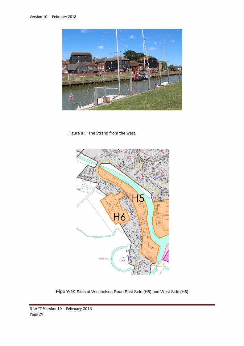
Figure 8 : The Strand from the west.
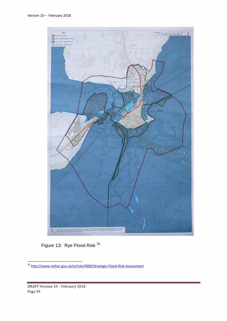
Figure 9: Sites at Winchelsea Road East Side (H5) and West Side (H6)

Version 10 – February 2018
DRAFT Version 10 – February 2018
Page 30
Winchelsea Rd (West Side):
4.12 This broad location sits on the west side of the main gateway to Rye from the
South Coast road. The location is lower than the road by some 2 metres and
is bounded by the road in the East and the Marsh in the West.
4.13 As the location is edged by Marsh there is a high flood risk, which has to be
mitigated as part of any development. (RNP Support 4)
The former Freda Gardham school site
4.14 This former school owned by ESCC, comprises school buildings,
outbuildings, a disused swimming pool and playing field between, all verging
onto Romney Marsh.
4.15 It should be noted that only the footprint of the former school, grounds and
former swimming pool to the South are allocated. This footprint differs from
the site described in RY 19a and 19r in the SHLAA 2103. The Steering Group
has allocated at variance to the SHLAA 2013, principally to confine the
allocation to the brownfield site (as currently fenced) without encroaching
onto the green spaces of the Marsh. The site assessment document (RNP
Support 2) shows this. This location is one of two where the Plan sees a
realignment of the settlement boundary (the other being Gibbet Marsh).
Policy H6 Winchelsea Road [West Side] Winchelsea Road (West Side) is allocated for a mixed use development of up to 20 dwellings and B1 employment subject to the following criteria:
a. development of the location will need to be undertaken on a comprehensive basis and/or according to an overall masterplan;
b. the design shall create a strong sense of place; c. buildings shall be orientated to allow views through to the
marsh to the south-west; and d. the development shall be designed to minimise and
mitigate flood risk.

Version 10 – February 2018
DRAFT Version 10 – February 2018
Page 31
4.16 One mechanism for providing affordable housing for local people is to enable
them to build their own homes (self-build) 23, or have them custom-built to
their own specification perhaps using the Community Land Trust 24 model.
Government figures indicate that 53% of people would wish to be able to build
or specify a new dwelling and the self-build register on the Neighbourhood
Plan website 25 demonstrated strong support from the local community with
many people ready to build if the land was made available. As one of the
larger sites in the Neighbourhood Plan, and one of those in public ownership,
the opportunity should be taken to meet some of the need for self-build
homes.
4.17 Such an initiative allocation does present risk. It is conceivable that the self-
build sites may not deliver housing as envisaged. It is therefore Rye Town
Council’s intention to review this allocation five years after the flood mitigation
works have been carried out and, if, despite having been properly prepared
and marketed, plots remain available, it will consider whether this land should
be re- allocated as conventional housing as part of a review of the
Neighbourhood Plan.
23
http://www.selfbuildportal.org.uk/
24
Community Land Trust 25
http://www.ryeneighbourhoodplan.org.uk/
Policy H7 Former Freda Gardham School The former Freda Gardham School site is allocated for a mixed use development of up to 35 dwellings, at least 10% of which will be self /custom build subject to the following criteria:
a. the development shall not commence until the flood mitigation works planned for 2022 by the Environment Agency for the eastern bank of the River Rother (Eastern Rother Tidal Walls) have been fully implemented;
b. the development shall include appropriate treatment to the south and west boundaries to protect the countryside and habitats beyond; and
c. the development shall be designed to minimise and
mitigate flood risk.

Version 10 – February 2018
DRAFT Version 10 – February 2018
Page 32
Figure 10: Former Freda Gardham School (Orange)
The former Lower School site
4.18 This former ESCC education site has been cleared and is now overgrown but
fenced. There was planning permission (expired early 2016) for a
supermarket outlet and earlier outline proposals for housing. However, two
major retail companies have considered and rejected the site for a
supermarket. There is a current planning application to develop the site
entirely for housing (70 dwellings), and this now seems to be a more realistic
use for the site. The site lies within 400yds of Rye Town Centre comprising
four distinct parts:
a. The former school site. b. The adjoining scrub land/woodland alongside the railway
line. c. The Queen Adelaide Public House site fronting Ferry Road
(B2089). d. Four houses in Ferry Road.

Version 10 – February 2018
DRAFT Version 10 – February 2018
Page 33
Figure 11: Lower School Site
Policy H8 Former Lower School Site The former Lower School Site is allocated for up to 50 dwellings subject to the following criteria:
a. the development shall be designed to minimise and mitigate flood risk;
b. the development shall be designed to protect the natural and heritage characteristics of the site and in particular to avoid damage to the Natural England priority woodland;
c. access to the site shall be carefully designed to be safe, accessible for pedestrians and cyclists as well as vehicles and avoid conflict with the nearby level crossing of the railway;
d. parking provision on the site will be in accordance with local standards and avoid increasing pressure for on-street parking in the vicinity of the site.

Version 10 – February 2018
DRAFT Version 10 – February 2018
Page 34
Windfall of Opportunity Sites across Rye
4.19 The Plan will support proposals for small residential developments on infill
and redevelopment sites within the parish, subject to the proposals being well
designed and meeting relevant requirements set out in other policies in this
Plan. These are known as ‘windfall sites’ and Rother District Council
estimates that up to 22 dwellings could be achieved by 2028 on small sites in
Rye at a rate commensurate with historic levels.
4.20 Development must achieve best use of land in a manner that does not
adversely impact on other policies within the Plan, particularly those that
relate to environmental and design quality. These issues are covered by the
Rother Core Strategy Policies EN2 and EN3 and the Design Policy D1 in this
Neighbourhood Plan.
High Quality Design and Conservation of the Historic Built Environment
4.21 High quality design of development is a key priority for Rye. However, there
is already a robust policy framework for this issue in the Rother Core Strategy
and emerging Development and Site Allocations Document so it is important
that the Neighbourhood Plan adds to this foundation rather than duplicates it.
Policy EN2: Stewardship of the Historic Built Environment is quoted in full at
paragraph 4.79 of this Plan and provides strong protection to heritage assets,
particularly where these are recognised through formal designation such as
the Rye Conservation Area which covers much of the central area of the
Town (see Figure 17). The Core Strategy also requires the following:
“Policy EN3: Design Quality New development will be required to be of
high design quality by:
a. Contributing positively to the character of the site and surroundings, including taking opportunities to improve areas of poor visual character or with poor townscape qualities, and
b. Demonstrating robust design solutions tested against the following Key Design Principles as appropriate (expanded in Appendix 4), tailored to a thorough and empathetic understanding of the particular site and context: 1) Character, Identity, Place-Making & Legibility 2) Continuity and Enclosure 3) Quality of Public Realm, Ease of Movement, and ‘Secured By
Design’ 4) Diversity

Version 10 – February 2018
DRAFT Version 10 – February 2018
Page 35
5) Landscape Setting of Buildings and Settlements 6) Design in Context (Understanding & appraisal of site and wider
setting, and incorporation of existing site features into proposals) 7) Building Appearance & Architectural Quality 8) Sustainable Design and Construction.
4.22 The draft Rother Development and Site Allocations document is also proposing specific policies on extensions, alterations and outbuildings to existing dwellings (Policy DHG5) and boundary treatments (DHG7).
4.23 In this context the Steering Group has carried out detailed work to establish
the character of different parts of Rye to inform the design of new development. This work is set out in the Rye Character Assessment that accompanies this Plan (RNP Support 1). For planning purposes, the assessment identifies three zones within the town as follows:
o Zone A (Red): the ancient “island site” zone covered by the Rye
Conservation Appraisal. This is sub-divided into the area within the Town Walls, known as the Citadel and the lower parts outside the walls. Zone A is designated as a Conservation Area which gives it legal protection as all development is required to conserve and enhance its character. Article 4 Directions relating to the Rye Conservation Area have removed permitted development rights and have had a significant impact in maintaining and enhancing the historic core townscape since the 1950’s.
o Zone B (Blue): at river level around the base of the Citadel. This is area is predominantly Victorian with some individual buildings from earlier periods. It lies between the Conservation Area, and the outer Zone C below.
o Zone C (Yellow): the outer zone is mainly 20c and covers the linear or ribbon development branching outwards from Zone B to the Parish Boundary at: Rye Hill, Military Road beyond the Victorian development, New Road; New Winchelsea Road and Harbour Road, Ferry and Udimore Road leading to Cadborough Cliff , Ashenden Avenue, Tilling Green and Valley Park and back to the Water Tower on Rye Hill.

Version 10 – February 2018
DRAFT Version 10 – February 2018
Page 36
Figure 12: Design Zones

Version 10 – February 2018
DRAFT Version 10 – February 2018
Page 37
Policy D1 High Quality Design Development within Rye will be expected to achieve high quality design having regard to the character of the area in which the development is located, which is detailed in the Rye Character Assessment. Proposals will demonstrate how the design has had regard to the relevant development plan policies and the following principles specific to Rye:
a. High quality design on a human scale with a clear sense of place and connection to its surroundings
b. Selective redevelopment which is planned comprehensively rather than piecemeal
c. A vibrant mix of land uses such as housing, employment and retail
d. Making the best use of the rural margins and riverfronts to reinforce the connections between the town and its landscape setting
e. Ensuring and improving accessibility including pedestrian and cycling routes linking all areas to each other and back into the centre of Rye, reinforcing Rye as ‘a connected community’ with pedestrian and cycle access to all
f. Managing flood risk including pluvial (surface), fluvial (river), coastal (sea), combined sewerage and runoff and high water table/springs
g. Providing affordable housing to meet the needs of Rye into the future
h. Respecting and recording archaeology, particularly that relating to Rye’s long history as a port, trading and agricultural centre
i. Maintaining quality into the future through the use of sustainable and good quality materials, sound construction techniques, and planned appropriate management regimes
j. Flexibility and innovation.

Version 10 – February 2018
DRAFT Version 10 – February 2018
Page 38
Reducing Flood Risk
4.24 At the confluence of the Rivers Rother, Brede and Tillingham and the coast,
there are some 1400 existing dwellings categorised “at risk” in Flood Zones 2
and 3 by the Environment Agency. This plan has taken account of these risks
in selecting the allocated sites and mitigation is covered in the policies ( Rye
Support 4). Measures to reduce flood risks can also impact on habitats and
wildlife and the Plan encourages opportunities to support wildlife conservation
where possible.
4.25 The Government announcement in December 2014 that the flood mitigation
schemes for area Folkestone to Cliff End will be funded, means that the
Eastern Rother Tidal Walls project is on course for completion in 2022. On
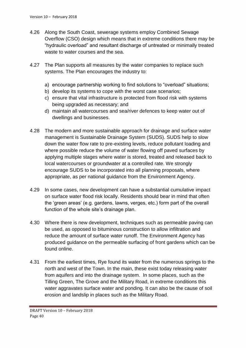
the map below, the blue area indicates the flood risk zone. There are two
different kinds of area shown:
Dark blue Flood Zone 3 for planning purposes, shows the area that could
be affected by flooding, either from rivers or the sea, if there were no flood
defences. This area could be flooded by tidal waters if the flood defence
system failed.
Light blue Flood Zone 2 for planning purposes, shows the additional extent
of an extreme flood from rivers or the sea.
Where there is no blue shading, flooding from rivers and the sea is unlikely
but might be subject to localised “ponding” of surface water caused by
extreme rainfall in conditions of high ground water. They might also be subject
to spillage from the Combined Sewer System in the same conditions. For
planning and development purposes, this is the same as Flood Zone 1.
Version 10 – February 2018
DRAFT Version 10 – February 2018
Page 39
Figure 13: Rye Flood Risk 26
26
http://www.rother.gov.uk/article/4900/Strategic-Flood-Risk-Assessment
Version 10 – February 2018
DRAFT Version 10 – February 2018
Page 40
4.26 Along the South Coast, sewerage systems employ Combined Sewage
Overflow (CSO) design which means that in extreme conditions there may be
“hydraulic overload” and resultant discharge of untreated or minimally treated
waste to water courses and the sea.
4.27 The Plan supports all measures by the water companies to replace such
systems. The Plan encourages the industry to:
a) encourage partnership working to find solutions to “overload” situations;
b) develop its systems to cope with the worst case scenarios;
c) ensure that vital infrastructure is protected from flood risk with systems
being upgraded as necessary; and
d) maintain all watercourses and sea/river defences to keep water out of
dwellings and businesses.
4.28 The modern and more sustainable approach for drainage and surface water
management is Sustainable Drainage System (SUDS). SUDS help to slow
down the water flow rate to pre-existing levels, reduce pollutant loading and
where possible reduce the volume of water flowing off paved surfaces by
applying multiple stages where water is stored, treated and released back to
local watercourses or groundwater at a controlled rate. We strongly
encourage SUDS to be incorporated into all planning proposals, where
appropriate, as per national guidance from the Environment Agency.
4.29 In some cases, new development can have a substantial cumulative impact
on surface water flood risk locally. Residents should bear in mind that often
the ‘green areas’ (e.g. gardens, lawns, verges, etc.) form part of the overall
function of the whole site’s drainage plan.
4.30 Where there is new development, techniques such as permeable paving can
be used, as opposed to bituminous construction to allow infiltration and
reduce the amount of surface water runoff. The Environment Agency has
produced guidance on the permeable surfacing of front gardens which can be
found online.
4.31 From the earliest times, Rye found its water from the numerous springs to the
north and west of the Town. In the main, these exist today releasing water
from aquifers and into the drainage system. In some places, such as the
Tilling Green, The Grove and the Military Road, in extreme conditions this
water aggravates surface water and ponding. It can also be the cause of soil
erosion and landslip in places such as the Military Road.

Version 10 – February 2018
DRAFT Version 10 – February 2018
Page 41
Figure 14: “Ponding” caused by localised flooding on the Strand, Rye Dec 2015
4.32 Many in the community have concerns about flood risk. Some have asked
that even with effective flood defences, “should we be building on the flood
plain at all?” This plan seeks to meet the challenge of balancing the need for
new homes and mitigating flood risks. The community has underscored that:
a. new development in flood risk areas in Rye must be designed to
mitigate risk;27
b. any development on any land unprotected by a flood defence scheme
must be avoided;
c. no development should disrupt the existing watercourses of the
existing and complex drainage system; and
d. Southern Water must be encouraged to work with partners to ensure
that the sewerage system can cope with any new development.
4.33 The National Planning Policy Framework (paragraph 100) requires plans such
as Neighbourhood Plans to “apply a sequential, risk-based approach to the
location of development to avoid where possible flood risk to people and
property and manage any residual risk, taking account of the impacts of
climate change” . The NPPF provides clear guidance for local planning
authorities, including the need to adopt proactive strategies to mitigate and
adapt to climate change (paragraphs 93-108). They should take full account
27
http://planningguidance.communities.gov.uk/blog/guidance/flood-risk-and-coastal-change/neighbourhood-
planning-flood-risk/what-should-be-considered-if-there-is-a-risk-of-flooding-in-the-neighbourhood-plan-area/

Version 10 – February 2018
DRAFT Version 10 – February 2018
Page 42
of flood risk, water supply and demand considerations. The RNP has applied
the Sequential Test and the Exception Test. (RNP Support 4).
4.34 The Rother DC Core Strategy (policies EN6 and EN7) seeks to work with partners to achieve an effective and integrated approach to flood risk management and to avoid inappropriate development in areas at current or future risk from flooding, and to direct development away from areas of highest risk. These higher level strategies provide a clear context for the Plan’s policies in relation to reducing flood risk. The Rother DC Strategic Flood Risk Assessment (SFRA) 28 informs the application of the Sequential and Exception Test as set out in the Planning Practice Guidance (PPG)29.
4.35 Rye is one of the 6 flood risk "hotspots" in the East Sussex County Council
Flood Management Plan30. ESCC has initiated a surface water flood risk
assessment of Rye; the results of which will be reflected in this plan31.
4.36 As sites in Flood Zone 3 with development potential have been identified
across Rye in this plan, developers proposing to build in a flood plain should
make themselves very familiar with the technical guidance accompanying the
National Planning Policy Framework..32 This explains that “site specific and
detailed flood risk assessments will be necessary and any developments will
include flood-resilient buildings, designed to reduce the consequences of
flooding and facilitate recovery from the effects of flooding sooner than
conventional buildings. This may be achieved through the use of water-
resistant materials for floors, walls and fixtures and the siting of electrical
controls, cables and appliances at a higher than normal level. The lower floors
of buildings in areas at medium and high probability of flooding should be
reserved for uses consistent with the flood risk. If the lowest floor level is
raised above the predicted flood level, consideration must be given to
providing access for those with restricted mobility. In considering appropriate
resilience measures, it will be necessary to plan for specific circumstances
and have a clear understanding of the mechanisms that lead to flooding and
the nature of the flood risk by undertaking a flood risk assessment.”
28
http://www.rother.gov.uk/article/4900/Strategic-Flood-Risk-Assessment 29
http://planningguidance.communities.gov.uk/
30
https://new.eastsussex.gov.uk/environment/flooding/localfloodriskmanagementstrategy/ 31
http://apps.environment-agency.gov.uk/wiyby/37837.aspx
32
https://www.gov.uk/government/uploads/system/uploads/attachment_data/file/6000/2115548.pdf

Version 10 – February 2018
DRAFT Version 10 – February 2018
Page 43
Policy F1 Reducing Flood Risk Development in areas at current or future risk from flooding will be subject to a Flood Risk Assessment which applies the ‘sequential test’ and ‘exception test’ and demonstrates that:
a. there are no other reasonable available sites for the development;
b. there are sustainability benefits to the community that outweigh flood risk; and
c. the development can be made safe for its lifetime without increasing risk elsewhere.
Flood Risk Assessments will take into account the following local characteristics:
a. the particular geographic location of Rye at the confluence of three rivers and the coast;
b. the planned improvements to flood defences and the need to maintain those that exist;
c. the need to address local sewerage systems which, in extreme conditions, experience “hydraulic overload” and may discharge untreated waste to water courses and the sea;
d. the need to manage drainage for surface water to reduce existing flooding problems either on the site or elsewhere, taking into account the springs to the north and west of Rye which aggravate surface water and ponding and can also be the cause of soil erosion and landslip;
e. the need to avoid any loss of or have adverse impact on any open watercourse and existing culverts and drainage ditches;
f. the use of Sustainable Drainage Systems (SUDS) and measures such as permeable driveways, water harvesting systems and/or green roofs;
g. the impact of any flood mitigation measures on the local habitats and wildlife, which are protected by national and international designations.
All design to cope with flood risk will take full account of the detailed technical guidance accompanying the National Planning Policy Framework (Footnote 29)

Version 10 – February 2018
DRAFT Version 10 – February 2018
Page 44
Business, Enterprise and Employment
4.37 Rother District has one of the weakest economies in the South East, with a
low level of economic productivity (Gross Value Added only 68% of the
regional average).33 The global trading situation has an adverse impact,
particularly as the area started from a relatively weak base. This is
compounded by the uncertainty associated with the UK’s plans to leave the
European Union. An issue raised by many in the community is the need for
effective business development for jobs, inward investment and enterprise.
4.38 The levels of earnings in Rye are below the national average, adversely
impacting on prosperity and standard of living. The economy has limited
capacity to support a wide range of job opportunities, especially for younger
people. 34 Those with skills and education must travel outside to find suitable
employment and those with low skill levels find themselves competing in a
crowded and uncertain commercial market.
4.39 With its attractive topography and distinctive heritage, Rye has a unique
identity and widespread reputation with tourists. However, it must encourage
businesses appropriate to its characteristics to maximise its role as a
destination town. Further information about the economic and tourism profile
of Rye is contained in the Evidence Background Paper.
Figure 15: Heritage Centre Rye
33
http://www.rother.gov.uk/CHttpHandler.ashx?id=14875&p=0 Rye and Rye Harbour Study
34 http://www.theguardian.com/news/datablog/2011/nov/24/wages-britain-ashe-mapped

Version 10 – February 2018
DRAFT Version 10 – February 2018
Page 45
4.40 In March 2015, the South East Tourist Office was closed as a result of budget
cuts. The important facility of information centre for visitors has passed to the
Rye Town Council managed Heritage Centre.
4.41 The Citadel provides the focus for retail and other services for the town, an
attraction for tourists and a place of residence for many. However, there is
also a need to increase the number of micro businesses, less dependent on
footfall, in the surrounding areas of the town centre, the working port and
industrial areas of Rye Harbour.
4.42 The High Street needs specific attention with future development providing
real “reasons to visit”. High rents and business rates remain an issue. In
common with many town centres there have been business closures and
relocations. The Plan looks to national studies35 36to support its policies.
4.43 The Port of Rye and Rye Harbour Road Industrial Estate provide main centres
of employment unrelated with tourism for the town and the surrounding
settlements (up to 1000 jobs including the fishing fleet). 37 With the
Environment Agency holding significant plots of riverside and land alongside
“gateways”, its policy of short term leasing, (for necessary income to the Port),
rather than disposals deters long term substantial business investment. The
result is short term use by car lots, car washes, parking and storage.
35
http://thegreatbritishhighstreet.co.uk/pdf/GBHS-British-High-Streets-Crisis-to-Recovery.pdf
36 https://www.ucl.ac.uk/transport-institute/pdfs/future-high-street
37 http://rother.devplan.org.uk/document.aspx?document=19&display=chapter&id=167

Version 10 – February 2018
DRAFT Version 10 – February 2018
Page 46
Figure 16: Historic ship Balmoral at Rye
4.44 Discussions with local small businesses suggest that there is a requirement
for a small office/enterprise centre (Incubator/SME cluster site) close to the
town centre. One site which provides this facility is the Rope Walk Centre.
Other community feedback suggests that the Plan should:
a. Encourage festivals and major town events;
b. Take every opportunity to create employment and training opportunities;
c. Encourage maritime related enterprise;
d. Support the fishing fleet;
e. Support the High Street and encourage “reasons to visit”;
f. Support a second supermarket;
g. Support a second petrol station and food outlet; and
h. Support faster broadband.
4.45 The Rother DC Core Strategy Policy RY1: Policy Framework for Rye and Rye
Harbour includes that proposals for development and change will:
a. Retain the centre of Rye as the main focus for retail and services for the
town, and increase the choice of convenience shopping in Rye by
facilitating the increase of some 1,650 sq m net additional convenience
floorspace within or adjacent to the town centre;

Version 10 – February 2018
DRAFT Version 10 – February 2018
Page 47
b. Promote at least 10,000 sq m of employment floorspace at Rye Harbour
Road industrial estate to promote economic regeneration and job creation,
having particular regard to protecting the integrity of internationally
designated habitats;
c. Promote green tourism initiatives, including careful management of Rye
Harbour Nature Reserve and, where feasible, new habitat creation and
green infrastructure linkages, that protects and enhances the integrity of
the internationally important ecological interests;
d. Tackle social exclusion and promote opportunities for young people to
access education, community facilities, employment and leisure;
e. Maintain and enhance the community, cultural and tourism assets of
both Rye and Rye Harbour village”.
4.46 Rother DC has also carried out an ‘Employment Sites Review’ to inform plan-
making, and its recommendations include:
a. of the 7 areas/estates with intensification potential, 3 of these are already
recognised through planning permissions, with Harbour Road, Rye having
by far the greatest potential, with over 15,000sqm of floorspace benefiting
from an outstanding planning permission;
b. for Rye and Harbour Road, it notes that the lower end of the minimum floorspace target is already provided for by outstanding planning permissions at Harbour Road Industrial Estate but adds that, given its strategic role, identified opportunities for further intensification would most appropriately be provided for by an enabling policy, which would also need to fully acknowledge the need to not adversely impact on the surrounding nature conservation designations;
c. at the same time, encouragement is given to Rye Town Council, through
its Neighbourhood Plan, to consider the potential to promote higher
density office led schemes in more central locations”
4.47 Proposed Policy DEC3 of the Development and Site Allocations document seeks the effective use of existing employment sites by retention of existing uses, and supporting intensification, conversion, redevelopment and/or extension of existing sites. Where sites cannot continue solely in employment use then a mixed use is preferred, prioritising alternative community uses, affordable housing and then market housing, subject to local needs.

Version 10 – February 2018
DRAFT Version 10 – February 2018
Page 48
Policy B1 Business Development To support the economic vitality of Rye development proposals for the following will be permitted subject to other relevant development plan policies:
a. development which regenerates or enhances the fishing and maritime and port related industries;
b. development of micro (low footfall) businesses around the Citadel in Zone B (Figures 12 and17);
c. proposals for new business development especially small scale flexible office units, affordable workshops and high quality office space;
d. development which facilitates improved broadband
access for businesses and home workers.
Existing business floor space (particularly in the core area in Figure 17) will be safeguarded unless it can be demonstrated to the satisfaction of the Local Planning Authority that the premises are no longer suitable for business use and evidence has been submitted that demonstrates that the property has been actively marketed for at least 18 months on realistic market terms and it is shown that there is no prospect of new
business occupiers being found.

Version 10 – February 2018
DRAFT Version 10 – February 2018
Page 49
Figure 17: Core Town Centre Area in blue
Version 10 – February 2018
DRAFT Version 10 – February 2018
Page 50
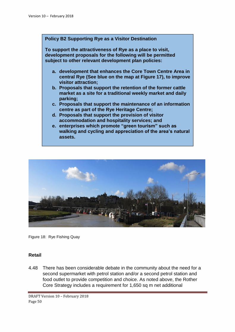
Figure 18: Rye Fishing Quay
Retail
4.48 There has been considerable debate in the community about the need for a
second supermarket with petrol station and/or a second petrol station and
food outlet to provide competition and choice. As noted above, the Rother
Core Strategy includes a requirement for 1,650 sq m net additional
Policy B2 Supporting Rye as a Visitor Destination To support the attractiveness of Rye as a place to visit, development proposals for the following will be permitted subject to other relevant development plan policies:
a. development that enhances the Core Town Centre Area in central Rye (See blue on the map at Figure 17), to improve visitor attraction;
b. Proposals that support the retention of the former cattle market as a site for a traditional weekly market and daily parking;
c. Proposals that support the maintenance of an information centre as part of the Rye Heritage Centre;
d. Proposals that support the provision of visitor accommodation and hospitality services; and
e. enterprises which promote “green tourism” such as walking and cycling and appreciation of the area’s natural
assets.

Version 10 – February 2018
DRAFT Version 10 – February 2018
Page 51
convenience floorspace within or adjacent to the town centre of Rye.
Accordingly the Steering Group carried out an assessment to identify the
potential sites around the town centre (RNP Support 2).
4.49 Three potential sites for a supermarket have been identified:
1. S1 Lower School Site
2. S2 Gibbet Marsh
3. S3 Existing convenience store and petrol station with potential to expand.
These sites identified are classed as “edge-of-centre” sites because suitable
and viable town centre sites were not available. However, importantly they
are near (within 10 minutes walk) to the centre of Rye population in the West
of Rye.
4.50 The Lower School site previously had a planning permission for a
supermarket (RR/2010/2570/P) but this has now expired due to lack of
commercial interest reflecting changing retail trends away from large
superstores to on-line shopping and smaller convenience stores. However, it
remains the case that there is significant convenience trade “leakage” from
Rye, such that a further large store would undoubtedly claw back trade, with
associated benefits in terms of reliance on the car. Also, with further
development in Rye and increasing fuel costs, it is considered that the
opportunity for accommodating a further supermarket or convenience store
and petrol station in the future should not be lost. Therefore, an appropriate
approach is to identify a site close to the centre in the event of demand
materialising during the plan period. The Lower School site is being promoted
for housing by its owners and this Plan proposes to allocate it for 50
dwellings. Given that the Lower School site (S1) may not be available for
retail use, the only other site relatively close to the town centre of a size to
accommodate the size of store envisaged in the Rother Core Strategy is the
Gibbet Marsh car park and adjoining land (S2). An alternative site (S3) has
also been considered, but is too small to provide a real choice in supermarket
shopping.
4.51 To reflect the desire by many in the Community for a second petrol station and
linked convenience store, for choice and competition the Steering Group, as
part of its work on site assessment has considered potential sites on the main
east-west through route, the A259 and by applying a sequential test has
annotated certain sites for mixed development to reflect this work. From
contacts with various companies it is not clear what interest there would be to
invitations to develop to meet this requirement, but the mixed use allocations
are flexible enough to cope, whilst still allowing the Plan to meet its housing
target, should a proposal come forward.

Version 10 – February 2018
DRAFT Version 10 – February 2018
Page 52
Figure 19: Potential retail outlets primarily for food

Version 10 – February 2018
DRAFT Version 10 – February 2018
Page 53
Figure 20: Site 2 Gibbet Marsh: Site shown in purple
Policy B3 New Supermarket
A suitable site at Gibbet Marsh as delineated on the Policies Map is allocated for a convenience store of about 1,650 sq m subject to other relevant development plan policies and the following criteria:
a. Submission of a retail impact assessment demonstrating that the proposal will not have a significant adverse impact on the vitality and viability of the town centre;
b. The development will be of a form, scale and height appropriate to its setting and retain or replace existing trees and other vegetation;
c. The development will retain and enhance pedestrian links into the town centre to encourage linked trips;
d. The development will retain the area of open space on the north-eastern portion of the site to act as an attractive transition between the development and the town centre;
e. At least 150 car parking spaces will be retained / re-provided as part of the proposal and made available to customers and linked trips to the town centre;
f. An improved access will be provided to the site including the ability for large delivery vehicles to enter and egressthe site safely; and
g. the development shall be designed to minimise and mitigate flood risk.

Version 10 – February 2018
DRAFT Version 10 – February 2018
Page 54
Traffic, Access and Getting Around
4.52 Rye’s unique geographic and physical situation creates a challenging
framework around and within which transport has to work: the original hill top with its small grid system of streets still houses much of the key business and commercial operations of the town (currently including all the town’s banks and building society, dentists, dispensing chemists, library and 3 churches), while the (trunk) A259 road coming in from the west skirts the base of the hill (with narrow carriageway for a trunk road) before going out across the marsh to the east. Developments, particularly in the last century have created residential, educational and industrial areas around and away from the base.
4.53 The A268 road takes much traffic north up Rye Hill through neighbouring villages to reach the A21 whilst the B2089 provides a link to the area to the west and the northern parts of Hastings and St Leonards. The are concerns over the speed of traffic coming into the town on these two major routes as well as on the A259, residents of New Road, New Winchelsea Road and Udimore Road in particular are looking for action to control the problem. There are issues for the safety of road users and traffic flow resulting from building developments within the town - that in Deadmans Lane continues to cause problems and the access for other sites in the town is a key concern and may impinge on their viability. Changes in traffic volumes underline fundamental shifts in living and working patterns. Further information about these characteristics, trends and community feedback are in the Evidence Background Paper.
4.54 Rye benefits from a centrally located station and rail links to Ashford in the
east and Bexhill to the west. There are proposals for a High Speed service between Ashford and Bexhill which may stop at Rye, but as this is currently uncertain, it is dealt with in the Community Aspirations section in Chapter 5. Reconciling all the different demands - the needs of residents and of commercial and business operations, the protection of structures that are in places fragile and historic, the demands of tourism and leisure activities, etc - is very difficult, especially as the town is not an easy place for people to get around under their own steam (even more so in inclement weather). The Neighbourhood Plan seeks to promote traffic management, supporting vulnerable road users - pedestrians, children, those with mobility difficulties - while recognising residents’ and visitors’ needs and those of business and commercial operations for vehicle usage.
4.55 Given the broad sweep of the Plan, it has not been possible to carry out a
detailed consideration of all traffic issues but the issues have been considered
strategically. Lessons from other neighbourhood plans indicate that we
should be innovative to encourage sustainable travel including local
community transport and street environments that significantly reduce the
impact of traffic on the town’s community life. The policies in this section focus
on aspects which the Rye Neighbourhood Plan can deliver through the

Version 10 – February 2018
DRAFT Version 10 – February 2018
Page 55
planning system by influencing the design of new developments, including
parking provision and connectivity for pedestrians and cycles. Other transport
issues, where partnership action is required, are addressed in Section 5:
Community Aspirations.
Policy Context
4.56 The Rother DC Core Strategy Policy RY1: Policy Framework for Rye and Rye Harbour includes the requirement for proposals for development and change to:
a. Promote efficiencies and improvements to the strategic transport network to
improve connectivity between Rye and other major urban centres;” and
b. Support traffic management on the local road network, promote sustainable alternatives to the car and implement the objectives stated in Local Transport Plan 3 and the Rye Local Area Transport Strategy”.
4.57 The Core Strategy also includes:
a. Policy TR2: Integrated Transport which promotes improvements in the provision and use of sustainable transport modes including walking and cycling;
b. Policy TR3: Access and New Development which seeks to minimise the need
to travel and support good access to employment, services and community facilities, as well as ensure adequate, safe access arrangements; and
c. Policy TR4: Car Parking which sets out principles for parking provision which
will be elaborated upon in the form of Supplementary Planning Document.
Connectivity and Sustainable Transport 4.58 In all development there must be a detailed consideration of access and
connectivity to existing and proposed routes leading from new development to the Town Centre and its services. Such connectivity encourages residents and users to walk and cycle more and use the private car less, which is important in a town such as Rye where the roads are narrow and parking facilities are restricted. One of the key factors in the selection of the development sites in the housing section was accessibility to the Town Centre.
4.59 The Rye Bay and Romney Marsh area also has huge potential for cycle
tourism. Rye should be the centre and natural hub for expansion and facilities. Within Rye, there is scope for improved connectivity, with better cycle routes and secure cycle parking to encourage cycling – as well as making it easier to

Version 10 – February 2018
DRAFT Version 10 – February 2018
Page 56
cycle (and walk) within Rye. More cycle parking provision is also needed to encourage this mode of transport and to meet existing demands.

Version 10 – February 2018
DRAFT Version 10 – February 2018
Page 57
Figure 21: Cycleways
Policy T1 Connectivity and Sustainable Transport Development proposals within Rye will be permitted subject to other relevant development plan policies and the following criteria:
a. The development is located close to the town centre and other community facilities to enable access to these amenities by walking and/or cycling;
b. The design of new development makes the most of opportunities to improve walking or cycling facilities in and around the site, including linking with other strategic routes such as the National Cycle Network and the Greenway initiative;
c. The development includes cycle parking and other facilities that would encourage users to access the site by foot or bicycle.
Proposals to implement all or parts of the Greenway initiative,
as shown on the Policies Map, will be supported.
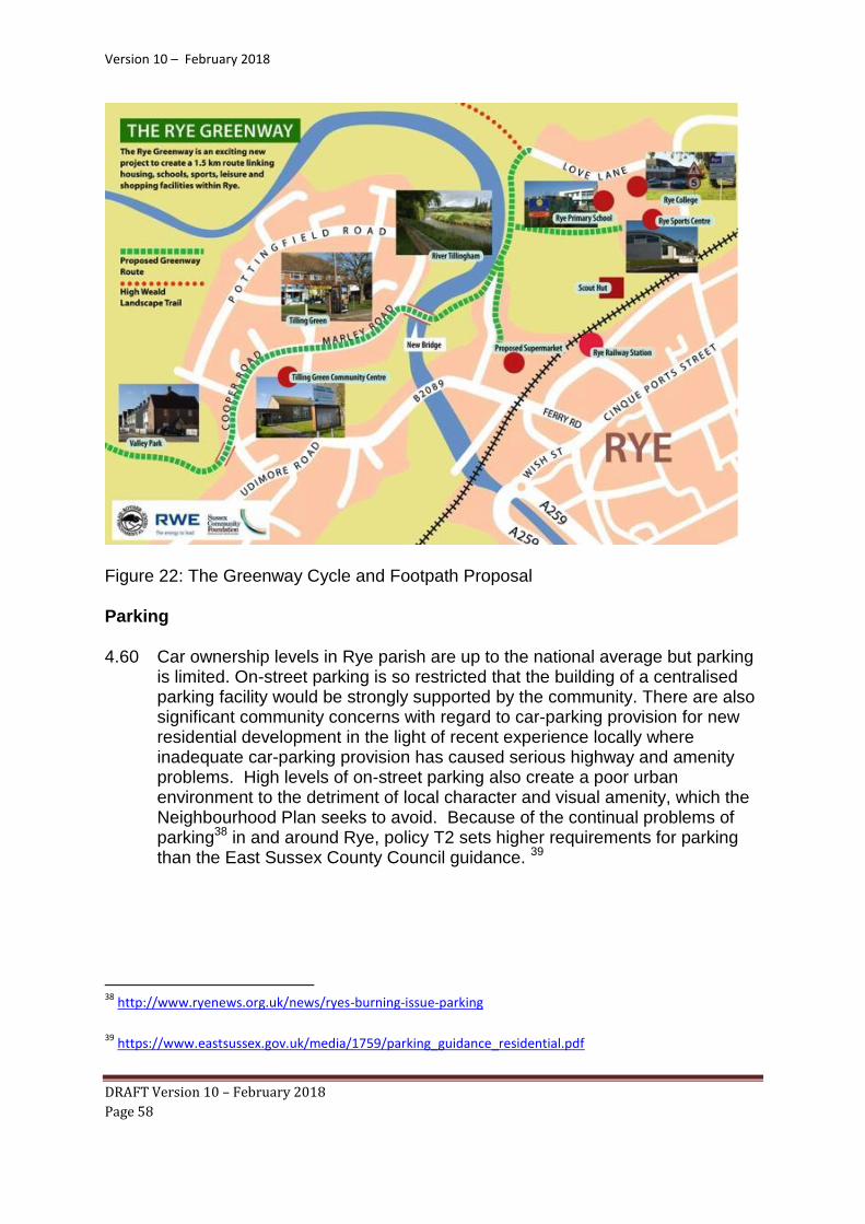
Version 10 – February 2018
DRAFT Version 10 – February 2018
Page 58
Figure 22: The Greenway Cycle and Footpath Proposal
Parking
4.60 Car ownership levels in Rye parish are up to the national average but parking is limited. On-street parking is so restricted that the building of a centralised parking facility would be strongly supported by the community. There are also significant community concerns with regard to car-parking provision for new residential development in the light of recent experience locally where inadequate car-parking provision has caused serious highway and amenity problems. High levels of on-street parking also create a poor urban environment to the detriment of local character and visual amenity, which the Neighbourhood Plan seeks to avoid. Because of the continual problems of parking38 in and around Rye, policy T2 sets higher requirements for parking than the East Sussex County Council guidance. 39
38
http://www.ryenews.org.uk/news/ryes-burning-issue-parking
39
https://www.eastsussex.gov.uk/media/1759/parking_guidance_residential.pdf

Version 10 – February 2018
DRAFT Version 10 – February 2018
Page 59
Infrastructure and Community Facilities
4.61 Rother District is recognised for its high quality of life and emphasis on
community life. With Rye at the extreme end of the District, the Plan should
support a vibrant, safe, balanced and inclusive community with a range of
facilities for all from birth to death. With an ageing population, the delivery of
services and activities in accessible locations is a particularly significant. The
Plan seeks to reflect the strong relationship between health, recreation,
leisure, culture, heritage and the environment. The existing range of facilities
and their role in the community is explored in the Evidence Background
Paper.
4.62 In the west of Rye, the former Tilling Green School is being disposed of and a
proposal for affordable housing has been withdrawn. The existing school
building has been used for several years as a community facility, which has
justified future need. The requirement to retain or replace this facility has
therefore been included within policy H3 which allocates this site for
development. There is also concern about the future location of facilities such
as the Housing Associations, Credit Union, Early Years Foundation Services
(EYFS) and nursery facilities.
4.63 Following many years of school closures there is a concentration of
educational assets and facilities within The Grove-Love Lane “education
quarter”. However, there is local concern that the facilities catering for Early
Years to post 16 education, even with some planned expansion, will not meet
Policy T2 Car Parking Development proposals within Rye will be permitted subject to other relevant development plan policies and the following parking standards:
a. new dwellings with 2, 3 or 4 bedrooms will be provided with a minimum of 2 off-street car-parking spaces per dwelling.
b. new dwellings with more than 4 bedrooms shall be provided with a minimum of 3 off-street car-parking
spaces.
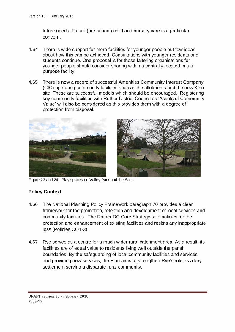
Version 10 – February 2018
DRAFT Version 10 – February 2018
Page 60
future needs. Future (pre-school) child and nursery care is a particular
concern.
4.64 There is wide support for more facilities for younger people but few ideas about how this can be achieved. Consultations with younger residents and students continue. One proposal is for those faltering organisations for younger people should consider sharing within a centrally-located, multi-purpose facility.
4.65 There is now a record of successful Amenities Community Interest Company
(CIC) operating community facilities such as the allotments and the new Kino site. These are successful models which should be encouraged. Registering key community facilities with Rother District Council as ‘Assets of Community Value’ will also be considered as this provides them with a degree of protection from disposal.
Figure 23 and 24: Play spaces on Valley Park and the Salts
Policy Context
4.66 The National Planning Policy Framework paragraph 70 provides a clear
framework for the promotion, retention and development of local services and
community facilities. The Rother DC Core Strategy sets policies for the
protection and enhancement of existing facilities and resists any inappropriate
loss (Policies CO1-3).
4.67 Rye serves as a centre for a much wider rural catchment area. As a result, its
facilities are of equal value to residents living well outside the parish
boundaries. By the safeguarding of local community facilities and services
and providing new services, the Plan aims to strengthen Rye’s role as a key
settlement serving a disparate rural community.

Version 10 – February 2018
DRAFT Version 10 – February 2018
Page 61
The Environment, Green Spaces and Energy
4.68 Rye is blessed with a wide range of green and open spaces: The Salts, Mason’s
Field, marshland, allotments, the Railway Corridor, former Freda Gardham playing
fields and informal areas of grassland/woodland. All these link to the rural and
surrounding rural countryside beyond which in turn links to the nearby coast. This is a
vital feature of the Town. There is a wide community view that green areas beyond
the parish boundary, in particular the ‘strategic gap’ between Rye and Rye Harbour,
should be maintained as green spaces.
Figure 25: Rye from the East
Policy I1 Community Facilities The following facilities are particularly valued by the community and they will be safeguarded from loss or alternative uses: Community Centres (Conduit Hill and Marley Road); Early Years facilities, Rye Leisure Centre; the Salts sports fields and facilities including Rye Bowls Club; and Rye Rugby Club. Development proposals that result in the loss of sites or premises currently or last used for community purposes will be refused unless:
a. alternative provision of the equivalent or better quality is available in the local area or will be provided and made available prior to the commencement or redevelopment of the proposed scheme; or
b. it can be demonstrated there is no reasonable prospect of retention for the current use and that no other community
use of the site is suitable or viable.

Version 10 – February 2018
DRAFT Version 10 – February 2018
Page 62
4.69 Much of the area around Rye is designated for the importance of its
landscape and/or its habitats for wildlife. This includes European
designations as Special Areas of Conservation (SAC), Special Protection
Areas (SPA) and Ramsar sites and national designations as Sites of Special
Scientific Interest. The location of these areas is shown on the map below.
The impact of proposed development on these areas is covered by Core
Strategy Policy EN1: Landscape Stewardship which covers the management
of the high quality historic, built and natural landscape and Policy EN5:
Biodiversity and Green Space. Rother District Council has confirmed that the
potential impact of development in Rye on the European designations has
already been assessed through the Habitats Regulations Assessment of its
Core Strategy.
Figure 26: Designated areas of protection

Version 10 – February 2018
DRAFT Version 10 – February 2018
Page 63
Figure 27: Rye Habitats
4.70 The characteristics of the environment of Rye and the community’s
aspirations for protecting it are explored in detail in the Evidence Background
Paper. These aspirations include:
a. Seeking more areas of green space around the town to create wildlife
habitat, enhance residents’ quality of life and contribute towards the
provision of a bio-diverse natural environment;

Version 10 – February 2018
DRAFT Version 10 – February 2018
Page 64
b. Protecting existing open space, including gardens, allotments, recreational
space, open fields, woodlands and pathways;
c. Existing groups, Transition Rye and Rother Environmental Group are
considering future energy use and intend to establish a community energy
company (RX) to encourage local generation and measures to reduce
energy usage.
d. For many, light pollution is an issue. The Campaign to Protect Rural
England (CPRE) claims that only around one 10th of the country enjoys a
truly dark night sky; 40
e. There are no local facilities for disposing of bulk domestic waste. Items
which cannot be removed through the Rother DC waste collection service
have to be collected by private contractors at cost or carried to the
household waste sites at Mountfield or Pebsham (East Sussex) or Lydd
(Kent).
The Development Boundary and Strategic Gaps
4.71 Development boundaries around settlements are a well-established planning
policy tool in East Sussex. Rother DC Core Strategy Policy OSS2 states that
development boundaries around settlements will continue to differentiate
between areas where most forms of new development would be acceptable
and where they would not. The draft Development and Site Allocations
Document proposes a policy DIM2 which says that new development shall be
focused within defined settlement development boundaries, principally on
already committed and allocated sites, together with other sites where
proposals accord with relevant policies. In the countryside (that is, outside of
defined settlement development boundaries), development shall be normally
limited to that which accords with specific policies or that for which a
countryside location is demonstrated to be necessary.
4.72 However, in order to meet the targets set by the Core Strategy, two sites are
proposed for development - the former Freda Gardham Site and the Gibbet
Marsh site - that require a change to the development boundary. This
amendment is shown on the Policies Map that accompanies this Plan and
RNP Support 2.
40
http://www.cpre.org.uk/resources/countryside/dark-skies

Version 10 – February 2018
DRAFT Version 10 – February 2018
Page 65
4.73 The Core Strategy designates one strategic gap (Policy RY1 iix) where
development is strongly resisted: the gap between between Rye’s Rock
Channel and the industrial estate at Rye Harbour Road. This remains to
protect the unique character and setting of Rye from further development and
the coalescence of settlements. For this reason, the policy below sets criteria
that should be applied to the countryside, within the parish of Rye and outside
the Rye NP Development Boundary, which surrounds and adjoins the town in
order to preserve the unique setting and special character of historic Rye.
This policy when applied in conjunction with Core Strategy Policy OSS2 –Use
of Development Boundaries will also assist in safeguarding the open
countryside41 and marsh and preserve the unique setting and special
character of historic Rye.
41
Coalescence of settlements and urban sprawl have been acknowledged as problems in England
since the 1950s. Strategic gaps and their policies are meant to be only concerned with the strategic pattern
of settlements and settlement identity. Open countryside is defined as undeveloped land beyond the
settlement boundary”
Policy E1 Development Boundary , Strategic Gap & Setting of Rye New development in Rye will be contained within the Town’s Development Boundary as defined on the Policies Map but taking account of two adjustments proposed by this Plan. (RNP Support 1 – Sites S2 and H7) Outside the Development Boundary, development will be restricted to that for which a countryside location is necessary or which accords with other specific Development Plan Policies Any development on the edge of Rye will be controlled to protect the designated areas surrounding Rye (Figure 26) and the Strategic Gap between Rock Channel and Rye Harbour, all with the aim of conserving and enhancing the open landscape
bordering Rye that contributes to its unique historic setting.

Version 10 – February 2018
DRAFT Version 10 – February 2018
Page 66
Green Infrastructure and Open Spaces
4.74 Effective management of habitats may be seen within a wider approach to
‘green infrastructure’. This is defined by the Rother DC Core Strategy as a
strategic network of multi-functional green space which supports a wide range
of purposes:
a. The creation and enhancement of a sense of place, b. Provision of recreation opportunities, c. Preservation and enhancement of biodiversity, d. Sustainable transport routes, e. Improved water resources and flood management, f. Contribution to climate change adaption and mitigation.
4.75 Rother DC sets out policies for green spaces and amenities. 42 There are
targets set out in Natural England’s standard for accessible natural green
space (ANGSt) and the follow-on work led by East Sussex County Council. 43
Given the specific environmental context of Rye, with its high quality historic
built environment and public realm, the distinctive character of its landscape
setting, its proximity to internationally protected habitats and its exposure to
potential flooding, the consideration of and compliance with these policies will
be of paramount importance.
4.76 The Plan will support development which:
a. integrates new multi-functional open space within it.
b. actively seeks to improve the connectivity of green infrastructure and
enhance biodiversity (and not supporting development which further
fragments green infrastructure and impacts negatively on biodiversity).
c. increases the number of street trees in a locality.
d. designates green infrastructure including spaces to protect them from
development, while encouraging gardens and permeable surfaces.
e. integrates biodiversity improvements within any renewable energy
installations 44
42
http://www.rother.gov.uk/CHttpHandler.ashx?id=6405&p=0 43
http://sussexlnp.org.uk/documents/EastSussexGIStrategyFinal.pdf 44 Research by the Building Research Establishment shows that where a Biodiversity Management Plan is
developed, field based solar farms can deliver habitat enhancements

Version 10 – February 2018
DRAFT Version 10 – February 2018
Page 67
Policy E2 Green Infrastructure To protect and encourage the provision of green infrastructure:
a. the green spaces listed below and identified on the Policies Map will be safeguarded from loss or alternative uses.
1) Valley Park common areas 2) TG Community Centre green area 3) Masons Field 4) Tilling Green Triangle 5) Pottingfield Green 1 6) Pottingfield Green 2 7) Pottingfield Green 3 8) The Close Green 9) Rye College Sports Field 10) Gibbet Marsh – car parking and green space 11) North Salts - cricket pitch and skate board park 12) Middle Salts – play area 13) Town/Recreation Salts – Bowls and recreational area 14) The Strand – green spaces within flood defence walls 15) The Church Yard 16) Freda Gardham School Field 17) Rye Rugby Club Field 18) Kings Avenue Open Space 19) Land adjacent to the railway line in central Rye 20) Land to the East of the River Tillingham accessed from
Ferry Road
b. Any trees lost through development are to be replaced either on the site or in close vicinity to it. As roots are vital to keep trees healthy and upright all development proposals must take into account the impact on the roots of trees to be retained and avoid damage to them.
c. Where practical, development proposals will include
improvements to local green infrastructure, particularly to
improve connectivity for people and habitats.

Version 10 – February 2018
DRAFT Version 10 – February 2018
Page 68
Figure 28: Rye Green Spaces
To promote conservation of the historic environment.
4.77 Rye is a historic town with records going back to Saxon times when the region
along the south coast including Rye, was under the rule of the Abbey of
Fecamp in France. In the 14th century Rye underwent regeneration and
fortification. This was begun with the building of the town wall and four gates;
Landgate, Strandgate, Baddings Gate and Postern Gate. Modernisation of
defence was implemented in the 15th and 16th centuries but today only one
of the gates remains; the Landgate. The remains of these medieval defensive
structures, including the Landgate and Ypres Tower, form the core of the
heritage buildings today.

Version 10 – February 2018
DRAFT Version 10 – February 2018
Page 69
Figure 28: Ypres Tower
4.78 The rich diversity of architectural styles and periods make Rye an architectural and heritage gem partly set in cobbled streets with heritage street furniture, making the town such an important tourist destination. In all there are some 200 listed and varied structures in Rye including:
a. 14c The Monastery45, Landgate46 and Ypres Tower47 b. 1735: The Water System in Church Square (Pump Street) is Grade
II* listed and a Scheduled Ancient Monument; c. the 18th century Water Cistern in Wish Ward is Grade II listed; d. 1923: the WW1 memorial48 designed and built under the
supervision of Sir Reginald Blomfield who had property in the Town; e. 1927: the St Anthony of Padua Roman Catholic church in Watchbell
Street is unique to the UK as the only building in this country in the Spanish Romanesque style popularised in Spain's former South American colonies;49
f. Later additions include the lookouts at the East and West ends of the Citadel (Hilders Cliff) 50
45
http://www.ryemuseum.co.uk/the-monastery/
46
http://www.ryemuseum.co.uk/landgate-walls-and-strandgate/
47
http://www.ryemuseum.co.uk/home/ypres-tower/
48
https://www.warmemorialsonline.org.uk/memorial/106976/
49
http://www.catholicdirectory.org/Catholic_Information.asp?ID=33760
50
http://www.ryesussex.co.uk/directory/127/ef-benson-society/

Version 10 – February 2018
DRAFT Version 10 – February 2018
Page 70
4.79 Ancient Monuments, Listed Buildings and Conservation Areas are protected
by law under the Planning (Listed Buildings and Conservation Areas) Act
1990. The National Planning Policy Framework (paragraphs 126-141) and
the Planning Practice Guidance require that decision-making aims to sustain
and enhance the significance of all heritage assets, including non-designated
assets. Archaeological sites, historic buildings and other heritage assets are
recorded on the County Historic Environment Record (HER)51.
4.80 There are significant archaeological remains across the parish. With Rye’s
long history as a port, trading and agricultural centre with the shifting nature of
past river channels, beaches and marshes, there is high potential of the
survival of evidence of past human activity of industrial, ship-building, fishing,
and as a rural centre. Development will take account of this potential through
appropriate assessment, evaluation and mitigation in order that significant
archaeological remains are protected in situ, enhanced and conserved or
where this is not possible adequately recorded in advance of their loss.
Provision will be made for all discoveries and findings to be reported to
appropriate professional standards and the archive deposited with Rye
Museum.
4.81 There is already a strong policy framework protecting heritage assets in the
NPPF and the Rother DC Core Strategy. In particular the latter includes the
following policy:
“Policy EN2: Stewardship of the Historic Built Environment
Development affecting the historic built environment, including that both
statutorily protected and the non-statutorily protected, will be required to:
a. Reinforce the special character of the district’s historic settlements,
including villages, towns and suburbs, through siting, scale, form and
design;
b. Take opportunities to improve areas of poor visual character or with
poor townscape qualities;
c. Preserve, and ensure clear legibility of, locally distinctive vernacular
building forms and their settings, features, fabric and materials,
including forms specific to historic building typologies;
51 https://www.eastsussex.gov.uk/environment/archaeology/her

Version 10 – February 2018
DRAFT Version 10 – February 2018
Page 71
d. Make reference to the character analysis in Conservation Area
Appraisals, where relevant;
e. Reflect current best practice guidance produced by English Heritage
and HELM59;
f. Ensure appropriate archaeological research and investigation of both
above and below-ground archaeology, and retention where required”.
4.82 Criteria iv of the above policy refers to the relevance of Conservation Area
Appraisals52 in design decisions. The Conservation Area Appraisal for Rye
was adopted by Rother District Council in 2006 and informs the following
policy. This applies primarily to proposals within the Conservation Area but
may also be relevant to proposals affecting historic areas outside the
designated area.
4.83 Many non-designated heritage assets go unrecognised and therefore may fail
to be taken into account during decision-making. Historic England
52
http://www.rother.gov.uk/CHttpHandler.ashx?id=6181&p=0
Policy E3 Heritage All development impacting on the historic built environment of Rye will be designed with regard to the characteristics set out in the Rye Conservation Area Appraisal. These include:
a. The medieval pattern of narrow streets with most of the buildings lining the footways; the occasional recess by way of court or garden providing an interesting contrast and giving variety to the streetscene;
b. Partially revealed 'glimpse' views created by the curve or slope of many of the streets or by passageways;
c. Buildings largely of two or three storeys with pitched roofs in which there are often dormer windows;
d. The high number of timber-framed buildings, with the more formal work of the medieval period being represented in the few buildings of stone;
e. The restricted palette of materials, prevalent ones being brick, handmade clay tile (for roof or tile hanging), weather boarding, painted render and slate;
f. The good historic street surfaces including several streets that are paved with cobbles;
g. The highly visible and important roofscape of jumbled historic clay-tiled roofs, its impact heightened by the
topography of the town.

Version 10 – February 2018
DRAFT Version 10 – February 2018
Page 72
encourages communities to produce ‘local lists’ of non-designated heritage
assets to help ensure that their conservation needs are taken into account53.
Section 5: Community Aspirations includes the aim to compile such a list for
Rye in consultation with Historic England and Rother District Council.
Figure 29: Rye Heritage and Conservation Area
Renewable and Low Carbon Energy
53
https://historicengland.org.uk/advice/hpg/has/locallylistedhas/

Version 10 – February 2018
DRAFT Version 10 – February 2018
Page 73
4.84 The Government’s National Planning Policy Framework expects local
planning authorities to have a positive strategy to promote energy from
renewable and low carbon sources. In response, the Core Strategy has a
strategy (Policy SRM1) ‘Towards a Low Carbon Future’ which supports in
principle proposals for renewable and low carbon energy generation
schemes, particularly those utilising solar, biomass and wind energy
technologies, that:
a. do not have a significant adverse impact on local amenities, ecological
and heritage assets or landscape character, and
b. in respect of locations in or adjacent to the High Weald AONB and
other sensitive landscapes, are generally small in scale.
The Rother Development and Site Allocations document seeks views on
appropriate locations for wind turbines, opportunities to encourage
biomass/wood fuel from local sources and the thresholds that should apply to
the requirement on developers to submit an ‘energy statement’. The following
policy suggests that all development proposals should be accompanied by an
energy statement proportionate to their scale, i.e. one for a house extension is
likely to be much briefer than one for a development of ten houses. It also
suggests a number of specific measures, some of which will not be
acceptable in certain circumstances. For instance, solar panels will be
carefully controlled where they could impact on the historic roofscape of Rye.
Some of these measures will also only be appropriate for retro-fitting to
existing buildings as new development would be expected to take a ‘fabric
first’ approach such as the Passivehouse concept 54.
54
http://www.passivehouse.com/

Version 10 – February 2018
DRAFT Version 10 – February 2018
Page 74
To encourage measures to handle landslip and rockfall
4.85 Planning Practice Guidance on Land Stability (6 March 2014) sets out the
broad planning and technical issues in respect of development on or close to
unstable land and states that planning authorities may need to consider
identifying areas where particular consideration of such risks is needed,
potentially limiting development in those areas or ensuring that there is
appropriate land remediation or mitigation.
4.86 Building Regulations state that "The building shall be constructed so that
ground movement caused by - ... landslip ... in so far as the risk can be
reasonably foreseen, will not impair the stability of any part of the building."
4.87 The Rother Development and Site Allocations document proposes Policy DEN6: Land Stability which says:
“Development will only be permitted on unstable or potentially unstable land, including former landfill sites and coastal margins, where:
Policy E4 Renewable and Low Carbon Energy All new developments shall be required to submit an ‘energy statement’ proportionate to the scale of development which explains how the proposal promotes the use of renewable and low carbon energy. Measures could include the following:
a. The installation of smart meters for gas and electricity. b. The fitting of solar panel systems where this is
appropriate to the character of the building and the area. c. Systems which permit energy storage (to transfer the
11am – 2 pm generation peak of a solar panel system to the evening demand peak between 6pm and 9pm).
d. Small scale individual and community energy generation systems including solar photovoltaic panels, biomass, anaerobic digestion and communal combined heat & power (CHP) units, ground and air source heat pumps.
e. wood fuel systems for smoke-free woodburners. f. Demand response systems (rather than supply side)
integrated by Virtual Power Plant (VPP) to manage the timing of peak demands for electricity.
g. Ground source heat pump (GSHP) networks where they can be installed in new installations such as future flood
defences.

Version 10 – February 2018
DRAFT Version 10 – February 2018
Page 75
a. the nature of the instability has been properly assessed; and b. any remedial measures required to ensure that the development does
not add to the instability of the site or surrounding land are environmentally acceptable and normally implemented prior to the commencement of building works”.
4.88 This policy, if adopted, would provide sufficient safeguards on this issue, but
the supporting text should include reference to the areas in Rye where there
has been a record of rock fall and landslip since medieval times: land above
Military Road; the boundaries of the Citadel where there was no Town Wall;
and Cadborough Cliff.
Section 5 – Community Aspirations
5.1 The process of preparing the RNP has resulted in the community raising a
significant number of issues and suggested actions that cannot be addressed
through the planning system. These are considered no less important; indeed,
many would help to address the problems that have been created by
development in the past. They might also mitigate the impacts of future
development in the Neighbourhood Plan.
5.2 What follows represents the aspirations of the community which can be acted
on through community projects. Each will need to be considered by separate
project teams, studies completed and if agreed then funding sought from a
mix of sources: from partners, from community grants, from S106/CIL
developers’ contributions, or from private sources. These fall into the following
themes:
a. Heritage
b. Enterprise
c. Town Promotion and Tourism
d. Green Tourism
e. Traffic and Parking
f. Rail connectivity
g. Strand Water Project
h. Community Infrastructure and Services
i. Education and
j. Health

Version 10 – February 2018
DRAFT Version 10 – February 2018
Page 76
Heritage
5.3 The heritage assets of Rye are an integral part of its value to residents and as
a visitor attraction. The community can help to protect these assets by raising
awareness about heritage features that are not formally designated but are
nonetheless important reminders of Rye’s past. They can also work with
partners to raise funds to restore heritage structures and items such as the
Rother barge ‘Primrose’ which has been offered to Rye by Hastings Museum
to relocate to display on the Strand. This barge is the only surviving Rother
Barge and used to lay in the mud on the River Rother.
Figure 30: Rother Barge “Primrose”
Community Aspiration 1 – Heritage
a. To work with Historic England and Rother District Council to compile a local list of non-designated heritage assets in Rye.
b. To protect, through work with partners, Rye’s public
heritage structures: including the Landgate Tower, remains of the Town Walls to the North of the Centre, the Town War Memorial and the lookouts in the west and east of the Citadel.
c. To encourage the movement of the Rother Barge
“Primrose” from Hastings to Rye to a location to be decided on the Strand

Version 10 – February 2018
DRAFT Version 10 – February 2018
Page 77
Enterprise
Training for Specific Skills and Enterprise
5.4 The Town Council will work in partnership with the local authorities, Local
Enterprise Partnerships (LEPs), businesses and training providers to enable
training and skills development. Local apprenticeship schemes will be strongly
encouraged.
Town Promotion and Tourism
5.5 Promotion of the Town as a visitor destination needs to happen in a more
coherent and coordinated way, drawing together the several organisations
involved. All organisations involved in marketing must work together and take
a more joined up approach. Each website should provide links to the others
where appropriate and should be updated regularly providing information
about events, accommodation, transport and any other information needed by
visitors.
Green Tourism
5.6 Green Tourism encourages organisations and businesses involved in tourism
to improve their sustainability and there is a certification scheme to recognise
their efforts55. Rye is in an excellent position to promote green tourism due to
55
http://www.green-tourism.com/
Community Aspiration 2 – Training To encourage training opportunities for:
a. the hospitality trade; b. maritime related businesses in the Port of Rye; and
c. the fishing industry.
Community Aspiration 3 – Town Promotion and Tourism To better coordinate the marketing of the Town as a visitor
destination.

Version 10 – February 2018
DRAFT Version 10 – February 2018
Page 78
the extensive environmental assets within and around the town. The Town
Council encourage visitors to Rye to use public transport where possible and
provides details of local cycling routes, cycle hire, farmers’ markets, and
wildlife factsheets as well as details of local Green Tourism Business Scheme
members.
5.7 One environmental asset within easy reach of the town is Rye Harbour Nature
Reserve adjacent to Rye Parish. There is wildlife, habitat, landscape and
walks beside the sea, whatever the season. The Nature Reserve lies within a
large triangle of land extending south from Rye, along the River Rother, past
Rye Harbour to the sea, westward to Winchelsea Beach and northwards
along the River Brede. This triangle of land is largely designated as a Site of
Special Scientific Interest (SSSI) because of the many unusual plants and
animals that live here as well as the way the land has been built up by the sea
over the last 500 years.
5.8 Shingle wildlife is specialised because of the harsh conditions that prevail, so
there are many rare and endangered plants and animals to be found here.
Large gravel pits were created by shingle extraction and these have become
a valuable habitat for wetland wildlife. Most of the area also has the European
wildlife designations of Special Protection Area (SPA) and Special Area of
Conservation (SAC). In 2006 the SSSI was included in the new 9,000+ ha.
site called the Dungeness, Romney Marsh and Rye Bay SSSI.
Traffic Issues
5.9 Traffic issues are very important to Rye, its residents and its businesses so
are a significant element of the Community Aspiration Chapter. There is
national guidance on how to improve traffic management such as Historic
England’s ‘Streets for All (South East)’56 and DCLG/DfT’s ‘Manual for
Streets57’. Joint working with East Sussex County Council as Local
Highways Authority will be key to developing holistic solutions and individual
56
https://historicengland.org.uk/images-books/publications/streets-for-all/ 57
https://www.gov.uk/government/publications/manual-for-streets
Community Aspiration 4 – Green Tourism To encourage Green tourism and leisure, including support for the nearby Rye Harbour Nature Reserve

Version 10 – February 2018
DRAFT Version 10 – February 2018
Page 79
projects. Much work has already been done: the 1993 Rye Initiative was
updated by Rother DC and the Rye Partnership in 2006 and revisited through
the RNP. The strategic design concepts are shown below:
1993 2016
Figures 31 and 32: Rye traffic management concepts
5.10 In 1987/8 the Ferry Road/Crownfields/Station Approach/Cinque Ports Street
one-way system was introduced when a supermarket was built on the site of
the former bus depot. The system does not properly address the needs of
pedestrians, bus/train passengers and road users.
5.11 During the last five years, there has been:
a. an extension of parking restrictions in South Undercliff to 7 days a
week;
b. the introduction of a one-way system in Deadmans Lane; and
c. the creation of a single central High Street loading bay, which has had
some positive effects on traffic problems in the centre of town, but
without traffic enforcement is often used for unauthorised car parking.
5.12 A wide range of issues and possible solutions were raised by the Community
and considered by the Steering Group. These are set out in detail in the
Evidence Background Paper. These have resulted in the aspirations below.
Through Routes
5.13 Improvements to through routes are beyond the control of the Town Council
because they are strategic roads. However, it is appropriate to record local
aspirations, many of which arise from the issues raised by the Community, to
influence future studies and decision-making by the local highway authority.

Version 10 – February 2018
DRAFT Version 10 – February 2018
Page 80
Now Proposed by MarksBarfield
Figure 33 and 34: The Strand – examples of earlier schemes
The Town Gateways
5.14 The Rye Initiative (1993) made recommendations about these which are
generally considered to hold good today. Of the identified inner Town
“gateways” two should be considered for improvement.
Community Aspiration 5 – Through Routes To consider some innovative improvements, including road widening of parts of the A259 from New Winchelsea Road to the Monkbretton Bridge, where land allows; improvements to the Harbour Road junction and a possible re-routing to bypass much of the Strand Quayside, as recommended by the earlier Marks Barfield Study (Figure 48).

Version 10 – February 2018
DRAFT Version 10 – February 2018
Page 81
Figure 35: Town “Gateways” showing linkage with through and internal routes
5.15 Winchelsea Road to the Strand is part of the gateway to Rye from the West, a
visitor attraction and therefore should be subject to further study. With its
heritage buildings, cafes and antique shops, it is a major tourist attraction, but
cars and people are mixed to the extent that safety is compromised. Many
desire the location to be more pedestrian friendly and conducive for visitors.
Community Aspiration 6 – Town Gateways To consider innovative approaches to the town gateways, including a form of ‘shared space’ street environment at the junction of
Mermaid Street, Wish Ward and the Strand.

Version 10 – February 2018
DRAFT Version 10 – February 2018
Page 82
Ferry Road/Station Approach
5.16 The Station Approach is Rye’s multi-transport hub (railway station, bus stops,
taxi rank, coach and car parking). It has related vehicle parking (Network Rail
and former Cattle Market), for cars and coaches, which is vital for those
working in and visiting the Town.
5.17 This hub at peak times of travel and on Market Days, sees pedestrians
crossing in all directions competing with vehicles travelling through Rye and
manoeuvring to park. Safety of the location could be enhanced by considering
innovative solutions such as “shared space” or multiple crossings. Clearer
information displays and signage should also be provided, rather than the
current confusing system.
Figure 36: Station Approach:
Parking
5.18 This is one of the most contentious issues for the community in 2016. It
resulted in an inconclusive 2016 Public Meeting with the Sussex PCC to
address the issues. The issues raised by residents together with the other
Community Aspiration 7 – Ferry Road/Station Approach To consider innovative improvements to Station Approach to make it more pedestrian friendly, accessible to cyclists and enhancing its appearance. Any approach might include improved pedestrian crossings perhaps combined with system of “shared
space”.

Version 10 – February 2018
DRAFT Version 10 – February 2018
Page 83
evidence considered by the Steering Group are set out in the Evidence
Background paper.
5.19 A strategic and holistic review is recommended, which should build on the
work completed in the past, including as part of the 1993 Initiative. An outline
strategy is suggested in the following community aspiration.
Figure 37 Vehicles parking on the pavements in
the High Street.

Version 10 – February 2018
DRAFT Version 10 – February 2018
Page 84
Community Aspiration 8 – Parking Strategy
a. Encourage people who drive to the town to park in the “interceptor car parks” (Car parks shown in RED on Figure 35). These have the potential to capture vehicles before they enter the town centre. This will require increased signage and consultation about more attractive parking fees.
b. Provide an improved town centre allocation of short term
on-street car parking in the Town Centre with better clarity for users, more blue badge spaces and signage to underused parking areas. The on-street car parking zones need to be better allocated (loading, short stay, blue badge) and marked. Clear signage, designation and delineation of car parking bay areas without yellow lining is required to assist users.
c. Provide more capacity closer to the Town Centre,
considering the feasibility of multilevel parking sites close to the Station subject to design/built form implications.
d. Consider more effective motorcycle parking provision at
the Strand to meet existing peak demands and to create separation between bikes and pedestrians.
e. At peak tourist times consider Park and Ride, using
existing sites, such as Gibbet Marsh.
f. Consider the creation of residents’ parking zones in certain areas of the town centre and station. This will prevent commuters and town centre employees from occupying residents’ parking areas.
g. Ensure that all new developments have adequate off-road
parking.
h. Work with Rother DC, Network Rail and ESCC to provide preferential parking rates – for residents and town centre workers.
i. Encourage other partners to reinstate daily parking
enforcement.

Version 10 – February 2018
DRAFT Version 10 – February 2018
Page 85
Electric Car Facilities
5.20 Electric cars are becoming more common and this trend is likely to increase
with the Government’s announcement that petrol and diesel cars will be
phased out by 2040. However, there are no facilities in the area to recharge
electric vehicles.
Figure 38: Example of electric car charging power point
Out of Town Bulk Delivery Handling
5.21 With increasing use of internet suppliers and “just in time” supplies for
business there has been a rise in the number and frequency of LGV, HGV
and vans entering the Town. Currently some companies such as Hermes
Logistics and the Tuscan Restaurant use large supply vehicles to drop off at out of
town storage (3 miles away in Rye Harbour where there are facilities for storage and
handling). Smaller vehicles then supply goods to the Town Centre. By wider adoption
of this process larger vehicles (up to 7.5T) could be restricted or removed from the
High Street.
Community Aspiration 9 – Electric Car Facilities To consider establishing electric car parking facilities near the Station Approach.
Community Aspiration 10 – Out of Town Bulk Delivery Facilities To consider edge of edge-of-town storage facilities to remove
large deliveries from the Town Centre

Version 10 – February 2018
DRAFT Version 10 – February 2018
Page 86
Improved Road Signage
5.22 To provide greater clarity of directions to car parking within the town and in
response to comments and concerns of misunderstanding, clearer signage
and better road markings are required. Car parking control zone signs should
be located at key entrances to the town particularly into the Town Centre.
Well designed signs should also be placed to divert incoming traffic to those
car parks acting as “interceptor parks” (Figure 49).
High Street
5.23 Comments from both the community and visitors indicate the need to create a
more pedestrian-friendly and more ‘active’ Town Centre. The speed of traffic
needs to be reduced and the control/management of on-street car parking
improved. Pedestrianisation is impracticable because of the lack of rear
access for delivery vehicles and community transport. There are innovative
options such as “shared space”58 but to move from established practice
requires political will and determination, careful thought and observation, and
the courage to explore and refine new solutions.
58
A term for an emerging approach to urban design both to reduce the adverse impacts of traffic in town
centres and increase the safety of pedestrians. Although there is steep learning curve initially, it is seen that
the Public quickly see the benefits.
Community Aspiration 11 – Improved Road Signage To encourage a holistic review of all road and pedestrian signage with a view to redesigning to better guide visitors to
“interceptor car parks” and to aid through traffic.
Figure 39: Examples of shared (road) space

Version 10 – February 2018
DRAFT Version 10 – February 2018
Page 87
Figure 40: Detail of the Strand Junction
Inner Citadel
5.24 Timber framed medieval houses, cobbled surfaces, fragile narrow and often
uneven pavements are all adversely affected by too much heavy and
speeding traffic on the inner Citadel roads. Pavements are routinely mounted
by vehicles in attempts to pass in single track roads, endangering
pedestrians, property and street furniture.
.
Community Aspiration 12 - High Street To consider innovative solutions to improve the roadscape of the broad location of the High Street from Hilders Cliff to the Mint and at the junction of the Mint, Mermaid Street and Wish
Ward.

Version 10 – February 2018
DRAFT Version 10 – February 2018
Page 88
Figures 41 and 42 : Citadel congestion
Speeding
5.25 The local Police Panel lists speeding as one of its top three priorities to
address. Traffic calming and speed reduction measures have been
considered for the main through roads. This Plan has considered several
proposals to improve road safety and reduce the hazards caused by speeding
vehicles (particularly those coming into the town) by the main access routes.
Community Aspiration 13- Inner Citadel To consider one-way travel or traffic control systems between
Watchbell Street and lower West Street (See below).
Community Aspiration 14 – Speeding To support proposals for:
a. A 20mph speed limit for the Citadel, Cinque Ports Street, Wish Ward, Ferry Road (as far as the level crossing), Station Approach, Tower Street and Landgate; and
b. The installation at the town boundary on all 5 entry roads
distinctive markings to remind all road users to comply with the 30mph limit and to proceed with care in the town.

Version 10 – February 2018
DRAFT Version 10 – February 2018
Page 89
Figures: 43 and 44: Examples of traffic speed regulation signs
Rail Connectivity
5.26 In its relatively isolated location at the eastern end of East Sussex, Rye needs
improved infrastructure (road and rail) to increase connectivity to and from the
town. Many, but not all, aspire to seeing the Fast Javelin Service (also known
as HS1 extension) extended from Ashford to Bexhill with a stopping service at
Rye. As and when fast Javelin rail services arrive to serve Rye, more parking
will be needed for those coming into Rye from surrounding areas to catch
trains. The proposal is currently the subject of the on-going rail franchise
removal process and the Kent Area Route Study. Depending on the outcome
of these, further consideration will be given to the implications, including
parking, in the submission plan. Two strategic rail improvements will be
supported:
Community Aspiration 15 – Rail Connectivity To support:
a. The Fast Javelin Train (HS1) extension from Ashford to Bexhill, stopping at Rye and Hastings; and
b. Improvements to the existing rail service to provide better
connection with mainline routes (later train times; more
rolling stock).

Version 10 – February 2018
DRAFT Version 10 – February 2018
Page 90
Figures 45 and 46: Rail transport
5.27 In 1895 the Rye and Camber Tramway was opened to connect Rye with a
new golf course at Camber. The Rye & Camber Tramways Co. Ltd was
liquidated in February 1949. Originally designed to cater for the transportation
needs of golfers and their caddies to Rye Golf Club from Rye, the steam
railway also took fishermen from Rye to their fishing boats moored opposite
Rye Harbour village, where a river ferry could be hailed. During WW2 the line
served military purposes between Rye and Rye Harbour (East Side). When
built it was entirely on private land. Sections of the track and some
infrastructure remain today.
Figures 47 and 48: The Rye Harbour Halt and sections of rail at Rye Golf Club.
5.28 A renewal project would provide an important “green” tourism attraction and
would chime with trends in other parts of the Country where old rail lines have
been reinstated.
Community Aspiration 16 - Rye and Camber Railway
To encourage a project to reinstate the Rye & Camber Railway.

Version 10 – February 2018
DRAFT Version 10 – February 2018
Page 91
Figure 49: The Route of the Rye & Camber Railway East of the River Rother.
The Strand Water Project
5.29 Marks Barfield Architects59 have carried out a study for Rother DC and the
Environment Agency to look at ways of relieving traffic on the A259 around
the Strand Quayside Broad Location and improving the location to make it
more attractive for visitors. The highway improvements are covered by
Community Aspiration 3 and the following aspiration supports the proposals
for maintaining the water level at Strand Quay.
59
http://www.marksbarfield.com/#/projects/
Community Aspiration 17 – Strand Water Project To encourage an innovative project to maintain the water level at the Strand Quay to a depth of 1.5m and to provide ways over
the River Rother to enhance the visitor experience.

Version 10 – February 2018
DRAFT Version 10 – February 2018
Page 92
Figure 50: The Marks Barfield Project to improve the Rye Quayside Broad Location
Community Infrastructure and Services
5.30 There is a wide variety of community infrastructure needs in Rye Parish.
These have been considered by a sub working group which recommended
the following aspiration be included.

Version 10 – February 2018
DRAFT Version 10 – February 2018
Page 93
Education
5.31 The schools (covering age 2 to 19) in Rye are now governed by The Rye
Academy Trust (RAT): Rye College60, Rye Studio School and Rye Community
60
https://www.ryecollege.co.uk/
https://ryeacademytrust.org/files/documents/Annual_Report_and_Financial_Statements_for_the_Year_Ende
d_31_August_2016.pdf
Community Aspiration 18 – Community Infrastructure and Services. By encouraging and supporting existing community activities and facilities, including social enterprises, to:
a. Enhance cultural and heritage activities, including at St Mary’s Church (and tower), Rye Castle Museum, Kino, the Rye Heritage Centre, the Conduit Hill Community Centre and Rye Art Gallery.
b. Support local organisations that enhance activities for
young people
c. Support the local “Recycle Swap Shop”
d. Encourage the sale of Fairtrade goods
e. Retain and enhance the two existing allotment areas Love Lane and South Undercliff) and community garden as part of the green infrastructure and community facilities.
f. Encourage a local domestic bulk waste facility for
recycling perhaps sited at Rye Harbour.
g. Encourage high speed broadband communication with improved services across the Parish for both domestic and business use.
h. Support the publicly-accessible leisure centre and
swimming pool to meet local needs.

Version 10 – February 2018
DRAFT Version 10 – February 2018
Page 94
Primary School. The last includes the Pugwash Nursery. In 2016 there was a review of facilities with a view to enhancement and development. 61
5.32 Early years’ provision is made independently (privately) at the Ferry Road
Centre and also at the Grove Lane facility (co-located with Rye Community Primary School).
Health
5.33 The Community is able to choose to access medical services in one of two
places locally: the Ferry Road Surgery and the Kiln Road Medical Centre co-
located with the Rye Memorial Hospital. The latter is in the Parish of Rye
Foreign.
5.34 Capacity and services should expand to cater for the increased population
resulting from the implementation of this plan.
61
https://ryeacademytrust.org/files/documents/Annual_Report_and_Financial_Statements_for_the_Year_Ende
d_31_August_2016.pdf
Community Aspiration 19 – Education To encourage and support the expansion and enhancement of
education facilities in Rye.
Community Aspiration 20 – Health To encourage increased local medical services which support
the increased community and reduce the need to travel

Version 10 – February 2018
DRAFT Version 10 – February 2018
Page 95
Section 6 – Delivery and Monitoring
Introduction 6.1 The Rye Neighbourhood Plan will be implemented through a combination of
Rother District Council’s consideration and determination of planning applications for development in the parish and through steering public and private investment into a series of infrastructure projects contained in the Plan. The community aspirations set out in Chapter 5 will inform projects to be led by Rye Town Council working in partnership with other relevant bodies, subject to funding being available.
Development Management 6.2 Most of the planning policies contained in the Neighbourhood Plan will be
delivered by landowners and developers responding to its proposals for encouraging and managing development. In preparing the Plan, care has been taken to ensure, as far as possible, that these proposals are achievable.
6.3 Rother District Council will be responsible for determining planning
applications for development within Rye Parish, in line with the Core Strategy, the Development and Site Allocations document and the Rye Neighbourhood Plan. The Town Council will use the Rye Neighbourhood Plan to frame its representations on submitted planning applications. It will also work with the authorities to monitor the progress of sites coming forward for development.
Infrastructure Projects 6.4 The Community Infrastructure Levy was implemented by Rother District
Council in April 2016 and has largely replaced the pooling of S106 agreement financial contributions. It is charged on qualifying residential and retail development; further details are available at http://www.rother.gov.uk/CIL
6.5 At least 25% of the Levy collected by Rother District Council from
development in the Parish of Rye will be transferred to the Town Council once it has a made Neighbourhood Plan. The projects set out in Section 5 will be put forward for inclusion in Rother District Council’s infrastructure list (known as the Regulation 123 List) and will guide Rye Town Council’s own expenditure of its proportion of the Community Infrastructure Levy.
Monitoring and Review of the Neighbourhood Plan
6.6 Changes in the local planning context, such as an increase in the housing
requirement, a delay in allocated sites being delivered or a deficiency in the
district’s five year supply of housing land, could result in the Neighbourhood
Plan needing to be reviewed. The need for this will be assessed by the Town
Council on a regular basis.

Version 10 – February 2018
DRAFT Version 10 – February 2018
Page 96
Acknowledgements
This Neighbourhood Plan represents 4 years’ work, mostly by volunteer councillors and a group of citizens of Rye. These people held the conviction that without a plan Rye would remain a hostage to fortune to developers and others, who would then decide Rye’s future development. For all those who contributed the time and effort there are sincere thanks. We trust that the generations who follow will appreciate the work and build on it for the long term future.
Mayor of Rye Vice Chair Chair
Appendices:
A List of those who prepared the Rye Neighbourhood Plan
B Policies Map
Supporting Documents:
• RNP Support 1: Evidence Background Paper
• RNP Support 2: Site Assessment Document
• RNP Support 3: Consultation Statement
• RNP Support 4: Strategic Environmental Assessment and supporting
sequential and exception assessments

Version 10 – February 2018
DRAFT Version 10 – February 2018
Page 97
Appendix A List of those who participated in preparing the Rye Neighbourhood Plan
September 2013
Cllr Shaun Rogers (SR) (Chair) Colonel Anthony Kimber (AK) (Vice Chair, Neale
East (Sec); Cllr Heidi Foster (HF), Prof Burton Rosner (BR), Mandy Turner (MT), Cllr
Nigel Jennings (NJ), Canon Richard Orchard (RO), ( Rye TC Advice) Cllr Sonia
Holmes, Cllr Berni Fiddimore (BF), Cllr Mike Eve (ME), Andy Stuart (AS), Julian
Luckett (JL), Town Clerk Richard Farhall (RF)
May 2014
Cllr Berni Fiddimore (BF) (Mayor and Chair),Colonel Anthony Kimber (AK) (Vice
Chair and Secretary), Cllr Mike Eve (ME), Prof Burton Rosner (BR), Canon Richard
Orchard (RO), Cllr Nigel Jennings (NJ), Cllr Shaun Rogers (SR), Andy Stuart (AS),
Mandy Turner (MT), Cllr John Breeds (JB), Cllr Heidi Foster (HF). Richard Farhall
(RF) (Town Clerk).
May 2015
Berni Fiddimore (BF) (Mayor and Chair); Colonel Anthony Kimber (AK) (Vice Chair
and Secretary), Cllr Cllr Shaun Rogers (SR), Cllr Ray Prewer (RP), Cllr Cheryl
Creaser (CC), Cllr Andy Stuart (AS), Mike Eve (ME), Heidi Foster (HF), Cllr Pat
Hughes (PH), Dan Lake (DL), Prof Burton Rosner (BR), Frank Palmer (FP), Cllr John
Breeds (JB), Canon Richard Orchard (RO), Richard Farhall (RF) (Town Clerk),
May 2016
Cllr Jonathan Breeds (JB) (Mayor and Chair); Colonel Anthony Kimber (AK) (Vice
Chair and Secretary), Cllr Shaun Rogers (SR), Cllr Ray Prewer (RP), Cllr Cheryl
Creaser (CC), Cllr Pat Hughes (PH), Prof Burton Rosner (BR), Frank Palmer (FP),
Heidi Foster (HF), Cllr Berni Fiddimore (BF), Cllr Andy Stuart (AS), Mike Eve (ME),
Dan Lake (DL), Canon Richard Orchard (RO), Richard Farhall (RF) (Town Clerk)
2017
Cllr Jonathan Breeds (JB) (Mayor and Chair), Colonel Anthony Kimber (AK) (Vice
Chair and Secretary), Cllr Cheryl Creaser (CC), Cllr Berni Fiddimore (BF), Cllr Shaun
Rogers (SR), Mike Eve (ME), Cllr Ray Prewer (RP), Cllr Andy Stuart (AS), Dan Lake
(DL), Cllr Pat Hughes (PH), Frank Palmer (FP), Prof Burton Rosner (BR), Canon
Richard Orchard (RO), Heidi Foster (HF).; Richard Farhall (RF) (Town Clerk),

Version 10 – February 2018
DRAFT Version 10 – February 2018
Page 98
Key Functions – Leads
Vision and Objectives (Previous Mayors Cllr Berni Fiddimore, Cllr Shaun
Rogers and Vice Chair, Col Anthony Kimber)
Housing (Handled by the Steering Group : Vice Chair Steering Group, Col Anthony
Kimber. Involved Cllr Bernadine Fiddimore, Cllr John Breeds, Cllr Shaun Rogers and
Cllr Ray Prewer and Cllr Cheryl Creaser).
Community infrastructure: ( former Cllr) Heidi Foster , Chris Coverdale, Jack Ash
Transport/traffic: John Howlett, Kenneth Bird, Business and Enterprise: (Former Cllr) Mike Eve. Environment: (Former Cllr) Nigel Jennings, Mike Slavin. Advice and Plans. Dominic Manning Evidence: Vice Chair Col Anthony Kimber; Prof Burton Rosner and Canon Richard Orchard Budget and Workplan: Vice Chair Col Anthony Kimber and Richard Farhall,Town Clerk) including links with Locality, RTPI, Planning Aid and Action in Rural Sussex (AIRS). Communication and Engagement strategy: Col Anthony Kimber and Town Clerk. Both attend the fortnightly Rye Town Planning meeting to update, raise issues and seek approvals for key steps. In addition they coordinate input to annual Town Meetings, special RNP open events and attendance at planning seminars in the Southeast. Website, Facebook and Twitter: Colonel Anthony Kimber Community Asset Register: Cllr Andy Stuart Rye Town Council Linkage and Advice Richard Farhall: Town Clerk
Local Consultees Aroncorps Martin and Stubbs Estate Agents Eric Bourne Jonathan Jempson Jonathan Dunn Architects The Harbour Master of Rye Rye Tennis Club
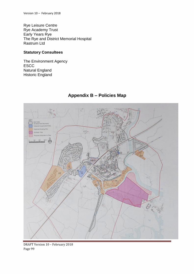
Version 10 – February 2018
DRAFT Version 10 – February 2018
Page 99
Rye Leisure Centre Rye Academy Trust Early Years Rye The Rye and District Memorial Hospital Rastrum Ltd Statutory Consultees The Environment Agency ESCC Natural England Historic England
Appendix B – Policies Map