Embed Size (px)
Citation preview
102 SEDIBENG DISTRICT SPATIAL DEVELOPMENT FRAMEWORK 2014 TO 2017
5. Spatial Development Framework
5.1 Structuring Elements
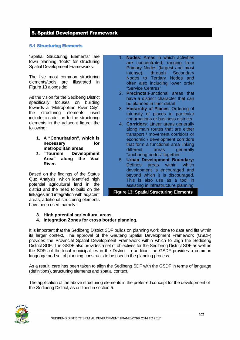
“Spatial Structuring Elements” are town planning “tools” for structuring Spatial Development Frameworks. The five most common structuring elements/tools are illustrated in Figure 13 alongside: As the vision for the Sedibeng District specifically focuses on building towards a “Metropolitan River City”, the structuring elements used include, in addition to the structuring elements in the adjacent figure, the following:
1. A “Conurbation”, which is necessary for metropolitan areas
2. “Tourism Development Area” along the Vaal River.
Based on the findings of the Status Quo Analysis, which identified high potential agricultural land in the district and the need to build on the linkages and integration with adjacent areas, additional structuring elements have been used, namely:
3. High potential agricultural areas 4. Integration Zones for cross border planning.
It is important that the Sedibeng District SDF builds on planning work done to date and fits within its larger context. The approval of the Gauteng Spatial Development Framework (GSDF) provides the Provincial Spatial Development Framework within which to align the Sedibeng District SDF. The GSDF also provides a set of objectives for the Sedibeng District SDF as well as the SDFs of the local municipalities in the District. In addition, the GSDF provides a common language and set of planning constructs to be used in the planning process. As a result, care has been taken to align the Sedibeng SDF with the GSDF in terms of language (definitions), structuring elements and spatial context.
The application of the above structuring elements in the preferred concept for the development of the Sedibeng District, as outlined in section 5.
1. Nodes : Areas in which activities are concentrated, ranging from Primary Nodes (largest and most intense), through Secondary Nodes to Tertiary Nodes and often also including lower order “Service Centres”
2. Precincts: Functional areas that have a distinct character that can be planned in finer detail
3. Hierarchy of Places : Ordering of intensity of places in particular conurbations or business districts
4. Corridors : Linear areas generally along main routes that are either transport / movement corridors or economic / development corridors that form a functional area linking different areas generally “anchoring nodes” together
5. Urban Development Boundary: Defines areas within which development is encouraged and beyond which it is discouraged. This is also use as a tool in assisting in infrastructure planning
Figure 13: Spatial Structuring Elements
103 SEDIBENG DISTRICT SPATIAL DEVELOPMENT FRAMEWORK 2014 TO 2017
5.2 Alternatives& Preferred Spatial Development Concept
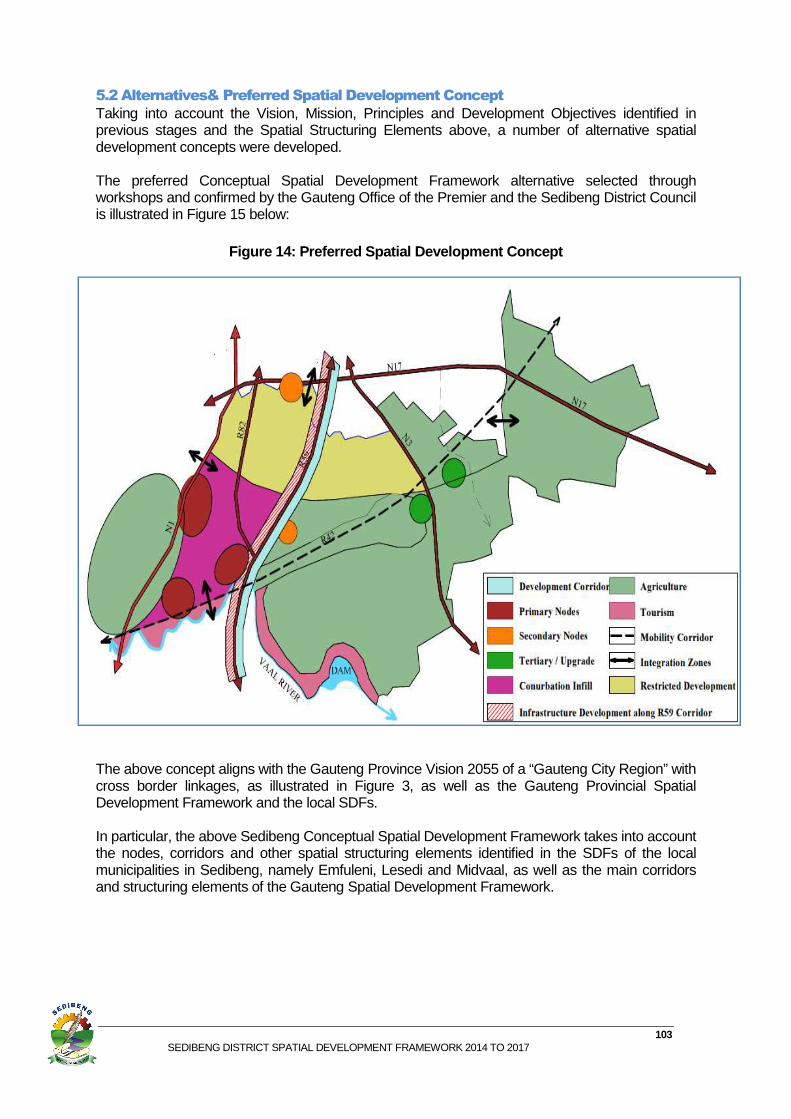
Taking into account the Vision, Mission, Principles and Development Objectives identified in previous stages and the Spatial Structuring Elements above, a number of alternative spatial development concepts were developed. The preferred Conceptual Spatial Development Framework alternative selected through workshops and confirmed by the Gauteng Office of the Premier and the Sedibeng District Council is illustrated in Figure 15 below:
Figure 14: Preferred Spatial Development Concept
The above concept aligns with the Gauteng Province Vision 2055 of a “Gauteng City Region” with cross border linkages, as illustrated in Figure 3, as well as the Gauteng Provincial Spatial Development Framework and the local SDFs. In particular, the above Sedibeng Conceptual Spatial Development Framework takes into account the nodes, corridors and other spatial structuring elements identified in the SDFs of the local municipalities in Sedibeng, namely Emfuleni, Lesedi and Midvaal, as well as the main corridors and structuring elements of the Gauteng Spatial Development Framework.
104 SEDIBENG DISTRICT SPATIAL DEVELOPMENT FRAMEWORK 2014 TO 2017
5.3Application of Structuring Elements in the Preferred Spatial Concept
Having identified the spatial structuring elements to be used and the preferred spatial concept in sections 4.1 and 4.2, this section addresses the practical application of these in Sedibeng and the incorporation of already identified precincts and projects.
5.3.1 Conurbation
Part of the Vision for the Sedibeng District is to be a “Metropolitan City” (refer to section 4).This requires complying with Section 2 of the Local Government: Municipal Structures Act, (Act 117 of 1998), in particular the need to have “conurbation/s” to be a metropolitan area. In terms of the Act, a conurbation must include:
1. High population density 2. Intensive movement of people, goods & services 3. Extensive Development (size, intensity & complexity) 4. Multiple CBDs & Industrial areas
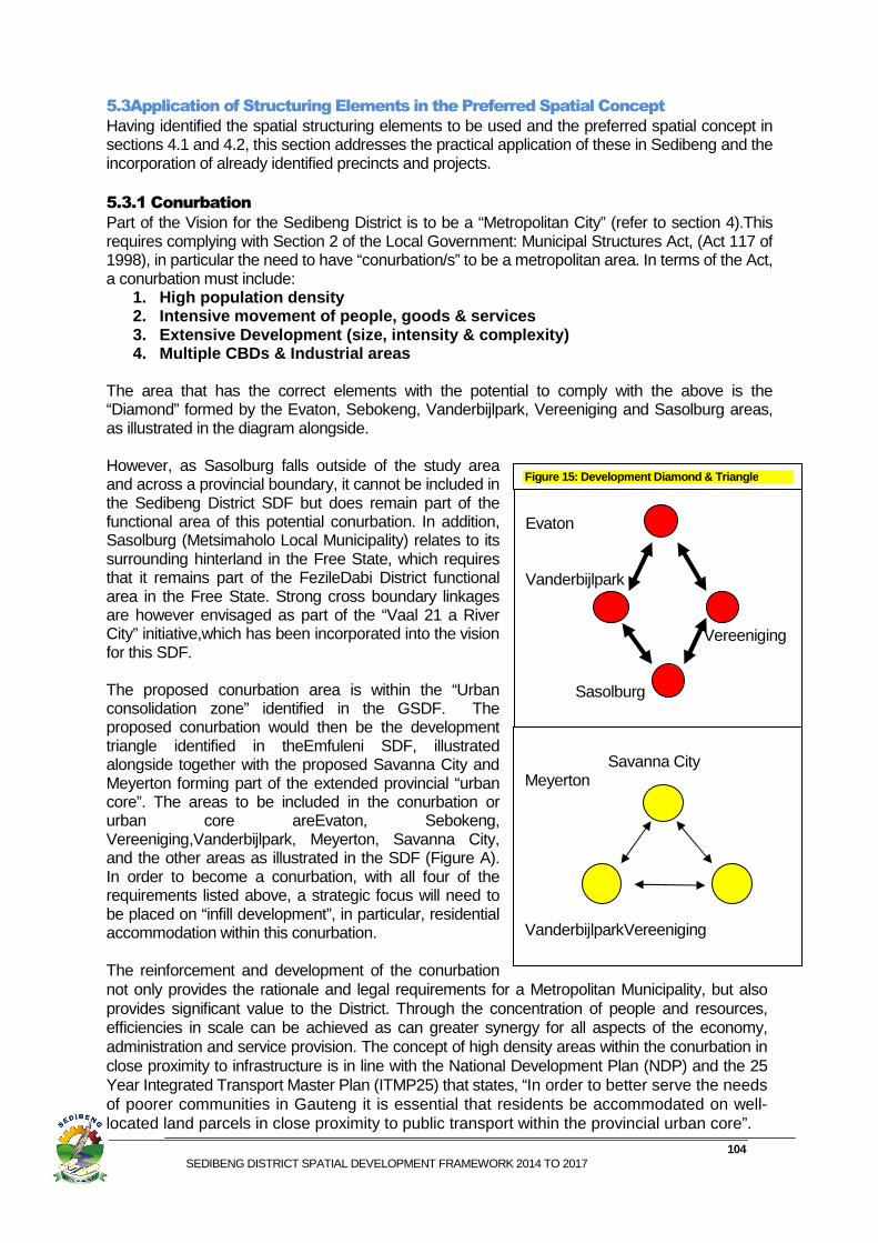
The area that has the correct elements with the potential to comply with the above is the “Diamond” formed by the Evaton, Sebokeng, Vanderbijlpark, Vereeniging and Sasolburg areas, as illustrated in the diagram alongside. However, as Sasolburg falls outside of the study area and across a provincial boundary, it cannot be included in the Sedibeng District SDF but does remain part of the functional area of this potential conurbation. In addition, Sasolburg (Metsimaholo Local Municipality) relates to its surrounding hinterland in the Free State, which requires that it remains part of the FezileDabi District functional area in the Free State. Strong cross boundary linkages are however envisaged as part of the “Vaal 21 a River City” initiative,which has been incorporated into the vision for this SDF. The proposed conurbation area is within the “Urban consolidation zone” identified in the GSDF. The proposed conurbation would then be the development triangle identified in theEmfuleni SDF, illustrated alongside together with the proposed Savanna City and Meyerton forming part of the extended provincial “urban core”. The areas to be included in the conurbation or urban core areEvaton, Sebokeng, Vereeniging,Vanderbijlpark, Meyerton, Savanna City, and the other areas as illustrated in the SDF (Figure A). In order to become a conurbation, with all four of the requirements listed above, a strategic focus will need to be placed on “infill development”, in particular, residential accommodation within this conurbation. The reinforcement and development of the conurbation not only provides the rationale and legal requirements for a Metropolitan Municipality, but also provides significant value to the District. Through the concentration of people and resources, efficiencies in scale can be achieved as can greater synergy for all aspects of the economy, administration and service provision. The concept of high density areas within the conurbation in close proximity to infrastructure is in line with the National Development Plan (NDP) and the 25 Year Integrated Transport Master Plan (ITMP25) that states, “In order to better serve the needs of poorer communities in Gauteng it is essential that residents be accommodated on well-located land parcels in close proximity to public transport within the provincial urban core”.
Evaton Vanderbijlpark Vereeniging Sasolburg
Savanna City Meyerton VanderbijlparkVereeniging
Figure 1 5: Development Diamond & Triangle
105 SEDIBENG DISTRICT SPATIAL DEVELOPMENT FRAMEWORK 2014 TO 2017
5.3.2Primary Nodes
Each of the local municipalities comprising the Sedibeng District has compiled an SDF that identifies primary nodes. These SDFs, as well as the Gauteng Provincial SDF, have various definitions of what constitutes a primary node. For the purposes of the Sedibeng District SDF, not all of the primary nodes in the LMs could be incorporated, for a number of practical and functional reasons. These include the fact that the economy of the district could not support the development of all of these nodes and, strategically, it would be more appropriate to focus development investment in the proposed conurbation area in multiple nodes/CBDs within this area. Furthermore, what may be defined as a primary node in a Local Municipality cannot be defined as a primary node in a district and provincial context. For these reasons, the only primary nodes identified for the Sedibeng District SDF are the Vereeniging CBD, Vanderbijlpark CBD and Meyerton CBD. All of these Primary Nodes fall within the proposed conurbation and are in terms of the definitions contained in the GSDF.
5.3.3 Secondary Nodes
The secondary nodes identified for the Sedibeng District SDF include the nodes identified in the Municipal SDFs, in particular Evaton, Sebokeng CBD, Savanna City, Waterval Precinct and ElandsfonteinPrecinct. These align with the spatial structure proposed in the GSDF.
5.3.4 Food Processing, Industrial & Distribution Node
Other nodes, which are also secondary nodes, but which have a specific character, have been identified. One such node is the “Food Processing, Industrial & Distribution Node”. This node will incorporate the area around the Heineken Brewery and Pick n Pay Warehouse, which will be a node focused on agri-processing, food production, storage and distribution to support the agricultural potential of the district, as well as general industrial activities, to take advantage of its location close to the metropolitan area of the City of Johannesburg and along the R59 corridor identified in both the GSDF and the Midvaal SDF.
5.3.5 Mixed Use Consolidation Node
This node, also identified in the SDFs of the Lesedi Municipality, includes Heidelberg, Ratanda, Jameson Park and the Heidelberg airfield and surrounds. Investment in these areas should be to support and consolidate existing development. An upgrade of the new Transnet multi-product pipeline (MPP), which runs between Durban and Jameson Park inLesedi, has the potential to impact positively on the development of this area.Asnoted in the 25 Year Gauteng Integrated Transport Master Plan, “The presence of the pipelines in the province constitutes a major transportation asset, as the large volumes transported would otherwise be moved by rail where possible, or by road, thereby increasing road usage and congestion. The pipelines from the coast currently move approximately 8.7 billion litres of refined products and crude oil per annum. Two main pipe lines are the Refined Products Pipeline, a 300 mm line from Durban to Sasolburg (Coalbrook); and the Crude oil line, a 400 mm pipeline that conveys crude oil from Durban's offshore mooring buoy to the Reef storage and inland refinery. The pipelines are linked to Albertpark, Waltloo, Tarlton and Jameson Park is currently under construction. Fuel is distributed by road from the fuel tank farms to the different outlets.” For this reason, the Heidelberg Consolidation Node includes Jameson Park. This proposed node is along the N3 corridor in the GSDF. 5.3.6 Residential Consolidation Nodes
These nodes include residential areas identified as nodes in the SDFs of the LMs, such as Devon/Impumelo and Vischskuil/Endicott. These areas are primarily residential in nature, but are also located outside of the strategic development focus areas for the District. Investment in these areas should be to support and consolidate existing development and upgrade current infrastructure facilities and amenities. These residential consolidation nodes have been divided
106 SEDIBENG DISTRICT SPATIAL DEVELOPMENT FRAMEWORK 2014 TO 2017
into two categories: those with a density of less than 5 dwelling units per hectare and those with a density of 5 to 10 dwelling units per hectare.
5.3.7 Corridors
In spatial planning, different types of corridors can be used. These range from Economic Corridors, promoting development within the corridor, to Movement Corridors, which have limited access points and are intended to facilitate movement through an area. Development Corridors can also have a specific focus, such as tourism development. Generally, corridors form a functional area along a main route connecting “anchoring nodes”. For the purposes of this SDF, three different types of corridors have been identified, namely:
1. National Development Corridors 2. Economic Development & Provincial Corridors 3. Movement Corridors
The National and Provincial Corridors are identified in the GSDF. Only those corridors that are expected to be developed in the short term are listed in the SDF development guidelines in this report. Those corridors for later implementation will be detailed in future spatial frameworks. National Development Corridors The N3 highway between Heidelberg and Tokoza, as illustrated in the Gauteng Provincial SDF, has been identified as a corridor for the Sedibeng SDF. The main purpose of this corridor is to support economic and commercial development along the corridor, building on visibility, high traffic volumes and accessibility from the N3 national route. The extent of this corridor and the buffer it creates is limited by the visibility and accessibility from the N3. The Local Municipality through which the corridor passes will define the physical extent of the corridor utilising existing cadastral boundaries. It is envisaged that this should be an approximately 500m wide corridor on either side of the N3 along the length of the corridor portion. Economic Development & Provincial Corridors The R59 corridor, originally planned as a corridor for Midvaal, acts as a corridor linking Sasolburg to Vereeniging through Midvaal to Alberton. The R59, as described in the R59 corridor document, has previously been identified as an Economic and Provincial Development Corridor in the GSDF. The function of this corridor is not only to provide an efficient transport route but also to support economic development along and around the corridor. The detailed description of the extent of this corridor and the corridor buffer has been included in the Corridor Document and is incorporated into the Midvaal SDF. Movement Corridors The R82 from Vereeniging to the R557,including the northern section of the road in Sedibeng, which extends towards the City of Johannesburg, as well as the R42 from Lesedi to Vereeniging, have been identified as Movement Corridors. The R82 Movement Corridor stretches from Eikenhof in Johannesburg through Walkerville, De Deur and Vereeniging through to Sasolburg. This route is designed to connect and enable movement through these areas, but with limited access so as to discourage “strip development”. The purpose of these corridors is to support ease of movement and increase linkages.
5.3.8 Precincts
Through a “bottom up process” of the Local Municipalities identifying areas in need of precinct plans, Sedibeng has identified and initiated the planning of the following precincts:
1. Vereeniging Regeneration Area 2. CBD Government Precinct 3. Fresh Produce Market 4. Doornkuil
107 SEDIBENG DISTRICT SPATIAL DEVELOPMENT FRAMEWORK 2014 TO 2017
The planning of these precincts has been conducted in close co-operation with the planning of the Sedibeng SDF.These precincts form an integral part of this SDF.
5.3.9 High Potential Agricultural Areas
In general,the District has good agricultural potential with areas of varying agricultural viability, as illustrated on Maps 42 to 45 . Utilising the areas of high potential combined with relative large open areas and other factors, three large areas of high potential agricultural land can be demarcated in the District. These were detailed in the Status Quo Report. The areas of varying potential based on soils are illustrated on Map 45 and strategic high potential agricultural land areas are illustrated on Map 42.
A major concern is that although the high potential agricultural land and agricultural hubs have been identified, the key strategy remains the “protection” of these areas. This results in stopping all development in these areas as opposed to providing appropriate support and facilitation to enhance and build this sector. Food security is a national priority, the addressing of which, will require creative approaches that benefit all parties involved. Appropriate empowered institutional structures, funding and strategy are needed to drive the development of this sector. In the Socio-economic Impact Assessment of the Sedibeng Regional Sanitation Scheme, a major concern raised was the continued loss of high potential agricultural land to other land uses as access to services is improved and land owners develop land for non-agricultural uses. One of the causal factors noted is the perception that residential and other land use rights provide higher returns on investment than agricultural land. Other causal factors include the lack of finance and skills for commercial agriculture. The breaking up of agricultural land into parcels below the critical size for commercial agricultural purposes and obstacles in the way of consolidation of land parcels for commercial agricultural production are other factors of concern. With the opening up of extensive areas in the Sedibeng District for development , particularly in those areas with good agricultural land and where there is a demand for non-agricultural uses, care must be taken to ensure sustainable development.
Appropriate empowered institutional structures, funding and strategy are needed to drive the development of this sector.
In addition, the sector must cater for the full range of farm activities, from emerging farmers to large commercial farming operations. Access to funding for those who traditionally could not access funding is being addressed through programmes such as the Micro-Agricultural Finance Institution of South Africa (Mafisa). 5.3.10 Integration Zones
The analysis conducted indicates the need for integration of the Sedibeng District with adjacent areas in which functional areas already exist or will develop. In particular:
1. Orange Farm and other parts of the City of Johannesburg Metropolitan area and the Savanna City/Doornkuil and De Deur areas in Sedibeng.
2. The proposed agricultural processing / industrial secondary node in Midvaal and the City of Johannesburg Metropolitan area.
3. Vereeniging and other parts of the proposed conurbation with the Metsimaholo Local Municipality in the FezileDabi District in the Free State and, in particular, Sasolburg.
4. Heidelberg and Devon in Lesedi with Ekurhuleni Metropolitan Municipality. The above Integration Zones are incorporated into this SDF.
SEDIBENG DISTRICT SPATIAL DEV
5.3.11Special Economic Zones (SEZ)
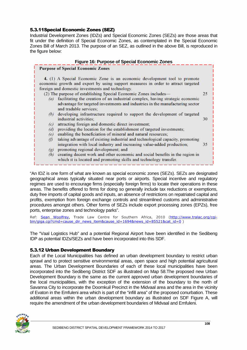
Industrial Development Zones (IDZs) and Special Economic Zones (SEZs) are those areas that fit under the definition of Special Economic Zones, as contemplated in the Special Economic Zones Bill of March 2013. The purpose of an SEZ, as outlined in the above Bill, is reproduced in the figure below:
Figure
“An IDZ is one form of what are known as special economic zones (SEZs). SEZs are designated geographical areas typically situated near ports or airports. Special incentive and regulatory regimes are used to encourage firms (especially foreign firms) to locate tareas. The benefits offered to firms for doing so generally include tax reductions or exemptions, duty free imports of capital goods and inputs, an absence of restrictions on repatriated capital and profits, exemption from foreign procedures amongst others. Other forms of SEZs include export processing zones (EPZs), free ports, enterprise zones and technology parks”.
Ref: Sean Woolfrey, Trade Law Centre for Southern Africa, 2010 (bin/giga.cgi?cmd=cause_dir_news_item&cause_id=1694&news_id=85521&cat_id=0
The “Vaal Logistics Hub” and a potential Regional Airport have been identified in the Sedibeng IDP as potential IDZs/SEZs and have been incorporated into this SDF. 5.3.12 Urban Development Boundary
Each of the Local Municipalities has defined an urban development boundary to restrict urban sprawl and to protect sensitive environmental areas, open space and high potential agricultural areas. The Urban Development Boundariesincorporated into the Sedibeng District SDFDevelopment Boundary is the same as the current approved urban development boundaries of the local municipalities, with the exception of the extension of the boundary to the north of Savanna City to incorporate the Doornkuil Precinct in the Midvaal area and the area in the vicinity of Evaton in the Emfuleni area which is part of the “infill area” of the proposed conurbadditional areas within the urban development boundary as illustrated on require the amendment of the urban development boundaries of Midvaal and Emfuleni.
DISTRICT SPATIAL DEVELOPMENT FRAMEWORK 2014 TO 2017
Economic Zones (SEZ)
Industrial Development Zones (IDZs) and Special Economic Zones (SEZs) are those areas that under the definition of Special Economic Zones, as contemplated in the Special Economic
Zones Bill of March 2013. The purpose of an SEZ, as outlined in the above Bill, is reproduced in
Figure 16: Purpose of Special Economic Zones
DZ is one form of what are known as special economic zones (SEZs). SEZs are designated geographical areas typically situated near ports or airports. Special incentive and regulatory regimes are used to encourage firms (especially foreign firms) to locate their operations in these areas. The benefits offered to firms for doing so generally include tax reductions or exemptions, duty free imports of capital goods and inputs, an absence of restrictions on repatriated capital and profits, exemption from foreign exchange controls and streamlined customs and administrative procedures amongst others. Other forms of SEZs include export processing zones (EPZs), free ports, enterprise zones and technology parks”.
rade Law Centre for Southern Africa, 2010 (http://www.tralac.org/cgiiga.cgi?cmd=cause_dir_news_item&cause_id=1694&news_id=85521&cat_id=0
The “Vaal Logistics Hub” and a potential Regional Airport have been identified in the Sedibeng IDP as potential IDZs/SEZs and have been incorporated into this SDF.
Urban Development Boundary
Each of the Local Municipalities has defined an urban development boundary to restrict urban sprawl and to protect sensitive environmental areas, open space and high potential agricultural areas. The Urban Development Boundaries of each of these local municipalities have been incorporated into the Sedibeng District SDF as illustrated on Map 58.The proposed new Urban Development Boundary is the same as the current approved urban development boundaries of
with the exception of the extension of the boundary to the north of Savanna City to incorporate the Doornkuil Precinct in the Midvaal area and the area in the vicinity
in the Emfuleni area which is part of the “infill area” of the proposed conurbadditional areas within the urban development boundary as illustrated on require the amendment of the urban development boundaries of Midvaal and Emfuleni.
108
Industrial Development Zones (IDZs) and Special Economic Zones (SEZs) are those areas that under the definition of Special Economic Zones, as contemplated in the Special Economic
Zones Bill of March 2013. The purpose of an SEZ, as outlined in the above Bill, is reproduced in
DZ is one form of what are known as special economic zones (SEZs). SEZs are designated geographical areas typically situated near ports or airports. Special incentive and regulatory
heir operations in these areas. The benefits offered to firms for doing so generally include tax reductions or exemptions, duty free imports of capital goods and inputs, an absence of restrictions on repatriated capital and
exchange controls and streamlined customs and administrative procedures amongst others. Other forms of SEZs include export processing zones (EPZs), free
http://www.tralac.org/cgi-iga.cgi?cmd=cause_dir_news_item&cause_id=1694&news_id=85521&cat_id=0 )
The “Vaal Logistics Hub” and a potential Regional Airport have been identified in the Sedibeng
Each of the Local Municipalities has defined an urban development boundary to restrict urban sprawl and to protect sensitive environmental areas, open space and high potential agricultural
of each of these local municipalities have been The proposed new Urban
Development Boundary is the same as the current approved urban development boundaries of with the exception of the extension of the boundary to the north of
Savanna City to incorporate the Doornkuil Precinct in the Midvaal area and the area in the vicinity in the Emfuleni area which is part of the “infill area” of the proposed conurbation. These
additional areas within the urban development boundary as illustrated on SDF Figure A, will require the amendment of the urban development boundaries of Midvaal and Emfuleni.
109 SEDIBENG DISTRICT SPATIAL DEVELOPMENT FRAMEWORK 2014 TO 2017
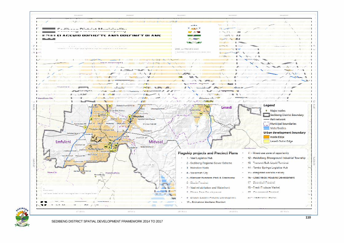
5.3.13Identified Projects& Precincts
The Sedibeng District IDP 2012/13 to 2016/17 has identified,16 “Flagship Projects” thatare in various stages of implementation. These Flagship Projects are listed below and are incorporated into the Sedibeng District SDF. Flagship Projects
1) Establishment of Vaal Logistical Hub 2) Sedibeng Regional Sewer Scheme (waste water treatment plant) 3) Ensure the development of the R59 Corridor 4) Savanna City 5) Kliprivier Business Park and Graceview (Heineken Node) 6) Sicelo Precinct 7) Vaal Rehabilitation and Waterfront 8) Ensure the implementation of the Dlomo Dam Development 9) Ensure the implementation of the Evaton Eastern Precinct Development 10) Ensure that Heritage Precincts are implemented (Boipatong) 11) A zone of opportunity has been identified at the intersection of the R42 and the N3
for the purposes of mixed retail, commercial and service industries 12) Heidelberg Showground Industrial Township. The township is ideally situated in
relation to the station and the existing industrial areas such as BAT, Eskom and Heidelberg Extension 6
13) Transnet Bulk Liquid Terminal. Transnet has started a construction of Bulk Liquid Terminal in Jameson Park along R42 Corridor
14) Tambo Springs Logistics Hub. The proposed development is located in between the N3 and R103 corridors (Tamboekiesfontein) and it can be directly accessed from the freeway through R550 corridor
15) Integrated Medical Facility. The Council has approved proposed development of an Integrated Medical Facility in the area North of Bergsig along R42. This development is envisaged for the construction of a university hospital that will use alternative healing therapy based of eastern medicine and methods such as acupuncture and herbal cures
16) ObedNkosi Housing Development project is envisaged for development of six thousand (6000) mixed income residential stands.
In addition, four Precincts have been identified, for which planning is at an advanced stage, namely: Precinct Plans
1. Doornkuil Precinct 2. Fresh Produce Market 3. Government Precinct 4. Waterfront Precinct
All of the above precincts have been incorporated into this SDF.The location of the Flagship Projects and Precincts are illustrated on Map 60 overleaf.
SEDIBENG DISTRICT SPATIAL DEVELOPMENT FRAMEWORK 2
ELOPMENT FRAMEWORK 2014 TO 2017 110
111 SEDIBENG DISTRICT SPATIAL DEVELOPMENT FRAMEWORK 2014 TO 2017
5.3.14 Vaal River Cross Boundary Tourism Area
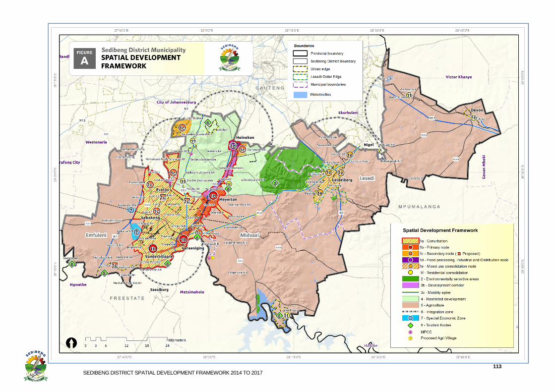
Sedibeng District is one of the primary driversof the “Vaal 21” initiative, which is a cross-border agreement between the municipalities in southern Gauteng and the northern Free State municipalities (FezileDabi) to co-operate in the developmentof a regional economy extending from both banks of the Vaal River. In terms of this initiative and the prominence and strategic advantage of the Vaal River forming the southern boundary of the district, the inclusion of strategies and projects into the Sedibeng District SDF is imperative. The Vaal River area is not a homogeneous area. It has diverse characteristics, ranging from areas that are in the hands of private individuals to those to which the public does not have access. There are a number of established focal points and other areas with undeveloped potential nodes, such as the Vaal Oewer, Lochvaal Barrage, Emerald Casino area, areas around the Vaal Dam and the Three Rivers area. TheEmfuleni SDF notes the need for the Vaal River to be seen not as a boundary to the district but as a development area: “RIVER CORRIDOR: The Vaal River should be seen as a corridor, rather than a boundary located on the edge of the city. Viewing the river as a corridor will help focus prime development of the river front and avoid locating peripheral uses, such as industrial areas, next to the river. NODAL DEVELOPMENT: In order to structure development along the river, it will be necessary to focus development at key areas along the river in nodal form. This will provide distinct destinations along the river, which will help draw tourists and day-visitor to the river. CONNECTION: To prevent the Vaal River from becoming an exclusive resource for only those living next to the river, it will be necessary to establish linkages between the river and inland locations where possible. This will make the river more accessible to the larger Emfuleni population.” Just as the proposed conurbation in which Sasolburg in the Free State is functionally linked to Vereeniging, so too are the southern banks of the Vaal River in the Free State functionally linked to development on the northern banks of the river. As a result, the planning of the River Corridor and nodes along both banks of the Vaal River should be done as a functional area precinct. This approach is supported in the Spatial Planning and Land Use Management Act (Act 16 of 2013), which also outlines institutional arrangements for planning, management and infrastructure provision across provincial and municipal boundaries, as illustrated in the definition for a region in the SPLUMA, reproduced below. The proposed lead project, “Vaal River Cross Boundary Nodes & Corridor Guidelines and Implementation Plan (River City)” should include the areas immediately north and south of the Vaal River up to appropriate cadastral boundaries for the full length of the Vaal River on the southern boundary of Sedibeng. The SDFs of Emfuleni and Midvaal have proposed Tourism Nodes which have been incorporated into this SDF (Refer to Figure A in section 5.3.15).
5.3.15Sedibeng District SDF
The Sedibeng District Spatial Development Framework (SDF) is attached overleaf.
“Region”, in relation to a regional development framework, means a circumscribed geographical area characterised by distinctive economic, social, or natural features which may or may not correspond to the administrative boundary of a province or a municipality or municipalities.
112 SEDIBENG DISTRICT SPATIAL DEVELOPMENT FRAMEWORK 2014 TO 2017
This SDF should be read in conjunction with the SDF Controls following the SDF in section 4.5 The main principles upon which the Sedibeng District Spatial Development Framework is based are to:
• Support and align with national and provincial planning, in particular the National Development Plan, Gauteng City Region, Gauteng Vision 2050, the 25 Year Integrated Transport Master Plan and the Gauteng Spatial Development Framework.
• Support and align with the IDPs and SDFs of Sedibeng, the Gauteng Province and the Local Municipalities within the District (Emfuleni, Lesedi and Midvaal).
• Promote higher densities and infill in the urban core in line with national and provincial policy.
• Promote environmentally sustainability. • Promote effective appropriate use of high potential agricultural areas. • Facilitate the development of a continuous sustainable open space system • Ensure functionally defined activity nodes • Maximise efficiency of service infrastructure and transport systems • Build sustainable internal linkages • Establish urban development boundaries to reduce sprawl and support
strategic infill • Support appropriate major current development initiatives and new initiatives • Support identified precincts • Support cross boarder integration of functionally linked areas • Facilitate the upgrading of existing settlements • Support identified development nodes and corridors
113 SEDIBENG DISTRICT SPATIAL DEVELOPMENT FRAMEWORK 2014 TO 2017
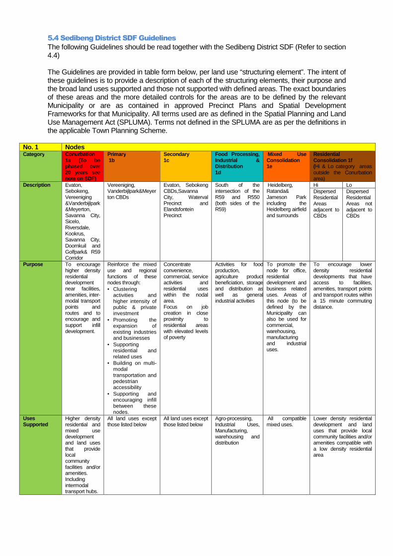
5.4 Sedibeng District SDF Guidelines
The following Guidelines should be read together with the Sedibeng District SDF (Refer to section 4.4) The Guidelines are provided in table form below, per land use “structuring element”. The intent of these guidelines is to provide a description of each of the structuring elements, their purpose and the broad land uses supported and those not supported with defined areas. The exact boundaries of these areas and the more detailed controls for the areas are to be defined by the relevant Municipality or are as contained in approved Precinct Plans and Spatial Development Frameworks for that Municipality. All terms used are as defined in the Spatial Planning and Land Use Management Act (SPLUMA). Terms not defined in the SPLUMA are as per the definitions in the applicable Town Planning Scheme.
No. 1 Nodes Category Conurbation
1a (To be phased over 20 years see note on SDF)
Primary 1b
Secondary 1c
Food Processing, Industrial & Distribution 1d
Mixed Use Consolidation 1e
Residential Consolidation 1f (Hi & Lo category areas outside the Conurbation area)
Description Evaton, Sebokeng, Vereeniging &Vanderbijlpark&Meyerton, Savanna City, Sicelo, Riversdale, Kookrus, Savanna City, Doornkuil and Golfpark& R59 Corridor
Vereeniging, Vanderbijlpark&Meyerton CBDs
Evaton, Sebokeng CBDs,Savanna City, Waterval Precinct and Elandsfontein Precinct
South of the intersection of the R59 and R550 (both sides of the R59)
Heidelberg, Ratanda& Jameson Park including the Heidelberg airfield and surrounds
Hi Lo Dispersed Residential Areas adjacent to CBDs
Dispersed Residential Areas not adjacent to CBDs
Purpose To encourage higher density residential development near facilities, amenities, inter-modal transport points and routes and to encourage and support infill development.
Reinforce the mixed use and regional functions of these nodes through: • Clustering
activities and higher intensity of public & private investment
• Promoting the expansion of existing industries and businesses
• Supporting residential and related uses
• Building on multi-modal transportation and pedestrian accessibility
• Supporting and encouraging infill between these nodes.
Concentrate convenience, commercial, service activities and residential uses within the nodal area. Focus on job creation in close proximity to residential areas with elevated levels of poverty
Activities for food production, agriculture product beneficiation, storage and distribution as well as general industrial activities
To promote the node for office, residential development and business related uses. Areas of this node (to be defined by the Municipality can also be used for commercial, warehousing, manufacturing and industrial uses.
To encourage lower density residential developments that have access to facilities, amenities, transport points and transport routes within a 15 minute commuting distance.
Uses Supported
Higher density residential and mixed use development and land uses that provide local community facilities and/or amenities. Including intermodal transport hubs.
All land uses except those listed below
All land uses except those listed below
Agro-processing, Industrial Uses, Manufacturing, warehousing and distribution
All compatible mixed uses.
Lower density residential development and land uses that provide local community facilities and/or amenities compatible with a low density residential area
115 SEDIBENG DISTRICT SPATIAL DEVELOPMENT FRAMEWORK 2014 TO 2017
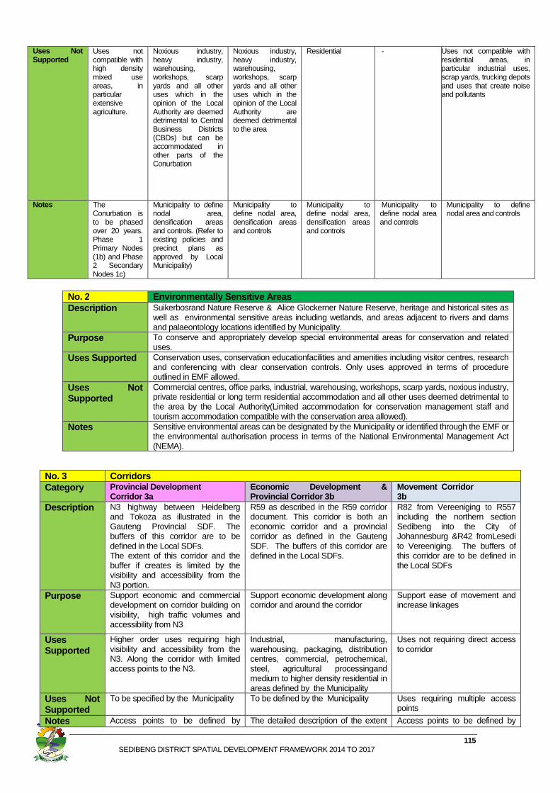
Uses Not Supported
Uses not compatible with high density mixed use areas, in particular extensive agriculture.
Noxious industry, heavy industry, warehousing, workshops, scarp yards and all other uses which in the opinion of the Local Authority are deemed detrimental to Central Business Districts (CBDs) but can be accommodated in other parts of the Conurbation
Noxious industry, heavy industry, warehousing, workshops, scarp yards and all other uses which in the opinion of the Local Authority are deemed detrimental to the area
Residential - Uses not compatible with residential areas, in particular industrial uses, scrap yards, trucking depots and uses that create noise and pollutants
Notes The Conurbation is to be phased over 20 years. Phase 1 Primary Nodes (1b) and Phase 2 Secondary Nodes 1c)
Municipality to define nodal area, densification areas and controls. (Refer to existing policies and precinct plans as approved by Local Municipality)
Municipality to define nodal area, densification areas and controls
Municipality to define nodal area, densification areas and controls
Municipality to define nodal area and controls
Municipality to define nodal area and controls
No. 2 Environmentally Sensitive Areas Description Suikerbosrand Nature Reserve & Alice Glockerner Nature Reserve, heritage and historical sites as
well as environmental sensitive areas including wetlands, and areas adjacent to rivers and dams and palaeontology locations identified by Municipality.
Purpose To conserve and appropriately develop special environmental areas for conservation and related uses.
Uses Supported Conservation uses, conservation educationfacilities and amenities including visitor centres, research and conferencing with clear conservation controls. Only uses approved in terms of procedure outlined in EMF allowed.
Uses Not Supported
Commercial centres, office parks, industrial, warehousing, workshops, scarp yards, noxious industry, private residential or long term residential accommodation and all other uses deemed detrimental to the area by the Local Authority(Limited accommodation for conservation management staff and tourism accommodation compatible with the conservation area allowed).
Notes Sensitive environmental areas can be designated by the Municipality or identified through the EMF or the environmental authorisation process in terms of the National Environmental Management Act (NEMA).
No. 3 Corridors Category Provincial Development
Corridor 3a Economic Development & Provincial Corridor 3b
Movement Corridor 3b
Description N3 highway between Heidelberg and Tokoza as illustrated in the Gauteng Provincial SDF. The buffers of this corridor are to be defined in the Local SDFs. The extent of this corridor and the buffer if creates is limited by the visibility and accessibility from the N3 portion.
R59 as described in the R59 corridor document. This corridor is both an economic corridor and a provincial corridor as defined in the Gauteng SDF. The buffers of this corridor are defined in the Local SDFs.
R82 from Vereeniging to R557 including the northern section Sedibeng into the City of Johannesburg &R42 fromLesedi to Vereeniging. The buffers of this corridor are to be defined in the Local SDFs
Purpose Support economic and commercial development on corridor building on visibility, high traffic volumes and accessibility from N3
Support economic development along corridor and around the corridor
Support ease of movement and increase linkages
Uses Supported
Higher order uses requiring high visibility and accessibility from the N3. Along the corridor with limited access points to the N3.
Industrial, manufacturing, warehousing, packaging, distribution centres, commercial, petrochemical, steel, agricultural processingand medium to higher density residential in areas defined by the Municipality
Uses not requiring direct access to corridor
Uses Not Supported
To be specified by the Municipality To be defined by the Municipality Uses requiring multiple access points
Notes Access points to be defined by The detailed description of the extent Access points to be defined by
116 SEDIBENG DISTRICT SPATIAL DEVELOPMENT FRAMEWORK 2014 TO 2017
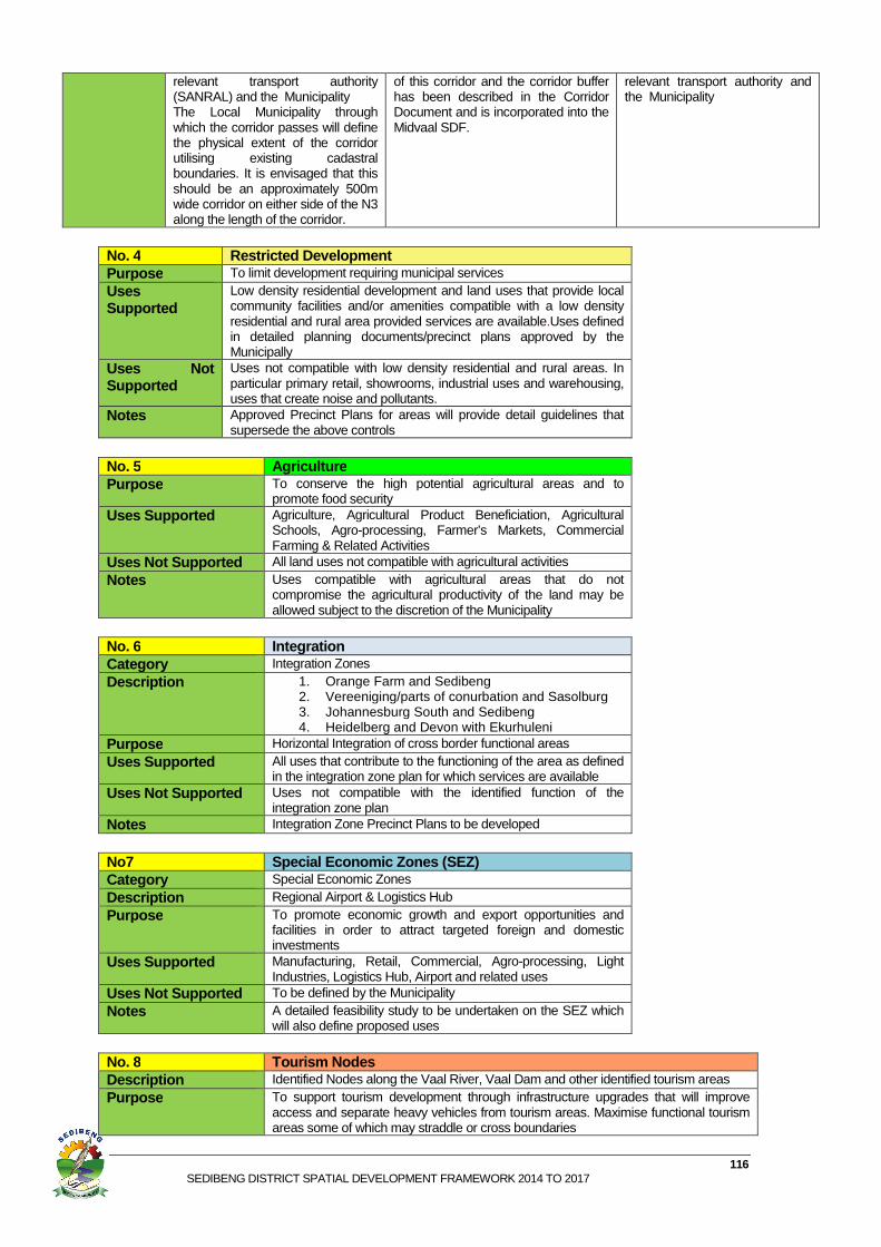
No. 4 Restricted Development Purpose To limit development requiring municipal services Uses Supported
Low density residential development and land uses that provide local community facilities and/or amenities compatible with a low density residential and rural area provided services are available.Uses defined in detailed planning documents/precinct plans approved by the Municipally
Uses Not Supported
Uses not compatible with low density residential and rural areas. In particular primary retail, showrooms, industrial uses and warehousing, uses that create noise and pollutants.
Notes Approved Precinct Plans for areas will provide detail guidelines that supersede the above controls
No. 5 Agriculture Purpose To conserve the high potential agricultural areas and to
promote food security Uses Supported Agriculture, Agricultural Product Beneficiation, Agricultural
Schools, Agro-processing, Farmer’s Markets, Commercial Farming & Related Activities
Uses Not Supported All land uses not compatible with agricultural activities Notes Uses compatible with agricultural areas that do not
compromise the agricultural productivity of the land may be allowed subject to the discretion of the Municipality
No. 6 Integration Category Integration Zones Description 1. Orange Farm and Sedibeng
2. Vereeniging/parts of conurbation and Sasolburg 3. Johannesburg South and Sedibeng 4. Heidelberg and Devon with Ekurhuleni
Purpose Horizontal Integration of cross border functional areas Uses Supported All uses that contribute to the functioning of the area as defined
in the integration zone plan for which services are available Uses Not Supported Uses not compatible with the identified function of the
integration zone plan Notes Integration Zone Precinct Plans to be developed
No7 Special Economic Zones (SEZ) Category Special Economic Zones Description Regional Airport & Logistics Hub Purpose To promote economic growth and export opportunities and
facilities in order to attract targeted foreign and domestic investments
Uses Supported Manufacturing, Retail, Commercial, Agro-processing, Light Industries, Logistics Hub, Airport and related uses
Uses Not Supported To be defined by the Municipality Notes A detailed feasibility study to be undertaken on the SEZ which
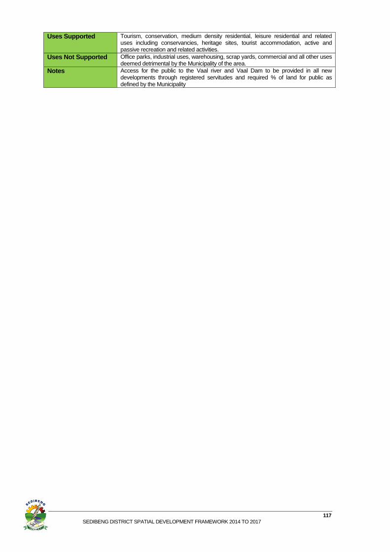
will also define proposed uses No. 8 Tourism Nodes Description Identified Nodes along the Vaal River, Vaal Dam and other identified tourism areas Purpose To support tourism development through infrastructure upgrades that will improve
access and separate heavy vehicles from tourism areas. Maximise functional tourism areas some of which may straddle or cross boundaries
relevant transport authority (SANRAL) and the Municipality The Local Municipality through which the corridor passes will define the physical extent of the corridor utilising existing cadastral boundaries. It is envisaged that this should be an approximately 500m wide corridor on either side of the N3 along the length of the corridor.
of this corridor and the corridor buffer has been described in the Corridor Document and is incorporated into the Midvaal SDF.
relevant transport authority and the Municipality
117 SEDIBENG DISTRICT SPATIAL DEVELOPMENT FRAMEWORK 2014 TO 2017
Uses Supported Tourism, conservation, medium density residential, leisure residential and related uses including conservancies, heritage sites, tourist accommodation, active and passive recreation and related activities.
Uses Not Supported Office parks, industrial uses, warehousing, scrap yards, commercial and all other uses deemed detrimental by the Municipality of the area.
Notes Access for the public to the Vaal river and Vaal Dam to be provided in all new developments through registered servitudes and required % of land for public as defined by the Municipality