Embed Size (px)
Citation preview

Coimisiún na Scrúduithe StáitState Examinations Commission
LEAVING CERTIFICATE 2010
MARKING SCHEME
GEOGRAPHY
HIGHER LEVEL

Project1 12/1/10 15:41 Page 1

1
Any 10 questions @ 8 marks each. Each question:
4 parts @ 2 marks each 8 parts @ 1 mark each
No grading / scaling of marks Q1 B D C A Q2 (i) County Boundary / Coniferous
Plantation / Natural Woodland / Mixed Woodland / Forest Park
(ii) South Leinster Way (iii) S 401(2) 289/290(1)(2) (iv) Megalithic Tomb & Ogham Stone (v) S 406(7) 220 (vi) River Suir & Glen River Q3 D A B C Q4 (i) River Suir (ii) Old Bridge & Dillon Bridge (iii) S 408 215 Q5 (i) 161
(ii)Cirque/Corrie/Tarn/Coom/Ribbon (iii) Arête (iv) North Eastwards Q6 (i) Anticyclone (ii) Isobar (iii) 1012 mb / hectopascals (hPa)
(iv) Calm dry weather with warm temperature
Q7 A = 8 B = 1 C = 9 D = 2 E = 7 F = 3 G = 4 H = 6 I = 5
Q8 Left Background Left Foreground Right Foreground
Centre Background / Centre Middleground / Centre Centre
Q9 (i) Basalt Granite (ii) 1
2 Q10 C A D B Q11 (i) 100.5 (ii) 54.2 (iii) Aquaculture (iv) Plankton Q12 (i) 25-29 (ii) 7.0 (iii) 11.7 (iv) 2.8%
PART ONE – SHORT-ANSWER QUESTIONS – 80 MARKS
Attempt TEN questions.
All Questions carry equal marks.
THESE QUESTIONS ARE TO BE ANSWERED IN THE SPACES PROVIDED

2
PART TWO – STRUCTURED and ESSAY QUESTIONS – 320 MARKS
You must attempt FOUR questions, as follows:
TWO questions from Section 1: One question from Questions 1, 2 and 3
AND
One question from Questions 4, 5 and 6 ONE question from Section 2 ONE question from Section 3
THESE QUESTIONS ARE TO BE ANSWERED IN THE ANSWER BOOK
3
SECTION 1 – CORE
Questions 1 to 6
You MUST attempt TWO questions:
ONE from Patterns and Processes in the Physical Environment
AND
ONE from Regional Geography

4
Question 1 A. Ordnance Survey Map
Examine the Ordnance Survey map that accompanies this paper. In your answer book, draw a sketch-map to half scale of the area shown. On it, mark and name each of the following: One landform created by the processes of river deposition A V-Shaped river valley An area with a trellised drainage pattern The complete course of the Glen River.
[20m]
Proportion: 4 marks (Graded 4-2-0) 4 features @ 4 marks each (Shown 2 marks graded, Named 2 marks)
Proportion involves showing correct scale Required size is 9cm x 12cm [Allow a difference of up to ½cm] If sketch is traced or a section of the map is drawn, lose 4 marks for proportion &
2 marks for showing per item
PATTERNS AND PROCESSES IN THE PHYSICAL ENVIRONMENT
Questions 1 to 3
Attempt ONE question

5
B. Landform Development
Answer (i) or (ii)
(i) Examine, with the aid of a labelled diagram or diagrams, the processes that have led to the formation of any one Irish landform of erosion or deposition of your choice.
Landform identified: 2 marks Named process: 2 marks Irish example: 2 marks Labelled diagram: 2 marks + 2 marks Examination: 10 x SRPs (Significant Relevant Point = 2 marks)
Give credit for labelling in diagram from examination Feature or process can be starting point Max 2 SRP’s if description only
OR
(ii) Describe and explain one mass movement process that you have studied. [30m]
Mass Movement identified: 2 marks
Examination: 14 x SRPs
Give credit for 2 SRPs for examples provided Give credit for labelling in diagram from examination Give credit for 1 SRP for diagram without annotation Max 2 SRPs for effects / solutions Accept a broad interpretation of describe / explain
6
C. Rocks
Examine, with reference to examples from Ireland, the formation of metamorphic rocks. [30m]
Name two metamorphic rocks: 2 + 2 marks Name two associated Irish locations: 2 + 2 marks Examination: 11 x SRPs
Give credit for labelling in diagram from examination Give credit for 1 SRP for diagram without annotation Give credit for 3rd named metamorphic rock Max 2 SRPs if description only
7
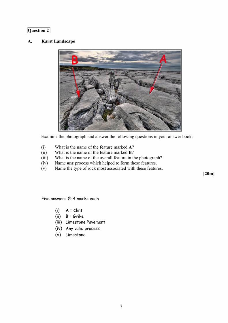
Question 2 A. Karst Landscape
Examine the photograph and answer the following questions in your answer book:
(i) What is the name of the feature marked A? (ii) What is the name of the feature marked B? (iii) What is the name of the overall feature in the photograph? (iv) Name one process which helped to form these features. (v) Name the type of rock most associated with these features.
[20m]
Five answers @ 4 marks each
(i) A = Clint (ii) B = Grike (iii) Limestone Pavement (iv) Any valid process (v) Limestone

8
B. Folding
Explain how the study of plate tectonics has helped us to understand the global distribution of Fold Mountains.
[30m]
Reference to global distribution: 2 marks + 2 marks 2 named Fold Mountains: 2 marks + 2 marks Plate tectonics examined: 11 x SRPs
Max 6 SRPs if examination is of plate tectonics with no reference to Fold Mountains
Give credit to relevant information on diagrams C. Human Interaction
Humans interact with the rock cycle in many ways. Discuss this with reference to any one human interaction you have studied.
[30m]
Interaction identified: 2 marks Example: 2 marks Discussion: 13 x SRPs
Allow 1 SRP for a 2nd example within discussion Question is not tied to Ireland

9
Question 3 A. Earthquakes
Examine the map above relating to the earthquake in Haiti in January 2010 and answer the following questions in your answer book: (i) Activity along which two plates resulted in the earthquake in Haiti? (ii) What type of fault caused the earthquake? (iii) Describe the fault responsible for the earthquake. (iv) What tectonic activity along the subduction zone created the island arc on the map?
[20m] Four answers @ 5 marks each:
(i) 3 marks + 2 marks North American Plate / Caribbean Plate (ii) 5 marks Transform /Transverse /Tear/Passive /Neutral (iii) 3 marks + 2 marks Any valid description (iv) 5 marks Volcanic Activity / Rock Melting etc.
10
B. Human Interaction
With reference to an example you have studied, describe and account for one way in which humans attempt to influence or control natural processes. In your answer, refer to one of the following: Fluvial processes Marine processes Mass movement.
[30m]
Influence / Control identified: 2 marks Named Example / Location: 2 marks Reference to natural process: 2 marks Discussion: 12 x SRPs
Max 6 SRPs for discussion without reference to influence or control Question not tied to Ireland Amalgamate all relevant discussion
C. Karst Landscape
With reference to the Irish landscape, examine the processes which have influenced the development of any one underground landform in a karst region.
[30m]
Named process: 2 marks Underground landform identified: 2 marks
Irish example: 2 marks Discussion: 12 x SRPs
Max 2 SRPs if description only Give credit for labelling on diagrams from discussion Credit 1 SRP for diagram without annotation
11
Question 4 A. Irish Regions
In your answer book, draw an outline map of Ireland. On it show and name the following:
(i) Two Irish regions you have studied (ii) One urban centre in each region (iii) One feature of the physical landscape in each region.
[20m]
Map outline: 2 marks graded Showing and naming region: 2 x (2 marks graded + 1 mark) Showing and naming urban centres: 2 x (2 marks graded + 1 mark) Showing and naming physical features: 2 x (2 marks graded + 1 mark)
B. Economic Activities
Examine the factors that influence the development of one tertiary economic activity in a European region (not in Ireland) that you have studied.
[30m]
Named tertiary economic activity: 2 marks Two factors identified: 2 marks + 2marks Region named: 2 marks Examination: 11 x SRPs
Do not accept Irish or Continental/Sub-Continental regions Discussion without reference to a named or clearly inferred region = 0 marks All further factors require discussion
REGIONAL GEOGRAPHY
Questions 4 to 6
Attempt ONE question
12
C. Culture
Describe and explain the importance of culture in defining any region studied by you.
[30m]
Region Named: 2 marks Aspect of culture identified: 2 marks
Explanation: 13 x SRPs
Other aspects of culture may be credited from the SRPs Accept a broad definition of culture

13
Irish Unemployment Rates 2009
11.612.9
13.914.6
15.2 15.4 15.5 15.7 16.2
6.37 7.6 8.1 8.5 8.2 8.3 8.4
8.9
0
5
10
15
20
25
Jan-09 Feb-09 Mar-09 Apr-09 May-09 Jun-09 Jul-09 Aug-09 Sep-09
Males
Females
Question 5 A. Irish Unemployment
Examine the data in the chart above which shows the monthly unemployment rates in Ireland and answer the following questions:
(i) By how much has the male unemployment rate increased from January to September? (ii) By how much has the female unemployment rate increased from January to September? (iii) What is the difference between the total male and total female unemployment rate from
January to September? (iv) In which month was the difference between the male and female unemployment rates
greatest? (v) Briefly explain one reason why the percentage increase in unemployment for males was
greater than the percentage increase for females.
[20m] Five answers @ 4 marks each:
(i) 4.6 (ii) 2.6 (iii) 59.7 / 12.6 / 2.0 / 7.2 (iv) August or September (v) Any valid explanation (2 marks + 2 marks)

14
B. Urban Regions
Examine the development of one urban area in any Irish region studied by you. [30m]
Region named: 2 marks Urban area named: 2 marks Examination: 13 x SRPs
Do not accept European or Continental/Sub-Continental regions Discussion without reference to a named or clearly inferred urban area = 0 marks Development can be positive / negative
C. Agriculture
Describe and explain any two factors that influence the development of agriculture in a non-European Continental / Sub-Continental Region that you have studied.
[30m]
Region named: 2 marks Two named factors: 2 marks + 2 marks Examination: 12 x SRPs (6SRPs per factor)
Do not accept Irish or European regions Discussion without reference to appropriate region = 0 marks
15
Question 6 A. European Regions
In your answer book, draw an outline map of a European Region (not in Ireland) that you have studied. On it show and name the following:
(i) Any two physical features in the region (ii) Any two urban centres in the region.
[20m] Map outline: 4 marks graded Showing and naming physical features: 2 x (2 marks graded + 2 marks) Showing and naming urban centres: 2 x (2 marks graded + 2 marks)
B. Irish Regions
Regions can be defined by many factors including:
Economic Human Physical.
Explain how any one of the above factors has defined an Irish Region studied by you.
[30m]
Region named: 2 marks Examination: 14 x SRPs
Do not accept European or Continental/Sub-Continental regions Max 2 SRPs for mere listing of aspects of factor (heading) chosen
16
C. European Regions
Describe and explain any two factors that influence the development of secondary economic activities in a European Region (not in Ireland) that you have studied.
[30m]
Region named: 2 marks
Two named factors: 2 marks + 2 marks Examination: 12 x SRPs (6SRPs per factor)
Do not accept Irish or Continental/Sub-Continental regions Discussion without reference to appropriate or clearly inferred region = 0 marks

17
SECTION 2 – ELECTIVES
Questions 7 to 12
You MUST attempt ONE question from EITHER
Patterns and Processes in Economic Activities
OR
Patterns and Processes in the Human Environment

18
Question 7 A. Environmental Impact
Examine the graph above and answer the following questions in your answer book:
(i) Which Greenhouse gas makes up most of Ireland’s gas emissions? (ii) In which year did Ireland emit 70,000 kilotonnes of greenhouse gas emissions? (iii) What was the trend in Ireland’s emissions between 1990 and 2001? (iv) Explain one reason why Ireland should reduce its Greenhouse gas emissions.
[20m]
Four answers @ 5 marks each:
(i) Carbon Dioxide (ii) 2001 (iii) Increasing / Rising / Growing / Upward (iv) Any valid explanation (3 marks + 2 marks)
PATTERNS AND PROCESSES IN ECONOMIC ACTIVITIES
Questions 7 to 9
Nitrous Oxide
Methane
Carbon Dioxide
Ireland’s Greenhouse Gas Emissions CO2 equivalent kilotonnes

19
B. Multinational Companies
Examine the aerial photograph and the Ordnance Survey map accompanying this paper. Using evidence from the Ordnance Survey map and the aerial photograph, explain three reasons why Carrick-on-Suir would be a suitable location for a multinational company.
[30m]
3 reasons @ 10 marks each:
Reason identified: 2 marks Map / Photograph evidence: 2 marks Examination: 3 x SRPs
A minimum of 1 reference to the Ordnance Survey map and 1 reference to the aerial photograph is required as evidence
Accept a max of 2 reasons on modes of transport
C. Globalisation
Explain the effects of globalisation on the economy of a developing country that you have studied.
[30m]
Named Developing Country: 2 marks Effects identified: 2 marks + 2 marks Examination: 12 x SRPs
Max 2 SRPs for discussion without reference to globalisation Max 2 SRPs for discussion without reference to named developing country Accept positive / negative effects of globalisation Credit a 3rd effect from within examination

20
Question 8 A. Economic Development
Human Development Index (HDI)
Country HDINorway 0.97 Ireland 0.92 Egypt 0.70 India 0.61 Zambia 0.48 Niger 0.34
Examine the data in the above table showing the HDI for a number of countries in 2007. (i) Use graph paper to draw a suitable graph to illustrate this data.
Bar Chart Pie Chart Title: 2 marks 2 marks Scaled axis: 2 marks 2 marks (Circle & Centred) 6 items illustrated: 2 marks each graded 2 marks each graded
If graph paper is not used deduct 2 marks from total.
Accept bar chart / histogram /pie chart / divided rectangle Naming of chart type not sufficient for title mark.
(ii) Literacy levels is one of the indicators used to calculate the HDI. In your answer book name two other indicators used.
Any two appropriate indicators @ 2 marks each
[20m]

21
B. Developed Economy
Explain the growth of any one developed economy you have studied under one or more of the following headings: Financial services Tourism Industrial decline.
[30m] Developed economy named: 2 marks Examination: 14 x SRPs
Max 7 SRPS for discussion without reference to growth Max 7 SRPs for discussion without reference to at least one heading
C. Conflicts of Interest
Examine how conflict can arise between local interests and global interests when a resource is exploited for economic reasons. In your answer refer to an example of such conflict that you have studied.
[30m]
Conflict identified: 2 marks Resource identified: 2 marks Reference to one example: 2 marks Examination: 12 x SRPs
A second conflict may be credited from the examination SRPs Example can refer to region / conflict Max 6 SRPs for discussion to one side of the argument only Max 6 SRPs for discussion without reference to economic reason
22
Question 9 A. Ordnance Survey Map and the Transport Network
Examine the Ordnance Survey map that accompanies this paper. In your answer book, draw a sketch-map to half scale of the area shown. On it, show and name the following: Built-up area of Carrick-on-Suir N24 road R697 road Railway line.
[20m]
Proportion: 4 marks (Graded 4-2-0)
4 features @ 4 marks each (Shown 2 marks graded, Named 2 marks)
Proportion involves showing correct scale Required size is 9cm x 12cm [Allow a difference of up to ½cm] If sketch is traced or a section of the map is drawn, lose 4 marks for proportion &
2 marks for showing per item
B. European Union Policy
Examine how any one major policy of the European Union has influenced Ireland’s economic development.
[30m]
Major European policy named: 2 marks Influence to Ireland’s economic development: 2 marks Examination: 13 x SRPs Max 2 SRPs for discussion without link to Irish economy Amalgamate all relevant discussion points More than 1 policy discussed – mark both and credit the best All further influences require discussion

23
C. Sustainable Development
Discuss the environmental and economic advantages of using renewable energy sources.
[30m]
Environmental advantage identified: 2 marks Economic advantage identified: 2 marks Renewable energy sources: 2 marks + 2 marks Examination: 11 x SRPs (6/5 SRPs per advantage)
Credit other named advantages for a max of 2 SRPs

24
Question 10 A. Population
Population Density
Country Population
Density Ireland 62 Brazil 22 Kenya 64 Sweden 21 Mali 10 Mexico 54
Examine the data in the table above showing population density for a number of countries in 2007. (i) Use graph paper to draw a suitable graph to illustrate this data.
Bar Chart Pie Chart Title: 2 marks 2 marks Scaled axis: 2 marks 2 marks (Circle & Centred) 6 items illustrated: 2 marks each graded 2 marks each graded
If graph paper is not used deduct 2 marks from total.
Accept bar chart / histogram /pie chart / divided rectangle Naming of chart type not sufficient for title mark
(ii) In your answer book explain the term ‘population density’. Any valid explanation @ 4 marks [2 marks + 2 marks]
[20m]
PATTERNS AND PROCESSES IN THE HUMAN ENVIRONMENT
Questions 10 to 12

25
B. Migration and Ireland
Examine two major changes in the patterns of Irish migration within the last one hundred years.
[30m]
Two changes named: 2 marks + 2 marks Reference to two time periods: 2 marks + 2 marks Examination: 11 x SRPs (6/5 SRPs per change) C. Historic Settlement
Examine the 1:50,000 Ordnance Survey map of Carrick-on-Suir that accompanies this paper. Using evidence from the map describe and explain three different examples of historic settlement.
[30m]
3 historic settlements @ 10 marks each Settlement identified: 2 marks Map reference: 2 marks Examination: 3 x SRPs
Examination must be based on relevant explanation rather than on further map
references If answer is based on aerial photograph allow marks for identifying historic settlement
only

26
Question 11 A. Dynamics of Settlement
Scoilnet Maps
Examine the 1830’s Ordnance Survey map extract of Kilrush, labelled X and a recent aerial photograph of the same area, labelled Y above. In your answer book, draw a sketch map of the aerial photograph, labelled Y above. On it mark and name the following:
The present day coastline A marina with boats Two land-uses which have developed since the 1830’s.
[20m]
Outline: 4 marks Each of 4 items: Shown 2 marks graded, Named 2 marks
1830’s Ordnance Survey Map Recent Aerial Photograph
X Y

27
B. Urban Problems
(i) Explain the term ‘traffic congestion’. (ii) Explain two methods used to overcome traffic congestion. Use examples you have
studied in your answer. [30m]
(i) Explanation: 2 marks graded (ii) Two named methods: 2 marks + 2 marks
Named examples: 2 marks + 2 marks Examination: 10 x SRPs (5 SRPs per method)
Allow for transfer of information from part (i) to part (ii) if it refers to
methods used to overcome traffic congestion C. Developing World Cities
‘Problems can develop as urban centres expand and grow.’ Discuss this statement with reference to one developing world city that you have studied.
[30m]
Developing word city identified: 2 marks Two problems identified: 2 marks + 2 marks Examination: 12 x SRPs
Max 2 SRPs if answer is not tied to a named developing world city Credit a 3rd named problem from within examination if discussed
28
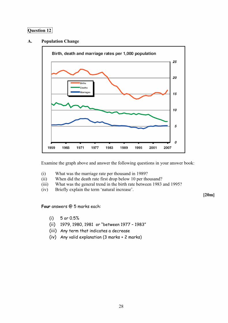
Question 12 A. Population Change
Examine the graph above and answer the following questions in your answer book:
(i) What was the marriage rate per thousand in 1989? (ii) When did the death rate first drop below 10 per thousand? (iii) What was the general trend in the birth rate between 1983 and 1995? (iv) Briefly explain the term ‘natural increase’.
[20m] Four answers @ 5 marks each:
(i) 5 or 0.5% (ii) 1979, 1980, 1981 or “between 1977 – 1983” (iii) Any term that indicates a decrease (iv) Any valid explanation (3 marks + 2 marks)
29
B. Migration
‘Ethnic and religious issues can arise as a result of migration.’ Examine this statement with reference to example(s) you have studied.
[30m]
Ethnic issue identified: 2 marks Religious issue identified: 2 marks Example: 2 marks Examination: 12 x SRPs
Credit 1 extra example from examination Issues can be positive / negative Max 6 SRPs for discussion to one issue only
C. Central Place
Examine the Ordnance Survey map and aerial photograph accompanying this paper. Using evidence from the Ordnance Survey map and aerial photograph, show that Carrick-on-Suir performs the function of a Central Place or market centre for the surrounding hinterland.
[30m]
Ordnance Survey Map evidence: 2 marks Aerial Photograph evidence: 2 marks
Examination: 13 x SRPs Max 6 SRPs if reference to map or photograph only Max 2 SRPs if the answer is theory-based and without relevant reference to
Carrick-on-Suir

30
SECTION 3 – OPTIONS
Questions 13 to 24
Attempt ONE question
N.B. It is better to discuss three or four aspects of the theme in some detail, rather
than to give a superficial treatment of a large number of points.

31
13. Discuss how the operations of Multinational Companies may contribute to the widening economic gap between developing and developed countries. [80m]
Number of aspects: 3 (27 + 27 + 26) (4 @ 20 marks each) Identifying aspect: 4 marks 4 marks Discussion: 8 x SRPs OR 6 x SRPs Overall coherence: 7/6 marks graded 4 marks graded Select scheme according to number of aspects discussed Allow credit for up to 2 examples to a max of 2SRPs (Different examples and in
different aspects) Allow credit for up to 2 illustrations to a max of 2SRPs (Different illustrations and in
different aspects) 14. Discuss the idea that Fair Trade not Aid is the best way to tackle economic inequality in the
world. [80m] Number of aspects: 3 (27 + 27 + 26) (4 @ 20 marks each) Identifying aspect: 4 marks 4 marks Discussion: 8 x SRPs OR 6 x SRPs Overall coherence: 7/6 marks graded 4 marks graded
Select scheme according to number of aspects discussed Allow credit for up to 2 examples to a max of 2SRPs (Different examples and in
different aspects) Allow credit for up to 2 illustrations to a max of 2SRPs (Different illustrations and in
different aspects) 15. Examine the causes and the impact of one global environmental issue studied by you. [80m] Number of aspects: 3 (27 + 27 + 26) (4 @ 20 marks each) Identifying aspect: 4 marks 4 marks Examination: 8 x SRPs OR 6 x SRPs Overall coherence: 7/6 marks graded 4 marks graded A named environmental issue is required for 1 SRP A ratio of 2:1 or 1:2 or 3:1 or 1:3 or 2:2 is required Select scheme according to number of aspects discussed Allow credit for up to 2 examples to a max of 2SRPs (Different examples and in
different aspects) Allow credit for up to 2 illustrations to a max of 2SRPs (Different illustrations and in
different aspects)
Global Interdependence

32
16. Examine the influence of climate on the characteristics of one biome that you that have studied. [80m]
Number of aspects: 3 (27 + 27 + 26) (4 @ 20 marks each) Identifying aspect: 4 marks 4 marks Examination: 8 x SRPs OR 6 x SRPs Overall coherence: 7/6 marks graded 4 marks graded A named biome is required for 1 SRP Select scheme according to number of aspects discussed Do not accept climate as an aspect. Aspects must be clearly tied to the influence of
climate Allow credit for up to 2 examples to a max of 2SRPs (Different examples and in
different aspects) Allow credit for up to 2 illustrations to a max of 2SRPs (Different illustrations and in
different aspects) 17. Examine two ways in which human activities have impacted on soils. [80m] Number of aspects: 3 (27 + 27 + 26) (4 @ 20 marks each) Identifying aspect: 4 marks 4 marks Examination: 8 x SRPs OR 6 x SRPs Overall coherence: 7/6 marks graded 4 marks graded Select scheme according to number of aspects discussed Allow credit for up to 2 examples to a max of 2SRPs (Different examples and in
different aspects) Allow credit for up to 2 illustrations to a max of 2SRPs (Different illustrations and in
different aspects) 18. Describe and explain the characteristics of any one soil type studied by you. [80m] Number of aspects: 3 (27 + 27 + 26) (4 @ 20 marks each) Identifying aspect: 4 marks 4 marks Examination: 8 x SRPs OR 6 x SRPs Overall coherence: 7/6 marks graded 4 marks graded A named soil type is required for 1 SRP Select scheme according to number of aspects discussed Allow credit for up to 2 examples to a max of 2SRPs (Different examples and in
different aspects) Allow credit for up to 2 illustrations to a max of 2SRPs (Different illustrations and in
different aspects)
Geoecology

33
19. The Gaeltacht areas are distinctive cultural regions. Discuss. [80m] Number of aspects: 3 (27 + 27 + 26) (4 @ 20 marks each) Identifying aspect: 4 marks 4 marks Discussion: 8 x SRPs OR 6 x SRPs Overall coherence: 7/6 marks graded 4 marks graded Select scheme according to number of aspects discussed Allow credit for up to 2 examples to a max of 2SRPs (Different examples and in
different aspects) Allow credit for up to 2 illustrations to a max of 2SRPs (Different illustrations and in
different aspects) 20. Examine the significance of either language or religion as a cultural indicator. [80m] Number of aspects: 3 (27 + 27 + 26) (4 @ 20 marks each) Identifying aspect: 4 marks 4 marks Examination: 8 x SRPs OR 6 x SRPs Overall coherence: 7/6 marks graded 4 marks graded Select scheme according to number of aspects discussed Allow credit for up to 2 examples to a max of 2SRPs (Different examples and in
different aspects) Allow credit for up to 2 illustrations to a max of 2SRPs (Different illustrations and in
different aspects) 21. Discuss the role of migration in any European region you have studied. [80m Number of aspects: 3 (27 + 27 + 26) (4 @ 20 marks each) Identifying aspect: 4 marks 4 marks Examination: 8 x SRPs OR 6 x SRPs Overall coherence: 7/6 marks graded 4 marks graded A named European region is required for 1 SRP Select scheme according to number of aspects discussed Allow credit for up to 2 examples to a max of 2SRPs (Different examples and in
different aspects) Allow credit for up to 2 illustrations to a max of 2SRPs (Different illustrations and in
different aspects)
Culture and Identity
34
22. Describe and explain why the characteristics of climate change over time. [80m] Number of aspects: 3 (27 + 27 + 26) (4 @ 20 marks each) Identifying aspect: 4 marks 4 marks Examination: 8 x SRPs OR 6 x SRPs Overall coherence: 7/6 marks graded 4 marks graded Select scheme according to number of aspects discussed Allow credit for up to 2 examples to a max of 2SRPs (Different examples and in
different aspects) Allow credit for up to 2 illustrations to a max of 2SRPs (Different illustrations and in
different aspects) 23. Examine the impact of climate on the development of tourism in any region that you have
studied. [80m] Number of aspects: 3 (27 + 27 + 26) (4 @ 20 marks each) Identifying aspect: 4 marks 4 marks Examination: 8 x SRPs OR 6 x SRPs Overall coherence: 7/6 marks graded 4 marks graded A named region is required for 1 SRP Select scheme according to number of aspects discussed Allow credit for up to 2 examples to a max of 2SRPs (Different examples and in
different aspects) Allow credit for up to 2 illustrations to a max of 2SRPs (Different illustrations and in
different aspects) 24. Describe and explain the formation of mid-latitude depressions and the weather patterns
associated with them. [80m]
Number of aspects: 3 (27 + 27 + 26) (4 @ 20 marks each) Identifying aspect: 4 marks 4 marks Examination: 8 x SRPs OR 6 x SRPs Overall coherence: 7/6 marks graded 4 marks graded Select scheme according to number of aspects discussed Allow credit for up to 2 examples to a max of 2SRPs (Different examples and in
different aspects) Allow credit for up to 2 illustrations to a max of 2SRPs (Different illustrations and in
different aspects)
The Atmosphere-Ocean Environment
35
GEOGRAPHICAL INVESTIGATION 1 INTRODUCTION (5 marks):
4 x SRPs: 1 mark each Overall Coherence: 1 mark graded 2 PLANNING (5 marks):
4 x SRPs: 1 mark each Overall Coherence: 1 mark graded 3 GATHERING OF DATA (40 marks):
Two methods / tasks @ 20 marks each. For each method / task: 9 x SRPs @ 2 marks each Overall coherence: 4 marks graded
A method may be a task which is a group of relevant linked activities. Credit may be given to diagrams / sketches if they relate to the gathering. Do not award marks for results in this written section.
4 RESULTS, CONCLUSIONS, EVALUATION (30 marks):
Three headings @ 8 marks each. For each heading: 4 x SRPs @ 2 marks each Overall coherence: 6 marks graded
Conclusions are based directly or indirectly on the results, otherwise it is evaluation.
Evaluation can be forward-thinking as well as retrospective.
5 ORGANISATION & PRESENTATION OF RESULTS (20 marks):
Presentation: 8 x SRPs @ 2 marks each Overall coherence: 4 marks graded.
Two different graphic forms of presentation required – such as graphs / charts / maps / tables / sketches etc.
Presentation to appear in the appropriate graph pages. Maximum of 4 x SRPs per chart.

36
BREAKDOWN OF PRESENTATION MARKS
General scheme:
Up to 4 x SRPs per chart / map / table / sketch etc. Overall coherence: 4 marks graded
BAR CHART / TREND GRAPH / SCATTER GRAPH etc:
Title: 1 SRP = 2 marks
1 axis with units or scale: 1 SRP = 2 marks
Each of 2 correctly drawn & labelled points / bars: 2 x SRP = 4 marks
PIE CHART:
Title: 1 SRP = 2 marks
Circle with correctly placed centre: 1SRP = 2 marks
Each of 2 correctly drawn & labelled sectors: 2 x SRP = 4 marks
RANK ORDER TABLE / TABLE:
Title: 1 SRP = 2 marks
Boxes: 1 SRP = 2 marks
Rows (across) labelled: 1 SRP = 2 marks
Columns (side) labelled: 1 SRP = 2 marks
SKETCH/MAP:
Title: 1 SRP = 2 marks
Frame: 1 SRP = 2 marks
Two relevant pieces of information re results: 2 x SRP= 4 marks
If information not relevant to results, no SRPs for it.

37
List of Geographical Investigation Topics 2010
1. Geomorphic processes of erosion in a fluvial or coastal or glaciated environment.
2. Geomorphic underground processes in a karst environment.
3. Demographic change in a local setting.
4. Management of a local environmental issue.
5. Traffic patterns in a rural or urban setting.
6. Changing land-use in a local setting.
N.B. Each candidate is required to complete a report on one of the above
Investigation Topics.

38
Scrúdu na hArdteistiméireachta
Marcanna breise as ucht fregairt trí Ghaeilge
Táible a léiríonn an méid marcanna breise ar choir a bhronnadh ar iarrthóirí a ghnóthaíonn that 75% d’iomlán na marcanna atá ag dul don ábhar. N.B. Ba choir marcanna do réir an ghnáth-ráta a bhronnadh ar iarrthóirí nach ngnóthaíonn thar 75% d’iomlán na marcanna.
Iomlán = 400 marks Gnáthráta = 10%
Marcanna a Bronnadh
Marcanna Breise
Marcanna a Bronnadh
Marcanna Breise
301 30 352 –355 14 302 – 305 29 356 –358 14 306 – 308 28 359 – 361 12 309 – 311 27 362 – 356 11 312 – 315 26 366 – 368 10 316 – 318 25 369 – 371 9 319 – 321 24 372 – 375 8 322 – 325 23 376 – 378 7 326 – 328 22 379 – 381 6 329 – 331 21 382 – 385 5 332 – 335 20 386 – 388 4 336 – 338 19 389 – 391 3 339 – 341 18 392 – 395 2 342 – 345 17 396 – 398 1 346 – 348 16 399 – 400 0 349 – 351 15
Geographical Investigation – Not included in total for bonus marks
Note: Modified marking scheme available for candidates who sat a modified examination paper.