Embed Size (px)
Citation preview
Coimisiún na Scrúduithe StáitState Examinations Commission
LEAVING CERTIFICATE 2009
MARKING SCHEME
GEOGRAPHY
HIGHER LEVEL
BOOKS EV SETUPS 2009 18/8/09 12:21 Page 1

BOOKS EV SETUPS 2009 21/7/09 13:10 Page 12
1
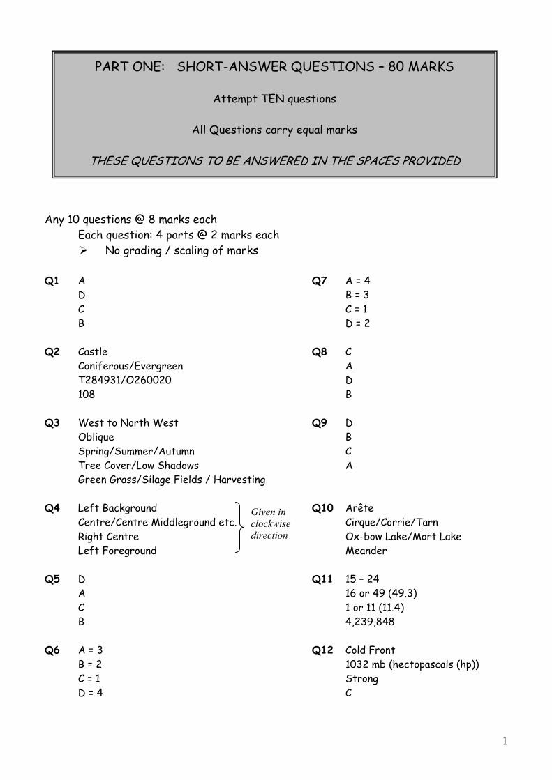
Any 10 questions @ 8 marks each Each question: 4 parts @ 2 marks each
No grading / scaling of marks
Q1 A Q7 A = 4 D B = 3 C C = 1 B D = 2
Q2 Castle Q8 C Coniferous/Evergreen A T284931/O260020 D
108 B
Q3 West to North West Q9 D Oblique B Spring/Summer/Autumn C Tree Cover/Low Shadows A Green Grass/Silage Fields / Harvesting
Q4 Left Background Q10 Arête Centre/Centre Middleground etc. Cirque/Corrie/Tarn Right Centre Ox-bow Lake/Mort Lake
Left Foreground Meander
Q5 D Q11 15 – 24 A 16 or 49 (49.3) C 1 or 11 (11.4) B 4,239,848
Q6 A = 3 Q12 Cold Front B = 2 1032 mb (hectopascals (hp)) C = 1 Strong D = 4 C
PART ONE: SHORT-ANSWER QUESTIONS – 80 MARKS
Attempt TEN questions
All Questions carry equal marks
THESE QUESTIONS TO BE ANSWERED IN THE SPACES PROVIDED
Given in clockwise direction

2
PART TWO – STRUCTURED and ESSAY QUESTIONS – 320 MARKS
Candidates must attempt FOUR questions, as follows:
Two questions from Section 1
One question from Section 2
One question from Section 3
THESE QUESTIONS TO BE ANSWERED IN THE ANSWERBOOK
SECTION 1 - CORE
You MUST attempt TWO questions:
ONE from Patterns and Processes in the Physical Environment AND
ONE from Regional Geography
3
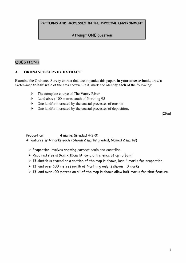
QUESTION 1
A. ORDNANCE SURVEY EXTRACT
Examine the Ordnance Survey extract that accompanies this paper. In your answer book, draw a sketch-map to half scale of the area shown. On it, mark and identify each of the following:
The complete course of The Vartry River Land above 100 metres south of Northing 95 One landform created by the coastal processes of erosion One landform created by the coastal processes of deposition.
[20m]
Proportion: 4 marks (Graded 4-2-0) 4 features @ 4 marks each (Shown 2 marks graded, Named 2 marks)
Proportion involves showing correct scale and coastline. Required size is 9cm x 12cm [Allow a difference of up to ½cm] If sketch is traced or a section of the map is drawn, lose 4 marks for proportion If land over 100 metres north of Northing only is shown = 0 marks If land over 100 metres on all of the map is shown allow half marks for that feature
PATTERNS AND PROCESSES IN THE PHYSICAL ENVIRONMENT
Attempt ONE question
4
B. PLATE MARGINS
Explain, with reference to examples you have studied, how plate tectonics helps us understand the forces at work along crustal plate boundaries.
[30m]
Name two forces: 2 marks + 2 marks Name examples of different boundaries: 2 marks + 2 marks
Discussion: 11 x SRPs
Credit 1 named example from SRPs. Give credit to relevant diagrams for a max of 1 x SRPs and credit extra annotated information on diagrams.
C. LANDFORM DEVELOPMENT
Examine, with the aid of labelled diagram/diagrams, the processes which have shaped one Irishlandform of your choice.
[30m]
Landform identified: 2 marks One named process: 2 marks Irish example: 2 marks Labelled diagram: 4 marks graded Examination: 10 x SRPs
Give credit for 1 SRP for diagram without annotation. Give credit for extra labelling in diagram from Examination SRPs Feature or process can be starting point. If description only –2 x SRPs max

5
QUESTION 2
A CRUSTAL PLATES
Examine the map above, showing the major crustal plates of the Earth. In your answer book answerthe following:
(i) Name the volcanic island at L.(ii) Which term constructive or destructive best describes the plate boundary M?(iii) Name the plate at N.(iv) Which of the following statements is False?
O. As the plates move apart (very slowly) magma rises from the mantle. P. Convection currents inside the Earth cause the earth’s plates to move apart. Q. The North American Plate moves eastwards. R. Volcanoes often form at plate boundaries.
[20m]
Four answers @ 5 marks each No grading / scaling of marks
(i) L = Iceland (ii) M = Constructive (iii) N = Eurasian Plate (iv) Q The North American Plate moves eastwards.
B. ROCKS
Examine, with reference to examples from Ireland, the formation of sedimentary rocks. [30m]
Name two sedimentary rocks: 2 + 2 marks Name two associated Irish locations: 2 + 2 marks Examination: 11 x SRPs
Give credit for 1 SRP for diagram without annotation. Give credit for extra labelling in diagram from Examination SRPs. Allow treatment of up to 3 rocks in examination. At least 3 SRPs for treatment of second sedimentary rock If description only –2 x SRPs max
6
C. HUMAN INTERACTION
Discuss, with reference to one of the following, how humans interact with the rock cycle: MiningExtraction of building materials Oil / Gas exploitation Geothermal energy production.
[30m]
Interaction identified: 2 marks Discussion: 14 x SRPs
Give credit for up to two examples of location.
7
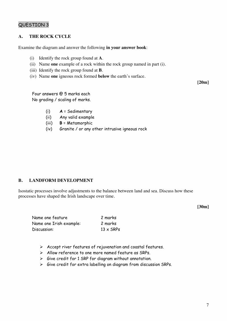
QUESTION 3
A. THE ROCK CYCLE
Examine the diagram and answer the following in your answer book:
(i) Identify the rock group found at A.(ii) Name one example of a rock within the rock group named in part (i). (iii) Identify the rock group found at B.(iv) Name one igneous rock formed below the earth’s surface.
[20m]
Four answers @ 5 marks each No grading / scaling of marks.
(i) A = Sedimentary (ii) Any valid example (iii) B = Metamorphic (iv) Granite / or any other intrusive igneous rock
B. LANDFORM DEVELOPMENT
Isostatic processes involve adjustments to the balance between land and sea. Discuss how these processes have shaped the Irish landscape over time.
[30m]
Name one feature 2 marks Name one Irish example: 2 marks Discussion: 13 x SRPs
Accept river features of rejuvenation and coastal features. Allow reference to one more named feature as SRPs. Give credit for 1 SRP for diagram without annotation. Give credit for extra labelling on diagram from discussion SRPs.
8
C. HUMAN INTERACTION
Examine, with reference to one of the following, how human activities can impact on surface processes:
Mass movement processes River processesCoastal processes.
[30m]
Impact identified: 2 marks Named Example: 2 marks Reference to surface processes: 2 marks Discussion: 12 x SRPs
Mere discussion without reference to impact = Max 6 xSRPs Credit 2nd example from discussion Examples not tied to Ireland Amalgamate all relevant discussion
9
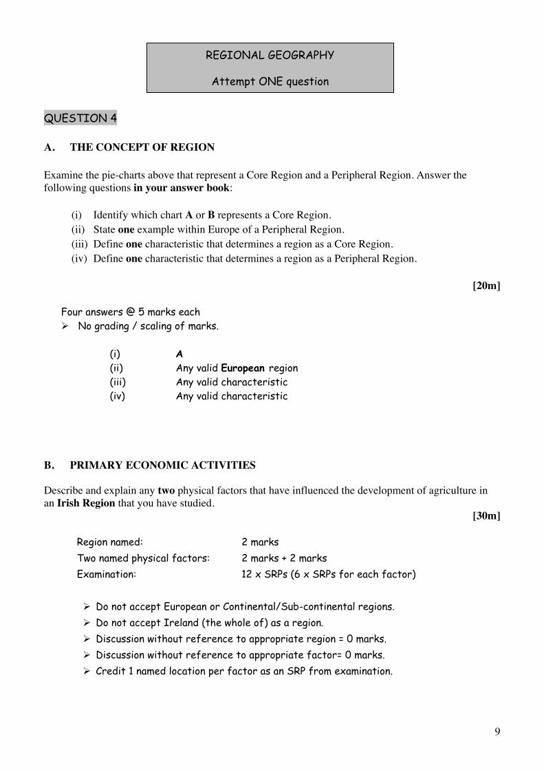
QUESTION 4
A. THE CONCEPT OF REGION
Examine the pie-charts above that represent a Core Region and a Peripheral Region. Answer the following questions in your answer book:
(i) Identify which chart A or B represents a Core Region. (ii) State one example within Europe of a Peripheral Region. (iii) Define one characteristic that determines a region as a Core Region. (iv) Define one characteristic that determines a region as a Peripheral Region.
[20m]
Four answers @ 5 marks each No grading / scaling of marks.
(i) A(ii) Any valid European region(iii) Any valid characteristic (iv) Any valid characteristic
B. PRIMARY ECONOMIC ACTIVITIES
Describe and explain any two physical factors that have influenced the development of agriculture in an Irish Region that you have studied.
[30m]
Region named: 2 marks Two named physical factors: 2 marks + 2 marks Examination: 12 x SRPs (6 x SRPs for each factor)
Do not accept European or Continental/Sub-continental regions. Do not accept Ireland (the whole of) as a region. Discussion without reference to appropriate region = 0 marks. Discussion without reference to appropriate factor= 0 marks. Credit 1 named location per factor as an SRP from examination.
REGIONAL GEOGRAPHY
Attempt ONE question
10
C. HUMAN PROCESSES
Examine how the distribution of population, in a European Region [not Ireland] that you have studied, has been influenced by the region’s level of economic development.
[30m]
Named region: 2 marks Reference to distribution of population: 2 marks Reference to associated economic development: 2 marks Discussion: 12 x SRPs
Do not accept Irish or Continental/Sub-Continental regions Discussion without link to a named region – 0 marks Max 6 xSRPs for discussion without reference to distribution. Max 6 x SRPs for discussion without reference to economic development.
11
QUESTION 5
A. IRISH REGIONS
In your answer book draw an outline map of Ireland. Show and name the following on it:
(i) Two contrasting regions. (ii) Two different physical landscape features – one in each region.(iii) Two urban centres – one in each region.
[20m]
Map outline: 2 marks graded Showing and naming region: 2 x (2 marks graded + 1 mark) Showing and naming physical features: 2 x (2 marks graded + 1 mark) Showing and naming urban centres: 2 x (2 marks graded + 1 mark)
If both physical features or urban centres are from the same region accept one only.
B. EUROPEAN UNION
Describe and explain two impacts on Ireland of the enlargement of the European Union.
[30m]
Impacts identified: 2 + 2 marks Examination: 13 x SRPs (7/6 x SRPs for each impact)
Discussion without reference to Ireland = 0 marks. Discussion without reference to enlargement – max 6 x SRPs.
12
C. TERTIARY ECONOMIC ACTIVITY
Account for the development of one tertiary economic activity in any one Continental / Sub-Continental Region that you have studied.
[30m]
Region named: 2 marks Named tertiary activity: 2 marks
Examination: 13 x SRPs
Do not accept Irish or European regions. Discussion without reference to appropriate region = 0 marks. If more than one tertiary activity is given, mark both separately and accept the best. Allow up to 3 SRPs for reference to specific examples or locations related to named activity.
13
QUESTION 6
A. CONTINENTAL / SUB-CONTINENTAL REGION
In your answer book draw an outline map of a Continental / Sub-Continental Region. Show and name the following on it:
(i) Two physical landscape features. (ii) Two urban centres.
[20m]
Map outline: 4 marks graded Showing and naming physical features: 2 x (2 marks graded + 2 marks) Showing and naming urban centres: 2 x (2 marks graded + 2 marks)
B. URBAN GROWTH
Examine the development of one urban area in a European region [not Ireland] that you have studied.
[30m]
Region named: 2 marks Urban area named: 2 marks Examination: 13 x SRPs
Do not accept Irish or Continental/Sub-Continental regions. Discussion without reference to named or clearly inferred urban area = 0 marks. Mere description – max 6 x SRPs. An urban area can be a city, a specific part of a named city, or areas such as Randstad.
14
C. SECONDARY ECONOMIC ACTIVITY
Describe and explain the development of secondary economic activities in an Irish Region that you have studied.
[30m]
Region named: 2 marks Two named secondary activities: 2 marks + 2 marks Examination: 12 x SRPs
Do not accept European or continental/sub-continental regions Discussion without link to a region – 0 marks If only one activity named candidate loses the 2 marks for naming a second activity only. Give credit for 3rd activity as 1 SRP from examination.

15
SECTION 2 - ELECTIVES
You MUST attempt ONE question
From EITHER Patterns and Processes in Economic Activities
ORPatterns and Processes in the Human Environment
16
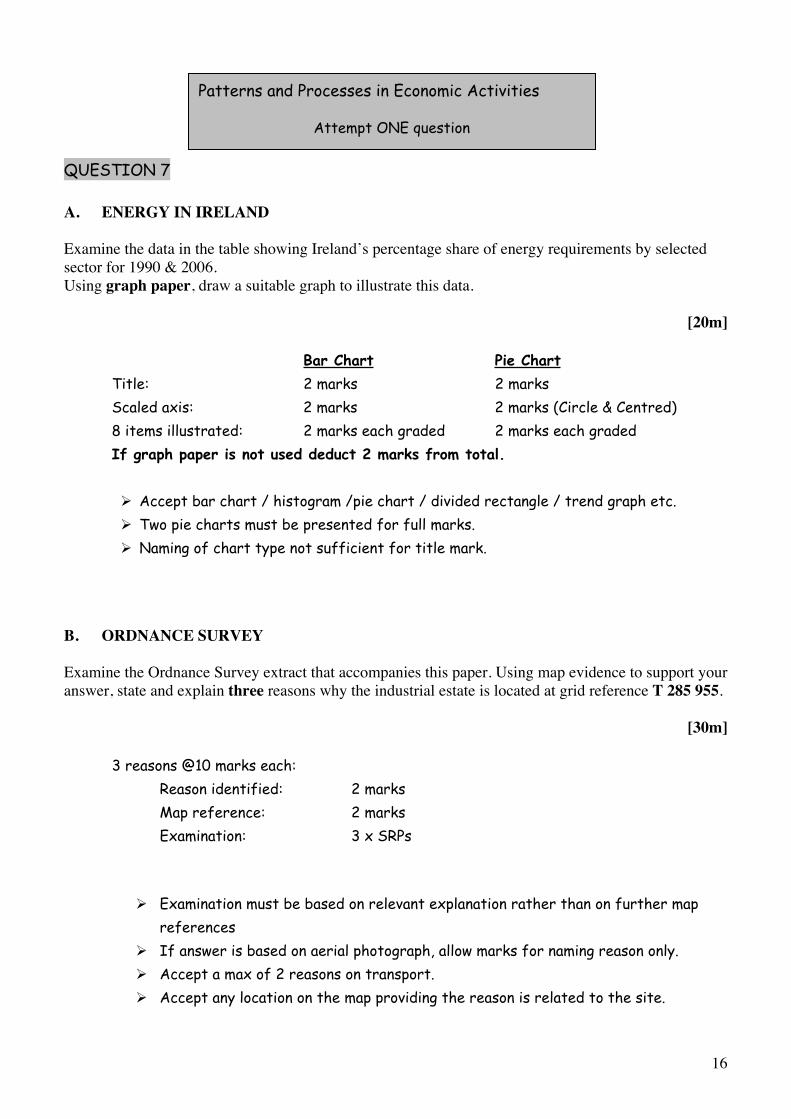
QUESTION 7
A. ENERGY IN IRELAND
Examine the data in the table showing Ireland’s percentage share of energy requirements by selected sector for 1990 & 2006.Using graph paper, draw a suitable graph to illustrate this data.
[20m]
Bar Chart Pie Chart Title: 2 marks 2 marks Scaled axis: 2 marks 2 marks (Circle & Centred) 8 items illustrated: 2 marks each graded 2 marks each graded
If graph paper is not used deduct 2 marks from total.
Accept bar chart / histogram /pie chart / divided rectangle / trend graph etc. Two pie charts must be presented for full marks. Naming of chart type not sufficient for title mark.
B. ORDNANCE SURVEY
Examine the Ordnance Survey extract that accompanies this paper. Using map evidence to support your answer, state and explain three reasons why the industrial estate is located at grid reference T 285 955.
[30m]
3 reasons @10 marks each: Reason identified: 2 marks Map reference: 2 marks Examination: 3 x SRPs
Examination must be based on relevant explanation rather than on further map references If answer is based on aerial photograph, allow marks for naming reason only. Accept a max of 2 reasons on transport. Accept any location on the map providing the reason is related to the site.
Patterns and Processes in Economic Activities
Attempt ONE question
17
C. DEVELOPING ECONOMIES
Examine the impact of colonialism on a developing economy that you have studied.
[30m]
Impact identified: 2 marks Named Developing Economy: 2 marks Examination: 13 x SRPs
Discussion without reference to colonialism – max 6 x SRPs. Discussion without reference to named developing economy – max 6 x SRPs. Give credit for 2 further impacts as SRPs from examination.
18
QUESTION 8
A. HUMAN DEVELOPMENT INDEX
Refer to the table and answer the following questions in your answer book:
(i) Which country had the lowest HDI in 2005? (ii) Which country had the greatest change in its HDI since 1975? (iii) Adult Literacy rate and the GDP are two indicators used to assess the HDI. What is the third
indicator? (iv) What does the term GDP stand for?
[20m]
4 answers @ 5 marks each
(i) Mali(ii) China(iii) Life expectancy (iv) Gross Domestic Product
B. MULTINATIONAL COMPANIES
Examine the mobility of modern economic activities referring to one Multinational Company (MNC) that you have studied.
[30m]
Naming MNC: 2 marks Naming two mobility factors: 2 marks + 2 marks Examination: 12 x SRPs
Discussion without link to a named MNC – max 6 x SRPs. Discussion with no obvious reference to mobility of modern economic activities – max 6 x SRPs. Give credit for 3 locations as SRPs from examination. Locations must refer to at least 2 countries.

19
C. ENVIRONMENTAL IMPACT
Describe and explain the impact of the burning of fossil fuels on the environment.
[30m]
Environmental impact named: 2 marks Examples of two fossil fuels named: 2 marks + 2 marks Discussion: 12 x SRPs
Discussion must refer to the environmental impact. Credit a max of 3 x SRPs for economic references.
20
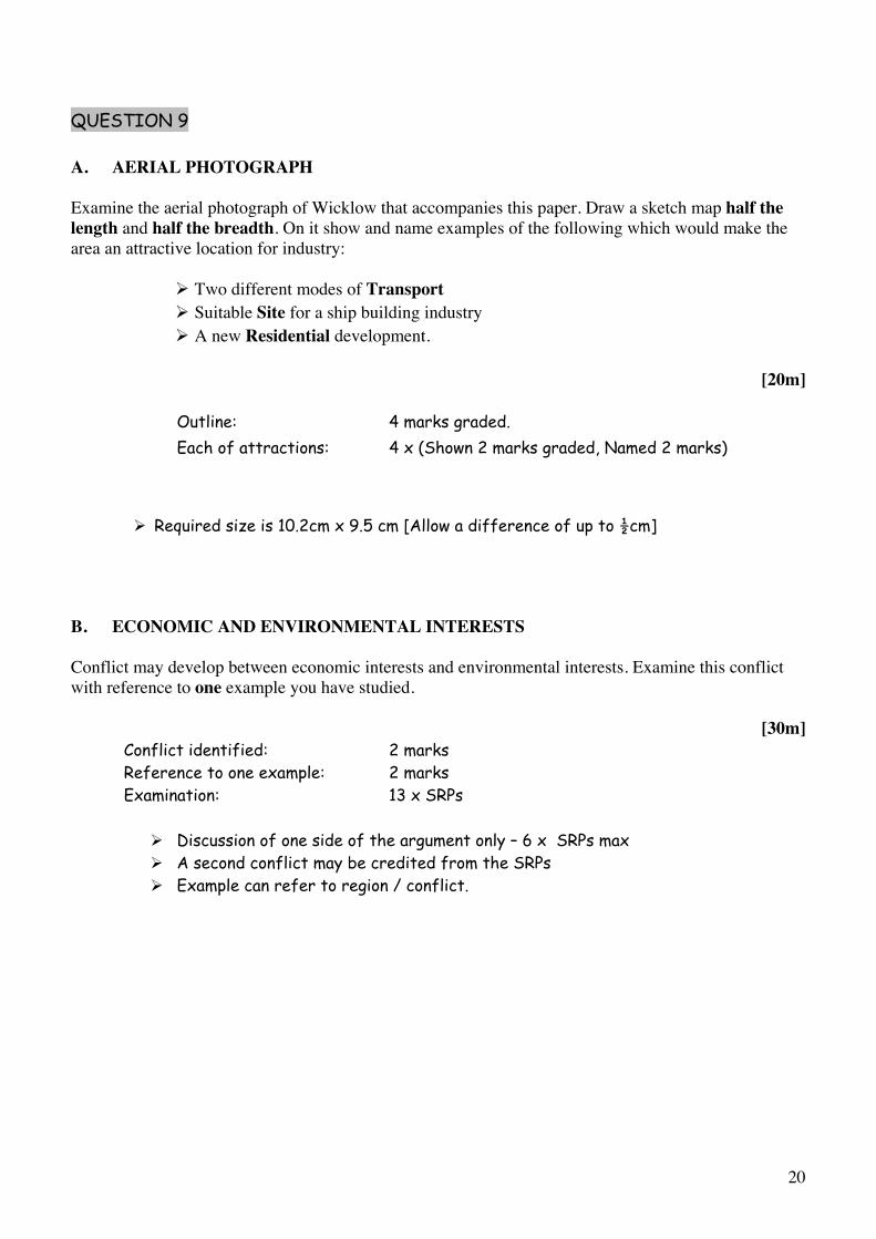
QUESTION 9
A. AERIAL PHOTOGRAPH
Examine the aerial photograph of Wicklow that accompanies this paper. Draw a sketch map half the length and half the breadth. On it show and name examples of the following which would make the area an attractive location for industry:
Two different modes of TransportSuitable Site for a ship building industry A new Residential development.
[20m]
Outline: 4 marks graded. Each of attractions: 4 x (Shown 2 marks graded, Named 2 marks)
Required size is 10.2cm x 9.5 cm [Allow a difference of up to ½cm]
B. ECONOMIC AND ENVIRONMENTAL INTERESTS
Conflict may develop between economic interests and environmental interests. Examine this conflict with reference to one example you have studied.
[30m]Conflict identified: 2 marks Reference to one example: 2 marks Examination: 13 x SRPs
Discussion of one side of the argument only – 6 x SRPs max A second conflict may be credited from the SRPs Example can refer to region / conflict.
21
C. EUROPEAN UNION
Examine the importance of any one of the following to the development of the Irish economy:
Common Agricultural Policy Common Fisheries Policy Regional Development Funds Social Funding.
[30m]
Importance to the Irish economy: 2 marks + 2 marks Examination: 13 x SRPs
Discussion without link to Irish economy – 6 x SRPs max Amalgamate all relevant discussion points. More than 1 policy discussed – mark both and credit the better.
22
QUESTION 10
A. BIRTH RATES
Using the above map as a reference answer the following questions in your answer book:
(i) What is The Netherland’s birth rate for 2007? (ii) What is Switzerland’s birth rate for 2007? (iii) Identify one social factor that influences the birth rate. (iv) Define the term Mortality Rate.
[20m]
Four answers @ 5 marks each (i) 11 per thousand or 1.1% [2 marks + 3 marks] (ii) 10 per thousand or 1.0% [2 marks + 3 marks] (iii) Any valid factor [5 marks] (iv) Death Rate per thousand of population [2 marks + 3 marks]
B. SETTLEMENT PATTERNS
Examine the Ordnance Survey extract that accompanies this paper. Using map evidence to support your answer, identify and explain three patterns of rural settlement.
[30m]
3 patterns @10 marks each: Pattern identified: 2 marks Map reference: 2 marks Examination: 3 x SRPs
Examination must be based on relevant explanation rather than on further map references If answer is based on aerial photograph, allow marks for naming pattern only.
PATTERNS AND PROCESSES IN THE HUMAN ENVIRONMENT
Attempt ONE question
23
C. DYNAMICS OF SETTLEMENT
With reference to one Irish urban centre that you have studied, examine how its functions change over time.
[30m]
Named Irish urban centre: 2 marks Two named functions : 2 + 2 marks Examination: 12 x SRPs
Discussion without link to Irish urban centre = 0 marksDiscussion without reference to time – 6 x SRPsCredit 1 extra function as an SRP from examination.
24
QUESTION 11
A. URBANISATION
The table shows the percentage of urban population in selected regions for 1975 and the predicted percentage of urban population in selected regions for 2015.Using graph paper, draw a suitable graph to illustrate this data.
[20m]
Bar Chart Pie Chart Title: 2 marks 2 marks Scaled axis: 2 marks 2 marks (Circle & Centred) 8 items illustrated: 2 marks each graded 2 marks each graded
If graph paper is not used deduct 2 marks from total.
Accept bar chart / histogram /pie chart / divided rectangle /trend graph etc. Two pie charts must be presented for full marks. Naming of chart type not sufficient for title mark.
B. PROBLEMS IN CITIES
With reference to one example you have studied, examine the effectiveness of urban planning strategies in dealing with urban problems.
[30m]
Two named strategies: 2 + 2 marks Two named urban problems: 2 + 2 marks Examination: 11 x SRPs
Allow a named urban area as one SRP from the examination Max 5 SRPs if not related to ‘effectiveness’
25
C. OVER-POPULATION
(i) Explain the term over-population.(ii) Examine two causes of over-population in one area you have studied.
[30m]
(i) Explanation: 4 marks graded (4 - 2 - 0 )
(ii) Named Area: 2 marks Two named causes 2 marks + 2 marks Examination: 10 x SRPs (5 x SRPs per cause)
Explanation of over-population should refer to population numbers and to natural resourcesExamination without reference to named area – 5 x SRPs max. Allow for transfer of information from part (i) to part (ii).
26
QUESTION 12
A. AERIAL PHOTOGRAPH
Examine the aerial photograph of Wicklow that accompanies this paper. Draw a sketch map half the length and half the breadth. On it show and name the following:
A new housing development An area of water-based recreationA bridgeA church.
[20m]Outline: 4 marks graded Each of 4 land-uses: Shown 2 marks graded, Named 2 marks
Outline refers to coastline & dimensions Required size is 10.2cm x 9.5 cm [Allow a difference of up to ½cm]
B. MIGRATION
With reference to examples you have studied, examine two impacts of rural to urban migration.
[30m]
Two impacts named: 2 + 2 marks One migration named: 2 marks Examination: 12 x SRPs (6 x SRPs per impact)
Credit 1 further named migration as SRP from examination.

27
C. URBAN LAND-USE
With reference to one example you have studied, describe and explain changing land-use in urban areas.
[30m]
Two changing land uses identified: 2 + 2 marks Discussion: 13 x SRPs.
Discussion without reference to change / time 6 x SRPs. Credit a named location as an SRP from examination once.
28
SECTION 3 - OPTIONS
Attempt ONE question
N.B. It is better to treat of three or four aspects of the theme in some detail, rather than to give a superficial treatment of a large number of points.
29
13. Discuss the role played by Non-Governmental Organisations (NGOs) in the ‘aid debate’.
[80m]
Number of aspects: 3 (27 + 27 + 26) (4 @ 20 marks each) Identifying aspect: 4 marks 4 marks Discussion: 8 x SRPs OR 6 x SRPs Overall coherence: 7/6 marks graded 4 marks graded
Select scheme according to number of aspects discussed. Allow credit for up to 2 examples from SRPs (Different examples & in different aspects)
14. We live in an interdependent global economy. Actions or decisions taken in one area have an impact on other areas. Discuss.
[80m]
Number of aspects 3(27 + 27 + 26) (4 @ 20 marks each) Identifying aspect: 4 marks 4 marks Discussion: 8 x SRPs OR 6 x SRPs Overall coherence: 7/6 marks graded 4 marks graded
Select scheme according to number of aspects discussed. Allow credit for up to 2 examples from SRPs (Different examples & in different aspects)
15. Fair trade supports sustainable development. Discuss.
[80m]
Number of aspects: 3 (27 + 27 + 26) (4 @ 20 marks each) Identifying aspect: 4 marks 4 marks Discussion: 8 x SRPs OR 6 x SRPs Overall coherence: 7/6 marks graded 4 marks graded
Select scheme according to number of aspects discussed. Allow credit for up to 2 examples from SRPs (Different examples & in different aspects).
Global Interdependence
30
16. With reference to one soil type you have studied, examine how parent material, climate and organic matter influence the soil.
[80m]
Number of aspects: 3 (27 + 27 + 26) (4 @ 20 marks each) Identifying aspect 4 marks 4 marks Examination: 8 x SRPs OR 6 x SRPs Overall coherence: 7/6 marks graded 4 marks graded
Select scheme according to number of aspects examined. Allow credit for up to 2 examples from SRPs (Different examples & in different aspects) Accept named soil type as one SRP once
17. Discuss how human activities can accelerate soil erosion.
[80m]
Number of aspect : 3 (27 + 27 + 26) (4 @ 20 marks each) Identifying aspect : 4 marks 4 marks Discussion: 8 x SRPs OR 6 x SRPs
Overall coherence: 7/6 marks graded 4 marks graded
Select scheme according to number of aspects discussed. Allow credit for up to 2 examples from SRPs (Different examples & in different aspects)
18. Assess how biomes have been altered by human activity.
[80m]
Number of aspect: 3 (27 + 27 + 26) (4 @ 20 marks each) Identifying aspect: 4 marks 4 marks Examination: 8 x SRPs OR 6x SRPs Overall coherence: 7/6 marks graded 4 marks graded
Select scheme according to number of aspects examined. Allow credit for up to 2 examples from SRPs (Different examples & in different aspects. Accept two named biome as two SRPs. Examination can refer to one or more biomes.
Geoecology
31
19. Cultural identity is defined by many diverse factors. Discuss this statement with reference to onecase study of a European region you have studied.
[80m]
Number of aspects: 3 (27 + 27 + 26) (4 @ 20 marks each) Identifying aspect: 4 marks 4 marks Discussion: 8 x SRPs OR 6 x SRPs Overall coherence: 7/6 marks graded 4 marks graded
Select scheme according to number of aspects discussed. Allow credit for up to 2 examples from SRPs (Different examples & in different aspects) Accept named region as one SRP once Discussion must refer to at least 3 different factors
20. Conflicts exist between political structures and cultural groups. Discuss this statement with reference to examples you have studied.
[80m]
Number of aspects: 3 (27 + 27 + 26) (4 @ 20 marks each) Identifying aspect: 4 marks 4 marks Discussion: 8 x SRPs OR 6 x SRPs Overall coherence: 7/6 marks graded 4 marks graded
Select scheme according to number of aspects discussed. Allow credit for up to 2 examples from SRPs (Different examples & in different aspects)
21. Discuss how people express their culture and identity in everyday life.
[80m]
Number of aspects: 3 (27 + 27 + 26) (4 @ 20 marks each) Identifying aspect: 4 marks 4 marks Discussion: 8 x SRPs OR 6 x SRPs
Overall coherence: 7/6 marks graded 4 marks graded
Select scheme according to number of aspects discussed. Allow credit for up to 2 examples from SRPs (Different examples & in different aspects)
Culture and Identity
32
22. Give an explanatory account of any one global climate you have studied.
[80m]
Number of aspects: 3 (27 + 27 + 26) (4 @ 20 marks each) Identifying aspect: 4 marks 4 marks Examination: 8 x SRPs OR 6 x SRPs Overall coherence: 7/6 marks graded 4 marks graded
Select scheme according to number of aspects examined. Allow credit for up to 2 examples from SRPs (Different examples & in different aspects) Accept named climate for one SRP once At least two aspects must deal with cause of climate
23. Explain why temperatures vary greatly over the surface of the earth.
[80m]
Number of aspects: 3 (27 + 27 + 26) (4 @ 20 marks each) Identifying aspect: 4 marks 4 marks Discussion: 8 x SRPs OR 6 x SRPs Overall coherence: 7/6 marks graded 4 marks graded
Select scheme according to number of aspects dealt with (2:1/1:2/2:2) Allow credit for up to 2 examples from SRPs (Different examples & in different aspects)
24. Climate influences economic development. Discuss this statement with reference to examples you have studied.
[80m]
Number of aspects: 3 (27 + 27 + 26) (4 @ 20 marks each) Identifying aspect: 4 marks 4 marks Discussion: 8 x SRPs OR 6 x SRPs Overall coherence: 7/6 marks graded 4 marks graded
Select scheme according to number of aspects discussed. Allow credit for up to 2 examples from SRPs (Different examples & in different aspects)
The Atmosphere-Ocean Environment
33
GEOGRAPHICAL INVESTIGATION
1 INTRODUCTION (5 marks):
4 x SRPs: 1 mark each Overall Coherence: 1 mark graded
2 PLANNING (5 marks):
4 x SRPs: 1 mark each Overall Coherence: 1 mark graded
3 GATHERING OF DATA (40 marks):
Two methods @ 20 marks each. For each method: 9 x SRPs @ 2 marks each Overall coherence: 4 marks graded
A method may be a task which is a group of relevant linked activities. Credit may be given to diagrams / sketches if they relate to the gathering. Do not award marks for results in this written section.
4 RESULTS, CONCLUSIONS, EVALUATION (30 marks):
Three heading @ 8 marks each. For each heading: 4 x SRPs @ 2 marks each Overall coherence: 6 marks graded
Conclusions are based directly or indirectly on the results, otherwise it’s evaluation. Evaluation can be forward-thinking as well as retrospective.
5 ORGANISATION & PRESENTATION OF RESULTS (20 marks):
Presentation: 8 x SRPs @ 2 marks each Overall coherence: 4 marks graded.
Two different graphic forms of presentation required – such as graphs / charts / maps / tables / sketches etc. Presentation to appear in the appropriate graph pages. Maximum of 4 x SRPs per chart.
34
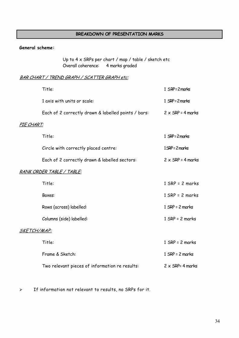
BREAKDOWN OF PRESENTATION MARKS
General scheme:
Up to 4 x SRPs per chart / map / table / sketch etc Overall coherence: 4 marks graded
BAR CHART / TREND GRAPH / SCATTER GRAPH etc:
Title: 1 SRP = 2 marks
1 axis with units or scale: 1 SRP = 2 marks
Each of 2 correctly drawn & labelled points / bars: 2 x SRP = 4 marks
PIE CHART:
Title: 1 SRP = 2 marks
Circle with correctly placed centre: 1SRP = 2 marks
Each of 2 correctly drawn & labelled sectors: 2 x SRP = 4 marks
RANK ORDER TABLE / TABLE:
Title: 1 SRP = 2 marks
Boxes: 1 SRP = 2 marks
Rows (across) labelled: 1 SRP = 2 marks
Columns (side) labelled: 1 SRP = 2 marks
SKETCH/MAP:
Title: 1 SRP = 2 marks
Frame & Sketch: 1 SRP = 2 marks
Two relevant pieces of information re results: 2 x SRP= 4 marks
If information not relevant to results, no SRPs for it.
35
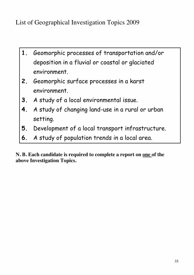
List of Geographical Investigation Topics 2009
1. Geomorphic processes of transportation and/or deposition in a fluvial or coastal or glaciated environment.
2. Geomorphic surface processes in a karst environment.
3. A study of a local environmental issue.4. A study of changing land-use in a rural or urban
setting.5. Development of a local transport infrastructure.6. A study of population trends in a local area.
N. B. Each candidate is required to complete a report on one of the above Investigation Topics.
36
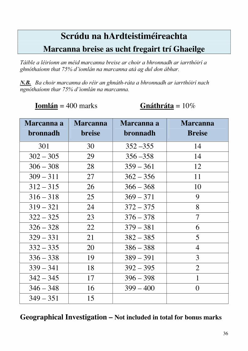
Scrúdu na hArdteistiméireachta Marcanna breise as ucht fregairt trí Ghaeilge
Táible a léiríonn an méid marcanna breise ar choir a bhronnadh ar iarrthóirí a ghnóthaíonn that 75% d’iomlán na marcanna atá ag dul don ábhar.
N.B. Ba choir marcanna do réir an ghnáth-ráta a bhronnadh ar iarrthóirí nach ngnóthaíonn thar 75% d’iomlán na marcanna.
Iomlán = 400 marks Gnáthráta = 10%
Marcanna a bronnadh
Marcannabreise
Marcanna a bronnadh
MarcannaBreise
301 30 352 –355 14 302 – 305 29 356 –358 14306 – 308 28 359 – 361 12 309 – 311 27 362 – 356 11 312 – 315 26 366 – 368 10 316 – 318 25 369 – 371 9319 – 321 24 372 – 375 8322 – 325 23 376 – 378 7326 – 328 22 379 – 381 6329 – 331 21 382 – 385 5332 – 335 20 386 – 388 4336 – 338 19 389 – 391 3339 – 341 18 392 – 395 2342 – 345 17 396 – 398 1346 – 348 16 399 – 400 0349 – 351 15
Geographical Investigation – Not included in total for bonus marks

BOOKS EV SETUPS 2009 21/7/09 13:10 Page 12

BOOKS EV SETUPS 2009 28/7/09 17:53 Page 5