Embed Size (px)
Citation preview
VOL. 2, Special Issue, ICESR 2012 ISSN 2225-7217
ARPN Journal of Science and Technology ©2011-2012. All rights reserved.
http://www.ejournalofscience.org
61
SUSTAINABLE FLOODPLAIN MANAGEMENT THROUGH LINKING OF MAJOR RIVERS IN INDIA
S. K. Sharma
Head, Geography and Department of Environmental Education,
Carman Residential and Day School, Dehradun 248007, India
Abstract India has a variable monsoon climate and is subjected to cyclical flood and drought. The country has a large network of rivers with an estimated annual flow of 1900 Km3
, much of which occurs from June to September. According to the UN report, in the Himalayas, rapidly melting glaciers due to global warming are causing floods followed by a dip in river flow. Many of the rivers in the north of India are frequently affected by floods and discharge copious amount of water during monsoon months of June to September every year. However, the rivers of southern part of India are monsoon fed and faces severe drought, in case the monsoon fails. A feasible solution is the linking of north-south rivers so that the massive surplus flood water from the northern part be transferred to the deficit water prone rivers of south in order to get rid of floods in the north and droughts in the south. The scheme envisages effecting 30 river links. The idea of inter-basin transfer, at first instance, envisages the construction of a Ganga – Cauvery Canal, drawing nearly 60000 cusecs of flood flows of the Ganga near Patna in the north for about 150 days in a year and link it up with water starved river Cauvery in the south. Government of India has a very ambitious plan for a Sustainable Floodplain Management through linking major flood prone rivers of north with the drought prone rivers of south India for achieving a Socioeconomic Sustainability in the country.
Keywords : Himalaya, floods, glaciers, monsoon, river linking
INTRODUCTION
India is an agrarian country. At the time of independence in 1947, the country had a population of about 400 million and faced severe food crisis. At that time the irrigation potential of the country was only about 20 million hectare. After independence massive program of irrigation was launched for development and utilization of both surface and ground water resources. The irrigation potential of the country could increase to 57 million hectare in 1979. This resulted in green revolution, which helped to transform the country from the state of food scarcity to food self-sufficiency producing about 125 to 130 million tones food grains. However, rate of increase in food production could not just managed to equal the rate of population growth which now stands at 1.02 billion and requires nearly 160 million hectare irrigated land to make country self-sufficient in food grains. Obviously, the water is main input to the agriculture. The SW summer monsoon accounts for more than 85 % of the precipitation which is unpredictable and unevenly distributed, is a serious problem for the country. Of the county’s total geographical area of 329 million hectare, 40 million hectare is prone to floods, out of which 32 million hectare can be provided with reasonable degree of protection. Till March 2004 an area of 16.46 million hectare has been provided with reasonable degree of protection against flood by construction of embankments rather than dams. Total withdrawal of water are estimated to be 750 Km3 currently, and have been projected to increase to 1050 Km3 by 2050. At present, to mitigate the damages from floods, a nationwide Flood Forecasting and Warning System
VOL. 2, Special Issue, ICESR 2012 ISSN 2225-7217
ARPN Journal of Science and Technology ©2011-2012. All rights reserved.
http://www.ejournalofscience.org
62
are establishes by the Government. Forecasts about water level in rivers likely to be attained as result of floods and volume of inflow into reservoirs are formulated and disseminated to various administrative authorities, media and other users in order to reduce the loss of human lives and miseries, and immovable properties. Large parts of Haryana, Maharashtra, Andhra Pradesh, Rajasthan, Gujarat, Madhya Pradesh, Karnataka and Tamil Nadu are not only in deficit in rainfall but also subject to large variations, resulting in frequent droughts. The water availability even for drinking purposes becomes critical, particularly in the summer months as the rivers dry up and the ground water recedes. Regional variations in the rainfall lead to situations when some parts of the country has excess water leading to floods and some part do not have enough water even for raising a single crop. The World Water Vision Commission drew attention to the "gloomy arithmetic of water" as water demand will out strip its availability. The scenario of water in India is equally gloomy. India has a variable monsoon climate and is subjected to cyclical flood and drought. It is in this context that the proposed Indian Interlinking of Rivers assumes great importance so that the surplus water from flood prone snow fed rivers of northern India , be diverted to water deficit regions of mainly southern, western and central India.
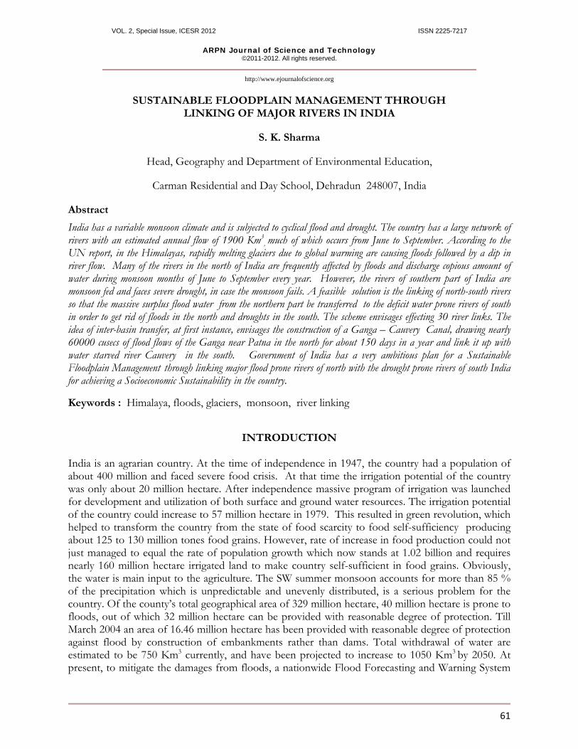
PROJECT'S TECHNICAL AND SCIENTIFIC BASIC ASSUMPTIONS India has a monsoonal type of climate where the entire nation except the south –eastern part receives rainfall from the south-west monsoon winds during May to August ranging from 100 to 300 cm whereas the south- eastern part receives rainfall from the retreating monsoon during winter ranging from 40 to 60 cm. The following figure 1 shows the annual distribution of rainfall in India.
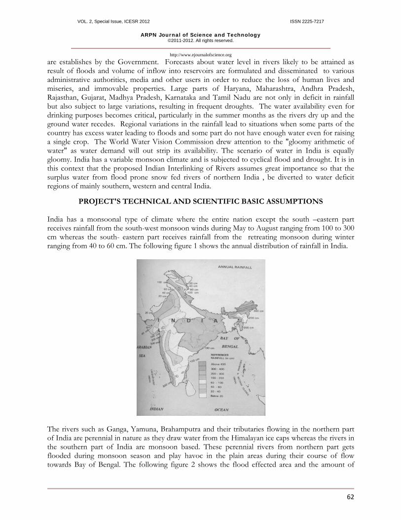
The rivers such as Ganga, Yamuna, Brahamputra and their tributaries flowing in the northern part of India are perennial in nature as they draw water from the Himalayan ice caps whereas the rivers in the southern part of India are monsoon based. These perennial rivers from northern part gets flooded during monsoon season and play havoc in the plain areas during their course of flow towards Bay of Bengal. The following figure 2 shows the flood effected area and the amount of
VOL. 2, Special Issue, ICESR 2012 ISSN 2225-7217
ARPN Journal of Science and Technology ©2011-2012. All rights reserved.
http://www.ejournalofscience.org
63
water being wasted as a surplus flow due to non availability of water storage facilities in the country. The Figure 2 showing the flood effected area.
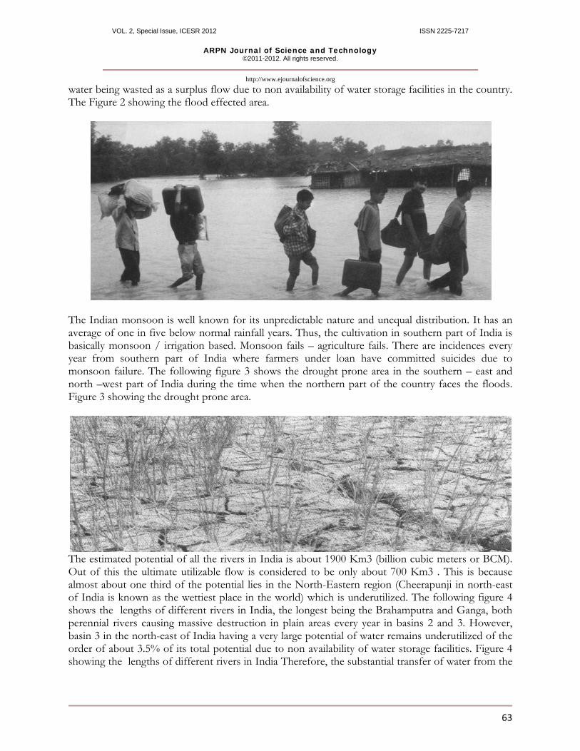
The Indian monsoon is well known for its unpredictable nature and unequal distribution. It has an average of one in five below normal rainfall years. Thus, the cultivation in southern part of India is basically monsoon / irrigation based. Monsoon fails – agriculture fails. There are incidences every year from southern part of India where farmers under loan have committed suicides due to monsoon failure. The following figure 3 shows the drought prone area in the southern – east and north –west part of India during the time when the northern part of the country faces the floods. Figure 3 showing the drought prone area.
The estimated potential of all the rivers in India is about 1900 Km3 (billion cubic meters or BCM). Out of this the ultimate utilizable flow is considered to be only about 700 Km3 . This is because almost about one third of the potential lies in the North-Eastern region (Cheerapunji in north-east of India is known as the wettiest place in the world) which is underutilized. The following figure 4 shows the lengths of different rivers in India, the longest being the Brahamputra and Ganga, both perennial rivers causing massive destruction in plain areas every year in basins 2 and 3. However, basin 3 in the north-east of India having a very large potential of water remains underutilized of the order of about 3.5% of its total potential due to non availability of water storage facilities. Figure 4 showing the lengths of different rivers in India Therefore, the substantial transfer of water from the
VOL. 2, Special Issue, ICESR 2012 ISSN 2225-7217
ARPN Journal of Science and Technology ©2011-2012. All rights reserved.
http://www.ejournalofscience.org
64
surplus regions to the regions of shortage is a formidable concept provided it meets the problems related to costs, engineering and environment.
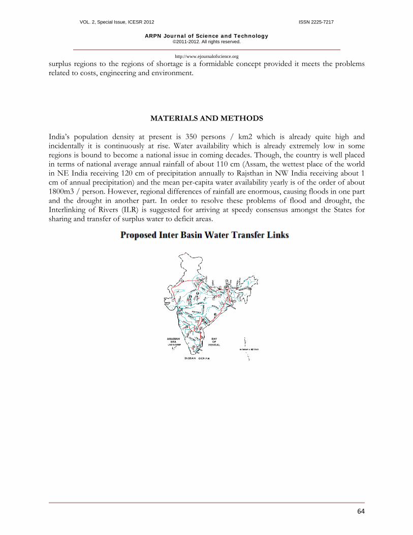
MATERIALS AND METHODS India’s population density at present is 350 persons / km2 which is already quite high and incidentally it is continuously at rise. Water availability which is already extremely low in some regions is bound to become a national issue in coming decades. Though, the country is well placed in terms of national average annual rainfall of about 110 cm (Assam, the wettest place of the world in NE India receiving 120 cm of precipitation annually to Rajsthan in NW India receiving about 1 cm of annual precipitation) and the mean per-capita water availability yearly is of the order of about 1800m3 / person. However, regional differences of rainfall are enormous, causing floods in one part and the drought in another part. In order to resolve these problems of flood and drought, the Interlinking of Rivers (ILR) is suggested for arriving at speedy consensus amongst the States for sharing and transfer of surplus water to deficit areas.
VOL. 2, Special Issue, ICESR 2012 ISSN 2225-7217
ARPN Journal of Science and Technology ©2011-2012. All rights reserved.
http://www.ejournalofscience.org
65
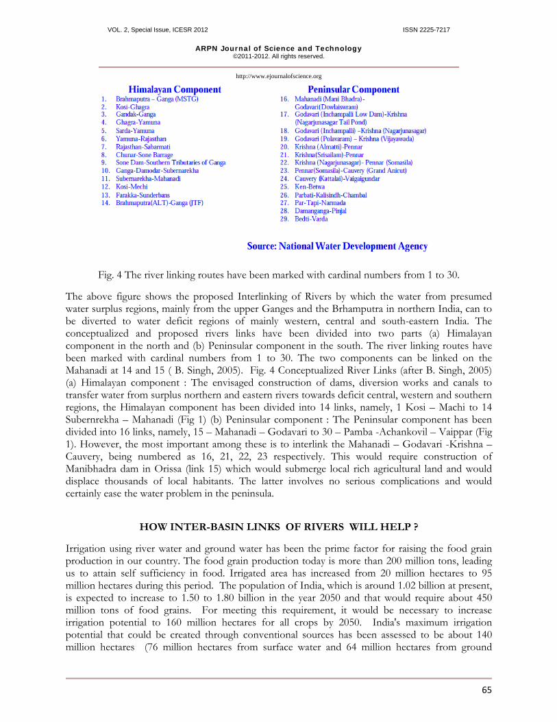
Fig. 4 The river linking routes have been marked with cardinal numbers from 1 to 30.
The above figure shows the proposed Interlinking of Rivers by which the water from presumed water surplus regions, mainly from the upper Ganges and the Brhamputra in northern India, can to be diverted to water deficit regions of mainly western, central and south-eastern India. The conceptualized and proposed rivers links have been divided into two parts (a) Himalayan component in the north and (b) Peninsular component in the south. The river linking routes have been marked with cardinal numbers from 1 to 30. The two components can be linked on the Mahanadi at 14 and 15 ( B. Singh, 2005). Fig. 4 Conceptualized River Links (after B. Singh, 2005) (a) Himalayan component : The envisaged construction of dams, diversion works and canals to transfer water from surplus northern and eastern rivers towards deficit central, western and southern regions, the Himalayan component has been divided into 14 links, namely, 1 Kosi – Machi to 14 Subernrekha – Mahanadi (Fig 1) (b) Peninsular component : The Peninsular component has been divided into 16 links, namely, 15 – Mahanadi – Godavari to 30 – Pamba -Achankovil – Vaippar (Fig 1). However, the most important among these is to interlink the Mahanadi – Godavari -Krishna – Cauvery, being numbered as 16, 21, 22, 23 respectively. This would require construction of Manibhadra dam in Orissa (link 15) which would submerge local rich agricultural land and would displace thousands of local habitants. The latter involves no serious complications and would certainly ease the water problem in the peninsula.
HOW INTER-BASIN LINKS OF RIVERS WILL HELP ?
Irrigation using river water and ground water has been the prime factor for raising the food grain production in our country. The food grain production today is more than 200 million tons, leading us to attain self sufficiency in food. Irrigated area has increased from 20 million hectares to 95 million hectares during this period. The population of India, which is around 1.02 billion at present, is expected to increase to 1.50 to 1.80 billion in the year 2050 and that would require about 450 million tons of food grains. For meeting this requirement, it would be necessary to increase irrigation potential to 160 million hectares for all crops by 2050. India's maximum irrigation potential that could be created through conventional sources has been assessed to be about 140 million hectares (76 million hectares from surface water and 64 million hectares from ground
VOL. 2, Special Issue, ICESR 2012 ISSN 2225-7217
ARPN Journal of Science and Technology ©2011-2012. All rights reserved.
http://www.ejournalofscience.org
66
water). But for attaining a potential of 160 million hectares, other strategies shall have to be evolved. One such option before the country is inter-basin water transfer. The implementation of the above program of inter-basin water transfers would resolve the mismatch of water availability and the demand and provide : *Additional irrigation benefits of 35 million hectare (25 million hectare from surface water and 10 million hectare increased use of groundwater. *It will be over and above the ultimate irrigation potential of about 140 million hectare from major, medium and minor irrigation projects. In addition, it would also generate nearly 34,000 MW of hydropower. *Apart from these benefits, the flood control, navigation, water supply, fisheries, salinity and pollution control etc are also expected to get a boost
FEASIBILITY Government of India has endorsed the Supreme Court of India’s directive and gave a time span of 12 years for implementation of project. This seems to be quite unrealistic under present conditions. The project involves constructions of dams which itself takes nearly two decades to complete. Therefore, more realistic time is need to complete the project.
FEASIBILITY AND COST EFECTIVENESS
The Government of India has endorsed the Supreme Court of India’s directive and gave a time span of 12 years for implementation of project since 2006. This seems to be quite unrealistic under present conditions. The project involves constructions of dams which itself takes nearly two decades to complete. Therefore, more realistic time is need to complete the project. The estimated cost of the project is Rs 560,000 crores that is, 20% of the Indian GDP, or 1.7 times the annual budget of India ( Equivalent to US$ 115 billions – 80 billions for Himalaya component and 40 billions for Peninsular component). It is to be completed in a time span of 10-15 years. Raising such a big amount for a poor country like India is a big problem. The cost escalation will further complicate the matter. The project to be funded by the Government of India, international agencies and market borrowings. The proposed cost of the project has been calculated to US$ 120 billion, that is, 20% of the Indian GDP, or 1.7 times the annual budget of India (Khalequzzaman et al 2004).
PROBABLE OUTCOME The idea of inter-basin transfer, at first instance, envisages the construction of a Ganga – Cauvery Canal, drawing nearly 60000 cusecs of flood flows of the Ganga near Patna in the north for about 150 days in a year and link it up with water starved river Cauvery in the south. Government of India has a very ambitious plan for a Sustainable Floodplain Management through linking major flood prone rivers of north with the drought prone rivers of south India. When completed, the ILR is expected to to meet the objectives of transferring surplus water from north to water deficit regions of southern and western part of India ; control the twin problems of flooding and drought ; irrigate the land thus, producing additional food grains and generating about 35000 MW of electricity for
VOL. 2, Special Issue, ICESR 2012 ISSN 2225-7217
ARPN Journal of Science and Technology ©2011-2012. All rights reserved.
http://www.ejournalofscience.org
67
achieving a Socio-economic Sustainability in the country. Additional anticipated benefits include navigation, water supply, fisheries, salinity control and pollution control.
FORESEEABLE EFFECT ON THE ENVIRONMENT The construction of many dams and canals to interlink the rivers will submerge millions of hactares of fertile agricultural land, rare medicinal plants and would displace millions of people from there home land. The displaced persons might not get the suitable compensation from the Government and would find it difficult to rehabilitate at alternate provided sites.
COMPARISON WITH SIMILAR PROJECT ELSEWHERE It is no doubt true that many rivers in the north of India are frequently affected by floods and discharge copious amount of water during monsoon months of June to September whereas other parts of India remain thirsty. It is also not possible to control flood through dams where the magnitude of the river water flow is of the order of 5 to 16 m above the danger mark. Therefore, to deal with the surplus flood water and drought, the interlinking of rivers appears to be a viable solution. But the examples of similar projects attempted in other countries of the world are few and full details are not available. California in USA appears to be the only successful State to have transferred surplus water from hilly north to fertile plains of south California over a distance of 720 km.
DISCUSSION Till March 2004 an area of 16.46 million hectare has been provided with reasonable degree of protection against flood by construction of embankments rather than dams (except a few which are primarily constructed for the purpose of flood control), drainage channels and by raising villages. Total withdrawal of water is estimated to be 750 Km3 currently, and have been projected to increase to 1050 Km3 by 2050. At present, to mitigate the damages from floods, a nationwide Flood Forecasting and Warning System are establishes by the Government. Forecasts about water level in rivers likely to be attained as result of floods and volume of inflow into reservoirs are formulated and disseminated to various administrative authorities, media and other users in order to reduce the loss of human lives and miseries, and immovable properties. According to the UN report, in the Himalayas, rapidly melting glaciers due to global warming are causing floods followed by a dip in river flow. Such decrease can be witnessed in the Gangetic plains which is turning from fertile to infertile in the northern part of India where the snow fed perennial river Ganga, originating from the Gangotri glacier in Himalayan flows throughout the year. Quirky weather sees eastern Bihar in north India getting twice as much rainfall as normal, resulting in flash floods. Many of the rivers in the north of India are frequently affected by floods and discharge copious amount of water during monsoon months of June to September every year. Cholera and malaria cases increase because of floods. Food production is expected to drop by 30% by 2050, devastating an agriculture-led rural economy of India. Food insecurity and loss of livelihood along with cultivable land is a nightmarish scenario. The scheme envisages effecting 30 river links. The interlinking of rivers, therefore, will bring relief to utilize surplus water flow to water deficit regions in southern and western India, control twin problem of flood and drought, irrigate additional areas, help to produce additional food grain to cater to the needs of country’s ever growing population and generate
VOL. 2, Special Issue, ICESR 2012 ISSN 2225-7217
ARPN Journal of Science and Technology ©2011-2012. All rights reserved.
http://www.ejournalofscience.org
68
electricity to an otherwise energy starved country.
CONCLUSION The inter-basin transfer project is to be funded mainly by the government of India, international agencies and market borrowings. The interlinking of rivers, therefore, will bring relief to utilize surplus water flow to water deficit regions in southern and western India, control twin problem of flood and drought, irrigate additional areas, help to produce additional food grain to cater to the needs of country’s ever growing population and generate electricity to an otherwise energy starved country. However, inter-linking of rivers alone may not solve all the water related problems of the country. some other ways to conserve water like rainwater harvesting, water reuse, watershed management and regulating the optimal exploitation of underground water resources need to be developed at a much faster rate and efficient way than what is existing today.
REFERENCES Khalequzzaman, M., Srivastava, P.,Faruque, F.S., 2004. The Indian River-linking project: Hydrologic, Ecologic and sociao-economic perspective. Regional Cooperation on Tran boundary Rivers. 78-90. Radhakrishna, B.P., 2003. Linking major rivers of India. Journal of the geological Society of India, vol 61, 252 Singh, B, 2005 A big dream of little logic. The Hindustan Times, 15th June, 2005