Embed Size (px)
Citation preview
Imperial Journal of Interdisciplinary Research (IJIR) Vol-2, Issue-11, 2016 ISSN: 2454-1362, http://www.onlinejournal.in
Imperial Journal of Interdisciplinary Research (IJIR) Page 680
The Mullaperiyar Battle - Networking of Rivers
Aditya Thejus Krishnan
Abstract: The Mullaperiyar dam issue is one that has significantly strained the relationship between the states of Kerala and Tamil Nadu. At a time when water has come to be recognised as one of the predominant resources, the battle for its access and employability continue in many states in the country. The present submission is an attempt to analyse the sinuous ways of the Mullaperiyar issue.
1. Introduction
Our country has often been quoted as the land of “unity in diversity”. This is a prominent feature of our sub-continent and extends to all aspects of its nationhood and life forms. The same applies to water as well, i.e. the abundance of water in some parts of our country which exist in stark contrast to the severe droughts found in other parts. The present written submission is a look at the variation in the distribution of water resources across the country and a comprehensive look at one of the challenging plans taken up by the Government in order to meet this predicament.
The average rainfall in India is about 4,000 billion cubic meter, but most of India's rainfall comes over a 4 month period - June through September. Further the rains across the nation are not uniform, the east and north gets most of the rains, while the west and south get less. India also sees years of excess monsoons and floods, followed by below average or late monsoons with droughts. This geographical and time variance in availability of natural water versus the year round demand for irrigation, drinking and industrial water creates a demand-supply gap that has been worsening with India's rising population.
Water being a primary resource, the elixir of life, a uniform distribution becomes an essential pre requisite to ensure sustained quality of life for all the people of the country. Hence the proposal for inter linking of rivers. It essentially guarantees to link all the rivers across the country and thereby divert the excess flow from the water abundant rivers to the water-deficit rivers and hence make them more arable and suitable to life.
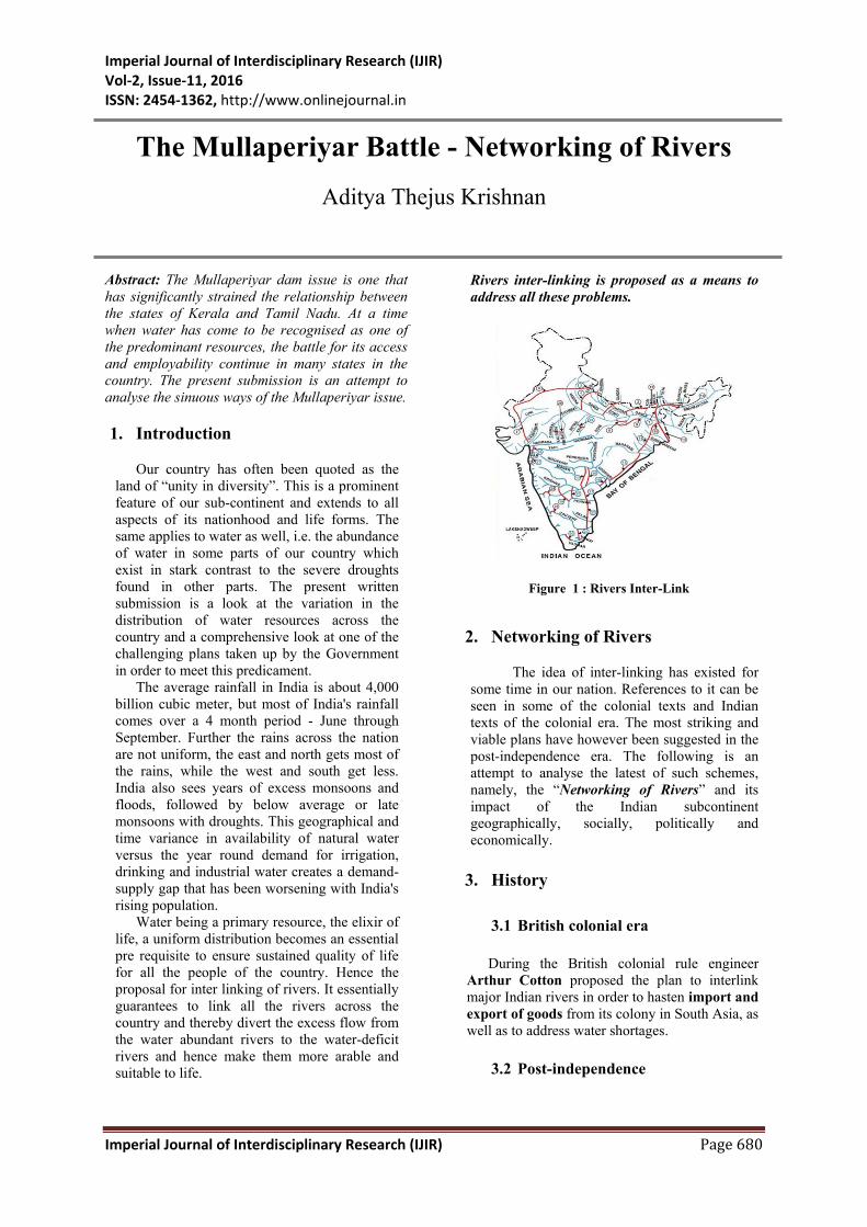
Rivers inter-linking is proposed as a means to address all these problems.
Figure 1 : Rivers Inter-Link
2. Networking of Rivers
The idea of inter-linking has existed for some time in our nation. References to it can be seen in some of the colonial texts and Indian texts of the colonial era. The most striking and viable plans have however been suggested in the post-independence era. The following is an attempt to analyse the latest of such schemes, namely, the “Networking of Rivers” and its impact of the Indian subcontinent geographically, socially, politically and economically.
3. History
3.1 British colonial era
During the British colonial rule engineer Arthur Cotton proposed the plan to interlink major Indian rivers in order to hasten import and export of goods from its colony in South Asia, as well as to address water shortages.
3.2 Post-independence

Imperial Journal of Interdisciplinary Research (IJIR) Vol-2, Issue-11, 2016 ISSN: 2454-1362, http://www.onlinejournal.in
Imperial Journal of Interdisciplinary Research (IJIR) Page 681
In 1973, then Union minister for water resources K.L.Rao proposed the Ganga-Cauvery (Kaveri) Link. The idea resurfaced, bigger in scope, in the late 1970s as the Garland Canal, proposed by engineering consultant Dinshaw Dastur. The government made its first serious move in 1980, when the ministry of water resources framed the National Perspective Plan, which proposed inter-basin transfers.
In 1982, the National Water Development Agency was set up to carry out pre-feasibility studies, which formed the basis of an interlinking plan. In 1999, a national commission was set up to review these study reports. It was of the view that there was "no imperative necessity for massive water transfers in the peninsular component" and that the Himalayan component would "require more detailed study."
3.3 The present project
Former Prime Minister, Sri Atal Bihari Vajpayee, is credited with giving the interlinking programme a big push in October 2002. It was further pushed to the mainstream, when then President APJ Abdul Kalam made a reference to “the need for finding a solution to simultaneous floods and droughts in 2002”.
In the year 2012, the justices of the Supreme Court decided that interlinking was a good idea and forced the government to get moving on the plan.
4. Need for Rivers Inter-link
4.1 Floods , drought and drinking water shortage
Even though India receives about 4,000 cubic kilometres of rain annually, about 85% of the same is received during summer months through monsoons. The uncertainty of the monsoons, sometimes marked by prolonged dry spells and fluctuations in seasonal and annual rainfall is a serious problem for the country. The nation sees cycles of drought years and flood years, with large parts of west and south experiencing more deficits.
Lack of irrigation water regionally leads to crop failures and farmer suicides. Despite abundant rains during July-September, some regions in other seasons see shortages of drinking water. Some years, the problem temporarily
becomes too much rainfall, and weeks of havoc from floods. This excess-scarcity regional disparity and flood-drought cycles have created the need for water resources management. Rivers inter-linking is one proposal to address that need.
A brief note on the floods and the drought happened in India during 2013:-
4.1.1 North India floods – 2013
• Uttarakhand
From 14 to 17 June 2013, Uttarakhand and adjoining areas received heavy rainfall, which was about 375% more than the benchmark rainfall during a normal monsoon. This caused devastating floods and more than 5,700 people were "presumed dead." Destruction of bridges and roads left about 100,000 pilgrims and tourists trapped in the valleys.1
• Delhi
Received a high amount of rainfall on 16 June 2013, and Yamuna River swelled to a high of 207.75 meters submerging the low lying flood plains along the banks.
• Uttar Pradesh
608 villages were affected by the flood and more than 120 deaths were reported.
• Himachal Pradesh
Floods caused loss of life and property and death toll in the state was 20.
• Nepal
About 6000 citizens of Nepal were visiting the Indian region, of which 1,000 were rescued. A bridge that joins the India-Nepal border was destroyed.
4.1.2. Western India drought – 2013
• Maharashtra
The drought is considered as the region's worst drought in 40 years. With millions estimated to be affected, lakhs of cattle rendered 1The Times of India , June 18, 2013

Imperial Journal of Interdisciplinary Research (IJIR) Vol-2, Issue-11, 2016 ISSN: 2454-1362, http://www.onlinejournal.in
Imperial Journal of Interdisciplinary Research (IJIR) Page 682
hungry without fodder, this drought is the worst kind of natural disaster that the state has faced. Almost 1/5th of Maharashtra is reeling under drought.
4.2 Population and food security
India's population growth rate has been falling, but still continues to increase by about 10 to 15 million people every year. The resulting demand for food must be satisfied with higher yields and better crop security, both of which require adequate irrigation of about 140 million hectares of land. Currently, just a fraction of that land is irrigated, and most irrigation relies on monsoon.
4.3 Navigation
India needs infrastructure for logistics and movement of freight. Using connected rivers as navigation is a cleaner, low carbon footprint form of transport infrastructure, particularly for ores and food grains.2 .
4.4 Current reserves and loss in groundwater level
India currently stores only 30 days of rainfall, while developed nations strategically store 900 days’ worth of water demand in arid areas river basins and reservoirs. India’s dam reservoirs store only 200 cubic meters per person. India also relies excessively on groundwater, which accounts for over 50 percent of irrigated area with 20 million tube wells installed. About 15 percent of India’s food is being produced using rapidly depleting groundwater. The end of the era of massive expansion in groundwater use is going to demand greater reliance on surface water supply systems.
5. The Project
Indian Rivers Inter-link is a proposed large-scale civil engineering project that aims to link India's rivers by a network of reservoirs and canals and so reduce the persistent floods and water shortages.
The project proposes to:-
2The Hindu, September 16, 2014
• Conserve the abundant monsoon water bounty
• Store it in reservoirs and • Deliver this water to areas and over times
when water becomes scarce • Optimise usage from the flow of rivers
5.1 Objectives
• Equitable distribution of the available water resources within a nation or a region
• Increased economic efficiency • Self-sufficiency in basic water related
outputs such as food and hydro energy • Providing livelihood and employment
opportunities in various parts of the nation so that migration of population is avoided through a balanced regional economic development.
5.2 The Plan
The entire River Linking project has been split into three parts:-
1. a northern Himalayan rivers inter-link
component 2. a southern Peninsular component and 3. an intra-state rivers linking component3.
The project is being managed by India's National Water Development Agency (NWDA), under the Ministry of Water Resources and they have studied and prepared reports on:-
• 14 inter-link projects for Himalayan component,
• 16 inter-link projects for Peninsular component and
• 36 intra-state river linking projects
3added in 2005

Imperial Journal of Interdisciplinary Research (IJIR) Vol-2, Issue-11, 2016 ISSN: 2454-1362, http://www.onlinejournal.in
Imperial Journal of Interdisciplinary Research (IJIR) Page 683
1. The Himalayan Component
Figure 2 : Himalayan Component
The Himalayan Rivers Development consists
of a series of dams built along the Ganga and Brahmaputra rivers in India, Nepal and Bhutan for the purposes of storage. Canals would be built to transfer surplus water from the eastern tributaries of the Ganga to the west. This is expected to contribute to flood control measures in the Ganga and Brahmaputra river basins.
14 inter-links are under consideration for this component of which the feasibility studies of 9 links have been completed. Apart from providing irrigation to an additional area of about 22 million hectares the generation of about 30 million kilowatt of hydro-power, it will provide substantial flood control in the Ganga-Brahmaputra basin. The Scheme will benefit not only the States in the Ganga-Brahmaputra Basin, but also Nepal and Bangladesh.
2. The Peninsular Component
In the southern Peninsular River Development component four phases are planned.
• First Phase: the Mahanadi, Godavari,
Krishna and Kaveri rivers would all be linked by canals. Extra water storage dams would be built to transfer surplus water to the south of India. (8 inter-links)
• Second Phase: those rivers that flow west
would be linked and the water would be used to provide irrigation in the coastal areas of Maharashtra and also Mumbai. (2 inter-links)
• Third Phase: the Ken and Chambal rivers
would be linked in order to provide better water facilities for M.P. and U.P. (2 inter-links)
• Fourth Phase: the west-flowing rivers along
the Western would be diverted for irrigation purposes. The Peninsular part of the project would provide additional irrigation to 130,000 sq. km. and generation an additional 4 gigawatts of power. (4 inter-links)
Figure 2 : Peninsular Component 3. Intra-state inter-linking of rivers. • As the name suggests, this part focuses on
linking rivers within a state so as to regulate the use and ensure uniform distribution.
• National Water Development Agency (NWDA) was commissioned in June 2005 to identify and complete feasibility studies of intra-State projects that would inter-link rivers within that state.
• The following States responded
positively with their proposed projects :-
Maharashtra : 20 Bihar : 6 Jharkhand & Orissa : 3 each Rajasthan & Tamil Nadu : 2 each Gujarat : 1
• States of Meghalaya, Kerala, Punjab, Delhi, Sikkim, Haryana, Nagaland, Lakshadweep, Daman & Diu, and Andaman &Nicobar responded that they have no intra-state river connecting proposals.
• Since 2005, NDWA completed feasibility studies on the projects, found 1 project infeasible, 20 projects as feasible, 1 project was withdrawn by Government of Maharashtra, and others are still under study.

Imperial Journal of Interdisciplinary Research (IJIR) Vol-2, Issue-11, 2016 ISSN: 2454-1362, http://www.onlinejournal.in
Imperial Journal of Interdisciplinary Research (IJIR) Page 684
6. International comparisons
The Indian Rivers Inter-link project is similar in scope and technical challenges as other major global river inter-link projects, such as:
6.1 Rhine–Main–Danube Canal
(Europa Canal)
• Completed in 1992and provides a navigable artery between the Rhine Delta in the Netherlands to the Danube Delta in eastern Romania.
• It is 171 km long, has the summit altitude of 406 m above sea level, the highest point on Earth reachable by ships from the sea.
• The inter-link provides navigation for 5.2 million tonnes of goods reducing the need for 250,000 truck trips per year and is also a source for irrigation, industrial water and power generation plants.
6.2 Illinois Waterway system • Consists of 541 kilometres of interlink
that provides a shipping connection from the Great Lakes to the Gulf of Mexico via the Mississippi River and provides a navigation route for export.
6.3 Tennessee–Tombigbee Waterway
• Is a 377 kilometre man-made waterway
that links the major coal producing regions with the consuming regions and serves as commercial navigation for coal and timber products.
• Also it is a major source of water supply, and irrigation along its way.
6.4 Gulf Intracoastal Waterway
• Completed in 1949, interlinks 8 rivers,
and is located along the Gulf Coast of US.
• It is a navigable inland waterway running approximately 1700 kilometres. It handles70 million tonnes of cargo per year and has become a significant source for fishing industry along the coast line of the United States.
7. Constitution of the task force on river linking4
With a view to bringing about a consensus among the States and provide guidance on norms of appraisal of individual projects and modalities for project funding etc. the Central Government had set up a Task Force with :-
• Shri Suresh Prabhu, MP as Chairman • Shri C.C. Patel, Vice-Chairman; and • Dr. C.D. Thatte, Member-Secretary.
In addition to the above members of the Task Force, part-time members were nominated in consultation with the Chairman of the Task Force and with the approval of the Prime Minister. These part-time members will be as under:
• a member from water deficit States; • a person from water surplus States; • an economist; • a sociologist; and • a legal/world wildlife expert.
The terms of reference of the Task Force were to:
• Provide guidance on norms of appraisal of individual projects in respect of economic viability, socio-economic impacts, environmental impacts and preparation of resettlement plans;
• Devise suitable mechanism for bringing
about speedy consensus amongst the States;
• Prioritize the different project
components for preparation of Detailed Project Reports and implementation;
• Propose suitable organizational
structure for implementing the project; • Consider various modalities for project
funding; and
4Resolution No.2/21/2002-BM; Ministry of Water Resources; New Delhi, 13th December 2002

Imperial Journal of Interdisciplinary Research (IJIR) Vol-2, Issue-11, 2016 ISSN: 2454-1362, http://www.onlinejournal.in
Imperial Journal of Interdisciplinary Research (IJIR) Page 685
• Consider international dimensions that may be involved in some project components.
8. Analysis of the project
Mr. Suresh Prabhu the head of the Task Force in 2002 has described this project as “Rationalisation of water lost to the sea”. It was targeted at minimizing the loss of water lost to the sea and optimizing its use. But the mounting opposition against the implementation of the project from the states 5as well as by other organizations and experts6has augmented the need to analyse the benefits and concerns of the project
8.1 Benefits
1. Proponents of the projects claim that it is
the answer to India’s entire water problem.
2. The project offers :-
• Potential benefits to transport
infrastructure through navigation
• Broadening income sources in rural areas through fish farming.
• Cheaply irrigating 35 million hectares;
• Availability of drinking water
• Enabling full use of existing irrigation projects;
• Generating 35,000 megawattsof power with added benefits, including flood control.
5 “Karnataka farmers oppose” - Business Line Dec 12,
2002 “Not possible: Chhattisgarh” - Rajasthan Patrika , 8
Dec, 2003 “Maharashtra, Kerala Oppose” - The Indian Express,
Hindustan Times, Business Line Feb 06, 2003 “W Bengal says ‘No’” - The Statesman 23 January,
2003 “Assam won’t allow River Linking” - The Indian
Express January 31, 2003 6 “Linking rivers can affect ecology, warns WWF” -
The Hindustan Times February 10, 2003 “Step in Wrong Direction: Assam Expert “ - The
Assam Tribune January 10, 2002
• The transfer of water -34 Km3 through Himalayan and 144 km3 through Peninsular component - per year through a combined network of 12,500 km long canals.
8.2 Concerns
8.2.1 Ecological and environmental issues
Activists and scholars have questioned whether appropriate study of benefits and risks to environment and ecology has been completed so far. They claim that there are knowledge gaps between the claimed benefits and potential threats from environment and ecological impact. They also question whether the inter-linking project will deliver the benefits of flood control. Also there are uncertainty and unknowns about operations, how much water will be shifted and when, whether this may cause water-logging, salinisation and the resulting desertification in the command areas of these projects. Rivers, however, have naturally formed water flow systems and tampering with them will only kill rivers. Upstream dams, for example, have killed rivers, leaving them looking like drainage canals with neither flow of water, nor the availability of new water. Submergence of forests and cultivable areas, displacement and resettlement and serious implications in terms of bio-diversity loss. Also the Project may not have much effect on improving the supply situations in the vast dry areas that are in the higher parts of the basins and away from the interlinked rivers
• The Aral Sea Crisis7
The Aral Sea (68,000 km2) is situated in Central Asia, between the Southern part of Kazakhstan and Northern Uzbekistan. Up until the third quarter of the 20th century it was the world’s fourth largest saline lake, and contained 10grams of salt per litre. The two rivers that feed it - Amu Darya and Syr Darya- reach the Sea through the South and the North.
The Soviet government decided in the 1960s to divert those rivers so that they could irrigate the desert region surrounding the Sea in order to favour agriculture rather than supply the Aral Sea basin. Since then the Aral Sea has been steadily shrinking. By 2009, the south-eastern lake had disappeared and the south-western lake had retreated to a thin strip.
7Daily Mail, 5 April 2010

Imperial Journal of Interdisciplinary Research (IJIR) Vol-2, Issue-11, 2016 ISSN: 2454-1362, http://www.onlinejournal.in
Imperial Journal of Interdisciplinary Research (IJIR) Page 686
The shrinking of the Aral Sea has been called "one of the planet's worst environmental disasters". The region's once prosperous fishing industry has been essentially destroyed, bringing unemployment and economic hardship.
The Aral Sea region is also heavily polluted, with consequent serious public health problems. The retreat of the sea has reportedly also caused local climate change, with summers becoming hotter and drier, and winters colder and longer. Concerns have been raised from different parts of the country that a similar situation may occur in our country as well.
8.2.2 Displacement of people and fisheries profession
Water storage and distribution reservoirs are likely to displace people - a rehabilitation process that has attracted concern of sociologists and political groups. Further, the inter-link would create a path for aquatic ecosystems to migrate from one river to another, which in turn may affect the livelihoods of people who rely on fishery as their income. The issue with respect to displacement has however been discarded by the courts by stating that it will be adequately dealt with by the new Act8.
On September 26, 2013, India adopted a historic new bill which, for the first time, addresses internal displacement caused by development. The new act is called “The Right to Fair Compensation and Transparency in Land Acquisition, Rehabilitation and Resettlement Act, 2013”.9 (Henceforth called LARR)
8.2.3 Poverty and population issues
8 The new Act institutes not only novel rules for
acquiring land, but also legislates the obligation of the project which causes the displacement to resettle affected communities and enable their recovery. The LARR also provides, for the first time, a measure of protection of the human rights of internally displaced persons (IDPs) – rights trampled upon and denied to them in previous displacements. The LARR also sets forth new economic entitlements for IDPs, and new entitlements to information and consultation on the changes that displacement imposes on their work, income and entire existence.
9 Act No. 30 of 2013
India has a growing population, and large impoverished rural population that rely on monsoon-irrigated agriculture. Weather uncertainties and potential climate change induced weather volatilities raise concerns of social stability and impact of floods and droughts on rural poverty.
The increasing population will increase the demand for reliable sources of food and improved agriculture yields - both of which require significantly improved irrigation network than the current state.
8.2.4 Opposition from states
The main concern of the Central Government is that there will be unending disputes between states over the sharing of inter-state water resources. This is in addition to the already existing disputes which have caused significant impact on the country.
Examples are:-
• The second Krishna Water Disputes
Tribunal10turned into a warzone as the states of Maharashtra, Karnataka and Andhra Pradesh fought to win the maximum allocation of the Krishna River for their respective state.
• The Mullaperiyar dam battle is a case pitting Kerala against Tamil Nadu which is also at war with Karnataka over the distribution of Cauvery waters.
8.2.5 International issues
Neighbouring countries such as Bangladesh
may be affected, and international concerns for the project must be negotiated.
China has several projects in west-central Tibet that may reduce the river water flow into India and Bangladesh.
9. Present Scenario
• “The interlinking of river projects will get new impetus under the Narendra Modi government. “ 11
10 set up by the government of India in 1969 under the Inter State Water Disputes Act of 1956 11Times Of India, June 2, 2014

Imperial Journal of Interdisciplinary Research (IJIR) Vol-2, Issue-11, 2016 ISSN: 2454-1362, http://www.onlinejournal.in
Imperial Journal of Interdisciplinary Research (IJIR) Page 687
It is presumed that the interlinking of river projects will get new impetus under the Narendra Modi government, but the Centre would like to select the specific project for implementation very cautiously. Its focus will first be on linking rivers of sub-basins within a basin or nearby basins instead of going on for distant inter-basin river linkages.
The projects — which have, so far, more or less remained on papers — will make water available for irrigating 35 million hectares, generate hydroelectricity to the tune of 34,000MW and control floods in many states across the country, if implemented.
• “Cabinet okays linking Ken, Betwa rivers “12
The approval of the much awaited Ken-Betwa river link will benefit Uttar Pradesh and Madhya Pradesh in terms of meeting irrigation, drinking water and electricity needs of people across six districts in the two states
The government is now expected to turn its focus towards approving two other ILR projects -- Daman Ganga-Pinjal Link (Gujarat and Maharashtra) and Par-Tapi-Narmada Link (Gujarat) - whose detailed project reports (DPRs) are ready for consideration.
10. Mullaperiyar Dam Battle
10.1 Introduction
The Mullaperiyar Dam was constructed during 1887-1895 across Periyar River in the then Travancore State13 territory after an indenture (Periyar Lake Lease Agreement) was signed on 29th October, 1886 between the Maharajah of Travancore and the Secretary of State for India for Periyar Irrigation Works. The construction continued for about eight years and was completed in 1895.
The dam is situated at Thekkady District in Kerala and is owned and operated by the Tamil Nadu Government. By the 1886 Lease Agreement between the Maharaja of Travancore and the Secretary of State for India in Council, the leased area, as set out therein was granted on lease for 999 years from 01.01.1886 to the State of Tamil Nadu. The Dam with full reservoir level of 152 ft. provides for diversion of water from the reservoir 12Times Of India, July 25, 2014 13now the State of Kerala
through a tunnel to Tamil Nadu for irrigation benefits in 68558 ha.
10.2 Features of the Dam
Type of Dam : Masonry structure
Length : 1200 ft. (365.76 m.)
Length of e Baby dam : 240 ft. (73.15 m.)
Maximum height : 176 ft. (53.64 m.)
Top of the dam : 155 ft. (47.24 m.)
FRL (Full Reservoir Level) :152 ft. (46.33 m.)
Crest level of spillway : 136 ft.
Storage Capacity (gross) : 443.23 mn cubic
metres
Spillway capacity : 10 vents of 36’ x
16’
(10.97 m. x 4.88
m.).
Live capacity : 299.13 mn cubic
metres
Age : 113 years
10.3 Timeline and developments
1979-1980: Controversy about safety of
the Dam
In 1979, reports appeared in Kerala Press about the safety of Mullaperiyar Dam. On 25th November, 1979 Chairman, Central Water Commission (CWC) held discussions at Thirvananthapuram regarding strengthening of the dam with officers of Kerala and Tamil Nadu. In the meeting, emergency measures to be completed before next monsoon (1980), medium term measures and long-term measures for strengthening of the Dam were decided. One of the emergency measures was to keep the shutters of spillway raised fully to lower the reservoir level to 136 ft.
A second meeting under the Chairmanship of Chairman, CWC was held on 29th April 1980 at New Delhi and it was opined that after the completion of emergency and medium term measures in the form of cable

Imperial Journal of Interdisciplinary Research (IJIR) Vol-2, Issue-11, 2016 ISSN: 2454-1362, http://www.onlinejournal.in
Imperial Journal of Interdisciplinary Research (IJIR) Page 688
anchoring, the water level in the reservoir can be restored up to 145 ft.
As per the Memorandum on the ‘Rehabilitation of Mullaperiyar Dam’ prepared by CWC and forwarded to Tamil Nadu on 25th
March, 1986, emergency measures were implemented. In the aforesaid Memo, CWC gave its recommendation about peak flood and size of additional vents to be added in the spillway for implementing remaining emergency measure of providing additional spilling capacity. It also gave its recommendation about the design details of concrete backing on the downstream face of the dam. It was opined in the forwarding note that after completion of the proposed strengthening measures, provision of other additional vents and implementation of other suggestions, the dam would be competent to hold water upto FRL of 152 ft.
1998: Litigation begins
The matter became sub judice with several petitions in the Kerala and Tamil Nadu High Courts. All these cases were transferred to the Supreme Court which heard the matter and desired in its order dated 28.4.2000 that Hon’ble Minister (WR) may convene a meeting of the Chief Ministers of both the states to amicably resolve the issue.
Expert's Committee on Dam Safety and
Recommendations for Strengthening the Dam (June 2000)
The Minister (Water Resources) convened the ‘Inter-State meeting’ on 19.5.2000 and it was decided to form an Expert Committee to look into the matters relating to the safety of the dam and to give recommendations for strengthening the dam. After initial resistance, the Kerala Government nominated one Member to the Expert Committee. The Committee was thus constituted and gave its final report on 16.03.2001. While the matter was under consideration by the Expert Committee, it also gave certain interim directions. In its report, the Expert Committee had opined that the water level in the Mullaperiyar reservoir could be raised to 142 ft. (43.28 m.), as that would not endanger the safety of the main dam, including spillway, baby dam and earthen bund. Further raising of water level to 152 ft. would also be considered after balance strengthening measures are implemented.
In the case of Transfer Petition, Dr. Subramanian Swamy v.Tamil Nadu14, the Report of the Expert Committee was filed in the Hon’ble Supreme Court on 31.8.2001 and also sent to the State Governments of Kerala and Tamil Nadu.
First litigation before the Supreme Court
Despite the above recommendation from the Expert Committee, Kerala continued to resist raising of water level in the reservoir beyond 136 ft. It was then that a writ petition15 was filed by Mullaperiyar Environmental Protection Forum, directly before the Supreme Court wherein diverse prayers were made. The primary concern of the petitioners, was the fitness of the dam and hence the safety of the people of Kerala. In the Mullaperiyar Environmental Protection Forum v. Union of India and Ors16, the Supreme Court in its Judgment dated 27.2.2006, permitted Tamil Nadu to raise the water level of .the dam from 136 ft. to 142 ft. and take up the remaining strengthening measures. The State of Kerala and its officers were also restrained from causing any obstruction to the above. It was also observed that, once the strengthening work was complete to the satisfaction of CWC, independent experts would examine the danger prospects before the water level is permitted to be raised up to 152 ft. A Review Petition filed by the State of Kerala on 3.4.2006 was dismissed by the Supreme Court on 27.7.2006.
The 2003 Act
The Kerala Irrigation and Water Conservation Act, 2003 (for short, “2003 Act”) was enacted by Kerala legislature, which came into force on 18.09.2003. The 2003 Act was enacted to consolidate and amend the laws relating to construction of irrigation works, conservation and distribution of water for the purpose of irrigation and levy of and, contribution of water cess on lands benefited by irrigation works in the State of Kerala and to provide for involvement of farmers in water utilisation system and for matters connected therewith or incidental thereto. The 2003 Act was neither referred to nor relied upon by the State of Kerala at the time of hearing in Mullaperiyar Environmental Protection Forum117.
14 Transfer Petition (Civil) No. 779-783/1998 15(C) No. 386 of 2001 16(2006) 3 SCC 643 17Supra footnote 16

Imperial Journal of Interdisciplinary Research (IJIR) Vol-2, Issue-11, 2016 ISSN: 2454-1362, http://www.onlinejournal.in
Imperial Journal of Interdisciplinary Research (IJIR) Page 689
2006 (Amendment) Act
Aggrieved by the directions of the Apex Court, the Kerala Legislature took it upon themselves to set things right. On 18.03.2006, less than three weeks after the decision of Apex Court in Mullaperiyar Environmental Protection Forum1, the Kerala State Legislature, amended the 2003 Act by means of the Kerala Irrigation and Water Conservation (Amendment) Act, 2006 [for short, “2006 (Amendment) Act”)]. By means of the above statute, the Mullaperiyar Dam was placed under the Schedule of ‘Endangered Dams’, which prohibited the raising of water level beyond 136 ft. in. In the Second Schedule, appended to the 2006 (Amendment) Act, the Mullaperiyar dam owned and maintained by Tamil Nadu, is included as Item No.1, where the height has been fixed at 136 ft. By including the said dam in the Schedule, the Kerala Legislature ensured that it would have absolute monopoly to decide the level of water in the reservoir and the risk factor associated with it. This gave rise to a whole new era of conflict and litigation. In State of Tamil Nadu v. State of Kerala18, the petitioners contended the validity of the above amendment and the procedure followed by the State of Kerala in enacting it.
10.4 specifics of 2014 case 10.4.1 Constitutionality of 2006 (Amendment)
Act
The Tamil Nadu Government filed a suit19- State of Tamil Nadu v.State of Kerala and Union of India - in the Apex Court on 31.3.2006 under Article 131 of the Constitution of India (dealing with Original Jurisdiction of the Supreme Court)20praying :
18 Decided on 7 may, 2014 19No. 3 of 2006 20Subject to the provisions of this Constitution, the Supreme Court shall, to the exclusion of any other court, have original jurisdiction in any dispute (a) between the Government of India and one or more States; or (b) between the Government of India and any State or States on one side and one or more other States on the other; or (c) between two or more States, if and in so far as the dispute involves any question (whether of law or fact) on which the existence or extent of a legal right
(i) to declare the 2006 (Amendment) Act passed by the Kerala legislature as unconstitutional in its application to, and effect on the Mullaperiyar dam, and
(ii) to pass a decree of permanent injunction restraining the first defendant21 from applying and enforcing the impugned legislation interfering with or obstructing the plaintiff from increasing the water level to 142 ft. and from carrying out the repair works as per the judgment of Apex Court dated 27.02.2006 in W. P.(Civil) No. 386 of 2001 with connected matters. The Union of India has been impleaded as defendant no. 2 in the suit.
The competency of the Kerala legislature
to enact the 2006 (Amendment) Act was sought to be justified by relying upon Entries 17 and 18 of List II (State List) and Entries 17, 17-A and 17-B of the Concurrent List of the Seventh Schedule to the Constitution. Kerala also states that it is competent for the Kerala legislature to modify the terms of the lease in public interest (if the lease has survived as contended by the Tamil Nadu), as the lease inherited under Article 295 of the Constitution does not bind the legislature of the state and that it is always open to the legislature to modify such conditions by law.
About 2006 (Amendment) Act, it is stated that Kerala legislature enacted the Act regulating the storage levels of 22 dams listed in the Second Schedule read with Section 62A (1), as these dams fall entirely within the territory of Kerala and these dams are considered to be endangered on account of their age, degeneration, degradation, structural or other impediments. Kerala states that such law is perfectly valid. Under Section 62A(3) of the 2006 (Amendment) Act, the FRL can be increased beyond 136ft. after obtaining prior consent of the Dam Safety Authority headed by are tired Judge of the High Court.
If Tamil Nadu approaches under Section 62A(3), Kerala reserves its right to oppose such plea by demonstrating how such an increase would lead to spread of the backwaters beyond
depends: Provided that the said jurisdiction shall not extend to a dispute arising out of any treaty, agreement, covenant, engagements, and or other similar instrument which, having been entered into or executed before the commencement of this Constitution, continues in operation after such commencement, or which provides that the said jurisdiction shall not extend to such a dispute 21The State of Kerala

Imperial Journal of Interdisciplinary Research (IJIR) Vol-2, Issue-11, 2016 ISSN: 2454-1362, http://www.onlinejournal.in
Imperial Journal of Interdisciplinary Research (IJIR) Page 690
the contour line of 155 ft. and how the flora and fauna including ecology would be destroyed. The impact of the increased storage on the safety of the dam will also have to be demonstrated before the Dam Safety Authority22. This was not the matter that was required to be considered by this Court in the previous case, since in that case, the focal issue was the implications of the increase in height upon the safety and integrity of the dam. The 2006 (Amendment) Act creates a working mechanism to deal with a problem like displacement of those whose lands are likely to be affected by the backwater effect.
In the matter referred to above, the Hon’ble Supreme Court has passed an order on 25.9.2006 - “the two State Governments independently or with the intervention of the Union of India may try to sort out the dispute, if possible.”
10.4.2 Validity of 1886 lease agreement
Kerala has raised the objection about maintainability of the present suit under Article 131 of the Constitution of India. According to Kerala, because the basis of the claim made by Tamil Nadu lies in the 1886 Lease Agreement, which is a contractual right leading to civil dispute if any, but it is not in dispute in the constitutional context as required under Article 131 of the Constitution of India. Kerala’s further case is that the 1886 Lease Agreement was executed between the Maharaja of Travancore and Secretary of State for India in England and as such the agreement is in the nature of treaty and act of state, the enforcement of which is barred by proviso to Article 131 of the Constitution. Tamil Nadu, therefore, cannot seek enforcement of 1886 lease deed. The plaintiff (Tamil Nadu) avers that on coming into force of the States Reorganisation Act, 1956, (“SR Act”), the State of Travancore – Cochin (Part – B, State) was formed. The State of Kerala (first defendant) is the successor in interest of the State of Travancore–Cochin. The State of Tamil Nadu is the successor in interest of the Governor in Council, Secretary of State for India. Tamil Nadu has thus pleaded that the plaintiff and the first defendant are successors in interest of the original contracting parties of the 1886 Lease Agreement.
It is further contended by Tamil Nadu that on 29.05.1970, two supplemental agreements were executed between it and Kerala. The two
22 As constituted under S. 57 of the 2003 Act
supplemental agreements did not change the basic character of the 1886 Lease Agreement. By the first supplemental agreement, Tamil Nadu surrendered the fishing rights in the leased lands and also agreed to the upward revision of the rent of the leased land. The second supplemental agreement conferred on Tamil Nadu, the right to generate power and right to construct all facilities required for power generation. An additional extent of 42.7 acres was leased to Tamil Nadu for the said purposes and correspondingly Tamil Nadu was required to pay to Kerala a sum annually as specified in the agreement. Tamil Nadu claims that the two supplemental agreements have re-affirmed, re-asserted and ratified 1886 Lease Agreement, which was statutorily protected and continued by Section 108 of the SR Act.
10.4.3 Nature of the lease
Kerala traversed the claim of Tamil Nadu on merits and also raised objections about the maintainability of the suit. Kerala’s defence is that the 1886 Lease Agreement for 999 years lapsed under the provisions of Section 7(1)(b) of the Indian Independence Act, 1947 (“Act of 1947”). From 1947 to 26.01.1950, the lease was continued as a temporary lease on annual basis. After 26.01.1950, even the temporary continuation of the lease came to an end. The possession of the land held and continued by the then Government of Madras and now Tamil Nadu, after 26.01.1950 has no juridical basis. Kerala states that 1886 Lease Agreement, on the basis of which Tamil Nadu has laid its claim, is an unconscionable contract because of its duration (999 years). The lease was obtained by the Secretary of State for India in England obviously by holding threat of paramountcy over Maharaja of Travancore, who was his vassal. As regards the two supplemental agreements of 1970, Kerala states that these agreements have not been executed in terms of mandatory provisions of Article 299 of the Constitution and, therefore, they do not constitute contracts in the eye of law. In any event, these agreements do not bind the State legislature at all. After due consideration of the two issues above, it was held that the agreement was infact valid and that the State of Kerala could not stake it claims on the ‘mistakes of its so called predecessors’.

Imperial Journal of Interdisciplinary Research (IJIR) Vol-2, Issue-11, 2016 ISSN: 2454-1362, http://www.onlinejournal.in
Imperial Journal of Interdisciplinary Research (IJIR) Page 691
10.4.4 Safety of the dam
It was contended by the plaintiffs that the dam was constructed with rubble masonry and that the report of the Expert Committees and other experts conjointly and unanimously hold that the dam was installed with sufficient safe-guards and was hence safe to hold water till the required amount of 146ft. As regards the structure of the dam, Kerala’s stand is that it is not constructed entirely with rubble masonry in lime mortar. The front and rear faces are constructed of uncoursed rubble masonry in lime mortar. The hearting (centre core) is of lime surkhi concrete, therefore, dam cannot be considered as homogeneous masonry dam under any circumstances. In view of Kerala, a dam could never have been intended to remain for long years without decommissioning at some point of time. For this background, people in Kerala, living in the downstream region of the Mullaperiyar dam, have raised serious apprehensions as to the safety of the structure. Kerala has challenged the report of the Expert Committee for assessing the structural safety of the dam that was relied upon by Apex Court in its judgment on 27.02.2006. Kerala says that both the interim and final reports submitted by the Expert Committee are riddled with inconsistencies and the views of the Committee do not constitute an authoritative opinion. Kerala has denied the contention that the storages at Mullaperiyar dam beyond 136 ft. will not pose any danger. In the mean time, Kerala conducted a hydrological review studies and filed the said hydrological studies report in the Supreme Court on 15.07.08, in connection with suit of 2006 filed by the Government of Tamil Nadu. It has been concluded in the report that the Mullaperiyardam is hydrologically unsafe for passing the estimated Probable Maximum Flood (2, 91,275 cusec / 8,248 cusec) with the existing spillway capacity.
Comments of Hydrological Studies Organisation, CWC on the report were forwarded to the Government Advocate. CWC has commented that the difference in the adopted values of Design Rainfall (Storm) depth, Time distribution of rainfall, Unit hydrograph & Infiltration rate have resulted in estimation of higher flood peak (PMF) and the said studies do not appear to be well founded.
10.4.5 Is it an interstate water dispute?
Tamil Nadu claims that the banks of river Periyar extend toward the State of Tamil Nadu. Further, the Water Atlas of Kerala, wherein details of Periyar basin are given shows that part of the basin falls in the neighbouring State of Tamil Nadu.
Kerala has denied that river Periyar is an inter-state river. It has asserted that river Periyar is an intra-state river as it rises in Quilon (Kollam) District in Kerala and traverses only through the territory of Kerala before falling into the Arabian Sea. The total catchment of Periyar basin is 5398 sq. km. of which only about 113 or 114 sq. km. lie within the territory of Tamil Nadu. Even this small catchment of 113 sq. km. lying in Tamil Nadu, is in the downstream region of the Mullaperiyar dam. Therefore, no water from this catchment is contributed to the kitty of Mullaperiyar dam.
It was held by the court that since Kerala has raised the plea that river Periyar is an intra- State river, obviously, burden is on Kerala to prove this fact. Kerala, except asserting that Periyar River rises in and traverses only in the territory of Kerala, did not produce substantial evidence to prove that river Periyar is an intra-State river and hence did not discharge its burden to the satisfaction of the Court.
As regards the earlier judgment of this Court, Kerala’s stand is that the judgment concluded the issue relating to safety of the people and degradation of the environment, apart from the issue arising from Article 363 of the Constitution.
The doctrine of res judicata or constructive res judicata has no relevance to the question of powers on the Kerala legislature to regulate the storage level of the Mullaperiyar dam in larger public interest by legislation.
Kerala states that the impugned legislation removes the legal basis of the judgment, i.e., the right of Tamil Nadu to store water up to 142 ft. in Mullaperiyar reservoir. The legislature is competent to remove the basis of any judgment and, therefore, it is not permissible for Tamil Nadu to claim any right to store water at Mullaperiyar dam beyond 136 ft. Kerala has assailed the findings and conclusions in the earlier judgment dated 27.02.2006 on all possible grounds.
Kerala states that the storage at Mullaperiyar dam beyond 136 ft. would not be required to meet the irrigation requirement of 2,08,144 acres in 5southern districts of Tamil Nadu, although the irrigation originally planned was not more than 1.5 lakh acres.

Imperial Journal of Interdisciplinary Research (IJIR) Vol-2, Issue-11, 2016 ISSN: 2454-1362, http://www.onlinejournal.in
Imperial Journal of Interdisciplinary Research (IJIR) Page 692
Kerala has denied the contention of Tamil Nadu that due to non-restoration of FRL from 136 ft., Tamil Nadu’s irrigation is getting suffered. According to Kerala, Tamil Nadu was able to irrigate more area with the Mullaperiyar water, even after lowering the water level to 136 ft.
10.4.6 Feb 2010 : Constitution of an
Empowered Committee
Following the order of Hon’ble Supreme Court dated 29.02.2010, Centre (MoWR) has constituted an Empowered Committee23 with Dr. A.S. Anand, former Chief Justice of India as Chairman and comprising of two members nominated by the States of Kerala and Tamil Nadu and two renowned technical experts. The EC was requested to hear parties to the suit on all issues that may be raised before it, without being limited to the issues that have been raised before the Court in the matter and furnish a report as far as possible within six months from its constitution.
It was left open to the EC to frame its own procedure and issue appropriate directions as to the hearings as well as venue of its sittings and it was also left to the EC to receive such further evidence as it considered appropriate. It was, however, clarified that the legal and constitutional issues including validity of the 2006 Amendment Act, are matters that would be considered by the Court.
Further, Supreme Court vide its order dated 20th September, 2010 has extended the term of Committee by a further period of six months. Therefore, implementing the said directions of the Supreme Court, the Central Government extends, the terms of Empowered Committee for a further period of six months w.e.f. 30th October, 201024. The report was submitted by theEmpowered Committee finally on 23.04.2012.
Setting at rest the controversy over the safety of the 116-year-old Mullaperiyar dam, the Empowered Committee, headed by the former Chief Justice of India A.S. Anand, has said it is “structurally and hydrologically safe and Tamil Nadu can raise the water level from 136 to 142 feet after carrying out certain repairs.”
In its report submitted to the Supreme Court, the committee is understood to have said: “The dam is seismically safe.” Last year's earth tremors in that region “did not have
23vide Notification dated the 30th April, 2010 24Vide Notification dated the 28th October, 2010
any impact on the Mullaperiyar dam and the Idukki reservoir and there was no danger to the safety of the two dams. 10.4.7 Objections by Kerala
Kerala has vehemently challenged the EC report and its conclusions saying that the EC suo motu decided to conduct investigations, tests and studies on various aspects related to the case through the apex organizations, the Coordination Committee was formed, headed by Dr. C.D. Thatte, member of the EC, and consisting of representatives of Kerala and Tamil Nadu and though the representatives of States were made part of the Coordination Committee, but their role was limited to more of being an observer and unilateral decisions regarding the studies, etc., were taken by Dr. C.D. Thatte, which were prejudicial to the interest of Kerala. However the Supreme Court observed that it has appointed the EC to assure itself about the safety of the Mullaperiyar dam. The Court also opined that the EC has completed its task admirably by thoroughly going into each and every aspect of the safety of Mullaperiyar dam.
10.5 Construction of a new dam
Government of Kerala had constituted a Committee in May 2009 which submitted its report in June, 2009. The Committee suggested mapping of the underwater area, installation of highly sensitive computer operated Seismograph and construction of a new Dam downstream of the existing dam. The Committee has also opined that the dam has reached such a deteriorated condition that no amount of rectification work could salvage it to a safe and healthy condition.
Keeping in view this report, Minister (WR) advised Chairman, CWC in July, 2009 to constitute a team of officers to visit the dam and assess the present condition of the Mullaperiyar dam and look into the issues raised in the report of the above Expert Committee. The team had proposed a visit to the dam from 22-25 July, 2009 and the conveniences of the Government of Kerala and Tamil Nadu for the visit were sought. The Government of Tamil Nadu agreed to the proposed visit but the Government of Kerala requested for postponement of the proposed visit because of torrential rains. Thereafter, the visit could not materialise.
Thereafter, Secretary (WR) convened a meeting on the Mullaperiyar Dam on 31.7.2009. The meeting was attended among others by Principal Secretary, PWD, Tamil Nadu and Additional Chief Secretary, WRD, Kerala. In the meeting the representative of Kerala informed

Imperial Journal of Interdisciplinary Research (IJIR) Vol-2, Issue-11, 2016 ISSN: 2454-1362, http://www.onlinejournal.in
Imperial Journal of Interdisciplinary Research (IJIR) Page 693
that the Kerala Government visualizes construction of new dam as the only feasible solution and they have started survey and investigation for a new dam at an alternate site downstream of the existing dam and they may also consider the construction of a new dam at their own cost.
Representative of Kerala stated that the Government of Kerala also recognizes the established uses of water from the dam by Tamil Nadu as per the existing agreement between the two States and will continue the same after the construction of a new dam. In the said meeting the representative of Government of Tamil Nadu informed that the Government of Tamil Nadu would examine the proposal of the Government of Kerala for new Dam after the same is formally received from them. In view of this, Minister (WR) vide DO dated 26.08.2009 requested the then Chief Minister, Kerala to send the proposal in this regard to Tamil Nadu for their consideration.
Later, the Government of Tamil Nadu vide letter dated 14.9.09 mentioned that as regards the decision that has emerged in the meeting, to examine the proposal of the Kerala Government for the construction of a new dam by Tamil Nadu Government, the Government of Tamil Nadu had already communicated to the Government of India as well as to the Government of Kerala that there is no need for construction of a new dam by the Kerala Government, as the existing dam after it is strengthened, functions like a new dam. They also mentioned that the Chief Minister of Tamil Nadu in his letter dated 13.07.09 to Chief Minister of Kerala had mentioned that Kerala Government may not raise the issue of new dam any more.
10.6.1 Kerala passes fourth resolution for
new Mullaperiyar dam25
The Kerala assembly on Monday, for a record fourth time, passed a unanimous resolution demanding that the Centre act as a mediator for building a new dam at Mullaperiyar. At an all-party meeting last week, it was decided to invoke Rule 130 to initiate a discussion on the Mullaperiyar dam issue. This was in the wake of the Supreme Court on May 7 striking down the Kerala Irrigation and Water Conservation (Amendment) Act, 2006 restricting the dam's water level at 136 feet, restraining Kerala from interfering or obstructing in any manner Tamil Nadu from increasing the level to 142 feet besides
25Ibid live, Jun 09, 2014
giving a clean chit to the safety of the 119-year-old leaking dam
10.6 Present Scenario
However, to allay the apprehensions of Kerala, though inexistent as per the opinion of the Supreme court about the safety of the Mullaperiyar dam on restoration of the FRL to 142 ft., a three member Supervisory Committee comprising representatives of Tamil Nadu, Kerala, and a senior official of the Central Water Commission was formed on August 1 to monitor the implementation of a Supreme Court Order dated 7.5.2014 raising the Mullaperiyar water level from 136 to 142 ft. The representative of the Central Water Commission shall be the Chairman of the Committee. The Committee will select the place for its office, which shall be provided by Kerala. Tamil Nadu shall bear the entire expenditure of the Committee. The powers and functions of the Supervisory Committee shall be as follows:
(i) The Committee shall supervise the
restoration of FRL in the Mullaperiyar dam to the elevation of 142 ft.
(ii) The Committee shall inspect the dam periodically, particularly, immediately before and during monsoon and keep close watch on its safety and recommend necessary measure, which shall be carried out by Tamil Nadu.
(iii) The Committee shall be free to take appropriate steps and issue necessary directions to the two States - Tamil Nadu and Kerala –or any of them if so required for the safety of the Mullaperiyar dam in an emergent situation. Such directions shall be obeyed by all concerned.
(iv) The Committee shall permit Tamil Nadu to carry out further precautionary measures that may become necessary upon its periodic inspection of the dam in accordance with the guidelines of the Central Water Commission and Dam Safety Organisation.
The three-member high-power committee comprising Chairman M.V. Nathan, Chief Engineer, Dam Safety Organisation, Central Water Commission, and members M. Saikumar, Principal Secretary, PWD, Tamil Nadu and M.V. Kurien, Additional Chief Secretary, Kerala, inspected the dam and the measures adopted by the Tamil Nadu government for raising the water level. They also inspected the

Imperial Journal of Interdisciplinary Research (IJIR) Vol-2, Issue-11, 2016 ISSN: 2454-1362, http://www.onlinejournal.in
Imperial Journal of Interdisciplinary Research (IJIR) Page 694
spillway shutters that had been closed for raising the water level. Mr. Nathan said the Supreme Court order was final and the committee would monitor its implementation in a smooth way satisfactory to the two States. He also said that the subcommittee would meet every week and transmit information daily to the two States. An office for the subcommittee would start functioning on August 10 near the dam site and Tamil Nadu would prepare an operation schedule to raise the water level. . Mr. Kurien, said there was clear violation of three Acts, Environment Protection Act 1986, Wildlife Protection Act 1972 and Protection of Tribal Life Act 2004, in implementing the Supreme Court order. Mr. Kurien also said that the loss of forestland and houses of the tribal people to be submerged in the waters were impediments in raising the water level to 142 ft. However, Mr. Nathan said the Supreme Court was categorical on raising the water level and the committee also believed that there were no safety issues with the dam.“Environmental and other issues are not under the purview of the monitoring committee. The suggestion of the State (raised by Mr. Kurien) stands rejected.. Recently Tamil Nadu requested the Central government to ensure raising the permissible water level of Mullaperiyar dam to 152ft. 26. However Kerala has strongly opposed this, and have stated that it favours the construction of a new dam in place of the existing Mullaperiyar reservoir, as the interest of the state is to completely ensure the safety of the life and assets of its people.
11. Critical Analysis
11.1 Networking of rivers
The entire proposal for the interlinking of rivers arose from a casual statement raised in an Independence Day speech. This has had wide reaching consequences. Many parts of the country have actively taken up this proposal and set strides to achieve their objectives. As far as these states are considered this plan is a way to relieve them of their greatest miseries of either flood or drought. On another side, people call it a chimerical idea; a visualisation of a hypothetical situation. It is often quoted as a far-fetched idea that can bring far greater losses than benefits.
26 The Indian Express , September 25, 2016
The Apex Court is however optimistic. Examples of successful interlinking projects illustrated above give hope for a better future where the entire country will be able to make use of its abundant water resources. It is expected that at the hands of Mr. Modi this project will be taken further to achieve the long awaited dream of water sufficient India.
11.2 Mullaperiyar case
The above case is one based on the balancing of interests of two states. The Central Legislature and the Judiciary have always been tested, time and over, and called upon to balance the odds when it came to the interests of two conflicting states which involves serious issues of national import. In the present situation, on the one hand we have the State of Kerala, which claims that the lives of the millions will be at stake if the capacity of the dam is increased and on the other we have the State of Tamil Nadu whose entire agricultural setup depends on the timely availability of water. On a prima facie view of the case, it would seem that the courts would be compelled to favour the lives of the million as opposed to the agricultural benefit. However, the Apex Court has decided in favour of the State of Tamil Nadu. The Supreme Court issued notice to Kerala to respond, however it did not stay the operation of the Act even as an interim measure. The Court then advised the States to settle the matter amicably, and adjourned hearing to enable them to do so. The Supreme Court termed the act as not unconstitutional. Meanwhile, the Supreme Court constituted a Constitution bench to hear the case considering its wide ramifications. It is seen that the present dispute is one based more on facts of the case rather than on the legal issues. The State of Tamil Nadu has scientific reports and evidence from reports confirmed by expert committees, while the grievance raised by Kerala is based on the actual trauma faced by the people who live under the constant fear of death. The decision of the Apex Court does perplex one’s mind. But the fact is, in the presence of irrefutable evidence and scientific corroboration there seems to be no other alternative. The demands of Kerala are based on emotional and technical grounds. By deciding in favour of Tamil Nadu it has once again set the trend that justice should not only be done, but should manifestly and undoubtedly be seen to be done.


![Study of Interlinking of Rivers by using Geographic ... · Study of Interlinking of Rivers by using Geographic Information System (GIS) With Quantum-GIS [1] Anupriya , [2] Lalit R](https://img.pdfslide.us/doc/110x75/5ebbcd53ab03d3799645346d/study-of-interlinking-of-rivers-by-using-geographic-study-of-interlinking-of.jpg)