Embed Size (px)
Citation preview
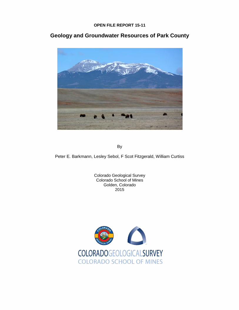
OPEN FILE REPORT 15-11
Geology and Groundwater Resources of Park County
By
Peter E. Barkmann, Lesley Sebol, F Scot Fitzgerald, William Curtiss
Colorado Geological Survey Colorado School of Mines
Golden, Colorado 2015
ii
TABLE OF CONTENTS
TABLE OF CONTENTS ........................................................................................................................ ii
LIST OF FIGURES ............................................................................................................................... iv
LIST OF PLATES ................................................................................................................................. iv
LIST OF TABLES .................................................................................................................................. v
ACKNOWLEDGMENTS ....................................................................................................................... vi
INTRODUCTION .................................................................................................................................... 1
BACKGROUND AND PURPOSE ............................................................................................................ 1
GEOLOGY OF PARK COUNTY ........................................................................................................... 3
REGIONAL SETTING .............................................................................................................................. 3
MAJOR ROCK UNITS AND STRATIGRAPHY ....................................................................................... 5 Precambrian Crystalline Bedrock ............................................................................................ 10 Paleozoic through Early Mesozoic Sedimentary Units ......................................................... 12
Cambrian through Mississippian Units ..................................................................................... 12
Pennsylvanian and Permian Sedimentary Units Associated with the Ancestral Rocky Mountains .................................................................................................................................. 14
Jurassic Sedimentary Units ...................................................................................................... 15
Cretaceous Seaway Sedimentary Units .................................................................................. 16 Laramide Sedimentary Units .................................................................................................... 17 Tertiary and Cretaceous Igneous Intrusions .......................................................................... 19 Post-Laramide Volcanic Rocks and Sedimentary Units ....................................................... 20
Tertiary Volcanic Rock Units ..................................................................................................... 20
Tertiary Sedimentary Rock Units .............................................................................................. 22
Quaternary Alluvium and Glacial Deposits ............................................................................ 23
STRUCTURAL GEOLOGY .................................................................................................................... 24 Structural Evolution of Park County ....................................................................................... 27 Post-Laramide and Neogene Tectonism ................................................................................. 31 Evaporitic Tectonism in South Park ........................................................................................ 31 Primary Structural Features ..................................................................................................... 34
GROUNDWATER IN PARK COUNTY ................................................................................................ 37
CRYSTALLINE ROCK AQUIFERS ....................................................................................................... 40 Precambrian Crystalline Bedrock ............................................................................................ 40
Precambrian Igneous Rocks ..................................................................................................... 41
Precambrian Metamorphic Rocks ............................................................................................. 41
Tertiary and Cretaceous Igneous Intrusions .......................................................................... 42 Tertiary Volcanic Rocks ............................................................................................................ 43
SEDIMENTARY BEDROCK AQUIFERS AND CONFINING UNITS ..................................................... 43 Paleozoic and Early Mesozoic Hydrogeologic Units ............................................................. 43
Older Paleozoic Formations ...................................................................................................... 43
Belden Formation ...................................................................................................................... 44
Minturn Formation ..................................................................................................................... 45
Maroon Formation ..................................................................................................................... 46

iii
Garo Sandstone ........................................................................................................................ 46
Morrison Formation ................................................................................................................... 47
Cretaceous Seaway Hydrogeologic Units .............................................................................. 47 Dakota Sandstone ..................................................................................................................... 47
Benton/Niobrara Unit................................................................................................................. 48
Pierre Shale .............................................................................................................................. 49
Laramie-Fox Hills Aquifer .......................................................................................................... 49
Laramide Hydrogeologic Units ................................................................................................ 50 South Park Formation and Echo Park Alluvium ....................................................................... 50
Post-Laramide Sedimentary Units ........................................................................................... 51 Tallahassee Conglomerate ....................................................................................................... 51
Antero Formation ...................................................................................................................... 51
Wagontongue/Trump Formation ............................................................................................... 52
UNCONSOLIDATED QUATERNARY DEPOSITS ................................................................................ 53 Alluvial Aquifer .......................................................................................................................... 53 Glacial Deposits ......................................................................................................................... 53
GROUNDWATER FLOW CONDITIONS ............................................................................................... 54 Aquifer Recharge and Discharge ............................................................................................. 54 Groundwater Storage ................................................................................................................ 58 Structural Elements and Groundwater Flow .......................................................................... 58 Water-level Conditions and Direction of Groundwater Flow ................................................ 59
REFERENCES ..................................................................................................................................... 63
iv
LIST OF FIGURES
1. Regional map of Park County.
2. Park County stratigraphic column.
3. Structural setting of Park County.
4. Principal structural features in Park County.
5. Pre-South Park Formation outcrop patterns.
6. Map of structural zones in Park County.
7. Average annual precipitation over Park County.
8. Generalized direction of groundwater flow in Park County.
LIST OF PLATES
1. Geologic map of Park County.
2. Cross-sections through Park County.
3. Hydrogeologic Unit Map: Precambrian Crystalline Bedrock.
4. Hydrogeologic Unit Map: Tertiary and Cretaceous Intrusive and Volcanic Igneous
Rocks.
5. Hydrogeologic Unit Map: Older Paleozoic Formations.
6. Hydrogeologic Unit Map: Belden Formation.
7. Hydrogeologic Unit Map: Minturn Formation.
8. Hydrogeologic Unit Map: Maroon Formation.
9. Hydrogeologic Unit Map: Garo Sandstone.
10. Hydrogeologic Unit Map: Morrison Formation.
11. Hydrogeologic Unit Map: Dakota Sandstone.
12. Hydrogeologic Unit Map: Benton/Niobrara.
13. Hydrogeologic Unit Map: Pierre Shale.
14. Hydrogeologic Unit Map: Laramie-Fox Hills Aquifer.
15. Hydrogeologic Unit Map: Laramide Sedimentary Units.
16. Hydrogeologic Unit Map: Tallahassee Creek Conglomerate.
17. Hydrogeologic Unit Map: Antero Formation.
18. Hydrogeologic Unit Map: Wagontongue-Trump Formation.
19. Hydrogeologic Unit Map: Unconsolidated Quaternary Deposits.

v
LIST OF TABLES
1. Geologic Map Sources.
2. Mapped Units in the Precambrian Crystalline Basement.
3. Summary of Age Dates for Tertiary and Cretaceous Intrusive and Volcanic Igneous
Rocks.
vi
ACKNOWLEDGMENTS
This project was funded by a grant from the Colorado Water Conservation Board (CWCB)
matched by the Colorado Geological Survey through its Severance Tax Operational Funds.
Many people contributed to this project indirectly over the years. Development of the
generalized geologic map builds on many hours of field mapping by CGS and USGS
geologists and special recognition goes to Robert Kirkham, Cal Ruleman, Beth Widmann,
and Alex Scarbrough, Jr
1
INTRODUCTION
BACKGROUND AND PURPOSE
Park County has experienced considerable population growth in recent decades with development
becoming increasingly reliant on local groundwater resources. A diverse geologic setting
characterizes the County and groundwater can be found in many different geologic settings. The
County also plays an important regional role as watershed of the South Platte River. The watershed
is a recreational mecca with over 1.6 million acres of public lands; provides municipal water for about
three quarters of Colorado’s residents; is renowned for its "gold-medal" fishing streams; and is home
to numerous threatened and endangered species.
South Park, with its diverse geology, has long been recognized for its mineral resource potential
including historic hard-rock metal mining, placer gold mining, coal and peat mining and renewed
interest in petroleum and uranium resources. Recent interest in petroleum potential in the Niobrara
Formation through leasing by the United States Bureau of Land Management (BLM, 2013) sparked
local concern in South Park over possible harmful impacts to local water resources.
This product compiles the most recent geologic mapping and interpretations focusing on
groundwater occurrences in the various geologic formations found in the area. It has been prepared
as a web-based product with the general public in mind, although it contains detailed background to
be beneficial to more technical users. The intent is to create a framework that illustrates the variety
of geologic formations and how groundwater resources fit in the many geologic settings across the
County. Because of the regional nature of this effort, detailed specifics are not presented. Aquifer
specifics would require site-specific data and interpretation. For many aquifers and areas site-
specific data simply are not available in the public domain. This effort should help guide future data
gathering efforts that would be very useful for detailed assessments on an aquifer-by-aquifer basis
and area-by-area basis.
#*
#*
#*
#*
#*
#*
#*
#*
#*
#*
#*
#*
#*
#*
#*
#*#*
#*
#*
#*#*
#*
#*
#*
#*
#*
#*
#*
#*
#*
#*
#*
#*
#*
#*
#*
#*
#*
#*
#*
#*
#*
#*
#*
#*
#*
#*#*
#*
#*
#*
#*
#*
#*
#*
#*
#*
#*
#*
#*
#*
#*
#*
#*
#*
#*#*
#*
#*
#*
VAILAVON
ALMA
DENVER
SALIDA
PITKIN
FRASER
DILLONFRISCO
VICTOR
GOLDEN
ARVADAEMPIRE
BONANZA
MINTURN
BOULDER
BOW MAR
FAIRPLAY
ROCKVALE
SUPERIOR
MORRISON
LAKESIDE
LAKEWOOD
SHERIDAN
GLENDALE
THORNTON
LONE TREE
LEADVILLE
MONTEZUMA
BROOKSIDE
RED CLIFF
LITTLETON
LAFAYETTENEDERLAND
COAL CREEK
CANON CITY
BLUE RIVER
NORTHGLENN
GEORGETOWN
BROOMFIELD
BLACK HAWK
LOUISVILLE
BUENA VISTA
PALMER LAKE
WHEAT RIDGE
WESTMINSTER
WINTER PARK
BRECKENRIDGE
SILVERTHORNE
CENTRAL CITY
SILVER PLUME
CRIPPLE CREEK
WOODLAND PARK
IDAHO SPRINGS
PONCHA SPRINGS
MANITOU SPRINGS
PROSPECT HEIGHTS
COLUMBINE VALLEY
GREEN MOUNTAIN FALLS
Denver Basin
South Park
Rampart Range
Rocky Mountain Front Range Uplift
Upper Arkansas Valley
Sawatch Range
Mosquito Range
Tarryall Range
Sawatch UpliftRio Grande Rift
Arkansas Hills
South Park BasinElkhorn Upland
Figure 1. Regional map of Park County. Park county sits high in the Rocky Mountains in close proximity to the Denver Metropolitan Region and encompasses the watershed of the vital South Platte River. Its diverse geography includes high alpine settings, rough forested hill and canyon country, and vast open parklands. Easy access to the Front Range population centers has made the area a favorite for outlying residences, recreation, hunting, fishing and other wildlife appreciation, and history buffs.
¯0 10 205 Miles Line of Cross-section in Figure 3
3
GEOLOGY OF PARK COUNTY
REGIONAL SETTING
Park County (Figure 1) straddles two very different geologic terrains that share a long and complex
history. The east side of the County extends into the Precambrian cored Front Range uplift of the
Rocky Mountains. It is comprised primarily of crystalline igneous and metamorphic rocks displaying
complex patterns of deformation. This eastern part of the County is drained by the North Fork of the
South Platte River and its upper tributaries.
The west side of the County covers the South Park topographic basin, a 50 miles long by 35 miles
wide structural feature shaped by a long and varied history of geologic processes (Stark and others,
1949; De Voto, 1971; Scarbrough, 2001; Ruleman and others, 2011). It is contains a wide variety of
crystalline igneous and metamorphic rocks, sedimentary units, volcanic rocks, and igneous rocks
ranging in age from Precambrian through Cenozoic (Figure 2). The basin is bound on the west by
the Mosquito Range and the south by the Thirtynine Mile and Arkansas Hills. Within the basin lies
the rolling Elkhorn Upland, as used herein, between Jefferson and Hartsel as well as the Red Hill
Hogback between Red Hill Pass and Hartsel. Major streams draining South Park include various
forks of the South Platte River and Tarryall Creek, which have headwaters in the Mosquito Range
and Boreas Pass area, respectively. These tributaries converge and exit through the Rampart
Range at the south end of South Park near Lake George.
Generally speaking, the South Park basin is an eastward-dipping block of sedimentary rocks
preserved between uplifts of Precambrian igneous and metamorphic rocks (Figure 3). Locally,
Cretaceous and Tertiary igneous stocks, sills, and dikes intrude these rocks. Remnants of formally
widespread Tertiary volcanic, lacustrine, and fluvial deposits overly the older rocks in many parts of
the basin. The high ranges bordering South Park were deeply sculpted by Quaternary glaciers that
produced debris deposited in extensive moraine complexes and outwash plains extending well into
the basin.
Structurally, the basin is quite complex, dominated by the Laramide Sawatch uplift on the west and
Front Range uplift on the east. Internally, the basin contains faulting and folding (Figure 4) attributed
by many Late Cretaceous to Eocene Laramide deformation (Stark and others, 1949; De Voto, 1971;
Chapin and Cather, 1983; Scarbrough, 2001). Deformation styles attributed to the Laramide event
include thrust faulting, folding, and possible strike-slip faulting with widespread zones of deformation
affecting most of the basin. The Neogene Rio Grande Rift system follows the upper Arkansas River
valley just to the west, where it bisects the Laramide Sawatch uplift into the main Sawatch Range
and the Mosquito Range, the latter forming the west boundary of South Park. Evidence of Neogene

4
deformation related to the Rio Grande Rift can be found throughout South Park, as described by
Ruleman and others (2011). In addition, there is evidence of ongoing local deformation related to
dissolution and possible collapse of Paleozoic evaporite deposits (Kirkham and others, 2012).
5
MAJOR ROCK UNITS AND STRATIGRAPHY
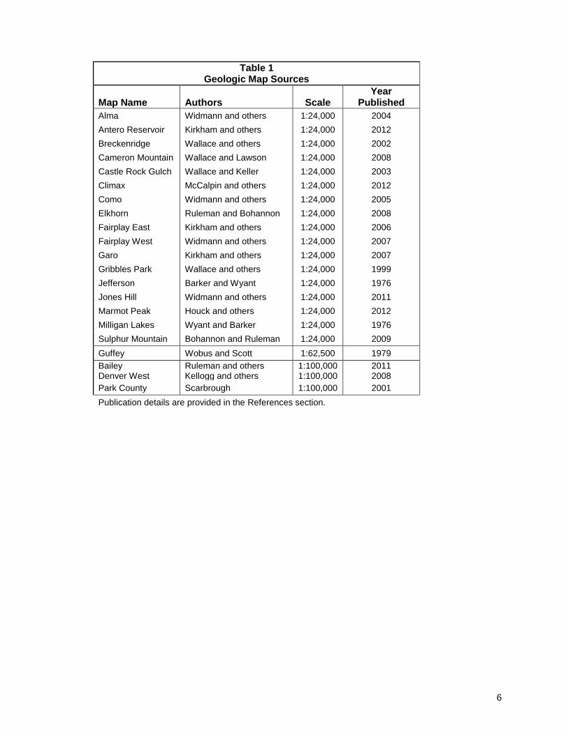
This effort incorporates results of mapping at different scales from many sources spanning decades
of work by many authors. Table 1 lists spatial data sources grouped by mapping scales. Primary
sources consist of recent 1:24,000 quadrangle geologic maps produced by the CGS National
Cooperative STATEMAP program and the USGS 1:100,000 30’ X 60’ quadrangle series. Data from
older or smaller scale maps have been used to fill in where detailed mapping has not been available.
Over the years geologic mapping has expanded upon and enhanced the understanding of the
origins of the many units present in the region. Nomenclature of the geologic units has changed
through this evolution in geologic interpretation. This effort uses the most recent nomenclature as
published in the public domain, as shown in Figure 2. The following discussion groups formations by
geologic settings that led to similar enough characteristics to simplify the geologic setting with
respect to groundwater resources and energy resources. Plate 1 is a generalized geologic map that
groups formations as units in the same manner. Plate 2 contains cross-sections through the county
that portray a three-dimensional view of the geology at depth as interpreted from surface outcrop
patterns and limit subsurface data. This section describes the major geologic formations mapped in
the County and the section that follows places them in context of groundwater resources that
includes mapped extent and current groundwater use patterns.
6
Table 1 Geologic Map Sources
Map Name Authors Scale Year
Published
Alma Widmann and others 1:24,000 2004
Antero Reservoir Kirkham and others 1:24,000 2012
Breckenridge Wallace and others 1:24,000 2002
Cameron Mountain Wallace and Lawson 1:24,000 2008
Castle Rock Gulch Wallace and Keller 1:24,000 2003
Climax McCalpin and others 1:24,000 2012
Como Widmann and others 1:24,000 2005
Elkhorn Ruleman and Bohannon 1:24,000 2008
Fairplay East Kirkham and others 1:24,000 2006
Fairplay West Widmann and others 1:24,000 2007
Garo Kirkham and others 1:24,000 2007
Gribbles Park Wallace and others 1:24,000 1999
Jefferson Barker and Wyant 1:24,000 1976
Jones Hill Widmann and others 1:24,000 2011
Marmot Peak Houck and others 1:24,000 2012
Milligan Lakes Wyant and Barker 1:24,000 1976
Sulphur Mountain Bohannon and Ruleman 1:24,000 2009
Guffey Wobus and Scott 1:62,500 1979
Bailey Denver West
Ruleman and others Kellogg and others
1:100,000 1:100,000
2011 2008
Park County Scarbrough 1:100,000 2001
Publication details are provided in the References section.
Antero Fm. (up to 2,000)
Tallahassee Ck. Congl. (up to 800)
Wall Mtn. Tuff and Buffalo Peaks Volc. (up to 1,200)
Echo Park Alluvium (50 to 1,000)
Laramie Formation (up to 375)
Pierre Shale (4,200–5,300)
Niobrara Formation (400–550)
Fox Hills Sandstone (up to 350)
Syntectonic Conglomerate (up to 300)
Fine-grained Arkose Member.
(up to 3,000)
Link Spring Tuff Memb. (~200)
Conglomerate Memb. (1,200 –5,100)
Reinecker Ridge Volcanic Member
(300 –900)
Thirtynine Mile and Guffey Mtn. Volcanics
(up to 2,600)
Benton Group (~250)
Dakota Sandstone (250–300)
PALE
OC
ENE
UPP
ER C
RET
ACEO
US
LOW
ER C
RET
.
Sout
h Pa
rk F
orm
atio
n
GEOLOGIC UNIT(THICKNESS IN FT)AGE LITHOLOGY EXTENT
MAPIDENT.
ENERGYRESOURCE
HYDRO-UNIT
QUA
TERN
ARY
MIO
CENE
EOCE
NEO
LIG
OCE
NE
PleistoceneAlluvium, Outwash, and
Glacial Drift(up to 150)
HoloceneAlluvium(up to 20)
(500–1,400)
Wagontongue Fm.Trump Sandstone
?
? ?
PARK COUNTY STRATIGRAPHIC COLUMN, QUATERNARY THROUGH CRETACEOUS UNITS
gravel, sandstone, and
siltstone
limited to south and
west of Hartsel
limited to southwest
part of South Park
limited to southwest
part of South Park
andesite and basalt flows,
flow breccias,
conglomerates, and
ash-flows
conglomerate, shale,
sandstone, limestone,
ash-flow tuff
conglomerate with sand and
silt
conglomerate with sand
gravel, sand, and boulders
lenticular sandstone,
conglomerate, siltstone and
mudstone
lenticular conglomerate,
sandstone, siltstone and
mudstone
conglomerate, sandstone,
andesite flows and breccia
shale, sandstone, and coal
shale, sandstone, bentonitic
layers
sandstone, pebble
conglomerate, and shale
calcareous shale and
limestone
shale, limestone, and
bentonite beds
sandstone and minor shale
rhyolitic ash-flow tuff,
andesite, flow breccias
laminated tuff, breccia, and
andesite flows
gravel, sand, clay, peat;
unstratified glacial drift
widespread in valleys
and along rivers and
tributaries
historic peat
mining
uranium
potential
uranium
potential
Alluvial
Aquifer
Wagontongue/
Trump
Aquifer
Antero
Aquifer
local source in
granular layers
and fractures
limited to south and
west of Hartsel
very limited south of
Hartsel
uranium
potential
limited to west side and
south of Hartsel
limited to Sevenmile
and Link Spring areas
limited to a belt
between Jefferson and
Spinney Mountain
Reservoir
Upper South
Park
Aquifer
limited to Link Spring
Ridge areaconfining unit
limited to a belt
between Jefferson and
Spinney Mountain
Reservoir
Lower South
Park
Aquifer
limited to Reinecker
Ridge area
lower part a
confining unit
limited between
Jefferson and Spinney
Mountain Reservoir
coal,
methane, and
uranium
potential
Laramie-Fox
Hills Aquifer
confining unit
limited to the central
part of South Park
confining unit,
but sand beds
and fractures
can be a local
source
limited to the central
part of South Park
oil and gas
potential
limited to the central
part of South Park
limited to the central
part of South Park
oil and gas
potentialDakota Aquifer
Qua
tern
ary
Allu
vium
and
Gla
cial
Dep
osits
Post
-Lar
amid
e Vo
lcan
ic R
ocks
and
Sed
imen
tary
Uni
tsLa
ram
ide
Sedi
men
tary
Uni
ts
Tallahassee Ck.
Aquifer
peaks and buttes,
areas of recharge
Glacial
Deposits
Echo Park
Aquifer
Cret
aceo
us S
eaw
ay S
edim
enta
ryU
nits
Figure 2a. Park County Stratigraphic Column, Quaternary through Cretaceous Units
Garo Formation (60-230)
Maroon Formation (up to 3,300)
Morrison Formation180–360
Anc
estr
al R
ocky
Mou
ntai
n Se
dim
enta
ry U
nits
Cam
bria
n th
roug
h M
issi
ssip
pian
n Se
dim
enta
ry U
nits
Prec
ambr
ian
Rock
s
PARK COUNTY STRATIGRAPHIC COLUMN, JURRASIC THROUGH PRECAMBRIAN UNITS
Figure 2b. Park County Stratigraphic Column, Jurassic through Precambrian Units
MAPIDENT.
Chaffee Group (80-200)
Upper Interval (up to 5,000)
Evaporite Facies (up to 1,000)
Coffman Member (up to 800)
Belden Formation(750-850)
[Kerber/Sharpsdale Fms.]
MIS
SISS
-IP
PIAN
DEV
ON
IAN
OR
DO
VIC
IAN
CAM
BRIA
NPR
ECAM
BRIA
N
Min
turn
For
mat
ion
GEOLOGIC UNIT(THICKNESS IN FT)AGE LITHOLOGY EXTENT
ENERGYRESOURCE
HYDRO-UNIT
PENN
SYLV
ANNI
ANJU
RR
AS
ICP
ER
MIA
N
?
?
?
Lower Interval (200)
Leadville Limestone(100-400)
Fremont Dolomite
Harding Sandstone80–200
Manitou Formation65–230
Dotsero Formation and Sawatch Quartzite
10–250
Precambrian Igneous and Metamorphic Rocks
igneous plutons of varying composition and age with felsic gneiss and biotite gneiss
shale, sandstone, siltstone, basal limestone
sandstone and conglomerate
sandstone, siltstone, shale, conglomerate, and rare limestone
sandstone, siltstone, shale, conglomerate, and limestone
sandstone, siltstone, shale, conglomerate, and limestone
shale with minor limestone and siltstone;sandstone and conglomerate
limestone and dolomite with chert and beds of quartz sandstone
quartzite, dolomite, and limestone
quartzite
quartzite and dolomitic sandstone
dolomite
dolomite and shale
includes beds of gypsum and halite
limited to the central part of South Park from Boreas Pass to Hartsel
potential uranium
confining unit, can yield water in porous zones
limited to the central part of South Park
Garo SSAquifer
widespread over west-central part of South Park
Maroon Fm. Unit, variable, with porous zones interbeded with confining shales
widespread over west-central part of South Park
Minturn Fm. Unit, variable, with porous zones interbeded with confining shales
widespread over west-central part of South Park
widespread over west-central part of South Park
can be source of saline and sulfate-rich waterporous zones interbeded with confining shales
limited to west side of South Park
Belden Fm. Unit, variable
limited to west side of South Park
limited to west side of South Park
limited to west side of South Park
limited to west side of South Park
limited to west side of South Park
widespread over the east side of South Park and limited exposures in southern and western regions
Older PaleozoicFormations Unit,fractures and solution channels provide potential local groundwater
Precambriancrystalline bedrock aquifer
uranium potential
Approximately 70 miles(see Figure 1 for location)
Paleozoic Sediments
Mesozoic Sediments
Precambrian Metamorphic and Igneous RocksPrecambrian Metamorphic and Igneous Rocks
and Scattered Tertiary Igneous Rocks
PARK COUNTYCHAFFEE COUNTY JEFFERSON COUNTY
Tarryall-Kenosha-South Platte River Ranges
North Fork South Platte River Valley
Elkhorn Upland
Mosquito RangeSawatch Range
Upper Arkansas River Valley
FRONT RANGE UPLIFT
SAWATCH UPLIFT
SOUTH PARK BASIN
RIO GRANDE RIFT
Elkhorn Fault
Boundary of Paleozoic
Central Colorado Trough
Weston-Bu�
alo Creek Fault
SW NE
Figure 3. Structural Setting of Park County. Park County straddles three major structural blocks. Laramide uplifts that expose cores of Precambrian crystalline bedrock bound a basin that preserves Cambrian through Paleocene sedimentarystrata. The younger Rio Grande rift system cuts through the Sawatch uplift west of the county, forming the Upper Arkansas Valley in Chaffee and Lake Counties.
10
Precambrian Crystalline Bedrock
Precambrian crystalline igneous and metamorphic rocks are exposed at the surface, or can be found
near the surface, in four areas in the Park County region. These old rocks are widely exposed in the
Front Range uplift core underlying the eastern half of the County as well as on the west side of
South Park in the core of the bounding Mosquito Range of the Sawatch uplift. Although these
crystalline rocks tend to be very resistant to erosion and form high mountain ranges, in South Park
they are also found in the rolling Elkhorn Upland between Jefferson and Hartsel. Precambrian
igneous rocks also appear as isolated outcrops beneath Tertiary volcanic and sedimentary cover
between Hartsel and Thirtynine Mile Mountain. Elsewhere in South Park these rocks are deeply
covered by younger units.
Table 2 lists the many crystalline rock types mapped within the County. Basement rocks include
older Paleoproterozoic (1,700 to 1,800 million year [Ma] old, designated by “X” in Table 2) gneiss of
varying composition intruded by granite and quartz diorite. Mesoproterozoic (approximately 1,400
Ma, designated by “YX” in Table 2) granite and monzogranite intrude the older units. The youngest
of the Precambrian rocks found in Park County are the approximate 1,100 Ma granitic intrusives
(designate by “Y”), dominated by the Pikes Peak Batholith, and its many phases, exposed across
much of east side of the County. The suite of Precambrian igneous and metamorphic rocks are well
summarized in Ruleman and others (2011) and Kellogg and others (2008).
11
Table 2 Mapped Units in the Precambrian Crystalline Basement
Unit Type Description
Xb Metamorphic Biotite gneiss, well-foliated biotite-quartz-plagioclase gneiss and schist. Can include lenses of other metamorphic rocks and pods of igneous rocks.
Xbm Meta-igneous Mixed metamorphic and igneous rocks. Primarily Biotite gneiss with primarily granitic pods derived from partial melting.
Xbs Metamorphic Biotite-sillimanite gneiss and schist. Can include muscovite, quartz, hornblende and local garnets.
Xca Metamorphic Calc-silicate gneiss, marble, and amphibolite. Calc-silicate contains clinopyroxene, hornblende, calcite, epidote, scapolite and sphene. Marble contains clinopyroxene, hornblende. Thin lenses of quartzite also present.
Xf Metamorphic Quartz-feldspar gneiss. Moderately to well foliated quartz-plagioclase-microcline-biotite gneiss. Locally contains foliated monzogranite and granodiorite. Minor thin layer of hornblende gneiss and amphibolite.
Xfh Metamorphic Quartz-feldspar gneiss and hornblende gneiss. Well foliated quartz-feldspar gneiss, with equal proportions of hornblende-plagioclase gneiss and amphibolite. Locally contains few layers of calc-silicate rock lenses.
Xgd Metamorphic Granodiorite. Well foliated medium to coarse grained biotite and hornblende-biotite-granodiorite.
Xgg Metamorphic Granitic gneiss. Strongly foliate monzogranite, granodiorite, and trondhjemite. Lesser amounts of biotite, hornblende and muscovite. Local abundant xenoliths of biotite gneiss..
Xh Metamorphic Hornblende-plagioclase gneiss and amphibolite. Weakly to strongly foliated, layered hornblende-plagioclase gneiss and amphibolite containing variable amounts of biotite, quartz and augite.
Xhc Metamorphic Hornblende gneiss and calc-silicate gneiss. Interlayered hornblende-plagioclase gneiss and amphibolite with lesser amounts of interlayered calc-silicate gneiss. Locally contain layers of marble.
Xmg Metamorphic Gabbro and mafic rocks. Pyroxene
Xqd Metamorphic Quartz-diorite. Massive to strongly foliated locally porphyritic biotite and biotite-hornblende quartz diorite. Contains abundant locally derived xenoliths of biotite gneiss and schist.
Xqg Metamorphic Massive to strongly foliated monzogranite and granodiorite. Locally intruded by monzogranite Yg.
Ycc Igneous Cripple Creek Quartz Monzonite, Biotite-muscovite, quartz monzonite.
Yem Igneous Quartz monzonite of Elevenmile Canyon. Medium-grained porphyritic biotite quartz monzonite.
Yg Igneous Monzogranite and granite. Biotite-muscovite monzogranite, biotite monzogranite, and leucogranite. Contains aplite and pegmatite. Locally foliated garnet and sphene are accessory minerals.
YgdM Igneous Mount Evans Batholith. Metaluminous granodiorite and monzogranite. Strongly foliated porphyritic biotite-hornblende granodiorite. Ranges in composition from monzogranite to tonalite. Locally contains up to 5% of an aplite-pegmatite, phase consisting of dikes and irregular bodies of massive, weakly foliated aplite and magnetite-bearing pegmatite.
YgP Igneous Pikes Peak Granite. Subequigranular biotite and biotite-hornblende granite with feldspar crystals.
YgPcp Igneous Pikes Peak coarse-grained porphyritic phase. Seriate porphyritic biotite granite with tabular microcline phenocrysts. Intruded by fine-grained porphyritic granite.
YgPf Igneous Pikes Peak fine-grained granite. Equigranular biotite granite.
YgPfp Igneous Pikes Peak fine-grained porphyritic granite. Porphyritic biotite granite with phenocrysts of spherical gray quartz, and subhedral microcline and oligoclase are abundant. Fluorite is common accessory mineral.
YgPp Igneous Pink, fine to medium grained, massive porphyritic biotite granite with phenocrysts of spheroidal gray quartz. Subhedral microcline, and oligoclase.
YgPs Igneous Syenite and fayalite granite of Pikes Peak batholith. Pegmatitic syenite and fayalite granite. Fayalite granite is primarily composed of granite with minor amounts of fayalite. Perthitic feldspar and ferrorichterite amphibole are dominant. Fluorite, zircon and chevkinite are accessory minerals.
YgR Igneous Granite of Rosalie Peak. Equigranular to porphyritic biotite syenogranite and monzogranite. Locally contains Carlsbad-twinned microcline phenocrysts. Weak foliation defined by aligned biotite.
Ylg Igneous Quartz syenite and fayalite granite in discontinuous ring dikes. Alkali diorite containing andesite, augite, olivine and abundant secondary biotite. Syenomonzonite, dark green, augite-ferrohastingsite; Syenomonzonite in center of stock and ferrohastingsite syenite near margin of stock. Gabbro composed of andesine-labradorite, augite and biotite.
12
Table 2 (cont’d) Mapped Units in the Precambrian Crystalline Basement
Unit Type Description
Yqm Igneous Quartz-monzonite. Muscovite-biotite quartz monzonite; locally porphyritic with aligned tabular microcline phenocrysts. Unit includes Silver Plume Quartz Monzonite in Silver Plume batholith.
YXmr Meta-igneous Mixed metamorphic and igneous rocks. Contains at least two of the following units in equal proportions: Monzogranite (Yg), biotite gneiss and schist (Xb), and felsic gneiss (Xf). Xenoliths of Xb and Xf within unit Yg
YXp Igneous Pegmatite and aplite. Irregular pods and dikes primarily composed of massive quartz, perthitic microcline, albite, oligoclase, muscovite and biotite. Magnetite, garnet, tourmaline, and beryl are present locally.
YXqgm Meta-igneous Mixed metamorphic and igneous rocks. Consists of unit Xqg intruded into country rock consisting of biotite gneiss and schist and hornblende gneiss. Diffuse intrusions from Yg and Yxp.
Precambrian rocks have undergone a long history of varying depths of burial combined with multiple
episodes of deformation. Notable tectonic events include several during the Precambrian Era that
can be difficult to discretize, mountain-building tectonism during the Pennsylvanian Period, Laramide
mountain-building tectonism during Late Cretaceous through early Tertiary Periods, and recent
extensional tectonism associated with development of the Rio Grande Rift system. Each event
imparted its own fabric upon the ancient rocks, reflecting changes in stress patterns and depths of
burial.
Styles of deformation have varied and include highly ductile deformation combined with partial
melting under high temperatures and pressures to brittle deformation at cooler temperatures and low
pressures. Evidence of ductile deformation include dramatic and often contorted appearing fold in
the mineral banding of gneiss units. Brittle deformation includes dense fracture systems and
complex fault patterns. Many modern stream drainages follow very linear trends interpreted to be
major faults where weakened rocks in the fault zone are less resistant to erosion.
Paleozoic through Early Mesozoic Sedimentary Units
Cambrian through Mississippian Units Cambrian through Mississippian sedimentary rocks underlie the western half of South Park. These
units are present at, or near, the surface along a narrow band flanking the east side of the Mosquito
Range along the western County boundary. Prevailing dips of the strata and stratigraphic evidence
indicates that the units extend in an eastward direction through the subsurface into the South Park
Basin. In the subsurface the units truncate against a hypothesized buried edge believed to be a
bounding fault of the Late Paleozoic Ancestral Front Range Uplift (DeVoto, 1971; Ruleman and
others, 2011). Although surface outcrop is limited, the formations are recognized as major aquifers
in other parts of the state.
13
These sediments record a series of marine flooding events across the continent’s interior and
include the Cambrian Sawatch Quartzite and Dotsero Formation; Ordovician Manitou Formation,
Harding Sandstone and Fremont Dolomite; Devonian Chaffee Group; and Mississippian Leadville
Limestone. Descriptions that follow provide brief summaries of the individual formations. For more
detail the reader is directed to the source literature as referenced and listed in Table 1.
Sawatch Quartzite (Late Cambrian) overlies the Precambrian igneous and metamorphic rocks
separated by a nonconformity representing a time gap of nearly 600 Ma. It consists of white to
purple-pink fine- to medium-grained well-sorted quartz that can be glauconitic (Wallace and Keller,
2003; Widmann and others, 2004; Widmann and others, 2007, Houck and others, 2012). A basal
quartz-pebble conglomerate may also be present. Thickness ranges from 10 to 150 feet where
present.
Dotsero Formation (Late Cambrian) consists of fine- to medium-grained reddish-purple to maroon
quartzitic sandstone and dolomitic sandstone with thin dolomite beds (Widmann and others, 2004;
Widmann and others, 2007; Houck and others, 2012). Thickness is up to 90 feet where present.
Manitou Formation (Ordovician to Late Cambrian) is a cliff-forming gray dolomite with interbeds
of dark-gray limestone (Wallace and others, 1999; Widmann and others, 2004; Widmann and others,
2007; Houck and others, 2012). Thickness ranges from 65 to 230 feet in the area.
Harding Sandstone and Fremont Dolomite (Upper Ordovician) are often mapped together and
consist of the basal gray to dark-orange to purple, quartzitic sandstone with rare pebble
conglomerate overlain by gray to brown-gray dolomite (Widmann and others, 2004; Widmann and
others, 2007; Houck and others, 2012; Kirkham and others, 2012). The dolomite can have abundant
echinoderm parts and rare coral. Combined thickness ranges between 80 and 200 feet.
Chaffee Group (Late Devonian) includes the Parting Formation and Dyer Dolomite and is also
mapped as a single unit in this area. It consists of white, gray, to brown quartz sandstone with beds
of dolomitic sandstone overlain by light gray vuggy limestone and gray, massive to thinly bedded,
dolomite chert breccias (Widmann and others, 2004; Widmann and others, 2007; Houck and others,
2012; Kirkham and others, 2012). Combined thickness ranges between 80 and 200 feet.
Leadville Limestone (Lower Mississippian) consists of gray to blue-gray massive to medium-
bedded dolomite that can contain lenticular beds of white quartz sandstone as well as black and/or
red chert nodules (Widmann and others, 2004; Widmann and others, 2007; Houck and others, 2012;
Kirkham and others, 2012). Thickness ranges from 100 to 400 feet in the area.
14
Pennsylvanian and Permian Sedimentary Units Associated with the Ancestral Rocky Mountains Tectonic activity from Late Mississippian through Permian resulted in the development of a series of
uplifts and downwarps across the region. Downwarping resulted in advance of an interior seaway
across much of central Colorado for a period of time during the Pennsylvanian Period. The central
downwarp is often referred to as the Central Colorado Trough (DeVoto, 1972) and Nesse (200 ) has
proposed Anasazi Uplifts as a term for the uplifted ranges. As the ranges rose, erosion stripped off
the older Paleozoic sedimentary cover, exposing the Precambrian metamorphic and igneous cores
of the uplifts. Concurrently, clastic sediments, carbonates, and evaporite deposits accumulated in
the subsiding basins (DeVoto, 1971; Kirkham and others, 2007; Ruleman and others, 2011; Hauck
and others, 2012; Kirkham and others, 2012). Orientations of these ancient uplifts and basins are
not well constrained because of later tectonic deformation, but are approximately defined by the
distribution of the basins sediments that have survived subsequent tectonic disruption. Sediments
associated with this period of tectonic activity in Park County occur in the western half of South Park
and include the Belden, Minturn, and Maroon Formations. The Garo Sandstone is also included by
some as part of this interval. In the Gribbles Park area at the very southern of the County, the
interval includes the Kerber and Sharpsdale Formations.
Belden Formation (Middle and Early Pennsylvanian) is predominantly fine grained marine shale
with minor limestone, siltstone, and sandstone that is exposed along the western edge of South Park
(Wallace and Keller, 2003; Widmann and others, 2007; Widmann and others, 2011; Houck and
others, 2012). It can contain thin beds of fine-grained arkosic sandstone near its top and is
transitional with the overlying Minturn Formation. The unit has not been mapped in the northern part
of the Mosquito Range (Widmann and others, 2004) and it may thin to the east. Total thickness
reaches up to 1,200 feet near Jones Hill.
Kerber and Sharpsdale Formations (Middle and Early Pennsylvanian) are stratigraphically
equivalent to the Belden Formation and are found only in the very southern part of the County. The
units consist of reddish gray to grayish-red and drab conglomeritic arkose, shale, siltstone, and
limestone with rare beds of dolomite and gypsum (Wallace and others, 1999). The contact between
the two is conformable and the absence of limestone is used to differentiate the upper Sharpsdale
Formation from the Kerber Formation. Total thickness in the area is up to 450 feet.
Minturn Formation (Middle and Early Pennsylvanian) contains interbedded pebble to cobble
conglomerate, sandstone, siltstone, and limestone (Wallace and Keller, 2003; Widmann and others,
2007; Widmann and others, 2011; Houck and others, 2012). It includes the Coffman member, an
upper member and a lower member. These sediments record a period of intensified tectonic activity
15
of the Anazasi uplifts and development of the interior seaway. The Minturn Formation also includes
evaporitic facies that contains thick beds of salt and gypsum, evidence of restricted circulation and
high evaporation rates within the subsiding basin (Kirkham and others, 2007). Although the extent of
the evaporitic facies of the Minturn Formation is not well defined regionally, given the current level of
detail of surface and subsurface mapping, this facies has particular relevance to structural and water
quality aspects of this study. Detailed mapping in the vicinity of Antero Reservoir does suggest,
however, that there may be a considerable thickness of this facies over a widespread area. The
Minturn Formation is exposed at or near the surface throughout much of the western portion of
South Park and total thickness ranges between 900 and 7,000 feet.
Maroon Formation (Lower Permian to Upper and Middle Pennsylvanian) overlies, and is
gradational with, the Minturn Formation and is exposed in the central South Park just west of the
central hogback. It closely resembles the Minturn Formation in composition but has a redder color
and contains less limestone (Widmann and others, 2005; Kirkham and others, 2006; Kirkham and
others, 2012). The change reflects a transition away from a marine-dominated clastic wedge to a
sub-aerial fluvial clastic wedge (DeVoto, 1971; Kirkham and others, 2006). Total thickness reaches
up to 5,600 feet.
Garo Sandstone (Permian??) overlies the Maroon Formation and consists of calcareous
sandstone and conglomerate (Widmann and others, 2005; Kirkham and others, 2006; Kirkham and
others, 2007). The unit forms a conspicuous hogback that separates the western part of South Park
dominated by Paleozoic Rocks and the eastern part of the basin dominated by Mesozoic rocks and
the Elkhorn Upland. Age of the Garo Sandstone is uncertain and has been controversial.
Historically it was considered to be Jurassic in age (Singewald, 1942; Stark and others, 1949) and
possibly correlative with the Entrada Sandstone found further to the west in the Colorado Plateau
region (Scarbrough, 2001). It, and the upper part of the Maroon Formation, have also been mapped
as the Weber Formation (Patton and others, 1912; Tweto, 19 9), but that nomenclature is no longer
used (Widmann and others, 2005). DeVoto (1965) found evidence that the base of the Garo
Sandstone was conformable with the Maroon Formation. Recent mapping by Widmann and others
(2005) and Kirkham and others (2012) have adopted the Permian age for the unit. Thickness
ranges between 60 and 225 feet.
Jurassic Sedimentary Units Jurassic strata are represented by a relatively thin interval along the central hog back in South Park.
Here it is represented by the Morrison Formation (Upper Jurassic) which is made up of
interbedded shale, sandstone, claystone, and basal limestone (Widmann and others, 2005; Kirkham
and others, 2006; Kirkham and others, 2007). Thickness ranges from 200 to 350 feet.
16
Cretaceous Seaway Sedimentary Units
Cretaceous Seaway sedimentary units mark the encroachment and eventual retreat of the
Cretaceous Interior Seaway, herein referred to as Interior Seaway. Volumetrically, marine shale
dominates this group of sediments that accumulated over the 30 to 40 Ma period during which the
Interior Seaway occupied the region. Sedimentary units deposited during this period of marine
inundation identified in South Park include the Dakota Sandstone, Benton Group, Niobrara
Formation, Pierre Shale, Fox Hills Sandstone, and Laramie Formation. These units are genetically
linked by their direct association with the seaway, by being deposited in either strictly marine,
shoreline or coastal plain environments. They are preserved in a broad arcuate belt that extends
across the middle of South Park from the Continental Divide north of Como south to Hartsel.
Dakota Sandstone (Lower Cretaceous) lies above the Morrison Formation and the contact
appears to be disconformable, marked by evidence of erosion (Kirkham and others, 2007). This unit
consists of tan to light gray sandstone, pebble conglomerate, and non-calcareous shale (Widmann
and others, 2005; Kirkham and others, 2006; Kirkham and others, 2007) deposited along the
advancing Interior Seaway shoreline. Estimated thickness ranges between 175 and 450 feet.
Benton Group and Niobrara Formation (Upper Cretaceous) have limited surface exposure in
South Park and are sometimes mapped together although they are separated by a disconformity.
The Benton Group includes the dark gray shale and siltstone of the Graneros Shale; gray limestone,
sandstone, and calcareous shale of the Greenhorn Limestone; and black shale and calcareous
sandstone of the Carlile Shale (Widmann and others, 2005; Kirkham and others, 2006; Kirkham and
others, 2007). It rests conformably on the Dakota Sandstone. The Niobrara Formation consists of
the dense gray Fort Hays Limestone and thinly bedded brown calcareous shale and limestone of the
Smokey Hill Shale. The Niobrara Formation is the target of recent source bed petroleum exploration
throughout the Rocky Mountain region. The Benton Group ranges in thickness between 205 and
600 feet and the Niobrara Formation ranges in thickness between 350 and 500 feet.
Pierre Shale (Upper Cretaceous) consists of gray calcareous marine shale with thin beds of fine- to
very fine-grained sandstone that conformably overlies the Niobrara Formation (Widmann and others,
2005; Kirkham and others, 2006; Kirkham and others, 2007). Thickness is difficult to estimate and
the formation may be highly deformed in South Park, but estimates reach upwards of 6,000 feet
(Barker and Wyant, 1976). It also appears that the upper part was removed by erosion prior to
deposition of the younger South Park Formation in the southern part of South Park where only
between 2,000 and 2,500 feet remain (Kirkham and others, 2007).
17
Fox Hills Sandstone and Laramie Formation (Upper Cretaceous) were deposited in near-shore
and beach environments of the retreating Interior Seaway. The Fox hills Sandstone is transitional
with the underlying Pierre Shale and consists of yellow-brown to gray-brown fine to medium-grained
sandstone (Ruleman and Bohannon, 2008). Eastward retreat of the Seaway caused individual
overlapping sandstone bodies to climb up-section and become progressively younger to the east.
Total thickness is estimated to be between 150 and 350 feet. It may have been removed by erosion
prior to deposition of the younger South Park Formation in the southern part of South Park (Kirkham
and others, 2007; Ruleman and Bohannon, 2008). In this area the South Park Formation directly
overlies a thinned section of Pierre Shale.
The Laramie Formation is a non-marine coastal plain deposit that is transitional to, and interfingers
with, the Fox Hills Sandstone. It consists of overbank shale interbedded with lenticular beds of
sandstone and coal (Wyant and Barker, 1976) deposited on a low-relief coastal plain following the
retreat of the Interior Seaway. This formation includes coal beds near its base that were exploited in
the 19th and early 20th century. Thickness is estimated to be up to 300 feet and the formation has
not been identified at the surface south of Milligan Lakes. In the southern area it either cannot be
differentiated from the Fox Hills Sandstone in the field or it may have been removed by erosion prior
to deposition of the younger South Park Formation.
Laramide Sedimentary Units
Upper Cretaceous, Paleocene, and Eocene sediments record the evolution of the Laramide uplift
throughout the Rocky Mountain region (Chapin and Cather, 1983; Raynolds, 1997). During this
period of uplift, which lasted from approximately 70 Ma to 50 Ma (Dechesne and others, 2011), a
series of Precambrian basement-core blocks rose to the surface while basins subsided between and
flanking the blocks. Clastic sediments shed off of the rising blocks accumulated in the basins.
Concurrent igneous activity contributed volcanic material to the sedimentary basin fill. Geometry
and style of uplift may have evolved and changed during this prolonged period of uplift and details
are still being unraveled through ongoing surface and subsurface mapping. Chapin and Cather
(1983) suggest that the Laramide uplift evolved through two major phases. These phases may have
been separated by a period of quiescence (Raynolds, 1997).
The South Park Formation has been subdivided into six members, both formal and informal, listed
below in order from oldest to youngest. Differentiation is based on compositional differences
reflecting changes in source areas as Laramide tectonism evolved (Ruleman and others, 2011).
Lower volcaniclastic member (Upper Cretaceous), is a localized basal member derived from
nearby volcanic sources. It consists of poorly sorted reddish-brown to greenish-brown medium- to
18
coarse-grained sandstone with fragments of volcanic rocks believed derived from, a local source
(Kirkham and others, 2006).
Reinecker Ridge Volcanic Member (Paleocene and Upper Cretaceous) contains flows and
breccias of trachyandesite, andesite, and dacite (Widmann and others 2005; Kirkham and others,
2006). It varies in color from purple-gray and brown to greenish-gray, to deep red and contains thin
discontinuous layers of gray tuffaceous sandstone and siltstone. Radiometric age dating indicates
an age of approximately 67 to 69 Ma for this unit. Thickness relationships indicate a possible source
to the north (Kirkham and others, 2006). Thickness reaches up to 2,000 feet.
Conglomerate member (Paleocene) overlies the Reinecker Ridge Member and consists of
yellowish-brown, brown, greenish-brown, and greenish-gray conglomerate interbedded with
sandstone and mudstone that are partially volcaniclastic or tuffaceous. Finer-grained sandstone
dominates the unit to the south near Sulphur Mountain. It contains clasts of the older volcanic
material mixed with clasts of limited Precambrian basement, Paleozoic rocks, and Cretaceous
intrusives indicating a source from the Sawatch uplift to the west (Widmann and others, 2005;
Kirkham and others, 2006; Ruleman and Bohannon, 2008). Radiometric age dating of a tuff bed
indicates an age of approximately 66 Ma for this unit (Bryant and others, 1981b). Thickness ranges
between 1,200 and 5,200 feet.
Link Springs Tuff Member (Paleocene) overlies the lower conglomerate member and consists of
yellowish-brown to gray laminated tuff with some volcaniclastic breccia and andesitic flows as well
as minor cobble conglomerate (Wyant and Barker, 1976; Ruleman and others, 2011). Radiometric
age dating indicates an age of approximately 60 Ma for this unit (Bryant and others, 1981b). The
unit is found south of Milligan Lakes and reaches a thickness of about 600 feet. It thins both to the
north and south where it eventually pinches out.
Fine-grained arkosic member (Paleocene) unconformably overlies the Link Springs Tuff Member
in the north and the conglomerate member in the south; however, it is not present as far south as
Sulphur Mountain. It consists of pale-brown, greenish-gray, and gray calcareous mudstone,
sandstone, siltstone, and conglomerate (Sawatzky, 1967; Wyant and Barker, 1976). The arkosic
content and lack of clasts of Paleozoic sedimentary rocks indicates a possible source from the Front
Range uplift to the east for this later unit. In the Milligan Lakes and Michigan Hill area it contains
layers of large-boulder conglomerate. Radiometric age dating of a tuff bed indicates an age of
approximately 56 Ma for this unit (Bryant and others, 1981b). Thickness is as much as 3,500 feet.
19
Syn-tectonic conglomeratic unit (Eocene?) is a poorly sorted, boulder-rich conglomerate believed
to be derived from local Precambrian sources and overlies the other South Park Formation members
(Ruleman and others, 2011). This unit occurs along the perimeter of the Elkhorn Upland and may
have been deposited during uplift of Precambrian rock to the east.
Echo Park Alluvium (Eocene) is not always considered part of the South Park Formation; however,
it is included in this section because of possible origins during the latest phases of the Laramide
uplift. This unit is a boulder-rich, poorly stratified alluvium containing clasts of Precambrian
crystalline rock and is limited to small areas in the southern part of South Park (Epis and others,
1974; Scarbrough, 2001). Chapin and Cather (1983) believe this unit was deposited as fault-bound
basins formed by regional wrench faulting at, or near, the end of the Laramide event. Total
thickness may be over 1,000 feet in fault-bound grabens and paleovalleys. The relationship of the
Echo Park Alluvium in the southern part of the basin to the syn-tectonic conglomeratic unit in the
north is not clear. The two units coincide with late phases of deformation following deposition of the
South Park Formation.
Tertiary and Cretaceous Igneous Intrusions
There are a number of igneous intrusions with Late Cretaceous through Tertiary ages in the South
Park region. The many units are listed in Table 3 from youngest to oldest. The largest, and oldest,
is the Whitehorn granodiorite laccolith that extends into the southwest corner of the County (Wallace
and Lawson, 2008). Many other mapped intrusions include sills, dikes, and small stocks of felsic to
intermediate composition concentrated in the Mosquito Range and Continental Divide (Scarbrough,
2001; Barker and Wyant, 1976; Widmann and others, 2004; Widmann and others, 2005; Widmann
and others, 2007).
Generally, igneous intrusive activity in the area falls into two episodes correlative with volcanic
activity in the region. Earlier intrusions between 56 and 70 Ma are coeval with Laramide deformation
and the Reinecker Ridge volcanic member of the South Park Formation. Later, more felsic,
intrusions between 33 and 49 Ma are coeval with post-Laramide volcanism and sedimentation
described below. The younger and more felsic intrusive bodies are more prevalent in the northern
part of the County where resistance to erosion of the intrusive rocks themselves as well as altered
host sediments holds up the high mountainous terrain.
20
Table 3 Summary of Age Dates for
Tertiary and Cretaceous Intrusive and Volcanic Igneous Rocks
Unit Map Symbol
Approximate Age (Ma)
Source
Basalt Tb Miocene Gribbles Park (Wallace and others, 1999)
Gribbles Peak Tuff Tg 32-33 Gribbles Park (Wallace and others, 1999)
Guffey Peak Volcanics Tgv Oligocene Guffey Peak (Epis and others, 1976)
Antero tuff bed Tat 34 Antero Reservoir (Kirkham and others, 2012)
Thirtynine Mile Volcanics Ttm 34 Guffey Mtn (Epis and others, 1974)
Later White Porphyry (Rhyolite) Tlw 33-35 Alma (Widmann and others, 2004)
Antero Ash Flow Tuff Tat 34 Antero Reservoir (Kirkham and others, 2012)
Monzogranite porphyry Tmm 35-40 Denver West (Kellogg and others, 2008)
Kenosha Pass Andesite Tan 37 Bryant (1981b)
Wall Mountain Tuff Twm 37 McIntosh and Chapin (1994)
Eocene Andesite Tva 38 Antero Reservoir (Kirkham and others, 2012)
Buffalo Peaks Volcanics Tbp 38 Marmot Peak (Houck and others, 2012)
Biotite quartz latite porphyry Tpb 38 Jefferson, date from Bryant (1981b)
Quartz monzonite porphyry Tqpm 37-49, 65 Alma (Widmann and others, 2004)
Monzonite porphyry Tmp 42-43 Alma (Widmann and others, 2004)
Monzodiorite porphyry Tmd 44 Alma (Widmann and others, 2004)
Quartz monzonite Porphyry (Early Tqp 37-49 Fairplay West (Widmann and others, 2007)
South Park Fm tuff in Fine-grained arkosic member
Tsf 56 Bryant (1981b)
Link Spring Tuff Tsl 60 Elkhorn, Jefferson, date from Bryant (1981b)
Porphyritic intrusion Ti 61 Antero Reservoir (Kirkham and others, 2012)
Granite porphyry of Tumble hill Tgp2 60 Jones Hill (Widmann and others, 2011)
Granite Porphyry of Black Mtn Tgp1 61 Jones Hill (Widmann and others, 2011)
Sparse quartz monzonite Tsqm Alma (Widmann and others, 2004)
Diorite of Buckskin gulch Td 42, 67-72 Alma (Widmann and others, 2004)
Conglomerate Mmbr S Park Fm tuff bed
Tsc 66 Bryant (1981b)
Reinecker Ridge Volcanic Mmbr TKsr 67-69 Como and Fairplay East (Widmann and others, 2005; Kirkham and others, 2006)
Granite Porphyry TKg 64-70 Fairplay West, (Widmann and others, 2007)
Whitehorn Granodiorite Kw 69-70 Cameron Mtn (Wallace and Lawson, 2008)
Post-Laramide Volcanic Rocks and Sedimentary Units
The region continued to be modified by tectonism following the Laramide uplift, although the style
changed. Rock units in South Park record continued volcanism accompanied by fluvial and
lacustrine sedimentation. A prolonged period of broad erosion led to beveling of the landscape
following the Laramide tectonic event. The resulting surface upon which the post-Laramide volcanic
and sedimentary units were deposited has been referred to as the Late Eocene surface (Epis and
others, 1976).
Tertiary Volcanic Rock Units Table 3 lists the volcanic rocks with approximate ages for volcanic rocks deposited during the
Paleocene though Miocene Epochs. Post-Laramide volcanism in the area began approximately 38
21
Ma with eruption in the vicinity of Buffalo Peaks and continued through approximately 33 Ma with the
Thirtynine Mile center. Volcanism has left behind a widespread volcanic rocks across much of the
southern part of the County and form the southern rim of South Park. A small basalt flow in the
southern part of the County near Gribbles Park may be Miocene (Wallace and Keller, 2003) making
it the youngest volcanic rock [5.4 to 23 Ma] in Park County.
Buffalo Peaks Volcanic Sequence (Eocene) rocks are found high on the Buffalo Peaks and
Thunder Mountain on the west side of South Park. The sequence includes ash fall deposits, lahar
deposits, volcanic breccia, and andesite flows (Widmann and others, 2011; Houck and others,
2012). Field relationships suggest a local source; however, a volcanic edifice has not been
identified. Radiometric age dating indicates an age of approximately 38 Ma. The units are resistant
to erosion and form cap rocks holding up Buffalo Peaks and thickness is quite variable, reaching up
to 1,500 feet. Small cap rocks of andesite further to the east near Antero Reservoir may be outliers
(Kirkham, personal communication, 2013).
Wall Mountain Tuff (Eocene) blanketed a large part of the region and was sourced from a
postulated caldera northwest of Salida (Chapin and Lowell, 1979). It is a rhyolite ash-flow tuff that is
moderately to densely welded (Wallace and Keller, 2003; Kirkham and others, 2012) forming
resistant cap rock. Small remnants have been preserved scattered across much of the southern
part of South Park. Thickness is variable possibly exceeding 200 feet in the area. Radiometric age
dating indicates an age of approximately 37 Ma (McIntosh and Chapin, 1994).
Thirtynine Mile Andesite and Guffey Volcanic Center (Oligocene) is a large volcanic field that
covers much of the southern part of the County concealing older rocks and geologic structures
below. It consists of flows rhyolitic, andesitic, and basaltic composition; volcanic breccias; ash fall
deposits; and lahar deposits (Wobus and Scott, 1979; Scarbrough, 2001). Other volcanic units
found with in the same area are the Gribble Park Tuff and Badger Creek Tuff (Wallace and others,
1999). Stratigraphic relationships are complex and thickness can be quite variable because of the
rugged volcanic terrain at the time of eruption. Radiometric age dating indicates an age of
approximately 32 to 34 Ma.
Other scattered occurrences of volcanic rocks have been described for the South Park area. These
include small flows of andesite southeast of Kenosha Pass and northwest of Hartsel approximately
37 Ma in age (Bryant and others,1981b; Ruleman and others, 2011) and the small Miocene basalt
flow near Gribble Park.
22
Tertiary Sedimentary Rock Units
Sediments accumulated in the region contemporaneously with active volcanism in the Eocene,
Oligocene, and Miocene Epochs. Many deposits are found within the volcanic sequences such as
the Thirtynine Mile and Guffey Mountain volcanic rocks. However, several regionally mappable units
have been identified, primarily in the southern part of South Park. Stratigraphic relationships with
the volcanic rocks are complex and continue to be refined.
Tallahassee Creek Conglomerate (Oligocene) consists of fluvial sediments with sizes up to
boulders, containing clasts of varied composition reflecting the variety of rocks exposed in South
Park by that time (Scarbrough, 2001; Wallace and Keller, 2003; Kirkham and others, 2012). It is
reported to have a tuffaceous matrix and boulders of Wall Mountain Tuff. This places the unit
younger than the Wall Mountain Tuff. It is in turn, overlain by the Antero Formation and it may have
pre-dated the Thirtynine Mile Volcanics. It also contains silicified and opalized petrified wood. This
unit fills paleovalleys scattered across much of the southern part of South Park and thickness is
variable up to 800 feet. Boulders in the unit can reach 20 feet in length.
Antero Formation (Oligocene) laps onto the Thirtynine Mile volcanic complex. This complex unit
consists of fluvial sediments shed off of the eroding highland into a restricted basin north of the
volcanic field. It consists of a number of distinct facies including sandstone and conglomeritic facies,
limestone facies, and ash-flow tuff facies (Scarbrough, 2001; Kirkham and others, 2012).
Radiometric age dating of an ash-flow tuff bed indicates an age of approximately 34 Ma. Total
thickness may reach approximately 2,000 feet. The Florissant Formation near Lake George, famous
for fossilized wood and insects shares a similar age and depositional setting.
Deep drilling in Chase Gulch Valley to assess seismic hazards of the Spinney Mountain Reservoir
region identified over 1,800 feet of what were referred to as Neogene sediments filling a half-graben
east of Spinney Mountain (Shaffer, 1980; Powell, 2003). It is not clear whether these sediments
correlate with the Antero Formation or the Wagontongue Formation, or both. Antero Formation is
exposed at the surface at the north end of the graben indicating it is probably present at depth as the
graben deepens to the south.
An area south of Fairplay is underlain by Oligocene sandstone, conglomerate, mudstone, and tuff
filling what Kirkham and others (2006) describe as the “Fairplay Paleo-valley”. The sediments occur
in a fault-bound half-graben tilted to the west and bound by an inferred concealed fault on the west
side. The sediments may correlate with the Antero Formation.
23
Wagontongue Formation (Miocene) is another conglomeritic unit of mixed lithologies that
unconformably overlies the Antero Formation southwest of Hartsel. A more conglomeratic facies of
the Wagontongue was previously mapped as the Trump Formation based on its prevalence in the
southwest part of the region (Stark and others, 1949; Wallace and Keller, 2003). Recent mapping in
the Hartsel area does not differentiate the two facies (Ruleman and others, 2011; Kirkham and
others, 2012). This unit unconformably overlies earlier units and indicates a return to a higher
energy fluvial environment. The change may signal initiation of Cenozoic extensional tectonism.
Total thickness is estimated to be about 1,400 feet. It is likely that similar age sediments may be
present above the Antero Formation in the Chase Gulch half graben mentioned above.
Quaternary Alluvium and Glacial Deposits
Quaternary deposits include extensive glacial drift and outwash deposits along with post-glacial
alluvium along modern streams. Alpine glaciers during several stages carved the higher valleys of
the Mosquito Range along the west side of South Park and Continental Divide to the north. Glacial
drift left behind by these glaciers forms extensive moraine complexes at the mouths of valleys at the
base of the ranges (Widmann and others, 2004 and 2007). Outwash deposits form series of
terraces fanning out into the park below the moraine complexes. Mountains on the east and south
sides of South Park as well as interior ridges and highlands do not display evidence of past
glaciations, yet alluvial deposits do occur along streams originating from them (Ruleman and others,
2011).
The manner in which these many Quaternary deposits have been mapped has varied between
geologists over time. Classification schemes and nomenclature as well as interpretations of
relationships with alluvial deposits in areas not directly affected by glacial sedimentation have
changed over time. For the purposes of this scoping study, Quaternary deposits in South Park
generally fall into four main groups: 1) undifferentiated Quaternary sheetwash, colluvium, landslide,
and talus deposits; 2) older Pleistocene stream deposited alluvium found as thin veneers on terraces
above modern streams; younger Pleistocene and Holocene stream deposits in direct hydraulic
connection with streams; and 4) deposits of glacial drift and till. Older deposits form relatively thin
veneers on terraces that stair-step down, from oldest to youngest, to modern stream courses.
Modern streams and corresponding flood plains follow bands of the youngest Holocene and late
Pleistocene deposits.
24
STRUCTURAL GEOLOGY
Primary geologic structures defining Park County consist of a downwarped basin bound by two
generally northwest-trending Laramide uplifts. As described below, the Laramide uplifts formed
between approximately 50 and 70 Ma (Sonnenberg and Bolyard, 1997; Dechesne and others,
2011). The northeast half of the County covers the Front Range uplift and the southwest edge
touches on the Sawatch uplift. South Park falls between the two uplifts, and can be described in a
simplified view, as an east-tilting down-dropped block trapped between the two Laramide uplifts
(Figure 3). In addition, the Rio Grande Rift system cross-cuts the Sawatch uplift just to the west
where if forms the Upper Arkansas River valley in Chaffee and Lake Counties. This more recent
tectonic event began approximately 25 Ma and splits the original Laramide uplift into the topographic
Sawatch and Mosquito Ranges.
For purposes of organizing layers in a GIS environment, the area is divided herein into a Front
Range Block, corresponding with the Front Range Uplift and a western Sawatch Block,
corresponding with the Sawatch Uplift. Map layers in the GIS projects for geologic formations are
grouped according relative age and these two blocks. Formations deposited during and prior to the
Laramide uplift are grouped by block and those younger than the Laramide uplift cover the entire
County. This allows three-dimensional layering that recognizes reverse fault relationships that place
older units above younger in highly deformed areas. Contrasting stratigraphic relationships
differentiate the blocks as well. The entire Paleozoic sedimentary section is present over much of
the Sawatch Block and Morrison Formation rests upon Permian Garo and Maroon Formations.
However on the Front Range Block, Paleozoic sediments are absent or rare, and Morrison
Formation rests directly upon Precambrian crystalline rocks. As implied, there is approximate, but
not direct, correspondence between the ancestral Anazasi Rocky Mountain uplift with the Laramide
Rocky Mountain uplift (Kluth, 1997).
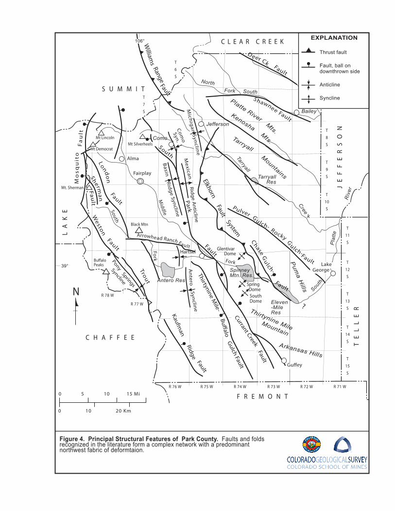
Secondary to these primary regional structural features are the many faults, fault zones, and folds
that bound the primary structural features and deform the rock units within. Major structural features
recognized in the literature are shown in Figure 4 which is adapted from Scarborough (2001) and
Ruleman and others (2011) and incorporates findings from the many 1:24,000 quadrangle maps
listed in Table 1.
Many faults and folds have been mapped by workers in South Park over the years (Figure 4 and
Plate 1). Interpretations of individual structures have varied from author to author and over time.
For example, earlier mapping (Stark and others 1949; DeVoto, 1971) interpreted that many large-
scale folds traversed the basin. Recent mapping revise the interpretation and indicate that what may
have appeared to be a fold is instead, juxtaposition of contrasting bedding orientation across faults
25
or fault zones. Similarly, early efforts attempted to explain structural patterns using large-scale,
through-going faults. Recent mapping suggests that strain was likely accommodated by movement
along a number of smaller, more dispersed structures (Widmann and others, 2005). Because of
these changes in interpretations, there is often poor edge-map continuity as well as consistency in
nomenclature from map-to-map for many structural features.
The variety in interpretations of structures is in part due to poor exposures that prevent following
individual features across the landscape. Identification of structural features and recognition of
coherent patterns is also complicated where igneous intrusions are widespread such as is seen in
the Mosquito Range. The same may hold for areas underlain by thick evaporitic facies of the
Minturn Formation where dissolution and ductile deformation of gypsum and halite beds may impart
a somewhat chaotic appearing structural fabric.
Overall, patterns of structural features reflect the complexity of the region and the fact that a unifying
model for deformation through the multiple phases of tectonism may not yet have been devised to
facilitate mapping of the features. Figure 6 integrates patterns of faulting and deformation into
discrete zones of deformation labeled to correspond with historic nomenclature. It illustrates that the
structural fabric is a complex lattice of cross-cutting and through-going bands of deformation.
Orientations appear to fall into two main groupings, one with an azimuth of 100 to 120 degrees and a
second with an azimuth of 140 to 160 degrees. The following discussion provides a brief summary
of the evolution of the basin and describes principal features that appear to be relevant to regional
groundwater conditions.
Middle
Fork
South
Pla
tte
Tarryall
Cree
NorthFork
Mt Lincoln Tarryall
Kenosha
Platte River
Mountains
Mts.
Mts.
Mo
squ
i to
Fa
ul t
Antero Res
Eleven-MileRes
Mt Democrat
Mt. Sherman
Thirtynine MileMountain
Bu�alo Peaks
Black Mtn
Arkansas Hills
Pum
a Hills
C L E A R C R E E K
R 75 W R 74 W R 73 W R 72 W
T
6
S
T
7
S
T
8
S
T
9
S
T
10
S
T
11
S
T
12
S
T
13
S
T
14
S
T
15
S
R 71 WR 76 W
R 77 W
R 78 W
?
Spring Dome
SouthDome
GlentivarDome
TarryallRes
South
Fork
39°
Riv
er
South
Spinney Mtn. Res.
kWeston
Fault
Sherm
an
Fault
South
Fault
Elkhorn Fault
System
D eer Ck. Fault
Shawne e Fault
Pulver G
ulch- Rocky Gulch-Fault
Trout W
illiams
RangeFault
Lond
on
Fault
Chase G
ulch-
Fault
Fairplay
Jefferson
Hartsel
Bailey
Como
Alma
S U M M I T
JE
FF
ER
SO
N
TE
LL
ER
F R E M O N T
C H A F F E E
LA
KE
Gu�ey
LakeGeorge
N
0 5 10 15 Mi
0 10 20 Km
Thrust fault
Fault, ball on downthrown side
Anticline
Syncline
EXPLANATION106°
ParkM
ichig
an Syn
cline
Mexican
Com
o
Syn.
Ridg
e Anticlin
e
Basin
Ridg
e Synclin
e
An
teroSyn
cline
PonySprings
Syncline
Kaufman
RidgeFault
Thirtynine Mile-
Bu�alo
Gulch Fault
Currant CreekFault
Mt Silverheels
Arrowhead Ranch Fault
Figure 4. Principal Structural Features of Park County. Faults and folds recognized in the literature form a complex network with a predominant northwest fabric of deformtaion.
27
Structural Evolution of Park County
Park County has undergone a long and complex structural evolution. Certainly, much of the
structural fabric has origins from back in the Precambrian Era. Many episodes of deformation, from
ductile to brittle, occurred during this long period of time spanning from 1.7 to 0.54 billion years ago.
Episodes that may have more relevance to the modern-day landscape, as well as groundwater
resources, occurred more recently. These younger episodes may have reactivated and probably
modified older structures.
Phases of this evolution most relevant to groundwater resources and water quality reach back to the
Pennsylvanian-Permian Anazasi uplifts and development of the Central Colorado Trough (DeVoto,
1972; Ruleman and others, 2011). This trough extended in a north-northwest direction through the
region and accommodated deposition of the Minturn and Maroon Formations. The deep structural
trough and sedimentary fill that it accommodated contributes to much of the geologic and
topographic character of much of South Park. The sediments tend to be easily eroded which has led
to the broad gentle landscape between the Red Hill Hogback and the Mosquito Range.
Bounding features of the uplifts bounding the Central Colorado Trough are not well constrained;
however, it is proposed that a concealed fault with a trend and location similar to the South Park
Fault (Figure 4) may have formed the east edge of the trough. Recent mapping of the evaporitic
facies in the Minturn Formation show these basin-center deposits extend almost up to the South
Park Fault trace as mapped. Basin-margin transitional facies do not appear to interfinger with or
truncate the evaporate facies, as would be expected if an active bounding fault had been nearby at
the time of deposition. This suggests that this may have not been the basin-bounding fault at the
time of deposition. The basin edge must have been further to the east during deposition. This leads
to uncertainty about location and timing of any faults bounding the trough. Widmann and others
(2004; 2005) found evidence that the Pennsylvanian sediments may have lapped onto the eastern
highland. This may very well be the case; however, the boundary may have been modified by later
Laramide faulting. The apparent abrupt termination of the evaporite facies shown by DeVoto (1972)
and Kirkham (2012) suggests a more complicated structural history at the edge of the Central
Colorado Trough. This history may include multiple episodes of deformation along different fault
systems which ultimately separated ancient uplift from trough.
Following the Anazasi uplift phase, the region was sub-aerially exposed, subject to erosion
combined with minor sediment deposition from Permian through Jurassic Periods. This period is
recorded by thin accumulations of the Garo and Morrison Formations. The next major phase of
structural evolution began during the Cretaceous Period, a time marked by broad regional downwarp
allowing advance of the Western Interior Seaway. Marine sediments blanketed the entire Rocky
28
Mountain region for a period of over 30 to 40 Ma (Cobban, 1993; Cobban and others, 2006). This
thick accumulation of organic-rich sediments includes many sandstone, shale, and limestone units
from the Dakota Formation up through the Fox Hills Sandstone (Figure 2).
The next phase of tectonism began in the Late Cretaceous with initiation of the Laramide uplift. In its
early stages, this phase of tectonism may have been the result of east to northeast directed
compression (Chapin and Cather, 1983). An early hint of this phase was retreat of the Interior
Seaway and deposition of the Fox Hills shoreline. Eventually, basement-cored uplifts rose to be
stripped of older Paleozoic and Mesozoic sedimentary cover exposing their Precambrian basement
cores (Raynolds, 1997). Locally, this was accompanied by igneous intrusion and volcanism as
evidenced by the Reinecker Ridge volcanic member of the South Park Formation. This sequence of
uplift and denudation is recorded in the sediments preserved in the basins between uplifts. Fine-
grained sediments dominate the Laramie Formation, which may represent denudation of the thick
sequence of Cretaceous Interior Seaway sediments.
Although modified by later Neogene events (Ruleman and others, 2011), Laramide tectonism
generated much of the South Park basin geologic framework as it appears today. What has been
traditionally mapped as the South Park Formation (Sawatzky, 1967) represents the early phase of
Laramide uplift when Precambrian basement blocks first emerged and the Echo Park Alluvium
represents a later phase of renewed uplift and possible wrench faulting (Chapin and Cather, 1983).
A basin formed between the Sawatch uplift to the west and the Front Range uplift to the east early
during the Laramide event that accommodated the thick South Park Formation sequence.
Progressive Laramide tectonism, dominated by westward-directed movement along the Elkhorn
thrust fault, subsequently deformed these sediments. Sedimentation continued as deformation
progressed with accumulation of syn-tectonic conglomerates recognized by Ruleman and others
(2011) and Echo Park Alluvium. The Echo Park Alluvium appears to fill fault-bound grabens along
the South Park fault system (Chapin and Cather, 1983).
Outcrop patterns suggest that the South Park Formation was deposited on an already tectonically
active landscape. Contact relationships at the base of the South Park Formation suggest that there
had been considerable differential uplift and erosion of the older sediments prior to deposition of the
first syn-tectonic sediments. Figure 5 is an interpretive map of pre-South Park outcrop patterns of
the Pierre Shale, Fox Hills Sandstone and Laramie Formation based on outcrop relationships at the
base of the South Park Formation. The Laramie Formation is either very thin or absent in the
southern part of the basin where published maps indicate that the South Park Formation directly
overlies Fox Hills Sandstone. Further to the west, the South Park Formation has been mapped in
direct contact with Pierre Shale with no evidence of Fox Hills Sandstone. This suggests that greater
29
uplift had occurred in this direction prior to South Park Formation deposition. This uplift may have
been early emergence of the Sawatch uplift, or early movement on the South Park Fault zone.
Clasts of Paleozoic Formations found in the lower part of the South Park Formation suggests early
emergence of the Sawatch uplift. Composition of the South Park Formation becomes more
dominated by Precambrian clasts higher in the section suggesting later emergence of the
Front Range uplift.
Stripping of the fine-grained marine sediments off of the uplifts eventually exposed older, more
competent rocks as evidenced in the South Park Formation. Members of this sequence of
sediments records progressive stripping of volcanic rocks and Paleozoic sediments down to the
Precambrian igneous and metamorphic uplift cores. Clasts of Paleozoic sediments in the
Conglomeritic member of the South Park Formation indicates a western source (Widmann and
others, 2005; Kirkham and others, 2006) early on. In contrast, the granitic composition of the upper
Fine-grained arkosic member indicates an eastern source. This compositional contrast suggests
that the Sawatch uplift, which contained Paleozoic sediments, preceded the Front Range uplift,
which had already been stripped of that very same Paleozoic cover during the Pennsylvanian
Anazasi uplift. The unconformity at the base of the South Park Formation, which indicates erosion of
more section to the west and preservation on the east (Plate 2), provides evidence of earlier uplift on
the west side. Another piece of evidence of later timing of the Front Range uplift is westward-
directed deformation of the older South Park Formation by the Front Range uplift.
Chapin and Cather (1983) have proposed that the later stages of the Laramide event reflect a
change to a more northerly directed compressive stress. The style of deformation may have
changed from one dominated by westward-directed folding and faulting to one of right-lateral wrench
faulting. This later phase may have been characterized by the growth of smaller fault-bound basins
that accommodated the Echo Park Alluvium.
A prolonged period of broad erosion led to beveling of the landscape following the Laramide uplift.
The resulting surface has been referred to as the Late Eocene surface (Epis and others, 1976).
Next came a period of extensive igneous activity and widespread volcanism accompanied by
accumulation of sediments derived from erosion of the volcanic terrain. In the southern part of the
County, this time period is represented by deposits of volcanic rocks of Buffalo Peaks area, Wall
Mountain Tuff, and volcanic rocks in the Thirtynine Mile and Guffey Mountain area. Sedimentary
deposits coeval with the volcanic accumulations include the Tallahassee Creek Conglomerate and
Antero Formation. In the northern part of the County surface accumulations have been stripped off,
revealing the deeper igneous plugs, sills and dikes.
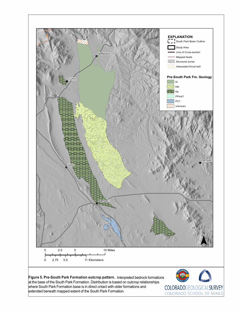
"
"
"
"
"
"
"
Como
Garo
Bailey
Hartsel
Tarryall
Singleton
Jefferson
0 5 102.5 Miles
0 5.5 112.75 Kilometers
F ig u re 5 . P re -S o u th P ark F o rm atio n o u tc ro p p a ttern . Interpreted bedrock formationsat the base of the South Park Formation. Distribution is based on outcrop relationships where South Park Formation base is in direct cntact with older formations and extended beneath mapped extent of the South Park Formation.
¯
EX P LA NATIO NSouth Park Basin Outline
Study AreaLine of Cross-sectionMapped faults
Interpreted thrust beltStructural zones
Pre-South Park Fm . GeologyKlKfhKpPPmb?PC?unknown
31
Post-Laramide and Neogene Tectonism
Cenozoic development of the Rio Grande Rift system, which extends up through Central New
Mexico into Colorado, represents the most recent phase of tectonism affecting the region. This
transition represents a change from a compressional to an extensional stress regime. The later
stress regime overprinted older structural features and, in places, reactivated them but in opposing
ways. The main part of this rift system passes through the upper Arkansas Valley just to the west,
where it separates the former Sawatch uplift into the modern Sawatch Range and the Mosquito
Range. Extensional tectonism may have begun about 25 Ma accompanied by deposition of Dry
Union Formation to the west in the upper Arkansas Valley part of the rift and Wagontongue-Trump
Formation in the South Park area.
Ruleman and others (2011) and Houck and others (2012) have identified many features and
relationships within South Park that suggest post-Laramide deformation in the area. Ruleman
(personal communication, 2012) believes that much of the topographic relief that defines the South
Park physiographic basin may owe its origin to Late Tertiary tectonism. A number of faults in South
Park display evidence of movement related to this phase of tectonism (Ruleman and others, 2011).
Indeed, the topographic expression of the Tarryall Range rising above the Elkhorn Upland may be
attributed to Late Tertiary movement along faults parallel to Tarryall Creek. The Elkhorn Upland
preserves a scattered veneer of post-Laramide volcanic and sedimentary cover that is absent on the
top of the Tarryall Range. One explanation is that the Tarryall Range has risen during Cenozoic
extensional tectonism.
The Chase Gulch half-graben east of Spinney Reservoir may also be a feature formed by Neogene
extensional tectonism. Evolution of this half-graben deserves further investigation as it may
represent one of the only direct rift-related structural feature in the South Park basin. It also may
have hydrologic significance as it may be filled with relatively permeable coarse-grained sediments.
Similarly, the Oligocene Fairplay Paleovalley sediments just south of Fairplay described by Kirkham
and others (2006) appear to be preserved in a fault-bound half-graben. This feature points to
significant post-Oligocene faulting and tilting in this area of South Park.
Evaporitic Tectonism in South Park
Houck and others (2012) and Kirkham and others (2007; 2012) have identified features in the
southwest part of South Park that may owe their origin to dissolution and plastic flow of beds of
evaporite minerals within the Minturn Formation. Evaporitic tectonism, as this is often referred to,
has been recognized in other parts of the state where the similar strata are present (Kirkham and
others, 2001). This deformation has played a major role in shaping the geologic landscape in these

32
other areas and this may be another example. While evaporite deposits have long been known to
be a part of the Pennsylvanian section, their role in the structural evolution of South Park may not be
well understood yet. Differential movement in the evaporitic facies, diapiric flow, and collapse may
all modify the Laramide and post-Laramide features where these sediments are present at depth.
Much of the apparent discontinuity in structural features in the western part of the basin may be
attributable to modification or overprinting by evaporitic tectonism.
Tarryall
Kenosha
Shawnee
Elkhorn-South
South Park
Current Creekk
South Platte
Como
Buffalo Gulch
Agate Creek
Trout Creek
Weston Pulver -Rocky Gluch
London
Deer Creek
Salt Creek
JeffersonEmbayment
Elkho
rn-No
rth
285Arrowhead Ranch
Pony ParkLong Park
Williams Range
Kaufman Ridge
Boreas Pass
Como-Elkhorn
Como
Alma
Garo
Grant
Bailey
Hartsel
Fairplay
Tarryall
Singleton
Jefferson
Lake George
£¤24
£¤285
¬«9
0 10 205 Miles
0 10 205 Kilometers
Figure 5. Map of structural zones in Park County. Recent mapping efforts have identified many faults within South Park. Although the pattern can be complex, it is possible to group faults into zones of deformation with similar trends for simplification and to help identify regional trends.
¯
LegendHighways
" TownsMapped faults
Deformation zonesevaporitefold-thrustigneousfault zones
Fairplay
34
Primary Structural Features
Figure 6 is a generalized map that shows the major fault systems as structural zones. Many
individual faults may lie within these zones as identified in previous mapping efforts. The zones may
have roots during Precambrian tectonism and have continued to accommodate strain through
subsequent tectonic events. Sense of displacement may not always be the same throughout a zone
which suggests that the areas are zones of weakness along which deformation is concentrated in
response to varying stress fields. The following are some of the features that have relevance to this
effort.
Eklhorn Fault zone dominates the structural terrain where it forms the eastern boundary separating
the Precambrian Front Range uplift to the east from the tilted sedimentary block to the west.
Generally, it follows a sinuous trace supporting the interpretation that it is a low angle thrust fault
(Stark and others, 1949; Sawatzky, 1967; Barker and Wyant, 1976; Wyant and Barker, 1976; Bryant
and others, 1981a; Ruleman and Bohannon, 2008; Ruleman and others, 2011). It has been
suggested that it continues north to connect with the Williams Fork Thrust fault north of the
Continental Divide (Barker and Wyant, 1976; Kellogg and others, 2008) To the south it may connect
with a mapped thrust fault at Spinney Mountain (Sawatsky, 1967). The Elkhorn Fault system is
difficult to follow further to the southeast where it appears to continue on into the area covered by
Tertiary volcanic and sedimentary units.
In 1992 Hunt drilled the No. 17-1 Tarryall Federal to a depth of 12,768 ft. through the Precambrian
hanging wall of the Elkhorn Fault (Steyaert and Wandrey, 1997). The well penetrated South Park
Formation at a reported depth of 1,900 feet before drilling into the Upper Cretaceous marine section.
The depth of the reported fault at the distance to the outcrop of the fault gives an angle of
approximately 35°. Durrani (1980) argues that the southern trace near Hartsel is a high angle
reverse fault and Ruleman and others (2011) provide evidence that the northern segment near
Jefferson is a normal fault. This fault may very well be very complicated, displaying changing
geometry along its trace as a result of a long complex history of movement.
South Park Fault zone is another fault system just west of the Elkhorn Fault displaying apparent
Laramide deformation of the entire Cretaceous through Paleocene package of sediments, including
the South Park Formation. It consists of several splays in the central part of South Park that may all
be part of the same zone of deformation where splays converge at depth (Sterne, 2006). As with the
Elkhorn Fault, this fault places the east side up, above the west side. It is difficult to extend this zone
as a discrete fault north in the direction of Boreas Pass. To the south it closely aligns with the
Current Creek Fault system that deforms the Tertiary volcanic and sedimentary units (Scarbrough,
2001). Sense of displacement in younger rocks to the south is opposite of that observe to the north
35
in older rocks that may reflect reactivation of the Laramide feature within the different extensional
environment.
Current Creek Fault zone consists of several normal faults that form a series of grabens and half-
grabens extending through the Thirtynine Mile Mountains and Arkansas Hills. Grabens preserve
sections of Echo Park Alluvium suggesting late Laramide movement.
London Fault zone passes into the Mosquito Range at the northwestern edge of South Park and
has been mapped as an east-dipping reverse fault that places the east side above the west
(Widmann and others, 2007). The zone of deformation that this fault follows continues to the
southwest to include the 285 fault mapped by Kirkham and others (2012). In this area Kirkham has
mapped many of the faults as strike slip faults with left lateral displacement prevalent.
Weston-Trout Creek-Kaufman Ridge Fault zone is the furthest west feature in the South Park
study area that shares characteristics with the London Fault zone. It too places the east side up
relative to the west. Sterne (2006) interprets this to be yet another east-dipping thrust fault.
Agate Creek zone, west of Hartsel bounds the west side of the structural block, often referred to as
the Hartsel Ridge, where Precambrian crystalline rocks made up primarily of Paleoproterozoic
granite gneiss (Scarbrough, 2001; Ruleman and others, 2011) can be found near the surface or
buried beneath Tertiary volcanic rocks and sediments with little Paleozoic or Mesozoic cover. It also
forms the eastern boundary of the extent of exposed Minturn-Maroon sediments in the southern part
of the basin. It has been shown as a high-angle feature by previous authors (DeVoto, 1979).
However, its sinuous trace, combined with an apparent eastward thickening of Minturn evaporitic
facies up to its trace (Kirkham and others, 2012), suggest a lower angle reverse fault or thrust.
South Platte-Arrowhead zone is a northwest trending zone crossing South Park that separates the
Elkhorn highlands to the north from Hartsel Ridge to the south. This feature has not received wide
recognition, yet it appears to affect patterns of distribution of many units. Use of the term South Park
zone is introduced herein to describe a zone with apparent linear continuity over a great distance
through the region. From north to south, it appears to transfer Elkhorn style deformation westward
to the Agate Creek zone, giving an apparent right lateral offset of uplifted Precambrian blocks.
Paleozoic and Mesozoic sediments are rare or absent on the south side as are the syn-orogenic
sediments of the South Park Formation. It also forms the northern boundary of preserved Oligocene
volcanic rocks and southern boundary of exposed Tertiary igneous rocks. Lastly, Quaternary fluvial
sediments appear to be deflected to the southeast along this zone.
36
Deer Creek, Shawnee, Kenosha, Tarryall Creek, and Pulver Gulch-Rocky Gulch zones form
very linear northwest oriented drainage patterns in the Precambrian crystalline core of the Front
Range uplift. Kenosha and Tarryall Creek nomenclature is commonly used in the literature, but are
used herein for clarity. These faults lie entirely within Precambrian igneous and metamorphic rocks
of the Front Range uplift and may all have long histories of deformation up to and including
Quaternary (Ruleman, 2011). The Tarryall and Pulver Gulch-Rocky Gulch zones delineate the
topographic scarp between the elevated Tarryall Mountains on the east and the subdued Elkhorn
Upland to the west. Preservation of post-Laramide sediments and volcanic rocks on the Elkhorn
Upland suggests Cenozoic movement on some of these faults raising the Tarryall and South Platte
ranges above the Elkhorn Upland.
Jefferson Embayment is the area north of the Elkhorn Upland where the Michigan Hill and the town
of Jefferson are located. It separates the northern trace of the Elkhorn Fault from the southern trace
of the Williams Range Fault found further to the north (Kellogg and others, 2008). Detailed mapping
by Barker and Wyant (1976) infer a concealed link between the Elkhorn and Williams Range faults.
Ruleman (2011) interprets that the embayment is simply a broad northeast-trending syncline with
little direct evidence of faulting.
Chase gulch Fault is the northwest-trending normal fault bounding the west side of the Chase
Gulch half-graben east of Spinney Mountain Reservoir. It is concealed beneath Quaternary alluvium
and sheetwash deposits over its entire extent but its presence is indicated by a thick accumulation of
coarse-grained sediments encountered in exploratory boreholes and water wells (Shaffer, 1980;
Powell, 2003). It closely follows, and segments, the Elkhorn Fault along its extent. The fault is
included here as it may represent a clear example of an extensional fault related to development of
the Rio Grande Rift further to the west.
37
GROUNDWATER IN PARK COUNTY
This section describes aquifers present in Park County following the framework outlined in the
previous general geologic description. Aquifer descriptions expand upon those outlined in the
scoping study prepared for the Coalition for the Upper South Platte that focused on the central part
of South Park (Barkmann and others, 2013). Content for the central portion of South Park is
adapted from Arnold (2013).
Based on differences in hydrologic properties, aquifers and confining units in Park County can be
grouped into three general categories: 1) crystalline-rock aquifers, 2) sedimentary bedrock aquifers
and confining units, and 3) unconsolidated Quaternary deposits. Hydrogeologic units based on
stratigraphy described in the previous section fall into each group. The term hydrogeologic unit is
used herein to describe stratigraphic formations, or multiple formations, that have similar enough
hydrologic properties to be grouped together at the 1:100,000 scale upon which this publication is
based. More detailed hydrologic assessments at larger scales may find that further subdivision by
stratigraphy may be more appropriate. Plates 4 through 18 focus on these units individually and
projects their extents in the subsurface where they may form aquifers buried beneath younger
formations. Plate 19 shows the extent of the unconsolidated Quaternary deposits including the
surficial alluvial aquifer directly under the influence of surface water.
Hydrogeologic units outlined in this publication are listed below and are described in the sections
that follow. Relationships between the units and mapped stratigraphy in the County are provided in
Figure 2.
(1) Crystalline-rock aquifers
a. Precambrian crystalline bedrock, b. Cretaceous and Tertiary igneous intrusions, c. Post-Laramide volcanic rocks,
(2) Sedimentary bedrock aquifers and confining units
a. Older Paleozoic units, b. Belden Formation, c. Minturn Formation, d. Maroon Formation, e. Garo Sandstone aquifer, f. Morrison Formation, g. Dakota aquifer, h. Benton-Niobrara Formations confining unit, i. Pierre Shale confining unit, j. Laramie-Fox Hills aquifer,
38
k. Laramide Sedimentary Units (South Park Aquifer and Echo Park Alluvium), l. Tallahassee Creek Conglomerate aquifer, m. Antero Formation, n. Wagontongue-Trump Formation aquifer.
(3) Unconsolidated Quaternary deposits
a. Alluvial aquifer b. Glacial deposits
Plates 3 through 19 are maps for each of these units and show the aerial extent of the unit across
South Park and where exposed. Extent has been estimated by outcrop patterns projecting into the
subsurface using interpretations of structural relationships based on surface mapping. Subsurface
data are very limited on a County-wide basis and these maps are intended for portraying unit extent
at a regional scale.
Bedrock maps include projected intersections of the units with the Quaternary alluvial aquifer
system. These patterns have been generated in the GIS environment by projecting bedrock unit
polygons through the subsurface and intersecting with the overlying alluvial aquifer polygons. This is
intended to help map connections between surface water, alluvial groundwater, and deeper
groundwater. Not only does this illustrate potential pathways for flow between the different water
sources, but it also helps identify potential water quality mixing pathways. For example,
intersections of the evaporate facies of the Minturn Formation hydrogeologic unit with the alluvial
aquifer can be a direct pathway for naturally occurring sodium chloride and calcium sulphate from
the evaporate beds to shallow groundwater.
Maps for the Dakota Aquifer (Plate 11) and Laramie- Fox hills Aquifer (Plate 14) include layers
depicting estimated depth to the base of the aquifer. Estimated depth is shown as a classified color
scheme derived by a raster subtraction of an elevation surface of the unit base from a surface
topography digital elevation model (DEM). The unit base surface elevation model was estimated
from measured outcrop dips combined with depths from oil and gas well penetrations. The depth
ranges are intended to provide a rough approximation of the depth ranges away from the outcrop.
The upper depth limit shown is 5,000 feet, well beyond the depth considered practical for
groundwater usage taking into consideration well costs, pumping costs, and deteriorating water
quality conditions. The aquifers that include depth layers, and areas for those aquifers that include
depth estimates, were limited by availability of reliable date for generation of the raster models.
The maps also include locations of permitted water wells estimated to be completed in each unit.
The well application database of the Colorado Division of Water Resources (CDWR, 2012) was
reviewed for data concerning well location, depth, screen interval, and primary water use to assess
the current distribution of water wells and use of groundwater in the County. Only wells having a
39
current status of “Well Constructed” were included in the analysis to minimize the inclusion of wells
from the database that were not constructed or have been abandoned. No additional criteria were
used to filter the data other than a search to eliminate duplicate entries for wells where there may be
multiple receipt numbers for the same well because of permit modifications.
Initial determination of completion interval by hydrogeologic unit for wells in the database was made
in a GIS environment. Wells were attributed for a particular unit when their location falls within the
unit extents as shown in Plates 3 through 19. The attributes were then sorted by stratigraphic order
so that each well has a listing of units beneath its location from shallowest to deepest. Labelling for
probable aquifer is based on the shallowest unit for a given location. Wherever wells fall in an area
where the shallowest unit is a confining unit, they are identified by the first aquifer below the
confining unit. In many cases, two different aquifers are shown because two units may be present
near surface and it is not possible to differentiate with the methodology applied. When available in
the DWR database, lithologic logs describing materials encountered during drilling were examined
for many wells near the margins of hydrogeologic units and for deeper wells away from margins to
verify hydrogeologic completions identified by the initial estimate. In cases where lithologic logs
provided evidence contrary to the initial estimate, the hydrogeologic completion was modified to
reflect the lithologic log.
Location accuracy in the DWR database is a limiting factor for accuracy of the aquifer determinations
presented in these maps. Many well locations have only been recorded in the database by quarter-
quarter reference. Others are made using manual measurements off of topographic maps. Aquifer
designations and well statistics by aquifer are only estimates using available data. Any
determination on a site-specific basis will require better location determination.
Depth data are not available for most of the units for a more refined methodology using well
completion depths with the exception of wells within the alluvial aquifer areas. For those wells within
the extent of the alluvial aquifer, a depth of 100 feet was used to discriminate between the alluvial
aquifer and shallowest bedrock aquifer for given locations. Wells less than or equal to 50 feet deep
in areas covered by alluvium were assumed to be completed in alluvium. Wells greater than 50 feet
deep in areas covered by alluvium were assumed to be completed in the hydrogeologic unit
estimated to underlie the alluvium.
Using the methods described above, there were 7,656 water wells inventoried in Park County as of
December 19, 2012. About 92 percent (7,066 wells) of wells in Park County are permitted for
domestic use or household use only; 3 percent (236 wells) are permitted for monitoring; 2.4 percent
(181 wells) are permitted for watering livestock; 0.7 percent (7 wells) are used for irrigation; 1.6
40
percent (121 wells) are permitted for commercial, industrial, or municipal purposes. The remaining
0.6 percent (45 wells) have other uses such as evaporative, fire, geothermal, gravel, or unspecified
uses.
CRYSTALLINE ROCK AQUIFERS Crystalline-rock aquifers in the South Park study area can be subdivided into three general
hydrogeologic units on the basis of geologic age and rock type—(1) Precambrian igneous and
metamorphic rocks, (2) Tertiary and Cretaceous igneous intrusions, and (3) Tertiary volcanic rocks.
Precambrian Crystalline Bedrock
Precambrian crystalline bedrock lies at, or very near, the surface beneath nearly the entire northeast
half of the County as well as in areas scattered within the Mosquito Range along the western edge
(Plate 3). Precambrian crystalline rock is the sole bedrock for the entire area east of Kenosha Pass,
where proximity to the Front Range Metropolitan area has prompted rapid growth of commuter
communities heavily reliant on individual well water. In these areas it forms the primary aquifer
unless alluvium is present above it, which is very rare. In the Mosquito Range the area is either very
rugged mountainous terrain or public land where groundwater utilization is limited. Scattered
exposures in the Thirtynine Mile and Arkansas Hills south of the South Platte River indicate that it
may be only thinly covered by volcanic rocks in large parts of this area.
These basement rocks consist of 1.7 to 1.8 billion year old biotite gneiss; biotite-sillimanite gneiss
and schist; hornblende gneiss; and granitic gneiss. In places, approximately 1.4 billion year old
granite and monzogranite intrude the older units. The youngest of the Precambrian rocks found in
the County are the approximate 1.1 billion year old granitic intrusive rocks that include the Pikes
Peak Batholith.
Groundwater Occurrence
There is essentially no primary porosity in these rocks with secondary fractures storing and
transmitting groundwater. Faulting can influence groundwater storage and flow through this unit to a
great extent and Plate 3 shows mapped faults based on the current level of mapping efforts.
Bossong and others (2003) identified fault zones as the most permeable sub-unit of the Precambrian
crystalline bedrock in the Turkey Creek watershed of Jefferson County, just to the east. This can
result in higher well productivity within fault zones as well as preferential groundwater pathways
along fault zones.
The Precambrian rocks can be subdivided into two general hydrogeologic units, igneous and
metamorphic, on the basis of rock type and internal fabric. The following sections address each type
41
and gives an evaluation of the well distributions based on surface location. The three-dimensional
framework of metamorphic rocks intruded by younger igneous bodies can be complex and the rock
type can change with depth.
Precambrian Igneous Rocks Precambrian igneous rocks underlie large areas of the foothills area in the northeastern corner of the
County and within the Elkhead uplands. Locally, the granite can be deeply weathered into grus,
which can enhance secondary porosity and permeability. Where grusification has been very
advanced, the unit can be indistinguishable from local alluvium. There is no limit to depth other than
practical drilling depths. Wells are typically drilled to a depth that intercepts enough water-bearing
fractures to supply a household. Aquifer parameters in fractured crystalline bedrock aquifers can be
quite variable and depend on fracture density and fracture apertures.
Groundwater Utilization
Based on location, 3,036 wells are estimated to be completed in the Precambrian igneous rocks. Of
these, 2,926 wells, or about 96 percent, are permitted for domestic use or household use only, 1 for
irrigation, 30 for commercial or municipal uses, 42 as monitoring wells, and the remaining listed as
“other”. Reported depths range from 4 to 1,302 feet with water levels ranging between 1 to 687 feet
below ground surface. Reported production rates range from 0.08 to 500 gallons per minute (gpm).
Precambrian Metamorphic Rocks Precambrian metamorphic rocks form a fractured crystalline rock aquifer along the north Fork of the
South Platte in the Bailey area and in parts of the Elkhead upland. This unit consists of biotite
gneiss with minor inliers of hornblende-plagioclase gneiss and biotite-sillimanite gneiss. These sub-
units are treated as a single unit in these maps because their physical properties are very similar.
Metamorphic rocks differ from igneous in having a strong internal fabric, or foliation. Depending on
mineralogical content, this can affect fracture intensity and orientation which, in turn, can affect
hydrologic properties (Bassong and others, 2003). Weathering can also affect hydrologic properties
of metamorphic rocks; however, not as significantly as grusification of granite. There is no limit to
depth other than practical drilling depths. Wells are typically drilled to a depth that intercepts enough
water-bearing fractures to supply a household.
Groundwater Utilization
Based on location, 1,298 wells are estimated to be completed in Precambrian metamorphic rocks.
Of these, 1,246 wells, or about 95 percent, are permitted for domestic use or household use only, 1
for irrigation, 17 for commercial or municipal uses, 21 as monitoring wells, and the remaining listed
as “other”. Where reported, depths range from 4 to 1,750 feet with water levels ranging between 1
and 800 feet below ground surface. Reported production rates range from 0.06 to 40 gpm.
42
Tertiary and Cretaceous Igneous Intrusions
Cretaceous and Tertiary igneous intrusions occur mainly in two areas of the County (Plate 4). Most
occur in a belt along the Continental Divide extending in a northeast direction from Weston Pass to
Kenosha Pass. Intrusions in this belt consist of dikes, sills, and small plugs of granitic, monzonite,
monzodiorite and diorite, composition. Most are small; however, some can be large, for example the
large sill-like body holding up Boreas Mountain north of Como covers an area of almost 15 square
miles in the County. Nearly all occur in rugged mountainous terrain partly because the igneous
intrusions and altered host rocks are more resistant to erosion resulting in greater topographic
elevation and relief. The areas also tend to be lightly inhabited or are likely to be public land where
groundwater use would be limited.
Cretaceous granodiorite of the Whitehorn laccolith is found in the very southwest corner of the
County. This is predominantly public land and rugged terrain with limited groundwater demand.
Groundwater Occurrence and Utilization
There is essentially no primary porosity in these rocks with secondary fractures storing and
transmitting groundwater. Faulting can influence groundwater storage and flow through this unit to a
great extent and Plate 4 shows mapped faults based on the current level of mapping efforts. As with
the Precambrian crystalline bedrock units, faults and fault zones may form preferential groundwater
pathways and may be areas with higher well productivity.
Although these intrusive bodies are discontinuous and cover a very small aerial extent of the basin,
they have some relevance to groundwater and water quality. Intrusive bodies can serve as conduits
or barriers for groundwater flow depending on degree of alteration and fracturing. Potential
alteration can also introduce mineralogy such as metal sulfides that can impact natural water quality
conditions.
Based on location and reported depths, only 10 wells currently tap this unit. Six wells in the vicinity
of Fairplay and Como appear to be completed in the unit. Four are listed as domestic or household
wells, and one is a monitoring well, one is listed as “other”. Reported depths range from 10 to 569
feet and water levels measured at the time of well completion range between 2 and 326 feet. Only
two pump rates are reported at 3.5 and 7 gpm. There are two monitoring wells installed in the unit in
the watershed of the North Fork South Platte River near the continental divide with depths of 10 and
30 feet. To date no wells have been reported in the Whitehorn granodiorite.
43
Tertiary Volcanic Rocks
Tertiary volcanic rocks occur primarily in the southern part of the County (Plate 4) and represent one
of the most heterogeneous units in the region. The unit can vary considerably in composition,
thickness, and fabric in very short distances based on proximity to volcanic sources, original
topography, as well as erosion patterns subsequent to deposition. Rock types can include primary
volcanic flows, flow breccia and ash fall tuff deposits intercalated with debris flow conglomerates
(lahar deposits) and stream deposited sand and gravel.
Groundwater Flow in the Tertiary and Volcanic Rocks
With this heterogeneity, hydrogeologic properties can be quite variable and site-specific. Primary
porosity and permeability can be found in intergranular pore spaces of ash fall tuff deposits, lahar
deposits and fluvial sediments in the unit. Secondary porosity and permeability can be found in
fractures within volcanic flow units, welded tuff deposits, and well cemented sedimentary deposits.
Tertiary volcanic rocks often occur as highlands or caps of buttes rising above the South Park
landscape. These elevated areas can receive greater precipitation and often hold snow cover better
than the surrounding lowlands. Because of this, these outcrop areas may act as sources of
recharge for underlying units.
Groundwater Utilization
Based on location and reported depths, 462 wells are estimated to be completed in the Tertiary
volcanic rocks. Most are in the Thirtynine Mile area south of Hartsel. Of these, 446 are permitted
for domestic use or household use only, 13 as stock wells, and three commercial wells. Reported
depths range from 3 to 763 feet with water levels ranging between 1 and 540 feet below ground
surface. Reported production rates range from 0.01 to 100 gpm.
SEDIMENTARY BEDROCK AQUIFERS AND CONFINING UNITS For the purpose of this study, sedimentary bedrock aquifers and confining units are subdivided into
four general hydrogeologic units on the basis of geologic age and similar tectonic setting—(1)
Paleozoic and Early Mesozoic hydrogeologic units, (2) Cretaceous seaway hydrogeologic units (3)
Laramide hydrogeologic units, and (4) Post-Laramide hydrogeologic units.
Paleozoic and Early Mesozoic Hydrogeologic Units
Older Paleozoic Formations Because of their limited extent and utilization, Cambrian through Mississippian clastic sedimentary
and carbonate formations are considered a single unit in this description. Sedimentary formations
44
comprising the older Paleozoic unit include the Sawatch Quartzite, Dotsero Formation, Manitou
Formation, Harding Sandstone, Fremont Dolomite, Chaffee Group, and Leadville Limestone.
Thicknesses for each formation within the unit vary considerably and total thickness for the
hydrogeologic unit may be anywhere from about 400 to 1,000 feet. This unit is present at or near
the surface in a north- to northwest-trending belt on the flanks of the Mosquito Range along the west
side of the County (Plate 5). The belt is crossed by a number of fault zones that give it an irregular
map pattern. In particular, the London and Weston fault zones, which have a reverse sense of
displacement, cause a repeat of the section from east to west from Alma south toward Antero
Junction. The unit generally dips to the east and may be present at much greater depths within
South Park; however, anticipated depths are so great that water quality may unsuitable for most
uses. Although distribution in Park County is limited, the units are considered important aquifer
systems elsewhere in the state (Topper and others, 2003).
Groundwater Occurrence and Utilization
Primary porosity in the clastic sediments, which are mostly quartzite and shale, tends to be quite low
and groundwater is stored and transmitted through fractures. Similarly, porosity and permeability in
the carbonate units tend to be in fractures and solution channels and cavities.
Based on location and reported depths, 19 wells currently tap this unit. Four wells located on the
southern end of the Mosquito Range in the unincorporated area south of Trout Creek Pass appear to
be completed in the unit. The remainder are located west of Alma and Fairplay. Eighteen are listed
as domestic or household wells and the other is listed as “other”. Reported depths range between
55 and 640 feet and water levels measured at the time of well completion range between 5 and 480
feet. None of the wells listed reported pumping rates.
Belden Formation The Belden Formation unit is present at or near the surface in a north- to northwest-trending belt on
the southern flanks of the Mosquito Range along the west side of the County (Plate 6). It has not
been mapped at the surface in the northern part of the Mosquito Range and its extent into the
subsurface is uncertain. It generally is recognized as a shale-dominant formation and might be
considered a confining unit on a regional basis. However; locally it contains sandstone and
limestone beds that can produce water. In the southern part of the County, the coarser-grained
Kerber and Sharpsdale Formations are stratigraphically equivalent to the Belden and are included
on Plate 6. The unit dips to the east away from the outcrop belt and may be present at much greater
depths within South Park; however, anticipated depths are so great that water quality may unsuitable
for most uses. Plate 6 also shows undifferentiated Permian and Pennsylvanian Formations in
scattered outcrops on the Front Range block south of Hartsel.
45
Groundwater Occurrence and Utilization
Primary porosity and permeability in the coarser-grained granular sediments is in inter-granular pore
spaces. Fractures can enhance secondary permeability in the finer-grained beds. Similarly, porosity
and permeability in the limestone beds tends to be in fractures and solution channels and cavities.
Based on location and reported depths, 47 wells are estimated to be completed in the Belden
Formation and undifferentiated Permian and Pennsylvanian Formations on the Front Range Block.
Nearly all of these wells are in the unincorporated area south of Trout Creek Pass. Of these 43 are
permitted for domestic use or household use only, one monitoring well, one irrigation, and the last
two listed as “other”. Reported depths range from 12 to 600 feet with water levels ranging between
1 and 250 feet below ground surface. Reported production rates range from 1.5 to 15 gpm.
Minturn Formation The Minturn Formation is present at or near the surface over a wide area on the south side of South
Park (Plate 7). It is a heterogeneous assemblage of sandstone, conglomerate, limestone, and shale
considered as a single hydrogeologic unit herein. Through much of this area it is highly deformed
and cross-cut by a number of faults. An evaporite facies that contains beds of halite and gypsum is
present in the middle of the Minturn Formation. Dissolution and evaporitic tectonism involving these
beds may be responsible for some of the deformation evident in this area (Kirkham and others,
2011). If the overprint of evaporitic tectonism is factored out, the unit generally dips to the east and
may be present at much greater depths within South Park; however, anticipated depths are so great
that water quality may unsuitable for most uses. Based on outcrop patterns, thickness ranges
between 900 and 7,000 feet; however thickness in the subsurface may be further modified by
diapiric flow and dissolution.
Groundwater Occurrence and Utilization
Primary porosity and permeability in the coarser-grained granular sediments is in inter-granular pore
spaces. Fractures can enhance secondary permeability in the finer-grained beds. Similarly, porosity
and permeability in the limestone beds tends to be in fractures and solution channels and cavities.
Flow patterns may be very complex because of stratigraphy as well as structural deformation from
diapiric flow and dissolution of the evaporate facies.
Based on location and reported depths, 1,030 wells are estimated to be completed in the Minturn
Formation throughout the outcrop belt on the east side of the Mosquito Range between Hoosier
Pass on the north and just south of Trout Creek Pass. There are several concentrations of wells in
rural subdivisions in this belt. Of the total number for the unit, 995 are permitted for domestic use or
household use only; thirteen as stock wells; nine as monitoring wells; six as municipal, industrial or
commercial; and ten as “other”. Reported depths range from 10 to 700 feet with water levels ranging
46
between 1 and 540 feet below ground surface. Reported production rates range from 0.5 to 100
gpm.
Maroon Formation The Maroon Formation is present at or near the surface in three areas of South Park (Plate 8). The
largest is a belt on the west side of the Red Hill hogback extending from the Continental Divide south
to Hartsel. In this belt the unit generally dips to the east where it continues in the subsurface toward
the Elkhorn Upland. Two other small, structurally controlled blocks occur north of US Highway 285
between Hartsel and the Mosquito Range. The western-most block is highly deformed and cross-cut
by faults. Dissolution and evaporitic tectonism within the evaporate facies of the underlying Minturn
Formation may be responsible for some of the deformation evident in these areas (Kirkham and
others, 2011). The unit is a heterogeneous assemblage of sandstone, conglomerate, rare
limestone, and shale considered as a single hydrogeologic unit herein. It may be present at much
greater depths within South Park; however, anticipated depths are so great that water quality may
unsuitable for most uses.
Groundwater Occurrence and Utilization
Primary porosity and permeability in the coarser-grained granular sediments is in inter-granular pore
spaces. Fractures can enhance secondary permeability in the finer-grained beds. Similarly, porosity
and permeability in the limestone beds tends to be in fractures and solution channels and cavities.
Based on location and reported depths, 153 wells are estimated to be completed in the Maroon
Formation. Of these, 127 are permitted for domestic use or household use only, three for stock, nine
for commercial or municipal uses, thirteen as monitoring wells, and two listed as “other” or
unspecified. Where reported, depths range from 40 to 480 feet with water levels ranging between 3
and 225 feet below ground surface. Reported production rates range from 0.5 to 280 gpm. Most of
these wells are in a small remote area south of Trout Creek Pass where the unit outcrops along the
County boundary.
Garo Sandstone The Garo Sandstone is present at or near the surface in a narrow belt along the Red Hill hogback
extending from northwest of Como south to Hartsel (Plate 9). In this belt the unit generally dips to
the east where it continues in the subsurface toward the Elkhorn Upland. The unit consists of
calcareous sandstone and conglomerate. It may be present at much greater depths within South
Park; however, anticipated depths are so great that water quality may unsuitable for most uses.
47
Groundwater Occurrence and Utilization
Primary porosity and permeability is in inter-granular pore spaces. Fractures can enhance
secondary permeability in the finer-grained beds.
Based on location and reported depths, only 4 wells are currently estimated to be completed in the
Garo Sandstone and these are permitted for domestic use or household use only. Reported depths
range from 75 to 510 feet with water levels ranging between 10 and 365 feet below ground surface.
Reported production rates range from 7 to 15 gpm. These wells are scattered along the Red Hill
hogback outcrop of the formation.
Morrison Formation The Morrison Formation is present at or near the surface in a narrow belt along the Red Hill hogback
extending from northwest of Como south to Hartsel (Plate 10). In this belt the unit generally dips to
the east where it continues in the subsurface toward the Elkhorn Upland. Other scattered outcrop
locations include a narrow belt east of Jefferson and several areas south of Hartsel where the
formation appears to rest directly on Precambrian crystalline bedrock. It may be present at much
greater depths within South Park; however, anticipated depths are so great that water quality may
unsuitable for most uses. The unit consists of interbedded shale, mudstone, sandstone and
limestone and ranges in thickness between 200 and 350 feet.
Groundwater Occurrence and Utilization
Primary porosity and permeability is in inter-granular pore spaces of the coarse-grained intervals.
Otherwise the formation can be considered a confining unit. Fractures can enhance secondary
permeability in the finer-grained beds.
Based on location and reported depths, 14 wells are estimated to be completed in the Morrison
Formation. Seven are located in the vicinity of Como and Jefferson, one east of Jefferson, and six
near Hartsel. All of these are permitted for domestic use or household use only. Reported depths
range from 100 to 302 feet with water levels ranging between 20 and 170 feet below ground surface.
Reported production rates are 5 and 13 gpm.
Cretaceous Seaway Hydrogeologic Units
Dakota Sandstone The Dakota Sandstone is present at or near the surface in a narrow belt along the Red Hill hogback
extending from northwest of Como south to Hartsel (Plate 11). In this belt the unit generally dips to
the east where it continues in the subsurface toward the Elkhorn Upland. Other scattered outcrop
locations are a narrow belt east of Jefferson, narrow strips along the Elkhorn Fault north of the
Spinney Mountain Reservoir, and several areas south of Hartsel. It may be present at much greater
48
depths within South Park; however, anticipated depths are so great that water quality may unsuitable
for most uses. The unit consists of sandstone, conglomerate, with lesser interbedded shale.
Groundwater Occurrence and Utilization
Primary porosity and permeability is in inter-granular pore spaces of the coarse-grained intervals.
Fractures can enhance secondary permeability when the sandstone is well cemented and brittle. In
other parts of Colorado it is recognized as a major aquifer (Topper and others, 2003).
Based on location and reported depths, 13 wells are estimated to be completed in the Dakota
Sandstone. Eight of these are permitted for domestic use or household use only, three for
commercial or municipal, and the other two for stock. Reported depths range from 8 to 630 feet with
water levels ranging between 20 and 283 feet below ground surface. Reported production rates
range from 5 to 150 gpm.
Benton/Niobrara Unit The Benton Group and Niobrara Formations are grouped together herein as a single
hydrogeological unit because they are often poorly exposed and mapped together. It is
differentiated from the overlying Pierre Shale because the Niobrara Formation has received attention
for being a petroleum source rock. The Niobrara is also the target for recent exploration drilling
using new horizontal drilling and hydro-fracturing techniques. Outcrops in South Park are limited to
east slope of the Red Hill hogback extending from northwest of Como south to Hartsel (Plate 12). In
this belt the unit generally dips to the east where it continues in the subsurface toward the Elkhorn
Upland. Other scattered outcrop locations are a narrow belt east of Jefferson and narrow strips
along the Elkhorn Fault north of the Spinney Mountain Reservoir. It may be present at much greater
depths within South Park. The unit consists of interbedded marine shale, siltstone, limestone, and
sandstone.
Groundwater Occurrence and Utilization
The dominant sediment type is fine-grained marine shale and siltstone and the unit is generally
considered a confining unit. Primary porosity and permeability can occur as inter-granular pore
spaces in the sandstone and limestone units. Fractures can enhance secondary permeability in the
limestone and shale intervals. Based on location and reported depths, 35 wells are estimated to be
completed in the Benton/Niobrara unit. Many of the wells are located along the Red Hill hogback
between Fairplay and Hartsel and a few are east of Jefferson. Twenty six of these are permitted for
domestic use or household use only, six are stock wells, two are permitted for municipal, and one is
a monitoring well. Reported depths range from 4 to 905 feet with water levels ranging between 2
and 312 feet below ground surface. Reported production rates range from 0.75 to 140 gpm.
49
Pierre Shale The Pierre Shale is exposed in areas east of the Red Hill hogback extending from northwest of
Como south to Hartsel (Plate 13). In this belt the unit generally dips to the east where it continues in
the subsurface toward the Elkhorn Upland. Deformation along the South Park fault zone causes a
repeat in the exposure pattern at the base of Reinecker Ridge. Other exposures straddle the South
Platte River valley in the vicinity of Spinney Mountain Reservoir. The unit is quite thick and
recessive, and probably underlies large areas of alluvium throughout central South Park. It may be
present at much greater depths within South Park. The unit consists of interbedded marine shale,
siltstone, limestone, and sandstone.
Groundwater Occurrence and Utilization
The dominant sediment type is fine-grained marine shale and the unit is generally considered a
confining unit. Primary porosity and permeability can occur as inter-granular pore spaces in thin
sandstone beds within the shale. Fractures can enhance secondary permeability in the sandstone
and shale intervals. Based on location and reported depths, 230 wells are estimated to be
completed in the Pierre Shale. With the great thickness of the unit and wide distribution, the unit can
provide the only source of groundwater. Of these, 182 wells are permitted for domestic use or
household use only, 20 as stock wells, 14 monitoring, 12 commercial, and two listed as “other”.
Reported depths range from 5 to 650 feet with water levels ranging between 2 and 500 feet below
ground surface. Reported production rates range from 0.1 to 72 gpm.
Laramie-Fox Hills Aquifer The Fox Hills Sandstone, combined with sandstone beds in the lower part of the overlying Laramie
Formation, comprise an important regional aquifer on the east side of the Front Range in the Denver
and Cheyenne basins (Topper and others, 2003). The formations are also present in South Park
where they outcrop in a narrow belt just west of the Elkhorn Fault zone (Plate 14). In this belt the
unit generally dips to the east where it continues in the subsurface toward the Elkhorn Upland.
Outcrops of the Laramie Formation also occur in a narrow belt just east of Como where coal had
been mined in the 19th century. Baker and Wyant (1976) also indicated that the formations are at, or
near, the surface in a subcrop belt around the axis of an anticline between Michigan Hill and
Jefferson.
The upper part of the Laramie formation is considered a confining unit in the Denver Basin.
Exposures are poor to adequately characterize the unit in the South Park Basin and subsurface data
are sparse. Furthermore, outcrop patterns suggest that the Laramie Formation is either very thin or
absent in the southern part of the basin (Figure 7 and Plate 14). Published maps in this area
indicate that the younger South Park Formation directly overlies Fox Hills Sandstone, and further to
the south, the Pierre Shale. This would suggest that tectonism and uplift accompanied by erosion
50
removed the Laramie Formation through the Fox Hills Sandstone and into the Pierre Shale prior to
deposition of the South Park Formation.
Groundwater Occurrence and Utilization
The unit consists of sandstone, interbedded with shale and minor coal. Primary porosity and
permeability is in inter-granular pore spaces of the sandstone beds. Fractures can enhance
secondary permeability when the sandstone is well cemented and brittle. Some porosity and
permeability can also be present in pore spaces and cleats within the coal seams.
Based on location and reported depths, 62 wells are estimated to be completed in the Laramie-Fox
Hills Aquifer in South Park. Fifty three of these are permitted for domestic use or household use, six
for municipal, and three for stock. Reported depths range from 58 to 480 feet with water levels
ranging between 4 and 220 feet below ground surface. Reported production rates range from 0.25
to 100 gpm.
Laramide Hydrogeologic Units
South Park Formation and Echo Park Alluvium Laramide hydrogeologic units consist primarily of various sedimentary members that collectively
comprise the South Park aquifer and its confining units. These syn-tectonic sediments from the
Laramide uplift event outcrop in two generally north to northwest trending fault-separated blocks in
the central part of South Park (Plate 15). Where present, the Link Springs tuff member subdivides
the unit into an upper and lower South Park Aquifer. Locally, this unit includes the Echo Park
Alluvium and scattered late syn-tectonic conglomerate deposits that overlap the older South Park
sediments along the Elkhorn Fault system. The Echo Park Alluvium is found in several fault-bound
blocks south of the South Platte River.
Groundwater Occurrence and Utilization
The unit is heterogeneous consisting of interbedded sandstone, conglomerate, siltstone and
mudstone. At Reinecker Ridge the base of the unit includes volcanic flows and flow breccias,
generally andesitic in composition, as well as volcanogenic sediments. Primary porosity and
permeability is within intergranular pore spaces of the coarser-grained clastic sediments. There may
be secondary permeability through fractures in the volcanic flows.
Based on location and reported depths, 480 wells are estimated to be completed in the South Park
Formation, 429 of these are permitted for domestic use or household use only and 26 for stock.
Nineteen wells are permitted as monitoring wells, five are permitted for commercial uses, and one is
a fire well. Permitted wells are scattered all along the outcrop belt from the Jefferson area to the hills
51
south of Hartsel. Reported depths range from 3 to 1,950 feet with water levels ranging between 2
and 582 feet below ground surface and reported production rates range from 0.08 to 75 gpm.
Twenty one wells are estimated to be complete in the late Laramide Echo Park Alluvium and Syn-
tectonic conglomerate. Sixteen are permitted for domestic use or household use only, three for
stock, and two as monitoring wells. Reported depths range from 4 to 750 feet with water levels
ranging between 25 and 400 feet below ground surface and reported production rates range from
0.5 to 30 gpm.
Post-Laramide Sedimentary Units
Tallahassee Conglomerate The Tallahassee Conglomerate is found primarily southwest of Hartsel with a small outlier just to the
northeast (Plate 16). Much of what is observed are surface exposures that may not be connected
with surface water or receive adequate recharge to be a source of groundwater. However, outcrop
patterns indicate that the main body extends in the subsurface through the Antero Syncline where it
could potentially be an aquifer. There are insufficient data to prepare a structure map.
Groundwater Occurrence and Utilization
The unit is heterogeneous consisting of interbedded sandstone, conglomerate, siltstone and
mudstone with varying clast sizes up to very large boulders. Primary porosity and permeability is
through intergranular pore spaces of the coarser-grained materials. The matrix is reported to be
tuffaceous which may limit permeability, depending on degree of weathering.
Based on location and reported depths, 42 wells are estimated to be completed in the Tallahassee
Creek Conglomerate. These are all located southeast of Trout Creek Pass. Thirty eight of these are
permitted for domestic use or household use only, 3 are permitted as stock wells, and one is a
monitoring well. Reported depths range from 70 and 601 feet with water levels ranging between 24
and 231 feet below ground surface and reported production rates range from 1 to 15 gpm.
Antero Formation The Antero Formation occurs primarily south and west of Hartsel where it laps onto the Tertiary
Thirtynine Mile volcanic rock assemblage (Plate 17). Outcrop patterns suggest that the unit
continues in the subsurface through the Antero Syncline as well as to the west toward isolated
outcrops along Kaufman Ridge. There is also a small patch northeast of Hartsel in the Elkhorn
Upland where is may mark the Late Eocene, or post-Laramide erosion surface. Extension of these
patches on the Elkhorn Upland south into the Chase Gulch half-graben suggests that is the
formation is present at depth in this structural feature. Although the age of sediments within the
52
Chase Gulch graben is not well-constrained, the sediments are considered part of the Antero
formation hydrologic unit herein. Oligocene sediments of the Fairplay Paleovalley and the Florissant
lake beds near Lake George are also considered part of this unit herein.
Groundwater Occurrence and Utilization
The unit is heterogeneous consisting of interbedded sandstone, conglomerate, ash-flow tuffs, and
limestone. Primary porosity and permeability is through intergranular pore spaces of the coarser-
grained clastic materials. The matrix is reported to be tuffaceous which may limit permeability,
depending on degree of weathering. Fractures and void spaces in the limestone may form
secondary porosity and permeability.
Based on location and reported depths, 177 wells are estimated to be completed in the Antero
Formation unit. Of these 60 are within the main body of the Antero Formation, Most located south of
Hartsel, 47 are located within the Chase Valley graben, 48 are in the Fairplay Paleo-valley, and 22
are located in the Florissant Lake beds near Lake George. One hundred and forty seven of these
are permitted for domestic use or household use only, 13 are permitted as stock wells, five are
monitoring wells, ten are commercial wells and one is listed as a geothermal well. Reported depths
range from 40 and 550 feet with water levels ranging between 22 and 440 feet below ground surface
and reported production rates range from 0.6 to 115 gpm.
Wagontongue/Trump Formation The Wagontongue and Trump Formations occurs in several blocks south and west of Hartsel (Plate
18). Deep drilling identified what were believed to be Neogene sediments in a small fault-bound
block just east of Spinney Mountain Reservoir. The unit is the shallowest of the bedrock
sedimentary formations and may be a widespread aquifer.
Groundwater Occurrence and Utilization
The unit is heterogeneous consisting of interbedded sandstone, pebble conglomerate, siltstone and
tuff. Primary porosity and permeability is through intergranular pore spaces of the coarser-grained
clastic materials. The matrix is reported to be tuffaceous which may limit permeability, depending on
degree of weathering. Fractures and void spaces in the limestone may form secondary porosity and
permeability.
Based on location and reported depths, 110 wells are estimated to be completed in the Antero
Formation. Most are located southeast of Trout Creek Pass. Ninety seven of these are permitted
for domestic use or household use only, nine are permitted as stock wells, and four are monitoring
wells. Reported depths range from 40 and 515 feet with water levels ranging between 22 and 440
feet below ground surface and reported production rates range from 0.22 to 50 gpm
53
UNCONSOLIDATED QUATERNARY DEPOSITS Alluvial Aquifer
Quaternary alluvial deposits along the modern streams and glacial deposits form perhaps the most
widespread aquifer system in the County (Plate 19). Where present, this system is the most
accessible source of groundwater with its shallow depth and relative ease in well drilling and
construction.
Groundwater Occurrence and Utilization
Alluvial aquifers are composed of sand and gravel deposits associated with modern stream systems.
As such the aquifer forms a network of narrow belts along streams yet with wide aerial distribution.
Lithologic logs of several wells penetrating alluvium indicate the alluvium generally is less than 50
feet thick and is variably saturated. Water level measurements reported for completed wells range
from 1 to 40 feet below land surface.
Since the alluvial deposits have a variable thickness, a cut-off of 50 feet was useable as a first pass
for identifying wells that may be completed in the deposits where they fall within the polygon areas
shown as alluvial deposits. This was based on a review of approximately 20 well logs from locations
within the alluvial areas. Wells shown in Plate 19 were selected using this number. Wells deeper
than 100 feet within the same areas were assigned to underlying bedrock formations. There were
exceptions discovered in later geologic log reviews that added several deeper wells. Further
resolution requires detailed evaluation on a well-by-well basis. Even this is not completely thorough
because may wells do not have logs and many logs have vague or incomplete descriptions. Based
on this technique, 258 permitted wells tap the alluvial aquifer. Of these 118 are permitted for
domestic use or household use only; 29 are permitted as stock wells; 96 are monitoring wells; 3 are
commercial, industrial, or municipal wells; four are irrigation wells; four are gravel pits or evaporative
features; and four wells are listed as “other” or not specified. Reported production rates range
between 0.25 and 96 gpm.
Glacial Deposits
Quaternary glacial deposits cover the lower slopes and parts of valley floors of most of the higher
valleys of the Mosquito Range and along the Continental Divide of the Front Range (Plate 19). The
deposits also extend well out into South Park near Fairplay. The area west of Fairplay and Alma has
seen growth in residential housing reliant on groundwater. Many wells in this area tap either
Quaternary alluvium or glacial till and outwash. Glacial deposits tend to be variable in thickness with
the thickest accumulations in terminal moraines that formed at the distal end of the glacier. Many
moraine areas consist of overlapping deposits of different ages and can be quite complex.
54
Groundwater Occurrence and Utilization
Glacial deposits consist of sand, gravel, silt and clay, similar to alluvium. However, the material
tends to be very poorly sorted and can contain very large boulders interspersed with the fines in
what very often appears to be a disorganized accumulation. In places the till can be very dense if it
had been over-ridden by an advancing glacier. The lack of sorting can reduce permeability
considerably in comparison with alluvial deposits. Older moraine deposits may contain clasts that
are very weathered where some minerals may have degraded to clay, which can further reduce
permeability.
Since the glacial deposits have a highly variable thickness, an area west of Fairplay was selected for
a review of DWR permit file geologic logs for reported thicknesses. This indicated that a cut-off of
100 feet was useable as a first pass for identifying wells that may be completed in the deposits
where they fall within the polygon areas shown as glacial deposits. Wells shown in Plate 19 were
selected using this number. Wells deeper than 100 feet within the same areas were assigned to
underlying bedrock formations. There were exceptions discovered in later geologic log reviews that
added several deeper wells. Further resolution requires detailed evaluation on a well-by-well basis.
Even this is not completely thorough because may wells do not have logs and many logs have
vague or incomplete descriptions. Based on this technique, 118 permitted wells penetrate the
glacial deposits. Of these 108 are permitted for domestic use or household use only, one is
permitted as a stock well, four are monitoring wells, and one is are commercial. Reported static
water levels ranged between 1 and 91 feet below ground surface. Only two wells had reported
production rates and the rates were 10 and 14 gpm.
GROUNDWATER FLOW CONDITIONS Aquifer-specific groundwater flow patterns in Park County are complex, given the variety of aquifer
types, structural complexity, and topographic expression. Generalizations can be made, however,
that provide insight to the overall water budget of the region. These generalizations are useful in
understanding the potential as well as limitations of the resource. In simple terms, the groundwater
flow regime is a function of recharge, storage, flow pathways and discharge. These components are
discussed below on a regional basis with the understanding that aquifer-specific and site specific
conditions can vary considerably in an area as diverse as Park County.
Aquifer Recharge and Discharge
Recharge to aquifers in the South Park basin can occur through areal infiltration of precipitation,
return flow from irrigation and on-site wastewater disposal systems, seepage from surface water
features such as streams and reservoirs, and subsurface flow from adjacent hydrogeologic units or
mountain blocks. Groundwater modeling by Ball (2012) indicated that more than 92 percent of
55
inflow to the South Park basin, including the eastern slopes of the Mosquito Range, comes from
areal recharge in topographically high areas along the basin margins and 8 percent comes from
losing streams. Figure 7 is a map showing the diverse precipitation patterns across the county and
illustrates the areas with greatest potential for recharge. Modeling from the Turkey Creek watershed
study by Bossong (2003) and results from the Upper Mountain Communities Water Needs
Assessment (CDM, 2010) indicate that the most important precipitation comes in winter months and
the greatest recharge during spring snowmelt and runoff.
Groundwater modeling specifically of the Laramide South Park aquifer by Jehn Water Consultants,
Inc. (1997) simulated natural recharge to the aquifer as ranging from about 0.18 to 0.88 inch per
year. Similarly, natural recharge to an area of Precambrian igneous and metamorphic rocks in
South Park was simulated as 0.22–0.88 inch per year. Chlorofluorocarbon data collected from
selected wells by Miller and Ortiz (2007) indicated apparent groundwater recharge dates in Park
County, including the South Park study area, ranged from the mid-1940’s to modern water (2004) .
Wells completed in sedimentary bedrock aquifers tended to have older waters than wells completed
in alluvium, Precambrian igneous and metamorphic rocks, and post-Laramide volcanic rocks. Many
of the wells sampled were believed to likely have a mixture of water from several parts of the aquifer
system that may have different recharge areas, flow paths, and groundwater recharge dates.
Each rock type has different capacity for recharge as well. Results of model analyses of recharge
rates for different rock types of crystalline igneous and metamorphic rock types in the Upper
Mountain Communities Water Needs Assessment (CDM, 2010) indicate wide variety of recharge
potential. Results indicated the highest for the Pikes Peak Granite, at 19.2% of annual precipitation,
followed by 10% for general igneous intrusions, 7.5% for metamorphic rocks and 5.4% for fractured
zones. The low result for the fractured zones was noted as being anomalous and counter-intuitive;
however, the results may be skewed by limited aerial exposure. Analyses were not performed on
sedimentary or volcanic rocks. Depending on exposure and rock type, sedimentary rocks would be
expected to be higher than metamorphic or general igneous rocks.
Groundwater discharge from aquifers in the basin can occur as outflow to streams or reservoirs;
outflow to springs, seeps, and wetlands; evapotranspiration; subsurface flow to adjacent
hydrogeologic units; subsurface outflow at downgradient areas of the basin; and pumping. The
modeling also indicated that 50 percent of outflow from the basin occurs as discharge to streams, 45
percent occurs as surface seepage or evapotranspiration, and 4 percent leaves the basin as
groundwater flow along its eastern side, primarily through alluvial aquifers in the valleys of the South
Platte River and Tarryall Creek. Groundwater discharge from the basin by pumping was not
simulated. Within the basin, subsurface flow from high-elevation mountain blocks at the margins of

56
the basin (particularly the Mosquito Range on the western margin) to sedimentary bedrock aquifers
at lower elevations was an important component of groundwater flow in the model.
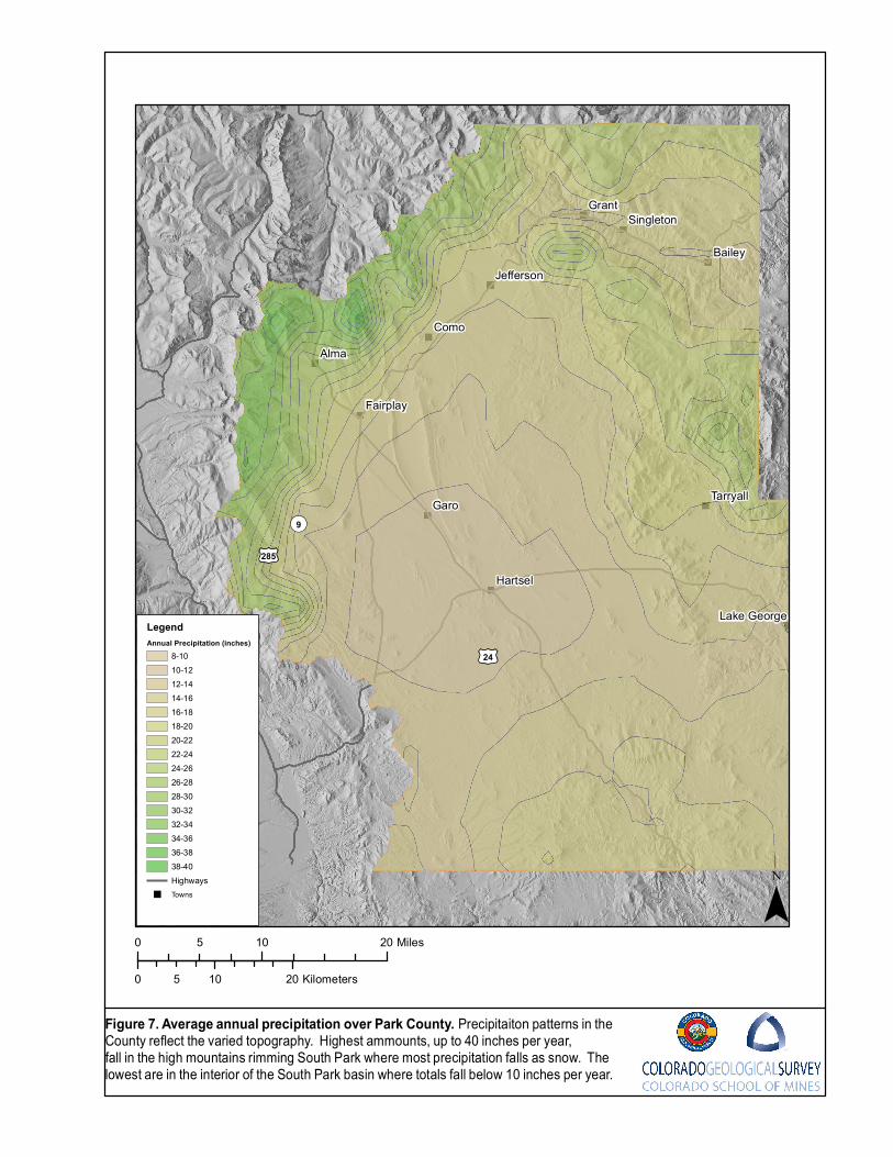
ComoAlma
Garo
Grant
Bailey
Hartsel
Fairplay
Tarryall
Singleton
Jefferson
Lake George
£¤24
£¤285
¬«9
0 10 205 Miles
0 10 205 Kilometers
Figure 7. Average annual precipitation over Park County. Precipitaiton patterns in the County reflect the varied topography. Highest ammounts, up to 40 inches per year, fall in the high mountains rimming South Park where most precipitation falls as snow. The lowest are in the interior of the South Park basin where totals fall below 10 inches per year.
¯
LegendAnnual Precipitation (inches)
8-1010-1212-1414-1616-1818-2020-2222-2424-2626-2828-3030-3232-3434-3636-3838-40Highways
" Towns
58
Groundwater Storage
Groundwater storage potential can also be quite variable depending on rock type, pore space, pore
space geometry and geologic setting. Geologic setting is perhaps the most important as it
determines whether an aquifer is confined or unconfined. Many of the aquifers in the County could
be considered unconfined in a broad scale. This would include the alluvial aquifer, nearly all of the
crystalline bedrock aquifers, and may of the sedimentary bedrock aquifers. Because of the geologic
structure of the South Park Basin, all of the Paleozoic, Jurassic Sedimentary Units, Cretaceous
Seaway Units, and Laramide Sedimentary Units have the potential to be confined as the units
extend down-dip to the east.
Another concept of groundwater storage that is useful for understanding groundwater resource
potential and limitations was described by Bossong (2003) and CDM (2010). Most recharge into the
soils is taken up by evapotranspiration. What is not can go into several areas, most enters shallow
groundwater interflow that feeds directly to nearby streams, other enters deeper baseflow that
maintains surface water baseflow of regional streams and rivers, a small portion may also be
available to recharge conceptual deep groundwater reservoir. Interflow is very temporary and
follows significant precipitation events and snowmelt. Baseflow can be seen as continuing through
the dry seasons and maintains minimum baseflow conditions of the rivers.
While the alluvial aquifer represents one of the most wide-spread aquifers in the County, it has been
found to be very thin and is generally restricted to narrow bands along active streams and rivers.
Storage is probably very limited and groundwater in the aquifer is directly tied to the surface water
system. The aquifer may also maintain sustainability through times of drought as it channels
groundwater baseflow to the stream system. CDM outlined buffers around active stream systems to
include alluvial and bedrock aquifers that have potential to capture water from both baseflow and
deep reservoirs as described above.
Structural Elements and Groundwater Flow
Fault Systems
Attention has been given to the possibility of faults, or fault systems, playing an important role in
groundwater flow systems (Jehn Water Consultants, Inc, 1997; Ball, 2012), yet there is little data to
provide conclusive determinations. Depending on physical geometry and characteristics, faults may
juxtapose hydrologic units with varying hydrologic properties. They have been described as either
barriers or pathways, or both, to groundwater flow.
59
Site-specific investigations by Ball (2012) showed the Elkhorn Fault acts as both a barrier and a
pathway and can affect groundwater flow locally, but less so regionally. This feature juxtaposes the
Precambrian crystalline rock hydrogeologic unit against a bedrock sedimentary hydrogeologic unit.
Field investigations combining geophysics with borehole drilling and water level data indicated that
the zone consists of a fault core barrier surrounded by a permeable damage zone. Groundwater
modeling suggests that, locally, the fault can channel flow through its permeable zone and can
mound flow when flow is perpendicular to the fault. On a regional scale modeling suggests that
faults have little impact to groundwater flow.
Other evidence within South Park suggests that faults may act as significant conduits to local flow.
Ruleman (personal communication) reports that springs in the Basin are very often located close to
mapped faults. Jehn Water Consultants, Inc (1997) cites salt deposits near Garcia Gulch and Seven
Mile Gulch south of Como that they attribute to evaporation of discharging groundwater. Although
the exact locations of these deposits have not been provided, they appear to be within the faulted
and folded zone between the Elkhorn and South Park fault systems. This suggests a possible
connection with deeper systems that may include the Minturn formation evaporite facies. This
possibility deserves further investigation.
Bossong and others (2003) found that highly fractured rock in fault zones are areas where the
highest producing wells are often found. This indicates increased permeability as well as increased
storage potential.
Implications of Minturn formation Evaporite Facies on Groundwater Flow
Very little is known about possible influences on the evaporite facies of the Minturn formation on
groundwater flow. Most of the area where this unit is located lies at the west side of the study area;
however, the eastward extent beneath other units is not well constrained. In the area where it is
present at, or near the surface, structural deformation appears to be quite complex, possibly owing
to diapiric flow and dissolution (Kirkham and others, 2012). The complex structural framework may
have significant impacts on local flow conditions. Obviously, groundwater flow within this unit has
the potential of direct contact with soluble salt minerals that will impact water quality.
Water-level Conditions and Direction of Groundwater Flow
The distribution of wells with reliable water level data is very limited for each individual unit. Synoptic
water level data, or water level measurements collected from multiple wells close in time, are even
rarer. This limits the ability to prepare water level elevation contour maps used to interpret
groundwater flow patterns. To assess water-level conditions and directions of groundwater flow in
South Park, a map was developed for the South Park Scoping Study that shows the generalized
potentiometric surface of sedimentary bedrock and crystalline-rock aquifers in South Park (Figure 8)
60
using water-level data in the CDWR well-applications database (Colorado Division of Water
Resources, 2012). Alluvium was not included in the analysis because it occurs as a relatively thin
layer of sediment overlying sedimentary bedrock and crystalline rocks and potentially has
substantially different water levels than in the underlying units. The map incorporates water-level
data from different hydrogeologic units, and because nearly all wells appear to be completed in the
uppermost hydrogeologic unit at a given location (except where alluvium is present), the map
represents the composite potentiometric surface of the uppermost hydrogeologic units basin-wide.
Because the water-level data represent various aquifers, measurement dates, depth intervals within
aquifers, and hydrologic conditions, the resulting potentiometric map should be considered
representative of general water-level conditions in South Park rather than precise water-level
conditions for a specific location or time.
The altitude of the water level in each well used to create the potentiometric-surface map was
determined by interpolating the land-surface altitude derived from the USGS National Elevation Data
Set (NED) with 10-meter resolution (U.S. Geological Survey, 2011) to each well location and
subtracting depth to water indicated by the STATIC_LVL field in the database to obtain a water-level
altitude for each well location. Water-level altitudes were then interpolated by using kriging (circular
semivariogram model) with the Spatial Analyst tool in ArcGIS 10.0 (Environmental Systems
Research Inc., 1999–2010) and contours were drawn to graphically represent the potentiometric
surface. Kriging was used to interpolate water-level data in order to generate a geostatistical fit to
potentially inconsistent values at a local scale. Prior to kriging, construction reports were reviewed
for wells having STATIC_LVL greater than the well depth, and corrections were made to the water-
level data where errors were found. Wells having a value of zero for STATIC_LVL were excluded
from analysis to avoid misrepresenting null values as valid water levels. Resulting contours were
smoothed using a maximum offset of 30 meters (about 98.4 feet).
The potentiometric surface shown in Figure 8 generally reflects the topography of the ground surface
with highest altitudes along the margins of the South Park basin and beneath upland areas and
ridges. Groundwater flows generally from the topographically high areas toward the stream valleys
and tributaries of the South Platte River and Tarryall Creek. A groundwater divide (Figure 8) that
separates the direction of groundwater flow toward the South Platte River from flow toward Tarryall
Creek is located approximately along the topographic divide between the two drainage basins.
Groundwater south and west of the divide flows toward the South Platte River and its tributaries,
whereas groundwater north and east of the divide flows toward the stream valley of Tarryall Creek.
Because few wells were found to penetrate through the uppermost sedimentary bedrock or
crystalline-rock hydrogeologic unit into underlying units, comparisons of water levels in vertically
adjacent units was limited and vertical gradients among hydrogeologic units could not be properly

61
evaluated. Although water-level data for the alluvial aquifer are sparse or lacking for substantial
parts of the South Park basin, available data indicate groundwater flow directions in the alluvium,
where saturated, generally are similar to those in the underlying hydrogeologic units.
Figure 8 includes general groundwater flow-directions inferred from topography outside of the areas
delineated for the South Park Scoping Study. These arrows are shown as general indicators of
expected groundwater flow patterns only.
"
"
"
"
"
"
"
"
"
"
"
Como
Alma
Garo
Grant
Bailey
Hartsel
Fairplay
Tarryall
Singleton
Jefferson
Lake George
Modified from Arnold (2013) and Barkmann and others (2013)Base from U.S. Geological Survey digital data, 1:100,000Wells modified from Colorado Division of Water Resources, 2012
0 10 205 Miles
0 10 205 Kilometers
Figure 8. Potentiometric surface and generalized direction of groundwater flow in South Park. The potentiometric surface is estimated from groundwater-levels in sedimentary bedrock and crystalline-rock aquifers and generally follows surface topography. It is based on water-level data from the Colorado Division of Water Resources permit files (CDWR, 2012).
EXPLANATIONGroundwater divide— Shows approximate location of divide separating flow toward the South Platte River from flow toward Tarryall Creek.Generalized direction of groundwater flow
ParkCoFlowlines Generalized direction of groundwater flowSouthParkStudyGWElevcontPark CountyHighways
Surface GeologyQuaternary depositsPost-Laramide hydrogeologic unitsPost-Laramide volcanic rocksCretaceous and Tertiary igneous intrusionsLaramide hydrogelogic unitsCretaceous seaway hydrogeologic unitsPaleozoic hydrogeologic unitsPrecambrian rocks ¯
63
REFERENCES
Arnold, L.R., 2013, Groundwater in South Park, Written communication to Coalition for the Upper
South Park dated October 17, 2013, U.S. Geological Survey Colorado Water Science Center,
Denver, CO.
Ball, L.B., 2012, Groundwater flow in an intermountain basin: hydrological, geophysical, and
geological exploration of South Park, Colorado: Univ. of Colo. Ph.D. Thesis, 240 p.
Barker, F. and Wyant, D.G., 1976, Geologic map of the Jefferson quadrangle, Park and Summit
Counties, Colorado, U.S. Geological Survey Geologic Quadrangle GQ 1345, scale 1:24,000.
Barkmann, P.E., Moore, A., Johnson, J., 2013, South Park Groundwater Quality Scoping Study,
Unpublished report by the Colorado Geological Survey for the Coalition for the Upper South Platte,
64p.
Bossong, C.R., Caine, J.S., Stannard, D.I., Flynn, J.L., Stevens, M.R., and Heiny-Dash, J.S., 2003,
Hydrologic conditions and assessment of water resources in the Turkey Creek watershed,
Jefferson county, Colorado, 1998-2001, U.S. Geological Survey, Water Resources Investigations
Report 03-4034.
Bohannon, R.G. and Ruleman, C.A., 2009, Geologic map of the Sulphur Mountain quadrangle, Park
County, Colorado, U.S. Geological Survey Scientific Investigations Map 3082, 1:24,000.
Bryant, B., McGrew, L.W., and Wobus, R.A., 1981a, Geologic map of the Denver 1 degree x 2
degrees quadrangle, north-central Colorado: U.S. Geological Survey Miscellaneous Investigations
Series Map I-1163, scale 1:250,000.
Bryant, B., Marvin, R.F., Naeser, C.W., and Mehnert, H.H.,1981b, Ages of igneous rocks of the
South Park-Breckenridge region, Colorado, and their relation to the tectonic history of the Front
Range uplift, Chapter C, in Shorter contributions to isotope research in the western United States,
1980: U.S. Geological Survey Professional Paper 1199, p. 15-26.
CDM, 2010, Upper Mountain Counties Aquifer Sustainability Project-Final Report, Prepared for
Upper Mountain Counties Water Need Consortium, Clear Creek County, Gilpin County, Jefferson
County, Park County, December 29, 2010, 106 p.
64
Chapin, C.E., and Cather, S.M., 1983, Eocene tectonics and sedimentation in the Colorado Plateau-
Rocky Mountain Area, in Lowell, J.D., and Gries, R., eds., Rocky Mountain Foreland Basins and
Uplifts: Denver, Colo., Rocky Mountain Association of Geologists Symposium, p. 33-56.
Chapin, C.E., and Lowell, G.R., 1979, Primary and secondary flow structures in ash-flow tuffs of the
Gribbles Run paleovalley, central Colorado: in Chapin, C.E., and Elston, W.E., eds, Ash-flow tuffs,
Geological Society of America Special Paper 180, p. 137-154.
Cobban, W.A., 1993, Diversity and distribution of Cretaceous ammonites, western United States, in
Caldwell, W.G.E. and Kauffman, E.G., eds., Evolution of the Western interior Basin: Geological
Society of Canada Special Paper 39, p. 435-451.
Cobban, W.A., Walaszczyk, I., Obradovich, J.D., and McKinney, K.C., 2006, A USGS zonal table for
the Upper Cretaceous Middle Cenomanian−Maastrichtian of the western Interior of the United
States based on ammonites, inoceramids, and radiometric ages: U.S. Geological Survey Open-
File Report OF2006-1250, 45 p.
Colorado Division of Water Resources, 2012, Well application information: Colorado Division of
Water Resources spatial representation of well application data available on the Web, accessed
December 19, 2012 at http://water.state.co.us/DataMaps/GISandMaps/Pages/
GISDownloads.aspx.
DeVoto, R.H., 1965, Facies relationships between Garo Sandstone and Maroon Formation, South
Park, Colorado: American Association of Petroleum Geologists Bulletin, v. 49, no. 4, p. 460-462.
De Voto, R.H., 1971, Geologic History of South Park and Geology of the Antero Reservoir
quadrangle, Colorado: Colorado School of Mines Quarterly, v. 66, 90 p.
De Voto, R.H., 1972, Pennsylvanian and Permian stratigraphy and tectonism in central Colorado:
Colorado School of Mines Quarterly, v. 67, no. 4, p. 139-185.
Dechesne, M., Raynolds, R.G., Barkmann, P.E., and Johnson, K.R., 2011, Denver Basin Geologic
Maps: Bedrock Geology, Structure, and Isopach Maps of the Upper Cretaceous to Paleogene
Strata between Greeley and Colorado Springs, Colorado: Colorado Geological Survey, Denver,
Map Series scale 1:250,000, booklet 54 p.
65
Durrani, J.A., 1980, Seismic investigation of the tectonic and stratigraphic history, eastern South
Park, Park County, Colorado. PhD Thesis, 112 p.
Environmental Systems Research Inc., 1999–2010, ArcGIS, version 10.0.
Epis, R.C., and Chapin, C.E., 1974, Stratigraphic nomenclature of the Thirtynine Mile volcanic field,
central Colorado: U.S. Geological Survey Bulletin 1395-C, p. C1–C23.
Epis, R.C., Scott, G.R., Taylor, R.B., and Chapin, C.E., 1976, Cenozoic Volcanic, Tectonic, and
Geomorphic Features of Central Colorado, in Studies in Colorado Field Geology, edited by R.C.
Epis and R.J. Weimer, Professional Contributions of Colorado School of Mines, Number 8, p 323-
338.
Houck, K.J., Funk, J.A., Kirkham, R.M., Carroll, C.J., and Heberton-Morimoto, A.D., 2012, Marmot
Peak geologic map, Park and Chaffee Counties, Colorado: Colorado Geological Survey, Denver,
scale 1:24,000, booklet.
Jehn Water Consultants, Inc. (JWCI), 1997, South Park basin initial ground water model
development report: Report prepared for the South Park Conjunctive Use Project, 91 p., 4 pls.
Kirkham, R.M., Houck, K.J., Carroll, C.J., and Heberton-Morimoto, A.D., 2012, Antero Reservoir
geologic map, Park and Chaffee Counties, Colorado: Colorado Geological Survey, Denver,
1:24,000, booklet 69 p.
Kirkham, R.M., Houck, K.J., and Lindsay, N.R., Keller, S.M., 2007, Geologic map of the Garo
quadrangle, Park County, Colorado: Colorado Geological Survey Open-File Report OF07-06,
1:24,000, booklet 78 p.
Kirkham, R.M., Keller, J.W., Houck, K.J., and Lindsay, N.R., 2006, Geologic map of the Fairplay
East quadrangle, Park County, Colorado: Colorado Geological Survey Open-File Report OF06-09,
1:24,000, booklet 81 p.
Kirkham, R.M., Streufert, R.K., Budahn, J.R., Kunk, M.J., and Perry, W.J., 2001, Late Cenozoic
regional collapse due to evaporite flow and Dissolution in the Carbondale Collapse Center, West-
Central Colorado, Mountain Geologist, 38: 193 – 210.
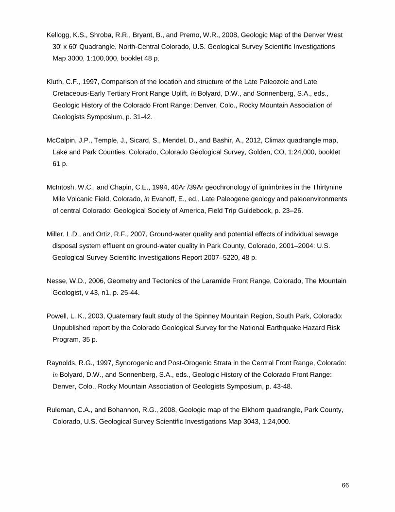
66
Kellogg, K.S., Shroba, R.R., Bryant, B., and Premo, W.R., 2008, Geologic Map of the Denver West
30' x 60' Quadrangle, North-Central Colorado, U.S. Geological Survey Scientific Investigations
Map 3000, 1:100,000, booklet 48 p.
Kluth, C.F., 1997, Comparison of the location and structure of the Late Paleozoic and Late
Cretaceous-Early Tertiary Front Range Uplift, in Bolyard, D.W., and Sonnenberg, S.A., eds.,
Geologic History of the Colorado Front Range: Denver, Colo., Rocky Mountain Association of
Geologists Symposium, p. 31-42.
McCalpin, J.P., Temple, J., Sicard, S., Mendel, D., and Bashir, A., 2012, Climax quadrangle map,
Lake and Park Counties, Colorado, Colorado Geological Survey, Golden, CO, 1:24,000, booklet
61 p.
McIntosh, W.C., and Chapin, C.E., 1994, 40Ar /39Ar geochronology of ignimbrites in the Thirtynine
Mile Volcanic Field, Colorado, in Evanoff, E., ed., Late Paleogene geology and paleoenvironments
of central Colorado: Geological Society of America, Field Trip Guidebook, p. 23–26.
Miller, L.D., and Ortiz, R.F., 2007, Ground-water quality and potential effects of individual sewage
disposal system effluent on ground-water quality in Park County, Colorado, 2001–2004: U.S.
Geological Survey Scientific Investigations Report 2007–5220, 48 p.
Nesse, W.D., 2006, Geometry and Tectonics of the Laramide Front Range, Colorado, The Mountain
Geologist, v 43, n1, p. 25-44.
Powell, L. K., 2003, Quaternary fault study of the Spinney Mountain Region, South Park, Colorado:
Unpublished report by the Colorado Geological Survey for the National Earthquake Hazard Risk
Program, 35 p.
Raynolds, R.G., 1997, Synorogenic and Post-Orogenic Strata in the Central Front Range, Colorado:
in Bolyard, D.W., and Sonnenberg, S.A., eds., Geologic History of the Colorado Front Range:
Denver, Colo., Rocky Mountain Association of Geologists Symposium, p. 43-48.
Ruleman, C.A., and Bohannon, R.G., 2008, Geologic map of the Elkhorn quadrangle, Park County,
Colorado, U.S. Geological Survey Scientific Investigations Map 3043, 1:24,000.
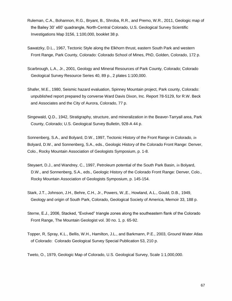
67
Ruleman, C.A., Bohannon, R.G., Bryant, B., Shroba, R.R., and Premo, W.R., 2011, Geologic map of
the Bailey 30’ x60’ quadrangle, North-Central Colorado, U.S. Geological Survey Scientific
Investigations Map 3156, 1:100,000, booklet 38 p.
Sawatzky, D.L., 1967, Tectonic Style along the Elkhorn thrust, eastern South Park and western
Front Range, Park County, Colorado: Colorado School of Mines, PhD, Golden, Colorado, 172 p.
Scarbrough, L.A., Jr., 2001, Geology and Mineral Resources of Park County, Colorado; Colorado
Geological Survey Resource Series 40, 89 p., 2 plates 1:100,000.
Shafer, M.E., 1980, Seismic hazard evaluation, Spinney Mountain project, Park county, Colorado:
unpublished report prepared by converse Ward Davis Dixon, Inc. Report 78-5129, for R.W. Beck
and Associates and the City of Aurora, Colorado, 77 p.
Singewald, Q.D., 1942, Stratigraphy, structure, and mineralization in the Beaver-Tarryall area, Park
County, Colorado; U.S. Geological Survey Bulletin, 928-A 44 p.
Sonnenberg, S.A., and Bolyard, D.W., 1997, Tectonic History of the Front Range in Colorado, in
Bolyard, D.W., and Sonnenberg, S.A., eds., Geologic History of the Colorado Front Range: Denver,
Colo., Rocky Mountain Association of Geologists Symposium, p. 1-8.
Steyaert, D.J., and Wandrey, C., 1997, Petroleum potential of the South Park Basin, in Bolyard,
D.W., and Sonnenberg, S.A., eds., Geologic History of the Colorado Front Range: Denver, Colo.,
Rocky Mountain Association of Geologists Symposium, p. 145-154.
Stark, J.T., Johnson, J.H., Behre, C.H., Jr., Powers, W.,E., Howland, A.L., Gould, D.B., 1949,
Geology and origin of South Park, Colorado, Geological Society of America, Memoir 33, 188 p.
Sterne, E.J., 2006, Stacked, “Evolved” triangle zones along the southeastern flank of the Colorado
Front Range, The Mountain Geologist vol. 30 no. 1, p. 65-92.
Topper, R, Spray, K.L., Bellis, W.H., Hamilton, J.L., and Barkmann, P.E., 2003, Ground Water Atlas
of Colorado: Colorado Geological Survey Special Publication 53, 210 p.
Tweto, O., 1979, Geologic Map of Colorado, U.S. Geological Survey, Scale 1:1,000,000.
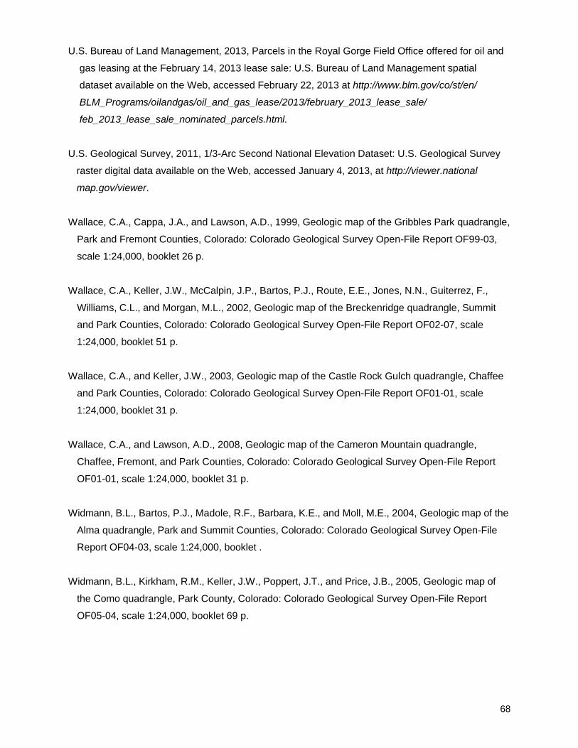
68
U.S. Bureau of Land Management, 2013, Parcels in the Royal Gorge Field Office offered for oil and
gas leasing at the February 14, 2013 lease sale: U.S. Bureau of Land Management spatial
dataset available on the Web, accessed February 22, 2013 at http://www.blm.gov/co/st/en/
BLM_Programs/oilandgas/oil_and_gas_lease/2013/february_2013_lease_sale/
feb_2013_lease_sale_nominated_parcels.html.
U.S. Geological Survey, 2011, 1/3-Arc Second National Elevation Dataset: U.S. Geological Survey
raster digital data available on the Web, accessed January 4, 2013, at http://viewer.national
map.gov/viewer.
Wallace, C.A., Cappa, J.A., and Lawson, A.D., 1999, Geologic map of the Gribbles Park quadrangle,
Park and Fremont Counties, Colorado: Colorado Geological Survey Open-File Report OF99-03,
scale 1:24,000, booklet 26 p.
Wallace, C.A., Keller, J.W., McCalpin, J.P., Bartos, P.J., Route, E.E., Jones, N.N., Guiterrez, F.,
Williams, C.L., and Morgan, M.L., 2002, Geologic map of the Breckenridge quadrangle, Summit
and Park Counties, Colorado: Colorado Geological Survey Open-File Report OF02-07, scale
1:24,000, booklet 51 p.
Wallace, C.A., and Keller, J.W., 2003, Geologic map of the Castle Rock Gulch quadrangle, Chaffee
and Park Counties, Colorado: Colorado Geological Survey Open-File Report OF01-01, scale
1:24,000, booklet 31 p.
Wallace, C.A., and Lawson, A.D., 2008, Geologic map of the Cameron Mountain quadrangle,
Chaffee, Fremont, and Park Counties, Colorado: Colorado Geological Survey Open-File Report
OF01-01, scale 1:24,000, booklet 31 p.
Widmann, B.L., Bartos, P.J., Madole, R.F., Barbara, K.E., and Moll, M.E., 2004, Geologic map of the
Alma quadrangle, Park and Summit Counties, Colorado: Colorado Geological Survey Open-File
Report OF04-03, scale 1:24,000, booklet .
Widmann, B.L., Kirkham, R.M., Keller, J.W., Poppert, J.T., and Price, J.B., 2005, Geologic map of
the Como quadrangle, Park County, Colorado: Colorado Geological Survey Open-File Report
OF05-04, scale 1:24,000, booklet 69 p.
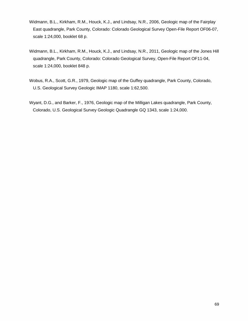
69
Widmann, B.L., Kirkham, R.M., Houck, K.J., and Lindsay, N.R., 2006, Geologic map of the Fairplay
East quadrangle, Park County, Colorado: Colorado Geological Survey Open-File Report OF06-07,
scale 1:24,000, booklet 68 p.
Widmann, B.L., Kirkham, R.M., Houck, K.J., and Lindsay, N.R., 2011, Geologic map of the Jones Hill
quadrangle, Park County, Colorado: Colorado Geological Survey, Open-File Report OF11-04,
scale 1:24,000, booklet 848 p.
Wobus, R.A., Scott, G.R., 1979, Geologic map of the Guffey quadrangle, Park County, Colorado,
U.S. Geological Survey Geologic IMAP 1180, scale 1:62,500.
Wyant, D.G., and Barker, F., 1976, Geologic map of the Milligan Lakes quadrangle, Park County,
Colorado, U.S. Geological Survey Geologic Quadrangle GQ 1343, scale 1:24,000.