Embed Size (px)
Citation preview
A9 Dualling – Dalwhinnie to Crubenmore DMRB Stage 3 Environmental Impact Assessment
Chapter 10: Geology, Soils and Groundwater
Page 10-1
�� Geology, Soils and Groundwater
��.� Introduction
10.1.1 This chapter presents the results of the geology, soils and groundwater assessment undertaken
as part of the Design Manual for Roads and Bridges (DMRB) Stage 3 Environmental Impact
Assessment (EIA) for Project 8 – Dalwhinnie to Crubenmore of the A9 Dualling Programme,
hereafter referred to as the Proposed Scheme, as described in Chapter 5.
10.1.2 This includes assessment of potential impacts related to superficial and solid geology, designated
geological sites, geodiversity features, mineral extraction, soils, potential contamination,
groundwater and associated receptors, including Groundwater Dependent Terrestrial Ecosystems
(GWDTE), groundwater abstractions and private water supplies (PWS).
10.1.3 The assessment is supported by the following appendices presented in Volume 2 of this report:
• Appendix 10.1: Peat Survey Information
• Appendix 10.2: Groundwater Dependent Terrestrial Ecosystems
• Appendix 10.3: Groundwater Abstractions and Private Water Supplies
• Appendix 10.4: Potential Contamination Sources
• Appendix 10.5: Preliminary Peat Landslide Risk Assessment
• Appendix 10.6: Outline Peat Management Plan
10.1.4 Supporting considerations related to the assessment have also been addressed separately within
Chapter 8, Chapter 11 and Chapter 12, and associated appendices in Volume 2, with regards
agricultural land use, ecology, hydrology, fluvial geomorphology, drainage and flooding. National
and local planning policies which are relevant to geology, soils and groundwater are described in
Chapter 19, together with an assessment of the Proposed Scheme compliance against these.
��.� Approach and Methods
Scope and Guidance
10.2.1 This EIA has been undertaken using the guidance contained in DMRB Volume 11 Section 3 Part 11
‘Geology and Soils’ (The Highways Agency et al., 1993), taking into account updated guidance on
contaminated land within ‘The Model Procedures for the Management of Land Contamination’
(Environment Agency, 2004) where appropriate, and DMRB Volume 11 Section 3 Part 10 HD
45/09 ‘Road Drainage and the Water Environment’ (The Highways Agency et al., 2009).
10.2.2 Consideration of soil includes potential impacts in terms of conservation value and impacts on
peaty soils and peat. Potential agricultural productivity of the soils is also considered, though
impacts in relation to general agricultural land use interests and land-take are assessed in
Chapter 8. Made ground is included in the assessment of potential contamination sources, while
earthworks volumes and ‘cut and fill balance’ of the Proposed Scheme is described in Chapter 5.
A9 Dualling – Dalwhinnie to Crubenmore DMRB Stage 3 Environmental Impact Assessment
Chapter 10: Geology, Soils and Groundwater
Page 10-2
10.2.3 For groundwater, the assessment considers potential impacts on quality, level, flow, GWDTE and
groundwater-related changes to surface water, groundwater abstractions and PWS. Impacts in
relation to fluvial geomorphology, surface water quality, drainage and flooding are assessed in
Chapter 11.
Study Area
10.2.4 The assessment covers a study area extending to 250m from the permanent and temporary
works boundaries of the Proposed Scheme. For GWDTE, the study area extends to at least 100m
from the permanent and temporary works boundaries, and up to 250m where required.
10.2.5 Impacts on groundwater abstractions and PWS have been assessed to a distance of 850m from
the temporary and permanent works boundaries of the Proposed Scheme. This was considered
to correspond to the minimum study areas applied for groundwater abstractions under The
Water Environment (Controlled Activities) (Scotland) Regulations 2011 (CAR).
Baseline Data Collection
10.2.6 Baseline conditions described cover the following aspects:
• Superficial and solid geology
• Designated geological receptors and features of geodiversity interest
• Mineral extraction
• Soils and peat
• Groundwater and associated receptors, including GWDTE, abstractions and PWS
• Potential contamination sources.
10.2.7 Baseline conditions were determined through desk-based data assessments, consultation with
statutory and non-statutory bodies and landowners, ground investigations and field surveys.
Desk-based Assessment
10.2.8 The desk-based assessment included a review of the following information:
• Ordnance Survey (OS) historical maps (sourced from Envirocheck Reports) dating back to
1856 for information on former land use, potential contamination and information on PWS
• British Geological Survey (BGS) data including BGS Geological Maps, BGS Hydrogeological and
Groundwater Vulnerability Maps, BGS borehole logs and BGS publications
• James Hutton Institute (JHI) published soil maps, thematic data and derived information,
including the National Soil Map of Scotland (1981)
• Scottish Environment Protection Agency (SEPA) Groundwater Vulnerability Maps, interactive
River Basin Management Plan map and Scottish Wetland Inventory
• Scottish Natural Heritage (SNH) designation database (SNH, 2016a) and Carbon and Peatland
Map (SNH, 2016b)
• Previous assessments, including the Strategic Environmental Assessment (SEA) and
Addendum Reports for the A9 Dualling Programme (Transport Scotland, 2013 and 2014a),
DMRB Stage 1 Preliminary Engineering Services Report (Transport Scotland, 2014b) and
Geotechnical Preliminary Sources Study Report (PSSR) (CFJV, 2016).
A9 Dualling – Dalwhinnie to Crubenmore DMRB Stage 3 Environmental Impact Assessment
Chapter 10: Geology, Soils and Groundwater
Page 10-3
Field Surveys
10.2.9 Several site walkovers were conducted by the CH2M Fairhurst Joint Venture (CFJV) to obtain
information on the baseline geology, soil, groundwater, potential contamination conditions and
PWS locations where possible. These were also supplemented by the following field surveys:
• Phase 1 Habitat Surveys (CH2M, June to September 2014)
• Preliminary ecological peat probing surveys (CFJV, August 2014)
• National Vegetation Classification (NVC) Surveys (MacArthur Green, June to July 2015)
• Detailed peat probing and sampling surveys (CFJV, July to August and December 2016)
Consultations
10.2.10 Consultations were undertaken with the following:
• Cairngorms National Park Authority (CNPA) and The Highland Council (THC) for information
on potential contamination sources, PWS and any additional relevant information
• SEPA for information on groundwater abstractions and potential contaminated land uses
• SNH for information on the location, extent and boundaries of environmental sensitivities and
geodiversity features in the vicinity of the Proposed Scheme
• HighWater (Scotland) Ltd and private landowners/ residents via questionnaire, for additional
information on groundwater abstractions or PWS, their source, location, type and use.
Ground Investigations
10.2.11 Intrusive ground investigations (GI) were conducted by Raeburn Drilling and Geotechnical Ltd
(Raeburn) between August and December 2015 (referred to as the ‘Advanced GI’) and between
December 2016 and April 2017 (referred to as the ‘Preliminary GI’). Both phases consisted of
boreholes, trial pit excavations and peat probes, in addition to groundwater and ground gas
monitoring, and selected chemical testing of soil, groundwater and surface water samples.
10.2.12 The results of the Advanced GI and Preliminary GI are presented in the ‘A9 Dualling – Glen Garry
to Dalraddy, Project 8 Dalwhinnie to Crubenmore Report on Ground Investigation’ (Raeburn,
March 2017) and ‘A9 Dualling – Dalwhinnie to Crubenmore Project 8, Report on Preliminary
Ground Investigation’ (Raeburn, June 2017), respectively.
Impact Assessment
10.2.13 The potential impacts in relation to geology, soils, groundwater and potential contamination
have been assessed individually as per the methodologies provided below. The criteria outlined
are based on those that have been applied to similar schemes in Scotland and are designed to
comply with DMRB Stage 3 EIA requirements.
Geology and Soils
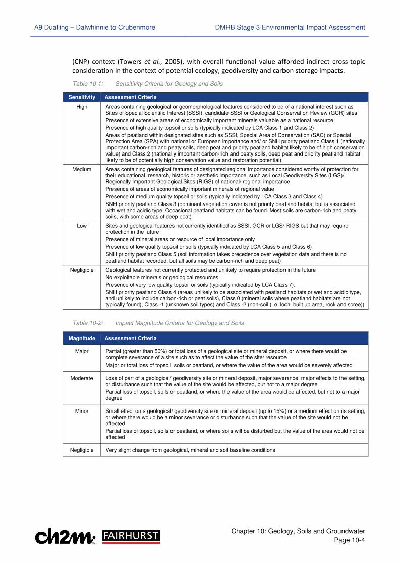
10.2.14 For superficial and solid geology, soils, designated geological receptors, features of geodiversity
interest and mineral extraction, the sensitivity and magnitude criteria in Table 10-1 and
Table 10-2 were applied. The impact significance was then determined using Table 10-3.
10.2.15 In relation to soils and peat, the criteria for defining sensitivity has been initially informed based
on environmental designations, SNH priority peatland and Land Capability for Agriculture (LCA)
categories, but refined based on field survey data where possible. Soil conservation value is
recognised based on rarity, representivity and diversity within the Cairngorms National Park
A9 Dualling – Dalwhinnie to Crubenmore DMRB Stage 3 Environmental Impact Assessment
Chapter 10: Geology, Soils and Groundwater
Page 10-4
(CNP) context (Towers et al., 2005), with overall functional value afforded indirect cross-topic
consideration in the context of potential ecology, geodiversity and carbon storage impacts.
Table 10-1: Sensitivity Criteria for Geology and Soils
Sensitivity Assessment Criteria
High Areas containing geological or geomorphological features considered to be of a national interest such as Sites of Special Scientific Interest (SSSI), candidate SSSI or Geological Conservation Review (GCR) sites
Presence of extensive areas of economically important minerals valuable as a national resource
Presence of high quality topsoil or soils (typically indicated by LCA Class 1 and Class 2)
Areas of peatland within designated sites such as SSSI, Special Area of Conservation (SAC) or Special Protection Area (SPA) with national or European importance and/ or SNH priority peatland Class 1 (nationally important carbon-rich and peaty soils, deep peat and priority peatland habitat likely to be of high conservation value) and Class 2 (nationally important carbon-rich and peaty soils, deep peat and priority peatland habitat likely to be of potentially high conservation value and restoration potential)
Medium Areas containing geological features of designated regional importance considered worthy of protection for their educational, research, historic or aesthetic importance, such as Local Geodiversity Sites (LGS)/ Regionally Important Geological Sites (RIGS) of national/ regional importance
Presence of areas of economically important minerals of regional value
Presence of medium quality topsoil or soils (typically indicated by LCA Class 3 and Class 4)
SNH priority peatland Class 3 (dominant vegetation cover is not priority peatland habitat but is associated with wet and acidic type. Occasional peatland habitats can be found. Most soils are carbon-rich and peaty soils, with some areas of deep peat)
Low Sites and geological features not currently identified as SSSI, GCR or LGS/ RIGS but that may require protection in the future
Presence of mineral areas or resource of local importance only
Presence of low quality topsoil or soils (typically indicated by LCA Class 5 and Class 6)
SNH priority peatland Class 5 (soil information takes precedence over vegetation data and there is no peatland habitat recorded, but all soils may be carbon-rich and deep peat)
Negligible Geological features not currently protected and unlikely to require protection in the future
No exploitable minerals or geological resources
Presence of very low quality topsoil or soils (typically indicated by LCA Class 7).
SNH priority peatland Class 4 (areas unlikely to be associated with peatland habitats or wet and acidic type, and unlikely to include carbon-rich or peat soils), Class 0 (mineral soils where peatland habitats are not typically found), Class -1 (unknown soil types) and Class -2 (non-soil (i.e. loch, built up area, rock and scree))
Table 10-2: Impact Magnitude Criteria for Geology and Soils
Magnitude Assessment Criteria
Major Partial (greater than 50%) or total loss of a geological site or mineral deposit, or where there would be complete severance of a site such as to affect the value of the site/ resource
Major or total loss of topsoil, soils or peatland, or where the value of the area would be severely affected
Moderate Loss of part of a geological/ geodiversity site or mineral deposit, major severance, major effects to the setting, or disturbance such that the value of the site would be affected, but not to a major degree
Partial loss of topsoil, soils or peatland, or where the value of the area would be affected, but not to a major degree
Minor Small effect on a geological/ geodiversity site or mineral deposit (up to 15%) or a medium effect on its setting, or where there would be a minor severance or disturbance such that the value of the site would not be affected
Partial loss of topsoil, soils or peatland, or where soils will be disturbed but the value of the area would not be affected
Negligible Very slight change from geological, mineral and soil baseline conditions
A9 Dualling – Dalwhinnie to Crubenmore DMRB Stage 3 Environmental Impact Assessment
Chapter 10: Geology, Soils and Groundwater
Page 10-5
Table 10-3: Matrix for Determination of Impact Significance for Geology and Soils
Sensitivity Magnitude
Major Moderate Minor Negligible
High Large Moderate/ Large Moderate Slight
Medium Moderate/ Large Moderate Slight/ Moderate Neutral/ Slight
Low Moderate Slight/ Moderate Neutral/ Slight Neutral
Negligible Slight Neutral/ Slight Neutral Neutral
Groundwater
10.2.16 For groundwater, the assessment considers sensitivity in the context of the known or anticipated
hydrogeological conditions, including potential groundwater receptors. The sensitivity and
magnitude criteria for this are shown in Table 10-4 and Table 10-5 respectively. The impact
significance was then determined using the matrix as shown in Table 10-6.
10.2.17 The criteria for defining the magnitude of impact on the quality, level and flow of groundwater is
based primarily on the type of proposed road profile (cutting, widening or embankment) facing
the receptor, vulnerability of the groundwater to disruption, estimates of drawdown and
potential zones of dewatering influence in accordance with ‘CIRIA C750 Groundwater Control:
Design and Practice, Second Edition’ (CIRIA, 2016) using the Sichardt formula (Powers et al.,
2007). Impacts on the quality, level and flow of groundwater may also have effects on GWDTE,
surface water, groundwater abstractions and PWS.
10.2.18 For GWDTE, the sensitivity criteria have been based on analysis of NVC Surveys findings
(MacArthur Green, 2015) against ‘Land Use Planning System Guidance Note 31 (LUPS-GU31)
Guidance on Assessing the Impacts of Development Proposals on Groundwater Abstractions and
GWDTE (Version 2)’ (SEPA, 2014a). These were used to identify NVC communities as ‘potentially’
groundwater dependent or not, but with additional hydrogeological and ecological consideration
of ‘likely’ dependence undertaken to refine this where possible.
Table 10-4: Sensitivity Criteria for Groundwater
Sensitivity Assessment Criteria
Very High Groundwater aquifer(s) with very high productivity and/ or Water Framework Directive (WFD) good groundwater quality and quantity status
Exploitation of groundwater resource is extensive for public, private domestic and/ or agricultural use (i.e. feeding ten or more properties) and/ or industrial supply
Important sites of nature conservation dependent on groundwater as per importance criteria attributed in Chapter 12 or groundwater is considered likely to support wetland vegetation which is highly groundwater dependent
Surface water features with hydrological importance to designated sensitive ecosystems of national/ international importance
High Groundwater aquifer(s) with moderate/ high productivity and/ or WFD good groundwater quality and quantity status
Exploitation of groundwater resource is not extensive (i.e. private domestic and/ or agricultural supply feeding less than ten properties)
Local areas of nature conservation dependent on groundwater as per importance criteria attributed in Chapter 12, or groundwater is considered likely to support wetland vegetation which is moderately groundwater dependent
Surface water features with hydrological importance to sensitive ecosystems of regional importance
Medium Groundwater aquifer(s) with low productivity and/ or WFD variable groundwater quality and quantity status
No current known exploitation of groundwater as a resource and aquifer(s) properties make potential exploitation appear unlikely
Minor areas of nature conservation with a degree of groundwater dependency, as per importance criteria attributed in Chapter 12
Surface water features with some but limited hydrologic importance to sensitive or protected ecosystems of authority area importance
A9 Dualling – Dalwhinnie to Crubenmore DMRB Stage 3 Environmental Impact Assessment
Chapter 10: Geology, Soils and Groundwater
Page 10-6
Sensitivity Assessment Criteria
Low Groundwater aquifer(s) with very low productivity and/ or WFD poor groundwater quality and quantity status
No known past or present exploitation of groundwater aquifer(s) as a resource
Areas of vegetation with no groundwater dependency
Surface water features with minimal/ insignificant hydrological importance to sensitive ecosystems of less than authority area importance
Table 10-5: Impact Magnitude Criteria for Groundwater
Magnitude Assessment Criteria
Major Major or long term change to groundwater aquifer(s) flow, water level, quality or available yield
Groundwater resource use is irreparably impacted upon, with a major or total loss of an existing supply or supplies
Changes to water table level or quality would result in a major or total change in or loss of a groundwater dependent area, where the value of a site would be severely affected
Changes to groundwater aquifer(s) flow, water level and quality would result in major changes to groundwater base flow contributions to surface water and/ or alterations in surface water quality, resulting in a major shift away from baseline conditions such as change to WFD status
Moderate Moderate changes to groundwater aquifer(s) flow, water level, quality or available yield
Groundwater resource use is impacted slightly, but existing supplies remain sustainable
Changes to water table level or quality would result in partial change in or loss of a groundwater dependent area, where the value of the site would be affected, but not to a major degree
Changes to groundwater aquifer(s) flow, water level and quality would result in moderate changes to groundwater base flow contributions to surface water and/ or alterations in surface water quality, resulting in a moderate shift from baseline conditions that may be long-term or temporary
Minor Minor changes to groundwater aquifer(s) flow, water level, quality or available yield
Changes to water table level, quality and yield result in little discernible change to existing resource use
Changes to water table level or quality would result in minor change to groundwater dependent areas, but where the value of the site would not be affected
Changes to groundwater aquifer(s) flow, water level and quality would result in minor changes to groundwater base flow contributions to surface water and/ or alterations in surface water quality, resulting in a minor shift from baseline conditions (equivalent to minor but measurable change within WFD status)
Negligible Very slight change from groundwater baseline conditions, approximating to ‘no change’ conditions
Table 10-6: Matrix for Determination of Impact Significance for Groundwater
Sensitivity Magnitude
Major Moderate Minor Negligible
Very High Very Large Large/ Very Large Moderate/ Large Neutral
High Large/ Very Large Moderate/ Large Slight/ Moderate Neutral
Medium Large Moderate Slight Neutral
Low Slight/ Moderate Slight Neutral Neutral
Potential Contamination
10.2.19 The assessment of potential contamination has focused on the potential for impacts on receptors
as a direct consequence of the Proposed Scheme encountering contamination, within the context
of a preliminary conceptual site model (CSM). A receptor can be a person (construction or
maintenance workers, road users or local residents), the water environment (groundwater and
surface water features), ecological receptors (GWDTE, agricultural land or livestock) and/ or
property receptors (structures, buried concrete, services and PWS).
10.2.20 The preliminary CSM represents an outline of potential ‘pollutant linkages’ (PL) that may be
present between a source of contamination, pathways by which it may move and ultimately,
affected receptors. Should any element of that linkage (contaminant, pathway or receptor) be
A9 Dualling – Dalwhinnie to Crubenmore DMRB Stage 3 Environmental Impact Assessment
Chapter 10: Geology, Soils and Groundwater
Page 10-7
missing or removed, the contamination is considered unlikely to represent a potential risk or
impact. The potential receptors and pathways were compiled based on the definitions in Part IIA
of the Environmental Protection Act 1990, as provided in Statutory Guidance (Scottish Executive,
2006).
10.2.21 Potential contamination sources are identified in the baseline information and the pollutant
linkages used in the assessment of these are provided in Table 10-7, with individual references
for each linkage, PL1 to PL24, during construction and operation.
Table 10-7: Potential Pollutant Linkages for Potential Contamination
Pollutant Linkage
Receptor Pathway
Construction
PL1 Human Health (construction workers)
Ingestion, inhalation and dermal contact with soil, soil dust and fibres (asbestos), deep and shallow groundwater and surface water
PL2 Migration of ground gases into shallow pits or site buildings
PL3 Human Health (local residents and transient traffic (foot, road and rail))
Property (Scheduled Monuments (SM), buildings)
Ingestion, inhalation and dermal contact with wind-blown dust created during excavation works
PL4 Migration of ground gases into homes or workplaces through preferential pathways created during construction posing a potential asphyxiation/ explosion risk
PL5 Water Environment (superficial groundwater)
Leaching and migration of contaminants
PL6 Water Environment (bedrock groundwater)
Migration of contaminants or contaminated shallow groundwater into the deeper rock aquifer
PL7
Water Environment (surface water)
Ecological Receptors (GWDTE)
Property (PWS and services)
Migration/ mobilisation of contaminated shallow groundwater through drift deposits or made ground
PL8
Water Environment (surface water)
Runoff from contaminated source(s)
PL9 Migration of contaminated bedrock groundwater towards surface water receptor
PL10 Discharge of intercepted contaminated groundwater during passive or active dewatering
PL11 Ecological receptors (agricultural land/ livestock)
Inhalation, ingestion and direct contact with contaminated soils, soil dust, fibres (asbestos) and water
PL12 Property (SM, buried concrete and services)
Direct contact with made ground, superficial deposits, groundwater and bedrock materials
Operation
PL13 Human Health (maintenance workers)
Ingestion, inhalation and dermal contact with soil, soil dust, fibres (asbestos), deep and shallow groundwater, surface water in the long-term during routine maintenance e.g. drainage inspections
PL14 Migration of ground gases into confined spaces e.g. service pits, accommodation buildings creating an asphyxiation/explosion risk
PL15 Human Health (local residents and transient traffic (foot, road and rail))
Property (SM and buildings)
Ingestion, inhalation and dermal contact with wind-blown dust from contaminated soils re-used within road features such as embankments and landscaped areas
PL16 Migration of ground gases into homes or workplaces through preferential pathways remaining following construction thus posing a potential asphyxiation/ explosion risk
PL17 Water Environment (superficial groundwater)
Leaching and migration of contaminants
PL18 Water Environment (bedrock groundwater)
Migration of contaminated shallow groundwater into the deeper rock aquifer
PL19
Water Environment (surface water)
Ecological Receptors (GWDTE)
Property (PWS and services)
Migration of shallow groundwater through drift deposits or made ground
A9 Dualling – Dalwhinnie to Crubenmore DMRB Stage 3 Environmental Impact Assessment
Chapter 10: Geology, Soils and Groundwater
Page 10-8
Pollutant Linkage
Receptor Pathway
PL20
Water Environment (surface water)
Runoff from contaminated source(s)
PL21 Migration of contaminated shallow groundwater through drainage channels and associated granular bedding materials or engineered structures
PL22 Discharge of intercepted contaminated groundwater
PL23 Ecological receptors (agricultural land/ livestock)
Inhalation, ingestion and direct contact with contaminated soils/ water
PL24 Property (buried concrete and services)
Direct contact with made ground, superficial deposits, groundwater and bedrock materials
10.2.22 For the purposes of this assessment, the preliminary CSM disregards those pollutant linkages that
are incomplete and cannot pose a risk to identified receptors. Where a complete pollutant
linkage exists, a generic qualitative risk assessment has been undertaken.
10.2.23 The output of the assessment cannot be reported in terms of ‘sensitivity’. Instead, it is reported
as the ‘likelihood’ of a complete pollutant linkage being present, which is defined within CIRIA
C552 ‘Contaminated Land Risk Assessment: A Guide to Good Practice’ (CIRIA, 2001), ‘CLR11 –
Model Procedures for the Management of Land Contamination’ (Environment Agency, 2004) and
summarised in Table 10-8. The magnitude, or consequence, of the effect on likely receptors is
outlined in Table 10-9 and overall risk (significance), taking account of both likelihood and
consequence, is identified with reference to the matrix in Table 10-10.
Table 10-8: Likelihood Criteria for Potential Contamination
Likelihood Assessment Criteria
High Likelihood There is a complete pollution linkage and an event that either appears very likely in the short-term and almost inevitable over the long-term, or there is evidence at the receptor of harm or pollution
Likely There is a complete pollution linkage and all the elements are present and available, which means that it is probable that an event will occur
Circumstances are such that an event is not inevitable, but possible in the short-term and likely over a long-term
Low Likelihood There is a complete pollution linkage and the circumstances are possible under which an event could occur
However, it is by no means certain that even over a longer period such an event would take place, and is less likely in the shorter term
Unlikely There is a complete pollution linkage but circumstances are such that it is improbable that an event would occur even in the very long-term
Table 10-9: Impact Magnitude (Consequence) Criteria for Potential Contamination
Consequence Assessment Criteria
Severe Short-term (acute) damage to human health (significant harm)
Pollution of sensitive water resources as a result of short-term exposure
Damage to a particular ecosystem as a result of acute exposure
Catastrophic damage to buildings/ property/ services/ Scheduled Monument (SM)
Medium Long-term (chronic) damage to human health (significant harm)
Pollution of sensitive water resources as a result of chronic exposure
A significant change in a particular ecosystem, or organism forming part of such an ecosystem
Substantial damage to buildings/ property/ services/ SM
Mild No appreciable impact on human health based on the potential effects on the critical human health receptor
Pollution of non-sensitive water resources
Damage to ecological systems with no significant impairment
Significant damage to sensitive buildings/ structures/ SM/ services or the environment
A9 Dualling – Dalwhinnie to Crubenmore DMRB Stage 3 Environmental Impact Assessment
Chapter 10: Geology, Soils and Groundwater
Page 10-9
Consequence Assessment Criteria
Minor Harm (not necessarily significant), which may result in financial loss or require expenditure to resolve
Non-permanent health effects to human health
No appreciable pollution
Easily repairable effects or damage to ecological systems
Easily reparable damage to buildings, structures, SM and services
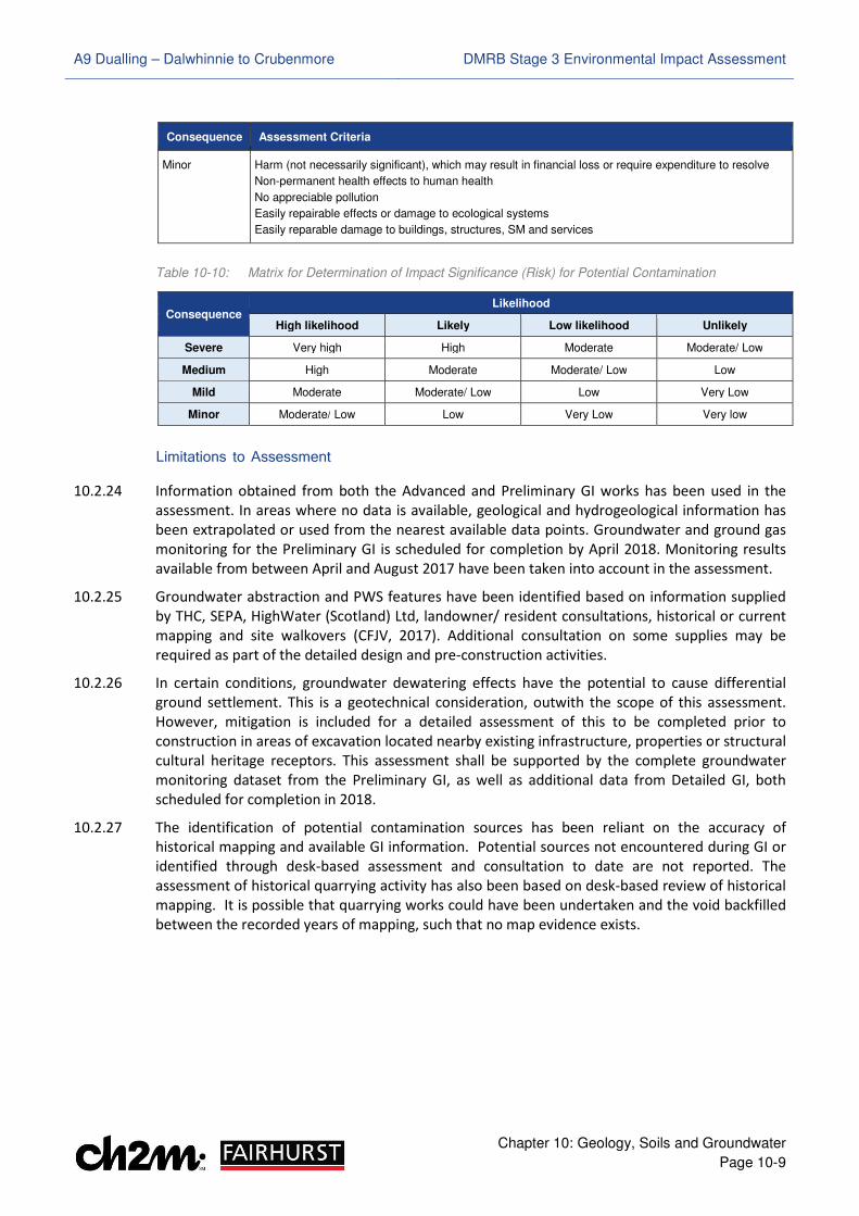
Table 10-10: Matrix for Determination of Impact Significance (Risk) for Potential Contamination
Consequence Likelihood
High likelihood Likely Low likelihood Unlikely
Severe Very high High Moderate Moderate/ Low
Medium High Moderate Moderate/ Low Low
Mild Moderate Moderate/ Low Low Very Low
Minor Moderate/ Low Low Very Low Very low
Limitations to Assessment
10.2.24 Information obtained from both the Advanced and Preliminary GI works has been used in the
assessment. In areas where no data is available, geological and hydrogeological information has
been extrapolated or used from the nearest available data points. Groundwater and ground gas
monitoring for the Preliminary GI is scheduled for completion by April 2018. Monitoring results
available from between April and August 2017 have been taken into account in the assessment.
10.2.25 Groundwater abstraction and PWS features have been identified based on information supplied
by THC, SEPA, HighWater (Scotland) Ltd, landowner/ resident consultations, historical or current
mapping and site walkovers (CFJV, 2017). Additional consultation on some supplies may be
required as part of the detailed design and pre-construction activities.
10.2.26 In certain conditions, groundwater dewatering effects have the potential to cause differential
ground settlement. This is a geotechnical consideration, outwith the scope of this assessment.
However, mitigation is included for a detailed assessment of this to be completed prior to
construction in areas of excavation located nearby existing infrastructure, properties or structural
cultural heritage receptors. This assessment shall be supported by the complete groundwater
monitoring dataset from the Preliminary GI, as well as additional data from Detailed GI, both
scheduled for completion in 2018.
10.2.27 The identification of potential contamination sources has been reliant on the accuracy of
historical mapping and available GI information. Potential sources not encountered during GI or
identified through desk-based assessment and consultation to date are not reported. The
assessment of historical quarrying activity has also been based on desk-based review of historical
mapping. It is possible that quarrying works could have been undertaken and the void backfilled
between the recorded years of mapping, such that no map evidence exists.
A9 Dualling – Dalwhinnie to Crubenmore DMRB Stage 3 Environmental Impact Assessment
Chapter 10: Geology, Soils and Groundwater
Page 10-10
��.� Baseline Conditions
Geology
10.3.1 As shown in Drawing 10.1 in Volume 3 of this report, BGS mapping indicates the superficial
deposits within the study area to variably include made ground, peat, alluvium, alluvial fan, river
terrace deposits, glaciofluvial deposits, diamicton till and hummocky glacial deposits.
10.3.2 The solid geology throughout the majority of the study area comprises Precambrian Psammite of
the Gaick Psammite Formation; recorded as predominantly quartzose psammite with scattered
biotite flakes and laminae. BGS mapping also indicates the Loch Laggan Psammite and Falls of
Phones Semipelite Formations in the north, as shown in Drawing 10.2 (Volume 3). These strata
comprise micaceous and feldspathic psammite, and gneissose but locally schistose, respectively.
The axis of a synclinal fold additionally runs along and adjacent to the existing A9 carriageway
between ch. 30,550 and ch. 32,500, with an Ordovician igneous intrusion site (pegmatite) present
beneath the existing A889 Dalwhinnie junction. Faulting is present to west in Glen Truim and in
Crubenmore in the north, but does not cross the Proposed Scheme area.
10.3.3 These conditions have broadly been substantiated by GI information, as summarised below.
Findings in relation to peat are described in Appendix 10.1 (Volume 2) and the soils sub-section.
Made Ground
10.3.4 Made ground or possible made ground has been encountered at several locations during the
Advanced and Preliminary GI works, predominantly within southern portions of the study area
adjacent to the existing A9 carriageway and the existing A889 Dalwhinnie junction. Isolated areas
were also encountered near the Scottish and Southern Energy (SSE) Aqueduct (chainage (ch.)
23,800 and ch. 24,500), and north of Cuaich (ch. 26,200 and ch. 26,800).
10.3.5 The materials encountered ranged from 0.10 to 3.20m in thickness, and were described to vary
between clayey, sandy, gravelly topsoil with pockets of peat or sandy gravelly or silty clay, sand
and gravel. Concrete, cobbles, boulders, fragments of tarmac, brick, timber, metal, plastic and
glass were also observed, together with a strong hydrocarbon odour between 1.20 and 1.70m
below ground level (bgl) in one location (ch. 21,250) and an organic odour from decomposing
vegetation at 1.50m bgl in another (ch. 21,450).
10.3.6 Based on Table 10-1, made ground is considered to be of negligible sensitivity. However, each
occurrence has been reviewed as a potential contamination source in Appendix 10.4 (Volume 2)
and their locations are shown in Drawings 10.30 to 10.38 (Volume 3).
Superficial Geology
10.3.7 Superficial deposits identified from available GI include alluvium and river terrace deposits
(underlying the River Truim floodplain and various watercourses), and alluvial fans (fanning out
from watercourses including Allt Coire Chuirn, Allt Cuaich and Allt Garbh). Alluvium and river
terrace deposits were described to vary between clayey, silty or gravelly fine to coarse sand and
silty sandy fine to coarse gravel, with variable cobble and boulder content. Alluvial fans were
described as sandy gravelly silt and silty sandy fine to coarse gravel with variable cobble content.
The thickness of the alluvial units varies between 0.50 and 16.60m.
10.3.8 Glaciofluvial deposits, diamicton till and hummocky glacial deposits have also been observed
across the study area. These have predominantly been recorded as granular, varying between
clayey gravelly fine to coarse sand, silty sandy fine to coarse gravel and sandy slightly gravelly silt,
A9 Dualling – Dalwhinnie to Crubenmore DMRB Stage 3 Environmental Impact Assessment
Chapter 10: Geology, Soils and Groundwater
Page 10-11
with variable cobble and boulder content. The thickness of the glacial superficial units varies from
0.40m near Dalwhinnie, to over 20.00m near Cuaich.
10.3.9 Based on the criteria in Table 10-1 and, with the exception of specific areas of alluvial fan, the
superficial deposits are considered to be of negligible sensitivity.
Solid Geology
10.3.10 The available GI information has identified bedrock at depths between 0.10 and 23.20m bgl,
predominantly composed of interlayered psammite, semi-pelite, quartzite and schist, with heavy
fracturing and partial or distinct weathering. Fractured and weathered granite has also been
encountered locally around Dalwhinnie and near Dalannach. Depth to rockhead appears
generally shallower in the southern and northern portions of the study area, and deeper in
central areas around Cuaich; consistent with greater superficial thicknesses. However, this is
likely to be variable across the Proposed Scheme given the metamorphic and likely folded nature
of the rock.
10.3.11 Based on Table 10-1, solid geology in the study area is considered to be of negligible sensitivity.
Designated Geological Receptors and Features of Geodiversity Interest
10.3.12 No geological SSSI or GCR sites are present within the study area. However, the Drumochter
Hummocky Moraines are a regionally important landform assemblage and candidate LGS (Barron
et al., 2011), while consultation with SNH highlighted ‘impressive’ alluvial fan at Allt Coire Chuirn
as an important site of geodiversity interest (Transport Scotland, 2014a). Three rock exposures
were also identified on the existing A9 within the Proposed Scheme area.
10.3.13 Details of these features are provided below and shown in Drawing 10.3 (Volume 3).
Drumochter Hummocky Moraines
10.3.14 The lower slopes and edges of the valley bottoms through the Pass of Drumochter, adjacent to
the south of the Proposed Scheme, contain numerous examples of bouldery moraine that formed
during the Loch Lomond Stadial (the period between deglaciation and the start of the Holocene).
The moraines are associated with meltwater channels that were eroded parallel to ice margins
and take the form of ridge fragments and mounds, which mark standstills in the glacial retreat.
10.3.15 Two main groups of moraine can be distinguished in the area based on previous studies (Lukas
2002, Lukas et al, 2004) and field visits (CFJV, 2016); smaller ridges and mounds (5m to 20m wide,
up to 150m long and up to 5m high) and larger ridges and mounds (up to 140m wide, 260m long
and up to 10m high). Both are typically confined to the lowermost 50m of slopes, bordering the
valley floors, and the length and abundance of moraine ridges usually increases upslope, with
mounds dominating on steep slope sections.
10.3.16 The locations of the features as illustrated in Drawings 10.3 and 10.10 (Volume 3) have been
informed through previous mapping of ridges, mounds and terraces undertaken by Lukas (2003
and 2004). The moraines are of importance because the landform assemblage through the Pass
of Drumochter is commonly cited to contain textbook examples of the hummocky moraine
formed during the Loch Lomond Stadial, albeit their origin and age remain an active field of
research (Barron et al, 2011). Taken together, the features provide an important record of glacial
recession across the district.
10.3.17 The Drumochter Hummocky Moraines have been identified as a candidate LGS (Barron et al.,
2011) and are therefore considered to be of medium sensitivity, based on Table 10-1.
A9 Dualling – Dalwhinnie to Crubenmore DMRB Stage 3 Environmental Impact Assessment
Chapter 10: Geology, Soils and Groundwater
Page 10-12
Allt Coire Chuirn Alluvial Fan
10.3.18 As illustrated in Drawing 10.1 (Volume 3), a large area of alluvial fan is present underlying the
Proposed Scheme within the 180m southern tie-in to Project 7 – Glen Garry to Dalwhinnie, and
southward of this. The largest parts of the fan are situated within, or at the margins of, the
Drumochter Hills SSSI, SAC and SPA, associated with the Allt Coire Chuirn and Allt Coire Bhotie
watercourses. Deposits extend both east and west from the existing A9, fanning out from these
and other minor watercourses between them.
10.3.19 The alluvial fan is likely to have formed during deglaciation in the early Holocene, representing
debris transported by melting glaciers and snow melt. Qualitative catchment analysis in
Appendix 11.4 (Volume 2) indicates there is currently ample sediment and debris flow supply
from the upper catchments, which is transported through steep channels and deposited where
the slopes reduce on the fan. The fan is largely contained within the channel, which helps
contribute to active morphological processes and further sediment production. There also
appears to be morphological evidence for avulsion events (the formation of new or alternate
river channels) associated with Allt Coire Chuirn; with either high flow distributaries or additional
channels present to the north of it, which diverge from the main channel at the fan apex.
10.3.20 The catchment analysis and field visits (CFJV, 2016) identified several unvegetated bar locations
along the banks of and near the fan apex on Allt Coire Chuirn, as illustrated in Drawing 10.10
(Volume 3). Although frequently obscured by slumping, some of these reveal stratigraphic cross-
sections through the upper parts of the fan and terrace sediments.
10.3.21 Taken together, the fan area, soils and landform, active morphology and stratigraphic insight
from some partial exposure areas, provides a basis for studying the local present-day and longer-
term fan formation, together with the river and morphological processes. Although it is not
currently identified as a GCR, LGS, RIGS or SSSI geological qualifying feature, the area may require
protection in the future and has previously been described by SNH as regionally important
(Transport Scotland, 2014a). Based on this and the criteria in Table 10-1, the Allt Coire Chuirn
alluvial fan is therefore considered to be of medium sensitivity.
Allt Cuaich Catchment
10.3.22 The other main alluvial fan present in the study area is a relatively large, low-angle deposit at Allt
Cuaich (ch. 25,900), as shown in Drawings 10.3 and 10.11 (Volume 3). Allt Cuaich has a large
catchment and flows in a south-west then westerly direction from Loch Cuaich (4.10km east of
the A9) and is a major contributor to the SSE Tummel Hydropower Scheme.
10.3.23 Qualitative catchment analysis in Appendix 11.4 (Volume 2) and field visits (CFJV, 2016) indicates
there is extensive upstream sediment supply to Allt Cuaich, which is transported through terrace-
confined channels. There is also evidence of bar development and bank erosion, with engineered
measures using stone gabions, indicating erosion risks up and downstream of where it crosses
the Proposed Scheme.
10.3.24 The lower reaches of the catchment where Allt Cuaich joins the valley of the River Truim are
relatively featureless, though comprise an obvious fan landform in which its former primary and
secondary channels are clearly visible in the floodplain morphology. There are no fan exposures,
but river cliff sections (in the form of hillslope failures) are present on the northern bank of Allt
Cuaich, on the upstream side of the existing A9. These have been documented by Merrit in ‘The
Quaternary of the Central Grampian Highlands Field Guide’ (Quaternary Research Association,
2004) as partially vegetated exposures through morainic deposits, with many pebbles, cobbles
and boulders of psammite. Although probably of local provenance, Merrit notes there is also
A9 Dualling – Dalwhinnie to Crubenmore DMRB Stage 3 Environmental Impact Assessment
Chapter 10: Geology, Soils and Groundwater
Page 10-13
proportions of grey granite, granodiorite and mica schist clasts visible, which were almost
certainly derived from the south-west of the region near Rannoch Moor.
10.3.25 Based on Table 10-1, the alluvial fan at Allt Cuaich is considered to be of negligible sensitivity, as
it is not currently protected and is unlikely to require protection in the future. However, the river
cliff sections and observations made by Merritt (2004) in the catchment do provide some
important indicators that support regional glacial retreat pattern interpretations. As such, the
catchment is considered to be of overall low sensitivity based on the criteria in Table 10-1.
Rock Exposures
10.3.26 As illustrated in Drawing 10.3 (Volume 3), three areas of exposed rock are present within existing
road cuttings on the A9. Field mapping visits (CFJV, 2016) have recorded these as follows:
• P08-RE01: Grey greenish and brown medium strong to strong psammite, which is medium
grained and very thinly to medium bedded, with minor toppling failures and one instance of
possible faulting. Southbound carriageway (ch. 26,525 and ch. 26,960), approximately 4.00m
to 10.00m in height and 90 to 100% exposure with limited or absent soil or vegetative cover.
• P08-RE02: Dark purple/ black and dark purple/ grey strong to very strong psammite with
quartz veins and lenses, and variable foliation (repetitive layering) visible in the rock face.
Northbound carriageway (ch. 26,550 to ch. 26,875), approximately 2.00m to 5.00m in height
and 80% exposure due to limited local soil or vegetative cover.
• P08-RE03: Dark purple/ grey and purple/ grey strong to very strong psammite with local dark
and light pink pegmatite intrusions, some quartz and felsite veins along a locally deformed
and folded rock face. Southbound carriageway (ch. 26,550 to ch. 26,875), approximately
3.00m to 10.00m in height and 80 to 90% exposure due to limited soil or vegetative cover.
10.3.27 Based on the criteria in Table 10-1, the exposures are considered to be of negligible sensitivity,
as they are not currently protected and are unlikely to require protection in the future. The rock
types and structures exposed are also widespread across the region and similar exposures exist
elsewhere.
Mineral Extraction
10.3.28 BGS mapping and mineral resources publications (BGS, 2014) indicate that there are no records
of historic or current coal mining within the study area. However, historical mapping indicated
three historic gravel or sand pits within 250m of the Proposed Scheme. The location of these sites
are detailed in Appendix 10.4 (Volume 2) and are likely to indicate local historical sand and
gravel extraction. A review of BGS mineral resources publications (BGS, 2014) did not indicate
any specific current or future mineral resource.
10.3.29 Based on this, the locale and history of the study area, potential future exploitation and mineral
resource could be expected to remain similarly limited and of local importance only. As such, this
is considered to be of low sensitivity based on the criteria in Table 10-1.
Soils
10.3.30 The soils present within the study area have been identified using BGS mapping, the National Soil
Map of Scotland (1:250,000 Scale) (JHI, 1981), LCA maps (JHI, 1983), available GI and publications
related to Scotland’s soils and their conservation value (Towers et al., 2005).
A9 Dualling – Dalwhinnie to Crubenmore DMRB Stage 3 Environmental Impact Assessment
Chapter 10: Geology, Soils and Groundwater
Page 10-14
Soil Conservation
10.3.31 As illustrated in Drawings 10.4 and 10.5 (Volume 3), the majority of the study area is underlain
by peaty gleyed and peaty podzols, with humus-iron podzols and peaty gleys with blanket peat
and peaty podzols or rankers also present. The River Truim valley is underlain by mineral and
peaty alluvial soils between ch. 24,300 and ch. 29,700, with humus-iron podzols and alluvial soils
northward of these at Crubenmore. Dystrophic basin and valley peat (peat formed in topographic
basins and valleys and fed by mineral-poor water) is also present within, and adjacent to, the east
of the Proposed Scheme between ch. 22,100 and ch. 22,700 at Dalwhinnie, and peaty gleys with
blanket peat and peaty podzols are shown north and southward of this.
10.3.32 These soil types are derived from metamorphic rock or fluvioglacial sands and gravels, and in the
case of peats, accumulations of organic material. Some of the soils are rare within Scottish,
European and/ or CNP contexts; including peaty gleys and peat (Towers et al., 2005). Rare soils in
a Scottish context, but common in the CNP, are subalpine and alpine soils associated with some
montane environments of the Drumochter Hills SSSI, SAC and SPA (Gauld et al., 2003). However,
these are located outwith the Proposed Scheme extents.
10.3.33 Previous studies of soil conservation value in the CNP (Bruneau et al., 2003; Towers et al., 2005)
generated conservation index values of less than 100 (humus-iron podzols and peaty gleys),
between 100 and 200 (peaty gleyed and peaty podzols, mineral and peaty alluvial soils) and
greater than 200 (peat) for those present within the study area. These respectively indicate the
soils are of low, moderate and high soil conservation interest.
10.3.34 This correlates well with the typical properties of the soil types (drainage, carbon content,
nutrient levels) (JHI, 1986; Bruneau et al., 2003; Bruneau, 2006; CNPA, 2015); though is based
solely on their rarity, representivity and diversity. In real terms, it is recognised that the overall
conservation (functional) value will vary, with soils providing a range of ecological services and
functions at a local scale and within wider environmental frameworks.
Agricultural Productivity
10.3.35 Some of the study area is currently utilised for sheep grazing or herding, with parts also used for
sporting interest and grouse drives associated with the Phoines, North and South Drumochter
Estates, described in Chapter 8. As shown on Drawings 8.7 to 8.12 (Volume 3), the predominant
LCA Classes are 6.1, 6.2 and 6.3 (rough grazing). LCA Classes 5.1 and 5.2 (improved grassland) are
present to the west of southern (ch. 22,200 to ch. 22,800) and northern stretches (ch. 27,000 to
ch. 29,400 and ch. 30,600 to ch. 31,050). However, no prime agricultural land has been identified.
10.3.36 Based on Table 10-1, soils within the study area are therefore considered to be of low sensitivity
in terms of potential agricultural productivity.
Peat
10.3.37 As shown in Drawings 10.1, 10.4 and 10.5 (Volume 3), BGS mapping identifies two areas of peat
130m east of the A9 at ch. 24,800, and adjacent to the west at ch. 25,600 near Cuaich, while soil
mapping shows complex peaty soils with peat across the study area, and basin peat to the east at
Dalwhinnie. Class 1 and Class 2 priority peatland (nationally important carbon-rich, peaty soils
and deep peat) are shown on SNH Carbon and Peatland mapping (SNH, 2016) to the west, across
southern portions of the Proposed Scheme, to the east and west at Dalwhinnie, and to the east
beyond the SSE Aqueduct near Cuaich, as shown in Drawing 10.6 (Volume 3).
A9 Dualling – Dalwhinnie to Crubenmore DMRB Stage 3 Environmental Impact Assessment
Chapter 10: Geology, Soils and Groundwater
Page 10-15
10.3.38 Based on this information, field surveys were undertaken and considered alongside Phase 1
Habitat (CH2M, 2014) and NVC Surveys (MacArthur Green, 2015) to develop an understanding of
peaty soil and peat presence, depth and characteristics. These surveys and their findings are
described in Appendix 10.1 (Volume 2), and were used to create a peat depth model for the
Proposed Scheme and adjacent areas, as shown in Drawing 10.12 to 10.20 (Volume 3).
10.3.39 Ecology surveys identified several peatland and heathland habitats, with peat-forming vegetation
types including mire, blanket mire and wet heaths, or mosaics of these as shown in Drawings
12.13 to 12.30 (Volume 3). A feature morphologically resembling a raised bog (but ecologically
identified as blanket bog) is also present to the west of the 180m southern tie-in to Project 7 –
Glen Garry to Dalwhinnie, with a possible low dome perched on a low terrace above the River
Truim floodplain. Dry heaths and other semi-natural vegetation such as grasslands and woodland
are also present.
10.3.40 Peaty soils and topsoil (less than 0.50m thickness) are predominant in areas of dry and wet heath
and mosaics of these and acid grassland transitions on hummocky ground or steeper and drier
slopes, with discontinuous and localised shallow peat (between 0.50m and 1.00m thickness) also
present in these and mire mosaics on gentler slopes, flatter ground or hollows. Deep peat
(greater than 1.00m thickness) is located within and adjacent to the Proposed Scheme at
Dalwhinnie, and surrounding it in pockets elsewhere within areas of mire, blanket mire or
mosaics of these and wet heath. Peat depths across the Proposed Scheme ranged from 0.00 to
4.95m, with the deepest areas observed to be generally outwith the permanent and temporary
works boundaries.
10.3.41 The basic peat characteristics are considered in Appendix 10.1 (Volume 2). This identifies the
majority of areas to be affected by artificial drainage channels of varying continuity and length;
associated with existing or recent infrastructure and areas of grouse habitat or grouse drives. As
a result, the majority of areas in the Proposed Scheme extents may be considered as degraded
(drained or modified). However, some areas to the east of Dalwhinnie and to the east and west
at Cuaich appear sufficiently wet and contain local bog pools indicating good peat condition.
Many of the habitats and vegetation identified are also recognised under Annex 1 of the
European Council Habitats Directive 92/43/EEC (Council of the European Communities, 1992),
the Scottish Biodiversity List (Scottish Government, 2013) and Cairngorms Nature Action Plan
(CNPA, 2013), while additionally being present within or connected to habitats in the Drumochter
Hills SSSI, SAC and SPA in southern extents.
10.3.42 Based on the above and the criteria in Table 10-1, peaty soils and peat identified across the
Proposed Scheme would therefore generally be considered to vary between medium and high
sensitivity for one or more reasons (such as locally good condition, presence and role in notable
habitats, conservation interest, priority peatland class or designated sites); though lower quality
or impacted areas of dry heath and grasslands may reasonably be considered medium or low
sensitivity. The key area of sensitivity is considered to be within and adjacent to the Proposed
Scheme at Dalwhinnie (ch. 22,000 to ch. 23,700) where peat soils, shallow peat and deep peat
correspond to an expanse of wet heath/ mire mosaic to the east and west, and an area of
drained, but locally good condition, blanket mire to the east.
Groundwater
10.3.43 The groundwater characteristics of the study area are summarised below, based on information
obtained from BGS and SEPA publications, available GI information and previous reports.
A9 Dualling – Dalwhinnie to Crubenmore DMRB Stage 3 Environmental Impact Assessment
Chapter 10: Geology, Soils and Groundwater
Page 10-16
Hydrogeology
10.3.44 The SEPA River Basin Management Plan (RBMP) interactive map (SEPA, 2017) indicates the study
area is underlain by the Upper Spey Bedrock and localised sand and gravel aquifer, with River
Truim floodplain to the west being underlain by the Truim Valley sand and gravel aquifer,
corresponding to fluvial deposits shown on BGS mapping. The WFD classification from 2008 for
groundwater in both the superficial and bedrock deposits is ‘good’ with ‘high’ confidence for
both quantity and quality, with no trend for pollutants and no current pressures.
10.3.45 As shown in Drawing 10.7 (Volume 3), the majority of glacial deposits (till and hummocky glacial
deposits) within the study area are not a significant aquifer. Glaciofluvial and fluvial deposits
(alluvium, alluvial fan and river terrace deposits) are moderate to high or high in productivity with
intergranular flow. The Gaick Psammite Formation bedrock is classified as a very low productivity
aquifer, with the Falls of Phones Semipellite Formation in the north being low productivity, as
shown in Drawing 10.8 (Volume 3). Within these rocks, groundwater storage and flow is likely to
be limited to near surface weathered zones and fractures.
10.3.46 Groundwater flow in the superficial deposits is likely to follow surface topography towards local
surface watercourses. However, flows may be locally complex and influenced by the presence of
peat, shallow rock and man-made features associated with the existing A9, the Beauly to Denny
Power Line (BDL), SSE Aqueduct, Highland Main Line railway (HML) and some access tracks.
Groundwater emergence, seepage and through-flow has also been observed to be locally
significant in the east of the study area, with several spring and flush areas identified, as shown in
Drawings 10.21 to 10.29 (Volume 3).
10.3.47 The flow direction of bedrock groundwater is unconfirmed, but is likely to follow the direction of
local surface watercourses and may be locally discontinuous due to fracturing and folding.
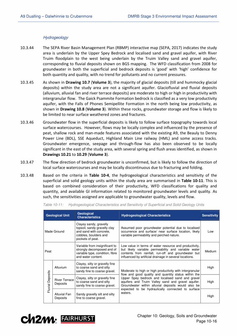
10.3.48 Based on the criteria in Table 10-4, the hydrogeological characteristics and sensitivity of the
superficial and solid geology units within the study area are summarised in Table 10-11. This is
based on combined consideration of their productivity, WFD classifications for quality and
quantity, and available GI information related to monitored groundwater levels and quality. As
such, the sensitivities assigned are applicable to groundwater quality, levels and flow.
Table 10-11: Hydrogeological Characteristics and Sensitivity of Superficial and Solid Geology Units
Geological Unit Geological Characteristics
Hydrogeological Characteristics Sensitivity
Made Ground
Clayey sandy, gravelly topsoil, sandy gravelly clay and sand with concrete, cobbles, boulders and pockets of peat.
Assumed poor groundwater potential due to localised occurrence and surface/ near surface location, likely variable permeability and perched nature.
Low
Peat
Variable from insignificant to strongly decomposed and of variable type, condition, fibre and water content.
Low value in terms of water resource and productivity, but likely variable permeability and variable water contents from rainfall, run-off and groundwater but influenced by artificial drainage in several locations.
Medium
Flu
via
l D
eposits
Alluvium Clayey, silty or gravelly fine to coarse sand and silty sandy fine to coarse gravel. Moderate to high or high productivity with intergranular
flow and good quality and quantity status within the Upper Spey bedrock and localised sand and gravel aquifers and Truim Valley sand and gravel aquifer. Groundwater within alluvial deposits would also be expected to be hydraulically connected to surface waters.
High
River Terrace Deposits
Clayey, silty or gravelly fine to coarse sand and silty sandy fine to coarse gravel.
High
Alluvial Fan Deposits
Sandy gravelly silt and silty fine to coarse gravel.
High
A9 Dualling – Dalwhinnie to Crubenmore DMRB Stage 3 Environmental Impact Assessment
Chapter 10: Geology, Soils and Groundwater
Page 10-17
Geological Unit Geological Characteristics
Hydrogeological Characteristics Sensitivity
Glaciofluvial Deposits
Clayey, silty and sandy fine to coarse gravel.
Moderate to high or high productivity with intergranular flow and good quality and quantity status in the Upper Spey bedrock and localised sand and gravel aquifers and Truim Valley sand and gravel aquifer. Groundwater in glaciofluvial deposits would also be expected to be hydraulically connected to surface waters.
High
Gla
cia
l D
eposits
Till Clayey silty sandy fine to coarse gravel and sandy gravelly silt.
Although mapped and present within the Upper Spey bedrock and localised sand and gravel aquifers with good quality and quantity status, glacial deposits of till and hummocky glacial deposits are predominantly identified as not being a significant aquifer.
This may because of their variable permeability, but they have been recorded as predominantly granular and therefore may therefore be locally connected to surface waters, with groundwater presence also likely to be heavily influenced by rainfall and snowmelt. This may be because of their variable permeability.
Medium
Hummocky Glacial Deposits
Clayey, silty and sandy fine to coarse gravel or clayey, silty gravelly sand.
Medium
Falls of Phones Formation
Semipelite, mainly gneissose but locally schistose
Low productivity with fracture flow and, despite good quality and quantity status within the Upper Spey bedrock and localised sand and gravel aquifers, limited spatial extent within study area.
Medium
Gaick Psammite and Loch Laggan Psammite Formation
Psammite and quartzose psammite
Very low productivity with fracture flow, but good quality and quantity status within the Upper Spey bedrock and localised sand and gravel aquifers.
Medium
Groundwater Abstractions and Private Water Supplies
10.3.49 Based on consultation undertaken with THC and SEPA, one groundwater abstraction (comprising
three wells) and three PWS source locations were identified in the study area, supplying
properties at Dalwhinnie (including domestic use water for Dalwhinnie Distillery), Cuaich and
Crubenmore.
10.3.50 Consultation was undertaken with landowners, Scottish Water and HighWater (Scotland) Ltd to
obtain additional information on these and establish if any other such features may be present.
The information obtained is described in Appendix 10.3 (Volume 2) and summarised in Table 10-
12. The sensitivity of each feature has been assigned based on the criteria in Table 10-4.
Table 10-12: Groundwater Abstractions and Private Water Supplies
Feature ID
Feature Type
Chainage Source of
Information Landowner Response Sensitivity
ABS 8.1 Spring ch. 30,700 THC/
Landowner
THC/ landowner consultation identified an active PWS sourced from a spring, supplying Crubenmore Lodge, Truim Cottage, Crubenmore Cottage and Crubenmore Chalet for domestic use
High
ABS 8.5 Wells ch. 23,100 SEPA/ Scottish
Water
SEPA/ Scottish Water consultation identified an active groundwater abstraction from three wells, which is the public supply for domestic use to the village of Dalwhinnie and the Dalwhinnie Distillery and Visitor Centre. Dalwhinnie Distillery separately abstracts surface water for commercial use outwith the study area.
Very High
ABS 8.23 - ch. 23,000 THC/
Landowner
THC indicated the presence of a PWS at Dalwhinnie Beag, but the landowner believes this property is serviced by the mains and it is therefore assumed to be inactive
N/A
A9 Dualling – Dalwhinnie to Crubenmore DMRB Stage 3 Environmental Impact Assessment
Chapter 10: Geology, Soils and Groundwater
Page 10-18
Feature ID
Feature Type
Chainage Source of
Information Landowner Response Sensitivity
ABS 8.24 Spring ch. 25,800 THC/
Landowner
THC/ landowner consultation identified an active PWS sourced from a spring, supplying five residential units at the Cuaich farm settlement for domestic and agricultural use
High
10.3.51 The location of the abstraction and PWS features are shown in Drawings 10.21 to 10.29 (Volume
3). These also identify additional natural spring and flush features based on ecological surveys or
current mapping. However, these have not been identified as existing PWS sources.
10.3.52 Surface water abstractions have also been identified as being associated with the SSE Aqueduct.
However, these are described and assessed, where necessary, in Chapter 11.
Groundwater Monitoring
10.3.53 Groundwater has been encountered in boreholes and trial pits during the Advanced and
Preliminary GI, with water strikes between 0.50 and 11.00m in superficial deposits and between
1.10m and 15.00m in bedrock. Several areas were also recorded as dry.
10.3.54 Groundwater monitoring data has been collected from 22 borehole locations between January
and December 2016 for the Advanced GI, and from 50 borehole locations between April and
August 2017 for the Preliminary GI. The data collected indicates water levels ranging from ground
level (ch. 24,000) to 13.60m bgl (ch. 29,900), but typically within 3.00m bgl. Piezometric levels
have varied between 309.43m (ch. 29,100 in the River Truim valley north of Cuaich) and 400.55m
(ch. 20,025 towards Drumochter) Above Ordnance Datum (AOD).
10.3.55 Tests conducted during previous GI for the existing dual carriageway at Crubenmore identified
permeability estimates between 5 x 10⁻⁷ and 9 x 10⁻⁷ metres per second (m/s) for superficial
glacial soils and at least 1 x 10⁻⁴ m/s for bedrock. Similar tests from the Preliminary GI identified
estimates of between 1.48 x 10⁻⁷ and 2.47 x 10⁻⁷ m/s in glacial soils. Taken together, the data
suggest permeability of the geology across the Proposed Scheme is likely to be variable, with
lower and higher permeability bands present; which also corresponds to indications from particle
size distribution tests and published literature values (Freeze and Cherry, 1979; Wheeler, 2009;
Natural England, 2010).
Groundwater Quality
10.3.56 The BGS publication ‘Scotland’s aquifers and groundwater bodies – OR/15/028’ (BGS, 2015)
provides an outline of groundwater quality in the Precambrian bedrock underlying the Proposed
Scheme. It describes the groundwater as weakly mineralised, with variable redox conditions,
calcium as a dominant cation and bicarbonate as a dominant anion, and with nitrate
concentrations between 0.15 to 17.46 milligrams per litre (mg/l). The study area is not located in
a Nitrate Vulnerable Zone, but is within a Drinking Water Protection Zone.
10.3.57 Consultation with SEPA indicates there are 31 discharge consent records within the study area,
primarily associated with discharge of septic tank effluent to soakaways and occasionally land or
surface watercourses. Details of these are provided in Appendix 10.4 (Volume 2).
10.3.58 The results of available soil leachate and groundwater chemical analysis have been compared
against water quality standards for drinking water, surface water and GWDTE in accordance with
SEPA Position Statement WAT-PS-10-01 ‘Assigning Groundwater Assessment Criteria for Pollutant
Inputs’ (SEPA, 2014c). This identified elevated concentrations of lead, mercury, zinc, ammoniacal
nitrogen and nitrate in the soil leachate analysis. Groundwater results identified localised
elevated mercury, nickel, nitrate, polycyclic aromatic hydrocarbons (PAH) and total petroleum
A9 Dualling – Dalwhinnie to Crubenmore DMRB Stage 3 Environmental Impact Assessment
Chapter 10: Geology, Soils and Groundwater
Page 10-19
hydrocarbons (TPH), with ammoniacal nitrogen generally slightly elevated across all borehole
locations. The criteria most frequently exceeded were for surface water, but with most nitrate
concentrations in soil leachate and groundwater identified to exceed GWDTE thresholds.
Groundwater Dependent Terrestrial Ecosystems
10.3.59 As described in Appendix 12.3 (Volume 2), NVC Surveys (MacArthur Green, 2015) identified a
number of habitats which may be groundwater dependent; including wet heaths, mires, flushes,
springs, rush pasture and grasslands, or mosaics of these. The location and extents of the areas
based on the groundwater dependence ratings in ‘LUPS-GU31 Guidance on Assessing the Impacts
of Development Proposals on Groundwater Abstractions and GWDTE (Version 2)’ (SEPA, 2014a)
are illustrated in Drawings 10.21 to 10.29 (Volume 3).
10.3.60 Two-hundred and eighteen of the habitats were identified to require further assessment within
the study area, and the vegetation details of each and consideration of their likely dependence
on groundwater is presented in Appendix 10.2 (Volume 2). This identifies that groundwater is
unlikely to be a contributory source to some 62 of the habitats – particularly those comprising
existing road verge, embankment or cut slopes, and where the wet vegetation are fragmented or
discontinuous parts of these, associated with surface water features or run-off. A total of 79 have
also been assessed as being likely to have only a low dependency on groundwater inputs due to
their topographic setting, the likely influence of surface water and run-off, presence in areas of
floodplain or association with ombrotrophic areas of peatland.
10.3.61 Several areas of wet heath (NVC M15), mire (NVC M6, M25) and local rush pasture (NVC M23)
however, have been recorded as dominant or sub-dominant communities in multiple habitat
areas and considered likely to be dependent on groundwater to varying degrees. In this respect,
58 have been identified to have moderate dependence on groundwater input, 14 have been
identified to have moderate/ high dependence on groundwater input, and 5 have been identified
to have a high dependence on groundwater input. These are located to the east and west of the
Proposed Scheme; where either the topographic setting and presence of faulting or folding
correspond to potential or evidenced increased groundwater supply from fractured bedrock via
emergence, seepage and through-flow from spring heads (NVC M32) and soligenous (NVC M15a)
or base-enriched (NVC M10 and M11) flushings, or the hydrogeological conditions are such that
permeable and/ or productive superficial soils may support GWDTE presence.
10.3.62 Based on the criteria in Table 10-4, the sensitivity of individual GWDTE in the study area are
presented in Appendix 10.2 (Volume 2). These are considered to vary between medium and
very high sensitivity based on their likely groundwater dependence. Those determined to have
no dependency on groundwater input are considered low sensitivity and are assessed further as
part of the ecological impact assessment in Chapter 12.
Surface Water Features
10.3.63 All surface water features in the study area are described in Chapter 11 and shown in Drawings
11.1 to 11.7 (Volume 3). These are expected to have a groundwater baseflow component, and
groundwater may be a contributor to local flooding mechanisms.
10.3.64 The principal surface watercourse is the River Truim, flowing northwards through the Glen Truim
valley, before its confluence with the River Spey. The River Truim is located to the west and along
the length of the Proposed Scheme and forms part of the River Spey SAC, which is designated for
the protection of freshwater pearl mussel, sea lamprey, Atlantic salmon and otter. There are also
several watercourse tributaries to the River Truim which cross under the existing A9.
A9 Dualling – Dalwhinnie to Crubenmore DMRB Stage 3 Environmental Impact Assessment
Chapter 10: Geology, Soils and Groundwater
Page 10-20
10.3.65 In addition to these features, there also several other major and minor watercourse tributaries,
predominantly to the River Truim, which cross under the Proposed Scheme. Based on Table 10-4
and the corresponding sensitivity criteria in Chapter 11 and Chapter 12, surface watercourse
features within the study area are considered to vary between low and very high sensitivity.
10.3.66 Samples were retrieved following the Preliminary GI at 13 surface watercourse locations –
including the River Truim, Allt Coire Bhathaich, Allt Cuaich, Allt Garbh and others across the
Proposed Scheme. The results of subsequent chemical testing have been compared against water
quality standards for drinking water, surface water and GWDTE. This identified that the majority
of concentrations were below the criteria, with the exception of ammoniacal nitrogen and locally,
nitrate, which exceeded the drinking water and surface water standards.
Potential Contamination
10.3.67 Thirty-one principal potential contamination sources have been identified within the study area
as part of the assessment, together with 22 individual occurrences of made ground or visual/
olfactory indications of contamination. Details of these are provided in Appendix 10.4 (Volume 2)
and each has been assigned a reference (prefixed ‘DC’) to assist identification and assessment.
The locations of each potential source and occurrence of made ground are shown in Drawings
10.30 to 10.38 (Volume 3).
10.3.68 Available soil sample chemical testing results have been compared against published generic
assessment criteria for residential, commercial and open space end uses (DEFRA, 2014; LQM/
CIEH, 2015) to assess potential risks to construction/ maintenance workers, transient site users
and local residents during construction. Potential exposure pathways to end users and local
residents during operation are likely to be limited, but may remain valid along access tracks and
for maintenance workers during inspection or repair activities.
10.3.69 The vast majority of samples analysed did not identify contaminant concentrations in excess of
the criteria. However, comparison of the soil results against the residential assessment criteria
identified three isolated exceedances for arsenic (51 to 85 mg/kg at 0.10 to 0.50m depth) at two
locations – ch. 21,400 (near the existing A889 Dalwhinnie junction) and ch. 22,600 (near the
proposed Dalwhinnie junction) – both in areas of peat. None are attributable to any particular
source area and the concentrations were below the open space or commercial criteria.
10.3.70 Ground gas data has been collected from 22 borehole locations on up to 12 occasions between
January and December 2016 for the Advanced GI, and on up to eight occasions from 50 borehole
locations between April and August 2017 for the Preliminary GI. As ground gases may pose risks
to human receptors working below ground or in confined spaces during construction, the data
was compared to published assessment criteria (HSE, 2011; CIRIA, 2007; BS8485, 2015) for
elevated methane, carbon dioxide, carbon monoxide, hydrogen sulphide and depleted oxygen.
10.3.71 Isolated raised detections of methane (between 1.0 and 50.6% volume/ volume (v/v)) have been
recorded in three monitoring locations, with the concentrations observed to exceed the safety
threshold of 1% v/v. Each borehole location is situated to the west of the Proposed Scheme at ch.
22,900, ch. 29,000 and ch. 30,200 at Dalwhinnie and in the River Truim valley. The installations
are screened in, across or nearby areas of peat or natural alluvial materials; suggesting these may
be the potential source. All other detected concentrations of methane elsewhere are less than
the safety threshold of 1% v/v.
10.3.72 Carbon dioxide concentrations also exceed the short term (15 minutes) occupational exposure
limit (1.5% v/v) in 36 boreholes and the long term (8 hour) exposure limit (0.5% v/v) in 41
boreholes across the Proposed Scheme, with detected concentrations ranging between 0.1 and
13.3% v/v. Depleted oxygen concentrations below 19% v/v have been observed in 38 boreholes
A9 Dualling – Dalwhinnie to Crubenmore DMRB Stage 3 Environmental Impact Assessment
Chapter 10: Geology, Soils and Groundwater
Page 10-21
on one or more occasion, with levels considered to be very low (less than 16% v/v) in several
instances and frequently coinciding with higher methane or carbon dioxide levels.
10.3.73 Carbon monoxide and hydrogen sulphide were predominantly below the monitoring equipment’s
level of detection (0.1 part per million (ppm)), with any isolated detections all being below their
respective short and long term exposure limits.
��.) Potential Impacts
Embedded Mitigation
10.4.1 Throughout the DMRB Stage 3 design development process described in Chapter 4; a number of
environmentally-led workshops considered each aspect of the developing design and made
recommendations for certain features to be included or aspects of the design to be reconsidered.
Where included, these aspects have been defined as ‘embedded mitigation’.
10.4.2 For geology, soils and groundwater features; the approach to achieving a first-level of embedded
mitigation for the Proposed Scheme was to avoid or minimise impacts on receptors. This was
achieved through the following:
• layout and positioning of infrastructure to avoid or minimise disturbance of soils of high
conservation value, priority peatland, deep peat and potential GWDTE
• where avoidance has not been possible, local level assessments were completed where
possible, to determine local solutions such as earthworks extent reductions to minimise
potential impacts and inform management plans for storage, re-instatement and re-use
• layout and positioning of infrastructure to avoid or minimise disturbance of designated and
non-designated geological receptors or features of geodiversity interest
• incorporation of access tracks with cross-drainage where relevant, to alleviate potential
spring and flush overland or shallow groundwater flow disruption
• watercourse diversions, culverts and drainage to re-direct and maintain hydrological regimes
across the Proposed Scheme as far as practicable.
Potential Impact Assessment
10.4.3 When assessing potential impacts from the Proposed Scheme, construction and operational
phases have been considered together, as the majority of construction impacts (such as removal
of excavated material) will be permanent and extend through operation. Where differences are
predicted between construction and operation, these have been assessed for each phase in turn.
10.4.4 There are several ways that the Proposed Scheme may impact on geology, soils or groundwater
features during construction and operation. These include:
• excavation or masking of bedrock or superficial deposit exposures or sites of specific scientific
or geodiversity interest, particularly if the features are not reproduced elsewhere in the area
• constraint or limitation to existing or potential commercial exploitation of mineral resources
• excavation, removal or sealing of local soil resources, such as soils of high conservation
interest or potentially productive agricultural soils
• excavation or removal of peat, with resultant carbon release and potential permanent loss,
unless environmentally beneficial re-use or restoration can be achieved
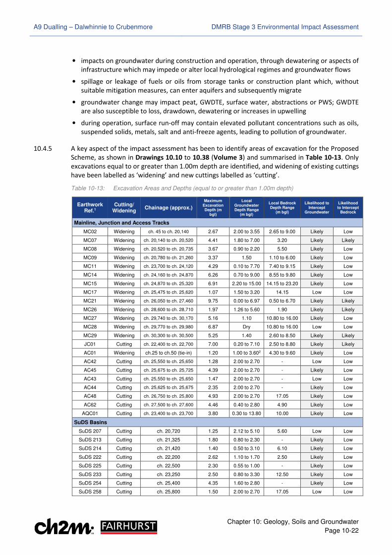
A9 Dualling – Dalwhinnie to Crubenmore DMRB Stage 3 Environmental Impact Assessment
Chapter 10: Geology, Soils and Groundwater
Page 10-22
• impacts on groundwater during construction and operation, through dewatering or aspects of
infrastructure which may impede or alter local hydrological regimes and groundwater flows
• spillage or leakage of fuels or oils from storage tanks or construction plant which, without
suitable mitigation measures, can enter aquifers and subsequently migrate
• groundwater change may impact peat, GWDTE, surface water, abstractions or PWS; GWDTE
are also susceptible to loss, drawdown, dewatering or increases in upwelling
• during operation, surface run-off may contain elevated pollutant concentrations such as oils,
suspended solids, metals, salt and anti-freeze agents, leading to pollution of groundwater.
10.4.5 A key aspect of the impact assessment has been to identify areas of excavation for the Proposed
Scheme, as shown in Drawings 10.10 to 10.38 (Volume 3) and summarised in Table 10-13. Only
excavations equal to or greater than 1.00m depth are identified, and widening of existing cuttings
have been labelled as ‘widening’ and new cuttings labelled as ‘cutting’.
Table 10-13: Excavation Areas and Depths (equal to or greater than 1.00m depth)
Earthwork Ref.1
Cutting/ Widening
Chainage (approx.)
Maximum Excavation Depth (m
bgl)
Local Groundwater Depth Range
(m bgl)
Local Bedrock Depth Range
(m bgl)
Likelihood to Intercept
Groundwater
Likelihood to Intercept
Bedrock
Mainline, Junction and Access Tracks
MC02 Widening ch. 45 to ch. 20,140 2.67 2.00 to 3.55 2.65 to 9.00 Likely Low
MC07 Widening ch. 20,140 to ch. 20,520 4.41 1.80 to 7.00 3.20 Likely Likely
MC08 Widening ch. 20,520 to ch. 20,735 3.67 0.90 to 2.20 5.50 Likely Low
MC09 Widening ch. 20,780 to ch. 21,260 3.37 1.50 1.10 to 6.00 Likely Low
MC11 Widening ch. 23,700 to ch. 24,120 4.29 0.10 to 7.70 7.40 to 9.15 Likely Low
MC14 Widening ch. 24,160 to ch. 24,870 6.26 0.70 to 9.00 8.55 to 9.80 Likely Low
MC15 Widening ch. 24,870 to ch. 25,320 6.91 2.20 to 15.00 14.15 to 23.20 Likely Low
MC17 Widening ch. 25,475 to ch. 25,620 1.07 1.50 to 3.20 14.15 Low Low
MC21 Widening ch. 26,050 to ch. 27,460 9.75 0.00 to 6.97 0.50 to 6.70 Likely Likely
MC26 Widening ch. 28,600 to ch. 28,710 1.97 1.26 to 5.60 1.90 Likely Likely
MC27 Widening ch. 29,740 to ch. 30,170 5.16 1.10 10.80 to 16.00 Likely Low
MC28 Widening ch. 29,770 to ch. 29,980 6.87 Dry 10.80 to 16.00 Low Low
MC29 Widening ch. 30,300 to ch. 30,500 5.25 1.40 2.60 to 8.50 Likely Likely
JC01 Cutting ch. 22,400 to ch. 22,700 7.00 0.20 to 7.10 2.50 to 8.80 Likely Likely
AC01 Widening ch.25 to ch.50 (tie-in) 1.20 1.00 to 3.602 4.30 to 9.60 Likely Low
AC42 Cutting ch. 25,550 to ch. 25,650 1.28 2.00 to 2.70 - Low Low
AC45 Cutting ch. 25,675 to ch. 25,725 4.39 2.00 to 2.70 - Likely Low
AC43 Cutting ch. 25,550 to ch. 25,650 1.47 2.00 to 2.70 - Low Low
AC44 Cutting ch. 25,625 to ch. 25,675 2.35 2.00 to 2.70 - Likely Low
AC48 Cutting ch. 26,750 to ch. 25,800 4.93 2.00 to 2.70 17.05 Likely Low
AC62 Cutting ch. 27,500 to ch. 27,600 4.46 0.40 to 2.80 4.90 Likely Low
AQC01 Cutting ch. 23,400 to ch. 23,700 3.80 0.30 to 13.80 10.00 Likely Low
SuDS Basins
SuDS 207 Cutting ch. 20,720 1.25 2.12 to 5.10 5.60 Low Low
SuDS 213 Cutting ch. 21,325 1.80 0.80 to 2.30 - Likely Low
SuDS 214 Cutting ch. 21,420 1.40 0.50 to 3.10 6.10 Likely Low
SuDS 222 Cutting ch. 22,200 2.62 1.10 to 1.70 2.50 Likely Low
SuDS 225 Cutting ch. 22,500 2.30 0.55 to 1.00 - Likely Low
SuDS 233 Cutting ch. 23,250 2.50 0.80 to 3.30 12.50 Likely Low
SuDS 254 Cutting ch. 25,400 4.35 1.60 to 2.80 - Likely Low
SuDS 258 Cutting ch. 25,800 1.50 2.00 to 2.70 17.05 Low Low
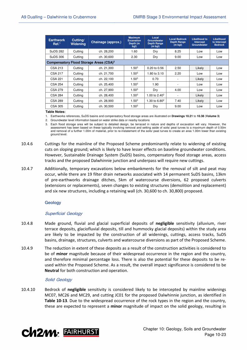
A9 Dualling – Dalwhinnie to Crubenmore DMRB Stage 3 Environmental Impact Assessment
Chapter 10: Geology, Soils and Groundwater
Page 10-23
Earthwork Ref.1
Cutting/ Widening
Chainage (approx.)
Maximum Excavation Depth (m
bgl)
Local Groundwater Depth Range
(m bgl)
Local Bedrock Depth Range
(m bgl)
Likelihood to Intercept
Groundwater
Likelihood to Intercept
Bedrock
SuDS 282 Cutting ch. 28,200 1.60 Dry 8.25 Low Low
SuDS 306 Cutting ch. 30,600 2.30 Dry 9.00 Low Low
Compensatory Flood Storage Areas (CSA)3
CSA 213 Cutting ch. 21,300 1.503 0.20 to 0.56 2.50 Likely Low
CSA 217 Cutting ch. 21,700 1.503 1.80 to 3.10 2.20 Low Low
CSA 221 Cutting ch. 22,100 1.503 0.70 - Likely Low
CSA 254 Cutting ch. 25,400 1.503 1.90 - Low Low
CSA 279 Cutting ch. 27,900 1.503 Dry 4.00 Low Low
CSA 284 Cutting ch. 28,400 1.503 1.00 to 2.402 - Likely Low
CSA 289 Cutting ch. 28,900 1.503 1.30 to 6.802 7.40 Likely Low
CSA 305 Cutting ch. 30,500 1.503 Dry 9.00 Low Low
Table Notes:
1. Earthworks references, SuDS basins and compensatory flood storage areas are illustrated on Drawings 10.21 to 10.38 (Volume 3)
2. Groundwater level information based on water strike data or nearby locations
3. Each flood storage area will be subject to detailed design, be terraced in nature and depths of excavation will vary. However, the assessment has been based on these typically involving removal and setting aside of soils/ peat turves to a maximum depth of 0.50m and removal of a further 1.00m of material, prior to re-instatement of the soils/ peat turves to create an area 1.00m lower than existing ground level.
10.4.6 Cuttings for the mainline of the Proposed Scheme predominantly relate to widening of existing
cuts on sloping ground; which is likely to have lesser effects on baseline groundwater conditions.
However, Sustainable Drainage System (SuDS) basins, compensatory flood storage areas, access
tracks and the proposed Dalwhinnie junction and underpass will require new cuttings.
10.4.7 Additionally, temporary excavations below embankments for the removal of silt and peat may
occur, while there are 19 filter drain networks associated with 14 permanent SuDS basins, 13km
of pre-earthworks drainage ditches, 5km of watercourse diversions, 62 proposed culverts
(extensions or replacements), seven changes to existing structures (demolition and replacement)
and six new structures, including a retaining wall (ch. 30,600 to ch. 30,800) proposed.
Geology
Superficial Geology
10.4.8 Made ground, fluvial and glacial superficial deposits of negligible sensitivity (alluvium, river
terrace deposits, glaciofluvial deposits, till and hummocky glacial deposits) within the study area
are likely to be impacted by the construction of all widenings, cuttings, access tracks, SuDS
basins, drainage, structures, culverts and watercourse diversions as part of the Proposed Scheme.
10.4.9 The reduction in extent of these deposits as a result of the construction activities is considered to
be of minor magnitude because of their widespread occurrence in the region and the country,
and therefore minimal percentage loss. There is also the potential for these deposits to be re-
used within the Proposed Scheme. As a result, the overall impact significance is considered to be
Neutral for both construction and operation.
Solid Geology
10.4.10 Bedrock of negligible sensitivity is considered likely to be intercepted by mainline widenings
MC07, MC26 and MC29, and cutting JC01 for the proposed Dalwhinnie junction, as identified in
Table 10-13. Due to the widespread occurrence of the rock types in the region and the country,
these are expected to represent a minor magnitude of impact on the solid geology, resulting in
A9 Dualling – Dalwhinnie to Crubenmore DMRB Stage 3 Environmental Impact Assessment
Chapter 10: Geology, Soils and Groundwater
Page 10-24
an impact significance of Neutral for construction and operation. There is also the potential for
excavated rock deposits to be re-used in the Proposed Scheme.
10.4.11 The use of blasting in excavation areas likely to encounter bedrock cannot be ruled out at this
stage, which may impact upon the existing rock structure and have the potential to generate new
fractures, extend existing ones and have indirect impacts on groundwater flow pathways. The
impacts of blasting on such flow paths are considered in the groundwater assessment. However,
based on the anticipated depth of rock cut at the locations identified in Table 10-13 and the
structural geology present (including faulting and folding), the impacts of blasting on the solid
geology is expected to be of minor magnitude and Neutral significance for both construction and
operation.
10.4.12 Mainline widening MC21 is additionally considered likely to intercept bedrock, but is discussed
further in the geodiversity sub-section in relation to existing rock exposures.
Designated Geological Receptors and Features of Geodiversity Interest
Drumochter Hummocky Moraines
10.4.13 The Drumochter Hummocky Moraines candidate LGS (Barron et al, 2011), which is of medium
sensitivity, is unlikely to be directly impacted by construction or operation of the Proposed
Scheme. Hummocky glacial deposits underlie large parts of the study area; however, the
estimated extents of the moraine ridge and mound landform assemblage are outwith the
permanent and temporary works boundaries, meaning no direct disturbance will occur.
Allt Coire Chuirn Alluvial Fan
10.4.14 An access track is proposed to follow the alignment of an existing track that was constructed for
the BDL development in the area of Allt Coire Chuirn near Drumochter, with alluvial fan deposits
here being of medium sensitivity. Assuming the existing track infrastructure stays in place, the
works proposed would comprise up-grading to make it permanent, up-grading an additional track
at the southern extent which connects down to the A9 carriageway and a new crossing structure
over Allt Coire Chuirn.
10.4.15 Shallow widening, embankment and drainage upgrades would therefore be required and may
intercept alluvial fan deposits and soil (peaty gleys and peaty podzols with blanket peat some
humus-iron podzols) in the area. Within and between the 180m southern tie-in to Project 7 –
Glen Garry to Dalwhinnie and ch. 20,200; mainline widenings, drainage, culverts and watercourse
crossings may also intercept these at Allt Coire Bhotie and other minor watercourses as shown in
Drawing 10.10 (Volume 2).
10.4.16 Most works are reasonably distanced from, and would avoid direct disturbance of observed
partial exposure areas near the Allt Coire Chuirn fan apex and along its length, while interception
of fan deposits and soils across the wider area is likely to result in only very slight additional
direct disturbance of these and the local landform (additional to that of the existing track and
other infrastructure).
10.4.17 Some additional disturbance is therefore considered likely as a result of the Proposed Scheme,
but such that the soils and geodiversity value of the area would not be affected. Based on
Table 10-2, this is therefore considered to represent an impact of overall minor magnitude and
Slight/ Moderate significance during construction and operation. In terms of hydromorphology in
the area (sediment regime, channel morphology and fluvial processes), impacts during
construction and operation are identified and assessed in Chapter 11.
A9 Dualling – Dalwhinnie to Crubenmore DMRB Stage 3 Environmental Impact Assessment
Chapter 10: Geology, Soils and Groundwater
Page 10-25
Allt Cuaich Catchment
10.4.19 Soils (peaty podzols with some humus-iron podzols and peat) and negligible sensitivity alluvial
fan deposits at Allt Cuaich are likely to be intercepted by cuttings for access at the Cuaich farm
settlement, SuDS basins, drainage, watercourse diversions and underpass beneath the mainline
as shown in Drawing 10.11 (Volume 2). However, these are likely to avoid direct disturbance of
the upstream and otherwise low sensitivity catchment geodiversity interest features such as river
cliff sections.
10.4.20 Impacts on the hydromorphology (sediment regime, channel morphology and fluvial processes)
during construction and operation are identified and assessed in Chapter 11. However, based on
these and the criteria in Table 10-2, there is considered likely to be an overall impact of minor
magnitude and Neutral/ Slight significance during construction and operation.
Rock Exposures
10.4.21 Based on Table 10-13, no earthworks or aspects of the Proposed Scheme anticipated to intercept
bedrock were identified on, or within proximity to existing rock exposures P08-RE02 (psammite
with quartz veins, lenses and layering) or P08-RE03 (psammite with pegmatite intrusions,
deformations and folding). However, widening MC21 is likely to intercept rock exposure P08-
RE01 (medium grained psammite), which is of negligible sensitivity. There is likely to be a major
magnitude of impact, relative to the proportion of exposure loss defined in Table 10-2, resulting
in an impact of Slight significance.
Mineral Extraction
10.4.22 Mineral extraction has occurred historically within the study area, inferred as likely to have been
local sand and gravel deposit extraction. Potential future exploitation of similar resources cannot
be ruled out, but due to their widespread occurrence they are considered to be of low sensitivity.
10.4.23 The impact magnitude is therefore considered to be minor based on the minimal percentage loss
of potential local resources and the criteria in Table 10-2, resulting in an impact of Neutral/ Sight
significance during construction and operation.
Soils
Soil Conservation
10.4.24 Soils of low (humus-iron podzols and peaty gleys), medium (peaty podzols, mineral and peaty
alluvial soils) and high (peat) conservation interest are likely to be impacted by the construction
of widenings, cuttings, access tracks, SuDS basins, drainage, structures, culverts, watercourse
diversions and compensatory flood storage across the Proposed Scheme extents.
10.4.25 The impact on the conservation interest of the soils as a result of the construction activities is
considered to be of minor magnitude. This equates to partial losses and soil disturbance across
the Proposed Scheme, but where their overall rarity, representivity and diversity is unlikely to be
significantly diminished and conservation value in the area and region will not be significantly
affected. There is also the potential for the soils to be re-used within the Proposed Scheme or re-
instated. The impact significance in terms of conservation interest is therefore considered to be
Neutral/ Slight to Moderate for both construction and operation.
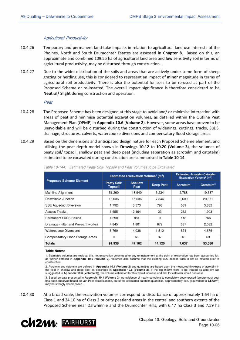
A9 Dualling – Dalwhinnie to Crubenmore DMRB Stage 3 Environmental Impact Assessment
Chapter 10: Geology, Soils and Groundwater
Page 10-26
Agricultural Productivity
10.4.26 Temporary and permanent land-take impacts in relation to agricultural land use interests of the
Phoines, North and South Drumochter Estates are assessed in Chapter 8. Based on this, an
approximate and combined 109.55 ha of agricultural land area and low sensitivity soil in terms of
agricultural productivity, may be disturbed through construction.
10.4.27 Due to the wider distribution of the soils and areas that are actively under some form of sheep
grazing or herding use, this is considered to represent an impact of minor magnitude in terms of
agricultural soil productivity. There is also the potential for soils to be re-used as part of the
Proposed Scheme or re-instated. The overall impact significance is therefore considered to be
Neutral/ Slight during construction and operation.
Peat
10.4.28 The Proposed Scheme has been designed at this stage to avoid and/ or minimise interaction with
areas of peat and minimise potential excavation volumes, as detailed within the Outline Peat
Management Plan (OPMP) in Appendix 10.6 (Volume 2). However, some areas have proven to be
unavoidable and will be disturbed during the construction of widenings, cuttings, tracks, SuDS,
drainage, structures, culverts, watercourse diversions and compensatory flood storage areas.
10.4.29 Based on the dimensions and anticipated design nature for each Proposed Scheme element, and
utilising the peat depth model shown in Drawings 10.12 to 10.20 (Volume 3), the volumes of
peaty soil/ topsoil, shallow peat and deep peat (including separation as acrotelm and catotelm)
estimated to be excavated during construction are summarised in Table 10-14.
Table 10-144: Estimated Peaty Soil/ Topsoil and Peat Volumes to be Excavated
Proposed Scheme Element
Estimated Excavation Volume1 (m3) Estimated Acrotelm-Catotelm
Excavation Volume2 (m3)
Peaty Soil/ Topsoil
Shallow Peat
Deep Peat Acrotelm Catotelm3
Mainline Alignment 51,260 18,940 3,234 2,788 19,387
Dalwhinnie Junction 16,036 15,636 7,844 2,609 20,871
SSE Aqueduct Diversion 1,792 3,573 798 539 3,832
Access Tracks 6,655 2,164 23 282 1,903
Permanent SuDS Basins 4,590 884 0 118 766
Drainage (Filter and Pre-earthworks) 4,845 1,801 672 387 2,082
Watercourse Diversions 6,760 4,038 1,512 874 4,676
Compensatory Flood Storage Areas 0 66 37 40 63
Totals 91,938 47,102 14,120 7,637 53,580
Table Notes:
1. Estimated volumes are residual (i.e. net excavation volumes after any re-instatement at the point of excavation has been accounted for, as further detailed in Appendix 10.6 (Volume 2). Volumes also assume that the existing BDL access track is not re-instated prior to construction.
2. Acrotelm and catotelm are defined in Appendix 10.1 (Volume 2) and quantities are based upon the measured thickness of acrotelm in the field in shallow and deep peat as described in Appendix 10.6 (Volume 2). If the top 0.50m were to be treated as acrotelm (as suuggested in Appendix 10.6 (Volume 2)), the volume estimated for this would increase and that for catotelm would decrease.
3. Based on data presented in Appendix 10.1 (Volume 2), no evidence of nearly complete to completely decomposed (amorphous) peat has been observed based on von Post classifications, but of the calculated catotelm quantities, approximately 16% (equivalent to 8,573m3) may be strongly decomposed.
10.4.30 At a broad scale, the excavation volumes correspond to disturbance of approximately 1.64 ha of
Class 1 and 24.10 ha of Class 2 priority peatland areas in the central and southern extents of the
Proposed Scheme near Dalwhinnie and the Drumochter Hills, with 6.47 ha Class 3 and 7.59 ha
A9 Dualling – Dalwhinnie to Crubenmore DMRB Stage 3 Environmental Impact Assessment
Chapter 10: Geology, Soils and Groundwater
Page 10-27
Class 5 in the north. At a local scale, they correlate to the permanent and temporary disturbance
of natural and semi-natural peaty soil or peat-based habitat such as blanket mire, mire, wet
heath, mosaics of these, dry heath and grasslands, as described in Chapter 12.
10.4.31 Based on these considerations and the criteria in Table 10-2, the magnitude of direct disturbance
impacts from the Proposed Scheme in relation to peaty soils and peat are therefore anticipated
to be minor to moderate overall. This equates to partial disturbance and loss of individual
peatland areas of varying sensitivity throughout, but predominantly where it is considered their
value would either not be affected, or would be, but not to a major degree. The key area of
higher magnitude impact is located within and adjacent to the Proposed Scheme at the proposed
Dalwhinnie junction (ch. 22,000 to ch. 23,700), where several proposed scheme elements and
winter resilience planting directly intercept or border a large area of degraded, but locally good
condition blanket mire to the east. Overall, direct impacts are therefore anticipated to be of
Slight/ Moderate to Moderate significance during construction and operation.
10.4.32 Areas of excavation within and adjacent to peat may also lead to dewatering of acrotelm layers,
oxidation, drying and shrinkage of the catotelm, while dense tree planting for winter resilience
may dry out peat mass margins via water uptake. Based on estimates of potential dewatering
extents for peat (JNCC, 2005; CIRIA, 2016), published literature and typical peat permeabilities
(Stewart and Lance, 1991; Nayak et al., 2008; Dargie, 2009; Scottish Government, 2011c); the
magnitude of these impacts is anticipated to be minor, resulting in impacts of Slight/ Moderate
significance for the majority of the Proposed Scheme and Moderate significance in the vicinity of
Dalwhinnie junction (ch. 22,300 to ch. 23,600) and to the east, north of Cuaich (ch. 26,200 to ch.
26,500).
10.4.33 A Preliminary Peat Landslide Risk Assessment for the Proposed Scheme has identified risks across
the majority of it and adjacent areas to be negligible or slight. However, localised areas assessed
to be of moderate risk have been highlighted. The location of these are detailed in Appendix 10.5
(Volume 2) and illustrated in Drawing 10.5.15 to 10.5.18 (Volume 3).
Groundwater
10.4.34 Potential impacts on groundwater level and flow are outlined below, followed by consideration
of impacts that may apply to groundwater quality, GWDTE, surface water features, groundwater
abstractions and PWS.
Groundwater Flow
10.4.35 Several areas of mainline widening or other cutting have the potential to intercept groundwater
as identified in Table 10-13. This is expected to result in lowering of groundwater levels and alter
local flow directions in these areas. The excavations are anticipated to be predominantly formed
in coarse granular till and hummocky glacial deposits (medium sensitivity) to the east and west,
but also alluvium and alluvial fan (high sensitivity) in southern extents towards Drumochter and
in central areas near and north of Cuaich.
10.4.36 Due to the nature of the existing topography across the Proposed Scheme and that the majority
of cuttings relate to widening of existing ones to the east, the impacts on groundwater level and
flow in superficial deposits are assessed to be of predominantly minor magnitude. This equates
to potential impacts of Slight significance on groundwater in glacial deposits (till and hummocky
glacial) and Slight/ Moderate significance on groundwater in fluvial deposits (alluvium and
alluvial fan) during construction and operation. The magnitude of potential impacts is assessed to
be higher for the Dalwhinnie junction (JC-01) and SSE aqueduct diversion (AQC01) due to the
depth of excavations, potential drawdown and greater likelihood for flow patterns to be locally
A9 Dualling – Dalwhinnie to Crubenmore DMRB Stage 3 Environmental Impact Assessment
Chapter 10: Geology, Soils and Groundwater
Page 10-28
altered. Potential groundwater level and flow impacts in these areas are therefore assessed to be
of moderate magnitude and Moderate significance.
10.4.37 Bedrock groundwater may be intercepted in five areas of widening or cutting underlain by the
Gaick Psammite Formation (medium sensitivity) through Dalwhinnie and north of Cuaich, while
the requirement for rock blasting cannot be ruled out at this stage. Based on the location of the
areas, the depth of potential rock cut, the structural geology (including faulting and folding) and
the criteria in Table 10-5, the potential impacts on levels and flow of bedrock groundwater are
considered to be of minor magnitude and Slight significance during construction and operation.
10.4.38 The construction of embankments across the Proposed Scheme may also result in excavation or
compaction of shallow soil and superficial deposits below their footprint, while pre-earthworks
drainage during construction, and filter drains during operation could create localised drawdown
of shallow groundwater. These are assessed to result in localised impacts of negligible to minor
magnitude and Neutral to Slight significance on groundwater levels and flow.
Groundwater Quality
10.4.39 Based on groundwater vulnerability mapping shown in Drawing 10.9 (Volume 3), all groundwater
within the study area may be vulnerable to accidental spillages during construction or operation,
and subsequent contamination impact on groundwater in the underlying superficial deposits or
bedrock. The areas at highest risk are those in the vicinity of widenings and cuttings anticipated
to intercept groundwater in Table 10-13 and other receptors such as GWDTE, groundwater
abstractions or PWS. The magnitude of potential impacts is assessed as moderate on both
superficial deposits (medium to high sensitivity) and bedrock (medium sensitivity), resulting in
groundwater quality impacts of Moderate to Moderate/ Large significance.
10.4.40 SuDS basins and filter drains could also act as pathways for contamination to enter groundwater.
However, at least two levels of treatment for mainline and junction drainage will be provided
(one level for access tracks), while filter drains and SuDS basins are proposed to be lined. This is
anticipated to prevent ingress of potential contaminants to groundwater and provide attenuation
before discharging to surface waters. As such, impacts of negligible magnitude and Neutral
significance are expected on groundwater quality in superficial soils and bedrock with respect to
these features.
Groundwater Dependent Terrestrial Ecosystems
10.4.41 The Proposed Scheme has been designed at this stage to avoid and/ or minimise disturbance of
GWDTE as far as practicable. However, almost all proposed infrastructure is located within 100m
of areas with at least a degree of groundwater dependence. Several have therefore proven to be
unavoidable and are likely to be impacted.
10.4.42 The quantified extent of areas directly affected due to the permanent and temporary works are
detailed in an assessment for each GWDTE habitat in Appendix 10.2 (Volume 2), together with
consideration of potential indirect effects from areas of mainline widening or other cutting that
have the potential to intercept groundwater from Table 10-13. The magnitude and significance of
impact for each area is based on combined consideration of the potential direct and indirect
effects where relevant, together with assessment of the potential drawdown at the receptor
against the intervening topography and the nature of the likely local water supply mechanisms to
the habitat being assessed.
10.4.43 Based on these aspects and the criteria in Table 10-5, the magnitude of potential impacts on the
individual GWDTE (medium to very high sensitivity) are assessed to vary from negligible to major
across the Proposed Scheme; with direct loss, temporary disturbance and/ or drawdown effects
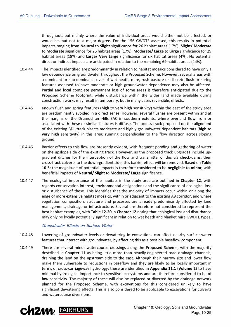
A9 Dualling – Dalwhinnie to Crubenmore DMRB Stage 3 Environmental Impact Assessment
Chapter 10: Geology, Soils and Groundwater
Page 10-29
throughout, but mainly where the value of individual areas would either not be affected, or
would be, but not to a major degree. For the 156 GWDTE assessed, this results in potential
impacts ranging from Neutral to Slight significance for 26 habitat areas (17%), Slight/ Moderate
to Moderate significance for 26 habitat areas (17%), Moderate/ Large to Large significance for 29
habitat areas (18%) and Large/ Very Large significance for six habitat areas (4%). No potential
direct or indirect impacts are anticipated in relation to the remaining 69 habitat areas (44%).
10.4.44 The impacts identified are predominantly in relation to habitat mosaics considered to have only a
low dependence on groundwater throughout the Proposed Scheme. However, several areas with
a dominant or sub-dominant cover of wet heath, mire, rush pasture or discrete flush or spring
features assessed to have moderate or high groundwater dependence may also be affected.
Partial and local complete permanent loss of some areas is therefore anticipated due to the
Proposed Scheme footprint, while disturbance within the wider land made available during
construction works may result in temporary, but in many cases reversible, effects.
10.4.45 Known flush and spring features (high to very high sensitivity) within the east of the study area
are predominantly avoided in a direct sense. However, several flushes are present within and at
the margins of the Drumochter Hills SAC in southern extents, where overland flow from or
associated with these or similar features is diffuse. The access track proposed on the alignment
of the existing BDL track bisects moderate and highly groundwater dependent habitats (high to
very high sensitivity) in this area; running perpendicular to the flow direction across sloping
ground.
10.4.46 Barrier effects to this flow are presently evident, with frequent ponding and gathering of water
on the upslope side of the existing track. However, as the proposed track upgrades include up-
gradient ditches for the interception of the flow and transmittal of this via check-dams, then
cross-track culverts to the down-gradient side; this barrier effect will be removed. Based on Table
10-5; the magnitude of potential impacts is therefore considered to be negligible to minor, with
beneficial impacts of Neutral/ Slight to Moderate/ Large significance.
10.4.47 The ecological importance of the habitats in the study area are outlined in Chapter 12, with
regards conservation interest, environmental designations and the significance of ecological loss
or disturbance of these. This identifies that the majority of impacts occur within or along the
edge of more extensive habitat mosaics, within or adjacent to the existing A9 corridor, and where
vegetation composition, structure and processes are already predominantly affected by land
management, drainage or infrastructure. Several are therefore not considered to represent the
best habitat examples, with Table 12-20 in Chapter 12 noting that ecological loss and disturbance
may only be locally potentially significant in relation to wet heath and blanket mire GWDTE types.
Groundwater Effects on Surface Water
10.4.48 Lowering of groundwater levels or dewatering in excavations can affect nearby surface water
features that interact with groundwater, by affecting this as a possible baseflow component.
10.4.49 There are several minor watercourse crossings along the Proposed Scheme, with the majority
described in Chapter 11 as being little more than heavily-engineered road drainage channels,
draining the land on the upstream side to the east. Although their narrow size and lower flow
make them vulnerable to reductions in baseflow and they are likely to be locally important in
terms of cross-carriageway hydrology; these are identified in Appendix 11.1 (Volume 2) to have
minimal hydrological importance to sensitive ecosystems and are therefore considered to be of
low sensitivity. The majority of these will also be replaced or diverted by the drainage network
planned for the Proposed Scheme, with excavations for this considered unlikely to have
significant dewatering effects. This is also considered to be applicable to excavations for culverts
and watercourse diversions.

A9 Dualling – Dalwhinnie to Crubenmore DMRB Stage 3 Environmental Impact Assessment
Chapter 10: Geology, Soils and Groundwater
Page 10-30
10.4.50 For other minor and major watercourses however, an assessment of potential impacts as a result
of interaction with widenings and cuttings which are anticipated to intercept groundwater is
summarised in Table 10-15. Surface watercourses are identified as per the feature referencing in
Chapter 11 and are illustrated in Drawings 11.1 to 11.7 (Volume 3).
10.4.51 Where groundwater is not anticipated to be encountered in areas of excavation from Table 10-
13, the potential impact is assigned as being of negligible magnitude and Neutral significance.
Otherwise, the magnitude of impact is based on consideration of potential drawdown at the
receptor against the intervening topography, size of the feature and its ecological sensitivity.
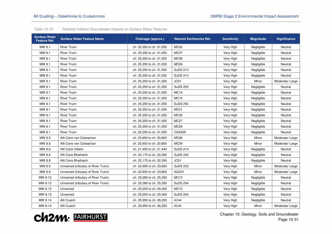
A9 Dualling – Dalwhinnie to Crubenmore DMRB Stage 3 Environmental Impact Assessment
Chapter 10: Geology, Soils and Groundwater
Page 10-31
Table 10-15: Potential Indirect Groundwater Impacts on Surface Water Features
Surface Water Feature Ref.
Surface Water Feature Name Chainage (approx.) Nearest Earthworks Ref. Sensitivity Magnitude Significance
MW 8.1 River Truim ch. 25,350 to ch. 31,050 MC02 Very High Negligible Neutral
MW 8.1 River Truim ch. 25,350 to ch. 31,050 MC07 Very High Negligible Neutral
MW 8.1 River Truim ch. 25,350 to ch. 31,050 MC08 Very High Negligible Neutral
MW 8.1 River Truim ch. 25,350 to ch. 31,050 MC09 Very High Negligible Neutral
MW 8.1 River Truim ch. 25,350 to ch. 31,050 SuDS 213 Very High Negligible Neutral
MW 8.1 River Truim ch. 25,350 to ch. 31,050 SuDS 214 Very High Negligible Neutral
MW 8.1 River Truim ch. 25,350 to ch. 31,050 JC01 Very High Minor Moderate/ Large
MW 8.1 River Truim ch. 25,350 to ch. 31,050 SuDS 225 Very High Negligible Neutral
MW 8.1 River Truim ch. 25,350 to ch. 31,050 MC14 Very High Negligible Neutral
MW 8.1 River Truim ch. 25,350 to ch. 31,050 MC15 Very High Negligible Neutral
MW 8.1 River Truim ch. 25,350 to ch. 31,050 SuDS 254 Very High Negligible Neutral
MW 8.1 River Truim ch. 25,350 to ch. 31,050 MC21 Very High Negligible Neutral
MW 8.1 River Truim ch. 25,350 to ch. 31,050 MC26 Very High Negligible Neutral
MW 8.1 River Truim ch. 25,350 to ch. 31,050 MC27 Very High Negligible Neutral
MW 8.1 River Truim ch. 25,350 to ch. 31,050 MC29 Very High Negligible Neutral
MW 8.1 River Truim ch. 25,350 to ch. 31,050 CSA305 Very High Negligible Neutral
MW 8.5 Allt Coire nan Cisteachan ch. 20,650 to ch. 20,800 MC08 Very High Minor Moderate/ Large
MW 8.5 Allt Coire nan Cisteachan ch. 20,650 to ch. 20,800 MC09 Very High Minor Moderate/ Large
MW 8.6 Allt Coire Uilleim ch. 21,400 to ch. 21,440 SuDS 214 Very High Negligible Neutral
MW 8.8 Allt Coire Bhathaich ch. 22,175 to ch. 22,290 SuDS 222 Very High Negligible Neutral
MW 8.8 Allt Coire Bhathaich ch. 22,175 to ch. 22,290 JC01 Very High Negligible Neutral
MW 8.9 Unnamed (tributary of River Truim) ch. 22,950 to ch. 23,800 SuDS 233 Very High Minor Moderate/ Large
MW 8.9 Unnamed (tributary of River Truim) ch. 22,950 to ch. 23,800 AQC01 Very High Minor Moderate/ Large
MW 8.12 Unnamed (tributary of River Truim) ch. 25,280 to ch. 25,350 MC15 Very High Negligible Neutral
MW 8.12 Unnamed (tributary of River Truim) ch. 25,280 to ch. 25,350 SuDS 254 Very High Negligible Neutral
MW 8.13 Unnamed ch. 25,250 to ch. 25,400 MC15 Very High Negligible Neutral
MW 8.13 Unnamed ch. 25,250 to ch. 25,400 SuDS 254 Very High Negligible Neutral
MW 8.14 Allt Cuaich ch. 25,950 to ch. 26,250 AC44 Very High Negligible Neutral
MW 8.14 Allt Cuaich ch. 25,950 to ch. 26,250 AC45 Very High Minor Moderate/ Large

A9 Dualling – Dalwhinnie to Crubenmore DMRB Stage 3 Environmental Impact Assessment
Chapter 10: Geology, Soils and Groundwater
Page 10-32
Surface Water Feature Ref.
Surface Water Feature Name Chainage (approx.) Nearest Earthworks Ref. Sensitivity Magnitude Significance
MW 8.14 Allt Cuaich ch. 25,950 to ch. 26,250 AC48 Very High Minor Moderate/ Large
MW 8.14 Allt Cuaich ch. 25,950 to ch. 26,250 SuDS 258 Very High Negligible Neutral
MW 8.16 Unnamed (tributary of River Truim) ch. 26,450 to ch. 26,800 MC21 Low Moderate Slight
MW 8.18 Dalannach (tributary of Allt Garbh) ch. 27,730 to ch. 27,850 AC62 Low Moderate Slight
MW 8.18 Dalannach (tributary of Allt Garbh) ch. 27,730 to ch. 27,850 MC21 Low Negligible Neutral
MW 8.19 Unnamed ch. 27,650 to ch. 28,050 AC62 High Negligible Neutral
MW 8.21 Unnamed (tributary of River Truim) ch. 30,500 to ch. 30,610 MC29 Low Minor Neutral
W 8.1 Unnamed (tributary of River Truim) ch. 20,750 MC02 Low Moderate Slight
W 8.2 Unnamed (tributary of River Truim) ch. 20,950 to ch. 21,350 MC08 High Negligible Neutral
W 8.2 Unnamed (tributary of River Truim) ch. 20,950 to ch. 21,350 MC09 High Minor Slight/ Moderate
W 8.3 Unnamed (tributary of River Truim) ch. 20,900 to ch. 21,050 MC09 Low Negligible Neutral
W 8.4 Unnamed (tributary of River Truim) ch. 20,350 to ch. 20,400 SuDS 213 High Moderate Moderate/ Large
W 8.4 Unnamed (tributary of River Truim) ch. 20,350 to ch. 20,400 SuDS 214 High Moderate Moderate/ Large
W 8.7 Unnamed (tributary of River Truim) ch. 21,950 to ch. 22,140 SuDS 222 High Moderate Moderate/ Large
W 8.7 Unnamed (tributary of River Truim) ch. 21,950 to ch. 22,140 CSA 221 High Minor Slight/ Moderate
W 8.12 Unnamed (tributary of River Truim) ch. 24,850 to ch. 24,950 MC15 Low Major Slight/ Moderate
W 8.13 Unnamed (drainage from SSE aqueduct) ch. 25,100 to ch. 25,370 MC15 Very High Major Very Large
W 8.14 Unnamed (field drainage channel) ch. 25,800 MC17 Low Minor Neutral
W 8.14 Unnamed (field drainage channel) ch. 25,800 AC42 Low Negligible Neutral
W 8.14 Unnamed (field drainage channel) ch. 25,800 AC44 Low Minor Neutral
W 8.14 Unnamed (field drainage channel) ch. 25,800 AC45 Low Moderate Slight
W 8.14 Unnamed (field drainage channel) ch. 25,800 AC48 Low Negligible Neutral
W 8.14 Unnamed (field drainage channel) ch. 25,800 SuDS 254 Low Negligible Neutral
W 8.16 Unnamed (mill lade from Allt Cuaich) ch. 25,950 to ch. 26,150 AC44 High Negligible Neutral
W 8.16 Unnamed (mill lade from Allt Cuaich) ch. 25,950 to ch. 26,150 AC45 High Negligible Neutral
W 8.16 Unnamed (mill lade from Allt Cuaich) ch. 25,950 to ch. 26,150 AC48 High Minor Slight/ Moderate
W 8.16 Unnamed (mill lade from Allt Cuaich) ch. 25,950 to ch. 26,150 SuDS 258 High Negligible Neutral
W 8.17 Unnamed (field drainage channel) ch. 26,200 to ch. 26,350 MC21 High Minor Slight/ Moderate
W 8.19 Unnamed (tributary of River Truim) ch. 26,900 MC21 Low Moderate Slight/ Moderate
W 8.19a Unnamed (field drainage channel) ch. 27,150 to ch. 27,300 MC21 Very High Moderate Large/ Very Large
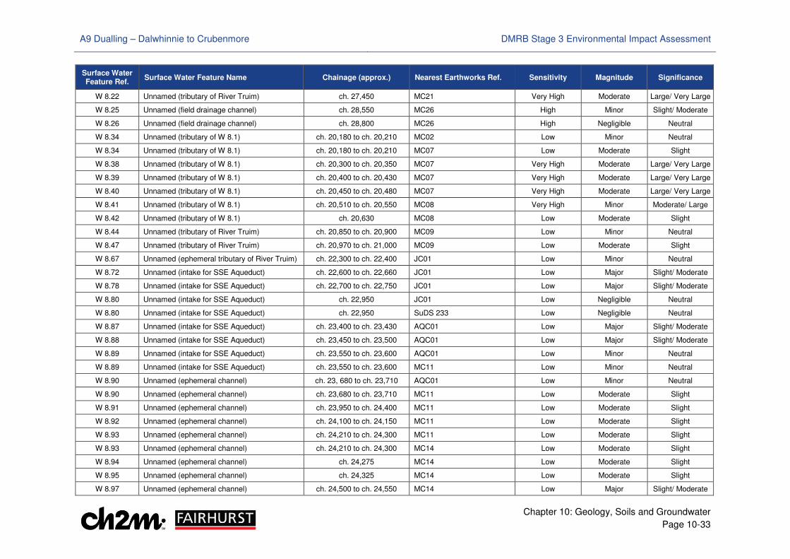
A9 Dualling – Dalwhinnie to Crubenmore DMRB Stage 3 Environmental Impact Assessment
Chapter 10: Geology, Soils and Groundwater
Page 10-33
Surface Water Feature Ref.
Surface Water Feature Name Chainage (approx.) Nearest Earthworks Ref. Sensitivity Magnitude Significance
W 8.22 Unnamed (tributary of River Truim) ch. 27,450 MC21 Very High Moderate Large/ Very Large
W 8.25 Unnamed (field drainage channel) ch. 28,550 MC26 High Minor Slight/ Moderate
W 8.26 Unnamed (field drainage channel) ch. 28,800 MC26 High Negligible Neutral
W 8.34 Unnamed (tributary of W 8.1) ch. 20,180 to ch. 20,210 MC02 Low Minor Neutral
W 8.34 Unnamed (tributary of W 8.1) ch. 20,180 to ch. 20,210 MC07 Low Moderate Slight
W 8.38 Unnamed (tributary of W 8.1) ch. 20,300 to ch. 20,350 MC07 Very High Moderate Large/ Very Large
W 8.39 Unnamed (tributary of W 8.1) ch. 20,400 to ch. 20,430 MC07 Very High Moderate Large/ Very Large
W 8.40 Unnamed (tributary of W 8.1) ch. 20,450 to ch. 20,480 MC07 Very High Moderate Large/ Very Large
W 8.41 Unnamed (tributary of W 8.1) ch. 20,510 to ch. 20,550 MC08 Very High Minor Moderate/ Large
W 8.42 Unnamed (tributary of W 8.1) ch. 20,630 MC08 Low Moderate Slight
W 8.44 Unnamed (tributary of River Truim) ch. 20,850 to ch. 20,900 MC09 Low Minor Neutral
W 8.47 Unnamed (tributary of River Truim) ch. 20,970 to ch. 21,000 MC09 Low Moderate Slight
W 8.67 Unnamed (ephemeral tributary of River Truim) ch. 22,300 to ch. 22,400 JC01 Low Minor Neutral
W 8.72 Unnamed (intake for SSE Aqueduct) ch. 22,600 to ch. 22,660 JC01 Low Major Slight/ Moderate
W 8.78 Unnamed (intake for SSE Aqueduct) ch. 22,700 to ch. 22,750 JC01 Low Major Slight/ Moderate
W 8.80 Unnamed (intake for SSE Aqueduct) ch. 22,950 JC01 Low Negligible Neutral
W 8.80 Unnamed (intake for SSE Aqueduct) ch. 22,950 SuDS 233 Low Negligible Neutral
W 8.87 Unnamed (intake for SSE Aqueduct) ch. 23,400 to ch. 23,430 AQC01 Low Major Slight/ Moderate
W 8.88 Unnamed (intake for SSE Aqueduct) ch. 23,450 to ch. 23,500 AQC01 Low Major Slight/ Moderate
W 8.89 Unnamed (intake for SSE Aqueduct) ch. 23,550 to ch. 23,600 AQC01 Low Minor Neutral
W 8.89 Unnamed (intake for SSE Aqueduct) ch. 23,550 to ch. 23,600 MC11 Low Minor Neutral
W 8.90 Unnamed (ephemeral channel) ch. 23, 680 to ch. 23,710 AQC01 Low Minor Neutral
W 8.90 Unnamed (ephemeral channel) ch. 23,680 to ch. 23,710 MC11 Low Moderate Slight
W 8.91 Unnamed (ephemeral channel) ch. 23,950 to ch. 24,400 MC11 Low Moderate Slight
W 8.92 Unnamed (ephemeral channel) ch. 24,100 to ch. 24,150 MC11 Low Moderate Slight
W 8.93 Unnamed (ephemeral channel) ch. 24,210 to ch. 24,300 MC11 Low Moderate Slight
W 8.93 Unnamed (ephemeral channel) ch. 24,210 to ch. 24,300 MC14 Low Moderate Slight
W 8.94 Unnamed (ephemeral channel) ch. 24,275 MC14 Low Moderate Slight
W 8.95 Unnamed (ephemeral channel) ch. 24,325 MC14 Low Moderate Slight
W 8.97 Unnamed (ephemeral channel) ch. 24,500 to ch. 24,550 MC14 Low Major Slight/ Moderate
A9 Dualling – Dalwhinnie to Crubenmore DMRB Stage 3 Environmental Impact Assessment
Chapter 10: Geology, Soils and Groundwater
Page 10-34
Surface Water Feature Ref.
Surface Water Feature Name Chainage (approx.) Nearest Earthworks Ref. Sensitivity Magnitude Significance
W 8.98 Unnamed (ephemeral channel) ch. 24,600 to ch. 24,660 MC14 Low Major Slight/ Moderate
W 8.103 Unnamed (ephemeral channel) ch. 25,550 MC15 Low Moderate Slight
W 8.107 Unnamed (drainage channel) ch. 26,000 to ch. 26,025 AC44 Medium Negligible Neutral
W 8.107 Unnamed (drainage channel) ch. 26,000 to ch. 26,025 AC45 Medium Negligible Neutral
W 8.107 Unnamed (drainage channel) ch. 26,000 to ch. 26,025 AC48 Medium Minor Slight
W 8.107 Unnamed (drainage channel) ch. 26,000 to ch. 26,025 SuDS 258 Medium Negligible Neutral
W 8.139 Unnamed (ephemeral drainage channel) ch. 27,800 to ch. 27,850 AC62 Low Negligible Neutral
W 8.153 Unnamed (drainage channel) ch. 28,410 to ch. 28,460 MC28 High Negligible Neutral
W 8.154 Unnamed (field drainage channel) ch. 28,550 MC28 High Negligible Neutral
W 8.172 Unnamed (tributary to River Truim) ch. 29,650 to ch. 29,680 MC28 High Negligible Neutral
W 8.177 Unnamed (tributary to River Truim) ch. 30,200 MC27 Low Minor Neutral
W 8.177 Unnamed (tributary to River Truim) ch. 30,200 MC29 Low Negligible Neutral
W 8.177 Unnamed (tributary to River Truim) ch. 30,200 MC28 Low Negligible Neutral
W 8.178 Unnamed (tributary to River Truim) ch. 30,200 to ch. 30,350 MC27 Low Negligible Neutral
W 8.178 Unnamed (tributary to River Truim) ch. 30,200 to ch. 30,350 MC29 Low Minor Neutral
W 8.183 Unnamed (tributary to River Truim) ch. 30,900 MC29 Low Minor Neutral
A9 Dualling – Dalwhinnie to Crubenmore DMRB Stage 3 Environmental Impact Assessment
Chapter 10: Geology, Soils and Groundwater
Page 10-35
Groundwater Abstractions and Private Water Supplies
10.4.52 Given its distance from the Proposed Scheme, intervening topography and the presence of the
River Truim; no potential impacts on the quality or yield of the PWS source or supply network at
Crubenmore (ABS 8.1) (high sensitivity) are anticipated.
10.4.53 The PWS at the Cuaich farm settlement (ABS 8.24) (high sensitivity) is understood to be conveyed
to the farm properties via a pipe network that crosses under the existing A9 at approximate ch.
25,900. The spring source, tank and an associated intake near the SSE aqueduct will be avoided
and are unlikely to be affected indirectly given their distance from the Proposed Scheme and the
intervening topography. However, the supply valve and pipe network may be intercepted by
cuttings for proposed access and other works at the farm settlement, with disruption to the
supply network potentially affecting both quantity and quality. Based on Table 10-5, this is
considered to equate to an impact of major magnitude and Large/ Very Large significance.
10.4.54 The groundwater abstractions for Dalwhinnie Water Treatment Works (ABS 8.5) (very high
sensitivity) comprise three shallow wells (2.00 to 3.00m in depth) situated adjacent to the River
Truim, which are considered likely to have a groundwater as well as surface water component.
Potential permanent or indirect groundwater impacts, in terms of yield or quality, are considered
unlikely – as the wells are situated at least 500m down and cross-gradient, outwith the estimated
zones of dewatering influence for Dalwhinnie junction (JC-01) and the SSE Aqueduct diversion
(AQC01). The low productivity superficial and solid geology within these cuttings is also unlikely
to be in hydraulic continuity with the moderate to high productivity strata present where the
wells are located. Notwithstanding, the wells may be vulnerable to temporary disturbance from
work within or adjacent to the River Truim and from pollution incidents during construction. This
is particularly of relevance in the vicinity of the proposed Dalwhinnie junction and associated link
road to the existing A889. Based on Table 10-5, the magnitude of impacts related to this are
assessed as minor on yield and moderate on quality, resulting in a potential impact of Moderate/
Large to Large/ Very Large significance during construction.
Potential Contamination
10.4.55 A number of potential contamination sources have been identified in the study area, as shown in
Drawings 10.30 to 10.38 (Volume 3). An assessment of each source is presented in Appendix
10.4 (Volume 2) in the context of a preliminary CSM and with reference to the pollutant linkages
identified in Table 10-7. Based on the criteria in Table 10-8 to Table 10-10, the CSM evaluates the
level of potential risk (significance) that may be present in relation to impacts from each source,
as a direct result of construction or operation activities associated with the Proposed Scheme.
10.4.56 In this respect, there are considered to be two potential ways in which the Proposed Scheme may
interact with potential contamination, as follows:
• direct disturbance of potential contamination sources (i.e. those within the Proposed Scheme
footprint or permanent and temporary works boundaries)
• indirect disturbance of nearby potential contamination sources as a result of construction of
the Proposed Scheme (i.e. interception within areas of excavation).
10.4.57 Direct interaction may occur with potential sources including the existing A9 carriageway (DC-01),
former electricity pylons (DC-02), made ground at Dalannach (DC-10), a former quarry/ sand pit
(DC-11), occurrences of made ground (DC-32 to DC-52), potential radon hazard areas (DC-15) and
raised levels of ground gas (DC-53). Based on the preliminary CSM assessment, this interaction is
considered likely to occur for these sources and may affect human receptors (PL1 to PL4), with
A9 Dualling – Dalwhinnie to Crubenmore DMRB Stage 3 Environmental Impact Assessment
Chapter 10: Geology, Soils and Groundwater
Page 10-36
minor to medium consequence and potential impacts of Low to Moderate significance during
construction. Direct interaction with the same sources may also occur during operation via PL13
to PL16, with similar consequence, but lower likelihood. Resultantly, potential impacts during
operation would be proportionately lower and range between Very Low and Moderate/ Low
significance.
10.4.58 Where areas of made ground or other material is excavated and temporarily stored during
construction (including materials from demolished structures), these may additionally represent
potential risks to human health (PL1 and PL3), the water environment and ecological receptors
such as groundwater, surface water, GWDTE, agricultural land and livestock (PL5 to PL9 and
PL11) or property receptors such as local abstractions or PWS (PL7), buried concrete and services
(PL12). In the absence of mitigation, the potential of this occurring has been assessed as likely,
and of mild to medium consequence during construction. Potential risks to the same receptors
during operation are also possible (PL13, PL15, PL17 to PL21, and PL23 to PL24) if the materials
were re-used, and are assessed to be of similar consequence, but lower likelihood. Potential
impacts are therefore identified to be of Moderate/ Low to Moderate significance during
construction and Very Low to Moderate/ Low significance during operation.
10.4.59 Indirect impacts may occur where areas of widening and cutting intercept groundwater during
construction, as they could draw local potential contaminated water towards them or mobilise
potential contaminated water within or adjacent to the footprint. This may then impact human
health (PL1 and PL13), surface water, GWDTE or PWS receptors through migration (PL7) and
require discharge during construction (PL10) and operation (PL22). Potential sources in relation
to this principally include former electricity pylons (DC-03), the existing BDL (DC-04), Dalwhinnie
Service Station (DC-08a-b), septic tank effluent discharges to soakaways or land (DC-12a-f, DC-22,
DC-23, DC-24, DC-27 and DC-28) and localised inorganic and organics recorded in groundwater
chemical testing results.
10.4.60 Dewatering effects from the excavations for the Proposed Scheme are likely to be predominantly
localised and greatest during construction, with longer-term interception of water managed by
the detailed design of the excavation areas. The CSM assessment for the source areas, based on
the potential for excavations in proximity to draw in or mobilise contaminated groundwater is
presented in Appendix 10.4 (Volume 2). During construction, the potential impacts are assessed
to be of Very Low to Moderate/ Low significance, but with some source areas (including DC-08a-
b) identified to have potential impacts of Moderate significance, based on evidence for potential
or actual contamination presence and the proximity of sensitive receptors. Similar potential
impacts during operation are proportional in terms of consequence, but of lesser likelihood. As
such, comparable impacts of between Very Low and Moderate/ Low significance are expected.
��.+ Mitigation
10.5.1 Based on the impact assessment, Standard Mitigation measures for the Proposed Scheme
followed by Project Specific Mitigation considerations are detailed in Table 10-16. These
measures take into account best practice, current legislation and guidance to further avoid,
reduce or off-set the potential impacts identified where possible.
10.5.2 The Standard Mitigation measures are based upon those being applied across the A9 Dualling
Programme and will be developed by the Contractor alongside the Project Specific Mitigation and
relevant management systems to structure, monitor, control and communicate implementation,
including a Construction Environmental Management Plan (CEMP).
A9 Dualling – Dalwhinnie to Crubenmore DMRB Stage 3 Environmental Impact Assessment
Chapter 10: Geology, Soils and Groundwater
Page 10-37
Table 10-16: Standard and Project-Specific Mitigation Commitments – Geology, Soils and Groundwater
Mitigation
Item
Approximate
Chainage/ Location
Timing of
Measure Description
Mitigation Purpose/
Objective
Specific Consultation
or Approval Required
Standard A9 Mitigation
SMC-G1 Throughout Proposed Scheme
Pre-Construction
Prior to construction, consultation will be undertaken with the relevant local authorities and SEPA regarding works in relation to land affected by contamination to support the obligations set out in ‘Planning Advice Note 33: Development of Contaminated Land’ (Scottish Government, 2000). Any remedial action undertaken in relation to land affected by contamination will be carried out under the appropriate remediation licencing.
To reduce impacts from contaminated land sources.
Consultation with THC (and SEPA as required).
SMC-G2 Throughout Proposed Scheme
Pre-Construction
Prior to construction and where potential contamination has been identified, further site investigations sufficient to determine the extent and type of contaminants present will be undertaken as necessary to inform identification of appropriate construction methods and any additional mitigation.
To determine the extent and type of contaminants present and to inform identification of appropriate construction methods and any additional mitigation.
None required
SMC-G3 Throughout Proposed Scheme
Pre-Construction & Construction
Prior to construction, appropriate health and safety and waste management procedures for working with potentially contaminated soils will be established. Waste management procedures will take account of inter alia: Waste Management Licence (Scotland) Regulations 2011 (as amended by the Waste Management Licensing (Scotland) Amendment Regulations 2016), HSE Guidance Note MS31 (HSE, 2012) and the Health and Safety Commission Approved Code of Practice and Guidance Note. These procedures will be implemented as appropriate during construction.
To ensure appropriate health and safety and waste management procedures for working with potentially contaminated soils are followed.
None required
SMC-G4 Throughout Proposed Scheme
Construction & Post-Construction/ Operation
Risks to construction and maintenance staff working with/near contaminated land will be mitigated by the implementation of Mitigation Item SMC-G3 in combination with the adoption of appropriate systems of work, including personal protective equipment (PPE) as a last resort. In the event that unrecorded contamination is encountered, works should be stopped and the working procedures reassessed to confirm the working methods remain appropriate. Construction staff will be trained to identify asbestos containing material.
To reduce impacts from contaminated land sources and confirm the safety of construction and maintenance staff.
None required
SMC-G5 Throughout Proposed Scheme
Construction Appropriate training will be provided for personnel involved in earthworks activities to enable implementation of a watching brief to identify presence of previously unidentified contamination.
To identify potential presence of previously unidentified contamination.
None required
SMC-G6 Throughout Proposed Scheme
Pre-Construction &
Construction
Where required, landowner consultation and site visits will be undertaken to confirm the location of septic tanks and associated infrastructure. Where septic tanks are located within the LMA they will be relocated subject to discussion and agreement with the affected landowner(s).
To mitigate the loss of any septic tanks.
Approval from landowners
SMC-G7 Throughout Proposed Scheme
Construction To prevent cross contamination and pollution from piling works undertaken in areas of land affected by contamination, the Contractor will undertake a Piling Risk Assessment and adhere to appropriate guidance including the ‘Piling and Penetrative Ground Improvement Methods on Land Affected by Contamination: Guidance on Pollution Prevention, National Groundwater and Contaminated Land Centre Report NC/99/77’.
To prevent cross contamination and pollution from piling works undertaken in areas of land affected by contamination.
None required
A9 Dualling – Dalwhinnie to Crubenmore DMRB Stage 3 Environmental Impact Assessment
Chapter 10: Geology, Soils and Groundwater
Page 10-38
Mitigation
Item
Approximate
Chainage/ Location
Timing of
Measure Description
Mitigation Purpose/
Objective
Specific Consultation
or Approval Required
SMC-G8 Throughout Proposed Scheme
Construction
Excavated soils deemed unsuitable for reuse will be assessed in line with the ‘Waste Classification: Guidance on the Classification and Assessment of Waste’ (Technical Guidance WM3) (Natural Resources Wales, SEPA, Northern Ireland Environment Agency, Environment Agency, May 2015) to determine whether they are hazardous or non-hazardous. This will establish the most appropriate and cost effective waste stream for the waste materials.
To determine whether disposed soils are hazardous or non-hazardous.
None required
SMC-G9 Throughout Proposed Scheme
Pre-Construction
To maximise the reuse of site-won materials on-site (and minimise the need for disposal of waste in line with the principles of the “Waste Hierarchy”) whilst ensuring that no risks are posed to human health nor the water environment a soil reuse assessment will be undertaken prior to construction. The soil reuse assessment will identify any potential risks posed to both human health and the water environment from potentially contaminated soils reused throughout the proposed scheme.
To identify any potential risks posed to human health and the water environment.
In addition, this mitigation item would maximise re-use of site-won materials on-site and minimise the need for disposal of waste in line with the principles of the “Waste Hierarchy” through re-use of excavation arisings (refer to Mitigation Item SMC-M3).
None required
SMC-G10 Throughout Proposed Scheme
Construction Where peat is encountered during construction, it will be excavated, stored and re-used if possible, taking cognisance of ‘Development on Peatland: Guidance on the Assessment of Peat Volumes, Reuse of Excavated Peat and the Minimisation of Waste’ (Scottish Renewables and SEPA, 2012) and The Waste Management Licensing (Scotland) Regulations 2011. This will be captured in a Peat Management Plan that will be developed by the Contractor.
Does not apply to Project 8, more specific mitigation required for this Scheme.
To comply with relevant waste management practices under The Waste Management Licensing (Scotland) Regulations 2011 and reduce impacts on peatlands.
Consultation with SEPA
SMC-G11 Throughout Proposed Scheme
Pre-Construction & Construction
Where concrete materials are proposed to be used, appropriate guidance such as ‘Building Research Establishment (BRE) SD1:2005’ and ‘British Standard (BS) BS8500’ should be followed to ensure that ground conditions are appropriate for the use of concrete at each given location.
To ensure that ground conditions are appropriate for the use of concrete at each given location.
None required
SMC-G12 Contamination sources: DC-15 and DC-53
Pre-Construction, Construction &
Post-Construction/ Operation
Where potential pollutant pathways for ground gas have been identified, a ground gas monitoring programme will be developed prior to construction in adherence to ‘BS 8485:2015 - Code of practice for the design of protective measures for methane and carbon dioxide ground gases for new buildings’’. This will include an assessment of gassing issues following receipt of additional ground gas monitoring results at selected boreholes.
Appropriate working methods will be developed and adopted during below ground site construction works (including piling works and excavations). This should include as a minimum, gas monitoring undertaken prior to any entry into excavations, confined spaces or below ground structures and use of PPE as a last resort.
If ground gas issues are identified during construction, further post construction monitoring will be undertaken and/or appropriate gas protection measures will be incorporated into the final design.
To mitigate against potential impacts on human health during construction and Off Site Receptors (Local residents, transient traffic (foot, road and rail traffic) in the surrounding area) due to ground gas.
None required
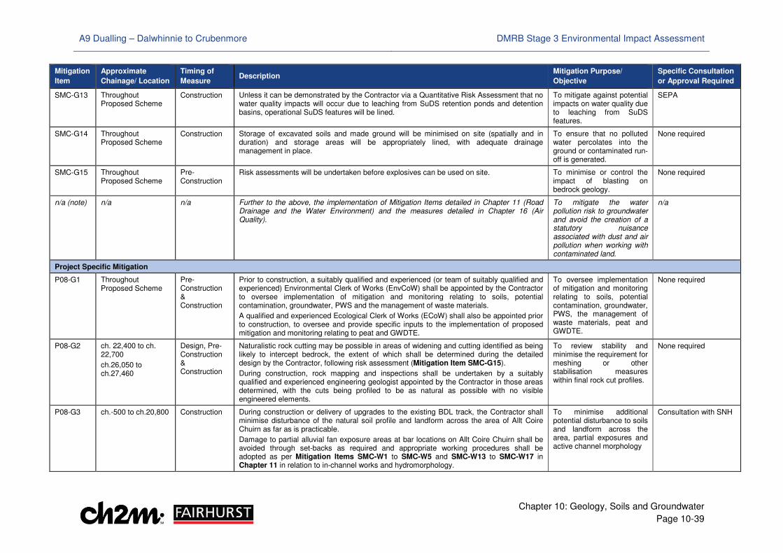
A9 Dualling – Dalwhinnie to Crubenmore DMRB Stage 3 Environmental Impact Assessment
Chapter 10: Geology, Soils and Groundwater
Page 10-39
Mitigation
Item
Approximate
Chainage/ Location
Timing of
Measure Description
Mitigation Purpose/
Objective
Specific Consultation
or Approval Required
SMC-G13 Throughout Proposed Scheme
Construction Unless it can be demonstrated by the Contractor via a Quantitative Risk Assessment that no water quality impacts will occur due to leaching from SuDS retention ponds and detention basins, operational SuDS features will be lined.
To mitigate against potential impacts on water quality due to leaching from SuDS features.
SEPA
SMC-G14 Throughout Proposed Scheme
Construction Storage of excavated soils and made ground will be minimised on site (spatially and in duration) and storage areas will be appropriately lined, with adequate drainage management in place.
To ensure that no polluted water percolates into the ground or contaminated run-off is generated.
None required
SMC-G15 Throughout Proposed Scheme
Pre-Construction
Risk assessments will be undertaken before explosives can be used on site. To minimise or control the impact of blasting on bedrock geology.
None required
n/a (note) n/a n/a Further to the above, the implementation of Mitigation Items detailed in Chapter 11 (Road Drainage and the Water Environment) and the measures detailed in Chapter 16 (Air Quality).
To mitigate the water pollution risk to groundwater and avoid the creation of a statutory nuisance associated with dust and air pollution when working with contaminated land.
n/a
Project Specific Mitigation
P08-G1 Throughout Proposed Scheme
Pre-Construction & Construction
Prior to construction, a suitably qualified and experienced (or team of suitably qualified and experienced) Environmental Clerk of Works (EnvCoW) shall be appointed by the Contractor to oversee implementation of mitigation and monitoring relating to soils, potential contamination, groundwater, PWS and the management of waste materials.
A qualified and experienced Ecological Clerk of Works (ECoW) shall also be appointed prior to construction, to oversee and provide specific inputs to the implementation of proposed mitigation and monitoring relating to peat and GWDTE.
To oversee implementation of mitigation and monitoring relating to soils, potential contamination, groundwater, PWS, the management of waste materials, peat and GWDTE.
None required
P08-G2 ch. 22,400 to ch. 22,700
ch.26,050 to ch.27,460
Design, Pre-Construction & Construction
Naturalistic rock cutting may be possible in areas of widening and cutting identified as being likely to intercept bedrock, the extent of which shall be determined during the detailed design by the Contractor, following risk assessment (Mitigation Item SMC-G15).
During construction, rock mapping and inspections shall be undertaken by a suitably qualified and experienced engineering geologist appointed by the Contractor in those areas determined, with the cuts being profiled to be as natural as possible with no visible engineered elements.
To review stability and minimise the requirement for meshing or other stabilisation measures within final rock cut profiles.
None required
P08-G3 ch.-500 to ch.20,800 Construction During construction or delivery of upgrades to the existing BDL track, the Contractor shall minimise disturbance of the natural soil profile and landform across the area of Allt Coire Chuirn as far as is practicable.
Damage to partial alluvial fan exposure areas at bar locations on Allt Coire Chuirn shall be avoided through set-backs as required and appropriate working procedures shall be adopted as per Mitigation Items SMC-W1 to SMC-W5 and SMC-W13 to SMC-W17 in Chapter 11 in relation to in-channel works and hydromorphology.
To minimise additional potential disturbance to soils and landform across the area, partial exposures and active channel morphology
Consultation with SNH
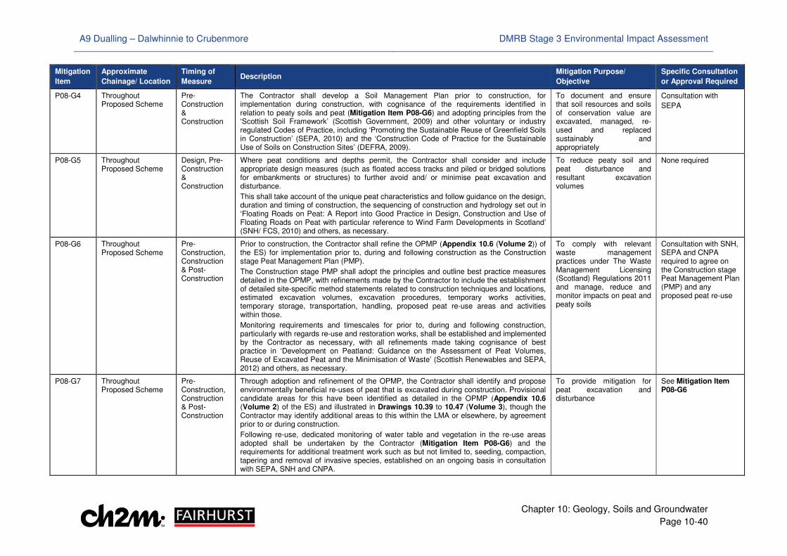
A9 Dualling – Dalwhinnie to Crubenmore DMRB Stage 3 Environmental Impact Assessment
Chapter 10: Geology, Soils and Groundwater
Page 10-40
Mitigation
Item
Approximate
Chainage/ Location
Timing of
Measure Description
Mitigation Purpose/
Objective
Specific Consultation
or Approval Required
P08-G4 Throughout Proposed Scheme
Pre-Construction & Construction
The Contractor shall develop a Soil Management Plan prior to construction, for implementation during construction, with cognisance of the requirements identified in relation to peaty soils and peat (Mitigation Item P08-G6) and adopting principles from the ‘Scottish Soil Framework’ (Scottish Government, 2009) and other voluntary or industry regulated Codes of Practice, including ‘Promoting the Sustainable Reuse of Greenfield Soils in Construction’ (SEPA, 2010) and the ‘Construction Code of Practice for the Sustainable Use of Soils on Construction Sites’ (DEFRA, 2009).
To document and ensure that soil resources and soils of conservation value are excavated, managed, re-used and replaced sustainably and appropriately
Consultation with
SEPA
P08-G5 Throughout Proposed Scheme
Design, Pre-Construction & Construction
Where peat conditions and depths permit, the Contractor shall consider and include appropriate design measures (such as floated access tracks and piled or bridged solutions for embankments or structures) to further avoid and/ or minimise peat excavation and disturbance.
This shall take account of the unique peat characteristics and follow guidance on the design, duration and timing of construction, the sequencing of construction and hydrology set out in ‘Floating Roads on Peat: A Report into Good Practice in Design, Construction and Use of Floating Roads on Peat with particular reference to Wind Farm Developments in Scotland’ (SNH/ FCS, 2010) and others, as necessary.
To reduce peaty soil and peat disturbance and resultant excavation volumes
None required
P08-G6 Throughout Proposed Scheme
Pre-Construction, Construction & Post-Construction
Prior to construction, the Contractor shall refine the OPMP (Appendix 10.6 (Volume 2)) of the ES) for implementation prior to, during and following construction as the Construction stage Peat Management Plan (PMP).
The Construction stage PMP shall adopt the principles and outline best practice measures detailed in the OPMP, with refinements made by the Contractor to include the establishment of detailed site-specific method statements related to construction techniques and locations, estimated excavation volumes, excavation procedures, temporary works activities, temporary storage, transportation, handling, proposed peat re-use areas and activities within those.
Monitoring requirements and timescales for prior to, during and following construction, particularly with regards re-use and restoration works, shall be established and implemented by the Contractor as necessary, with all refinements made taking cognisance of best practice in ‘Development on Peatland: Guidance on the Assessment of Peat Volumes, Reuse of Excavated Peat and the Minimisation of Waste’ (Scottish Renewables and SEPA, 2012) and others, as necessary.
To comply with relevant waste management practices under The Waste Management Licensing (Scotland) Regulations 2011 and manage, reduce and monitor impacts on peat and peaty soils
Consultation with SNH, SEPA and CNPA required to agree on the Construction stage Peat Management Plan (PMP) and any proposed peat re-use
P08-G7 Throughout Proposed Scheme
Pre-Construction, Construction & Post-Construction
Through adoption and refinement of the OPMP, the Contractor shall identify and propose environmentally beneficial re-uses of peat that is excavated during construction. Provisional candidate areas for this have been identified as detailed in the OPMP (Appendix 10.6 (Volume 2) of the ES) and illustrated in Drawings 10.39 to 10.47 (Volume 3), though the Contractor may identify additional areas to this within the LMA or elsewhere, by agreement prior to or during construction.
Following re-use, dedicated monitoring of water table and vegetation in the re-use areas adopted shall be undertaken by the Contractor (Mitigation Item P08-G6) and the requirements for additional treatment work such as but not limited to, seeding, compaction, tapering and removal of invasive species, established on an ongoing basis in consultation with SEPA, SNH and CNPA.
To provide mitigation for peat excavation and disturbance
See Mitigation Item P08-G6
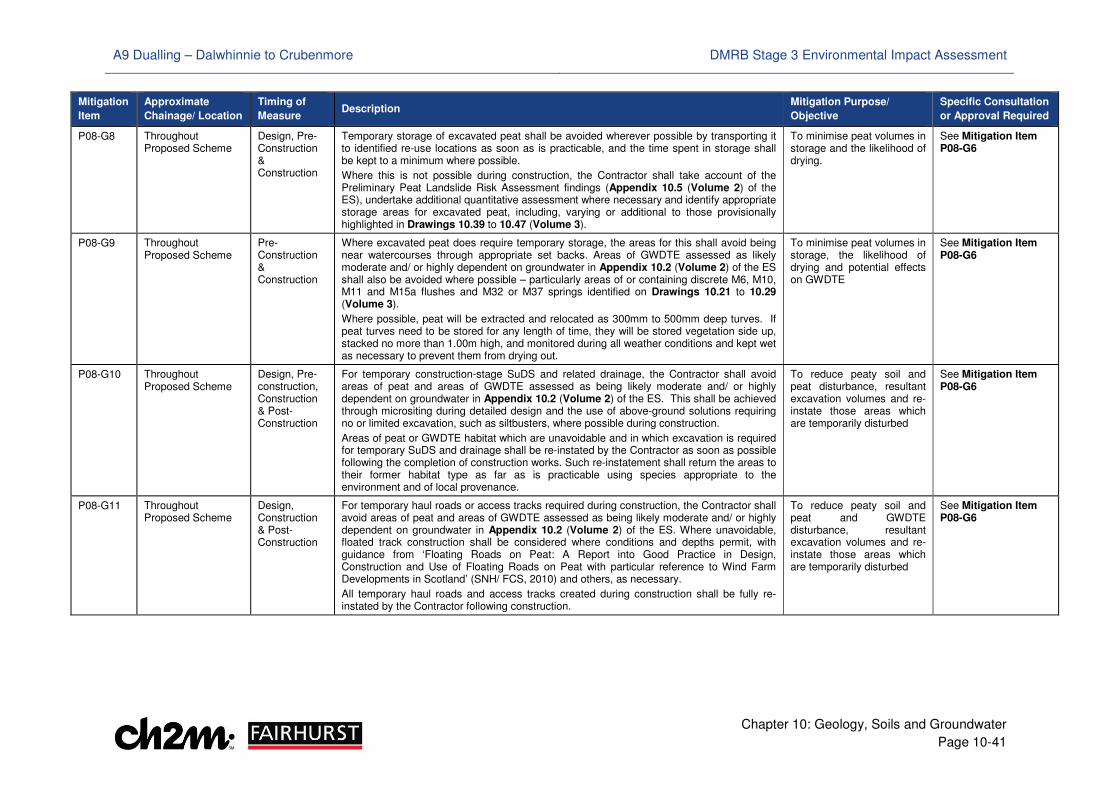
A9 Dualling – Dalwhinnie to Crubenmore DMRB Stage 3 Environmental Impact Assessment
Chapter 10: Geology, Soils and Groundwater
Page 10-41
Mitigation
Item
Approximate
Chainage/ Location
Timing of
Measure Description
Mitigation Purpose/
Objective
Specific Consultation
or Approval Required
P08-G8 Throughout Proposed Scheme
Design, Pre-Construction & Construction
Temporary storage of excavated peat shall be avoided wherever possible by transporting it to identified re-use locations as soon as is practicable, and the time spent in storage shall be kept to a minimum where possible.
Where this is not possible during construction, the Contractor shall take account of the Preliminary Peat Landslide Risk Assessment findings (Appendix 10.5 (Volume 2) of the ES), undertake additional quantitative assessment where necessary and identify appropriate storage areas for excavated peat, including, varying or additional to those provisionally highlighted in Drawings 10.39 to 10.47 (Volume 3).
To minimise peat volumes in storage and the likelihood of drying.
See Mitigation Item P08-G6
P08-G9 Throughout Proposed Scheme
Pre-Construction & Construction
Where excavated peat does require temporary storage, the areas for this shall avoid being near watercourses through appropriate set backs. Areas of GWDTE assessed as likely moderate and/ or highly dependent on groundwater in Appendix 10.2 (Volume 2) of the ES shall also be avoided where possible – particularly areas of or containing discrete M6, M10, M11 and M15a flushes and M32 or M37 springs identified on Drawings 10.21 to 10.29 (Volume 3).
Where possible, peat will be extracted and relocated as 300mm to 500mm deep turves. If peat turves need to be stored for any length of time, they will be stored vegetation side up, stacked no more than 1.00m high, and monitored during all weather conditions and kept wet as necessary to prevent them from drying out.
To minimise peat volumes in storage, the likelihood of drying and potential effects on GWDTE
See Mitigation Item P08-G6
P08-G10 Throughout Proposed Scheme
Design, Pre-construction, Construction & Post-Construction
For temporary construction-stage SuDS and related drainage, the Contractor shall avoid areas of peat and areas of GWDTE assessed as being likely moderate and/ or highly dependent on groundwater in Appendix 10.2 (Volume 2) of the ES. This shall be achieved through micrositing during detailed design and the use of above-ground solutions requiring no or limited excavation, such as siltbusters, where possible during construction.
Areas of peat or GWDTE habitat which are unavoidable and in which excavation is required for temporary SuDS and drainage shall be re-instated by the Contractor as soon as possible following the completion of construction works. Such re-instatement shall return the areas to their former habitat type as far as is practicable using species appropriate to the environment and of local provenance.
To reduce peaty soil and peat disturbance, resultant excavation volumes and re-instate those areas which are temporarily disturbed
See Mitigation Item P08-G6
P08-G11 Throughout Proposed Scheme
Design, Construction & Post-Construction
For temporary haul roads or access tracks required during construction, the Contractor shall avoid areas of peat and areas of GWDTE assessed as being likely moderate and/ or highly dependent on groundwater in Appendix 10.2 (Volume 2) of the ES. Where unavoidable, floated track construction shall be considered where conditions and depths permit, with guidance from ‘Floating Roads on Peat: A Report into Good Practice in Design, Construction and Use of Floating Roads on Peat with particular reference to Wind Farm Developments in Scotland’ (SNH/ FCS, 2010) and others, as necessary.
All temporary haul roads and access tracks created during construction shall be fully re-instated by the Contractor following construction.
To reduce peaty soil and peat and GWDTE disturbance, resultant excavation volumes and re-instate those areas which are temporarily disturbed
See Mitigation Item P08-G6
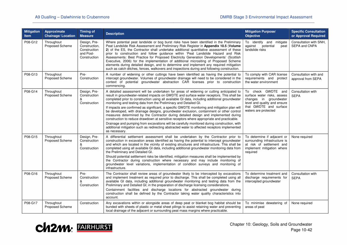
A9 Dualling – Dalwhinnie to Crubenmore DMRB Stage 3 Environmental Impact Assessment
Chapter 10: Geology, Soils and Groundwater
Page 10-42
Mitigation
Item
Approximate
Chainage/ Location
Timing of
Measure Description
Mitigation Purpose/
Objective
Specific Consultation
or Approval Required
P08-G12 Throughout Proposed Scheme
Design, Pre-Construction, Construction and Post-Construction
Where potential peat landslide or bog burst risks have been identified in the Preliminary Peat Landslide Risk Assessment and Preliminary Risk Register in Appendix 10.5 (Volume 2) of the ES, the Contractor shall undertake additional quantitative assessment of these prior to construction and follow guidance within ‘Peat Landslide Hazard and Risk Assessments: Best Practice for Proposed Electricity Generation Developments’ (Scottish Executive, 2006) for the implementation of additional micrositing of Proposed Scheme elements during detailed design, and to determine and implement any required mitigation such as catch ditches, fences, walkovers and inspections during and following construction.
To identify and mitigate against potential peat landslide risks
Consultation with SNH, SEPA and CNPA
P08-G13 Throughout Proposed Scheme
Pre-Construction
A number of widening or other cuttings have been identified as having the potential to intercept groundwater. Volumes of groundwater drainage will need to be considered in the context of potential groundwater abstraction CAR licenses prior to construction commencing.
To comply with CAR license requirements and protect the water environment
Consultation with and
approval from SEPA
P08-G14 Throughout Proposed Scheme
Design, Pre-Construction & Construction
A detailed assessment will be undertaken for areas of widening or cutting anticipated to result in groundwater-related impacts on GWDTE and surface water receptors. This shall be completed prior to construction using all available GI data, including additional groundwater monitoring and testing data from the Preliminary and Detailed GI.
If impacts are confirmed as significant, a specific GWDTE monitoring and mitigation plan will be developed, with drainage designs, groundwater exclusion, containment or other control measures determined by the Contractor during detailed design and implemented during construction to reduce drawdown at sensitive receptors where appropriate and practicable.
Drainage and pumping from excavations will be carefully monitored during construction, with additional mitigation such as redirecting abstracted water to affected receptors implemented as necessary.
To check GWDTE and surface water risks, assess changes in groundwater level and quality and ensure that GWDTE and surface waters are protected
Consultation with
SEPA
P08-G15 Throughout Proposed Scheme
Design, Pre-Construction & Construction
A differential settlement assessment shall be undertaken by the Contractor prior to construction in excavation areas identified as having the potential to intercept groundwater and which are located in the vicinity of existing structures and infrastructure. This shall be completed using all available GI data, including additional groundwater monitoring data from the Preliminary and Detailed GI.
Should potential settlement risks be identified, mitigation measures shall be implemented by the Contractor during construction where necessary and may include monitoring of groundwater level variations, implementation of condition surveys and monitoring of infrastructure.
To determine if adjacent or surrounding infrastructure is at risk of settlement and implement mitigation where required
None required
P08-G16 Throughout Proposed Scheme
Pre-Construction & Construction
The Contractor shall review areas of groundwater likely to be intercepted by excavations and implement treatment as required prior to discharge. This shall be completed using all available GI data, including additional groundwater monitoring and testing data from the Preliminary and Detailed GI; in the preparation of discharge licensing considerations.
Containment facilities and discharge locations for abstracted groundwater during construction shall be defined by the Contractor taking water quality characteristics into account.
To determine treatment and discharge requirements for intercepted groundwater
Consultation with
SEPA
P08-G17 Throughout Proposed Scheme
Construction Any excavations within or alongside areas of deep peat or blanket bog habitat should be bunded with sheets of plastic or metal sheet pilings to assist retaining water and preventing local drainage of the adjacent or surrounding peat mass margins where practicable.
To minimise dewatering of areas of peat
None required
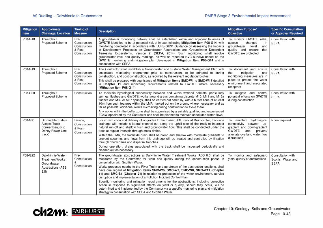
A9 Dualling – Dalwhinnie to Crubenmore DMRB Stage 3 Environmental Impact Assessment
Chapter 10: Geology, Soils and Groundwater
Page 10-43
Mitigation
Item
Approximate
Chainage/ Location
Timing of
Measure Description
Mitigation Purpose/
Objective
Specific Consultation
or Approval Required
P08-G18 Throughout Proposed Scheme
Pre-Construction, Construction & Post-Construction
A groundwater monitoring network shall be established within and adjacent to areas of GWDTE identified to be at potential risk of impact following Mitigation Item P08-G14, with monitoring completed in accordance with ‘LUPS-GU31 Guidance on Assessing the Impacts of Development Proposals on Groundwater Abstractions and Groundwater Dependent Terrestrial Ecosystems, Version 2’ (SEPA, 2014). Such monitoring shall involve groundwater level and quality readings, as well as repeated NVC surveys based on the GWDTE monitoring and mitigation plan developed in Mitigation Item P08-G14 and in consultation with SEPA.
To monitor GWDTE risks, assess changes in groundwater level and quality and ensure that GWDTE are protected
Consultation with
SEPA
P08-G19 Throughout Proposed Scheme
Pre-Construction, Construction & Post-Construction
The Contractor shall establish a Groundwater and Surface Water Management Plan with associated monitoring programme prior to construction, to be adhered to during construction, and post construction, as required by the relevant regulatory bodies.
This shall be prepared with cognisance of Mitigation Items SMC-W1 to SMC-W17 detailed in Chapter 11 and monitoring requirements related to GWDTE where necessary (Mitigation Item P08-G14).
To document and ensure that mitigation and monitoring measures are in place to protect the water environment and associated receptors
Consultation with
SEPA
P08-G20 Throughout Proposed Scheme
Construction To maintain hydrological connectivity between and within wetland habitats, particularly springs, flushes and GWDTE; works around areas containing discrete M10, M11 and M15a flushes and M32 or M37 springs, shall be carried out carefully, with a buffer zone of at least 10m from such features within the LMA marked out on the ground where necessary and as far as possible, additional works micrositing during construction to avoid them.
Any works within the buffer zone shall be supervised by a suitably qualified and experienced ECoW appointed by the Contractor and shall be planned to maintain unpolluted water flows.
To mitigate and control potential effects on GWDTE during construction
Consultation with
SEPA
P08-G21 Drumochter Estate Access Track (former Beauly to Denny Power Line track)
Design,
Construction
& Post-
Construction
For construction and delivery of upgrades to the former BDL track at Drumochter, trackside drainage will include a lateral channel cut along the uphill side of the track to intercept natural run-off and shallow flush and groundwater flow. This shall be conducted under the track at regular intervals through cross-drains.
Within the LMA, the trackside drain shall be broad and shallow with moderate gradients to prevent scouring, and flows from this drainage will be treated and controlled by filtration through check dams and dispersal trenches.
During operation, drains associated with the track shall be inspected periodically and cleaned out as necessary.
To maintain hydrological connectivity between up-gradient and down-gradient GWDTE and prevent/ alleviate overland water flow disruptions
None required
P08-G22 Dalwhinnie Water
Treatment Works
Groundwater
Abstractions (ABS
8.5)
Pre-Construction & Construction
The groundwater abstractions at Dalwhinnie Water Treatment Works (ABS 8.5) shall be monitored by the Contractor for yield and quality during the construction phase in consultation with Scottish Water.
Works proposed nearby to the River Truim and up-stream of the abstraction locations, shall have due regard of Mitigation Items SMC-W6, SMC-W7, SMC-W8, SMC-W11 (Chapter 11) and SMC-S1 (Chapter 21) in relation to protection of the water environment, service disruption and implementation of a Pollution Incident Control Plan.
Specific monitoring and mitigation requirements for the abstractions, including corrective action in response to significant effects on yield or quality, should they occur, will be determined and implemented by the Contractor via a specific monitoring plan and mitigation strategy in consultation with SEPA and Scottish Water.
To monitor and safeguard yield/ quality of abstractions
Consultation with
Scottish Water and
SEPA
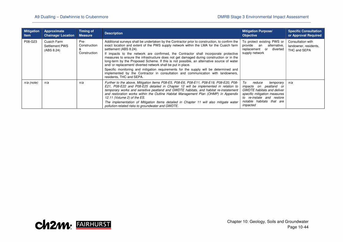
A9 Dualling – Dalwhinnie to Crubenmore DMRB Stage 3 Environmental Impact Assessment
Chapter 10: Geology, Soils and Groundwater
Page 10-44
Mitigation
Item
Approximate
Chainage/ Location
Timing of
Measure Description
Mitigation Purpose/
Objective
Specific Consultation
or Approval Required
P08-G23 Cuaich Farm
Settlement PWS
(ABS 8.24)
Pre-Construction & Construction
Additional surveys shall be undertaken by the Contractor prior to construction, to confirm the exact location and extent of the PWS supply network within the LMA for the Cuaich farm settlement (ABS 8.24).
If impacts to the network are confirmed, the Contractor shall incorporate protective measures to ensure the infrastructure does not get damaged during construction or in the long-term by the Proposed Scheme. If this is not possible, an alternative source of water and/ or replacement/ diverted network shall be put in place.
Specific monitoring and mitigation requirements for the supply will be determined and implemented by the Contractor in consultation and communication with landowners, residents, THC and SEPA.
To protect existing PWS or provide an alternative, replacement or diverted supply network
Consultation with
landowner, residents,
THC and SEPA
n/a (note) n/a n/a Further to the above, Mitigation Items P08-E5, P08-E6, P08-E11, P08-E19, P08-E20, P08-E21, P08-E22 and P08-E25 detailed in Chapter 12 will be implemented in relation to temporary works and sensitive peatland and GWDTE habitats, and habitat re-instatement and restoration works within the Outline Habitat Management Plan (OHMP) in Appendix 12.11 (Volume 2) of the ES.
The implementation of Mitigation Items detailed in Chapter 11 will also mitigate water pollution-related risks to groundwater and GWDTE.
To reduce temporary impacts on peatland or GWDTE habitats and deliver specific mitigation measures to re-instate and restore notable habitats that are impacted
n/a
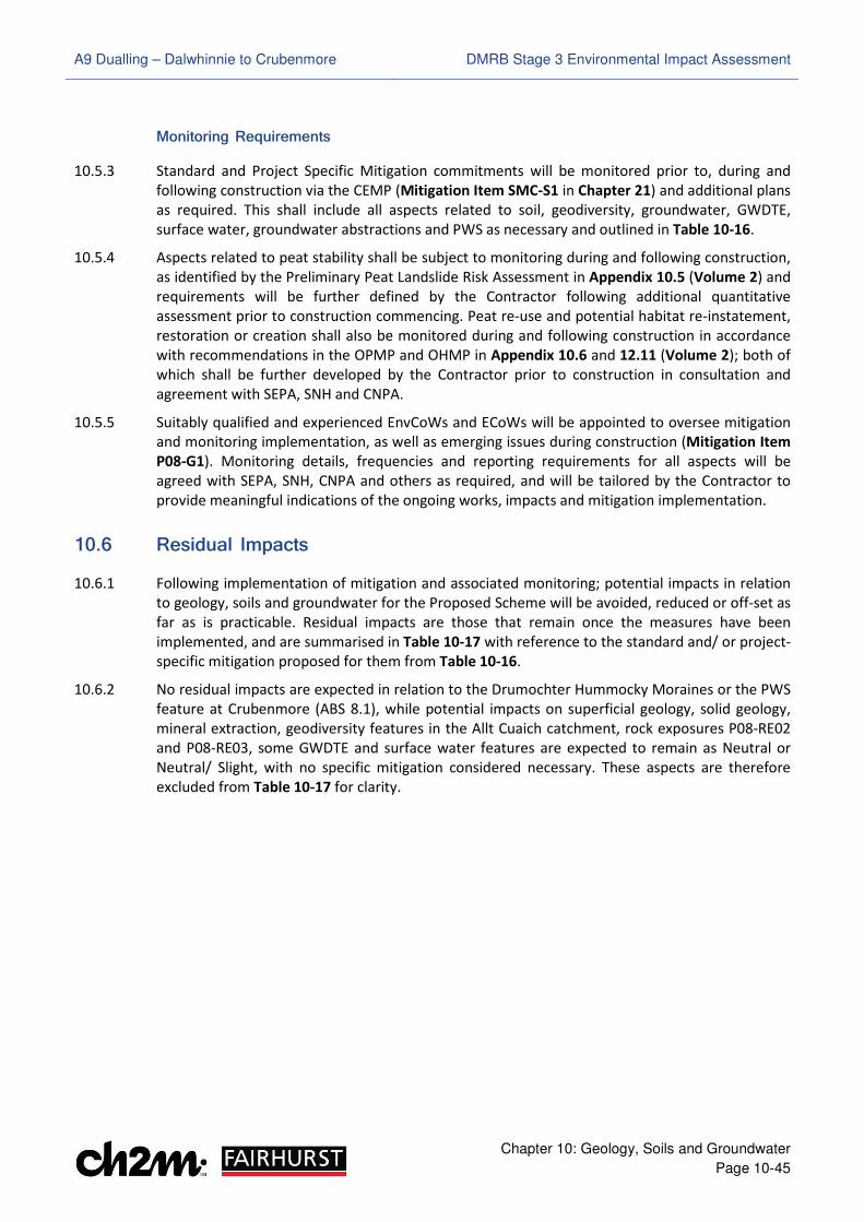
A9 Dualling – Dalwhinnie to Crubenmore DMRB Stage 3 Environmental Impact Assessment
Chapter 10: Geology, Soils and Groundwater
Page 10-45
Monitoring Requirements
10.5.3 Standard and Project Specific Mitigation commitments will be monitored prior to, during and
following construction via the CEMP (Mitigation Item SMC-S1 in Chapter 21) and additional plans
as required. This shall include all aspects related to soil, geodiversity, groundwater, GWDTE,
surface water, groundwater abstractions and PWS as necessary and outlined in Table 10-16.
10.5.4 Aspects related to peat stability shall be subject to monitoring during and following construction,
as identified by the Preliminary Peat Landslide Risk Assessment in Appendix 10.5 (Volume 2) and
requirements will be further defined by the Contractor following additional quantitative
assessment prior to construction commencing. Peat re-use and potential habitat re-instatement,
restoration or creation shall also be monitored during and following construction in accordance
with recommendations in the OPMP and OHMP in Appendix 10.6 and 12.11 (Volume 2); both of
which shall be further developed by the Contractor prior to construction in consultation and
agreement with SEPA, SNH and CNPA.
10.5.5 Suitably qualified and experienced EnvCoWs and ECoWs will be appointed to oversee mitigation
and monitoring implementation, as well as emerging issues during construction (Mitigation Item
P08-G1). Monitoring details, frequencies and reporting requirements for all aspects will be
agreed with SEPA, SNH, CNPA and others as required, and will be tailored by the Contractor to
provide meaningful indications of the ongoing works, impacts and mitigation implementation.
��.- Residual Impacts
10.6.1 Following implementation of mitigation and associated monitoring; potential impacts in relation
to geology, soils and groundwater for the Proposed Scheme will be avoided, reduced or off-set as
far as is practicable. Residual impacts are those that remain once the measures have been
implemented, and are summarised in Table 10-17 with reference to the standard and/ or project-
specific mitigation proposed for them from Table 10-16.
10.6.2 No residual impacts are expected in relation to the Drumochter Hummocky Moraines or the PWS
feature at Crubenmore (ABS 8.1), while potential impacts on superficial geology, solid geology,
mineral extraction, geodiversity features in the Allt Cuaich catchment, rock exposures P08-RE02
and P08-RE03, some GWDTE and surface water features are expected to remain as Neutral or
Neutral/ Slight, with no specific mitigation considered necessary. These aspects are therefore
excluded from Table 10-17 for clarity.

A9 Dualling – Dalwhinnie to Crubenmore DMRB Stage 3 Environmental Impact Assessment
Chapter 10: Geology, Soils and Groundwater
Page 10-46
Table 10-17: Residual Impacts – Geology, Soils and Groundwater
Receptor/ Aspect Sensitivity Pre-Mitigation
Impact Significance
Mitigation Post-Mitigation Residual Impact
Significance
Designated Geological Receptors and Features of Geodiversity Interest
Allt Coire Chuirn Alluvial Fan
Medium Slight/ Moderate
Residual impacts on the Allt Coire Chuirn alluvial fan geodiversity interest are likely to be Slight through minimisation of disturbance to the natural soil profile and landform as far as practicable, avoidance of damage to partial fan exposure areas through appropriate set-backs (Mitigation Item P08-G3) and working procedures identified in Chapter 11 in relation to hydromorphology (Mitigation Items SMC-W3 to SMC-W13).
Slight
Rock Exposure (P08-RE01)
Negligible Slight
Loss of existing rock exposure P08-RE01 has the potential to be offset by the provision of a larger and enhanced exposure. The extent of this will be determined during the detailed design and a requirement will be placed on the Contractor for a suitably qualified and experienced engineering geologist to be on site while rock is cut for the Proposed Scheme, to conduct logging and inspections, and to ensure rock cuts are profiled to be as natural as possible with no visible engineered elements (Mitigation Item P08-G2).
Neutral/ Slight
Soils
Soil Conservation Medium to
High Neutral/ Slight to
Moderate
The establishment of a Soil Management Plan (Mitigation Item P08-G4), for implementation during construction, combined with standard measures in relation to materials management (Mitigation Items SMC-G9 and SMC-M3 (Chapter 18)) will ensure that soil resources, soils of conservation interest or low agricultural productivity are excavated, managed, re-used and re-instated sustainably and appropriately; with residual impacts of Neutral to Slight significance.
It is also anticipated that the Soil Management Plan will be linked directly to landscape and ecology mitigation proposals in relation to habitat re-instatement, restoration and creation outlined in Appendix 12.11 (Volume 2) and Drawings 6.1 to 6.8 (Volume 3), with consideration of the soil-base for certain habitats within these (i.e. dry heath, wet heath, acid or species-rich grasslands) being an important consideration.
Neutral to Slight
Agricultural Soil Productivity
Low Neutral/ Slight Neutral
Peat Low to High Slight/ Moderate
to Moderate
The OPMP in Appendix 10.6 (Volume 2) demonstrates how unnecessary disturbance of peaty soils and peat has been minimised through design development and that there are ways in which these may be beneficially re-instated or re-used as part of the Proposed Scheme. This includes re-use as part of the landscaping strategy, re-use in candidate habitat re-instatement, restoration and creation areas (Drawings 10.39 to 10.47 (Volume 3)) or selected SuDS basins and compensatory flood storage areas, which offer opportunities for the extent of peatland habitats within the locality to be maintained, or locally, improved.
This will be subject to agreement with and subsequent refinement by the Contractor in consultation with SEPA, SNH and CNPA. However, together with construction methods to further avoid or limit impacts where possible (Mitigation Items P08-G5), and other mitigation and monitoring related to peat stability and dewatering (Mitigation Items P08-G6 to P08-G12 and P08-G17), residual impacts are expected to remain as Slight/ Moderate in the short-term and reduce to Slight to Slight/ Moderate in the longer term. This is expected reduce further still and deliver ecological benefits once habitat re-instatement, restoration and creation measures through appropriate re-use of peat become firmly established.
Slight to Slight/ Moderate
Groundwater
Groundwater Levels and Flow
Low to High Slight to
Moderate
Mitigation for potential impacts on groundwater levels and flow includes provision of appropriate construction and operation-stage drainage, combined with control measures and monitoring prior to and during construction (Mitigation Items P08-G13 to P08-G20). Optimising the drainage design and adoption of these measures where possible may reduce impacts slightly. However, residual impacts of Slight to Slight/ Moderate significance are expected to remain in superficial soils and bedrock at a local scale in vicinity of cuttings JC01 at Dalwhinnie junction and AQC01 for the SSE Aqueduct diversion.
Slight to Slight/ Moderate
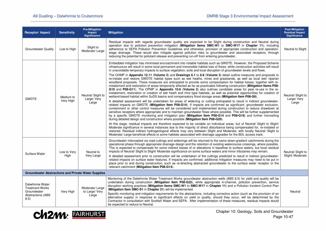
A9 Dualling – Dalwhinnie to Crubenmore DMRB Stage 3 Environmental Impact Assessment
Chapter 10: Geology, Soils and Groundwater
Page 10-47
Receptor/ Aspect Sensitivity Pre-Mitigation
Impact Significance
Mitigation Post-Mitigation Residual Impact
Significance
Groundwater Quality Low to High Slight to
Moderate/ Large
Residual impacts with regards groundwater quality are expected to be Slight during construction and Neutral during operation due to pollution prevention mitigation (Mitigation Items SMC-W1 to SMC-W17 in Chapter 11); including adherence to SEPA Pollution Prevention Guidelines and otherwise, provision of appropriate construction and operation-stage drainage. These would also mitigate against pollution risks to groundwater and associated receptors, through reducing the potential for pollutant release and preventing run-off from entering groundwater.
Neutral to Slight
GWDTE Medium to Very High
Neutral/ Slight to Large/ Very
Large
Embedded mitigation has minimised encroachment into notable habitats such as GWDTE. However, the Proposed Scheme infrastructure will result in some local permanent and irreversible habitat loss of these, while construction activities will result in unavoidable temporary impacts to surface vegetation, soils and local disruption of groundwater levels and flows.
The OHMP in Appendix 12.11 (Volume 2) and Drawings 6.1 to 6.8 (Volume 3) detail outline measures and proposals to re-instate and restore GWDTE habitat types such as wet heaths, mires and grasslands, as well as local wet/ riparian woodland proposals. These measures are anticipated to provide some compensation for habitat losses, together with re-instatement and restoration of areas temporarily affected as far as practicable following construction (Mitigation Items P08-G10 and P08-G11). The OPMP in Appendix 10.6 (Volume 2) also outlines candidate areas for peat re-use in the re-instatement, restoration or creation of wet heath and mire type habitats, as well as potential opportunities for creation of wetland-based habitat within SuDS basins and compensatory flood storage areas (Mitigation Item P08-G6).
A detailed assessment will be undertaken for areas of widening or cutting anticipated to result in indirect groundwater-related impacts on GWDTE (Mitigation Item P08-G14). If impacts are confirmed as significant, groundwater exclusion, containment or other control measures will be considered and implemented during construction to reduce drawdown at sensitive receptors where appropriate and to maintain groundwater flows where possible. This will be further supplemented by a specific GWDTE monitoring and mitigation plan (Mitigation Item P08-G14 and P08-G18) and further micrositing during detailed design and construction where possible (Mitigation Item P08-G20).
At this stage, residual impacts are therefore expected to be variable on individual areas, but of Neutral/ Slight to Slight/ Moderate significance in several instances due to the majority of direct disturbance being compensated for, re-instated or restored. Residual indirect hydrogeological effects may vary between Slight and Moderate, with locally Neutral/ Slight to Moderate/ Large beneficial effects to some habitats associated with drainage upgrades for the BDL access track.
Neutral/ Slight to Large/ Very
Large
Surface Water Low to Very
High Neutral to Very Large
Groundwater intercepted via road cuttings and widenings will be returned to the same down-gradient catchments during the operational phase through appropriate drainage design and the retention of existing watercourse crossings, where possible. This is expected to compensate for some indirect losses of or alterations in baseflow to surface waters, but local residual impacts of Neutral/ Slight to Slight/ Moderate significance on some surface waters and minor tributaries may remain.
A detailed assessment prior to construction will be undertaken of the cuttings predicted to result in indirect groundwater-related impacts on surface water features. If impacts are confirmed, additional mitigation measures may need to be put in place prior to and during construction, such as re-directing abstracted groundwater to the surface water receptor or the relevant catchment (Mitigation Item P08-G14).
Neutral/ Slight to Slight/ Moderate
Groundwater Abstractions and Private Water Supplies
Dalwhinnie Water Treatment Works Groundwater Abstractions (ABS 8.5)
Very High Moderate/ Large to Large/ Very
Large
Monitoring of the Dalwhinnie Water Treatment Works groundwater abstraction wells (ABS 8.5) for yield and quality will be undertaken during construction (Mitigation Item P08-G22), while appropriate in-channel, pollution prevention, service disruption working practices (Mitigation Items SMC-W1 to SMC-W17 in Chapter 11) and a Pollution Incident Control Plan (Mitigation Item SMC-S1 in Chapter 21) will be implemented.
Specific monitoring and mitigation requirements for the abstractions, including corrective action (such as the provision of an alternative supply) in response to significant effects on yield or quality, should they occur, will be determined by the Contractor in consultation with Scottish Water and SEPA. After implementation of these measures, residual impacts would be expected to reduce to Neutral.
Neutral
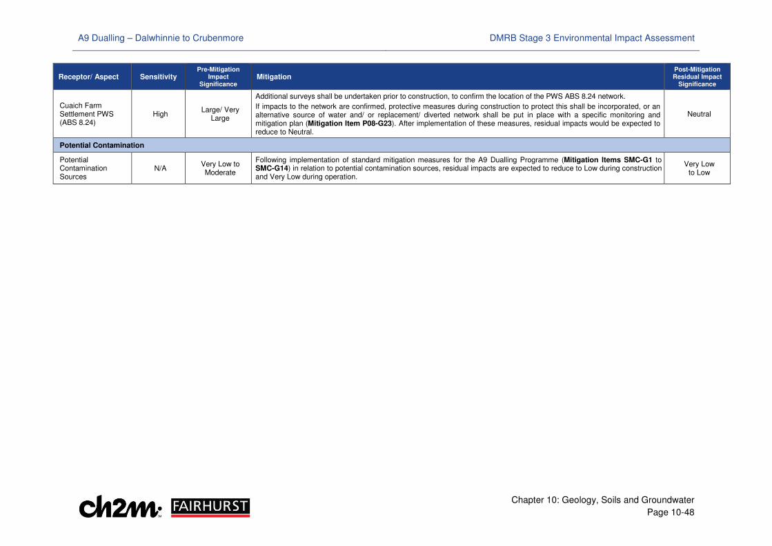
A9 Dualling – Dalwhinnie to Crubenmore DMRB Stage 3 Environmental Impact Assessment
Chapter 10: Geology, Soils and Groundwater
Page 10-48
Receptor/ Aspect Sensitivity Pre-Mitigation
Impact Significance
Mitigation Post-Mitigation Residual Impact
Significance
Cuaich Farm Settlement PWS (ABS 8.24)
High Large/ Very
Large
Additional surveys shall be undertaken prior to construction, to confirm the location of the PWS ABS 8.24 network.
If impacts to the network are confirmed, protective measures during construction to protect this shall be incorporated, or an alternative source of water and/ or replacement/ diverted network shall be put in place with a specific monitoring and mitigation plan (Mitigation Item P08-G23). After implementation of these measures, residual impacts would be expected to reduce to Neutral.
Neutral
Potential Contamination
Potential Contamination Sources
N/A Very Low to Moderate
Following implementation of standard mitigation measures for the A9 Dualling Programme (Mitigation Items SMC-G1 to SMC-G14) in relation to potential contamination sources, residual impacts are expected to reduce to Low during construction and Very Low during operation.
Very Low to Low
A9 Dualling – Dalwhinnie to Crubenmore DMRB Stage 3 Environmental Impact Assessment
Chapter 10: Geology, Soils and Groundwater
Page 10-49
10.6.3 In summary, with the Proposed Scheme in place and taking the identified mitigation measures
into account, residual impacts in relation to groundwater levels and flows in glacial deposits and
bedrock at Dalwhinnie are expected to be significant at a local scale during construction and
operation.
10.6.4 Peat excavation and GWDTE habitat loss or disturbance during construction are also identified to
be locally significant. However, it is noted that the vast majority of effects will occur along the
edge of more extensive peatland or wetland habitat mosaics within or adjacent to the existing A9
corridor, where areas have already been affected by existing land management, drainage or
infrastructure, and the consideration and implementation of additional micrositing, appropriate
construction methods and control measures is likely to further minimise or avoid effects on areas
in better condition. During operation, the residual impacts on these aspects are expected to
reduce and be further off-set, once measures for and ecological benefits from landscaping,
beneficial peat re-use and habitat re-instatement, restoration and creation become established
in the longer term. Residual effects in terms of permanent GWDTE habitat loss will be localised
and significant only at the local scale, with Chapter 12 also stating that no significant residual
ecological habitat loss or disturbance is expected following the implementation of mitigation.
10.6.5 All other residual impacts on geology, soils and groundwater receptors are not predicted to be
significant, and in some instances, may carry consequential benefits for local rock exposures and
ecology as summarised in Table 10-17.
��.. Summary of Combined Impacts
10.7.1 Some of the geology, soils and groundwater receptors may be subject to residual effects that, in
combination with others for different environmental topics, could contribute to cumulative
impacts during construction or operation. These include soils of conservation interest, peaty soils
and peat (direct and indirect disturbance, habitat fragmentation or loss), geodiversity features
(direct disturbance and landscape/ visual effects), GWDTE (groundwater flow impacts, habitat
fragmentation or loss and pollution risks), surface water features (dewatering or groundwater
flow impact from multiple widenings/ cuttings, geomorphological change, flood risk changes and
pollution risks) and properties (private water supplies and land-take, noise or visual effects).
10.7.2 Such potential cumulative impacts of the Proposed Scheme in relation to different environmental
topic-specific impacts on single receptors are considered in Chapter 20. However, based on the
above assessment and review of the residual impacts and mitigation measures proposed in other
Chapters, no significant adverse cumulative impacts of the Proposed Scheme have been
identified in relation to geology, soils and groundwater receptors.
A9 Dualling – Dalwhinnie to Crubenmore DMRB Stage 3 Environmental Impact Assessment
Chapter 10: Geology, Soils and Groundwater
Page 10-50
��./ References
Barron, H. F., Gillespie, M. R. and Merrit, J. W. (2011). Geodiversity of the Cairngorms National Park. British
Geological Survey Open Report, OR/10/019, 2011
British Geological Survey (1988). Hydrogeological Map of Scotland, 1:625,000 Scale
British Geological Survey (1995). Groundwater Vulnerability Map of Scotland, 1:625,000 Scale
British Geological Survey (2017). GeoIndex Onshore (Online) Available at (www.bgs.ac.uk/geoindex)
(Accessed June 2017)
British Standards Institute (2015). BS 8485:2015 – Code of Practice for the Design of Protective Measures
for Methane and Carbon Dioxide Ground Gases for New Buildings, June 2015
CH2M Fairhurst Joint Venture (CFJV) (2016). A9 Dualling – Glen Garry to Dalraddy, Geotechnical
Preliminary Sources Study Report for Project 8, Dalwhinnie to Crubenmore
Construction Industry Research and Information Association (2001). Contaminated Land Risk Assessment –
A Guide to Good Practice (C552), D J Rudland, R M Lancefield and P N Mayell
Construction Industry Research and Information Association (2007). Assessing Risks Posed by Hazardous
Ground Gases to Buildings C665, S Wilson, S Oliver and H Mallett et al
Construction Industry Research and Information Association (2016). Groundwater control: design and
practice, second edition C750, M Preene, T O L Roberts, W Powrie
Dargie, T. (2009). The Role of EIA Process in Assessing Wind Farm Impacts Upon Blanket Bog Habitat in
Scotland, IMCG Proceedings, April 2009
Department of Environment Food and Rural Affairs (2014). SP1010: Development of Category 4 Screening
Levels for Assessment of Land Affected by Contamination – Policy Companion Document
Environment Agency (2004). Model Procedures for the Management of Land Contamination,
Contaminated Land Report 11 (CLR11)
Freeze, A R and Cherry, J A (1979). Groundwater, Prentice Hall, Englewood Cliffs, 1979
Gauld, J H, Bell, J S, Mckeen, M and Bruneau, P M C (2003). Soils and nature conservation: an inventory of
selected Natural Heritage Futures areas. Scottish Natural Heritage Commissioned Report No. 019 (ROAME
No. F00AC101).
Health and Safety Executive (2011). EH40/ 2005 Workplace Exposure Limits, Second Edition
Hobbs, N. B., (1986). Mire Morphology and the Properties and Behaviour of some British and Foreign
Peats. Quarterly Journal of Engineering Geology, 19.
Jacobs UK (2014). A9 Dualling Perth to Inverness, Geotechnical Preliminary Sources Study Report,
Dalwhinnie to Crubenmore - Chainage 85700 to 95200, Reference: B1557620/GEO/PSSR07 – Revision 2
James Hutton Institute (1984). National Soil Map of Scotland, 1:250,000 Scale
Lukas, S (2003). Scottish Landform Example No. 31: The Moraines around the Pass of Drumochter, pp. 383-
393, Scottish Geographical Journal, 119(4), 2003
Lukas, S (2004). The Pattern of Deglaciation around the Pass of Drumochter, pp. 68-77, The Quaternary of
the Central Grampian Highlands Field Guide, Quaternary Research Association, 2004
Mitchell, W A and Lukas, S (2004), Drumochter Mast, pp. 163-170, The Quaternary of the Central Grampian
Highlands Field Guide, Quaternary Research Association
Merrit, J W (2004). A Guide to the Geomorphology and Glacial Geology of the Allt Cuaich Catchment and
the Gaick Plateau, pp. 180-189, The Quaternary of the Central Grampian Highlands Field Guide, Quaternary
Research Association
Nathanail, C.P., McCaffrey, C., Gillett, A.G., Ogden, R.C. and Nathaniel, J.F. (2015). The Land Quality
Management/ Chartered Institute of Environmental Health Suitable 4 Use Levels for Human Health Risk
Assessment. (Copyright Land Quality Management Limited reproduced with permission, Publication
Number S4UL3401. All rights reserved)
Natural England (2013). Restoration of Degraded Blanket Bog, Reference NEER003, First Edition
A9 Dualling – Dalwhinnie to Crubenmore DMRB Stage 3 Environmental Impact Assessment
Chapter 10: Geology, Soils and Groundwater
Page 10-51
Nayak, D. R., Miller, D., Nolan, A., Smith, P., Smith, J., (2008). Calculating carbon savings from wind farms
on Scottish peat lands – a new approach. Report for the Scottish Government
Powers, J. P., Corwin, A. B., Schmall, P. C. and Kaeck, W. E. (2007). Construction dewatering and
groundwater control: new methods and applications, third edition, Wiley-Blackwell, New York, USA
Raeburn Drilling and Geotechnical Ltd (2017). A9 Dualling – Glen Garry to Dalraddy, Project 8 Dalwhinnie to
Crubenmore – Final Report on Ground Investigation, Raeburn Drilling and Geotechnical Ltd
Raeburn Drilling and Geotechnical Ltd (2017). A9 Dualling – Glen Garry to Dalraddy, Project 8 Dalwhinnie to
Crubenmore – Final Report on Ground Investigation, Raeburn Drilling and Geotechnical Ltd, issued on 31
March 2017
Scotland and Northern Ireland Forum for Environmental Research (2009). WFD 95: A Functional Wetland
Typology for Scotland
Scottish Executive (2006a), Environmental Protection Act 1990: Part IIA Contaminated Land Statutory
Guidance: Edition 2
Scottish Executive (2006b). Peat Landslide Hazard and Risk Assessments, Best Practice Guide for Proposed
Electricity Generation Developments
Scottish Environment Protection Agency (2010). SEPA Regulatory Position Statement – Developments on
Peat. National Waste Policy Unit.
Scottish Environment Protection Agency (2014a). LUPS-GU31 Guidance on Assessing the Impacts of
Development Proposals on Groundwater Abstractions and Groundwater Dependent Terrestrial
Ecosystems, Version 2
Scottish Environment Protection Agency (2014b). Position Statement WAT-PS-10-01 Assigning
Groundwater Assessment Criteria for Pollutant Inputs, Version 3
Scottish Environment Protection Agency (2017). Interactive River Basin Management Plan Map (Online)
Available at (http://gis.sepa.org.uk/rbmp) (Accessed June 2017)
Scottish Government (2000). Planning Advice Note 33: Development of Contaminated Land
Scottish Government (2009). The Scottish Soil Framework
Scottish Government (2011a). The Waste Management Licensing (Scotland) Regulations 2011
Scottish Government (2011b). The Water Environment (Controlled Activities) (Scotland) Regulations 2011
Scottish Government (2011c). Carbon Implications of Windfarms Located on Peatlands – Update of the
Scottish Government Carbon Calculator Tool.
Scottish Government, Scottish Environment Protection Agency, Scottish Natural Heritage and The James
Hutton Institute (2014). Guidance on Developments on Peatland – Site Surveys 7p.
Scottish Government, Scottish Natural Heritage and Scottish Environment Protection Agency (2017).
Peatland Survey – Guidance on Developments on Peatland.
Scottish Natural Heritage (2013). Constructed tracks in the Scottish Uplands, Second Edition (updated in
September 2015)
Scottish Natural Heritage (2016a). Sitelink Designation Database (https://gateway.snh.gov.uk/sitelink/)
(Accessed June 2017)
Scottish Natural Heritage (2016b). Carbon and Peatland 2016 Map
Scottish Natural Heritage and Forestry Commission Scotland (2010). Floating Roads on Peat - A Report into
Good Practice in Design, Construction and Use of Floating Roads on Peat with particular reference to Wind
Farm Developments in Scotland
Scottish Natural Heritage, Scottish Environment Protection Agency and The James Hutton Institute (2014).
Guidance on Developments on Peatland - Site Surveys
Scottish Renewables, Scottish Natural Heritage, Scottish Environment Protection Agency and Forestry
Commission Scotland (2010). Good Practice during Windfarm Construction, Version 1
Scottish Renewables and Scottish Environment Protection Agency (2012). Developments on Peatland:
Guidance on the assessment of peat volumes, re-use of excavated peat and the minimisation of waste,
Version 1
A9 Dualling – Dalwhinnie to Crubenmore DMRB Stage 3 Environmental Impact Assessment
Chapter 10: Geology, Soils and Groundwater
Page 10-52
Stunnel, J (2010). Investigating Wind Farms on Peat. Report to Natural England No. NECR032. Maslen
Environmental
Stewart and Lance (1991). Effects of moor-draining on hydrology and vegetation of northern Pennine
blanket bog. Journal of Applied Ecology, 28: 1105 – 1117
Towers, W, Malcolm, A and Bruneau, P M C (2005). Assessing the nature conservation value of soil and its
relation with designated features. Scottish Natural Heritage Commissioned Report No. 111 (ROAME No.
F03AC104)
Transport Scotland (2013). A9 Dualling Programme Strategic Environmental Assessment (SEA)
Transport Scotland (2014a). A9 Dualling Programme Strategic Environmental Assessment (SEA)
Environmental Report Addendum. Document TSSEA9/ER/02
Transport Scotland (2014b). A9 Dualling: Preliminary Engineering Support Services, Design Manual for
Roads and Bridges Stage 1 Report Document TSSEA9/ER/02
The Highways Agency, Scottish Government, Welsh Assembly Government and The Department for
Regional Development Northern Ireland (1993). Design Manual for Roads and Bridges Volume 11, Section
3, Part 11, Geology and Soils, 1993
The Highways Agency, Transport Scotland, Welsh Assembly Government and The Department for Regional
Development Northern Ireland (2009). Design Manual for Roads and Bridges Volume 11, Section 3, Part 10,
HD45/09 Road Drainage and the Water Environment, 2009
Walker, M J C (1975). A Pollen Diagram from the Pass of Drumochter, Central Grampian Highlands,
Scotland, pp. 335-343, Transactions of the Botanical Society of Edinburgh, 42 (3), 1975
Werritty, A. (1997). Allt Dubhaig, Dorback Burn. In: Gregory, K.J., ed. Fluvial Geomorphology of Great
Britain. Geological Conservation Review Series. London, Chapman and Hall, 66–69, 69–72.
Wheeler, B D, Shaw, S and Tanner, K (2009). A wetland framework for impact assessment at statutory sites
in England and Wales. Environment Agency Science Report SC030232/SR1