Embed Size (px)
Citation preview
A9 Dualling – Glen Garry to Dalwhinnie DMRB Stage 3 Environmental Impact Assessment
Chapter 10: Geology, Soils and Groundwater
Page 10-1
�� Geology, Soils and Groundwater
��.� Introduction
10.1.1 This chapter presents the results of the geology, soils and groundwater assessment undertaken
as part of the Design Manual for Roads and Bridges (DMRB) Stage 3 Environmental Impact
Assessment (EIA) for Project 7 – Glen Garry to Dalwhinnie of the A9 Dualling Programme,
hereafter referred to as the Proposed Scheme, described in Chapter 5.
10.1.2 This includes assessment of potential impacts related to superficial and solid geology, designated
geological sites, geodiversity features, mineral extraction, soils, potential contamination sources,
groundwater and associated receptors, including Groundwater Dependent Terrestrial Ecosystems
(GWDTE), groundwater abstractions and private water supplies (PWS).
10.1.3 The assessment is supported by the following appendices presented in Volume 2:
• Appendix 10.1: Peat Survey Information
• Appendix 10.2: Groundwater Dependent Terrestrial Ecosystems
• Appendix 10.3: Groundwater Abstractions and Private Water Supplies
• Appendix 10.4: Potential Contamination Sources
• Appendix 10.5: Preliminary Peat Landslide Risk Assessment
• Appendix 10.6: Outline Peat Management Plan
10.1.4 Supporting considerations related to the assessment have also been addressed separately within
Chapter 8, Chapter 11 and Chapter 12, and associated appendices in Volume 2, with regards
agricultural land use, ecology, hydrology, fluvial geomorphology, drainage and flooding. National
and local planning policies which are relevant to geology, soils and groundwater are described in
Chapter 19, together with an assessment of the Proposed Scheme compliance against these.
��.� Approach and Methods
Scope and Guidance
10.2.1 This EIA has been undertaken using the guidance in DMRB Volume 11 Section 3 Part 11 ‘Geology
and Soils’ (The Highways Agency et al., 1993), taking account of updated guidance on
contaminated land in ‘CLR11 – Model Procedures for the Management of Land Contamination’
(Environment Agency, 2004) where appropriate, and DMRB Volume 11 Section 3 Part 10 HD
45/09 ‘Road Drainage and the Water Environment’ (The Highways Agency et al., 2009).
10.2.2 Consideration of soil includes potential impacts in terms of conservation value and potential
impacts on peat and peaty soils. Potential agricultural productivity of the soils is also considered,
though impacts in relation to general agricultural land use interests and land-take are assessed in
Chapter 8. Made ground is included in the assessment of potential contamination sources, while
earthworks volumes and ‘cut and fill balance’ of the Proposed Scheme is described in Chapter 5.
A9 Dualling – Glen Garry to Dalwhinnie DMRB Stage 3 Environmental Impact Assessment
Chapter 10: Geology, Soils and Groundwater
Page 10-2
10.2.3 For groundwater, the assessment considers potential impacts on quality, level, flow, GWDTE and
groundwater-related changes to surface water, groundwater abstractions and PWS. Impacts in
relation to fluvial geomorphology, surface water quality and flooding are assessed in Chapter 11.
Study Area
10.2.4 The assessment covers a study area extending to 250m from the permanent and temporary
works boundaries of the Proposed Scheme. For GWDTE, the study area extends to at least 100m
from the permanent and temporary works boundaries, and up to 250m where required.
10.2.5 Impacts on groundwater abstractions and PWS have been assessed to a distance of 850m from
the permanent and temporary works boundaries of the Proposed Scheme. This was considered
to correspond to the minimum study areas applied for groundwater abstractions under The
Water Environment (Controlled Activities) (Scotland) Regulations 2011 (CAR).
Baseline Data Collection
10.2.6 Baseline conditions described cover the following aspects:
• Superficial and solid geology
• Designated geological receptors and features of geodiversity interest
• Mineral extraction
• Soils and peat
• Groundwater and associated receptors, including GWDTE, abstractions and PWS
• Potential contamination sources.
10.2.7 Baseline conditions were determined through desk-based data assessments, consultation with
statutory and non-statutory bodies and landowners, ground investigations and field surveys.
Desk-based Assessment
10.2.8 The desk-based assessment included a review of the following information:
• Ordnance Survey (OS) historical maps (sourced from Envirocheck Reports) dating back to
1856 for information on former land use, potential contamination and information on PWS
• British Geological Survey (BGS) data including BGS Geological Maps, BGS Hydrogeological and
Groundwater Vulnerability Maps, BGS borehole logs and BGS publications
• James Hutton Institute (JHI) published soil maps, thematic data and derived information,
including the National Soil Map of Scotland (1981)
• Scottish Environment Protection Agency (SEPA) Groundwater Vulnerability Maps, interactive
River Basin Management Plan map and Scottish Wetland Inventory
• Scottish Natural Heritage (SNH) designation database (SNH, 2016a) and Carbon and Peatland
Map (SNH, 2016b)
• Previous assessments and information, including the Strategic Environmental Assessment
(SEA) and Addendum Reports for the A9 Dualling Programme (Transport Scotland, 2013 and
A9 Dualling – Glen Garry to Dalwhinnie DMRB Stage 3 Environmental Impact Assessment
Chapter 10: Geology, Soils and Groundwater
Page 10-3
2014a), DMRB Stage 1 Preliminary Engineering Services Report (Transport Scotland, 2014b)
and Geotechnical Preliminary Sources Study Report (PSSR) (CFJV, 2016)
Field Surveys
10.2.9 Several site walkovers were conducted by the CH2M Fairhurst Joint Venture (CFJV) to obtain
information on the baseline geology, soil, groundwater, potential contamination conditions and
PWS locations where possible. These were also supplemented by the following field surveys:
• Phase 1 Habitat Surveys (CH2M, June to September 2014)
• Preliminary ecological peat probing surveys (CFJV, August 2014)
• National Vegetation Classification (NVC) Surveys (MacArthur Green, June to July 2015)
• Detailed peat probing and sampling surveys (CFJV, July to August and December 2016).
Consultations
10.2.10 Consultations were undertaken with the following:
• Cairngorms National Park Authority (CNPA), Perth and Kinross Council (P&KC) and The
Highland Council (THC) for information on potential contamination sources and PWS
• SEPA for information on groundwater abstractions and potential contaminated land uses
• SNH for information on the location, extent and boundaries of environmental sensitivities and
geodiversity features in the vicinity of the Proposed Scheme
• HighWater (Scotland) Ltd and private landowners/ residents via questionnaire, for additional
information on groundwater abstractions or PWS, their source, location, type and use.
Ground Investigations
10.2.11 Intrusive ground investigations (GI) were conducted by Raeburn Drilling and Geotechnical Ltd
(Raeburn) between August and December 2015 (Advanced GI) and between December 2016 and
April 2017 (Preliminary GI). Both phases of work consisted of boreholes, trial pit excavations and
peat depth probes across the Proposed Scheme area, in addition to groundwater and ground gas
monitoring, and selected chemical testing of soil, groundwater and surface water samples.
10.2.12 The results of the Advanced and Preliminary GI are presented in the ‘A9 Dualling – Glen Garry to
Dalraddy, Project 7 Glen Garry to Dalwhinnie Report on Ground Investigation’ (Raeburn, March
2017) and ‘A9 Dualling – Glen Garry to Dalwhinnie Project 7, Report on Preliminary Ground
Investigation’ (Raeburn, June 2017), respectively.
Impact Assessment
10.2.13 The impacts in relation to geology, soils, groundwater and potential contamination have been
assessed individually as per the methodologies provided below. The criteria outlined are based
on those that have been applied to similar schemes in Scotland and are designed to comply with
DMRB Stage 3 EIA requirements.
Geology and Soils
10.2.14 For superficial and solid geology, soils, designated geological receptors, features of geodiversity
interest and mineral extraction, the sensitivity and magnitude criteria in Table 10-1 and Table
10-2 were applied. The impact significance was then determined using Table 10-3.
A9 Dualling – Glen Garry to Dalwhinnie DMRB Stage 3 Environmental Impact Assessment
Chapter 10: Geology, Soils and Groundwater
Page 10-4
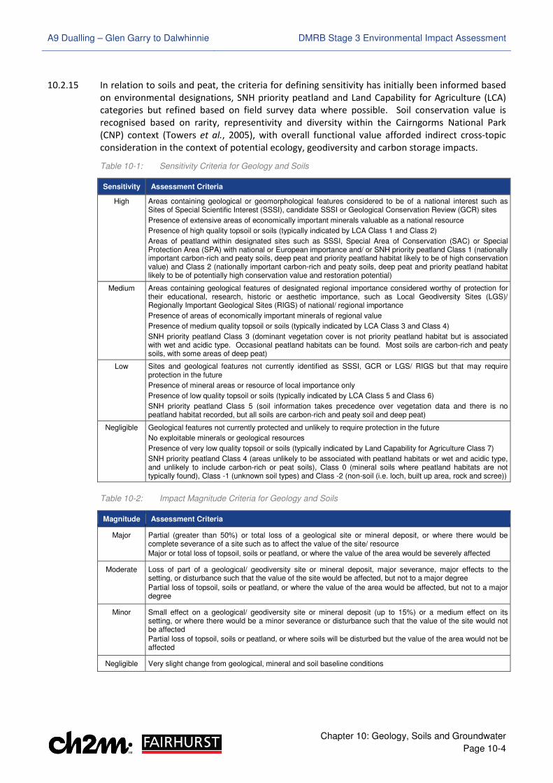
10.2.15 In relation to soils and peat, the criteria for defining sensitivity has initially been informed based
on environmental designations, SNH priority peatland and Land Capability for Agriculture (LCA)
categories but refined based on field survey data where possible. Soil conservation value is
recognised based on rarity, representivity and diversity within the Cairngorms National Park
(CNP) context (Towers et al., 2005), with overall functional value afforded indirect cross-topic
consideration in the context of potential ecology, geodiversity and carbon storage impacts.
Table 10-1: Sensitivity Criteria for Geology and Soils
Sensitivity Assessment Criteria
High Areas containing geological or geomorphological features considered to be of a national interest such as Sites of Special Scientific Interest (SSSI), candidate SSSI or Geological Conservation Review (GCR) sites
Presence of extensive areas of economically important minerals valuable as a national resource
Presence of high quality topsoil or soils (typically indicated by LCA Class 1 and Class 2)
Areas of peatland within designated sites such as SSSI, Special Area of Conservation (SAC) or Special Protection Area (SPA) with national or European importance and/ or SNH priority peatland Class 1 (nationally important carbon-rich and peaty soils, deep peat and priority peatland habitat likely to be of high conservation value) and Class 2 (nationally important carbon-rich and peaty soils, deep peat and priority peatland habitat likely to be of potentially high conservation value and restoration potential)
Medium Areas containing geological features of designated regional importance considered worthy of protection for their educational, research, historic or aesthetic importance, such as Local Geodiversity Sites (LGS)/ Regionally Important Geological Sites (RIGS) of national/ regional importance
Presence of areas of economically important minerals of regional value
Presence of medium quality topsoil or soils (typically indicated by LCA Class 3 and Class 4)
SNH priority peatland Class 3 (dominant vegetation cover is not priority peatland habitat but is associated with wet and acidic type. Occasional peatland habitats can be found. Most soils are carbon-rich and peaty soils, with some areas of deep peat)
Low Sites and geological features not currently identified as SSSI, GCR or LGS/ RIGS but that may require protection in the future
Presence of mineral areas or resource of local importance only
Presence of low quality topsoil or soils (typically indicated by LCA Class 5 and Class 6)
SNH priority peatland Class 5 (soil information takes precedence over vegetation data and there is no peatland habitat recorded, but all soils are carbon-rich and peaty soil and deep peat)
Negligible Geological features not currently protected and unlikely to require protection in the future
No exploitable minerals or geological resources
Presence of very low quality topsoil or soils (typically indicated by Land Capability for Agriculture Class 7)
SNH priority peatland Class 4 (areas unlikely to be associated with peatland habitats or wet and acidic type, and unlikely to include carbon-rich or peat soils), Class 0 (mineral soils where peatland habitats are not typically found), Class -1 (unknown soil types) and Class -2 (non-soil (i.e. loch, built up area, rock and scree))
Table 10-2: Impact Magnitude Criteria for Geology and Soils
Magnitude Assessment Criteria
Major Partial (greater than 50%) or total loss of a geological site or mineral deposit, or where there would be complete severance of a site such as to affect the value of the site/ resource
Major or total loss of topsoil, soils or peatland, or where the value of the area would be severely affected
Moderate Loss of part of a geological/ geodiversity site or mineral deposit, major severance, major effects to the setting, or disturbance such that the value of the site would be affected, but not to a major degree
Partial loss of topsoil, soils or peatland, or where the value of the area would be affected, but not to a major degree
Minor Small effect on a geological/ geodiversity site or mineral deposit (up to 15%) or a medium effect on its setting, or where there would be a minor severance or disturbance such that the value of the site would not be affected
Partial loss of topsoil, soils or peatland, or where soils will be disturbed but the value of the area would not be affected
Negligible Very slight change from geological, mineral and soil baseline conditions
A9 Dualling – Glen Garry to Dalwhinnie DMRB Stage 3 Environmental Impact Assessment
Chapter 10: Geology, Soils and Groundwater
Page 10-5
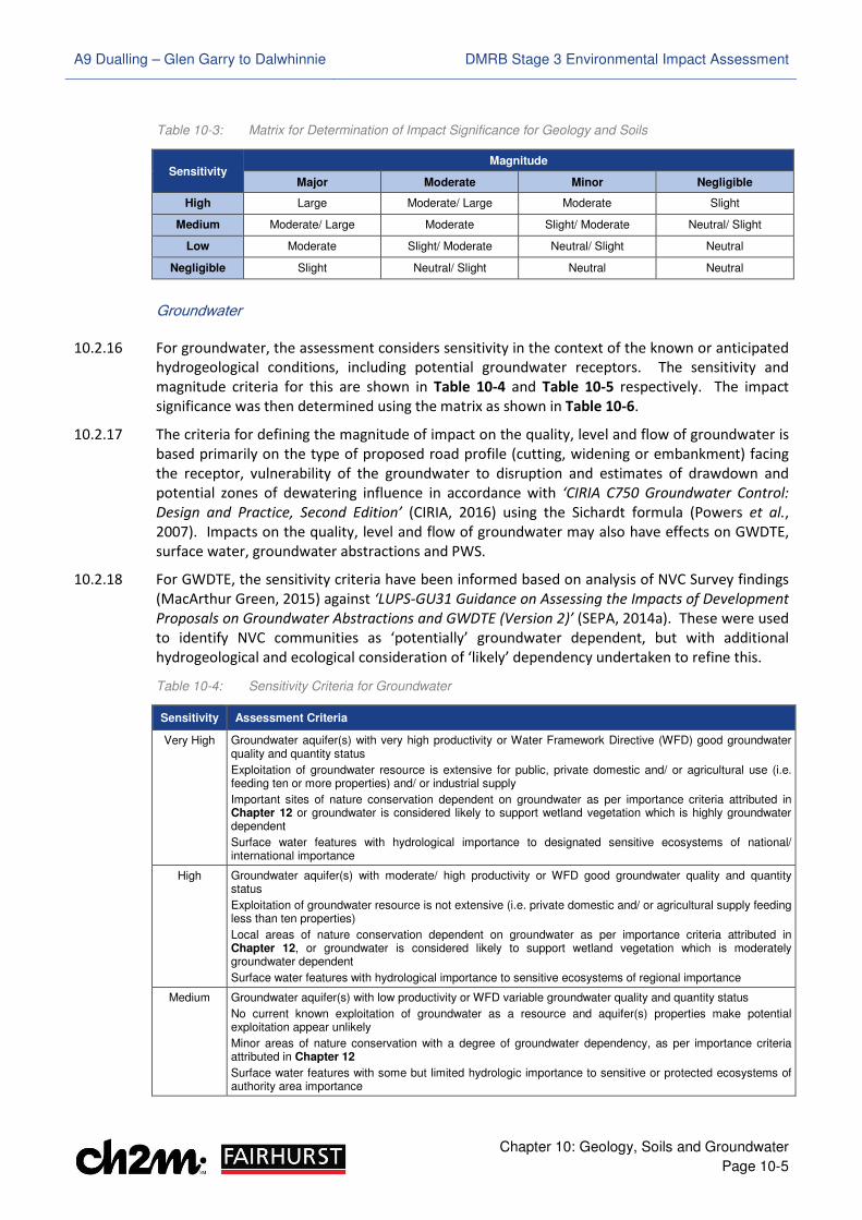
Table 10-3: Matrix for Determination of Impact Significance for Geology and Soils
Sensitivity Magnitude
Major Moderate Minor Negligible
High Large Moderate/ Large Moderate Slight
Medium Moderate/ Large Moderate Slight/ Moderate Neutral/ Slight
Low Moderate Slight/ Moderate Neutral/ Slight Neutral
Negligible Slight Neutral/ Slight Neutral Neutral
Groundwater
10.2.16 For groundwater, the assessment considers sensitivity in the context of the known or anticipated
hydrogeological conditions, including potential groundwater receptors. The sensitivity and
magnitude criteria for this are shown in Table 10-4 and Table 10-5 respectively. The impact
significance was then determined using the matrix as shown in Table 10-6.
10.2.17 The criteria for defining the magnitude of impact on the quality, level and flow of groundwater is
based primarily on the type of proposed road profile (cutting, widening or embankment) facing
the receptor, vulnerability of the groundwater to disruption and estimates of drawdown and
potential zones of dewatering influence in accordance with ‘CIRIA C750 Groundwater Control:
Design and Practice, Second Edition’ (CIRIA, 2016) using the Sichardt formula (Powers et al.,
2007). Impacts on the quality, level and flow of groundwater may also have effects on GWDTE,
surface water, groundwater abstractions and PWS.
10.2.18 For GWDTE, the sensitivity criteria have been informed based on analysis of NVC Survey findings
(MacArthur Green, 2015) against ‘LUPS-GU31 Guidance on Assessing the Impacts of Development
Proposals on Groundwater Abstractions and GWDTE (Version 2)’ (SEPA, 2014a). These were used
to identify NVC communities as ‘potentially’ groundwater dependent, but with additional
hydrogeological and ecological consideration of ‘likely’ dependency undertaken to refine this.
Table 10-4: Sensitivity Criteria for Groundwater
Sensitivity Assessment Criteria
Very High Groundwater aquifer(s) with very high productivity or Water Framework Directive (WFD) good groundwater quality and quantity status
Exploitation of groundwater resource is extensive for public, private domestic and/ or agricultural use (i.e. feeding ten or more properties) and/ or industrial supply
Important sites of nature conservation dependent on groundwater as per importance criteria attributed in Chapter 12 or groundwater is considered likely to support wetland vegetation which is highly groundwater dependent
Surface water features with hydrological importance to designated sensitive ecosystems of national/ international importance
High Groundwater aquifer(s) with moderate/ high productivity or WFD good groundwater quality and quantity status
Exploitation of groundwater resource is not extensive (i.e. private domestic and/ or agricultural supply feeding less than ten properties)
Local areas of nature conservation dependent on groundwater as per importance criteria attributed in Chapter 12, or groundwater is considered likely to support wetland vegetation which is moderately groundwater dependent
Surface water features with hydrological importance to sensitive ecosystems of regional importance
Medium Groundwater aquifer(s) with low productivity or WFD variable groundwater quality and quantity status
No current known exploitation of groundwater as a resource and aquifer(s) properties make potential exploitation appear unlikely
Minor areas of nature conservation with a degree of groundwater dependency, as per importance criteria attributed in Chapter 12
Surface water features with some but limited hydrologic importance to sensitive or protected ecosystems of authority area importance
A9 Dualling – Glen Garry to Dalwhinnie DMRB Stage 3 Environmental Impact Assessment
Chapter 10: Geology, Soils and Groundwater
Page 10-6
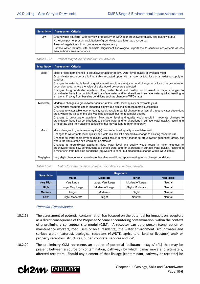
Sensitivity Assessment Criteria
Low Groundwater aquifer(s) with very low productivity or WFD poor groundwater quality and quantity status
No known past or present exploitation of groundwater aquifer(s) as a resource
Areas of vegetation with no groundwater dependency
Surface water features with minimal/ insignificant hydrological importance to sensitive ecosystems of less than authority area importance
Table 10-5: Impact Magnitude Criteria for Groundwater
Magnitude Assessment Criteria
Major Major or long term change to groundwater aquifer(s) flow, water level, quality or available yield
Groundwater resource use is irreparably impacted upon, with a major or total loss of an existing supply or supplies
Changes to water table level or quality would result in a major or total change in or loss of a groundwater dependent area, where the value of a site would be severely affected
Changes to groundwater aquifer(s) flow, water level and quality would result in major changes to groundwater base flow contributions to surface water and/ or alterations in surface water quality, resulting in a major shift away from baseline conditions such as change to WFD status
Moderate Moderate changes to groundwater aquifer(s) flow, water level, quality or available yield
Groundwater resource use is impacted slightly, but existing supplies remain sustainable
Changes to water table level or quality would result in partial change in or loss of a groundwater dependent area, where the value of the site would be affected, but not to a major degree
Changes to groundwater aquifer(s) flow, water level and quality would result in moderate changes to groundwater base flow contributions to surface water and/ or alterations in surface water quality, resulting in a moderate shift from baseline conditions that may be long-term or temporary
Minor Minor changes to groundwater aquifer(s) flow, water level, quality or available yield
Changes to water table level, quality and yield result in little discernible change to existing resource use
Changes to water table level or quality would result in minor change to groundwater dependent areas, but where the value of the site would not be affected
Changes to groundwater aquifer(s) flow, water level and quality would result in minor changes to groundwater base flow contributions to surface water and/ or alterations in surface water quality, resulting in a minor shift from baseline conditions (equivalent to minor but measurable change within WFD status)
Negligible Very slight change from groundwater baseline conditions, approximating to ‘no change’ conditions.
Table 10-6: Matrix for Determination of Impact Significance for Groundwater
Sensitivity Magnitude
Major Moderate Minor Negligible
Very High Very Large Large/ Very Large Moderate/ Large Neutral
High Large/ Very Large Moderate/ Large Slight/ Moderate Neutral
Medium Large Moderate Slight Neutral
Low Slight/ Moderate Slight Neutral Neutral
Potential Contamination
10.2.19 The assessment of potential contamination has focused on the potential for impacts on receptors
as a direct consequence of the Proposed Scheme encountering contamination, within the context
of a preliminary conceptual site model (CSM). A receptor can be a person (construction or
maintenance workers, road users or local residents), the water environment (groundwater and
surface water features), ecological receptors (GWDTE, agricultural land or livestock) and/ or
property receptors (structures, buried concrete, services and PWS).
10.2.20 The preliminary CSM represents an outline of potential ‘pollutant linkages’ (PL) that may be
present between a source of contamination, pathways by which it may move and ultimately,
affected receptors. Should any element of that linkage (contaminant, pathway or receptor) be
A9 Dualling – Glen Garry to Dalwhinnie DMRB Stage 3 Environmental Impact Assessment
Chapter 10: Geology, Soils and Groundwater
Page 10-7
missing or removed, the contamination is considered unlikely to represent a potential risk or
impact. The potential receptors and pathways were compiled based on the definitions in Part IIA
of the Environmental Protection Act 1990, as provided in the Statutory Guidance (Scottish
Executive, 2006).
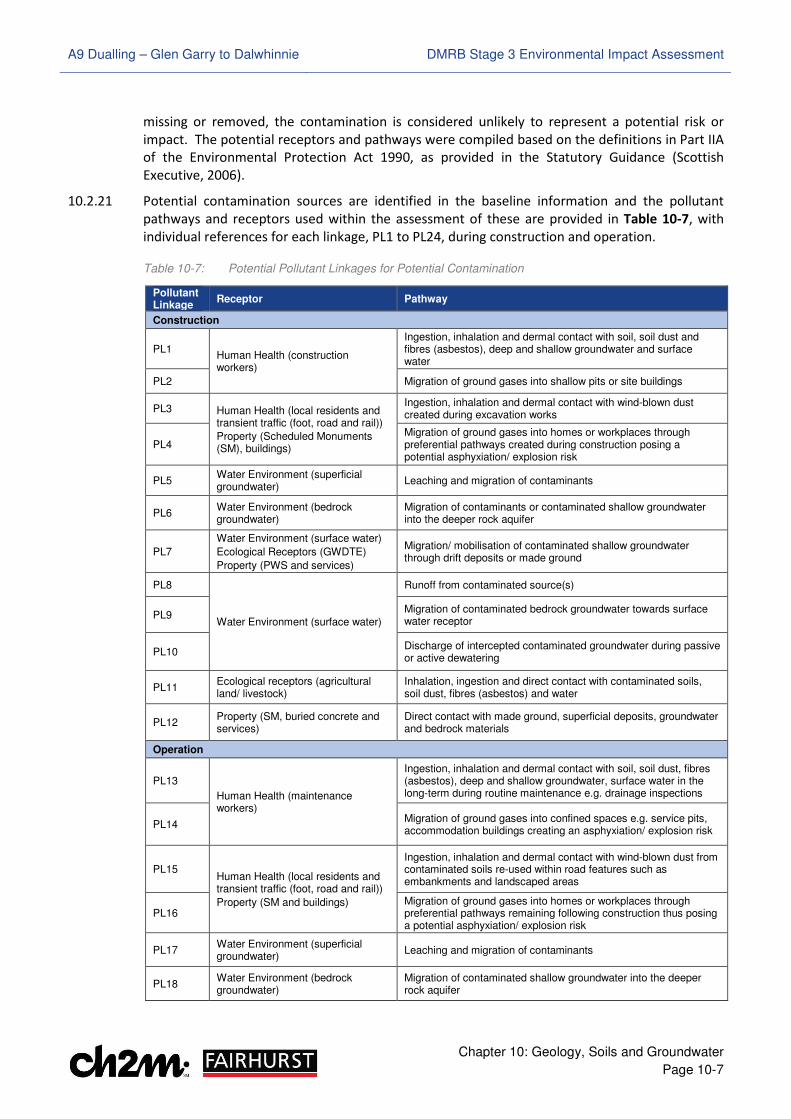
10.2.21 Potential contamination sources are identified in the baseline information and the pollutant
pathways and receptors used within the assessment of these are provided in Table 10-7, with
individual references for each linkage, PL1 to PL24, during construction and operation.
Table 10-7: Potential Pollutant Linkages for Potential Contamination
Pollutant Linkage
Receptor Pathway
Construction
PL1 Human Health (construction workers)
Ingestion, inhalation and dermal contact with soil, soil dust and fibres (asbestos), deep and shallow groundwater and surface water
PL2 Migration of ground gases into shallow pits or site buildings
PL3 Human Health (local residents and transient traffic (foot, road and rail))
Property (Scheduled Monuments (SM), buildings)
Ingestion, inhalation and dermal contact with wind-blown dust created during excavation works
PL4 Migration of ground gases into homes or workplaces through preferential pathways created during construction posing a potential asphyxiation/ explosion risk
PL5 Water Environment (superficial groundwater)
Leaching and migration of contaminants
PL6 Water Environment (bedrock groundwater)
Migration of contaminants or contaminated shallow groundwater into the deeper rock aquifer
PL7
Water Environment (surface water)
Ecological Receptors (GWDTE)
Property (PWS and services)
Migration/ mobilisation of contaminated shallow groundwater through drift deposits or made ground
PL8
Water Environment (surface water)
Runoff from contaminated source(s)
PL9 Migration of contaminated bedrock groundwater towards surface water receptor
PL10 Discharge of intercepted contaminated groundwater during passive or active dewatering
PL11 Ecological receptors (agricultural land/ livestock)
Inhalation, ingestion and direct contact with contaminated soils, soil dust, fibres (asbestos) and water
PL12 Property (SM, buried concrete and services)
Direct contact with made ground, superficial deposits, groundwater and bedrock materials
Operation
PL13
Human Health (maintenance workers)
Ingestion, inhalation and dermal contact with soil, soil dust, fibres (asbestos), deep and shallow groundwater, surface water in the long-term during routine maintenance e.g. drainage inspections
PL14 Migration of ground gases into confined spaces e.g. service pits, accommodation buildings creating an asphyxiation/ explosion risk
PL15 Human Health (local residents and transient traffic (foot, road and rail))
Property (SM and buildings)
Ingestion, inhalation and dermal contact with wind-blown dust from contaminated soils re-used within road features such as embankments and landscaped areas
PL16 Migration of ground gases into homes or workplaces through preferential pathways remaining following construction thus posing a potential asphyxiation/ explosion risk
PL17 Water Environment (superficial groundwater)
Leaching and migration of contaminants
PL18 Water Environment (bedrock groundwater)
Migration of contaminated shallow groundwater into the deeper rock aquifer
A9 Dualling – Glen Garry to Dalwhinnie DMRB Stage 3 Environmental Impact Assessment
Chapter 10: Geology, Soils and Groundwater
Page 10-8
Pollutant Linkage
Receptor Pathway
PL19
Water Environment (surface water)
Ecological Receptors (GWDTE)
Property (PWS and services)
Migration of shallow groundwater through drift deposits or made ground
PL20
Water Environment (surface water)
Runoff from contaminated source(s)
PL21 Migration of contaminated shallow groundwater through drainage channels and associated granular bedding materials or engineered structures
PL22 Discharge of intercepted contaminated groundwater
PL23 Ecological receptors (agricultural land/ livestock)
Inhalation, ingestion and direct contact with contaminated soils/ water
PL24 Property (buried concrete and services)
Direct contact with made ground, superficial deposits, groundwater and bedrock materials
10.2.22 For the purposes of this assessment, the preliminary CSM has disregarded those pollutant
linkages that are incomplete and cannot pose a risk to identified receptors. Where a complete
pollutant linkage exists, a generic qualitative risk assessment has been undertaken.
10.2.23 The output of the assessment cannot be reported in terms of ‘sensitivity’. Instead, it is reported
as the ‘likelihood’ of a complete pollutant linkage being present, which is defined within CIRIA
C552 ‘Contaminated Land Risk Assessment: A Guide to Good Practice’ (CIRIA, 2001), ‘CLR11 –
Model Procedures for the Management of Land Contamination’ (EA, 2004) and summarised in
Table 10-8. The magnitude, or consequence, of the effect on likely receptors is outlined in Table
10-9 and overall risk (significance), taking account of both likelihood and consequence, is
identified with reference to the matrix in Table 10-10.
Table 10-8: Likelihood Criteria for Potential Contamination
Likelihood Assessment Criteria
High Likelihood There is a complete pollution linkage and an event that either appears very likely in the short-term and almost inevitable over the long-term, or there is evidence at the receptor of harm or pollution
Likely There is a complete pollution linkage and all the elements are present and available, which means that it is probable that an event will occur
Circumstances are such that an event is not inevitable, but possible in the short-term and likely over a long-term
Low Likelihood There is a complete pollution linkage and the circumstances are possible under which an event could occur
However, it is by no means certain that even over a longer period such an event would take place, and is less likely in the shorter term
Unlikely There is a complete pollution linkage but circumstances are such that it is improbable that an event would occur even in the very long-term
Table 10-9: Impact Magnitude (Consequence) Criteria for Potential Contamination
Consequence Assessment Criteria
Severe Short-term (acute) damage to human health (significant harm)
Pollution of sensitive water resources as a result of short-term exposure
Damage to a particular ecosystem as a result of acute exposure
Catastrophic damage to buildings/ property/ services/ SM
Medium Long-term (chronic) damage to human health (significant harm)
Pollution of sensitive water resources as a result of chronic exposure
A significant change in a particular ecosystem, or organism forming part of such an ecosystem
Substantial damage to buildings/ property/ services/ SM
A9 Dualling – Glen Garry to Dalwhinnie DMRB Stage 3 Environmental Impact Assessment
Chapter 10: Geology, Soils and Groundwater
Page 10-9
Consequence Assessment Criteria
Mild No appreciable impact on human health based on the potential effects on the critical human health receptor
Pollution of non-sensitive water resources
Damage to ecological systems with no significant impairment
Significant damage to sensitive buildings/ structures/ SM/ services or the environment
Minor Harm (not necessarily significant), which may result in financial loss or require expenditure to resolve
Non-permanent health effects to human health
No appreciable pollution
Easily repairable effects or damage to ecological systems
Easily reparable damage to buildings, structures, SM and services
Table 10-10: Matrix for Determination of Impact Significance (Risk) for Potential Contamination
Consequence Likelihood
High likelihood Likely Low likelihood Unlikely
Severe Very high High Moderate Moderate/ Low
Medium High Moderate Moderate/ Low Low
Mild Moderate Moderate/ Low Low Very Low
Minor Moderate/ Low Low Very Low Very low
Limitations to Assessment
10.2.24 Information obtained from both the Advanced and Preliminary GI works has been used in the
assessment. In areas where no data is available, geological and hydrogeological information has
been extrapolated or used from the nearest available data points. Groundwater monitoring for
the Preliminary GI is scheduled for completion by April 2018. Monitoring results available from
between April and August 2017 have been taken into account in the assessment.
10.2.25 Groundwater abstraction and PWS features have been identified based on information supplied
by P&KC, THC, SEPA, HighWater (Scotland) Ltd, landowner consultations, historical or current
mapping and site walkovers (CFJV, 2017). Additional consultation regarding some supplies may
be required as part of pre-construction activities.
10.2.26 In certain conditions, groundwater dewatering effects have the potential to cause differential
ground settlement. This is a geotechnical consideration, outwith the scope of this assessment.
However, mitigation is included for a detailed assessment of this to be completed prior to
construction in areas of excavation located nearby existing infrastructure, properties or structural
cultural heritage receptors. This assessment will be supported by the complete groundwater
monitoring dataset from the Preliminary GI, as well as additional data from Detailed GI scheduled
for completion in 2018.
10.2.27 The identification of potential contamination sources has been reliant on the accuracy of
historical mapping and available GI information. Potential sources not encountered during GI or
identified through desk-based assessment and consultation are not reported. The assessment of
historical quarrying activity has also been based on desk-based review of historical mapping. It is
possible that quarrying works could have been undertaken and the void backfilled between the
recorded years of mapping, such that no map evidence exists.
A9 Dualling – Glen Garry to Dalwhinnie DMRB Stage 3 Environmental Impact Assessment
Chapter 10: Geology, Soils and Groundwater
Page 10-10
��.� Baseline Conditions
Geology
10.3.1 As shown in Drawing 10.1 in Volume 3 of this report, published BGS mapping indicates superficial
deposits within the study area to variably include till, hummocky (moundy) glacial deposits, head,
talus, alluvial fan, alluvium, river terrace deposits and peat.
10.3.2 The solid geology comprises Precambrian Psammite of the Gaick Psammite Formation; recorded
as predominantly quartzose psammite with scattered biotite flakes and laminae, as shown in
Drawing 10.2 (Volume 3). BGS mapping also records the Grampian Group (locally arkosic
psammite with subsidiary semipelite to pelite), several areas of faulting and local Ordovician and
Siluro-Devonian igneous intrusions (microdioirite, microgranite, felsite and pegmatite) that cross
or outcrop beneath or adjacent to the existing carriageway.
10.3.3 These conditions have broadly been substantiated by GI information, as summarised below.
Findings in relation to peat are described in Appendix 10.1 (Volume 2) and the soils sub-section.
Made Ground
10.3.4 Made ground has been encountered at several locations across the Proposed Scheme extent.
The materials ranged from 0.05 to 3.50m in thickness, and were described to vary between
clayey, silty or peaty sand, clayey silty, sandy or gravelly topsoil and sand and gravel with low
cobble and boulder content. Areas of tarmac and bitumous material were also recorded.
10.3.5 Extraneous material fragments including wood, timber, rubber, brick, rope, tarmac, plastic,
metal, fabric and glass were occasionally observed, with organic traces, organic odours and
hydrocarbon odours in seven locations; including areas at Dalnaspidal (ch. 325), the Pass of
Drumochter (ch. 2,900, ch. 4,500 and ch. 6,100), Balsporran (ch. 6,900) and Drumochter Lodge
(ch. 7,650). Possible made ground was also observed in three locations as clayey sandy slightly
gravelly topsoil and gravelly sand with some organic and boulder content between ground level
and 1.60m. These were noted to be indicative of possible landslips at locations northward of
Dalnaspidal (ch. 800 and ch. 1,100).
10.3.6 Based on Table 10-1, made ground is considered to be of negligible sensitivity. However, each
occurrence has been reviewed and incorporated as a potential contamination source in Appendix
10.4 (Volume 2) and their locations are shown in Drawings 10.31 to 10.37 (Volume 3).
Superficial Geology
10.3.7 Superficial deposits identified from available GI include alluvium (underlying the River Truim and
Allt Dubhaig floodplains and various watercourses) and alluvial fans (fanning out from
watercourses including Allt Coire Chuirn, Allt Coire Mhic Sith and Allt an Creagach). Alluvium
deposits were described to vary between silty, gravelly, fine to medium and fine to coarse sand
and gravel, with variable cobble and boulder content. Alluvial fans were encountered in central
portions of the Proposed Scheme near Balsporran and northward past Drumochter Lodge;
described as silty, clayey and gravelly fine to coarse sand and sandy fine to coarse gravel with
variable cobble content and locally, organic materials including roots and traces of peat.
10.3.8 Glacial deposits including hummocky glacial deposits and till, were also observed throughout the
study area. These were predominantly recorded as granular, varying between silty or clayey and
gravelly fine to medium and coarse sand with fine to coarse gravel, and clayey or silty sandy fine
to coarse gravel, with variable cobble and boulder content, occasional pockets of peat and local
A9 Dualling – Glen Garry to Dalwhinnie DMRB Stage 3 Environmental Impact Assessment
Chapter 10: Geology, Soils and Groundwater
Page 10-11
layers of sandy gravelly clay or sandy gravelly silt. The thickness of the alluvial and glacial
superficial units varies from 2.80 to 19.00m, with the greater thicknesses generally being present
to the west of the Proposed Scheme on the valley floor through the Pass of Drumochter and
northward past Drumochter Lodge.
10.3.9 Mass movement deposits comprising head and blanket head were identified locally on the
eastern side of the existing carriageway through the Pass of Drumochter. These were recorded to
comprise silty fine to coarse sand and silty gravelly fine to medium sand with gravel and variable
cobble content and occasional traces of peat. The thickness of the deposits was unconfirmed.
10.3.10 Based on Table 10-1 and, with the exception of those associated with designated geological
receptors and features of geodiversity interest, the superficial deposits are considered to be of
negligible sensitivity.
Solid Geology
10.3.11 The available GI information has identified bedrock at depths between 2.80 and 19.00m below
ground level (m bgl), but with bedrock close to or at the surface on the eastern side of the existing
carriageway in central portions of the study area through the Pass of Drumochter and towards the
north. The rock observed is predominantly composed of interlayered psammite, semi-pelite,
quartzite and schist, with heavy fracturing and partial or distinct weathering. Granite also been
encountered in the north of the study area near Allt Coire Chuirn, while intrusive bands of dolerite,
pegmatite and granite were recorded between 4.55 and 14.10m bgl at Dalnaspidal and through the
Pass of Drumochter.
10.3.12 Based on Table 10-1, solid geology in the study area is considered to be of negligible sensitivity.
Designated Geological Receptors and Features of Geodiversity Interest
10.3.13 The Allt Dubhaig GCR site lies within the study area and is the qualifying geological interest of the
Drumochter Hills SSSI for fluvial geomorphology. Additional features of geodiversity interest
include the Drumochter Hummocky Moraines, alluvial fan at Allt Coire Chuirn, an important
pollen record site, the Drumochter debris cones and hillsides in the Pass of Drumochter. CFJV
field visits (CFJV, 2016) have also identified three partial rock exposure areas on the existing A9.
10.3.14 Details of these features are provided below and shown in Drawing 10.3 (Volume 3).
Allt Dubhaig
10.3.15 The Allt Dubhaig GCR site is located to the north west of Dalnaspidal Lodge between the Sow of
Atholl and Highland Main Line (HML) railway, which forms its eastern boundary adjacent to the
west of the Proposed Scheme, as illustrated in Drawings 10.10 to 10.12 (Volume 3). The site is
around 3km in length (between ch. 400 and ch. 2,950) and is between 250 and 650m in width
across the floodplain associated with the Allt Dubhaig watercourse.
10.3.16 The Allt Dubhaig watercourse is an alluvial, gravel-bed channel that emerges from a mountain
torrent (Allt Coire Dhomhain) through hummocky moraine drift, and flows south along the base
of the Pass of Drumochter. South of Dalnaspidal Lodge, it flows into Loch Garry, the River Garry
and ultimately, the River Tay. Across its length, minimal additional discharge from tributaries and
no lateral input of sediment is received by the channel (Ferguson et al., 1990; Werritty, 1997),
though there is a close hydrological connection between the site and A9 via several watercourse
crossings that pass under the existing carriageway and HML railway.
A9 Dualling – Glen Garry to Dalwhinnie DMRB Stage 3 Environmental Impact Assessment
Chapter 10: Geology, Soils and Groundwater
Page 10-12
10.3.17 Local base-level control is exerted by a debris alluvial fan at the base of Allt Coire Mhic Sith near
to the outflow of Loch Garry; causing the channel gradient to decline rapidly. This has generated
a significant decrease in the size of the bed material, and progressive changes in channel
planform in a downstream sequence toward this, from near braided to meandering to stable
sinuous types, are evident (Werrity, 1997). The alluvial valley floor in the lower reaches of the
watercourse is marshy and comprises silty sands and peat, with few signs of gravel beyond the
base of Allt Coire Mhic Sith. The channel pattern toward Dalnaspidal Lodge here is also likely to
have been influenced by a hydroelectric diversion sluice which is present and was built in 1935.
10.3.18 The Allt Dubhaig GCR is an example of a dynamic fluvial area, with the interests being progressive
change in channel morphology and the unusual floodplain. The combination of a highly concave
long profile, the absence of significant lateral inputs of water or sediment and historical field
studies have unequivocally confirmed that size-selective transport is responsible for the rapid
downstream fining of bed material (Werrity, 1997; Barron et al., 2011). This is found in many
rivers, but the Allt Dubhaig offers an ideal site within which the relative roles of this can be
observed, studied and understood.
10.3.19 Based on Table 10-1, the Allt Dubhaig GCR site is considered to be of high sensitivity.
Drumochter Hummocky Moraines
10.3.20 As illustrated in Drawings 10.10 to 10.16 (Volume 3), the lower slopes and edges of the valley
bottoms through the Pass of Drumochter and across the Proposed Scheme extent are underlain
by hummocky (moundy) glacial deposits and contain numerous examples of bouldery moraine
that formed during the Loch Lomond Stadial (the period between deglaciation and the start of
the Holocene). The moraines are associated with meltwater channels that were eroded parallel
to ice margins and take the form of ridge fragments and mounds, which mark standstills in the
glacial retreat.
10.3.21 Two main groups of moraine can be distinguished in the area based on previous studies (Lukas
2003; Lukas et al, 2004) and field visits (CFJV, 2016); smaller ridges and mounds (5 to 20m wide,
up to 150m long and up to 5m high) and larger ridges and mounds (up to 140m wide, 260m long
and up to 10m high). Both are typically confined to the lowermost 50m of slopes, bordering the
valley floors, and the length and abundance of moraine ridges usually increases upslope, with
mounds dominating on steep slope sections.
10.3.22 The study area contains numerous examples of these features, and the indicative locations
illustrated in Drawings 10.10 to 10.16 (Volume 3) have been informed through previous mapping
of ridges, mounds and terraces (Lukas 2003; 2004). The moraines are of importance because the
landform assemblage through the Pass of Drumochter is commonly cited to contain textbook
examples of the hummocky moraine formed during the Loch Lomond Stadial, albeit their origin
and age remain an active field of research (Barron et al., 2011). Taken together, the features
provide an important record of glacial recession across the district.
10.3.23 The Drumochter Hummocky Moraines have been identified as a candidate LGS (Barron et al.,
2011) and are therefore considered to be of medium sensitivity, based on Table 10-1.
Allt Coire Chuirn Alluvial Fan
10.3.24 A large alluvial fan is present underlying and adjacent to the north of the Proposed Scheme
between ch. 7,850 and ch. 9,550 as illustrated in Drawings 10.15 and 10.16 (Volume 3). The
largest parts of the fan are situated within, or at the margins of, the Drumochter Hills SSSI, SAC
and SPA, and appear to be associated with the Allt Coire Chuirn and Allt Coire Bhotie major
A9 Dualling – Glen Garry to Dalwhinnie DMRB Stage 3 Environmental Impact Assessment
Chapter 10: Geology, Soils and Groundwater
Page 10-13
watercourse tributaries to the River Truim. The deposits extend both east and west from the
existing A9, fanning out from these and other minor watercourses between them.
10.3.25 The alluvial fan is likely to have formed during deglaciation in the early Holocene, representing
debris transported by melting glaciers and snow melt. Qualitative catchment analysis indicates
there is currently ample sediment and debris flow supply from the upper catchments, which is
transported through steep channels and deposited where the slopes reduce on the fan. The fan
is largely contained within the channel, which helps contribute to active morphological processes
and further sediment production. There also appears to be morphological evidence for avulsion
events (the formation of new or alternate river channels) associated with Allt Coire Chuirn; with
either high flow distributaries or additional channels present to the north of it, which diverge
from the main channel at the fan apex.
10.3.26 Field visits by the CFJV (2016) identified several unvegetated bar locations along the banks of and
near the fan apex on Allt Coire Chuirn, as illustrated in Drawings 10.15 and 10.16 (Volume 3).
Although frequently obscured by slumping, some of these reveal partial cross-sections through
the upper parts of the fan and terrace sediments.
10.3.27 Taken together; the fan area, soils and landform, active morphology and stratigraphic insight
from some partial exposure areas provide a basis for studying the local present-day and longer-
term fan formation, together with the river and morphological processes. Although it is not
currently identified as a GCR, LGS or SSSI geological qualifying feature, the area may require
protection in the future and has previously been described by SNH as regionally important
(Transport Scotland, 2014a). Based on this and the criteria in Table 10-1; the Allt Coire Chuirn
alluvial fan is therefore considered to be of medium sensitivity.
Drumochter Debris Cones and Hillsides of Drumochter Pass
10.3.28 At the base of An Torc (the Boar of Badenoch) and the Sow of Atholl approximately 250m to the
west of the Proposed Scheme in the Pass of Drumochter, there are several substantial debris
cones; comprising steep, cone-shaped accumulations of rock fragments (Ballantyne, 2004).
Debris cones are mainly formed during heavy rainfall as a result of landslides that develop quickly
downslope into debris flows and many cones are bounded by levées up to 2.50m high.
10.3.29 The cones in the Pass of Drumochter represent good examples that have been studied in detail,
and they were interpreted by Ballantyne and Benn (1996) as the products of delayed or renewed
paraglacial re-working of glacigenic deposits by debris flows. The gullies feeding the debris cones
are incised into steep drift-mantled slopes that support a thick cover of glacigenic sediment,
interpreted by Sissons (1974) to be of Loch Lomond Stadial age. If Sissons’ (1974) interpretation
of the age of deglaciation in Drumochter is valid, this indicates that the cones have accumulated
since the retreat of glacier ice at the end of the Loch Lomond Stadial; making them important in
studies of paraglacial processes, Holocene climate change, and possible impacts on the landscape
resulting from changing land use and climate.
10.3.30 Examples of debris flow are also present on the hillsides of Creagan Doire Chonaich through the
Pass of Drumochter, with one distinct cone at the base approximately 85m to the east of the
Proposed Scheme at ch. 4,200. This and other examples to the east are considered to be of low
sensitivity based on the criteria in Table 10-1. However, the substantial debris cones located to
the west of the Proposed Scheme have been identified as a candidate LGS (Barron et al., 2011)
and are considered to be of medium sensitivity.
A9 Dualling – Glen Garry to Dalwhinnie DMRB Stage 3 Environmental Impact Assessment
Chapter 10: Geology, Soils and Groundwater
Page 10-14
Pass of Drumochter Pollen Record Site
10.3.31 Historical pollen investigations (Walker, 1975) in the Pass of Drumochter identified a former lake
or lochan within the Drumochter Hummocky Moraines, that progressive hydroseral development
has converted into a Sphagnum peat bog; approximately 1km in length and 130m in width at its
widest point. This is located adjacent to the west of the A9 carriageway, between this and the
HML railway, from approximate ch. 3,400 to ch. 4,600. The investigations identified that 8.00m
of infill had accumulated near the centre of the basin (approximated to be ch. 4,000), comprising
sphagnum peat with fragments of birchwood and pinewood to approximately 6.19m, underlain
by fibrous lake mud, organic-rich sediment, clay and gravel.
10.3.32 Sample results from pollen analysis undertaken identified three assemblage zones within the
infill profile; spanning the mid- and late-Postglacial periods. The earliest vegetational record is of
birch and hazel woodland, which was in turn succeeded by establishment of pine forest, possibly
around 7,000 BP (before present) (Walker, 1975). Pollen percentages declined in the upper
profile, interpreted by Walker (1975) to be reflective of Neolithic man impact in the area; with
the destruction of forest and the spread of dwarf shrub heath and heather moor.
10.3.33 Taken together with the stratigraphy and pollen content of sediment at Loch Etteridge (13km
north of the Proposed Scheme) (Gordon et al., 1993), the site in the Pass of Drumochter has
implications for Late Devensian glacial sequences across the region. Notwithstanding, the site is
considered to be of low sensitivity based on the criteria in Table 10-1; as it is not identified as a
GCR, LGS or SSSI geological qualifying feature, but may require protection in the future.
Rock Exposures
10.3.34 As illustrated in Drawing 10.3 (Volume 3), three areas of partially exposed rock are present on
the A9 in the Pass of Drumochter. Field mapping visits (CFJV, 2016) recorded these as follows:
• P07-RE01: Light grey and pink strong to very strong psammite with quartz veins. No water
seepages noted, but existing wedge and toppling failures were evident. Southbound
carriageway (ch. 4,850 to ch. 4,925), with approximately 4.00 to 7.00m slope height
(60 to 80o) and 50% exposure due to soil or vegetative cover
• P07-RE02: Pink/ purple medium strong to strong slightly weathered psammite, thinly to
medium bedded with occasional felsite veins. Several water seepages were noted, with
ravelling, with blast/ frost damage, toppling and wedge failures evident. Southbound
carriageway (ch. 4,975 to ch. 5,150), with approximately 2.00 to 6.00m slope height
(40 to 60o) and 40 to 90% exposure due to variable soil or vegetative cover
• P07-RE03: Light pink/ grey and light pink strong to very strong psammite with quartz lenses, a
fault with a crystallised face and approximately 5cm weathered fault gouge. Water seepage
was noted, with plane toppling and wedge failures all event. Southbound carriageway
(ch. 5,325 to ch. 5,550), with approximately 2.00 to 3.00m slope height (50 to 60o) and
80 to 90% exposure due to limited soil or vegetative cover.
10.3.35 Based on the criteria in Table 10-1, the exposures are considered to be of negligible sensitivity.
Mineral Extraction
10.3.36 BGS mapping and mineral resources publications (BGS, 2014) indicate that there are no records
of historic or current coal mining within the study area. Available information also did not
highlight the presence of any current or historical areas of mining or mineral extraction.
A9 Dualling – Glen Garry to Dalwhinnie DMRB Stage 3 Environmental Impact Assessment
Chapter 10: Geology, Soils and Groundwater
Page 10-15
10.3.37 Based on the criteria in Table 10-1, mineral extraction potential is therefore considered to be of
low sensitivity, given the absence of current or historical extraction activities and the likelihood
of any potential superficial or solid geological resources present being of local importance only.
Soils
10.3.38 The soils present within the study area have been identified using BGS mapping, the National Soil
Map of Scotland (1:250,000 Scale) (JHI, 2013), LCA maps (JHI, 1983), available GI and publications
related to Scotland’s soils and their conservation value.
Soil Conservation
10.3.39 As illustrated in Drawings 10.4 and 10.5 (Volume 3), the majority of the study area is underlain
by peaty and peaty gleyed podzols, with peaty gleys, humus-iron podzols with peat, peaty
rankers and mineral and peaty alluvial soils also present. These soil types are derived from
metamorphic rock or fluvioglacial sands and gravels, and in the case of peats, accumulations of
organic material.
10.3.40 Some of the soils are rare within Scottish and/ or CNP contexts; including peaty gleys and peat
(Towers et al., 2005). Rare soils in a Scottish context, but common in the CNP, are subalpine soils
associated with some montane environments of the Drumochter Hills (Gauld et al., 2003). How-
ever, these are shown to be present outwith the study area, higher up the surrounding hillsides.
10.3.41 Previous studies of soil conservation value in the CNP (Bruneau et al., 2003; Towers et al., 2005)
generated conservation index values of less than 100 (humus-iron podzols and peaty gleys),
between 100 and 200 (peaty gleyed and peaty podzols, mineral and peaty alluvial soils) and
greater than 200 (peat) for those present within the study area. These respectively indicate
these soils are of low, moderate and high soil conservation interest.
10.3.42 This correlates well with the typical properties of the soil types (drainage, organic content,
nutrient levels) (JHI, 1986; Bruneau et al., 2003; Bruneau, 2006; CNPA, 2015); though is based
solely on rarity, representivity and diversity. In real terms, it is recognised that the overall soil
conservation (functional) value will vary, with them providing a range of ecological services and
functions at a local scale and within wider environmental frameworks.
Agricultural Productivity
10.3.43 Only proportions of the study area are currently utilised for sheep grazing or herding, associated
with the South and North Drumochter, Dalnacardoch and Dalnaspidal Estates, as described in
Chapter 8. As shown on Drawing 8.7 (Volume 3), the predominant LCA Classes are 6.2 and 6.3
(rough grazing) across the study area and no prime agricultural land has been identified.
10.3.44 Based on Table 10-1, soils within the study area are therefore considered to be of low sensitivity
in terms of potential agricultural productivity.
Peat
10.3.45 As shown in Drawings 10.1, 10.4 and 10.5 (Volume 3), BGS mapping identifies two areas of peat
adjacent to the west of the existing A9 at ch. 6,200 and ch. 7,600 near Balsporran and
Drumochter, while soil mapping shows complex peaty soils with peat across the study area. Class
1 and Class 2 priority peatland (nationally important carbon-rich, peaty soils and deep peat) are
shown on SNH Carbon and Peatland mapping (SNH, 2016b) to the east and/ or west across the
central and northern portions of the Proposed Scheme, with Class 3 areas (not priority peatland,
A9 Dualling – Glen Garry to Dalwhinnie DMRB Stage 3 Environmental Impact Assessment
Chapter 10: Geology, Soils and Groundwater
Page 10-16
but where most soils are carbon-rich, peaty soils and deep peat) shown to the east and west
around Dalnaspidal, Balsporran and Drumochter, as illustrated in Drawing 10.6 (Volume 3).
10.3.46 Based on this information, field surveys were undertaken and considered alongside Phase 1
Habitat (CH2M, 2014) and NVC Surveys (MacArthur Green, 2015) to develop an understanding of
peaty soil and peat presence, depth and characteristics. These surveys are described in Appendix
10.1 (Volume 2) and were used to create a peat depth model for the Proposed Scheme and
adjacent areas, as shown in Drawings 10.17 to 10.23 (Volume 3).
10.3.47 Ecology surveys identified several peatland and heathland habitats with peat-forming vegetation
types, including mire, blanket bog and wet heaths, or mosaics of these, swamp and fen as shown
in Drawings 12.7 to 12.24 (Volume 3). A feature morphologically resembling a raised bog (but
ecologically identified as blanket bog) is also present to the west of the Proposed Scheme at ch.
9,300, with a possible low dome perched on a low terrace above the River Truim floodplain. Dry
heaths and other semi-natural vegetation such as grassland and woodland are also present.
10.3.48 Peaty soils and topsoil (less than 0.50m thickness) are predominant in areas of dry and wet heath
and grassland transitions on hummocky ground or steeper and drier slopes, with discontinuous
and localised shallow peat (between 0.50 and 1.00m thickness) within these and mire mosaics on
gentler slopes, flatter ground or hollows. Deep peat (greater than 1.00m thickness) up to 8.40m
but generally between 1.00 and 4.50m depth, is present within and adjacent to the Proposed
Scheme in several areas. Notable areas of this are to the east at Dalnaspidal (ch. 500 to ch.
1,100), to the west through the Pass of Drumochter (ch. 3,000 to ch. 4,600) and near Balsporran
(ch. 7,050 to ch. 7,250), and to the east and west at Drumochter Lodge (ch. 7,500 to ch. 7,700).
10.3.49 The basic peat characteristics across the study area are considered in Appendix 10.1 (Volume 2).
This identifies several areas are affected by a network of artificial drainage channels of varying
continuity and length; which are most frequent at the margins of existing or recent infrastructure
and areas of grouse habitat or grouse drives. However, several areas of blanket bog, transition
mire, swamp and wet heath appear sufficiently wet with relatively intact hydrological regimes
and contain bog pool communities indicative of good condition. Many of the habitats and
vegetation identified are also recognised under Annex 1 of the European Council Habitats
Directive 92/43/EEC (Council of the European Communities, 1992), the Scottish Biodiversity List
(Scottish Government, 2013) and Cairngorms Nature Action Plan (CNPA, 2013), while additionally
being present within or connected to habitats in the Drumochter Hills SSSI, SAC and SPA.
10.3.50 Based on the criteria in Table 10-1, peaty soils and peat across the Proposed Scheme would
therefore generally be considered high sensitivity for one or more reasons (such as locally good
condition, presence and role in notable habitats, priority peatland class or designated sites);
though lower quality or impacted areas of dry or wet heath and grasslands across the Proposed
Scheme may reasonably be considered medium sensitivity. The key areas are considered to
include the expanse of blanket bog, transition mire, swamp and mosaic adjacent to the west
between ch. 3,400 and ch. 4,600 (which corresponds to the pollen record site identified by
Walker (1975)), additional areas of blanket bog and/ or transition mire to the west of the HML
railway (ch. 5,800 to ch. 6,400), near Balsporran (ch. 7,050 to ch. 7,250) and at Drumochter Lodge
(ch. 7,500 to ch. 7,700), and areas of blanket bog with deep peat to the east at Dalnaspidal (ch.
500 to ch. 1,100) and through the Pass of Drumochter in the Drumochter Hills SSSI, SAC and SPA.
Groundwater
10.3.51 The groundwater characteristics of the study area are summarised below, based on information
obtained from BGS and SEPA publications, available GI information and previous reports.
A9 Dualling – Glen Garry to Dalwhinnie DMRB Stage 3 Environmental Impact Assessment
Chapter 10: Geology, Soils and Groundwater
Page 10-17
Hydrogeology
10.3.52 The SEPA River Basin Management Plan (RBMP) interactive map (SEPA, 2017) indicates the study
area is predominantly underlain by the Upper Spey Bedrock and localised sand and gravel
aquifer, with parts of the River Truim floodplain to the west being underlain by the Truim Valley
sand and gravel aquifer and the Allt Dubhaig valley to the south being underlain by the Garry and
Loch Rannoch bedrock and localised sand and gravel aquifer. The WFD classification from 2008
for groundwater in both the superficial and bedrock deposits is ‘good’ with ‘high’ confidence for
both quantity and quality, with no trend for pollutants and no current pressures.
10.3.53 As shown in Drawing 10.7 (Volume 3), head and glacial deposits (till and hummocky glacial
deposits) within the study area are identified as being not a significant aquifer. Talus deposits are
low to moderate in productivity and intergranular flow is significant, while fluvial deposits
(alluvium, alluvial fan and river terrace deposits) are moderate to high or high in productivity,
with intergranular flow. The Gaick Psammite Formation and Grampian Group are classified as a
very low productivity aquifers, as shown in Drawing 10.8 (Volume 3). Within these, groundwater
storage and flow is likely to be limited to near surface weathered zones and fractures.
10.3.54 Groundwater flow in superficial deposits is likely to follow surface topography towards local
surface watercourses. However, flows are likely to be locally complex, influenced by rainfall and
snowmelt from surrounding hillsides and the presence of peat, shallow rock and man-made
features associated with the existing A9, Beauly to Denny Power Line (BDL) , HML railway, tracks
and structures. Groundwater emergence, seepage and through-flow has also been observed to
be locally significant in the east of the study area, with several spring and flush areas identified
and shown in Drawings 10.24 to 10.30 (Volume 3).
10.3.55 The flow direction of bedrock groundwater is unconfirmed, but is likely to follow the direction of
local surface watercourses and may be locally discontinuous due to fracturing and folding.
10.3.56 Based on the criteria in Table 10-4, the hydrogeological characteristics and sensitivity of the
superficial and solid geology units within the study area are summarised in Table 10-11. This is
based on combined consideration of their productivity, WFD classifications for quality and
quantity, and available GI information related to groundwater levels and quality. As such, the
sensitivities assigned are applicable to groundwater quality, levels and flow.
Table 10-11: Hydrogeological Characteristics and Sensitivity of Superficial and Solid Geology Units
Geological Unit Geological Characteristics Hydrogeological Characteristics Sensitivity
Made Ground
Clayey sandy, gravelly topsoil, sandy gravelly clay and sand with concrete, cobbles, boulders and pockets of peat
Assumed poor groundwater potential due to local nature and surface/ near surface location, likely variable permeability and perched nature
Low
Peat
Variable from insignificant to strongly decomposed and of variable type, condition, fibre and water content
Low value in terms of resource and productivity, but variable permeability and variable water contents from rainfall, run-off and groundwater and influenced by artificial drainage in several locations
Medium
Flu
via
l D
eposits
Alluvium Clayey, silty or gravelly fine to coarse sand and silty sandy fine to coarse gravel Moderate to high or high productivity with intergranular
flow and good quality and quantity status within the Upper Spey bedrock and localised sand and gravel aquifers and Truim Valley sand and gravel aquifer. Groundwater within alluvial deposits would also be expected to be hydraulically connected to surface waters
High River Terrace Deposits
Clayey, silty or gravelly fine to coarse sand and silty sandy fine to coarse gravel
Alluvial Fan Deposits
Sandy gravelly silt and silty fine to coarse gravel
A9 Dualling – Glen Garry to Dalwhinnie DMRB Stage 3 Environmental Impact Assessment
Chapter 10: Geology, Soils and Groundwater
Page 10-18
Geological Unit Geological Characteristics Hydrogeological Characteristics Sensitivity
Glaciofluvial Deposits
Clayey, silty and sandy fine to coarse gravel
Moderate to high or high productivity with intergranular flow and good quality and quantity status in the Upper Spey bedrock and localised sand and gravel aquifers and Truim Valley sand and gravel aquifer. Groundwater in glaciofluvial deposits would also be expected to be hydraulically connected to surface waters
High
Gla
cia
l D
eposits
Till Clayey silty sandy fine to coarse gravel and sandy gravelly silt
Although mapped and present within the Upper Spey bedrock and localised sand and gravel aquifers with good quality and quantity status, till and hummocky glacial deposits are predominantly identified as not being a significant aquifer
This may because of their variable permeability, but they have been recorded as predominantly granular and therefore may therefore be locally connected to surface waters, with groundwater presence also likely to be heavily influenced by rainfall and snowmelt
Medium
Hummocky Glacial Deposits
Clayey, silty and sandy fine to coarse gravel or clayey, silty gravelly sand
Mass M
ovem
ent
Talus Rock fragments Mapped and present within the Upper Spey bedrock and localised sand and gravel aquifers with good quality and quantity status; talus and head deposits are identified as being low to moderate in productivity and may support reasonable intergranular flow, but limited coverage
Medium
Head Gravel, sand, silt and clay
Gaick Psammite Formation
Psammite and quartzose psammite
Very low productivity with fracture flow, but good quality and quantity status within the Upper Spey bedrock and localised sand and gravel aquifers
Medium
Grampian Group Quartzose psammite
Very low productivity with fracture flow, but good quality and quantity status within the Upper Spey bedrock and localised sand and gravel aquifers, although limited spatial extent within study area
Medium
Groundwater Abstractions and Private Water Supplies
10.3.57 Based on consultation undertaken with P&KC, THC, HighWater (Scotland) Ltd and SEPA; five PWS
source locations were identified in the study area, supplying properties at Drumochter Lodge,
Balsporran Cottage and Dalnaspidal. One possible well was also recorded on historical mapping
and during CFJV site walkovers (2016 and 2017) near Dalnaspidal.
10.3.58 Landowner and resident consultation was undertaken to obtain additional information on these
and establish if any other such features may be present. The information obtained is described in
Appendix 10.3 (Volume 2) and summarised in Table 10-12. The sensitivity of each feature has
been assigned based on the criteria in Table 10-4. Where the status of an abstraction or PWS is
unconfirmed or unclear, it is considered to be of high sensitivity.
Table 10-12: Groundwater Abstractions and Private Water Supplies
Feature ID
Feature Type
Chainage (ch.)
Source of Information
Landowner Response Sensitivity
ABS 7.2 Spring ch. 6,800 Landowner/
THC
Resident consultation/ THC identified an active PWS sourced from a spring, supplying Balsporran Cottage and associated bed and breakfast lettings for domestic use. Residents confirmed the supply source, network and treatment locations.
High
A9 Dualling – Glen Garry to Dalwhinnie DMRB Stage 3 Environmental Impact Assessment
Chapter 10: Geology, Soils and Groundwater
Page 10-19
Feature ID
Feature Type
Chainage (ch.)
Source of Information
Landowner Response Sensitivity
ABS 7.3 Spring ch. 7,000 Landowner/
THC/ Walkover
Landowner/ THC identified a PWS sourced from a spring supplying Drumochter Lodge, North Drumochter Cottage and a larder for domestic use. CFJV walkovers (2017) confirmed the spring and capture tank locations.
High
ABS 7.4 Surface Water
ch. 500 P&KC/
Walkover
No landowner response received. However, P&KC identified a PWS sourced from the Allt Coire Mhic Sith watercourse, supplying Dalnaspidal Lodge. CFJV walkovers (2017) confirmed the locations of intake from Allt Coire Mhic Sith and tanks for ABS 7.5 and it is assumed that ABS 7.4 is connected.
High
ABS 7.5 Surface Water
ch. 500
Landowner/ Residents/
P&KC/ Walkover
Landowner/ residents/ P&KC identified an active PWS sourced from Allt Coire Mhic Sith, supplying the Old Schoolhouse and Station Cottages at Dalnaspidal for domestic use and consumption. CFJV walkovers (2017) confirmed the locations of the intake from Allt Coire Mhic Sith and tanks.
High
ABS 7.6 Borehole ch. 200 P&KC/
HighWater
P&KC information identified a PWS borehole supplying Dalnaspidal Lodge. Consultation with HighWater (Scotland) Ltd confirmed this to be a 15m deep well which supplies five properties at Dalnaspidal, including the lodge.
High
ABS 7.7 Possible
Well ch. 100
OS Mapping/ Walkover
Local resident understands this to be a well formerly associated with Dalnaspidal Lodge. However, confirmation of the status from the landowner has not been received.
High
10.3.59 The location of the PWS sources and supplied properties are shown on Drawings 10.24 to 10.30
(Volume 3). These also identify natural spring and flush features based on ecological surveys or
current mapping. However, these have not been identified as existing PWS sources.
Groundwater Monitoring
10.3.60 Groundwater has been encountered in several boreholes and trial pits during the Advanced and
Preliminary GI, with water strikes between 0.20 and 12.40m bgl in superficial deposits and
between 3.70 and 14.00m bgl in bedrock. Some locations were also recorded as dry.
10.3.61 Groundwater monitoring data has been collected from 14 borehole locations between January
and December 2016 for the Advanced GI, and from 44 borehole locations between April and
August 2017 for the Preliminary GI. The data collected indicates water levels ranging from
ground level (ch. 800 near Dalnaspidal) to 15.52m bgl (ch. 5,950 in the Pass of Drumochter), but
typically within 4.00m of the ground surface. Equivalent piezometric levels have varied from
398.80 (ch. 9,225 toward Dalwhinnie) to 475.46m (ch. 1,800 in the Pass of Drumochter) Above
Ordnance Datum (AOD) across the Proposed Scheme area.
10.3.62 Tests conducted during previous GI for the existing dual carriageway at Crubenmore identified
permeability estimates between 5 x 10⁻⁷ and 9 x 10⁻⁷ metres per second (m/s) for superficial
glacial soils and at least 1 x 10⁻⁴ m/s for bedrock. Similar test results from the Preliminary GI
identified estimates of between 4.23 x 10⁻⁷ and 1.40 x 10⁻⁵ m/s in glacial soils. Taken together,
these results suggest permeability of the materials across the Proposed Scheme is likely to be
variable and may indicate the presence of lower and higher permeability bands; which also
corresponds to indications from particle size distribution testing and published literature values
(Freeze and Cherry, 1979; Wheeler, 2009; Natural England, 2010).
A9 Dualling – Glen Garry to Dalwhinnie DMRB Stage 3 Environmental Impact Assessment
Chapter 10: Geology, Soils and Groundwater
Page 10-20
Groundwater Quality
10.3.63 The BGS publication ‘Scotland’s aquifers and groundwater bodies – OR/15/028’ (BGS, 2015)
provides an outline of groundwater quality in the Precambrian bedrock underlying the Proposed
Scheme. It describes the groundwater as weakly mineralised, with variable redox conditions, and
with nitrate concentrations between 0.15 to 17.46 milligrams per litre (mg/ l). The study area is
not located in a Nitrate Vulnerable Zone, but is within a Drinking Water Protection Zone.
10.3.64 Consultation with SEPA indicates seven discharge consent records within the study area; six
associated with the discharge of septic tank effluent to soakaways, and one associated with the
same to land. Details of these are provided in Appendix 10.4 (Volume 2).
10.3.65 The results of available soil leachate and groundwater chemical analysis from the Advanced and
Preliminary GI have been compared against water quality standards for drinking water, surface
water and GWDTE in accordance with SEPA Position Statement WAT-PS-10-01 ‘Assigning
Groundwater Assessment Criteria for Pollutant Inputs’ (SEPA, 2014). The comparison identified
localised elevated concentrations of arsenic, lead, mercury, copper, ammoniacal nitrogen, nitrate,
polyclic aromatic hydrocarbons (PAHs) and total petroleum hydrocarbons (TPH) in soil leachate
analysis. Groundwater results identified localised and slightly raised cadmium, nitrate and PAHs,
with ammoniacal nitrogen and mercury more frequently raised in several borehole locations.
Groundwater Dependent Terrestrial Ecosystems
10.3.66 As described in Appendix 12.2 (Volume 2), NVC Surveys (MacArthur Green, 2015) identified a
number of habitats which may be groundwater dependent; including wet heaths, mires, flushes,
springs, rush pasture and grasslands, or mosaics of these. The location and extents of the areas
based on the groundwater dependence ratings in ‘LUPS-GU31 Guidance on Assessing the Impacts
of Development Proposals on Groundwater Abstractions and GWDTE (Version 2)’ (SEPA, 2014a)
are illustrated in Drawings 10.24 to 10.30 (Volume 3).
10.3.67 Three hundred and eighty-eight potential GWDTE were identified as requiring assessment within
the study area, and the vegetation details of each and consideration of their likely dependence
on groundwater is presented in Appendix 10.2 (Volume 2). This identifies that groundwater is
unlikely to be a contributory source to some 43 of the habitats – particularly those comprising
existing road verge, embankment or cut slopes, and where the wet vegetation are fragmented or
discontinuous parts of these, associated with surface water features or run-off. A total of 135
have also been assessed as being likely to have only a low dependency on groundwater inputs
due to their topographic setting, likely influence of surface water and run-off, presence in areas
of floodplain or association with ombrotrophic (rain-fed) areas of peatland.
10.3.68 Several areas of wet heath (NVC M15 and M16), mire (NVC M5 and M6), soakaway (NVC M29),
rush pasture (NVC M23), calcifugous and mesotrophic grasslands (NVC U6, MG9, MG10, CG10)
however have been recorded as dominant or sub-dominant communities in multiple habitat
areas and considered likely to be dependent on groundwater to varying degrees. In this respect,
151 have been identified to have moderate dependence on groundwater input, 22 have been
identified to have moderate/ high dependence on groundwater input, and 37 have been
identified to have a high dependence on groundwater input. These are located throughout the
Proposed Scheme extents, to the east and west; where either the topographic setting and
presence of faulting correspond to potential or evidenced increased groundwater supply from
fractured bedrock via emergence, seepage and through-flow from spring heads (NVC M32) and
soligenous (NVC M15a) or base-enriched (NVC M10 and M11) flushings, or the hydrogeological
conditions are such that regional groundwater through-flow within permeable and productive
superficial soils are likely to support GWDTE presence.
A9 Dualling – Glen Garry to Dalwhinnie DMRB Stage 3 Environmental Impact Assessment
Chapter 10: Geology, Soils and Groundwater
Page 10-21
10.3.69 Based on the criteria in Table 10-4, the sensitivity of individual GWDTE in the study area are
presented in Appendix 10.2 (Volume 2). These are considered to vary between medium and
very high sensitivity based on their likely groundwater dependence. Those determined to have
no dependency on groundwater input are considered low sensitivity and are assessed further as
part of the ecological impact assessment in Chapter 12.
Surface Water Features
10.3.70 All surface water features within the study area are described within Chapter 11 and shown in
Drawings 11.1 to 11.7 (Volume 3). These are variably expected to have a groundwater baseflow
component, and groundwater may be a contributor to local flooding mechanisms.
10.3.71 Among the principal surface watercourses, are the River Garry and Allt Dubhaig. As previously
described, the Allt Dubhaig is located to the west of the Proposed Scheme between the Sow of
Atholl and HML railway; where it emerges from a mountain torrent (Allt Coire Dhomhain)
through hummocky moraine drift, and flows south along the base of the Pass of Drumochter.
The watercourse and surrounding area comprise the Allt Dubhaig GCR, which is the qualifying
geological interest of the Drumochter Hills SSSI for fluvial geomorphology. South of Dalnaspidal,
the Allt Dubhaig flows into Loch Garry, the River Garry and ultimately, the River Tay.
10.3.72 The other principal surface water feature in the study area is the River Truim, whose head waters
emerge in the Pass of Drumochter and flow northwards through the valley, before confluence
with the River Spey. The River Truim is located to the west along the length of the Proposed
Scheme from ch. 4,000, and it forms part of the River Spey SAC, which is designated for the
protection of freshwater pearl mussel, sea lamprey, Atlantic salmon and otter.
10.3.73 In addition to these features, there are several other major and minor watercourse tributaries,
predominantly to the River Truim, which cross under the Proposed Scheme. Based on Table 10-4
and corresponding sensitivity criteria in Chapter 11 and Chapter 12, surface watercourse features
within the study area are considered to vary between low and very high sensitivity.
10.3.74 Samples were retrieved following the Preliminary GI at 14 surface watercourse locations –
including the River Garry, Allt Dubhaig, River Truim, Allt Coire Mhic Sith and others across the
Proposed Scheme. The results of subsequent chemical testing have been compared against water
quality standards for drinking water and surface water. This identified raised PAH concentrations
in four sample locations (Allt Fuarr Bheann, Allt a’Chaorainn, Allt an Creagach and the River
Truim), with ammoniacal nitrogen, nitrate and mercury more frequently raised; which is generally
consistent with the groundwater analysis.
Potential Contamination
10.3.75 Twenty principal potential contamination sources have been identified in the study area as part
of the assessment, together with 54 individual occurrences of made ground or visual/ olfactory
indications of contamination. Details of these are provided in Appendix 10.4 (Volume 2) and
each has been assigned a reference (prefixed ‘GGD’), to assist identification and assessment. The
locations of each potential source are shown in Drawings 10.31 to 10.37 (Volume 3).
10.3.76 Available soil sample chemical testing results have been compared against published generic
assessment criteria for residential, commercial and open space end uses (DEFRA, 2014; LQM/
CIEH, 2015) to assess potential risks to construction/ maintenance workers, transient site users
and local residents during construction. Potential exposure pathways to end users and local
residents during operation are likely to be limited, but may remain valid along access tracks and
for maintenance workers during inspection or repair activities.
A9 Dualling – Glen Garry to Dalwhinnie DMRB Stage 3 Environmental Impact Assessment
Chapter 10: Geology, Soils and Groundwater
Page 10-22
10.3.77 The vast majority of samples analysed did not identify contaminant concentrations in excess of
the criteria. Fourteen samples recorded local concentrations for contaminants such as PAHs
(including benzo(a)pyrene and dibenzo(ah)anthracene), TPH, lead and nickel marginally in excess
of the residential and/ or open space criteria, but all below the commercial criteria.
10.3.78 Most instances did not appear to be associated with any particular source area, so are considered
to be attributable to incidental, though numerous areas of made ground (GGD-21 to GGD-74)
and likely to be associated with the existing A9 carriageway (GGD-01). Two samples were noted
to be within/ nearby the former telephone exchange at Dalnaspidal (GGD-05) and a former
cottage in the Pass of Drumochter (GGD-10). One sample also identified a small bundle of
chrysotile asbestos at 0.001% concentration, within an area of made ground (GGD-73) adjacent
to the east of the existing A9 at ch. 9,500.
10.3.79 Ground gas data has been collected from 14 borehole locations on up to 12 occasions between
January and December 2016 for the Advanced GI, and on up to 8 occasions from 44 borehole
locations between April and August 2017 for the Preliminary GI. As ground gases may pose risks
to humans working below ground and in confined spaces during construction, concentrations
were compared to published assessment criteria (HSE, 2011; CIRIA, 2007; BS 8485, 2015;) for
elevated methane, carbon dioxide, carbon monoxide, hydrogen sulphide and depleted oxygen.
10.3.80 Isolated raised detections of methane (between 4.10 and 45% volume (v/v)) have been recorded
in three monitoring locations, with the concentrations observed to exceed the safety threshold of
1% v/v. Each of the locations is situated to the west of the Proposed Scheme at ch. 800, ch. 2,025
and ch. 2,950 near Dalnaspidal and in the Pass of Drumochter, within installations screened in or
across alluvial or made ground material; suggesting these may be the potential source. All other
detected concentrations elsewhere are less than the recommended safety threshold of 1% v/v.
10.3.81 Carbon dioxide concentrations exceed the short term occupational exposure limit (1.5% v/v) in
27 boreholes and the long term exposure limit (0.5% v/v) in 35 boreholes on one or more
occasion across the Proposed Scheme, with detected concentrations ranging between 0.10 and
8.00% v/v. Depleted oxygen concentrations below 19% v/v have been observed in 26 boreholes
on one or more occasion, with levels considered to be very low (less than 16% v/v) in several
instances and frequently coinciding with methane or carbon dioxide detections.
10.3.82 Hydrogen sulphide was consistently below the monitoring equipment’s level of detection (0.1
part per million (ppm)) and thus, below the short and long term exposure limits. Two boreholes
recorded isolated detections of 13 and 17 ppm for carbon monoxide, but these levels are below
the short and long term exposure limits for this gas.
��.) Potential Impacts
Embedded Mitigation
10.4.1 Throughout the DMRB Stage 3 design development process described in Chapter 4; a number of
environmentally-led workshops considered each aspect of the developing design and made
recommendations for certain features to be included, or aspects of the design to be
reconsidered. These aspects have been defined as ‘embedded mitigation’.
10.4.2 With respect to geology, soils and groundwater, the approach to achieving a first-level of
embedded mitigation for the Proposed Scheme was to avoid or minimise impacts on receptors as
far as practicable. This was achieved through the following:
• layout and positioning of infrastructure to avoid or minimise disturbance of soils of high
conservation value, priority peatland, deep peat and GWDTE
A9 Dualling – Glen Garry to Dalwhinnie DMRB Stage 3 Environmental Impact Assessment
Chapter 10: Geology, Soils and Groundwater
Page 10-23
• where avoidance has not been possible, local level assessments were completed where
possible, to determine local solutions such as earthworks extent reductions to minimise
potential impacts and inform management plans for storage, re-instatement and re-use
• layout and positioning of infrastructure to avoid or minimise disturbance of designated and
non-designated geological receptors or features of geodiversity interest
• incorporation of access tracks with cross-drainage where relevant, to alleviate potential
spring and flush overland or shallow groundwater flow disruption
• watercourse diversions, culverts and drainage to re-direct and maintain hydrological regimes
across the Proposed Scheme as far as practicable.
Potential Impact Assessment
10.4.3 When assessing potential impacts from the Proposed Scheme, construction and operation phases
have been considered together, as the majority of construction impacts (such as removal of
excavated material) will be permanent and extend through operation. Where differences are
predicted between construction and operation, these have been assessed for each phase in turn.
10.4.4 There are several ways that the Proposed Scheme may impact on geology, soils or groundwater
features during construction and operation. These include:
• excavation or masking of bedrock or superficial deposit exposures or sites of specific scientific
or geodiversity interest, particularly if the features are not reproduced elsewhere in the area
• constraint or limitation to existing or potential commercial exploitation of mineral resources
• excavation, removal or sealing of local soil resources, such as those of high conservation
interest or potentially productive agricultural soils
• excavation or removal of peat, with resultant carbon release and potential permanent loss,
unless environmentally beneficial re-use or restoration can be achieved
• impacts on groundwater during construction and operation, through dewatering or aspects of
infrastructure which may impede or alter local hydrological regimes and groundwater flows
• spillage or leakage of fuels or oils from storage tanks or construction plant which, without
suitable mitigation measures, can enter aquifers and subsequently migrate
• groundwater change may impact peat, GWDTE, surface water, abstractions or PWS; GWDTE
are also susceptible to direct loss and drawdown via dewatering
• during operation, surface run-off may contain elevated pollutant concentrations such as oils,
suspended solids and metals, leading to pollution of groundwater.
10.4.5 A key aspect of the impact assessment has been to identify areas of excavation for the Proposed
Scheme, as shown in Drawings 10.24 to 10.37 (Volume 3) and summarised in Table 10-13. Only
excavations equal to or greater than 1.00m depth are identified, and widening of existing cuttings
have been labelled as ‘widening’ and new cuttings labelled as ‘cutting’.
A9 Dualling – Glen Garry to Dalwhinnie DMRB Stage 3 Environmental Impact Assessment
Chapter 10: Geology, Soils and Groundwater
Page 10-24
Table 10-13: Excavation Areas and Depths (equal to or greater than 1.00m depth)
Earthwork Ref.1
Cutting/ Widening
Chainage (approx.)
Maximum Excavation Depth (m
bgl)
Local Groundwater Depth Range
(m bgl)
Local Bedrock Depth Range
(m bgl)
Likelihood to Intercept
Groundwater
Likelihood to Intercept
Bedrock
Mainline, Junctions and Access Tracks
P7-MC-01 Widening ch. -500 to ch. 0 2.60 Dry2 - Low Low
P7-MC-02 Widening ch. -450 to ch. 0 3.95 2.102 - Likely Low
P7-MC-03 Widening ch. 100 to ch. 200 2.46 2.30 to 3.702 5.00 Likely Low
SuDS 001 Access Cutting ch. 100 to ch. 200 1.01 2.602 5.00 Low Low
P7-MC-04 Widening ch. 275 to ch. 325 3.78 0.80 to 1.002 5.00 Likely Low
P7-DJ-01 Cutting ch. 400 to ch. 500 6.36 5.33 to 5.61 3.20 Likely Likely
P7-DJ-02 Cutting ch. 425 to ch. 625 18.14 3.84 to 6.37 7.15 Likely Likely
P7-NCN-01 Cutting ch. 600 to ch. 750 3.44 3.02 to 4.13 7.15 Likely Low
P7-DJ-03 Widening ch. 625 to ch. 975 8.59 0.05 to 4.53 6.20 to 7.15 Likely Likely
P7-MC-05 Widening ch. 975 to ch. 1,150 3.39 3.24 to 3.75 7.90 Likely Low
P7-MC-06 Widening ch. 1,150 to ch. 1,500 5.42 2.97 to 3.58 12.10 Likely Low
P7-MC-07 Widening ch. 1,500 to ch. 1,850 6.54 1.35 to 4.55 5.40 to 6.50 Likely Likely
P7-NCN-02 Widening ch. 1,700 to ch. 1,850 3.94 0.88 to 6.02 5.40 to 6.50 Likely Low
SuDS 020 Access Cutting ch. 1,900 to ch. 2,050 2.63 4.01 to 5.99 6.45 Low Low
P7-MC-08 Widening ch. 2,100 to ch. 2,200 4.52 2.35 to 3.62 - Likely Low
P7-MC-09 Widening ch. 2,175 to ch. 2,450 3.70 1.402 6.70 Likely Low
P7-MC-10 Widening ch. 2,325 to ch. 2,375 3.83 1.40 to 3.362 6.70 Likely Low
P7-MC-11 Widening ch. 2,425 to ch. 2,600 3.59 2.54 to 3.36 5.00 to 7.30 Likely Low
P7-MC-12 Widening ch. 2,700 to ch. 2,850 1.24 Dry2 19.00 Low Low
P7-MC-13 Widening ch. 2,850 to ch. 3,000 1.63 Dry2 - Low Low
P7-UP-01 Cutting ch. 3,050 to ch. 3,100 3.27 2.76 to 3.41 - Likely Low
P7-MC-16 Widening ch. 3,450 to ch. 3,625 5.53 Dry2 - Low Low
P7-MC-17 Widening ch. 3,625 to ch. 3,750 4.21 Dry2 - Low Low
P7-MC-18 Widening ch. 3,375 to ch. 3,850 1.23 Dry2 - Low Low
P7-MC-21 Widening ch. 4,125 to ch. 4,225 4.43 2.302 - Likely Low
P7-MC-22 Widening ch. 4,725 to ch. 4,775 1.70 0.802 - Likely Low
P7-MC-23 Widening ch. 4,775 to ch. 4,850 2.91 2.902 - Low Low
P7-MC-25 Widening ch. 4,925 to ch. 4,950 2.46 3.96 to 10.142 5.00 Low Low
P7-MC-26 Widening ch. 4,950 to ch. 5,075 4.79 3.96 to 10.142 5.00 Likely Low
P7-MC-27 Widening ch. 5,075 to ch. 5,200 4.28 3.96 to 10.14 5.60 Likely Low
P7-MC-28 Widening ch. 5,200 to ch. 5,275 3.07 0.30 to 6.252 2.80 to 5.60 Likely Likely
P7-NCN-05 Cutting ch. 5,225 to ch. 5,375 1.07 4.44 to 4.70 2.80 Low Low
P7-MC-29 Widening ch. 5,275 to ch. 5,375 4.33 3.70 to 4.90 4.20 Likely Likely
P7-MC-30 Widening ch. 5,375 to ch. 5,750 4.39 1.53 to 3.37 4.55 Likely Likely
P7-MC-32 Widening ch. 5,975 to ch. 6,025 1.55 1.84 to 7.88 - Low Low
P7-MC-33 Widening ch. 6,100 to ch. 6,250 2.53 Dry2 - Low Low
P7-MC-34 Widening ch. 6,250 to ch. 6,450 2.66 Dry2 - Low Low
P7-NCN-06 Cutting ch. 6,400 to ch. 6,450 1.57 1.82 to 2.132 - Low Low
P7-MC-35 Widening ch. 6,450 to ch. 6,600 1.74 Dry2 - Low Low
P7-NCN-07 Cutting ch. 6,500 to ch. 6,600 1.92 2.902 6.00 to 9.90 Low Low
P7-MC-35 Widening ch. 6,600 to ch. 6,700 1.20 1.50 to 2.702 - Low Low
P7-MC-36 Widening ch. 6,700 to ch. 6,800 2.35 1.50 to 2.702 - Likely Low
P7-BJ-01 Cutting ch. 7,400 to ch. 7,575 7.26 0.60 to 7.17 - Likely Low
P7-MC-39 Widening ch. 9,300 to ch. 9,600 3.49 2.00 to 3.502 4.30 Likely Low
A9 Dualling – Glen Garry to Dalwhinnie DMRB Stage 3 Environmental Impact Assessment
Chapter 10: Geology, Soils and Groundwater
Page 10-25
Earthwork Ref.1
Cutting/ Widening
Chainage (approx.)
Maximum Excavation Depth (m
bgl)
Local Groundwater Depth Range
(m bgl)
Local Bedrock Depth Range
(m bgl)
Likelihood to Intercept
Groundwater
Likelihood to Intercept
Bedrock
Sustainable Drainage System (SuDS) Basins
SuDS 000 Cutting ch. -900 3.00 0.87 to 1.10 7.40 Likely Low
SuDS 001 Cutting ch. 100 1.80 2.10 to 2.602 - Low Low
SuDS 003 Cutting ch. 300 3.80 0.70 to 1.802 - Likely Low
SuDS 004 Cutting ch. 400 2.50 1.802 - Likely Low
SuDS 042 Cutting ch. 4,200 2.90 4.002 - Low Low
SuDS 065 Cutting ch. 6,500 2.06 2.902 - Low Low
SuDS 069 Cutting ch. 6,900 3.40 0.86 to 1.40 6.00 Likely Low
SuDS 078 Cutting ch. 7,800 3.80 8.40 to 10.502 - Low Low
SuDS 083 Cutting ch. 8,300 1.40 6.10 to 9.12 - Low Low
SuDS 092 Cutting ch. 9,200 1.80 2.40 to 4.21 - Low Low
Compensatory Flood Storage Areas3
CSA-030a Cutting ch. 3,000 1.50 Dry2 19.00 Low Low
CSA-030b Cutting ch. 3,050 1.50 4.502 19.00 Low Low
CSA-031 Cutting ch. 3,175 1.50 1.80 to 6.702 - Low Low
CSA-033 Cutting ch. 3,300 1.50 1.60 to 6.502 - Low Low
CSA-041 Cutting ch. 4,100 1.50 1.30 to 3.502 - Likely Low
CSA-046 Cutting ch. 4,600 1.50 0.40 to 0.43 - Likely Low
CSA-048 Cutting ch. 4,800 1.50 2.802 - Low Low
CSA-049-1 Cutting ch. 4,900 1.50 2.803 - Low Low
CSA-049-2 Cutting ch. 4,950 1.50 2.802 - Low Low
CSA-064 Cutting ch. 6,400 1.50 1.82 to 2.132 9.90 Low Low
CSA-066 Cutting ch. 6,600 1.50 2.902 6.00 to 9.90 Low Low
CSA-071 Cutting ch. 7,100 1.50 1.20 to 4.402 4.25 Likely Low
CSA-079 Cutting ch. 7,900 1.50 3.002 - Low Low
CSA-092 Cutting ch. 9,200 1.50 3.57 to 3.88 4.30 Low Low
CSA-093 Cutting ch. 9,300 1.50 3.57 to 3.88 4.30 Low Low
Table Notes:
1. Earthworks references and proposed SuDS basins/ compensatory flood storage areas are shown on Drawings 10.24to 10.37 (Volume 3)
2. Groundwater level information based on water strike data or nearby locations
3. Each flood storage area will be subject to detailed design, be terraced in nature and depths of excavation will vary.However, the assessment has been based on these typically involving removal and setting aside of soils/ peat turves toa maximum depth of 0.50m and removal of a further 1.00m of material, prior to re-instatement of the soils/ peat turvesto create an area 1.00m lower than existing ground level.
10.4.6 Cuttings for the mainline of the Proposed Scheme predominantly relate to widening of existing
cuts on sloping ground; which is likely to have lesser effects on baseline groundwater conditions.
However, SuDS basins, compensatory flood storage areas, some access tracks and the proposed
Dalnaspidal and Balsporran Cottage/ Drumochter Lodge Junctions will require new cuttings.
10.4.7 Additionally, excavations below embankments for the removal of silt and peat may occur, while
filter drain networks associated with the twelve SuDS basins, pre-earthworks drainage ditches,
fifty-eight proposed culverts (extensions or replacements), five changes to existing structures
(demolition and replacement or extension) and two new structures are proposed.
10.4.8 Ten retaining walls of varying length are also proposed northward of Dalnaspidal and through the
Pass of Drumochter. Nine of these would be located on the southbound carriageway to minimise
encroachment into the Drumochter Hills SAC and avoid undermining BDL pylons to the east. The
A9 Dualling – Glen Garry to Dalwhinnie DMRB Stage 3 Environmental Impact Assessment
Chapter 10: Geology, Soils and Groundwater
Page 10-26
other is required on the northbound carriageway where the mainline alignment passes close to
the National Cycle Network Route 7 (NCN7) access track and HML railway line to the west.
Geology
Superficial Geology
10.4.9 Made ground, fluvial and glacial superficial deposits of negligible sensitivity (alluvium, river
terrace deposits, glaciofluvial deposits and till) within the permanent and temporary works
boundaries of the Proposed Scheme are likely to be impacted by construction of all widenings,
cuttings, access tracks, SuDS basins, drainage, structures, culverts and watercourse diversions, to
varying extents.
10.4.10 The reduction in extent of these deposits as a result of the construction activities is considered to
be of minor magnitude because of their widespread occurrence in the region and the country,
and therefore minimal percentage loss. There is also the potential for these deposits to be re-
used within the Proposed Scheme. As a result, the overall impact significance is considered to be
Neutral for both the construction and operation phases.
Solid Geology
10.4.11 Bedrock of negligible sensitivity is considered likely to be intercepted by mainline widening P7-
MC-07 and cuttings P7-DJ-01, P7-DJ-02 and P7-DJ-03 for Dalnaspidal Junction, as identified in
Table 10-13. Due to the widespread occurrence of the rock types in the region and the country,
these are expected to represent a minor magnitude of impact on the solid geology, resulting in
an overall impact significance of Neutral for both construction and operation. There is also the
potential for excavated rock to be re-used in the Proposed Scheme.
10.4.12 The use of blasting in areas of anticipated rock cut cannot be ruled out, which may impact upon
the existing rock structure and have the potential to generate new fractures, extend existing ones
and have indirect impacts on groundwater flow paths. The impacts of blasting on such flow
paths has been considered in the groundwater assessment. However, based on the anticipated
depth of rock cut at the locations identified in Table 10-13 and the structural geology present,
the impacts of blasting on the solid geology is expected to be of minor magnitude and Neutral
significance for construction and operation.
10.4.13 Widenings for the mainline at P7-MC-28, P7-MC-29 and P7-MC-30 may also intercept bedrock;
but are discussed in the geodiversity sub-section in relation to existing rock exposures.
Designated Geological Receptors and Features of Geodiversity Interest
Allt Dubhaig
10.4.14 The Allt Dubhaig GCR is of high sensitivity and located adjacent to the west of the permanent and
temporary works boundaries beyond the HML railway; from ch. 400 at Dalnaspidal to ch. 2,950 in
the Pass of Drumochter. No encroachment will occur through construction or operation of the
Proposed Scheme and no direct impacts are anticipated as a result.
10.4.15 Notwithstanding; the GCR is a dynamic fluvial area, with a close hydrological connection to
several watercourse crossings that pass under the existing A9 carriageway and HML railway. As
the Proposed Scheme will cross the catchment area; it may therefore be vulnerable to potential
impacts during construction or operation, through any un-natural changes in the magnitude and
frequency of run-off, water and sediment discharge, which could lead to changes in the nature
and rate of fluvial geomorphological processes operating at the site.
A9 Dualling – Glen Garry to Dalwhinnie DMRB Stage 3 Environmental Impact Assessment
Chapter 10: Geology, Soils and Groundwater
Page 10-27
10.4.16 These potential indirect impacts during construction and operation of the Proposed Scheme,
including impacts to sediment regime, channel morphology, fluvial processes and flow conditions
in the catchment, are identified and assessed in Chapter 11.
Drumochter Hummocky Moraines
10.4.17 Moraine ridges and mounds associated with the Drumochter Hummocky Moraines landform
assemblage and candidate LGS (Barron et al., 2011) of medium sensitivity, are located to the east
and west of the Proposed Scheme across its extents, as indicatively illustrated in Drawings 10.10
to 10.16 (Volume 3). The abundance of the features and prevalence of the landform assemblage
predominantly increases upslope and outwith the permanent and temporary works boundaries,
particularly west of the HML railway. However, marginal valley-bottom examples of remnant
ridges and mounds as documented by Lukas (2003; 2004) are located in vicinity of the Proposed
Scheme earthworks extents; most notably at Dalnaspidal and through the Pass of Drumochter.
10.4.18 These features are likely to be impacted by construction of mainline widenings, embankments,
establishment of retaining walls and temporary works through the Pass of Drumochter and
cuttings, winter resilience planting, SuDS basins and access tracks at Dalnaspidal Junction. The
resultant disturbance, partial or total loss of individual mounds, ridges, or groups of these, is
considered to be of minor magnitude overall given the marginal nature of the examples present
within the Proposed Scheme extents, and their wider distribution across the study area.
10.4.19 The Proposed Scheme is therefore likely to represent a medium effect on the overall landform
assemblage and setting, but disturbances are considered to be such that the overall geodiversity
value of the moraines across and outwith the study area would not be affected. The impact is
therefore assessed to be of Slight/ Moderate significance for construction and operation.
Allt Coire Chuirn Alluvial Fan
10.4.20 An access track is proposed to follow the alignment of an existing track that was constructed for
the BDL Power Line development in the area of Allt Coire Chuirn, with alluvial fan deposits here
being medium sensitivity. Assuming the existing track infrastructure stays in place, the works
proposed would comprise upgrading to make it permanent, an additional track at the central
portion which connects down to the A9, a new crossing structure of Allt Coire Chuirn and a
widened access track leading towards Drumochter Lodge.
10.4.21 Shallow widening, embankment and drainage upgrades would be required throughout and may
intercept or seal alluvial fan deposits and soil (peaty gleys and peaty podzols with blanket peat
some humus-iron podzols) in the area. Within the northern extents of the Proposed Scheme,
from ch. 7,900 through the northern tie-in to Project 8 – Dalwhinnie to Crubenmore; widenings
and cuttings for the mainline, drainage, SuDS basins, culverts and watercourse crossings may also
intercept these as shown in Drawings 10.15 and 10.16 (Volume 3).
10.4.22 Most works are distanced from and would avoid direct disturbance of observed partial exposure
areas near the Allt Coire Chuirn fan apex and along its length, while interception of fan deposits
and soil across the wider area is likely to result in only a small overall direct effect on and
additional disturbance to these and the local landform (additional to that of the existing track
and other infrastructure).
10.4.23 Some additional disturbance is therefore considered likely as a result of the Proposed Scheme,
but such that the soils and geodiversity value of the area would not be affected. Based on Table
10-2, this is therefore considered to represent an impact of overall minor magnitude and Slight/
Moderate significance during construction and operation. In terms of hydromorphology in the
A9 Dualling – Glen Garry to Dalwhinnie DMRB Stage 3 Environmental Impact Assessment
Chapter 10: Geology, Soils and Groundwater
Page 10-28
area (sediment regime, channel morphology and fluvial processes), impacts during construction
and operation are identified and assessed in Chapter 11.
Drumochter Debris Cones and Hillsides of Drumochter Pass
10.4.24 Neither the Drumochter debris cones at the base of An Torc and the Sow of Atholl to the west
(medium sensitivity) or other examples of debris flow and cones on the hillsides of Creagan Doire
Chonaich to the east through the Pass of Drumochter (low sensitivity) are considered likely to be
directly or indirectly impacted by construction of the Proposed Scheme.
Pass of Drumochter Pollen Record Site
10.4.25 The low sensitivity pollen record site (Walker, 1975) in the Pass of Drumochter is likely to be
impacted by the construction of mainline embankments, temporary works areas, watercourse
diversions, compensatory flood storage, drainage and the proposed realignment of the NCN7
access track. The area also corresponds to an expanse of blanket bog, transition mire, swamp
and wet heath, with deep peat recorded throughout, and up to 8.40m near the centre of the
basin.
10.4.26 Walker (1975) recorded that pollen percentages declined in the upper peat profiles in the area,
which suggests shallow surface disturbance of these and the near-surface hydrology as a result of
cuttings for the NCN7 track realignment, temporary works, compensatory flood storage, drainage
or diversion of existing watercourses across the area are unlikely to result in the disruption or
loss of vegetational records at greater depth. Given the nature of the habitat and peat conditions
in the area however, the possible requirement for excavation below and beyond the mainline
embankments and other scheme elements between ch. 3,950 and ch. 4,300 may be significant.
This would result in major effects to the setting and cause disturbance of the stratigraphy,
sediments and vegetational records at depth, such that the value of the site may be affected.
10.4.27 Based on Table 10-2, this would result in potential impacts of moderate to major magnitude and
Slight/ Moderate to Moderate significance for both construction and operation.
Rock Exposures
10.4.28 Based on Table 10-13, proposed retaining walls through the Pass of Drumochter and widenings
for the mainline at P7-MC-28, P7-MC-29 and P7-MC-30 are likely to be founded on or intercept
bedrock in existing exposure areas P07-RE01, P07-RE-02 and P07-RE03, which are of negligible
sensitivity. These will have a major magnitude of impact, relative to the proportion of
concealment or exposure loss defined in Table 10-2, resulting in impacts of Slight significance.
Mineral Extraction
10.4.29 There is an absence of historical/ recent mineral extraction activities within the study area, and
widenings or cuttings within superficial deposits or bedrock are considered unlikely to result in
future mineral exploitation or mineral resources being limited or sterilised.
10.4.30 The impact magnitude is therefore considered to be negligible based on the minimal percentage
loss of potential local resources and the criteria in Table 10-2, resulting in an impact of Neutral
significance during both construction and operation.
A9 Dualling – Glen Garry to Dalwhinnie DMRB Stage 3 Environmental Impact Assessment
Chapter 10: Geology, Soils and Groundwater
Page 10-29
Soils
Soil Conservation
10.4.31 Soils of medium (peaty gleyed and peaty podzols, peaty rankers, mineral and peaty alluvial soils)
and high (peat) conservation interest are likely to be impacted by the construction of widenings,
cuttings, access tracks, SuDS basins, drainage, structures, culverts and watercourse diversions
throughout the Proposed Scheme extents.
10.4.32 The impact on the conservation interest of the soils as a result of the construction activities is
considered to be of minor magnitude. This equates to partial losses and soil disturbance across
the Proposed Scheme, but where their overall rarity, representivity and diversity is unlikely to be
significantly diminished and conservation value in the area and region will not be significantly
affected. There is also the potential for the soils to be re-used within the Proposed Scheme or re-
instated. The impact significance in terms of conservation interest is therefore considered to be
Slight/ Moderate to Moderate for both construction and operation.
Agricultural Productivity
10.4.33 Temporary and permanent land-take impacts in relation to agricultural land use interests of the
Dalnacardoch, Dalnaspidal, North and South Drumochter Estates are assessed in Chapter 8.
Based on this, an approximate and combined 118ha of agricultural land area and low sensitivity
soil in terms of agricultural productivity, will be disturbed by construction.
10.4.34 Due to the wider distribution of the soils and areas that are actively under some form of grazing
or sheep herding use, this is considered to represent an impact of minor magnitude in terms of
agricultural soil productivity. There is also the potential for soils to be re-used as part of the
Proposed Scheme or re-instated. The overall impact significance is therefore considered to be
Neutral/ Slight during both construction and operation.
Peat
10.4.35 The Proposed Scheme has been designed at this stage to avoid and/ or minimise disturbance or
impact in areas of peat and minimise potential excavation volumes, as detailed in the Outline
Peat Management Plan (OPMP) within Appendix 10.6 (Volume 2). However, some areas have
proven to be unavoidable and will be disturbed during the construction of widenings,
embankments, cuttings, tracks, SuDS, drainage, structures, culverts, watercourse diversions and
compensatory flood storage areas.
10.4.36 Based on the dimensions and anticipated design nature for each of these Proposed Scheme
elements, and utilising the peat depth model shown in Drawings 10.17 to 10.23 (Volume 3); the
volumes of peaty soil/ topsoil, shallow peat and deep peat (including separation as acrotelm and
catotelm) estimated to be excavated during construction are summarised in Table 10-14.
Table 10-14: Estimated Peaty Soil/ Topsoil and Peat Excavation Volumes
Scheme Element
Estimated Excavation Volume1 (m3) Estimated Acrotelm-Catotelm
Excavation Volume2 (m3)
Peaty Soil/ Topsoil
Shallow Peat
Deep Peat Acrotelm Catotelm3
Mainline Alignment 57,805 25,234 44,090 10,872 58,452
Dalnaspidal Junction 12,529 5,912 3,078 2,278 6,713
Balsporran/ Drumochter Junction 5,670 5,767 8,485 2,812 11,440
Permanent SuDS Basins 5,887 6,160 3,553 2,401 7,312
A9 Dualling – Glen Garry to Dalwhinnie DMRB Stage 3 Environmental Impact Assessment
Chapter 10: Geology, Soils and Groundwater
Page 10-30
Scheme Element
Estimated Excavation Volume1 (m3) Estimated Acrotelm-Catotelm
Excavation Volume2 (m3)
Peaty Soil/ Topsoil
Shallow Peat
Deep Peat Acrotelm Catotelm3
SuDS Access 1,043 1,380 0 347 1,033
Underpass (ch. 3,000) 263 0 0 0 0
Watercourse Diversions 3,410 2,676 2,437 1,775 3,337
Compensatory Flood Storage Areas 0 1,372 3,644 76 4,940
Drainage 5,364 2,395 1,323 1,787 1,931
Totals 91,971 50,896 66,610 22,348 95,158
Table Notes:
1. Estimated volumes are residual (i.e. net volumes after any re-instatement at the point of excavation has been accounted for, as detailed in Appendix 10.6 (Volume 2). Volumes also assume that existing BDL/ Drumochter access track is not re-instated prior to construction.
2. Acrotelm and catotelm are defined in Appendix 10.1 (Volume 2) and quantities are based upon the measured thickness of acrotelm in the field in shallow and deep peat as described in Appendix 10.6 (Volume 2). If the top 0.50m were to be treated as acrotelm (as suggested in Appendix 10.6 (Volume 2)), the volume estimated for this would increase and that for catotelm would decrease.
3. Based on data presented in Appendix 10.1 (Volume 2), evidence of nearly complete to completely decomposed (amorphous) peat (H9 or H10) has been observed at depth in selected areas based on von Post (Hobbs, 1986) classifications. Of the initial calculated residual catotelm quantities, approximately 10% (equivalent to 9,515m3) may be more strongly decomposed (H7 or greater).
10.4.37 At a broad scale, the excavation volumes correspond to the direct disturbance of 1.11 ha of Class
1 and 34.52 ha of Class 2 priority peatland areas in the Proposed Scheme extents, with 14.67 ha
Class 3 and 16.49 ha Class 5 near Dalnaspidal and south of Drumochter Lodge. At a local scale,
they correlate to the permanent and temporary disturbance of natural and semi-natural peaty
soil and/ or peat-based habitat such as blanket mire, mire, wet heath, mosaics of these, dry
heath and grasslands, as described in Chapter 12.
10.4.38 Based on these considerations and the criteria in Table 10-2, the magnitude of direct disturbance
impacts from the Proposed Scheme in relation to peaty soil, topsoil and peat are anticipated to
be minor to moderate overall. This equates to partial disturbance and loss of individual peatland
areas of medium to high sensitivity throughout, but predominantly where their value would
either not be affected, or would be, but not to a major degree. This results in impacts of Slight/
Moderate to Moderate significance during construction and operation.
10.4.39 The key areas of potential higher magnitude impact are located within and adjacent to the
Proposed Scheme at Dalnaspidal (ch. 500 to ch. 1,100), through the Pass of Drumochter (ch.
3,000 to ch. 4,600), near Balsporran (ch. 7,050 to ch. 7,250), and Drumochter Lodge (ch. 7,450 to
ch. 7,650). Proposed infrastructure (widenings, cuttings, embankments, SuDS basins, access
tracks, drainage and watercourse diversions) in these locations intercept and/ or border high
sensitivity areas of shallow or deep peat within blanket bog, transition mire, swamp or wet
heath/ bog mosaics. Based on Table 10-2 and the estimated excavation volumes; the impact in
these areas is assessed to be of moderate magnitude and Moderate/ Large significance.
10.4.40 Areas of excavation within and adjacent to peat may also lead to its oxidation via dewatering,
while other infrastructure may alter local hydrological regimes. Based on estimates of potential
dewatering extents (JNCC, 2005; CIRIA, 2016), published literature and typical peat permeabilities
(Stewart and Lance, 1991; Nayak et al., 2008; Dargie, 2009; Scottish Government, 2011c); the
magnitude of such impacts are anticipated to be minor, resulting in impacts of Slight/ Moderate
significance for the majority of the Proposed Scheme and Moderate significance in the vicinity of
the Dalnaspidal and Balsporran/ Drumochter Junctions.
10.4.41 A Preliminary Peat Landslide Risk Assessment for the Proposed Scheme identified risks across the
majority of it and adjacent areas to be negligible or slight. However, localised areas assessed to
be of moderate and/ or substantial risk have been highlighted. The location of these are detailed
in Appendix 10.5 (Volume 2) and illustrated in Drawings 10.5.15 to 10.5.18 (Volume 3).
A9 Dualling – Glen Garry to Dalwhinnie DMRB Stage 3 Environmental Impact Assessment
Chapter 10: Geology, Soils and Groundwater
Page 10-31
Groundwater
10.4.42 Potential impacts on groundwater levels and flow are outlined below, followed by consideration
of impacts that may apply to groundwater quality, GWDTE, surface water features and PWS.
Groundwater Flow
10.4.43 Several areas of mainline widening or other cutting have the potential to intercept groundwater
as identified in Table 10-13. This is expected to result in lowering of groundwater levels and alter
local flow directions in these areas. The excavations are anticipated to be predominantly formed
in coarse granular till and hummocky glacial deposits (medium sensitivity) to the east and west,
but also alluvium and alluvial fan (high sensitivity) in northern extents of the Proposed Scheme,
to the west at Dalnaspidal and to the east and west near Balsporran and Drumochter.
10.4.44 Due to the nature of the existing topography across the Proposed Scheme and that the majority
of cuttings relate to widening of existing ones to the east, the impacts on groundwater level and
flow in superficial deposits in these areas are assessed to be of predominantly minor magnitude.
This equates to impacts of Slight significance on glacial (till and hummocky glacial) deposits, and
Slight/ Moderate significance on fluvial (alluvium and alluvial fan) deposits during construction
and operation. The magnitude of potential impact is assessed to be higher for the Dalnaspidal
(P7-DJ-01 to P7-DJ-03) and Balsporran/ Drumochter Lodge Junctions (P7-BJ-01), due to the depth
of excavations, potential drawdown and greater likelihood for local flow patterns to be altered.
Retaining walls through the Pass of Drumochter may also alter local flows at the superficial-
bedrock interface due to piled foundations. Potential groundwater level and flow impacts in
these areas are therefore assessed to be of moderate magnitude and Moderate significance.
10.4.45 Bedrock groundwater may be intercepted in seven areas of widening or cutting underlain by the
Gaick Psammite Formation and the Grampian Group (medium sensitivity) through the Pass of
Drumochter, while the requirement for rock blasting cannot be ruled out. Based on the location
of these areas, the structural geology present (including faulting), depth of possible rock cut and
the criteria in Table 10-5, potential impacts on bedrock groundwater levels and flow are
considered to be of moderate magnitude and Moderate significance during construction and
operation.
10.4.46 The construction of embankments across the Proposed Scheme may also result in excavation or
compaction of shallow soil and superficial deposits below their footprint, while pre-earthworks
drainage during construction, and filter drains during operation could create localised drawdown
of shallow groundwater. These are assessed to result in local impacts of negligible to minor
magnitude and Neutral to Slight significance on groundwater levels and flow.
Groundwater Quality
10.4.47 Based on groundwater vulnerability mapping shown in Drawing 10.9 (Volume 3), all groundwater
within the study area may be vulnerable to accidental spillages during construction or operation,
and subsequent contamination impact on groundwater in the underlying superficial deposits or
bedrock. The areas at highest risk are those in the vicinity of widenings and cuttings anticipated
to intercept groundwater in Table 10-13 and receptors such as GWDTE or PWS. The magnitude
of impact is assessed as moderate on both superficial deposits (medium to high sensitivity) and
bedrock (medium sensitivity), resulting in potential groundwater quality impacts of Moderate to
Moderate/ Large significance.
10.4.48 SuDS basins and filter drains could also act as pathways for contamination to enter groundwater.
However, at least two levels of treatment for mainline and junction drainage will be provided
A9 Dualling – Glen Garry to Dalwhinnie DMRB Stage 3 Environmental Impact Assessment
Chapter 10: Geology, Soils and Groundwater
Page 10-32
(one level for access tracks), while filter drains and SuDS basins are proposed to be lined. This is
anticipated to prevent ingress of potential contaminants to groundwater and provide attenuation
before discharging to surface waters. As such, impacts of negligible magnitude and Neutral
significance are expected on groundwater quality in superficial soils and bedrock with respect to
these features.
Groundwater Dependent Terrestrial Ecosystems
10.4.49 The Proposed Scheme has been designed at this stage to avoid and/ or minimise disturbance of
GWDTE. However, almost all proposed infrastructure is located within 100m of areas assessed to
have at least a degree of groundwater dependence. Several have therefore proven to be
unavoidable and are likely to be impacted.
10.4.50 The quantified extent of areas directly affected due to the permanent and temporary works are
detailed in an assessment for each GWDTE habitat in Appendix 10.2 (Volume 2), together with
consideration of potential indirect effects from areas of mainline widening or other cutting that
have the potential to intercept groundwater from Table 10-13. The magnitude and significance of
impact for each area is based on combined consideration of the potential direct and indirect
effects where relevant, together with assessment of the potential drawdown at the receptor
against the intervening topography and the nature of the likely local water supply mechanisms to
the habitat being assessed.
10.4.51 Based on these aspects and the criteria in Table 10-5, the magnitude of potential impacts on the
individual GWDTE (medium to very high sensitivity) are assessed to vary from negligible to major
across the Proposed Scheme; with direct loss and/ or drawdown effects throughout, but mainly
where the value of the individual areas would either not be affected, or would be, but not to a
major degree. For the 345 GWDTE assessed, this results in potential impacts ranging from
Neutral to Slight significance for 203 habitat areas (59%), Slight/ Moderate to Moderate
significance for 71 habitat areas (21%), Moderate/ Large to Large significance for 54 habitat
areas (16%) and Large/ Very Large to Very Large significance for 17 habitat areas (5%).
10.4.52 The impacts identified are predominantly in relation to habitat mosaics considered to have only a
low dependence on groundwater throughout the Proposed Scheme. However, several areas
with a dominant or sub-dominant cover of wet heath (NVC M15 and M16), mire (NVC M6),
soakaway (NVC M29), calcifugous and mesotrophic grasslands (NVC U6, MG9, MG10, CG10) or
containing flushes and springs assessed to have a moderate or high groundwater dependence
will also be affected. Partial and locally complete permanent loss of some areas is therefore
anticipated due to the Proposed Scheme footprint, while disturbance within the land made
available during construction may result in temporary, but in many cases reversible, effects.
10.4.53 With the exception of some that are locally present in habitat mosaics around Dalnaspidal and
through the Pass of Drumochter, known flush (NVC M15a, M10, M11) and spring (NVC M32)
features within the east of the study area are predominantly avoided. However, a number of
soligenous and base-rich flushes are present within and at the margins of the Drumochter Hills
SAC to the east of the northern extents, where overland flow from or associated with these or
similar features is diffuse. The access track proposed on the alignment of the existing BDL track
bisects moderate and highly groundwater dependent areas (high to very high sensitivity) in this
area; running perpendicular to the flow direction across sloping ground.
10.4.54 Barrier effects to this flow are presently evident in the area, with frequent ponding and gathering
of water on the upslope side of the track. However, as proposed track upgrades include up-
gradient ditches for the interception of the flow and transmittal of this via check-dams, then
cross-track culverts to the down-gradient side; this barrier effect will be removed. Based on
A9 Dualling – Glen Garry to Dalwhinnie DMRB Stage 3 Environmental Impact Assessment
Chapter 10: Geology, Soils and Groundwater
Page 10-33
Table 10-5; the magnitude of impact is therefore considered to be negligible to minor, resulting
in beneficial impacts of Neutral/ Slight to Moderate/ Large significance.
10.4.55 The ecological importance of the habitats in the study area are outlined in Chapter 12, with
regards conservation interest, environmental designations and the significance of ecological loss
or disturbance of these. This identifies that the majority of impacts occur within or along the
edge of more extensive habitat mosaics, within or adjacent to the existing A9 corridor, and where
vegetation composition, structures and processes are already affected by land management,
drainage or infrastructure. Several are therefore not considered to represent the best habitat
examples, with Table 12-28 in Chapter 12 noting that ecological losses and disturbance may only
be locally potentially significant in relation to wet heath and blanket mire types.
Groundwater Effects on Surface Water
10.4.56 Lowering of groundwater levels or dewatering in excavations can affect nearby surface water
features that interact with groundwater, by altering their baseflow component.
10.4.57 There are several minor watercourses along and adjacent to the Proposed Scheme, with the
majority described in Chapter 11 as being little more than road drainage or ephemeral channels.
Although their narrow size and low flow make them vulnerable to reductions in baseflow and
they are likely to be locally important for cross-carriageway hydrology; these are identified in
Appendix 11.1 (Volume 2) to have minimal hydrological importance to sensitive ecosystems and
are therefore considered to be of low sensitivity. The majority of these will also be replaced or
diverted by the drainage network planned for the Proposed Scheme, with excavations considered
unlikely to have significant dewatering effects. This is also considered to be applicable to
excavations for culverts and watercourse diversions.
10.4.58 For other minor and major watercourses however, an assessment of potential impacts as a result
of interaction with widenings and cuttings anticipated to intercept groundwater is summarised in
Table 10-15. Surface watercourses are identified as per the feature referencing in Chapter 11
and are illustrated in Drawings 11.1 to 11.7 (Volume 3).
10.4.59 Where groundwater is not anticipated to be encountered in areas of excavation from Table 10-
13, the potential impact is assigned as being of negligible magnitude and Neutral significance.
Otherwise, the magnitude of impact is based on consideration of potential drawdown at the
receptor against the intervening topography, size of the feature and its ecological sensitivity.
A9 D
ualli
ng –
Gle
n G
arr
y t
o D
alw
hin
nie
D
MR
B S
tage 3
En
viro
nm
enta
l Im
pact A
ssessm
ent
Chapte
r 10:
Geo
log
y,
So
ils a
nd G
rou
nd
wate
r
Pag
e 1
0-3
4
Ta
ble
10
-15
: P
ote
ntia
l Im
pa
cts
on S
urf
ace
Wate
r F
ea
ture
s d
ue
to
Inte
ractio
n w
ith
Wid
enin
gs/
Cu
ttin
gs
Su
rface W
ate
r F
eatu
re R
ef.
S
urf
ace W
ate
r F
eatu
re N
am
e
Ch
ain
ag
e (
ap
pro
x.)
N
eare
st
Eart
hw
ork
s R
ef.
S
en
sit
ivit
y
Mag
nit
ud
e
Sig
nif
ican
ce
MW
7.2
A
llt D
ubhaig
ch. 400 t
o c
h.
2,9
50
P7-M
C-0
7
Very
Hig
h
Neglig
ible
N
eutr
al
MW
7.2
A
llt D
ubhaig
ch. 400 t
o c
h.
2,9
50
P7-M
C-0
8
Very
Hig
h
Neglig
ible
N
eutr
al
MW
7.2
A
llt D
ubhaig
ch. 400 t
o c
h.
2,9
50
P7-M
C-0
9
Very
Hig
h
Neglig
ible
N
eutr
al
MW
7.2
A
llt D
ubhaig
ch. 400 t
o c
h.
2,9
50
P7-M
C-1
0
Very
Hig
h
Neglig
ible
N
eutr
al
MW
7.2
A
llt D
ubhaig
ch. 400 t
o c
h.
2,9
50
P7-M
C-1
1
Very
Hig
h
Neglig
ible
N
eutr
al
MW
7.2
A
llt D
ubhaig
ch. 400 t
o c
h.
2,9
50
P7-M
C-1
2
Very
Hig
h
Neglig
ible
N
eutr
al
MW
7.2
A
llt D
ubhaig
ch. 400 t
o c
h.
2,9
50
SuD
S 0
20
Very
Hig
h
Neglig
ible
N
eutr
al
MW
7.3
A
llt C
oire M
hic
Sith
ch. 500
P7-D
J-0
1
Hig
h
Modera
te
Modera
te/
Larg
e
MW
7.3
A
llt C
oire M
hic
Sith
ch. 500
P7-D
J-0
2
Hig
h
Modera
te
Modera
te/
Larg
e
MW
7.3
A
llt C
oire M
hic
Sith
ch. 500
P7-M
C-0
4
Hig
h
Neglig
ible
N
eutr
al
MW
7.4
A
llt R
uid
h n
an S
goile
ara
n
ch. 1,4
00
P7-M
C-0
6
Hig
h
Modera
te
Modera
te/
Larg
e
MW
7.5
U
nnam
ed (
trib
uta
ry o
f A
llt D
ubhaig
) ch. 1,9
00
P7-M
C-0
7
Low
M
odera
te
Slig
ht
MW
7.5
U
nnam
ed (
trib
uta
ry o
f A
llt D
ubhaig
) ch. 1,9
00
P7-N
CN
-02
Low
N
eglig
ible
N
eutr
al
MW
7.5
U
nnam
ed (
trib
uta
ry o
f A
llt D
ubhaig
) ch. 1,9
00
SuD
S 0
20
Low
N
eglig
ible
N
eutr
al
MW
7.6
A
llt F
uar
Bheann
ch. 2,0
00
SuD
S 0
20
Hig
h
Neglig
ible
N
eutr
al
MW
7.9
A
llt a
’ C
haora
inn
ch. 3,0
00
P7-M
C-1
3
Very
Hig
h
Neglig
ible
N
eutr
al
MW
7.9
A
llt a
’ C
haora
inn
ch. 3,0
00
P7-U
P-0
1
Very
Hig
h
Min
or
Modera
te/
Larg
e
MW
7.1
1
Allt
an C
reagach
ch. 3,7
70
P7-M
C-1
7
Very
Hig
h
Neglig
ible
N
eutr
al
MW
7.1
1
Allt
an C
reagach
ch. 3,7
70
P7-M
C-1
8
Very
Hig
h
Neglig
ible
N
eutr
al
MW
7.1
8
Allt
Coire C
haora
inn
ch. 6,9
50
P7-B
J-0
1
Very
Hig
h
Min
or
Modera
te/
Larg
e
MW
7.2
0
Unnam
ed (
trib
uta
ry o
f R
iver
Tru
im)
ch. 7,2
50
P07-B
J-0
1
Hig
h
Neglig
ible
N
eutr
al
MW
7.2
3
Allt
Coire B
hotie
ch. 9,3
00
P7-M
C-3
9
Hig
h
Min
or
Slig
ht/ M
odera
te
MW
7.2
3
Allt
Coire B
hotie
ch. 9,3
00
SuD
S 0
92
Hig
h
Neglig
ible
N
eutr
al
MW
7.2
3
Allt
Coire B
hotie
ch. 9,3
00
CS
A-0
92
Hig
h
Neglig
ible
N
eutr
al
MW
7.2
5
Unnam
ed (
trib
uta
ry o
f A
llt C
haora
ch B
eag)
ch. -3
50
P7-M
C-0
1
Low
N
eglig
ible
N
eutr
al
MW
7.2
5
Unnam
ed (
trib
uta
ry o
f A
llt C
haora
ch B
eag)
ch. -3
50
P7-M
C-0
2
Low
N
eglig
ible
N
eutr
al
A9 D
ualli
ng –
Gle
n G
arr
y t
o D
alw
hin
nie
D
MR
B S
tage 3
En
viro
nm
enta
l Im
pact A
ssessm
ent
Chapte
r 10:
Geo
log
y,
So
ils a
nd G
rou
nd
wate
r
Pag
e 1
0-3
5
Su
rface W
ate
r F
eatu
re R
ef.
S
urf
ace W
ate
r F
eatu
re N
am
e
Ch
ain
ag
e (
ap
pro
x.)
N
eare
st
Eart
hw
ork
s R
ef.
S
en
sit
ivit
y
Mag
nit
ud
e
Sig
nif
ican
ce
MW
7.2
5
Unnam
ed (
trib
uta
ry o
f A
llt C
haora
ch B
eag)
ch. -3
50
SuD
S 0
00
Low
N
eglig
ible
N
eutr
al
MW
8.1
R
iver
Tru
im
ch. 3,7
50 to c
h. 9,7
41
P7-M
C-3
2
Very
Hig
h
Neglig
ible
N
eutr
al
MW
8.1
R
iver
Tru
im
ch. 3,7
50 to c
h. 9,7
41
P7-M
C-3
3
Very
Hig
h
Neglig
ible
N
eutr
al
MW
8.1
R
iver
Tru
im
ch. 3,7
50 to c
h. 9,7
41
P7-M
C-3
4
Very
Hig
h
Neglig
ible
N
eutr
al
MW
8.1
R
iver
Tru
im
ch. 3,7
50 to c
h. 9,7
41
P7-N
CN
-07
V
ery
Hig
h
Neglig
ible
N
eutr
al
MW
8.1
R
iver
Tru
im
ch. 3,7
50 to c
h. 9,7
41
P7-M
C-3
5
Very
Hig
h
Neglig
ible
N
eutr
al
MW
8.1
R
iver
Tru
im
ch. 3,7
50 to c
h. 9,7
41
P7-M
C-3
6
Very
Hig
h
Neglig
ible
N
eutr
al
MW
8.1
R
iver
Tru
im
ch. 3,7
50 to c
h. 9,7
41
P7-B
J-0
1
Very
Hig
h
Min
or
Modera
te/
Larg
e
MW
8.1
R
iver
Tru
im
ch. 3,7
50 to c
h. 9,7
41
P7-M
C-3
9
Very
Hig
h
Neglig
ible
N
eutr
al
MW
8.1
R
iver
Tru
im
ch. 3,7
50 to c
h. 9,7
41
SuD
S 0
69
Very
Hig
h
Min
or
Modera
te/
Larg
e
MW
8.1
R
iver
Tru
im
ch. 3,7
50 to c
h. 9,7
41
SuD
S 0
77
Very
Hig
h
Neglig
ible
N
eutr
al
MW
8.1
R
iver
Tru
im
ch. 3,7
50 to c
h. 9,7
41
SuD
S 0
83
Very
Hig
h
Neglig
ible
N
eutr
al
MW
8.1
R
iver
Tru
im
ch. 3,7
50 to c
h. 9,7
41
SuD
S 0
92
Very
Hig
h
Neglig
ible
N
eutr
al
MW
8.1
R
iver
Tru
im
ch. 3,7
50 to c
h. 9,7
41
CS
A-0
41
Very
Hig
h
Neglig
ible
N
eutr
al
MW
8.1
R
iver
Tru
im
ch. 3,7
50 to c
h. 9,7
41
CS
A-0
46
Very
Hig
h
Neglig
ible
N
eutr
al
MW
8.1
R
iver
Tru
im
ch. 3,7
50 to c
h. 9,7
41
CS
A-0
64
Very
Hig
h
Neglig
ible
N
eutr
al
MW
8.1
R
iver
Tru
im
ch. 3,7
50 to c
h. 9,7
41
CS
A-0
69
Very
Hig
h
Neglig
ible
N
eutr
al
MW
8.1
R
iver
Tru
im
ch. 3,7
50 to c
h. 9,7
41
CS
A-0
71
Very
Hig
h
Neglig
ible
N
eutr
al
W 7
.5
Unnam
ed (
trib
uta
ry o
f A
llt D
ubhaig
) ch. 2,4
50
P7-M
C-0
9
Hig
h
Neglig
ible
N
eutr
al
W 7
.5
Unnam
ed (
trib
uta
ry o
f A
llt D
ubhaig
) ch. 2,4
50
P7-M
C-1
0
Hig
h
Neglig
ible
N
eutr
al
W 7
.5
Unnam
ed (
trib
uta
ry o
f A
llt D
ubhaig
) ch. 2,4
50
P7-M
C-1
1
Hig
h
Min
or
Slig
ht/ M
odera
te
W 7
.9
Unnam
ed (
trib
uta
ry o
f R
iver
Tru
im)
ch. 5,5
00
P7-M
C-3
0
Hig
h
Min
or
Slig
ht/ M
odera
te
W 7
.15
Unnam
ed (
trib
uta
ry o
f R
iver
Tru
im)
ch. 7,0
00
SuD
S 0
69
Hig
h
Neglig
ible
N
eutr
al
W 7
.16
Unnam
ed (
trib
uta
ry o
f R
iver
Tru
im)
ch. 7,3
00
P07-B
J-0
1
Very
Hig
h
Modera
te
Larg
e/
Very
Larg
e
W 7
.19
Unnam
ed (
trib
uta
ry o
f R
iver
Tru
im)
ch. 8,2
00
SuD
S 0
83
Low
N
eglig
ible
N
eutr
al
W 7
.23
Unnam
ed (
trib
uta
ry o
f A
llt C
oire B
hotie)
ch. 9,2
70
P7-M
C-3
9
Hig
h
Min
or
Slig
ht/ M
odera
te
W 7
.23
Unnam
ed (
trib
uta
ry o
f A
llt C
oire B
hotie)
ch. 9,2
70
SuD
S 0
92
Hig
h
Neglig
ible
N
eutr
al
W 7
.23
Unnam
ed (
trib
uta
ry o
f A
llt C
oire B
hotie)
ch. 9,2
70
CS
A-0
92
Hig
h
Neglig
ible
N
eutr
al

A9 D
ualli
ng –
Gle
n G
arr
y t
o D
alw
hin
nie
D
MR
B S
tage 3
En
viro
nm
enta
l Im
pact A
ssessm
ent
Chapte
r 10:
Geo
log
y,
So
ils a
nd G
rou
nd
wate
r
Pag
e 1
0-3
6
Su
rface W
ate
r F
eatu
re R
ef.
S
urf
ace W
ate
r F
eatu
re N
am
e
Ch
ain
ag
e (
ap
pro
x.)
N
eare
st
Eart
hw
ork
s R
ef.
S
en
sit
ivit
y
Mag
nit
ud
e
Sig
nif
ican
ce
W 7
.25
Unnam
ed (
trib
uta
ry o
f R
iver
Tru
im)
ch. 9,2
50
SuD
S 0
92
Low
N
eglig
ible
N
eutr
al
W 7
.31
Unnam
ed (
trib
uta
ry o
f R
iver
Garr
y)
ch. -4
80
P7-M
C-0
1
Low
N
eglig
ible
N
eutr
al
W 7
.31
Unnam
ed (
trib
uta
ry o
f R
iver
Garr
y)
ch. -4
80
P7-M
C-0
2
Low
M
inor
Neutr
al
W 7
.43
Unnam
ed (
trib
uta
ry o
f A
llt D
ubhaig
) ch. 790
P7-D
J-0
2
Low
M
ajo
r S
light
W 7
.43
Unnam
ed (
trib
uta
ry o
f A
llt D
ubhaig
) ch. 790
P7-N
CN
-01
Low
M
ajo
r S
light/ M
odera
te
W 7
.50
Unnam
ed (
trib
uta
ry o
f A
llt D
ubhaig
) ch. 970
P7-D
J-0
2
Low
M
inor
Neutr
al
W 7
.50
Unnam
ed (
trib
uta
ry o
f A
llt D
ubhaig
) ch. 970
P7-D
J-0
3
Low
M
ajo
r S
light/ M
odera
te
W 7
.50
Unnam
ed (
trib
uta
ry o
f A
llt D
ubhaig
) ch. 970
P7-M
C-0
5
Low
M
ajo
r S
light/ M
odera
te
W 7
.54
Unnam
ed (
trib
uta
ry o
f A
llt D
ubhaig
) ch. 1,2
50
P7-M
C-0
5
Low
M
odera
te
Slig
ht
W 7
.54
Unnam
ed (
trib
uta
ry o
f A
llt D
ubhaig
) ch. 1,2
50
P7-M
C-0
6
Low
M
ajo
r S
light/ M
odera
te
W 7
.60
Unnam
ed (
trib
uta
ry o
f A
llt D
ubhaig
) ch. 1,6
80
P7-M
C-0
7
Low
M
ajo
r S
light/ M
odera
te
W 7
.60
Unnam
ed (
trib
uta
ry o
f A
llt D
ubhaig
) ch. 1,6
80
P7-N
CN
-02
Low
N
eglig
ible
N
eutr
al
W 7
.78
Unnam
ed (
trib
uta
ry o
f A
llt a
'Chaora
inn)
ch. 2,8
50
P7-M
C-1
2
Low
N
eglig
ible
N
eutr
al
W 7
.78
Unnam
ed (
trib
uta
ry o
f A
llt a
'Chaora
inn)
ch. 2,8
50
P7-M
C-1
3
Low
N
eglig
ible
N
eutr
al
W 7
.84
Unnam
ed (
trib
uta
ry o
f A
llt D
ubhaig
) ch. 3,4
35
P7-M
C-1
6
Low
N
eglig
ible
N
eutr
al
W 7
.89
Unnam
ed (
trib
uta
ry o
f R
iver
Tru
im)
ch. 3,6
70
P7-M
C-1
6
Low
N
eglig
ible
N
eutr
al
W 7
.89
Unnam
ed (
trib
uta
ry o
f R
iver
Tru
im)
ch. 3,6
70
P7-M
C-1
7
Low
N
eglig
ible
N
eutr
al
W 7
.93
Unnam
ed (
trib
uta
ry o
f R
iver
Tru
im)
ch. 3,8
50
P7-M
C-1
8
Very
Hig
h
Neglig
ible
N
eutr
al
W 7
.101
Unnam
ed (
trib
uta
ry o
f R
iver
Tru
im)
ch. 4,2
50
P7-M
C-2
1
Low
M
odera
te
Slig
ht
W 7
.101
Unnam
ed (
trib
uta
ry o
f R
iver
Tru
im)
ch. 4,2
50
SuD
S 0
42
Low
N
eglig
ible
N
eutr
al
W 7
.108
Unnam
ed (
trib
uta
ry o
f R
iver
Tru
im)
ch. 4,5
55
CS
A-0
46
Low
N
eglig
ible
N
eutr
al
W 7
.109
Unnam
ed (
trib
uta
ry o
f R
iver
Tru
im)
ch. 4,6
90
P7-M
C-2
2
Low
M
ajo
r S
light/ M
odera
te
W 7
.115
Unnam
ed (
trib
uta
ry o
f R
iver
Tru
im)
ch. 4,9
55
P7-M
C-2
3
Low
N
eglig
ible
N
eutr
al
W 7
.115
Unnam
ed (
trib
uta
ry o
f R
iver
Tru
im)
ch. 4,9
55
P7-M
C-2
5
Low
N
eglig
ible
N
eutr
al
W 7
.134
Unnam
ed (
trib
uta
ry o
f R
iver
Tru
im)
ch. 6,2
70
P7-M
C-3
3
Hig
h
Neglig
ible
N
eutr
al
W 7
.134
Unnam
ed (
trib
uta
ry o
f R
iver
Tru
im)
ch. 6,2
70
P7-M
C-3
4
Hig
h
Neglig
ible
N
eutr
al
W 7
.134
Unnam
ed (
trib
uta
ry o
f R
iver
Tru
im)
ch. 6,2
70
SuD
S 0
63
Hig
h
Neglig
ible
N
eutr
al
W 7
.137
Unnam
ed (
trib
uta
ry o
f R
iver
Tru
im)
ch. 6,4
70
P7-M
C-3
4
Low
N
eglig
ible
N
eutr
al

A9 D
ualli
ng –
Gle
n G
arr
y t
o D
alw
hin
nie
D
MR
B S
tage 3
En
viro
nm
enta
l Im
pact A
ssessm
ent
Chapte
r 10:
Geo
log
y,
So
ils a
nd G
rou
nd
wate
r
Pag
e 1
0-3
7
Su
rface W
ate
r F
eatu
re R
ef.
S
urf
ace W
ate
r F
eatu
re N
am
e
Ch
ain
ag
e (
ap
pro
x.)
N
eare
st
Eart
hw
ork
s R
ef.
S
en
sit
ivit
y
Mag
nit
ud
e
Sig
nif
ican
ce
W 7
.137
Unnam
ed (
trib
uta
ry o
f R
iver
Tru
im)
ch. 6,4
70
P7-M
C-3
5
Low
N
eglig
ible
N
eutr
al
W 7
.137
Unnam
ed (
trib
uta
ry o
f R
iver
Tru
im)
ch. 6,4
70
P7-N
CN
-06
Low
M
inor
Neutr
al
W 7
.137
Unnam
ed (
trib
uta
ry o
f R
iver
Tru
im)
ch. 6,4
70
SuD
S 0
65
Low
N
eglig
ible
N
eutr
al
W 7
.146
Unnam
ed (
trib
uta
ry o
f R
iver
Tru
im)
ch. 6,6
20
P7-M
C-3
5
Low
N
eglig
ible
N
eutr
al
W 7
.146
Unnam
ed (
trib
uta
ry o
f R
iver
Tru
im)
ch. 6,6
20
P7-N
CN
-07
Low
N
eglig
ible
N
eutr
al
W 7
.146
Unnam
ed (
trib
uta
ry o
f R
iver
Tru
im)
ch. 6,6
20
SuD
S 0
65
Low
N
eglig
ible
N
eutr
al
W 7
.146
Unnam
ed (
trib
uta
ry o
f R
iver
Tru
im)
ch. 6,6
20
CS
A-0
66
Low
N
eglig
ible
N
eutr
al
W 7
.147
Unnam
ed (
trib
uta
ry o
f R
iver
Tru
im)
ch. 6,7
45
P7-M
C-3
5
Low
N
eglig
ible
N
eutr
al
W 7
.147
Unnam
ed (
trib
uta
ry o
f R
iver
Tru
im)
ch. 6,7
45
P7-M
C-3
6
Low
M
ajo
r S
light/ M
odera
te
W 7
.147
Unnam
ed (
trib
uta
ry o
f R
iver
Tru
im)
ch. 6,7
45
P7-N
CN
-07
Low
N
eglig
ible
N
eutr
al
W 7
.150
Unnam
ed (
trib
uta
ry o
f R
iver
Tru
im)
ch. 6,8
20
SuD
S 0
69
Low
N
eglig
ible
N
eutr
al
W 7
.152
Unnam
ed (
trib
uta
ry o
f R
iver
Tru
im)
ch. 6,8
70
SuD
S 0
69
Low
M
inor
Neutr
al
W 7
.157
Unnam
ed (
trib
uta
ry o
f R
iver
Tru
im)
ch. 7,6
30
P7-B
J-0
1
Low
M
ajo
r S
light/ M
odera
te
A9 Dualling – Glen Garry to Dalwhinnie DMRB Stage 3 Environmental Impact Assessment
Chapter 10: Geology, Soils and Groundwater
Page 10-38
Groundwater Abstractions and Private Water Supplies
10.4.60 Given its distance from the Proposed Scheme, intervening topography and proximity to the
nearest areas of excavation considered likely to intercept groundwater; no potential impacts on
quality or yield of the Balsporran Cottage PWS (ABS 7.2) (high sensitivity) are anticipated. This is
also considered to be the case for the Drumochter Lodge PWS spring (ABS 7.3) (high sensitivity),
as the source is located 500m up and cross-gradient outwith the estimated zone of dewatering
influence from P7-BJ-01, and no works appear likely to intercept the supply network.
10.4.61 The PWS features for Dalnaspidal Lodge (ABS 7.4) (high sensitivity) and the Old Schoolhouse/
Station Cottages (ABS 7.5) (high sensitivity) are sourced from the Allt Coire Mhic Sith surface
watercourse, with intakes on the eastern side of the A9 feeding holding tanks, then crossing the
carriageway to supply the properties via a pipe network. The tanks and pipe network appear
likely to be intercepted by cuttings P7-DJ-01, P7-DJ-02 and the footprint of Dalnaspidal Junction,
while the supply quality may also be vulnerable to pollution incidents due to construction works
in the vicinity of the surface water source. Based on Table 10-5, this is considered to equate to a
potential impact of major magnitude and Large/ Very Large significance.
10.4.62 The response zone of the PWS borehole at Dalnaspidal Lodge (ABS 7.6) (high sensitivity) has not
been confirmed, but this is considered likely to be within the alluvial/ weathered bedrock aquifer
in the area. Potential impacts on the yield therefore cannot be ruled out, due to the depth of the
borehole (15m), upgradient cuttings P7-DJ-01, P7-DJ-02 and P7-DJ-03 intercepting groundwater
and the possibility of rock blasting being required for these. The quality of this supply may also
be impacted by any contamination entering shallow groundwater during construction activities,
particularly given the indications that a nearby well feature (ABS 7.7) represents a former supply
to the same properties and thus, may be connected to the same aquifer as the current borehole
(ABS 7.6). Based on Table 10-5, potential impacts are therefore assessed to be of major
magnitude and Large/ Very Large significance.
10.4.63 The well feature itself (ABS 7.7) (high sensitivity) is also likely to be intercepted by the footprint
of the Dalnaspidal Junction and SuDS 001, equating to a potential impact of major magnitude and
Large/ Very Large significance.
Potential Contamination
10.4.64 A number of potential contamination sources have been identified in the study area, as shown in
Drawing 10.31 to 10.37 (Volume 3). An assessment of each source is presented in Appendix 10.4
(Volume 2) within the context of a preliminary CSM and with reference to the pollutant linkages
identified in Table 10-7. Based on the criteria in Table 10-8 to Table 10-10, the CSM evaluates
the level of potential risk (significance) that may be present in relation to impacts from each
source, as a direct result of construction or operation activities associated with the Proposed
Scheme.
10.4.65 In this respect, there are considered to be two potential ways in which the Proposed Scheme may
interact with potential contamination, as follows:
• direct disturbance of potential contamination sources (i.e. those within the Proposed Scheme
footprint or permanent and temporary works boundaries)
• indirect disturbance of nearby potential contamination sources as a result of construction of
the Proposed Scheme (i.e. interception within areas of excavation).
A9 Dualling – Glen Garry to Dalwhinnie DMRB Stage 3 Environmental Impact Assessment
Chapter 10: Geology, Soils and Groundwater
Page 10-39
10.4.66 Direct interaction may occur with potential sources including the existing A9 carriageway (GGD-
01), former electricity pylons (GGD-03), the former telephone exchange and tanks (GGD-05 and
GGD-06), buildings/ properties at Dalnaspidal and Drumochter Lodge, including septic tanks
(GGD-07, GGD-12, GGD-18 and GGD-20), occurrences of made ground (GGD-21 to GGD-74) with
one instance of detected asbestos (GGD-73), potential radon hazard areas (GGD-09) and raised
levels of ground gas (GGD-75). Based on the CSM assessment, this interaction is considered likely
to occur for these sources and may affect human receptors during construction (PL1 to PL4), with
minor to medium consequence and potential impacts of Low to Moderate significance.
Interaction with the same sources may also occur during operation (PL13 to PL16) with similar
consequence, but lower likelihood and Very Low to Moderate/ Low significance.
10.4.67 Where made ground material is excavated and temporarily stored during construction (including
materials from demolished structures), this may additionally represent potential risks to human
receptors (PL1 and PL3), the water environment and ecological receptors such as groundwater,
surface water, GWDTE and livestock (PL5 to PL9 and PL11) or property receptors such as PWS
(PL7), buried concrete and services (PL12). In the absence of mitigation, the potential of this
occurring has been assessed as likely, and of mild to medium consequence during construction.
Potential risks to the same receptors during operation are possible (PL13, PL15, PL17 to PL21, and
PL23 to PL24) if the materials were re-used, and are assessed to be of similar consequence, but
lower likelihood. Potential impacts are therefore identified to be of Moderate/ Low to Moderate
significance during construction and Very Low to Moderate/ Low significance during operation.
10.4.68 Indirect impacts may occur where areas of widening and cutting intercept groundwater during
construction, as they could draw local potential contaminated groundwater towards them or
mobilise potential contaminated water within or adjacent to the footprint. This may then impact
human health (PL1 and PL13), surface water, GWDTE or PWS receptors through migration (PL7)
and require discharge during construction and operation (PL10 and PL22). Potential sources in
relation to this principally include the HML railway (GGD-02), former pylons (GGD-03), existing
BDL Power Line (GGD-04), former telephone exchange and tanks (GGD-05 and GGD-06), former
Dalnaspidal Station (GGD-08), septic tanks at Dalnaspidal (GGD-18) and Drumochter Lodge (GGD-
20), and localised inorganics and organics recorded in groundwater chemical testing results.
10.4.69 Dewatering effects from excavations for the Proposed Scheme are likely to be predominantly
localised and greatest during construction, with longer-term interception of water managed by
the detailed design of the excavation areas. The CSM assessment for the source areas, based on
the potential for excavations in proximity to draw in or mobilise contaminated groundwater is
presented in Appendix 10.4 (Volume 2). During construction, the potential impacts are assessed
to be of Very Low to Moderate/ Low significance, but with some source areas (including GGD-05,
GG-06, GGD-08, GGD-10, GGD-18 and GGD-20) identified to have potential impacts of Moderate
significance, based on potential for contamination presence and the proximity of sensitive
receptors. Similar potential impacts during operation are proportional in terms of consequence,
but one level lower in terms of likelihood. As such, impacts of between Very Low and Moderate/
Low significance are expected.
��.+ Mitigation
10.5.1 Based on the impact assessment, Standard Mitigation measures for the Proposed Scheme
followed by Project Specific Mitigation considerations are detailed in Table 10-16. These
measures take into account best practice, current legislation and guidance to further avoid,
reduce or off-set the potential impacts identified where possible.
A9 Dualling – Glen Garry to Dalwhinnie DMRB Stage 3 Environmental Impact Assessment
Chapter 10: Geology, Soils and Groundwater
Page 10-40
10.5.2 The Standard Mitigation measures are based upon those being applied across the A9 Dualling
Programme and will be developed by the Contractor alongside the Project Specific Mitigation and
relevant management systems to structure, monitor, control and communicate implementation,
including a Construction Environmental Management Plan (CEMP).
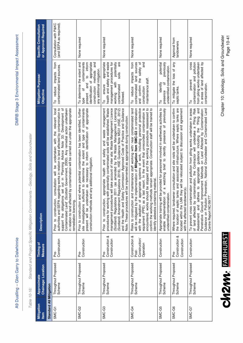
A9 D
ualli
ng –
Gle
n G
arr
y t
o D
alw
hin
nie
D
MR
B S
tage 3
En
viro
nm
enta
l Im
pact A
ssessm
ent
Chapte
r 10:
Geo
log
y,
So
ils a
nd G
rou
nd
wate
r
Pag
e 1
0-4
1
Ta
ble
10
-16
: S
tan
da
rd a
nd
Pro
ject
Sp
ecific
Mitig
atio
n C
om
mitm
en
ts –
Geo
logy,
Soils
an
d G
rou
nd
wa
ter
Mit
igati
on
Item
Ap
pro
xim
ate
Ch
ain
ag
e/ L
ocati
on
Tim
ing
of
Measu
re
Descri
pti
on
M
itig
ati
on
Pu
rpo
se/
Ob
jecti
ve
Sp
ecif
ic C
on
su
ltati
on
or
Ap
pro
val
Req
uir
ed
Sta
nd
ard
A9 M
itig
ati
on
SM
C-G
1
Thro
ughout
Pro
posed
Schem
e
Pre
-C
onstr
uction
Prior
to
constr
uction,
consultation
will
be
undert
aken
with
the
rele
vant
local
auth
orities a
nd S
EP
A r
egard
ing w
ork
s in r
ela
tion t
o land a
ffecte
d b
y c
onta
min
ation to
support
th
e
oblig
ations
set
out
in
‘Pla
nnin
g
Advic
e
Note
33:
Develo
pm
ent
of
Conta
min
ate
d L
and’
(Scottis
h G
overn
ment, 2
000).
Any r
em
edia
l action u
ndert
aken
in r
ela
tion t
o land a
ffecte
d b
y c
onta
min
ation w
ill b
e c
arr
ied o
ut
under
the a
ppro
priate
re
media
tion lic
encin
g.
To
reduce
impacts
fr
om
conta
min
ate
d land s
ourc
es.
Consultation w
ith P
&K
C
(and S
EP
A a
s r
equired).
SM
C-G
2
Thro
ughout
Pro
posed
Schem
e
Pre
-C
onstr
uction
Prior
to c
onstr
uction a
nd w
here
pote
ntial
conta
min
ation h
as b
een i
dentified,
furt
her
site
investigations
suffic
ient
to
dete
rmin
e
the
ext
ent
and
type
of
conta
min
ants
pre
sent
will
be
undert
aken
as
necessary
to
in
form
id
entification
of
appro
priate
constr
uction m
eth
ods a
nd a
ny a
dditio
nal m
itig
ation.
To d
ete
rmin
e t
he e
xtent
and
type
of
conta
min
ants
pre
sent
and
to
info
rm
identification
of
appro
priate
constr
uction
meth
ods
and
any a
dditio
nal m
itig
ation.
None r
equired
SM
C-G
3
Thro
ughout
Pro
posed
Schem
e
Pre
-C
onstr
uction &
C
onstr
uction
Prior
to
constr
uction,
appro
priate
health
and
safe
ty
and
waste
m
anagem
ent
pro
cedure
s f
or
work
ing w
ith p
ote
ntially
conta
min
ate
d s
oils
will
be e
sta
blis
hed.
Waste
m
anagem
ent
pro
cedure
s w
ill t
ake a
ccount
of
inte
r alia
: W
aste
Managem
ent
Lic
ence
(Scotland)
Regula
tions 2011 (a
s am
ended by th
e W
aste
M
anagem
ent
Lic
ensin
g
(Scotland)
Am
endm
ent
Regula
tions 2
016),
HS
E G
uid
ance N
ote
MS
31 (
HS
E,
2012)
and t
he H
ealth a
nd S
afe
ty C
om
mis
sio
n A
ppro
ved C
ode o
f P
ractice a
nd G
uid
ance
Note
. T
hese p
rocedure
s w
ill b
e im
ple
mente
d a
s a
ppro
priate
during c
onstr
uction.
To
ensure
appro
priate
health a
nd s
afe
ty a
nd w
aste
m
anagem
ent
pro
cedure
s f
or
work
ing
with
pote
ntially
conta
min
ate
d
soils
are
fo
llow
ed.
None r
equired
SM
C-G
4
Thro
ughout
Pro
posed
Schem
e
Constr
uction &
P
ost-
Constr
uction/
Opera
tion
Ris
ks t
o c
onstr
uction a
nd m
ain
tenance s
taff w
ork
ing w
ith/
near
conta
min
ate
d l
and
will
be m
itig
ate
d b
y t
he i
mple
menta
tion o
f M
itig
ati
on
Ite
m S
MC
-G3 i
n c
om
bin
ation
with
the
adoption
of
appro
priate
sys
tem
s
of
work
, in
clu
din
g
pers
onal
pro
tective
equip
ment
(PP
E)
as a la
st
resort
. In
th
e event
that
unre
cord
ed conta
min
ation is
encounte
red,
work
s s
hould
be s
topped a
nd t
he w
ork
ing p
rocedure
s r
eassessed t
o
confirm
the w
ork
ing m
eth
ods r
em
ain
appro
priate
. C
onstr
uction s
taff w
ill b
e t
rain
ed t
o
identify
asbesto
s c
onta
inin
g m
ate
rial.
To
reduce
impacts
fr
om
conta
min
ate
d
land
sourc
es
and
confirm
th
e
safe
ty
of
constr
uction
and
main
tenance s
taff.
None r
equired
SM
C-G
5
Thro
ughout
Pro
posed
Schem
e
Constr
uction
Appro
priate
tra
inin
g w
ill b
e p
rovid
ed f
or
pers
onnel in
volv
ed in e
art
hw
ork
s a
ctivitie
s t
o
enable
im
ple
menta
tion
of
a
watc
hin
g
brief
to
identify
pre
sence
of
pre
vio
usly
unid
entified c
onta
min
ation.
To
identify
pote
ntial
pre
sence
of
pre
vio
usly
unid
entified c
onta
min
ation.
None r
equired
SM
C-G
6
Thro
ughout
Pro
posed
Schem
e
Pre
-C
onstr
uction &
Constr
uction
Where
required,
landow
ner
consultation a
nd s
ite v
isits w
ill b
e u
ndert
aken t
o c
onfirm
th
e l
ocation o
f septic t
anks a
nd a
ssocia
ted i
nfr
astr
uctu
re.
Where
septic t
anks a
re
locate
d w
ithin
the L
MA
they w
ill b
e r
elo
cate
d s
ubje
ct
to d
iscussio
n a
nd a
gre
em
ent
with t
he a
ffecte
d landow
ner(
s).
To m
itig
ate
th
e lo
ss of
any
septic tanks.
Appro
val fr
om
la
ndow
ne
rs
SM
C-G
7
Thro
ughout
Pro
posed
Schem
e
Constr
uction
To p
revent
cro
ss c
onta
min
ation a
nd p
ollu
tion f
rom
pili
ng w
ork
s u
ndert
aken i
n a
reas
of
land
aff
ecte
d
by
conta
min
ation,
the
Contr
acto
r w
ill
undert
ake
a
Pili
ng
Ris
k
Assessm
ent
and
adhere
to
appro
priate
guid
ance
inclu
din
g
the
‘Pili
ng
and
Penetr
ative
Gro
und
Impro
vem
ent
Meth
ods
on
Land
Aff
ecte
d
by
Conta
min
ation:
Guid
ance o
n P
ollu
tion P
revention,
National
Gro
undw
ate
r and C
onta
min
ate
d L
and
Centr
e R
eport
NC
/99/7
7’.
To
pre
vent
cro
ss
conta
min
ation
and
pollu
tion
from
pili
ng w
ork
s u
ndert
aken
in a
reas o
f la
nd a
ffecte
d b
y conta
min
ation.
None r
equired
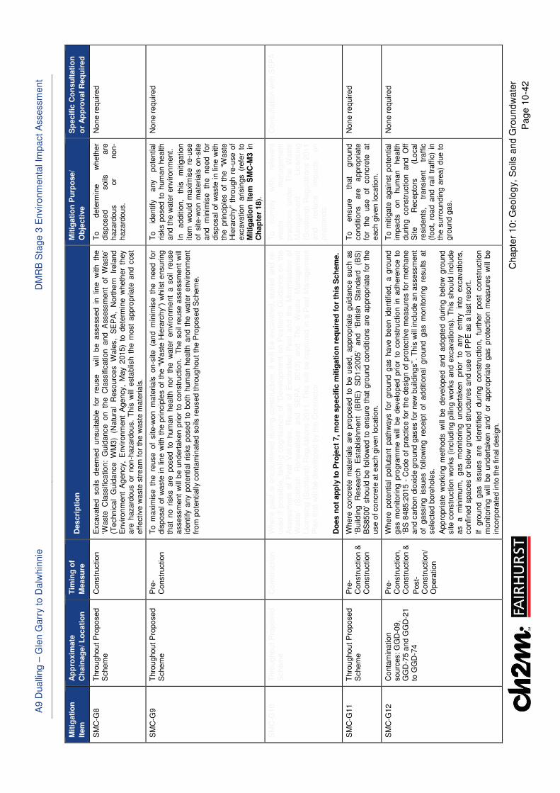
A9 D
ualli
ng –
Gle
n G
arr
y t
o D
alw
hin
nie
D
MR
B S
tage 3
En
viro
nm
enta
l Im
pact A
ssessm
ent
Chapte
r 10:
Geo
log
y,
So
ils a
nd G
rou
nd
wate
r
Pag
e 1
0-4
2
Mit
igati
on
Item
Ap
pro
xim
ate
Ch
ain
ag
e/ L
ocati
on
Tim
ing
of
Measu
re
Descri
pti
on
M
itig
ati
on
Pu
rpo
se/
Ob
jecti
ve
Sp
ecif
ic C
on
su
ltati
on
or
Ap
pro
val
Req
uir
ed
SM
C-G
8
Thro
ughout
Pro
posed
Schem
e
Constr
uction
Exc
avate
d soils
deem
ed unsuitable
fo
r re
use w
ill be assessed in
lin
e w
ith th
e
‘Waste
C
lassific
ation:
Guid
ance on th
e C
lassific
ation and A
ssessm
ent
of
Waste
’ (T
echnic
al
Guid
ance
WM
3)
(Natu
ral
Resourc
es
Wale
s,
SE
PA
, N
ort
hern
Ir
ela
nd
Environm
ent
Agency,
Environm
ent
Agency,
May 2
015)
to d
ete
rmin
e w
heth
er
they
are
hazard
ous o
r non-h
azard
ous.
This
will
esta
blis
h t
he m
ost
appro
priate
and c
ost
eff
ective w
aste
str
eam
for
the w
aste
mate
rials
.
To
dete
rmin
e
wheth
er
dis
posed
soils
are
hazard
ous
or
non-
hazard
ous.
None r
equired
SM
C-G
9
Thro
ughout
Pro
posed
Schem
e
Pre
-C
onstr
uction
To m
axi
mis
e th
e re
use of
site-w
on m
ate
rials
on-s
ite (a
nd m
inim
ise th
e need fo
r dis
posal of
waste
in lin
e w
ith t
he p
rincip
les o
f th
e “
Waste
Hie
rarc
hy”)
whils
t ensuring
that
no r
isks a
re p
osed t
o h
um
an h
ealth n
or
the w
ate
r environm
ent
a s
oil
reuse
assessm
ent
will
be u
ndert
aken p
rior
to c
onstr
uction.
The s
oil
reuse a
ssessm
ent
will
id
entify
any p
ote
ntial
risks p
osed t
o b
oth
hum
an h
ealth a
nd t
he w
ate
r environm
ent
from
pote
ntially
conta
min
ate
d s
oils
reused thro
ughout
the P
roposed S
chem
e.
To
identify
any
pote
ntial
risks p
osed t
o h
um
an h
ealth
and t
he w
ate
r environm
ent.
In
additio
n,
this
m
itig
ation
item
would
maxi
mis
e r
e-u
se
of
site-w
on m
ate
rials
on-s
ite
and
min
imis
e
the
need
for
dis
posal of
waste
in lin
e w
ith
the p
rincip
les o
f th
e “
Waste
H
iera
rchy”
thro
ugh r
e-u
se o
f exc
avation a
risin
gs (
refe
r to
M
itig
ati
on
Ite
m S
MC
-M3 i
n
Ch
ap
ter
18).
None r
equired
SM
C-G
10
Thro
ughout
Pro
posed
Schem
e
Constr
uction
Where
peat
is e
ncounte
red d
uring c
onstr
uction,
it w
ill b
e e
xcavate
d,
sto
red a
nd r
e-
used i
f possib
le,
takin
g c
ognis
ance o
f ‘D
evelo
pm
ent
on P
eatland:
Guid
ance o
n t
he
Assessm
ent
of
Peat
Volu
mes,
Reuse o
f E
xcavate
d P
eat
and t
he M
inim
isation o
f W
aste
’ (S
cott
ish
Renew
able
s
and
SE
PA
, 2012)
and
The
Waste
M
anagem
ent
Lic
ensin
g (
Scotland)
Regula
tions 2
011.
This
will
be c
aptu
red in a
Peat
Managem
ent
Pla
n that
will
be d
evelo
ped b
y t
he C
ontr
acto
r.
Do
es n
ot
ap
ply
to
Pro
ject
7, m
ore
sp
ecif
ic m
itig
ati
on
req
uir
ed
fo
r th
is S
ch
em
e.
To
com
ply
w
ith
rele
vant
waste
m
anagem
ent
pra
ctices
under
The W
aste
M
anagem
ent
Lic
ensin
g
(Scotland)
Regula
tions 2
011
and
reduce
impacts
on
peatlands.
Consultation w
ith S
EP
A
SM
C-G
11
Thro
ughout
Pro
posed
Schem
e
Pre
-C
onstr
uction &
C
onstr
uction
Where
concre
te m
ate
rials
are
pro
posed t
o b
e u
sed,
appro
priate
guid
ance s
uch a
s
‘Build
ing
Researc
h
Esta
blis
hm
ent
(BR
E)
SD
1:2
005’
and
‘British
Sta
ndard
(B
S)
BS
8500’ should
be f
ollo
wed t
o e
nsure
that
gro
und c
onditio
ns a
re a
ppro
priate
for
the
use o
f concre
te a
t each g
iven location.
To
ensure
th
at
gro
und
conditio
ns
are
appro
priate
fo
r th
e
use
of
concre
te
at
each g
iven location.
None r
equired
SM
C-G
12
Conta
min
ation
sourc
es: G
GD
-09,
GG
D-7
5 a
nd G
GD
-21
to G
GD
-74
Pre
-C
onstr
uction,
Constr
uction &
Post-
Constr
uction/
Opera
tion
Where
pote
ntial
pollu
tant
path
ways f
or
gro
und g
as h
ave b
een i
dentified,
a g
round
gas m
onitoring p
rogra
mm
e w
ill b
e d
evelo
ped p
rior
to c
onstr
uction i
n a
dhere
nce t
o
‘BS
8485:2
015 -
Code o
f pra
ctice f
or
the d
esig
n o
f pro
tective m
easure
s f
or
meth
ane
and c
arb
on d
ioxi
de g
round g
ases f
or
new
build
ings’’.
This
will
inclu
de a
n a
ssessm
ent
of
gassin
g is
sues fo
llow
ing re
ceip
t of
additio
nal
gro
und gas m
onitoring re
sults
at
sele
cte
d b
ore
hole
s.
Appro
priate
work
ing m
eth
ods w
ill b
e d
evelo
ped a
nd a
dopte
d d
uring b
elo
w g
round
site c
onstr
uction w
ork
s (
inclu
din
g p
iling w
ork
s a
nd e
xcavations).
This
should
inclu
de
as
a
min
imum
, gas
monitoring
undert
aken
prior
to
any
entr
y
into
exc
avations,
confined s
paces o
r belo
w g
round s
tructu
res a
nd u
se o
f P
PE
as a
last
resort
.
If gro
und gas is
sues are
id
entified during constr
uction,
furt
her
post
constr
uction
monitoring w
ill b
e u
ndert
aken a
nd/
or
appro
priate
gas p
rote
ction m
easure
s w
ill b
e
incorp
ora
ted into
the f
inal desig
n.
To m
itig
ate
again
st
pote
ntial
impacts
on
hum
an
health
during constr
uction and O
ff
Site
Recepto
rs
(Local
resid
ents
, tr
ansie
nt
traff
ic
(foot, r
oad a
nd r
ail
traffic
) in
th
e s
urr
oundin
g a
rea)
due t
o
gro
und g
as.
None r
equired
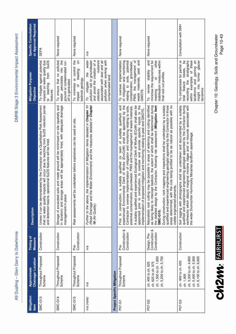
A9 D
ualli
ng –
Gle
n G
arr
y t
o D
alw
hin
nie
D
MR
B S
tage 3
En
viro
nm
enta
l Im
pact A
ssessm
ent
Chapte
r 10:
Geo
log
y,
So
ils a
nd G
rou
nd
wate
r
Pag
e 1
0-4
3
Mit
igati
on
Item
Ap
pro
xim
ate
Ch
ain
ag
e/ L
ocati
on
Tim
ing
of
Measu
re
Descri
pti
on
M
itig
ati
on
Pu
rpo
se/
Ob
jecti
ve
Sp
ecif
ic C
on
su
ltati
on
or
Ap
pro
val
Req
uir
ed
SM
C-G
13
Thro
ughout
Pro
posed
Schem
e
Constr
uction
Unle
ss it
can b
e d
em
onstr
ate
d b
y t
he C
ontr
acto
r via
a Q
uantita
tive R
isk A
ssessm
ent
that
no w
ate
r qualit
y i
mpacts
will
occur
due t
o l
eachin
g f
rom
SuD
S r
ete
ntion p
onds
and d
ete
ntion b
asin
s, opera
tional S
uD
S featu
res w
ill b
e lin
ed.
To m
itig
ate
again
st
pote
ntial
impacts
on w
ate
r qualit
y d
ue
to
leachin
g
from
S
uD
S
featu
res.
SE
PA
SM
C-G
14
Thro
ughout
Pro
posed
Schem
e
Constr
uction
Sto
rage o
f exc
avate
d s
oils
and m
ade g
round w
ill b
e m
inim
ised o
n s
ite (
spatially
and
in d
ura
tion)
and s
tora
ge a
reas w
ill b
e a
ppro
priate
ly l
ined,
with a
dequate
dra
inage
managem
ent in
pla
ce.
To
ensure
th
at
no
pollu
ted
wate
r perc
ola
tes
into
th
e
gro
und o
r conta
min
ate
d r
un-
off
is g
enera
ted.
None r
equired
SM
C-G
15
Thro
ughout
Pro
posed
Schem
e
Pre
-C
onstr
uction
Ris
k a
ssessm
ents
will
be u
ndert
aken b
efo
re e
xplo
siv
es c
an b
e u
sed o
n s
ite.
To
min
imis
e
or
contr
ol
the
impact
of
bla
sting
on
bedro
ck g
eolo
gy.
None r
equired
n/a
(note
) n/a
n/a
F
urt
her
to t
he a
bove,
the i
mple
menta
tion o
f M
itig
ation I
tem
s d
eta
iled i
n C
hap
ter
11
(Road D
rain
age a
nd t
he W
ate
r E
nvironm
ent)
and t
he m
easure
s d
eta
iled in C
hap
ter
16 (
Air Q
ualit
y).
To
mitig
ate
th
e
wate
r pollu
tion r
isk t
o g
roundw
ate
r and avoid
th
e cre
ation of
a
sta
tuto
ry
nuis
ance
associa
ted w
ith d
ust
and a
ir
pollu
tion w
hen w
ork
ing w
ith
conta
min
ate
d land.
n/a
Pro
ject
Sp
ecif
ic M
itig
ati
on
P07-G
1
Thro
ughout
Pro
posed
Schem
e
Pre
-C
onstr
uction &
C
onstr
uction
Prior
to
constr
uction,
a
suitably
qualif
ied
(or
team
of
suitably
qualif
ied)
and
exp
erienced E
nvironm
enta
l C
lerk
of
Work
s (E
nvC
oW
) shall
be appoin
ted by th
e
Contr
acto
r to
overs
ee i
mple
menta
tion o
f m
itig
ation a
nd m
onitoring r
ela
ting t
o s
oils
, pote
ntial conta
min
ation,
gro
undw
ate
r, P
WS
and t
he m
anagem
ent
of w
aste
mate
rials
.
A s
uitably
qualif
ied a
nd e
xperienced E
colo
gic
al C
lerk
of
Work
s (
EC
oW
) shall
als
o b
e
appoin
ted
prior
to
constr
uction,
to
overs
ee
and
pro
vid
e
specifi
c
inputs
to
th
e
imple
menta
tion o
f pro
posed m
itig
ation a
nd m
onitoring r
ela
ting to p
eat
and G
WD
TE
.
To
overs
ee
imple
menta
tion
of
mitig
ation a
nd m
onitoring
rela
ting
to
soils
, pote
ntial
conta
min
ation,
gro
undw
ate
r,
PW
S,
the
managem
ent
of
waste
m
ate
rials
, peat
and
GW
DT
E.
None r
equired
P07-G
2
ch. 400 t
o c
h.
625
ch. 625 t
o c
h.
975
ch. 1,5
00 to c
h. 1,8
50
ch. 5,2
00 to c
h. 5,7
50
Desig
n, P
re-
Constr
uction &
C
onstr
uction
Natu
ralis
tic r
ock c
uttin
g m
ay b
e p
ossib
le i
n a
reas o
f w
idenin
g a
nd c
uttin
g i
dentified
as b
ein
g l
ikely
to i
nte
rcept
bedro
ck,
the e
xtent
of
whic
h s
hall
be d
ete
rmin
ed d
uring
the d
eta
iled d
esig
n b
y th
e C
ontr
acto
r, f
ollo
win
g r
isk a
ssessm
ent
(Mit
igati
on
Ite
m
SM
C-G
15).
During c
onstr
uction,
rock m
appin
g a
nd inspections s
hall
be u
ndert
aken b
y a
suitably
qualif
ied a
nd e
xperienced e
ngin
ee
ring g
eolo
gis
t appoin
ted b
y t
he C
ontr
acto
r in
those
are
as d
ete
rmin
ed,
with t
he c
uts
bein
g p
rofile
d t
o b
e a
s n
atu
ral
as p
ossib
le w
ith n
o
vis
ible
engin
eere
d e
lem
ents
.
To
revie
w
sta
bili
ty
and
min
imis
e t
he r
equirem
ent
for
meshin
g
or
oth
er
sta
bili
sation m
easure
s w
ithin
final ro
ck c
ut
pro
file
s.
None r
equired
P07-G
3
ch. -9
00 t
o c
h.
650
ch. 1,9
00
ch. 3,3
00 to c
h. 4,8
00
ch. 5,4
00 to c
h. 5,9
00
ch. 6,1
00 to c
h. 6,6
00
Constr
uction
Soil
loggin
g w
ith p
hoto
gra
phs s
hall
be u
ndert
aken a
nd d
ocum
ente
d b
y a
suitably
qualif
ied a
nd e
xperienced e
ngin
eering g
eolo
gis
t appoin
ted b
y th
e C
ontr
acto
r during
eart
hw
ork
s w
hic
h d
istu
rb m
arg
inal
mora
ine r
idges a
nd/
or
mounds a
ssocia
ted w
ith
the w
ider
Dru
mochte
r H
um
mocky M
ora
ines landfo
rm a
ssem
bla
ge.
To c
om
pensate
for
part
ial
or
tota
l fe
atu
re
losses,
by
record
ing
the
str
atigra
phy
within
exa
mple
s
of
these
landfo
rms
and
gain
ing
an
insig
ht
into
fo
rmer
gla
cie
r dynam
ics
Consultation w
ith S
NH
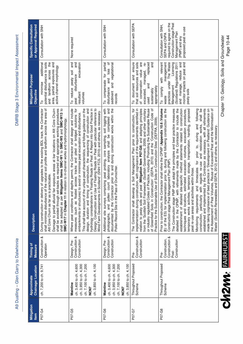
A9 D
ualli
ng –
Gle
n G
arr
y t
o D
alw
hin
nie
D
MR
B S
tage 3
En
viro
nm
enta
l Im
pact A
ssessm
ent
Chapte
r 10:
Geo
log
y,
So
ils a
nd G
rou
nd
wate
r
Pag
e 1
0-4
4
Mit
igati
on
Item
Ap
pro
xim
ate
Ch
ain
ag
e/ L
ocati
on
Tim
ing
of
Measu
re
Descri
pti
on
M
itig
ati
on
Pu
rpo
se/
Ob
jecti
ve
Sp
ecif
ic C
on
su
ltati
on
or
Ap
pro
val
Req
uir
ed
P07-G
4
ch. 7,2
00 to c
h. 9,7
41
Constr
uction &
O
pera
tion
During c
onstr
uction o
r deliv
ery
of
upgra
des t
o t
he e
xisting B
DL t
rack,
the C
ontr
acto
r shall
min
imis
e d
istu
rbance o
f th
e n
atu
ral soil
pro
file
and landfo
rm a
cro
ss t
he a
rea o
f A
llt C
oire C
huirn a
s far
as is p
racticable
.
Dam
age t
o p
art
ial
allu
via
l fa
n e
xposure
are
as a
t bar
locations o
n A
llt C
oire C
huirn
shall
be a
void
ed t
hro
ugh s
et-
backs a
s r
equired a
nd a
ppro
priate
work
ing p
rocedure
s
shall
be a
dopte
d a
s p
er
Mit
igati
on
Ite
ms S
MC
-W1 t
o S
MC
-W5 a
nd S
MC
-W13 t
o
SM
C-W
17 in C
hap
ter
11 in r
ela
tion t
o in-c
hannel w
ork
s a
nd h
ydro
morp
holo
gy.
To
min
imis
e
additio
nal
pote
ntial
dis
turb
ance t
o s
oils
and
landfo
rm
acro
ss
the
are
a,
part
ial
exp
osure
s and
active c
hannel m
orp
holo
gy
Consultation w
ith S
NH
P07-G
5
Main
lin
e
ch. 3,4
00 to c
h. 4,6
00
ch. 3,9
50 to c
h. 4,3
00
ch. 7,1
00 to c
h. 7,2
00
NC
N7
ch. 3,8
50 to c
h. 4,1
00
Desig
n, P
re-
Constr
uction &
C
onstr
uction
Where
peat
conditio
ns a
nd d
epth
s p
erm
it,
the C
ontr
acto
r shall
desig
n a
nd i
nclu
de
measure
s
(such
as
floate
d
access
tracks
and
pile
d
or
bridged
solu
tions
for
em
bankm
ents
or
str
uctu
res)
to a
void
or
min
imis
e p
eat exc
avation a
nd d
istu
rbance.
This
shall
take a
ccount
of
the u
niq
ue p
eat
chara
cte
ristics,
and follo
w g
uid
ance o
n t
he
desig
n,
dura
tion
and
tim
ing
of
constr
uction,
the
sequencin
g
of
constr
uction
and
hydro
logy c
onsid
era
tions in ‘F
loating R
oads o
n P
eat: A
Report
into
Good P
ractice in
Desig
n,
Constr
uction a
nd U
se o
f F
loating R
oads o
n P
eat
with p
art
icula
r re
fere
nce t
o
Win
d F
arm
Develo
pm
ents
in S
cotland’ (S
NH
/ F
CS
, 2010)
and o
thers
, as n
ecessary
.
To
reduce
peaty
soil
and
peat
dis
turb
ance
and
resultant
exc
avation
volu
mes
None r
equired
P07-G
6
Main
lin
e
ch. 3,4
00 to c
h. 4,6
00
ch. 3,9
50 to c
h. 4,3
00
ch. 7,1
00 to c
h. 7,2
00
NC
N7
ch. 3,8
50 to c
h. 4,1
00
Desig
n, P
re-
Constr
uction &
C
onstr
uction
Additio
nal
site surv
eys com
prisin
g peat
pro
bin
g,
core
sam
plin
g,
soil
loggin
g w
ith
photo
gra
phs,
and
polle
n
count
labora
tory
analy
sis
shall
be
com
ple
ted
and
docum
ente
d by
the C
ontr
acto
r prior
to and during constr
uction w
ork
s w
ithin
th
e
Polle
n R
ecord
Site in t
he P
ass o
f D
rum
ochte
r.
To
com
pensate
fo
r part
ial
dis
turb
ance
and
loss
of
sedim
ent
and
vegeta
tional
record
s
Consultation w
ith S
NH
P07-G
7
Thro
ughout
Pro
posed
Schem
e
Pre
-C
onstr
uction &
C
onstr
uction
The C
ontr
acto
r shall
develo
p a S
oil
Managem
ent
Pla
n prior
to constr
uction,
for
imple
menta
tion d
uring c
onstr
uction,
with c
ognis
ance o
f th
e r
equirem
ents
identified in
rela
tion t
o p
eaty
soils
and p
eat
(Mit
igati
on
Ite
m P
07-G
8)
and a
dopting p
rincip
les
from
the ‘S
cottis
h S
oil
Fra
mew
ork
’ (S
cottis
h G
overn
ment, 2
009)
and o
ther
volu
nta
ry
or
industr
y r
egula
ted C
odes o
f P
ractice,
inclu
din
g ‘P
rom
oting t
he S
usta
inable
Reuse
of
Gre
enfield
S
oils
in
C
onstr
uction’
(SE
PA
, 2010)
and th
e ‘C
onstr
uction C
ode of
Pra
ctice f
or
the S
usta
inable
Use o
f S
oils
on C
onstr
uction S
ites’ (D
EF
RA
, 2009).
To
docum
ent
and
ensure
th
at
soil
resourc
es a
nd s
oils
of
conserv
ation
valu
e
are
exc
avate
d,
managed,
re-
used
and
repla
ced
susta
inably
and
appro
priate
ly
Consultation w
ith S
EP
A
P07-G
8
Thro
ughout
Pro
posed
Schem
e
Pre
-C
onstr
uction,
Constr
uction &
P
ost-
Constr
uction
Prior
to c
onstr
uction,
the C
ontr
acto
r shall
refine t
he O
PM
P (
Ap
pen
dix
10.6
(V
olu
me
2))
of
the E
S)
for
imple
menta
tion p
rior
to,
during a
nd f
ollo
win
g c
onstr
uction a
s t
he
Constr
uction s
tage P
eat M
anagem
ent P
lan (
PM
P).
The C
onstr
uction s
tage P
MP
shall
adopt
the p
rincip
les a
nd b
est
pra
ctice m
easure
s
deta
iled
in
the
OP
MP
, w
ith
refinem
ents
m
ade
by
the
Contr
acto
r to
in
clu
de
the
esta
blis
hm
ent
of
deta
iled site-s
pecific
m
eth
od sta
tem
ents
re
late
d to
constr
uction
techniq
ues and lo
cations,
estim
ate
d exc
avation volu
mes,
exc
avation pro
cedure
s,
tem
pora
ry w
ork
s activitie
s,
tem
pora
ry sto
rage,
transport
ation,
handlin
g,
pro
posed
peat
re-u
se a
reas a
nd a
ctivitie
s w
ithin
those.
Monitoring
requirem
ents
and
timescale
s
for
prior
to,
during
and
follo
win
g
constr
uction,
part
icula
rly
with
regard
s
re-u
se
and
resto
ration
work
s,
shall
be
esta
blis
hed a
nd i
mple
mente
d b
y t
he C
ontr
acto
r as n
ecessary
, w
ith a
ll re
finem
ents
m
ade t
akin
g c
ognis
ance o
f best
pra
ctice in ‘D
evelo
pm
ent
on P
eatland:
Guid
ance o
n
the A
ssessm
ent
of
Peat
Volu
mes,
Reuse o
f E
xcavate
d P
eat
and t
he M
inim
isation o
f W
aste
’ (S
cottis
h R
enew
able
s a
nd S
EP
A,
2012)
and o
thers
, as n
ecessary
.
To
com
ply
w
ith
rele
vant
waste
m
anagem
ent
pra
ctices
under
The W
aste
M
anagem
ent
Lic
ensin
g
(Scotland)
Regula
tions 2
011
and
manage,
reduce
and
monitor
impacts
on p
eat
and
peaty
soils
Consultation w
ith S
NH
, S
EP
A a
nd C
NP
A
required t
o a
gre
e o
n t
he
Constr
uction s
tage P
eat
Managem
ent P
lan
(PM
P)
and a
ny
pro
posed p
eat
re-u
se
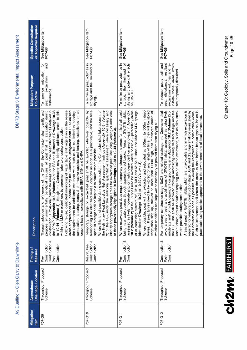
A9 D
ualli
ng –
Gle
n G
arr
y t
o D
alw
hin
nie
D
MR
B S
tage 3
En
viro
nm
enta
l Im
pact A
ssessm
ent
Chapte
r 10:
Geo
log
y,
So
ils a
nd G
rou
nd
wate
r
Pag
e 1
0-4
5
Mit
igati
on
Item
Ap
pro
xim
ate
Ch
ain
ag
e/ L
ocati
on
Tim
ing
of
Measu
re
Descri
pti
on
M
itig
ati
on
Pu
rpo
se/
Ob
jecti
ve
Sp
ecif
ic C
on
su
ltati
on
or
Ap
pro
val
Req
uir
ed
P07-G
9
Thro
ughout
Pro
posed
Schem
e
Pre
-C
onstr
uction,
Constr
uction &
P
ost-
Constr
uction
Thro
ugh a
doption a
nd r
efinem
ent
of
the O
PM
P,
the C
ontr
acto
r shall
identify
and
pro
pose
environm
enta
lly
benefic
ial
re-u
ses
of
peat
that
is
exc
avate
d
during
constr
uction.
Pro
vis
ional candid
ate
are
as f
or
this
have b
een identified a
s d
eta
iled in
the O
PM
P (
Ap
pen
dix
10.6
(V
olu
me 2
) of
the E
S)
and illu
str
ate
d in D
raw
ing
s 1
0.3
8
to 10.4
4 (V
olu
me 3),
though th
e C
ontr
acto
r m
ay
identify
additio
nal
are
as t
o t
his
w
ithin
the L
MA
or
els
ew
here
, by a
gre
em
ent prior
to o
r during c
onstr
uction.
Follo
win
g r
e-u
se,
dedic
ate
d m
onitoring o
f w
ate
r ta
ble
and v
egeta
tion i
n t
he r
e-u
se
are
as a
dopte
d s
hall
be u
ndert
aken b
y t
he C
ontr
acto
r (M
itig
ati
on
Ite
m P
07-G
8)
and
the r
equirem
ents
for
additio
nal
treatm
ent
work
such a
s b
ut
not
limited t
o,
seedin
g,
com
paction,
tapering,
rem
oval
of
invasiv
e s
pecie
s a
nd f
encin
g,
esta
blis
hed o
n a
n
ongoin
g b
asis
in c
onsultation w
ith S
EP
A, S
NH
and C
NP
A.
To
pro
vid
e
mitig
ation
for
peat
exc
avation
and
dis
turb
ance
See M
itig
ati
on
Ite
m
P07-G
8
P07-G
10
Thro
ughout
Pro
posed
Schem
e
Desig
n, P
re-
Constr
uction &
C
onstr
uction
Tem
pora
ry
sto
rage
of
exc
avate
d
peat
shall
be
avoid
ed
where
ver
possib
le
by
transport
ing i
t to
identified r
e-u
se l
ocations a
s s
oon a
s i
s p
racticable
, and t
he t
ime
spent in
sto
rage s
hall
be k
ept to
a m
inim
um
where
possib
le.
Where
this
is n
ot
possib
le d
uring c
onstr
uction,
the C
ontr
acto
r shall
take a
ccount
of
the P
relim
inary
Peat
Landslid
e R
isk A
ssessm
ent
findin
gs (
Ap
pen
dix
10.5
(V
olu
me
2)
of
the E
S),
undert
ake a
dditio
nal
quantita
tive a
ssessm
ent
where
necessary
and
identify
appro
priate
sto
rage a
reas f
or
exc
avate
d p
eat,
inclu
din
g,
vary
ing o
r additio
nal
to t
hose p
rovis
ionally
hig
hlig
hte
d in D
raw
ing
s 1
0.3
8 to 1
0.4
4 (
Vo
lum
e 3
).
To m
inim
ise p
eat
volu
mes in
sto
rage a
nd t
he l
ikelih
ood o
f dry
ing.
See M
itig
ati
on
Ite
m
P07-G
8
P07-G
11
Thro
ughout
Pro
posed
Schem
e
Pre
-C
onstr
uction &
C
onstr
uction
Where
exc
avate
d p
eat
does r
equire t
em
pora
ry s
tora
ge,
the a
reas f
or
this
shall
avoid
bein
g n
ear
wate
rcours
es t
hro
ugh a
ppro
priate
set
backs.
Are
as o
f G
WD
TE
habitat
assessed a
s l
ikely
modera
te a
nd/
or
hig
hly
dependent
on g
roundw
ate
r in
Ap
pen
dix
10.2
(V
olu
me 2
) of
the E
S s
hall
als
o b
e a
void
ed w
here
possib
le –
part
icula
rly a
reas
of
or
conta
inin
g d
iscre
te M
6,
M10,
M11 a
nd M
15a f
lushes a
nd M
32 o
r M
37 s
prings
identified o
n D
raw
ing
s 1
0.2
4 t
o 1
0.3
0 (
Vo
lum
e 3
).
Where
possib
le,
peat
will
be e
xtra
cte
d a
nd r
elo
cate
d a
s 3
00m
m t
o 5
00m
m d
eep
turv
es.
If
peat
turv
es n
eed t
o b
e s
tore
d f
or
any l
ength
of
tim
e,
they w
ill b
e s
tore
d
vegeta
tion sid
e up,
sta
cked no m
ore
th
an 1.0
0m
hig
h,
and m
onitore
d during all
weath
er
conditio
ns a
nd k
ept
wet
as n
ecessary
to p
revent
them
fro
m d
ryin
g o
ut.
To m
inim
ise p
eat
volu
mes in
sto
rage,
the
likelih
ood
of
dry
ing
and
pote
ntial
eff
ects
on G
WD
TE
See M
itig
ati
on
Ite
m
P07-G
8
P07-G
12
Thro
ughout
Pro
posed
Schem
e
Constr
uction &
P
ost-
Constr
uction
For
tem
pora
ry c
onstr
uction-s
tage S
uD
S a
nd r
ela
ted d
rain
age,
the C
ontr
acto
r shall
avoid
are
as o
f peat
and a
void
are
as o
f G
WD
TE
habitat
assessed a
s b
ein
g l
ikely
m
odera
te a
nd/
or
hig
hly
dependent
on g
roundw
ate
r in
Ap
pen
dix
10.2
(V
olu
me 2
) of
the E
S.
This
shall
be a
chie
ved t
hro
ugh m
icro
sitin
g d
uring d
eta
iled d
esig
n a
nd t
he
use o
f above-g
round s
olu
tions r
equirin
g n
o o
r lim
ited e
xcavation,
such a
s s
iltbuste
rs,
whe
re p
ossib
le,
during c
onstr
uction.
Are
as o
f peat
or
GW
DT
E h
abitat
whic
h a
re u
navoid
able
and i
n w
hic
h e
xcavation i
s
required f
or
tem
pora
ry c
onstr
uction-s
tage S
uD
S a
nd d
rain
age s
hall
be r
e-insta
ted b
y
the C
ontr
acto
r as s
oon a
s p
ossib
le f
ollo
win
g t
he c
om
ple
tion o
f constr
uction w
ork
s.
Such r
e-insta
tem
ent
shall
retu
rn t
he a
reas t
o t
heir f
orm
er
habitat
type a
s f
ar
as i
s
pra
cticable
usin
g s
pecie
s a
ppro
priate
to t
he e
nvironm
ent
and o
f lo
cal pro
venance.
To
reduce
peaty
soil
and
peat
dis
turb
ance,
resultant
exc
avation v
olu
mes a
nd r
e-
insta
te
those
are
as
whic
h
are
tem
pora
rily
dis
turb
ed
See M
itig
ati
on
Ite
m
P07-G
8
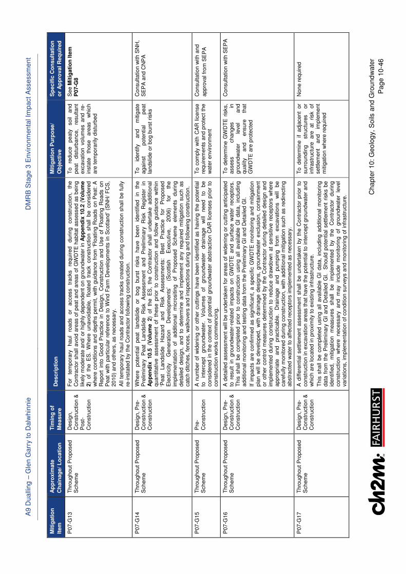
A9 D
ualli
ng –
Gle
n G
arr
y t
o D
alw
hin
nie
D
MR
B S
tage 3
En
viro
nm
enta
l Im
pact A
ssessm
ent
Chapte
r 10:
Geo
log
y,
So
ils a
nd G
rou
nd
wate
r
Pag
e 1
0-4
6
Mit
igati
on
Item
Ap
pro
xim
ate
Ch
ain
ag
e/ L
ocati
on
Tim
ing
of
Measu
re
Descri
pti
on
M
itig
ati
on
Pu
rpo
se/
Ob
jecti
ve
Sp
ecif
ic C
on
su
ltati
on
or
Ap
pro
val
Req
uir
ed
P07-G
13
Thro
ughout
Pro
posed
Schem
e
Desig
n,
Constr
uction &
P
ost-
Constr
uction
For
tem
pora
ry
haul
roads
or
access
tracks
required
during
constr
uction,
the
Contr
acto
r shall
avoid
are
as o
f peat
and a
reas o
f G
WD
TE
habitat
assessed a
s b
ein
g
likely
modera
te a
nd/
or
hig
hly
dependent
on g
round
wate
r in
Ap
pen
dix
10.2
(V
olu
me
2)
of
the E
S.
Where
unavoid
able
, floate
d tr
ack constr
uction shall
be consid
ere
dw
he
re c
onditio
ns a
nd d
epth
s p
erm
it,
with g
uid
ance f
rom
‘F
loating R
oads o
n P
eat: A
Report
into
Good P
ractice i
n D
esig
n,
Constr
uction a
nd U
se o
f F
loating R
oads o
nP
eat
with p
art
icula
r re
fere
nce t
o W
ind F
arm
Develo
pm
ents
in S
cotland’
(SN
H/
FC
S,
2010)
and o
thers
, as n
ecessary
.
All
tem
pora
ry h
aul ro
ads a
nd a
ccess t
racks c
reate
d d
uring c
onstr
uction s
hall
be f
ully
re
-insta
ted b
y th
e C
ontr
acto
r fo
llow
ing c
onstr
uction.
To
reduce
peaty
soil
and
peat
dis
turb
ance,
resultant
exc
avation v
olu
mes a
nd r
e-
insta
te
those
are
as
whic
h
are
tem
pora
rily
dis
turb
ed
See M
itig
ati
on
Ite
m
P07-G
8
P07-G
14
Thro
ughout
Pro
posed
Schem
e
Desig
n, P
re-
Constr
uction &
C
onstr
uction
Where
pote
ntial
peat
landslid
e
or
bog
burs
t risks
have
been
identified
in
the
Pre
limin
ary
P
eat
Landslid
e
Ris
k
Assessm
ent
and
Pre
limin
ary
R
isk
Regis
ter
in
Ap
pen
dix
10.5
(V
olu
me 2)
of
the E
S,
the C
ontr
acto
r shall
undert
ake additio
nal
quantita
tive assessm
ent
of
these prior
to c
onstr
uction and f
ollo
w guid
ance w
ithin
‘P
eat
Landslid
e
Hazard
and
Ris
k
Assessm
ents
: B
est
Pra
ctice
for
Pro
posed
Ele
ctr
icity
Genera
tion
Develo
pm
ents
’ (S
cottis
h
Exe
cutive,
2006)
for
the
imple
menta
tion
of
additio
nal
mic
rositin
g
of
Pro
posed
Schem
e
ele
ments
during
deta
iled d
esig
n,
and t
o d
ete
rmin
e a
nd i
mple
ment
any r
equired m
itig
ation s
uch a
s
catc
h d
itches, fe
nces,
walk
overs
and inspections d
uring a
nd f
ollo
win
g c
onstr
uction.
To
identify
and
mitig
ate
again
st
pote
ntial
peat
landslid
e o
r bog b
urs
t risks
Consultation w
ith S
NH
, S
EP
A a
nd C
NP
A
P07-G
15
Thro
ughout
Pro
posed
Schem
e
Pre
-C
onstr
uction
A n
um
ber
of
wid
enin
g o
r oth
er
cutt
ings h
ave b
een i
dentified a
s h
avi
ng t
he p
ote
ntial
to
inte
rcept
gro
undw
ate
r.
Volu
mes
of
gro
undw
ate
r dra
inage
will
need
to
be
consid
ere
d i
n t
he c
onte
xt o
f pote
ntial
gro
undw
ate
r abstr
action C
AR
lic
enses p
rior
to
constr
uction w
ork
s c
om
mencin
g.
To c
om
ply
with C
AR
lic
ense
requirem
ents
and p
rote
ct
the
wate
r environm
ent
Consultation w
ith a
nd
appro
val fr
om
SE
PA
P07-G
16
Thro
ughout
Pro
posed
Schem
e
Desig
n, P
re-
Constr
uction &
C
onstr
uction
A d
eta
iled a
ssessm
ent
will
be u
ndert
aken f
or
are
as o
f w
idenin
g o
r cutt
ing a
nticip
ate
d
to r
esult i
n g
roundw
ate
r-re
late
d i
mpacts
on G
WD
TE
and s
urf
ace w
ate
r re
cepto
rs.
This
shall
be c
om
ple
ted p
rior
to c
onstr
uction u
sin
g a
ll availa
ble
GI
data
, in
clu
din
g
additio
nal m
onitoring a
nd testing d
ata
fro
m t
he P
relim
inary
GI and D
eta
iled G
I.
If im
pacts
are
confirm
ed a
s s
ignific
ant, a
specific
GW
DT
E m
onitoring a
nd m
itig
ation
pla
n w
ill b
e d
evelo
ped,
with d
rain
age d
esig
ns,
gro
undw
ate
r e
xclu
sio
n,
conta
inm
ent
or
oth
er
contr
ol
measure
s d
ete
rmin
ed b
y t
he C
ontr
acto
r during d
eta
iled d
esig
n a
nd
imple
mente
d d
uring c
onstr
uction t
o r
educe d
raw
do
wn a
t sensitiv
e r
ecepto
rs w
here
appro
priate
and
pra
cticable
. D
rain
age
and
pum
pin
g
from
exc
avations
will
be
care
fully
monitore
d d
uring c
onstr
uction,
with a
dditio
nal m
itig
ation s
uch a
s r
edirecting
abstr
acte
d w
ate
r to
aff
ecte
d r
ecepto
rs im
ple
mente
d a
s n
ecessary
.
To d
ete
rmin
e G
WD
TE
ris
ks,
assess
changes
in
gro
und
wate
r le
vel
and
qualit
y
and
ensure
th
at
GW
DT
E a
re p
rote
cte
d
Consultation w
ith S
EP
A
P07-G
17
Thro
ughout
Pro
posed
Schem
e
Desig
n, P
re-
Constr
uction &
C
onstr
uction
A d
iffe
rential
settle
ment
assessm
ent
shall
be u
ndert
aken b
y t
he C
ontr
acto
r prior
to
constr
uction in e
xcavation a
reas t
hat
have t
he p
ote
ntial to
inte
rcept gro
und
wate
r and
w
hic
h a
re locate
d in p
roxi
mity t
o e
xisting infr
astr
uctu
re.
This
shall
be c
om
ple
ted u
sin
g a
ll availa
ble
GI
data
, in
clu
din
g a
dditio
nal
monitoring
data
fro
m t
he P
relim
inary
GI
and D
eta
iled G
I.
Should
pote
ntial
settle
ment
risks b
e
identified,
mitig
ation
measure
s
shall
be
imple
mente
d
by
the
Contr
acto
r during
constr
uction
where
necessary
and
may
inclu
de m
onitoring
of
gro
und
wate
r le
vel
variations, im
ple
menta
tion o
f conditio
n s
urv
eys a
nd m
onitoring o
f in
frastr
uctu
re.
To dete
rmin
e if adja
cent
or
surr
oundin
g
str
uctu
res
or
infr
astr
uctu
re
are
at
risk
of
settle
ment
and
imple
ment
mitig
ation w
here
required
None r
equired
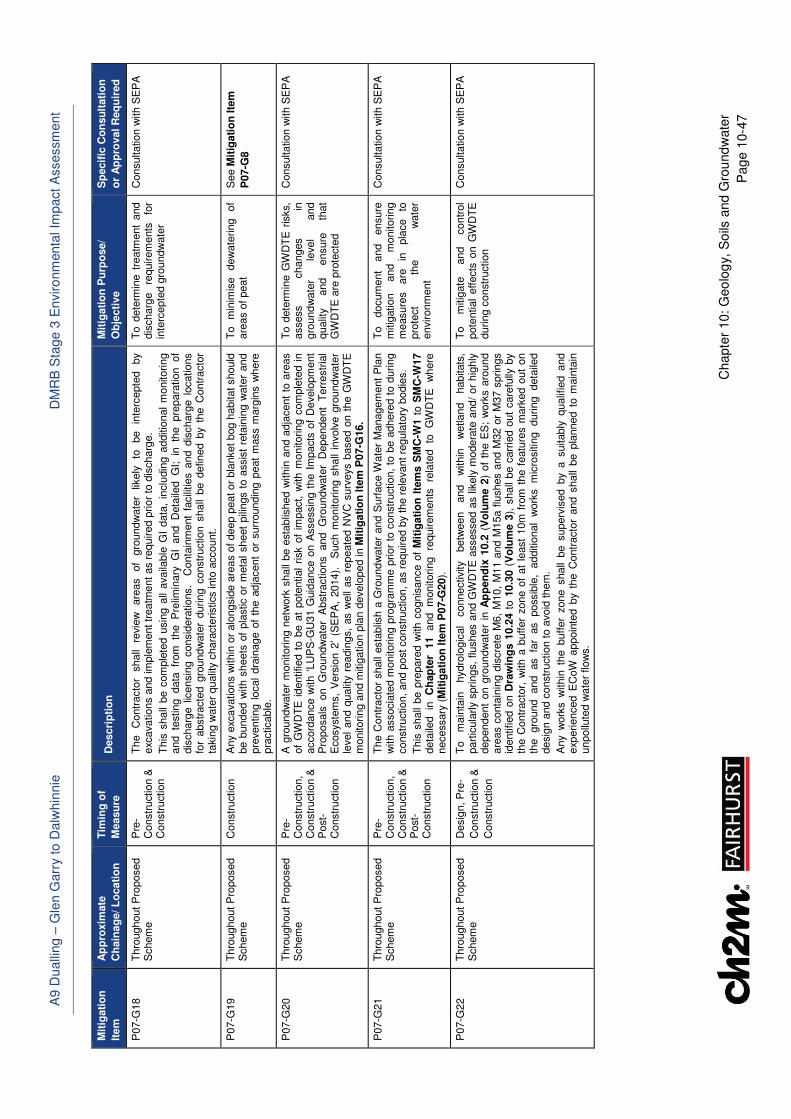
A9 D
ualli
ng –
Gle
n G
arr
y t
o D
alw
hin
nie
D
MR
B S
tage 3
En
viro
nm
enta
l Im
pact A
ssessm
ent
Chapte
r 10:
Geo
log
y,
So
ils a
nd G
rou
nd
wate
r
Pag
e 1
0-4
7
Mit
igati
on
Item
Ap
pro
xim
ate
Ch
ain
ag
e/ L
ocati
on
Tim
ing
of
Measu
re
Descri
pti
on
M
itig
ati
on
Pu
rpo
se/
Ob
jecti
ve
Sp
ecif
ic C
on
su
ltati
on
or
Ap
pro
val
Req
uir
ed
P07-G
18
Thro
ughout
Pro
posed
Schem
e
Pre
-C
onstr
uction &
C
onstr
uction
The
Contr
acto
r shall
revie
w
are
as
of
gro
undw
ate
r lik
ely
to
be
inte
rcepte
d
by
exc
avations a
nd im
ple
ment tr
eatm
ent
as r
equired p
rior
to d
ischarg
e.
This
shall
be c
om
ple
ted u
sin
g a
ll availa
ble
GI
data
, in
clu
din
g a
dditio
nal
monitoring
and te
sting data
fr
om
th
e P
relim
inary
G
I and D
eta
iled G
I; in
th
e pre
para
tion of
dis
charg
e l
icensin
g c
onsid
era
tions.
Conta
inm
ent
facili
ties a
nd d
ischarg
e l
ocations
for
abstr
acte
d g
roundw
ate
r durin
g c
onstr
uction s
hall
be d
efined b
y t
he C
ontr
acto
r ta
kin
g w
ate
r qualit
y c
hara
cte
ristics into
account.
To d
ete
rmin
e t
reatm
ent
and
dis
charg
e
requirem
ents
fo
r in
terc
epte
d g
roundw
ate
r
Consultation w
ith S
EP
A
P07-G
19
Thro
ughout
Pro
posed
Schem
e
Constr
uction
Any e
xcavations w
ithin
or
alo
ngsid
e a
reas o
f deep p
eat or
bla
nket bog h
abitat should
be b
unded w
ith s
heets
of
pla
stic o
r m
eta
l sheet
pili
ngs t
o a
ssis
t re
tain
ing w
ate
r an
d
pre
venting l
ocal
dra
inage o
f th
e a
dja
cent
or
surr
oundin
g p
eat
mass m
arg
ins w
here
pra
cticable
.
To
min
imis
e
dew
ate
ring
of
are
as o
f peat
See M
itig
ati
on
Ite
m
P07-G
8
P07-G
20
Thro
ughout
Pro
posed
Schem
e
Pre
-C
onstr
uction,
Constr
uction &
P
ost-
Constr
uction
A g
roundw
ate
r m
onitoring n
etw
ork
shall
be e
sta
blis
hed w
ithin
and a
dja
cent
to a
reas
of
GW
DT
E i
dentified t
o b
e a
t pote
ntial
risk o
f im
pact, w
ith m
onitoring c
om
ple
ted i
n
accord
ance w
ith ‘
LU
PS
-GU
31 G
uid
ance o
n A
ssessin
g t
he I
mpacts
of
Develo
pm
ent
Pro
posals
on
Gro
undw
ate
r A
bstr
actions
and
Gro
undw
ate
r D
ependent
Terr
estr
ial
Ecosyste
ms,
Vers
ion 2
’ (S
EP
A,
2014).
S
uch m
onitoring s
hall
involv
e g
round
wate
r le
vel
and q
ualit
y r
eadin
gs,
as w
ell
as r
epeate
d N
VC
surv
eys b
ased o
n t
he G
WD
TE
m
onitoring a
nd m
itig
ation p
lan d
evelo
ped in M
itig
ati
on
Ite
m P
07-G
16.
To d
ete
rmin
e G
WD
TE
ris
ks,
assess
changes
in
gro
und
wate
r le
vel
and
qualit
y
and
ensure
th
at
GW
DT
E a
re p
rote
cte
d
Consultation w
ith S
EP
A
P07-G
21
Thro
ughout
Pro
posed
Schem
e
Pre
-C
onstr
uction,
Constr
uction &
P
ost-
Constr
uction
The C
ontr
acto
r shall
esta
blis
h a
Gro
und
wate
r and S
urf
ace W
ate
r M
anagem
ent
Pla
n
with a
ssocia
ted m
onitoring p
rogra
mm
e p
rior
to c
onstr
uction,
to b
e a
dhere
d t
o d
uring
constr
uction,
and p
ost constr
uction,
as r
equired b
y t
he r
ele
vant
regula
tory
bodie
s.
This
shall
be p
repare
d w
ith c
ognis
ance o
f M
itig
ati
on
Ite
ms S
MC
-W1 t
o S
MC
-W17
deta
iled
in
Ch
ap
ter
11
and
monitoring
requirem
ents
re
late
d
to
GW
DT
E
where
necessary
(M
itig
ati
on
Ite
m P
07-G
20).
To
docum
ent
and
ensure
m
itig
ation
and
monitoring
measure
s
are
in
pla
ce
to
pro
tect
the
wate
r environm
ent
Consultation w
ith S
EP
A
P07-G
22
Thro
ughout
Pro
posed
Schem
e
Desig
n, P
re-
Constr
uction &
Constr
uction
To
main
tain
hydro
logic
al
connectivity
betw
een
and
within
w
etland
habitats
, part
icula
rly s
prings,
flushes a
nd G
WD
TE
assessed a
s lik
ely
modera
te a
nd/
or
hig
hly
dependent
on g
roundw
ate
r in
Ap
pen
dix
10.2
(V
olu
me 2
) of
the E
S;
work
s a
round
are
as c
onta
inin
g d
iscre
te M
6,
M10,
M11 a
nd M
15a f
lushes a
nd M
32 o
r M
37 s
prings
identified o
n D
raw
ing
s 1
0.2
4 t
o 1
0.3
0 (
Vo
lum
e 3
), s
hall
be c
arr
ied o
ut
care
fully
by
the C
ontr
acto
r, w
ith a
buffer
zone o
f at
least
10m
fro
m t
he f
eatu
res m
ark
ed o
ut
on
the
gro
und
and
as
far
as
possib
le,
additio
nal
work
s
mic
rositin
g
during
deta
iled
desig
n a
nd c
onstr
uction to a
void
them
.
Any w
ork
s w
ithin
the b
uff
er
zone s
hall
be s
uperv
ised b
y a
suitably
qualif
ied a
nd
exp
erienced E
CoW
appoin
ted b
y t
he C
ontr
acto
r and s
hall
be p
lanned t
o m
ain
tain
unpollu
ted w
ate
r flow
s.
To
mitig
ate
and
contr
ol
pote
ntial
effects
on G
WD
TE
during c
onstr
uction
Consultation w
ith S
EP
A
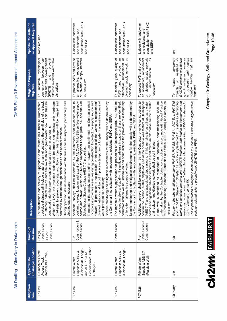
A9 D
ualli
ng –
Gle
n G
arr
y t
o D
alw
hin
nie
D
MR
B S
tage 3
En
viro
nm
enta
l Im
pact A
ssessm
ent
Chapte
r 10:
Geo
log
y,
So
ils a
nd G
rou
nd
wate
r
Pag
e 1
0-4
8
Mit
igati
on
Item
Ap
pro
xim
ate
Ch
ain
ag
e/ L
ocati
on
Tim
ing
of
Measu
re
Descri
pti
on
M
itig
ati
on
Pu
rpo
se/
Ob
jecti
ve
Sp
ecif
ic C
on
su
ltati
on
or
Ap
pro
val
Req
uir
ed
P07-G
23
Dru
mochte
r E
sta
te
Access T
rack
(form
er
BD
L tra
ck)
Desig
n,
Constr
uction
& P
ost-
Constr
uction
For
constr
uction a
nd d
eliv
ery
of
upgra
des t
o t
he f
orm
er
BD
L t
rack a
t D
rum
ochte
r,
tracksid
e d
rain
age w
ill inclu
de a
late
ral channel cut
alo
ng t
he u
phill
sid
e o
f th
e t
rack
to i
nte
rcept
natu
ral
run-o
ff a
nd s
hallo
w f
lush a
nd g
roundw
ate
r flow
. T
his
shall
be
conducte
d u
nder
the t
rack a
t re
gula
r in
terv
als
thro
ugh c
ross-d
rain
s.
With
in th
e
LM
A,
the tr
acksid
e
dra
in
shall
be
bro
ad
and
shallo
w
with m
odera
te
gra
die
nts
to
pre
vent
scouring,
and flow
s fr
om
th
is dra
inage w
ill be tr
eate
d and
contr
olle
d b
y filt
ration thro
ugh c
heck d
am
s a
nd d
ispers
al tr
enches.
During o
pera
tion,
dra
ins a
ssocia
ted w
ith t
he t
rack s
hall
be inspecte
d p
eriodic
ally
and
cle
aned o
ut as n
ecessary
.
To
main
tain
hydro
logic
al
connectivity
betw
een
up-
gra
die
nt
and
dow
n-g
radie
nt
GW
DT
E
and
pre
vent/
alle
via
te o
verland w
ate
r flow
dis
ruptions
None r
equired
P07-G
24
Private
Wate
r
Supplie
s: A
BS
7.4
(Daln
aspid
al Lodge)
and A
BS
7.5
(O
ld
Schoolh
ouse/ S
tation
Cott
ages)
Pre
-C
onstr
uction &
C
onstr
uction
Additio
nal
surv
eys s
hall
be u
ndert
aken b
y th
e C
ontr
acto
r prior
to c
onstr
uction,
to
confirm
the e
xact
location a
nd e
xtent
of
the A
llt C
oire M
hic
-Sith s
urf
ace w
ate
r supply
sourc
e a
nd n
etw
ork
within
the L
MA
for
Daln
aspid
al
Lodge (
AB
S 7
.4)
and t
he O
ld
Schoolh
ouse/ S
tation C
ott
age (
AB
S 7
.5)
pro
pert
ies.
If i
mpacts
to t
he s
upply
sourc
e a
nd/
or
netw
ork
are
confirm
ed,
the C
ontr
acto
r shall
incorp
ora
te p
rote
ctive m
easure
s d
uring c
onstr
uction t
o p
rote
ct
the s
upply
sourc
e a
nd
netw
ork
. I
f pro
tection i
s n
ot
possib
le i
n t
he c
onte
xt o
f th
e w
ork
s,
a r
epla
cem
ent/
div
ert
ed n
etw
ork
shall
be p
ut
in p
lace o
r te
mpora
ry o
r lo
ng-t
erm
altern
ative s
ourc
e o
f w
ate
r pro
vid
ed a
s n
ecessary
.
Specific
monitoring a
nd m
itig
ation r
equirem
ents
for
the s
upply
will
be d
ete
rmin
ed b
y
the C
ontr
acto
r in
consultation w
ith landow
ne
rs,
resid
ents
, P
&K
C a
nd S
EP
A.
To p
rote
ct
PW
S a
nd p
rovid
e
an
altern
ative,
repla
cem
ent
or
div
ert
ed
supply
netw
ork
as n
ecessary
Lia
ison w
ith landow
ner
and r
esid
ents
, and
consultation w
ith P
&K
C
and S
EP
A
P07-G
25
Private
Wate
r
Supplie
s: A
BS
7.6
(Daln
aspid
al Lodge)
Constr
uction
The b
ore
hole
wate
r supply
sourc
e f
or
pro
pert
ies a
t D
aln
aspid
al
(AB
S 7
.6)
shall
be
monitore
d f
or
yie
ld a
nd q
ualit
y.
If
sig
nific
ant
advers
e im
pacts
on t
hese a
re identified,
corr
ective a
ctions w
ill b
e u
ndert
aken a
nd c
ould
inclu
de t
he p
rovis
ion o
f a t
em
pora
ry
or
long-t
erm
altern
ative s
ourc
e o
f w
ate
r.
Specific
monitoring a
nd m
itig
ation r
equirem
ents
for
the s
upply
will
be d
ete
rmin
ed b
y
the C
ontr
acto
r in
consultation w
ith landow
ne
rs,
resid
ents
, P
&K
C a
nd S
EP
A.
To m
onitor
yie
ld/
qualit
y
of
PW
S
and
pro
vid
e
an
altern
ative,
repla
cem
ent
or
div
ert
ed
supply
netw
ork
as
necessary
Lia
ison w
ith landow
ner
and r
esid
ents
, and
consultation w
ith P
&K
C
and S
EP
A
P07-G
26
Private
Wate
r
Supplie
s: A
BS
7.7
(Possib
le W
ell)
Pre
-C
onstr
uction &
C
onstr
uction
Additio
nal
surv
eys s
hall
be u
ndert
aken b
y th
e C
ontr
acto
r prior
to c
onstr
uction,
to
confirm
the location, sta
tus,
depth
and u
se o
f th
e p
ossib
le w
ell
featu
re a
t D
aln
aspid
al
(AB
S 7
.7)
and a
ny a
ssocia
ted p
ipe n
etw
ork
. I
f th
is r
em
ain
s t
o b
e u
tilis
ed a
s a
wate
r sourc
e a
nd s
ignific
ant
advers
e im
pacts
are
confirm
ed,
an a
ltern
ative
sourc
e o
f w
ate
r and r
epla
cem
ent/ d
ivert
ed n
etw
ork
shall
be p
ut in
pla
ce,
If
the
well
is
confirm
ed
as
redundant
or
inopera
ble
, decom
mis
sio
nin
g
shall
be
undert
aken b
y th
e C
ontr
acto
r during c
onstr
uction i
n a
ccord
ance w
ith ‘
Good P
ractice
for
Decom
mis
sio
nin
g R
edundant
Bore
hole
s a
nd W
ells
’ (S
EP
A,
2010)
and o
thers
, as
necessary
.
To p
rote
ct
PW
S a
nd p
rovid
e
an
altern
ative,
repla
cem
ent
or
div
ert
ed
supply
netw
ork
or
decom
mis
sio
n
as
necessary
Lia
ison w
ith landow
ner
and r
esid
ents
, and
consultation w
ith P
&K
C
and S
EP
A
n/a
(note
) n/a
n/a
F
urt
her
to t
he a
bove,
Mitig
ation I
tem
s P
07-E
7,
P07-E
8,
P07-E
11,
P07-E
14,
P07-E
15
and P
07-E
25 d
eta
iled i
n C
hapte
r 12 w
ill b
e i
mple
mente
d i
n r
ela
tion t
o t
em
pora
ry
work
s a
nd s
ensitiv
e p
eatland a
nd G
WD
TE
habitats
, and h
abitat
re-insta
tem
ent
and
resto
ration w
ork
s w
ithin
the O
utlin
e H
abitat
Managem
ent
Pla
n (
OH
MP
) in
Appendix
12.1
1 (
Volu
me 2
) of th
e E
S.
The im
ple
menta
tion o
f M
itig
ation I
tem
s d
eta
iled in C
hapte
r 11 w
ill a
lso m
itig
ate
wate
r pollu
tion-r
ela
ted r
isks t
o g
roundw
ate
r, G
WD
TE
and P
WS
.
To
reduce
tem
pora
ry
impacts
on
peatland
or
GW
DT
E h
abitats
and d
eliv
er
specific
mitig
ation m
easure
s
to
re-insta
te
and
resto
re
nota
ble
habitats
th
at
are
im
pacte
d
n/a
A9 Dualling – Glen Garry to Dalwhinnie DMRB Stage 3 Environmental Impact Assessment
Chapter 10: Geology, Soils and Groundwater
Page 10-49
Monitoring Requirements
10.5.3 Standard and Project Specific Mitigation commitments will be monitored prior to, during and
following construction via the CEMP (Mitigation Item SMC-S1 in Chapter 21) and additional plans
as required. This shall include all aspects related to soil, geodiversity, groundwater, GWDTE,
surface water and PWS as necessary and outlined in Table 10-16.
10.5.4 Aspects related to peat stability shall be subject to monitoring during and following construction,
as identified by the Preliminary Peat Landslide Risk Assessment in Appendix 10.5 (Volume 2) and
requirements will be further defined by the Contractor following additional quantitative
assessment prior to construction commencing. Peat re-use and potential habitat re-instatement,
restoration or creation activities shall also be monitored during and following construction in
accordance with recommendations in the OPMP and OHMP in Appendix 10.6 and 12.11 (Volume
2); both of which shall be further developed by the Contractor prior to construction in
consultation and agreement with SEPA, SNH and CNPA.
10.5.5 Suitably qualified and experienced EnvCoWs and ECoWs will be appointed to oversee mitigation
and monitoring implementation, as well as emerging issues during construction (Mitigation Item
P07-G1). Monitoring details, frequencies and reporting requirements for all aspects will be
agreed with SEPA, SNH, CNPA and others as required, and will be tailored by the Contractor to
provide meaningful indications of the ongoing works, impacts and mitigation implementation.
��.- Residual Impacts
10.6.1 Following implementation of mitigation and associated monitoring; potential impacts in relation
to geology, soils and groundwater for the Proposed Scheme will be avoided, reduced or off-set as
far as is practicable. Residual impacts are those that remain once the measures have been
implemented, and are summarised in Table 10-17 with reference to the Standard and/ or Project
Specific Mitigation proposed for them from Table 10-16.
10.6.2 No residual impacts are expected in relation to the Drumochter Debris Cones or hillsides of
Drumochter Pass, PWS features at Balsporran Cottages (ABS 7.2) or Drumochter Lodge (ABS 7.3),
while potential impacts on superficial geology, solid geology, mineral extraction, some individual
GWDTE and surface water features are expected to remain as Neutral, with no specific mitigation
considered necessary. These aspects are therefore excluded from Table 10-17 for clarity, while
mitigation requirements for indirect impacts and residual effects in relation to hydromorphology
within the Allt Dubhaig GCR catchment are described, where necessary, in Chapter 11.
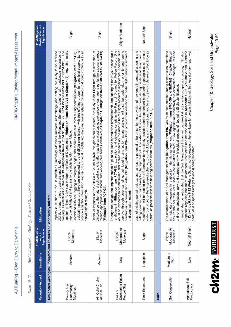
A9 D
ualli
ng –
Gle
n G
arr
y t
o D
alw
hin
nie
D
MR
B S
tage 3
En
viro
nm
enta
l Im
pact A
ssessm
ent
Chapte
r 10:
Geo
log
y,
So
ils a
nd G
rou
nd
wate
r
Pag
e 1
0-5
0
Ta
ble
10
-17
: R
esid
ua
l Im
pa
cts
– G
eo
logy, S
oils
an
d G
rou
nd
wa
ter
Recep
tor/
Asp
ect
Sen
sit
ivit
y
Pre
-Mit
igati
on
Im
pa
ct
Sig
nif
ica
nc
e
Mit
igati
on
P
ost-
Mit
iga
tio
n
Resid
ual
Imp
act
Sig
nif
ica
nc
e
Desig
nate
d G
eo
log
ical R
ecep
tors
an
d F
eatu
res o
f G
eo
div
ers
ity I
nte
rest
Dru
mochte
r H
um
mocky
Mora
ines
Mediu
m
Slig
ht/
Modera
te
Impacts
in r
ela
tion t
o t
he D
rum
ochte
r H
um
mocky
Mora
ines l
andfo
rm a
ssem
bla
ge a
nd s
ettin
g a
re l
ikely
to b
e r
educed
slig
htly th
rough slo
pe tr
eatm
ent
and la
ndfo
rm desig
n of
the P
roposed S
chem
e,
togeth
er
with la
ndscape in
tegra
tion of
pla
nting,
as i
dentified i
n C
hap
ter
13 (
Mit
igati
on
Ite
ms P
07-L
V1,
P07-L
V2,
P07-L
V7 a
nd P
07-L
V21 t
o P
07-L
V25).
T
he
location o
f T
ype A
lay-b
ys t
hro
ugh t
he P
ass o
f D
rum
ochte
r (M
itig
ati
on
Ite
ms P
07-L
V3 i
n C
hap
ter
13),
may a
lso l
ocally
im
pro
ve v
isib
ility
of
and a
ccess to the w
ider
landfo
rm a
ssem
bla
ge.
Com
bin
ed w
ith s
oil
loggin
g a
s m
arg
inal
ridges a
nd m
ounds a
re d
istu
rbed d
uring c
onstr
uction (
Mit
igati
on
Ite
m P
07-G
3),
re
sid
ual
impacts
are
there
fore
exp
ecte
d t
o b
e o
f S
light
sig
nific
ance;
with t
his
off
ering a
pote
ntial
beneficia
l opport
unity t
o
pro
vid
e s
cie
ntific info
rmation a
nd r
ecord
s o
f lo
cal in
sig
hts
into
marg
inal fo
rmer
gla
cie
r dynam
ics t
hat
could
contr
ibute
to a
n
active fie
ld o
f re
searc
h.
Slig
ht
Allt
Coire C
huirn
Allu
via
l F
an
Mediu
m
Slig
ht/
Modera
te
Resid
ual
impacts
on t
he A
llt C
oire C
huirn a
lluvia
l fa
n g
eodiv
ers
ity i
nte
rest
are
lik
ely
to b
e S
light
thro
ugh m
inim
isation o
f dis
turb
ance t
o t
he n
atu
ral soil
pro
file
and landfo
rm a
s f
ar
as p
racticable
, avoid
ance o
f dam
age t
o p
art
ial fa
n e
xposure
are
as
thro
ugh a
ppro
priate
set-
backs a
nd w
ork
ing p
rocedure
s i
dentified i
n C
hap
ter
11 (
Mit
igati
on
Ite
ms S
MC
-W3 t
o S
MC
-W13)
(Mit
igati
on
Ite
m P
07-G
4).
Slig
ht
Pass o
f D
rum
ochte
r P
olle
n
Record
Site
Low
S
light/
Modera
te t
o
Modera
te
Thro
ugh t
he d
esig
n a
nd im
ple
menta
tion o
f pile
d s
olu
tions f
or
main
line e
mbankm
ents
and f
loating o
f th
e N
CN
7 a
ccess t
rack
re-a
lignm
ent
(Mit
igati
on
Ite
m P
07-G
5),
exc
avation a
nd d
istu
rbance w
ithin
the P
ass o
f D
rum
ochte
r P
olle
n R
ecord
Site
would
be e
xpecte
d t
o b
e m
inim
ised a
nd r
educe i
mpacts
on t
he a
rea t
o b
e o
f S
light/ M
odera
te s
ignific
ance.
Additio
nal site
surv
eys
thro
ugh
core
sam
plin
g,
soil
loggin
g
and
polle
n
count
analy
sis
w
ill
als
o
be
undert
aken
prior
to
and
during
constr
uction in c
onsultation w
ith S
NH
(M
itig
ati
on
Ite
m P
07-G
6)
to p
rovid
e c
om
pensation f
or
part
ial dis
turb
ance o
f sedim
ent
and v
egeta
tion r
ecord
s.
Slig
ht/ M
odera
te
Rock E
xposure
s
Neglig
ible
S
light
Loss o
f exi
sting p
art
ial ro
ck e
xposure
s h
as t
he p
ote
ntial to
be o
ff-s
et
by t
he p
rovis
ion o
f new
ones in a
reas o
f w
idenin
g a
nd
cuttin
g identified a
s b
ein
g lik
ely
to inte
rcept
bedro
ck.
The e
xtent
of
this
will
be d
ete
rmin
ed d
uring t
he d
eta
iled d
esig
n a
nd a
re
quirem
ent
will
be p
laced o
n t
he C
ontr
acto
r fo
r a s
uitably
qualif
ied a
nd e
xperienced e
ngin
eering g
eolo
gis
t to
be o
n s
ite
while
rock is c
ut fo
r th
e P
roposed S
chem
e,
to c
onduct
loggin
g a
nd inspections,
and t
o e
nsure
rock c
uts
are
pro
file
d t
o b
e a
s
natu
ral as p
ossib
le w
ith n
o v
isib
le e
ngin
eere
d e
lem
ents
(M
itig
ati
on
Ite
m P
07-G
2).
Neutr
al/ S
light
So
ils
Soil
Conserv
ation
Mediu
m to
Hig
h
Slig
ht/
Modera
te t
o
Modera
te
The e
sta
blis
hm
ent
of
a S
oil
Managem
ent
Pla
n (
Mit
igati
on
Ite
m P
07-G
4)
for
imple
menta
tion d
uring c
onstr
uction,
com
bin
ed
with s
tandard
measure
s i
n r
ela
tion t
o m
ate
rials
managem
ent
(Mit
igati
on
Ite
ms S
MC
-G9 a
nd S
MC
-M3 (
Ch
ap
ter
18))
, w
ill
ensure
that
soil
resourc
es,
soils
of
conserv
ation i
nte
rest
or
low
agricultura
l pro
ductivity
are
exc
avate
d,
managed,
re-u
sed
and r
e-insta
ted s
usta
inably
and a
ppro
priate
ly;
with r
esid
ual im
pacts
of
Neutr
al to
Slig
ht sig
nific
ance.
It w
ould
als
o b
e a
nticip
ate
d t
hat
the S
oil
Managem
ent
Pla
n w
ill b
e l
inked d
irectly t
o l
andscape a
nd e
colo
gy m
itig
ation
pro
posals
regard
ing h
abitat
re-insta
tem
ent, r
esto
ration a
nd c
reation o
utlin
ed in A
pp
en
dix
12.1
1 (
Vo
lum
e 2
) and illu
str
ate
d
in D
raw
ing
s 6
.1 t
o 6
.12 (
Vo
lum
e 3
), w
ith c
onsid
era
tion o
f th
e s
oil-
base f
or
cert
ain
habitats
within
these (
i.e.
dry
heath
, w
et
heath
, acid
or
specie
s-r
ich g
rassla
nds)
bein
g im
port
ant.
Slig
ht
Agricultura
l S
oil
Pro
ductivity
Low
N
eutr
al/ S
light
Neutr
al
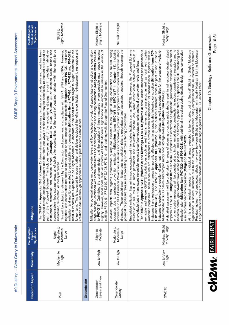
A9 D
ualli
ng –
Gle
n G
arr
y t
o D
alw
hin
nie
D
MR
B S
tage 3
En
viro
nm
enta
l Im
pact A
ssessm
ent
Chapte
r 10:
Geo
log
y,
So
ils a
nd G
rou
nd
wate
r
Pag
e 1
0-5
1
Recep
tor/
Asp
ect
Sen
sit
ivit
y
Pre
-Mit
igati
on
Im
pa
ct
Sig
nif
ica
nc
e
Mit
igati
on
P
ost-
Mit
iga
tio
n
Resid
ual
Imp
act
Sig
nif
ica
nc
e
Peat
Mediu
m to
Hig
h
Slig
ht/
Modera
te t
o
Modera
te/
Larg
e
The O
PM
P i
n A
pp
en
dix
10.6
(V
olu
me 2
) dem
onstr
ate
s h
ow
unnecessary
dis
turb
ance o
f peaty
soils
and p
eat
has b
een
min
imis
ed t
hro
ugh d
esig
n d
evelo
pm
ent
and t
hat
there
are
ways in w
hic
h t
hese m
ay b
e b
eneficia
lly r
e-insta
ted o
r re
-used a
s
part
of
the P
roposed S
chem
e.
This
inclu
des r
e-u
se a
s p
art
of
the l
andscapin
g s
trate
gy,
re-u
se i
n c
andid
ate
habitat
re-
insta
tem
ent,
resto
ration
and
cre
ation
are
as
(Dra
win
gs
10.3
8
to
10.4
4
(Vo
lum
e
3))
or
sele
cte
d
SuD
S
basin
s
and
com
pensato
ry f
lood s
tora
ge a
reas,
all
of
whic
h o
ffer
opport
unitie
s f
or
the e
xtent
of
peatland h
abitats
within
the localit
y t
o b
e
main
tain
ed, re
-insta
ted, or
locally
im
pro
ved.
This
will
be s
ubje
ct
to r
efinem
ent
by t
he C
ontr
acto
r and a
gre
em
ent
in c
onsultation w
ith S
EP
A,
SN
H a
nd C
NP
A.
How
ever,
to
geth
er
with c
onstr
uction m
eth
ods t
o f
urt
her
avoid
or
limit i
mpacts
where
possib
le (
Mit
igati
on
Ite
ms P
07-G
5),
and o
ther
mitig
ation a
nd m
onitoring r
ela
ted t
o p
eat
sta
bili
ty a
nd d
ew
ate
ring (
Mit
igati
on
Ite
ms P
07-G
6 t
o P
07-G
12 a
nd P
07-G
19),
re
sid
ual
impacts
are
exp
ecte
d t
o b
e S
light/ M
odera
te t
o M
odera
te i
n t
he s
hort
-term
and S
light
to S
light/
Modera
te i
n t
he
longer
term
. T
his
is e
xpecte
d t
o r
educe f
urt
her
and d
eliv
er
ecolo
gic
al
benefits
once h
abitat
re-insta
tem
ent, r
esto
ration a
nd
cre
ation m
easure
s thro
ugh a
ppro
priate
re-u
se o
f peat becom
e e
sta
blis
hed.
Slig
ht to
Slig
ht/ M
odera
te
Gro
un
dw
ate
r
Gro
und
wate
r Levels
and F
low
Low
to H
igh
Slig
ht to
M
odera
te
Mitig
ation f
or
pote
ntial im
pacts
on g
roundw
ate
r le
vels
and f
low
inclu
des p
rovis
ion o
f appro
priate
constr
uction a
nd o
pera
tion-
sta
ge d
rain
age,
com
bin
ed w
ith c
ontr
ol m
easure
s a
nd m
onitoring p
rior
to a
nd d
uring c
onstr
uction (
Mit
igati
on
Ite
ms P
07-G
15
to P
07-G
18).
Optim
isin
g t
he d
rain
age d
esig
n a
nd t
he a
doption o
f th
ese m
easure
s w
here
possib
le m
ay r
educe i
mpacts
slig
htly.
How
ever,
local
scale
resid
ual
impacts
of
Slig
ht/ M
odera
te s
ignific
ance a
re e
xpecte
d t
o r
em
ain
in t
he v
icin
ity
of
cuttin
gs P
7-D
J-0
1, P
7-D
J-0
2, P
7-D
J-0
3, P
7-B
J-0
1 a
nd r
eta
inin
g w
alls
thro
ugh t
he P
ass o
f D
rum
ochte
r.
Neutr
al/ S
light to
S
light/ M
odera
te
Gro
und
wate
r Q
ualit
y
Low
to H
igh
Modera
te t
o
Modera
te/
Larg
e
Resid
ual
impacts
w
ith
regard
s
gro
und
wate
r qualit
y
are
exp
ecte
d
to
be
Slig
ht
during
constr
uction
and
Neutr
al
during
opera
tion
due
to
pollu
tion
pre
vention
mitig
ation
(Mit
igati
on
It
em
s
SM
C-W
1
to
SM
C-W
17
in
Ch
ap
ter
11);
in
clu
din
g
adhere
nce t
o S
EP
A P
ollu
tion P
reve
ntion G
uid
elin
es a
nd o
therw
ise, pro
vis
ion o
f appro
priate
constr
uction a
nd o
pera
tion-s
tage
dra
inage.
These w
ould
als
o m
itig
ate
again
st
pollu
tion r
isks t
o g
roundw
ate
r and a
ssocia
ted r
ecepto
rs,
thro
ugh r
educin
g t
he
pote
ntial fo
r pollu
tant
rele
ase a
nd p
reventing r
un-o
ff f
rom
ente
ring g
roundw
ate
r.
Neutr
al to
Slig
ht
GW
DT
E
Low
to V
ery
H
igh
Neutr
al/ S
light
to V
ery
Larg
e
Em
bedded m
itig
ation h
as m
inim
ised e
ncro
achm
ent
into
nota
ble
habitats
such a
s G
WD
TE
. H
ow
ever,
the P
roposed S
chem
e
infr
astr
uctu
re
will
re
sult
in
som
e
perm
anent
and
irre
vers
ible
habitat
loss,
while
constr
uction
activitie
s
will
re
sult
in
unavoid
able
, but
in m
any c
ases r
evers
ible
im
pacts
to s
urf
ace v
egeta
tion, soils
and local gro
undw
ate
r le
vels
and flo
ws.
The O
HM
P in A
pp
en
dix
12.1
1 (
Vo
lum
e 2
) and D
raw
ing
s 6
.1 t
o 6
.12 (
Vo
lum
e 3
) deta
il outlin
e m
easure
s a
nd p
roposals
to
re-insta
te and re
sto
re G
WD
TE
habitat
types such as w
et
heath
s,
mires and gra
ssla
nds,
as w
ell
as lo
cal
wet/
riparian
woodla
nd p
roposals
. T
hese m
easure
s a
re a
nticip
ate
d t
o p
rovid
e s
om
e c
om
pensation f
or
habitat
losses,
togeth
er
with r
e-
insta
tem
ent
and r
esto
ration o
f are
as t
em
pora
rily
aff
ecte
d a
s f
ar
as p
racticable
follo
win
g c
onstr
uction (
Mit
igati
on
Ite
ms P
07-
G12 a
nd P
07-G
13).
The O
PM
P i
n A
pp
en
dix
10.6
(V
olu
me 2
) als
o o
utlin
es c
andid
ate
are
as f
or
peat
re-u
se i
n t
he r
e-
insta
tem
ent, r
esto
ration o
r cre
ation o
f w
et
heath
and m
ire t
ype h
abitats
, as w
ell
as o
pport
unitie
s f
or
the c
reation o
f w
etland-
based h
abitat
in S
uD
S b
asin
s a
nd c
om
pensato
ry f
lood s
tora
ge a
reas (
Mit
igati
on
Ite
m P
07-G
8).
A d
eta
iled a
ssessm
ent
will
be u
ndert
aken f
or
are
as o
f w
idenin
g o
r cutt
ing a
nticip
ate
d t
o r
esult in indirect
gro
undw
ate
r-re
late
d
impacts
on G
WD
TE
(M
itig
ati
on
Ite
m P
07-G
16).
If
impacts
are
confirm
ed a
s s
ignific
ant, g
roundw
ate
r exc
lusio
n,
conta
inm
ent
or
oth
er
contr
ol m
easure
s w
ill b
e c
onsid
ere
d a
nd i
mple
mente
d d
uring c
onstr
uction t
o r
educe d
raw
do
wn a
t re
cepto
rs a
nd t
o
main
tain
natu
ral
gro
undw
ate
r flow
s w
here
possib
le.
This
will
be f
urt
her
supple
mente
d b
y a
specific
GW
DT
E m
onitoring a
nd
mitig
ation p
lan (
Mit
igati
on
Ite
m P
07-G
20 a
nd P
07-G
21),
with a
dditio
nal m
icro
sitin
g d
uring d
eta
iled d
esig
n a
nd c
onstr
uction
als
o r
ecom
mended w
here
possib
le (
Mit
igati
on
Ite
m P
07-G
22).
At
this
sta
ge,
resid
ual
impacts
on in
div
idual
are
as exp
ecte
d to
be variable
, but
of
Neutr
al/ S
light
to S
light/ M
odera
te
sig
nific
ance i
n s
evera
l in
sta
nces d
ue t
o t
he m
ajo
rity
of
direct
dis
turb
ance b
ein
g c
om
pensate
d f
or,
re-insta
ted o
r re
sto
red.
Resid
ual
indirect
hydro
geolo
gic
al
eff
ects
may v
ary
betw
een S
light
and M
odera
te,
with l
ocally
Neutr
al/ S
light
to M
odera
te/
Larg
e b
eneficia
l effects
to s
om
e h
abitats
associa
ted w
ith d
rain
age u
pgra
des f
or
the B
DL a
ccess t
rack.
Neutr
al/ S
light to
Very
Larg
e
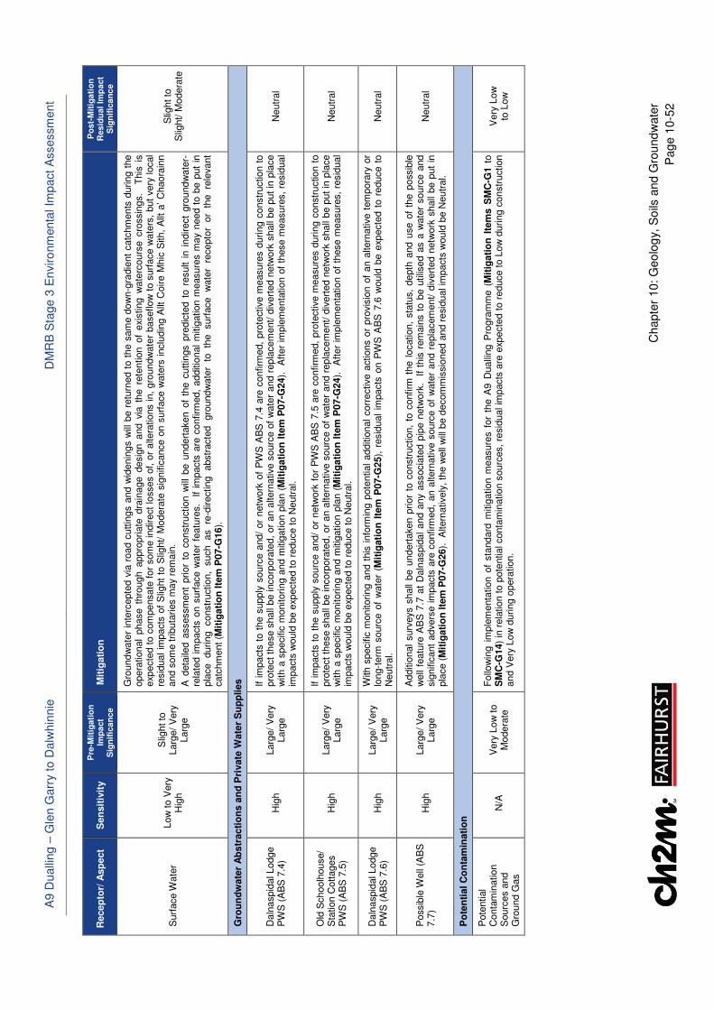
A9 D
ualli
ng –
Gle
n G
arr
y t
o D
alw
hin
nie
D
MR
B S
tage 3
En
viro
nm
enta
l Im
pact A
ssessm
ent
Chapte
r 10:
Geo
log
y,
So
ils a
nd G
rou
nd
wate
r
Pag
e 1
0-5
2
Recep
tor/
Asp
ect
Sen
sit
ivit
y
Pre
-Mit
igati
on
Im
pa
ct
Sig
nif
ica
nc
e
Mit
igati
on
P
ost-
Mit
iga
tio
n
Resid
ual
Imp
act
Sig
nif
ica
nc
e
Surf
ace W
ate
r Low
to V
ery
H
igh
Slig
ht to
Larg
e/
Very
Larg
e
Gro
und
wate
r in
terc
epte
d v
ia r
oad c
uttin
gs a
nd w
idenin
gs w
ill b
e r
etu
rned t
o t
he s
am
e d
ow
n-g
radie
nt
catc
hm
ents
during t
he
opera
tional
phase t
hro
ugh a
ppro
priate
dra
inage d
esig
n a
nd v
ia t
he r
ete
ntion o
f exi
sting w
ate
rcours
e c
rossin
gs.
This
is
exp
ecte
d t
o c
om
pensate
for
som
e indirect
losses o
f, o
r altera
tions in,
gro
undw
ate
r baseflow
to s
urf
ace w
ate
rs,
but
very
local
resid
ual
impacts
of
Slig
ht
to S
light/ M
odera
te s
ignific
ance o
n s
urf
ace w
ate
rs i
nclu
din
g A
llt C
oire M
hic
Sith,
Allt
a’ C
haora
inn
and s
om
e t
ributa
ries m
ay r
em
ain
.
A d
eta
iled a
ssessm
ent
prior
to c
onstr
uction w
ill b
e u
ndert
aken o
f th
e c
uttin
gs p
redic
ted t
o r
esult i
n i
ndirect
gro
undw
ate
r-re
late
d i
mpacts
on s
urf
ace w
ate
r fe
atu
res.
If
impacts
are
confirm
ed,
additio
nal
mitig
ation m
easure
s m
ay n
eed t
o b
e p
ut
in
pla
ce
during
constr
uction,
such
as
re-d
irecting
abstr
acte
d
gro
undw
ate
r to
th
e
surf
ace
wate
r re
cepto
r or
the
rele
vant
catc
hm
ent (M
itig
ati
on
Ite
m P
07-G
16).
Slig
ht to
S
light/ M
odera
te
Gro
un
dw
ate
r A
bs
tracti
on
s a
nd
Pri
vate
Wate
r S
up
plies
Daln
aspid
al Lodge
PW
S (
AB
S 7
.4)
H
igh
Larg
e/
Very
Larg
e
If im
pacts
to t
he s
upply
sourc
e a
nd/
or
netw
ork
of
PW
S A
BS
7.4
are
confirm
ed,
pro
tective m
easure
s d
uring c
onstr
uction t
o
pro
tect
these s
hall
be incorp
ora
ted,
or
an a
ltern
ative s
ourc
e o
f w
ate
r and r
epla
cem
ent/
div
ert
ed n
etw
ork
shall
be p
ut
in p
lace
with a
specific
monitoring a
nd m
itig
ation p
lan (
Mit
igati
on
Ite
m P
07-G
24).
A
fter
imple
menta
tion o
f th
ese m
easure
s,
resid
ual
impacts
would
be e
xpecte
d t
o r
educe t
o N
eutr
al.
Neutr
al
Old
Schoolh
ouse/
Sta
tion C
ottages
PW
S (
AB
S 7
.5)
Hig
h
Larg
e/
Very
Larg
e
If im
pacts
to t
he s
upply
sourc
e a
nd/
or
netw
ork
for
PW
S A
BS
7.5
are
confirm
ed,
pro
tective m
easure
s d
uring c
onstr
uction t
o
pro
tect
these s
hall
be incorp
ora
ted,
or
an a
ltern
ative s
ourc
e o
f w
ate
r and r
epla
cem
ent/
div
ert
ed n
etw
ork
shall
be p
ut
in p
lace
with a
specific
monitoring a
nd m
itig
ation p
lan (
Mit
igati
on
Ite
m P
07-G
24).
A
fter
imple
menta
tion o
f th
ese m
easure
s,
resid
ual
impacts
would
be e
xpecte
d t
o r
educe t
o N
eutr
al.
Neutr
al
Daln
aspid
al Lodge
PW
S (
AB
S 7
.6)
Hig
h
Larg
e/
Very
Larg
e
With
specific
monitoring a
nd t
his
info
rmin
g p
ote
ntial
additio
nal
corr
ective a
ctions o
r pro
vis
ion o
f an a
ltern
ative t
em
pora
ry o
r lo
ng-t
erm
sourc
e o
f w
ate
r (M
itig
ati
on
Ite
m P
07-G
25),
resid
ual
impacts
on P
WS
AB
S 7
.6 w
ould
be e
xpecte
d t
o r
educe t
o
Neutr
al.
Neutr
al
Possib
le W
ell
(AB
S
7.7
)
Hig
h
Larg
e/
Very
Larg
e
Additio
nal
surv
eys s
hall
be u
ndert
aken p
rior
to c
onstr
uction,
to c
onfirm
the l
ocation,
sta
tus,
depth
and u
se o
f th
e p
ossib
le
well
featu
re A
BS
7.7
at
Daln
aspid
al
and a
ny a
ssocia
ted p
ipe n
etw
ork
. I
f th
is r
em
ain
s t
o b
e u
tilis
ed a
s a
wate
r sourc
e a
nd
sig
nific
ant
advers
e i
mpacts
are
confirm
ed,
an a
ltern
ative s
ourc
e o
f w
ate
r and r
epla
cem
ent/ d
ivert
ed n
etw
ork
shall
be p
ut
in
pla
ce (
Mit
igati
on
Ite
m P
07-G
26).
A
ltern
atively
, th
e w
ell
will
be d
ecom
mis
sio
ned a
nd r
esid
ual im
pacts
would
be N
eutr
al.
Neutr
al
Po
ten
tial C
on
tam
inati
on
Pote
ntial
Conta
min
ation
Sourc
es a
nd
Gro
und G
as
N/A
V
ery
Low
to
Modera
te
Follo
win
g i
mple
menta
tion o
f sta
ndard
mitig
ation m
easure
s f
or
the A
9 D
ualli
ng P
rogra
mm
e (
Mit
igati
on
Ite
ms S
MC
-G1 t
o
SM
C-G
14)
in r
ela
tion t
o p
ote
ntial conta
min
ation s
ourc
es,
resid
ual im
pacts
are
exp
ecte
d t
o r
educe t
o L
ow
during c
onstr
uction
and V
ery
Low
during o
pera
tion.
Very
Low
to
Low
A9 Dualling – Glen Garry to Dalwhinnie DMRB Stage 3 Environmental Impact Assessment
Chapter 10: Geology, Soils and Groundwater
Page 10-53
10.6.3 In summary, with the Proposed Scheme in place and taking the identified mitigation measures
into account, the residual impacts in relation to groundwater levels and flows in glacial deposits
and bedrock at the Dalnaspidal Junction, through the Pass of Drumochter and at the Balsporran/
Drumochter Lodge Junction are expected to be significant at local scales during construction and
operation. These may in turn have similarly local scale residual groundwater-related effects on
surface water features in the vicinity.
10.6.4 Peat excavation and GWDTE habitat loss or disturbance impacts are also identified to be locally
significant. However, the assessment has identified that the vast majority of effects will occur
along the edge of more extensive peatland or wetland habitat mosaics through the existing A9
corridor, where areas have already been affected by existing land management, drainage or
infrastructure, and the consideration and implementation of appropriate construction methods
and control measures is likely to further avoid or minimise effects on areas in better condition.
During operation, the residual impacts on these aspects are expected to reduce and be further
off-set once measures for and ecological benefits from landscaping, beneficial peat re-use and
habitat re-instatement, restoration and creation become firmly established in the longer term.
Residual effects in terms of permanent GWDTE habitat loss will be localised and significant only
at the local scale, with Chapter 12 also stating that no significant residual ecological habitat loss
or disturbance is expected following the implementation of mitigation.
10.6.5 All other residual impacts on geology, soils and groundwater receptors are not predicted to be
significant and in some instances, may carry consequential benefits for local geodiversity access/
visibility opportunities, geomorphology and ecology, as summarised in Table 10-17.
��.. Summary of Combined Impacts
10.7.1 Some of the geology, soils and groundwater receptors may be subject to residual effects that, in
combination with others for different environmental topics, could contribute to cumulative
impacts during construction or operation. These include soils of conservation interest, peaty soils
and peat (direct and indirect disturbance, habitat fragmentation or loss), geodiversity features
(direct disturbance and landscape/ visual effects), GWDTE (groundwater flow impacts, habitat
fragmentation or loss and pollution risks), surface water features (dewatering or groundwater
flow impact from multiple widenings/ cuttings, geomorphological change, flood risk changes and
pollution risks) and properties (private water supplies and land-take, noise or visual effects).
10.7.2 Such potential cumulative impacts of the Proposed Scheme for the different environmental topic-
specific impacts on single receptors are considered further in Chapter 20. However, based on the
above assessment and review of the residual impacts and mitigation measures proposed in other
Chapters, no significant adverse combined impacts of the Proposed Scheme have been identified
in relation to geology, soils and groundwater receptors.
A9 Dualling – Glen Garry to Dalwhinnie DMRB Stage 3 Environmental Impact Assessment
Chapter 10: Geology, Soils and Groundwater
Page 10-54
��./ References
Ballantyne, C. K., Benn, D. I., (1996). Paraglacial slope adjustment during recent deglaciation and its
implications for slope evolution in formerly glaciated environments. In: Anderson, M. G., Brooks, S. (eds).
Advances in Hillslope Processes. Wiley, Cichester, pp. 1173 – 1195
Ballantyne, C. K., (2004). The Drumochter Debris Cones. In: Lukas, S., Merritt, J. W., Mitchell., W. A. The
Quaternary of the Central Grampian Highlands. Quaternary Research Association, 171-173
Barron, H. F., Gillespie, M. R. and Merrit, J. W. (2011). Geodiversity of the Cairngorms National Park. British
Geological Survey Open Report, OR/10/019, 2011
British Geological Survey (1988). Hydrogeological Map of Scotland, 1:625,000 Scale
British Geological Survey (1995). Groundwater Vulnerability Map of Scotland, 1:625,000 Scale
British Geological Survey (2017). GeoIndex Onshore (Online) Available at (www.bgs.ac.uk/geoindex)
(Accessed June 2017)
British Standards Institute (2015). BS 8485:2015 – Code of Practice for the Design of Protective Measures
for Methane and Carbon Dioxide Ground Gases for New Buildings, June 2015
CH2M Fairhurst Joint Venture (CFJV) (2016). A9 Dualling – Glen Garry to Dalraddy, Geotechnical
Preliminary Sources Study Report for Project 7, Glen Garry to Dalwhinnie
Construction Industry Research and Information Association (2001). Contaminated Land Risk Assessment –
A Guide to Good Practice (C552), D J Rudland, R M Lancefield and P N Mayell
Construction Industry Research and Information Association (2007). Assessing Risks Posed by Hazardous
Ground Gases to Buildings C665, S Wilson, S Oliver and H Mallett et al
Construction Industry Research and Information Association (2016). Groundwater control: design and
practice, second edition C750, M Preene, T O L Roberts, W Powrie
Dargie, T. (2009). The Role of EIA Process in Assessing Wind Farm Impacts Upon Blanket Bog Habitat in
Scotland, IMCG Proceedings, April 2009
Department of Environment Food and Rural Affairs (2014). SP1010: Development of Category 4 Screening
Levels for Assessment of Land Affected by Contamination – Policy Companion Document
Environment Agency (2004). Model Procedures for the Management of Land Contamination,
Contaminated Land Report 11 (CLR11)
Ferguson, R. & Ashworth, P. (1990). Slope-induced changes in channel character along a gravel-bed stream:
the Allt Dubhaig, Scotland. Earth Surface Processes & Landforms, 16, 65–82.
Freeze, A R and Cherry, J A (1979). Groundwater, Prentice Hall, Englewood Cliffs, 1979
Gauld, J H, Bell, J S, Mckeen, M M and Bruneau, P M C (2003). Soils and nature conservation: an inventory
of selected Natural Heritage Futures areas. Scottish Natural Heritage Commissioned Report No. 019
(ROAME No. F00AC101).
Gordon J. E., Sutherland D.G., (1993). Quaternary of Scotland, 6, Chapman & Hall, London.
Health and Safety Executive (2011). EH40/ 2005 Workplace Exposure Limits, Second Edition
Hobbs, N. B., (1986). Mire Morphology and the Properties and Behaviour of some British and Foreign
Peats. Quarterly Journal of Engineering Geology, 19.
Jacobs UK (2013). A9 Dualling Perth to Inverness, Geotechnical Preliminary Sources Study Report, Glen
Garry to Dalwhinnie - Chainage 75000 to 85700m, Reference: B1557620/GEO/PSSR06 – Revision 3
A9 Dualling – Glen Garry to Dalwhinnie DMRB Stage 3 Environmental Impact Assessment
Chapter 10: Geology, Soils and Groundwater
Page 10-55
Joint Nature Conservation Committee (2005). Report No. 365, Characterisation of Hydrological Protection
Zones at the Margins of Designated Lowland Raised Peat Bog Sites
James Hutton Institute (1984). National Soil Map of Scotland, 1:250,000 Scale
Lukas, S (2003). Scottish Landform Example No. 31: The Moraines around the Pass of Drumochter, pp. 383-
393, Scottish Geographical Journal, 119(4), 2003
Lukas, S (2004). The Pattern of Deglaciation around the Pass of Drumochter, pp. 68-77, The Quaternary of
the Central Grampian Highlands Field Guide, Quaternary Research Association, 2004
Mitchell, W A and Lukas, S (2004), Drumochter Mast, pp. 163-170, The Quaternary of the Central Grampian
Highlands Field Guide, Quaternary Research Association
Merrit, J W (2004). A Guide to the Geomorphology and Glacial Geology of the Allt Cuaich Catchment and
the Gaick Plateau, pp. 180-189, The Quaternary of the Central Grampian Highlands Field Guide, Quaternary
Research Association
Nathanail, C.P., McCaffrey, C., Gillett, A.G., Ogden, R.C. and Nathaniel, J.F. (2015). The Land Quality
Management/ Chartered Institute of Environmental Health Suitable 4 Use Levels for Human Health Risk
Assessment. (Copyright Land Quality Management Limited reproduced with permission, Publication
Number S4UL3401. All rights reserved)
Natural England (2013). Restoration of Degraded Blanket Bog, Reference NEER003, First Edition
Nayak, D. R., Miller, D., Nolan, A., Smith, P., Smith, J., (2008). Calculating carbon savings from wind farms
on Scottish peat lands – a new approach. Report for the Scottish Government
Powers, J. P., Corwin, A. B., Schmall, P. C. and Kaeck, W. E. (2007). Construction dewatering and
groundwater control: new methods and applications, third edition, Wiley-Blackwell, New York, USA
Raeburn Drilling and Geotechnical Ltd (2017). A9 Dualling – Glen Garry to Dalraddy, Project 7 Glen Garry to
Dalwhinnie – Final Report on Ground Investigation, Raeburn Drilling and Geotechnical Ltd, issued on 31
March 2017
Raeburn Drilling and Geotechnical Ltd (2017). A9 Dualling – Glen Garry to Dalraddy, Project 7 Glen Garry to
Dalwhinnie – Draft Final Report on Preliminary Ground Investigation, Raeburn Drilling and Geotechnical
Ltd, issued on 22 June 2017
Scotland and Northern Ireland Forum for Environmental Research (2009). WFD 95: A Functional Wetland
Typology for Scotland
Scottish Executive (2006a), Environmental Protection Act 1990: Part IIA Contaminated Land Statutory
Guidance: Edition 2
Scottish Executive (2006b). Peat Landslide Hazard and Risk Assessments, Best Practice Guide for Proposed
Electricity Generation Developments
Scottish Environment Protection Agency (2010). SEPA Regulatory Position Statement – Developments on
Peat. National Waste Policy Unit.
Scottish Environment Protection Agency (2014a). LUPS-GU31 Guidance on Assessing the Impacts of
Development Proposals on Groundwater Abstractions and Groundwater Dependent Terrestrial
Ecosystems, Version 2
Scottish Environment Protection Agency (2014b). Position Statement WAT-PS-10-01 Assigning
Groundwater Assessment Criteria for Pollutant Inputs, Version 3
Scottish Environment Protection Agency (2017). Interactive River Basin Management Plan Map (Online)
Available at (http://gis.sepa.org.uk/rbmp) (Accessed June 2017)
Scottish Government (2000). Planning Advice Note 33: Development of Contaminated Land
A9 Dualling – Glen Garry to Dalwhinnie DMRB Stage 3 Environmental Impact Assessment
Chapter 10: Geology, Soils and Groundwater
Page 10-56
Scottish Government (2009). The Scottish Soil Framework
Scottish Government (2011a). The Waste Management Licensing (Scotland) Regulations 2011
Scottish Government (2011b). The Water Environment (Controlled Activities) (Scotland) Regulations 2011
Scottish Government (2011c). Carbon Implications of Windfarms Located on Peatlands – Update of the
Scottish Government Carbon Calculator Tool.
Scottish Government, Scottish Environment Protection Agency, Scottish Natural Heritage and The James
Hutton Institute (2014). Guidance on Developments on Peatland – Site Surveys 7p.
Scottish Government, Scottish Natural Heritage and Scottish Environment Protection Agency (2017).
Peatland Survey – Guidance on Developments on Peatland.
Scottish Natural Heritage (2013). Constructed tracks in the Scottish Uplands, Second Edition (updated in
September 2015)
Scottish Natural Heritage (2016a). Sitelink Designation Database (https://gateway.snh.gov.uk/sitelink/)
(Accessed June 2017)
Scottish Natural Heritage (2016b). Carbon and Peatland 2016 Map
Scottish Natural Heritage and Forestry Commission Scotland (2010). Floating Roads on Peat - A Report into
Good Practice in Design, Construction and Use of Floating Roads on Peat with particular reference to Wind
Farm Developments in Scotland
Scottish Natural Heritage, Scottish Environment Protection Agency and The James Hutton Institute (2014).
Guidance on Developments on Peatland - Site Surveys
Scottish Renewables, Scottish Natural Heritage, Scottish Environment Protection Agency and Forestry
Commission Scotland (2010). Good Practice during Windfarm Construction, Version 1
Scottish Renewables and Scottish Environment Protection Agency (2012). Developments on Peatland:
Guidance on the assessment of peat volumes, re-use of excavated peat and the minimisation of waste,
Version 1
Sissons, J. B. (1974). A lateglacial ice cap in the central Grampians, Scotland. Transactions of the Institute of
British Geographers 62: 95 – 114
Stunnel, J (2010). Investigating Wind Farms on Peat. Report to Natural England No. NECR032. Maslen
Environmental
Stewart and Lance (1991). Effects of moor-draining on hydrology and vegetation of northern Pennine
blanket bog. Journal of Applied Ecology, 28: 1105 – 1117
Towers, W, Malcolm, A and Bruneau, P M C (2005). Assessing the nature conservation value of soil and its
relation with designated features. Scottish Natural Heritage Commissioned Report No. 111 (ROAME No.
F03AC104)
Transport Scotland (2013). A9 Dualling Programme Strategic Environmental Assessment (SEA)
Transport Scotland (2014a). A9 Dualling Programme Strategic Environmental Assessment (SEA)
Environmental Report Addendum. Document TSSEA9/ER/02
Transport Scotland (2014b). A9 Dualling: Preliminary Engineering Support Services, Design Manual for
Roads and Bridges Stage 1 Report Document TSSEA9/ER/02
The Highways Agency, Scottish Government, Welsh Assembly Government and The Department for
Regional Development Northern Ireland (1993). Design Manual for Roads and Bridges Volume 11, Section
3, Part 11, Geology and Soils, 1993

A9 Dualling – Glen Garry to Dalwhinnie DMRB Stage 3 Environmental Impact Assessment
Chapter 10: Geology, Soils and Groundwater
Page 10-57
The Highways Agency, Transport Scotland, Welsh Assembly Government and The Department for Regional
Development Northern Ireland (2009). Design Manual for Roads and Bridges Volume 11, Section 3, Part 10,
HD45/09 Road Drainage and the Water Environment, 2009
Walker, M J C (1975). A Pollen Diagram from the Pass of Drumochter, Central Grampian Highlands,
Scotland, pp. 335-343, Transactions of the Botanical Society of Edinburgh, 42 (3), 1975
Werritty, A. (1997). Allt Dubhaig, Dorback Burn. In: Gregory, K.J., ed. Fluvial Geomorphology of Great
Britain. Geological Conservation Review Series. London, Chapman and Hall, 66–69, 69–72.
Wheeler, B D, Shaw, S and Tanner, K (2009). A wetland framework for impact assessment at statutory sites
in England and Wales. Environment Agency Science Report SC030232/SR1

A9 Dualling – Glen Garry to Dalwhinnie DMRB Stage 3 Environmental Impact Assessment