Embed Size (px)
DESCRIPTION
Short analysis of the geology of southern Whidbey Island, Washington
Citation preview
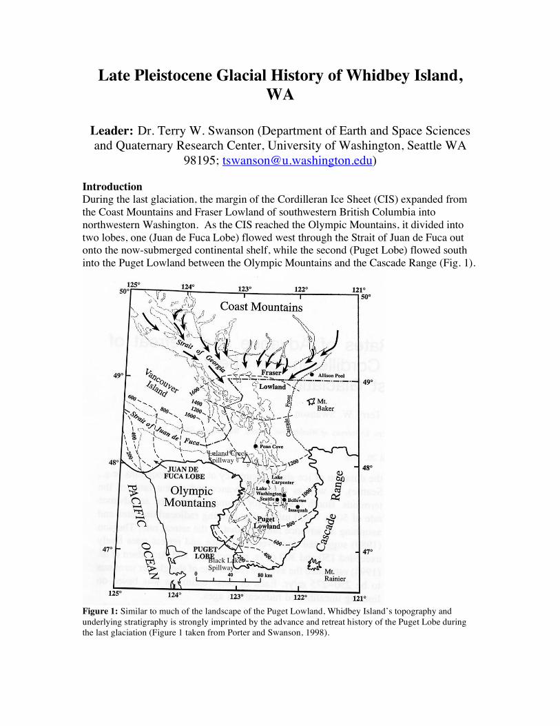
Late Pleistocene Glacial History of Whidbey Island, WA
Leader: Dr. Terry W. Swanson (Department of Earth and Space Sciences and Quaternary Research Center, University of Washington, Seattle WA
98195; [email protected]) Introduction During the last glaciation, the margin of the Cordilleran Ice Sheet (CIS) expanded from the Coast Mountains and Fraser Lowland of southwestern British Columbia into northwestern Washington. As the CIS reached the Olympic Mountains, it divided into two lobes, one (Juan de Fuca Lobe) flowed west through the Strait of Juan de Fuca out onto the now-submerged continental shelf, while the second (Puget Lobe) flowed south into the Puget Lowland between the Olympic Mountains and the Cascade Range (Fig. 1).
Figure 1: Similar to much of the landscape of the Puget Lowland, Whidbey Island’s topography and underlying stratigraphy is strongly imprinted by the advance and retreat history of the Puget Lobe during the last glaciation (Figure 1 taken from Porter and Swanson, 1998).
Leland Creek Spillway
Black Lake Spillway
Glacial History of Whidbey Island 2
The chronology of the advance and retreat history of the Puget Lobe during the Vashon Stade of the Fraser Glaciation (Armstrong et al., 1965) is based on a suite of conventional and AMS radiocarbon ages lying above and below the respective drift units (e.g., Yount et al., 1980; Easterbrook, 1992; Porter and Swanson, 1998; Booth et al., 2004; Polenz et al., 2006). Porter and Swanson (1998), inferred that the Puget Lobe advanced south of Seattle shortly after 14,600 ± 90 14C yr B.P. (~17,500 cal yr) based on dating the outermost rings of spruce logs collected from the topset beds of a proglacial delta near Issaquah, Washington. Limiting dates for glacier recession indicate that the Puget Lobe had retreated north Seattle sometime before 13,610 ± 80 based on radiocarbon dating of bog peat. A brief overview of the glacial history of this region is presented below. Between 25,000 and 18,000 years ago eustatic (global) sea level was about 120-150 m lower than modern due to continental ice sheet build up during the last glaciation. During the Olympia Interstade, Puget Lowland stream systems flowed westerly from the Cascades and easterly from the Olympic Mountains into the Puget Lowland and then northerly along a gently sloping alluvial flood plain towards the Strait of Juan de Fuca. Sandy and gravelly layers within this unit likely represent point bar and/or channel deposits and tend to be discontinuous over horizontal distances. These discontinuous coarse-grained layers tend to have low discharge rates, but keep the slopes damp year round. The interlayered silts likely represent slack-water deposits, which accumulated along the alluvial flood plain. Approximately 18,000 years ago the Cordilleran Ice Sheet reached the Fraser Lowland and a lobe flowed west into the Strait of Juan de Fuca and south into the Puget Lowland (Puget Lobe). As the Puget Lobe dammed the north flowing streams within the lowland, a system of proglacial lakes developed in the structural low topography within the Puget Lowland. The lake level of the pro-glacial lakes was defined by spillways located near Port Townsend, WA (Leland Creek spillway) in the northern part of the lowland and southwest of Olympia, WA (Black Lake spillway) in the southern part of the lowland (Fig. 1). Glacial lacustrine sediment was deposited in these proglacial lakes and is locally defined as the Lawton Formation. The Lawton Formation consists of gleyed, laminated clays, with sporadic ice-rafted dropstones present, and has a very low permeability and porosity. The Lawton clays form relatively shallow aquicludes on southern Whidbey island. Within such aquicludes subsurface water becomes perched and reaches the surface as seepage springs along many of the upper bluff slopes. The discharge rate along these types of seepage springs depends largely on the sediment characteristics of the aquifer (i.e., Esperance outwash vs. Vashon Till) and overlying substrate (i.e., porosity and permeability) of the recharge area. Seepage springs perched on the Lawton Clays are evident along easterly bluff exposures of Double Bluff, Possession Point to Scatchet Head. Many of the seepage springs observed along the bluff slopes on southern Whidbey Island are perched above this aquiclude. The Lawton clay is not present within the substrate of central and northern Whidbey Island as the outlet to the Strait of Juan de Fuca permitted inundation of marine waters into low lying topography as the northern sound became deglaciated.
Glacial History of Whidbey Island 3
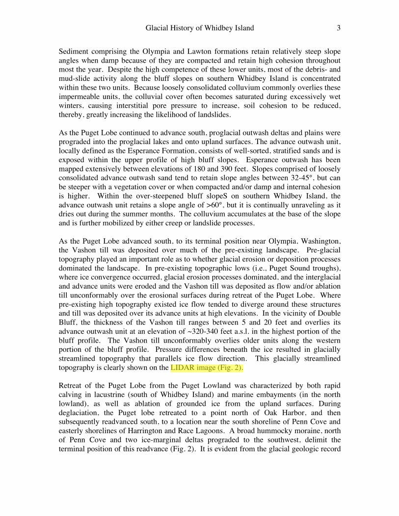
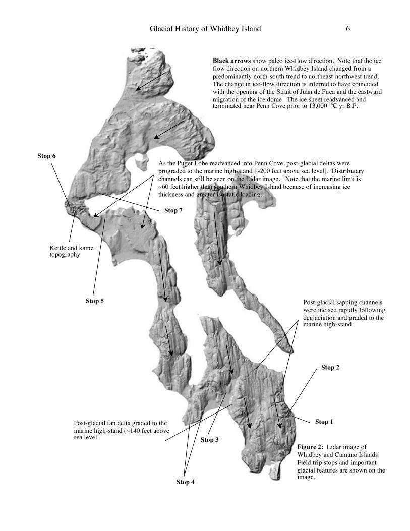
Sediment comprising the Olympia and Lawton formations retain relatively steep slope angles when damp because of they are compacted and retain high cohesion throughout most the year. Despite the high competence of these lower units, most of the debris- and mud-slide activity along the bluff slopes on southern Whidbey Island is concentrated within these two units. Because loosely consolidated colluvium commonly overlies these impermeable units, the colluvial cover often becomes saturated during excessively wet winters, causing interstitial pore pressure to increase, soil cohesion to be reduced, thereby, greatly increasing the likelihood of landslides. As the Puget Lobe continued to advance south, proglacial outwash deltas and plains were prograded into the proglacial lakes and onto upland surfaces. The advance outwash unit, locally defined as the Esperance Formation, consists of well-sorted, stratified sands and is exposed within the upper profile of high bluff slopes. Esperance outwash has been mapped extensively between elevations of 180 and 390 feet. Slopes comprised of loosely consolidated advance outwash sand tend to retain slope angles between 32-45°, but can be steeper with a vegetation cover or when compacted and/or damp and internal cohesion is higher. Within the over-steepened bluff slopeS on southern Whidbey Island, the advance outwash unit retains a slope angle of >60°, but it is continually unraveling as it dries out during the summer months. The colluvium accumulates at the base of the slope and is further mobilized by either creep or landslide processes. As the Puget Lobe advanced south, to its terminal position near Olympia, Washington, the Vashon till was deposited over much of the pre-existing landscape. Pre-glacial topography played an important role as to whether glacial erosion or deposition processes dominated the landscape. In pre-existing topographic lows (i.e., Puget Sound troughs), where ice convergence occurred, glacial erosion processes dominated, and the interglacial and advance units were eroded and the Vashon till was deposited as flow and/or ablation till unconformably over the erosional surfaces during retreat of the Puget Lobe. Where pre-existing high topography existed ice flow tended to diverge around these structures and till was deposited over its advance units at high elevations. In the vicinity of Double Bluff, the thickness of the Vashon till ranges between 5 and 20 feet and overlies its advance outwash unit at an elevation of ~320-340 feet a.s.l. in the highest portion of the bluff profile. The Vashon till unconformably overlies older units along the western portion of the bluff profile. Pressure differences beneath the ice resulted in glacially streamlined topography that parallels ice flow direction. This glacially streamlined topography is clearly shown on the LIDAR image (Fig. 2). Retreat of the Puget Lobe from the Puget Lowland was characterized by both rapid calving in lacustrine (south of Whidbey Island) and marine embayments (in the north lowland), as well as ablation of grounded ice from the upland surfaces. During deglaciation, the Puget lobe retreated to a point north of Oak Harbor, and then subsequently readvanced south, to a location near the south shoreline of Penn Cove and easterly shorelines of Harrington and Race Lagoons. A broad hummocky moraine, north of Penn Cove and two ice-marginal deltas prograded to the southwest, delimit the terminal position of this readvance (Fig. 2). It is evident from the glacial geologic record
Glacial History of Whidbey Island 4
that ice remained in this recessional position for a long enough period of time to prograde the large glacial marine deltas. The horizontal topset beds of the post-glacial marine deltas were graded to sea level during this time (~ 15,000 years ago) and form the present day surfaces of Smith and Ebey Prairies. The topographic expression of these deltas is clearly shown on the LIDAR image (Fig. 2). Following deglaciation, Whidbey Island was isostatically depressed (due to ice loading) during which time a marine incursion occurred into the Puget Lowland. The topset beds of the post-glacial marine deltas were graded to relative sea level, which was ~200 feet above modern sea level (Fig. 2). Initially, the rate of isostatic uplift was greater than eustatic sea level rise, which resulted in the formation of a series of post-glacial marine terraces incised into the pre-existing substrate as the land emerged. These terraces are well preserved along the north shoreline of Penn Cove. As the ice retreated from its recessional limit, proximal meltwater fan sediment was deposited over the stratified and massive diamicton facies. The proximal meltwater fan unit consists of stratified sands and gravels with trough cross-stratification, indicating deposition by channelized flows. Bedding tends to be discontinuous and grades to ice-rafted pebbly mud and silty units (ice-rafted facies), which comprise the upper part of the section. The ice-rafted facies was deposited by melt-out of icebergs as the calving ice sheet retreated from the northern Puget Lowland. The more massive section (i.e., contain no laminations) of the ice-rafted facies look similar to the Vashon till, but generally have a higher percentage of fines (silts and clays) within the supporting matrix. The ice-rafted facies appears more buff colored than the gray Vashon till and possesses a characteristic blocky weathering structure, easily observed in bluff exposures. Field Log UW to the Mukilteo Ferry Terminal We will depart from the UW and travel to Mukilteo ferry terminal via I-5 north. As we leave the city of Seattle traveling north, north-south trending flutes (drumlinoid structures) and troughs modified are clearly visible. In fact, “the seven hills” of Seattle represent this ice-molded topography. Much of the upland surfaces are veneered with the Vashon Till. Travel north along I-5 until you reach exit 189 (Washington State Highway 526 W). Exit the freeway taking the Mukilteo-Whidbey Island exit heading west. We will continue traveling west along WA-526 past the Boeing jet assembly plant. After passing the large Boeing assembly buildings you pass a set of stop lights at the plant entrance. Follow WA-526 until you reach an intersection. Keep to the right and follow the traffic signs directing traffic towards the Mukilteo Ferry and Washington State Route 525 (Mukilteo Speedway). Go through the traffic lights and follow WA-526 to the bottom of a steep hill. Keep to the right and turn right (north) onto WA-525 (Mukilteo Speedway). You will see signs directing you to the Mukilteo Ferry. Merge right into the ferry lane at the appropriate location along the Mukilteo Speedway (signage will direct traffic into ferry
Glacial History of Whidbey Island 5
lane). Go through the toll booths (after paying!) and wait for the Mukilto-Clinton ferry in the vehicle holding area. Drive onto the ferry and assemble on the observation deck. You may purchase snacks or drinks in the cafeteria and use restroom facilities. This is an excellent time to observe the bluff stratigraphy from the bow of the ferry. The stratigraphy is well-exposed in recent landslide scarps on the mainland and southern Whidbey Island. Seepage springs are perched above the impermeable glacial-lacustrine and older silty alluvial units. The Vashon till and its advance outwash can be observed near the top of the section of the higher bluffs. We will look at these two units at our second stop near the Clinton water tower. Most of the landslides exposed along the bluff slopes of southern Whidbey Island are colluvial or shallow debris slides that were initiated during excessively wet winters or high magnitude precipitation events. Southwesterly-facing bluffs have the additional problem of being undermined by wave processes, particularly during the winter storm season (storm track originates from the southwest). For more information regarding landslide processes and hazards in this region refer to Gerstel et al., (1997). As we travel across Possession Sound towards the Clinton ferry terminal a series of post-glacial marine terraces are observed inland from the ferry terminal. Similar terraces are observed along coastal areas of Whidbey Island where bluff retreat rates are relatively low (i.e., the lee east side of the prevailing storm track as well as sheltered embayments). The elevation of the highest post-glacial terrace is ~140 feet (~43 m) a.s.l. and is inferred to represent the marine high stand following deglaciation. The postglacial terraces are both constructional, defined by prograded topset beds of small outwash fans/deltas during ablation of ice from upland surfaces and erosional, where wave-cutting has incised minor platforms paralleling the post-glacial coastline (shown on Lidar image, Fig. 2). The interplay of post-glacial isostatic uplift and eustatic sea level rise likely gave rise to periods of stability where the more prominent terraces were incised. The more poorly-defined strand lines may have formed during extreme storm events during isostatic recovery, similar to modern strand lines formed along the isostatically emerging coastline of Hudson Bay. From the Clinton ferry terminal we will head north on WA state highway 525 and visit 5 to 6 representative field locations that will provide a comprehensive overview of the Late Pleistocene history of Whidbey Island. The field locations are denoted on the lidar image (Fig. 2). We may change the order in which we visit field locations to take advantage of the timing of the lowest tides today.
Glacial History of Whidbey Island 6
Post-glacial sapping channels were incised rapidly following deglaciation and graded to the marine high-stand.
Black arrows show paleo ice-flow direction. Note that the ice flow direction on northern Whidbey Island changed from a predominantly north-south trend to northeast-northwest trend. The change in ice-flow direction is inferred to have coincided with the opening of the Strait of Juan de Fuca and the eastward migration of the ice dome. The ice sheet readvanced and terminated near Penn Cove prior to 13,000 14C yr B,P..
As the Puget Lobe readvanced into Penn Cove, post-glacial deltas were prograded to the marine high-stand [~200 feet above sea level]. Distributary channels can still be seen on the Lidar image. Note that the marine limit is ~60 feet higher than southern Whidbey Island because of increasing ice thickness and greater isostatic loading..
Stop 1
Stop 2
Stop 3
Stop 4
Kettle and kame topography
Stop 6
Stop 5
Stop 7
Post-glacial fan delta graded to the marine high-stand (~140 feet above sea level.
Figure 2: Lidar image of Whidbey and Camano Islands. Field trip stops and important glacial features are shown on the image.
Glacial History of Whidbey Island 7
Field Log 0.0 mi. As you leave the Clinton ferry terminal set your odometer to 0.0 miles at the traffic lights by the toll booth and merge towards the left lane. Travel north along WA-525. 0.20 mi Turn left (west) onto Humphrey Road. You are driving along one of the post-glacial terraces discussed above. 0.40 mi Turn left (southeast) onto Berg Road. 0.5 mi Turn right (south) onto Conrad Street. 0.6 mi Park along the right side of the road near the large greenstone till boulder exposed near drainage ditch on the west side of the road. Stop 1: Clinton Erratic: This greenstone boulder was deposited within lodgment till (basally) during the most recent advance of the Puget Lobe (Vashon Stade). The long axis of the boulder trends north-south, paralleling ice-flow direction at this location. Faint grooves also trending north-south indicate that ice flow continued for a period of time while this boulder was emplaced. Much of the exposed relief of the boulder was likely exhumed by wave incision during post-glacial isostatic recovery. The lithology of the boulder indicates that it was likely transported from the greenstone rocks eroded from Fidalgo Island. This boulder represents one of 50 calibration samples used by Swanson and Caffee (2001) to determine the 36Cl production rates for this region. Swanson and Caffee (2001) used the well-constrained deglaciation history of the Puget Lobe from the northern-central lowland to calculate production rates. Return to the vehicles and retrace the route back to WA-525. 0.65 mi Turn left onto Berg Rd. 0.80 mi Turn right on to Humphrey Rd. 1.05 mi Turn left onto WA-525 North. As you leave the town of Clinton WA-525 enters a post-glacial outwash channel, which was incised into the pre-existing topography as remnant ice ablated from upland surface. The radial pattern of these channels are well-defined on the LIDAR image (Fig. 2) were mostly graded to the marine high-stand (140 feet, 43 m) suggesting that the retreat was rapid from this region of Whidbey Island. 1.80 mi Turn right onto Forgotten Lane and park to the right (NW) of the water tower.
Glacial History of Whidbey Island 8
Stop 2: Clinton Water Tower The bluff exposed to the southeast of the Clinton Water Tower provides an opportunity to observe the advance sequence of the Vashon Till and its underlying outwash unit. The outwash was prograded into proglacial lakes that formed as the Puget Lobe dammed the outlet of north-flowing drainage through the Strait of Juan de Fuca. At this location the side-wall of a post-glacial channel is exposed in the section. The original channel morphology and its post-glacial colluvial fill are well-exposed on the NW side of the outcrop. UW glacial geology students have cored the base and sidewalls of several of these channels and determined that original slope angle at the time of channel incision was around 32°. Slope diffusivity can be evaluated by surveying the modern channel morphology 22°. Return to the vehicles and follow the dirt access road past Dalton Realty to WA-525. 2.0 mi Turn right onto WA-525 north. Notice the undulating topography as we drive NW over N-S trending flutes and troughs. 6.75 mi Turn right (NE) onto Bayview Rd. 6.90 mi Turn left onto Marshview Ave at the 4-way stop. 7.1 mi Turn left into the Whidbey Telephone parking lot. Stop 3: Whidbey Telephone (GMD and emergent facies) We will make a brief stop at this 2 m high road cut to observe the thin emergent beach lag gravels that cap a stony glacial marine drift (GMD) unit. The GMD has no mollusk fossils present and its origin is mainly inferred to by its low elevation (~50 ft. a.s.l.) and its stratigraphic relationship to the overlying emergent facies gravels. The retreat record is thin over much of the south end of Whidbey Island, except where small fans and deltas were prograded into marine embayments from ablating ice on upland surfaces. Return to the vehicles. 7.2 mi Turn right onto WA-525 north. To your left is Useless Bay, which got its name because of its shallowness, and problems for larger ships. A series of fans and deltas are easily observed on LIDAR image (Fig. 2), as well as multiple strand lines surrounding the low-lying topography between Lone Lake and Deer Lagoon. 9.5 mi Turn left (SW) onto Double Bluff Rd. 11.0 Park in the County Park parking lot. This will be 1.5 to 2.0 mile beach walk (Fig. 3). Public restrooms are available here.
Glacial History of Whidbey Island 9
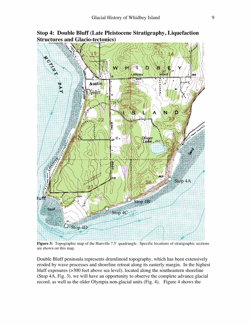
Stop 4: Double Bluff (Late Pleistocene Stratigraphy, Liquefaction Structures and Glacio-tectonics)
Figure 3: Topographic map of the Hanville 7.5’ quadrangle. Specific locations of stratigraphic sections are shown on this map. Double Bluff peninsula represents drumlinoid topography, which has been extensively eroded by wave processes and shoreline retreat along its easterly margin. In the highest bluff exposures (>300 feet above sea level), located along the southeastern shoreline (Stop 4A, Fig. 3), we will have an opportunity to observe the complete advance glacial record, as well as the older Olympia non-glacial units (Fig. 4). Figure 4 shows the
Stop 4A
Stop 4B
Stop 4C
Stop 4D

Glacial History of Whidbey Island 10
Glacial History of Whidbey Island 11
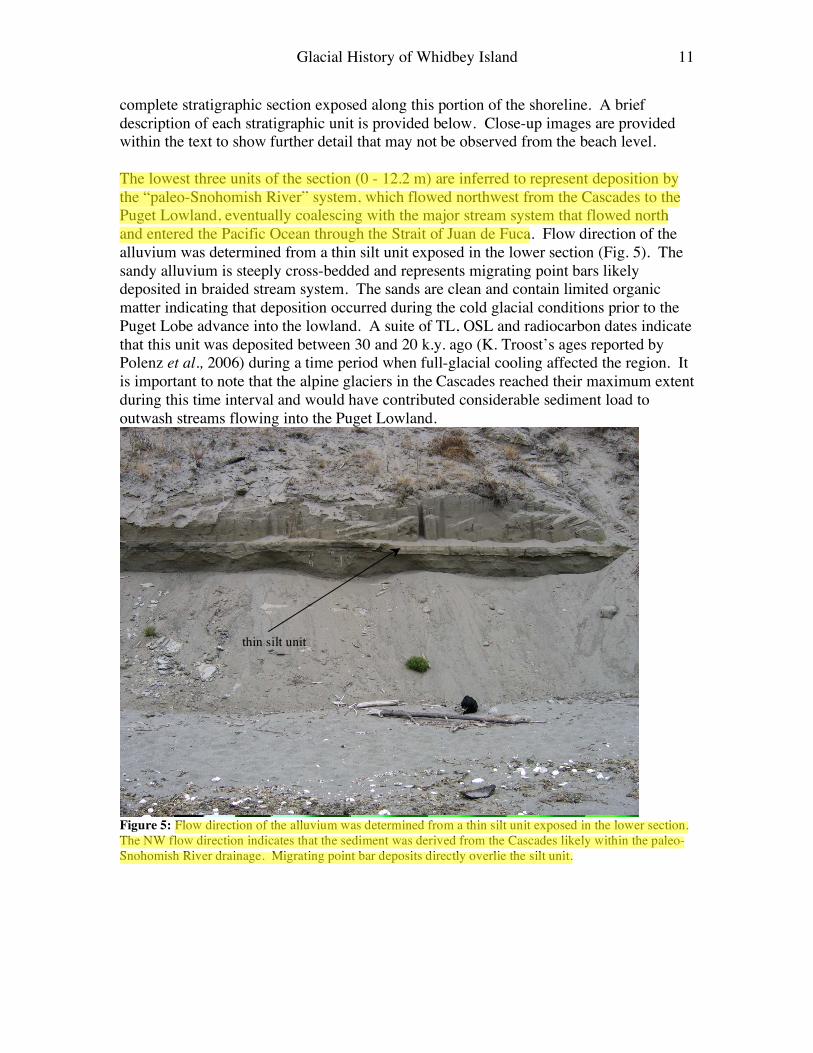
complete stratigraphic section exposed along this portion of the shoreline. A brief description of each stratigraphic unit is provided below. Close-up images are provided within the text to show further detail that may not be observed from the beach level. The lowest three units of the section (0 - 12.2 m) are inferred to represent deposition by the “paleo-Snohomish River” system, which flowed northwest from the Cascades to the Puget Lowland, eventually coalescing with the major stream system that flowed north and entered the Pacific Ocean through the Strait of Juan de Fuca. Flow direction of the alluvium was determined from a thin silt unit exposed in the lower section (Fig. 5). The sandy alluvium is steeply cross-bedded and represents migrating point bars likely deposited in braided stream system. The sands are clean and contain limited organic matter indicating that deposition occurred during the cold glacial conditions prior to the Puget Lobe advance into the lowland. A suite of TL, OSL and radiocarbon dates indicate that this unit was deposited between 30 and 20 k.y. ago (K. Troost’s ages reported by Polenz et al., 2006) during a time period when full-glacial cooling affected the region. It is important to note that the alpine glaciers in the Cascades reached their maximum extent during this time interval and would have contributed considerable sediment load to outwash streams flowing into the Puget Lowland.
Figure 5: Flow direction of the alluvium was determined from a thin silt unit exposed in the lower section. The NW flow direction indicates that the sediment was derived from the Cascades likely within the paleo-Snohomish River drainage. Migrating point bar deposits directly overlie the silt unit.
thin silt unit
Glacial History of Whidbey Island 12
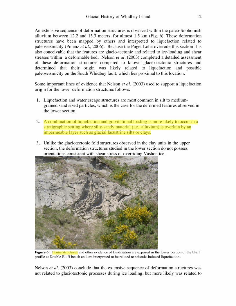
An extensive sequence of deformation structures is observed within the paleo-Snohomish alluvium between 12.2 and 15.3 meters, for almost 1.5 km (Fig. 6). These deformation structures have been mapped by others and interpreted to liquefaction related to paleoseismicity (Polenz et al., 2006). Because the Puget Lobe overrode this section it is also conceivable that the features are glacio-tectonic and related to ice-loading and shear stresses within a deformable bed. Nelson et al. (2003) completed a detailed assessment of these deformation structures compared to known glacio-tectonic structures and determined that their origin was likely related to liquefaction and possible paleoseismicity on the South Whidbey fault, which lies proximal to this location. Some important lines of evidence that Nelson et al. (2003) used to support a liquefaction origin for the lower deformation structures follows: 1. Liquefaction and water escape structures are most common in silt to medium-
grained sand sized particles, which is the case for the deformed features observed in the lower section.
2. A combination of liquefaction and gravitational loading is more likely to occur in a
stratigraphic setting where silty-sandy material (i.e., alluvium) is overlain by an impermeable layer such as glacial lacustrine silts or clays.
3. Unlike the glaciotectonic fold structures observed in the clay units in the upper
section, the deformation structures studied in the lower section do not possess orientations consistent with shear stress of overriding Vashon ice.
Figure 6: Flame structures and other evidence of fluidization are exposed in the lower portion of the bluff profile at Double Bluff beach and are interpreted to be related to seismic-induced liquefaction. Nelson et al. (2003) conclude that the extensive sequence of deformation structures was not related to glaciotectonic processes during ice loading, but more likely was related to
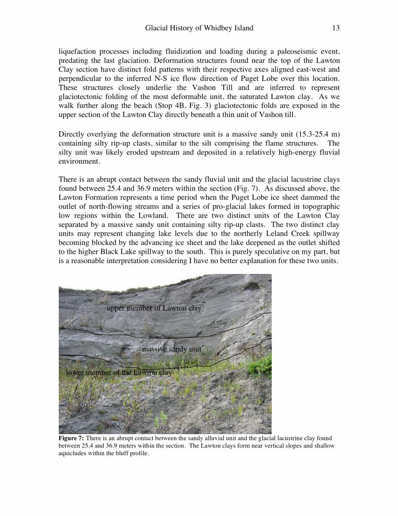
Glacial History of Whidbey Island 13
liquefaction processes including fluidization and loading during a paleoseismic event, predating the last glaciation. Deformation structures found near the top of the Lawton Clay section have distinct fold patterns with their respective axes aligned east-west and perpendicular to the inferred N-S ice flow direction of Puget Lobe over this location. These structures closely underlie the Vashon Till and are inferred to represent glaciotectonic folding of the most deformable unit, the saturated Lawton clay. As we walk further along the beach (Stop 4B, Fig. 3) glaciotectonic folds are exposed in the upper section of the Lawton Clay directly beneath a thin unit of Vashon till. Directly overlying the deformation structure unit is a massive sandy unit (15.3-25.4 m) containing silty rip-up clasts, similar to the silt comprising the flame structures. The silty unit was likely eroded upstream and deposited in a relatively high-energy fluvial environment. There is an abrupt contact between the sandy fluvial unit and the glacial lacustrine clays found between 25.4 and 36.9 meters within the section (Fig. 7). As discussed above, the Lawton Formation represents a time period when the Puget Lobe ice sheet dammed the outlet of north-flowing streams and a series of pro-glacial lakes formed in topographic low regions within the Lowland. There are two distinct units of the Lawton Clay separated by a massive sandy unit containing silty rip-up clasts. The two distinct clay units may represent changing lake levels due to the northerly Leland Creek spillway becoming blocked by the advancing ice sheet and the lake deepened as the outlet shifted to the higher Black Lake spillway to the south. This is purely speculative on my part, but is a reasonable interpretation considering I have no better explanation for these two units.
Figure 7: There is an abrupt contact between the sandy alluvial unit and the glacial lacustrine clay found between 25.4 and 36.9 meters within the section. The Lawton clays form near vertical slopes and shallow aquicludes within the bluff profile.
upper member of Lawton clay
massive sandy unit
lower member of the Lawton clay
Glacial History of Whidbey Island 14
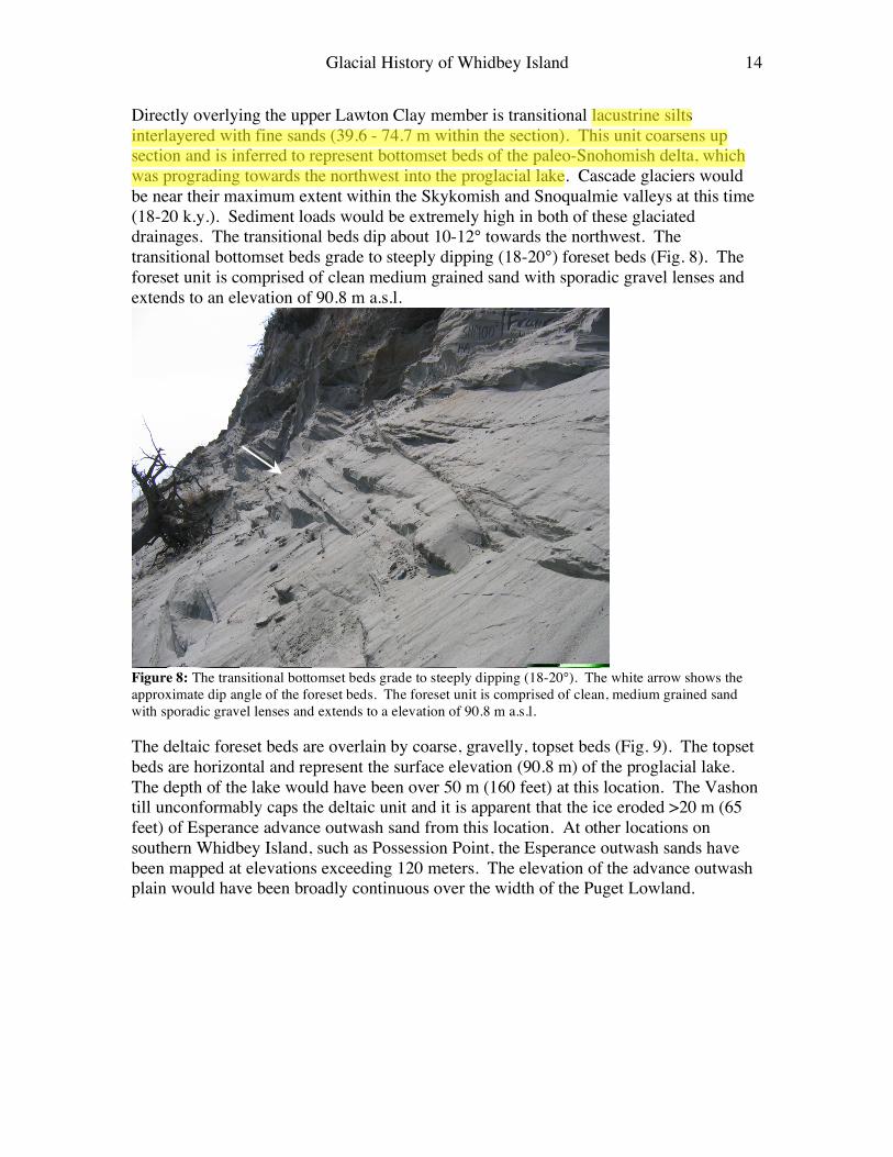
Directly overlying the upper Lawton Clay member is transitional lacustrine silts interlayered with fine sands (39.6 - 74.7 m within the section). This unit coarsens up section and is inferred to represent bottomset beds of the paleo-Snohomish delta, which was prograding towards the northwest into the proglacial lake. Cascade glaciers would be near their maximum extent within the Skykomish and Snoqualmie valleys at this time (18-20 k.y.). Sediment loads would be extremely high in both of these glaciated drainages. The transitional beds dip about 10-12° towards the northwest. The transitional bottomset beds grade to steeply dipping (18-20°) foreset beds (Fig. 8). The foreset unit is comprised of clean medium grained sand with sporadic gravel lenses and extends to an elevation of 90.8 m a.s.l.
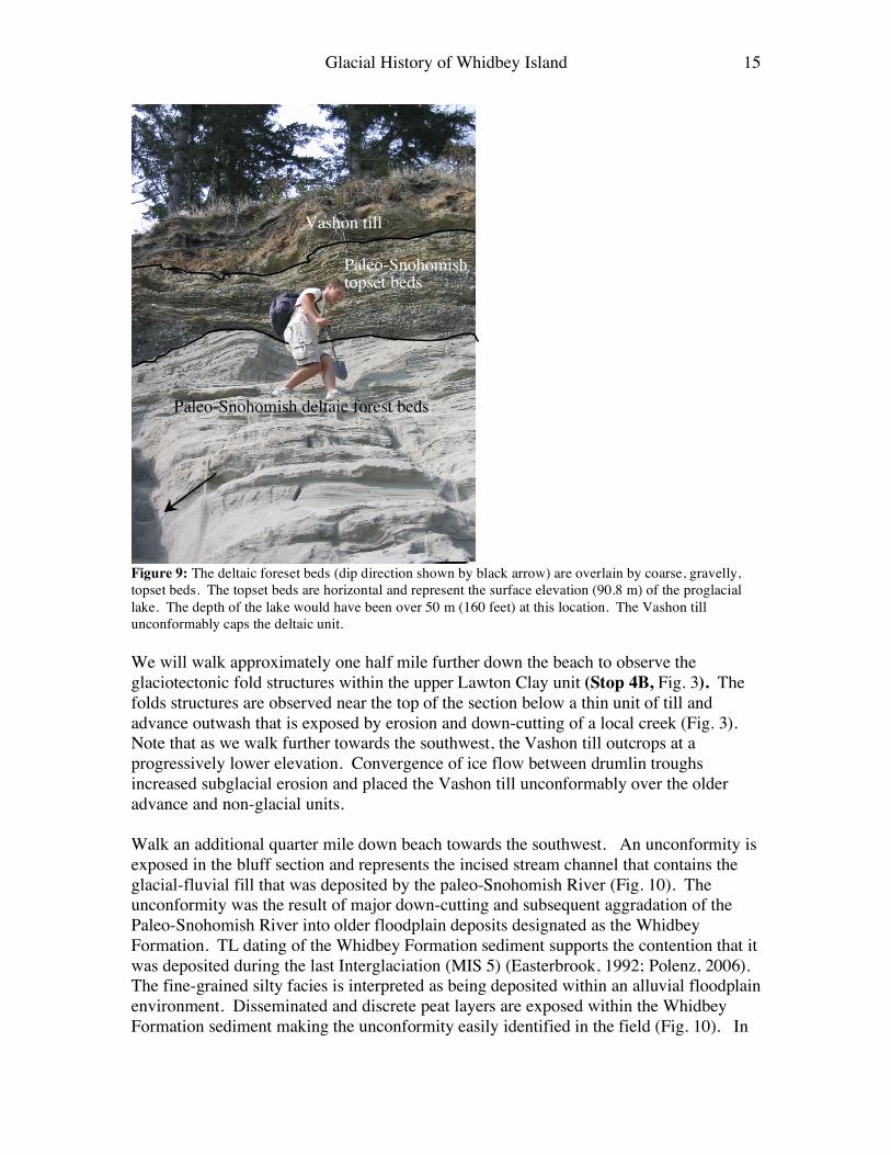
Figure 8: The transitional bottomset beds grade to steeply dipping (18-20°). The white arrow shows the approximate dip angle of the foreset beds. The foreset unit is comprised of clean, medium grained sand with sporadic gravel lenses and extends to a elevation of 90.8 m a.s.l. The deltaic foreset beds are overlain by coarse, gravelly, topset beds (Fig. 9). The topset beds are horizontal and represent the surface elevation (90.8 m) of the proglacial lake. The depth of the lake would have been over 50 m (160 feet) at this location. The Vashon till unconformably caps the deltaic unit and it is apparent that the ice eroded >20 m (65 feet) of Esperance advance outwash sand from this location. At other locations on southern Whidbey Island, such as Possession Point, the Esperance outwash sands have been mapped at elevations exceeding 120 meters. The elevation of the advance outwash plain would have been broadly continuous over the width of the Puget Lowland.
Glacial History of Whidbey Island 15
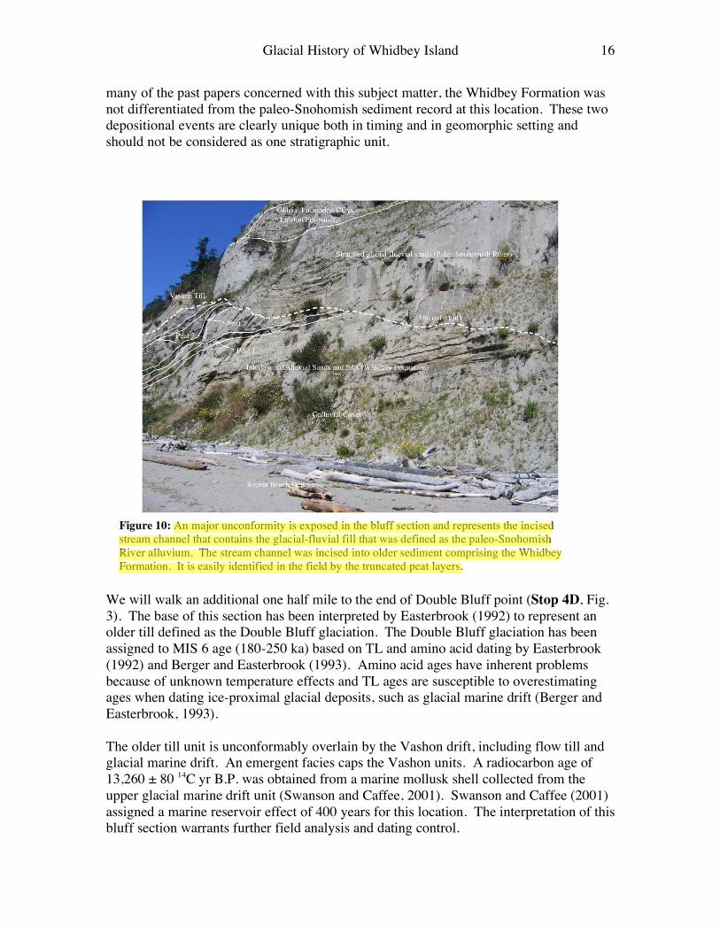
Figure 9: The deltaic foreset beds (dip direction shown by black arrow) are overlain by coarse, gravelly, topset beds. The topset beds are horizontal and represent the surface elevation (90.8 m) of the proglacial lake. The depth of the lake would have been over 50 m (160 feet) at this location. The Vashon till unconformably caps the deltaic unit. We will walk approximately one half mile further down the beach to observe the glaciotectonic fold structures within the upper Lawton Clay unit (Stop 4B, Fig. 3). The folds structures are observed near the top of the section below a thin unit of till and advance outwash that is exposed by erosion and down-cutting of a local creek (Fig. 3). Note that as we walk further towards the southwest, the Vashon till outcrops at a progressively lower elevation. Convergence of ice flow between drumlin troughs increased subglacial erosion and placed the Vashon till unconformably over the older advance and non-glacial units. Walk an additional quarter mile down beach towards the southwest. An unconformity is exposed in the bluff section and represents the incised stream channel that contains the glacial-fluvial fill that was deposited by the paleo-Snohomish River (Fig. 10). The unconformity was the result of major down-cutting and subsequent aggradation of the Paleo-Snohomish River into older floodplain deposits designated as the Whidbey Formation. TL dating of the Whidbey Formation sediment supports the contention that it was deposited during the last Interglaciation (MIS 5) (Easterbrook, 1992; Polenz, 2006). The fine-grained silty facies is interpreted as being deposited within an alluvial floodplain environment. Disseminated and discrete peat layers are exposed within the Whidbey Formation sediment making the unconformity easily identified in the field (Fig. 10). In
Paleo-Snohomish deltaic forest beds
Paleo-Snohomish topset beds
Vashon till
Glacial History of Whidbey Island 16
many of the past papers concerned with this subject matter, the Whidbey Formation was not differentiated from the paleo-Snohomish sediment record at this location. These two depositional events are clearly unique both in timing and in geomorphic setting and should not be considered as one stratigraphic unit.
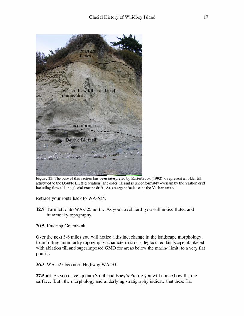
We will walk an additional one half mile to the end of Double Bluff point (Stop 4D, Fig. 3). The base of this section has been interpreted by Easterbrook (1992) to represent an older till defined as the Double Bluff glaciation. The Double Bluff glaciation has been assigned to MIS 6 age (180-250 ka) based on TL and amino acid dating by Easterbrook (1992) and Berger and Easterbrook (1993). Amino acid ages have inherent problems because of unknown temperature effects and TL ages are susceptible to overestimating ages when dating ice-proximal glacial deposits, such as glacial marine drift (Berger and Easterbrook, 1993). The older till unit is unconformably overlain by the Vashon drift, including flow till and glacial marine drift. An emergent facies caps the Vashon units. A radiocarbon age of 13,260 ± 80 14C yr B.P. was obtained from a marine mollusk shell collected from the upper glacial marine drift unit (Swanson and Caffee, 2001). Swanson and Caffee (2001) assigned a marine reservoir effect of 400 years for this location. The interpretation of this bluff section warrants further field analysis and dating control.
Figure 10: An major unconformity is exposed in the bluff section and represents the incised stream channel that contains the glacial-fluvial fill that was defined as the paleo-Snohomish River alluvium. The stream channel was incised into older sediment comprising the Whidbey Formation. It is easily identified in the field by the truncated peat layers.
Glacial History of Whidbey Island 17
Figure 11: The base of this section has been interpreted by Easterbrook (1992) to represent an older till attributed to the Double Bluff glaciation. The older till unit is unconformably overlain by the Vashon drift, including flow till and glacial marine drift. An emergent facies caps the Vashon units. Retrace your route back to WA-525. 12.9 Turn left onto WA-525 north. As you travel north you will notice fluted and
hummocky topography. 20.5 Entering Greenbank. Over the next 5-6 miles you will notice a distinct change in the landscape morphology, from rolling hummocky topography, characteristic of a deglaciated landscape blanketed with ablation till and superimposed GMD for areas below the marine limit, to a very flat prairie. 26.3 WA-525 becomes Highway WA-20. 27.5 mi As you drive up onto Smith and Ebey’s Prairie you will notice how flat the surface. Both the morphology and underlying stratigraphy indicate that these flat
Unconformity
Double Bluff till
emergent facies
Vashon flow till and glacial marine drift
Glacial History of Whidbey Island 18
surfaces are defined by topset beds of moraine delta (See Lidar image, Fig. 2). During the retreat of the Puget Lobe over north Whidbey Island, it readvanced over the landscape south near Penn Cove. In North- Central Whidbey Everson Glacial Marine Drift has becomes more prevalent in the stratigraphic record, as the marine high stand progressively increases as you we drove north. The planar surfaces of each prairie is representative of the topset surface of two ice-contact moraine deltas. We will spend much of the afternoon studying the facies changes that exist when ice readvances into a marine environment. Domack (1983) and Dethier et al., (1995) provide a nice overview on glacial marine drift sedimentation and facies changes and the interplay between eustasy and isostasy on relative sea level. 30.7 mi Terry Rd. descends between two morainal deltas that were in contact with the readvancing ice from the northwest. At our next four stops we will observe and discuss the major facies changes described by Domack (1983), and also observe kettle and kame topography.
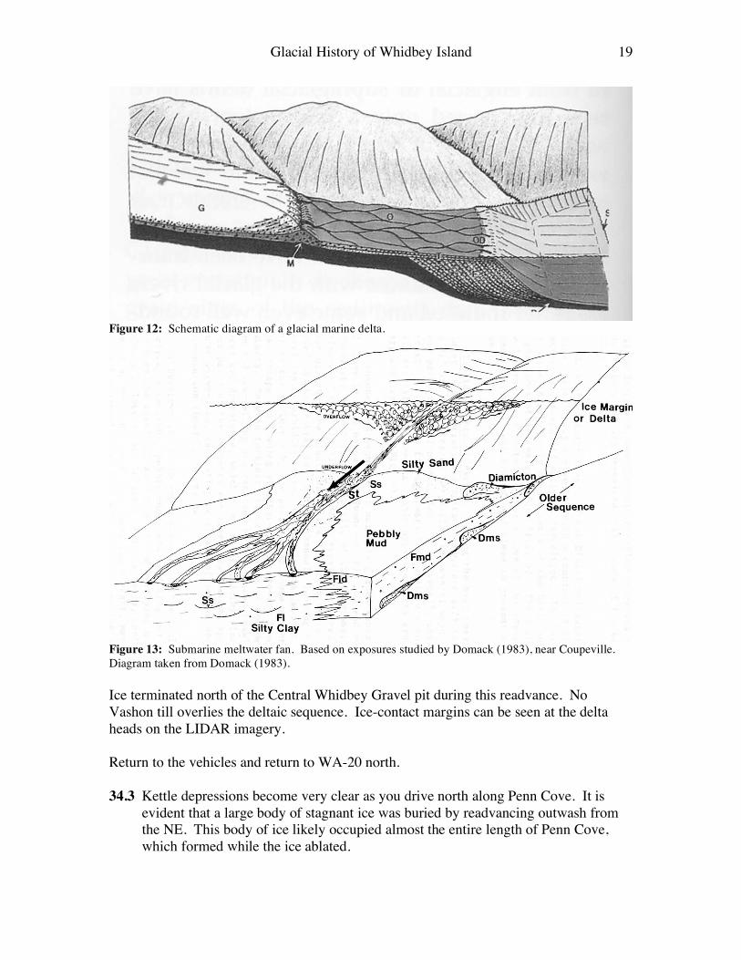
31.55 mi As you enter the town of Coupeville, turn left (west) onto S. Main St. Go past the school. 31.7 mi Turn right into the driveway of the Big Rock Apartments. Drive around the back of the apartments and park on the right side of the parking lot where you do not block local residents from backing out. Stop 5: The Coupeville Erratic This is one of the more famous glacial field boulders on Whidbey Island. This greenstone “erratic” was glacially quarried from Mt. Erie 40 km to the north. The boulder is situated between two deltas. This boulder was used for a calibration site by Swanson and Caffee (2001) to solve for 36Cl production rates. Return to the vehicles and retrace the route back to WA-20. Turn left onto WA-20 north. 33.6 mi Pull over to the right into the slow vehicle turn out. Stop 6: Central Whidbey Gravel Pit (Deltaic Facies.) Take the dirt access road on the right to the Central Whidbey Gravel pit. The gravel excavation provides us an opportunity to observe the internal structure of post-glacial marine delta (Fig. 12). Foreset beds dip to the SSW. The upper surface of the gravel pit has been disturbed and reworked. Vashon till was found at the base near sea level at Penn Cove.
Glacial History of Whidbey Island 19
Figure 12: Schematic diagram of a glacial marine delta.
Figure 13: Submarine meltwater fan. Based on exposures studied by Domack (1983), near Coupeville. Diagram taken from Domack (1983). Ice terminated north of the Central Whidbey Gravel pit during this readvance. No Vashon till overlies the deltaic sequence. Ice-contact margins can be seen at the delta heads on the LIDAR imagery. Return to the vehicles and return to WA-20 north. 34.3 Kettle depressions become very clear as you drive north along Penn Cove. It is
evident that a large body of stagnant ice was buried by readvancing outwash from the NE. This body of ice likely occupied almost the entire length of Penn Cove, which formed while the ice ablated.
Glacial History of Whidbey Island 20
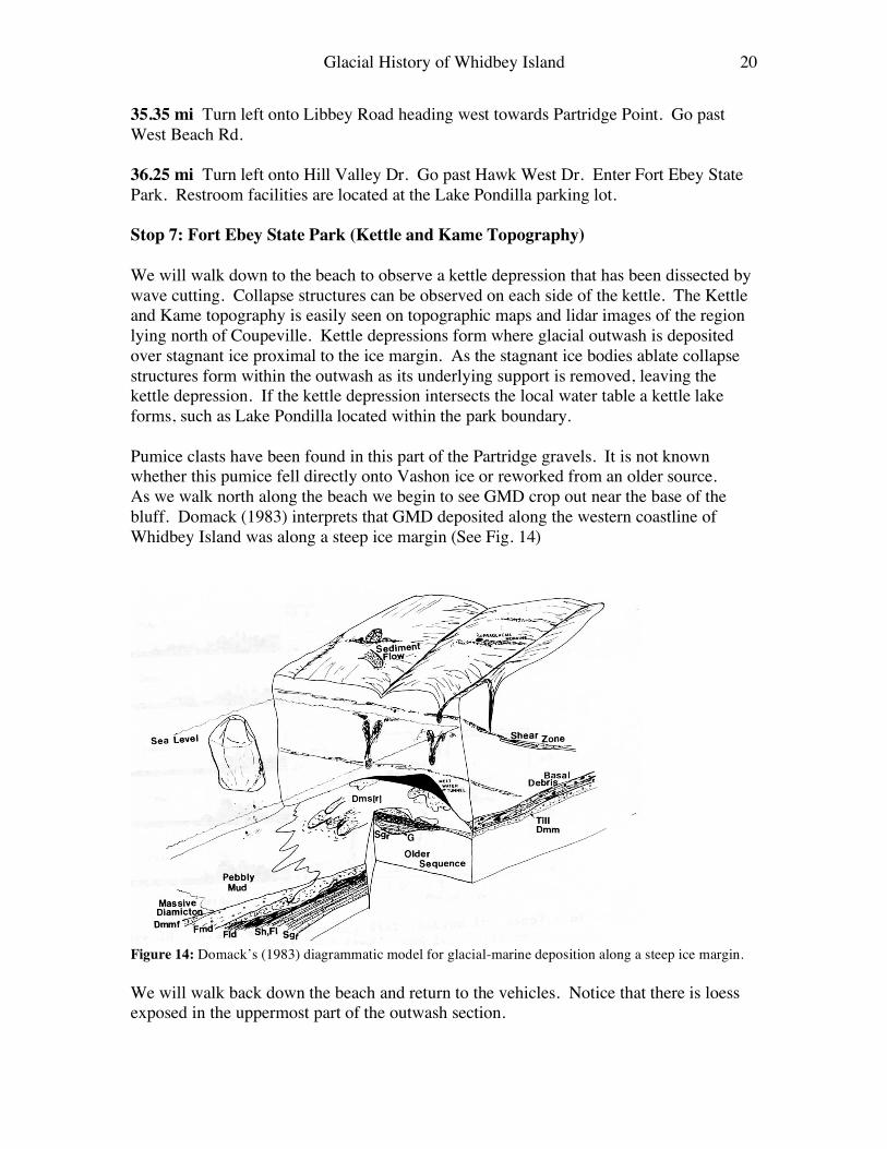
35.35 mi Turn left onto Libbey Road heading west towards Partridge Point. Go past West Beach Rd. 36.25 mi Turn left onto Hill Valley Dr. Go past Hawk West Dr. Enter Fort Ebey State Park. Restroom facilities are located at the Lake Pondilla parking lot. Stop 7: Fort Ebey State Park (Kettle and Kame Topography) We will walk down to the beach to observe a kettle depression that has been dissected by wave cutting. Collapse structures can be observed on each side of the kettle. The Kettle and Kame topography is easily seen on topographic maps and lidar images of the region lying north of Coupeville. Kettle depressions form where glacial outwash is deposited over stagnant ice proximal to the ice margin. As the stagnant ice bodies ablate collapse structures form within the outwash as its underlying support is removed, leaving the kettle depression. If the kettle depression intersects the local water table a kettle lake forms, such as Lake Pondilla located within the park boundary. Pumice clasts have been found in this part of the Partridge gravels. It is not known whether this pumice fell directly onto Vashon ice or reworked from an older source. As we walk north along the beach we begin to see GMD crop out near the base of the bluff. Domack (1983) interprets that GMD deposited along the western coastline of Whidbey Island was along a steep ice margin (See Fig. 14)
Figure 14: Domack’s (1983) diagrammatic model for glacial-marine deposition along a steep ice margin. We will walk back down the beach and return to the vehicles. Notice that there is loess exposed in the uppermost part of the outwash section.
Glacial History of Whidbey Island 21
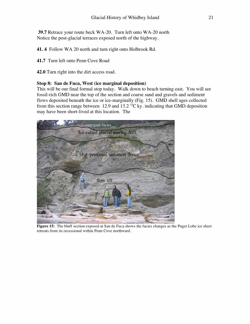
39.7 Retrace your route beck WA-20. Turn left onto WA-20 north Notice the post-glacial terraces exposed north of the highway. 41. 4 Follow WA 20 north and turn right onto Holbrook Rd. 41.7 Turn left onto Penn Cove Road 42.0 Turn right into the dirt access road. Stop 8: San de Fuca, West (ice marginal deposition) This will be our final formal stop today. Walk down to beach turning east. You will see fossil-rich GMD near the top of the section and coarse sand and gravels and sediment flows deposited beneath the ice or ice-marginally (Fig. 15). GMD shell ages collected from this section range between 12.9 and 13.2 14C ky. indicating that GMD deposition may have been short-lived at this location. The
Figure 15: The bluff section exposed at San de Fuca shows the facies changes as the Puget Lobe ice sheet retreats from its recessional within Penn Cove northward.
flow till
Ice-proximal sediment flows
Ice-rafted glacial marine drift emergent facies
Glacial History of Whidbey Island 22
Fig. 9: Ice-marginal marine deposition similar to what Domack observed near San de Fuca, West. On the west side of the beach entrance, a Native American midden site exists directly below the lower terrace surface. Radiocarbon ages are less than 3000 14C years old for this site. The site was largely used for preparation and disposal of shellfish. Selected References Armstrong, J.E., Crandell, D.R., Easterbrook, D.J., and Noble, J.B. (1965). Late
Pleistocene stratigraphy and chronology in southwestern British Columbia and northwestern Washington, Geological Society of America Bulletin. 76, 321-330.
Berger, G.W. and Easterbrook, D.J. (1993). Thermo luminescence dating tests for
lacustrine, glaciomarine, and floodplain sediments from western Washington and British Columbia. Canadian Journal of Earth Sciences 30, 1815-1828.
Booth, D.B., Troost, K.G., Clague, J.J., Waitt, R.B. (2004). The Cordilleran ice sheet. In
Gillespie, A.R., Porter, S.C., Atwater, B.F. The Quaternary period in the United State: Elsevier Publishers, p. 17-43.
Booth, D.B. (1987). Timing and processes of deglaciation long the southern margin of
the Cordilleran ice sheet. In, “North America and Adjacent Oceans during the Last Deglaciation” (W.F. Ruddiman and H.E. Wright, Eds., 71-90, the Geology of North America, Vol K3 Geological society of America, Boulder.
Glacial History of Whidbey Island 23
Dethier, D.P., Pessel Jr., F, Keuler, R.., Balzarini, M.A., and Pevear, D.R. (1995). Late
Wisconsinan glaciomarine deposition and isostatic rebound, northern Puget Lowland, Washington. GSA Bulletin 107, 1288-1303.
Domack, E.W. (1983). Facies of late Pleistocene glacial-marine sediments on Whidbey
Island, Washington: An isostatic glacial-marine sequence in Molnia, B.F., ed Glacial-marine sedimentation: New York, Plenum, 535-570.
Easterbrook, D.J. (1992). Advance and retreat of cordilleran ice sheets in Washington,
U.S.A. Geographie physique et Quaternaire 46, 51-68. Gerstel, W.J., Brunengo, M.J., Lingley Jr., W.S., Logan, R.L. Shipman, H., and Walsh,
T.J. 1997. Puget Sound Bluffs: The Where, Why, and When of Landslides Following the Holiday 1996/97 Storms. Washington Geology 25, 17-31.
Nelson C., Mohadjer, S. and Swanson, T.W. (2003). Comparative evaluation of
deformation structures exposed in the Double Bluff stratigraphy of Whidbey Island, WA. Geological Society of America Abstracts with Program. Seattle WA. 27-5.
Polenz, M., Schasse, H.W., Petersen, B.B. (2006). Geologic Map of Freeland and
Northern Part of the Hanville 7.5-minute Quadrangles, Island County, Washington: Washington Division of Geology and Earth Resources Geologic Map GM-64, 1 sheet, scale 1:24,000.
Polenz, M., Slaughter, S.L., Thorsen, G.W. (2005). Geologic Map of the Coupeville and
part of the Port Townsend North 7.5-minute quadrangles, Island County, Washington: Washington Division of Geology and Earth Resources Geologic Map GM-58, 1 sheet, scale 1:24,000.
Porter, S.C., and Swanson, T.W. (1998). Advance and Retreat rate of the Cordilleran Ice
Sheet in southeastern Puget Sound Region. Quaternary Research 50, 205-213. Swanson, T.W. and Caffee, M. (2001). Determination of 36Cl production rates derived
from the well-dated deglaciation surfaces of Whidbey and Fidalgo islands, Washington. Quaternary Research 56, 366-382.
Thorson, R.M. (1980). Ice-sheet glaciation of the Puget lowland, Washington during the
Vashon Stade (Late Pleistocene). Quaternary Research. 13, 303-321. Thorson, R.M. (1989). Glacio-isostatic response of the Puget Sound area, Washington: Geological Society of America Bulletin, 101, 1163-1174.