Embed Size (px)
Citation preview
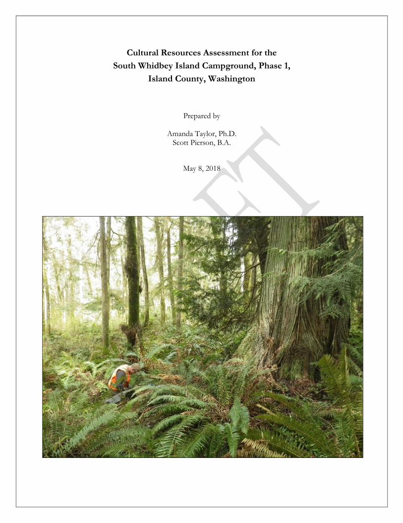
Cultural Resources Assessment for the
South Whidbey Island Campground, Phase 1,
Island County, Washington
Prepared by
Amanda Taylor, Ph.D. Scott Pierson, B.A.
May 8, 2018

Cover Photo: Large second growth western redcedar observed in the southern portion of Loop A.
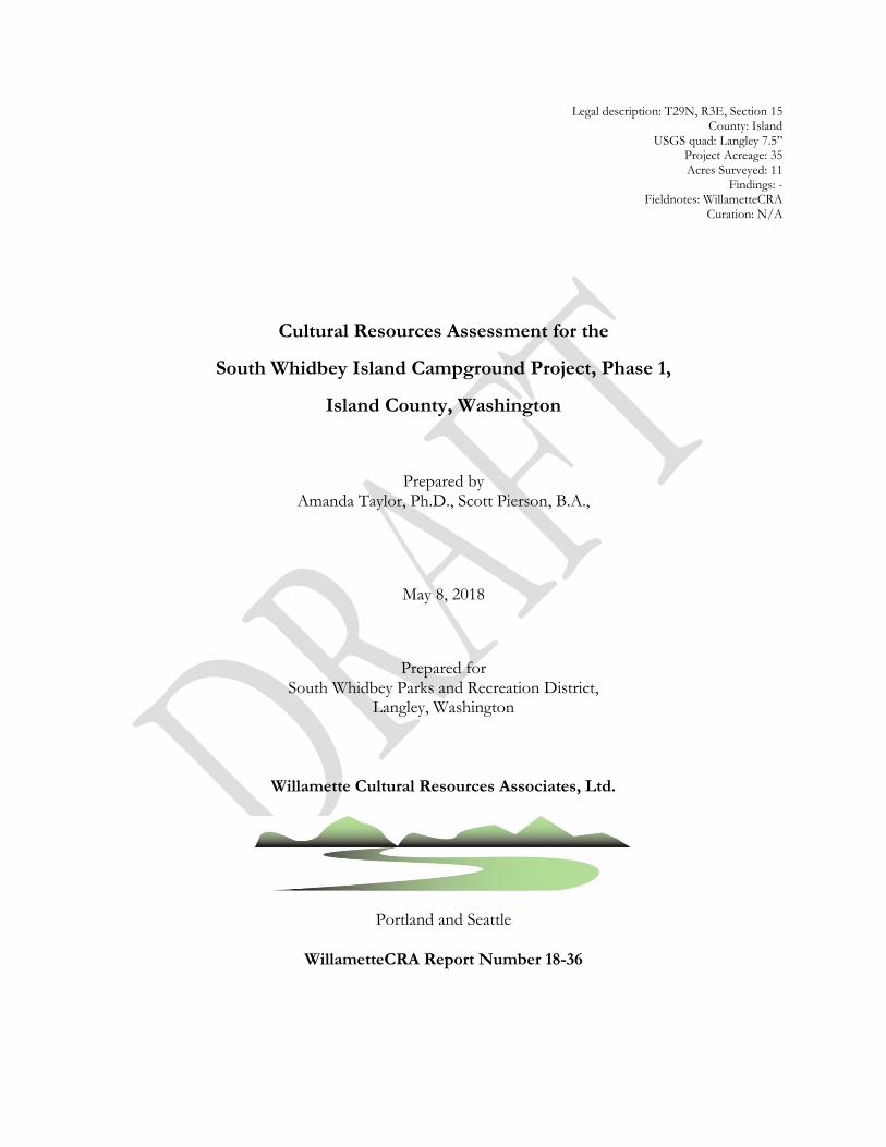
Legal description: T29N, R3E, Section 15 County: Island
USGS quad: Langley 7.5” Project Acreage: 35 Acres Surveyed: 11
Findings: - Fieldnotes: WillametteCRA
Curation: N/A
Cultural Resources Assessment for the
South Whidbey Island Campground Project, Phase 1,
Island County, Washington
Prepared by Amanda Taylor, Ph.D., Scott Pierson, B.A.,
May 8, 2018
Prepared for South Whidbey Parks and Recreation District,
Langley, Washington
Willamette Cultural Resources Associates, Ltd.
Portland and Seattle
WillametteCRA Report Number 18-36


i
Table of Contents
List of Figures .............................................................................................................................................. ii
Introduction ................................................................................................................................................. 1
Regulatory Context ................................................................................................................................ 1
Project Location and Description ........................................................................................................ 2
Project Area Setting and Background ...................................................................................................... 2
Geology .................................................................................................................................................... 2
Paleoenvironment .................................................................................................................................. 5
Precontact Native American History .................................................................................................. 5
Native Peoples ........................................................................................................................................ 7
Euroamerican Development ................................................................................................................ 8
Previous Archaeological Investigations ................................................................................................. 11
Expectations .............................................................................................................................................. 12
Archaeological Field Investigations........................................................................................................ 12
Field Methods ....................................................................................................................................... 12
Results .................................................................................................................................................... 14
Conclusions and Recommendations ...................................................................................................... 19
References Cited ....................................................................................................................................... 21
Appendix A: Summary of Shovel Probe Results
ii
List of Figures
Figure 1. Location of the project area. ............................................................................................................ 3
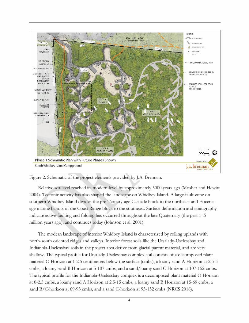
Figure 2. Schematic of the project elements provided by J.A. Bennan. .................................................... 4
Figure 3. Project area depicted on 1874 GLO Map (Bureau of Land Management 2004). ................. 10
Figure 4. Project area depicted on a 1960 Metsker Map (Metsker 1960). ............................................... 10
Figure 5. Project area depicted on a 1963 aerial photograph. ................................................................... 11
Figure 6. Aerial image showing project area and location of shovel probes and test trenches. ........... 13
Figure 7. Overview of the project area from northeast corner of Loop A, view facing west. ............. 15
Figure 8. Overview of the project area from the southwest corner of Loop A, view facing west. ..... 15
Figure 9. Second growth western redcedar tree at location of SP 7, view facing north. ....................... 16
Figure 10. Notched western redcedar, view facing west. ........................................................................... 16
Figure 11. Notched western redcedar close-up, view facing west. ........................................................... 17
Figure 12. Disturbed road area in foreground. Excavator at TS 1, view facing south. ......................... 17
Figure 13. Soil profile for SP 8, plan view with north facing down. ........................................................ 18
Figure 14. Profile for TS 6, view to the south. ............................................................................................ 18
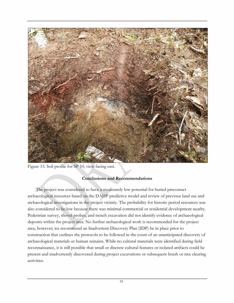
Figure 15. Soil profile for SP 10, view facing east. ...................................................................................... 19
1
Introduction
The South Whidbey Parks and Recreation District (SWPRD) plans to construct a campground
on a forested lot adjacent to South Whidbey High School near the City of Langley, Island County,
Washington. The SWPRD contracted with Willamette Cultural Resources Associates, Ltd.
(WillametteCRA) to conduct a cultural resources assessment of the proposed project area in
compliance with Washington State historic preservation regulations. This report presents the results
of our study.
The current cultural resources investigation consisted of a review of records on file with the
Washington State Department of Archaeology and Historic Preservation’s (DAHP) online database
system (WISAARD), a limited review of historic maps and archival materials, contact with the
affected Tribes, and pedestrian survey and shovel probing of the project area. WillametteCRA staff
conducted archaeological fieldwork on April 18, 2018. We identified no archaeological resources,
and no further cultural resources management measures are recommended.
Regulatory Context
The proposed South Whidbey Island Campground Project Phase 1 is receiving funding from
the Washington State Recreation and Conservation Office (RCO), and is therefore subject to review
under the Governor’s Executive Order No. 05-05. The project may also be subject to the provisions
of SEPA and its implementing rules contained in the Washington Administrative Code [WAC 197-
11], which require project proponents to identify any places or objects on or adjacent to the project
that are listed in, or eligible for, national, state, or local preservation registers, and to identify sites of
archaeological, scientific, or cultural importance on or adjacent to the project. Project proponents
are required to describe proposed measures to reduce or control impacts to those places, objects,
and sites.
Other potentially applicable Washington state laws address archaeological sites and Native
American burials. The Archaeological Sites and Resources Act [RCW 27.53] prohibits knowingly
excavating or disturbing prehistoric and historic archaeological sites on public or private land. The
Indian Graves and Records Act [RCW 27.44] prohibits knowingly destroying American Indian
graves and provides that inadvertent disturbance through construction or other activities requires re-
interment under supervision of the appropriate Indian tribe. To prevent the looting or depredation
of sites, any maps, records, or other information identifying the location of archaeological sites,
historic sites, artifacts, or the site of traditional ceremonial, or social uses and activities of Indian
Tribes are exempt from disclosure [RCW 42.56.300].
WillametteCRA contacted cultural resource representatives of the Tulalip, Swinomish,
Stillaguamish, Samish, Suquamish, Snoqualmie, Sauk-Suiattle, and Upper Skagit tribes with an
2
informal (non-consultation) technical inquiry regarding concerns they may have for cultural
resources specific to this project location and invited them to visit or participate in the fieldwork.
Project Location and Description
The project area is on a forested, gently sloping inland landform averaging approximately 50
meters above sea level within Township 29N, Range 3E, Section 15, Willamette Meridian, south of
the town of Langley on Whidbey Island in Island County (Figure 1). The tax parcel number is
R32910-091-3750. It is approximately 2.5 kilometers (km) west of the Saratoga Passage and 0.8 km
west of an unnamed creek. The SWPRD plans to build a new campground on an existing system of
logging roads within the parcel. Activities associated with potential subsurface impacts include road
construction, tree and brush clearing and ground leveling for campsites, and construction of a pay
station and washroom. WillametteCRA conducted a cultural resources survey for the 11-acre Phase
1 (Loop A) portion of the proposed 35-acre parcel (Figure 2). Aside from an access road and logging
trails, the property has not been developed. There is currently no public access to the project area.
Project Area Setting and Background
Geology, paleoenvironment, and previous ethnographic and archaeological studies provide
general expectation that informs our field survey methodology and provides context for interpreting
the depositional environment, integrity, and significance of cultural resources identified during
archival and field research.
Geology
Past global climate change caused the advance and retreat of large ice sheets that shaped the
landscape of northern Puget Sound. During the cool Fraser glaciation period 30-10,000 calibrated
years before the present (BP), the Puget lobe of the Cordilleran Ice Sheet advanced into the Puget
Lowland between the Olympic and Cascade Mountain Ranges. The ice retreated when the climate
warmed toward the end of that period, and by ca. 15,000 years ago it had left behind glacial drift and
Vashon till on the deglaciated landscape (Armstrong et al. 1965; Easterbrook 1986; Porter and
Swanson 1998). Detailed topographic LIDAR images of the landscape on Whidbey Island show the
ice flow direction across the surface of the island; Vashon till is visible on the images, exposed in the
eroding landforms on Double Bluff (Haugerud et al. 2003). When the glacial ice rested upon the
Puget Lowland during the Fraser glaciation, the land was depressed and sea level was higher relative
to modern sea level. As the ice melted, the land rose (isostatic uplift), which caused relative sea level
to be lower than it is today. As a result, during the early Holocene beginning around 10,000 years
ago, rivers and streams had higher energy and incised glacial deposits. However, global (eustatic) sea
level was also rising as continental glaciers melted, so sea level rose again, river and stream energy
slowed, and deltas formed in the Puget Lowland (Dragovich et al. 2002; Porter and Swanson 1998).

3
Figure 1. Location of the project area.
4
Figure 2. Schematic of the project elements provided by J.A. Brennan.
Relative sea level reached its modern level by approximately 5000 years ago (Mosher and Hewitt
2004). Tectonic activity has also shaped the landscape on Whidbey Island. A large fault zone on
southern Whidbey Island divides the pre-Tertiary-age Cascade block to the northeast and Eocene-
age marine basalts of the Coast Range block to the southeast. Surface deformation and stratigraphy
indicate active faulting and folding has occurred throughout the late Quaternary (the past 1-.5
million years ago), and continues today (Johnson et al. 2001).
The modern landscape of interior Whidbey Island is characterized by rolling uplands with
north-south oriented ridges and valleys. Interior forest soils like the Utsalady-Uselessbay and
Indianola-Uselessbay soils in the project area derive from glacial parent material, and are very
shallow. The typical profile for Utsalady-Uselessbay complex soil consists of a decomposed plant
material O Horizon at 1-2.5 centimeters below the surface (cmbs), a loamy sand A Horizon at 2.5-5
cmbs, a loamy sand B Horizon at 5-107 cmbs, and a sand/loamy sand C Horizon at 107-152 cmbs.
The typical profile for the Indianola-Uselessbay complex is a decomposed plant material O Horizon
at 0-2.5 cmbs, a loamy sand A Horizon at 2.5-15 cmbs, a loamy sand B Horizon at 15-69 cmbs, a
sand B/C-horizon at 69-93 cmbs, and a sand C-horizon at 93-152 cmbs (NRCS 2018).
5
Paleoenvironment
Alongside glaciation and sea level changes, climate shifts altered vegetation communities in the
northern Puget Sound region and have shaped the landscape of this region into its condition we see
today (see Whitlock and Knox 2002; Weiser 2006). Due to the rainshadow effect of the Olympic
Mountains, Whidbey Island is drier than the adjacent mainland. The Early Holocene (11,000-7,800
years ago) was characterized by a dry climate with slightly higher temperatures than today, and
naturally occurring prairies amid red alder and Douglas-fir forests. In the Middle Holocene (7,800-
4,400 BP), the climate became cooler and wetter. Open prairies decreased in size, and forests
dominated by western redcedar, western hemlock, Oregon ash, and big leaf maple expanded. In the
Late Holocene (4,400-present), the climate was like today with the exception of a warm, dry Fraser
Valley Fire Period (2,400-1,200 BP). Natural prairies shrank, but anthropogenic burning maintained
open areas (Weiser 2006). Today, the Western Hemlock Zone forests of interior Whidbey Island
include western hemlock, western red cedar, Douglas-fir, big leaf maple, and madrone with
understory bracken fern, salmonberry, ocean spray, and red and evergreen huckleberry (Franklin and
Dryness 1973).
Faunal communities have been affected by changes in climate, vegetation and human predation.
Bison, mammoth, and other large mammals were present in the greater Puget Sound and Straits
region until the end of the Ice Age (Wilson et al. 2009), along with wolves, bear, and elk which were
extirpated by human farming and hunting by the 1850s (White 1980). Mammals on the island today
include deer, raccoons, weasels, and skunks. The island is also rich in waterfowl (Bryan 1963; White
1980). Aquatic resources include freshwater fish, several species of salmon, steelhead, flounder,
perch, rockfish, dogfish, greenling, herring, smelt and sole (Miller and Borton 1980). In intertidal
environments, there are mussels, littleneck and butter clams, oysters, sea urchins, acorn barnacles
and a variety of other shellfish (Kozloff 1996). Marine mammals noted in the area include orca and
gray whales, harbor seals, sea lions and porpoises (Ingles 1965). People who lived on Whidbey Island
had good access to plant and animal resources, and the locations and abundance of these resources
provides an important context for archaeological investigations.
Precontact Native American History
In the early 1900s, the Jesup North Pacific Expedition explored the Northwest Coast. Harlan
Smith directed the archaeological research effort, and recorded observations about several shell
middens and rock cairns on Whidbey Island (Smith 1907). In the 1950s, additional sites on Whidbey
Island were recorded when the University of Washington Department of Anthropology funded a
shoreline survey of Skagit, Snohomish, and Island Counties (Bryan 1963). As development increased
in Island County in the 1970s, more small-scale cultural resources surveys were conducted. Wessen
(1988) conducted an extensive survey of archaeological sites in Island County in 1987-1988. He
relocated and reported on previously recorded sites that were mostly on shorelines, although he also
6
surveyed some inland areas to find previously unrecorded sites. On southern Whidbey Island,
Wessen noted that of 16 previously recorded sites, all were on shorelines, 12 were shell middens and
4 were earthworks. Only 3 could be relocated due to erosion and development. Since that time, most
archaeological work on Whidbey Island has been associated with cultural resources management
projects with the exception of Weiser’s research on ancient land management on Ebey’s prairie
(Weiser 2006; Weiser and Lepofsky 2009). Geological work has been conducted on sea level,
seismic, glacial history, and shoreline erosion (e.g., Haugerud et al. (2003); Liberty and Pape 2013;
Rogers et al. 2012; Shipman 2010).
Culture histories for Island County and Whidbey Island are based on a relatively small number
of sites and limited material evidence due to a lack of systematic archaeological work. Bryan (1955,
1963) proposed two cultural phases, an earlier terrestrial-oriented stage and a later maritime phase.
Blukis Onat’s (1987:17-19) four stage scheme for the northern Puget Sound emphasizes changes in
subsistence adaptations through time. The review below focuses mainly on the available
archaeological evidence specific to Whidbey Island.
The earliest archaeological evidence for a terminal Pleistocene/early Holocene occupation of
the northern Puget Sound includes a bison butchering site and two projectile point isolates. On
Orcas Island, there is possible evidence for butchering of a Bison antiquus at between about 13,000
and 14,000 years ago (Kenady et al. 2011). An isolated Clovis point (45IS112) was found in a garden
on Whidbey Island (Croes et al. 2008), and a Western Stemmed Tradition (WST) point was found in
the plow zone at Ebey’s Landing (Stein et al. 2006) – point styles indicative of Late Pleistocene stone
tool-making traditions. In Redmond, Washington, the Bear Creek site yielded WST artifacts
(Kopperl et al. 2015, 2016). However, no fluted or large stemmed points have been found in intact
buried contexts in the northern Puget Sound (Croes et al. 2008). Elsewhere in Western Washington,
“Olcott” willow-leaf-shaped projectile points and blade cores made on heavily weathered
metasedimentary rock found in buried contexts date to the Early-Middle Holocene (about 9000-
5000 years ago) (Blukis Onat et al. 2001; Carlson 1990; Chatters et al. 2011). Radiocarbon dates from
features from an archaeological site at Ebey’s Landing on central Whidbey Island approximately 25
miles north-northwest of the project area range from over 8,000 years ago to the late historic period,
indicating a long-term use of interior prairies (Stein et al. 2006; Weiser 2006).
In the Middle Holocene (8000-4000 years ago), the general trend in the Puget Sound region
likely paralleled a trend toward a mixed marine and terrestrial economy found elsewhere in western
Washington with the first evidence of cedar plank houses (Blukis Onat 1987). There is no specific
archaeological evidence of sites dating to this period on Whidbey Island, potentially because of
rising sea level and erosion that likely destroyed or inundated sites of this age along the now-
submerged shoreline from that time period.

7
In the Late Holocene (4000 years ago to the present), archaeological evidence from Whidbey
Island is consistent with increased use of marine resources, prairie resources, and increasing social
complexity and social interaction. Many shell middens on the shorelines of Whidbey Island likely
date to this time period as they do in the San Juan Islands (Taylor et al. 2011), although there have
been few systematic excavations. On nearby Camano Island, the Cama Beach shell midden was
occupied for much of the past two millennia (Schalk 2010). Results of analysis of this large shell
midden were consistent with the interpretation that increasingly intensive use of marine resources
occurred during this time. On central Whidbey Island on Ebey’s Prairie, Weiser (2006) proposes that
an increase in the number of features after 2300 BP along with increase in prairie plants such as
camas suggests more intensive maintenance and use of prairies. An important site on Penn Cove,
the Snakelum Point shell midden, was occupied since at least the contact period (430-130 BP) and
likely before that time. Wollwage et al. (2015) report on past salvage excavations there noting that
along with marine resources, historic artifacts like copper ball buttons and glass and stone beads had
been reported (Bryan 1963).
Native Peoples
Ancestors of present day Sauk-Suiattle, Snoqualmie, Stillaguamish, Suquamish, Tulalip, and
Upper Skagit tribes have lived on or visited Whidbey Island for thousands of years. Southern Coast
Salish peoples who spoke a Northern Lushootseed dialect were present on Whidbey Island at
historic contact (Bryan 1955, 1963; Gibbs 1855, 1877; Smith 1901, 1907; Suttles and Lane 1990;
Vancouver 1801; Wilkes 1845). Ethnohistorians note that in the early historic period, Whidbey
Island was shared by several groups including the Snohomish on southern Whidbey Island and
Camano Island, the Skagit on central Whidbey Island, and the Squinamish on northern Whidbey
Island (Suttles and Lane 1990). Coast Salish peoples on Whidbey Island lived in large winter villages
in cedar plank houses, breaking off into smaller summer groups to gather plants, hunt, fish, and dry
and process resources (Miss and Campbell 1991; Wessen 1988). Subsistence focused on shellfishing,
gathering plant resources, and hunting for deer, elk and duck (Bryan 1963). During the early contact
period, there were almost 100 habitation or resource procurement sites and a population of
approximately 1500-2500 (White 1980:15). Native communities in the northern Puget Sound created
strong social networks through marriages, ceremonies, and exchange (Miss and Campbell 1991;
Suttles and Lane 1990). Although ethnographic documentation of use of inland forest resources is
very limited, people would have traversed the interior of Whidbey Island to cut and haul logs for
canoes, strip cedar bark for a variety of uses such as baskets and clothes (Stewart 2009), and hunt
and gather plants.
Ethnohistoric writings and traditional ecological knowledge suggest that native peoples focused
on prairie plant resources including bracken fern, camas, berries, wild onions, and nettle. Along with
burning forested areas to increase harvests, they also tilled the land with digging sticks (Weiser

8
2006). Gunther (1973) documents use of blackberry, serviceberry, cranberry, thimbleberry,
huckleberry, ferns (bracken, wood, and sword), wild carrots, rose hips, tiger lilies, hazelnuts, camas,
wapato, acorns, and crab apple.
Several locations near the project area are associated with traditional native place names, but
none are plotted in interior areas near the project. There are five recorded locations on the bay on
Possession Sound across from Hat Island, approximately 2.5 miles east of the project area: Ctcu’sad
“star” (Randall Point), Tcutcu’Ladzutsid “among the maple’s mouth” (flat area where an unnamed
creek enters the sound), Sglli’lgw L “wading with your canoe” (area where waves cut into a cliff), B teb
tco’ “having lumps” (projection south of Sandy Point), and Tc ‘tc Leks “scratched nose” (Sandy
Point). Along with Tc ‘tc Leks, two other large native villages on South Whidbey Island were
recorded as DEgwadzk “lots of species of crab” and SHET’LH-shet-lhuts “burnt leaves” (Riddle 2012;
Waterman 2001).
Euroamerican Development
When George Vancouver explored the Puget Sound in 1792, he encountered southern Coast
Salish peoples who may have recently survived a smallpox epidemic (Suttles and Lane 1990). Under
Vancouver’s command, Lieutenant Joseph Whidbey visited the cove that later became known as
Penn Cove (Meany 1957:61). The Hudson’s Bay company founded Fort Langley on the Fraser River
in 1827 and Fort Nisqually in what is today Dupont, Washington in 1833 (Suttles and Lane 1990).
Roman Catholic missionaries Fathers Francis Norbert Blanchet and Modeste Demers traveled
through the Puget Sound in 1839-1840, holding a church service on Whidbey Island with Chief
Tslalakum at Ebey’s Landing (Suttles and Lane 1990; Neil and Brainerd 1989). The Wilkes U.S.
Exploring Expedition mapped the island in 1841, noting that native people were building a log
church, growing potatoes, and had a barricade for protection against Haida peoples (Kellogg 1961).
Drawn by cleared prairies and rich natural resources, Isaac Ebey and other Euroamericans
began claiming land on central and northern Whidbey Island under the Donation Land Act of 1850
(Kellogg 1934:18-19; White 1980:37). Euroamericans grazed pigs, cattle, and sheep on the prairies
formerly managed through controlled burns by native peoples. Forests were cleared for more
farmland, and wetland habitats were drained (White 1980). South Whidbey Island was largely
untouched by Euroamerican settlement until the 1880s when logging camps were established (Neil
and Brainerd 1989:11). An exception was Robert Bailey, who made an early land claim on south
Whidbey Island at Bailey Bay in 1852, and R. Brunn who made a claim on Mutiny Bay in 1853
(Kellogg 1934:26). Bailey married a native woman from the nearby native village of Digwash, and so
did his son Henry. The Bailey family recorded longhouses, a shack, and clam drying structures on
Bailey’s (now Cultus) Bay. In the 1880s, a small number of settlers established land claims that
would later be the Maxwelton community 5 miles south-southwest of the project area (Neil and
Brainerd 1989; White 1980).

9
In 1881, Jacob Anthes began homesteading what would later become the townsite of Langley
about 4 km north of the project, in 1891(Kellog 1934). In the 1880s, he established south Whidbey
Island as a center of cordwood supply for the Mosquito Fleet (Riddle 2012). The town of Langley
grew and prospered in the 1890s due to a shingle mill and an influx of settlers from the Gold Rush
and from summer tourism from crowded cities. A boat service to the island began in 1911; Puget
Sound Navigation Company started a vehicle ferry service in 1919, which increased automobile
traffic to, and within, the island (Riddle 2012).
Logging has been the historic-period process that played the greatest role in shaping the
immediate vicinity of the project parcel. The history of logging on South Whidbey Island parallels
the history of logging throughout Western Washington. Prior to contact, Native peoples selectively
harvested trees for tools, baskets, mats, and clothing. Western redcedar was particularly important.
They also managed forests through anthropogenic burning. When Euroamericans first visited the
area, they described dense forests with towering old growth trees. In the 1820s, Hudson’s Bay
Company and other Euroamerican colonists put fur hunters to work chopping down trees in the
off-season. The California Gold Rush of the late 1840s created even larger demand for lumber. San
Francisco entrepreneurs backed Western Washington sawmills. Workers lived in mill towns and also
established temporary logging camps (Center for the Study of the Pacific Northwest 2018). Loggers
cut trees with crosscut saws and used ox teams to drag them to the water to be rafted to mills or
loaded onto ships. They often cut notches into the trunk of the trees above base to insert a plank
using a technique called “springboard notching” (White 1980). The innovation of the narrow gauge
donkey engine in 1881 allowed the logging of interior areas where water transport was not an
option. The Timber Industry expanded rapidly, and in many places including Whidbey Island, most
of the old growth forests had been logged by the 1920s (Riddle 2012).
Historic maps and documents indicate that the project area was undeveloped when it was first
surveyed by the General Land Office (GLO) in 1874. An unnamed creek is shown within
approximately 0.5 km of the project area. The first landowners were William Page Druitt and Ad
Spangenbarger in 1888 who purchased the land through cash sale under the Land Act of 1820
(Bureau of Land Management 2018). The property changed hands a few times since the original land
claims. On a 1960 Metsker Map, the landowner is listed as A. Gabelein (Figure 4), a member of a
prominent Euroamerican family on Whidbey Island. Arthur Gabelein’s parents Gustav and Emilie
Gabelein were German immigrants who came to the island in 1908 and settled on a farm on Useless
Bay. Their children and grandchildren farmed, logged, and bought up tracts of forest land on South
Whidbey Island (Thompson 2018). The family selectively logged the property on which the project
area is located. They donated the land to its current owner, the South Whidbey Parks and Recreation
District, in 2017 (Austin Carter, Tom Fallon, Personal communication April 18, 2018). The earliest
available aerial imagery for the project area dates to 1963 and shows an undeveloped forested area
(Figure 5).

10
Figure 3. Project area depicted on 1874 GLO Map (Bureau of Land Management 2004).
Figure 4. Project area depicted on a 1960 Metsker Map (Metsker 1960).
11
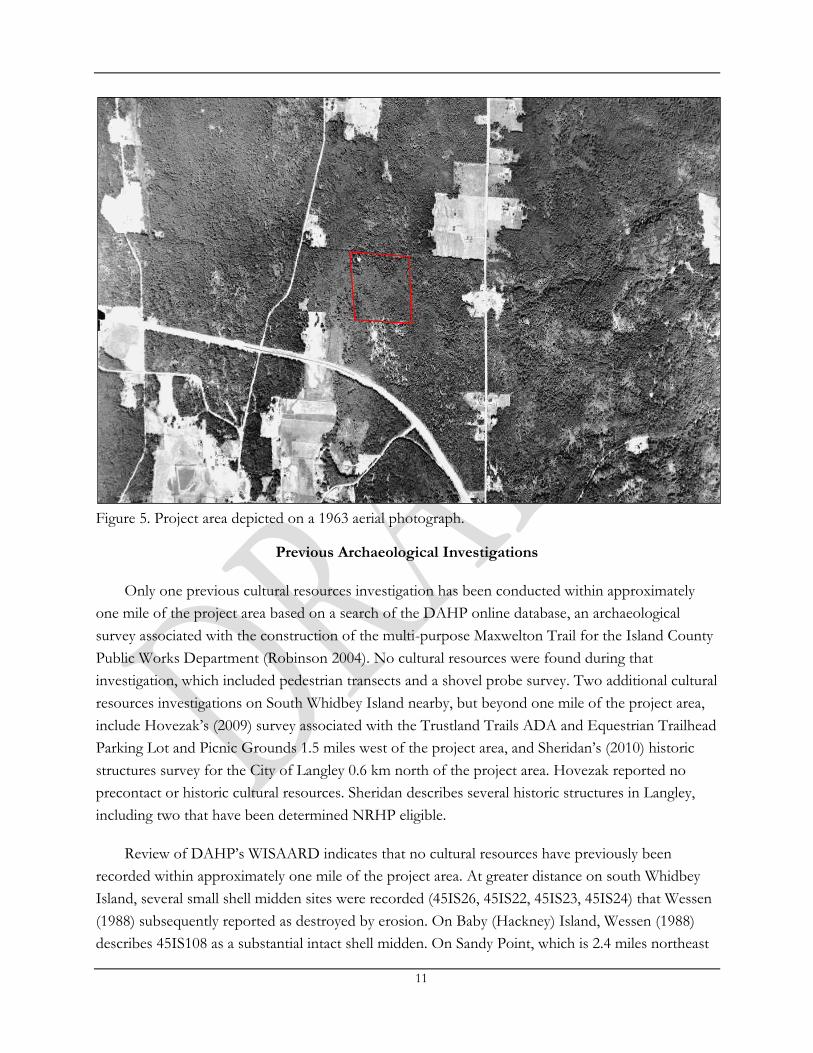
Figure 5. Project area depicted on a 1963 aerial photograph.
Previous Archaeological Investigations
Only one previous cultural resources investigation has been conducted within approximately
one mile of the project area based on a search of the DAHP online database, an archaeological
survey associated with the construction of the multi-purpose Maxwelton Trail for the Island County
Public Works Department (Robinson 2004). No cultural resources were found during that
investigation, which included pedestrian transects and a shovel probe survey. Two additional cultural
resources investigations on South Whidbey Island nearby, but beyond one mile of the project area,
include Hovezak’s (2009) survey associated with the Trustland Trails ADA and Equestrian Trailhead
Parking Lot and Picnic Grounds 1.5 miles west of the project area, and Sheridan’s (2010) historic
structures survey for the City of Langley 0.6 km north of the project area. Hovezak reported no
precontact or historic cultural resources. Sheridan describes several historic structures in Langley,
including two that have been determined NRHP eligible.
Review of DAHP’s WISAARD indicates that no cultural resources have previously been
recorded within approximately one mile of the project area. At greater distance on south Whidbey
Island, several small shell midden sites were recorded (45IS26, 45IS22, 45IS23, 45IS24) that Wessen
(1988) subsequently reported as destroyed by erosion. On Baby (Hackney) Island, Wessen (1988)
describes 45IS108 as a substantial intact shell midden. On Sandy Point, which is 2.4 miles northeast
12
of the project area, site 45IS20 was recorded by Bryan (1955) based on ethnographic research. Prior
to residential and shoreline development, the site included a “potlatch house”, campsite, and earth
ovens that were in use until at least 1914. Two historic properties have been recorded within
approximately one mile of the project area, the Free Methodist (Little Brown) Church at the
intersection of Maxwelton Road and Sills Road and the Karen Kirshner home at 5717 Maxwelton
Road, which has been determined not eligible for listing in the NRHP. No cemeteries or traditional
cultural places have been reported within one mile of the project area.
Expectations
The Washington state archaeological predictive model categorizes the project vicinity as having
a moderately low risk for precontact archaeological resources. Prior to the fieldwork component of
the current assessment, and based on previous investigations near the project area, archaeological
manifestations of past human use in the project area potentially included precontact lithic sites, lithic
isolates, and historic isolates. Because there is no recorded commercial or residential development
on site, intact historic archaeological sites were not expected. Historic refuse was considered a
possibility, however, and potentially associated with past logging, hunting, or recreation activities.
Archaeological Field Investigations
Field Methods
WillametteCRA archaeologists Amanda Taylor and Scott Pierson conducted fieldwork on April
18, 2018, using a combination of pedestrian survey and shovel probes. Survey conditions were fair.
Forest, understory plants, and leaf litter hindered ground surface visibility in most locations although
there were some areas of ground surface visibility along cleared logging trails, and at root exposures
and animal burrows. Pedestrian survey focused on identifying remnants of historic logging practices,
precontact and historic artifacts on the ground surface, and suitable areas for subsurface excavation.
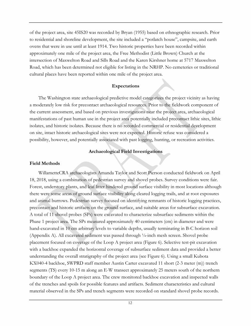
A total of 11 shovel probes (SPs) were excavated to characterize subsurface sediments within the
Phase 1 project area. The SPs measured approximately 40 centimeters (cm) in diameter and were
hand-excavated in 10 cm arbitrary levels to variable depths, usually terminating in B-C horizon soil
(Appendix A). All excavated sediment was passed through ¼-inch mesh screen. Shovel probe
placement focused on coverage of the Loop A project area (Figure 6). Selective test-pit excavation
with a backhoe expanded the horizontal coverage of subsurface sediment data and provided a better
understanding the overall stratigraphy of the project area (see Figure 6). Using a small Kubota
KX040-4 backhoe, SWPRD staff member Austin Carter excavated 11 short (2-3 meter (m)) trench
segments (TS) every 10-15 m along an E-W transect approximately 25 meters south of the northern
boundary of the Loop A project area. The crew monitored backhoe excavation and inspected walls
of the trenches and spoils for possible features and artifacts. Sediment characteristics and cultural
material observed in the SPs and trench segments were recorded on standard shovel probe records.
13
Figure 6. Aerial image showing project area and location of shovel probes and test trenches.

14
General observations regarding the project area were documented on a standard daily work record.
Digital photographs were taken of the project area and shovel probe locations with photograph
information noted on a photo log. Probes were backfilled immediately upon completion. Mapping
data were recorded using a hand-held GPS unit.
Results
No cultural materials were observed during fieldwork. The project area is located on a gently
sloping and hummocky inland forested landform with thick vegetation. Plants observed on site
include conifers (western redcedar, western hemlock, Douglas-fir) and salal, blackberries,
salmonberries, and sword fern (Figure 7 and 8). Previous landowners selectively harvested wood,
maintaining several large western redcedar trees on the south side of the Loop A project area. Wide
paths previously cleared as logging trails will be used as the footprint for the road for Loop A of the
proposed campground (Doug Coutts, personal communication April 18, 2018). Parts of the mapped
trail system match well with the schematic, but the south and east sides of Loop A on the schematic
are several meters out of alignment with the plans. Large second-growth western redcedars are
present on the south side of the property (Figure 9). During pedestrian survey, no artifacts or
structures were encountered in the project area. We identified one potential springboard notch in a
western redcedar tree near SP 4 (Figures 10 and 11), consistent with long-term use of the property
for selective logging. None of the mature trees observed during the survey exhibited peeling scars or
other evidence of traditional Native American modification. Most of the ground surface appeared
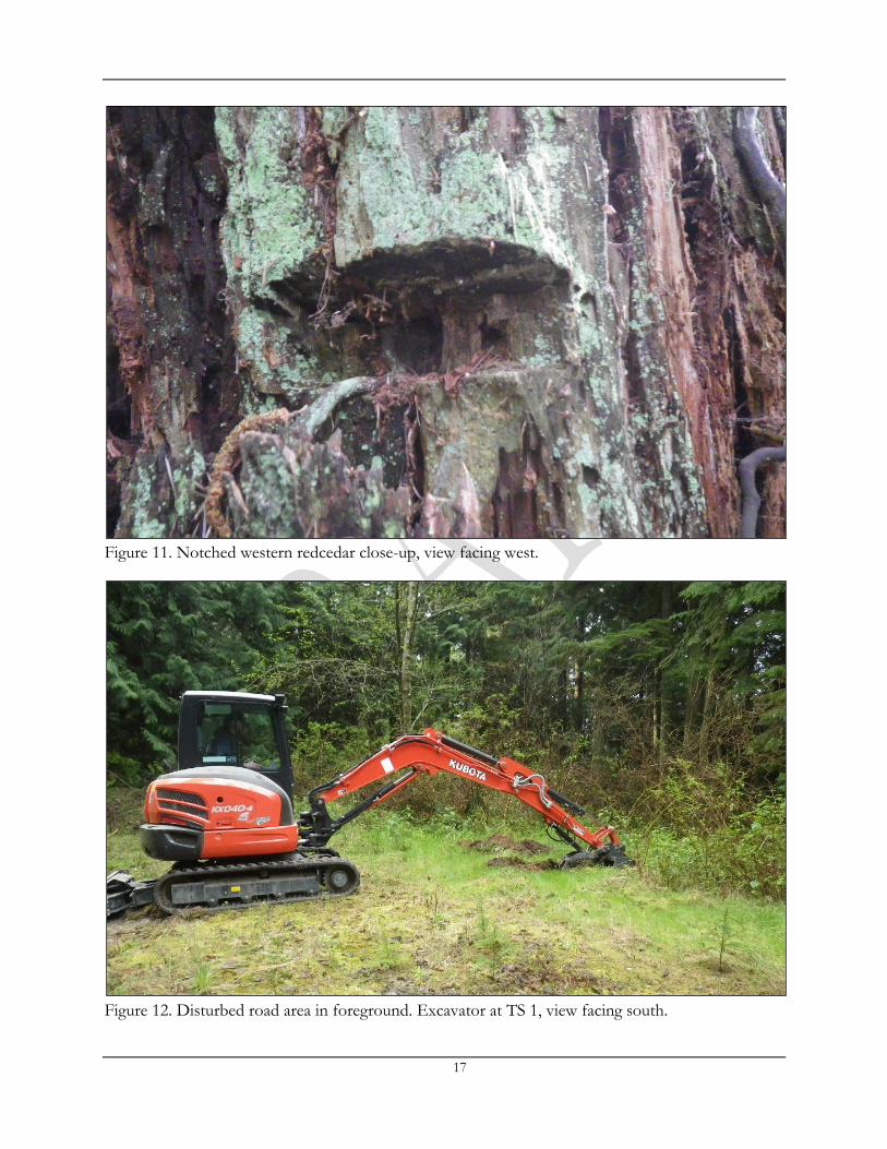
relatively undisturbed except for the area in the northwest corner of the project area where the
access road from South Whidbey High School intersects with the logging trail. There appears to be a
push pile in this area where the road was flattened (Figure 12).
A total of 11 shovel probes were excavated within the project area: SPs 1-5 are located on the
west side of the loop, SPs 6-8 are on the south side of the loop, SPs 9-10 are on the east side of the
loop, and SP 11 is on the north side of the loop (see Figure 6). In many of the SPs and trench
segments, an organic duff layer and brown to dark brown sandy silt or silty fine sand A Horizon was
underlain by a reddish brown B Horizon with common or many very small to very large subrounded
and rounded pebbles. The boundary between the two horizons typically occurred between 8-24
cmbs, consistent with forest soils as opposed to prairie, or former prairie, soils. In SPs 3-5 and TS 7,
no A Horizon was present. Roots and rootlets decreased with depth. The lower boundary of the
reddish or yellowish brown B Horizon occurred at 40-45 cmbs. A light gray fine-coarse sandy silt C
Horizon with common or many small-medium sub round pebbles marked the beginning of
unweathered parent glacial material (Figures 13 and 14; Appendix A). Therefore, most SPs were
terminated at approximately 10 cm into the C Horizon at 50-70 cmbs. In some cases, such as SP 10,
we encountered evidence of previous forest burning (Figure 15). No cultural materials were present
in the shovel probes or the trench segments.

15
Figure 7. Overview of the project area from northeast corner of Loop A, view facing west.
Figure 8. Overview of the project area from the southwest corner of Loop A, view facing west.

16
Figure 9. Second growth western redcedar tree at location of SP 7, view facing north.
Figure 10. Notched western redcedar, view facing west.
17
Figure 11. Notched western redcedar close-up, view facing west.
Figure 12. Disturbed road area in foreground. Excavator at TS 1, view facing south.

18
Figure 13. Soil profile for SP 8, plan view with north facing down.
Figure 14. Profile for TS 6, view to the south.
19
Figure 15. Soil profile for SP 10, view facing east.
Conclusions and Recommendations
The project was considered to have a moderately low potential for buried precontact
archaeological resources based on the DAHP predictive model and review of previous land use and
archaeological investigations in the project vicinity. The probability for historic period resources was
also considered to be low because there was minimal commercial or residential development nearby.
Pedestrian survey, shovel probes, and trench excavation did not identify evidence of archaeological
deposits within the project area. No further archaeological work is recommended for the project
area, however; we recommend an Inadvertent Discovery Plan (IDP) be in place prior to
construction that outlines the protocols to be followed in the event of an unanticipated discovery of
archaeological materials or human remains. While no cultural materials were identified during field
reconnaissance, it is still possible that small or discrete cultural features or isolated artifacts could be
present and inadvertently discovered during project excavations or subsequent brush or tree clearing
activities.

20
In the unlikely event human remains are encountered during any part of the project, the law
requires all activity to cease that may cause further disturbance to those remains, and the area of the
find secured and protected from further disturbance. The finding of human skeletal remains will be
reported to the county medical examiner/coroner and local law enforcement in the most expeditious
manner possible. The remains will not be touched, moved, or further disturbed. The county coroner
will assume jurisdiction over the human skeletal remains and make a determination of whether those
remains are forensic or non-forensic. If the county coroner determines the remains are non-forensic,
they will report that finding to the DAHP who will then take jurisdiction over the remains. The
DAHP will notify any appropriate cemeteries and all affected tribes of the find. The State Physical
Anthropologist will make a determination of whether the remains are Indian or Non-Indian and
report that finding to any appropriate cemeteries and the affected tribes. The DAHP will then
handle all consultation with the affected parties as to the future preservation, excavation, and
disposition of the remains.

21
References Cited
Armstrong, J. E., Crandell, D. R., Easterbrook, D. J., & Noble, J. B. 1965 Late Pleistocene stratigraphy and chronology in southwestern British Columbia and
northwestern Washington. Geological Society of America Bulletin 76(3): 321-330.
Blukis Onat, Astrida R. 1987 Resource Protection Planning Process: Identification of Prehistoric Archaeological Resources in the Northern
Puget Sound Study Unit. BOAS, Inc. report prepared for the Office of Archaeology and Historic Preservation, Olympia, Washington.
Blukis Onat, Astrida R., Maury E. Morgenstein, Philippe D. LeTourneau, Robert P. Stone, Jerre Kosta and Paula Johnson
2000 Archaeological Investigations at stuwe’yuq - Site 45KI464, Tolt River, King County, Washington. BOAS, Inc. report prepared for Philip and Seattle Public Utilities, Seattle, WA.
Boyd, Robert (editor) 1999 Indians, Fire, and the Land in the Pacific Northwest. Oregon State University Press, Corvallis.
Bryan, Alan L. 1955 An Intensive Archaeological Reconnaissance in the Northern Puget Sound Region.
Unpublished Master’s Thesis, Department of Anthropology, University of Washington, Seattle, Washington.
1963 An Archaeological Survey of Northern Puget Sound. Occasional Papers of the Idaho State University Museum, Number 11, Pocatello, Idaho.
Bureau of Land Management 2004 BLM GLO Records. Electronic resource, http://www.glorecords.blm.gov, accessed April
12, 2018.
Carlson, Roy L. 1990 Cultural Antecedents. In Handbook of North American Indians, Volume 7: Northwest
Coast, edited by W. Suttles, pp. 60-69. Smithsonian Institution Press, Washington, D.C.
Center for the Study of the Pacific Northwest 2018 Seeing the Forest for the Trees: Placing Washington’s Forest in Historical Context. University of
Washington. Electronic resource, http://www.washington.edu/uwired/outreach/cspn/Website/Classroom%20Materials/Curriculum%20Packets/Evergreen%20State/Section%20II.html, accessed April 19, 2010.
Chatters, James C., Jason B. Cooper, and Phillippe D. LeTourneau 2011 Understanding Olcott: Data Recovery at Sites 45SN28 and 45SN303, Snohomish County, Washington.
AMEC Earth & Environmental report prepared for Snohomish County Department of Public Works, Everett, Washington.
22
Croes, Dale R., Scott Williams, Larry Ross, Mark Collard, Carolyn Dennier, and Barbara Vargo 2008 The projectile point sequences in the Puget Sound region. In Projectile Point Sequences in
Northwestern North America edited by R.L. Carlson and M.P.R. Magne, pp.105-130. Archaeology Press, Simon Fraser University, Burnaby British Columbia.
Dragovich, Joe D., Robert L. Logan, Henry W. Schasse, Timothy J. Walsh, William S. Lingley, Jr., David K. Norman, Wendy J. Gerstel, Thomas J. Lapen, J. E. Shuster, and Karen D. Meyers
2002 Geologic Map of Washington - Northwest Quadrant. Geologic Map GM-50. Washington Division of Geology and Earth Resources, Olympia, Washington.
Easterbrook, Don J. 1986 Stratigraphy and chronology of Quaternary deposits of the Puget Lowland and Olympic
Mountains of Washington and the Cascade Mountains of Washington and Oregon. Quaternary Science Reviews 5:145-159.
Frankin, Jerry F. and C. T. Dyrness 1973 Natural Vegetation of Oregon and Washington. USDA Forest Service, General
Technical Report PNW-8.
Gibbs, George 1855 Report of Mr. George Gibbs to Captain McClellen, on the Indian Tribes of the Territory of
Washington. Pacific Railroad Reports. United States War Department, Washington D.C. 1877 Tribes of Western Washington and Northwestern Oregon. Contributions to North
American Ethnology (I) 2.
Gunther, Erna 1973 Ethnobotany of Western Washington, Revised Edition. University of Washington Press, Seattle, Washington.
Hovezak, M.J. 2009 Cultural Resources Assessment of the Proposed Trustland Trails ADA and Equestrian Trailhead Parking
Lot and Picnic Grounds and ADA Loop Trail Project, Whidbey Island, Washington. Rosario Archaeology L.L.C. report prepared on behalf of South Whidbey Parks and Recreation District, Langley, Washington.
Haugerud, Ralph A., David J. Harding, Samuel Y. Johnson, Jerry L. Harless, Craig S. Weaver, and Brian L. Sherrod.
2003 High-resolution lidar topography of the Puget Lowland, Washington. GSA Today 13(6):4-10.
Ingles, Lloyd G. 1965 Mammals of the Pacific States: California, Oregon, Washington. Stanford University
Press, Stanford, California.
Johnson, Samuel Y., Christopher J. Potter, John J. Miller, John M. Armentrout, Carol Finn, and Craig S. Weaver.
1996 The southern Whidbey Island fault: an active structure in the Puget Lowland, Washington. Geological Society of America Bulletin 108(3): 334-354.
23
Kellogg, George Albert 1933 A History of Whidbey's Island. Island County Farm Bureau News.
Kenady, Stephen M., Michael C. Wilson, Randall F. Schalk, and Robert R. Mierendorf 2011 Late Pleistocene butchered Bison antiquus from Ayer Pond, Orcas Island, Pacific
Northwest: Age confirmation and taphonomy. Quaternary international 233(2):130-141.
Kozloff, Eugene N. 1996 Marine Invertebrates of the Pacific Northwest. University of Washington Press, Seattle,
Washington.
Kopperl, Robert E. (editor) 2016 Results of Data Recovery at the Bear Creek Site (45KI839), King County, Washington. SWCA
Environmental Consultants report 15-462 prepared for the City of Redmond, Washington.
Kopperl, Robert E., Amanda K. Taylor, Christian J. Miss, Kenneth M. Ames, and Charles M. Hodges
2015 The Bear Creek Site (45KI839), a Late Pleistocene–Holocene Transition Occupation in the Puget Sound Lowland, King County, Washington. PaleoAmerica 1(1):116-120.
Lepofsky, Dana, Ken Lertzman, Douglas Hallett, and Rolf Mathewes 2005 Climate Change and Culture Change on the Southern Coast of British Columbia, 2,400-
1,200 cal. BP: An Hypothesis. American Antiquity 70(2):267-293.
Liberty, Lee M., and Kristin M. Pape 2013 Seismic Characterization of the Seattle and Southern Whidbey Island Fault Zones in the
Snoqualmie River Valley, Washington. Center for Geophysical Investigation of the Shallow Subsurface (CGISS)-Boise State University.
Meany, E. S. 1957 Vancouver's Discovery of Puget Sound. Vancouver's Journals as far as they deal with the journey from Cape
Flattery into Puget Sound and north around Vancouver Island to Nootka Sound]. Binford & Mort, Portland, Oregon.
Metsker, Chas. F. 1960 Township 29 N., Range 3 E. W.M., King County, Wash. Electronic resource,
http://www.historicmapworks.com, accessed on April 15, 2018.
Miller, Bruce S. and Steven F. Borton 1980 Geographical Distribution of Puget Sound Fishes: Maps and Data Source Sheets. Washington Sea
Grant, Seattle, Washington.
Miss, C. and S.K. Campbell 1991 Prehistoric Cultural Resources of Snohomish County, Washington. Northwest Archaeological
Associates report prepared for the Washington State Department of Community Development, Office of Archaeology and Historic Preservation (now Department of Archaeology and Historic Preservation), Olympia, Washington.
24
Mosher, David C. and Antony T. Hewitt 2004 Late Quaternary Deglaciation and Sea-level history of eastern Juan De Fuca Strait, Cascadia.
Quaternary International 12(1):23-39.
Neil, Dorothy and Lee Brainard 1989 By Canoe and Sailing Ship They Came: A History of Whidbey’s Island. Spendthrift Publishing
Company, Oak Harbor, Washington.
Porter, Stephen C. and Terry W. Swanson 1998 Radiocarbon Age Constrains on Rates of Advance and Retreat of the Puget Lobe of the
Cordilleran ice sheet during the last glaciation. Quaternary Research 50(3):205-213.
National Resource Conservation Service (NRCS) 2018 Web Soil Survey. Electronic resource,
http://websoilsurvey.nrcs.usda.gov/app/WebSoilSurvey.aspx, accessed April 11, 2018.
United States Department of Agriculture, Natural Resources Conservation Service 2008 Soil survey of Island County, Washington. Electronic resource,
http://soils.usda.gov/survey/printed_ surveys/, accessed April 11, 2018.
Riddle, Margaret 2012 Langley – Thumbnail History. Electronic resource, http://www.historylink.org/File/10220,
accessed April 19, 2018.
Robinson, Joan M. 2004 An Archaeological Survey of Island County’s Maxwelton Trail Project, Whidbey Island, WA. Robinson
Cultural Resource Services report prepared for the Island County Public Works Department/Washington State Department of Transportation, Coupeville/Olympia, WA.
Rogers, Heather E., Terry W. Swanson, and John O. Stone 2012 Long-term shoreline retreat rates on Whidbey Island, Washington, USA. Quaternary Research
78(2): 315-322.
Schalk, Randall and Margaret A. Nelson (editors) 2010 The Archaeology of the Cama Beach Shell Midden (45IS2) Camano Island, Washington. Cascadia
Archaeology report prepared for the Washington State Parks and Recreation Commission, Olympia, Washington.
Sheridan, Mimi 2010 City of Langley Historic Resource Survey Report. Sheridan Consulting Group report
prepared for City of Langley Historic Preservation Commission, Langley, Washington.
Shipman, Hugh 2010 The geomorphic setting of Puget Sound: implications for shoreline erosion and the impacts
of erosion control structures. Puget Sound shorelines and the impacts of armoring—proceedings of a state of the science workshop, May 2009.
25
Smith, Harlan 1901 Whidbey Island. In, Cairns of British Columbia and Washington, Memoirs of the American
Museum of Natural History. Volume IV, Publications of The Jesup North Pacific Expedition. Part II, by H.1. Smith and G. Fowke, New York.
1907 Archaeology of the Gulf of Georgia and Puget Sound. In, Memoir of the American Museum of Natural History, Publications of the Jesup North Pacific Expedition Volume II Part VI, edited by Franz Boas, AMS Press, New York.
Spier, Leslie 1936 Tribal Distribution in Washington. General Series in Anthropology Number 3, George
Banta, Menasha, Wisconsin.
Stein, Julie K., Shelby Anderson and Jacob Fisher 2006 Report on the Ebey’s Prairie Depositional History. University of Washington research report
prepared for the National Park Service, Pacific Northwest Region, Seattle, Washington.
Stewart, Hilary 2009 Cedar: Tree of Life to the Northwest Coast Indians. Douglas and McIntyre Publishers, Madeira
Park, British Columbia 2009.
Suttles, Wayne and Barbara Lane 1990 Southern Coast Salish. In Handbook of North American Indians, Volume 7: Northwest Coast,
edited by W. Suttles, pp. 485-502. Smithsonian Institution Press, Washington, D.C.
Taylor, Amanda K., Julie K. Stein, and Stephanie A.E. Jolivette 2011 Big sites, small sites, and coastal settlement patterns in the San Juan Islands, Washington,
USA. The Journal of Island and Coastal Archaeology 6(2): 287-313.
Thompson, Evan 2018 Historical Society to Lead Presentation About Gabelein family History. South Whidbey Record,
Wednesday February 21, 2018. Electronic resource, http://www.southwhidbeyrecord.com/news/historical-society-to-lead-presentation-about-gabelein-family-history/, accessed April 20, 2018.
Vancouver, George 1801 A Voyage of Discovery to the North Pacific Ocean, and Round the World, Volume 2. Printed for John
Stockdale, London.
Waterman, T. T. 2001 Puget Sound Geography edited by V. Hilbert, J. Miller, and Zalmai Zahir. Lushootseed Press,
Federal Way, Washington.
Wessen, G.C. 1988 Prehistoric Cultural Resources of Island County. Washington. Wessen and Associates report prepared
for the Washington State Department of Community Development, Office of Archaeology and Historic Preservation (now Department of Archaeology and Historic Preservation),Olympia.

26
Weiser, Andrea, and Dana Lepofsky 2009 Ancient land use and management of Ebey's Prairie, Whidbey Island, Washington. Journal of
Ethnobiology 29(2): 184-212.
Weiser, Andrea L. 2006 Exploring 10,000 years of Human History on Ebey’s Prairie, Whidbey Island, Washington.
Unpublished M.A. Thesis, Department of Archaeology-Simon Fraser University.
White, Richard 1980 Land Use, Environment, and Social Change: The Shaping of Island County, Washington. University of
Washington Press, Seattle, Washington.
Whitlock, C. and M.A. Knox 2002 Prehistoric Burning in the Pacific Northwest. In Fire, Native People, and the Natural Landscape,
edited by Thomas Vale, pp. 195-231. Island Press, Washington DC.
Wilkes, C. 1845 Narrative of the United States Expedition, Vol. IX. Lea and Blanchard, Philadelphia.
Wilson, Michael C., Stephen M. Kenady, and Randall F. Schalk. 2009 Late Pleistocene Bison antiquus from Orcas Island, Washington, and the biogeographic
importance of an early postglacial land mammal dispersal corridor from the mainland to Vancouver Island. Quaternary Research 71(1): 49-61.
Wollwage, Lance K., Guy Tasa and Stephenie Kramer 2015 A Partial Stratigraphy of the Snakelum Point Site, 45-IS-13, Island County, Washington, and
Comment on the Sampling of Shell Midden Sites Using Small Excavation Units. Journal of Northwest Anthropology 49(1):43-60.

Appendix A:
Summary of Shovel Probe Results
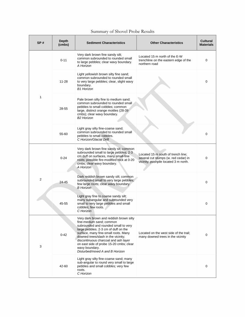
Summary of Shovel Probe Results
SP # Depth (cmbs)
Sediment Characteristics Other Characteristics Cultural
Materials
1
0-11
Very dark brown fine sandy silt; common subrounded to rounded small to large pebbles; clear wavy boundary. A Horizon
Located 15 m north of the E-W trenchline on the eastern edge of the northern road
0
11-28
Light yellowish brown silty fine sand; common subrounded to rounded small to very large pebbles; clear, slight wavy boundary. B1 Horizon
0
28-55
Pale brown silty fine to medium sand; common subrounded to rounded small pebbles to small cobbles; common large, distinct orange mottles (28-39 cmbs); clear wavy boundary. B2 Horizon
55-60
Light gray silty fine-coarse sand; common subrounded to rounded small pebbles to small cobbles. C Horizon/Glacial Drift
0
2
0-24
Very dark brown fine sandy sit; common subrounded small to large pebbles; 2-3 cm duff on surfaces, many small-fine roots; possible fire-modified rock at 0-20 cmbs; clear wavy boundary. A Horizon
Located 15 m south of trench line; several cut stumps (w. red cedar) in vicinity; pushpile located 3 m north.
0
24-45
Dark reddish brown sandy silt; common subrounded small to very large pebbles; few large roots; clear wavy boundary. B Horizon
0
45-55
Light gray fine to coarse sandy silt; many subangular and subrounded very small to very large pebbles and small cobbles; few roots. C Horizon
0
3
0-42
Very dark brown and reddish brown silty fine-medium sand; common subrounded and rounded small to very large pebbles. 2-3 cm of duff on the surface, many fine-small roots. Many downed trees/slash in the vicinity; discontinuous charcoal and ash layer on east side of probe 15-20 cmbs; clear wavy boundary. Disturbed/mixed A and B Horizon
Located on the west side of the trail; many downed trees in the vicinity
0
42-60
Light gray silty fine-coarse sand; many sub-angular to round very small to large pebbles and small cobbles; very few roots. C Horizon
0
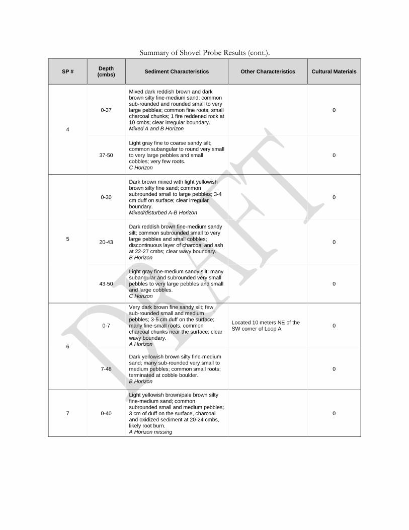
Summary of Shovel Probe Results (cont.).
SP # Depth (cmbs)
Sediment Characteristics Other Characteristics Cultural Materials
4
0-37
Mixed dark reddish brown and dark brown silty fine-medium sand; common sub-rounded and rounded small to very large pebbles; common fine roots, small charcoal chunks; 1 fire reddened rock at 10 cmbs; clear irregular boundary. Mixed A and B Horizon
0
37-50
Light gray fine to coarse sandy silt; common subangular to round very small to very large pebbles and small cobbles; very few roots. C Horizon
0
5
0-30
Dark brown mixed with light yellowish brown silty fine sand; common subrounded small to large pebbles; 3-4 cm duff on surface; clear irregular boundary. Mixed/disturbed A-B Horizon
0
20-43
Dark reddish brown fine-medium sandy silt; common subrounded small to very large pebbles and small cobbles; discontinuous layer of charcoal and ash at 22-27 cmbs; clear wavy boundary. B Horizon
0
43-50
Light gray fine-medium sandy silt; many subangular and subrounded very small pebbles to very large pebbles and small and large cobbles. C Horizon
0
6
0-7
Very dark brown fine sandy silt; few sub-rounded small and medium pebbles; 3-5 cm duff on the surface; many fine-small roots, common charcoal chunks near the surface; clear wavy boundary. A Horizon
Located 10 meters NE of the SW corner of Loop A
0
7-48
Dark yellowish brown silty fine-medium sand; many sub-rounded very small to medium pebbles; common small roots; terminated at cobble boulder. B Horizon
0
7 0-40
Light yellowish brown/pale brown silty fine-medium sand; common subrounded small and medium pebbles; 3 cm of duff on the surface, charcoal and oxidized sediment at 20-24 cmbs, likely root burn. A Horizon missing
0
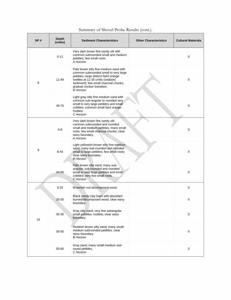
Summary of Shovel Probe Results (cont.).
SP # Depth (cmbs)
Sediment Characteristics Other Characteristics Cultural Materials
8
0-11
Very dark brown fine sandy silt with common subrounded small and medium pebbles; few small roots. A Horizon
0
11-49
Pale brown silty fine-medium sand with common subrounded small to very large pebbles; large distinct-faint orange mottles at 11-35 cmbs (oxidized sediment); few small charcoal chunks; gradual unclear transition. B Horizon
0
49-70
Light gray silty fine-medium sand with common sub-angular to rounded very small to very large pebbles and small cobbles; common small faint orange mottles. C Horizon
0
9
0-8
Very dark brown fine sandy silt; common subrounded and rounded small and medium pebbles; many small roots, few small charcoal chunks; clear wavy boundary. A Horizon
0
8-44
Light yellowish-brown silty fine-medium sand; many sub-rounded and rounded small to large pebbles; few small roots; clear wavy boundary. B Horizon
0
44-60
Pale brown silty sand; many sub-angular, sub-rounded and rounded small to very large pebbles and small cobbles; very few small roots. C Horizon
0
10
0-25 Brownish red decomposed wood. 0
25-30 Black sandy clay loam with abundant burned/decomposed wood; clear wavy boundary.
0
30-35 Gray silty sand; very few subangular small pebbles; rootlets; clear wavy boundary.
0
35-55
Reddish brown silty sand; many small-medium subrounded pebbles; clear wavy boundary. B Horizon
0
55-60 Gray sand; many small-medium sub-round pebbles. C Horizon
0

Summary of Shovel Probe Results (cont.).
SP # Depth (cmbs)
Sediment Characteristics Other Characteristics Cultural
Materials
11
0-25
Brown silty sand; few subrounded small pebbles; roots; some mottling and compact areas; gradual wavy boundary. O/A Horizon
0
25-45
Reddish brown sand; common subrounded small pebbles; rootlets and charcoal flecks, gradual wavy boundary. B Horizon
0
45-70 Brownish gray sand; common subrounded small pebbles C Horizon.
0


![Morphological homology, evolution, and proposed ... · Sciences and Center for Excellence in Life and Paleoenvironment, Beijing, 100044, China. Jin Chen [chenjin@ivpp.ac.cn], Key](https://img.pdfslide.us/doc/110x75/5e7737a24e31c13a0b035c20/morphological-homology-evolution-and-proposed-sciences-and-center-for-excellence.jpg)