Embed Size (px)
Citation preview

List of pages in this Trip Kit
Trip Kit IndexAirport Information For GCRRTerminal Charts For GCRRRevision Letter For Cycle 12-2018Change NoticesNotebook
Trip Kit Index
Printed on 06 Jul 2018
Page 1(c) JEPPESEN SANDERSON, INC., 2018, ALL RIGHTS RESERVED
jep=JEPPESEN
JeppView for Windows
General Information
Location: LANZAROTE XJEICAO/IATA: GCRR / ACELat/Long: N28° 56.7', W013° 36.3'Elevation: 47 ft
Airport Use: PublicDaylight Savings: ObservedUTC Conversion: +0:00 = UTCMagnetic Variation: 4.0° W
Fuel Types: 100 Octane (LL), Jet A-1Customs: YesAirport Type: IFRLanding Fee: YesControl Tower: YesJet Start Unit: NoLLWS Alert: NoBeacon: No
Sunrise: 0601 ZSunset: 1957 Z
Runway Information
Runway: 21Length x Width: 7874 ft x 148 ftSurface Type: asphaltTDZ-Elev: 47 ftLighting: Edge, ALS, Centerline, REIL
Runway: 03Length x Width: 7874 ft x 148 ftSurface Type: asphaltTDZ-Elev: 26 ftLighting: Edge, ALS, Centerline, REILDisplaced Threshold: 295 ft
Communication Information
ATIS: 118.625 (60°-190°) At or below 33574432 ft Out to 23 mi.Lanzarote Tower: 124.000 SecondaryLanzarote Tower: 120.700Lanzarote Tower: 25.780 MilitaryLanzarote Ground: 121.800Canarias Approach: 129.300
Airport Information For GCRR
Printed on 06 Jul 2018
Page 1(c) JEPPESEN SANDERSON, INC., 2018, ALL RIGHTS RESERVED
jep=JEPPESEN
JeppView for Windows
LANZAROTE, CANARY ISGCRR/ACELANZAROTE .AIRPORT.BRIEFING.
+ JEPPESEN
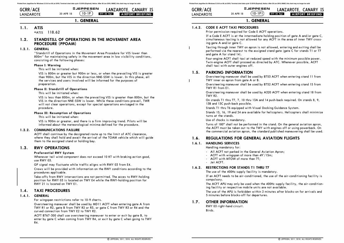
1.1. ATIS*ATIS 118.62
1.2. STANDSTILL OF OPERATIONS IN THE MOVEMENT AREA PROCEDURE (PPOAM)
1.2.1. GENERAL"Standstill of Operations in the Movement Area Procedure for VIS lower than
800m" for maintaining safety in the movement area in low visibility conditions,
consisting of the following phases:
Phase I: WarningThis will be initiated when:
VIS is 800m or greater but 900m or less, or when the prevailing VIS is greater
than 900m, but the VIS in the direction NNE-SSW is lower. In this phase, all
the services and users involved will be informed for the purposes of
preparation.
Phase II: Standstill of Operations
This will be initiated when:
VIS is less than 800m, or when the prevailing VIS is greater than 800m, but the
VIS in the direction NNE-SSW is lower. While these conditions prevail, TWR
will not clear operations, except for special operations envisaged in the
procedure.
Phase III: Resumption of OperationsThis will be initiated when:
VIS is 900m or greater, and there is a firm improving trend. Pilots will be
informed about the meteorological minima defined for the procedure.
1.2.2. COMMUNICATIONS FAILUREACFT shall continue by the designated route up to the limit of ATC clearance,
where they shall hold and await the arrival of the TOAM vehicle which will guide
them to the assigned stand or holding bay.
1.3. RWY OPERATIONSPreferential RWY SystemWhenever tail wind component does not exceed 10 KT with braking action good,
use RWY 03.
GP signal may fluctuate while traffic aligns with RWY 03 from E4.
Crews will be provided with information on the RWY conditions according to the
procedures applicable.
Take-offs from RWY intersections are not permitted. The acces to RWY-holding
position for RWY 03 is located on TWY E4 while the RWY-holding position for
RWY 21 is located on TWY E1.
1.4. TAXI PROCEDURES1.4.1. GENERAL
For wingspan restrictions refer to 10-9 charts.
Oversteering maneuver shall be used by MD11 ACFT when entering gate A from
TWY R1 or R2, gate B from TWY R2 or R3, or gate C from TWY R3 or R4 and the
curved connection from TWY E2 to TWY R2.
ACFT B767-300 shall use oversteering maneuver to enter or exit by gate B, to
enter by gate C when coming from TWY R4, or exit by gate C when going to TWY
R4.
10-1P20 APR 18 .Eff.26.Apr.
1. GENERAL
| JEPPESEN, 2011, 2018. ALL RIGHTS RESERVED.
Printed from JeppView for Windows 5.3.0.0 on 06 Jul 2018; Terminal chart data cycle 12-2018 (Expired); Notice: After 28 Jun 2018, 0000Z, this chart may no longer be valid
LANZAROTE, CANARY ISGCRR/ACELANZAROTE .AIRPORT.BRIEFING.
+ JEPPESEN
1.4.2. CODE E ACFT TAXI PROCEDURESPrior permission required for Code E ACFT operations.
If a Code E ACFT is at the intermediate holding position of gate A and/or gate C,
simultaneous taxiing is not allowed for any ACFT in the area of inner TWY cross-
ing gate A and/or gate C.
Taxiing through inner TWY on apron is not allowed, entering and exiting shall be
performed via the nearest to the assigned stand gate (gate C for stands T1 or T7
and gate A for stand 14).
Four-engine ACFT shall taxi at reduced speed with the minimum possible power.
Twin-engine ACFT shall proceed as directed by ATC. Whenever possible, ACFT
shall taxi with outer engines off.
1.5. PARKING INFORMATIONOversteering maneuver shall be used by B753 ACFT when entering stand 11 from
TWY inner on apron from gate A or B.
Oversteering maneuver shall be used by B752 ACFT when entering stand 15 from
TWY R1 from E1.
Oversteering maneuver shall be used by A320 ACFT when entering stand 18 from
TWY R2.
On stands T1 thru T7, 7, 10 thru 13A and 14 push-back required. On stands 8, 9,
13B and 13C push-back possible.
Stands T1 thru T6 equipped with Visual Docking Guidance System.
Stands 15, 16, 19 and 24 are available for helicopters. Helicopters shall minimize
turns at the stands.
Use of chocks is mandatory.
Turns of 180^ shall not be performed in the stand. On the general aviation apron,
the ACFT must be taken out to the TWY with engines off or using powerback. On
the commercial aviation apron, the standard published maneuvering shall be used.
1.6. REGULATIONS FOR GENERAL AVIATION FLIGHTS1.6.1. HANDLING SERVICES
Handling mandatory for:
- All ACFT not parked in the General Aviation Apron;
- ACFT with wingspan of more than 49'/15m;
- ACFT with MTOW of more than 7T;
- Jet ACFT.
1.6.2. RESTRICTIONS FOR STANDS T1 THRU T7The use of the 400Hz supply facility is mandatory.
If an ACFT needs to be air-conditioned, the use of the air-conditioning facility is
compulsory.
The ACFT APU may only be used when the 400Hz supply facility, the air-condition-
ing facility or respective mobile units are not available.
The use of the APU is forbidden within 2 minutes after blocks-on for arrivals and
5 minutes before blocks-off for departures.
1.7. OTHER INFORMATIONRWY 03 right-hand circuit.
Birds.
10-1P120 APR 18 .Eff.26.Apr.
1. GENERAL
| JEPPESEN, 2011, 2018. ALL RIGHTS RESERVED.
Printed from JeppView for Windows 5.3.0.0 on 06 Jul 2018; Terminal chart data cycle 12-2018 (Expired); Notice: After 28 Jun 2018, 0000Z, this chart may no longer be valid
LANZAROTE, CANARY ISGCRR/ACELANZAROTE .AIRPORT.BRIEFING.
+ JEPPESEN
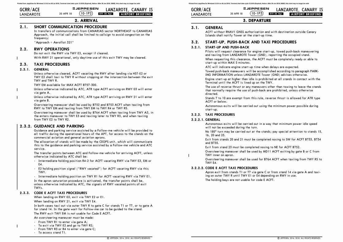
2.1. SHORT COMMUNICATION PROCEDUREIn transfers of communications from CANARIAS sector NORTHEAST to CANARIAS
Approach, the initial call shall be limited to callsign to avoid congestion on the
frequency:
"Approach + Aeroflot 321"
2.2. RWY OPERATIONSDo not exit the RWY via TWY E3, except if cleared.
With RWY 21 operational, only daytime use of this exit TWY may be cleared.
2.3. TAXI PROCEDURES2.3.1. GENERAL
Unless otherwise cleared, ACFT vacating the RWY after landing via HST-E2 or
TWY E3 shall taxi to TWY R without stopping at the intersection between the exit
TWY and TWY R.
TWY EM available for MAX ACFT B757-300.
Unless otherwise indicated by ATC, ATR type ACFT arriving on RWY 03 will enter
via gate A.
Unless otherwise indicated by ATC, ATR type ACFT arriving on RWY 21 will enter
via gate B.
Oversteering maneuver shall be used by B752 and B753 ACFT when taxiing from
RWY to TWY EM and taxiing from TWY EM to TWY R4 or TWY R5.
Oversteering maneuver shall be used by B764 ACFT when taxiing from TWY A3, in
the enters maneuver to TWY E3 and taxiing later to TWY R3, and when taxiing
from TWY E2 to TWY R2.
2.3.2. GUIDANCE AND PARKINGGuidance and parking service assisted by a Follow-me vehicle will be provided to
all traffic during the operational hours of the APT, for access to the stands on the
commercial aviation and general aviation aprons.
The allocation of stands will be made by the CEOPS unit, which will communicate
this to the guidance and parking service assisted by a Follow-me vehicle and ATC
service.
The transfer points between ATC and Follow-me vehicle for arriving ACFT, unless
otherwise indicated by ATC shall be:
- Intermediate holding position R4-2 for ACFT vacating RWY via TWY E3, EM or
E4.
- E2 holding position signal ("RWY vacated") for ACFT vacating RWY via this
TWY.
- Intermediate holding position on TWY R1 for ACFT vacating RWY via TWY E1.
In the apron saturation procedure is activated, the transfer points shall be,
unless otherwise indicated by ATC, the signals of RWY vacated points of exit
TWYs.
2.3.3. CODE E ACFT TAXI PROCEDURESWhen landing on RWY 03, exit via TWY E2 or E1.
When landing on RWY 21, exit via TWY E4.
In both cases taxi out via outer TWY R to gate C for stands T1 or T7, or to gate A
for stand 14. In the gate wait for Follow-me car to be guided to the stand.
The RWY exit TWY EM is not usable for Code E ACFT.
An oversteering maneuver must be made:
- From TWY R1 to enter via gate A;
- To exit via TWY E2 and go to TWY R2;
- From TWY R3 or R4 to enter via gate C;
- To access stand T1.
10-1P220 APR 18 .Eff.26.Apr.
2. ARRIVAL
| JEPPESEN, 2014, 2018. ALL RIGHTS RESERVED.
Printed from JeppView for Windows 5.3.0.0 on 06 Jul 2018; Terminal chart data cycle 12-2018 (Expired); Notice: After 28 Jun 2018, 0000Z, this chart may no longer be valid
LANZAROTE, CANARY ISGCRR/ACELANZAROTE .AIRPORT.BRIEFING.
+ JEPPESEN
3.1. GENERALACFT without RNAV1 GNSS authorization and with destination outside Canary
Islands shall notify Tower at the start-up time.
3.2. START-UP, PUSH-BACK AND TAXI PROCEDURES3.2.1. START-UP AND PUSH-BACK
Pilots will request clearance for engine start-up, towed push-back maneuvering
and taxiing from LANZAROTE Tower (GND), reporting the occupied stand.
When requesting this clearance, the ACFT must be completely ready or able to
start-up within MAX 5 minutes.
ATC will indicate engine start-up time when delays are expected.
Towed push-back maneuvers will be accomplished according to paragraph PARK-
ING INFORMATION unless LANZAROTE Tower (GND) advises otherwise.
Engine start-up at higher than idle is prohibited at all stands in contact with the
Terminal until the ACFT is lined up on the TWY.
The use of reverse thrust or any maneuvers other than towing to leave the stands
that normally require the use of push-back are prohibited, unless otherwise
directed.
Stands 7 to 10 are exempt from this rule, reverse thrust is allowed for ATR type
ACFT or below.
Autonomous exits will be carried out using the minimum power possible during
start-up.
3.2.2. TAXI PROCEDURES
3.2.2.1. GENERALAutonomous exits will be carried out in a way that minimum power idle speed
will not be exceeded during the turn.
No 180^ turn may be carried out at the stands; pay special attention to stands 15,
16, 20 and 23.
Exit from stands 20 and 21 must be completed nosing to SW for ACFT B733, B734
and B735.
Exit from stand 23 must be completed nosing to NE for ACFT B752.
Oversteering maneuver shall be used by MD11 ACFT exiting by gate B or C from
TWY inner on apron.
Oversteering maneuver shall be used for B764 ACFT when taxiing from TWY R5 to
TWY E4.
3.2.2.2. CODE E ACFT TAXI PROCEDURESApron exit from stands T1 or T7 via gate C or from stand 14 via gate A and taxi-
ing on outer TWY R until TWY E1 or E4 depending on RWY in use.
The holding bays are not usable for code E ACFT.
10-1P320 APR 18 .Eff.26.Apr.
3. DEPARTURE
| JEPPESEN, 2016, 2018. ALL RIGHTS RESERVED.
Printed from JeppView for Windows 5.3.0.0 on 06 Jul 2018; Terminal chart data cycle 12-2018 (Expired); Notice: After 28 Jun 2018, 0000Z, this chart may no longer be valid

LANZAROTE, CANARY ISGCRR/ACELANZAROTE .AIRPORT.BRIEFING.
+ JEPPESEN
3.2.3. HOLDING BAY RESTRICTIONS FOR FIXED-WING ACFT
Holding Bay at RWY 21. Intermediate Holding Position RA and RB - MAX wingspan 118’/36mACFT nosed to North (under normal operation):
- MAX ACFT A321-200 with sharklets or B737-800W in holding position RB,
and simultaneously ACFT ATR72 in holding position RA;
- ACFT MD81, MD83 or MD87 in holding position RB.
Holding Bay at RWY 03. Intermediate Holding Position RC and RD - MAX wingspan 125’/38mACFT nosed to South (under normal operation):
- Simultaneously ACFT A321-200 with sharklets or B737-800W in holding posi-
tion RC, and ACFT A321-200 without sharklets or B737-800W without winglets
in holding position RD;
- ACFT B757-300 without winglets in holding position RC.
ACFT nosed to North (in the case of apron saturation):
- B737-600 at RC and A321-200 with sharklets or B737-800W at RD, or else a
single B757-300 ACFT without winglets at RD.
3.3. RWY OPERATIONSMinimum RWY Occupancy TimeATC will consider that every ACFT at the holding position is able to commence
line-up and take-off roll immediately after take-off clearance has been issued.
Pilots unable to comply with this requirement shall notify ATC before reaching
the holding position.
3.4. SHORT COMMUNICATION PROCEDURETo avoid congestion on the frequency in transfers of communications of traffic
taking off from LANZAROTE Tower to CANARIAS Approach, the initial call shall
be the name of the unit being called and the callsign:
"Canarias, Aeroflot 321, from GCRR"
10-1P420 APR 18 .Eff.26.Apr.
3. DEPARTURE
| JEPPESEN, 2018. ALL RIGHTS RESERVED.
Printed from JeppView for Windows 5.3.0.0 on 06 Jul 2018; Terminal chart data cycle 12-2018 (Expired); Notice: After 28 Jun 2018, 0000Z, this chart may no longer be valid
JEPPESEN
KLATO
LINDE
TENDA
LANZA LTE VOR DMELANZAROTE
LZR VOR DMELANZAROTE
FTV VOR DMEFUERTEVENTURA
20NM
10NM
20NM
10NM
20NM
10NM
Lanzarote
Alt Set: hPa Trans level: By ATC Trans alt: 6000'The published minimum altitudes integrate no correction for low temperature.
2001'
2264'
2329'
2051'
Apt Elev
47'
| JEPPESEN, 2007, 2010. ALL RIGHTS RESERVED.
2000
3000
3500
.RADAR.MINIMUM.ALTITUDES.10-1R12 MAR 10
30NM
30NM
30NM
GCRR/ACELANZAROTE
LANZAROTE, CANARY IS
4000
28-30
29-00
29-30
13-3014-00
3000
2000
Sectors and altitudes completely revised; chart redrawn.
010
20
30
40
50
10
2001'
CONTOURINTERVALS
2000
4000
CHANGES:
Printed from JeppView for Windows 5.3.0.0 on 06 Jul 2018; Terminal chart data cycle 12-2018 (Expired); Notice: After 28 Jun 2018, 0000Z, this chart may no longer be valid
R154^D18.0
[DEVL3P]
Apt Elev
47'
GCRR/ACE
Trans level: By ATC Trans alt: 6000'
LANZAROTE
LANZAROTE, CANARY IS
Alt Set: hPa*ATIS
JEPPESEN
3500'
MSA ARP
DEVLAN29 14.9 W012 43.1
ASTAMN28 58.9 W013 18.9
ALEDUN28 54.1 W013 20.7
RR4~1
RR4~2N28 38.9 W013 17.1
BAPALN28 41.3 W013 25.8
GARGON28 43.6 W013 34.5 N28 46.9 W013 16.6
DAEROPUERTO
N28 56.9 W013 36.1
114.4 LTELTE
5.0
8.0
8.0
8.0
292^
188^
159^
204^
Between
FL80 & 6000'
220 KT
Between
FL80 & 6000'
220 KT
220 KT
At or above
5000'
MAX
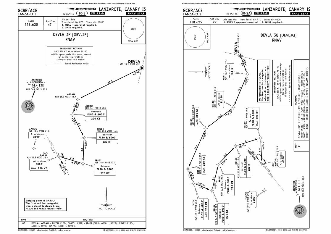
.RNAV.STAR.
2300'At or above
SPEED RESTRICTION
Merging point is GARGO.The first and last waypoint,where direct is cleared, areALEDU and RR402 respectively.
10-2
248^
35.2
118.625
.Eff.4.Feb.
| JEPPESEN, 2014, 2016. ALL RIGHTS RESERVED.
22 JAN 16
1. RNAV 1 approval required.2. GNSS required.
RR403 redesignated GARGO; radial update.
Between
FL80 & 6000'
220 KT
LANZAROTE
CHANGES:
ROUTING
334^
MHA 5
000
MAX 250 KT at or below FL100
within speed reduction area, except
for military aircraft orif danger areas are active.
Speed Reduction Area
(IAF)
NOT TO SCALE
RWY
03 DEVLA - ASTAM - ALEDU (FL80-; 6000'+; K220) - RR401 (FL80-; 6000'+; K220) - RR402 (FL80-;
6000'+; K220) - BAPAL (5000'+; K220-).
RNAVDEVLA 3P
Printed from JeppView for Windows 5.3.0.0 on 06 Jul 2018; Terminal chart data cycle 12-2018 (Expired); Notice: After 28 Jun 2018, 0000Z, this chart may no longer be valid
R055^
D18
.5
NA
VIM
N29
08.7 W
013
19.8
DETIV
N29
30.1 W
013
26.6
RR516
N29
24.3
W01
3 29
.3
RR517
N29
22.3
W01
3 20
.0
RR518
N29
16.9 W
013
13.4
RR519
N29
09.1
W01
3 10
.6TUXA
MN29
07.8 W
013
29.2
[DEVL3Q]
Apt Elev
47'
GCRR/ACELANZAROTE
LANZAROTE, CANARY IS
*ATIS
JEPPESEN
10-2A
DAER
OPU
ERTO
N28
56.9
W01
3 36
.1
114.4
LTE
LTE
.RNAV.STAR.
Betw
een
FL8
0 &
6000'
220 K
T
Betw
een
FL8
0 &
6000'
220 K
TBetw
een
FL8
0 &
6000'
220 K
TM
AX
4000'
At
or
above
207^
109^
139^
168^
272^
7.9
6.2
8.3
8.1
8.0
RR513
N29
25.8
W01
3 08
.8 RR512
N29
17.1 W
013
01.2
DEVLA
N29
14.9 W
012
43.1
RR511
N29
12.7
W01
2 49
.5
RR514
N29
31.3 W
013
23.0
MA
X230 K
T
250 K
TM
AX
FL1
10
At
or
above
FL1
10
At
or
above 6.0
11.1
10.9
13.6
3.4
254^
298^
328^
299^
254^
Merg
ing p
oin
t is
TUXA
M.
The f
irst
and l
ast
waypoin
t,w
here
dir
ect
is c
leare
d,
are
RR511 a
nd R
R519 r
especti
vely
.
3500'
At
or
above
118.625
.Eff.4.Feb.
| JEPPESEN, 2014, 2016. ALL RIGHTS RESERVED.
22 JAN 16
SPEED R
ESTRIC
TIO
N
3500'
MSA
ARP
Alt Set: hPa Trans level: By ATC Trans alt: 6000'
1. RNAV 1 approval required. 2. GNSS required.
RR521 redesignated TUXAM; radial update.
LANZARO
TE
Betw
een
FL8
0 &
6000'
220 K
T
Betw
een
FL9
0 &
6000'
230 K
TM
AX
CHANGES:
RO
UTIN
G
NO
T T
O S
CA
LE
235^
MHA 4
000
(IA
F)
DEVLA
- R
R511 (
FL110+
) -
RR512 (
FL110+
) -
RR513 (
K250-)
-
RR514 (
K230-)
- D
ETIV
(FL90-;
6000'+
; K230-)
- R
R516 (
FL80-;
6000'+
; K220)
- RR517 (
FL80-;
6000'+
; K220)
- RR518 (
FL80-;
6000'+
; K220)
- RR519 (
FL80-;
6000'+
; K220-)
- N
AVIM
(4000'+
).
MA
X 2
50 K
T a
t or
belo
w F
L100
wit
hin
speed r
educti
on a
rea,
except
for
mil
itary
air
cra
ft o
r
if d
anger
are
as a
re a
cti
ve.
Speed R
educti
on A
rea
RNAVDEVLA 3Q
RW
Y
21
Printed from JeppView for Windows 5.3.0.0 on 06 Jul 2018; Terminal chart data cycle 12-2018 (Expired); Notice: After 28 Jun 2018, 0000Z, this chart may no longer be valid

R154^D18.0
Apt Elev
47'
GCRR/ACELANZAROTE
LANZAROTE, CANARY IS
*ATIS
JEPPESEN
TERTO
PEPOM
GINAS
POKAB
NIRPO
ASTAM
ALEDU
RR4~1
RR4~2BAPAL
GARGO
10-2B
DAEROPUERTO
N28 56.9 W013 36.1
114.4 LTELTE
18.5
24.8
9.1
7.8
15.9
5.0
8.0
8.0
8.0
292^
188^
159^
201^
234^
204^
204^
Between
FL80 & 6000'
220 KT
Between
FL80 & 6000'
220 KT
Between
FL80 & 6000'
220 KT220 KT
At or above
5000'
MAX
.RNAV.STAR.
2300'At or above
118.625
.Eff.9.Nov.
At or above
FL130
| JEPPESEN, 2014, 2017. ALL RIGHTS RESERVED.
27 OCT 17
SPEED RESTRICTION
Alt Set: hPa Trans level: By ATC Trans alt: 6000'
1. RNAV 1 approval required. 2. GNSS required.
Merging point is GARGO.The first and last waypoint,where direct is cleared, areALEDU and RR402 respectively.
202^
LANZAROTE
At or below
FL170
MSA ARP
3500
RNAV STAR TERTO 6P renumbered 7P & revised.CHANGES:
334^
MHA 5
000
(IAF)
NOT TO SCALE
MAX 250 KT at or below FL100
within speed reduction area, except
for military aircraft or
if danger areas are active.
Speed Reduction Area
ROUTING
TERTO 7P [TERT7P]RWY 03 RNAV ARRIVAL
TERTO - PEPOM - GINAS (FL170-) - POKAB - NIRPO (FL130+) - ASTAM - ALEDU (FL80-; 6000'+; K220) -
RR401 (FL80-; 6000'+; K220) - RR402 (FL80-; 6000'+; K220) - BAPAL (5000'+; K220-).
Printed from JeppView for Windows 5.3.0.0 on 06 Jul 2018; Terminal chart data cycle 12-2018 (Expired); Notice: After 28 Jun 2018, 0000Z, this chart may no longer be valid
R028
^D46.1
R055^ D1
8.5
GAKMI
NAVIM
DETIVRR516
RR517
RR518
RR519TUXAM
Apt Elev
47'
GCRR/ACELANZAROTE
LANZAROTE, CANARY IS
*ATIS
JEPPESEN
TERTO
PEPOM
10-2C
DAEROPUERTO
N28 56.9 W013 36.1
114.4 LTELTE
18.5 23
4^
.RNAV.STAR.
Merging point is TUXAM.The first and last waypoint,where direct is cleared, areRR516 and RR519 respectively.
FL110At or above
Between
FL80 & 6000'
220 KT
Between
FL80 & 6000'
220 KT
Between
FL80 & 6000'
220 KTBetween
FL80 & 6000'
220 KTMAX
4000'At or above
231^
207^
109^
139^
168^
272^
20.5
13.4
7.9
6.2
8.3
8.1
8.0
Between
FL90 & 6000'
230 KTMAX
250 KT
At or above
MAX
FL90
3500'At or above
118.625
.Eff.9.Nov.
| JEPPESEN, 2014, 2017. ALL RIGHTS RESERVED.
27 OCT 17
SPEED RESTRICTION
Alt Set: hPa Trans level: By ATC Trans alt: 6000'
1. RNAV 1 approval required. 2. GNSS required.
LANZAROTE
MSA ARP
3500
RNAV STAR TERTO 3Q renumbered 4Q & revised.CHANGES:
NOT TO SCALE
208^
MHA F
L90
235^
MHA
400
0
(IAF)
ROUTING
MAX 250 KT at or below FL100
within speed reduction area, except
for military aircraft or
if danger areas are active.
Speed Reduction Area
TERTO 4Q [TERT4Q]RWY 21 RNAV ARRIVAL
TERTO - PEPOM (FL110+) - GAKMI (FL90+; K250-) - DETIV (FL90-; 6000'+; K230-) - RR516 (FL80-; 6000'+;
K220) - RR517 (FL80-; 6000'+; K220) - RR518 (FL80-; 6000'+; K220) - RR519 (FL80-; 6000'+; K220-) -
NAVIM (4000'+).
Printed from JeppView for Windows 5.3.0.0 on 06 Jul 2018; Terminal chart data cycle 12-2018 (Expired); Notice: After 28 Jun 2018, 0000Z, this chart may no longer be valid

060^
D63
.7
D65.1
GDV
112.9
GDV
D87
.2
D25.4
R27
1^
R271^
D25.4
LTE
[LARY2P]
Apt Elev
47'
GCRR/ACE
Trans level: By ATC Trans alt: 6000'
LANZAROTE
LANZAROTE, CANARY IS
Alt Set: hPa*ATIS
JEPPESEN
DLA
NZARO
TE
N28
56.9
W01
3 36
.1
114.4
LTE
LTE
(H)
SPEED
RESTRIC
TIO
N
10-2D
[RASE2P]
.STAR.
RA
SEP
N28
41.7
W01
4 26.8
LA
RYS
N28
52.3
W01
4 50
.1
MA
PED
N28
55.1
W01
4 05.0
D41.4
LTE
D71.1
GDV
23.7
16.0
16.1
7.4
092^
200 K
TM
AX
LA
RY
S 2
P
RASEP 2
P
MA
PED
1
2
2
Fro
m G
CLA a
nd G
CXO
Fro
m G
CLP a
nd G
CTS
1
220 K
T
220 K
T
STARs renumbered.
118.625
2 JAN 15 .Eff.8.Jan.
| JEPPESEN, 2014, 2015. ALL RIGHTS RESERVED.
HO
LDIN
G O
VER
(LTE
R-272
)
CHANGES:
(IA
F)
MAX 2
50 K
T a
t or
belo
w F
L100
within
speed r
eduction a
rea, except
for
military
aircra
ft o
rif d
anger
are
as a
re a
ctive.
LARYS TWO PAPA (LARYS 2P)RASEP TWO PAPA (RASEP 2P)
RWY 03 ARRIVALS
(IA
F)
5000
091^
NO
T T
O S
CA
LE
Printed from JeppView for Windows 5.3.0.0 on 06 Jul 2018; Terminal chart data cycle 12-2018 (Expired); Notice: After 28 Jun 2018, 0000Z, this chart may no longer be valid
060^
D63
.7
GDV
112.9
GDV
D87
.1
D71.8
D16.0 R33
5^
R262
^
D92.
6
D96
.6
[LARY2X]
Apt Elev
47'
GCRR/ACE
Trans level: By ATC Trans alt: 6000'
LANZAROTE
LANZAROTE, CANARY IS
Alt Set: hPa*ATIS
JEPPESEN
DLA
NZARO
TE
N28
56.9
W01
3 36
.1
114.4
LTE
LTE
(H)
10-2E
[RASE2Q]
.STAR.
RA
SEP
N28
41.7
W01
4 26
.8
LA
RYS
N28
52.3
W01
4 50
.1
MA
PED
D27.2
LZR
MO
TID
LUNO
BN29
10.8
W01
3 45
.2
082^
44.6
7.7
23.4
RASEP 2
Q
LA
RYS 2
X
N29
05.3
W01
3 52
.2
(D19.5
LZR)
LTE 16 DM
EArc
6000
LANZARO
TE11
5.2
LZR
LZ
RN29
10.0
W01
3 30
.6
D (H)
5.5
4.0
D21.0
LTE
N28
55.1
W01
4 05
.0
D18.0
LTE
N29
00.4
W01
3 56
.2
SPEED
RESTRIC
TIO
N
2
1
2
Fro
m G
CLA a
nd G
CXO
Fro
m G
CLP a
nd G
CTS
1
(115.0
LPC R
-053/
D111.8
)
(115.0
LPC R
-053/
D120.1
)
(115.0
LPC R
-053/
D96.7
)
118.625
STARs renumbered.
220 K
T
220 K
T
2 JAN 15 .Eff.8.Jan.
| JEPPESEN, 2014, 2015. ALL RIGHTS RESERVED.CHANGES:
(IA
F)
LARYS TWO X-RAY (LARYS 2X)
RWY 21 ARRIVALS
(IA
F)
6000
155^
RASEP TWO QUEBEC (RASEP 2Q)
NO
T T
O S
CA
LE
MAX 2
50 K
T a
t or
belo
w F
L100
within
speed r
eduction a
rea, except
for
military
aircra
ft o
rif d
anger
are
as a
re a
ctive.
Printed from JeppView for Windows 5.3.0.0 on 06 Jul 2018; Terminal chart data cycle 12-2018 (Expired); Notice: After 28 Jun 2018, 0000Z, this chart may no longer be valid

DDEVLA
N29
14.9
W01
2 43
.1
[DEVL1Z]
Apt Elev
47'
GCRR/ACE
Trans level: By ATC Trans alt: 6000'
LANZAROTE
LANZAROTE, CANARY IS
Alt Set: hPa*ATIS
JEPPESEN
3500'
MSA
ARP
| JEPPESEN, 2014. ALL RIGHTS RESERVED.
10-2F .STAR.
BY ATC
DLA
NZARO
TE
N28
56.9
W01
3 36
.1
114.4
LTE
LTE
LZ
LANZARO
TE
310
LZN28
57.3
W01
3 36.7
(H)
255^
R075
^
49.8
5000
018^
198^
HO
LDIN
GS O
VER
LZLT
ERW
Y 0
3RW
Y 2
1RW
Y 0
3
SPEED
RESTRIC
TIO
N
118.625
2 JAN 15 .Eff.8.Jan.
None.
5000
5000
CHANGES:
DEVLA ONE ZULU (DEVLA 1Z)
030^
210^
NO
T T
O S
CA
LE
RWYS 03, 21 ARRIVAL
(IA
F)
(IA
F)
193^ 5000
013^
MAX 2
50 K
T a
t or
belo
w F
L100
within
speed r
eduction a
rea, except
for
military
aircra
ft o
rif d
anger
are
as a
re a
ctive.
Speed R
eduction A
rea
Printed from JeppView for Windows 5.3.0.0 on 06 Jul 2018; Terminal chart data cycle 12-2018 (Expired); Notice: After 28 Jun 2018, 0000Z, this chart may no longer be valid
Apt Elev
47'
GCRR/ACE
Trans level: By ATC Trans alt: 6000'
LANZAROTE
LANZAROTE, CANARY IS10-3
[BAMK2M]
[BAMK2N]
JEPPESEN
.RNAV.SID.
3500'
MSA ARP
RIPIXN29 00.2 W013 33.5
RR45~N29 05.4 W013 26.4
UMOTON28 38.0 W013 25.2
FV731N28 30.3 W013 28.0
FV732N28 24.7 W013 34.7
BAMKUN28 22.8 W013 43.7
RODIMN28 52.2 W013 38.9
039^
212^
1600'At or above
At or above
1300'
BAMKU
2N
SPEED RESTRICTION
203^
232^
261^
8.1
8.1
8.2
3200'At or above
7.0% V/V (fpm) 532 709 1063 1418 1772 2127
5.0% V/V (fpm) 380 506 760 1013 1266 1519
Gnd speed-KT 75 100 150 200 250 300
209'
85'
MAX
220 KT
At or above
6000'
Direct distance from
Lanzarote Apt to:
RIPIX 4 NM
RODIM 5NM
.Eff.4.Feb.
BAMKU 2
M
| JEPPESEN, 2014, 2016. ALL RIGHTS RESERVED.
22 JAN 16
3. EXPECT close-in obstacles
1. RNAV 1 approval required.2. GNSS required.
Radial update.CHANGES:
RWY
03
ROUTING
4000' , await further clearance
SID
BAMKU 2M
BAMKU 2N 21
MAX 250 KT at or below FL100
within speed reduction area, exceptfor military aircraft or
if danger areas are active.
NOT TO SCALE
These SIDs require minimum climb gradients
of
7.0% up to 1600'.5.0% up to 1300'.
BAMKU 2M:BAMKU 2N:
BAMKU 2MBAMKU 2N
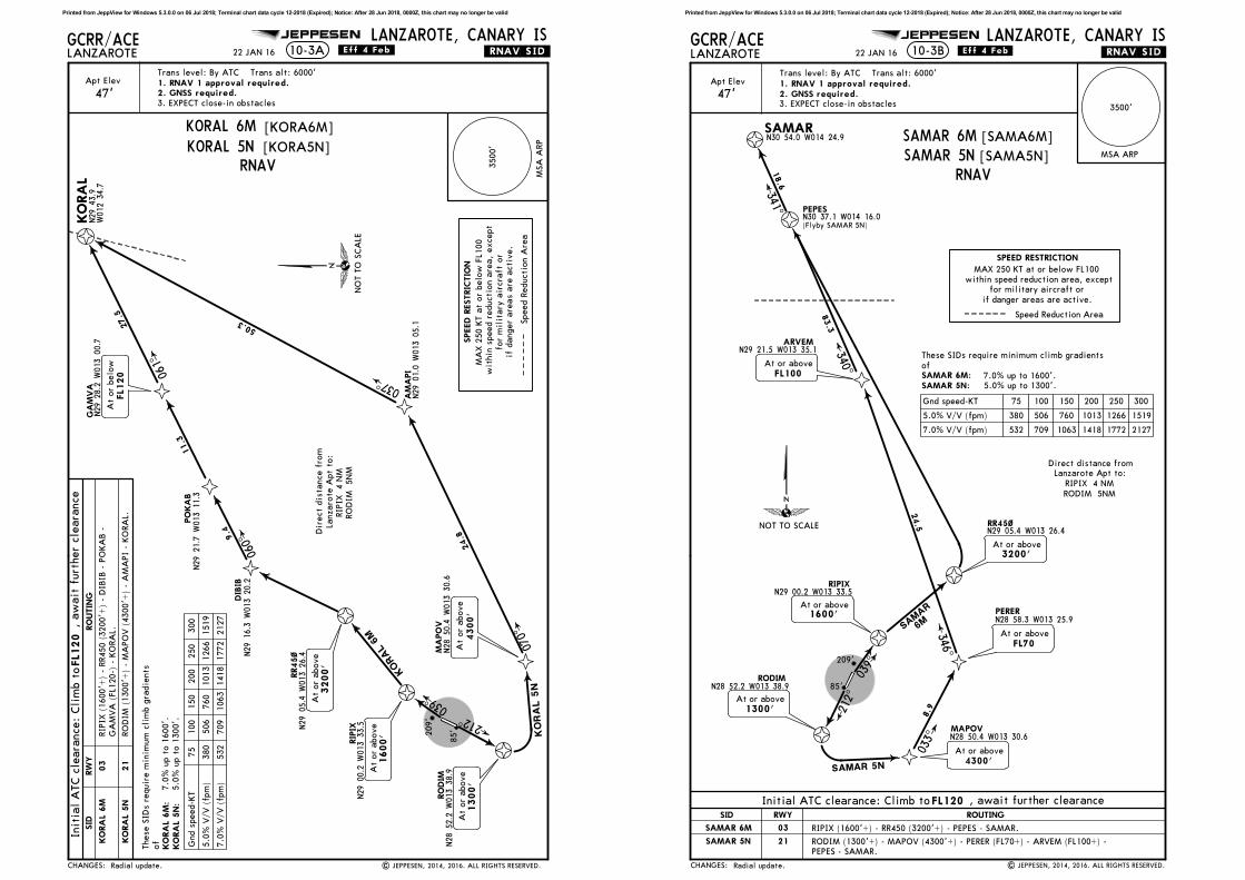
Initial ATC clearance: Climb to
At FL90
BAMKU 2M
RIPIX (1600'+) - RR450 (3200'+) - UMOTO (FL90; K220) - FV731 (6000'+;
FL90-; K220) - FV732 (6000'+; FL90-; K220) - BAMKU (6000'+; K220-).
220 KT
Between
6000' & FL90
BAMKU 2M
220 KT
Between
6000' & FL90
4000'At or above
BAMKU 2N
220 KT
BAMKU 2M
RNAV
RODIM (1300'+) - UMOTO (4000'+; K220) - FV731 (K220) - FV732 (K220) -
BAMKU (6000'+; K220-).
Printed from JeppView for Windows 5.3.0.0 on 06 Jul 2018; Terminal chart data cycle 12-2018 (Expired); Notice: After 28 Jun 2018, 0000Z, this chart may no longer be valid
DIB
IBN29
16.3
W01
3 20
.2
PO
KA
BN29
21.7
W01
3 11
.3
GA
MVA
N29
28.2
W01
3 00
.7
KO
RA
L
MA
PO
VN28
50.4
W01
3 30.6
AM
API
N29
01.0
W01
3 05
.1
GCRR/ACELANZAROTE
LANZAROTE, CANARY IS
[KORA6M]
[KORA5N]
JEPPESEN
.RNAV.SID.10-3A
KORAL 6
M
KO
RA
L 5
N
RR45~
N29
05.4
W01
3 26
.4
RIP
IXN29
00.2
W01
3 33
.5
1600'
At
or
above
RO
DIM
N28
52.2
W01
3 3
8.9
212^
039^
3200'
At
or
above
N29
43.9
W01
2 34
.7
At
or
above
4300'
070^
037^
24.8
50.3
9.4
11.3
27.5
060^
SPEED R
ESTRIC
TIO
N
7.0
% V
/V (
fpm
)532
709
1063
1418
1772
2127
5.0
% V
/V (
fpm
)380
506
760
1013
1266
1519
Gnd s
peed-K
T75
100
150
200
250
300
209'
85'
At
or
belo
w
FL1
20
At
or
above
1300'
.Eff.4.Feb.
| JEPPESEN, 2014, 2016. ALL RIGHTS RESERVED.
Dir
ect
dis
tance f
rom
Lanzaro
te A
pt
to:
RIP
IX 4 N
MRO
DIM
5N
M
22 JAN 16
Apt Elev
47'
Trans level: By ATC Trans alt: 6000'
3. EXPECT close-in obstacles
1. RNAV 1 approval required.2. GNSS required.
3500'
MSA
ARP
061^
Radial update.CHANGES:
RW
Y
03
RO
UTIN
G
FL1
20
, aw
ait
furt
her
cle
ara
nce
SID
KO
RA
L 6M
KO
RA
L 5N
21
RO
DIM
(1300'+
) -
MA
PO
V (
4300'+
) -
AM
API
- KO
RA
L.
MA
X 2
50 K
T a
t or
belo
w F
L100
wit
hin
speed r
educti
on a
rea,
except
for
mil
itary
air
cra
ft
or
if d
anger
are
as a
re a
cti
ve.
Speed R
educti
on A
rea
NO
T T
O S
CA
LE
These S
IDs r
equir
e m
inim
um
cli
mb g
radie
nts
of
7.0
% u
p t
o 1
600'.
5.0
% u
p t
o 1
300'.
KO
RA
L 6M
:KO
RA
L 5N:
KORAL 6MKORAL 5N
Init
ial
ATC c
leara
nce:
Cli
mb t
o
RIP
IX (
1600'+
) -
RR450 (
3200'+
) -
DIB
IB -
PO
KA
B -
GA
MVA
(FL120-)
- K
ORA
L.
RNAV
Printed from JeppView for Windows 5.3.0.0 on 06 Jul 2018; Terminal chart data cycle 12-2018 (Expired); Notice: After 28 Jun 2018, 0000Z, this chart may no longer be valid
PEPESN30 37.1 W014 16.0
SAMARN30 54.0 W014 24.9
MAPOVN28 50.4 W013 30.6
PERERN28 58.3 W013 25.9
ARVEMN29 21.5 W013 35.1
GCRR/ACELANZAROTE
LANZAROTE, CANARY ISJEPPESEN
.RNAV.SID.
[SAMA6M]
[SAMA5N]
10-3B
SAMAR 5N
RR45~N29 05.4 W013 26.4
RIPIXN29 00.2 W013 33.5
1600'At or above
RODIMN28 52.2 W013 38.9
At or above
1300' 212^
039^
3200'At or above
At or above
FL70
SAMAR
6M
033^
At or above
4300'
346^
340^
341^
At or above
FL100
8.9
83.3
18.6
24.5
7.0% V/V (fpm) 532 709 1063 1418 1772 2127
5.0% V/V (fpm) 380 506 760 1013 1266 1519
Gnd speed-KT 75 100 150 200 250 300
209'
85'
(Flyby SAMAR 5N)
.Eff.4.Feb.
| JEPPESEN, 2014, 2016. ALL RIGHTS RESERVED.
Direct distance fromLanzarote Apt to:
RIPIX 4 NM
RODIM 5NM
22 JAN 16
Apt Elev
47'
Trans level: By ATC Trans alt: 6000'
3. EXPECT close-in obstacles
1. RNAV 1 approval required.2. GNSS required.
SPEED RESTRICTION
3500'
MSA ARP
Radial update.CHANGES:
RWY
03
ROUTINGSID
SAMAR 6M
SAMAR 5N 21
RIPIX (1600'+) - RR450 (3200'+) - PEPES - SAMAR.
RODIM (1300'+) - MAPOV (4300'+) - PERER (FL70+) - ARVEM (FL100+) -
PEPES - SAMAR.
NOT TO SCALE
These SIDs require minimum climb gradients
of
7.0% up to 1600'.
5.0% up to 1300'.
SAMAR 6M:SAMAR 5N:
SAMAR 6MSAMAR 5N
MAX 250 KT at or below FL100
within speed reduction area, except
for military aircraft or
if danger areas are active.
Speed Reduction Area
RNAV
Initial ATC clearance: Climb toFL120 , await further clearance
Printed from JeppView for Windows 5.3.0.0 on 06 Jul 2018; Terminal chart data cycle 12-2018 (Expired); Notice: After 28 Jun 2018, 0000Z, this chart may no longer be valid

TENDAN28 32.0 W013 38.4
TOSPUN28 27.4 W013 40.7 NIDOM
N28 21.4 W013 39.7
FV621N28 14.4 W013 35.4
FV622N28 06.4 W013 36.5
FV623N28 00.4 W013 42.5
SOTADN27 58.5 W013 51.3
GCRR/ACELANZAROTE
LANZAROTE, CANARY IS
[SOTA2M]
JEPPESEN
.RNAV.SID.
[SOTA1N]
10-3C
SO
TA
D 1
N
SOTAD 2M
RR45~
RIPIXN29 00.2 W013 33.5
RODIMN28 52.2 W013 38.9
212^
039^
3200'At or above
N29 05.4W013 26.4
220 KT
At or above
5000'
MAX
Between
6000' & FL80
220 KT
Between
6000' & FL80
220 KT
Between
6000' & FL80
220 KT
Between
6000' & FL80
220 KT
209^
177^156^
193^
227^
262^
4.9
6.0
8.0
8.0
8.0
8.0
7.0% V/V (fpm) 532 709 1063 1418 1772 2127
5.0% V/V (fpm) 380 506 760 1013 1266 1519
Gnd speed-KT 75 100 150 200 250 300
209'
85'
.Eff.4.Feb.
| JEPPESEN, 2014, 2016. ALL RIGHTS RESERVED.
Direct distance from
Lanzarote Apt to:
RIPIX 4 NM
RODIM 5NM
22 JAN 16
SPEED RESTRICTION
Apt Elev
47'
Trans level: By ATC Trans alt: 6000'
3. EXPECT close-in obstacles
1. RNAV 1 approval required.2. GNSS required.
3500'
MSA ARP
Radial update.
At or above
1300'
1600'At or above
CHANGES:
RWY
03
ROUTINGSID
21
NOT TO SCALE
7.0% up to 1600'.
5.0% up to 1300'.
These SIDs require minimum
climb gradients of
SOTAD 2M:SOTAD 1N:
SOTAD 2MSOTAD 1N
MAX 250 KT at or below FL100
within speed reduction area, except
for military aircraft or
if danger areas are active.
RNAV
Initial ATC clearance: Climb to , await further clearance4000'
RIPIX (1600'+) - RR450 (3200'+) - TENDA - TOSPU - NIDOM (6000'+; FL80-;
K220) - FV621 (6000'+; FL80-; K220) - FV622 (6000'+; FL80-; K220) - FV623
(6000'+; FL80-; K220) - SOTAD (5000'+; K220-).
RODIM (1300'+) - TENDA - TOSPU - NIDOM (6000'+; FL80-; K220) - FV621
(6000'+; FL80-; K220) - FV622 (6000'+; FL80-; K220) - FV623 (6000'+; FL80-;
K220) - SOTAD (5000'+; K220-).
SOTAD2M
SOTAD1N
Printed from JeppView for Windows 5.3.0.0 on 06 Jul 2018; Terminal chart data cycle 12-2018 (Expired); Notice: After 28 Jun 2018, 0000Z, this chart may no longer be valid
GILDIN30 08.3 W013 33.3
VASTON30 30.6 W013 34.4
GCRR/ACELANZAROTE
LANZAROTE, CANARY ISJEPPESEN
.RNAV.SID.
[VAST6M]
[VAST5N]
10-3D
VASTO 5
N
RR450N29 05.4 W013 26.4
RIPIXN29 00.2 W013 33.5
1600'At or above
RODIMN28 52.2 W013 38.9
212^
039^
At or above
FL70
PERERN28 58.3 W013 25.9
MAPOVN28 50.4 W013 30.6
At or above
4300'
VASTO
6M
At or above1300'
033^
346^
007^
003^
3200'At or above
ARVEMN29 21.5 W013 35.1
At or above
FL100
8.9
24.5
46.8
22.2
7.0% V/V (fpm) 532 709 1063 1418 1772 2127
5.0% V/V (fpm) 380 506 760 1013 1266 1519
Gnd speed-KT 75 100 150 200 250 300
209'
85'
| JEPPESEN, 2014, 2016. ALL RIGHTS RESERVED.
Direct distance from
Lanzarote Apt to:RIPIX 4 NM
RODIM 5NM
22 JAN 16 .Eff.4.Feb.
SPEED RESTRICTION
Apt Elev
47'
Trans level: By ATC Trans alt: 6000'
3. EXPECT close-in obstacles
1. RNAV 1 approval required.2. GNSS required.
3500'
MSA ARP
Radial update.CHANGES:
SID ROUTING
VASTO 6M
VASTO 5N
FL120 , await further clearance.
RIPIX (1600'+) - RR450 (3200'+) - GILDI - VASTO.
FL120At or above
VASTO 5N
NOT TO SCALE
These SIDs require minimum climb gradients
of
7.0% up to 1600'.
5.0% up to 1300'.
VASTO 6M:VASTO 5N:
RODIM (1300'+) - MAPOV (4300'+) - PERER (FL70+) - ARVEM (FL100+) -
GILDI (FL120+) - VASTO.
VASTO 6MVASTO 5N
Initial ATC clearance: Climb to
RWY
03
21
MAX 250 KT at or below FL100
within speed reduction area, except
for military aircraft orif danger areas are active.
Speed Reduction Area
RNAV
Printed from JeppView for Windows 5.3.0.0 on 06 Jul 2018; Terminal chart data cycle 12-2018 (Expired); Notice: After 28 Jun 2018, 0000Z, this chart may no longer be valid
039^
050^
GILDIN30 08.3 W013 33.3
VASTON30 30.6 W013 34.4
Apt Elev
47'
GCRR/ACELANZAROTE
LANZAROTE, CANARY ISJEPPESEN
.RNAV.SID.
[VAST1Y]
[SAMA1Y]
10-3E
RR450
N29 05.4 W013 26.4
003^22.2
7.0% V/V (fpm) 532 709 1063 1418 1772 2127
Gnd speed-KT 75 100 150 200 250 300
209'
22 JAN 16 .Eff.4.Feb.
SAMARN30 54.0 W014 24.9
PEPES
18.6
341^
SAM
AR 1
Y
VA
STO
1Y
D12.0 LTE
DAEROPUERTO
LTEN28 56.9 W013 36.1
114.4 LTE
SPEED RESTRICTION
3500'
MSA ARP
At or above
FL160
4500'At or above
N30 37.1 W014 15.9
FL340At or above
FL260At or above
Trans level: By ATC Trans alt: 6000'
1. RNAV 1 approval required.2. DME/DME required.3.
4.5.
DME associated to ILS are not usable for these departures RNAV 1.
EXPECT close-in obstacles.
The RNAV (DME/DME) procedure will start once the initial conven-
tional climbing has been finished at the waypoint RR450.
Radial update. | JEPPESEN, 2015, 2016. ALL RIGHTS RESERVED.
LANZAROTE
CHANGES:
SID
VASTO 1Y
SAMAR 1Y
FL120, await further clearance.
NOT TO SCALE
7.0% up to 4500'.
VASTO 1YSAMAR 1Y
Initial ATC clearance: Climb to
At or above
1600'
D4.0 LTE
ROUTING
Climb on LTE R-039 direct to D4.0 LTE, turn RIGHT, intercept LTE R-050 to RR450.
At RR450 turn LEFT direct to GILDI, turn RIGHT to VASTO.
At RR450 turn LEFT direct to PEPES, turn LEFT to SAMAR.
These SIDs require a minimum climb gradient
of
RNAV
MAX 250 KT at or below FL100
within speed reduction area, except
for military aircraft or
if danger areas are active.
Speed Reduction Area
RWY
03
RWY
03
INITIAL CLIMB
FL120At or above
Printed from JeppView for Windows 5.3.0.0 on 06 Jul 2018; Terminal chart data cycle 12-2018 (Expired); Notice: After 28 Jun 2018, 0000Z, this chart may no longer be valid
060^
D59.4
050^
039^
170^
D30.1
D13.3R06
8^
.SID.GCRR/ACE
Trans level: By ATC Trans alt: 6000'
LANZAROTE
LANZAROTE, CANARY IS
12
25
EXPECT close-in obstacles
JEPPESEN
LTEN28 56.9 W013 36.1
LANZAROTE
115.2 LZRLZRN29 10.0 W013 30.6
D
SPEED RESTRICTION
TENDA 7
M
KORA
L1V
FUERTEVENTURA
114.1 FTVFTVN28 25.8 W013 51.9
D
At or above
5000'
By A
TC
By ATC
209'
10-3F .Eff.18.Aug.
| JEPPESEN, 2014, 2016. ALL RIGHTS RESERVED.
5 AUG 16
LANZAROTEAEROPUERTO
SID TENDA 5M renumbered 7M.
Apt Elev
47'
D114.4 LTE
21
KORAL
NOT TO SCALE
CHANGES:
At or above
1600'
These SIDs require a minimum climb gradient
of
75 100 150 200 250 300Gnd speed-KT
532 709 1063 1418 1772 2127
SID ROUTING
KORAL 1V
TENDA 7M
Initial ATC clearance:KORAL 1V:
TENDA 7M:
CONTINGENCY DEPARTURES
Climb on 047^ heading to 4000', turn by following ATC instructions.
D4.0 LTE
D14.0 LTE
D15.0 LZR
N29 32.1W012 54.2
7.0% V/V(fpm)
This SID requires a minimum climb gradient of 7.0% up to 3500'.
N29 43.9W012 34.7
TENDA
LINDE
248^16.8
N28 32.0 W013 38.4
N28 39.7 W013 21.5
7.0% up to 1600'.
In case of failure of one or more navaids, the following procedure shall be carried out:
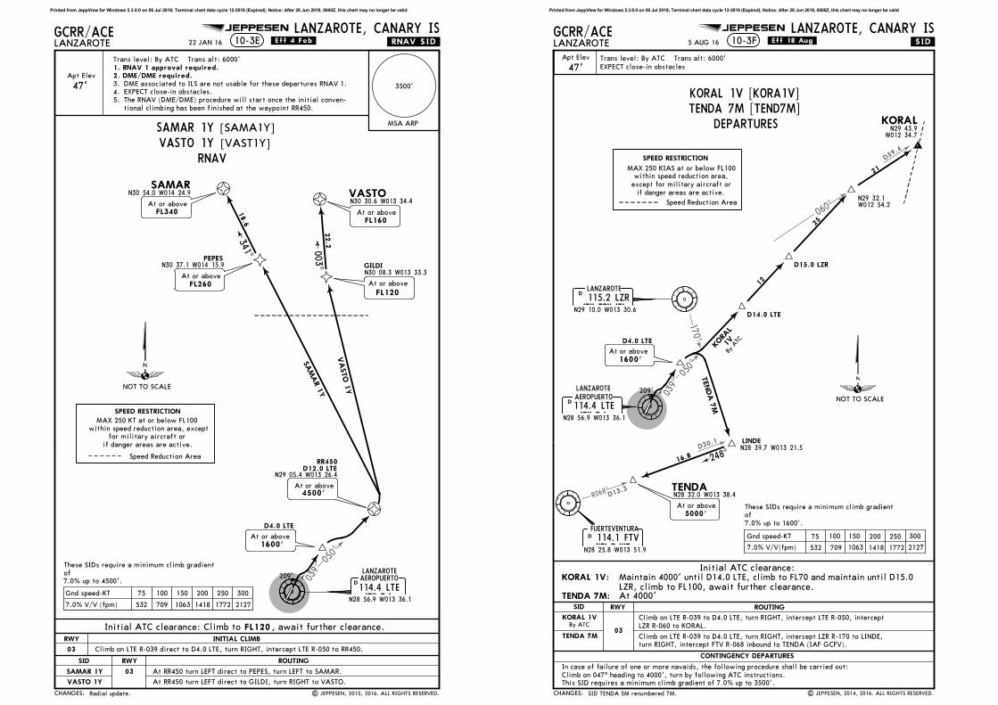
KORAL 1V [KORA1V]TENDA 7M [TEND7M]
MAX 250 KIAS at or below FL100within speed reduction area,
except for military aircraft or
if danger areas are active.
Speed Reduction Area
At 4000'LZR, climb to FL100, await further clearance.Maintain 4000' until D14.0 LTE, climb to FL70 and maintain until D15.0
DEPARTURES
RWY
03
Climb on LTE R-039 to D4.0 LTE, turn RIGHT, intercept LTE R-050, intercept
LZR R-060 to KORAL.
Climb on LTE R-039 to D4.0 LTE, turn RIGHT, intercept LZR R-170 to LINDE,
turn RIGHT, intercept FTV R-068 inbound to TENDA (IAF GCFV).
Printed from JeppView for Windows 5.3.0.0 on 06 Jul 2018; Terminal chart data cycle 12-2018 (Expired); Notice: After 28 Jun 2018, 0000Z, this chart may no longer be valid

D59.4
190^
D24.9
.SID.GCRR/ACE
Trans level: By ATC Trans alt: 6000'
LANZAROTE
LANZAROTE, CANARY IS
EXPECT close-in obstacles
JEPPESEN
SPEED RESTRICTION
By ATC
10-3G
114.4 LTELTEN28 56.9 W013 36.1
D
LANZAROTE
115.2 LZRLZRN29 10.0 W013 30.6
D 060^
3
12
44.4
D5.3 LTE
D6.8 LTE
145^hdg
013^
R193
^
KO
RA
L 1W
TENDA
3N
5.3% V/V (fpm) 403 537 805 1073 1342 1610
5.0% V/V (fpm) 380 506 760 1013 1266 1519
Gnd speed-KT 75 100 150 200 250 300
At or above
5000'
85'
By A
TC
.Eff.18.Aug.
| JEPPESEN, 2014, 2015. ALL RIGHTS RESERVED.
5 AUG 16
None.
LANZAROTEAEROPUERTO
47'Apt Elev
NOT TO SCALE
CHANGES:
SID ROUTING
KORAL 1W
TENDA 3N
Initial ATC clearance:KORAL 1W:
TENDA 3N:
CONTINGENCY DEPARTURES
This SID requires a minimum climb gradient of 5.3% up to 3500'.
KORALN29 43.9
W012 34.7
TENDAN28 32.0 W013 38.4
At or above
1200'
TENDA 3N
1300'
Turnat or above
TENDA 3NThis SID requires a minimum climb gradient
of
5.0% up to 3000'.
Climb on runway heading to 4000', turn by following ATC instructions.
In case of failure of one or more navaids, the following procedure shall be carried out:
KORAL 1W [KORA1W]TENDA 3N [TEND3N]
Speed Reduction Area
MAX 250 KIAS at or below FL100
within speed reduction area,
except for military aircraft orif danger areas are active.
D15.0 LZR
D3.0 LZR
Maintain 4000' until LZR R-060/D3.0, climb to FL70 and maintain untilLZR R-060/D15.0, climb to FL100, await further clearanceAt 4000'
DEPARTURES
RWY
21
Climb on runway heading to D6.8 LTE, turn LEFT, intercept LZR R-193 inbound
to LZR, LZR R-060 to KORAL.
Climb on runway heading to D5.3 LTE, turn LEFT, 145^ heading, intercept
LTE R-190 to TENDA (IAF GCFV).
Printed from JeppView for Windows 5.3.0.0 on 06 Jul 2018; Terminal chart data cycle 12-2018 (Expired); Notice: After 28 Jun 2018, 0000Z, this chart may no longer be valid
050^
039^
232^
R343^
R019
^
D15.0
D35.8
D
D36.
4
.SID.GCRR/ACE
Trans level: By ATC Trans alt: 6000'
LANZAROTE
LANZAROTE, CANARY IS10-3H
EXPECT close-in obstacles
JEPPESEN
LANZAROTE115.2 LZRLZR
N29 10.0 W013 30.6
D
114.4 LTELTEN28 56.9 W013 36.1
D
KEMEVN28 39.7 W013 58.4
RULOBN28 45.1 W014 01.0
ELNANN29 07.8 W013 40.6
SOMOBN29 00.8 W013 42.5
261^
199^
163^
8.9
7.0
23.0
6.0
At or above
FL80
FUERTEVENTURA
114.1 FTVFTVN28 25.8 W013 51.9
D
7.0% V/V (fpm) 532 709 1063 1418 1772 2127
Gnd speed-KT 75 100 150 200 250 300
209'
SPEED RESTRICTION
.Eff.18.Aug.
| JEPPESEN, 2014, 2016. ALL RIGHTS RESERVED.
5 AUG 16
Apt Elev
47'
LANZAROTEAEROPUERTO
SID renumbered.CHANGES:
N29 05.2W013 26.2
D4.0 LTE
D12.0 LTE
NOT TO SCALE
Climb on 047^ heading to 4000', turn by following ATC instructions.
ROUTING
CONTINGENCY DEPARTURES
This SID requires a minimum climb gradient of 7.0% up to 3500'.
3200'3200'At or above
At or above
1600'
This SID requires a minimum climb gradient
of
7.0% up to 1600'.
In case of failure of one or more navaids, the following procedure shall be carried out:
KEMEV 3M [KEME3M]
MAX 250 KIAS at or below FL100
within speed reduction area, except
for military aircraft or
if danger areas are active.
Initial ATC clearance: At 4000'
DEPARTURE
Climb on LTE R-039 to D4.0 LTE, turn RIGHT, intercept LTE R-050 to D12.0 LTE, turn LEFT direct
intercept LZR R-232 to RULOB, turn LEFT, intercept FTV R-343 inbound to KEMEV (IAF GCFV).to LZR, LZR R-261 to ELNAN, turn LEFT, intercept FTV R-019 inbound to SOMOB, turn RIGHT,
RWY
03
Printed from JeppView for Windows 5.3.0.0 on 06 Jul 2018; Terminal chart data cycle 12-2018 (Expired); Notice: After 28 Jun 2018, 0000Z, this chart may no longer be valid

232^
R343^
D15.0
D36.
4
D32.
7
250^
Apt Elev
.SID.
47'
GCRR/ACE
Trans level: By ATC Trans alt: 6000'
LANZAROTE
LANZAROTE, CANARY IS10-3J
EXPECT close-in obstacles
JEPPESEN
LANZAROTE
115.2 LZRLZRN29 10.0 W013 30.6
D
114.4 LTELTEN28 56.9 W013 36.1
D
KEMEVN28 39.7 W013 58.4
RULOBN28 45.1 W014 01.0
GOMSU
163^6.0
FUERTEVENTURA
114.1 FTVFTVN28 25.8 W013 51.9
D
SPEED RESTRICTION
3.7
283^ D5.3 LTE
At or above
1300'
85'
At or above
4000'
hdgN28 47.6
W013 58.0
5.3% V/V (fpm) 403 537 805 1073 1342 1610
5.0% V/V (fpm) 380 506 760 1013 1266 1519
Gnd speed-KT 75 100 150 200 250 300
.Eff.18.Aug.
| JEPPESEN, 2014, 2016. ALL RIGHTS RESERVED.
5 AUG 16
LANZAROTEAEROPUERTO
SID renumbered.CHANGES:
NOT TO SCALE
ROUTING
CONTINGENCY DEPARTURES
This SID requires a minimum climb gradient of 5.3% up to 3500'.
Climb on runway heading to 4000', turn by following ATC instructions.
This SID requires a minimum climb gradient
of
5.0% up to 3000'.
In case of failure of one or more navaids, the following procedure shall be carried out:
KEMEV 3N [KEME3N]
MAX 250 KIAS at or below FL100
within speed reduction area, except
for military aircraft or
if danger areas are active.
Initial ATC clearance: At 4000'
DEPARTURE
Climb on runway heading to D5.3 LTE, turn RIGHT, 283^ heading, intercept LTE R-250 to
GOMSU, turn LEFT, intercept LZR R-232 to RULOB, turn LEFT, intercept FTV R-343
inbound to KEMEV (IAF GCFV).
RWY
21
Printed from JeppView for Windows 5.3.0.0 on 06 Jul 2018; Terminal chart data cycle 12-2018 (Expired); Notice: After 28 Jun 2018, 0000Z, this chart may no longer be valid
232^
R019^D35.8
D
050^
039^
D82
.8
D50
.7
Apt Elev
.SID.
47'
GCRR/ACE
Trans level: By ATC Trans alt: 6000'
LANZAROTE
LANZAROTE, CANARY IS10-3K
EXPECT close-in obstacles
JEPPESEN
LANZARO
TE
115.2
LZR
LZ
RN29
10.0
W01
3 30
.6
D
114.4
LTE
LTE
N28
56.9
W01
3 36
.1
D
SPEED R
ESTRIC
TIO
N209'
ELN
AN
SO
MO
BN29
00.8
W01
3 42
.5
261^
199^
8.9
7.0
At
or
above
FL8
0
32.1
LORPO
N28
13.0
W01
4 39
.1
At
or
above
FL9
0
37.0
KO
SIB
N28
35.2
W01
4 12
.8
FUER
TEVEN
TURA
114.1
FTV
FTV
N28
25.8
W01
3 51
.9
D
N29
07.8
W01
3 40
.6
.Eff.18.Aug.
| JEPPESEN, 2014, 2016. ALL RIGHTS RESERVED.
5 AUG 16
SID renumbered.
LANZARO
TEAER
OPU
ERTO
CHANGES:
Cli
mb o
n 0
47^ h
eadin
g t
o 4
000',
turn
by f
oll
ow
ing A
TC i
nstr
ucti
ons.
75
100
150
200
250
300
Gnd s
peed-K
T
532
709
1063
1418
1772
2127
RO
UTIN
G
CO
NTIN
GENCY D
EPA
RTURES
7.0
% V
/V(f
pm
)
This
SID
requir
es a
min
imum
cli
mb g
radie
nt
of
7.0
% u
p t
o 3
500'.
NO
T T
O S
CA
LE
This
SID
requir
es a
min
imum
cli
mb g
radie
nt
of
7.0
% u
p t
o 1
600'.
D4.0
LTE
At
or
above
1600'
N29
05.2
W01
3 26
.2
D12.0
LTE
3200'
3200'
At
or
above
In c
ase o
f fa
ilure
of
one o
r m
ore
navaid
s,
the f
oll
ow
ing p
rocedure
shall
be
carr
ied o
ut:
Init
ial
ATC c
leara
nce:
At
4000'
LORPO 3M [LORP3M]
MA
X 2
50 K
IAS a
t or
belo
w F
L100
wit
hin
speed r
educti
on a
rea,
except
for
mil
itary
air
cra
ft o
r
if d
anger
are
as a
re a
cti
ve.
DEPARTURE
Cli
mb o
n L
TE R
-039 t
o D
4.0
LTE,
turn
RIG
HT,
inte
rcept
LTE R
-050 t
o D
12.0
LTE,
turn
LEFT d
irect
to L
ZR,
LZR R
-261 t
o E
LN
AN
, tu
rn L
EFT,
inte
rcept
FTV R
-019
inbound t
o S
OM
OB,
turn
RIG
HT,
inte
rcept
LZR R
-232 v
ia K
OSIB
to L
ORPO
.
RW
Y
03
Printed from JeppView for Windows 5.3.0.0 on 06 Jul 2018; Terminal chart data cycle 12-2018 (Expired); Notice: After 28 Jun 2018, 0000Z, this chart may no longer be valid
250^
232^
D50
.7
D32
.7
D82
.8
Apt Elev
.SID.
47'
GCRR/ACE
Trans level: By ATC Trans alt: 6000'
LANZAROTE
LANZAROTE, CANARY IS10-3L
EXPECT close-in obstacles
JEPPESEN
114.4
LTE
LTE
N28
56.9
W01
3 36
.1
D
SPEED R
ESTRIC
TIO
N
D5.3
LTE
At
or
above
1300'
85'
283^
hdg
GO
MSU
N28
47.6
W01
3 58.0
32.1
18.0
LORPO
N28
13.0
W01
4 39.1
KO
SIB
N28
35.2
W01
4 12
.8
At
or
above
FL9
0
5.3
% V
/V (
fpm
)403
537
805
1073
1342
1610
5.0
% V
/V (
fpm
)380
506
760
1013
1266
1519
Gnd s
peed-K
T75
100
150
200
250
300
LANZARO
TE11
5.2
LZR
LZ
RN29
10.0
W01
3 30
.6
D
At
or
above
FL8
0
At
or
above
5000'
.Eff.18.Aug.
| JEPPESEN, 2014, 2015. ALL RIGHTS RESERVED.
5 AUG 16
None.
LANZARO
TEAER
OPU
ERTO
CHANGES:
RO
UTIN
G
CO
NTIN
GENCY D
EPA
RTURES
NO
T T
O S
CA
LE
This
SID
requir
es a
min
imum
cli
mb g
radie
nt
of
This
SID
requir
es a
min
imum
cli
mb g
radie
nt
of
5.3
% u
p t
o 3
500'.
Cli
mb o
n r
unw
ay h
eadin
g t
o 4
000',
turn
by f
oll
ow
ing A
TC i
nstr
uctio
ns.
5.0
% u
p t
o 3
000'.
In c
ase o
f fa
ilure
of
one o
r m
ore
navaid
s,
the f
oll
ow
ing p
rocedure
shall
be
carr
ied o
ut:
MA
X 2
50 K
IAS a
t o
r belo
w F
L100
wit
hin
speed r
educti
on a
rea,
except
for
mil
itary
air
cra
ft
or
if d
anger
are
as a
re a
cti
ve.
Init
ial
ATC c
leara
nce:
At
4000'
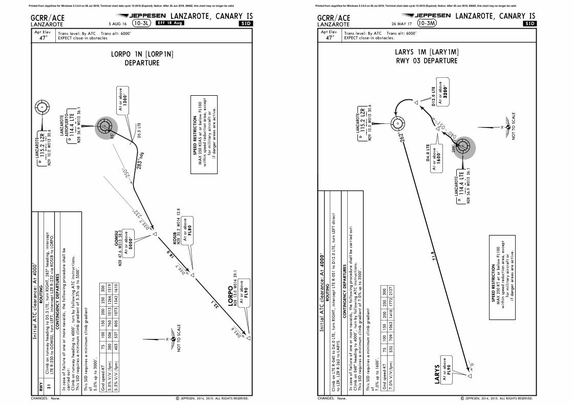
LORPO 1N [LORP1N]DEPARTURE
Cli
mb o
n r
unw
ay h
eadin
g t
o D
5.3
LTE,
turn
RIG
HT,
283^ h
eadin
g,
inte
rcept
LTE R
-250 t
o G
OM
SU,
turn
LEFT,
inte
rcept
LZR R
-232 v
ia K
OSIB
to L
ORPO
.
RW
Y
21
Printed from JeppView for Windows 5.3.0.0 on 06 Jul 2018; Terminal chart data cycle 12-2018 (Expired); Notice: After 28 Jun 2018, 0000Z, this chart may no longer be valid
051^
040^
D
Apt Elev
.SID.
47'
GCRR/ACE
Trans level: By ATC Trans alt: 6000'
LANZAROTE
LANZAROTE, CANARY IS10-3M
EXPECT close-in obstacles.
JEPPESEN
LANZARO
TE
115.2
LZR
LZ
RN29
10.0 W
013
30.6
D
LANZARO
TE
114.4
LTE
LTE
N28
56.9
W01
3 36
.1
D
LARYS
At
or
above
FL9
0
262^
71.8
SPEED R
ESTRIC
TIO
N
209'
26 MAY 17
| JEPPESEN, 2014, 2015. ALL RIGHTS RESERVED.None.CHANGES:
Cli
mb o
n 0
48^ h
eadin
g t
o 4
000',
turn
by f
oll
ow
ing A
TC i
nstr
ucti
ons.
D4.0
LTE
D12.0
LTE
75
100
150
200
250
300
Gnd s
peed-K
T
532
709
1063
1418
1772
2127
RO
UTIN
G
CO
NTIN
GENCY D
EPA
RTURES
7.0
% V
/V(f
pm
)
This
SID
requir
es a
min
imum
cli
mb g
radie
nt
of
7.0
% u
p t
o 3
500'.
NO
T T
O S
CA
LE
At
or
above
1600'
3200'
3200'
At
or
above
This
SID
requir
es a
min
imum
cli
mb g
radie
nt
of
RWY 03 DEPARTURE
MA
X 2
50 K
T a
t or
belo
w F
L100
wit
hin
speed r
educti
on a
rea,
except
for
mil
itary
air
cra
ft o
r
if d
anger
are
as a
re a
cti
ve.
7.0
% u
p t
o 1
600'.
In c
ase o
f fa
ilure
of
one o
r m
ore
navaid
s,
the f
oll
ow
ing p
rocedure
shall
be c
arr
ied o
ut:
LARYS 1M [LARY1M]
Cli
mb o
n L
TE R
-040 t
o D
4.0
LTE,
turn
RIG
HT,
inte
rcept
LTE R
-051 t
o D
12.0
LTE,
turn
LEFT d
irect
to L
ZR,
LZR R
-262 t
o L
ARYS.
Init
ial
ATC c
leara
nce:A
t4000'
Printed from JeppView for Windows 5.3.0.0 on 06 Jul 2018; Terminal chart data cycle 12-2018 (Expired); Notice: After 28 Jun 2018, 0000Z, this chart may no longer be valid

263^
271^
D65.1
D25.4
Apt Elev
.SID.
47'
GCRR/ACE
Trans level: By ATC Trans alt: 6000'
LANZAROTE
LANZAROTE, CANARY IS10-3N
EXPECT close-in obstacles.
JEPPESEN
LANZARO
TE
114.4
LTE
LTE
N28
56.9
W01
3 36
.1
D
LARYS
SPEED R
ESTRIC
TIO
N
At
or
above
1300'
At
or
above
FL1
20
MA
PED
At
or
above
5000'
39.7
85'
LTE R-27
2^
26 MAY 17
| JEPPESEN, 2014, 2017. ALL RIGHTS RESERVED.Climb gradient.
Arc
D8.0
D5.3
5.5
% V
/V (
fpm
)418
557
835
1114
1392
1671
Gnd s
peed-K
T75
100
150
200
250
300
CHANGES:
RO
UTIN
G
CO
NTIN
GENCY D
EPA
RTURES
NO
T T
O S
CA
LE
This
SID
requir
es a
min
imum
cli
mb g
radie
nt
of
RWY 21 DEPARTURE
MA
X 2
50 K
T a
t or
belo
w F
L100
wit
hin
speed r
educti
on a
rea,
except
for
mil
itary
air
cra
ft
or
if d
anger
are
as a
re a
cti
ve.
This
SID
requir
es a
min
imum
cli
mb g
radie
nt
of
5.3
% u
p t
o 3
500'.
Cli
mb o
n r
unw
ay h
eadin
g t
o 4
000',
turn
by f
oll
ow
ing A
TC i
nstr
uctio
ns.
5.5
% u
p t
o 3
000'.
In c
ase o
f fa
ilure
of
one o
r m
ore
navaid
s,
the f
oll
ow
ing p
rocedure
shall
be c
arr
ied o
ut:
LARYS 1N [LARY1N]Cli
mb o
n r
unw
ay h
eadin
g t
o D
5.3
LTE,
turn
RIG
HT,
alo
ng D
8.0
Arc
LTE,
when p
assin
g L
TE R
-263
turn
LEFT,
inte
rcept
LTE R
-271 t
o M
APED
, th
en t
o L
ARYS.
4000'
At
Init
ial
ATC c
leara
nce:
Printed from JeppView for Windows 5.3.0.0 on 06 Jul 2018; Terminal chart data cycle 12-2018 (Expired); Notice: After 28 Jun 2018, 0000Z, this chart may no longer be valid
PHASE 1
JEPPESEN
LEGEND
RUNWAY INCURSION
HOT SPOTS
No entry
| JEPPESEN, 2017. ALL RIGHTS RESERVED.
WORKS ON APRON AREAEXERCISE CAUTION DUE TO PRESENCE OF PERSONNEL & MACHINERY
REFER ALSO TO LATEST NOTAMS
PHASE 2
- Stands T1 and T2 closed. Taxiing on the stand access twy opposite Terminal 1 must be done with CAUTION as the stands T1 and T2 are being worked on.
- Stands T2, T3 and T7 closed. Taxiing on the stand access twy opposite Terminal 1 must be done with CAUTION as the stands T2 and T3 are being worked on.
PHASE 3
- Stands T3, T4 and T7 closed. Taxiing on the stand access twy opposite Terminal 1 must be done with CAUTION as the stands T3, T4 and T7 are being worked on.
PHASE 4
PHASE 5
T1
T2
T3
T7T4
T5
T6
24
7
20
21
22
B
C
RW
Y 0
3/21
AIS + MET
Control
Tower
R4
R3W
- Stands 22 and 23 closed.- Gate C closed.- Alternate gate W established. Taxiing on the stand access twy opposite Terminal 1 must be done with CAUTION. Stand 24: - Manoeuvre modification at the stand. - Parking nosing in to the East. - Parking exit to Twy INNER. - MAX acft reduced to B738W.
- Stands T4 and T5 closed. Taxiing on the stand access twy opposite Terminal 1 must be done with CAUTION as the stands T4, T5 and T6 are being worked on. Stand T6: - Displacement of parking centre line. - Docking guide u/s, parking with TOAM/Marshaller. Airbridge u/s.- MAX acft reduced to B738W.
21 JUL 17
None.
A3
T1
GCRR/ACE
CHANGES:
LANZAROTE, CANARY ISLANZAROTE10-8
Blast fence
Printed from JeppView for Windows 5.3.0.0 on 06 Jul 2018; Terminal chart data cycle 12-2018 (Expired); Notice: After 28 Jun 2018, 0000Z, this chart may no longer be valid

PHASE 6
JEPPESEN
| JEPPESEN, 2017. ALL RIGHTS RESERVED.
EXERCISE CAUTION DUE TO PRESENCE OF PERSONNEL & MACHINERYREFER ALSO TO LATEST NOTAMS
WORKS ON APRON AREA (Continued)
- Stands 22 and 23 closed. Taxiing on the stand access twy opposite Terminal 1 must be done with CAUTIONas the stands 22 and 23 are being worked on.
PHASE 7
T2
T3
T7T4
T5
T6
78
9
10 17
18
21
22
23
B
RW
Y 0
3/21
AIS + MET
Control
Tower R3
R2 E2LEGEND
RUNWAY INCURSION
HOT SPOTS
No entryS
PHASE 8
T6
13A
7
8
9
10
11
1213B
16
17
18
19
R1A
B
AIS + MET
R2
E2
LEGEND
RUNWAY INCURSION
HOT SPOTS
No entry
- Stands 9, 10 and 11 closed.- Twy INNER closed at stand 10. CAUTION when accessing the apron through Gate B due to the effect of jet wash on the work zone. Taxi Procedures: Stands 7 and 8: Exit by nosing to the NE by Gate B.Stand 12: Entry through Gate A. Departure at minimum power to minimise the jet wash until leaving Twy INNER and Gate A.Stands 13 and 14: Entry through Gate A.Stands 18 and 19: Exit with push-back to Twy R, supported by TOAM/Marshaller (contactTWR).
21 JUL 17
Phase 7.
- Stands 19, 20 and 21 closed.- Gate B closed.- Alternate Gate S established at stand 19. Taxiing on the stand access twy opposite Terminal 1 must be done with CAUTION as stands 19, 20 and 21 are being worked on. Twy INNER between stands T6 and 7 MAX wingspan 125'/38m. Traffic will be led to Gates A, C and S.
T1
T2
T2
RW
Y 0
3/21
GCRR/ACE
CHANGES:
LANZAROTE, CANARY ISLANZAROTE
Blast fence
Blast fence
10-8A
Printed from JeppView for Windows 5.3.0.0 on 06 Jul 2018; Terminal chart data cycle 12-2018 (Expired); Notice: After 28 Jun 2018, 0000Z, this chart may no longer be valid
PHASE 9
JEPPESEN
12 MAY 17 .Eff.25.May.
| JEPPESEN, 2017. ALL RIGHTS RESERVED.New temporary chart.
EXERCISE CAUTION DUE TO PRESENCE OF PERSONNEL & MACHINERYREFER ALSO TO LATEST NOTAMS
WORKS ON APRON AREA (Continued)
T6
13A
7
8
9
10
11
1213B
16
17
18
19
R1A
B
AIS + MET
R2
E2
LEGEND
RUNWAY INCURSION
HOT SPOTS
No entry
PHASE 10
T6
13A
7
8
9
10
12
13B
17
18
19
B
AIS + MET
R2
E2
13C
1116
14
15
R1
A
LEGEND
RUNWAY INCURSION
HOT SPOTS
No entry
- Stands 10, 11 and 12 closed.- Twy INNER at Stands 10, 11 and 12 closed. Taxi procedures: Stand 9: CAUTION when accessing the stand through Gate B. Exit nosing to the NE to leave through Gate B. Stand 14: Exit at minimum power to minimise the effect of jet wash until leaving the Twy INNER. Stand 16: Exit nosing to the NE and departure through Gate A. Stands 17 and 18: Exit with push-back to Twy R, supported by TOAM/Marshaller (contactTWR).
- Stands 11, 12 and 13 closed.- Twy INNER at Stand 13 closed. Taxi procedures: Stand 10: Exit nosing to the SW. Minimum power to minimise the effect of jet wash until leaving the Twy INNER.
Stand 14: Modification of the parking manoeuvre. Parking nosing to the West. MAX acft reduced to B738W. Autonomous exit to Twy INNER. CAUTION when accessing the stand in service through Gate A due to proximity of the work fence. Stands 16 and 17: Exit with push-back to Twy R, supported by TOAM/Marshaller (contactTWR). Stand 18: Exit from parking nosing to the SW. Minimum power to minimise the effect of jet wash until leaving the Twy INNER.
T2
RW
Y 0
3/21
T2
RW
Y 0
3/21
GCRR/ACE
CHANGES:
LANZAROTE, CANARY ISLANZAROTE10-8B
Blast fence
Blast fence
Printed from JeppView for Windows 5.3.0.0 on 06 Jul 2018; Terminal chart data cycle 12-2018 (Expired); Notice: After 28 Jun 2018, 0000Z, this chart may no longer be valid
PHASE 11
JEPPESEN
12 MAY 17 .Eff.25.May.
| JEPPESEN, 2017. ALL RIGHTS RESERVED.New temporary chart.
EXERCISE CAUTION DUE TO PRESENCE OF PERSONNEL & MACHINERYREFER ALSO TO LATEST NOTAMS
WORKS ON APRON AREA (Continued)
T6
13A
7
8
9
10
1213B
17
18
19
B
AIS + MET
R2
E2
13C
1116
14
15
R1
A
LEGEND
RUNWAY INCURSIONHOT SPOTS
No entry
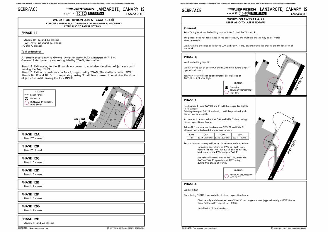
PHASE 12B- Stand 7 closed.
PHASE 12C
PHASE 12A
- Stands T1 and 24 closed.
PHASE 12D
PHASE 12E
PHASE 12F
PHASE 12G
PHASE 12H
- Stands 12, 13 and 14 closed.- Twy INNER at Stand 13 closed.- Gate A closed. Taxi procedures: Alternate access twy to General Aviation apron MAX wingspan 49'/15 m. General Aviation entry and exit guided by TOAM/Marshaller. Stand 11: Exit nosing to the SE. Minimum power to minimise the effect of jet wash until leaving the Twy INNER.Stand 15: Exit with push-back to Twy R, supported by TOAM/Marshaller (contact TWR).Stands 16, 17 and 18: Exit from parking nosing SE. Minimum power to minimise the effectof jet wash until leaving the Twy INNER.
- Stand T6 closed.
- Stand 15 closed.
- Stand 16 closed.
- Stand 17 closed.
- Stand 18 closed.
- Stand 19 closed.
T2
RW
Y 0
3/21
GCRR/ACE
CHANGES:
LANZAROTE, CANARY ISLANZAROTE10-8C
Blast fence
Printed from JeppView for Windows 5.3.0.0 on 06 Jul 2018; Terminal chart data cycle 12-2018 (Expired); Notice: After 28 Jun 2018, 0000Z, this chart may no longer be valid
| JEPPESEN, 2017. ALL RIGHTS RESERVED.
JEPPESENGCRR/ACE
REFER ALSO TO LATEST NOTAMS
General:
.Eff.17.Aug.
PHASE 1:
PHASE 2:
LANZAROTE, CANARY ISLANZAROTE10-8D
WORKS ON TWYS E1 & R1
R1
E2
E1Work on holding bay 21.
Work carried out at both DAY and NIGHT time during airport
operational hours.
Taxiway strip will not be penetrated. Lateral step on
TWY R1 is 5'/1.45m high.
E2
E1
E1
R1
PHASE 3:
Work on RWY.
Only during NIGHT time, outside of airport operation hours.
Disassembly and disconnection of RWY CL and edge markers (approximately 492'/150m to
1936'/590m with respect to THR 03).
Installation of new markers.
Resurfacing work on the holding bay for RWY 21 and TWY E1 and R1.
The phases need not take place in the order shown, and multiple phases may be activated
simultaneously.
Work will be executed both during DAY and NIGHT time, depending on the phases and the location of
the work.
LEGEND
No entry
RUNWAY INCURSION
HOT SPOT
LEGEND
RUNWAY INCURSION
HOT SPOT
In landing operations on RWY 03, ACFT must
vacate the RWY on TWY E2. If exit is missed,
backtrack on the RWY and use TWY E2.
For take-off operations on RWY 21, enter the
RWY on TWY E2 (provisional RWY entry
during this phase of work).
4 AUG 174 AUG 17
RWY
21
TORA TODA LDA
6234'(1900m) 6726'(2050m) 6234'(1900m)
Holding bay 21 and TWY R1 and E1 will be closed for traffic
in this phase.Existing turn pad THR 21 enabled, it will be provided with
centerline turn signal.
Actions will be carried out at DAY and NIGHT time during
airport operational hours.
Take-off from intersection between TWY E2 and RWY 21
allowed, with declared distances as follows:
Restrictions on runway will result in detours and variations:
A4
A4
A3
RW
Y 0
3/21
RW
Y 0
3/21
CHANGES: Temporary chart revised.
Printed from JeppView for Windows 5.3.0.0 on 06 Jul 2018; Terminal chart data cycle 12-2018 (Expired); Notice: After 28 Jun 2018, 0000Z, this chart may no longer be valid

10-9
JEPPESEN
A
B
C
D
.Standard.
| JEPPESEN, 1999, 2018. ALL RIGHTS RESERVED.
(50m)
(50m) (15m)
(15m)
6486' 1977m
47'Apt Elev
GCRR/ACEN28 56.7 W013 36.3
LANZAROTE
LANZAROTE, CANARY IS
*ATIS *LANZAROTE Tower (GND) *Tower(R)
121.8
For AIRPORT BRIEFINGrefer to 10-1P pages.
TAKE-OFF
RUNWAY INCURSION
HOT SPOTS
Elev47'
Elev18'
ControlTower
A
B
C
03031^
21211^
AIS + MET
VOR
7874'
2400m
Militaryapron
NDB
28-56 28-56
28-57 28-57
13-36
13-36
13-37
13-37
FOR DETAILSSEE 10-9A
RB
RAE1
R1
A4
A3
A2
R4 E3
R3
R2E2
EM
R5
A1
E4
RD
RC
HSTIL-E2.
No entry
04^W
118.625
7579' 2310m7579' 2310m
MAX wingspan 125'/38m.
MAX wingspan 118'/36m.
120.7 124.0
20 APR 18 .Eff.26.Apr.
R4-1(North)
R4-1(South)
R4-2
Holdings added.
550/RVR 800mVIS
CHANGES:
RWY
ADDITIONAL RUNWAY INFORMATION
Threshold
LANDING BEYONDUSABLE LENGTHS
WIDTHTAKE-OFFGlide Slope
03
21
PAPI(3.0^)
HIRL
HIRL CL
CL
HIALS
HIALS PAPI-L(3.7^)
REIL
REIL
148'45m
ARP
0
0 200 400 600 800 1000
1000 2000 3000 4000
1200
Feet
Meters
1
1
Printed from JeppView for Windows 5.3.0.0 on 06 Jul 2018; Terminal chart data cycle 12-2018 (Expired); Notice: After 28 Jun 2018, 0000Z, this chart may no longer be valid
10-9A
JEPPESENGCRR/ACE LANZAROTE, CANARY ISLANZAROTE
28-57
28-57.1
28-57.2
28-57.3
28-56.9
28-56.8
28-57
28-56.8
28-56.9
28-57.1
28-57.2
28-57.3
13-36
13-36
13-36.113-36.213-36.4 13-35.913-36.513-36.6
13-36.4 13-36.3 13-36.2 13-36.1 13-35.913-36.6 13-36.5
INS COORDINATES
COORDINATESSTAND No. COORDINATESSTAND No.
T1
T2
T3
T7T4
T5
T6
24
13C13A
78
9
10
11
1213B
16
17
18
19
20
21
22
23
14
15
R1
A
B
C
RW
Y 0
3/21
1 MAX wingspan 49'/15m.
2
LEGEND
CARGOTERMINAL
GENERAL AVIATION APRON
AIS + MET
Control
Tower
HANGAR2
13-36.7
13-36.7
| JEPPESEN, 2011, 2018. ALL RIGHTS RESERVED.
RUNWAY INCURSIONHOT SPOTS
R4 E3
R4
R3
R2
E2
RA E1
RB
AG3AG2AG1
AG4HANGAR
1
AG1 thru AG3AG4
T1 thru T3T4
T5, T6
T77 thru 9
10 thru 13B13C, 14
15
N28 57.3 W013 36.3N28 57.3 W013 36.2 N28 57.0 W013 36.5N28 57.0 W013 36.4N28 57.1 W013 36.4 N28 57.0 W013 36.5N28 57.1 W013 36.4 N28 57.2 W013 36.3N28 57.3 W013 36.3N28 57.3 W013 36.2
No entry
MAX wingspan 164'/50m.
16, 171819
20 thru 2223 24
N28 57.2 W013 36.2N28 57.1 W013 36.2N28 57.1 W013 36.3N28 57.0 W013 36.3N28 57.0 W013 36.4 N28 56.9 W013 36.4
3 MAX wingspan 171'/52m.
20 APR 18 .Eff.26.Apr.
R4-2
Holdings added.
R4-1
(North)
A3
A4
T1
T2
3
3
1
2
CHANGES:
Blast fence
Printed from JeppView for Windows 5.3.0.0 on 06 Jul 2018; Terminal chart data cycle 12-2018 (Expired); Notice: After 28 Jun 2018, 0000Z, this chart may no longer be valid
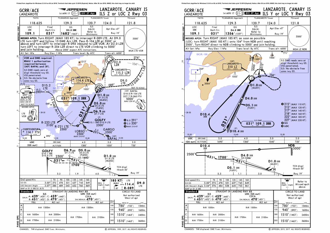
GC(D)-15
GC(R)-150
270^
1000
1000
1000
1000
Gnd speed-Kts
MAX185 KTHIALS
PAPI PAPI 114.4R-089
LTEREIL
RT
LOC Descent Angle
ILS GS 372 478 531 637 743 849
70 90 100 120 140 160
3.00^
PA
NS O
PS
MAP at D1.0 IRR/D1.8LTE
LANZAROTE, CANARY ISLANZAROTE 11-1
*CANARIAS Approach *LANZAROTE Tower *Ground
129.3 121.8LOC
IRR
109.1 031^
GS
1682'(1663')
DA(H)
ILS
Alt Set: hPa Rwy Elev: 1 hPa Trans level: By ATC Trans alt: 6000'
GCRR/ACE
MSA LTE VOR
*ATIS
Final
Apch CrsRefer to
Minimums
D5.0 IRR
D5.8 LTEIRRD5.0
LANZAROTE114.4 LTELTED
LOBSOGARGO
BAPAL
MAPED
STRAIGHT-IN LANDING RWY
A
B
C
D
ALS out ALS out MDA(H)
CIRCLE-TO-LANDILS LOC (GS out)
03
470'(451')
1500m
1600m
2400m
3600m
VIS
MaxKts
100
135
180
205
.Standard.
RVR 1700m
RVR 1500m
RVR 1600m
RVR 1700m
RVR 2000m
RVR 2100m
RVR 2100m
RVR 1500m
Not authorized
West of apt
D1.02300'031^
3.2 4.01.0
D6.9D7.7 LTE
IRR
031^
1.9
D5.0D5.8 LTE
IRR
1682'GS
1700'
IRRD1.8 LTE
D6.9 IRRD7.7 LTE
031^
(IF)
GOLFY
LANZAROTE115.2 LZRLZRD
270^
090^
D1.8 LTEIRRD1.0
NOT TO SCALE13
D
ME
Arc
LZR
274^
118.625 120.7 124.0
MISSED APCH:
BRIE
FIN
G S
TRIP
TM
JEPPESEN
089^
D9.0LTE
D2.0LZR
13
DM
EA
rc
LTE
D15.2LTE
28-50
29-00
13-3013-4013-5014-00
154^
334^
BAPAL
5.3291^
(IAF)
D18.0/R-154 LTE
D27.7/R-060 FTV
FUERTEVENTURA114.1 FTVFTVD
8.0 291^1
1
2.5 330^2
(IAF)
017^1
97^
LTE
VOR
5000
5000
5000
D25.4 LTE
GOLFYD10.1 IRR
| JEPPESEN, 1999, 2017. ALL RIGHTS RESERVED.
MISSED APCH
MAX 210 KT
05
510
15
20
2300'2300'
D10.1 IRR/D10.9 LTE
2300'
5000'
MAX 210 KT
204^
10.2
090^
MAX 200 KT
(IAF)
NOT TO SCALE
3100'R-233 LTE
2300'R-221 LTE
MISSED APCH:
3.07^ LTE
D9.0
D10.9 LTE
MAX 220 KT
ILS Z or LOC Z Rwy 03
Rwy 19'
Apt Elev 47'
14 APR 17 .Eff.27.Apr.
380 489 543 652 760 869
TCH displ
thresh 50'
THR displaced. DME fixes. Minimums.
(440')DA(H)
439' (420')
(451')451'459'470'(432')B:
C:
D:
A:
FULL
1510'
1510'
(1463')
(1463')
(733')780'
940' (893')
CDFA
648'
2004'
769'
892'
1213'
1055'
1589'
[FL~3Z]
[ML~3Z]
[ML~3Z]
[FL~3Z]
DA/MDA(H)
onto
23 3
104^
3500'
LOC(GS out) ALTITUDE
4.0 3.0 2.0
1380' 1050' 730'
IRR DME
ILS DME
031^ 109.1 IRRI R R
CHANGES:
LTE turn LEFT and follow 13 DME Arc LZR. Pass R-104 LZR at 3500' orabove and turn LEFT to intercept R-094 inbound to LZR VOR. At D2.0 LZR
Above 2000' expect ATC instructions.
Turn RIGHT (MAX 185 KT) to intercept R-089 LTE. At D9.0
Rwy 19'
and join holding.turn LEFT to intercept R-204 LZR direct to LTE VOR climbing to 5000'
VOR and DME required.
RNAV 1 authorizationrequired between(IAF) BAPAL and (IF).
ILS DME reads zero at
displ threshold rwy 03.VSS penetrated.
ILS: No obstacle free
zone rwy 03.
Printed from JeppView for Windows 5.3.0.0 on 06 Jul 2018; Terminal chart data cycle 12-2018 (Expired); Notice: After 28 Jun 2018, 0000Z, this chart may no longer be valid
GC(R)-150
GC(D)-15
1000
1000
MISSED APCH:3500'
MSA LZ NDBAlt Set: hPa Rwy Elev: 1 hPa Trans level: By ATC Trans alt: 6000'
28-50
29-00
13-3013-4013-50
192^
012^
5000
104^
LANZAROTE
310 LZ
(IAF)
L Z
Turn RIGHT (MAX 185 KT) as soon as possible
(LOC: turn RIGHT (MAX 185 KT)) onto 104^ from NDB until reaching2500'. Turn RIGHT direct to NDB climbing to 5000' and join holding.
PA
NS O
PS
LANZAROTE, CANARY ISLANZAROTE
*CANARIAS Approach *LANZAROTE Tower *Ground
129.3 121.8LOC
IRR
109.1 031^
GS
1356'(1337')
DA(H)
ILS
GCRR/ACE
*ATIS
Final
Apch CrsRefer to
Minimums
D4.0 IRR
STRAIGHT-IN LANDING RWY
A
B
C
D
ALS out ALS out MDA(H)
CIRCLE-TO-LANDILS LOC (GS out)
03
470'
1500m
1600m
2400m
3600m
VIS
MaxKts
100
135
180
205
DA(H)B:
C:
D:
A:
.Standard.
RVR 1700m
RVR 1500m
RVR 1700m RVR 2100m
RVR 2100m
RVR 1500m
Not authorized
West of apt
118.625 120.7 124.0
BRIE
FIN
G S
TRIP
TM
ILS Y or LOC Y Rwy 0311-2
JEPPESEN
05
510
222^227^
(MAX 185 KT)
(MAX 220 KT)
215^217^218^
(MAX 120 KT)
(MAX 140 KT)
(MAX 160 KT)
HIALS
PAPI PAPIREIL
NDB5000'
2500'1700'
3.0
031^
1.0
D10.4IRR
Refer to
Missed apchabove
Apt Elev 47'
Rwy 19'
031^
D4.0 IRR
031^
D1.0 IRR
IRRD10.4(IF)
IRR
ILS
LOC
215^(MAX 110 KT)
| JEPPESEN, 2015, 2017. ALL RIGHTS RESERVED.
14 APR 17 .Eff.27.Apr.
IRRD10.4
TCH displthresh 50'
D4.0 IRR
IRR
1.15.3
THR displaced. DME fixes. Minimums.
439'(420') 459'(440')
(451')470'(432')451' (451')
FULL
CDFA
(1463')
(1463')
(733')780'
940' (893')
1510'
1510'
771'
2004'
769'
1055'
1589'1066'
[FL~3Y]
[ML~3Y]
D1.0 IRR
[FL~3Y]
[ML~3Y]
DA/MDA(H)
1356'GS
Gnd speed-Kts
ILS GS
LOC Descent Angle
3.00^
3.04^
70 90 100 120 140 160
372 478 531 637 743 849
376 484 538 645 753 861
MAP at D1.0 IRR
RVR 1600m RVR 2000m
3
2
2
3
CHANGES:
Rwy 19'
1
ILS DME
031^ 109.1 IRRI R R
D5.1
1
1
ILS DME reads zero at
displ threshold rwy 03.VSS penetrated.ILS: No obstacle free
zone rwy 03.
D5.1
ALTITUDE(GS out) 1690' 1360' 1040' 720'
IRR DMELOC 5.0 4.0 3.0 2.0
Printed from JeppView for Windows 5.3.0.0 on 06 Jul 2018; Terminal chart data cycle 12-2018 (Expired); Notice: After 28 Jun 2018, 0000Z, this chart may no longer be valid

GC(D)-15
GC(R)-150
1000
1000
1000
IRRD7.3
LANZAROTE114.4 LTELTED
031^
IRRD0.8104^
13-50
Gnd speed-Kts HIALS
PAPI PAPI 114.4R-104
LTEREIL372 478 531 637 743 849
70 90 100 120 140 160
3.00^
LANZAROTE, CANARY ISLANZAROTE
*CANARIAS Approach *LANZAROTE Tower *Ground
129.3 121.8LOC
IRR
109.1 031^
GS
1356'(1337')
DA(H)
ILS
GCRR/ACE
*ATIS
Final
Apch CrsRefer to
Minimums
D4.0 IRR
STRAIGHT-IN LANDING RWY
A
B
C
D
ALS out ALS out
03.Standard.
4300'
031^
8.8 3.3
118.625 120.7 124.0
BRIE
FIN
G S
TRIP
TM
11-3
JEPPESEN
Trans level: By ATC Trans alt: 6000'Rwy Elev: 1 hPaAlt Set: hPa
Apt Elev 47'
Rwy 19'3500'
MSA LTE VOR
MISSED APCH:
05
510
15
20
ILS GS or
LOC Descent Angle
031^
D16.1 IRR
017^
197^
28-50
MIP
S
onto
(IF)
4300'
FL 2
00
017^
12.0
.CEILING.REQUIRED.
MDA(H) CEIL-VIS
Not authorized
West of apt
CIRCLE-TO-LAND
500'- 1700m 500'- 2100m2100m500'-1700m500'-
28-40
28-50
13-2013-30
MaxKts
180
205500'- 2000m 500'- 2400m2400m500'-2000m500'-
.Eff.27.Apr.14 APR 17
| JEPPESEN, 2015, 2017. ALL RIGHTS RESERVED.
HI-ILS DME or HI-LOC DME Rwy 03
climbing to 2500', then turn RIGHT to VOR climbing to 5000'and hold.
197^
017^
MHA5000
648'
2004'
769'
892'
594'
1019' 1033'
2326'
1394'
1055'
D17.0 LTE
NOT TO
SCALE
(IAF)
FL 200
8.2
346^
D8.2 LTE
D4.0 IRR
Procedure title. Procedure. Minimums.
TCH displ
thresh 50'
D16.1 IRRD17.0 LTE
D7.3 IRRD8.2 LTE
D4.0 IRR
GS 1356'
D1.6 LTE
IRRD0.8D1.6 LTE
3.2
3.01^ 373 479 532 639 745 852
RT
185 KTMAX
FULL
ILS(441')DA(H)
440' (421')
(452')452'460'471'(433')B:
C:
D:
A:
1500m500'- 1600m500'-
MAP at D0.8 IRR/D1.6 LTE
LOC (GS out)
470'(451')
CDFA
1500m500'- 1600m500'-
100
135
1600m
2000m
4800m1510' (1463')
890'
940' (893')
(843') 900'-
900'-
1500'-
DA/MDA(H)
2500'
Turn RIGHT (MAX 185 KT) to intercept R-104
D23.3 LTE
D45.3 LTE
D35.3 LTE
211^
VO
RLTE
197^
VO
R
LTE
ILS DME
031^ 109.1 IRRI R R
2400'
CHANGES:
Rwy 19'0.8
MIL USE ONLY
VOR required.ILS DME reads zero at
displ threshold rwy 03.
IRR DMELOC
(GS out) ALTITUDE
6.0
1990'
5.0
1670'
7.0
2310'
3.0
1030'
2.04.0
1350' 710'
Printed from JeppView for Windows 5.3.0.0 on 06 Jul 2018; Terminal chart data cycle 12-2018 (Expired); Notice: After 28 Jun 2018, 0000Z, this chart may no longer be valid
GC(D)-15
GC(R)-150
1000
1000
1000
1000
Gnd speed-Kts HIALS
PAPI PAPIREIL
70 90 100 120 140 160
PA
NS O
PS
LANZAROTE, CANARY ISLANZAROTE 13-1
*CANARIAS Approach *LANZAROTE Tower *Ground
129.3 121.8
033^
Alt Set: hPa Rwy Elev: 1 hPa Trans level: By ATC Trans alt: 6000'
GCRR/ACE
MSA LTE VOR
*ATIS
Final
Apch Crs D6.0 LTE
LTED6.0
LOBSOGARGO
BAPAL
STRAIGHT-IN LANDING RWY
A
B
C
D
ALS out MDA(H)
CIRCLE-TO-LAND03
1500m
1600m
2400m
3600m
VIS
MaxKts
100
135
180
205
.Standard.
RVR 1500m
Not authorized
West of apt
D2.02300'
5.0 4.0 1.2
033^
D6.0 LTE
1700'LTE
033^
(IF)
RR4~6
LTED2.0
118.625 120.7 124.0
MISSED APCH:
BRIE
FIN
G S
TRIP
TM
JEPPESEN
13
DM
EA
rc
LTE
090^
D15.2LTE
28-50
29-00
13-3013-4013-5014-00
5.3291^
FUERTEVENTURA114.1 FTVFTVD
8.0 291^1
1
2.7 325^2
(IAF)
RR4~6D11.0 LTE
MAX 210 KT
05
510
15
20
2300'2300'
2300'
MAX 210 KT
VOR
114.4
Minimum Alt
1700'(1681')
LTE
RVR RVR
500'(481')
VOR Z Rwy 03
D11.0 LTE
MAP at D2.0 LTE
3100'R-233 LTE
2300'R-221 LTE
MAPED
270^
090^
017^
197^
LTEVOR
5000
5000
D25.4 LTE
MISSED APCH
10.2
MAX 200 KT
(IAF)
NOT TO SCALE
3.00^
MISSED APCH:
LANZAROTE115.2 LZRLZRD
NOT TO SCALE13
D
ME
Arc
LZR
274^
089^
D9.0LTE
D2.0LZR
154^
334^
BAPAL(IAF)
D18.0/R-154 LTE
D27.7/R-060 FTV
5000
5000'
204^
| JEPPESEN, 2014, 2017. ALL RIGHTS RESERVED.
MAX 220 KT
Apt Elev 47'
Rwy 19'
14 APR 17 .Eff.27.Apr.
[FD~3Z]
[MD~3Z]
TCH displ
thresh 50'
Descent Angle 3.00^ 372 478 531 637 743 849
CDFA
THR displaced. Descent angle. Minimums.
1510'
1510'
(1463')
(1463')
750' (703')
(893')940'
[FD~3Z]
[MD~3Z]
648'
2004'
769'
892'
1213'
1055'
1589'
VOR
DA/MDA(H)
MAX185 KT
114.4R-089
LTE
RTLTE
D9.0onto
23 3
104^
3500'
ALTITUDE
5.0 4.0 3.0
1400' 1080' 760'
LTE DME
CHANGES:
500'(481')
DLANZAROTE
114.4 LTEL T E
1800m 2300m
RNAV 1 authorizationrequired between(IAF) BAPAL and (IF).
DME required.
LTE turn LEFT and follow 13 DME Arc LZR. Pass R-104 LZR at 3500' orabove and turn LEFT to intercept R-094 inbound to LZR VOR. At D2.0 LZR
Above 2000' expect ATC instructions.
Turn RIGHT (MAX 185 KT) to intercept R-089 LTE. At D9.0
Rwy 19'
and join holding.turn LEFT to intercept R-204 LZR direct to LTE VOR climbing to 5000'
Final approach track
offset 2^ from Rwy
centerline.
VSS penetrated.
DA/MDA(H)
Printed from JeppView for Windows 5.3.0.0 on 06 Jul 2018; Terminal chart data cycle 12-2018 (Expired); Notice: After 28 Jun 2018, 0000Z, this chart may no longer be valid

GC(D)-15
GC(R)-150
1000
1000
MISSED APCH:
BRIE
FIN
G S
TRIP
TM
Gnd speed-Kts
13-2
VOR
114.4 033^
Minimum Alt
D6.0
1700'(1681')
MaxKts
100
135
180
205
D11.0
D6.0
D2.0
VOR
70 90 100 120 140 160
Final
Apch Crs
05
510
2500'MAX
185 KTHIALS
PAPI PAPI 114.4R-104RT
114.4
RVR
GCRR/ACE
LTE
D2.0
D6.0
D11.0
D11.0
221^222^224^227^233^
28-50
29-00
13-3013-4013-50
LTE
REIL
LTE
129.3 121.8
*CANARIAS Approach *LANZAROTE Tower *Ground*ATIS
(MAX 120 KT)
(MAX 140 KT)
(MAX 160 KT)
(MAX 185 KT)
(MAX 220 KT)
| JEPPESEN, 2001, 2017. ALL RIGHTS RESERVED.
JEPPESEN
Descent Angle 3.00^
.Standard.
RVR RVR
500'(481')
5000
197^
017^
104^
3.00^
Not authorized
West of apt
118.625 120.7 124.0
Apt Elev 47'
Rwy 19'
1 220^ (MAX 110 KT)
14 APR 17 .Eff.27.Apr.
[FD~3Y]
[MD~3Y]
[FD~3Y]
[MD~3Y] TCH displ
thresh 50'
372 478 531 637 743 849
THR displaced. Descent angle. Minimums.
CDFA
771'
2004'
769'
1055'
1589'
1066'
DA/MDA(H)
onto
LANZAROTE
3500'
Trans level: By ATC Trans alt: 6000'
MAP at D2.0
LANZAROTE, CANARY IS
Rwy Elev: 1 hPa
CHANGES:
A
B
C
D
ALS out MDA(H)
CIRCLE-TO-LAND
2400m
3600m
1510'(1463')
1510'(1463')
1500m
1600m
500'(481')
VIS
Alt Set: hPa
5000'
4.05.0 1.2
12300'
1700'033^
1080'
4.0
ALTITUDE
03STRAIGHT-IN LANDING RWY
1500m
MSA
LTE VOR
LTE DME
(IF)
033^
DLANZAROTE
(IAF)
114.4 LTEL T E
Climb direct to VOR, then turn RIGHT (MAX 185 KT)and follow R-104 until reaching 2500'. Turn RIGHT direct toVOR climbing to 5000' and join holding.
VOR Y Rwy 03
1800m 2300m
1
3.0
1400'
5.0
760'
1. DME required.
PA
NS O
PS
Rwy 19'
2. Final approach track offset 2^ from Rwy centerline. 3. VSS penetrated.
890'
940'
(843')
(893')
DA/MDA(H)
Printed from JeppView for Windows 5.3.0.0 on 06 Jul 2018; Terminal chart data cycle 12-2018 (Expired); Notice: After 28 Jun 2018, 0000Z, this chart may no longer be valid
334^
261^
GC(D)-15
GC(R)-150
1000
100
0
100
10
00
0
0 001
1 000
TUXAM(IF)
213^
LANZAROTED
154^
334^
LUNOB(IAF)
D16.0 LTE
235^
055^
NAVIM(IAF)
RR52~
295^ 6.9
LTE
13-3
VOR
114.4 213^
Minimum Alt MDA(H)
2800'(2753')
D7.4 LTELTE
GCRR/ACE
*CANARIAS Approach *LANZAROTE Tower *Ground*ATIS
129.3 121.8Final
Apch CrsRefer to
Minimums
118.625 120.7 124.0
D12.5 LTE
D18.5/R-055 LTE
D21.8 LTE
MISSED APCH:
BRIE
FIN
G S
TRIP
TM
JEPPESEN
GRAN CANARIA112.9 GDVGDVD
16 DME Arc LTE
D1.5 LTE
D7.4 LTE
270^
D5.3 LTE
8 D
ME
Arc L
TE
4000
6000
29-00
29-10
13-2013-3013-4013-50
05
510
15
20
PA
NS O
PS
MaxKts
100
135
180
205
1.1 5.9
114.4on
R-213
114.4
D1.5
D7.4LTE VOR
LTE
LTE
LTE LTE
.Standard.
Chart
Refer toAirport
Lighting -
213^
NOT TO SCALE 114.4 LTE
TUXAMD12.5 LTE
5.1
3500'
3500'
6000' 4000'R-349 LTE R-022 LTE
3.8
213^
4000'R-0
57 GDV
3500'
LTE
D5.3
966'
1060'
648'
2004'
1589'
2211'
1450'
2001'
1478'
1028'
1066'
1213'
1088'
466'1089'
564'
769'
546'
1257'
Apt Elev 47'
771'
| JEPPESEN, 2014, 2018. ALL RIGHTS RESERVED.
20 APR 18 .Eff.26.Apr.
Notes.
LANZAROTE
3500'
Trans level: By ATC Trans alt: 6000'
LANZAROTE, CANARY IS
Apt Elev: 2 hPaAlt Set: hPa
DME required.
VOR A
CHANGES:
Climb direct to LTE VOR and proceed on R-213 LTE to reachD5.3 LTE at 2600' or above, then turn RIGHT and follow 8 DME Arc LTE.Passing R-261 LTE turn LEFT to intercept R-270 LTE. At D21.8 LTE turnRIGHT to intercept and follow R-057 GDV direct to LUNOB, climbingto 6000' and join holding. MSA
LTE VOR
A
B
C
D
MDA(H)
CIRCLE-TO-LAND
2400m
3600m
1780'(1733')
2020'(1973')
2020'(1973')
1600m
1500m1780'(1733')
VIS
2800'
MAP at D1.5 LTE
Not authorized West of airport
213^
RNAV 1 authorizationrequired between (IAF) NAVIM and (IF).Final approach trackoffset 2^ from Rwy
centerline.
Apt 47'
Circuit maneuvers inboth runways whenexecuting this VOR "A"
approach, should becoordinated with ATCbefore the IF.
Printed from JeppView for Windows 5.3.0.0 on 06 Jul 2018; Terminal chart data cycle 12-2018 (Expired); Notice: After 28 Jun 2018, 0000Z, this chart may no longer be valid

GC(D)-15
GC(R)-150
1000
1000
100 0
00
MHA5000
TUXAM(IF)
039^
042^045^050^
209^
040^
D1.5
D7.4
(MAX 120 KT)
(MAX 140 KT)
(MAX 160 KT)
(MAX 185 KT)
(MAX 220 KT)
213^
213^
D12.5
28-50
29-00
29-10
13-2013-3013-4013-50
MaxKts
100
135
180
205
1.1 5.9 5.1
MISSED APCH:
BRIE
FIN
G S
TRIP
TM
13-4
VOR
114.4 213^
Minimum Alt MDA(H)
2800'(2753')
3000'114.4on
R-213
114.4
D1.5
D7.4
LTE
GCRR/ACE
LTE LTE
*CANARIAS Approach *LANZAROTE Tower *Ground*ATIS
129.3 121.8Final
Apch Crs
05
510
15
20
| JEPPESEN, 2001, 2018. ALL RIGHTS RESERVED.
JEPPESEN
.Standard.
Refer toMinimums
Chart
Refer toAirport
Lighting -
118.625 120.7 124.0
D7.4
VOR
771'
1060'
2004'
1589'
2211'
1450'
2001'
1478'
1028'
1066'
1257'
1213'
1088'
1089'
648'
966'
769'
546'
466'
Apt Elev 47'
D12.5
1 039^ (MAX 110 KT)
TUXAMD12.5
Notes.
20 APR 18 .Eff.26.Apr.
Circuit maneuvers in both
runwayy when executing
this VOR "B" approach,should be coordinated with
ATC before the IF.
1
(IAF)
LANZAROTED 114.4 LTEL T E
MSALTE VOR
A
B
C
D
MDA(H)
CIRCLE-TO-LAND
2400m
3600m
1780'(1733')
2020'(1973')
2020'(1973')
1600m
1500m1780'(1733')
VIS
1 3500'5000'
2800'213^
LANZAROTE
3500'
Trans level: By ATC Trans alt: 6000'
LANZAROTE, CANARY IS
Apt Elev: 2 hPa
CHANGES:
Alt Set: hPa
DME required.1. 2. Final approach track offset 2^ from Rwy centerline.
Not authorized West of airport
PA
NS O
PS
MAP at D1.5
VOR B
Climb direct to VOR. Continue on R-213 untilreaching 3000'. Turn LEFT direct to VOR climbing to 5000' andjoin holding.
Apt 47'
Printed from JeppView for Windows 5.3.0.0 on 06 Jul 2018; Terminal chart data cycle 12-2018 (Expired); Notice: After 28 Jun 2018, 0000Z, this chart may no longer be valid
GC(D)-15
GC(R)-150
212^
1000
1000
1000
D8.2
LANZAROTE
LTED
D1.6104^
13-50
Gnd speed-Kts HIALS
PAPI PAPI 114.4R-104
LTE
REIL
70 90 100 120 140 160
LANZAROTE, CANARY ISLANZAROTE
*CANARIAS Approach *LANZAROTE Tower *Ground
129.3 121.8VOR
LTE
114.4 032^ 2400'(2381')
GCRR/ACE
*ATIS
Final
Apch Crs
STRAIGHT-IN LANDING RWY
A
B
C
D
ALS out
03.Standard.
4300'
8.8 6.6
118.625 120.7 124.0
BRIE
FIN
G S
TRIP
TM
13-5
JEPPESEN
Trans level: By ATC Trans alt: 6000'Rwy Elev: 1 hPaAlt Set: hPa
Apt Elev 47'
Rwy 19'3500'
MSA LTE VOR
MISSED APCH:
05
510
15
20
D17.0
017^
197^
28-50
MIP
Sonto
(IF)
4300'
FL 2
00
017^
11.9
.CEILING.REQUIRED.
MDA(H) CEIL-VIS
Not authorized
West of apt
CIRCLE-TO-LAND
500'- 1800m 500'- 2300m
28-40
28-50
13-2013-30
MaxKts
180
205500'- 2000m 500'- 2400m
.Eff.27.Apr.14 APR 17
climbing to 2500', then turn RIGHT to VOR climbing to 5000'and hold.
197^
017^
MHA5000
648'
2004'
769'
892'
594'
1019' 1033'
2326'
1394'
1055'
NOT TO
SCALE
(IAF)
FL 200
TCH displ
thresh 50'
D17.0 D8.2D1.6
3.01^ 373 479 532 639 745 852
RT
185 KTMAX
500'(481')
CDFA
1500m500'- 1600m500'-
100
135
1600m
2000m
4800m1510' (1463')
890'
940' (893')
(843') 900'-
900'-
1500'-
HI-VOR DME Rwy 03
Minimum Alt
500'(481')
114.4 LTE
032^
347^8.3
[FD~3]
[MD~3]
0.8
Descent Angle
| JEPPESEN, 2017. ALL RIGHTS RESERVED.New procedure.
032^
[MD~3]
[FD~3]
3.01^
VOR
DA/MDA(H)
DA/MDA(H)
2500'
D8.2
Turn RIGHT (MAX 185 KT) to intercept R-104
MAP at D1.6
D23.4
D45.3
D35.3
197^
2400'
CHANGES:
Rwy 19'
MIL USE ONLY
LTE DME
ALTITUDE
7.0
2340'
6.0
2020'
5.0
1700'
4.0
1380'
3.0
1060'
2.0
740'
Printed from JeppView for Windows 5.3.0.0 on 06 Jul 2018; Terminal chart data cycle 12-2018 (Expired); Notice: After 28 Jun 2018, 0000Z, this chart may no longer be valid

197^
GC(D)-15
GC(R)-150
211^
1000
1000
1000
D1.3104^
14-00 13-50
Gnd speed-Kts HIALS
PAPI PAPI
R-104
TLZ
REIL
70 90 100 120 140 160
LANZAROTE, CANARY ISLANZAROTE
*CANARIAS Approach *LANZAROTE Tower *Ground
129.3 121.8
031^ 2400'(2381')
GCRR/ACE
*ATIS
Final
Apch Crs
STRAIGHT-IN LANDING RWY
A
B
C
D
ALS out
03.Standard.
D1.34300'
8.8 6.6
118.625 120.7 124.0
BRIE
FIN
G S
TRIP
TM
14-1
JEPPESEN
Trans level: By ATC Trans alt: 6000'Rwy Elev: 1 hPaAlt Set: hPa
Apt Elev 47'
Rwy 19'
MISSED APCH:
05
510
15
20
D16.7 D7.9031^
28-50
MIP
S
onto
(IAF)
FL 200
.CEILING.REQUIRED.
MDA(H) CEIL-VIS
Not authorized
West of apt
CIRCLE-TO-LAND
HI-TACAN Rwy 03
017^ 19
7^
FL 2
00
017^
12.0
D7.9
(IF)
D16.7
4300'
D7.9 TLZ TAC
CH 94
TACAN
TLZ
CH
TAC
Descent Angle
MAP at D1.3 TLZ TAC
3.01^
TACAN
CDFA
500'(481')
2000m500'- 500'- 2400m
TLZ TAC
TLZ TAC
TLZ TAC
TLZ TAC TLZ TAC
TLZ TAC
28-40
28-50
13-3013-5014-00
1800m500'- 500'- 2300m
MaxKts
180
205
.Eff.27.Apr.14 APR 17
| JEPPESEN, 2015, 2017. ALL RIGHTS RESERVED.
94
Minimum Alt
(481')500'3500'
MSA TLZ TACAN
NOT TO
SCALE
D23.0TLZ TAC
346^7.9
[MT~3]
[FT~3]
197^
017^
MHA5000
648'
2004'
769'
892'
594'
1019' 1033'
2326'
1394'
1055'
031^
0.8
TCH displ
thresh 50'
3.01^ 373 479 532 639 745 852
Procedure. Minimums.
TLZ
CH 94
RT
185 KTMAX
DA/MDA(H)
DA/MDA(H)
100
135
1600m
2000m
4800m1510' (1463')
890'
940' (893')
(843') 900'-
900'-
1500'-
1500m500'- 1600m500'-
[FT~3]
[MT~3]
intercept R-104 climbing to 2500', then turn RIGHT to TACANclimbing to 5000' and hold.
2500'
Climb to TACAN. Turn RIGHT (MAX 185 KT) to
D35.0TLZ TAC
D45.0TLZ TAC
2400'
CHANGES:
Rwy 19'
MIL USE ONLY
CH
LANZAROTE
TLZ94 TLZ
ALTITUDE 2120' 1800' 1480' 1160'
TLZ TAC 7.0 6.0 5.0 4.0 3.0 2.0
840' 520'
Printed from JeppView for Windows 5.3.0.0 on 06 Jul 2018; Terminal chart data cycle 12-2018 (Expired); Notice: After 28 Jun 2018, 0000Z, this chart may no longer be valid
GC(D)-15
GC(R)-150
1000
1000
Missed apch climbgradient mim 2.5%
Missed apch climbgradient mim 5.0%
MISSED APCH:
BRIE
FIN
G S
TRIP
TM
LANZAROTE 16-1LANZAROTE, CANARY IS
NDB Rwy 03
3500'
MSA LZ NDB
NDB Final
Apch Crs
017^LZ
310
Minimum Alt
No FAF
MDA(H)
Alt Set: hPa Rwy Elev: 1 hPa Trans level: By ATC Trans alt: 6000'
NDB5000'
2500'
Startturn at
CAT A & B:
CAT C & D:
3 Min
Min3017^
2500'104^
LZ
310
from
MAP at NDB
STRAIGHT-IN LANDING RWY
A
B
C
D
ALS out
03
MDA(H)
CIRCLE-TO-LAND
MaxKts
100
135
180
205
VIS
1500m
1600m
5000m
5000m
MDA(H)
ALS outMDA(H)1660' 1800'(1641') (1781')
NOT APPLICABLE1800'
1800'
2200'
2200'
(1753')
(1753')
(2153')
(2153')
RVR 5000m
185 KTMAX
HIALS
PAPI PAPI
GCRR/ACE
28-50
29-00
13-3013-4013-50
192^
012^
5000
104^
LANZAROTED
207^CAT A & B:
212^CAT C & D:
213^214^
LANZAROTE
310 LZ
(IAF)
L Z
114.4 LTE
017^
REIL
129.3 121.8120.7 124.0
*CANARIAS Approach *LANZAROTE Tower *Ground*ATIS
Refer toMinimums
05
510
RT
Turn RIGHT (MAX 185 KT) onto 104^ from NDB untilreaching 2500'. Turn RIGHT direct to NDB climbing to 5000'and join holding.
(MAX 185 KT)
(MAX 200 KT)
(MAX 220 KT)
| JEPPESEN, 2001, 2017. ALL RIGHTS RESERVED.
JEPPESEN
.Standard.
PA
NS O
PS
Not authorizedWest of apt
118.625
Apt Elev 47'
Rwy 19'
14 APR 17 .Eff.27.Apr.
Minimums.
1. Final approach track offset 14^ from Rwy centerline. 2. VSS penetrated.
771'
2004'
769'
1055'
1589'1066'
CHANGES:
1
12
1
L T E1
Rwy 19'
Printed from JeppView for Windows 5.3.0.0 on 06 Jul 2018; Terminal chart data cycle 12-2018 (Expired); Notice: After 28 Jun 2018, 0000Z, this chart may no longer be valid
Chart changes since cycle 11-2018
ADD = added chart, REV = revised chart, DEL = deleted chart.ACT PROCEDURE IDENT INDEX REV DATE EFF DATE
LANZAROTE, (LANZAROTE - GCRR)
Chart changes since cycle 11-2018
ADD = added chart, REV = revised chart, DEL = deleted chart.ACT PROCEDURE IDENT INDEX REV DATE EFF DATE
LANZAROTE, (LANZAROTE - GCRR)
Revision Letter For Cycle 12-2018
Printed on 06 Jul 2018
Page 1(c) JEPPESEN SANDERSON, INC., 2018, ALL RIGHTS RESERVED
jep=JEPPESEN
JeppView for Windows
TERMINAL CHART CHANGE NOTICES
Chart Change Notices for Airport GCRR
Type: TerminalEffectivity: TemporaryBegin Date: 20170525End Date: 20181231
Works on apron area (based on SUP 66-17). Refer to temp charts 10-8 thru 10-8C and latest NOTAMs.
Type: TerminalEffectivity: TemporaryBegin Date: 20170525End Date: 20181231
Works on TWYs E1 & R1 (based on SUP 72-17, with eff date 4 JAN 18based on SUP 01/18). Refer to temporary chart 10-8D and latest NOTAMs.
Type: TerminalEffectivity: TemporaryBegin Date: 20180329End Date: 20190201
REIL Rwy 03 unserviceable (based on SUP 34-18).
Terminal Chart Change Notices
Page 1 - Printed on 06 Jul 2018Notice: After 28 Jun 2018, 0000Z, this data may no longer be valid
(c) JEPPESEN SANDERSON, INC., 2018, ALL RIGHTS RESERVED
jep=JEPPESEN
JeppView for Windows