Embed Size (px)
Citation preview
Topic #2: Sea Level Rise and Coastal Storms
Background Information
Sea Level Rise and Coastal Storms can cause flooding and damage to structures, infrastructure, and natural habitats. Wise planning for existing and future flood and wind threats reduces risks to businesses, people, and wildlife.
Sea levels in Delaware have risen by more than a foot over the past 100 years. Recent projections by Delaware’s Sea Level Technical Advisory Committee indicate that sea levels are continuing to rise, as a result of global climate change. By 2050, sea levels could rise between 0.7 and 1.9 feet in our state.
Sea level rise causes inundation of normally dry land, wetlands, and infrastructure. It also causes saltwater intrusion into groundwater and can decrease the depth to groundwater.
Coastal storms, like nor’easters and tropical storms, are a common occurrence in Delaware. Coastal storms often feature heavy rain, high winds, and higher than normal tides. High waves are also normally associated with coastal storms.
Sea level rise, coupled with coastal storms, is increasing the risk of flood damage to shorelines, infrastructure, and structures in coastal areas statewide. Delaware has comprehensively studied this issue and there are many publically available resources to help landowners reduce their risk.
Why is planning for Sea Level Rise and Coastal Storms Important?
What does the Coastal Zone Act say about Sea Level Rise and Coastal Storms?
All conversion permit applicants must provide:
“A plan to prepare the site for potential impacts of sea-level rise and coastal storms over the anticipated useful life of the facility and infrastructure in connection with the applied-for use.”
This type of plan will help everyone involved in the permit process understand the coastal risks on the project site and make sure that steps to reduce these risks are taken in development of new heavy industrial facilities.
Sea Level Rise Scenarios published in 2017 by the Delaware Sea Level Rise Technical Committee, based upon the “business as usual” case of future greenhouse gas emissions. These scenarios, along with maps depicting these scenarios, are used by state agencies and others to make decisions about how and where to invest in infrastructure, land preservation, etc.
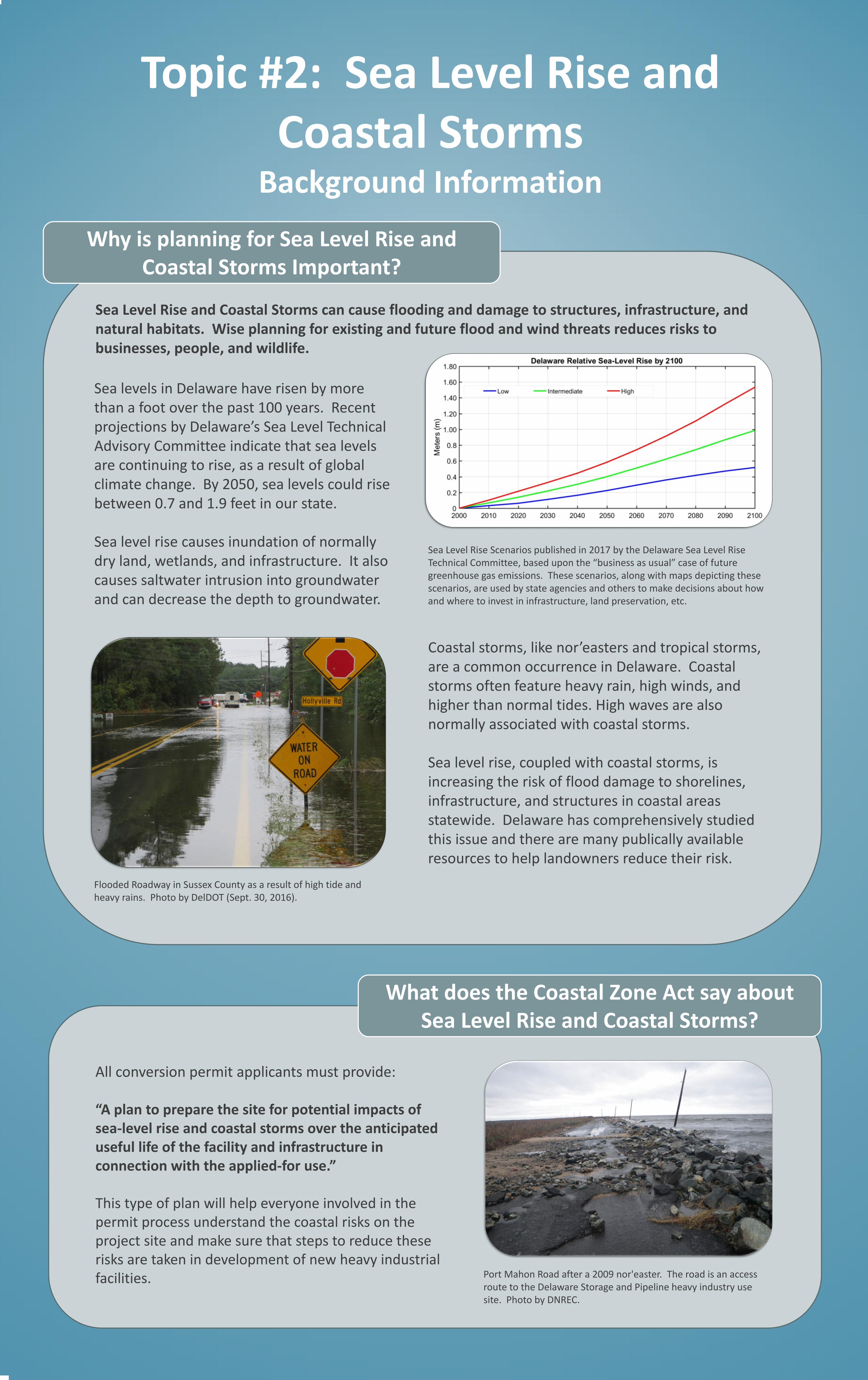
Flooded Roadway in Sussex County as a result of high tide and heavy rains. Photo by DelDOT (Sept. 30, 2016).
Port Mahon Road after a 2009 nor'easter. The road is an access route to the Delaware Storage and Pipeline heavy industry use site. Photo by DNREC.
Topic #2: Sea Level Rise and Coastal Storms
Preliminary Recommendations
What did the Regulatory Advisory Committee recommend?
How did the Committee come up with its preliminary recommendations?
The Regulatory Advisory Committee heard three presentations from a DNREC sea level rise expert. These presentations covered basic information about sea level rise and coastal storms, risks posed from these
hazards, and actions that can be taken to reduce risk. The Committee deliberated options over four meetings and made recommendations in November 2018.
The Committee’s preliminary recommendations state that the plans for sea level rise and coastal storms should:
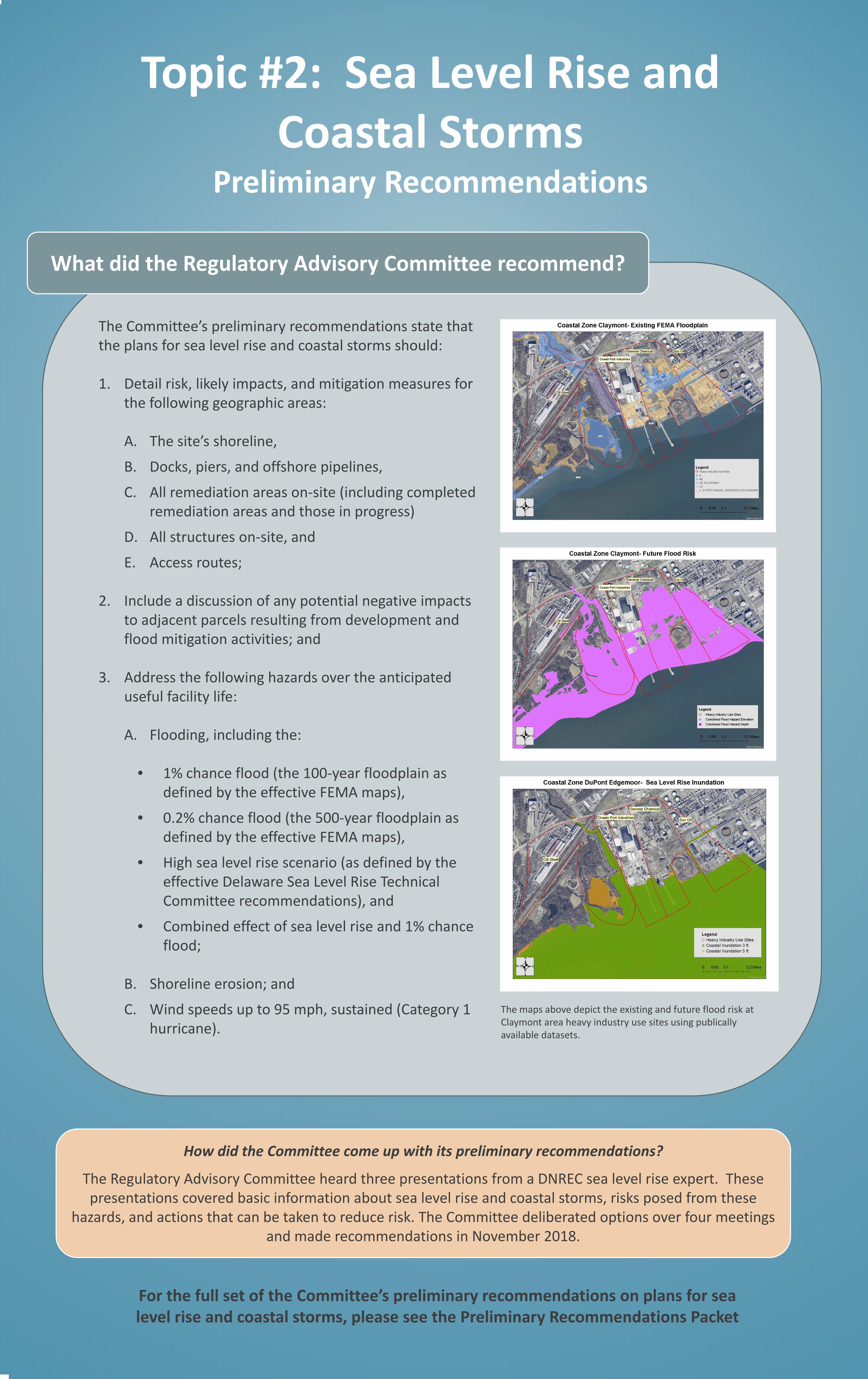
1. Detail risk, likely impacts, and mitigation measures for the following geographic areas:
A. The site’s shoreline,
B. Docks, piers, and offshore pipelines,
C. All remediation areas on-site (including completed remediation areas and those in progress)
D. All structures on-site, and
E. Access routes;
2. Include a discussion of any potential negative impacts to adjacent parcels resulting from development and flood mitigation activities; and
3. Address the following hazards over the anticipated useful facility life:
A. Flooding, including the:
• 1% chance flood (the 100-year floodplain as defined by the effective FEMA maps),
• 0.2% chance flood (the 500-year floodplain as defined by the effective FEMA maps),
• High sea level rise scenario (as defined by the effective Delaware Sea Level Rise Technical Committee recommendations), and
• Combined effect of sea level rise and 1% chance flood;
B. Shoreline erosion; and
C. Wind speeds up to 95 mph, sustained (Category 1 hurricane).
For the full set of the Committee’s preliminary recommendations on plans for sea level rise and coastal storms, please see the Preliminary Recommendations Packet
The maps above depict the existing and future flood risk at Claymont area heavy industry use sites using publically available datasets.