Embed Size (px)
Citation preview
Earthrsquos Future
An Earthrsquos Future Special Collection Impacts of the coastaldynamics of sea level rise on low-gradient coastal landscapes
David M Kidwell1 J Casey Dietrich2 Scott C Hagen3 and Stephen C Medeiros4
1National Oceanic and Atmospheric Administration National Centers for Coastal Ocean Science Silver SpringMaryland USA 2Department of Civil Construction and Environmental Engineering North Carolina State UniversityRaleigh North Carolina USA 3Department of Civil and Environmental Engineering Louisiana State University BatonRouge Louisiana USA 4Department of Civil Environmental and Construction Engineering University of CentralFlorida Orlando Florida USA
Abstract Rising sea level represents a significant threat to coastal communities and ecosystemsincluding altered habitats and increased vulnerability to coastal storms and recurrent inundation Thisthreat is exemplified in the northern Gulf of Mexico where low topography marshes and a prevalenceof tropical storms have resulted in extensive coastal impacts The ability to facilitate adaptation andmitigation measures relies in part on the development of robust predictive capabilities that incorporatecomplex biological processes with physical dynamics Initiated in 2010 the 6-year Ecological Effects of SeaLevel RisemdashNorthern Gulf of Mexico project applied a transdisciplinary science approach to develop asuite of integrated modeling platforms informed by empirical data that are capable of evaluating a rangeof climate change scenarios This special issue highlights resultant integrated models focused on tidalhydrodynamics shoreline morphology oyster ecology coastal wetland vulnerability and storm surgesthat demonstrate the need for dynamic models to incorporate feedbacks among physical and biologicalprocesses in assessments of sea level rise effects on coastal systems Effects are projected to be significantspatially variable and nonlinear relative to sea level rise rates Scenarios of higher sea level rise rates areprojected to exceed thresholds of wetland sustainability and many regions will experience enhancedstorm surges Influenced by an extensive collaborative stakeholder engagement process these assess-ments on the coastal dynamics of sea level rise provide a strong foundation for resilience measures in thenorthern Gulf of Mexico and a transferable approach for application to other coastal regions throughoutthe world
1 Introduction
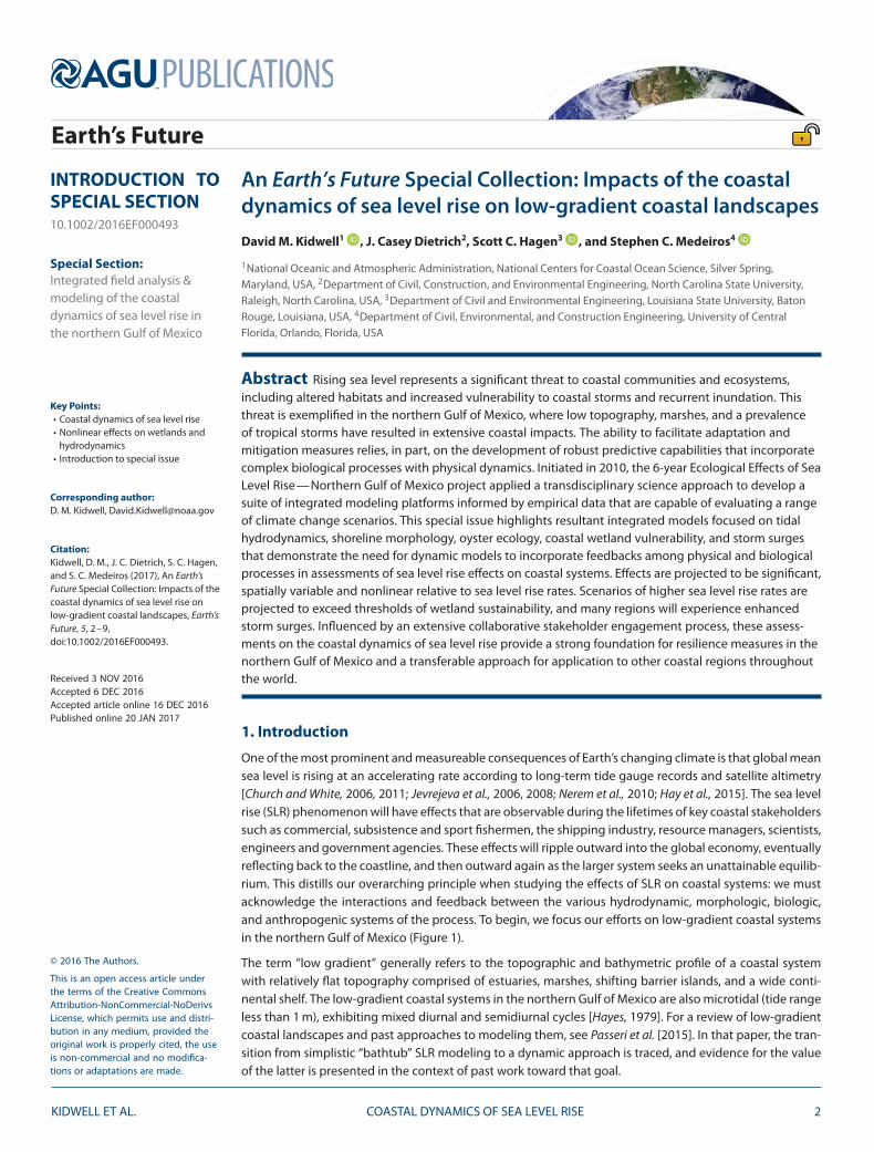
One of the most prominent and measureable consequences of Earthrsquos changing climate is that global meansea level is rising at an accelerating rate according to long-term tide gauge records and satellite altimetry[Church and White 2006 2011 Jevrejeva et al 2006 2008 Nerem et al 2010 Hay et al 2015] The sea levelrise (SLR) phenomenon will have effects that are observable during the lifetimes of key coastal stakeholderssuch as commercial subsistence and sport fishermen the shipping industry resource managers scientistsengineers and government agencies These effects will ripple outward into the global economy eventuallyreflecting back to the coastline and then outward again as the larger system seeks an unattainable equilib-rium This distills our overarching principle when studying the effects of SLR on coastal systems we mustacknowledge the interactions and feedback between the various hydrodynamic morphologic biologicand anthropogenic systems of the process To begin we focus our efforts on low-gradient coastal systemsin the northern Gulf of Mexico (Figure 1)
The term ldquolow gradientrdquo generally refers to the topographic and bathymetric profile of a coastal systemwith relatively flat topography comprised of estuaries marshes shifting barrier islands and a wide conti-nental shelf The low-gradient coastal systems in the northern Gulf of Mexico are also microtidal (tide rangeless than 1 m) exhibiting mixed diurnal and semidiurnal cycles [Hayes 1979] For a review of low-gradientcoastal landscapes and past approaches to modeling them see Passeri et al [2015] In that paper the tran-sition from simplistic ldquobathtubrdquo SLR modeling to a dynamic approach is traced and evidence for the valueof the latter is presented in the context of past work toward that goal
INTRODUCTION TOSPECIAL SECTION1010022016EF000493
Special SectionIntegrated field analysis ampmodeling of the coastaldynamics of sea level rise inthe northern Gulf of Mexico
Key Pointsbull Coastal dynamics of sea level risebull Nonlinear effects on wetlands and
hydrodynamicsbull Introduction to special issue
Corresponding authorD M Kidwell DavidKidwellnoaagov
CitationKidwell D M J C Dietrich S C Hagenand S C Medeiros (2017) An EarthrsquosFuture Special Collection Impacts of thecoastal dynamics of sea level rise onlow-gradient coastal landscapes EarthrsquosFuture 5 2ndash9doi1010022016EF000493
Received 3 NOV 2016Accepted 6 DEC 2016Accepted article online 16 DEC 2016Published online 20 JAN 2017
copy 2016 The Authors
This is an open access article underthe terms of the Creative CommonsAttribution-NonCommercial-NoDerivsLicense which permits use and distri-bution in any medium provided theoriginal work is properly cited the useis non-commercial and no modifica-tions or adaptations are made
KIDWELL ET AL COASTAL DYNAMICS OF SEA LEVEL RISE 2
Earthrsquos Future 1010022016EF000493
Figure 1 The low-gradient coastal land margin of the northern Gulf of Mexico including Mississippi Alabama and Florida and the location of the National Estuarine ResearchReserve for each state
Selection of the research setting is crucial to ensure a strong coastal stakeholder community committedto making significant contributions of resources such as facilities manpower and local expertise We wereextremely fortunate to find these partners through the National Estuarine Research Reserve (NERR) Pro-gram The NERRs (Figure 1) at Grand Bay (Mississippi) Weeks Bay (Alabama) and Apalachicola (Florida)provide the perfect combination of coastal system diversity (marine mixed and estuarine respectively)as well as access to personnel stores of historic data and local knowledge laboratory and presentationfacilities and community outreach infrastructure Furthermore because the NERR program is administeredby the National Oceanic and Atmospheric Administration (NOAA) in conjunction with state environmentalagencies it offers a natural fit in terms of administrative expediency and synergistic objectives The detailsof this symbiotic relationship and what we achieved as a result will be of great benefit to future studiesthat seek to emulate and enhance this collaborative approach [see DeLorme et al 2016]
2 Genesis
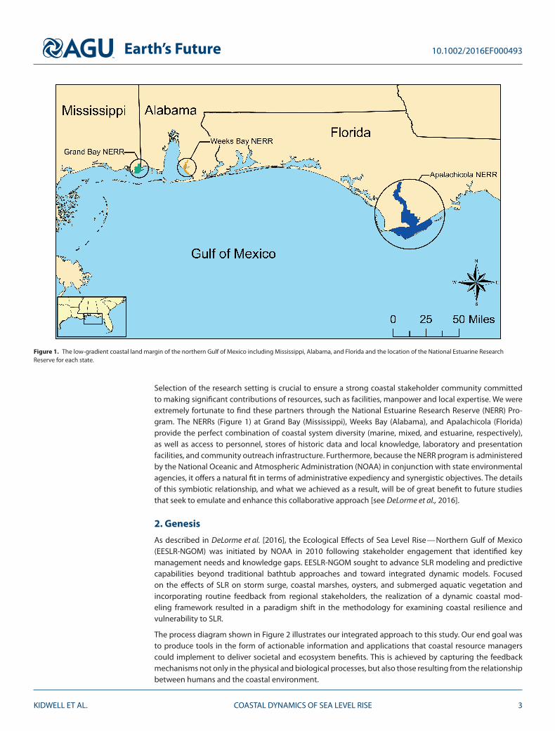
As described in DeLorme et al [2016] the Ecological Effects of Sea Level RisemdashNorthern Gulf of Mexico(EESLR-NGOM) was initiated by NOAA in 2010 following stakeholder engagement that identified keymanagement needs and knowledge gaps EESLR-NGOM sought to advance SLR modeling and predictivecapabilities beyond traditional bathtub approaches and toward integrated dynamic models Focusedon the effects of SLR on storm surge coastal marshes oysters and submerged aquatic vegetation andincorporating routine feedback from regional stakeholders the realization of a dynamic coastal mod-eling framework resulted in a paradigm shift in the methodology for examining coastal resilience andvulnerability to SLR
The process diagram shown in Figure 2 illustrates our integrated approach to this study Our end goal wasto produce tools in the form of actionable information and applications that coastal resource managerscould implement to deliver societal and ecosystem benefits This is achieved by capturing the feedbackmechanisms not only in the physical and biological processes but also those resulting from the relationshipbetween humans and the coastal environment
KIDWELL ET AL COASTAL DYNAMICS OF SEA LEVEL RISE 3
Earthrsquos Future 1010022016EF000493
Figure 2 A process diagram for the coastal dynamics of sea level rise
The paradigm shift in modeling the coastal dynamics of SLR begins with an understanding that carbonemission scenarios influence climate responses such as a rise in atmospheric temperature that results in sealevel change This phenomenon further stimulates changes to coastal-related processes such as shorelinemorphology barrier islands coastal dune systems salt marsh productivity and migration and influencespatterns in land useland cover (LULC) change Our efforts during the EESLR-NGOM project encompassedthe development and modification of climate change scenario-driven dynamic models
3 Collected Data
A suite of physical and biological models were employed to simulate the behavior of the various processesthat affect the response of the coastal systems to SLR As an interdisciplinary effort each model was over-seen by an expert or in some cases the original developer The key objective for this integrated modelingapproach is to capture the feedbacks among physical and biological responses to SLR through an investi-gation into the initial conditions for each model Accurate initial conditions that represent the state of thesystem at a given time are essential to this modeling approach These initial conditions were comprisedof collected earth data (eg lidar-derived topography surface roughness tidal constituents) field and labexperiments (eg marsh bioassays accretion rates) and global climate change scenarios (eg SLR ratesfuture precipitation estimates) Data collection and bioassays were completed at the three NERRs in thenorthern Gulf of Mexico
For wetlands location within an estuary or shoreline shifts in response to changes in sea level and dynamicsof the intertidal zone These changes particularly those associated with rises in sea level are a function of
KIDWELL ET AL COASTAL DYNAMICS OF SEA LEVEL RISE 4
Earthrsquos Future 1010022016EF000493
Figure 3 Adjustments to the digital elevation model of the coastal marsh that were essential to capturing the wetting and dryingregime of the system
the wetlandrsquos ability to accrete both organic and inorganic material to elevate the marsh platform Charac-terizing this dynamic vertical position of the coastal marsh starts with a lidar-derived digital elevation model(DEM) provided by the Northwest Florida Water Management District (httpwwwnwfwmdlidarcom) andApalachicola River surveyed bathymetric data from the US Army Corps of Engineers Mobile District andothers Due to a high bias in the marsh topography documented by Medeiros et al [2015] the DEM wasadjusted based on remotely sensed biomass density While this procedure reduced the high bias of theDEM by nearly 40 further adjustment was necessary This was accomplished by lowering the DEM at thesoutheastern edge of the salt marsh where the vegetation is densest and linearly decreasing the adjust-ment value to zero moving upriver to the northwest (Figure 3) These adjustments were necessitated by theobservation that the majority of the marsh platform was incorrectly characterized to be above mean highwater (MHW) which is infeasible for these systems If the marsh platform elevation were allowed to remainabove MHW the hydroperiod would have been grossly misrepresented thereby causing a chain reactionthat would affect the sediment supply and biomass density predictions
While Medeiros et al [2015] improved approaches for deriving elevation in marshes Morris et al [2016]focuses on the collection of data required to inform a biological model of wetland productivity and eleva-tion [Morris et al 2002 Hagen et al 2013 Alizad et al 2016a 2016b] Intertidal sediment parameters (egbulk density) derived from data obtained through EESLR-NGOM are combined with samples from over 30tidal and freshwater wetland sites across 14 states Striking in this analysis representing over 5000 discretemeasurements is fidelity in the relationship between organic matter (loss on ignition) and bulk density[see Figure 1 Morris et al 2016] This relationship permits calculation of an empirically based indication ofbaseline relative SLR rates that represent a possible tipping point for marsh function decline Thus absentacute inputs of sediment (eg storm events) or deltaic inputs Morris et al [2016] suggests that many East-and Gulf-coast marshes can only sustain SLR rates up to 05 cmyr and relative SLR levels above this wouldpotentially result in marsh decline and loss
KIDWELL ET AL COASTAL DYNAMICS OF SEA LEVEL RISE 5
Earthrsquos Future 1010022016EF000493
4 Integrated Models With Dynamic Results and Assessments
The integrated modeling framework of EESLR-NGOM utilized SLR projections developed by Parris et al[2012] for the year 2100 of low (02 m) intermediate-low (05 m) intermediate-high (12 m) and high(20 m) These projections were then linked to an individual carbon emission scenario for example theA2 carbon emission scenario corresponds to the high SLR scenario Each scenario was linked to a specificlandscape profile that included shoreline position and profile dune height state of a marsh system andLULC This linkage permitted seamless communication within the EESLR-NGOM multimodel frameworkand ultimately via the SLR scenarios back to the associated carbon emission scenarios
With this context and by building on field-derived input data and climate and coastal scenarios a 2-DADvanced CIRCulation hydrodynamic model and a 1-D marsh equilibrium model [MEM Morris et al 2002]were applied for finite time periods The results of these intermediate simulations were then fed backinto the models for simulation of the next sequential time period For example the inundation of coastalsalt marshes as a result of SLR caused a decrease or elimination of above-ground biomass density whichchanged the surface roughness of the terrain and potentially affected the hydrodynamics of the systemin the next time step In addition projections of SLR and coastal development were incorporated intothe modeling workflow to describe the future state of the system as accurately as possible This processcoupling system hydrodynamics and biological function [Hagen et al 2013 Alizad et al 2016a] resultsin a modeling framework entitled Hydro-MEM and represents one of the first dynamic modeling systemscapable of predicting marsh response to varying scenarios of SLR
Following development of Hydro-MEM Alizad et al [2016b] focuses the first detailed application ofHydro-MEM in the Apalachicola NERR In addition to providing an assessment of regional marsh vulnerabil-ity and response to SLR this study also highlights the dynamic response of these systems to SLR The rateof overall marsh extent loss and function decline are projected to accelerate over time in conjunction withthe increased rate of SLR rates a pattern demonstrated by numerous assessments in low-gradient coastalregions However marsh response at the low and intermediate-low SLR scenarios will be variable withsome regions keeping pace with SLR and others experiencing loss Much of this variation is attributable tochanges in the inundation accretion and elevation characteristics of the marsh systems Significant lossesin marsh extent predicted in the intermediate-high and high SLR scenarios reflect an initial reduction inproductivity as inundation frequency increased resulting in a negative feedback of decreasing accretionand increasing water levels Though not a focus of this Apalachicola assessment results from Hydro-MEMalso indicate some upland migration of tidal wetlands particularly under the higher SLR scenarios
Predicted changes in marsh extent under varying SLR scenarios reflect one of a suite of factors that willinfluence future shoreline conditions and change In Plant et al [2016] the dynamic feedbacks betweenSLR dune height and shoreline change are predicted through a statistical modeling approach Long-termshoreline-change rates are combined and used with dune-height data collected regularly and after stormsfor a 10-year time period in the northern Gulf of Mexico and then applied as input to a Bayesian net-work Predictions of shoreline change have less uncertainty but similar accuracy when dune heights areincluded as input thus demonstrating the combined effects of these processes An optimized model isthen applied to forecast scenarios with low and intermediate-low SLR rates in a subregion spanning fromeastern Louisiana to the Florida panhandle The erosion rate will increase but with higher uncertainty andspatial variability and the shoreline change by 2100 could be comparable to the widths of barrier islands inthis subregion This predictive model can be used to determine the likelihood of adverse impacts of futureSLR to shorelines and dunes and informs studies of hydrodynamics and flooding in coastal regions
Future changes in shoreline position barrier island width and location and dune crest heights may increaseinundation and alter the amplitude and propagation speed of tides in back bays Passeri et al [2016] exam-ines these effects of SLR on tidal hydrodynamics in the bays and estuaries from Mississippi to Florida Thepredictive model of Plant et al [2016] is used to project the shoreline change and dune heights at 4 kmsections along this coastline and then the 50th percentile projections were selected to represent an averageprojection of future morphodynamics In regions where these projections show the shoreline will recedebeyond infrastructure or even the width of the barrier island a decision-making flowchart was introducedto account for nourishment of beaches andor dunes This flowchart considers the present and projectedland use and limits the shoreline erosion in regions near urban areas thus allowing a realistic representation
KIDWELL ET AL COASTAL DYNAMICS OF SEA LEVEL RISE 6
Earthrsquos Future 1010022016EF000493
of future conditions A high-resolution hydrodynamic model is used to predict the combined effects of SLRand morphodynamics on tidal amplitudes and velocities along coastal bays in the region Deeper watersin these bays and especially their increased inlet cross-sectional areas act to enhance the propagation oftides In a forecast scenario with a high rate of SLR by 2100 the tidal amplitudes increase by as much as67 and the tidal velocities increase and even double in one bay These projections are being used toinform coastal managers and policy makers and can be integrated with other studies of storm surges andecological assessments of SLR
These advances are combined into a study of storm surge-induced flooding by Bilskie et al [2016] In con-trast to a static (ldquobathtubrdquo) framework in which the SLR is added a posteriori as a constant increase to thewater levels this study introduces a modeling system that considers changes to shoreline and barrier islandmorphodynamics marshes and LULC Four SLR scenarios for 2100 are considered via an increase in the ini-tial water level and then the effects are considered for 10 hurricane events that contributed to the majorityof observed peak surges in the northern Gulf of Mexico Shoreline and dune height evolution are includedvia the methods of Plant et al [2016] and Passeri et al [2016] and marsh evolution is included via the methodof Alizad et al [2016b] The resulting changes to storm surge and coastal inundation are highly nonlinearwith most regions seeing an increase in water level above the SLR The inundated total land area increasesby 87 with higher increases in inundated developed and agricultural land areas The SLR-induced reduc-tions in dune heights allows surge overtopping that increased water levels by as much as 1 m The increasein sea level also changes the duration and timing of surge including an earlier arrival of the peak surgeThis dynamic framework is a culmination of the paradigm shift beyond bathtub approaches and has broadimplications for future studies here and elsewhere
Climate change effects can be taken from the coast up the watershed Projected LULC changes can be usedto examine the impact of conversion of forested regions into agricultural and urban areas Temperatureand precipitation projections can be downscaled from general circulation model data Hovenga et al [2016]combine these methods with a physics-based long-term hydrologic model to assess runoff and sedimentloading in the Apalachicola River Basin which drains into Apalachicola Bay and the northern Gulf of Mex-ico Their study uses present-day and three forecast scenarios from the Intergovernmental Panel on ClimateChange and combines them with LULC changes and downscaled data from three climate models in a waythat allows intercomparisons to be made While the individual climate models have disagreement on futurerainfall seasonal patterns [eg Janssen et al 2014 and Wang and Kotamarthi 2015] they agree that peakrunoff and minimum sediment loading will be shifted earlier in the year as compared to present-day condi-tions Further LULC changes did not affect runoff but the shift from forested to agricultural and urban areaswill increase the sediment loading in the estuarine system The combination of LULC and climate changeshas nonlinear effects as changes in one forcing factor may amplify or dampen the effects of the other Bothfactors should be included in studies of future hydrological conditions
The outputs from the hydrologic model of Hovenga et al [2016] can be used for biological assessments of thesystem ecology Huang et al [2017] uses the hydrologic outputs of flow and sediment transport as bound-ary conditions and inputs to models for total suspended solids (TSS) near oyster habitats Higher levels ofsuspended sediments have been shown to inhibit the recruitment growth and development of oystersincluding in the once-lucrative oyster fisheries in Apalachicola Bay The forecast scenarios in Hovenga et al[2016] are used by Huang et al [2017] to establish values for 2100 for SLR streamflow and sediment loadinginputs Then a well-validated three-dimensional hydrodynamic model is coupled with a widely used sed-iment module so the density-driven circulation can be used to transport TSS in the estuarine system SLRis shown to cause a decrease in the TSS at the oyster reefs with larger decreases associated with larger SLRscenarios At one of the two primary oyster habitats in this system the maximum sediment concentrationwill be close or equal to zero thus causing a substantial loss of nutrients and a decrease in oyster produc-tion These projections can be used to assess existing and prepare new oyster habitats in Apalachicola Bayand these methods can be extended to assess vulnerabilities in other regions
5 Conclusion and Discussion
This collection of articles on the coastal dynamics of SLR represents a shift in the paradigm of how climatechange and SLR can be assessed at coastal land margins particularly for low-gradient landscapes While
KIDWELL ET AL COASTAL DYNAMICS OF SEA LEVEL RISE 7
Earthrsquos Future 1010022016EF000493
static (aka ldquobathtubrdquo) models have proved quite useful in providing first approximations the utility ofdynamic assessments are demonstrated and their appropriateness warranted by numerous examples ofthe highly nonlinear response of ecosystem components and hydrodynamics to SLR As with any modelingframework the accuracy and validity of outputs are highly sensitive to input parameters
Coastal wetlands are widely considered to be highly vulnerable to the effects of SLR given their sensitivelocation along the landndashwater interface Results from Alizad et al [2016b] project high wetland loss underhigher scenarios of SLR by 2100 However the dynamic feedbacks between physical (eg tidal dynam-ics) and biological (eg accretion rates and productivity) require a more nuanced perspective of marshvulnerability to SLR Regional variability in SLR rates and local factors such as marsh migration and accre-tion potential provide critical context to marsh vulnerability assessments [eg Enwright et al 2016 Kirwinet al 2016 Morris et al 2016] Low scenarios of SLR can increase marsh extent and productivity or greatlyextend the time before marsh collapse [Alizad et al 2016a 2016b] Quantifying these thresholds is criti-cal for informed mitigation actions and the analysis by Morris et al [2016] of 05 cmyr accretion potential(absent significant sources of mineral sediment) provides a key baseline from which to start Within thiscontext caution is advised when using static models andor nonlocation-specific input parameters
Perhaps no other input parameter is more critical in low-gradient micro-tidal systems than the accuracyof the baseline DEM Lidar-derived elevation error in low marsh systems dominated by Spartina alternifloraand Juncus roemerianus can range from 04 to 08 m in the northern Gulf of Mexico This error results in aDEM that does not accurately reflect marsh platform elevation and topography and can significantly influ-ence projections of marsh vulnerability to SLR A number of approaches for correcting this bias in coastalwetlands [eg Medeiros et al 2015 Buffington et al 2016] have emerged in recent years and must be usedprior to modeling SLR effects on coastal wetlands
Barrier islands along Mississippi (MS) Alabama (AL) and the Florida (FL) panhandle as well as low-lyingmarshes become more vulnerable not only to storm surge inundation but also tidal inundation especiallyunder the higher projections of SLR Under a 2-m SLR tidal inundation from MS through the FL panhandleincreases by 1472 km2 which is equivalent to 20 of the total surface area of the bays within this region atpresent day Barrier islands in this region are projected to have increased shoreline and dune erosion underhigher rates of SLR which have significant consequences for coastal infrastructure
Storm surge response to SLR is not simply additive Storm surge flooding of developed areas for the MS ALFL panhandle regions more than double with an overall increase of 138 from present day (2827 km2offlooding) to a 20-m SLR (6723 km2of flooding) To put this into perspective the average land area of acoastal city in MS AL and the FL panhandle is 50ndash100 km2 The most vulnerable areas include Floridarsquos BigBend the western FL panhandle AL and MS In the same SLR scenario agricultural lands in the region willsee an increase in inundation area by 189 and total inundated land area will increase by 87 In additionthose areas that are presently being flooded with storm surge will be flooded at greater depths The peaksurge will increase by as much as 1 m above the applied SLR in some areas however other regions will havea reduction in peak surge The nonlinear response to SLR is likely not limited to the northern Gulf of Mexicoor low-gradient landscapes For example Lentz et al [2016] found that 70 of the coastal landscape in thenortheast US responded dynamically to SLR Thus the ability to better predict the effects of SLR will requireexpanded development and application of dynamic modeling approaches
While the multimodel framework highlighted in this special issue represents significant advancement inhow predictions of SLR impacts are modeled the ultimate intent of EESLR-NGOM is to address explicit needsof coastal managers To ensure that products and tools developed through this project are relevant andusable by stakeholders DeLorme et al [2016] describes a transdisciplinary approach to facilitate collabo-ration between project scientists and a stakeholder advisory committee Pre-project engagement annualworkshops and periodic webinars are key tools that were used to facilitate objective feedback and analysisof EESLR-NGOM science activities As with most multi-institution science projects EESLR-NGOM had a leadprincipal investigator that provided oversight and coordination for project tasks and activities Howevercoupled with this traditional project structure was a funded ldquomanagement principal investigatorrdquo chargedwith ensuring collaboration providing oversight to stakeholder advisory committee activities and facilitat-ing the transition from research to application This collaborative approach resulted in model products andcapabilities applicable to stakeholder needs that have been applied to evaluate storm surge and marsh
KIDWELL ET AL COASTAL DYNAMICS OF SEA LEVEL RISE 8
Earthrsquos Future 1010022016EF000493
vulnerability in the northeast US and informed watershed management planning and land acquisitionactivities in the Gulf of Mexico
The interconnected built and natural environment demands integrative inclusion of a suite of solutions tomitigate coastal vulnerability Although the methodologies presented are by no means comprehensive thesystems approach exemplified in Figure 2 and pursued through the research presented herein provides astrong foundation from which we can adapt to rising sea levels and facilitate coastal resilience
ReferencesAlizad K S C Hagen J T Morris P Bacopoulos M V Bilskie and J F Weishampel (2016a) A coupled two-dimensional
hydrodynamic-marsh model with biological feedback Ecol Modell 327 29ndash43 doi101016jecolmodel201601013Alizad K S C Hagen J T Morris S C Medeiros M V Bilskie and J F Weishampel (2016b) Coastal wetland response to sea level rise in a
fluvial estuarine system Earthrsquos Future 4(11) 483ndash497 doi1010022016EF000385Bilskie M V S C Hagen K A Alizad S C Medeiros D L Passeri and H Needham (2016) Dynamic simulation and numerical analysis of
hurricane storm surge under sea level rise with geomorphologic changes along the northern Gulf of Mexico Earthrsquos Future 4(5)177ndash193 doi1010022015EF000347
Buffington K J B D Dugger K M Thorne and J Y Takekawa (2016) Statistical correction of lidar-derived digital elevation models withmultispectral airborne imagery in tidal marshes Remote Sens Environ 186 616ndash625 doi101016jrse201609020
Church J A and N J White (2006) A 20th century acceleration in global sea-level rise Geophys Res Lett 33(1) L01602doi1010292005GL024826
Church J A and N J White (2011) Sea-level rise from the late 19th to early 21st century Surv Geophys 32(4ndash5) 585ndash602doi101007s10712-011-9119-1
DeLorme D E D Kidwell S C Hagen and S Stephens (2016) Developing and managing transdisciplinary and transformative researchon the coastal dynamics of sea level rise Experiences and lessons learned Earthrsquos Future 4(5) 194ndash209 doi1010022015EF000346
Enwright N M K T Griffith and M J Osland (2016) Barriers to and opportunities for landward migration of coastal wetlands withsea-level rise Front Ecol Environ 14(6) 307ndash316 doi101002fee1282
Hagen S C J T Morris P Bacopoulos and J F Weishampel (2013) Sea-Level Rise Impact on a Salt Marsh System of the Lower St JohnsRiver J Waterway Port Coastal Ocean Eng 139(2) 118ndash125 doi101061(ASCE)WW1943-54600000177
Hay C C E Morrow R E Kopp and J X Mitrovica (2015) Probabilistic reanalysis of twentieth-century sea-level rise Nature 517481ndash484 doi101038nature14093
Hayes M O (1979) Barrier island morphology as a function of tidal and wave regime in Barrier Islands edited by SP Leatherman pp1ndash27 Academic Press New York N Y
Hovenga P A D Wang S C Medeiros S C Hagen and K A Alizad (2016) The response of runoff and sediment loading in theApalachicola River Florida to climate and land use land cover change Earthrsquos Future 4(5) 124ndash142 doi1010022015EF000348
Huang W S C Hagen D Wang P A Hovenga F Teng and J F Weishampel (2017) Suspended sediment projections in Apalachicola Bayin response to altered river flow and sediment loads under climate change and sea level rise Earthrsquos Future 4 428ndash439doi1010022016EF000384
Janssen E D J Wuebbles K E Kunkel S C Olsen and A Goodman (2014) Observational- and model-based trends and projections ofextreme precipitation over the contiguous United States Earthrsquos Future 2 99ndash113 doi1010022013EF000185
Jevrejeva S A Grinsted J Moore and S Holgate (2006) Nonlinear trends and multiyear cycles in sea level records J Geophys Res 111C09012 doi1010292005JC003229
Jevrejeva S J C Moore A Grinsted and P L Woodworth (2008) Recent global sea level acceleration started over 200 years agoGeophy Res Lett 35 L08715 doi1010292008GL033611
Kirwin M L S Temmerman E E Skeehan and G R Guntenspergen (2016) Overestimation of marsh vulnerability to sea level rise NatClim Change 6 253ndash260 doi101038nclimate2909
Lentz E E E R Thieler N G Plant S R Stippa R M Horton and D B Gesch (2016) Evaluation of dynamic coastal response to sea-levelrise modifies inundation likelihood Nat Clim Change 6 636ndash700 doi101038nclimate2957
Medeiros S S Hagen J Weishampel and J Angelo (2015) Adjusting Lidar-derived digital terrain models in coastal marshes based onestimated aboveground biomass density Remote Sens 7(4) 3507 doi103390rs70403507
Morris J T P V Sundareshwar C T Nietch B Kjerfve and D R Cahoon (2002) Responses of coastal wetlands to rising sea level Ecology83(10) 2869ndash2877 doi1018900012-9658(2002)083[2869ROCWTR]20CO2
Morris J T D C Barber J Callaway R Chambers S C Hagen B J Johnson P Megonigal S Neubauer T Troxler and C Wigand (2016)Contributions of organic and inorganic matter to sediment volume and accretion in tidal wetlands at steady state Earthrsquos Future 4(4)110ndash121 doi1010022015EF000334
Nerem R S D Chambers C Choe and G T Mitchum (2010) Estimating mean sea level change from the TOPEX and Jason AltimeterMissions Mar Geod 33(1) 435ndash446 doi101080014904192010491031
Parris A P Bromirski V Burkett D Cayan M Culver J Hall R Horton K Knuuti R Moss J Obeysekera A Sallenger and J Weiss (2012)Global sea level rise scenarios for the us national climate assessment NOAA Tech Memo OAR CPO-1 37 pp
Passeri D L S C Hagen S C Medeiros M V Bilskie K Alizad and D Wang (2015) The dynamic effects of sea level rise on low gradientcoastal landscapes A review Earthrsquos Future 3(6) 159ndash181 doi1010022015EF000298
Passeri D L S C Hagen N G Plant M V Bilskie and S C Medeiros (2016) Tidal hydrodynamics under future sea level rise and coastalmorphology in the Northern Gulf of Mexico Earthrsquos Future 4(5) 159ndash176 doi1010022015EF000332
Plant N G E R Thieler and D L Passeri (2016) Coupling centennial-scale shoreline change to sea-level rise and coastal morphology inthe Gulf of Mexico using a Bayesian network Earthrsquos Future 4(6) 143ndash158 doi1010022015EF000331
Wang J and V R Kotamarthi (2015) High-resolution dynamically downscaled projections of precipitation in the mid and late 21stcentury over North America Earthrsquos Future 3 268ndash288 doi1010022015EF000304
KIDWELL ET AL COASTAL DYNAMICS OF SEA LEVEL RISE 9
Earthrsquos Future 1010022016EF000493
Figure 1 The low-gradient coastal land margin of the northern Gulf of Mexico including Mississippi Alabama and Florida and the location of the National Estuarine ResearchReserve for each state
Selection of the research setting is crucial to ensure a strong coastal stakeholder community committedto making significant contributions of resources such as facilities manpower and local expertise We wereextremely fortunate to find these partners through the National Estuarine Research Reserve (NERR) Pro-gram The NERRs (Figure 1) at Grand Bay (Mississippi) Weeks Bay (Alabama) and Apalachicola (Florida)provide the perfect combination of coastal system diversity (marine mixed and estuarine respectively)as well as access to personnel stores of historic data and local knowledge laboratory and presentationfacilities and community outreach infrastructure Furthermore because the NERR program is administeredby the National Oceanic and Atmospheric Administration (NOAA) in conjunction with state environmentalagencies it offers a natural fit in terms of administrative expediency and synergistic objectives The detailsof this symbiotic relationship and what we achieved as a result will be of great benefit to future studiesthat seek to emulate and enhance this collaborative approach [see DeLorme et al 2016]
2 Genesis
As described in DeLorme et al [2016] the Ecological Effects of Sea Level RisemdashNorthern Gulf of Mexico(EESLR-NGOM) was initiated by NOAA in 2010 following stakeholder engagement that identified keymanagement needs and knowledge gaps EESLR-NGOM sought to advance SLR modeling and predictivecapabilities beyond traditional bathtub approaches and toward integrated dynamic models Focusedon the effects of SLR on storm surge coastal marshes oysters and submerged aquatic vegetation andincorporating routine feedback from regional stakeholders the realization of a dynamic coastal mod-eling framework resulted in a paradigm shift in the methodology for examining coastal resilience andvulnerability to SLR
The process diagram shown in Figure 2 illustrates our integrated approach to this study Our end goal wasto produce tools in the form of actionable information and applications that coastal resource managerscould implement to deliver societal and ecosystem benefits This is achieved by capturing the feedbackmechanisms not only in the physical and biological processes but also those resulting from the relationshipbetween humans and the coastal environment
KIDWELL ET AL COASTAL DYNAMICS OF SEA LEVEL RISE 3
Earthrsquos Future 1010022016EF000493
Figure 2 A process diagram for the coastal dynamics of sea level rise
The paradigm shift in modeling the coastal dynamics of SLR begins with an understanding that carbonemission scenarios influence climate responses such as a rise in atmospheric temperature that results in sealevel change This phenomenon further stimulates changes to coastal-related processes such as shorelinemorphology barrier islands coastal dune systems salt marsh productivity and migration and influencespatterns in land useland cover (LULC) change Our efforts during the EESLR-NGOM project encompassedthe development and modification of climate change scenario-driven dynamic models
3 Collected Data
A suite of physical and biological models were employed to simulate the behavior of the various processesthat affect the response of the coastal systems to SLR As an interdisciplinary effort each model was over-seen by an expert or in some cases the original developer The key objective for this integrated modelingapproach is to capture the feedbacks among physical and biological responses to SLR through an investi-gation into the initial conditions for each model Accurate initial conditions that represent the state of thesystem at a given time are essential to this modeling approach These initial conditions were comprisedof collected earth data (eg lidar-derived topography surface roughness tidal constituents) field and labexperiments (eg marsh bioassays accretion rates) and global climate change scenarios (eg SLR ratesfuture precipitation estimates) Data collection and bioassays were completed at the three NERRs in thenorthern Gulf of Mexico
For wetlands location within an estuary or shoreline shifts in response to changes in sea level and dynamicsof the intertidal zone These changes particularly those associated with rises in sea level are a function of
KIDWELL ET AL COASTAL DYNAMICS OF SEA LEVEL RISE 4
Earthrsquos Future 1010022016EF000493
Figure 3 Adjustments to the digital elevation model of the coastal marsh that were essential to capturing the wetting and dryingregime of the system
the wetlandrsquos ability to accrete both organic and inorganic material to elevate the marsh platform Charac-terizing this dynamic vertical position of the coastal marsh starts with a lidar-derived digital elevation model(DEM) provided by the Northwest Florida Water Management District (httpwwwnwfwmdlidarcom) andApalachicola River surveyed bathymetric data from the US Army Corps of Engineers Mobile District andothers Due to a high bias in the marsh topography documented by Medeiros et al [2015] the DEM wasadjusted based on remotely sensed biomass density While this procedure reduced the high bias of theDEM by nearly 40 further adjustment was necessary This was accomplished by lowering the DEM at thesoutheastern edge of the salt marsh where the vegetation is densest and linearly decreasing the adjust-ment value to zero moving upriver to the northwest (Figure 3) These adjustments were necessitated by theobservation that the majority of the marsh platform was incorrectly characterized to be above mean highwater (MHW) which is infeasible for these systems If the marsh platform elevation were allowed to remainabove MHW the hydroperiod would have been grossly misrepresented thereby causing a chain reactionthat would affect the sediment supply and biomass density predictions
While Medeiros et al [2015] improved approaches for deriving elevation in marshes Morris et al [2016]focuses on the collection of data required to inform a biological model of wetland productivity and eleva-tion [Morris et al 2002 Hagen et al 2013 Alizad et al 2016a 2016b] Intertidal sediment parameters (egbulk density) derived from data obtained through EESLR-NGOM are combined with samples from over 30tidal and freshwater wetland sites across 14 states Striking in this analysis representing over 5000 discretemeasurements is fidelity in the relationship between organic matter (loss on ignition) and bulk density[see Figure 1 Morris et al 2016] This relationship permits calculation of an empirically based indication ofbaseline relative SLR rates that represent a possible tipping point for marsh function decline Thus absentacute inputs of sediment (eg storm events) or deltaic inputs Morris et al [2016] suggests that many East-and Gulf-coast marshes can only sustain SLR rates up to 05 cmyr and relative SLR levels above this wouldpotentially result in marsh decline and loss
KIDWELL ET AL COASTAL DYNAMICS OF SEA LEVEL RISE 5
Earthrsquos Future 1010022016EF000493
4 Integrated Models With Dynamic Results and Assessments
The integrated modeling framework of EESLR-NGOM utilized SLR projections developed by Parris et al[2012] for the year 2100 of low (02 m) intermediate-low (05 m) intermediate-high (12 m) and high(20 m) These projections were then linked to an individual carbon emission scenario for example theA2 carbon emission scenario corresponds to the high SLR scenario Each scenario was linked to a specificlandscape profile that included shoreline position and profile dune height state of a marsh system andLULC This linkage permitted seamless communication within the EESLR-NGOM multimodel frameworkand ultimately via the SLR scenarios back to the associated carbon emission scenarios
With this context and by building on field-derived input data and climate and coastal scenarios a 2-DADvanced CIRCulation hydrodynamic model and a 1-D marsh equilibrium model [MEM Morris et al 2002]were applied for finite time periods The results of these intermediate simulations were then fed backinto the models for simulation of the next sequential time period For example the inundation of coastalsalt marshes as a result of SLR caused a decrease or elimination of above-ground biomass density whichchanged the surface roughness of the terrain and potentially affected the hydrodynamics of the systemin the next time step In addition projections of SLR and coastal development were incorporated intothe modeling workflow to describe the future state of the system as accurately as possible This processcoupling system hydrodynamics and biological function [Hagen et al 2013 Alizad et al 2016a] resultsin a modeling framework entitled Hydro-MEM and represents one of the first dynamic modeling systemscapable of predicting marsh response to varying scenarios of SLR
Following development of Hydro-MEM Alizad et al [2016b] focuses the first detailed application ofHydro-MEM in the Apalachicola NERR In addition to providing an assessment of regional marsh vulnerabil-ity and response to SLR this study also highlights the dynamic response of these systems to SLR The rateof overall marsh extent loss and function decline are projected to accelerate over time in conjunction withthe increased rate of SLR rates a pattern demonstrated by numerous assessments in low-gradient coastalregions However marsh response at the low and intermediate-low SLR scenarios will be variable withsome regions keeping pace with SLR and others experiencing loss Much of this variation is attributable tochanges in the inundation accretion and elevation characteristics of the marsh systems Significant lossesin marsh extent predicted in the intermediate-high and high SLR scenarios reflect an initial reduction inproductivity as inundation frequency increased resulting in a negative feedback of decreasing accretionand increasing water levels Though not a focus of this Apalachicola assessment results from Hydro-MEMalso indicate some upland migration of tidal wetlands particularly under the higher SLR scenarios
Predicted changes in marsh extent under varying SLR scenarios reflect one of a suite of factors that willinfluence future shoreline conditions and change In Plant et al [2016] the dynamic feedbacks betweenSLR dune height and shoreline change are predicted through a statistical modeling approach Long-termshoreline-change rates are combined and used with dune-height data collected regularly and after stormsfor a 10-year time period in the northern Gulf of Mexico and then applied as input to a Bayesian net-work Predictions of shoreline change have less uncertainty but similar accuracy when dune heights areincluded as input thus demonstrating the combined effects of these processes An optimized model isthen applied to forecast scenarios with low and intermediate-low SLR rates in a subregion spanning fromeastern Louisiana to the Florida panhandle The erosion rate will increase but with higher uncertainty andspatial variability and the shoreline change by 2100 could be comparable to the widths of barrier islands inthis subregion This predictive model can be used to determine the likelihood of adverse impacts of futureSLR to shorelines and dunes and informs studies of hydrodynamics and flooding in coastal regions
Future changes in shoreline position barrier island width and location and dune crest heights may increaseinundation and alter the amplitude and propagation speed of tides in back bays Passeri et al [2016] exam-ines these effects of SLR on tidal hydrodynamics in the bays and estuaries from Mississippi to Florida Thepredictive model of Plant et al [2016] is used to project the shoreline change and dune heights at 4 kmsections along this coastline and then the 50th percentile projections were selected to represent an averageprojection of future morphodynamics In regions where these projections show the shoreline will recedebeyond infrastructure or even the width of the barrier island a decision-making flowchart was introducedto account for nourishment of beaches andor dunes This flowchart considers the present and projectedland use and limits the shoreline erosion in regions near urban areas thus allowing a realistic representation
KIDWELL ET AL COASTAL DYNAMICS OF SEA LEVEL RISE 6
Earthrsquos Future 1010022016EF000493
of future conditions A high-resolution hydrodynamic model is used to predict the combined effects of SLRand morphodynamics on tidal amplitudes and velocities along coastal bays in the region Deeper watersin these bays and especially their increased inlet cross-sectional areas act to enhance the propagation oftides In a forecast scenario with a high rate of SLR by 2100 the tidal amplitudes increase by as much as67 and the tidal velocities increase and even double in one bay These projections are being used toinform coastal managers and policy makers and can be integrated with other studies of storm surges andecological assessments of SLR
These advances are combined into a study of storm surge-induced flooding by Bilskie et al [2016] In con-trast to a static (ldquobathtubrdquo) framework in which the SLR is added a posteriori as a constant increase to thewater levels this study introduces a modeling system that considers changes to shoreline and barrier islandmorphodynamics marshes and LULC Four SLR scenarios for 2100 are considered via an increase in the ini-tial water level and then the effects are considered for 10 hurricane events that contributed to the majorityof observed peak surges in the northern Gulf of Mexico Shoreline and dune height evolution are includedvia the methods of Plant et al [2016] and Passeri et al [2016] and marsh evolution is included via the methodof Alizad et al [2016b] The resulting changes to storm surge and coastal inundation are highly nonlinearwith most regions seeing an increase in water level above the SLR The inundated total land area increasesby 87 with higher increases in inundated developed and agricultural land areas The SLR-induced reduc-tions in dune heights allows surge overtopping that increased water levels by as much as 1 m The increasein sea level also changes the duration and timing of surge including an earlier arrival of the peak surgeThis dynamic framework is a culmination of the paradigm shift beyond bathtub approaches and has broadimplications for future studies here and elsewhere
Climate change effects can be taken from the coast up the watershed Projected LULC changes can be usedto examine the impact of conversion of forested regions into agricultural and urban areas Temperatureand precipitation projections can be downscaled from general circulation model data Hovenga et al [2016]combine these methods with a physics-based long-term hydrologic model to assess runoff and sedimentloading in the Apalachicola River Basin which drains into Apalachicola Bay and the northern Gulf of Mex-ico Their study uses present-day and three forecast scenarios from the Intergovernmental Panel on ClimateChange and combines them with LULC changes and downscaled data from three climate models in a waythat allows intercomparisons to be made While the individual climate models have disagreement on futurerainfall seasonal patterns [eg Janssen et al 2014 and Wang and Kotamarthi 2015] they agree that peakrunoff and minimum sediment loading will be shifted earlier in the year as compared to present-day condi-tions Further LULC changes did not affect runoff but the shift from forested to agricultural and urban areaswill increase the sediment loading in the estuarine system The combination of LULC and climate changeshas nonlinear effects as changes in one forcing factor may amplify or dampen the effects of the other Bothfactors should be included in studies of future hydrological conditions
The outputs from the hydrologic model of Hovenga et al [2016] can be used for biological assessments of thesystem ecology Huang et al [2017] uses the hydrologic outputs of flow and sediment transport as bound-ary conditions and inputs to models for total suspended solids (TSS) near oyster habitats Higher levels ofsuspended sediments have been shown to inhibit the recruitment growth and development of oystersincluding in the once-lucrative oyster fisheries in Apalachicola Bay The forecast scenarios in Hovenga et al[2016] are used by Huang et al [2017] to establish values for 2100 for SLR streamflow and sediment loadinginputs Then a well-validated three-dimensional hydrodynamic model is coupled with a widely used sed-iment module so the density-driven circulation can be used to transport TSS in the estuarine system SLRis shown to cause a decrease in the TSS at the oyster reefs with larger decreases associated with larger SLRscenarios At one of the two primary oyster habitats in this system the maximum sediment concentrationwill be close or equal to zero thus causing a substantial loss of nutrients and a decrease in oyster produc-tion These projections can be used to assess existing and prepare new oyster habitats in Apalachicola Bayand these methods can be extended to assess vulnerabilities in other regions
5 Conclusion and Discussion
This collection of articles on the coastal dynamics of SLR represents a shift in the paradigm of how climatechange and SLR can be assessed at coastal land margins particularly for low-gradient landscapes While
KIDWELL ET AL COASTAL DYNAMICS OF SEA LEVEL RISE 7
Earthrsquos Future 1010022016EF000493
static (aka ldquobathtubrdquo) models have proved quite useful in providing first approximations the utility ofdynamic assessments are demonstrated and their appropriateness warranted by numerous examples ofthe highly nonlinear response of ecosystem components and hydrodynamics to SLR As with any modelingframework the accuracy and validity of outputs are highly sensitive to input parameters
Coastal wetlands are widely considered to be highly vulnerable to the effects of SLR given their sensitivelocation along the landndashwater interface Results from Alizad et al [2016b] project high wetland loss underhigher scenarios of SLR by 2100 However the dynamic feedbacks between physical (eg tidal dynam-ics) and biological (eg accretion rates and productivity) require a more nuanced perspective of marshvulnerability to SLR Regional variability in SLR rates and local factors such as marsh migration and accre-tion potential provide critical context to marsh vulnerability assessments [eg Enwright et al 2016 Kirwinet al 2016 Morris et al 2016] Low scenarios of SLR can increase marsh extent and productivity or greatlyextend the time before marsh collapse [Alizad et al 2016a 2016b] Quantifying these thresholds is criti-cal for informed mitigation actions and the analysis by Morris et al [2016] of 05 cmyr accretion potential(absent significant sources of mineral sediment) provides a key baseline from which to start Within thiscontext caution is advised when using static models andor nonlocation-specific input parameters
Perhaps no other input parameter is more critical in low-gradient micro-tidal systems than the accuracyof the baseline DEM Lidar-derived elevation error in low marsh systems dominated by Spartina alternifloraand Juncus roemerianus can range from 04 to 08 m in the northern Gulf of Mexico This error results in aDEM that does not accurately reflect marsh platform elevation and topography and can significantly influ-ence projections of marsh vulnerability to SLR A number of approaches for correcting this bias in coastalwetlands [eg Medeiros et al 2015 Buffington et al 2016] have emerged in recent years and must be usedprior to modeling SLR effects on coastal wetlands
Barrier islands along Mississippi (MS) Alabama (AL) and the Florida (FL) panhandle as well as low-lyingmarshes become more vulnerable not only to storm surge inundation but also tidal inundation especiallyunder the higher projections of SLR Under a 2-m SLR tidal inundation from MS through the FL panhandleincreases by 1472 km2 which is equivalent to 20 of the total surface area of the bays within this region atpresent day Barrier islands in this region are projected to have increased shoreline and dune erosion underhigher rates of SLR which have significant consequences for coastal infrastructure
Storm surge response to SLR is not simply additive Storm surge flooding of developed areas for the MS ALFL panhandle regions more than double with an overall increase of 138 from present day (2827 km2offlooding) to a 20-m SLR (6723 km2of flooding) To put this into perspective the average land area of acoastal city in MS AL and the FL panhandle is 50ndash100 km2 The most vulnerable areas include Floridarsquos BigBend the western FL panhandle AL and MS In the same SLR scenario agricultural lands in the region willsee an increase in inundation area by 189 and total inundated land area will increase by 87 In additionthose areas that are presently being flooded with storm surge will be flooded at greater depths The peaksurge will increase by as much as 1 m above the applied SLR in some areas however other regions will havea reduction in peak surge The nonlinear response to SLR is likely not limited to the northern Gulf of Mexicoor low-gradient landscapes For example Lentz et al [2016] found that 70 of the coastal landscape in thenortheast US responded dynamically to SLR Thus the ability to better predict the effects of SLR will requireexpanded development and application of dynamic modeling approaches
While the multimodel framework highlighted in this special issue represents significant advancement inhow predictions of SLR impacts are modeled the ultimate intent of EESLR-NGOM is to address explicit needsof coastal managers To ensure that products and tools developed through this project are relevant andusable by stakeholders DeLorme et al [2016] describes a transdisciplinary approach to facilitate collabo-ration between project scientists and a stakeholder advisory committee Pre-project engagement annualworkshops and periodic webinars are key tools that were used to facilitate objective feedback and analysisof EESLR-NGOM science activities As with most multi-institution science projects EESLR-NGOM had a leadprincipal investigator that provided oversight and coordination for project tasks and activities Howevercoupled with this traditional project structure was a funded ldquomanagement principal investigatorrdquo chargedwith ensuring collaboration providing oversight to stakeholder advisory committee activities and facilitat-ing the transition from research to application This collaborative approach resulted in model products andcapabilities applicable to stakeholder needs that have been applied to evaluate storm surge and marsh
KIDWELL ET AL COASTAL DYNAMICS OF SEA LEVEL RISE 8
Earthrsquos Future 1010022016EF000493
vulnerability in the northeast US and informed watershed management planning and land acquisitionactivities in the Gulf of Mexico
The interconnected built and natural environment demands integrative inclusion of a suite of solutions tomitigate coastal vulnerability Although the methodologies presented are by no means comprehensive thesystems approach exemplified in Figure 2 and pursued through the research presented herein provides astrong foundation from which we can adapt to rising sea levels and facilitate coastal resilience
ReferencesAlizad K S C Hagen J T Morris P Bacopoulos M V Bilskie and J F Weishampel (2016a) A coupled two-dimensional
hydrodynamic-marsh model with biological feedback Ecol Modell 327 29ndash43 doi101016jecolmodel201601013Alizad K S C Hagen J T Morris S C Medeiros M V Bilskie and J F Weishampel (2016b) Coastal wetland response to sea level rise in a
fluvial estuarine system Earthrsquos Future 4(11) 483ndash497 doi1010022016EF000385Bilskie M V S C Hagen K A Alizad S C Medeiros D L Passeri and H Needham (2016) Dynamic simulation and numerical analysis of
hurricane storm surge under sea level rise with geomorphologic changes along the northern Gulf of Mexico Earthrsquos Future 4(5)177ndash193 doi1010022015EF000347
Buffington K J B D Dugger K M Thorne and J Y Takekawa (2016) Statistical correction of lidar-derived digital elevation models withmultispectral airborne imagery in tidal marshes Remote Sens Environ 186 616ndash625 doi101016jrse201609020
Church J A and N J White (2006) A 20th century acceleration in global sea-level rise Geophys Res Lett 33(1) L01602doi1010292005GL024826
Church J A and N J White (2011) Sea-level rise from the late 19th to early 21st century Surv Geophys 32(4ndash5) 585ndash602doi101007s10712-011-9119-1
DeLorme D E D Kidwell S C Hagen and S Stephens (2016) Developing and managing transdisciplinary and transformative researchon the coastal dynamics of sea level rise Experiences and lessons learned Earthrsquos Future 4(5) 194ndash209 doi1010022015EF000346
Enwright N M K T Griffith and M J Osland (2016) Barriers to and opportunities for landward migration of coastal wetlands withsea-level rise Front Ecol Environ 14(6) 307ndash316 doi101002fee1282
Hagen S C J T Morris P Bacopoulos and J F Weishampel (2013) Sea-Level Rise Impact on a Salt Marsh System of the Lower St JohnsRiver J Waterway Port Coastal Ocean Eng 139(2) 118ndash125 doi101061(ASCE)WW1943-54600000177
Hay C C E Morrow R E Kopp and J X Mitrovica (2015) Probabilistic reanalysis of twentieth-century sea-level rise Nature 517481ndash484 doi101038nature14093
Hayes M O (1979) Barrier island morphology as a function of tidal and wave regime in Barrier Islands edited by SP Leatherman pp1ndash27 Academic Press New York N Y
Hovenga P A D Wang S C Medeiros S C Hagen and K A Alizad (2016) The response of runoff and sediment loading in theApalachicola River Florida to climate and land use land cover change Earthrsquos Future 4(5) 124ndash142 doi1010022015EF000348
Huang W S C Hagen D Wang P A Hovenga F Teng and J F Weishampel (2017) Suspended sediment projections in Apalachicola Bayin response to altered river flow and sediment loads under climate change and sea level rise Earthrsquos Future 4 428ndash439doi1010022016EF000384
Janssen E D J Wuebbles K E Kunkel S C Olsen and A Goodman (2014) Observational- and model-based trends and projections ofextreme precipitation over the contiguous United States Earthrsquos Future 2 99ndash113 doi1010022013EF000185
Jevrejeva S A Grinsted J Moore and S Holgate (2006) Nonlinear trends and multiyear cycles in sea level records J Geophys Res 111C09012 doi1010292005JC003229
Jevrejeva S J C Moore A Grinsted and P L Woodworth (2008) Recent global sea level acceleration started over 200 years agoGeophy Res Lett 35 L08715 doi1010292008GL033611
Kirwin M L S Temmerman E E Skeehan and G R Guntenspergen (2016) Overestimation of marsh vulnerability to sea level rise NatClim Change 6 253ndash260 doi101038nclimate2909
Lentz E E E R Thieler N G Plant S R Stippa R M Horton and D B Gesch (2016) Evaluation of dynamic coastal response to sea-levelrise modifies inundation likelihood Nat Clim Change 6 636ndash700 doi101038nclimate2957
Medeiros S S Hagen J Weishampel and J Angelo (2015) Adjusting Lidar-derived digital terrain models in coastal marshes based onestimated aboveground biomass density Remote Sens 7(4) 3507 doi103390rs70403507
Morris J T P V Sundareshwar C T Nietch B Kjerfve and D R Cahoon (2002) Responses of coastal wetlands to rising sea level Ecology83(10) 2869ndash2877 doi1018900012-9658(2002)083[2869ROCWTR]20CO2
Morris J T D C Barber J Callaway R Chambers S C Hagen B J Johnson P Megonigal S Neubauer T Troxler and C Wigand (2016)Contributions of organic and inorganic matter to sediment volume and accretion in tidal wetlands at steady state Earthrsquos Future 4(4)110ndash121 doi1010022015EF000334
Nerem R S D Chambers C Choe and G T Mitchum (2010) Estimating mean sea level change from the TOPEX and Jason AltimeterMissions Mar Geod 33(1) 435ndash446 doi101080014904192010491031
Parris A P Bromirski V Burkett D Cayan M Culver J Hall R Horton K Knuuti R Moss J Obeysekera A Sallenger and J Weiss (2012)Global sea level rise scenarios for the us national climate assessment NOAA Tech Memo OAR CPO-1 37 pp
Passeri D L S C Hagen S C Medeiros M V Bilskie K Alizad and D Wang (2015) The dynamic effects of sea level rise on low gradientcoastal landscapes A review Earthrsquos Future 3(6) 159ndash181 doi1010022015EF000298
Passeri D L S C Hagen N G Plant M V Bilskie and S C Medeiros (2016) Tidal hydrodynamics under future sea level rise and coastalmorphology in the Northern Gulf of Mexico Earthrsquos Future 4(5) 159ndash176 doi1010022015EF000332
Plant N G E R Thieler and D L Passeri (2016) Coupling centennial-scale shoreline change to sea-level rise and coastal morphology inthe Gulf of Mexico using a Bayesian network Earthrsquos Future 4(6) 143ndash158 doi1010022015EF000331
Wang J and V R Kotamarthi (2015) High-resolution dynamically downscaled projections of precipitation in the mid and late 21stcentury over North America Earthrsquos Future 3 268ndash288 doi1010022015EF000304
KIDWELL ET AL COASTAL DYNAMICS OF SEA LEVEL RISE 9
Earthrsquos Future 1010022016EF000493
Figure 2 A process diagram for the coastal dynamics of sea level rise
The paradigm shift in modeling the coastal dynamics of SLR begins with an understanding that carbonemission scenarios influence climate responses such as a rise in atmospheric temperature that results in sealevel change This phenomenon further stimulates changes to coastal-related processes such as shorelinemorphology barrier islands coastal dune systems salt marsh productivity and migration and influencespatterns in land useland cover (LULC) change Our efforts during the EESLR-NGOM project encompassedthe development and modification of climate change scenario-driven dynamic models
3 Collected Data
A suite of physical and biological models were employed to simulate the behavior of the various processesthat affect the response of the coastal systems to SLR As an interdisciplinary effort each model was over-seen by an expert or in some cases the original developer The key objective for this integrated modelingapproach is to capture the feedbacks among physical and biological responses to SLR through an investi-gation into the initial conditions for each model Accurate initial conditions that represent the state of thesystem at a given time are essential to this modeling approach These initial conditions were comprisedof collected earth data (eg lidar-derived topography surface roughness tidal constituents) field and labexperiments (eg marsh bioassays accretion rates) and global climate change scenarios (eg SLR ratesfuture precipitation estimates) Data collection and bioassays were completed at the three NERRs in thenorthern Gulf of Mexico
For wetlands location within an estuary or shoreline shifts in response to changes in sea level and dynamicsof the intertidal zone These changes particularly those associated with rises in sea level are a function of
KIDWELL ET AL COASTAL DYNAMICS OF SEA LEVEL RISE 4
Earthrsquos Future 1010022016EF000493
Figure 3 Adjustments to the digital elevation model of the coastal marsh that were essential to capturing the wetting and dryingregime of the system
the wetlandrsquos ability to accrete both organic and inorganic material to elevate the marsh platform Charac-terizing this dynamic vertical position of the coastal marsh starts with a lidar-derived digital elevation model(DEM) provided by the Northwest Florida Water Management District (httpwwwnwfwmdlidarcom) andApalachicola River surveyed bathymetric data from the US Army Corps of Engineers Mobile District andothers Due to a high bias in the marsh topography documented by Medeiros et al [2015] the DEM wasadjusted based on remotely sensed biomass density While this procedure reduced the high bias of theDEM by nearly 40 further adjustment was necessary This was accomplished by lowering the DEM at thesoutheastern edge of the salt marsh where the vegetation is densest and linearly decreasing the adjust-ment value to zero moving upriver to the northwest (Figure 3) These adjustments were necessitated by theobservation that the majority of the marsh platform was incorrectly characterized to be above mean highwater (MHW) which is infeasible for these systems If the marsh platform elevation were allowed to remainabove MHW the hydroperiod would have been grossly misrepresented thereby causing a chain reactionthat would affect the sediment supply and biomass density predictions
While Medeiros et al [2015] improved approaches for deriving elevation in marshes Morris et al [2016]focuses on the collection of data required to inform a biological model of wetland productivity and eleva-tion [Morris et al 2002 Hagen et al 2013 Alizad et al 2016a 2016b] Intertidal sediment parameters (egbulk density) derived from data obtained through EESLR-NGOM are combined with samples from over 30tidal and freshwater wetland sites across 14 states Striking in this analysis representing over 5000 discretemeasurements is fidelity in the relationship between organic matter (loss on ignition) and bulk density[see Figure 1 Morris et al 2016] This relationship permits calculation of an empirically based indication ofbaseline relative SLR rates that represent a possible tipping point for marsh function decline Thus absentacute inputs of sediment (eg storm events) or deltaic inputs Morris et al [2016] suggests that many East-and Gulf-coast marshes can only sustain SLR rates up to 05 cmyr and relative SLR levels above this wouldpotentially result in marsh decline and loss
KIDWELL ET AL COASTAL DYNAMICS OF SEA LEVEL RISE 5
Earthrsquos Future 1010022016EF000493
4 Integrated Models With Dynamic Results and Assessments
The integrated modeling framework of EESLR-NGOM utilized SLR projections developed by Parris et al[2012] for the year 2100 of low (02 m) intermediate-low (05 m) intermediate-high (12 m) and high(20 m) These projections were then linked to an individual carbon emission scenario for example theA2 carbon emission scenario corresponds to the high SLR scenario Each scenario was linked to a specificlandscape profile that included shoreline position and profile dune height state of a marsh system andLULC This linkage permitted seamless communication within the EESLR-NGOM multimodel frameworkand ultimately via the SLR scenarios back to the associated carbon emission scenarios
With this context and by building on field-derived input data and climate and coastal scenarios a 2-DADvanced CIRCulation hydrodynamic model and a 1-D marsh equilibrium model [MEM Morris et al 2002]were applied for finite time periods The results of these intermediate simulations were then fed backinto the models for simulation of the next sequential time period For example the inundation of coastalsalt marshes as a result of SLR caused a decrease or elimination of above-ground biomass density whichchanged the surface roughness of the terrain and potentially affected the hydrodynamics of the systemin the next time step In addition projections of SLR and coastal development were incorporated intothe modeling workflow to describe the future state of the system as accurately as possible This processcoupling system hydrodynamics and biological function [Hagen et al 2013 Alizad et al 2016a] resultsin a modeling framework entitled Hydro-MEM and represents one of the first dynamic modeling systemscapable of predicting marsh response to varying scenarios of SLR
Following development of Hydro-MEM Alizad et al [2016b] focuses the first detailed application ofHydro-MEM in the Apalachicola NERR In addition to providing an assessment of regional marsh vulnerabil-ity and response to SLR this study also highlights the dynamic response of these systems to SLR The rateof overall marsh extent loss and function decline are projected to accelerate over time in conjunction withthe increased rate of SLR rates a pattern demonstrated by numerous assessments in low-gradient coastalregions However marsh response at the low and intermediate-low SLR scenarios will be variable withsome regions keeping pace with SLR and others experiencing loss Much of this variation is attributable tochanges in the inundation accretion and elevation characteristics of the marsh systems Significant lossesin marsh extent predicted in the intermediate-high and high SLR scenarios reflect an initial reduction inproductivity as inundation frequency increased resulting in a negative feedback of decreasing accretionand increasing water levels Though not a focus of this Apalachicola assessment results from Hydro-MEMalso indicate some upland migration of tidal wetlands particularly under the higher SLR scenarios
Predicted changes in marsh extent under varying SLR scenarios reflect one of a suite of factors that willinfluence future shoreline conditions and change In Plant et al [2016] the dynamic feedbacks betweenSLR dune height and shoreline change are predicted through a statistical modeling approach Long-termshoreline-change rates are combined and used with dune-height data collected regularly and after stormsfor a 10-year time period in the northern Gulf of Mexico and then applied as input to a Bayesian net-work Predictions of shoreline change have less uncertainty but similar accuracy when dune heights areincluded as input thus demonstrating the combined effects of these processes An optimized model isthen applied to forecast scenarios with low and intermediate-low SLR rates in a subregion spanning fromeastern Louisiana to the Florida panhandle The erosion rate will increase but with higher uncertainty andspatial variability and the shoreline change by 2100 could be comparable to the widths of barrier islands inthis subregion This predictive model can be used to determine the likelihood of adverse impacts of futureSLR to shorelines and dunes and informs studies of hydrodynamics and flooding in coastal regions
Future changes in shoreline position barrier island width and location and dune crest heights may increaseinundation and alter the amplitude and propagation speed of tides in back bays Passeri et al [2016] exam-ines these effects of SLR on tidal hydrodynamics in the bays and estuaries from Mississippi to Florida Thepredictive model of Plant et al [2016] is used to project the shoreline change and dune heights at 4 kmsections along this coastline and then the 50th percentile projections were selected to represent an averageprojection of future morphodynamics In regions where these projections show the shoreline will recedebeyond infrastructure or even the width of the barrier island a decision-making flowchart was introducedto account for nourishment of beaches andor dunes This flowchart considers the present and projectedland use and limits the shoreline erosion in regions near urban areas thus allowing a realistic representation
KIDWELL ET AL COASTAL DYNAMICS OF SEA LEVEL RISE 6
Earthrsquos Future 1010022016EF000493
of future conditions A high-resolution hydrodynamic model is used to predict the combined effects of SLRand morphodynamics on tidal amplitudes and velocities along coastal bays in the region Deeper watersin these bays and especially their increased inlet cross-sectional areas act to enhance the propagation oftides In a forecast scenario with a high rate of SLR by 2100 the tidal amplitudes increase by as much as67 and the tidal velocities increase and even double in one bay These projections are being used toinform coastal managers and policy makers and can be integrated with other studies of storm surges andecological assessments of SLR
These advances are combined into a study of storm surge-induced flooding by Bilskie et al [2016] In con-trast to a static (ldquobathtubrdquo) framework in which the SLR is added a posteriori as a constant increase to thewater levels this study introduces a modeling system that considers changes to shoreline and barrier islandmorphodynamics marshes and LULC Four SLR scenarios for 2100 are considered via an increase in the ini-tial water level and then the effects are considered for 10 hurricane events that contributed to the majorityof observed peak surges in the northern Gulf of Mexico Shoreline and dune height evolution are includedvia the methods of Plant et al [2016] and Passeri et al [2016] and marsh evolution is included via the methodof Alizad et al [2016b] The resulting changes to storm surge and coastal inundation are highly nonlinearwith most regions seeing an increase in water level above the SLR The inundated total land area increasesby 87 with higher increases in inundated developed and agricultural land areas The SLR-induced reduc-tions in dune heights allows surge overtopping that increased water levels by as much as 1 m The increasein sea level also changes the duration and timing of surge including an earlier arrival of the peak surgeThis dynamic framework is a culmination of the paradigm shift beyond bathtub approaches and has broadimplications for future studies here and elsewhere
Climate change effects can be taken from the coast up the watershed Projected LULC changes can be usedto examine the impact of conversion of forested regions into agricultural and urban areas Temperatureand precipitation projections can be downscaled from general circulation model data Hovenga et al [2016]combine these methods with a physics-based long-term hydrologic model to assess runoff and sedimentloading in the Apalachicola River Basin which drains into Apalachicola Bay and the northern Gulf of Mex-ico Their study uses present-day and three forecast scenarios from the Intergovernmental Panel on ClimateChange and combines them with LULC changes and downscaled data from three climate models in a waythat allows intercomparisons to be made While the individual climate models have disagreement on futurerainfall seasonal patterns [eg Janssen et al 2014 and Wang and Kotamarthi 2015] they agree that peakrunoff and minimum sediment loading will be shifted earlier in the year as compared to present-day condi-tions Further LULC changes did not affect runoff but the shift from forested to agricultural and urban areaswill increase the sediment loading in the estuarine system The combination of LULC and climate changeshas nonlinear effects as changes in one forcing factor may amplify or dampen the effects of the other Bothfactors should be included in studies of future hydrological conditions
The outputs from the hydrologic model of Hovenga et al [2016] can be used for biological assessments of thesystem ecology Huang et al [2017] uses the hydrologic outputs of flow and sediment transport as bound-ary conditions and inputs to models for total suspended solids (TSS) near oyster habitats Higher levels ofsuspended sediments have been shown to inhibit the recruitment growth and development of oystersincluding in the once-lucrative oyster fisheries in Apalachicola Bay The forecast scenarios in Hovenga et al[2016] are used by Huang et al [2017] to establish values for 2100 for SLR streamflow and sediment loadinginputs Then a well-validated three-dimensional hydrodynamic model is coupled with a widely used sed-iment module so the density-driven circulation can be used to transport TSS in the estuarine system SLRis shown to cause a decrease in the TSS at the oyster reefs with larger decreases associated with larger SLRscenarios At one of the two primary oyster habitats in this system the maximum sediment concentrationwill be close or equal to zero thus causing a substantial loss of nutrients and a decrease in oyster produc-tion These projections can be used to assess existing and prepare new oyster habitats in Apalachicola Bayand these methods can be extended to assess vulnerabilities in other regions
5 Conclusion and Discussion
This collection of articles on the coastal dynamics of SLR represents a shift in the paradigm of how climatechange and SLR can be assessed at coastal land margins particularly for low-gradient landscapes While
KIDWELL ET AL COASTAL DYNAMICS OF SEA LEVEL RISE 7
Earthrsquos Future 1010022016EF000493
static (aka ldquobathtubrdquo) models have proved quite useful in providing first approximations the utility ofdynamic assessments are demonstrated and their appropriateness warranted by numerous examples ofthe highly nonlinear response of ecosystem components and hydrodynamics to SLR As with any modelingframework the accuracy and validity of outputs are highly sensitive to input parameters
Coastal wetlands are widely considered to be highly vulnerable to the effects of SLR given their sensitivelocation along the landndashwater interface Results from Alizad et al [2016b] project high wetland loss underhigher scenarios of SLR by 2100 However the dynamic feedbacks between physical (eg tidal dynam-ics) and biological (eg accretion rates and productivity) require a more nuanced perspective of marshvulnerability to SLR Regional variability in SLR rates and local factors such as marsh migration and accre-tion potential provide critical context to marsh vulnerability assessments [eg Enwright et al 2016 Kirwinet al 2016 Morris et al 2016] Low scenarios of SLR can increase marsh extent and productivity or greatlyextend the time before marsh collapse [Alizad et al 2016a 2016b] Quantifying these thresholds is criti-cal for informed mitigation actions and the analysis by Morris et al [2016] of 05 cmyr accretion potential(absent significant sources of mineral sediment) provides a key baseline from which to start Within thiscontext caution is advised when using static models andor nonlocation-specific input parameters
Perhaps no other input parameter is more critical in low-gradient micro-tidal systems than the accuracyof the baseline DEM Lidar-derived elevation error in low marsh systems dominated by Spartina alternifloraand Juncus roemerianus can range from 04 to 08 m in the northern Gulf of Mexico This error results in aDEM that does not accurately reflect marsh platform elevation and topography and can significantly influ-ence projections of marsh vulnerability to SLR A number of approaches for correcting this bias in coastalwetlands [eg Medeiros et al 2015 Buffington et al 2016] have emerged in recent years and must be usedprior to modeling SLR effects on coastal wetlands
Barrier islands along Mississippi (MS) Alabama (AL) and the Florida (FL) panhandle as well as low-lyingmarshes become more vulnerable not only to storm surge inundation but also tidal inundation especiallyunder the higher projections of SLR Under a 2-m SLR tidal inundation from MS through the FL panhandleincreases by 1472 km2 which is equivalent to 20 of the total surface area of the bays within this region atpresent day Barrier islands in this region are projected to have increased shoreline and dune erosion underhigher rates of SLR which have significant consequences for coastal infrastructure
Storm surge response to SLR is not simply additive Storm surge flooding of developed areas for the MS ALFL panhandle regions more than double with an overall increase of 138 from present day (2827 km2offlooding) to a 20-m SLR (6723 km2of flooding) To put this into perspective the average land area of acoastal city in MS AL and the FL panhandle is 50ndash100 km2 The most vulnerable areas include Floridarsquos BigBend the western FL panhandle AL and MS In the same SLR scenario agricultural lands in the region willsee an increase in inundation area by 189 and total inundated land area will increase by 87 In additionthose areas that are presently being flooded with storm surge will be flooded at greater depths The peaksurge will increase by as much as 1 m above the applied SLR in some areas however other regions will havea reduction in peak surge The nonlinear response to SLR is likely not limited to the northern Gulf of Mexicoor low-gradient landscapes For example Lentz et al [2016] found that 70 of the coastal landscape in thenortheast US responded dynamically to SLR Thus the ability to better predict the effects of SLR will requireexpanded development and application of dynamic modeling approaches
While the multimodel framework highlighted in this special issue represents significant advancement inhow predictions of SLR impacts are modeled the ultimate intent of EESLR-NGOM is to address explicit needsof coastal managers To ensure that products and tools developed through this project are relevant andusable by stakeholders DeLorme et al [2016] describes a transdisciplinary approach to facilitate collabo-ration between project scientists and a stakeholder advisory committee Pre-project engagement annualworkshops and periodic webinars are key tools that were used to facilitate objective feedback and analysisof EESLR-NGOM science activities As with most multi-institution science projects EESLR-NGOM had a leadprincipal investigator that provided oversight and coordination for project tasks and activities Howevercoupled with this traditional project structure was a funded ldquomanagement principal investigatorrdquo chargedwith ensuring collaboration providing oversight to stakeholder advisory committee activities and facilitat-ing the transition from research to application This collaborative approach resulted in model products andcapabilities applicable to stakeholder needs that have been applied to evaluate storm surge and marsh
KIDWELL ET AL COASTAL DYNAMICS OF SEA LEVEL RISE 8
Earthrsquos Future 1010022016EF000493
vulnerability in the northeast US and informed watershed management planning and land acquisitionactivities in the Gulf of Mexico
The interconnected built and natural environment demands integrative inclusion of a suite of solutions tomitigate coastal vulnerability Although the methodologies presented are by no means comprehensive thesystems approach exemplified in Figure 2 and pursued through the research presented herein provides astrong foundation from which we can adapt to rising sea levels and facilitate coastal resilience
ReferencesAlizad K S C Hagen J T Morris P Bacopoulos M V Bilskie and J F Weishampel (2016a) A coupled two-dimensional
hydrodynamic-marsh model with biological feedback Ecol Modell 327 29ndash43 doi101016jecolmodel201601013Alizad K S C Hagen J T Morris S C Medeiros M V Bilskie and J F Weishampel (2016b) Coastal wetland response to sea level rise in a
fluvial estuarine system Earthrsquos Future 4(11) 483ndash497 doi1010022016EF000385Bilskie M V S C Hagen K A Alizad S C Medeiros D L Passeri and H Needham (2016) Dynamic simulation and numerical analysis of
hurricane storm surge under sea level rise with geomorphologic changes along the northern Gulf of Mexico Earthrsquos Future 4(5)177ndash193 doi1010022015EF000347
Buffington K J B D Dugger K M Thorne and J Y Takekawa (2016) Statistical correction of lidar-derived digital elevation models withmultispectral airborne imagery in tidal marshes Remote Sens Environ 186 616ndash625 doi101016jrse201609020
Church J A and N J White (2006) A 20th century acceleration in global sea-level rise Geophys Res Lett 33(1) L01602doi1010292005GL024826
Church J A and N J White (2011) Sea-level rise from the late 19th to early 21st century Surv Geophys 32(4ndash5) 585ndash602doi101007s10712-011-9119-1
DeLorme D E D Kidwell S C Hagen and S Stephens (2016) Developing and managing transdisciplinary and transformative researchon the coastal dynamics of sea level rise Experiences and lessons learned Earthrsquos Future 4(5) 194ndash209 doi1010022015EF000346
Enwright N M K T Griffith and M J Osland (2016) Barriers to and opportunities for landward migration of coastal wetlands withsea-level rise Front Ecol Environ 14(6) 307ndash316 doi101002fee1282
Hagen S C J T Morris P Bacopoulos and J F Weishampel (2013) Sea-Level Rise Impact on a Salt Marsh System of the Lower St JohnsRiver J Waterway Port Coastal Ocean Eng 139(2) 118ndash125 doi101061(ASCE)WW1943-54600000177
Hay C C E Morrow R E Kopp and J X Mitrovica (2015) Probabilistic reanalysis of twentieth-century sea-level rise Nature 517481ndash484 doi101038nature14093
Hayes M O (1979) Barrier island morphology as a function of tidal and wave regime in Barrier Islands edited by SP Leatherman pp1ndash27 Academic Press New York N Y
Hovenga P A D Wang S C Medeiros S C Hagen and K A Alizad (2016) The response of runoff and sediment loading in theApalachicola River Florida to climate and land use land cover change Earthrsquos Future 4(5) 124ndash142 doi1010022015EF000348
Huang W S C Hagen D Wang P A Hovenga F Teng and J F Weishampel (2017) Suspended sediment projections in Apalachicola Bayin response to altered river flow and sediment loads under climate change and sea level rise Earthrsquos Future 4 428ndash439doi1010022016EF000384
Janssen E D J Wuebbles K E Kunkel S C Olsen and A Goodman (2014) Observational- and model-based trends and projections ofextreme precipitation over the contiguous United States Earthrsquos Future 2 99ndash113 doi1010022013EF000185
Jevrejeva S A Grinsted J Moore and S Holgate (2006) Nonlinear trends and multiyear cycles in sea level records J Geophys Res 111C09012 doi1010292005JC003229
Jevrejeva S J C Moore A Grinsted and P L Woodworth (2008) Recent global sea level acceleration started over 200 years agoGeophy Res Lett 35 L08715 doi1010292008GL033611
Kirwin M L S Temmerman E E Skeehan and G R Guntenspergen (2016) Overestimation of marsh vulnerability to sea level rise NatClim Change 6 253ndash260 doi101038nclimate2909
Lentz E E E R Thieler N G Plant S R Stippa R M Horton and D B Gesch (2016) Evaluation of dynamic coastal response to sea-levelrise modifies inundation likelihood Nat Clim Change 6 636ndash700 doi101038nclimate2957
Medeiros S S Hagen J Weishampel and J Angelo (2015) Adjusting Lidar-derived digital terrain models in coastal marshes based onestimated aboveground biomass density Remote Sens 7(4) 3507 doi103390rs70403507
Morris J T P V Sundareshwar C T Nietch B Kjerfve and D R Cahoon (2002) Responses of coastal wetlands to rising sea level Ecology83(10) 2869ndash2877 doi1018900012-9658(2002)083[2869ROCWTR]20CO2
Morris J T D C Barber J Callaway R Chambers S C Hagen B J Johnson P Megonigal S Neubauer T Troxler and C Wigand (2016)Contributions of organic and inorganic matter to sediment volume and accretion in tidal wetlands at steady state Earthrsquos Future 4(4)110ndash121 doi1010022015EF000334
Nerem R S D Chambers C Choe and G T Mitchum (2010) Estimating mean sea level change from the TOPEX and Jason AltimeterMissions Mar Geod 33(1) 435ndash446 doi101080014904192010491031
Parris A P Bromirski V Burkett D Cayan M Culver J Hall R Horton K Knuuti R Moss J Obeysekera A Sallenger and J Weiss (2012)Global sea level rise scenarios for the us national climate assessment NOAA Tech Memo OAR CPO-1 37 pp
Passeri D L S C Hagen S C Medeiros M V Bilskie K Alizad and D Wang (2015) The dynamic effects of sea level rise on low gradientcoastal landscapes A review Earthrsquos Future 3(6) 159ndash181 doi1010022015EF000298
Passeri D L S C Hagen N G Plant M V Bilskie and S C Medeiros (2016) Tidal hydrodynamics under future sea level rise and coastalmorphology in the Northern Gulf of Mexico Earthrsquos Future 4(5) 159ndash176 doi1010022015EF000332
Plant N G E R Thieler and D L Passeri (2016) Coupling centennial-scale shoreline change to sea-level rise and coastal morphology inthe Gulf of Mexico using a Bayesian network Earthrsquos Future 4(6) 143ndash158 doi1010022015EF000331
Wang J and V R Kotamarthi (2015) High-resolution dynamically downscaled projections of precipitation in the mid and late 21stcentury over North America Earthrsquos Future 3 268ndash288 doi1010022015EF000304
KIDWELL ET AL COASTAL DYNAMICS OF SEA LEVEL RISE 9
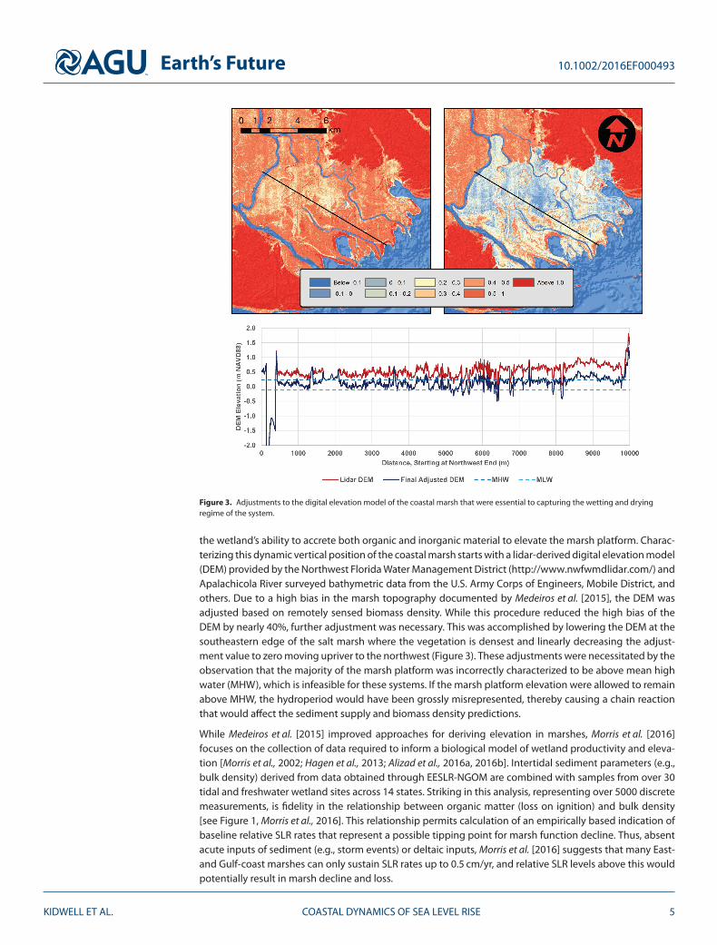
Earthrsquos Future 1010022016EF000493
Figure 3 Adjustments to the digital elevation model of the coastal marsh that were essential to capturing the wetting and dryingregime of the system
the wetlandrsquos ability to accrete both organic and inorganic material to elevate the marsh platform Charac-terizing this dynamic vertical position of the coastal marsh starts with a lidar-derived digital elevation model(DEM) provided by the Northwest Florida Water Management District (httpwwwnwfwmdlidarcom) andApalachicola River surveyed bathymetric data from the US Army Corps of Engineers Mobile District andothers Due to a high bias in the marsh topography documented by Medeiros et al [2015] the DEM wasadjusted based on remotely sensed biomass density While this procedure reduced the high bias of theDEM by nearly 40 further adjustment was necessary This was accomplished by lowering the DEM at thesoutheastern edge of the salt marsh where the vegetation is densest and linearly decreasing the adjust-ment value to zero moving upriver to the northwest (Figure 3) These adjustments were necessitated by theobservation that the majority of the marsh platform was incorrectly characterized to be above mean highwater (MHW) which is infeasible for these systems If the marsh platform elevation were allowed to remainabove MHW the hydroperiod would have been grossly misrepresented thereby causing a chain reactionthat would affect the sediment supply and biomass density predictions
While Medeiros et al [2015] improved approaches for deriving elevation in marshes Morris et al [2016]focuses on the collection of data required to inform a biological model of wetland productivity and eleva-tion [Morris et al 2002 Hagen et al 2013 Alizad et al 2016a 2016b] Intertidal sediment parameters (egbulk density) derived from data obtained through EESLR-NGOM are combined with samples from over 30tidal and freshwater wetland sites across 14 states Striking in this analysis representing over 5000 discretemeasurements is fidelity in the relationship between organic matter (loss on ignition) and bulk density[see Figure 1 Morris et al 2016] This relationship permits calculation of an empirically based indication ofbaseline relative SLR rates that represent a possible tipping point for marsh function decline Thus absentacute inputs of sediment (eg storm events) or deltaic inputs Morris et al [2016] suggests that many East-and Gulf-coast marshes can only sustain SLR rates up to 05 cmyr and relative SLR levels above this wouldpotentially result in marsh decline and loss
KIDWELL ET AL COASTAL DYNAMICS OF SEA LEVEL RISE 5
Earthrsquos Future 1010022016EF000493
4 Integrated Models With Dynamic Results and Assessments
The integrated modeling framework of EESLR-NGOM utilized SLR projections developed by Parris et al[2012] for the year 2100 of low (02 m) intermediate-low (05 m) intermediate-high (12 m) and high(20 m) These projections were then linked to an individual carbon emission scenario for example theA2 carbon emission scenario corresponds to the high SLR scenario Each scenario was linked to a specificlandscape profile that included shoreline position and profile dune height state of a marsh system andLULC This linkage permitted seamless communication within the EESLR-NGOM multimodel frameworkand ultimately via the SLR scenarios back to the associated carbon emission scenarios
With this context and by building on field-derived input data and climate and coastal scenarios a 2-DADvanced CIRCulation hydrodynamic model and a 1-D marsh equilibrium model [MEM Morris et al 2002]were applied for finite time periods The results of these intermediate simulations were then fed backinto the models for simulation of the next sequential time period For example the inundation of coastalsalt marshes as a result of SLR caused a decrease or elimination of above-ground biomass density whichchanged the surface roughness of the terrain and potentially affected the hydrodynamics of the systemin the next time step In addition projections of SLR and coastal development were incorporated intothe modeling workflow to describe the future state of the system as accurately as possible This processcoupling system hydrodynamics and biological function [Hagen et al 2013 Alizad et al 2016a] resultsin a modeling framework entitled Hydro-MEM and represents one of the first dynamic modeling systemscapable of predicting marsh response to varying scenarios of SLR
Following development of Hydro-MEM Alizad et al [2016b] focuses the first detailed application ofHydro-MEM in the Apalachicola NERR In addition to providing an assessment of regional marsh vulnerabil-ity and response to SLR this study also highlights the dynamic response of these systems to SLR The rateof overall marsh extent loss and function decline are projected to accelerate over time in conjunction withthe increased rate of SLR rates a pattern demonstrated by numerous assessments in low-gradient coastalregions However marsh response at the low and intermediate-low SLR scenarios will be variable withsome regions keeping pace with SLR and others experiencing loss Much of this variation is attributable tochanges in the inundation accretion and elevation characteristics of the marsh systems Significant lossesin marsh extent predicted in the intermediate-high and high SLR scenarios reflect an initial reduction inproductivity as inundation frequency increased resulting in a negative feedback of decreasing accretionand increasing water levels Though not a focus of this Apalachicola assessment results from Hydro-MEMalso indicate some upland migration of tidal wetlands particularly under the higher SLR scenarios
Predicted changes in marsh extent under varying SLR scenarios reflect one of a suite of factors that willinfluence future shoreline conditions and change In Plant et al [2016] the dynamic feedbacks betweenSLR dune height and shoreline change are predicted through a statistical modeling approach Long-termshoreline-change rates are combined and used with dune-height data collected regularly and after stormsfor a 10-year time period in the northern Gulf of Mexico and then applied as input to a Bayesian net-work Predictions of shoreline change have less uncertainty but similar accuracy when dune heights areincluded as input thus demonstrating the combined effects of these processes An optimized model isthen applied to forecast scenarios with low and intermediate-low SLR rates in a subregion spanning fromeastern Louisiana to the Florida panhandle The erosion rate will increase but with higher uncertainty andspatial variability and the shoreline change by 2100 could be comparable to the widths of barrier islands inthis subregion This predictive model can be used to determine the likelihood of adverse impacts of futureSLR to shorelines and dunes and informs studies of hydrodynamics and flooding in coastal regions
Future changes in shoreline position barrier island width and location and dune crest heights may increaseinundation and alter the amplitude and propagation speed of tides in back bays Passeri et al [2016] exam-ines these effects of SLR on tidal hydrodynamics in the bays and estuaries from Mississippi to Florida Thepredictive model of Plant et al [2016] is used to project the shoreline change and dune heights at 4 kmsections along this coastline and then the 50th percentile projections were selected to represent an averageprojection of future morphodynamics In regions where these projections show the shoreline will recedebeyond infrastructure or even the width of the barrier island a decision-making flowchart was introducedto account for nourishment of beaches andor dunes This flowchart considers the present and projectedland use and limits the shoreline erosion in regions near urban areas thus allowing a realistic representation
KIDWELL ET AL COASTAL DYNAMICS OF SEA LEVEL RISE 6
Earthrsquos Future 1010022016EF000493
of future conditions A high-resolution hydrodynamic model is used to predict the combined effects of SLRand morphodynamics on tidal amplitudes and velocities along coastal bays in the region Deeper watersin these bays and especially their increased inlet cross-sectional areas act to enhance the propagation oftides In a forecast scenario with a high rate of SLR by 2100 the tidal amplitudes increase by as much as67 and the tidal velocities increase and even double in one bay These projections are being used toinform coastal managers and policy makers and can be integrated with other studies of storm surges andecological assessments of SLR
These advances are combined into a study of storm surge-induced flooding by Bilskie et al [2016] In con-trast to a static (ldquobathtubrdquo) framework in which the SLR is added a posteriori as a constant increase to thewater levels this study introduces a modeling system that considers changes to shoreline and barrier islandmorphodynamics marshes and LULC Four SLR scenarios for 2100 are considered via an increase in the ini-tial water level and then the effects are considered for 10 hurricane events that contributed to the majorityof observed peak surges in the northern Gulf of Mexico Shoreline and dune height evolution are includedvia the methods of Plant et al [2016] and Passeri et al [2016] and marsh evolution is included via the methodof Alizad et al [2016b] The resulting changes to storm surge and coastal inundation are highly nonlinearwith most regions seeing an increase in water level above the SLR The inundated total land area increasesby 87 with higher increases in inundated developed and agricultural land areas The SLR-induced reduc-tions in dune heights allows surge overtopping that increased water levels by as much as 1 m The increasein sea level also changes the duration and timing of surge including an earlier arrival of the peak surgeThis dynamic framework is a culmination of the paradigm shift beyond bathtub approaches and has broadimplications for future studies here and elsewhere
Climate change effects can be taken from the coast up the watershed Projected LULC changes can be usedto examine the impact of conversion of forested regions into agricultural and urban areas Temperatureand precipitation projections can be downscaled from general circulation model data Hovenga et al [2016]combine these methods with a physics-based long-term hydrologic model to assess runoff and sedimentloading in the Apalachicola River Basin which drains into Apalachicola Bay and the northern Gulf of Mex-ico Their study uses present-day and three forecast scenarios from the Intergovernmental Panel on ClimateChange and combines them with LULC changes and downscaled data from three climate models in a waythat allows intercomparisons to be made While the individual climate models have disagreement on futurerainfall seasonal patterns [eg Janssen et al 2014 and Wang and Kotamarthi 2015] they agree that peakrunoff and minimum sediment loading will be shifted earlier in the year as compared to present-day condi-tions Further LULC changes did not affect runoff but the shift from forested to agricultural and urban areaswill increase the sediment loading in the estuarine system The combination of LULC and climate changeshas nonlinear effects as changes in one forcing factor may amplify or dampen the effects of the other Bothfactors should be included in studies of future hydrological conditions
The outputs from the hydrologic model of Hovenga et al [2016] can be used for biological assessments of thesystem ecology Huang et al [2017] uses the hydrologic outputs of flow and sediment transport as bound-ary conditions and inputs to models for total suspended solids (TSS) near oyster habitats Higher levels ofsuspended sediments have been shown to inhibit the recruitment growth and development of oystersincluding in the once-lucrative oyster fisheries in Apalachicola Bay The forecast scenarios in Hovenga et al[2016] are used by Huang et al [2017] to establish values for 2100 for SLR streamflow and sediment loadinginputs Then a well-validated three-dimensional hydrodynamic model is coupled with a widely used sed-iment module so the density-driven circulation can be used to transport TSS in the estuarine system SLRis shown to cause a decrease in the TSS at the oyster reefs with larger decreases associated with larger SLRscenarios At one of the two primary oyster habitats in this system the maximum sediment concentrationwill be close or equal to zero thus causing a substantial loss of nutrients and a decrease in oyster produc-tion These projections can be used to assess existing and prepare new oyster habitats in Apalachicola Bayand these methods can be extended to assess vulnerabilities in other regions
5 Conclusion and Discussion
This collection of articles on the coastal dynamics of SLR represents a shift in the paradigm of how climatechange and SLR can be assessed at coastal land margins particularly for low-gradient landscapes While
KIDWELL ET AL COASTAL DYNAMICS OF SEA LEVEL RISE 7
Earthrsquos Future 1010022016EF000493
static (aka ldquobathtubrdquo) models have proved quite useful in providing first approximations the utility ofdynamic assessments are demonstrated and their appropriateness warranted by numerous examples ofthe highly nonlinear response of ecosystem components and hydrodynamics to SLR As with any modelingframework the accuracy and validity of outputs are highly sensitive to input parameters
Coastal wetlands are widely considered to be highly vulnerable to the effects of SLR given their sensitivelocation along the landndashwater interface Results from Alizad et al [2016b] project high wetland loss underhigher scenarios of SLR by 2100 However the dynamic feedbacks between physical (eg tidal dynam-ics) and biological (eg accretion rates and productivity) require a more nuanced perspective of marshvulnerability to SLR Regional variability in SLR rates and local factors such as marsh migration and accre-tion potential provide critical context to marsh vulnerability assessments [eg Enwright et al 2016 Kirwinet al 2016 Morris et al 2016] Low scenarios of SLR can increase marsh extent and productivity or greatlyextend the time before marsh collapse [Alizad et al 2016a 2016b] Quantifying these thresholds is criti-cal for informed mitigation actions and the analysis by Morris et al [2016] of 05 cmyr accretion potential(absent significant sources of mineral sediment) provides a key baseline from which to start Within thiscontext caution is advised when using static models andor nonlocation-specific input parameters
Perhaps no other input parameter is more critical in low-gradient micro-tidal systems than the accuracyof the baseline DEM Lidar-derived elevation error in low marsh systems dominated by Spartina alternifloraand Juncus roemerianus can range from 04 to 08 m in the northern Gulf of Mexico This error results in aDEM that does not accurately reflect marsh platform elevation and topography and can significantly influ-ence projections of marsh vulnerability to SLR A number of approaches for correcting this bias in coastalwetlands [eg Medeiros et al 2015 Buffington et al 2016] have emerged in recent years and must be usedprior to modeling SLR effects on coastal wetlands
Barrier islands along Mississippi (MS) Alabama (AL) and the Florida (FL) panhandle as well as low-lyingmarshes become more vulnerable not only to storm surge inundation but also tidal inundation especiallyunder the higher projections of SLR Under a 2-m SLR tidal inundation from MS through the FL panhandleincreases by 1472 km2 which is equivalent to 20 of the total surface area of the bays within this region atpresent day Barrier islands in this region are projected to have increased shoreline and dune erosion underhigher rates of SLR which have significant consequences for coastal infrastructure
Storm surge response to SLR is not simply additive Storm surge flooding of developed areas for the MS ALFL panhandle regions more than double with an overall increase of 138 from present day (2827 km2offlooding) to a 20-m SLR (6723 km2of flooding) To put this into perspective the average land area of acoastal city in MS AL and the FL panhandle is 50ndash100 km2 The most vulnerable areas include Floridarsquos BigBend the western FL panhandle AL and MS In the same SLR scenario agricultural lands in the region willsee an increase in inundation area by 189 and total inundated land area will increase by 87 In additionthose areas that are presently being flooded with storm surge will be flooded at greater depths The peaksurge will increase by as much as 1 m above the applied SLR in some areas however other regions will havea reduction in peak surge The nonlinear response to SLR is likely not limited to the northern Gulf of Mexicoor low-gradient landscapes For example Lentz et al [2016] found that 70 of the coastal landscape in thenortheast US responded dynamically to SLR Thus the ability to better predict the effects of SLR will requireexpanded development and application of dynamic modeling approaches
While the multimodel framework highlighted in this special issue represents significant advancement inhow predictions of SLR impacts are modeled the ultimate intent of EESLR-NGOM is to address explicit needsof coastal managers To ensure that products and tools developed through this project are relevant andusable by stakeholders DeLorme et al [2016] describes a transdisciplinary approach to facilitate collabo-ration between project scientists and a stakeholder advisory committee Pre-project engagement annualworkshops and periodic webinars are key tools that were used to facilitate objective feedback and analysisof EESLR-NGOM science activities As with most multi-institution science projects EESLR-NGOM had a leadprincipal investigator that provided oversight and coordination for project tasks and activities Howevercoupled with this traditional project structure was a funded ldquomanagement principal investigatorrdquo chargedwith ensuring collaboration providing oversight to stakeholder advisory committee activities and facilitat-ing the transition from research to application This collaborative approach resulted in model products andcapabilities applicable to stakeholder needs that have been applied to evaluate storm surge and marsh
KIDWELL ET AL COASTAL DYNAMICS OF SEA LEVEL RISE 8
Earthrsquos Future 1010022016EF000493
vulnerability in the northeast US and informed watershed management planning and land acquisitionactivities in the Gulf of Mexico
The interconnected built and natural environment demands integrative inclusion of a suite of solutions tomitigate coastal vulnerability Although the methodologies presented are by no means comprehensive thesystems approach exemplified in Figure 2 and pursued through the research presented herein provides astrong foundation from which we can adapt to rising sea levels and facilitate coastal resilience
ReferencesAlizad K S C Hagen J T Morris P Bacopoulos M V Bilskie and J F Weishampel (2016a) A coupled two-dimensional
hydrodynamic-marsh model with biological feedback Ecol Modell 327 29ndash43 doi101016jecolmodel201601013Alizad K S C Hagen J T Morris S C Medeiros M V Bilskie and J F Weishampel (2016b) Coastal wetland response to sea level rise in a
fluvial estuarine system Earthrsquos Future 4(11) 483ndash497 doi1010022016EF000385Bilskie M V S C Hagen K A Alizad S C Medeiros D L Passeri and H Needham (2016) Dynamic simulation and numerical analysis of
hurricane storm surge under sea level rise with geomorphologic changes along the northern Gulf of Mexico Earthrsquos Future 4(5)177ndash193 doi1010022015EF000347
Buffington K J B D Dugger K M Thorne and J Y Takekawa (2016) Statistical correction of lidar-derived digital elevation models withmultispectral airborne imagery in tidal marshes Remote Sens Environ 186 616ndash625 doi101016jrse201609020
Church J A and N J White (2006) A 20th century acceleration in global sea-level rise Geophys Res Lett 33(1) L01602doi1010292005GL024826
Church J A and N J White (2011) Sea-level rise from the late 19th to early 21st century Surv Geophys 32(4ndash5) 585ndash602doi101007s10712-011-9119-1
DeLorme D E D Kidwell S C Hagen and S Stephens (2016) Developing and managing transdisciplinary and transformative researchon the coastal dynamics of sea level rise Experiences and lessons learned Earthrsquos Future 4(5) 194ndash209 doi1010022015EF000346
Enwright N M K T Griffith and M J Osland (2016) Barriers to and opportunities for landward migration of coastal wetlands withsea-level rise Front Ecol Environ 14(6) 307ndash316 doi101002fee1282
Hagen S C J T Morris P Bacopoulos and J F Weishampel (2013) Sea-Level Rise Impact on a Salt Marsh System of the Lower St JohnsRiver J Waterway Port Coastal Ocean Eng 139(2) 118ndash125 doi101061(ASCE)WW1943-54600000177
Hay C C E Morrow R E Kopp and J X Mitrovica (2015) Probabilistic reanalysis of twentieth-century sea-level rise Nature 517481ndash484 doi101038nature14093
Hayes M O (1979) Barrier island morphology as a function of tidal and wave regime in Barrier Islands edited by SP Leatherman pp1ndash27 Academic Press New York N Y
Hovenga P A D Wang S C Medeiros S C Hagen and K A Alizad (2016) The response of runoff and sediment loading in theApalachicola River Florida to climate and land use land cover change Earthrsquos Future 4(5) 124ndash142 doi1010022015EF000348
Huang W S C Hagen D Wang P A Hovenga F Teng and J F Weishampel (2017) Suspended sediment projections in Apalachicola Bayin response to altered river flow and sediment loads under climate change and sea level rise Earthrsquos Future 4 428ndash439doi1010022016EF000384
Janssen E D J Wuebbles K E Kunkel S C Olsen and A Goodman (2014) Observational- and model-based trends and projections ofextreme precipitation over the contiguous United States Earthrsquos Future 2 99ndash113 doi1010022013EF000185
Jevrejeva S A Grinsted J Moore and S Holgate (2006) Nonlinear trends and multiyear cycles in sea level records J Geophys Res 111C09012 doi1010292005JC003229
Jevrejeva S J C Moore A Grinsted and P L Woodworth (2008) Recent global sea level acceleration started over 200 years agoGeophy Res Lett 35 L08715 doi1010292008GL033611
Kirwin M L S Temmerman E E Skeehan and G R Guntenspergen (2016) Overestimation of marsh vulnerability to sea level rise NatClim Change 6 253ndash260 doi101038nclimate2909
Lentz E E E R Thieler N G Plant S R Stippa R M Horton and D B Gesch (2016) Evaluation of dynamic coastal response to sea-levelrise modifies inundation likelihood Nat Clim Change 6 636ndash700 doi101038nclimate2957
Medeiros S S Hagen J Weishampel and J Angelo (2015) Adjusting Lidar-derived digital terrain models in coastal marshes based onestimated aboveground biomass density Remote Sens 7(4) 3507 doi103390rs70403507
Morris J T P V Sundareshwar C T Nietch B Kjerfve and D R Cahoon (2002) Responses of coastal wetlands to rising sea level Ecology83(10) 2869ndash2877 doi1018900012-9658(2002)083[2869ROCWTR]20CO2
Morris J T D C Barber J Callaway R Chambers S C Hagen B J Johnson P Megonigal S Neubauer T Troxler and C Wigand (2016)Contributions of organic and inorganic matter to sediment volume and accretion in tidal wetlands at steady state Earthrsquos Future 4(4)110ndash121 doi1010022015EF000334
Nerem R S D Chambers C Choe and G T Mitchum (2010) Estimating mean sea level change from the TOPEX and Jason AltimeterMissions Mar Geod 33(1) 435ndash446 doi101080014904192010491031
Parris A P Bromirski V Burkett D Cayan M Culver J Hall R Horton K Knuuti R Moss J Obeysekera A Sallenger and J Weiss (2012)Global sea level rise scenarios for the us national climate assessment NOAA Tech Memo OAR CPO-1 37 pp
Passeri D L S C Hagen S C Medeiros M V Bilskie K Alizad and D Wang (2015) The dynamic effects of sea level rise on low gradientcoastal landscapes A review Earthrsquos Future 3(6) 159ndash181 doi1010022015EF000298
Passeri D L S C Hagen N G Plant M V Bilskie and S C Medeiros (2016) Tidal hydrodynamics under future sea level rise and coastalmorphology in the Northern Gulf of Mexico Earthrsquos Future 4(5) 159ndash176 doi1010022015EF000332
Plant N G E R Thieler and D L Passeri (2016) Coupling centennial-scale shoreline change to sea-level rise and coastal morphology inthe Gulf of Mexico using a Bayesian network Earthrsquos Future 4(6) 143ndash158 doi1010022015EF000331
Wang J and V R Kotamarthi (2015) High-resolution dynamically downscaled projections of precipitation in the mid and late 21stcentury over North America Earthrsquos Future 3 268ndash288 doi1010022015EF000304
KIDWELL ET AL COASTAL DYNAMICS OF SEA LEVEL RISE 9
Earthrsquos Future 1010022016EF000493
vulnerability in the northeast US and informed watershed management planning and land acquisitionactivities in the Gulf of Mexico
The interconnected built and natural environment demands integrative inclusion of a suite of solutions tomitigate coastal vulnerability Although the methodologies presented are by no means comprehensive thesystems approach exemplified in Figure 2 and pursued through the research presented herein provides astrong foundation from which we can adapt to rising sea levels and facilitate coastal resilience
ReferencesAlizad K S C Hagen J T Morris P Bacopoulos M V Bilskie and J F Weishampel (2016a) A coupled two-dimensional
hydrodynamic-marsh model with biological feedback Ecol Modell 327 29ndash43 doi101016jecolmodel201601013Alizad K S C Hagen J T Morris S C Medeiros M V Bilskie and J F Weishampel (2016b) Coastal wetland response to sea level rise in a
fluvial estuarine system Earthrsquos Future 4(11) 483ndash497 doi1010022016EF000385Bilskie M V S C Hagen K A Alizad S C Medeiros D L Passeri and H Needham (2016) Dynamic simulation and numerical analysis of
hurricane storm surge under sea level rise with geomorphologic changes along the northern Gulf of Mexico Earthrsquos Future 4(5)177ndash193 doi1010022015EF000347
Buffington K J B D Dugger K M Thorne and J Y Takekawa (2016) Statistical correction of lidar-derived digital elevation models withmultispectral airborne imagery in tidal marshes Remote Sens Environ 186 616ndash625 doi101016jrse201609020
Church J A and N J White (2006) A 20th century acceleration in global sea-level rise Geophys Res Lett 33(1) L01602doi1010292005GL024826
Church J A and N J White (2011) Sea-level rise from the late 19th to early 21st century Surv Geophys 32(4ndash5) 585ndash602doi101007s10712-011-9119-1
DeLorme D E D Kidwell S C Hagen and S Stephens (2016) Developing and managing transdisciplinary and transformative researchon the coastal dynamics of sea level rise Experiences and lessons learned Earthrsquos Future 4(5) 194ndash209 doi1010022015EF000346
Enwright N M K T Griffith and M J Osland (2016) Barriers to and opportunities for landward migration of coastal wetlands withsea-level rise Front Ecol Environ 14(6) 307ndash316 doi101002fee1282
Hagen S C J T Morris P Bacopoulos and J F Weishampel (2013) Sea-Level Rise Impact on a Salt Marsh System of the Lower St JohnsRiver J Waterway Port Coastal Ocean Eng 139(2) 118ndash125 doi101061(ASCE)WW1943-54600000177
Hay C C E Morrow R E Kopp and J X Mitrovica (2015) Probabilistic reanalysis of twentieth-century sea-level rise Nature 517481ndash484 doi101038nature14093
Hayes M O (1979) Barrier island morphology as a function of tidal and wave regime in Barrier Islands edited by SP Leatherman pp1ndash27 Academic Press New York N Y
Hovenga P A D Wang S C Medeiros S C Hagen and K A Alizad (2016) The response of runoff and sediment loading in theApalachicola River Florida to climate and land use land cover change Earthrsquos Future 4(5) 124ndash142 doi1010022015EF000348
Huang W S C Hagen D Wang P A Hovenga F Teng and J F Weishampel (2017) Suspended sediment projections in Apalachicola Bayin response to altered river flow and sediment loads under climate change and sea level rise Earthrsquos Future 4 428ndash439doi1010022016EF000384
Janssen E D J Wuebbles K E Kunkel S C Olsen and A Goodman (2014) Observational- and model-based trends and projections ofextreme precipitation over the contiguous United States Earthrsquos Future 2 99ndash113 doi1010022013EF000185
Jevrejeva S A Grinsted J Moore and S Holgate (2006) Nonlinear trends and multiyear cycles in sea level records J Geophys Res 111C09012 doi1010292005JC003229
Jevrejeva S J C Moore A Grinsted and P L Woodworth (2008) Recent global sea level acceleration started over 200 years agoGeophy Res Lett 35 L08715 doi1010292008GL033611
Kirwin M L S Temmerman E E Skeehan and G R Guntenspergen (2016) Overestimation of marsh vulnerability to sea level rise NatClim Change 6 253ndash260 doi101038nclimate2909
Lentz E E E R Thieler N G Plant S R Stippa R M Horton and D B Gesch (2016) Evaluation of dynamic coastal response to sea-levelrise modifies inundation likelihood Nat Clim Change 6 636ndash700 doi101038nclimate2957
Medeiros S S Hagen J Weishampel and J Angelo (2015) Adjusting Lidar-derived digital terrain models in coastal marshes based onestimated aboveground biomass density Remote Sens 7(4) 3507 doi103390rs70403507
Morris J T P V Sundareshwar C T Nietch B Kjerfve and D R Cahoon (2002) Responses of coastal wetlands to rising sea level Ecology83(10) 2869ndash2877 doi1018900012-9658(2002)083[2869ROCWTR]20CO2
Morris J T D C Barber J Callaway R Chambers S C Hagen B J Johnson P Megonigal S Neubauer T Troxler and C Wigand (2016)Contributions of organic and inorganic matter to sediment volume and accretion in tidal wetlands at steady state Earthrsquos Future 4(4)110ndash121 doi1010022015EF000334
Nerem R S D Chambers C Choe and G T Mitchum (2010) Estimating mean sea level change from the TOPEX and Jason AltimeterMissions Mar Geod 33(1) 435ndash446 doi101080014904192010491031
Parris A P Bromirski V Burkett D Cayan M Culver J Hall R Horton K Knuuti R Moss J Obeysekera A Sallenger and J Weiss (2012)Global sea level rise scenarios for the us national climate assessment NOAA Tech Memo OAR CPO-1 37 pp
Passeri D L S C Hagen S C Medeiros M V Bilskie K Alizad and D Wang (2015) The dynamic effects of sea level rise on low gradientcoastal landscapes A review Earthrsquos Future 3(6) 159ndash181 doi1010022015EF000298
Passeri D L S C Hagen N G Plant M V Bilskie and S C Medeiros (2016) Tidal hydrodynamics under future sea level rise and coastalmorphology in the Northern Gulf of Mexico Earthrsquos Future 4(5) 159ndash176 doi1010022015EF000332
Plant N G E R Thieler and D L Passeri (2016) Coupling centennial-scale shoreline change to sea-level rise and coastal morphology inthe Gulf of Mexico using a Bayesian network Earthrsquos Future 4(6) 143ndash158 doi1010022015EF000331
Wang J and V R Kotamarthi (2015) High-resolution dynamically downscaled projections of precipitation in the mid and late 21stcentury over North America Earthrsquos Future 3 268ndash288 doi1010022015EF000304
KIDWELL ET AL COASTAL DYNAMICS OF SEA LEVEL RISE 9