Embed Size (px)
Citation preview
Module 4- Making a Decision if the Site, Under Normal Circumstances Supports a
Predominance of Hydric FSA Soils
2011 This module provides the founding principles used to decide if a sampling unit contains hydric soils. The Food Security Act (FSA) is the only place where hydric soil is defined by federal law. This phrase (hydric soil) is defined somewhat differently by the National Technical Committee for Hydric Soils (NTCHS) and the Corps of Engineers. Differences are discussed in this module.
The FSA Wetland ID Procedures (FSA Procedures) allow for two decision-making options used by
the agency expert in verifying if under normal circumstances the sampling unit supports a predominance of hydric soil. These two options are (1) Direct Observations or (2) Indicators.
Developers: [email protected]
FSA Wetland Identification Procedures (Foundations to Sound Decision Making)
Module 4 – Making a Decision if a Site Under Normal Circumstances, Supports a Predominance of FSA Hydric Soils.
Objectives Upon completion of this module, the student will: Through the collection of off-site and/or on-site data, identify the presence or
absence of a hydric soil.
Key Concepts An understanding of how soils develop and the soil properties related to hydric
soil characteristics such as soil color, texture, and permeability that are used to identify indicators of hydric soils.
For FSA purposes a hydric soil is a soil that under normal circumstances meets
the FSA hydric soil definition. The use of (1) direct observations or (2) indicators (hydric soils lists, Field Indicators of Hydric Soils, and the hydric soils technical standard) are the two methods used by the agency expert to render a decision.
The Corps Methods emphasizes an indicator-based approach to identifying
hydric soils and those indicators are provided in regional supplements. These hydric soil indicators were developed under the leadership of the National Technical Committee for Hydric Soils and published in the Field Indicators of Hydric Soils of Hydric Soils in the United States.
Not all soils form hydric soil morphologies and both the Corps Methods and FSA
Procedures allows for the use of methodologies other than the Field Indicators of Hydric Soils to identify hydric soils.
This module is designed to take 5 - 8 hours and includes required exercises. Links are provided as optional learning opportunities.
2

FSA Wetland Identification Procedures (Foundations to Sound Decision Making)
If you are new to the concepts of writing a soil description and using the hydric soil indicators or if you have questions as you progress through this module it is recommended that you contact your local Resource Soil Scientist for assistance in completing the field exercises.
3
FSA Wetland Identification Procedures (Foundations to Sound Decision Making)
Learning Concept 4-1: Introduction to Hydric Soils.
What is a Soil?
Soil is "the collection of natural bodies in the earth's surface, in places modified or even made by man of earthy materials, containing living matter and supporting or capable of supporting plants out-of-doors.” Its upper limit is air or shallow water. The lower limit of soil is normally the lower limit of biologic activity, which generally coincides with the common rooting depth of native perennial plants.
What is a Hydric Soil?
A hydric soil is defined in the FSA as a soil that, “in its undrained condition, is saturated, flooded, or ponded long enough during the growing season to develop an anaerobic condition that supports the growth and regeneration of hydrophytic vegetation” [16 U.S.C. 3801(a) (12)]. The question is quite simply – without drainage (per the definition of drainage in the FSA procedures), would the soils be “saturated, flooded, or ponded long enough during the growing season to develop an anaerobic condition that supports the growth and regeneration of plants growing in (A) water or (B) growing in a substrate that is deficient in oxygen due to excessive water content”. If so, the soil is hydric. If not, the soil is not hydric. A NTCHS hydric soil indicator (from the hydric soil field indicator guide can be a vital tool in the decision making process. Nearly all hydric soils exhibit characteristic morphologies that result from repeated periods of saturation or inundation that result in reduction of free oxygen (“anaerobic condition”). Saturation or inundation, when combined with macro and microbial activity in the soil (and use of oxygen by plants), causes the depletion of oxygen. Microbial activity is the “driver” in the depletion of oxygen in most soils.
The delepetion of oxygen by soil microbes and the resuting anaerobiosis (without molecular oxygen or O2) promotes certain biogeochemical processes, such as the accumulation of organic matter and the reduction, translocation, or accumulation of iron and other reducible elements. These processes result in distinctive characteristics that persist in the soil during both wet and dry periods, making them particularly useful for identifying hydric soils in the field (USDA Natural Resources Conservation Service 2006b) even when the site visit is made outside of NEC.
4
FSA Wetland Identification Procedures (Foundations to Sound Decision Making)
Important concepts in the definition to note are
a. “in its undrained condition” means that prior to drainage, the soil experienced these conditions (wet) and does not currently need to be undergoing these conditions. In other words, it may be currently in the dry part of the season when it is being observed or it may have been artificially or naturally drained;
b. “saturated, flooded, or ponded” means that the soil must have water in an unlined bore hole in the upper part of the soil or the water must rise above the surface of the soil;
c. “during the growing season” means that the water must be present during the growing season. Growing season is defined in the FSA Proceedures (2-7);
d. “anaerobic condition” means the soil lacks molecular oxygen (O2) and is a reducing environment. If the soil meets all the above mentioned concepts, then it will “supports the growth and regeneration of hydrophytic vegetation” as hydrophytic vegetation, as defined in the FSA as “a plant growing in (A) water”; or (B) a “substrate that is at least periodically deficient in oxygen during a growing season as a result of excessive water content” [16 U.S.C. 3801(a)(13)].
The definition used by the Corps is from the National Technical Committee for Hydric Soils (NTCHS), which differs from FSA definition. However, the concepts are similar. Remember, to be determined a hydric soil the sampling unit must support a predominance of soils that meet the FSA definition of a hydric soil. There are always possibilities of false positives and false negatives (note: Unlike hydrophytic vegetation and wetland hydrology, false positives for hydric soil would be very rare (remember the once hydric always hydric concept). Hydric soil lists, Field Indicators of Hydric Soils, and the Hydric Soil Technical Standard were all created to help in the identification of soils that meet the definition. If the preponderance of evidence shows that the soil meets the definition of a hydric soil, then it is hydric regardless of whether or not it is a soil series on a hydric soils list or meets an approved field indicator. There is not a field indicators of hydric soils or soil series mapped that fit every hydric soil condition. When a soil fails to exhibit a hydric soil indictor, but meets the hydric soil definition, the FSA Procedures refer to this as a false negative. For hydric soils, false negative are not uncommon. Chapter 5 of the Regional Supplements has some suggested methods to assist in making hydric soils determinations when the sampling unit does not exhibit an indicator. Some State Offsite Methods (SOSM) as defined in (2-14) of the FSA Procedure may provide some assistance with situations where false negative might occur within that State.
5
FSA Wetland Identification Procedures (Foundations to Sound Decision Making)
Why is this important to me? It is important to understand the FSA definition of a hydric soil because it is the only requirement that is needed for a soil to be determined as hydric. Hydric Soil Lists, Field Indicators of Hydric Soils, the Technical Standard, and all other information regarding hydric soils have been developed to help you to identify soils that meet the hydric soils definition. If you can determine that the predominance of soil within the sampling unit meets the FSA definition of a hydric soil, regardless of whether it meets an “indicator”, it is still a hydric soil (or vice versa).
Question – True or false. A soil that does not meet a hydric soil field indicator and is not listed on the hydric soils list is not a hydric soil.
Answer: False. A soil needs to meet the definition to be considered a hydric soil. There are some hydric soil situations that exist that do not at this time have good indicators (false negatives).
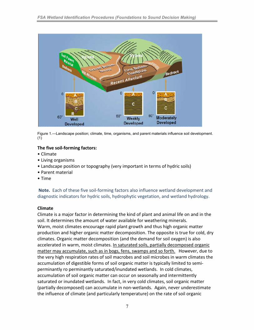
Factors of Soil Formation: How is soil formed? Figure 1 illustrates a few common landscapes. Soils develop as a result of the interactions of climate, living organisms, and landscape position as they influence parent material decomposition over time (the five soil-forming factors). Older stream terraces, or soils on second bottom positions, usually have developed B horizons (a horizon developed from smaller soil particles translocating through the soil profile from upper horizons). Recent soils deposited in first bottom positions usually do not have a developed B horizon (geologically too young). Instead, they may have stratified layers (sediments deposited during past flood events) varying in thickness, texture, and composition. Changes in climate, parent material, landscape position, and living organisms, as well as the amount of time the material has been in place, all influence the soil forming process.
6
FSA Wetland Identification Procedures (Foundations to Sound Decision Making)
Figure 1.—Landscape position; climate, time, organisms, and parent materials influence soil development. (1) The five soil-forming factors: • Climate • Living organisms • Landscape position or topography (very important in terms of hydric soils) • Parent material • Time Note. Each of these five soil-forming factors also influence wetland development and diagnostic indicators for hydric soils, hydrophytic vegetation, and wetland hydrology. Climate Climate is a major factor in determining the kind of plant and animal life on and in the soil. It determines the amount of water available for weathering minerals. Warm, moist climates encourage rapid plant growth and thus high organic matter production and higher organic matter decomposition. The opposite is true for cold, dry climates. Organic matter decomposition (and the demand for soil oxygen) is also accelerated in warm, moist climates. In saturated soils, partially decomposed organic matter may accumulate, such as in bogs, fens, swamps and so forth. However, due to the very high respiration rates of soil macrobes and soil microbes in warm climates the accumulation of digestible forms of soil organic matter is typically limited to semi-perminantly ro perminantly saturated/inundated wetlands. In cold climates, accumulation of soil organic matter can occur on seasonally and intermittently saturated or inundated wetlands. In fact, in very cold climates, soil organic matter (partially decomposed) can accumulate in non-wetlands. Again, never underestimate the influence of climate (and particularly temperature) on the rate of soil organic
7
FSA Wetland Identification Procedures (Foundations to Sound Decision Making)
matter, development of redoximorphic features (those featured that tend to develop in hydric soils), and the time that it takes for a saturated or inundated soil to become reduced (deficient of molecular Oxygen). In cold climates with large amounts of soil organic matter, it might take just a few days for the soil to become reduced. In soils with low amounts of digestible organic matter common to warm climates it might take weeks. Thus, climate is a critical consideration in determining if a sampling unit meets the FSA hydric soil definition (“in its undrained condition, is saturated, flooded, or ponded long enough during the growing season to develop an anaerobic condition …”). Organisms Plants and animals affect soil development. In particular, plants supplying upper layers with organic matter, recycleing nutrients from lower to upper layers, and helping to slow soil erosion. Soil microbial activity or inactivity is the driving force behind the development of soil morphological features that we use as indicators of a hydric soil. For example, the accumulation of soil organic matter is a hydric soil indicator which and results from the slowed respiration rates of soil microbes during long periods of saturation. Another common example of a soil feature used in the identification of hydric soils is the the reduction of iron compounds by soil microbes during periods with a limited supply of free oxygen (saturation or inundation) and the translocation and redistribution of the reduced compounds. This process results in “redoximorphic soil features” such as iron depletions and iron accumulations. Landscape Position Topography in terms of landscape position causes localized changes in moisture and temperature. Even though the landscape has the same soil-forming factors of climate, organisms, parent material, and time, the soils that occur at landscape positions that shed water may be quite different from the wetter soils where water accumulates. In some regions, aspect (north facing slopes, south facing slopes) can have a significant influence on soil development. Landscape position is an important soil forming factor as soil development is typically excelerated in these water receiving landscape when compaired to adjacent landscapes that shed water. A hydric soil is only going to occur in landscapes that receive more water than they shed (allow for an excessive accumulation of water to cause soil saturation and reduction in the upper part). Parent material Parent material refers to that great variety of unconsolidated organic (such as fresh peat) and mineral material (such as rocks) in which soil formation begins. Certain parent materials such as red parent material or parent material that weathers to soils with high pH can be problematic because the hydric soils that develop in these parent materials often lack characteristic hydric soil morphologies (redoximorphic features).
8
FSA Wetland Identification Procedures (Foundations to Sound Decision Making)
Soils dominated by very small particles (clays) will develop redoximorphic features (again, evidence of soil reduction) at a slower rate than soils with faster internal drainage rates. Remember that most redoximorphic soil features occur from the reduction of iron and manganese. The reduced compounds move into suspension, are translocated to another area, and then redistributed when the soil dries (and free oxygen moves back into the soil). The development of iron accumulations and iron depletions within the soil occurs rapidly in sandy soils and slowly in clayey soils. Why? First, the saturation (and eventually the reduction of iron) within a soil ped (soil internal structure) might be days after the rainfall/inundation event. In fact, the rate of runoff from clayey soils might be so rapid that the soil profile does not become saturated. Some high shrink swell clays crack so heavily that water quickly infiltrated the site via the cracks but the lateral movement of water into the very slowly permable ped is so slow that the site dries before the ped interior is saturated (depleted). Loamy soils lack this type of internal soil structure and so the entire soil profile might become saturated within minutes of a rainfall/inundation event. Thus, it would stand to reason that loamy soils (with a restrictive layer under the A horizon) become reduced much more rapidly than clays. Secondly, the lateral water movement within clayey soils is very slow. In some clays, the rate of water movement might be so slow that the reduced iron may not move very far before the soil is reoxygenated. In these soils, the development of areas with iron accumulations and iron depletions is slowed. In addition, the size of accumulations and depletions might be too small to be observed in clayey soils, whereas loamy soils tend to have large areas of both. Time Time is required for horizon formation. The longer a soil surface has been exposed to soil forming agents like rain, hoof action, and growing plants, the greater the development of the soil profile. Soils in recent alluvial or windblown materials or soils on steep slopes where erosion has been active may show very little horizon development. Soils in very dry climates, develop very slowly as the influence of water moving over and through the upper profile is limited. Soils on older, stable surfaces generally have well defined horizons because the rate of soil formation has exceeded the rate of geologic erosion or deposition. Relatively young soils may lack typical hydric soil morphologies due to lack of time to allow for organic matter accumulation or redoximorphic feature formation.
What are the soil forming processes?
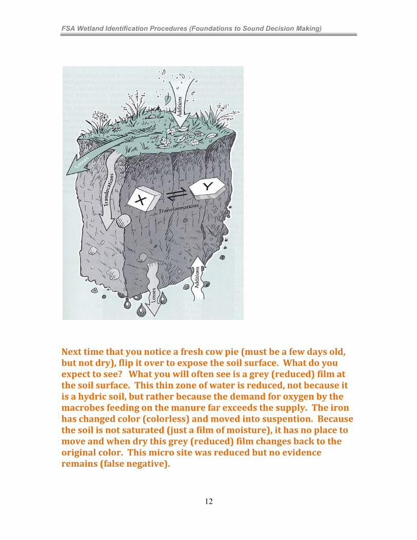
The four major processes that change parent material into soil are additions, losses, translocations, and transformations.
9
FSA Wetland Identification Procedures (Foundations to Sound Decision Making)
Additions The most obvious addition is organic matter. As soon as plant life begins to grow in fresh parent material, organic matter begins to accumulate. Organic matter gives a black or dark brown color to surface layer. Even young soils may have a dark surface layer. Partially decomposed organic matter may accumulate in saturated soils, the result of which is thick organic surfaces. However, because wetlands are in a water recieveing landscape position, they tend to accumulate sediment (wind or water) and nutrients faster than non-wetlands. Losses Most losses occur by leaching through the soil profile. Water moving through the soil dissolves certain minerals and smaller soil particles and transports them into deeper layers. In floodplains, scouring following a high energy flooding event might be the cause of a wetland being present. Translocations Translocation means movement from one place to another (either upward, downward, or laterally). In low rainfall areas, leaching often is incomplete. Water starts moving down through the soil, dissolving soluble minerals as it goes. There isn’t enough water, however, to move all the way through the soil. When the water stops moving, aided by evaporation, salts are left behind. Soil layers with calcium carbonate or other salt accumulations form this way. Translocation upward and lateral movement is also common. In dry areas, low-lying soils can have a high water table. Evaporation at the surface causes water to move upward. Salts are dissolved on the way and are deposited on the surface as the water evaporates. Some of these mineral deposits, particularly calcium carbonate, can result in false positives. The translocation of smaller (“fines” soil particles and/or minerials) downward and the deposition below the A horizon typically results in a restrictive layer. The most common is the development of a “Bt” horizon (accumulation of silts and clay) translocated from the A and/or E horizons (a leached zone) above. These restrictive layers slow water movement and very commonly result in a “perched water table”.. In depressional landscapes (and some flats) the accumulation of water due to these restrictive layers results in wetlands. Transformations Transformations are changes that take place in the soil. Microorganisms that live in the soil feed on new organic matter (e.g. dead root or insect) and change it into humus.
10
FSA Wetland Identification Procedures (Foundations to Sound Decision Making)
Other transformations can change the form of certain materials. Iron oxides (ferric form) usually give soils a yellowish or reddish color. In waterlogged soils, anerobic microbes are able to “steal” some of the oxygen from the iron oxides to allow for respiration (digestion of organic matter) transforming these oxidized compounds to a “reduced” (less oxyen) form. Unlike the oxygenated form, the reduced form of iron (ferrous) is soluable and rapidly“dissolved” in free water (remember the profile is saturated at this time). The reduced forms (ferrous) of iron translocte upward, downward, or laterally. Even if the water is not moving the reduced iron is moving from higher concentrations to lower concentrations (remember basic principles of “diffusion”). Relate this to smoke in a room. At first it is near the fire. Overtime is becomes evenly distributed. Reduced iron does acts similarly within soil water. If it comes in contact with some free oxyen (O2) it changes form again (ferric) and is no longer soluable (precipitates out of solution). Over years of this process, even without water movement downward, the iron will move from areas in the soil profile that have a heavy demand for oxygen (areas with a surpluss of digestible organic matter) to areas with lower demand for oxygen (area with little or no digestible organic matter). After most of the iron has moved from an area of the soil, the area has a grayish or whitish color. Repeated cycles of saturation and drying create a “mottled “look with splotches of different colored soils. Part of the soil is gray because of the loss of iron (area with high microbe populations/new organic matter), and part is a browner color where the iron oxide is not removed (area with less organic mater and lower respiration rates). During long periods of saturation, gray lined root channels develop. This may indicate a possible loss of iron or an addition of humus from decayed roots. Most non-hydric mineral soils have a somewhat uniform color within the same horizon. Most hydric mineral soils are multi-colored within the same general area, but can be fully depleted (most of the iron is gone and they soils are “bleached” or gray.
11
FSA Wetland Identification Procedures (Foundations to Sound Decision Making)
Next time that you notice a fresh cow pie (must be a few days old, but not dry), flip it over to expose the soil surface. What do you expect to see? What you will often see is a grey (reduced) film at the soil surface. This thin zone of water is reduced, not because it is a hydric soil, but rather because the demand for oxygen by the macrobes feeding on the manure far exceeds the supply. The iron has changed color (colorless) and moved into suspention. Because the soil is not saturated (just a film of moisture), it has no place to move and when dry this grey (reduced) film changes back to the original color. This micro site was reduced but no evidence remains (false negative).
12
FSA Wetland Identification Procedures (Foundations to Sound Decision Making)
Soil Color
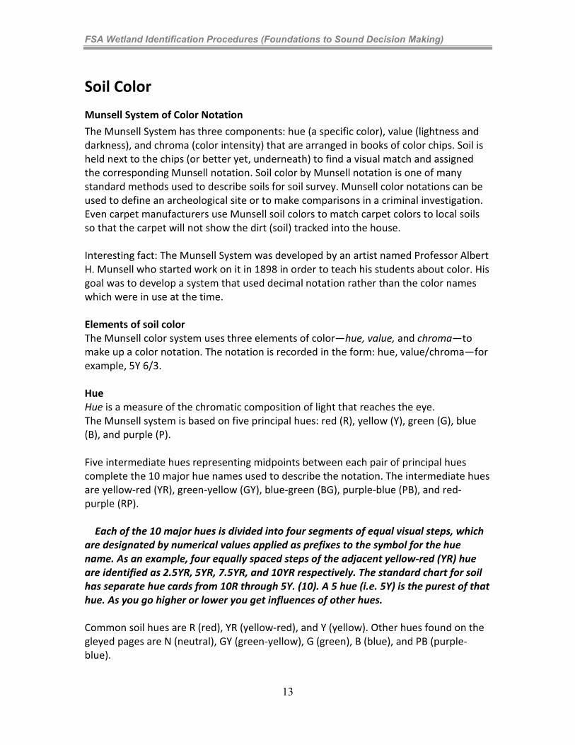
Munsell System of Color Notation
The Munsell System has three components: hue (a specific color), value (lightness and darkness), and chroma (color intensity) that are arranged in books of color chips. Soil is held next to the chips (or better yet, underneath) to find a visual match and assigned the corresponding Munsell notation. Soil color by Munsell notation is one of many standard methods used to describe soils for soil survey. Munsell color notations can be used to define an archeological site or to make comparisons in a criminal investigation. Even carpet manufacturers use Munsell soil colors to match carpet colors to local soils so that the carpet will not show the dirt (soil) tracked into the house. Interesting fact: The Munsell System was developed by an artist named Professor Albert H. Munsell who started work on it in 1898 in order to teach his students about color. His goal was to develop a system that used decimal notation rather than the color names which were in use at the time. Elements of soil color The Munsell color system uses three elements of color—hue, value, and chroma—to make up a color notation. The notation is recorded in the form: hue, value/chroma—for example, 5Y 6/3. Hue Hue is a measure of the chromatic composition of light that reaches the eye. The Munsell system is based on five principal hues: red (R), yellow (Y), green (G), blue (B), and purple (P). Five intermediate hues representing midpoints between each pair of principal hues complete the 10 major hue names used to describe the notation. The intermediate hues are yellow-red (YR), green-yellow (GY), blue-green (BG), purple-blue (PB), and red-purple (RP). Each of the 10 major hues is divided into four segments of equal visual steps, which are designated by numerical values applied as prefixes to the symbol for the hue name. As an example, four equally spaced steps of the adjacent yellow-red (YR) hue are identified as 2.5YR, 5YR, 7.5YR, and 10YR respectively. The standard chart for soil has separate hue cards from 10R through 5Y. (10). A 5 hue (i.e. 5Y) is the purest of that hue. As you go higher or lower you get influences of other hues. Common soil hues are R (red), YR (yellow-red), and Y (yellow). Other hues found on the gleyed pages are N (neutral), GY (green-yellow), G (green), B (blue), and PB (purple-blue).
13
FSA Wetland Identification Procedures (Foundations to Sound Decision Making)
Value Value indicates the degree of lightness or darkness of a color in relation to a neutral gray scale. On a neutral gray (achromatic) scale, value extends from pure black (0/) to pure white (10/). The value notation is a measure of the amount of light that reaches the eye under standard lighting conditions. Gray is perceived as about halfway between black and white and has a value notation of 5/. The neutral grays are located along a linear line between the black and white colors. Chroma Chroma is the relative purity or strength of the spectral color. The scales of chroma for soils extend from /0 for neutral colors to a chroma of /8 as the strongest expression of color used for soils. Chroma represents the strength or purity of a color. They become weaker to the left side of a color page and more vivid to the right.
14
FSA Wetland Identification Procedures (Foundations to Sound Decision Making)
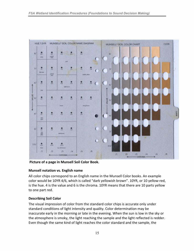
Picture of a page in Munsell Soil Color Book.
Munsell notation vs. English name
All color chips correspond to an English name in the Munsell Color books. An example color would be 10YR 4/6, which is called “dark yellowish brown”. 10YR, or 10 yellow-red, is the hue. 4 is the value and 6 is the chroma. 10YR means that there are 10 parts yellow to one part red.
Describing Soil Color
The visual impression of color from the standard color chips is accurate only under standard conditions of light intensity and quality. Color determination may be inaccurate early in the morning or late in the evening. When the sun is low in the sky or the atmosphere is smoky, the light reaching the sample and the light reflected is redder. Even though the same kind of light reaches the color standard and the sample, the
15
FSA Wetland Identification Procedures (Foundations to Sound Decision Making)
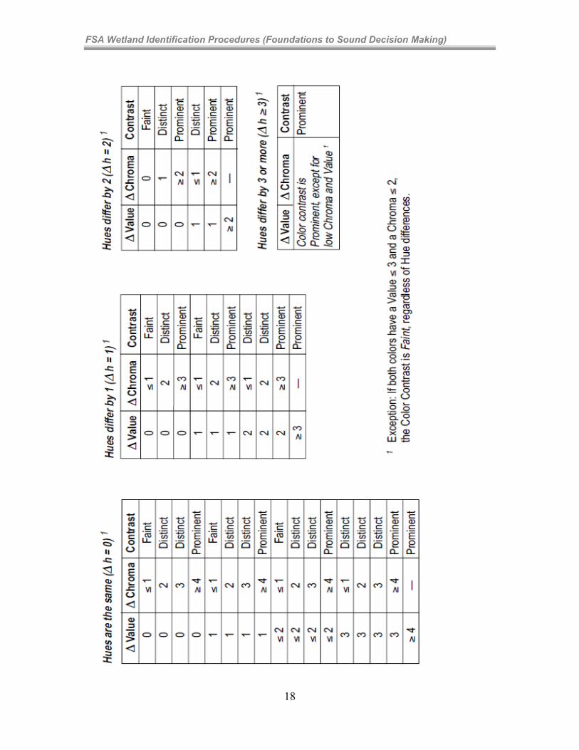
reading of sample color at these times is commonly one or more intervals of hue redder than at midday. Colors also appear different in the subdued light of a cloudy day than in bright sunlight. The intensity of incidental light is especially critical when matching soil to chips of low chroma and low value. Dominant Color The dominant color (matrix color) is the color that occupies the greatest volume of the layer. Dominant color (or colors) is always given first among those of a multicolored layer,. It is judged on the basis of colors of a broken sample. Mottling versus Redoximorphic Features Redoximorphic Features are discussed further in Learning Concept 4-3. Mottling refers to repetitive color changes that cannot be associated with compositional properties of the soil. Redoximorphic features such as redox concentrations or redox depletions, are not officially mottles. Redoximorphic features are a type of mottling that is associated with wetness. A color pattern that can be related to proximity to a ped surface (if you do not understand the concept of a soil ped, you will want to pause and conduct a short internet search or ask an experienced conservationist) or other organizational or compositional feature is not mottling. Percentages When documenting the percentage of the ped face represented by different colors, be aware of the requirements of the hydric soil indicator that you are citing. Some of these require a minimum percentage in the matrix and/or redox concentrations. One example would be A11, which requires a matrix color (primary soil color) that has 60% or more of the layer with a chroma of 2 or less starting within 30 cm of the soil surface. Another would be F6, which requires 2% or more distinct or prominent redox concentrations (F6a), or 5% or more distinct or prominent redox concentrations (F6b). Contrast refers to the degree of visual distinction that is evident between associated colors. This is not required on the Regional Data Forms, but it is an important consideration when using the Field Indicators of Hydric Soils. All redox concentrations are required to be either “distinct” or “prominent”. Faint (does not “count” for indicators of hydric soil): Evident only on close examination. Faint color changes commonly have the same hue as the color to which they are compared and differ by no more than 1 unit of chroma or 2 units of value.
16
FSA Wetland Identification Procedures (Foundations to Sound Decision Making)
Some faint color changes of similar but low chroma and value differ by 2.5 units (one card) of hue. Distinct: Readily seen but contrast only moderately with the color to which they are compared. Distinct mottles commonly have the same hue as the color to which they are compared but differ by 2 to 4 units of chroma or 3 to 4 units of value; or differ from the color to which they are compared by 2.5 units (one card) of hue but by no more than 1 unit of chroma or 2 units of value. Prominent: Contrast strongly with the color to which they are compared. Prominent mottles are commonly the most obvious color feature of the section described. Prominent mottles that have medium chroma and value commonly differ from the color to which they are compared by at least 5 units (two pages) of hue if chroma and value are the same; at least 4 units of value or chroma if the hue is the same; or at least 1 unit of chroma or 2 units of value if hue differs by 2.5 units (one card). Contrast is often not a simple comparison of one color with another but is a visual impression of the prominence of one color against a background commonly involving several colors. Tabular list for determination of color contrast:
17
FSA Wetland Identification Procedures (Foundations to Sound Decision Making)
18
FSA Wetland Identification Procedures (Foundations to Sound Decision Making)
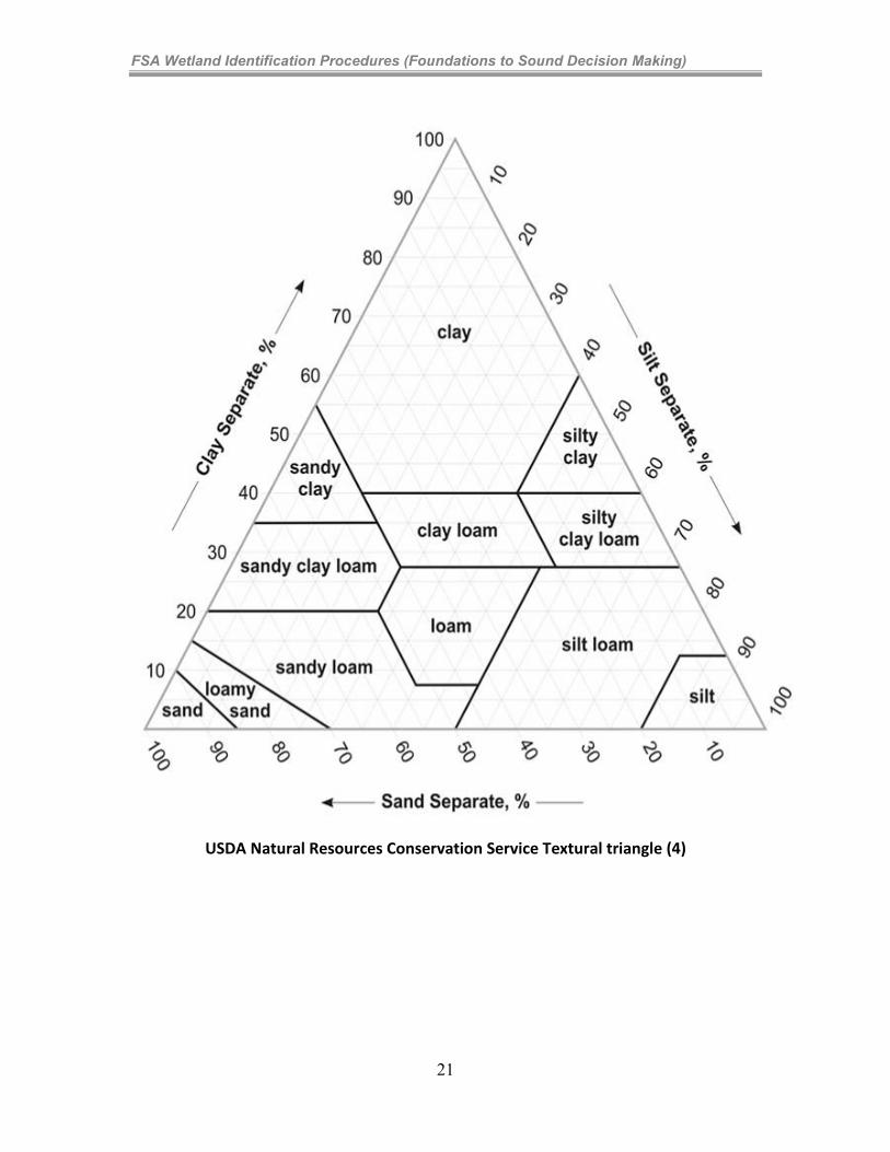
Type and Location Considerations on the Corps Regional Supplement Data Forms When noting “Type” there are four categories, which are defined below: C=Concentration: Bodies of apparent accumulation of Fe-Mn oxides D=Depletion: Bodies of low chroma (less than or equal to) having values of 4 or more where Fe-Mn oxides alone have been stripped out or where both Fe-Mn oxides and clay have been stripped out. RM=Reduced Matrix: Soil matrices that have a low chroma color in situ because of the presence of Fe (II), but whose color changes in hue or chroma when exposed to air as the Fe (II) is oxidized to Fe (III). The change in color occurs within 30 minutes or less after the sample is exposed to air. CS=Covered or Coated Sand Grains: This applies to particles masked with organic coats or oxides. When noting “Location” there are two categories, which are defined below: PL=Pore Lining: Zones of accumulation that may be either coatings on a ped or pore surface or impregnations of the matrix adjacent to the pore or ped. M=Matrix: The dominant soil volume that is continuous in appearance and envelops microsites. When three colors occur, such as when a matrix, depletions, and concentrations are present, the matrix may represent less than 50 percent of the total soil volume. Soil Texture for Identifying Field Indicators of Hydric Soils of Hydric Soils When using soil texture in describing hydric soils, you will need to keep a few things in mind when using “Field Indicators of Hydric Soils of Hydric Soils in the United States”, in that there are three categories: All Soils, Sandy Soils, and Loamy and Clayey Soils. “All soils” refers to soils with any USDA soil texture (e.g. sands, loams, clays, mucks). Examples include A1, Histosol; A4, Hydrogen Sulfide; & A12 Thick Dark Surface, among others. Sandy soils have a USDA texture of loamy fine sand and coarser (sandier). Examples include S1, Sandy Mucky Mineral; S6, Stripped Matrix; and S10, Alaska Gleyed, among others. Those not experienced with soil textures, these include very sandy soils, similar to beach sands or sand-box sand. The loamy and clayey soils category has USDA textures of loamy very fine sand and finer (more clay). (8) Examples include F1, Loamy mucky mineral; F6, Redox Dark Surface; and F9, Vernal Pools, among others. Again (for the non-soil scientist) there is a major difference between “loamy very fine sands” and “very fine sandy loams”. Fine sandy
19
FSA Wetland Identification Procedures (Foundations to Sound Decision Making)
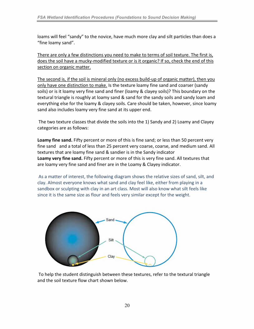
loams will feel “sandy” to the novice, have much more clay and silt particles than does a “fine loamy sand”. There are only a few distinctions you need to make to terms of soil texture. The first is, does the soil have a mucky-modified texture or is it organic? If so, check the end of this section on organic matter. The second is, if the soil is mineral only (no excess build-up of organic matter), then you only have one distinction to make. Is the texture loamy fine sand and coarser (sandy soils) or is it loamy very fine sand and finer (loamy & clayey soils)? This boundary on the textural triangle is roughly at loamy sand & sand for the sandy soils and sandy loam and everything else for the loamy & clayey soils. Care should be taken, however, since loamy sand also includes loamy very fine sand at its upper end. The two texture classes that divide the soils into the 1) Sandy and 2) Loamy and Clayey categories are as follows: Loamy fine sand. Fifty percent or more of this is fine sand; or less than 50 percent very fine sand and a total of less than 25 percent very coarse, coarse, and medium sand. All textures that are loamy fine sand & sandier is in the Sandy indicator Loamy very fine sand. Fifty percent or more of this is very fine sand. All textures that are loamy very fine sand and finer are in the Loamy & Clayey indicator. As a matter of interest, the following diagram shows the relative sizes of sand, silt, and clay. Almost everyone knows what sand and clay feel like, either from playing in a sandbox or sculpting with clay in an art class. Most will also know what silt feels like since it is the same size as flour and feels very similar except for the weight.
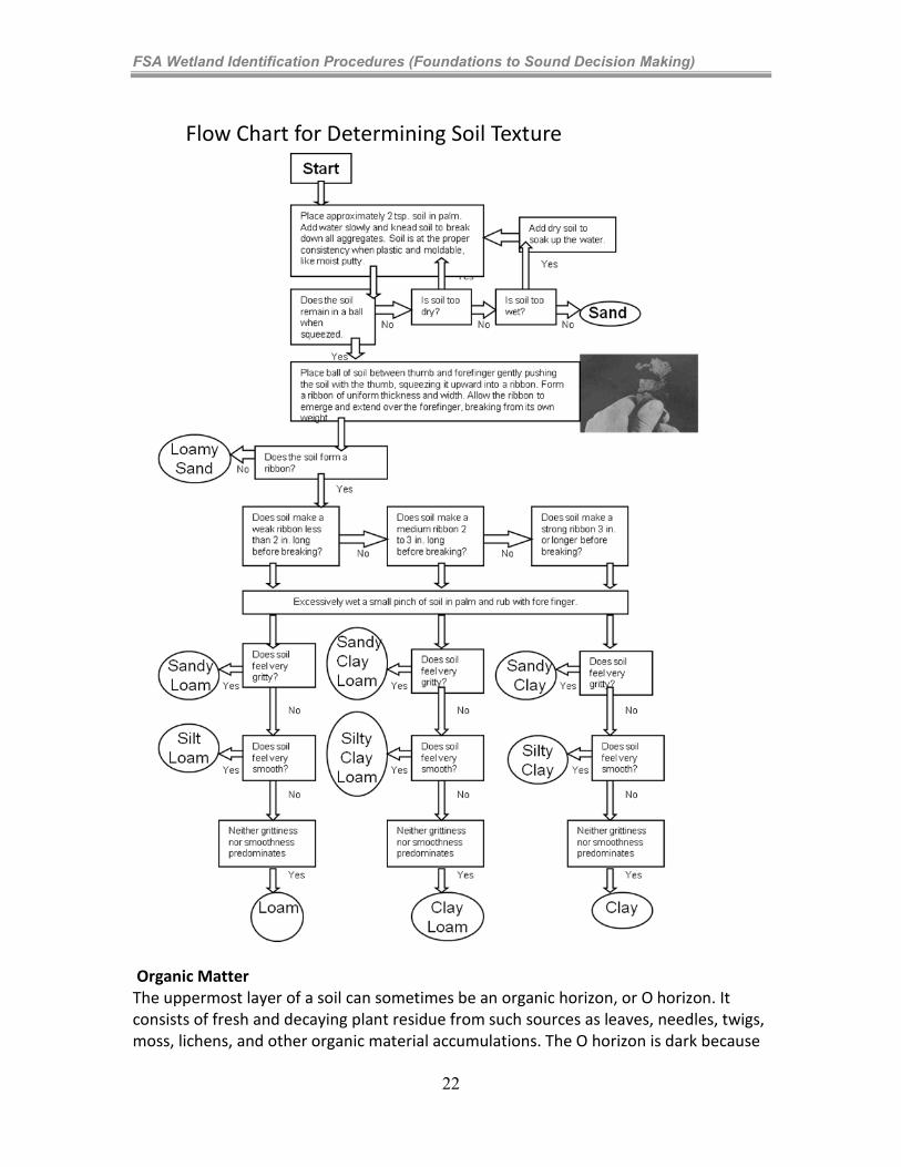
To help the student distinguish between these textures, refer to the textural triangle and the soil texture flow chart shown below.
20
FSA Wetland Identification Procedures (Foundations to Sound Decision Making)
USDA Natural Resources Conservation Service Textural triangle (4)
21
FSA Wetland Identification Procedures (Foundations to Sound Decision Making)
Flow Chart for Determining Soil Texture
Organic Matter The uppermost layer of a soil can sometimes be an organic horizon, or O horizon. It consists of fresh and decaying plant residue from such sources as leaves, needles, twigs, moss, lichens, and other organic material accumulations. The O horizon is dark because
22
FSA Wetland Identification Procedures (Foundations to Sound Decision Making)
decomposition is producing humus. Some soil organic materials were deposited under water. The subdivisions Oa, Oe, and Oi are used to identify levels of decomposition. Oa indicates highly decomposed organic material, Oe is intermediate and Oi is slightly decomposed. Organic matter accumulation Soil microbes use carbon compounds found in organic matter as an energy source. However, the rate at which organic carbon is utilized by soil microbes is considerably lower in a saturated and anaerobic environment than it is under aerobic conditions. Therefore, in saturated soils, partially decomposed organic matter may accumulate. The result in wetlands is often the development of thick organic surfaces, such as peat or muck, or dark organic-rich mineral surface layers. These accumulations are much more common in cold climates (slower activity by microbes and shorter warm season where they are active) than in cold climates. Thus, for two sites with similar wetness (duration), a soil in cold climates will accumulate more organic matter than warm and hot climates.
Organic Soil Material
Organic soil material is saturated with water for long periods or is artificially drained and, excluding live roots, has an organic carbon content of: 18 percent or more with 60 percent or more clay, or 12 percent or more organic carbon with 0 percent clay. Soils with an intermediate amount of clay have an intermediate amount of organic carbon.
Types of Organic Soil Material (See Table 4)
• Muck – Highly decomposed
• Peat – Very little decomposition
• Mucky peat – Intermediate decomposition Mucky Modified Mineral An example of a USDA soil texture modifier would be mucky sand. Mucky modified mineral soil with 0 percent clay has between 5 and 12 percent organic carbon. Mucky modified mineral soil with 60 percent clay has between 11 and 18 percent organic carbon. Soils with an intermediate amount of clay have intermediate amounts of organic carbon. The Hydric Soil Indicators in this category are: A7, 5 cm Mucky Mineral; S1, Sandy Mucky Mineral; and F1, Loamy Mucky Mineral. Methods for determining the texture of soil that is high in organic carbon. Material high in organic carbon could fall into three categories: 1) organic, 2) mucky mineral, or 3) mineral. In lieu of laboratory data, the following estimation method can be used for soil material that is wet or nearly saturated with water. This method may be inconclusive with loamy or clayey textured mineral soils. Gently rub the wet soil material between forefinger and thumb. If upon the first or second rub the material feels gritty, it
23
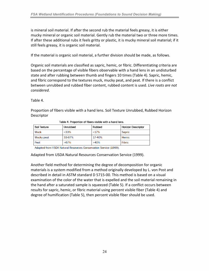
FSA Wetland Identification Procedures (Foundations to Sound Decision Making)
is mineral soil material. If after the second rub the material feels greasy, it is either mucky mineral or organic soil material. Gently rub the material two or three more times. If after these additional rubs it feels gritty or plastic, it is mucky mineral soil material; if it still feels greasy, it is organic soil material. If the material is organic soil material, a further division should be made, as follows. Organic soil materials are classified as sapric, hemic, or fibric. Differentiating criteria are based on the percentage of visible fibers observable with a hand lens in an undisturbed state and after rubbing between thumb and fingers 10 times (Table 4). Sapric, hemic, and fibric correspond to the textures muck, mucky peat, and peat. If there is a conflict between unrubbed and rubbed fiber content, rubbed content is used. Live roots are not considered. Table 4. Proportion of fibers visible with a hand lens. Soil Texture Unrubbed, Rubbed Horizon Descriptor
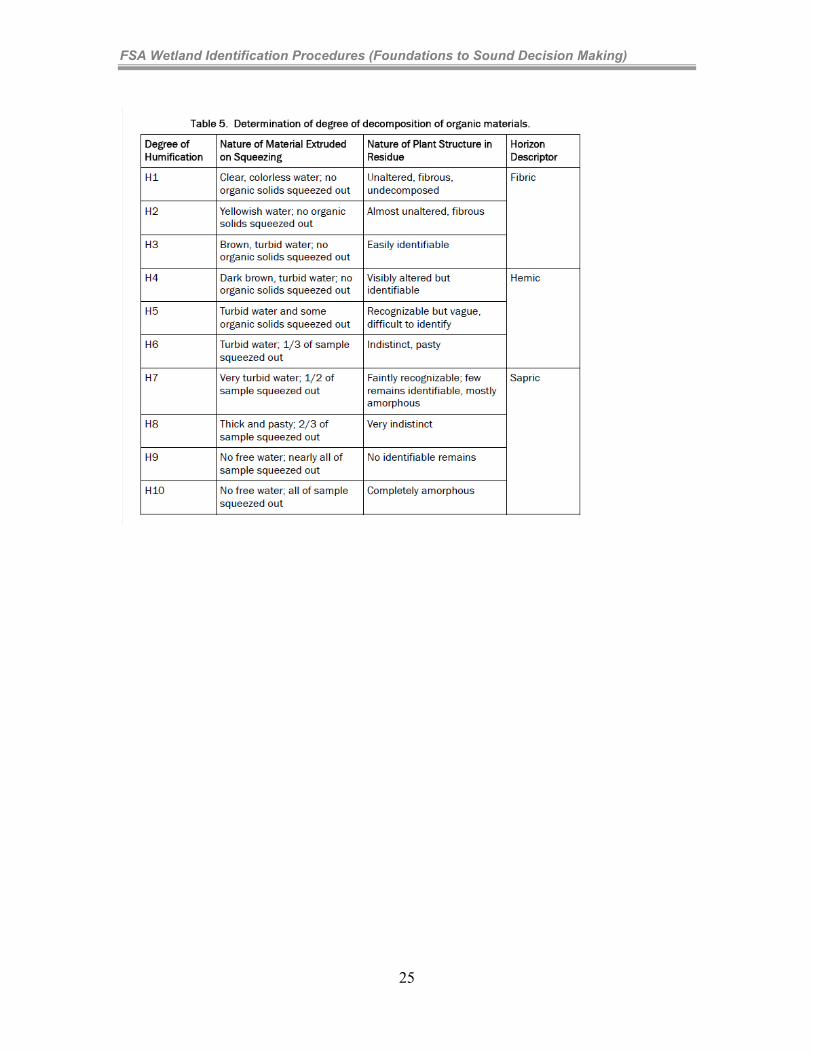
Adapted from USDA Natural Resources Conservation Service (1999). Another field method for determining the degree of decomposition for organic materials is a system modified from a method originally developed by L. von Post and described in detail in ASTM standard D 5715-00. This method is based on a visual examination of the color of the water that is expelled and the soil material remaining in the hand after a saturated sample is squeezed (Table 5). If a conflict occurs between results for sapric, hemic, or fibric material using percent visible fiber (Table 4) and degree of humification (Table 5), then percent visible fiber should be used.
24
FSA Wetland Identification Procedures (Foundations to Sound Decision Making)
25
FSA Wetland Identification Procedures (Foundations to Sound Decision Making)
Learning Concept 4-2: Scientific Foundations and Principles to Hydric Soils Soil Saturation A soil horizon is considered saturated when the soil water pressure is zero or positive (at or above atmospheric pressure). At these pressures, water will flow from the soil matrix into unlined auger holes. Three types or patterns of saturation were defined:
1. Endosaturation-permanent water table to within 2m (6 ft.). Soil is saturated in all horizons that lie between the water table and a depth of 2 meters. Endosaturation’s primary water source is from below (bottom up pressure)
2. Episaturation-perched water table. (Episaturation is saturation from above (top down pressure). Soil is saturated in a horizon that overlies an unsaturated horizon, where the unsaturated horizon lies within a depth of 2 meters from the surface.
3. Anthric saturation-paddy soil with created perched water table. Like episaturation but must occur under controlled flooding/irrigation (e.g. rice fields, cranberries, high-meadow hayfields in the west)
It should be noted that the term “water table” is not used in the definition of saturation. Also, horizons within the capillary fringe are technically not considered saturated since this contains soil water that has pressures less than atmospheric pressure. Under ideal circumstances, horizons that are saturated by the above criteria will have all their soil pores filled with water. However, for a horizon to be considered saturated it is not necessary that all pores be filled with water. Horizons that have soil water pressures of zero or positive are considered saturated even if they contain entrapped air in some pores. Saturation can occur at any time during the year.
Important Hydric Soil Characteristics
Concepts Hydric soil indicators are formed predominantly by the accumulation or loss of iron, manganese, sulfur, or carbon compounds in a saturated and anaerobic environment. Iron and Manganese Reduction, Translocation, and Accumulation. Both oxidized iron and manganese can be chemically reduced under certain soil conditions. Reduction occurs when each ion (for example, Fe (III) or MN (III or IV) accepts electrons from another source such as organic matter. Reduced Fe (or ferrous
26
FSA Wetland Identification Procedures (Foundations to Sound Decision Making)
Fe) is indicated by Fe (II), and reduced Mn (or manganous Mn) by Mn (II). When these elements are reduced in a soil, several things happen: (1) Fe and Mn oxide minerals begin to dissolve in water; (2) the soil colors change to gray; and (3) the reduced Fe (II) and Mn (II) ions diffuse through or move with the soil water to other parts of the soil horizon or may be leached from the soil. When Fe and Mn are in their reduced form, they have much less coloring effect on soil than when they occur in their oxide forms. Of the two, evidence of iron reduction is more commonly observed in soils. Sulfate reduction Sulfur is one of the last elements to be reduced by microbes in an anaerobic environment. The microbes convert sulfate to hydrogen sulfide gas. This results in a very pronounced “rotten egg” odor in some soils that are inundated or saturated for very long periods. In unsaturated or non-inundated soils, sulfate is not reduced and there is no rotten egg odor. The presence of hydrogen sulfide is a strong indicator of a hydric soil, but this indicator is found only in the wettest sites in soils that contain sulfur-bearing compounds. It can sometimes be sensed by simply walking across these areas. This is indicator A4, Hydrogen Sulfide. Organic matter accumulation Soil microbes use carbon compounds found in organic matter as an energy source. However, the rate at which organic carbon is utilized by soil microbes is considerably lower in a saturated and anaerobic environment than under aerobic conditions. Therefore, in saturated soils, partially decomposed organic matter may accumulate. The result in wetlands is often the development of thick organic surfaces, such as peat or muck, or dark organic-rich mineral surface layers.
27
FSA Wetland Identification Procedures (Foundations to Sound Decision Making)
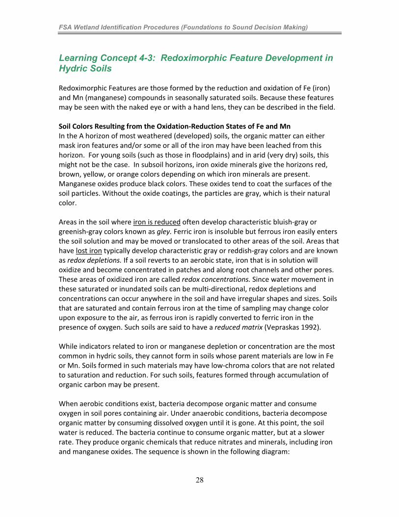
Learning Concept 4-3: Redoximorphic Feature Development in Hydric Soils Redoximorphic Features are those formed by the reduction and oxidation of Fe (iron) and Mn (manganese) compounds in seasonally saturated soils. Because these features may be seen with the naked eye or with a hand lens, they can be described in the field. Soil Colors Resulting from the Oxidation-Reduction States of Fe and Mn In the A horizon of most weathered (developed) soils, the organic matter can either mask iron features and/or some or all of the iron may have been leached from this horizon. For young soils (such as those in floodplains) and in arid (very dry) soils, this might not be the case. In subsoil horizons, iron oxide minerals give the horizons red, brown, yellow, or orange colors depending on which iron minerals are present. Manganese oxides produce black colors. These oxides tend to coat the surfaces of the soil particles. Without the oxide coatings, the particles are gray, which is their natural color. Areas in the soil where iron is reduced often develop characteristic bluish-gray or greenish-gray colors known as gley. Ferric iron is insoluble but ferrous iron easily enters the soil solution and may be moved or translocated to other areas of the soil. Areas that have lost iron typically develop characteristic gray or reddish-gray colors and are known as redox depletions. If a soil reverts to an aerobic state, iron that is in solution will oxidize and become concentrated in patches and along root channels and other pores. These areas of oxidized iron are called redox concentrations. Since water movement in these saturated or inundated soils can be multi-directional, redox depletions and concentrations can occur anywhere in the soil and have irregular shapes and sizes. Soils that are saturated and contain ferrous iron at the time of sampling may change color upon exposure to the air, as ferrous iron is rapidly converted to ferric iron in the presence of oxygen. Such soils are said to have a reduced matrix (Vepraskas 1992). While indicators related to iron or manganese depletion or concentration are the most common in hydric soils, they cannot form in soils whose parent materials are low in Fe or Mn. Soils formed in such materials may have low-chroma colors that are not related to saturation and reduction. For such soils, features formed through accumulation of organic carbon may be present. When aerobic conditions exist, bacteria decompose organic matter and consume oxygen in soil pores containing air. Under anaerobic conditions, bacteria decompose organic matter by consuming dissolved oxygen until it is gone. At this point, the soil water is reduced. The bacteria continue to consume organic matter, but at a slower rate. They produce organic chemicals that reduce nitrates and minerals, including iron and manganese oxides. The sequence is shown in the following diagram:
28
FSA Wetland Identification Procedures (Foundations to Sound Decision Making)
Reduction Sequence
+350 mV Oxygen O2 H2O
+220 mV Nitrogen NO3- N2O, NO2-
+200 mV Manganese Mn+4 Mn+2
+120 mV Iron Fe+3 Fe+2
-150 mV Sulfur SO4-2
H2S
-250 mV Carbon CO2 CH4
In terms of location, reducing conditions will occur near the root channels if the soluble carbon source required by the bacteria comes from dead roots. If the organic compounds are dissolved and dispersed in the soil water, then reduction can occur at any place in a soil horizon where the pores are filled with water. Formation of iron depletions and clay depletions Formation is similar for iron and clay depletions, and both may occur within the same or adjacent horizons. It is easiest to visualize these features forming around roots that grow along stable macropores. These are required so that features continue to enlarge as succeeding roots grow and die along the same macropore. Roots growing along a structural crack or channel provide an energy source, which is organic matter, needed by the microbes for iron reduction. When the root dies and the macropore is filled with water, the bacteria will consume the root tissue and utilize (reduce) oxygen in the water if soil temperatures are high enough for the bacteria to be active (generally >5 degrees Centigrade or 41 degrees Fahrenheit). The newly formed bleached layer where Fe and Mn have been removed along the channels is a redox depletion, specifically an iron depletion due to its lower content of Fe and Mn. It must have a color chroma of less than or equal to 2 in order in order to be considered a redoximorphic feature. Formation of Redox Features Pore linings occur along ped surfaces as well as root channels. They are also found on the roots of living plants that can transport oxygen to their roots in saturated soils (oxidized rhizospheres). These form by diffusion of reduced Fe and Mn ions toward
29
FSA Wetland Identification Procedures (Foundations to Sound Decision Making)
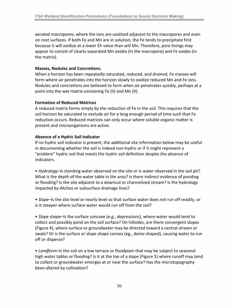
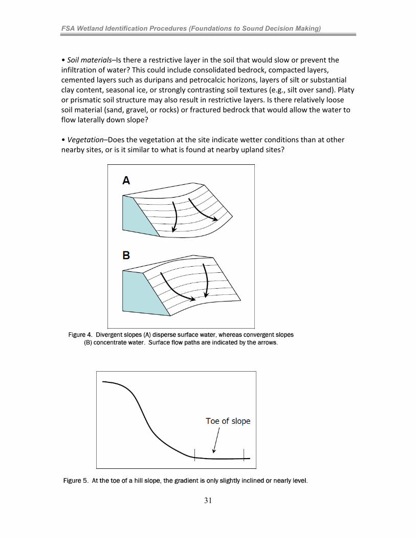
aerated macropores, where the ions are oxidized adjacent to the macropores and even on root surfaces. If both Fe and Mn are in solution, the Fe tends to precipitate first because it will oxidize at a lower Eh value than will Mn. Therefore, pore linings may appear to consist of clearly separated Mn oxides (in the macropore) and Fe oxides (in the matrix). Masses, Nodules and Concretions. When a horizon has been repeatedly saturated, reduced, and drained, Fe masses will form where air penetrates into the horizon slowly to oxidize reduced Mn and Fe ions. Nodules and concretions are believed to form when air penetrates quickly, perhaps at a point into the wet matrix containing Fe (II) and Mn (II). Formation of Reduced Matrices A reduced matrix forms simply by the reduction of Fe in the soil. This requires that the soil horizon be saturated to exclude air for a long enough period of time such that Fe reduction occurs. Reduced matrices can only occur where soluble organic matter is present and microorganisms are active. Absence of a Hydric Soil Indicator If no hydric soil indicator is present, the additional site information below may be useful in documenting whether the soil is indeed non-hydric or if it might represent a “problem” hydric soil that meets the hydric soil definition despite the absence of indicators. • Hydrology–Is standing water observed on the site or is water observed in the soil pit? What is the depth of the water table in the area? Is there indirect evidence of ponding or flooding? Is the site adjacent to a downcut or channelized stream? Is the hydrology impacted by ditches or subsurface drainage lines? • Slope–Is the site level or nearly level so that surface water does not run off readily, or is it steeper where surface water would run off from the soil? • Slope shape–Is the surface concave (e.g., depressions), where water would tend to collect and possibly pond on the soil surface? On hillsides, are there convergent slopes (Figure 4), where surface or groundwater may be directed toward a central stream or swale? Or is the surface or slope shape convex (eg., dome shaped), causing water to run off or disperse? • Landform–Is the soil on a low terrace or floodplain that may be subject to seasonal high water tables or flooding? Is it at the toe of a slope (Figure 5) where runoff may tend to collect or groundwater emerges at or near the surface? Has the microtopography been altered by cultivation?
30
FSA Wetland Identification Procedures (Foundations to Sound Decision Making)
• Soil materials–Is there a restrictive layer in the soil that would slow or prevent the infiltration of water? This could include consolidated bedrock, compacted layers, cemented layers such as duripans and petrocalcic horizons, layers of silt or substantial clay content, seasonal ice, or strongly contrasting soil textures (e.g., silt over sand). Platy or prismatic soil structure may also result in restrictive layers. Is there relatively loose soil material (sand, gravel, or rocks) or fractured bedrock that would allow the water to flow laterally down slope? • Vegetation–Does the vegetation at the site indicate wetter conditions than at other nearby sites, or is it similar to what is found at nearby upland sites?
31
FSA Wetland Identification Procedures (Foundations to Sound Decision Making)
Resources: Hydric Soil Terminology National Technical Committee for Hydric Soils (NTCHS) –This committee is chaired by NRCS and has representation from all federal agencies involved in wetlands work as well as University experts in hydric soils related issues. The NTCHS makes all decisions on issues related to hydric soils. Hydric Soils Lists-A list of hydric soils series listed by map unit that are hydric soils. This is a database generated list. Field Indicators of Hydric Soils in the United States (Field Indicators of Hydric Soils)-A list of morphological indicators that can be used to identify the hydric soils component of a wetland or map unit. All indicators are approved for use by the NTCHS. Hydric Soil Technical Standard-The standard required to collect long term data to establish new hydric soil Field Indicators of Hydric Soils or to identify a functional hydric soil in the absence of indicators. The requirements include: Water table measurements Redox potential measurements Reduced Iron (Fe II) measurements In-situ pH measurements On-site precipitation data Replicates
Use of Soil Surveys and Hydric Soil List Soil surveys are available for most areas and can provide useful information regarding soil properties and soil moisture conditions. A list of available soil surveys is located at http://soils.usda.gov/survey/online_surveys/. Soil maps and data are available online at http://websoilsurvey.nrcs.usda.gov/. Soil survey maps divide the landscape into areas called map units. Map units usually contain more than one soil type or component. They often contain several minor components or inclusions of soils with properties that may be similar to or quite different from the major component. Those soils that are hydric are noted in the Hydric Soils List. Hydric Soils Lists are developed for each detailed soil survey. Using criteria approved by the NTCHS, these lists rate each soil component as either hydric or non-hydric based on soil property data. If the soil is rated as hydric, information is provided regarding whether the soil meets the definition due to saturation, flooding, or ponding; and on what landform the soil typically occurs. Hydric Soils Lists are useful to identify areas likely to contain hydric soils. However, not all areas within a mapping unit or polygon identified as having hydric soils may be hydric. Conversely, inclusions of hydric soils may
32
FSA Wetland Identification Procedures (Foundations to Sound Decision Making)
be found within soil mapping units where no hydric soils have been identified. For FSA purposes, the Hydric Soils List can be used to indicate that hydric soils will likely be found within a given area, but when separation of hydric and non-hydric components of the map unit cannot be made remotely, an on-site investigation may be needed to make that separation. Soil survey information can be valuable during Preliminary Data Gathering and Synthesis (Section B of the Corps Methods) and can assist in the determination of the Level of the determination (Level 1, 2, or 3). Soil surveys and hydric soils lists can serve as an indicator for a determination of hydric soils when the agency expert decides to make an off-site determination for hydric soils (Level 1 or Level 3). In cases where Hydric Soil Lists are used off-site as a hydric soil “indicator”, it may be beneficial to contact the local Resource Soil Scientist for an opinion on the reliability of the map unit. Landscape relationships and other information that can help identify the component of the map unit that is hydric vs. non-hydric is also helpful. Evidence of presence of the other two parameters can also bolster the reliability of the use of Hydric Soils Lists as an “indicator” of the presence of hydric soils. Local Hydric Soils Lists are available from state or county NRCS offices and over the internet from the Field Office Technical Guide, Section 2, http://www.nrcs.usda.gov/technical/efotg/index.html or Soil Data Mart (http://soildatamart.nrcs.usda.gov/). Local Hydric Soils Lists have been compiled into a National Hydric Soils List and are available at:http://soils.usda.gov/use/hydric/. Take a moment to explore the following sources of hydric soils information derived from the soil survey for your selected site location:
1. Go to the NTCHS website (http://soils.usda.gov/use/hydric/) and look up the national Hydric Soil List and find the soil survey area your site is located in.
a. Note the soil survey area is located in column B. b. Column D contains the map unit symbol as it is mapped in the official soil
survey. c. Column E contains the map unit name as it is named in the official soil
survey. d. Column F contains the component name(s) that are hydric soil
components of that map unit. Note that some components are major components that are named in the map unit name and others are minor components (inclusions) within the map unit.
e. Column G contains the percentage of that map unit that contains a hydric soil component.
f. Column H contains the landform in which you will find the hydric component.
33
FSA Wetland Identification Procedures (Foundations to Sound Decision Making)
g. Column I tells you the criteria that was used to establish this component as hydric. A 1 indicates that the soi is a wet histisol or histel; a 2B1, 2B2 or 2B3 indicates the soil is hydric due to saturation; a 3 indicates the soil is hydric due to ponding; and a 4 indicates that the soil is hydric due to flooding.
2. Now go to the Soil Data Mart (http://soildatamart.nrcs.usda.gov/) and look up the local Hydric Soil List for your survey area.
a. Click on “select state” and select the state you are in. b. Click on “select survey area” and select the one you are interested in. c. Click on “generate reports” and click on “select all” to select all the map
units in the survey area. This should highlight all the map units. You can also select individual map units if you do not want a list of the whole county.
d. From the pull down menu of reports select “hydric soils” and click on “generate report”.
e. It will take a moment for the hydric soil report to come up. f. This report gives you the same information that is presented in the
national Hydric Soil List, however, this report is updated any time information is updated in Soil Data Mart while the national Hydric Soil List is only updated about once a year. There may be differences if an update to Soil Data Mart was made after the national List was generated. Soil Data Mart should be your source for official (and current) soil survey information.
3. Now go to Web Soil Survey (http://websoilsurvey.nrcs.usda.gov/) a. Click on “start WSS”. b. Locate your area of interest. You can do this by: clicking on state and
county and then zooming in, soil survey area and zooming in, typing in an address, using latitude and longitude, or any of the other methods listed.
c. Once zoomed in, click on either the area of interest rectangle icon or the area of interested icon that allows an irregular shape. These icons are located in the upper left of the map screen.
d. Outline the area of interest on the map and then click on the “Soil Data Explorer” tab. You should now see a soils map overlaying your area of interest.
e. Under the tab “suitability and limitations for use” click on “Land Classification”, then “Hydric Rating by Map Unit”, then view rating.
f. This will produce a map that shows map units that are hydric, partially hydric (contain components that are both hydric and non-hydric), or not hydric.
g. Click on “add to shopping cart” in the upper right and then ok. h. Click on the “shopping cart” tab at the top, and then “check out” in the
upper right and then ok.
34
FSA Wetland Identification Procedures (Foundations to Sound Decision Making)
i. Now you have a customized .pdf soil survey report for your area of interest that contains the Hydric Soils List information from Soil Data Mart along with a map categorizing those map units that are hydric, partially hydric, or non-hydric. You can save this to your computer and/or print the file for use when you do your on-site investigation exercise a little later.
Field Indicators of Hydric Soils in the United States Download and print out a copy of the most recent version of Field Indicators of Hydric Soils in the United States from the NTCHS website at http://soils.usda.gov/use/hydric/ and a copy of chapter 3 of the Corps Delineation Manual Regional Supplement for your area at http://www.usace.army.mil/CECW/Pages/reg_supp.aspx for reference. The publication Field Indicators of Hydric Soils in the United States is a comprehensive list of all the Field Indicators of Hydric Soils approved for use by the NTCHS. All Field Indicators of Hydric Soils listed in the Corps Regional Supplements are a subset of the NTCHS national list of indicators. Field Indicators of Hydric Soils are soil morphological features used to identify hydric soils. The features result from soil genesis in the presence of “anaerobic conditions”.They are used for on-site verification of the presence of a hydric soil. Processes involved in the genesis of the morphological features used as indicators are the result of reduction, translocation, and precipitation of iron and manganese; accumulation and differential translocation of organic matter; and reduction of sulfur. Development of the Field Indicators of Hydric Soils is an on-going process started in the mid-80’s and has involved inter-agency participation as well as inter-disciplinary participation (soil scientists, botanists, hydrologists, ecologists, etc.). As stated earlier and will be repeated many times, the requirements of a hydric soil are those stated in the definition. Field Indicators of Hydric Soils are created to assist in identifying those soils that meet the definition. However, the Field Indicators of Hydric Soils do not replace or relieve any of those requirements. If it meets a Field Indicator it has morphology that indicates that the soil meets the hydric soils definition and therefore is a hydric soil. However, if it does not meet a Field Indicator it may still be a hydric soil if it meets the requirements in the defintion. Hydric Soils Lists and the Hydric Soil Technical Standard are two approaches that may lead you to call a soil hydric by definition even though it does not meet a Field Indicator.
The descriptions of the Field Indicators of Hydric Soils are structured as follows:
1. Alpha-numeric listing (A, S, or F Indicators) 2. Short name 3. Applicable land resource regions (LRRs)
35
FSA Wetland Identification Procedures (Foundations to Sound Decision Making)
4. Description of the field indicator 5. User notes
For example, A2 is the second indicator in the “all soils” category; the short name is Histic Epipedon; the indicator is for use in all LRRs; the description is a histic epipedon underlain by mineral soil material with chroma of 2 or less. Helpful user notes are added. Definitions There are many important definitions that you need to understand in order to properly use the Field Indicators of Hydric Soils. The most important is the fact that the NTCHS uses a similar (none-the-less different) definition to what is provided to USDA from Congress in the FSA. Other definitions can be found in the glossary of the Field Indicators of Hydric Soils publication. Some of these definitions may be slightly different than the use of the same term for other purposes such as for use in soil taxonomy and soil survey. When a term that describes an indicator has a different definition than when it is used to describe something else, an asterisk (*) is placed next to the term in the Field Indicators of Hydric Soils glossary. Look up the following terms in the Field Indicators of Hydric Soils glossary and make sure you understand these terms before moving on to the exercise on using the Field Indicators of Hydric Soils.
Depleted matrix – This is an important concept used in many of the Field Indicators of Hydric Soils. Note that all depleted matrices must have values of 4 or more and chroma 2 or less, and depending on the value and chroma, may or may not need the presence of redox concentrations.
Gleyed matrix – The definition of a gleyed matrix for the purposes of the Field Indicators of Hydric Soils are different than the definition used in Soil Taxonomy. For the purposes of the Field Indicators of Hydric Soils, a gleyed matrix has colors found on the gleyed pages of the Munsell Soil Color Book and also must have a value of 4 or more.
Layer(s) – Note that a soil horizon and a layer for the purposes of the Field Indicators of Hydric Soils are not synonymous. You can have multiple “layers” in the same horizon or you can combine multiple horizons that meet all the requirements of a Field Indicator to meet the thickness requirement of a “layer”.
LRR and MLRA – You must know what LRR and in some cases what MLRA you are in to use the Field Indicators of Hydric Soils.
Organic soil material, peat, mucky peat, and peat – In order to use the Field Indicators of Hydric Soils you must be able to identify organic soil material vs. mineral soil material. Some Field Indicators of Hydric Soils also require the distinction between the grades of decomposition that determine whether you have muck, mucky peat, or peat.
36
FSA Wetland Identification Procedures (Foundations to Sound Decision Making)
Within – Note that when a Field Indicator states that a layer must start within a certain depth, if the layer starts at that depth it is considered to be within that depth.
Read the introductory material found in the Field Indicators of Hydric Soils publication and chapter 3 of your local Corps Regional Supplement. Some of the important concepts to make sure you understand are: The Field Indicators of Hydric Soils are proof positive. If it meets an Field
Indicator it is a hydric soil. If it does not meet an indicator it is still a hydric soil if it meets the definition.
You only need to meet the requirements in the indicator description. User notes are provided to assist in the interpretation of those requirements.
The Field Indicators of Hydric Soils were developed to locate the hydric soil boundary. Wetter soils may not meet Field Indicators of Hydric Soils.
Depths and thicknesses are critical in the upper 12 to 18 inches of the soil when using the Field Indicators of Hydric Soils. It is recommended that a spade, not an auger, be used to excavate the soil.
All soil (A) indicators can be used in any layer regardless of texture. Sandy soil (S) indicators can be used in layers that are loamy fine sand or coarser. Loamy and clayey (F) indicators can be used in layers that are loamy very fine
sand and finer. Layers are not synonymous with horizons. One horizon may consist of multiple
layers or one layer may include multiple horizons. If a soil meets all the requirements of multiple indicators except thickness, you
can combine indicators by adding up the thicknesses of each layer that meets the requirements. You can then say it is hydric if the thickness is thicker than the most stringent thickness requirement of the indicators it needs to meet (see an explanation of this in the introductory information of your regional supplement for a more thorough explanation).
Do not round chromas. If the chroma appears to be between color chips, indicate that by using a + or a decimal point. Some indicators require a chroma of x or less. Others require a chroma less than x. In the former if the color is in between the required chroma and a higher chroma it does not meet the requirement. In the latter if the color is in between the listed chroma and the next lower chroma it does meet the requirement.
In LRRs R, W, X, and Y, we begin our observations at the top of the mineral surface (underneath any and all fibric, hemic, and/or sapric material) except for application of indicators A1, A2, and A3, where we begin at the actual soil surface. In LRRs F, G, H, and M, we begin our observations at the actual soil surface if the soil is sandy and for the application of indicators A1, A2, and A3; and at the muck or mineral surface for the remaining Field Indicators of Hydric Soils. In the remaining LRRs, we begin our observations at the top of the muck or
37
FSA Wetland Identification Procedures (Foundations to Sound Decision Making)
mineral surface (underneath any fibric and/or hemic material) except for application of indicators A1, A2, and A3 (figure 2) where we begin at the actual soil surface.
Except for indicators S6, F8, F12, F19, and F20 (those indicators that do not require a chroma of 2 or less to meet the indicator), any soil material above the indicator must be a chroma of 2 or less or if the chroma is higher than 2 it must be less than 6 inches thick.
Both the definition of a depleted matrix and a gleyed matrix require values of 4 or more. This is to separate redox colors from organic matter accumulation colors. A, E and calcic horizons require at least 2 percent concentrations.
Remember to describe organic features such as type (peat, mucky peat, or peat), color, mucky modified mineral, and percent coatings on sand grains.
Why is this important to me? You cannot use the Field Indicators of Hydric Soils without knowledge of the general rules required for using them. There are situations where a soil may meet all the requirements of the Field Indicator, however, it is not a hydric soil based on that Field Indicator because it has failed one of the general rules. The most common example is a soil that meets all the requirements of F3, Depleted Matrix, but the layer that meets the requirements starts below 6 inches and the matrix chroma above the layer is a chroma higher than 2. While the soil does meet all the specific requirements of the Field Indicator, it fails the rule that any soil material above the indicator must have a matrix chroma of 2 or less or, if the matrix chroma is higher than 2 it must be less than 6 inches thick. The following is a key that was created to eliminate soils that will definitely not meet a Field Indicator. This key does not identify soils that are not hydric soils. What it does do is tell you when you can skip going through all the Field Indicators of Hydric Soils to try and make your decision. You may want to print this key out and take it to the field with you. After doing your complete soil description and if you can then answer no to all the questions asked, do not bother going through the Field Indicators of Hydric Soils because that soil will not meet one.
------------------------------------------------------------------------------------------------------- Key to Soils that Lack Field Indicators of Hydric Soils Dig a hole to 6 in.
Do organic soil materials or mucky modified layers exist? Do chromas ≤ 2 exist?
38

FSA Wetland Identification Procedures (Foundations to Sound Decision Making)
Are there any distinct or prominent redox concentrations as soft masses or pore linings?
Is there a hydrogen sulfide odor? Are you in a depression, on a floodplain, or within 200 meters of an
estuarine marsh and 1 meter of mean high water? If answer is no to all questions, the soil will not meet an indicator.
------------------------------------------------------------------------------------------------------------ Go through the Corps Regional Supplement for your area and identify those Field Indicators of Hydric Soils applicable in your LRR or MLRA. Eventually you may want to create a one page cheat sheet of the Field Indicators of Hydric Soils that only lists the indicator descriptions for those identified for use your region. However, when learning to use the Field Indicators of Hydric Soils it is helpful to have the user notes and glossary handy in case you need to refer to them when attempting to use a Field Indicator. When initially going through the Field Indicators of Hydric Soils you will find manyindicators that can be used in your region. While this can be intimidating, once you begin to use the Field Indicators of Hydric Soils, you will find that a small number of them are used for the majority of your hydric soil calls. The remainder are used in areas that are obviously wet and not near the hydric soil boundary. Others may fit areas or specific situations that did not have good Field Indicators of Hydric Soils in the past. For most of the country, the most commonly used Field Indicators of Hydric Soils, if applicable in your LRR, are A11, Depleted Below Dark Surface; F3, Depleted matrix; F6, Redox Dark Surface; S5, Sandy Redox; and S7, Dark Surface. However, you may want to contact your local Resource Soil Scientist to discuss which indicators are most common in your area. They may also be able to identify those situations where some of the less common indicators may be used. Examples Below are examples of data sheets that are completely filled out. Go through the latest version of Field Indicators of Hydric Soils and list all indicators that are met for each of the descriptions.
39
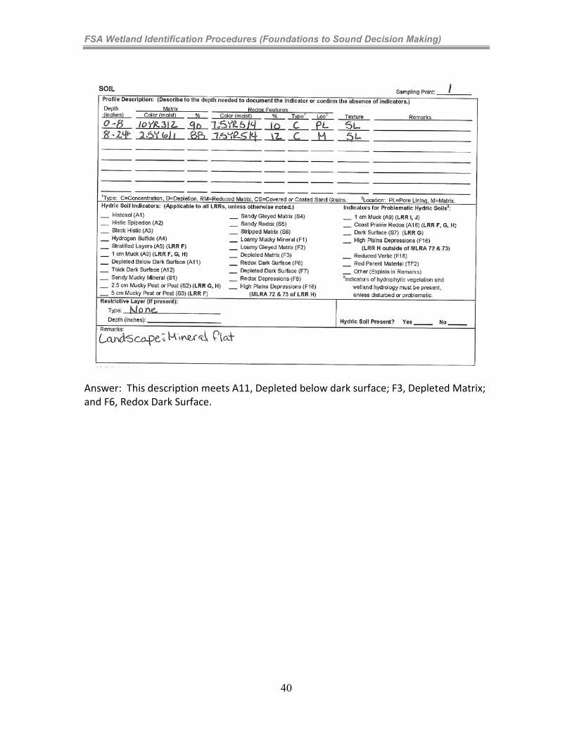
FSA Wetland Identification Procedures (Foundations to Sound Decision Making)
Answer: This description meets A11, Depleted below dark surface; F3, Depleted Matrix; and F6, Redox Dark Surface.
40
FSA Wetland Identification Procedures (Foundations to Sound Decision Making)
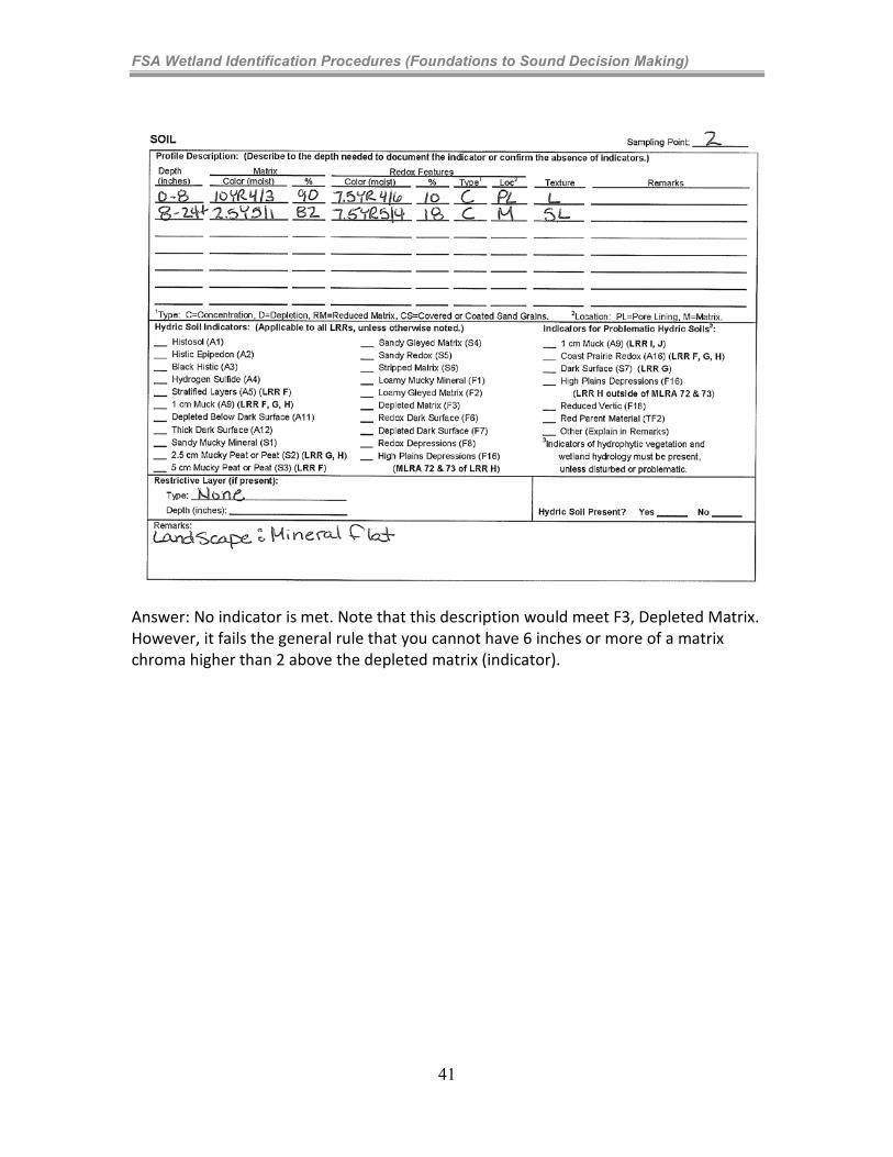
Answer: No indicator is met. Note that this description would meet F3, Depleted Matrix. However, it fails the general rule that you cannot have 6 inches or more of a matrix chroma higher than 2 above the depleted matrix (indicator).
41
FSA Wetland Identification Procedures (Foundations to Sound Decision Making)
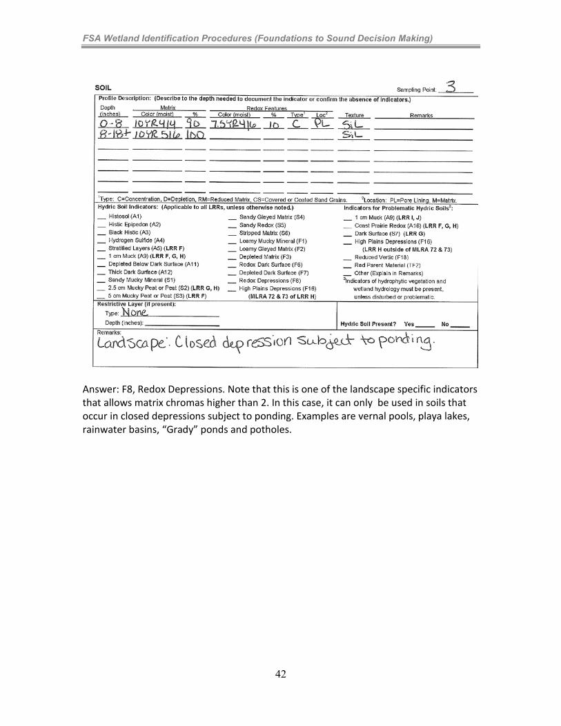
Answer: F8, Redox Depressions. Note that this is one of the landscape specific indicators that allows matrix chromas higher than 2. In this case, it can only be used in soils that occur in closed depressions subject to ponding. Examples are vernal pools, playa lakes, rainwater basins, “Grady” ponds and potholes.
42
FSA Wetland Identification Procedures (Foundations to Sound Decision Making)
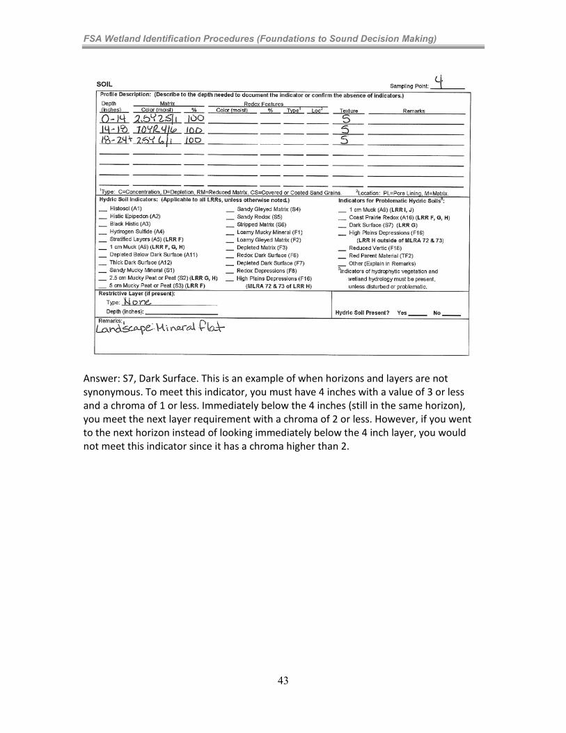
Answer: S7, Dark Surface. This is an example of when horizons and layers are not synonymous. To meet this indicator, you must have 4 inches with a value of 3 or less and a chroma of 1 or less. Immediately below the 4 inches (still in the same horizon), you meet the next layer requirement with a chroma of 2 or less. However, if you went to the next horizon instead of looking immediately below the 4 inch layer, you would not meet this indicator since it has a chroma higher than 2.
43
FSA Wetland Identification Procedures (Foundations to Sound Decision Making)
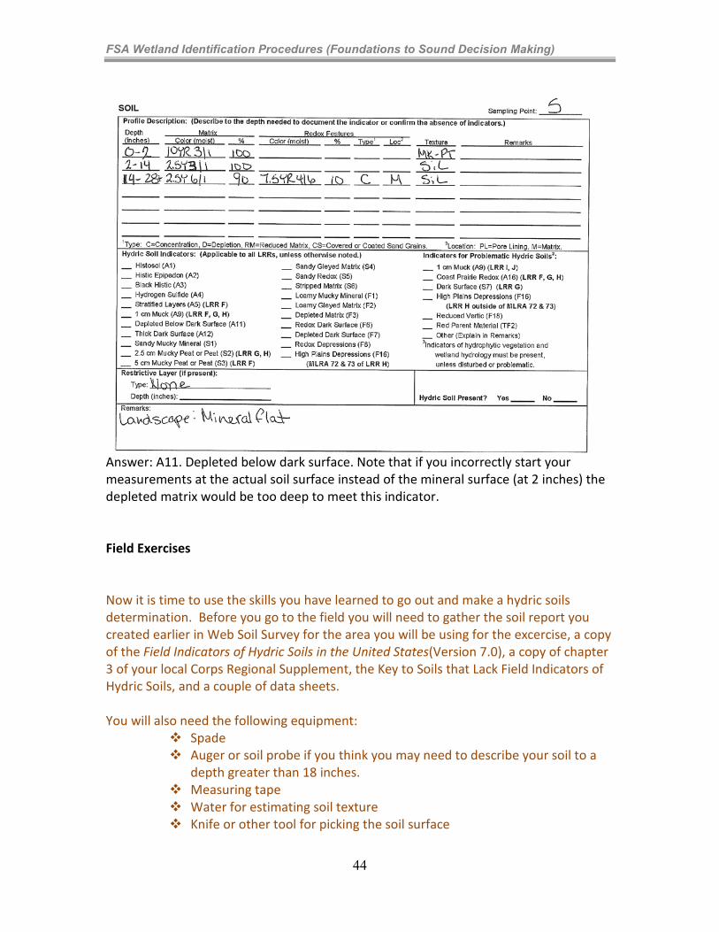
Answer: A11. Depleted below dark surface. Note that if you incorrectly start your measurements at the actual soil surface instead of the mineral surface (at 2 inches) the depleted matrix would be too deep to meet this indicator. Field Exercises Now it is time to use the skills you have learned to go out and make a hydric soils determination. Before you go to the field you will need to gather the soil report you created earlier in Web Soil Survey for the area you will be using for the excercise, a copy of the Field Indicators of Hydric Soils in the United States(Version 7.0), a copy of chapter 3 of your local Corps Regional Supplement, the Key to Soils that Lack Field Indicators of Hydric Soils, and a couple of data sheets. You will also need the following equipment:
Spade Auger or soil probe if you think you may need to describe your soil to a
depth greater than 18 inches. Measuring tape Water for estimating soil texture Knife or other tool for picking the soil surface
44
FSA Wetland Identification Procedures (Foundations to Sound Decision Making)
Munsell soil color chart Clipboard Pencil or pen You may also want to contact your local Resource Soil Scientist to
determine if there are any other tools you may need. For example, in areas where Mn may be used as a Field Indicator it is useful to carry Hydrogen Peroxide to determine if dark mottles in the soil are in fact redox concentrations that contain Mn.
If you are new to writing soil descriptions you may want to contact your local Resource Soil Scientist to schedule a time when they could meet you in the field to assist you in this exercise. Once in the field, locate an area that you feel is on the wet side of the hydric/non-hydric soil boundary and fill out the soils portion of the wetland delineation data sheet completely. Go to the drier side and complete another data sheet filling out the soils portion completely. Make sure you describe all the information that you will need to identify the Field Indicators of Hydric Soils the soil might meet. For example, if you are in a sandy soil with dark matrices it is important to record an estimate of masked vs. unmasked sand grains because this is a characteristic that can separate hydric soils from non-hydric soils. Once you have completed your descriptions, go through the Field Indicators of Hydric Soils in the field to identify all those indicators your soil meets. You should record all the Field Indicators of Hydric Soils met, although only one indicator is required. Once you get familiar with the Field Indicators of Hydric Soils you can start completing your descriptions in the field and going through the Field Indicators of Hydric Soils following the field visit, but for this exercise try to determine the indicators that are met in the field in case you need to go back and identify features you may have forgotten to record. Note the importance of recording colors, soil textures, accurate depths, percentage and location of redoximorphic features, masked vs. unmasked sand grains, and, if it applies, the type of organic soil material (muck, muck peat, peat). If you have gone through your exercise and were not able to identify a Field Indicator in a site that you feel should contain hydric soils, you may be in a problematic soil situation. The first steps you should take are to do the following:
• Look at the big picture.
• What landscape are you in?
• Does the vegetative community make sense?
• Are the soil characteristics what you expect? Read the information on problematic hydric soils and then go back to the information you have gathered to see if your site fits any of the problematic hydric soil situations described in your Regional Supplement and whether the information provided can help you to identify the soil as hydric. If you have not already asked for assistance from the
45
FSA Wetland Identification Procedures (Foundations to Sound Decision Making)
local Resource Soil Scientist, you may want to contact them to discuss whether it is likely that the site is problematic. Problematic Soil Situations At the end of chapter 3 of your local Regional Supplement is a list of test indicators that may help you in problematic soil situations. Look though these Field Indicators of Hydric Soils to familiarize yourself with problem soils in your area. There are many problematic soil situations that we currently do not have Field Indicators of Hydric Soils for. Chapter 5 of the Corps Regional Supplements suggests methods to assist you in the identification of a hydric soil in these problematic situations. Read through the problematic soils section of chapter 5 to identify issues you may have in your area and methods for identification of hydric soils in these areas. Hydric Soils Technical Standard If you have a site that is problematic and you need to monitor the site to determine the presence of a hydric soil, the Technical Standard is used as guidance for what data must be collected and when you have satisfied the requirements of a hydric soil. Requirements include:
Water table measurements Redox potential measurements Reduced Iron (Fe II) measurements In-situ pH measurements On-site precipitation data Replicates
The Hydric Soils Technical Standard can be used to evaluate the function of wetland restoration, mitigation, creation, and
construction, evaluate onsite the current functional hydric status of a soil, and with appropriate regional data modify, validate, eliminate, or adopt hydric soil
Field Indicators of Hydric Soils for the region. For more information on the use of the Hydric Soil Technical Standard see the NTCHS Technical Note 11 at ftp://ftp-fc.sc.egov.usda.gov/NSSC/Hydric_Soils/note11.pdf.
46

FSA Wetland Identification Procedures (Foundations to Sound Decision Making)
Why this is important? While you may never actually collect the data spelled out in the Hydric Soils Technical Standard, you may be asked about data collection protocols by others or be given data that was collected by others to evaluate the presence or absence of a hydric soil. So, it is good to familiarize yourself with what is required in the Hydric Soils Technical Standard and where to obtain the information in case you need it.
47
FSA Wetland Identification Procedures (Foundations to Sound Decision Making)
Learning Concept 4-4: Decision Making
Remember, it was discussed in Module 2 that the possibility exists of finding a false-positive from (1) Soils Mapping (off-site indicator) due to inclusions or erroneous mapping, or on rare situations (2) a Corps/NTCHS Indicator. More commonly, is the likelihood of finding a false-negative (not finding offsite or Corps/NTCHS indicators), but the predominant soils on the site meet the FSA hydric soil definition. It is made clear in the FSA Procedures that the occurrence of, or lack of, a NTCHS indicator does not necessarily confirm the presence or absence of a FSA hydric soil, nor does the absence of a NTCHS indicator necessarily disprove that the sampling unit not support a hydric soil. Rather, additional consideration is required. Before making any decision about the presence or absence of a predominance of FSA hydric soils, the overall site and how it interacts with the soil should be considered. Always look at the landscape features of the immediate site and compare them to the surrounding areas. Try to contrast the features of wet and dry sites that are in close proximity. When observing slope features, look first at the area immediately surrounding the sampling point. For example, a nearly level bench or depression at the sampling point may be more important to site wetness than the overall landform on which it occurs. By understanding how water moves across the site, the reasons for the presence or absence of hydric soil indicators should be clear. Unlike the vegetation and hydrology diagnostic features, for FSA purposes, the hydric soil definition is not related to current conditions; rather, it is linked to pre-“drainage” conditions. Therefore, there are very few situations where a false-positive can occur for FSA hydric soils as the definition allows for drained soils to still be hydric (“in an undrained condition”). While rare, this can occur, particularly in arid regions where features can develop from ponding or saturation events that might fail to meet the normal circumstances requirement of FSA decisions. The question asked by the agency expert in all situations just prior to decision making is:
o Would the site support a predominance of soils that, in an undrained condition, are saturated, flooded, or ponded long enough during a growing season 50 years in 100, to develop anaerobic conditions that support the growth and regeneration of hydrophytic vegetation? So the question is not just – Are these soils hydric (in their undrained condition), but rather are these soils hydric 50% of the time? This needs to be considered prior to rendering a FSA hydric soil decision and supports (once again) the reason that NRCS policy limits decision
48
FSA Wetland Identification Procedures (Foundations to Sound Decision Making)
making to those staffs experienced with the local nuances of wetlands within their work area.
Again, unique to the FSA wetland identification procedures, is that normal circumstances must be met at the factor level and that hydric soils must, under normal circumstances, support hydrophytic vegetation, as defined in the Act. In keeping with the three-factor approach to the identification of wetlands, in the development of their definitions and their methods, the Corps (and NTCHS) attempted to keep each diagnostic factor as autonomous as possible. For FSA purposes, this is not possible as the definitions used are not decided upon by NRCS wetland scientists (or an independent technical group), but rather they are provided by law. For FSA purposes: yes, each diagnostic factor is considered separately (per the concepts in the 3-factor approach), but by necessity the decision for each factor is not made in a bubble. Rather, each of the three decisions are made in consideration of the site behaving as an ecosystem (wetland ecosystem, mesic ecosystem, or xeric ecosystem). NRCS must include the consideration of the soil conditions, hydrology, and plant community that would normally occur prior to rendering a decision at the factor level. In review, for FSA purposes, normal circumstances are considered when making a decision for wetland diagnostic factors. Accordingly, your responsibility as an agency expert is to decide if soil reduction (thus, “an anaerobic condition”,satisfying the hydric soil definition, and “deficient in oxygen”, satisfying the requirement in the hydrophytic vegetation definition, which is part of the hydric soil definition) would occur under normal circumstances or prior to drainage. This decision is made after consideration of:
1. Typical or Atypical Conditions – For hydric soils, decision making differs from vegetation or hydrology decisions. The 1985 date is of no consequence for soils, due to the “in an undrained condition” statement in the FSA hydric soil definition. So, the question for hydric soils is: What were the pre-drainage conditions during NEC, regardless of when the drainage occurred?
2. Normal Environmental Conditions - For FSA hydric soils, NEC is related to the soil conditions that would occur during the wet portion of the growing season in a normal climatic year. This would have been those conditions that occurred prior to drainage (regardless of when the drainage occurred).
If the soil meets the FSA hydric soil definition (including undrained requirement) under NEC, then the soils are hydric. If not, then the soils are not hydric (for FSA purposes).
49
FSA Wetland Identification Procedures (Foundations to Sound Decision Making)
The following is a list of books and websites to reference more information on describing and identifying hydric soils. Environmental Laboratory. 1987. Corps of Engineers wetland delineation manual. Technical Report Y-87-1. Vicksburg, MS: U.S. Army Engineer Waterways Experiment Station. (http://el.erdc.usace.army.mil/wetlands/pdfs/wlman87.pdf) Florida Soil Survey Staff. 1992. Soil and Water Relationships of Florida’s Ecological Communities. G.W. Hurt, editor. USDA-Soil Conservation Service, Gainesville, FL. Mausbach, M.J. and J.l. Richardson. 1994. Biogeochemical Processes in Hydric Soils. Current Topics in Wetland Biogeochemistry 1:68-127. Wetlands Biogeochemistry Institute, Louisiana State University, Baton Rouge, LA. Mid-Atlantic Hydric Soils Committee. 2004. A guide to hydric soils in the Mid-Atlantic Region, ver. 1.0. L.M. Vasilas and B.L. Vasilas (eds.). USDA, NRCS, Morgantown, WV. (www.epa.gov/reg3esd1/hydric soils/) National Research Council. 1995. Wetlands: Characteristics and Boundaries. National Academy Press, Washington DC. Rabenhorst, M.C. and S. Parikh. 2000. Propensity of soils to develop redoximorphic color changes. Soil Sci. Soc. Am. J. 64:1904-1910.
Richardson, J. L. and M. J. Vepraskas (eds.) 2000. Wetland Soils: genesis, hydrology, landscapes, and classification. Lewis Scientific Publ., Boca Raton, FL.
Schoeneberger, P.J., Wysocki, D.A., Benham, E.C., and Broderson, W.D. (editors), 2002. Field book for describing and sampling soils, Version 2.0. Natural Resources Conservation Service, National Soil Survey Center, Lincoln, NE. (http://soils.usda.gov/technical/fieldbook/) Soil Science Society of America. 1993. Proceedings of the symposium on Soil Color, October 21-26, 1990. San Antonio, TX. J.M. Bigham and E.J. Coilkosz, editors. Soil Science Society of America, Madison, WI, Special Publication 31. Soil Science Society of America. 2001. Glossary of Soil Science Terms. Soil Science Society of America, Madison, WI. (https://www.soils.org/publications/soils-glossary) Soil Survey Division Staff. 1993. Soil Survey Manual. Soil Conservation Service. U.S. Department of Agriculture Handbook 18. (http://soils.usda.gov/technical/manual/)
50
FSA Wetland Identification Procedures (Foundations to Sound Decision Making)
Soil Survey Staff. 2010. Keys to Soil Taxonomy, 11th ed. USDA-Natural Resources Conservation Service, Washington, DC. (http://soils.usda.gov/technical/classification/tax_keys/) Soil Survey Staff. 1999. Soil Taxonomy: A basic system of soil classification for making and interpreting soil surveys. Agriculture Handbook 436. USDA-Natural Resources Conservation Service, Washington, D.C. (http://soils.usda.gov/technical/classification/taxonomy/) United States Army Corps of Engineers. September 2008. Interim Regional Supplement to the Corps of Engineers Wetland Delineation Manual: Midwest Region. http://www.usace.army.mil/cecw/pages/reg_supp.aspx United States Department of Agriculture, Natural Resources Conservation Service. 2010. National Soil Survey Handbook, title 430-VI. (http://soils.usda.gov/technical/handbook/) United States Department of Agriculture, Natural Resources Conservation Service. Field Indicators of Hydric Soils of Hydric Soils in the United States, Version 7.0, 2010. ftp://ftp-fc.sc.egov.usda.gov/NSSC/Hydric_Soils/FieldIndicators_v7.pdf United States Department of Agriculture, Natural Resources Conservation service. 2010. From the Surface Down. An Introduction to Soil Surveys for Agronomic Use. ftp://ftp-fc.sc.egov.usda.gov/NSSC/Educational_Resources/surdown.pdf
United States Department of Agriculture, Natural resources Conservation Service. Hydric Soils Technical Note, Proper use of Hydric Soil Terminology.
http://soils.usda.gov/use/hydric/ntchs/tech_notes/note1.html United States Department of Agriculture, Natural Resources Conservation Service. 2008. National Food Security Act Manual, Fourth Edition. M_180_TOC.
United States Department of Agriculture, Natural Resources Conservation Service. 2006. Land Resource Regions and Major Land Resource Areas of the United States, the Caribbean, and the Pacific Basin. U.S. Department of Agriculture Handbook 296. (http://soils.usda.gov/survey/geography/mlra/index.html) Vepraskas, M.J. 1994. Redoximorphic Features for Identifying Aquic Conditions. Technical Bulletin 301. North Carolina Agricultural Research Service, North Carolina State University, Raleigh, North Carolina.
51
FSA Wetland Identification Procedures (Foundations to Sound Decision Making)
Useful websites for describing and identifying hydric soils are listed below.
http://soils.usda.gov/use/hydric/ -- This is the NTCHS website and contains all official technical information regarding hydric soils and hydric soil issues. http://soils.usda.gov/technical/ -- This site is the NRCS Soil Survey Division technical resources website and contains all NRCS Technical References pertaining to soil survey issues. http://www.usace.army.mil/CECW/Pages/reg_supp.aspx -- This is the website to go to to obtain copies of the Corps of Engineers Wetland Delineation Regional Supplements. For information on hydric soils go to chapter 3 in your local suppplement and chapter 5 for problematic soil situations. http://soils.usda.gov/education/resources/lessons/texture/ This site is from the USDA Natural Resources Conservation Service and includes the Textural Triangle & the Guide to Texture by Feel.
52