Embed Size (px)
Citation preview

Extended Abstract 1
10th International Kimberlite Conference, Bangalore - 2012
10IKC-71
KIMBERLITE INDICATOR MINERALS AND “LATERITE”,CANADIAN ARCTIC
Davies* R and Davies AWTalmora Diamond Inc., Toronto, Canada
Laterite and its effect on kimberlite indicatorminerals is not expected in Canada’s glacialterrane and its presence if not recognized can haveserious consequences for diamond exploration.
Evidence of laterite in the area of TalmoraDiamond Inc.’s exploration property in Canada’sNorthwest Territories is presented and the effectof laterite on Talmora’s kimberlite indicatorminerals (KIMs) including preferential destructionof G-10 garnets is discussed.
The term “laterite” is used in an informalway to describe a profile from ferricrete down tosaprolite as has been suggested by Taylor (2006).In this case the laterite is hidden or has largelybeen destroyed by glaciation
Project Location
Talmora Diamond Inc. is exploring anupland plateau of flat lying Paleozoic dolomite inthe Horton River area about 400 kilometers eastof Inuvik and 100 kilometers south of Paulatukon Canada’s Arctic coast. The property is centeredat 68°N and 124°W and is part of the Lena Westdiamond region of Canada.
The dolomite shows up as a brown area onGoogle Earth and is surrounded by a green areaunderlain by Cretaceous mudstones (figure 1).
Geomorphology
The upland plateau is flat with scattered
small shallow ponds (Figure 2). Runoff is limitedand erosion has been minimal except for theincision by the Horton River through the centreof the plateau to a depth of 220 meters followinguplift and withdrawal of the Cretaceous sea.Geomorphic conditions were those generallysuited to laterite formation in tropical to sub-tropical areas.
Figure 1. Google Earth/Terrametics image of the area of browncolouration (green outline) with respect to Talmora property (red).Yellow dots are Darnley Bay till samples. Blue outline is area coveredby figure 6.
Figure 2 Plateau with shallow pond over coincident magneticanomaly.
Extended Abstract 2
10th International Kimberlite Conference, Bangalore - 2012
First Clues
Till samples, from the Cretaceous area,contain the normal suite of KIMs (ilmenite, spinel,garnet and chrome diopside) but those from thedolomite area around the Talmora property aredeficient in garnets and chrome diopside.
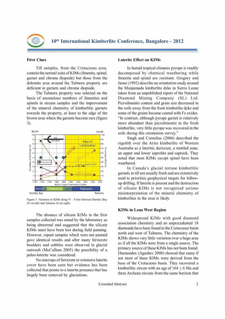
The Talmora property was selected on thebasis of anomalous numbers of ilmenites andspinels in stream samples and the improvementof the mineral chemistry of kimberlitic garnetstowards the property, at least to the edge of thebrown area where the garnets become rare (figure3).
Laterite Effect on KIMs
In humid tropical climates pyrope is readilydecomposed by chemical weathering whileilmenite and spinel are resistant. Gregory andJanse (1992) describe an orientation study aroundthe Manjamadu kimberlite dyke in Sierra Leonetaken from an unpublished report of the NationalDiamond Mining Company (SL) Ltd.Picroilmenite content and grain size decreased inthe soils away from the fresh kimberlite dyke andsome of the grains became coated with Fe oxides.“In contrast, although pyrope garnet is relativelymore abundant than picroilmenite in the freshkimberlite, very little pyrope was recovered in thesoils during this orientation survey.”
Singh and Cornelius (2006) described theregolith over the Aries kimberlite of WesternAustralia as a lateritic duricrust, a mottled zone,an upper and lower saprolite and saprock. Theynoted that most KIMs except spinel have beenweathered.
In Canada’s glacial terrane kimberliticgarnets in till are usually fresh and are extensivelyused to prioritize geophysical targets for follow-up drilling. If laterite is present and the destructionof silicate KIMs is not recognized seriousmisinterpretation of the mineral chemistry ofkimberlites in the area is likely.
KIMs in Lena West Region
Widespread KIMs with good diamondassociation chemistry and an unprecedented 18diamonds have been found in the Cretaceous basinnorth and west of Talmora. The chemistry of theKIMs shows very little variation over a huge areaas if all the KIMs were from a single source. Theprimary source of these KIMs has not been found.Diamondex (Agashev 2008) showed that many ifnot most of these KIMs were derived from thebase of the Cretaceous basin. They recovered akimberlitic zircon with an age of 164 + 6 Ma andthree Archean zircons from the same horizon that
Figure 3 Variation in KIMs along N – S line between Darnley Bay(N on left) and Talmora (S on right).
The absence of silicate KIMs in the firstsamples collected was noted by the laboratory asbeing abnormal and suggested that the silicateKIMs must have been lost during field panning.However, repeat samples which were not pannedgave identical results and after many ferricreteboulders and cobbles were observed in glacialoutwash (McCallum 2005) the possibility of apaleo-laterite was considered.
No outcrops of ferricrete or extensive lateritecover have been seen but evidence has beencollected that points to a laterite presence that haslargely been removed by glaciations.
Extended Abstract 3
10th International Kimberlite Conference, Bangalore - 2012
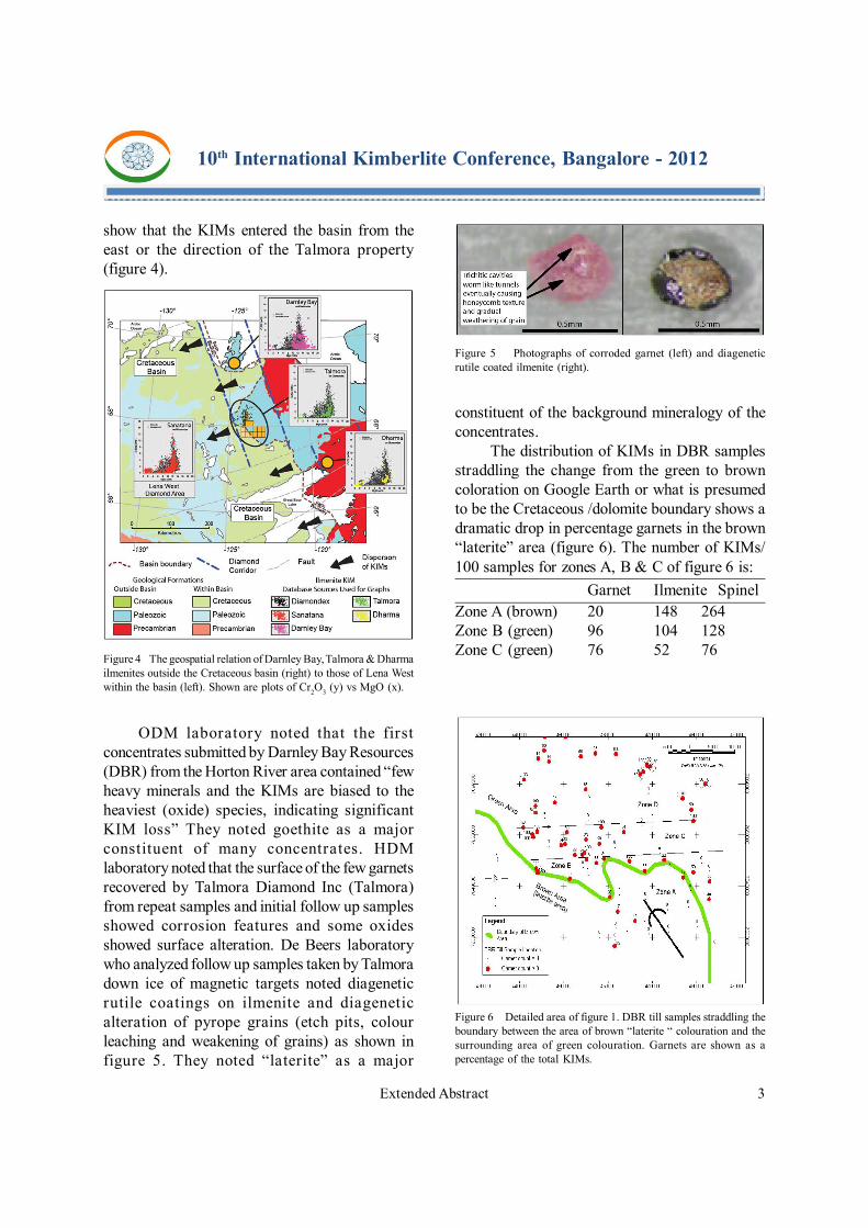
show that the KIMs entered the basin from theeast or the direction of the Talmora property(figure 4).
Figure 4 The geospatial relation of Darnley Bay, Talmora & Dharmailmenites outside the Cretaceous basin (right) to those of Lena Westwithin the basin (left). Shown are plots of Cr2O3 (y) vs MgO (x).
constituent of the background mineralogy of theconcentrates.
The distribution of KIMs in DBR samplesstraddling the change from the green to browncoloration on Google Earth or what is presumedto be the Cretaceous /dolomite boundary shows adramatic drop in percentage garnets in the brown“laterite” area (figure 6). The number of KIMs/100 samples for zones A, B & C of figure 6 is:
Garnet Ilmenite SpinelZone A (brown) 20 148 264Zone B (green) 96 104 128Zone C (green) 76 52 76
ODM laboratory noted that the firstconcentrates submitted by Darnley Bay Resources(DBR) from the Horton River area contained “fewheavy minerals and the KIMs are biased to theheaviest (oxide) species, indicating significantKIM loss” They noted goethite as a majorconstituent of many concentrates. HDMlaboratory noted that the surface of the few garnetsrecovered by Talmora Diamond Inc (Talmora)from repeat samples and initial follow up samplesshowed corrosion features and some oxidesshowed surface alteration. De Beers laboratorywho analyzed follow up samples taken by Talmoradown ice of magnetic targets noted diageneticrutile coatings on ilmenite and diageneticalteration of pyrope grains (etch pits, colourleaching and weakening of grains) as shown infigure 5. They noted “laterite” as a major
Figure 5 Photographs of corroded garnet (left) and diageneticrutile coated ilmenite (right).
Figure 6 Detailed area of figure 1. DBR till samples straddling theboundary between the area of brown “laterite “ colouration and thesurrounding area of green colouration. Garnets are shown as apercentage of the total KIMs.

Extended Abstract 4
10th International Kimberlite Conference, Bangalore - 2012
Preferential Destruction ofG10 Pyrope Garnets
Sanatana (2008) noted that KIMs in the traindown-ice of the Dharma kimberlite 180 kilometerssoutheast of Talmora are underrepresented in G-10 garnets (3.5%) compared to the pipe (10%)indicating a preferential destruction of the earlycrystallizing G-10 garnets. They pointed out theimplications for exploration that uses the presenceand abundance of G10 garnets in judging thediamond potential of the source kimberlite.Preferential destruction of G-10 garnets can alsobe seen down-ice of some Darnley Baykimberlites 120 kilometers to the north of Talmora.
Diagenetic destruction of garnets on theTalmora property and the preferential destructionof G10 garnets in the tills down-ice of the DBRand Dharma kimberlites suggests a common causewhich appears to be a period of lateritization.
Direct Evidence of Laterite
Ferricrete cobbles and small boulders werefirst noticed in a glacial outwash deposit (figure7). The ferricrete was conspicuous and wasobviously from a nearby source. It wassubsequently found elsewhere in the dolomite areaespecially down-ice of magnetic kimberlitetargets. Remnants of a laterite-like crust was notedon outcropping dolomite just above a slump blockof Cretaceous sediments in a gully in the northwestpart of the property. The present land surface isthe source of both the ferricrete and KIMs, andthe effect of the one on the other must beconsidered.
Figure 7 Ferricrete boulders on the Talmora property.
Figure 8 is a Mg+Ca+Fe plot of ICP analysesof till from Sanatana’s 2005 prospectus that showsa fan of high Mg+Ca values (green and blue)diminishing down-ice of the dolomite bedrockaround the Talmora property. High Fe values (red)in the fan furthest down-ice were noted but notexplained. The Fe appears to be part of the Mg+Cafan and not superimposed. It is probably the Fe ofthe “laterite” surface stripped first from theunderlying dolomite by the advancing ice.Absence of significant Fe in the fan nearest theTalmora property indicates almost completeremoval of the “laterite” from the dolomite surfacebefore the end of glaciation. Sanatana (2010)explained magnetic anomalies west of Talmoraas remnants of a flat-lying, iron-rich, paleo-weathered (“laterite”) horizon just beneath the tillcover.
Figure 8 ICP analyses of till [combined percent Ca (blue), Mg (green)and Fe (red)] after Sanatana (2005). Talmora property pink.
Climate
One does not think of northern Canada ashaving a tropical climate but during the Eocenethermal maximum 55 million years ago the areawas a lot warmer with surface waters of the ArcticOcean as warm as 18o Celsius (Moran & Backman2007). Ellesmere Island at 78 79o N latitude washome to lush lowland forests and swampsinhabited by giant tortoises and alligators (Eberle2011).
Extended Abstract 5
10th International Kimberlite Conference, Bangalore - 2012
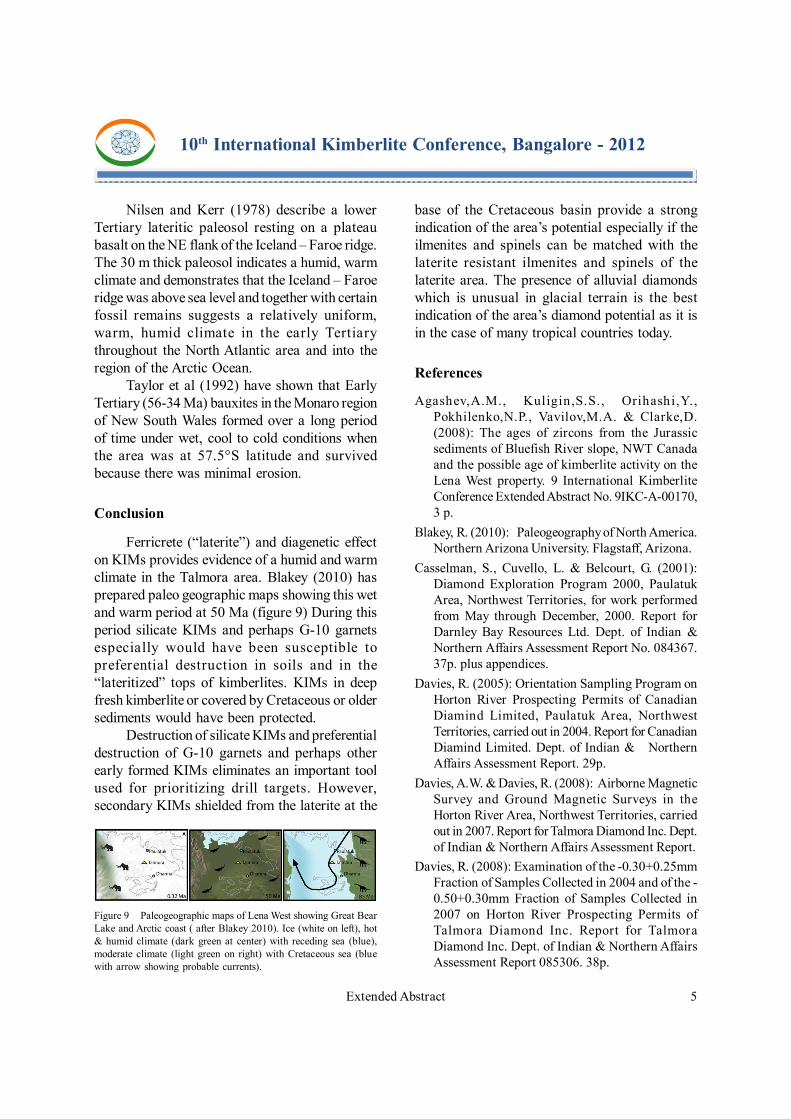
Nilsen and Kerr (1978) describe a lowerTertiary lateritic paleosol resting on a plateaubasalt on the NE flank of the Iceland – Faroe ridge.The 30 m thick paleosol indicates a humid, warmclimate and demonstrates that the Iceland – Faroeridge was above sea level and together with certainfossil remains suggests a relatively uniform,warm, humid climate in the early Tertiarythroughout the North Atlantic area and into theregion of the Arctic Ocean.
Taylor et al (1992) have shown that EarlyTertiary (56-34 Ma) bauxites in the Monaro regionof New South Wales formed over a long periodof time under wet, cool to cold conditions whenthe area was at 57.5°S latitude and survivedbecause there was minimal erosion.
Conclusion
Ferricrete (“laterite”) and diagenetic effecton KIMs provides evidence of a humid and warmclimate in the Talmora area. Blakey (2010) hasprepared paleo geographic maps showing this wetand warm period at 50 Ma (figure 9) During thisperiod silicate KIMs and perhaps G-10 garnetsespecially would have been susceptible topreferential destruction in soils and in the“lateritized” tops of kimberlites. KIMs in deepfresh kimberlite or covered by Cretaceous or oldersediments would have been protected.
Destruction of silicate KIMs and preferentialdestruction of G-10 garnets and perhaps otherearly formed KIMs eliminates an important toolused for prioritizing drill targets. However,secondary KIMs shielded from the laterite at the
base of the Cretaceous basin provide a strongindication of the area’s potential especially if theilmenites and spinels can be matched with thelaterite resistant ilmenites and spinels of thelaterite area. The presence of alluvial diamondswhich is unusual in glacial terrain is the bestindication of the area’s diamond potential as it isin the case of many tropical countries today.
References
Agashev,A.M., Kuligin,S.S., Orihashi,Y.,Pokhilenko,N.P., Vavilov,M.A. & Clarke,D.(2008): The ages of zircons from the Jurassicsediments of Bluefish River slope, NWT Canadaand the possible age of kimberlite activity on theLena West property. 9 International KimberliteConference Extended Abstract No. 9IKC-A-00170,3 p.
Blakey, R. (2010): Paleogeography of North America.Northern Arizona University. Flagstaff, Arizona.
Casselman, S., Cuvello, L. & Belcourt, G. (2001):Diamond Exploration Program 2000, PaulatukArea, Northwest Territories, for work performedfrom May through December, 2000. Report forDarnley Bay Resources Ltd. Dept. of Indian &Northern Affairs Assessment Report No. 084367.37p. plus appendices.
Davies, R. (2005): Orientation Sampling Program onHorton River Prospecting Permits of CanadianDiamind Limited, Paulatuk Area, NorthwestTerritories, carried out in 2004. Report for CanadianDiamind Limited. Dept. of Indian & NorthernAffairs Assessment Report. 29p.
Davies, A.W. & Davies, R. (2008): Airborne MagneticSurvey and Ground Magnetic Surveys in theHorton River Area, Northwest Territories, carriedout in 2007. Report for Talmora Diamond Inc. Dept.of Indian & Northern Affairs Assessment Report.
Davies, R. (2008): Examination of the -0.30+0.25mmFraction of Samples Collected in 2004 and of the -0.50+0.30mm Fraction of Samples Collected in2007 on Horton River Prospecting Permits ofTalmora Diamond Inc. Report for TalmoraDiamond Inc. Dept. of Indian & Northern AffairsAssessment Report 085306. 38p.
Figure 9 Paleogeographic maps of Lena West showing Great BearLake and Arctic coast ( after Blakey 2010). Ice (white on left), hot& humid climate (dark green at center) with receding sea (blue),moderate climate (light green on right) with Cretaceous sea (bluewith arrow showing probable currents).

Extended Abstract 6
10th International Kimberlite Conference, Bangalore - 2012
Davies, R. (2009): Examination of the -0.30+0.25mmFraction of Samples Collected in 2004 and of the -0.50+0.30mm and -0.30 +0.25mm Fractions ofSamples Collected in 2007 on Horton RiverProspecting Permits of Talmora Diamond Inc..Report for Talmora Diamond Inc. Dept. of Indian& Northern Affairs Assessment Report. 29p.
Doyle, B. J. , Gill, T. I. and Thompson, V. (2008): TheDiscovery of the Dharma Kimberlite Complex: -Evidence for a Previously Unknown ArcheanTerrain North of Great Bear Lake. In Jackson, V.and Irwin, D. (compilers) 2008, 36th AnnualYellowknife Geoscience Forum, Abstracts;Northwest Territories Geoscience Office,Yellowknife, NT. YKGSF Abstracts Volume 2008.p. 21.
Doyle, B. J., Gill, T. I., Kivi, K., Larson, P. andThompson, V. (2007): MacKenzie Project Southof 68o Block, Diamond Exploration in 2006,Report for Sanatana Diamonds Inc., Dept. of Indian& Northern Affairs Assessment Report 085171,37p. plus appendices.
Eberle, J. J. (2011): Ellesmere Island Eocene Fossils.The Canadian Encyclopedia.www.thecanadianencyclopedia.com SanatanaDiamond Inc. (2005): Prospectus. SanatanaDiamond Inc. dated November 28, 2005. 85p.Available on SEDAR www.sedar.com
Sanatana Diamond Inc. (2010): ManagementDiscussion and Analysis for the 9 months ended
December 31, 2009. 24p. Available on SEDAR.www.sedar.com
Taylor, G., Eggleton, R. A., Holzbauer, C. C.,Maconachie, I. A., Gordon, M., Brown, M. C. andMcQueen, K. G. (1992): Cool Climate Lateritic andBauxitic Weathering. Journal of Geology. Vol. 100,No. 6.
Taylor, G. (2006): Fundamentals of Regolith Geology.Regolith 2006 – Consolidation and Dispersion ofIdeas. Proceedings of the CRC Leme RegolithSymposium. pp .343-345.
Gregory, G.P. & Janse, A.J.A. (1992): DiamondExploration in Tropical Terrains. in BUTT, C.R.M.and ZEEGERS H., eds., Handbook of ExplorationGeochemistry Volume 4: Regolith ExplorationGeochemistry in Tropical and Subtropical Terrains.Elsevier pp 419 – 437.
McCallum, M. (2005): Cursory Evaluation of SurficialSample Material from the Canadian DiamindHorton River Project Area, NWT. UnpublishedReport for Canadian Diamind Limited. 2p.
Moran, K. & Backman, J. (2007): The Arctic Ocean:So Much We Still Don’t Know. Geotimes, OctoberIssue. 3p.
Nilsen, T.H. and Kerr, D.R. (1978): Paleoclimatic andPaleogeographic implications of a lower Tertiarylaterite (latosol) on the Iceland – Faeroe Ridge,North Atlantic region. Geological Magazine 115,pp 153 – 182.