Embed Size (px)
Citation preview
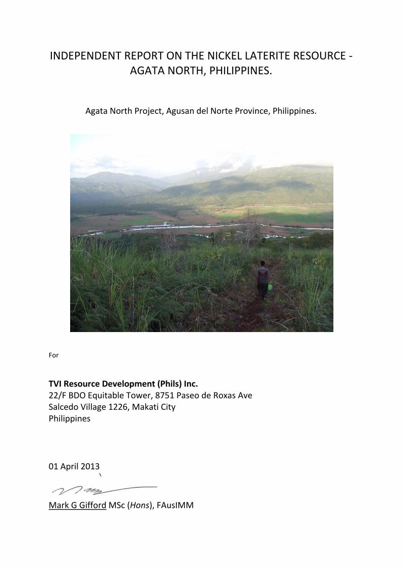
INDEPENDENT REPORT ON THE NICKEL LATERITE RESOURCE - AGATA NORTH, PHILIPPINES.
Agata North Project, Agusan del Norte Province, Philippines.
For
TVI Resource Development (Phils) Inc. 22/F BDO Equitable Tower, 8751 Paseo de Roxas Ave Salcedo Village 1226, Makati City Philippines
01 April 2013
Mark G Gifford MSc (Hons), FAusIMM
Independent Report on the Nickel Laterite Resource – Agata North, Philippines 2013
i
TABLE OF CONTENTS
Executive Summary ................1
1.0 Introduction ................3
2.0 Location, Description and Tenement Status ................4
2.1 Location
2.2 Property Description
2.3 Tenement Type
3.0 Regional Climate, Resources, Infrastructure, Physiography and Access ..............11
3.1 Climate
3.2 Local Resources and Infrastructure
3.3 Physiography
3.4 Access
4.0 History ..............13
5.0 Geology ..............14
5.1 Regional Geology
5.2 Local Geology
5.3 Laterite Ni Deposit Geology
5.4 Other Deposit Geology
6.0 Mineralization ..............22
7.0 Exploration ..............23
7.1 MRL General Exploration (1997-2000)
7.2 MRL General Exploration (2004-2009)
7.3 MRL Laterite Ni Exploration
7.4 Drillhole Collars Survey
8.0 Sampling and Assaying ..............29
8.1 ANLP Sampling Procedure
8.2 MRL Sampling Protocols
8.3 Laboratory Sampling Protocols
8.4 Internal Check Assays (McPhar and Intertek)
8.5 External Check Assays (MRL)
8.6 Summary
9.0 Data Verification ..............41
10.0 Bulk Density Determinations ..............42
11.0 Resource Estimate ..............45
11.1 Geometric Interpretation
11.2 Exploratory Data Analysis
11.3 Variography and Estimation
11.4 Resource Classification
12.0 Conclusions .............65
13.0 References .............66
14.0 Date and Signature .............68
Independent Report on the Nickel Laterite Resource – Agata North, Philippines 2013
ii
LIST OF FIGURES
Figure 1: Map of the Philippines showing MRL Project Areas ................4
Figure 2: MRL Tenements and Projects in the Surigao Mineral District ................5
Figure 3: Map showing broad outline of ANLP and Agata Cu-Au Prospects ................6
Figure 4: Compilation Map showing areas of mapped Ni Laterites within Surigao District ................7
Figure 5: Panoramic view of ANLP showing the main area of laterite development. ..............12
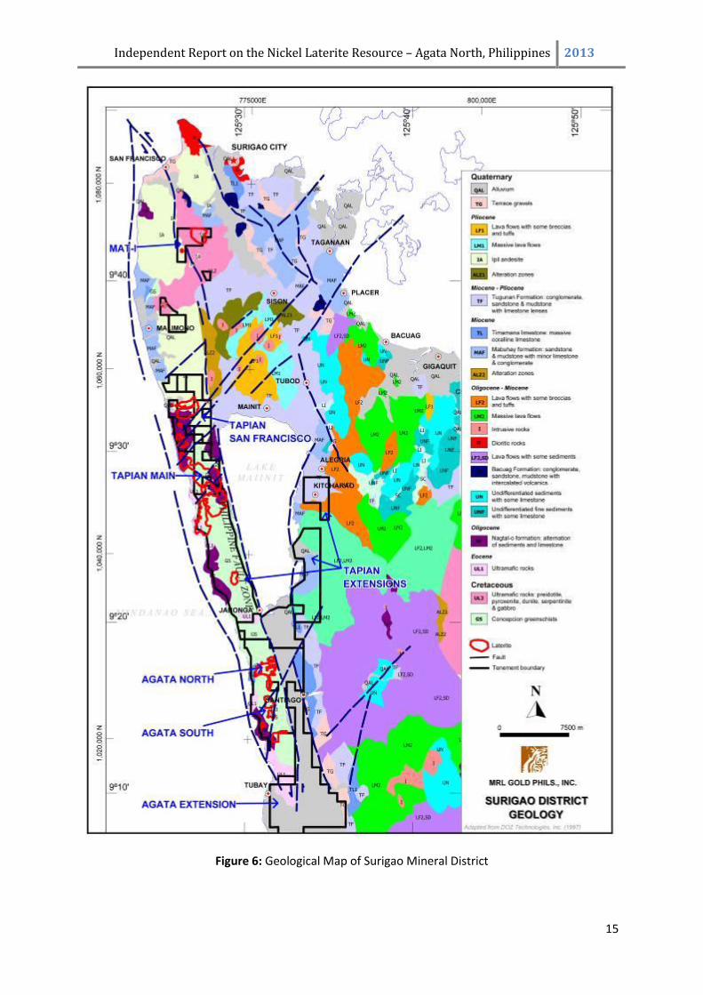
Figure 6: Geological Map of Surigao Mineral District ..............15
Figure 7: Local Geological Map of Agata North Project Area ..............17
Figure 8: ANLP Drillhole Location Map – BHP-Billiton and MRL (2007) Drilling. ..............26
Figure 9: ANLP Drillhole Location Map – All Drilling ..............28
Figure 10: Graphs of Nickel Standards Assays. ..............38
Figure 11: Comparison of Independent Checks and MRL Assays ..............42
Figure 12: Agata North Bulk Density Test Pit Location Map ..............44
Figure 13: ANLP Saprolite BD data graph – Dry Density vs Moisture All Data ..............45
Figure 14: Wireframe surfaces and drilling, Agata North (Ni on left, Fe on right side of drill trace....46
Figure 15: Block model sub-domains. ..............47
Figure 16: Histograms for composited Cr2O3 for saprolite sub-domains ..............49
Figure 17: Histogram for composited CaO in the upper limonite sub-domain ..............50
Figure 18: Contact analysis for the upper and lower limonite for Ni, Co, Al and Mn …………...51
Figure 19: Contact analysis for the upper and lower limonite for Fe, Mg, SiO2 and Cr2O3 ..............51
Figure 20: Contact analysis for the upper and lower limonite for CaO. ..............51
Figure 21: Contact analysis for the upper and lower saprolite for Ni, Co and Fe ..............52
Figure 22: Contact analysis for the upper and lower saprolite for Al, Mg, Cr2O3 and MnO ..............52
Figure 23: Contact analysis for the upper and lower saprolite for SiO2 and CaO ..............52
Figure 24: Comparison of composites against the block model for Ni in limonite. ..............59
Figure 25: Comparison of the sub-dom and dom block models for Cr2O3 in upper saprolite ............59
Figure 26: Resource classification, Agata North Deposit. ..............60
Figure 27: Grade-tonnage curve, Measured + Indicated, Limonite. ..............62
Figure 28: Grade-tonnage curve, Measured + Indicated, Saprolite ..............62
Figure 29: Grade-tonnage curve, Measured + Indicated, Upper Limonite ..............63
Figure 30: Grade-tonnage curve, Measured + Indicated, Lower Limonite ..............63
Figure 31: Grade-tonnage curve, Measured + Indicated, Upper Saprolite ..............64
Figure 32: Grade-tonnage curve, Measured + Indicated, Lower Saprolite ..............64
Independent Report on the Nickel Laterite Resource – Agata North, Philippines 2013
iii
LIST OF TABLES Table 1: Agata Project Tenements held by Mindoro ..........…...8
Table 2: Climate Averages and Extremes 1961-2000 ……………11
Table 3: NAMRIA Tie Points Technical Description ……………29
Table 4: Ni Standards used at ANLP and frequency ..............33
Table 5: Variance of Original and Internal Laboratory Duplicate Analyses ……………35
Table 6: Variance of Ni Standard and Laboratory Assays ……………36
Table 7: Variance of Field Duplicate and Original Assays .............36
Table 8: Variance of Field Duplicate and Original Assays .............37
Table 9: Variance of Pulp Duplicate and Original Assays .............39
Table 10: Variance of Pulp Duplicate and Interlab Assays .............40
Table 11: Results of Independent Check on Drill Core Assays .............41
Table 12: Summary of Bulk Density Measurements .............43
Table 13: Domain and Sub-Domain codes for Agata North Laterite ……..……45
Table 14: Block Model Properties .............46
Table 15: Comparison of raw sample lengths to composite sample lengths. .............47
Table 16: Composite statistics for sub-domains .............48
Table 17: Limonite Variogram Models .............53
Table 18: Saprolite Variogram Models .............54
Table 19: Domains and sub-domains estimated for each variable .............54
Table 20: Estimation neighbourhood parameters .............55
Table 21: Percent cells in estimation runs and mean number of samples used .............56
Table 22: Composite vs. block estimate comparison .............57
Table 23: Agata North Mineral Resource Estimate as at 18th March 2010. .............60
LIST OF APPENDICIES
Appendix 1: ANLP Cross-Sections
Appendix 2: MRL QA/QC Procedures
Appendix 3: McPhar / Intertek Sample Preparation Procedures
Appendix 4: ANLP Bulk Density Data
Appendix 5: ANLP Resource Estimate – Statistics and Variography
Appendix 6: 2010 and 2013 Resource Comparison
Independent Report on the Nickel Laterite Resource – Agata North, Philippines 2013
1
EXECUTIVE SUMMARY
This Ni Laterite Resource report was prepared at the request of Yulo Perez, Manager of TVI Resource
Development (Phils) Inc. It is the sixth mineral resource estimate completed over the Agata North
Lateritic Nickel Project (ANLP) project, and was to estimate a resource post the review and
application of further sub domains within the Agata North limonite and saprolite geological domains.
ANLP is located about 47 km north-northwest of Butuan City and 73 km southwest of Surigao City,
Mindanao Island, Philippines. The ANLP is one of the projects located within the overall Agata
Project, which is covered by the Mineral Production Sharing Agreement (MPSA) Contract Area held
by Minimax Mineral Exploration Corp. (Minimax) denominated as MPSA-134-99-XIII and approved
by the Department of Environment and Natural Resources (DENR) on May 26, 1999.
The Agata Project is situated along the southern part of the uplifted and fault-bounded Western
Range on the northern end of the east Mindanao Ridge. green schists, ultramafics, limestones,
andesite and tuff, younger limestones, intrusive, and alluvium are present within the area. The
widespread occurrence of ultramafics and serpentinized ultramafics, especially along the broad
ridges characterized by peneplaned topography provide a favourable environment for the
development of nickel laterites.
The laterite profile in the ANLP consists of the ferruginous laterite, limonite, saprolite grading to the
ultramafic rock, from surface to increasing depth. The limonite zone is iron oxide-rich, where the
predominant minerals are hematite, goethite and clays, and with moderate nickel content (over 1%),
while the saprolite zone has much less iron-oxide, is magnesium-rich, and has a slightly higher nickel
content than the limonite horizon in its upper portion.
This report is based on the exploration data that were produced and compiled by previous owners
Mindoro Resources Limited (MRL). Data verification performed by the author of the MRL database
found no discrepancies. Hence the database is considered adequate to meet industry standards to
estimate mineral resources.
The resource was estimated by Mike Job, Principal Consultant, Quantitative Group Perth, using the
Ordinary Kriging method. The data was domained into 5 ore types, Limonite (upper), Limonite
(lower), Saprolite(upper), saprolite (lower), and Bedrock and within each domain 9 individual
elements were estimated and reported upon. The resource estimate is as below:
Independent Report on the Nickel Laterite Resource – Agata North, Philippines 2013
2
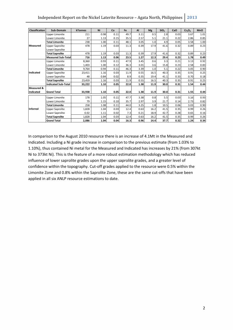
In comparison to the August 2010 resource there is an increase of 4.1Mt in the Measured and
Indicated. Including a Ni grade increase in comparison to the previous estimate (from 1.03% to
1.10%), thus contained Ni metal for the Measured and Indicated has increases by 21% (from 307kt
Ni to 373kt Ni). This is the feature of a more robust estimation methodology which has reduced
influence of lower saprolite grades upon the upper saprolite grades, and a greater level of
confidence within the topography. Cut-off grades applied to the resource were 0.5% within the
Limonite Zone and 0.8% within the Saprolite Zone, these are the same cut-offs that have been
applied in all six ANLP resource estimations to date.
Classification Sub-Domain kTonnes Ni Co Fe Al Mg SiO2 CaO Cr2O3 MnO
Upper Limonite 211 0.98 0.11 49.7 3.11 0.5 2.8 0.03 3.67 1.01
Lower Limonite 27 1.13 0.15 35.5 2.57 5.1 21.1 0.22 2.86 0.85
Total Limonite 238 1.00 0.11 48.1 3.05 1.0 4.9 0.05 3.58 1.00
Upper Saprolite 478 1.19 0.03 11.3 0.39 17.9 41.6 0.32 0.89 0.23
Lower Saprolite
Total Saprolite 478 1.19 0.03 11.3 0.39 17.9 41.6 0.32 0.89 0.23
Measured Sub-Total 716 1.13 0.06 23.5 1.27 12.3 29.4 0.23 1.78 0.49
Upper Limonite 8,360 0.93 0.11 47.9 3.45 0.6 3.3 0.21 3.13 0.92
Lower Limonite 1,403 1.00 0.12 36.3 3.01 3.6 15.8 0.23 2.58 0.83
Total Limonite 9,764 0.94 0.11 46.3 3.39 1.0 5.1 0.22 3.05 0.90
Upper Saprolite 23,411 1.16 0.03 11.9 0.55 16.5 40.3 0.35 0.91 0.25
Lower Saprolite 48 0.84 0.02 8.9 0.35 19.4 41.1 0.33 0.70 0.18
Total Saprolite 23,459 1.16 0.03 11.9 0.55 16.5 40.3 0.35 0.91 0.25
Indicated Sub-Total 33,222 1.10 0.05 22.0 1.38 11.9 30.0 0.31 1.54 0.44
Measured &
Indicated Grand Total 33,938 1.10 0.05 22.0 1.38 11.9 30.0 0.31 1.55 0.44
Upper Limonite 178 1.05 0.11 47.7 3.38 0.8 5.5 0.03 3.16 0.93
Lower Limonite 79 1.15 0.10 35.7 2.97 3.9 21.7 0.14 2.73 0.82
Total Limonite 258 1.08 0.11 44.0 3.25 1.8 10.5 0.06 3.03 0.90
Upper Saprolite 1,828 1.04 0.03 12.4 0.63 16.2 41.5 0.35 0.99 0.26
Lower Saprolite 0.02 1.11 0.02 7.3 0.21 18.9 42.7 0.28 0.65 0.16
Total Saprolite 1,828 1.04 0.03 12.4 0.63 16.2 41.5 0.35 0.99 0.26
Grand Total 2,086 1.04 0.04 16.3 0.96 14.4 37.7 0.32 1.24 0.34
Measured
Indicated
Inferred
Independent Report on the Nickel Laterite Resource – Agata North, Philippines 2013
3
1.0 INTRODUCTION
The Agata North Lateritic Nickel Project (ANLP) resource in the Philippines historically formed part of
the resource base of Mindoro Resources Limited (MRL) and had been under active exploration by
this company since 1997, with the first lateritic nickel resource drilling program completed in 2006. A
restructuring of MRL assets has meant that the ANLP has undergone active review by TVI Resources
Development (Phils) Inc. (TVI), with this report re-estimating the resource based on a re-evaluation
of geological domains and the re-estimating of 9 elements into the resource estimate.
This technical report was prepared at the request of Yulo Peres, Manager of TVI Resources
Development (Phils) Inc. This is the sixth mineral resource estimate for the Agata North Laterite
Nickel Project (ANLP) located within the northern areas of Mindanao, the southernmost Island
within the Philippines (Figure 1). The first four technical reports were completed from 2008 – 2009
and were compiled by Dallas M. Cox BE (Min) a qualified person as defined by National Instrument
43-101, with the 5th technical report completed by the author in 2010. All drilling programs
completed in the 2010 Resource were used again in the compilation of this resource – this re-
estimation is to aid TVI in determining the best approach to exploiting the resource in the short to
long term.
The resource estimate presented in this report has been completed by Mike Job, a qualified
geological statistician and Principal Consultant for Quantitative Group (QG) – a geological consulting
firm based in Perth, West Australia. The estimation methodology and geochemical modelling used
on the resource was defined by discussions with TVI, the author and QG so as to provide the most
comprehensive and accurate resource estimate possible considering the data spacing and continuity.
The author has visited site on three occasions, and has seen the exploration drilling in progress and
has been able to review all aspects of the operation. Tony Climie, the managing MRL exploration
geologist based in Manila has visited site on numerous occasions and was in charge of all drill
programs completed upon the ANLP since 1997. He and his technical staff have provided the
database and records and have ensured the accuracy and completeness of the dataset upon which
the author has made few changes or alterations.
Independent Report on the Nickel Laterite Resource – Agata North, Philippines 2013
4
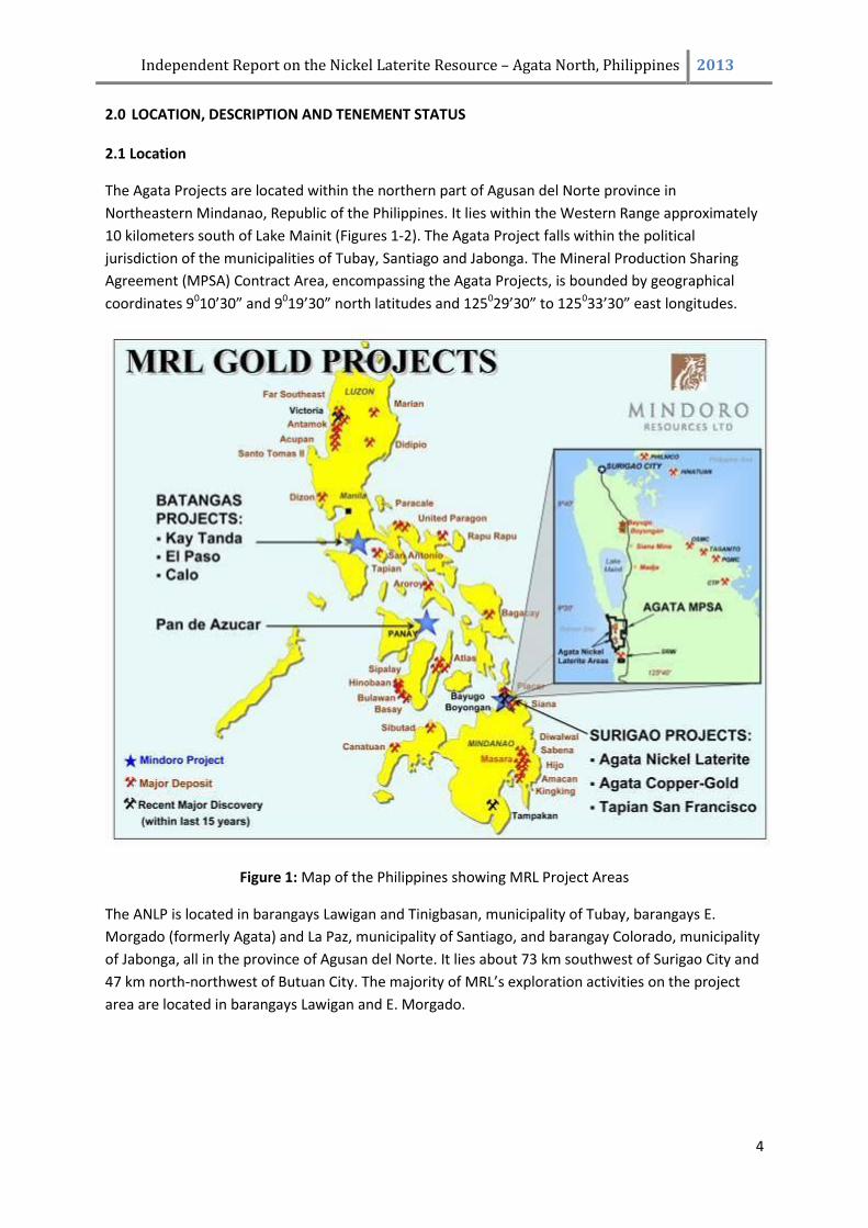
2.0 LOCATION, DESCRIPTION AND TENEMENT STATUS 2.1 Location
The Agata Projects are located within the northern part of Agusan del Norte province in
Northeastern Mindanao, Republic of the Philippines. It lies within the Western Range approximately
10 kilometers south of Lake Mainit (Figures 1-2). The Agata Project falls within the political
jurisdiction of the municipalities of Tubay, Santiago and Jabonga. The Mineral Production Sharing
Agreement (MPSA) Contract Area, encompassing the Agata Projects, is bounded by geographical
coordinates 9010’30” and 9019’30” north latitudes and 125029’30” to 125033’30” east longitudes.
Figure 1: Map of the Philippines showing MRL Project Areas
The ANLP is located in barangays Lawigan and Tinigbasan, municipality of Tubay, barangays E.
Morgado (formerly Agata) and La Paz, municipality of Santiago, and barangay Colorado, municipality
of Jabonga, all in the province of Agusan del Norte. It lies about 73 km southwest of Surigao City and
47 km north-northwest of Butuan City. The majority of MRL’s exploration activities on the project
area are located in barangays Lawigan and E. Morgado.
Independent Report on the Nickel Laterite Resource – Agata North, Philippines 2013
5
Figure 2: MRL Tenements and Projects in the Surigao Mineral District
Independent Report on the Nickel Laterite Resource – Agata North, Philippines 2013
6
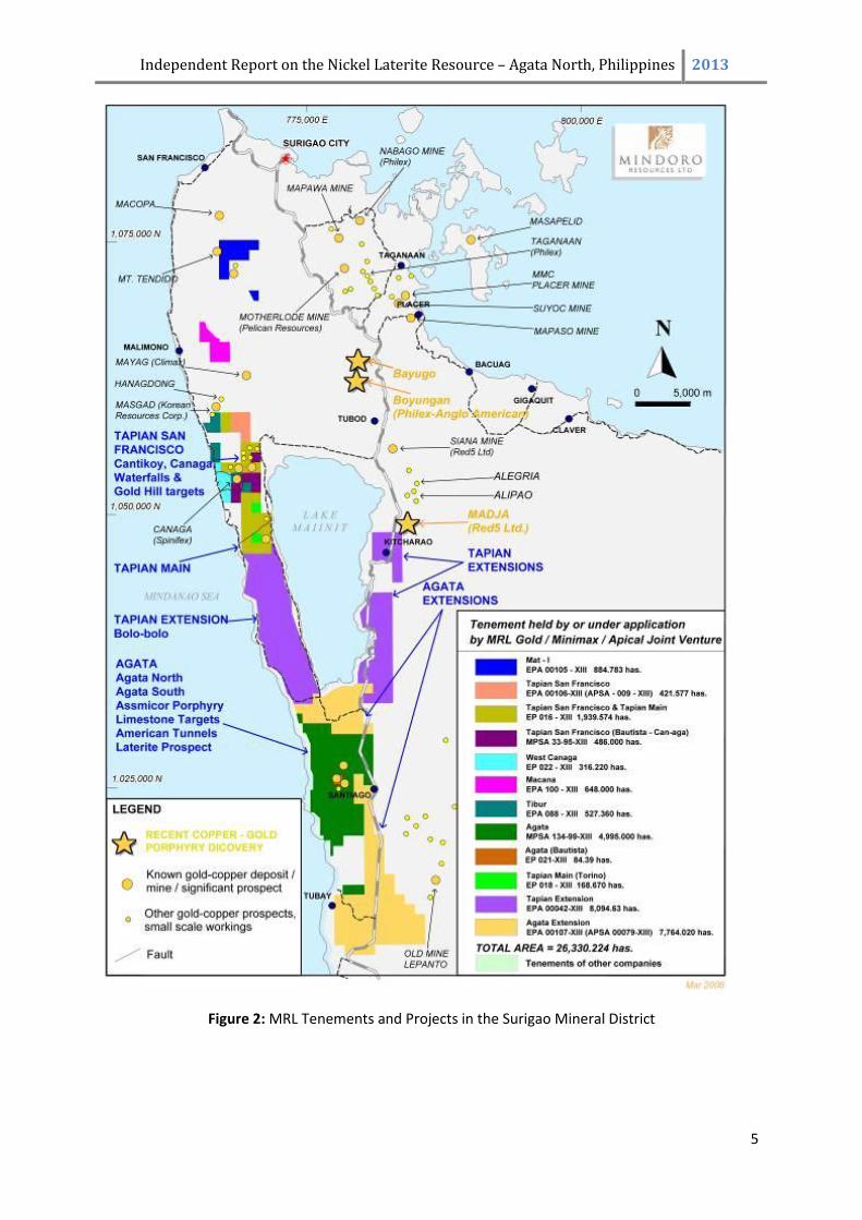
The Agata South Laterite Project (ASLP) is located in barangays Binuangan, Tagpangahoy, and
Tinigbasan, municipality of Tubay. It is under a joint venture agreement with Delta Earthmoving, Inc.
(Delta).
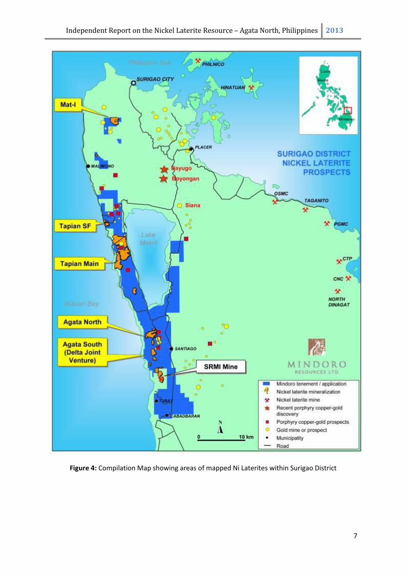
The locations of the known mineralized zones on the Agata MPSA relative to the property
boundaries are illustrated in Figure 3 and Figure 4. The ANLP mineralized zone, as defined by drilling
and mapping to date, lies entirely within the Agata MPSA. Other known nickel laterite zones exist
near the southern boundary of the property. Artisanal copper and gold mining is active in the Agata
MPSA area and are shown in Figure 3. These are outside the delineated nickel laterite mineralized
zones.
Figure 3: Map showing broad outline of ANLP and Agata Cu-Au Prospects
There are no existing mineral reserves within or near the property boundaries. The nearest mine
infrastructures, including settling ponds, are those of the SRMI Mine located in between the parcels
of the Agata MPSA at the southern boundaries (Figure 4). The National Highway runs parallel to the
length of the Agata MPSA, just outside the eastern boundary. In addition, a farm-to-market road
transects the northern portion of the MPSA area, near the Tubay River.
2.2 Property Description
The ANLP area is part of the Agata Projects and is covered by the approved MPSA of Minimax
denominated as MPSA 134-99-XIII, which is comprised of 66 blocks covering an area of 4,995
hectares (ha) (Figure 2). To the southeast of the ANLP area, and surrounded by the Minimax MPSA,
is the Estrella Bautista Exploration Permit (EP) Area denominated as EP 00021-XIII, covering 84.39
Independent Report on the Nickel Laterite Resource – Agata North, Philippines 2013
7
Figure 4: Compilation Map showing areas of mapped Ni Laterites within Surigao District
Independent Report on the Nickel Laterite Resource – Agata North, Philippines 2013
8
ha. This lone claim block is also part of MRL’s Agata Projects and was acquired through an
Agreement to Explore, Develop and Operate Mineral Property. The MPSA Contract and the EP areas
are located within the Western Range in the northern part of Agusan del Norte province.
The MPSA was approved on May 26, 1999 by the Department of the Environment and Natural
Resources (DENR) and was registered on June 17, 1999 with the Mines and Geosciences Bureau
(MGB) Regional Office No. XIII in Surigao City. A MOA was signed by Mindoro and Minimax on
January 19, 1997. Mindoro assigned all its rights in the MOA to MRL on June 27, 1997. The MOA
granted MRL the exclusive and irrevocable right to earn the Option Interests in the project. At
present, MRL has earned a 75% interests in the Agata Tapian Main, and Tapian San Francisco and the
Extension Projects (tenements acquired after the finalization of the MOA) in the Surigao Mineral
District. It also has a further option to acquire an additional 25% direct and indirect participating
interest. The 2nd and 3rd exploration periods for the MPSA were July 23, 2004 to July 22, 2006 and
February 7, 2007 to February 6, 2009, respectively. The fourth exploration was granted on June 19,
2009. The Agata-Bautista-EP was approved on October 2, 2006 and the first renewal was applied for
on September 29, 2008.
Both tenements are in good standing. Since the first Exploration Period in 1999, submission of all
quarterly and annual accomplishment reports, and quarterly drilling reports; and the payment of the
mandated occupation fees were accomplished by MRL, on behalf of Minimax. The same was done
for the Agata-Bautista EP.
Table 1: Agata Project Tenements held by Mindoro: TENEMENT ID AGATA AGATA-BAUTISTA
PERMIT NUMBER MPSA-134-99-XIII EP-21-XIII
APPLICATION NUMBER APSA-XIII-007 EPA-00080-XIII
DATE FILED (MGB XIII) 4-Jul-97
DATE APPROVED 26-May-99 2-Oct-06
PERMITTEE/ APPLICANT MINIMAX BAUTISTA
LOCATION Jabonga, Santiago, & Tubay, Agusan del Norte Santiago, Agusan del Norte
AREA (ha**) 4,995.00 84.39
STATUS
- 4th Exploration Pd. approved-June 19, 2009 1st renewal of EP filed on 29-Sep-08
-ECC granted May 20, 2008
MPSA - Mineral Production Sharing Agreement EP - Exploration Permit
APSA - Application for Mineral Production Sharing Agreement EPA - Exploration Permit Application
The boundaries of these tenements were located by the claimowners on a topographic map and
submitted to the MGB-DEMR for approval. A tenement boundary survey approved by the MGB will
be required through an “Order to Survey” once a mining project feasibility study has been submitted
Independent Report on the Nickel Laterite Resource – Agata North, Philippines 2013
9
by the proponent. The coordinates used by Mindoro are those indicated in the MPSA document
issued by the MGB. The surveyed drillhole collars are tied to a local grid, which in turn is tied to
National Mapping and Resource Information Authority (NAMRIA) satellite/GPS points and
benchmarks.
The original area of the MPSA was 7,679 ha comprising 99 blocks, but 32 claim blocks with an
approximate area of 2,700 ha were later relinquished. This leaves 4,995 ha of the approved Contract
area as of May 18, 2000. The details of the original 99 claim blocks may be referenced on Item 6.2,
pages 11-13 of the January 22, 2009 NI 43-101 Report on the Agata North Nickel Laterite Project
available on sedar.com and Mindoro’s website.
With the issuance of an MPSA covering the Agata Projects, the landuse classification of the area is
therefore for mineral production. Those outside the Contract area are essentially classified as
timberland. There are no dwellers within the ANLP and ASLP drilling areas. The author is not aware
of any environmental liabilities to which the property is subject other than those that fall under the
Philippine Mining Act of 1995.
On May 20, 2008, an Environmental Compliance Certificate (ECC) was issued by the DENR to MRL for
nickel laterite mineral production covering 600 ha within the Agata MPSA Contract area, including
both the Agata North and Agata South projects.
The barangay (village) centers where the projects are located, are mostly populated by Christians.
There are some indigenous peoples (IP) that live in the surrounding areas within and outside the
Minimax MPSA Contract area. Sitio Coro, Bgy. Colorado is almost entirely populated by IPs while
other IP groups have merged with the non-IP inhabitants in barangays E. Morgado and La Paz,
municipality of Santiago, and Bgy. Tagmamarkay, Tubay.
MRL, through the assistance of the National Commission on Indigenous Peoples (NCIP) - Regional
Office No. XIII, has signed a Memorandum of Agreement with the IPs living within the MPSA
Contract Area in 2008 albeit the latter have neither Certificate of Ancestral Domains Claim (CADC)
nor Certificate of Ancestral Domains Title (CADT) within the Contract area. The MOA calls for a 1%
royalty on gross sales of mineral products to be given to the IPs as provided for in the Indigenous
Peoples Reform Act (IPRA) of the Republic of the Philippines.
Areas of nickel laterite mineralization have been mapped at a regional scale in the ASLP located in
the southern part of the Agata Projects and are the subject of a Mining Services Agreement between
MRL, Minimax and Delta. No drilling or sampling has been carried out in this area prior to the
negotiations with Delta. Delta, at its sole cost and risk, may carry out exploration of the ASLP and
may select an area of up to 250 ha to advance to production if warranted.
2.3 Tenement Type
An MPSA is a form of Mineral Agreement, for which the government grants the contractor the
exclusive right to conduct mining operations within, but not title over, the contract area during a
defined period. Under this agreement, the Government shares in the production of the Contractor,
whether in kind or in value, as owner of the minerals. The total government share in a mineral
production sharing agreement shall be the excise tax on mineral products. The excise tax is 2% of the
Independent Report on the Nickel Laterite Resource – Agata North, Philippines 2013
10
actual market value of the gross output at the time of extraction. In return, the Contractor shall
provide the necessary financing, technology, management and personnel for the mining project.
Allowable mining operations include exploration, development and utilization of mineral resources.
The approved MPSA has a term not exceeding 25 years from the date of the execution thereof and
renewable for another term not exceeding 25 years. It gives the right to the Contractor to explore
the MPSA area for a period of 2 years renewable for like periods but not to exceed a total term of 8
years, subject to annual review by the Director to evaluate compliance with the terms and
conditions of the MPSA.
The Contractor is required to strictly comply with the approved Exploration and Environmental Work
Programs together with their corresponding budgets. These work programs are submitted by the
Contractor as requirements in securing the renewal of the Exploration Period within the MPSA term.
The Contractor is likewise required to submit quarterly and annual accomplishment reports under
oath on all activities conducted in the Contract Area. All the reports submitted to the Bureau shall be
subject to confidentiality clause of the MPSA. The Contractor is further required to pay at the same
date every year reckoned from the date of the first payment, to the concerned Municipality an
occupation fee over the Contract Area amounting to PhP 75.00 per hectare. If the fee is not paid on
the date specified, the Contractor shall pay a surcharge of 25% of the amount due in addition to the
occupation fees.
If the results of exploration reveal the presence of mineral deposits economically and technically
feasible for mining operations, the Contractor, during the exploration period, shall submit a
Declaration of Mining Project Feasibility together with a Mining Project Feasibility Study, a Three
Year Development and Construction or Commercial Operation Work Program, a complete geologic
report of the area and an Environmental Compliance Certificate (ECC). Failure of the Contractor to
submit a Declaration of Mining Project Feasibility during the Exploration Period shall be considered a
substantial breach of the MPSA.
Once the ECC is secured, the Contractor shall complete the development of the mine including
construction of production facilities within 36 months from the submission of the Declaration of
Mining Project Feasibility, subject to such extension based on justifiable reasons as the Secretary
may approve, upon the recommendation of the Regional Director, through the MGB Director.
Any portion of the contract area, which shall not be utilized for mining operations, shall be
relinquished to the Government. The Contractor shall also show proof of its financial and technical
competence in mining operations and environmental management.
On February 2005, the Philippine Supreme Court decided with finality allowing for the 100% foreign
ownership of the mineral tenement under the Financial and Technical Assistance Agreement (FTAA).
An Exploration Permit (EP) is an initial mode of entry in mineral exploration allowing a Qualified
Person to undertake exploration activities for mineral resources in certain areas open to mining in
the country. Any corporation may be allowed a maximum area of 32,400 ha in the entire country.
The term of an EP is for a period of two (2) years from date of its issuance, renewable for like periods
but not to exceed a total term of four (4) years for nonmetallic mineral exploration or six (6) years
for metallic mineral exploration. Renewal of the Permit is allowed if the Permittee has complied with
Independent Report on the Nickel Laterite Resource – Agata North, Philippines 2013
11
all the terms and conditions of the Permit and he/she/it has not been found guilty of violation of any
provision of “The Philippine Mining Act of 1995” and its implementing rules and regulations.
Likewise, the conduct of a feasibility study and filing of the declaration of mining project feasibility
are undertaken during the term of the Permit.
3.0 REGIONAL CLIMATE, RESOURCES, INFRASTRUCTURE, PHYSIOGRAPHY AND ACCESS
3.1 Climate
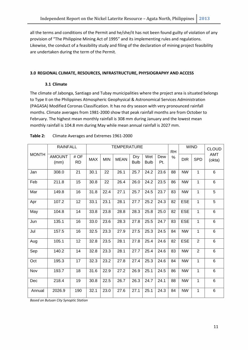
The climate of Jabonga, Santiago and Tubay municipalities where the project area is situated belongs
to Type II on the Philippines Atmospheric Geophysical & Astronomical Services Administration
(PAGASA) Modified Coronas Classification. It has no dry season with very pronounced rainfall
months. Climate averages from 1981-2000 show that peak rainfall months are from October to
February. The highest mean monthly rainfall is 308 mm during January and the lowest mean
monthly rainfall is 104.8 mm during May while mean annual rainfall is 2027 mm.
Table 2: Climate Averages and Extremes 1961-2000
MONTH
RAINFALL TEMPERATURE
RH
%
WIND CLOUD
AMT
(okta) AMOUNT
(mm)
# OF
RD MAX MIN MEAN
Dry
Bulb
Wet
Bulb
Dew
Pt. DIR SPD
Jan 308.0 21 30.1 22 26.1 25.7 24.2 23.6 88 NW 1 6
Feb 211.8 15 30.8 22 26.4 26.0 24.2 23.5 86 NW 1 6
Mar 149.8 16 31.8 22.4 27.1 25.7 24.5 23.7 83 NW 1 5
Apr 107.2 12 33.1 23.1 28.1 27.7 25.2 24.3 82 ESE 1 5
May 104.8 14 33.8 23.8 28.8 28.3 25.8 25.0 82 ESE 1 6
Jun 135.1 16 33.0 23.6 28.3 27.8 25.5 24.7 83 ESE 1 6
Jul 157.5 16 32.5 23.3 27.9 27.5 25.3 24.5 84 NW 1 6
Aug 105.1 12 32.8 23.5 28.1 27.8 25.4 24.6 82 ESE 2 6
Sep 140.2 14 32.8 23.3 28.1 27.7 25.4 24.6 83 NW 2 6
Oct 195.3 17 32.3 23.2 27.8 27.4 25.3 24.6 84 NW 1 6
Nov 193.7 18 31.6 22.9 27.2 26.9 25.1 24.5 86 NW 1 6
Dec 218.4 19 30.8 22.5 26.7 26.3 24.7 24.1 88 NW 1 6
Annual 2026.9 190 32.1 23.0 27.6 27.1 25.1 24.3 84 NW 1 6
Based on Butuan City Synoptic Station
Independent Report on the Nickel Laterite Resource – Agata North, Philippines 2013
12
3.2 Local Resources and Infrastructure
A farm-to-market road was constructed by MRL in 2005 and is currently servicing three (3)
barangays in two (2) towns. This road was turned-over to the local government. Road maintenance
is being supported by the company.
The drill site and the whole plateau is a fern-dominated (bracken heath) open grassland sparsely
interspersed with forest tree seedlings and saplings of planted species. A few secondary growth
trees line the streams along the lower slopes. The floodplain of Tubay River is planted with
agricultural crops such as rice, corn, banana, squash, etc.
3.3 Physiography
Most part of the Agata Projects spans the NNW-SSE-trending Western Range, which towers over the
Mindanao Sea to the west and Tubay River to the east, which drains southward from Lake Mainit.
The western part of the area is characterized by a rugged terrain with a maximum elevation of 528
meters above sea level. This part is characterized by steep slopes and deeply-incised valleys. The
eastern portion, on the other hand, is part of the floodplain of Tubay River, which is generally flat
and low-lying, and has an elevation of less than 30m above sea level.
Within the project area, steep to very steep slopes are incised by gullies and ravines while the
central portion is characterized by broad ridges dissected in the west section by a matured valley
formation exhibiting gentle to moderate slopes. Elevations range from 200-320m above sea level
extending similar topographic expressions going to the south. In the northern expanse, it abruptly
changes to rugged terrain having very steep slopes. Nickel enriched laterite is widespread on the
ridges stretching from the central part going to the south.
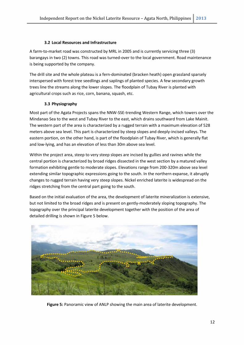
Based on the initial evaluation of the area, the development of laterite mineralization is extensive,
but not limited to the broad ridges and is present on gently-moderately sloping topography. The
topography over the principal laterite development together with the position of the area of
detailed drilling is shown in Figure 5 below.
Figure 5: Panoramic view of ANLP showing the main area of laterite development.
Independent Report on the Nickel Laterite Resource – Agata North, Philippines 2013
13
3.4 Access
The ANLP site is accessible by any land vehicle from either Surigao City or Butuan City via the Pan-
Philippine Highway. At the highway junction at Barangay Bangonay, Jabonga, access is through partly
cemented, gravel-paved Jabonga Municipal road for approximately 4 km, then for another 6 km thru
a farm-to-market road to Barangay E. Morgado in the municipality of Santiago. From Manila, daily
flights are available going to Butuan City. Moreover, commercial sea transport is available en-route
to Surigao City and Nasipit (west of Butuan City) ports.
An alternate route is available from the Pan-Philippine Highway via the Municipality of Santiago.
From Santiago town proper, barangay E. Morgado can be accessed through a 1.5 km municipal-
barangay road going to Bgy. La Paz, thence by pump boats. The travel time is about 15 minutes via
the Tubay River.
The northern portion of the ANLP can be reached from Bgy. E. Morgado by hiking for about 1 hour
along existing foot trails (approximately 1.5 km).
4.0 HISTORY The earliest recognized work done within the area is mostly from government-related projects
including:
The Regional Geological Reconnaissance of Northern Agusan reported the presence of gold claims in the region (Teves et al. 1951). Mapped units include sedimentary rocks (limestone, shale and sandstone) of Eocene to mid-Tertiary age.
Geologists from the former Bureau of Mines and Geosciences Regional Office No. X (BMG-X) in Surigao documented the results of regional mapping in the Jagupit Quadrangle within coordinates 125°29´E to 125°45´ east longitude and 9°10´ to 9°20´ north latitudes. The geology of the Western Range was described as a belt of pre-Tertiary metasediments, metavolcanics, marbleized limestone, sporadic schist and phyllite and Neogene ultramafic complex. (Madrona, 1979) This work defined the principal volcano-sedimentary and structural framework of the region and recognized the allochtonous nature of two areas of ultramafic rocks that comprise serpentinized peridotite in the Western Range, one between the Asiga and Puya rivers in the Agata project area and the other west of Jagupit. These were mapped by Madrona (1979) as blocks thrust westward, or injected into the metavolcanics between fault slices.
The United Nations Development Program (UNDP, 1982) conducted regional geological mapping at 1:50,000 scale and collected stream sediment samples over Northern Agusan. The UNDP report of 1984 described the geological evolution of this region and included a detailed stratigraphic column for the Agusan del Norte region. Two anomalous stream sediment sites were defined near the Agata project during this phase of work. The Asiga porphyry system that lies east of the Agata tenements was explored by Sumitomo Metal Mining Company of Japan in the 1970’s and 1980’s (Abrasaldo 1999).
La Playa Mining Corporation, financed by a German company in the late 1970’s, explored within the
Agata Project area for chromiferrous laterite developed over weathered ultramafic rocks. There
were five (5) test pits dug in the area.
Independent Report on the Nickel Laterite Resource – Agata North, Philippines 2013
14
In 1987, Minimax conducted reconnaissance and detailed mapping and sampling. Geological
mapping at 1:1,000 scale was undertaken in the high-grading localities, and an aerial photographic
survey was conducted and interpreted. MRL established a mining agreement with Minimax in
January 1997, and commenced exploration in the same year.
Several artisanal miners are active within the project site since the 1980’s up to the present. These
miners are conducting underground mining operations at the Assmicor and American Tunnels area
and gold panning of soft, oxidized materials within Assmicor and Lao Prospect areas and of
sediments in major streams including that of Tubay River. The region of small-scale mining activity
was later named “Kauswagan de Oro” (translated: “progress because of gold”). The majority
subsequently left the region for other high-grading areas in Mindanao. In more recent years, a group
of copper “high-graders” emerged in the American Tunnels area mining direct-shipping grade copper
ore. However, this new trend waned due to the softening of metal prices in the latter part of 2008.
5.0 GEOLOGY
5.1 Regional Geology
The principal tectonic element of the Philippine archipelago is the elongate Philippine Mobile Belt
(PMB – Rangin, 1991) which is bounded to the east and west by two major subduction zone systems,
and is bisected along its north-south axis by the Philippine Fault (Figure 6). The Philippine Fault is a
2000 km long sinistral strike-slip wrench fault. In the Surigao district, this fault has played an
important role in the development of the Late Neogene physiography, structure, magmatism and
porphyry copper-gold plus epithermal gold metallogenesis. There has been rapid and large-scale
uplift of the cordillera in the Quaternary, and limestone of Pliocene age is widely exposed at 1000-
2000 meters elevation (Mitchell and Leach 1991). A cluster of deposits on the Surigao Peninsula in
the north consists chiefly of epithermal gold stockwork, vein and manto deposits developed in
second-order splays of the Philippine Fault (Sillitoe 1988). The mineralization-associated igneous
rocks in Surigao consist mostly of small plugs, cinder cones and dikes dated by K-Ar as mid-Pliocene
to mid-Pleistocene (Mitchell and Leach 1991; Sajona et al. 1994; B.D.Rohrlach, 2005).
The basement rocks consist of the Concepcion greenschist and metamorphic rocks of Cretaceous
age overthrusted by the pillowed Pangulanganan Basalts of Cretaceous to Paleogene age, which in
turn, were overthrust by the Humandum Serpentinite. Its emplacement probably occurred during
the late Cretaceous. The Humandum Serpentinite occupies a large part in the tenement area, and
through its subsequent weathering the area has a high potential for nickel laterite mineralization.
(Tagura, et.al., 2007).
The Humandum Serpentinite is overlain by Upper Eocene interbedded limestone and terrigenous
clastic sediments of the Nabanog Formation. These are in turn overlain by a mixed volcano-
sedimentary package of the Oligocene Nagtal-O Formation, which comprises conglomeratic
andesite, wacke with lesser pillow basalt and hornblende andesite, and the Lower Miocene Tigbauan
Formation. The latter is comprised of conglomerates, amygdaloidal basalts, wackes and limestones.
Intrusive events associated with the volcanism during this period resulted in the emplacement of
Independent Report on the Nickel Laterite Resource – Agata North, Philippines 2013
15
Figure 6: Geological Map of Surigao Mineral District
Independent Report on the Nickel Laterite Resource – Agata North, Philippines 2013
16
plutons and stocks that are associated with porphyry copper-gold and precious metal epithermal
mineralization in the region. (Tagura, et.al., 2007)
Lower Miocene Kitcharao Limestone and the lower part of the Jagupit Formation overlie the
Tigbauan Formation. The Jagupit Formation consists of conglomeratic sandstone, mudstone and
minor limestone. The youngest stratigraphic unit is the Quaternary Alluvium of the Tubay River
floodplain.
Mineral deposits within the region are dominated by epithermal precious metal deposits and
porphyry copper-gold. There is a rather close spatial and probably genetic association between
epithermal precious metals and porphyry deposits. These deposits exhibit strong structural control.
First order structures are those of the Philippine Fault system, which play a role in the localization of
the ore deposits, while the second order structures that have developed as a result of the
movement along the Philippine Fault system are the most important in terms of spatial control of
ore deposition. (Tagura, et.al., 2007)
Other mineral deposits are related to ultramafic rocks of the ophiolite suite and comprise lenses of
chromite within harzburgite and lateritic nickel deposits that have developed over weathered
ultramafic rocks.
5.2 Local Geology
The Agata Projects area is situated along the southern part of the uplifted and fault-bounded
Western Range on the northern end of the east Mindanao Ridge. The Western Range is bounded by
two major strands of the Philippine Fault that lie on either side of the Tubay River topographic
depression (B. Rohrlach, 2005). The western strand lies offshore on the western side of the Surigao
Peninsula, whereas the eastern strand, a sub-parallel splay of the Lake Mainit Fault, passes through a
portion of the property and separates the Western Range from the Central Lowlands to the east
(Figure 7). These segments have juxtaposed lithologies consisting of at least six rock units including
pre-Tertiary basement cover rocks, ophiolite complex, clastic limestone and late-stage Pliocene calc-
alkaline intrusive rocks. (Tagura, et.al., 2007)
The rock units within the ANLA from oldest to youngest are discussed below:
Concepcion Greenschist (Cretaceous)
The basement sequence on the property comprises greenschists, correlative to the Concepcion
Greenschists (UNDP, 1984), which occur mostly in the central to southern portions of the Agata
Project. This rock outcrops in Guinaringan, Bikangkang and Agata Creek as long, elongated bodies. In
the northern half, this unit is mapped as narrow, scattered erosional windows. The predominant
minerals are quartz, albite, and muscovite with associated chlorite, epidote and sericite. In places,
talc and serpentine are the main components. (Tagura, et.al., 2007) The exposure of the schist by
the late Eocene implies a metamorphic age of Paleocene or older and a depositional age of early
Cretaceous. (UNDP, 1984)
Independent Report on the Nickel Laterite Resource – Agata North, Philippines 2013
17
Figure 7: Local Geological Map of Agata North Project Area
Independent Report on the Nickel Laterite Resource – Agata North, Philippines 2013
18
Humandum Ultramafic (Cretaceous?)
Ultramafic rocks unconformably overlie the basement schist and formed as conspicuously
peneplaned raised ground on the property area. These are comprised of serpentinites, serpentinized
peridotites, serpentinized pyroxenites, serpentinized harzburgites, peridotites, pyroxenites and
lesser dunite, which are fractured and cross-cut by fine networks of talc, magnesite and/or calcite
veins. These rocks are usually grayish-green, medium- to coarse-grained, massive, highly-sheared
and traversed by meshwork of serpentine and crisscrossed by talc, magnesite and calcite veinlets.
The serpentinites in the Agata Projects correlate with the Humandum Serpentinite (B. Rohrlach,
2005). The Humandum Serpentinite was interpreted by UNDP (1984) to be emplaced over the
Concepcion greenschists probably before the Oligocene, and before late Eocene deposition of the
Nabanog Formation. MGB (2002) classified the Humandum Serpentinite as a dismembered part of
the Dinagat Ophiolite Complex, which is established to be of Cretaceous age.
These rocks have potential for nickel due to nickel-enrichment in the weathering profile as observed
in its deep weathering into a reddish lateritic soil. (B. Rohrlach, 2005).
Nabanong Limestone (Upper Eocene)
Several bodies of limestone correlative to the Nabanog Formation (UNDP 1984), were mapped in the
project area. The easternmost limestone body lies in the Assmicor-Lao prospect region, in the
central portion of the property, Guinaringan-Bikangkang area and at Payong-Payong area located at
the western side. In the northern half of the property, these limestones occur as narrow scattered
bodies probably as erosional remnants. In places, this unit exhibits well-defined beddings and
schistosity and crisscrossed by calcite ± quartz veinlets. The limestones outcropping near intrusive
bodies are highly-fractured with limonite and fine pyrite, associated with gold mineralization in
fractures and show green hue due to chloritization. In places, the limestone is interbedded with thin
sandstone, siltstone, and shale beds.
Andesite and Tuff (Oligocene)
Sparsely distributed across the property are narrow bodies of andesite and tuff. Towards the vicinity
of Peak 426 at the northwestern part, the andesite occurs as a volcanic edifice. It is generally fine-
grained to locally porphyritic in texture. The tuff grades from crystal tuff to lithic lapilli. Several
exposures of this unit are described by Abrasaldo (1999) as being strongly fractured adjacent to
northeast-trending faults.
Volcanic Intrusives (Upper Oligocene to Lower Miocene)
A series of intrusives of alkalic and calc-alkaline composition occur in close vicinity to Lake Mainit
Fault. These include syenites, monzonites, monzodiorites and diorites that are closely associated
with gold mineralization as most of the workings and mining activities are concentrated within the
vicinity of these intrusive rocks. The syenites are well-observed in the American and Assmicor
tunnels and consist mostly of potash feldspar. The monzonites are noted in the Lao Area, in the
Independent Report on the Nickel Laterite Resource – Agata North, Philippines 2013
19
American Tunnel and occasionally along Duyangan Creek. Monzodiorite outcrops in the Kinatongan
and Duyangan creeks and sparsely in the American Tunnel. Trachyte to trachyandesite porphyry is
noted in the Kinatongan Creek. Diorites were observed in the American and Assmicor tunnels, which
occur mostly as dikes. The intrusions in the Lao and American Tunnel prospects have been
tentatively correlated with the Mabaho Monzonite (UNDP, 1984).
Kitcharao Limestone (Lower Miocene)
Correlatives of the Kitcharao limestone are scattered through large areas of the Agata Projects area.
Minor outcrops of the Jagupit Formation lie in the eastern claim block adjacent to barangay
Bangonay (Abrasaldo, 1999).
Recent Alluvium
Quaternary Alluvium underlies the Tubay River floodplain, within the valley between the Western
Range and the Eastern Highlands.
5.3 Laterite Ni Deposit Geology
The widespread occurrence of harzburgite, peridotite, pyroxenite, their serpentinized equivalents,
serpentinite, and localized lenses of dunite/serpentinized dunite comprise the lithology in the
project area. These rocks are confined to broad ridges extending down to the footslopes of the
Western Range. The ultramafic bodies are of probable late Cretaceous age, and were emplaced as
part of an ophiolite sequence during the Upper Eocene (Abrasaldo, 1999). Schists are also present in
the extremities of the laterite area. Several of these rock types were likewise identified in
petrographic/mineragraphic analyses of drill core and rock samples as wehrlite (peridotite),
serpentinized wehrlite, serpentinized websterites (pyroxenite), websterites, serpentinites and
cataclasite. The location of these samples is shown in Figure 7. Lineaments trending NE within the
ultramafic (and underlying green schist?) are interpreted as either fault splays or zones of weakness
in the area.
Geological mapping in the project area showed favorable development of laterite along the broad
ridges characterized by peneplane topography. These areas are where the drilling activities are
concentrated. In areas with moderate to semi-rugged topography, erosion proceeds much faster
than soil development, hence the laterite is thinner.
In the Agata Project, there are two distinct geomorphic features that have influenced laterite
formation and consequent nickel enrichment. The Eastern part of the delineated body has a
moderate relief whose bedrocks are exposed in ridge tops and in the nearby creeks. On the other
hand, the Western laterite occurs on a low relief terrain and with no exposures of bedrock on its
hillcrests. In the Western area, the laterite is well developed and contains thick and highly
mineralized limonite/saprolite and transition rocks. The Eastern Laterite Zones contain boulders
across the laterite profile suggesting transport. Its limonite zone is usually thinner. (A. Buenavista,
2008).
Independent Report on the Nickel Laterite Resource – Agata North, Philippines 2013
20
Test pits that were previously excavated by a previous company showed a maximum depth of 9.40
m and an average depth of 4.96 m. All these test pits have bottomed in limonite. Drilling done by
QNI, Phils. (QNPH) and MRL showed thicker laterite profile than what was revealed by previous test
pitting.
5.4 Other Deposit Type Geology – Agata
The Surigao Mineral District is host to several deposit types. The Philippine Fault has played an
important role in the development of the Late Neogene physiography, structure, magmatism and
porphyry Cu-Au plus epithermal Au metallogenesis. An intense clustering of porphyry Cu-Au and
epithermal Au deposits occurs along the Eastern Mindanao Ridge.
There is a strong structural control on the distribution of Cu-Au deposits in the Surigao district, and a
clear association of deposits and mineral occurrences with high-level intrusives and subvolcanic
bodies. Most of the centers of mineralization are located along NNW-SSE-trending second-order
fault splays of the Philippine Fault, and where these arc-parallel structures are intersected by
northeast-trending cross-faults. The Tapian-San Francisco property lies in a favorable structural
setting at the district-scale, at the intersection between multiple strands of a NE-trending cross-
structure and the Lake Mainit Fault. This same NE-trending structural axis encapsulates both the
Boyongan porphyry deposit and the Placer epithermal gold deposits. (B. Rohrlach, 2005)
Most of the known hydrothermal gold mineralization within the district is of low-sulfidation
epithermal character developed in second-order splays of the Philippine Fault. The mineralization is
predominantly of Pliocene age and is spatially and temporally associated with the Mabuhay
andesitic volcanism. Epithermal mineralization tends to be confined to the Mabuhay Clastics and
associated andesitic stocks, lavas and pyroclastics, and in older rocks immediately beneath the
unconformity at the base of the Mabuhay Clastics. The principal low-sulfidation epithermal-type,
carbonate-replacement-type and porphyry-type deposits and occurrences include: vein-type
(Tabon-Tabon vein, Plancoya vein); bulk-mineable stringer stockworks (Placer, Motherlode, Mapaso,
Nabago); stratabound ore or carbonate-hosted (Siana mine); surface workings in argillized zones
(Mapawa, Hill 664, Manpower, Layab, Gumod); placer gold (Malimono-Masgad region); porphyry
Cu-Au (Boyongan, Bayugo, Asiga and Madja); high-level porphyry-style alteration (Masgad,
Malimono, Tapian-San Francisco) and high sulfidation (Masapelid Island). (B.D. Rohrlach, 2005)
The principal deposit types that are being explored for in the Agata tenement area are:
Porphyry Cu-Au of calc-alkaline or alkaline affinity
Low-sulfidation epithermal Au
Carbonate-hosted Disseminated Au-Ag Ore
Skarn Au-(Cu)
Nickeliferrous Laterite
The first four deposit types collectively belong to the broad family of magmatic-hydrothermal Cu-Au
deposits that form above, within and around the periphery of high-level intrusive stocks of hydrous,
oxidized, calc-alkaline to potassic alkaline magmas that are emplaced at shallow levels in the crust of
active volcanic arcs. These different deposit types form at different structural levels of magmatic
intrusive complexes, and their character is governed by a multiplicity of factors that include depth of
Independent Report on the Nickel Laterite Resource – Agata North, Philippines 2013
21
magmatic degassing, degassing behavior, host-rock lithology and structural preparation. (B.D.
Rohrlach, 2005)
The Agata Projects area has high potential for the presence of one or more porphyry-type Cu-Au
hydrothermal systems associated with 3 principal targets, and multiple satellite targets, that are
associated with zones of high IP chargeability. Porphyry-style mineralization has been encountered
previously in the Agata region by shallow drill holes in targets that are associated with modest IP
chargeability anomalies. The Agata Projects possess multiple conceptual target styles such as
porphyry, epithermal, Carlin-type and Ni-laterite (Figure 3).
American Tunnels is a small erosional window through ultramafic cap rocks. It is in the center of a six
kilometer trend of chargeability anomalies and at a point where the chargeability is near-surface,
and actually daylights. It is also associated with extensive alteration, geochemical anomalies, and
abundant gold and copper-gold showings. American Tunnels is characterized by a chargeability
anomaly, extending over 800 meters by 300 meters. There are over 100 shallow artisanal mines and
workings within the trend, but mineralization is mostly obscured by ultramafic cap rock of variable
thickness. Where the mineralization is exposed, younger gold mineralization is telescoped into
interpreted porphyry copper-gold related mineralization (Figure 3).
Mineralization is at the top of multi-phase intrusives, on the cusp of the chargeability anomaly, and
is interpreted as a high-grade, late-stage concentration at the upper contact of the intrusive stocks
and dykes, and derived from porphyry copper-gold mineralization below. Petrology indicates
mineralization is principally within late, more-fractionated monzonite phases of a syenite,
monzonite, monzodiorite and diorite intrusive complex of dykes, sills, and small stocks intruding
ultramafic rocks. Mineralization is associated with complex alteration assemblages of chlorite,
epidote, actinolite, biotite ± k-feldspar, sericite, magnetite and albite. Copper minerals are
chalcopyrite and bornite. These features, as well as the high molybdenum values, are consistent with
a porphyry copper-gold setting.
Gold is mined from a honeycombing of shallow (5 to 20 meters) underground workings, estimated to
be several hundred meters in extent, within an area of about 200 meters by 225 meters at American
Tunnels. Free gold is also present in streams draining ultramafic cap rocks several hundred meters
north of American Tunnels. There are also dozens of artisanal gold workings within other erosional
windows to the south on the Agata Project.
Having artisanal workings producing both gold and copper throughout the local region indicates that
there is significant opportunity within the project area and provides Mindoro with significant
opportunity outside of the Ni Laterite resource defined in this report.
Independent Report on the Nickel Laterite Resource – Agata North, Philippines 2013
22
6.0 MINERALIZATION Nickeliferrous laterite deposits are present over a broad region in the Agata Projects area (Figure 4).
They are divided into two (2) major areas known as the ANLP and the ASLP. Based on mapping, the
former has an area of approximately 286 hectares while the latter comprises about 235 hectares. In
the ANLP, drilling is concentrated in about eighty (80) percent of the interpreted nickel laterite
mineralization to date.
The laterites are developed over ultramafic rocks that lie along the Western Range. The rock types
within the ultramafics are harzburgite, serpentinized harzburgite, peridotite, serpentinized
peridotite, pyroxenite, serpentinized pyroxenite, serpentinite with localized lenses of
dunite/serpentinized dunite. The ultramafic bodies are of probable Cretaceous age, and were
emplaced as part of an ophiolite sequence during the Upper Eocene (Abrasaldo, 1999). Formation of
the laterites is thought to have occurred during the Pliocene or early Pleistocene. The largest of the
laterite bodies overlies the central ultramafic body (Figure 7).
Initially, MRL undertook aerial photograph interpretations and field inspections, to define areas of
potential laterite formation. The soil profile is intensely ferruginous in this region, and relic cobbles
of intensely fractured and serpentinized ultramafic rock lie scattered throughout the region of
observed laterite development. At higher elevations along the topographic divide, ferruginous
pisolites and blocks of lateritic crust were observed developed on an ultramafic protolith.
Nickel laterites are the products of laterization or intense chemical weathering of the ultramafic
rocks, especially the olivine-rich varieties like harzburgite and dunite. The high rainfalls and intense
weathering breaks down the easily weathered harzburgite and dunite and the more mobile
elements of Mg and Si tend to leave the profile at a much faster rate than the less mobile Fe and
Ni/Co. Thus high Fe laterite and limonite zones overlie the weathering saprolite of the ultramafic
rocks and where erosion of the upper Fe laterite is low quite deep depths can be formed (<10m).
The Ni mineralization is predominantly at the base of the Fe laterite and the top of the saprolite, as
this mineral is concentrated in minerals that can hold it within their matrix (limonite and to a lesser
degree hematite, goethite and Fe-rich clays in the Fe Laterite, and more primary Mg rich clays
(saponite and stevensite) in the ultramafic saprolite. When weathering is very deep, in zones of
interpreted crush or fault zones, then more Ni can be located in the Fe laterite, but predominantly
the largest Ni enrichment is within the saprolite of the underlying ultramafic rock near the contact
zone with the Fe laterite.
Within the saprolitic ultramafic there are areas of more weathering resistant “boulders” and these
tend to carry less Ni mineralization than the surrounding more degraded saprolite – this is related to
the lower level presence of the Mg rich clays and their capacity to carry Ni and Co within their
structure.
Patches of garnierite are present within the saprolite. Abundant garnierite was observed in a trench
along the slopes on the western portion of ANLP.
Independent Report on the Nickel Laterite Resource – Agata North, Philippines 2013
23
7.0 EXPLORATION All exploration work on the Agata Project carried out by Mindoro was under the direct supervision of
James A. Climie, P.Geol., Exploration Manager. Local staff formed the exploration team with
qualified geologists logging all drill core and the site manager also being a qualified geologist.
7.1 MRL General Exploration (1997-2000)
Initial work by MRL on the Agata Project from 1997 to 2000 comprised a geological evaluation
conducted by Marshall Geoscience Services Pty Ltd. It was part of a due-diligence assessment of the
property prior to entering into a Joint Venture with Minimax. This work suggested that hydrothermal
gold mineralization at Agata is related to andesitic or dioritic intrusives, that vein mineralization is
representative of the upper levels of a porphyry system and that there is prospectivity for skarn
mineralization within limestones on the property (Marshall, 1997; Climie et al., 2000).
The 1st phase of exploration activity commenced in May 1997 in the Assmicor region and consisted
of grid establishment followed by soil geochemical survey (1,617 soil samples analyzed for Au, Ag,
Cu, Pb, Zn, As), geological mapping plus selective rockchip sampling and petrographic studies.
Furthermore, DOZ technologies of Quebec, Canada, interpreted a RadarSat image of the Agata area
and generated a 1:50,000 scale interpretation of the region. In addition, MRL re-sampled by channel
sampling, five test pits (ATP-1 to ATP-5) excavated by La Playa Mining Corporation. These pits
encountered laterite thicknesses of 2.48 to 9.40 meters. The composited assay values for each of the
re-sampled test pits range from 0.43% to 0.94% nickel.
The 2nd phase of exploration activities on the Agata Projects was undertaken between June 1999
and December 1999. This included grid re-establishment, geological mapping within the Assmicor
Prospect and American Tunnels, ground magnetic survey, soil geochemistry (50 samples), rock/core
sampling, petrography and drilling of 11 holes. (Climie et al., 2000).
The soil sampling survey generated widespread Cu and Au soil anomalies. Soil Cu anomalies tend to
be closely restricted to mapped intrusions at American Tunnels and Assmicor-Lao. Soil Au anomalies
are more widespread and extend into the surrounding and overlying carbonate rocks. In contrast,
soil As anomalies appear to be weakly developed over the intrusions but more strongly developed
over carbonates. The Cu and Au soil anomalies associated with the Assmicor-Lao prospect region
(Figures 10-11) are open to the east beneath the alluvial flood plain sediments of the Tubay River.
The potential for an extension of the Assmicor mineralization to the immediate east beneath the
Tubay River floodplain is strengthened by the observation that the dikes and intrusives encountered
in drilling at
Assmicor dip towards the east, that porphyry-like quartz veins were encountered in drillhole DH 99-
11, which lies east of the Assmicor prospect, and the evidence of a resistivity anomaly developing on
the edge of the IP survey east of the Assmicor prospect.
Independent Report on the Nickel Laterite Resource – Agata North, Philippines 2013
24
Nineteen surface channel samples were collected in the Limestone Prospect area (Figure 13). Sixteen
of these samples yielded grades ranging from 0.02 g/t Au to 0.85 g/t Au. Three of the samples
graded 2.79 g/t Au over 3.7 meters, 3.77 g/t Au over 2 meters and 1.48 g/t Au over 3 meters. The
channel samples indicate a zone of anomalous gold above 0.1 g/t in rock samples that extends over
an area of 100m by 50m in oxidized limestone.
Petrographic analyses by Comsti (1997) and Comsti (1998) reveal that the intrusive rocks at Agata
consist of alkalic, silica-undersaturated plutonic rocks. These comprise of syenites and monzonites
that display varying degrees of sericitic and propylitic alteration. Potassic feldspar is a primary
mineral phase in many of these rocks.
An in-house ground magnetic survey was conducted in 1999. The magnetic data comprised a series
of semi-continuous magnetic highs, with values >40250nT, that broadly coincide with the
distribution of ultramafic rocks along the western margin of the Lao and Assmicor areas. The
magnetic signature decreases gradually westward where the ultramafics are thought to be buried at
deeper levels beneath the limestones.
MRL drilled eleven (11) diamond drill holes into the Assmicor and Limestone prospects in 1999 and
encountered Au intersections associated with limonitic stockworks in biotite monzodiorite intrusive.
These include 18.8m @ 1.13 g/t Au and 24.2m @ 1.38 g/t Au in holes DH 99-05 and DH 99-06,
respectively. The intrusives comprise larger biotite monzodiorite bodies that are cross-cut by
younger diorite dikes, plagioclase diorite dikes, biotite diorites and quartz diorites. These dikes and
intrusive bodies dip predominantly eastward, suggesting that a deeper magmatic source lies to the
east, possibly along the trace of the Lake Mainit splay of the Philippine Fault, beneath the alluvial
floodplain of the Tubay River. Drillhole DH 99-11, collared east of the Assmicor shaft, intersected
porphyry-style quartz-magnetite veins in biotite diorite, quartz diorite and in hornblende-quartz
diorite.
7.2 MRL General Exploration (2004-2009)
MRL undertook a third phase of exploration activity in 2004 on the Agata Project. This activity
involved gridding, mapping and extensive grid-based pole-dipole induced polarization (IP)
geophysical surveying along 30 east-west-oriented survey lines that extend from 7,800 mN to 13,400
mN. The IP data were acquired by Elliot Geophysics International using a Zonge GGT-10 transmitter,
a Zonge GDP-32 receiver and a 7.5 KVA generator. A total of 77.10 km of grid were surveyed by pole-
dipole IP. The dipole spacing used in the survey was 150 meters. The data were modelled by Dr Peter
Elliot of Elliot Geophysics International using inversion modelling.
Induced polarization (IP) surveying on the Agata Project has identified numerous IP chargeability
anomalies that form finger-like apophyses at shallow levels, and which amalgamate into larger
anomalies at deeper levels. The IP chargeability anomalies tend to strengthen with depth in the core
anomaly regions (Southern Target anomaly and Northern Target anomaly). The IP chargeability
anomalies attain values that locally exceed 40 msecs, and routinely exceed 20 msecs on most of the
IP pseudo-sections from Agata. Weaker modeled IP chargeability anomalies are associated with
known mineralization at Assmicor (10-18 msec) and in other satellite positions adjacent to the two
cores Northern and Southern target anomalies. There is an indication, from the four plan views of
Independent Report on the Nickel Laterite Resource – Agata North, Philippines 2013
25
the IP chargeability data, that NNW to NW faults may be important in controlling the distribution
and shape of many of the IP anomalies at Agata. Faults that lie along these trends are expected to
lie in a dilational orientation in relation to the regional stress field associated with sinistral
movement on the near north-trending Philippine Fault splay.
Preliminary drilling on the Agata Project was carried out between November 2, 2005 and October
28, 2006. This was conducted under a joint-venture among MRL, Panoro Minerals Ltd. (Panoro), and
Minimax. The prospects were highly recommended priority targets for drill evaluation as these
prospects exhibit classic stacking of geophysical, geological and geochemical features associated
with Philippine porphyry copper-gold systems (Rohrlach, 2005). The preliminary drilling program was
aimed to test the area of highest chargeabilities in the North and South Porphyry Targets.
Great operational difficulties were encountered in extraordinarily bad ground conditions. A total of
five drill holes with a combined length of only 756.45 meters were completed, four of which were
drilled within the North Porphyry Target and one at South Porphyry Target. All five holes were
prematurely terminated, not reaching target depths. The chargeability anomalies were interpreted
to occur at around 375m below surface (N=4) based on IP geophysical inversion models. The deepest
hole bottomed at only 251.20m, a long way from the 500-meter target.
All drill holes have intersected and bottomed in strongly serpentinized ultramafics with very minimal
pyrite mineralization. Dr. Peter Elliot, Consulting Geophysicist, affirmed that the serpentine was not
the cause of the anomalies, and would only cause a weak IP anomaly.
From 2008 to 2009, underground mapping and sampling (continuous rock chip and grab sampling) of
the American Tunnels prospect was undertaken. To date, results of 48 rock samples have been
reported by Mindoro. Significant results include an aggregate of 26m @ 1.94 g/t Au; 21.90m @ 3.67
%Cu; and 17.5m @ 2.01% Cu. Results of the underground sampling are incorporated in the rock
geochemistry map.
7.3 MRL Laterite Ni Exploration
Lateritic Nickel mineralization was known within the ANLP area since the early 1990’s and grades
were confirmed in the development of test pits in 1997 (See Section 7.1). The project since this
initial definition has moved ahead so as to better define the resource and to provide better technical
information with regards to eventual exploitation.
In June 2004, Taganito Mining Corporation was selected from several interested parties and granted
the non-exclusive right to assess the nickel laterite potential of the Agata Project. Taganito carried
out two phases of evaluation and reported encouraging results. Forty-eight surface laterite and rock
samples were collected from an area of about 300 ha within a much more extensive area of nickel
laterite mineralization. Nickel contents range from very low to a high of 2.09%, with most of the
values exceeding 0.5%. Taganito considered these values to be within the range that normally cap
the secondary nickel enriched zone and have recommended a detailed geological survey and drilling.
However, MRL elected to allow Queensland Nickel Phils., Inc. (QNPH) to proceed with a
reconnaissance drill program in 2006.
Independent Report on the Nickel Laterite Resource – Agata North, Philippines 2013
26
Since Taganito, exploration has been carried out by the use of open core drilling on a drill pattern
that has been successively closed down with each subsequent drill program so as to enhance the
accuracy of the future reported lateritic Ni resource. All drilling to date has been completed by the
use of small mobile open hole NQ coring rigs, which are highly mobile in difficult to access terrain.
Recovery from these drill rigs is high, with losses generally occurring where there are changes in the
hardness of the drilled material, causing material to be disrupted at the bit face. The major ore zone
is generally a softer material and losses within the ore zones have been minimal at all stages of the
drilling programs. A variety of contractors have been used over time, with the drilling rate being the
only variation with regards to their performance and sampling rate.
Each of the individual drill programs will be discussed and summarized.
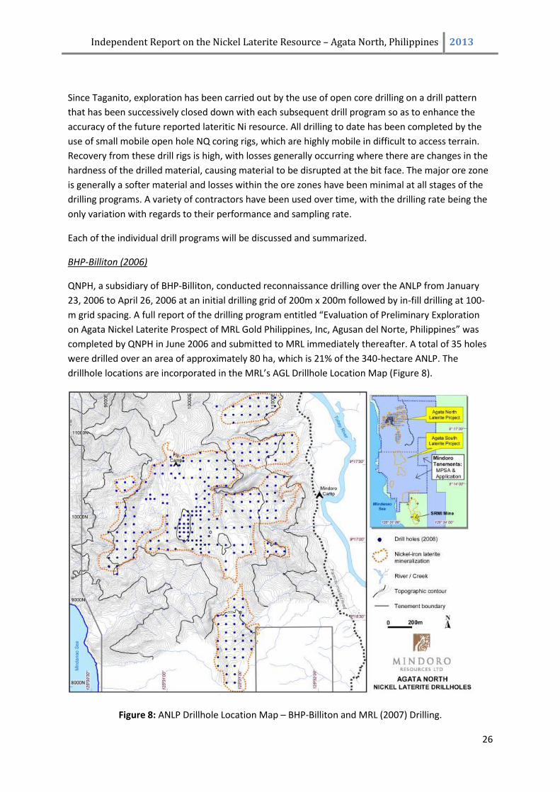
BHP-Billiton (2006)
QNPH, a subsidiary of BHP-Billiton, conducted reconnaissance drilling over the ANLP from January
23, 2006 to April 26, 2006 at an initial drilling grid of 200m x 200m followed by in-fill drilling at 100-
m grid spacing. A full report of the drilling program entitled “Evaluation of Preliminary Exploration
on Agata Nickel Laterite Prospect of MRL Gold Philippines, Inc, Agusan del Norte, Philippines” was
completed by QNPH in June 2006 and submitted to MRL immediately thereafter. A total of 35 holes
were drilled over an area of approximately 80 ha, which is 21% of the 340-hectare ANLP. The
drillhole locations are incorporated in the MRL’s AGL Drillhole Location Map (Figure 8).
Figure 8: ANLP Drillhole Location Map – BHP-Billiton and MRL (2007) Drilling.
Independent Report on the Nickel Laterite Resource – Agata North, Philippines 2013
27
This drilling program was subsequent to a Memorandum of Understanding (MOU) signed between
MRL and QNPH on December 5, 2005. The MOU allowed QNPH to conduct exploration in the
property, which also include technical review and geological mapping. It was intended to evaluate
and establish resource potential of the area and as a possible Yabulu Refinery ore source, and to
present a resource model. QNPH were looking for high Ni / high Fe ore and were not intending to
formalise any agreements with MRL until the results of the exploration proved positive.
To evaluate the potential of the ANLP for the Chinese market, MRL commissioned Denny Ambagan
to re-evaluate QNPH’s data with the aim of estimating low-grade resources for the Chinese market.
Ambagan is a geologist, who worked for Crew Minerals in its Lagonoy and Mindoro nickel laterite
exploration areas for three years. An in-house estimate was tabled. QNPH post this estimate did not
take up an option with MRL with regards to the ANLP.
MRL Phase 1 (2007)
The first drilling program in the ANLP managed and developed by MRL was conducted from February
22 to August 3, 2007 with 100 holes completed and a total meterage of 2267.12. Drilling was
confined to the area defined for an initial DSO operation. The drilling area related to areas covered
by initial Exploration Targets A and B. The drilling rate averaged 3.8m / day / drill rig and the
recovery of drill core over the program was 88.2%.
MRL Phase 2 (2007/08)
A follow-up infill drilling program in ANLP was started in December 17, 2007 to May 30, 2008,
completing 773.12 meters in 48 drill holes (37 new drill holes and 11 twin holes). The purpose of this
exercise was to better define the mineralization and extend the initial resource. The drilling rate
averaged 4.6m / day / drill rig and the recovery of drill core over the program was 93.9%.
MRL Phase 3 (2008)
From June 18, 2008 to September 26, 2008, step-out drilling was carried out with hole spacing
widened to 100m by 100m centers. Drilling totaled 3,601 meters in 225 holes. This program was
aimed to drill out the greater part of Agata North resource potential based on areas covered by
Exploration Targets C and D. The drilling rate averaged 11.5m / day / drill rig and the recovery of drill
core over the program was 95.0%.
A total of 408 vertical holes were completed during the first 4 phases of drilling in the ANLP,
including the previous BHP-Billiton drilling. The drilling patterns are all located on a 50m- to 100m-
spaced grid. Total meterage is 7,300.83 with an average depth of 17.89m/per hole, a maximum of
46.6m, and a minimum of 4.35m.
MRL Phase 4 (2010)
During 2010 the program continued to infill the resource so as to gain both a greater level of
accuracy for the resource estimate, but also to be able to study the variography of the resource
within a close spaced pattern combining both high grade limonite and saprolite ores. From April 23,
2010 to July 10, 2010 infill drilling totalled 147 drill holes for 2682 meters of drilling. The drilling rate
Independent Report on the Nickel Laterite Resource – Agata North, Philippines 2013
28
averaged 13.6m / day / drill rig and the recovery of drill core over the program was 91.5%. Lower
recovery is explained by the variably lithified ultramafic in the close spaced pattern to be used for
variographical purposes, this is not common throughout the deposit but the location weighting in
this program has skewed the recovery data.
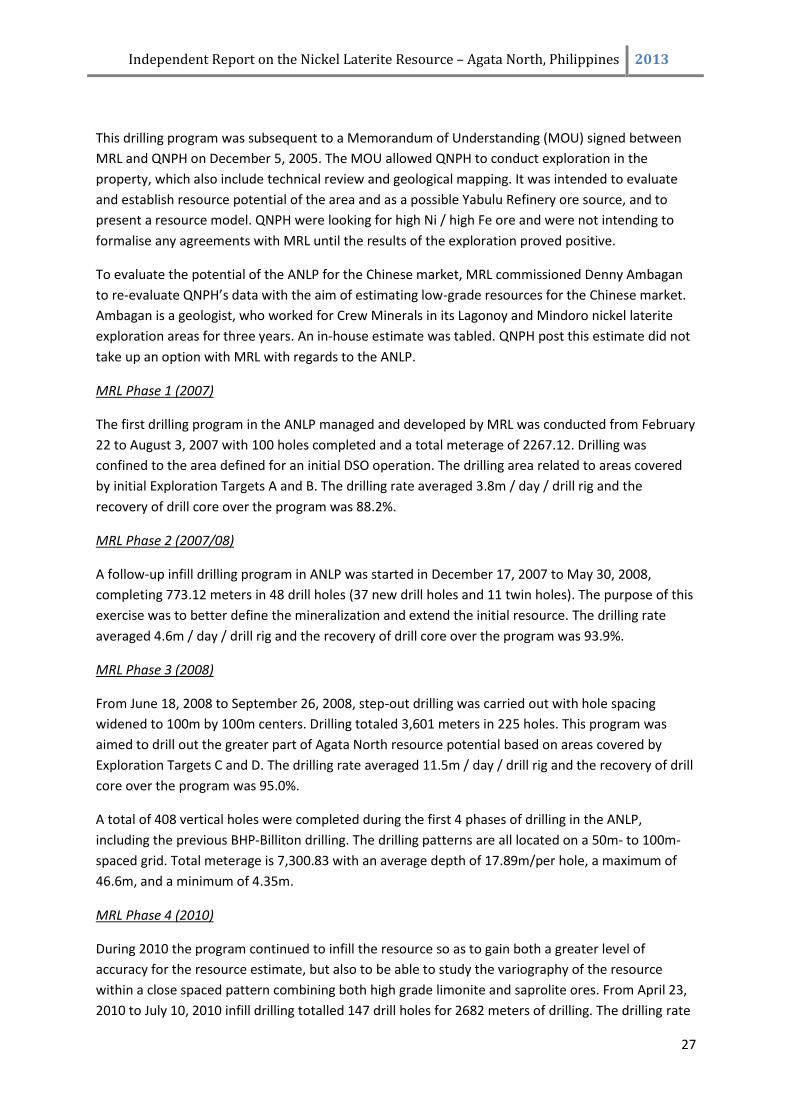
For the resource being compiled in this report the total number of drill holes completed is 593 for
10,851.84m meters of drilling with an average drill hole depth being 18.30m. All drill holes
completed within the ANLP area are located on Figure 9. All cross sections are in Appendix 1.
Figure 9: ANLP Drillhole Location Map – All Drilling
Summary
All exploration completed to date has been systematic and appropriate with regards to the
development of a resource estimate. The author considers the drilling methodology used within the
ANLP area and the various sample recovery rates appropriate and accurate with regards to providing
a sampling platform for resource estimation.
7.4 Drillhole Collars Survey
Surveying of drill hole collars’ position and elevation was undertaken by MRL surveyors using a
Nikon Total Station DTM-332. This, together with the topographic survey of the ANLP is tied to five
National Mapping and Resource Information Authority (NAMRIA) satellite/GPS points and
benchmarks with certified technical descriptions (Table 3). The Reference System used is PRS 92 or
WGS 84, used interchangeably by mathematical conversions.
Independent Report on the Nickel Laterite Resource – Agata North, Philippines 2013
29
Consequently, the baseline for the local gridlines is based on 51 MRL control stations. About 65,535
survey points, including drillhole collars, were established with varying shot distances. These are
downloaded into the computer by seamless data transfer, imported to MAPINFO, which are then
used for the Digital Terrain Modeling to derive the contour map.
Table 3: NAMRIA Tie Points Technical Description
STATION LATITUDE LONGITUDE EASTING NORTHING LOCATION
AGN_45 9°11'07.88738" 125°33'39.04409" 561636.287 1015703.065 SW-end corner of Sta. Ana
Bridge, Tubay
AGN_46 9°11'11.29480" 125°33'39.28491" 561643.476 1015807.756 NW-end corner of Sta. Ana
Bridge, Tubay
AGN_48 562018.601 1019260.784
AGN_153 9°19'23.02761" 125°33'15.95108" 560907.623 1030913.182 NW-end corner of Puyo
Bridge, Jabonga
AGN_154 9°19'14.68259" 125°33'13.72449" 560840.077 1030656.707 NW-end corner of Bangonay
Bridge, Jabonga
8.0 SAMPLING AND ASSAYING
8.1 MRL Sampling Procedure
The ANLP QA/QC Procedures for the whole ANLP drilling program was set up by MRL geologists and
was followed by all personnel involved in all stages of the program (Appendix 2). This was adapted
from the QA/QC Protocols of QNPH for the 2006 drill program carried out on the ANLP. Periodically,
the protocols were evaluated and improvements implemented. The core handling, logging and
sampling procedures applied in the program are briefly described below.
Core checkers, under the supervision of MRL technical personnel, are present on every drill rig
during operation. This is to record drilling activities from core recovery, core run, pull-out and put-
back, casing and reaming at the drill site. Once a core box is filled, it is sealed with a wooden board
then secured with a rubber packing band. This is placed in a sack and manually carried to the core
house some 300m to 1km m from the drill area.
Core logging was carried out in the core shed by MRL geologists. For standardization of logging
procedures, the geologists are guided by different codes for laterite horizon classification,
weathering scale, boulder size, and color.
After logging, the geologist determines the sampling interval. Core sampling interval is generally at
one (1) meter intervals down the hole, except at laterite horizon boundaries, when actual
boundaries are used. The sample length across the boundaries is normally in the range of 1.0 ±
0.30m to avoid excessively short and long samples. In the saprolitic rocks and bedrock layers, some
sample intervals have lengths greater than 1.30 meters to a maximum of 2.00 meters.
Independent Report on the Nickel Laterite Resource – Agata North, Philippines 2013
30
8.2 MRL Sampling Protocols
As in all stages of the program, the ANLP QA/QC Procedures (Appendix 2) were diligently followed
during the sample preparation and security procedures. The analyses for the first 2,689 core samples
were performed by McPhar Geoservices (Philippines), Inc. (McPhar), which follows internationally-
accepted laboratory standards in sample handling, preparation and analysis.
For the rechecking of the integrity of laboratory assays, independent consultant Dr. Bruce D.
Rohrlach, also a qualified person, provided MRL geologists with sampling procedures in May, 2007
after several site visits. This was incorporated into the QA/QC Procedures.
Following the recommendations of another qualified person, F. Roger Billington in May, 2008, the
sampling protocols were slightly modified. The most important modification was the insertion of
pulp rejects in the same batch as the mainstream samples. This is to ensure that all conditions in
assaying are similar, if not completely the same for both the mainstream and check samples. All of
the analyses are completed by Intertek Testing Services, Phils., Inc. (ITS) for analysis using the XRF
analytical method, and thus all 8,411 core samples since have been analysed by this group.
The ITS Phils. facility is among Intertek’s global network of mineral testing laboratories. It provides
high quality assay analysis of mineral samples for nickel deposit exploration projects. Intertek
mineral testing laboratories implement quality protocols.
MRL Core Sampling
During the first two phases of drilling, whole core sampling was conducted for 132 drill holes, and 17
holes were split-sampled. Whole core considering the relatively small core diameter, and to achieve
better precision by assaying the largest possible sample.
Whole core splitting was manually performed. The core was laid on a canvas sheet, pounded and
crushed by use of a pick, thoroughly mixed, quartered, then the split sample is taken from 2
opposite quarter portions. The other 2 quarters are combined and kept as a duplicate in a properly-
sealed and labelled plastic bag and arranged in core boxes according to depth. The duplicates are
stored in the core house at the Agata Base Camp, some 1.5 km from the drill area.
For the third and latest drilling phase, split-sampling was conducted to ensure the availability of
reference samples in the future (except for 45 drillholes from the third drilling phase). The cores
were cut in half using either a core saw or spatula. The remaining half is stored in properly-labelled
core boxes at the Mindoro Camp site in Agata.
The sampling interval is marked in the core box by means of masking tape/aluminum strip labeled
with the sampling depth. The sample collected is placed in a plastic bag with dimension of 35cm x
25cm secured with a twist tie. The plastic bag is labelled with the hole number and sample interval.
Independent Report on the Nickel Laterite Resource – Agata North, Philippines 2013
31
After the samples are collected, they are weighed then sun-dried for about 5 hours and weighed
again before final packing for delivery to the laboratory. In cases where there is continuous rain, the
samples are pan-dried for 5-6 hours using the constructed drying facility or wood-fired oven.
MRL prepared its own sample tags for all samples including pulp repeats, pulp standards, and coarse
rejects samples. The samples were placed in a rice sack and then in a crate to ensure the security of
the samples during transport.
For all of the 2007 cores and batch 2008 AGL 10, the prepared samples were sent to the McPhar
laboratory in Makati City, Metro Manila via a local courier (LBC Express). The samples were carefully
packed in craters with proper labels. This was accompanied by an official Submission Form and a
Courier Transmittal Form. The crates were transported to Butuan City where LBC Express branches
are present. The transportation of the crates containing the samples is always accompanied by
designated MRL staff. The courier received the package and provided MRL with receipts indicating
contents. For batches 2008 AGL 1, 3 and 6, the samples were delivered by MRL to McPhar’s sample
preparation facility in General Santos City. The assaying was performed in their laboratory in Makati
City.
Counting and cross-checking of samples vis-à-vis the McPhar Submission Form were performed by
McPhar supervisors. Notice is given to MRL if there are discrepancies, otherwise it is understood that
sample preparation and analysis will be carried out as requested. A sample tracking, quality control,
and reporting system was maintained between MRL and McPhar.
For batches 2008 AGL-13, 16, 18 and onwards, the core samples were delivered to Intertek’s sample
preparation facility in Surigao City. Likewise, checking of samples against the list was done upon
submission. Once prepared, Intertek-Surigao sends the samples to their assay laboratory in
Muntinlupa City, Metro Manila.
The core sampling and logging facility was under the supervision of MRL geologist or mining
engineer at all times. This facility was originally within the drill area and is about 300m to 1km from
the drill pads, however though logging of the core was completed at the drill rig for the phase 4
drilling, core trays were delivered to Bgy. E. Morgado base camp for sample splitting preparation
under the guidance of MRL staff. A civilian guard secures the base camp premises during the night.
The ANLP drilling was directly under the supervision of James A. Climie, P. Geol., Exploration
Manager of Mindoro.
Checking of Laboratory Performance
In addition to stringent sampling protocols, QA/QC procedures were also employed following Dr. B.
Rohrlach’s and F.R. Billington’s (MRL independent consultants) guidelines. Standard reference
materials, field duplicates, coarse rejects and pulp rejects were resubmitted to the analysing
laboratory to check the accuracy of the primary laboratory results. A total of 1269 analyses of check
samples were used in confirming the accuracy and repeatability of all assays to be used within the
resource estimation of the ANLP. Selection of check samples are spread throughout all holes and in
various laterite horizons.
Independent Report on the Nickel Laterite Resource – Agata North, Philippines 2013
32
The field duplicates totalled 325 or 2.93% of the 11,100 mainstream core samples of MRL. Normally,
1 in every 20 core samples is duplicated. The duplicate sample is selected to ascertain that the full
range of different laterite horizons is systematically covered. The samples were selected to cover the
full range of Ni grades at Agata, and to extensively cover the different stages and spatial distribution
of the drill program, so as to provide a representative check on the reliability of the original sample
splitting process undertaken by MRL at Agata North. Originally, the splitting method is the same as
for obtaining duplicates for storage but 1/4 part of the prepared sample represents the field
duplicate while the 3/4 part is the regular sample. For the half-core sampling, the field duplicates
were taken by cutting the remaining ½ core into 2. These samples were sent to the laboratory in the
same batch and were treated in the same way as the mainstream core samples.
A set of 81 coarse reject samples, comprising 0.73 % of the 11,100 core samples, were submitted to
the laboratory where the original samples were analyzed for resampling and assaying. Resampling
was done by taking a duplicate split from the coarse rejects and then placing it back into the assay
stream for analysis. Again, as in all duplicates, the submitted samples were chosen to cover the
natural range of assays. The reanalysis of the coarse reject samples was undertaken as an internal
check on the crushing and sub-sampling procedures of the laboratory to ensure that the samples
taken for analysis were representative of the bulk sample.
There were two sets of pulp rejects sent for re-assaying. One was sent to the laboratory where it was
originally analyzed. A total of 250 pulp rejects were sent under this category. The other set was sent
to an umpire laboratory wherein a total of 319 pulp rejects were analyzed. This is to establish
reproducibility of analysis and determine the presence or absence of bias between laboratories.
Samples were taken on all of the different laterite horizons. Originally, pulp rejects were collected
and sent in separate batches. Starting on June 2008, pulps were inserted together with the
mainstream samples (1 in each set of 40 samples). The pulp rejects for inter-laboratory checking
were sent at a later date.
The umpire laboratory for the 2007 drilling program was Intertek in Jakarta. Selected pulp samples
were sent by MRL to Intertek’s Manila office, after which they forward the samples to Jakarta in
Intertek Cilandak Commercial Estate 103E, JI Cilandak KKO, Jakarta 12560. Intertek (Jakarta) has
acquired an ISO 17025 2005 accreditation from KAN (National Accreditation Body of Indonesia)
denominated as LP 130_IDN. This is valid until 2010. With the change of primary laboratory to
Intertek Phils., Mcphar becomes the umpire laboratory. In 2008, Mcphar samples/assays were
checked by Intertek Phils. and vice-versa.
Nickel standards or certified reference materials are routinely inserted to the batches of core
samples sent for assaying. This is done as a double check on the precision of the analytical
procedures of Mcphar and Intertek on a batch by batch basis. The standards, which have known
assay values for Ni, were provided by Geostats Pty Ltd of Australia in pulverized (pulp) form weighing
about 5 grams contained in 7.5cm X 10cm heavy duty plastic bags. Originally, one (1) standard
sample is inserted for every batch of 40 to 45 samples. However, there were some standards
inserted in smaller intervals of 25-35 samples. Starting with Batch 2008 AGL-18, one standard
sample was included in every set of approximately 40 samples. In all, 294 standards equivalent to
2.65 % of the core samples were used.
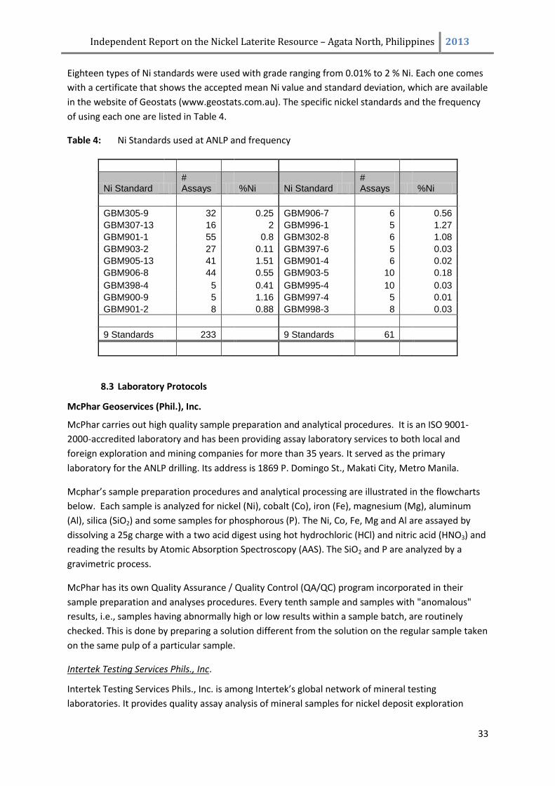
Independent Report on the Nickel Laterite Resource – Agata North, Philippines 2013
33
Eighteen types of Ni standards were used with grade ranging from 0.01% to 2 % Ni. Each one comes
with a certificate that shows the accepted mean Ni value and standard deviation, which are available
in the website of Geostats (www.geostats.com.au). The specific nickel standards and the frequency
of using each one are listed in Table 4.
Table 4: Ni Standards used at ANLP and frequency
Ni Standard # Assays %Ni Ni Standard
# Assays %Ni
GBM305-9 32 0.25 GBM906-7
6
0.56
GBM307-13
16
2 GBM996-1
5
1.27
GBM901-1
55
0.8 GBM302-8
6
1.08
GBM903-2
27
0.11 GBM397-6
5
0.03
GBM905-13
41
1.51 GBM901-4
6
0.02
GBM906-8
44
0.55 GBM903-5
10
0.18
GBM398-4
5
0.41 GBM995-4
10
0.03
GBM900-9
5
1.16 GBM997-4
5
0.01
GBM901-2 8 0.88 GBM998-3 8 0.03
9 Standards 233 9 Standards 61
8.3 Laboratory Protocols
McPhar Geoservices (Phil.), Inc.
McPhar carries out high quality sample preparation and analytical procedures. It is an ISO 9001-
2000-accredited laboratory and has been providing assay laboratory services to both local and
foreign exploration and mining companies for more than 35 years. It served as the primary
laboratory for the ANLP drilling. Its address is 1869 P. Domingo St., Makati City, Metro Manila.
Mcphar’s sample preparation procedures and analytical processing are illustrated in the flowcharts
below. Each sample is analyzed for nickel (Ni), cobalt (Co), iron (Fe), magnesium (Mg), aluminum
(Al), silica (SiO2) and some samples for phosphorous (P). The Ni, Co, Fe, Mg and Al are assayed by
dissolving a 25g charge with a two acid digest using hot hydrochloric (HCl) and nitric acid (HNO3) and
reading the results by Atomic Absorption Spectroscopy (AAS). The SiO2 and P are analyzed by a
gravimetric process.
McPhar has its own Quality Assurance / Quality Control (QA/QC) program incorporated in their
sample preparation and analyses procedures. Every tenth sample and samples with "anomalous"
results, i.e., samples having abnormally high or low results within a sample batch, are routinely
checked. This is done by preparing a solution different from the solution on the regular sample taken
on the same pulp of a particular sample.
Intertek Testing Services Phils., Inc.
Intertek Testing Services Phils., Inc. is among Intertek’s global network of mineral testing
laboratories. It provides quality assay analysis of mineral samples for nickel deposit exploration
Independent Report on the Nickel Laterite Resource – Agata North, Philippines 2013
34
projects. Measures are taken by Intertek mineral testing laboratories to ensure that correct method
development and quality protocols are in place to produce good quality results.
Each sample is analyzed for nickel (Ni), cobalt (Co), iron (Fe), magnesium (Mg), aluminum (Al), silica
(SiO2), CaO, Cr2O3, K2O, MnO, Na2O, P2O5, and TiO2. Whole rock analyses are done using X-ray
Fluorescence. The samples are fused using lithium metaborate. XRF analysis determines total
element concentrations that are reported as oxides.
For its internal QAQC, Intertek performs repeat analyses plus split sample analyses in every 15-20
samples. Furthermore, on the average, one standard reference material is inserted in every 40
samples, and one blank in every 60 samples.
Flowcharts of McPhar and intertek sample preparation and analysis procedure flowsheets are
presented in Appendix 3.
8.4 Internal Check Assays (McPhar and Intertek)
The laboratories of Mcphar and Intertek in Manila have a Quality Assurance/Quality Control
programs incorporated in their sample preparation and analyses procedures. The two laboratories
regularly conduct duplicate analysis of Ni and other elements as a check on analytical reproducibility
within their own laboratories. Repeats are routinely conducted on all elements being analyzed and
are typically on every 10th sample for McPhar and on every 20th sample for Intertek. All in all there
are 770 (6.94%) repeat analyses that are spread evenly throughout the entire database.
In analyzing the correlation between the original and duplicate sample, the Variance between the primary assay and the duplicate was computed as follows: (a – b)
Var = ________ x 100
a
Where: a - is the original sample analyzed
b - is the duplicate sample analyzed and
Var - is the percentage relative difference.
To interpret the Variance value, a value of zero means the two values are identical and the
duplication is perfect, a negative value means the duplicate is higher, while a positive value means
the original is higher. Values less than 10% variance (either negative or positive), are considered
excellent when reviewing comparative samples within lateritic Ni deposit assays. [NB This
methodology is used in all sections of Chapter 8.0 Sampling and Assaying within this report.]
There is an excellent correlation for all of the elements within an internal repeat with all below
Variances <1% (0.03 – 0.28%) as shown in Table 5, which is consistent with high precision
repeatability. There is generally a very even spread of the check assay being both higher and lower
than the primary assay which indicates that there is no systematic bias occurring in the check
analyses routine.
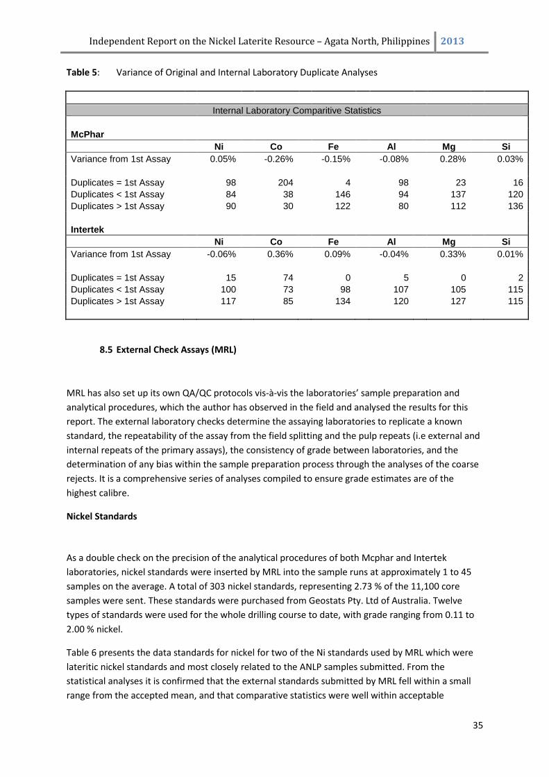
Independent Report on the Nickel Laterite Resource – Agata North, Philippines 2013
35
Table 5: Variance of Original and Internal Laboratory Duplicate Analyses
Internal Laboratory Comparitive Statistics
McPhar
Ni Co Fe Al Mg Si
Variance from 1st Assay
0.05%
-0.26%
-0.15%
-0.08%
0.28%
0.03%
Duplicates = 1st Assay
98
204
4
98
23
16
Duplicates < 1st Assay
84
38
146
94
137
120
Duplicates > 1st Assay
90
30
122
80
112
136
Intertek
Ni Co Fe Al Mg Si
Variance from 1st Assay
-0.06%
0.36%
0.09%
-0.04%
0.33%
0.01%
Duplicates = 1st Assay
15
74
0
5
0
2
Duplicates < 1st Assay
100
73
98
107
105
115
Duplicates > 1st Assay
117
85
134
120
127
115
8.5 External Check Assays (MRL)
MRL has also set up its own QA/QC protocols vis-à-vis the laboratories’ sample preparation and
analytical procedures, which the author has observed in the field and analysed the results for this
report. The external laboratory checks determine the assaying laboratories to replicate a known
standard, the repeatability of the assay from the field splitting and the pulp repeats (i.e external and
internal repeats of the primary assays), the consistency of grade between laboratories, and the
determination of any bias within the sample preparation process through the analyses of the coarse
rejects. It is a comprehensive series of analyses compiled to ensure grade estimates are of the
highest calibre.
Nickel Standards
As a double check on the precision of the analytical procedures of both Mcphar and Intertek
laboratories, nickel standards were inserted by MRL into the sample runs at approximately 1 to 45
samples on the average. A total of 303 nickel standards, representing 2.73 % of the 11,100 core
samples were sent. These standards were purchased from Geostats Pty. Ltd of Australia. Twelve
types of standards were used for the whole drilling course to date, with grade ranging from 0.11 to
2.00 % nickel.
Table 6 presents the data standards for nickel for two of the Ni standards used by MRL which were
lateritic nickel standards and most closely related to the ANLP samples submitted. From the
statistical analyses it is confirmed that the external standards submitted by MRL fell within a small
range from the accepted mean, and that comparative statistics were well within acceptable
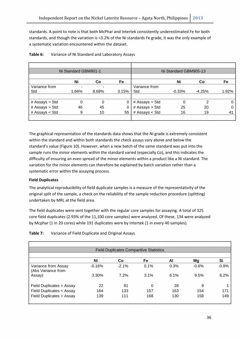
Independent Report on the Nickel Laterite Resource – Agata North, Philippines 2013
36
standards. A point to note is that both McPhar and Intertek consistently underestimated Fe for both
standards, and though the variation is <3.2% of the Ni standards Fe grade, it was the only example of
a systematic variation encountered within the dataset.
Table 6: Variance of Ni Standard and Laboratory Assays
Ni Standard GBM901-1 Ni Standard GBM905-13
Ni Co Fe Ni Co Fe
Variance from Std
-1.66%
-8.68% 3.15%
Variance from Std -0.33% -4.25% 1.92%
# Assays = Std 0 0 0 # Assays = Std 0 2 0
# Assays > Std
46
45
0 # Assays > Std
25
20
0
# Assays < Std 9 10 55 # Assays < Std 16 19 41
The graphical representation of the standards data shows that the Ni grade is extremely consistent
within the standard and within both standards the check assays vary above and below the
standard’s value (Figure 10). However, when a new batch of the same standard was put into the
sample runs the minor elements within the standard varied (especially Co), and this indicates the
difficulty of ensuring an even spread of the minor elements within a product like a Ni standard. The
variation for the minor elements can therefore be explained by batch variation rather than a
systematic error within the assaying process.
Field Duplicates
The analytical reproducibility of field duplicate samples is a measure of the representativity of the
original split of the sample, a check on the reliability of the sample reduction procedure (splitting)
undertaken by MRL at the field area.
The field duplicates were sent together with the regular core samples for assaying. A total of 325
core field duplicates (2.93% of the 11,100 core samples) were analyzed. Of these, 134 were analyzed
by Mcphar (1 in 20 cores) while 191 duplicates were by Intertek (1 in every 40 samples).
Table 7: Variance of Field Duplicate and Original Assays
Field Duplicates Comparitive Statistics
Ni Co Fe Al Mg Si
Variance from Assay
-0.16%
-2.1%
0.1%
0.3%
-0.6%
-0.9% (Abs Variance from Assay)
3.30%
7.2%
3.1%
6.1%
9.5%
6.2%
Field Duplicates = Assay
22
81
0
28
9
1
Field Duplicates < Assay
164
133
157
163
154
171
Field Duplicates > Assay
139
111
168
130
158
149
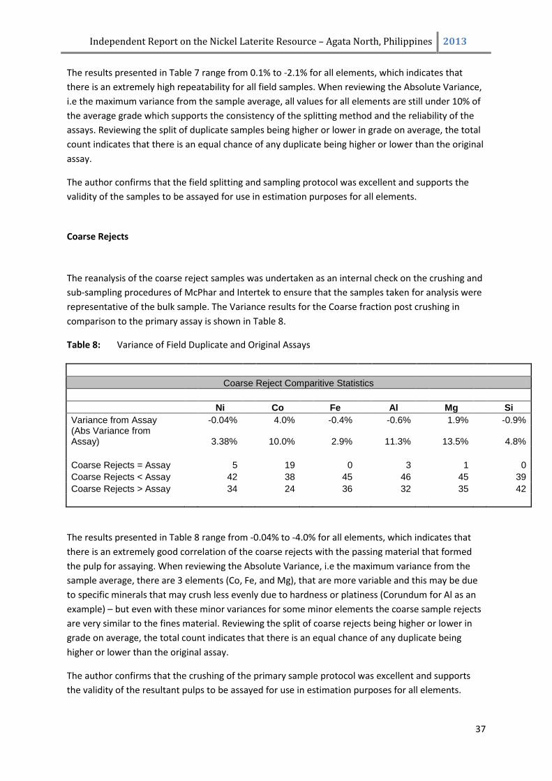
Independent Report on the Nickel Laterite Resource – Agata North, Philippines 2013
37
The results presented in Table 7 range from 0.1% to -2.1% for all elements, which indicates that
there is an extremely high repeatability for all field samples. When reviewing the Absolute Variance,
i.e the maximum variance from the sample average, all values for all elements are still under 10% of
the average grade which supports the consistency of the splitting method and the reliability of the
assays. Reviewing the split of duplicate samples being higher or lower in grade on average, the total
count indicates that there is an equal chance of any duplicate being higher or lower than the original
assay.
The author confirms that the field splitting and sampling protocol was excellent and supports the
validity of the samples to be assayed for use in estimation purposes for all elements.
Coarse Rejects
The reanalysis of the coarse reject samples was undertaken as an internal check on the crushing and
sub-sampling procedures of McPhar and Intertek to ensure that the samples taken for analysis were
representative of the bulk sample. The Variance results for the Coarse fraction post crushing in
comparison to the primary assay is shown in Table 8.
Table 8: Variance of Field Duplicate and Original Assays
Coarse Reject Comparitive Statistics
Ni Co Fe Al Mg Si
Variance from Assay
-0.04%
4.0%
-0.4%
-0.6%
1.9%
-0.9% (Abs Variance from Assay)
3.38%
10.0%
2.9%
11.3%
13.5%
4.8%
Coarse Rejects = Assay
5
19
0
3
1
0
Coarse Rejects < Assay
42
38
45
46
45
39
Coarse Rejects > Assay
34
24
36
32
35
42
The results presented in Table 8 range from -0.04% to -4.0% for all elements, which indicates that
there is an extremely good correlation of the coarse rejects with the passing material that formed
the pulp for assaying. When reviewing the Absolute Variance, i.e the maximum variance from the
sample average, there are 3 elements (Co, Fe, and Mg), that are more variable and this may be due
to specific minerals that may crush less evenly due to hardness or platiness (Corundum for Al as an
example) – but even with these minor variances for some minor elements the coarse sample rejects
are very similar to the fines material. Reviewing the split of coarse rejects being higher or lower in
grade on average, the total count indicates that there is an equal chance of any duplicate being
higher or lower than the original assay.
The author confirms that the crushing of the primary sample protocol was excellent and supports
the validity of the resultant pulps to be assayed for use in estimation purposes for all elements.
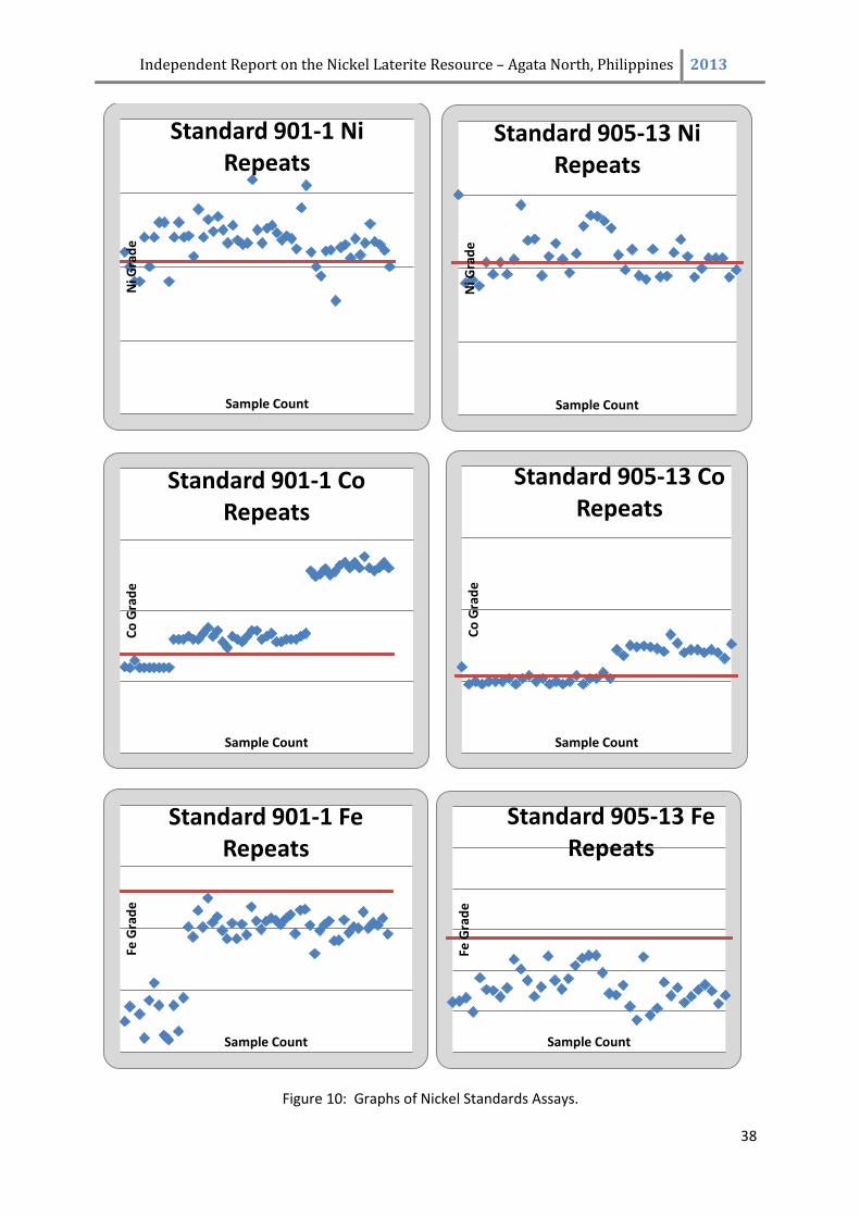
Independent Report on the Nickel Laterite Resource – Agata North, Philippines 2013
38
Figure 10: Graphs of Nickel Standards Assays.
Ni G
rad
e
Sample Count
Standard 901-1 Ni Repeats
Ni G
rad
e
Sample Count
Standard 905-13 Ni Repeats
Co
Gra
de
Sample Count
Standard 901-1 Co Repeats
Co
Gra
de
Sample Count
Standard 905-13 Co Repeats
Fe G
rad
e
Sample Count
Standard 901-1 Fe Repeats
Fe G
rad
e
Sample Count
Standard 905-13 Fe Repeats
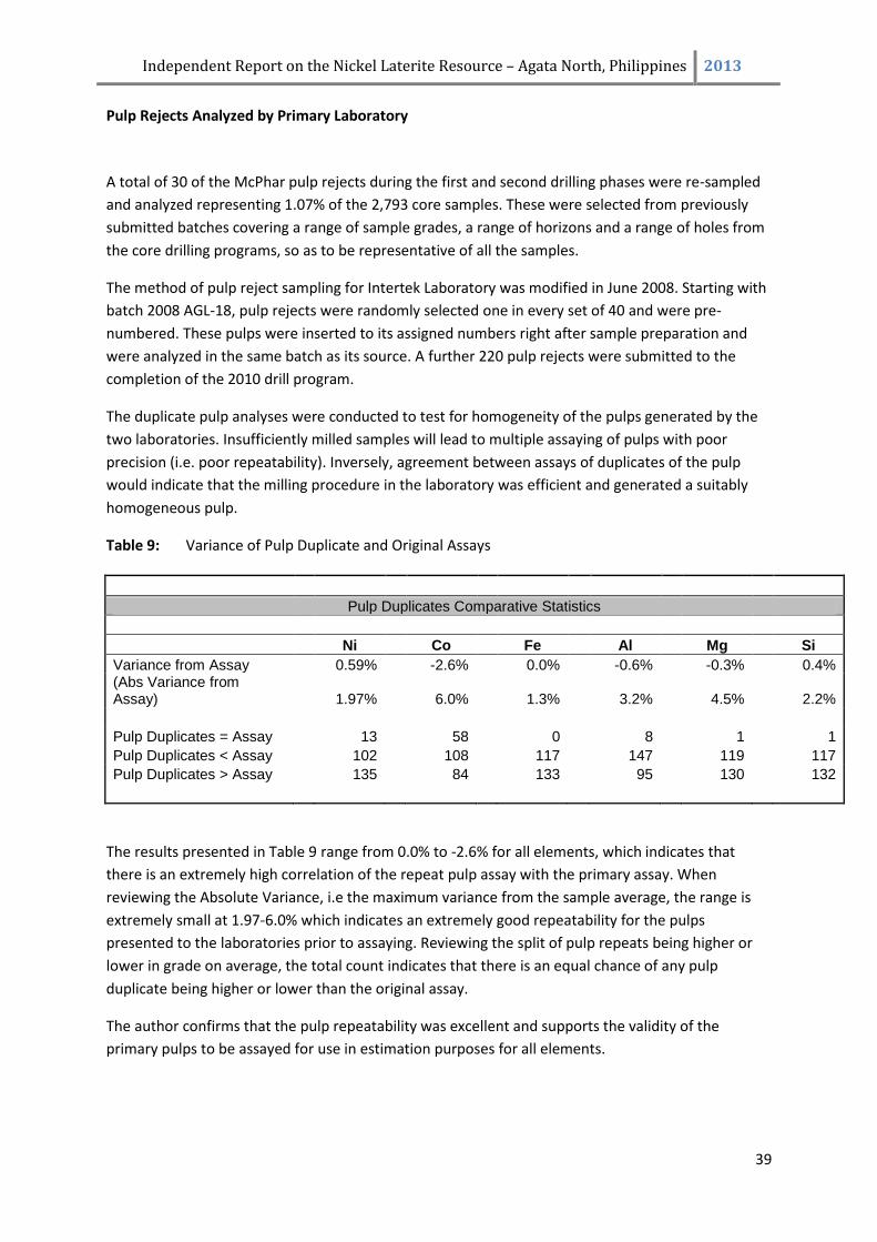
Independent Report on the Nickel Laterite Resource – Agata North, Philippines 2013
39
Pulp Rejects Analyzed by Primary Laboratory
A total of 30 of the McPhar pulp rejects during the first and second drilling phases were re-sampled
and analyzed representing 1.07% of the 2,793 core samples. These were selected from previously
submitted batches covering a range of sample grades, a range of horizons and a range of holes from
the core drilling programs, so as to be representative of all the samples.
The method of pulp reject sampling for Intertek Laboratory was modified in June 2008. Starting with
batch 2008 AGL-18, pulp rejects were randomly selected one in every set of 40 and were pre-
numbered. These pulps were inserted to its assigned numbers right after sample preparation and
were analyzed in the same batch as its source. A further 220 pulp rejects were submitted to the
completion of the 2010 drill program.
The duplicate pulp analyses were conducted to test for homogeneity of the pulps generated by the
two laboratories. Insufficiently milled samples will lead to multiple assaying of pulps with poor
precision (i.e. poor repeatability). Inversely, agreement between assays of duplicates of the pulp
would indicate that the milling procedure in the laboratory was efficient and generated a suitably
homogeneous pulp.
Table 9: Variance of Pulp Duplicate and Original Assays
Pulp Duplicates Comparative Statistics
Ni Co Fe Al Mg Si
Variance from Assay
0.59%
-2.6%
0.0%
-0.6%
-0.3%
0.4% (Abs Variance from Assay)
1.97%
6.0%
1.3%
3.2%
4.5%
2.2%
Pulp Duplicates = Assay
13
58
0
8
1
1
Pulp Duplicates < Assay
102
108
117
147
119
117
Pulp Duplicates > Assay
135
84
133
95
130
132
The results presented in Table 9 range from 0.0% to -2.6% for all elements, which indicates that
there is an extremely high correlation of the repeat pulp assay with the primary assay. When
reviewing the Absolute Variance, i.e the maximum variance from the sample average, the range is
extremely small at 1.97-6.0% which indicates an extremely good repeatability for the pulps
presented to the laboratories prior to assaying. Reviewing the split of pulp repeats being higher or
lower in grade on average, the total count indicates that there is an equal chance of any pulp
duplicate being higher or lower than the original assay.
The author confirms that the pulp repeatability was excellent and supports the validity of the
primary pulps to be assayed for use in estimation purposes for all elements.
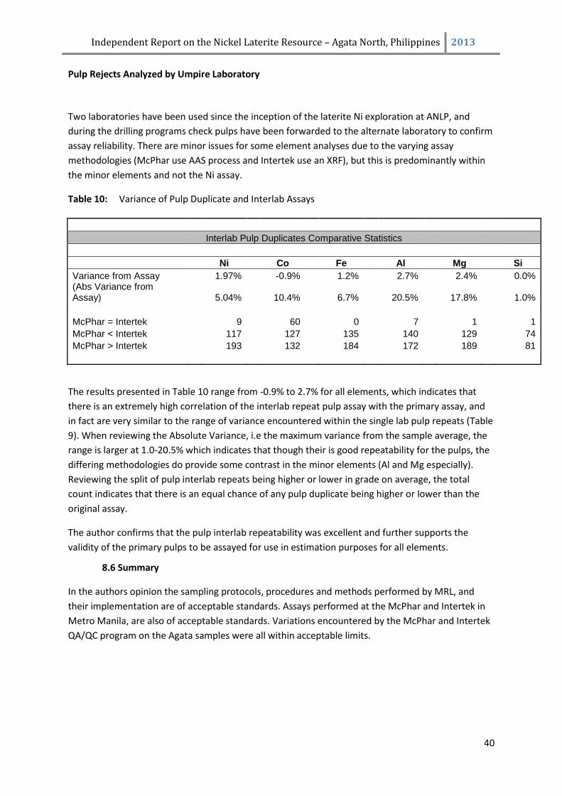
Independent Report on the Nickel Laterite Resource – Agata North, Philippines 2013
40
Pulp Rejects Analyzed by Umpire Laboratory
Two laboratories have been used since the inception of the laterite Ni exploration at ANLP, and
during the drilling programs check pulps have been forwarded to the alternate laboratory to confirm
assay reliability. There are minor issues for some element analyses due to the varying assay
methodologies (McPhar use AAS process and Intertek use an XRF), but this is predominantly within
the minor elements and not the Ni assay.
Table 10: Variance of Pulp Duplicate and Interlab Assays
Interlab Pulp Duplicates Comparative Statistics
Ni Co Fe Al Mg Si
Variance from Assay
1.97%
-0.9%
1.2%
2.7%
2.4%
0.0% (Abs Variance from Assay)
5.04%
10.4%
6.7%
20.5%
17.8%
1.0%
McPhar = Intertek
9
60
0
7
1
1
McPhar < Intertek
117
127
135
140
129
74
McPhar > Intertek
193
132
184
172
189
81
The results presented in Table 10 range from -0.9% to 2.7% for all elements, which indicates that
there is an extremely high correlation of the interlab repeat pulp assay with the primary assay, and
in fact are very similar to the range of variance encountered within the single lab pulp repeats (Table
9). When reviewing the Absolute Variance, i.e the maximum variance from the sample average, the
range is larger at 1.0-20.5% which indicates that though their is good repeatability for the pulps, the
differing methodologies do provide some contrast in the minor elements (Al and Mg especially).
Reviewing the split of pulp interlab repeats being higher or lower in grade on average, the total
count indicates that there is an equal chance of any pulp duplicate being higher or lower than the
original assay.
The author confirms that the pulp interlab repeatability was excellent and further supports the
validity of the primary pulps to be assayed for use in estimation purposes for all elements.
8.6 Summary
In the authors opinion the sampling protocols, procedures and methods performed by MRL, and
their implementation are of acceptable standards. Assays performed at the McPhar and Intertek in
Metro Manila, are also of acceptable standards. Variations encountered by the McPhar and Intertek
QA/QC program on the Agata samples were all within acceptable limits.
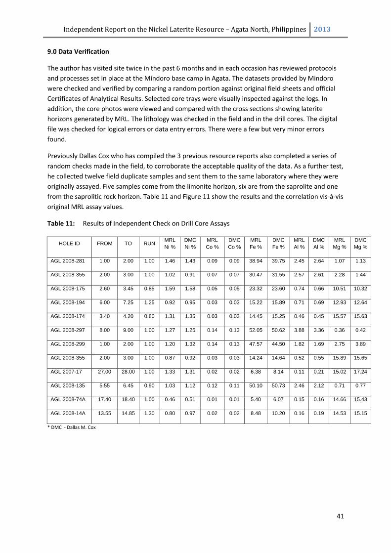
Independent Report on the Nickel Laterite Resource – Agata North, Philippines 2013
41
9.0 Data Verification
The author has visited site twice in the past 6 months and in each occasion has reviewed protocols
and processes set in place at the Mindoro base camp in Agata. The datasets provided by Mindoro
were checked and verified by comparing a random portion against original field sheets and official
Certificates of Analytical Results. Selected core trays were visually inspected against the logs. In
addition, the core photos were viewed and compared with the cross sections showing laterite
horizons generated by MRL. The lithology was checked in the field and in the drill cores. The digital
file was checked for logical errors or data entry errors. There were a few but very minor errors
found.
Previously Dallas Cox who has compiled the 3 previous resource reports also completed a series of
random checks made in the field, to corroborate the acceptable quality of the data. As a further test,
he collected twelve field duplicate samples and sent them to the same laboratory where they were
originally assayed. Five samples come from the limonite horizon, six are from the saprolite and one
from the saprolitic rock horizon. Table 11 and Figure 11 show the results and the correlation vis-à-vis
original MRL assay values.
Table 11: Results of Independent Check on Drill Core Assays
HOLE ID FROM TO RUN MRL
Ni %
DMC
Ni %
MRL
Co %
DMC
Co %
MRL
Fe %
DMC
Fe %
MRL
Al %
DMC
Al %
MRL
Mg %
DMC
Mg %
AGL 2008-281 1.00 2.00 1.00 1.46 1.43 0.09 0.09 38.94 39.75 2.45 2.64 1.07 1.13
AGL 2008-355 2.00 3.00 1.00 1.02 0.91 0.07 0.07 30.47 31.55 2.57 2.61 2.28 1.44
AGL 2008-175 2.60 3.45 0.85 1.59 1.58 0.05 0.05 23.32 23.60 0.74 0.66 10.51 10.32
AGL 2008-194 6.00 7.25 1.25 0.92 0.95 0.03 0.03 15.22 15.89 0.71 0.69 12.93 12.64
AGL 2008-174 3.40 4.20 0.80 1.31 1.35 0.03 0.03 14.45 15.25 0.46 0.45 15.57 15.63
AGL 2008-297 8.00 9.00 1.00 1.27 1.25 0.14 0.13 52.05 50.62 3.88 3.36 0.36 0.42
AGL 2008-299 1.00 2.00 1.00 1.20 1.32 0.14 0.13 47.57 44.50 1.82 1.69 2.75 3.89
AGL 2008-355 2.00 3.00 1.00 0.87 0.92 0.03 0.03 14.24 14.64 0.52 0.55 15.89 15.65
AGL 2007-17 27.00 28.00 1.00 1.33 1.31 0.02 0.02 6.38 8.14 0.11 0.21 15.02 17.24
AGL 2008-135 5.55 6.45 0.90 1.03 1.12 0.12 0.11 50.10 50.73 2.46 2.12 0.71 0.77
AGL 2008-74A 17.40 18.40 1.00 0.46 0.51 0.01 0.01 5.40 6.07 0.15 0.16 14.66 15.43
AGL 2008-14A 13.55 14.85 1.30 0.80 0.97 0.02 0.02 8.48 10.20 0.16 0.19 14.53 15.15
* DMC - Dallas M. Cox
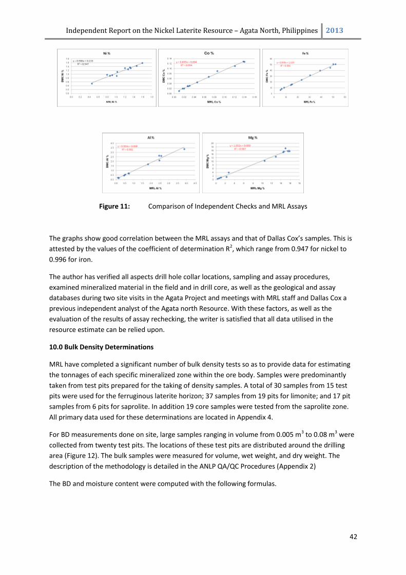
Independent Report on the Nickel Laterite Resource – Agata North, Philippines 2013
42
Figure 11: Comparison of Independent Checks and MRL Assays
The graphs show good correlation between the MRL assays and that of Dallas Cox’s samples. This is
attested by the values of the coefficient of determination R2, which range from 0.947 for nickel to
0.996 for iron.
The author has verified all aspects drill hole collar locations, sampling and assay procedures,
examined mineralized material in the field and in drill core, as well as the geological and assay
databases during two site visits in the Agata Project and meetings with MRL staff and Dallas Cox a
previous independent analyst of the Agata north Resource. With these factors, as well as the
evaluation of the results of assay rechecking, the writer is satisfied that all data utilised in the
resource estimate can be relied upon.
10.0 Bulk Density Determinations
MRL have completed a significant number of bulk density tests so as to provide data for estimating
the tonnages of each specific mineralized zone within the ore body. Samples were predominantly
taken from test pits prepared for the taking of density samples. A total of 30 samples from 15 test
pits were used for the ferruginous laterite horizon; 37 samples from 19 pits for limonite; and 17 pit
samples from 6 pits for saprolite. In addition 19 core samples were tested from the saprolite zone.
All primary data used for these determinations are located in Appendix 4.
For BD measurements done on site, large samples ranging in volume from 0.005 m3 to 0.08 m3 were
collected from twenty test pits. The locations of these test pits are distributed around the drilling
area (Figure 12). The bulk samples were measured for volume, wet weight, and dry weight. The
description of the methodology is detailed in the ANLP QA/QC Procedures (Appendix 2)
The BD and moisture content were computed with the following formulas.
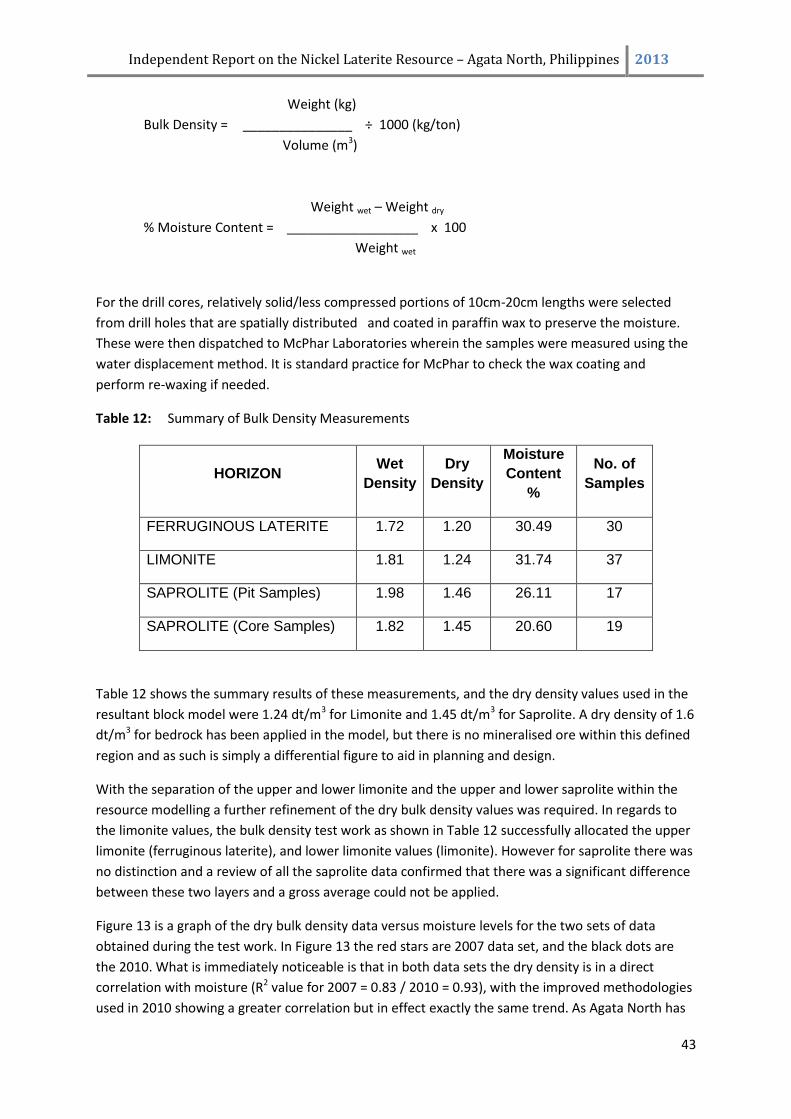
Independent Report on the Nickel Laterite Resource – Agata North, Philippines 2013
43
Weight (kg)
Bulk Density = _______________ ÷ 1000 (kg/ton)
Volume (m3)
Weight wet – Weight dry
% Moisture Content = __________________ x 100
Weight wet
For the drill cores, relatively solid/less compressed portions of 10cm-20cm lengths were selected
from drill holes that are spatially distributed and coated in paraffin wax to preserve the moisture.
These were then dispatched to McPhar Laboratories wherein the samples were measured using the
water displacement method. It is standard practice for McPhar to check the wax coating and
perform re-waxing if needed.
Table 12: Summary of Bulk Density Measurements
HORIZON Wet
Density
Dry
Density
Moisture
Content
%
No. of
Samples
FERRUGINOUS LATERITE 1.72 1.20 30.49 30
LIMONITE 1.81 1.24 31.74 37
SAPROLITE (Pit Samples) 1.98 1.46 26.11 17
SAPROLITE (Core Samples) 1.82 1.45 20.60 19
Table 12 shows the summary results of these measurements, and the dry density values used in the
resultant block model were 1.24 dt/m3 for Limonite and 1.45 dt/m3 for Saprolite. A dry density of 1.6
dt/m3 for bedrock has been applied in the model, but there is no mineralised ore within this defined
region and as such is simply a differential figure to aid in planning and design.
With the separation of the upper and lower limonite and the upper and lower saprolite within the
resource modelling a further refinement of the dry bulk density values was required. In regards to
the limonite values, the bulk density test work as shown in Table 12 successfully allocated the upper
limonite (ferruginous laterite), and lower limonite values (limonite). However for saprolite there was
no distinction and a review of all the saprolite data confirmed that there was a significant difference
between these two layers and a gross average could not be applied.
Figure 13 is a graph of the dry bulk density data versus moisture levels for the two sets of data
obtained during the test work. In Figure 13 the red stars are 2007 data set, and the black dots are
the 2010. What is immediately noticeable is that in both data sets the dry density is in a direct
correlation with moisture (R2 value for 2007 = 0.83 / 2010 = 0.93), with the improved methodologies
used in 2010 showing a greater correlation but in effect exactly the same trend. As Agata North has
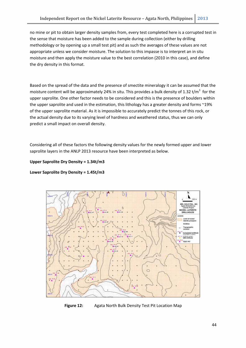
Independent Report on the Nickel Laterite Resource – Agata North, Philippines 2013
44
no mine or pit to obtain larger density samples from, every test completed here is a corrupted test in
the sense that moisture has been added to the sample during collection (either by drilling
methodology or by opening up a small test pit) and as such the averages of these values are not
appropriate unless we consider moisture. The solution to this impasse is to interpret an in situ
moisture and then apply the moisture value to the best correlation (2010 in this case), and define
the dry density in this format.
Based on the spread of the data and the presence of smectite mineralogy it can be assumed that the
moisture content will be approximately 24% in situ. This provides a bulk density of 1.32 t/m3 for the
upper saprolite. One other factor needs to be considered and this is the presence of boulders within
the upper saprolite and used in the estimation, this lithology has a greater density and forms ~19%
of the upper saprolite material. As it is impossible to accurately predict the tonnes of this rock, or
the actual density due to its varying level of hardness and weathered status, thus we can only
predict a small impact on overall density.
Considering all of these factors the following density values for the newly formed upper and lower
saprolite layers in the ANLP 2013 resource have been interpreted as below.
Upper Saprolite Dry Density = 1.34t/m3
Lower Saprolite Dry Density = 1.45t/m3
Figure 12: Agata North Bulk Density Test Pit Location Map
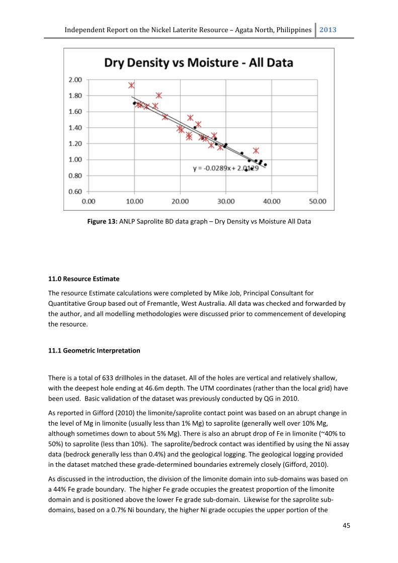
Independent Report on the Nickel Laterite Resource – Agata North, Philippines 2013
45
Figure 13: ANLP Saprolite BD data graph – Dry Density vs Moisture All Data
11.0 Resource Estimate
The resource Estimate calculations were completed by Mike Job, Principal Consultant for
Quantitative Group based out of Fremantle, West Australia. All data was checked and forwarded by
the author, and all modelling methodologies were discussed prior to commencement of developing
the resource.
11.1 Geometric Interpretation
There is a total of 633 drillholes in the dataset. All of the holes are vertical and relatively shallow,
with the deepest hole ending at 46.6m depth. The UTM coordinates (rather than the local grid) have
been used. Basic validation of the dataset was previously conducted by QG in 2010.
As reported in Gifford (2010) the limonite/saprolite contact point was based on an abrupt change in
the level of Mg in limonite (usually less than 1% Mg) to saprolite (generally well over 10% Mg,
although sometimes down to about 5% Mg). There is also an abrupt drop of Fe in limonite (~40% to
50%) to saprolite (less than 10%). The saprolite/bedrock contact was identified by using the Ni assay
data (bedrock generally less than 0.4%) and the geological logging. The geological logging provided
in the dataset matched these grade-determined boundaries extremely closely (Gifford, 2010).
As discussed in the introduction, the division of the limonite domain into sub-domains was based on
a 44% Fe grade boundary. The higher Fe grade occupies the greatest proportion of the limonite
domain and is positioned above the lower Fe grade sub-domain. Likewise for the saprolite sub-
domains, based on a 0.7% Ni boundary, the higher Ni grade occupies the upper portion of the
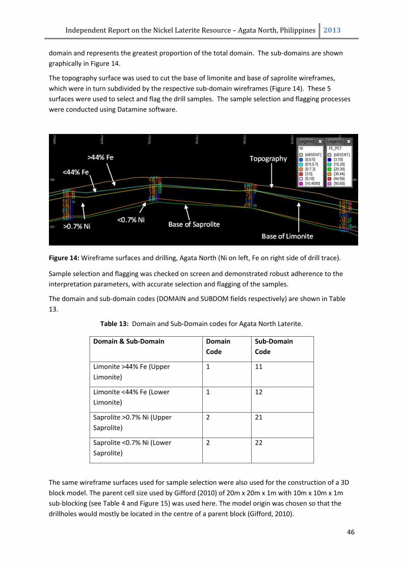
Independent Report on the Nickel Laterite Resource – Agata North, Philippines 2013
46
domain and represents the greatest proportion of the total domain. The sub-domains are shown
graphically in Figure 14.
The topography surface was used to cut the base of limonite and base of saprolite wireframes,
which were in turn subdivided by the respective sub-domain wireframes (Figure 14). These 5
surfaces were used to select and flag the drill samples. The sample selection and flagging processes
were conducted using Datamine software.
Figure 14: Wireframe surfaces and drilling, Agata North (Ni on left, Fe on right side of drill trace).
Sample selection and flagging was checked on screen and demonstrated robust adherence to the
interpretation parameters, with accurate selection and flagging of the samples.
The domain and sub-domain codes (DOMAIN and SUBDOM fields respectively) are shown in Table
13.
Table 13: Domain and Sub-Domain codes for Agata North Laterite.
Domain & Sub-Domain Domain
Code
Sub-Domain
Code
Limonite >44% Fe (Upper
Limonite)
1 11
Limonite <44% Fe (Lower
Limonite)
1 12
Saprolite >0.7% Ni (Upper
Saprolite)
2 21
Saprolite <0.7% Ni (Lower
Saprolite)
2 22
The same wireframe surfaces used for sample selection were also used for the construction of a 3D
block model. The parent cell size used by Gifford (2010) of 20m x 20m x 1m with 10m x 10m x 1m
sub-blocking (see Table 4 and Figure 15) was used here. The model origin was chosen so that the
drillholes would mostly be located in the centre of a parent block (Gifford, 2010).
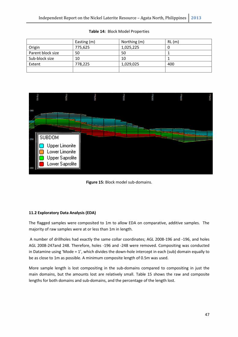
Independent Report on the Nickel Laterite Resource – Agata North, Philippines 2013
47
Table 14: Block Model Properties
Easting (m) Northing (m) RL (m)
Origin 775,625 1,025,225 0
Parent block size 50 50 1
Sub-block size 10 10 1
Extent 778,225 1,029,025 400
Figure 15: Block model sub-domains.
11.2 Exploratory Data Analysis (EDA)
The flagged samples were composited to 1m to allow EDA on comparative, additive samples. The
majority of raw samples were at or less than 1m in length.
A number of drillholes had exactly the same collar coordinates; AGL 2008-196 and -196, and holes
AGL 2008-247and 248. Therefore, holes -196 and -248 were removed. Compositing was conducted
in Datamine using ‘Mode = 1’, which divides the down-hole intercept in each (sub) domain equally to
be as close to 1m as possible. A minimum composite length of 0.5m was used.
More sample length is lost compositing in the sub-domains compared to compositing in just the
main domains, but the amounts lost are relatively small. Table 15 shows the raw and composite
lengths for both domains and sub-domains, and the percentage of the length lost.
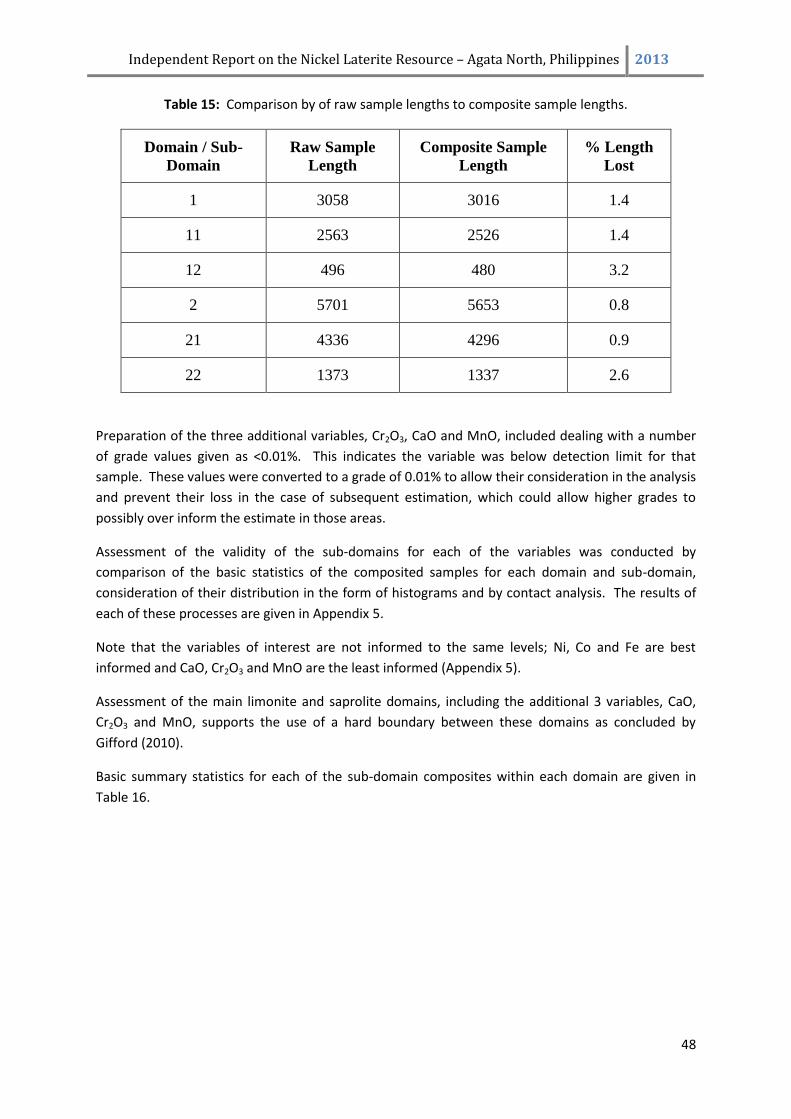
Independent Report on the Nickel Laterite Resource – Agata North, Philippines 2013
48
Table 15: Comparison by of raw sample lengths to composite sample lengths.
Domain / Sub-
Domain
Raw Sample
Length
Composite Sample
Length
% Length
Lost
1 3058 3016 1.4
11 2563 2526 1.4
12 496 480 3.2
2 5701 5653 0.8
21 4336 4296 0.9
22 1373 1337 2.6
Preparation of the three additional variables, Cr2O3, CaO and MnO, included dealing with a number
of grade values given as <0.01%. This indicates the variable was below detection limit for that
sample. These values were converted to a grade of 0.01% to allow their consideration in the analysis
and prevent their loss in the case of subsequent estimation, which could allow higher grades to
possibly over inform the estimate in those areas.
Assessment of the validity of the sub-domains for each of the variables was conducted by
comparison of the basic statistics of the composited samples for each domain and sub-domain,
consideration of their distribution in the form of histograms and by contact analysis. The results of
each of these processes are given in Appendix 5.
Note that the variables of interest are not informed to the same levels; Ni, Co and Fe are best
informed and CaO, Cr2O3 and MnO are the least informed (Appendix 5).
Assessment of the main limonite and saprolite domains, including the additional 3 variables, CaO,
Cr2O3 and MnO, supports the use of a hard boundary between these domains as concluded by
Gifford (2010).
Basic summary statistics for each of the sub-domain composites within each domain are given in
Table 16.
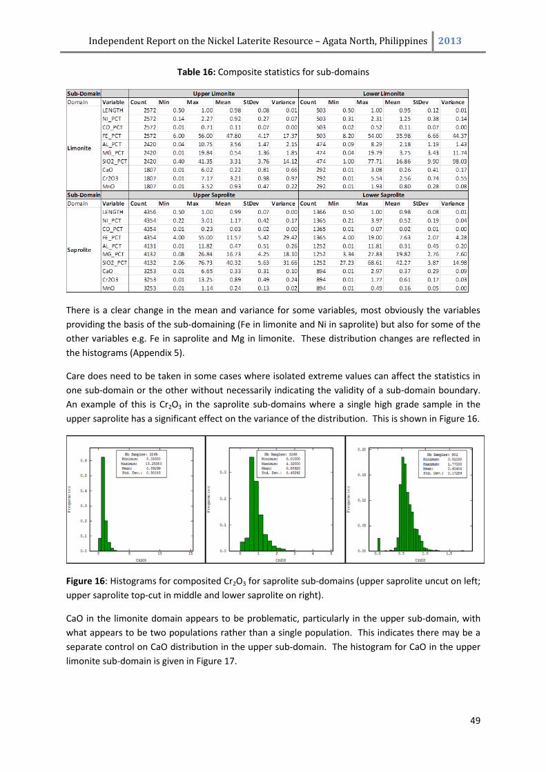
Independent Report on the Nickel Laterite Resource – Agata North, Philippines 2013
49
Table 16: Composite statistics for sub-domains
There is a clear change in the mean and variance for some variables, most obviously the variables
providing the basis of the sub-domaining (Fe in limonite and Ni in saprolite) but also for some of the
other variables e.g. Fe in saprolite and Mg in limonite. These distribution changes are reflected in
the histograms (Appendix 5).
Care does need to be taken in some cases where isolated extreme values can affect the statistics in
one sub-domain or the other without necessarily indicating the validity of a sub-domain boundary.
An example of this is Cr2O3 in the saprolite sub-domains where a single high grade sample in the
upper saprolite has a significant effect on the variance of the distribution. This is shown in Figure 16.
Figure 16: Histograms for composited Cr2O3 for saprolite sub-domains (upper saprolite uncut on left;
upper saprolite top-cut in middle and lower saprolite on right).
CaO in the limonite domain appears to be problematic, particularly in the upper sub-domain, with
what appears to be two populations rather than a single population. This indicates there may be a
separate control on CaO distribution in the upper sub-domain. The histogram for CaO in the upper
limonite sub-domain is given in Figure 17.
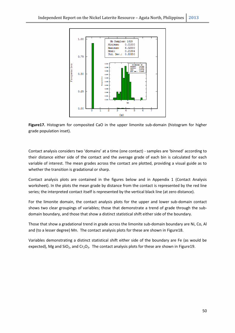
Independent Report on the Nickel Laterite Resource – Agata North, Philippines 2013
50
Figure17. Histogram for composited CaO in the upper limonite sub-domain (histogram for higher
grade population inset).
Contact analysis considers two ‘domains’ at a time (one contact) - samples are ‘binned’ according to
their distance either side of the contact and the average grade of each bin is calculated for each
variable of interest. The mean grades across the contact are plotted, providing a visual guide as to
whether the transition is gradational or sharp.
Contact analysis plots are contained in the figures below and in Appendix 1 (Contact Analysis
worksheet). In the plots the mean grade by distance from the contact is represented by the red line
series; the interpreted contact itself is represented by the vertical black line (at zero distance).
For the limonite domain, the contact analysis plots for the upper and lower sub-domain contact
shows two clear groupings of variables; those that demonstrate a trend of grade through the sub-
domain boundary, and those that show a distinct statistical shift either side of the boundary.
Those that show a gradational trend in grade across the limonite sub-domain boundary are Ni, Co, Al
and (to a lesser degree) Mn. The contact analysis plots for these are shown in Figure18.
Variables demonstrating a distinct statistical shift either side of the boundary are Fe (as would be
expected), Mg and SiO2, and Cr2O3. The contact analysis plots for these are shown in Figure19.
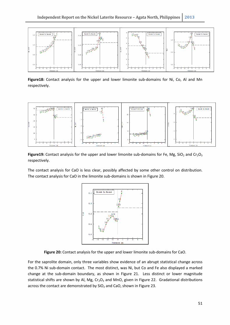
Independent Report on the Nickel Laterite Resource – Agata North, Philippines 2013
51
Figure18: Contact analysis for the upper and lower limonite sub-domains for Ni, Co, Al and Mn
respectively.
Figure19: Contact analysis for the upper and lower limonite sub-domains for Fe, Mg, SiO2 and Cr2O3
respectively.
The contact analysis for CaO is less clear, possibly affected by some other control on distribution.
The contact analysis for CaO in the limonite sub-domains is shown in Figure 20.
Figure 20: Contact analysis for the upper and lower limonite sub-domains for CaO.
For the saprolite domain, only three variables show evidence of an abrupt statistical change across
the 0.7% Ni sub-domain contact. The most distinct, was Ni, but Co and Fe also displayed a marked
change at the sub-domain boundary, as shown in Figure 21. Less distinct or lower magnitude
statistical shifts are shown by Al, Mg, Cr2O3 and MnO, given in Figure 22. Gradational distributions
across the contact are demonstrated by SiO2 and CaO, shown in Figure 23.
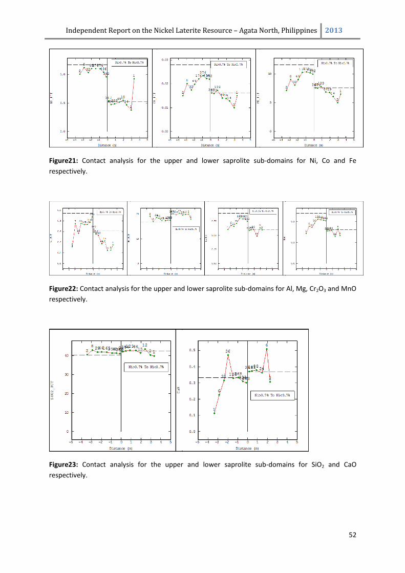
Independent Report on the Nickel Laterite Resource – Agata North, Philippines 2013
52
Figure21: Contact analysis for the upper and lower saprolite sub-domains for Ni, Co and Fe
respectively.
Figure22: Contact analysis for the upper and lower saprolite sub-domains for Al, Mg, Cr2O3 and MnO
respectively.
Figure23: Contact analysis for the upper and lower saprolite sub-domains for SiO2 and CaO
respectively.
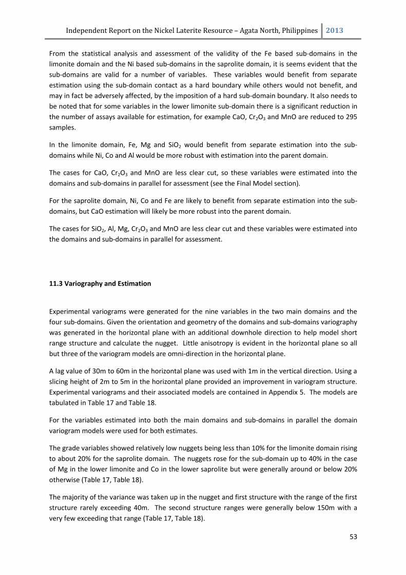
Independent Report on the Nickel Laterite Resource – Agata North, Philippines 2013
53
From the statistical analysis and assessment of the validity of the Fe based sub-domains in the
limonite domain and the Ni based sub-domains in the saprolite domain, it is seems evident that the
sub-domains are valid for a number of variables. These variables would benefit from separate
estimation using the sub-domain contact as a hard boundary while others would not benefit, and
may in fact be adversely affected, by the imposition of a hard sub-domain boundary. It also needs to
be noted that for some variables in the lower limonite sub-domain there is a significant reduction in
the number of assays available for estimation, for example CaO, Cr2O3 and MnO are reduced to 295
samples.
In the limonite domain, Fe, Mg and SiO2 would benefit from separate estimation into the sub-
domains while Ni, Co and Al would be more robust with estimation into the parent domain.
The cases for CaO, Cr2O3 and MnO are less clear cut, so these variables were estimated into the
domains and sub-domains in parallel for assessment (see the Final Model section).
For the saprolite domain, Ni, Co and Fe are likely to benefit from separate estimation into the sub-
domains, but CaO estimation will likely be more robust into the parent domain.
The cases for SiO2, Al, Mg, Cr2O3 and MnO are less clear cut and these variables were estimated into
the domains and sub-domains in parallel for assessment.
11.3 Variography and Estimation
Experimental variograms were generated for the nine variables in the two main domains and the
four sub-domains. Given the orientation and geometry of the domains and sub-domains variography
was generated in the horizontal plane with an additional downhole direction to help model short
range structure and calculate the nugget. Little anisotropy is evident in the horizontal plane so all
but three of the variogram models are omni-direction in the horizontal plane.
A lag value of 30m to 60m in the horizontal plane was used with 1m in the vertical direction. Using a
slicing height of 2m to 5m in the horizontal plane provided an improvement in variogram structure.
Experimental variograms and their associated models are contained in Appendix 5. The models are
tabulated in Table 17 and Table 18.
For the variables estimated into both the main domains and sub-domains in parallel the domain
variogram models were used for both estimates.
The grade variables showed relatively low nuggets being less than 10% for the limonite domain rising
to about 20% for the saprolite domain. The nuggets rose for the sub-domain up to 40% in the case
of Mg in the lower limonite and Co in the lower saprolite but were generally around or below 20%
otherwise (Table 17, Table 18).
The majority of the variance was taken up in the nugget and first structure with the range of the first
structure rarely exceeding 40m. The second structure ranges were generally below 150m with a
very few exceeding that range (Table 17, Table 18).
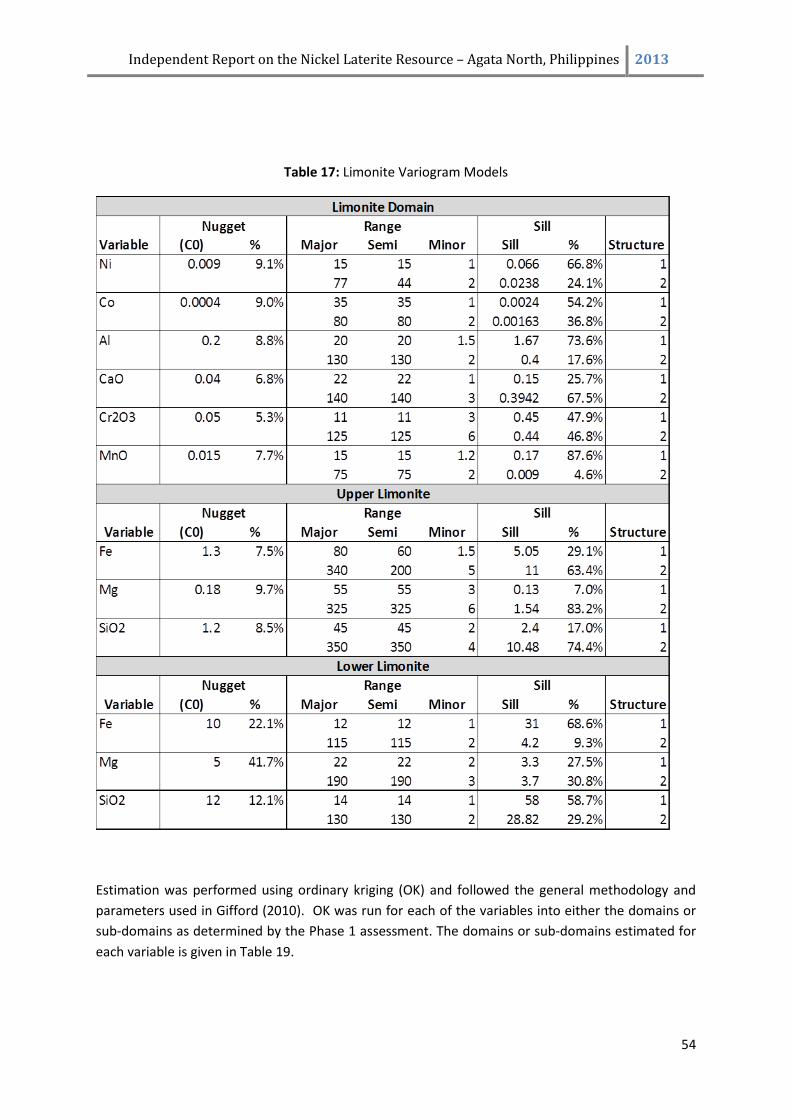
Independent Report on the Nickel Laterite Resource – Agata North, Philippines 2013
54
Table 17: Limonite Variogram Models
Estimation was performed using ordinary kriging (OK) and followed the general methodology and
parameters used in Gifford (2010). OK was run for each of the variables into either the domains or
sub-domains as determined by the Phase 1 assessment. The domains or sub-domains estimated for
each variable is given in Table 19.
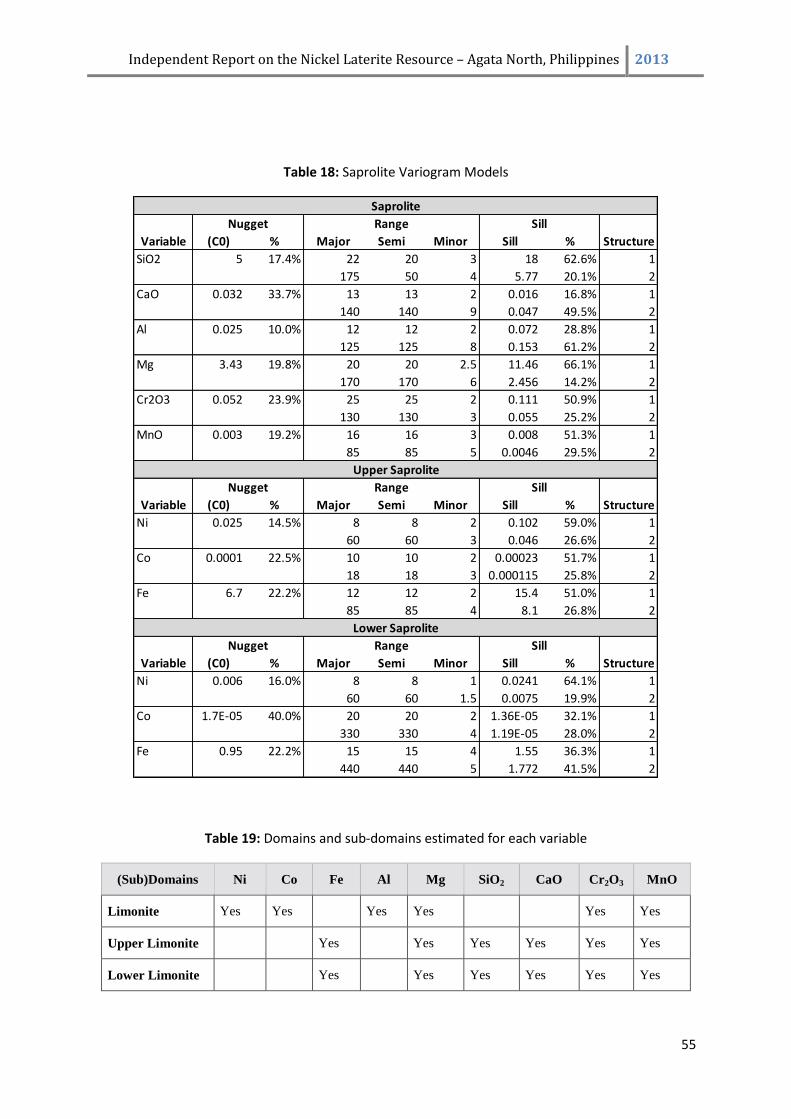
Independent Report on the Nickel Laterite Resource – Agata North, Philippines 2013
55
Table 18: Saprolite Variogram Models
Table 19: Domains and sub-domains estimated for each variable
(Sub)Domains Ni Co Fe Al Mg SiO2 CaO Cr2O3 MnO
Limonite Yes Yes Yes Yes Yes Yes
Upper Limonite Yes Yes Yes Yes Yes Yes
Lower Limonite Yes Yes Yes Yes Yes Yes
Variable (C0) % Major Semi Minor Sill % Structure
SiO2 5 17.4% 22 20 3 18 62.6% 1
175 50 4 5.77 20.1% 2
CaO 0.032 33.7% 13 13 2 0.016 16.8% 1
140 140 9 0.047 49.5% 2
Al 0.025 10.0% 12 12 2 0.072 28.8% 1
125 125 8 0.153 61.2% 2
Mg 3.43 19.8% 20 20 2.5 11.46 66.1% 1
170 170 6 2.456 14.2% 2
Cr2O3 0.052 23.9% 25 25 2 0.111 50.9% 1
130 130 3 0.055 25.2% 2
MnO 0.003 19.2% 16 16 3 0.008 51.3% 1
85 85 5 0.0046 29.5% 2
Variable (C0) % Major Semi Minor Sill % Structure
Ni 0.025 14.5% 8 8 2 0.102 59.0% 1
60 60 3 0.046 26.6% 2
Co 0.0001 22.5% 10 10 2 0.00023 51.7% 1
18 18 3 0.000115 25.8% 2
Fe 6.7 22.2% 12 12 2 15.4 51.0% 1
85 85 4 8.1 26.8% 2
Variable (C0) % Major Semi Minor Sill % Structure
Ni 0.006 16.0% 8 8 1 0.0241 64.1% 1
60 60 1.5 0.0075 19.9% 2
Co 1.7E-05 40.0% 20 20 2 1.36E-05 32.1% 1
330 330 4 1.19E-05 28.0% 2
Fe 0.95 22.2% 15 15 4 1.55 36.3% 1
440 440 5 1.772 41.5% 2
Saprolite
Upper Saprolite
Lower Saprolite
Nugget Range Sill
Nugget Range Sill
Nugget Range Sill
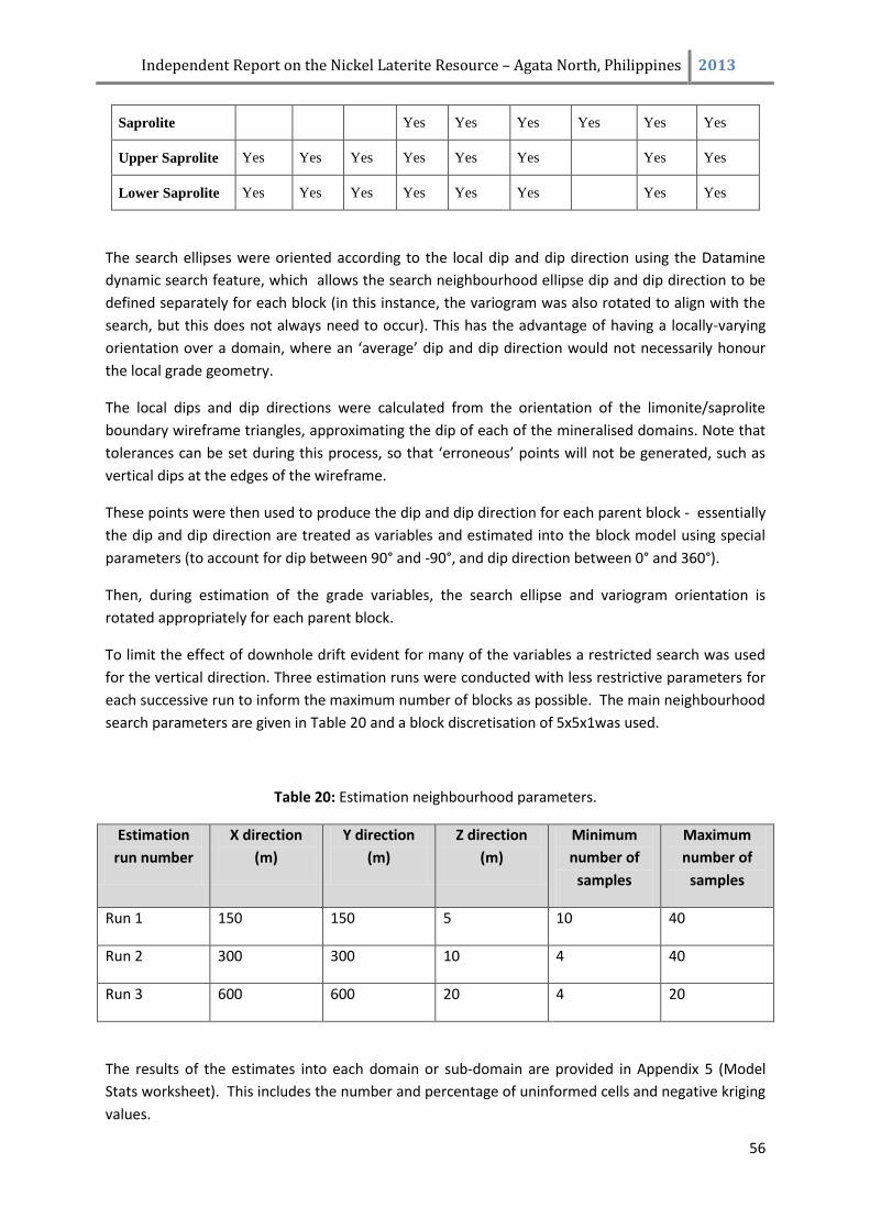
Independent Report on the Nickel Laterite Resource – Agata North, Philippines 2013
56
Saprolite Yes Yes Yes Yes Yes Yes
Upper Saprolite Yes Yes Yes Yes Yes Yes Yes Yes
Lower Saprolite Yes Yes Yes Yes Yes Yes Yes Yes
The search ellipses were oriented according to the local dip and dip direction using the Datamine
dynamic search feature, which allows the search neighbourhood ellipse dip and dip direction to be
defined separately for each block (in this instance, the variogram was also rotated to align with the
search, but this does not always need to occur). This has the advantage of having a locally-varying
orientation over a domain, where an ‘average’ dip and dip direction would not necessarily honour
the local grade geometry.
The local dips and dip directions were calculated from the orientation of the limonite/saprolite
boundary wireframe triangles, approximating the dip of each of the mineralised domains. Note that
tolerances can be set during this process, so that ‘erroneous’ points will not be generated, such as
vertical dips at the edges of the wireframe.
These points were then used to produce the dip and dip direction for each parent block - essentially
the dip and dip direction are treated as variables and estimated into the block model using special
parameters (to account for dip between 90° and -90°, and dip direction between 0° and 360°).
Then, during estimation of the grade variables, the search ellipse and variogram orientation is
rotated appropriately for each parent block.
To limit the effect of downhole drift evident for many of the variables a restricted search was used
for the vertical direction. Three estimation runs were conducted with less restrictive parameters for
each successive run to inform the maximum number of blocks as possible. The main neighbourhood
search parameters are given in Table 20 and a block discretisation of 5x5x1was used.
Table 20: Estimation neighbourhood parameters.
Estimation
run number
X direction
(m)
Y direction
(m)
Z direction
(m)
Minimum
number of
samples
Maximum
number of
samples
Run 1 150 150 5 10 40
Run 2 300 300 10 4 40
Run 3 600 600 20 4 20
The results of the estimates into each domain or sub-domain are provided in Appendix 5 (Model
Stats worksheet). This includes the number and percentage of uninformed cells and negative kriging
values.
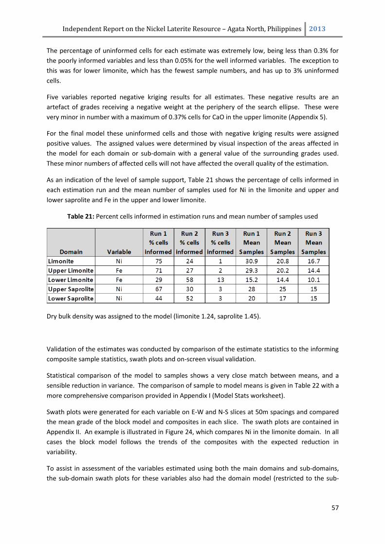
Independent Report on the Nickel Laterite Resource – Agata North, Philippines 2013
57
The percentage of uninformed cells for each estimate was extremely low, being less than 0.3% for
the poorly informed variables and less than 0.05% for the well informed variables. The exception to
this was for lower limonite, which has the fewest sample numbers, and has up to 3% uninformed
cells.
Five variables reported negative kriging results for all estimates. These negative results are an
artefact of grades receiving a negative weight at the periphery of the search ellipse. These were
very minor in number with a maximum of 0.37% cells for CaO in the upper limonite (Appendix 5).
For the final model these uninformed cells and those with negative kriging results were assigned
positive values. The assigned values were determined by visual inspection of the areas affected in
the model for each domain or sub-domain with a general value of the surrounding grades used.
These minor numbers of affected cells will not have affected the overall quality of the estimation.
As an indication of the level of sample support, Table 21 shows the percentage of cells informed in
each estimation run and the mean number of samples used for Ni in the limonite and upper and
lower saprolite and Fe in the upper and lower limonite.
Table 21: Percent cells informed in estimation runs and mean number of samples used
Dry bulk density was assigned to the model (limonite 1.24, saprolite 1.45).
Validation of the estimates was conducted by comparison of the estimate statistics to the informing
composite sample statistics, swath plots and on-screen visual validation.
Statistical comparison of the model to samples shows a very close match between means, and a
sensible reduction in variance. The comparison of sample to model means is given in Table 22 with a
more comprehensive comparison provided in Appendix I (Model Stats worksheet).
Swath plots were generated for each variable on E-W and N-S slices at 50m spacings and compared
the mean grade of the block model and composites in each slice. The swath plots are contained in
Appendix II. An example is illustrated in Figure 24, which compares Ni in the limonite domain. In all
cases the block model follows the trends of the composites with the expected reduction in
variability.
To assist in assessment of the variables estimated using both the main domains and sub-domains,
the sub-domain swath plots for these variables also had the domain model (restricted to the sub-
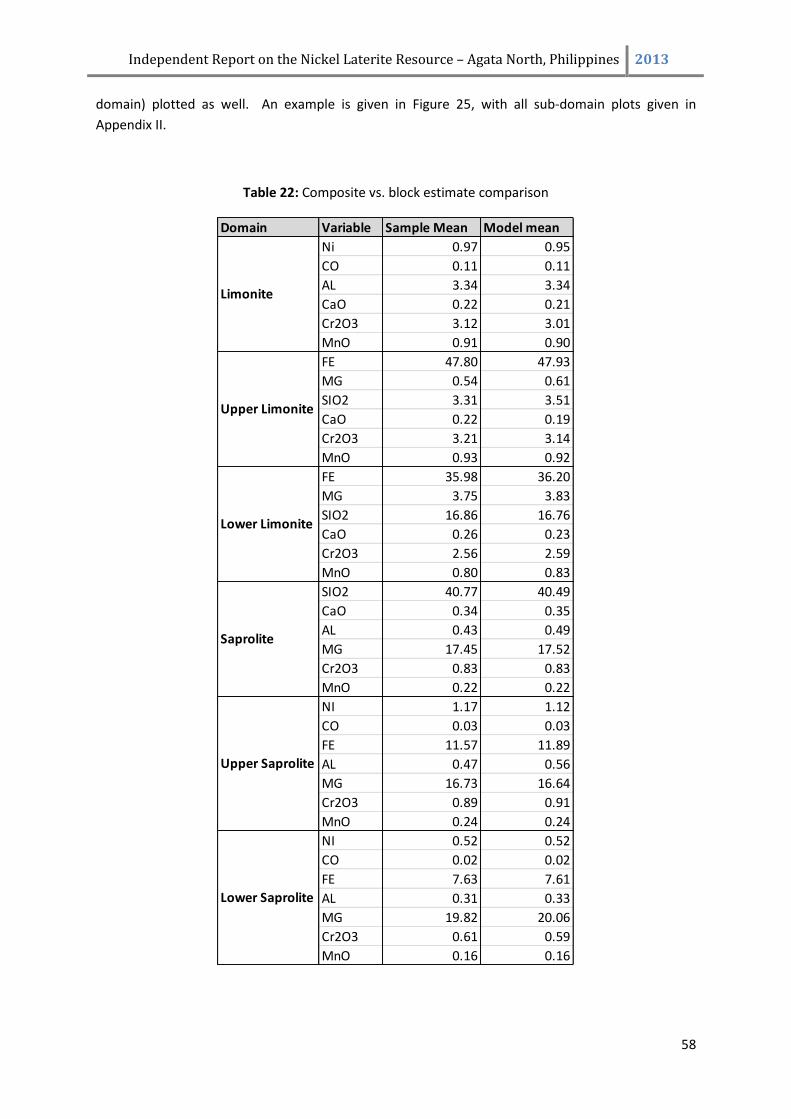
Independent Report on the Nickel Laterite Resource – Agata North, Philippines 2013
58
domain) plotted as well. An example is given in Figure 25, with all sub-domain plots given in
Appendix II.
Table 22: Composite vs. block estimate comparison
Domain Variable Sample Mean Model mean
Ni 0.97 0.95
CO 0.11 0.11
AL 3.34 3.34
CaO 0.22 0.21
Cr2O3 3.12 3.01
MnO 0.91 0.90
FE 47.80 47.93
MG 0.54 0.61
SIO2 3.31 3.51
CaO 0.22 0.19
Cr2O3 3.21 3.14
MnO 0.93 0.92
FE 35.98 36.20
MG 3.75 3.83
SIO2 16.86 16.76
CaO 0.26 0.23
Cr2O3 2.56 2.59
MnO 0.80 0.83
SIO2 40.77 40.49
CaO 0.34 0.35
AL 0.43 0.49
MG 17.45 17.52
Cr2O3 0.83 0.83
MnO 0.22 0.22
NI 1.17 1.12
CO 0.03 0.03
FE 11.57 11.89
AL 0.47 0.56
MG 16.73 16.64
Cr2O3 0.89 0.91
MnO 0.24 0.24
NI 0.52 0.52
CO 0.02 0.02
FE 7.63 7.61
AL 0.31 0.33
MG 19.82 20.06
Cr2O3 0.61 0.59
MnO 0.16 0.16
Limonite
Upper Limonite
Lower Limonite
Saprolite
Upper Saprolite
Lower Saprolite
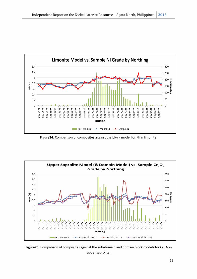
Independent Report on the Nickel Laterite Resource – Agata North, Philippines 2013
59
Figure24: Comparison of composites against the block model for Ni in limonite.
Figure25: Comparison of composites against the sub-domain and domain block models for Cr2O3 in
upper saprolite.
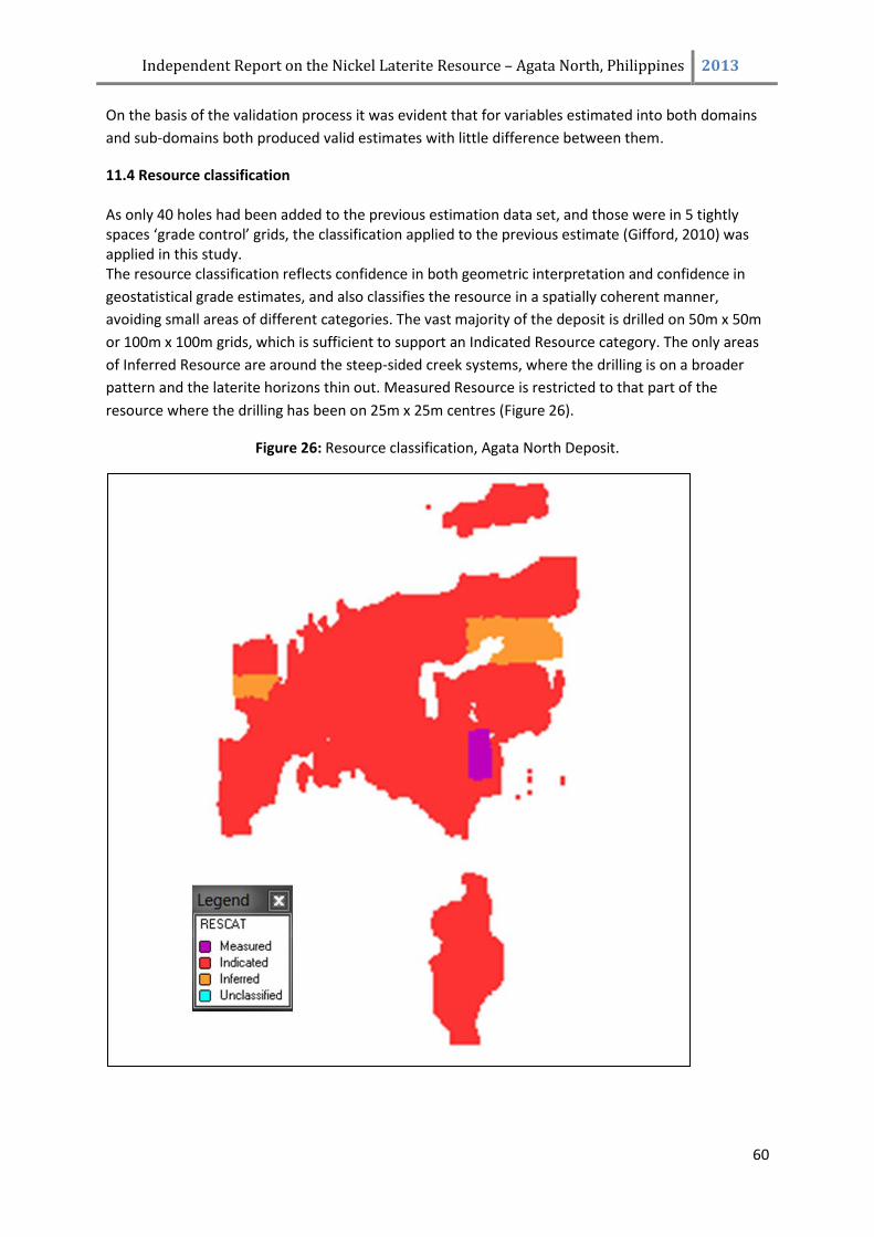
Independent Report on the Nickel Laterite Resource – Agata North, Philippines 2013
60
On the basis of the validation process it was evident that for variables estimated into both domains
and sub-domains both produced valid estimates with little difference between them.
11.4 Resource classification As only 40 holes had been added to the previous estimation data set, and those were in 5 tightly spaces ‘grade control’ grids, the classification applied to the previous estimate (Gifford, 2010) was applied in this study. The resource classification reflects confidence in both geometric interpretation and confidence in
geostatistical grade estimates, and also classifies the resource in a spatially coherent manner,
avoiding small areas of different categories. The vast majority of the deposit is drilled on 50m x 50m
or 100m x 100m grids, which is sufficient to support an Indicated Resource category. The only areas
of Inferred Resource are around the steep-sided creek systems, where the drilling is on a broader
pattern and the laterite horizons thin out. Measured Resource is restricted to that part of the
resource where the drilling has been on 25m x 25m centres (Figure 26).
Figure 26: Resource classification, Agata North Deposit.
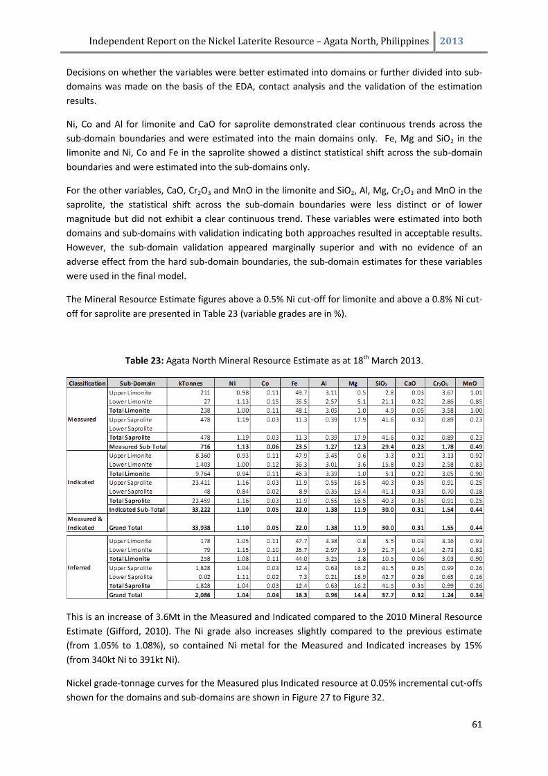
Independent Report on the Nickel Laterite Resource – Agata North, Philippines 2013
61
Decisions on whether the variables were better estimated into domains or further divided into sub-
domains was made on the basis of the EDA, contact analysis and the validation of the estimation
results.
Ni, Co and Al for limonite and CaO for saprolite demonstrated clear continuous trends across the
sub-domain boundaries and were estimated into the main domains only. Fe, Mg and SiO2 in the
limonite and Ni, Co and Fe in the saprolite showed a distinct statistical shift across the sub-domain
boundaries and were estimated into the sub-domains only.
For the other variables, CaO, Cr2O3 and MnO in the limonite and SiO2, Al, Mg, Cr2O3 and MnO in the
saprolite, the statistical shift across the sub-domain boundaries were less distinct or of lower
magnitude but did not exhibit a clear continuous trend. These variables were estimated into both
domains and sub-domains with validation indicating both approaches resulted in acceptable results.
However, the sub-domain validation appeared marginally superior and with no evidence of an
adverse effect from the hard sub-domain boundaries, the sub-domain estimates for these variables
were used in the final model.
The Mineral Resource Estimate figures above a 0.5% Ni cut-off for limonite and above a 0.8% Ni cut-
off for saprolite are presented in Table 23 (variable grades are in %).
Table 23: Agata North Mineral Resource Estimate as at 18th March 2013.
This is an increase of 3.6Mt in the Measured and Indicated compared to the 2010 Mineral Resource
Estimate (Gifford, 2010). The Ni grade also increases slightly compared to the previous estimate
(from 1.05% to 1.08%), so contained Ni metal for the Measured and Indicated increases by 15%
(from 340kt Ni to 391kt Ni).
Nickel grade-tonnage curves for the Measured plus Indicated resource at 0.05% incremental cut-offs
shown for the domains and sub-domains are shown in Figure 27 to Figure 32.
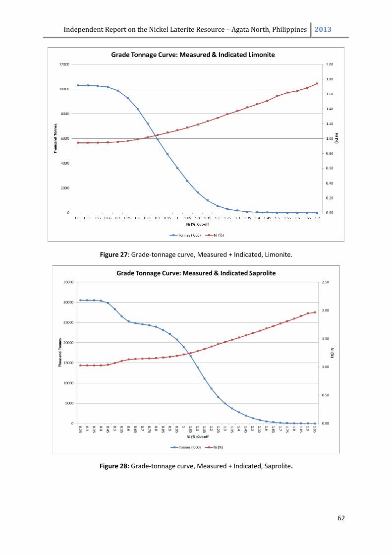
Independent Report on the Nickel Laterite Resource – Agata North, Philippines 2013
62
Figure 27: Grade-tonnage curve, Measured + Indicated, Limonite.
Figure 28: Grade-tonnage curve, Measured + Indicated, Saprolite.
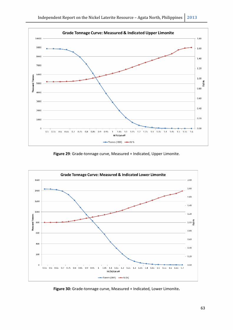
Independent Report on the Nickel Laterite Resource – Agata North, Philippines 2013
63
Figure 29: Grade-tonnage curve, Measured + Indicated, Upper Limonite.
Figure 30: Grade-tonnage curve, Measured + Indicated, Lower Limonite.
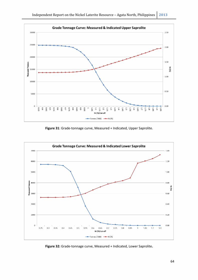
Independent Report on the Nickel Laterite Resource – Agata North, Philippines 2013
64
Figure 31: Grade-tonnage curve, Measured + Indicated, Upper Saprolite.
Figure 32: Grade-tonnage curve, Measured + Indicated, Lower Saprolite.
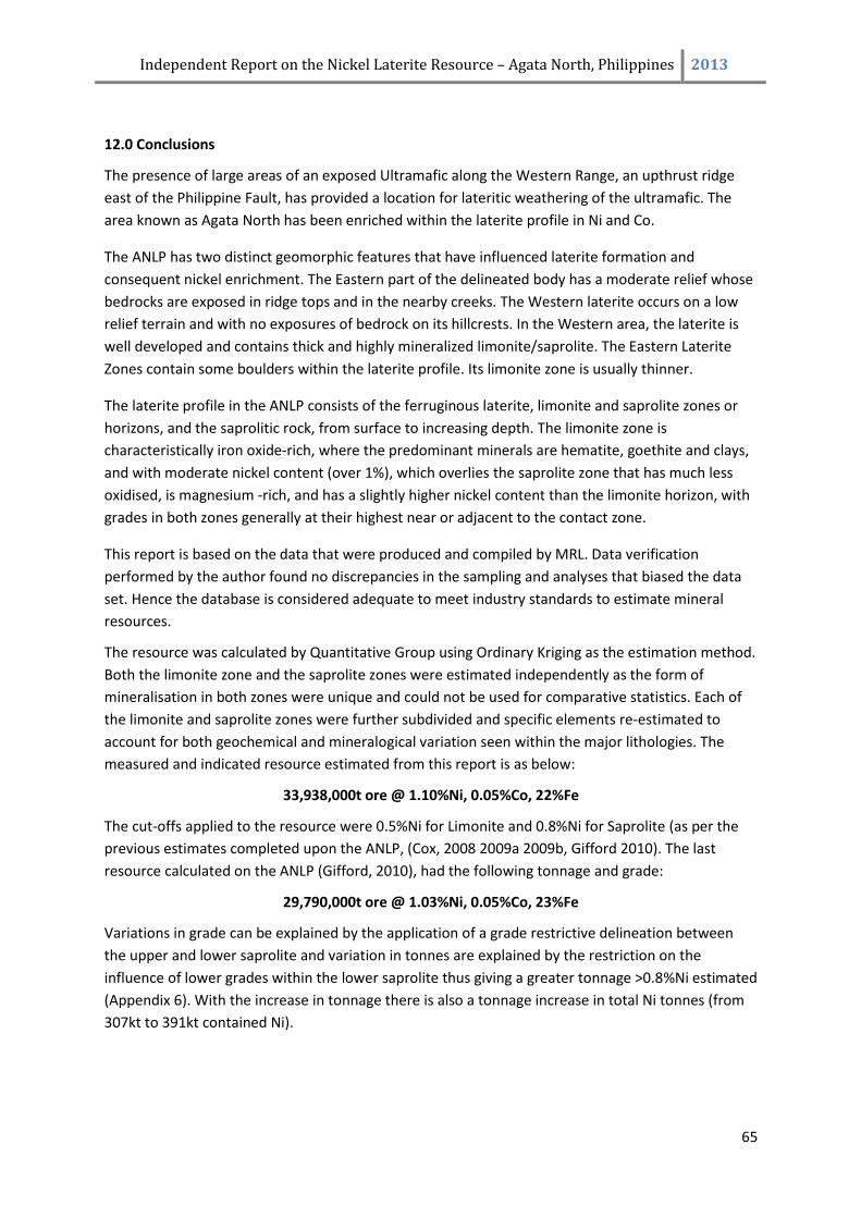
Independent Report on the Nickel Laterite Resource – Agata North, Philippines 2013
65
12.0 Conclusions
The presence of large areas of an exposed Ultramafic along the Western Range, an upthrust ridge
east of the Philippine Fault, has provided a location for lateritic weathering of the ultramafic. The
area known as Agata North has been enriched within the laterite profile in Ni and Co.
The ANLP has two distinct geomorphic features that have influenced laterite formation and
consequent nickel enrichment. The Eastern part of the delineated body has a moderate relief whose
bedrocks are exposed in ridge tops and in the nearby creeks. The Western laterite occurs on a low
relief terrain and with no exposures of bedrock on its hillcrests. In the Western area, the laterite is
well developed and contains thick and highly mineralized limonite/saprolite. The Eastern Laterite
Zones contain some boulders within the laterite profile. Its limonite zone is usually thinner.
The laterite profile in the ANLP consists of the ferruginous laterite, limonite and saprolite zones or
horizons, and the saprolitic rock, from surface to increasing depth. The limonite zone is
characteristically iron oxide-rich, where the predominant minerals are hematite, goethite and clays,
and with moderate nickel content (over 1%), which overlies the saprolite zone that has much less
oxidised, is magnesium -rich, and has a slightly higher nickel content than the limonite horizon, with
grades in both zones generally at their highest near or adjacent to the contact zone.
This report is based on the data that were produced and compiled by MRL. Data verification
performed by the author found no discrepancies in the sampling and analyses that biased the data
set. Hence the database is considered adequate to meet industry standards to estimate mineral
resources.
The resource was calculated by Quantitative Group using Ordinary Kriging as the estimation method.
Both the limonite zone and the saprolite zones were estimated independently as the form of
mineralisation in both zones were unique and could not be used for comparative statistics. Each of
the limonite and saprolite zones were further subdivided and specific elements re-estimated to
account for both geochemical and mineralogical variation seen within the major lithologies. The
measured and indicated resource estimated from this report is as below:
33,938,000t ore @ 1.10%Ni, 0.05%Co, 22%Fe
The cut-offs applied to the resource were 0.5%Ni for Limonite and 0.8%Ni for Saprolite (as per the
previous estimates completed upon the ANLP, (Cox, 2008 2009a 2009b, Gifford 2010). The last
resource calculated on the ANLP (Gifford, 2010), had the following tonnage and grade:
29,790,000t ore @ 1.03%Ni, 0.05%Co, 23%Fe
Variations in grade can be explained by the application of a grade restrictive delineation between
the upper and lower saprolite and variation in tonnes are explained by the restriction on the
influence of lower grades within the lower saprolite thus giving a greater tonnage >0.8%Ni estimated
(Appendix 6). With the increase in tonnage there is also a tonnage increase in total Ni tonnes (from
307kt to 391kt contained Ni).
Independent Report on the Nickel Laterite Resource – Agata North, Philippines 2013
66
13.0 References
Abrasaldo, E.M. 1999. Exploration Report Agata Project June 1997-April 1998. MRL Gold Phils., Inc.,
Internal Company Report (unpubl)
Ambagan, D. 2007. Notes on Resource Estimation of Agata Nickel Laterite Project of MRL Gold
Phils., Inc., Internal Report., (unpubl). January 2007.
Aurelio, M.A. and Peña R.E. 2002. Geology and Mineral Resources of the Philippines, Volume 1:
Geology. (eds) Aurelio, M.A. and Peña, R.E., Department of Environment and Natural
Resources, Mines and Geosciences Bureau, Philippines.
Bailey, D.G. 2003. Surigao Property Group, Northeastern Mindanao, Geology and Exploration
Potential. Bailey Geological Consultants (Canada), Technical Report for Panoro Minerals Ltd.
Buenavista, A.G. 2008. Notes on the Geology and Mineralization in the Surigao Western Range. MRL
Gold Phils., Inc. Internal Report, February 2008.
Buenavista, A.G. 2008. Geochemistry of the Agata Nickeliferrous Laterite Deposit. MRL Gold Phils.,
Inc. Internal Report, May 2008.
Cox, D.M. 2008. Independent Geologic Report on the Nickel Laterite Resource at Agata North
Laterite Project Area, Agata Project, Agusan del Norte Province, Northern Mindanao,
Phillipines. MRL Gold Phils., Inc., September 2008, rev. Oct 2008.
Cox, D.M. 2009a. 43-101 Technical Report on the Mineral Resource Estimate for the Agata North
Nickel Laterite Project of Mindoro Resources Ltd., January 22, 2009.
Cox, D.M. 2009b. 43-101 Technical Report on the Mineral Resource Estimate for the Agata North
Nickel Laterite Project of Mindoro Resources Ltd., December 22, 2009.
Climie, J.A., et,al. 2000. Accomplishment Report for the Period: June to December 1999. MRL Gold
Phils., Inc., Internal Company Report (unpubl). January 2000.
Climie, J.A., et,al. 2005. Interim Exploration Program Report, Surigao Joint Venture Projects: March
1 to June 20, 2005. MRL Gold Phils., Inc., Internal Company Report (unpubl). July 2005.
De Luna, R., et.al., 2004. Report on the Reconnaissance Geologic Survey of the Nickeliferrous Laterite
Deposits at Barangay Tapian, Mainit, Surigao del Norte and Barangay E. Morgado, Santiago,
Agusan del Norte. Taganito Mining Corp. Report, July 2004.
Elliott, P.J. 2005. Report on IP and Magnetic Surveys Over the: Agata Prospect, San Francisco
Project, Philippines. MRL Gold Phils., Inc. and Panoro Minerals Ltd,, Company Report, June 2005
Fang, E.F.E and C.A. Matilac. 2006. Evaluation of Preliminary Exploration on Agata Nickel Laterite
Prospect of MRL Gold Phils., Inc., QNPH Report, June 2006
Independent Report on the Nickel Laterite Resource – Agata North, Philippines 2013
67
Fetiza, I.A. Jr. 1999. Exploration Report: Tapian-San Francisco Project, May 1997 - May 1998. MRL
Gold Philippines Inc. Internal Company Report (unpubl.).
Gifford, M. G. 2010. Independent Geologic Report on the Nickel Laterite Resource at Agata North
Laterite Project Area, Agusan del Norte Province, Northern Mindanao, Phillipines. MRL Gold
Phils., Inc., August 2010.
Marshall, N.J. 1997. Geological Report on the Agata, Mat-I, Nabago and Tapian Gold Prospects,
Northern Mindanao, Republic of the Philippines. Marshall Geoscience Services Pty. Ltd.,
Australia.
Mitchell, A.H.G. and Leach, T.M. 1991. Epithermal gold in the Philippines: Island arc metallogenesis,
geothermal systems and geology. Academic Press Geology Series.
Rangin, C. 1991. The Philippine Mobile Belt: A complex plate boundary. Journal of Southeast Asian
Earth Sciences, 6 (3/4), pp. 209-220.
Rohrlach, B.D. 2005. Independent Geological Report on the Surigao Property Group, Northern
Mindanao, Philippines. MRL Gold Phils., Inc. and Panoro Minerals Ltd., Company Report, April
2005
Sajona, F.G., et.al., 1994. Magmatic response to abrupt changes in geodynamic settings: Pliocene-
Quaternary calc-alkaline and Nb-enriched lavas from Mindanao (Philippines). Tectonophysics,
237(1-2), pp. 47-72.
Sillitoe, R.H. 1988. Geotectonic setting of western Pacific gold deposits. In: M.J. Bartholomew. D.W.
Hyndman, D.W. Mogk, and R. Mason, (eds), 8th International Conference on Basement
Tectonics, 8, pp. 665-678. Kluwer Publishers, Butte, Montana.
Tagura, F. et. al. 2006. Comprehensive Report, MPSA-134-99-XIII, Agata Tenement Blocks. MRL Gold
Phils., Inc. Internal Company Report (unpubl.), 2006
Tagura, F. et. al. 2006. Report on the Preliminary Drill Evaluation on Canaga (MPSA-33-95-X),
Malimono, Surigao del Norte. MRL Gold Phils., Inc. Internal Company Report (unpubl.),
September 2006
Tagura, F. et. al. 2007. Report on Agata Drilling Program, Agusan del Norte, Philippines (Phase 1 Year
2 Expenditure Period 2005-2006), MRL Gold Phils., Inc. Internal Company Report (unpubl.),
January 2007
UNDP. 1984. Geology of Northern Agusan, Mindanao, United Nations Technical Report No. 2,
DP/UN/PHI-79-004/6, New York.
UNDP. 1987. Geology and Gold Mineralization of Surigao del Norte, United Nations Technical Report
No. 4, DP/UN/PHI-85-001/4, New York.
Zurkic, N. 2009. AGL-Vario_Report. Zurkic Mining Consultants Pty. Ltd., Internal Report (unpubl)
Independent Report on the Nickel Laterite Resource – Agata North, Philippines 2013
68
14.0 Date and Signature
CERTIFICATE OF QUALIFICATION
I, Mark G. Gifford of 636 Bramley River Road, Margaret River, Western Australia hereby certify that:
1. I am a Professional Geologist employed as a private consultant.
2. I am responsible for the preparation of the Technical Report titled “Independent Report on
the Nickel Laterite Resource – Agata North, Philippines.” And dated March 22nd 2013.
3. I am a Fellow in good standing of the Australian Institute of Mining and Metallurgy with
membership number 108672
4. I am a graduate of the University of Waikato, New Zealand with a Masters Degree (1st Class
Honours) in Earth Sciences.
5. I have practiced my profession for 24 years, and have worked specifically on lateritic Nickel
deposits throughout the world for 5 years in a geological managerial position. I have been
operating as an Independent Consulting Geologist since 2005.
6. I certify that by reason of my education, affiliation with a professional association (as
defined by NI 43-101), and past relevant work experience, I fulfil the requirements to be a
“qualified person” for the purposes of NI 43-101. I am an independent qualified person as
defined by NI 43-101 and by the companion policy 43-101CP to National Instrument 43-101.
7. This technical report is based on my review of the available published data, company reports
and data, and personal visits to the property. I have visited the property thrice in 2010/2011
and have completed inspections of all aspects of the exploration process, as well as
consulting with MRL staff at all levels during the development of the report. My visits were
in March - June 2010, and May 2011.
8. I have read NI 43-101 and form 101F1. The technical report has been prepared in
compliance with both of these documents.
9. I, Mark Gifford, do not expect to receive any interest (direct, indirect or contingent), in the
properties described herein, nor in the securities of Mindoro Resources Limited or any of
their affiliates. I am independent of the issuer under all criteria of Section 1.5 of NI 43-101.
10. I am not aware of any material fact or material change with respect to the subject matter of
this Technical Report which is not reflected in this report. I am not aware of any possible
omissions that would deem this report misleading.
11. I consent to the filing of the Technical Report with any stock exchange and other regulatory
authorities, and any further publication by them for regulatory purposes. I consent to the
inclusion of parts of the Technical Report as electronic publication on the companies’
websites that are accessible to the public.
Independent Report on the Nickel Laterite Resource – Agata North, Philippines 2013
69
Signed in Margaret River, Australia. Dated 01 April 2013.
_________________________________
Signature of Qualified Person
Mark G. Gifford MSc (Hons), MAusIMM
________________________________
Name of Qualified Person