Embed Size (px)
Citation preview
Independent Report on the Nickel Laterite Resource at Agata North
ii
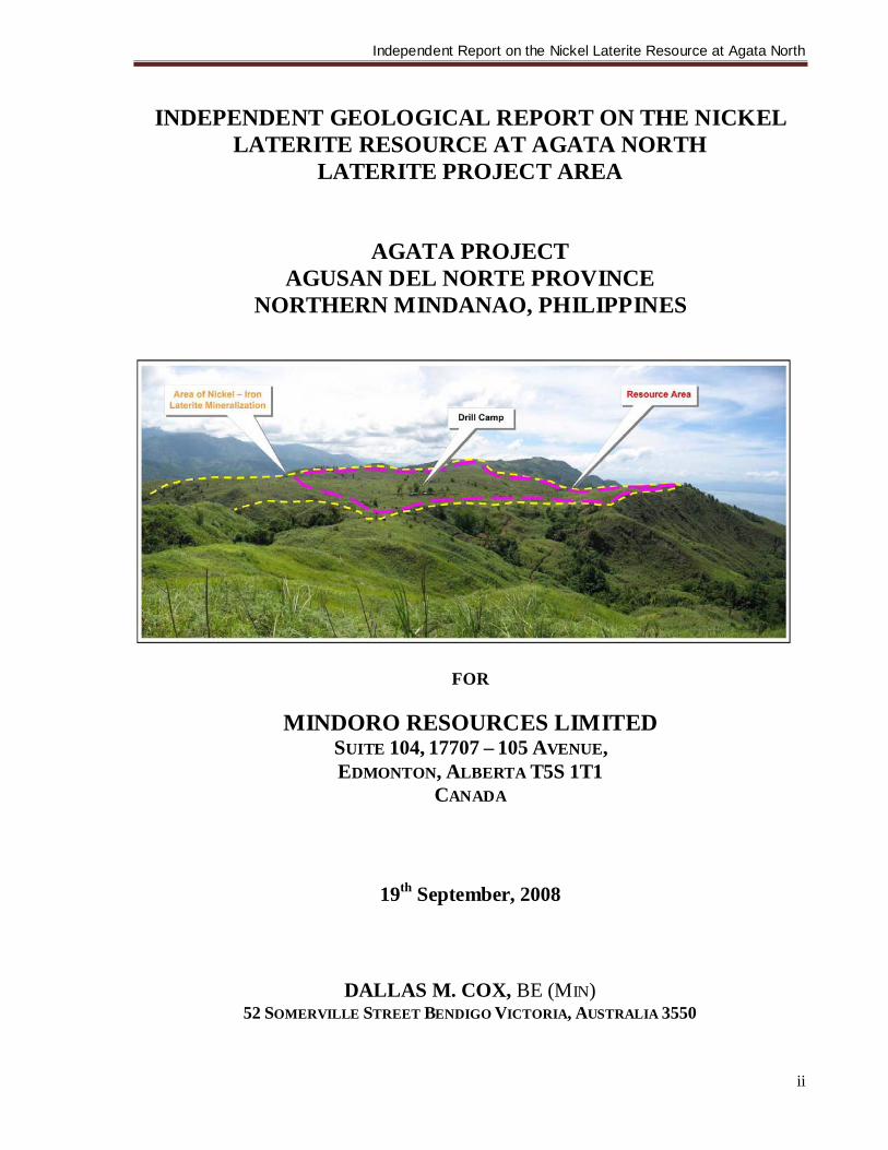
INDEPENDENT GEOLOGICAL REPORT ON THE NICKEL
LATERITE RESOURCE AT AGATA NORTH LATERITE PROJECT AREA
AGATA PROJECT AGUSAN DEL NORTE PROVINCE
NORTHERN MINDANAO, PHILIPPINES
FOR
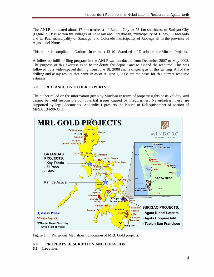
MINDORO RESOURCES LIMITED SUITE 104, 17707 – 105 AVENUE, EDMONTON, ALBERTA T5S 1T1
CANADA
19th September, 2008
DALLAS M. COX, BE (MIN) 52 SOMERVILLE STREET BENDIGO VICTORIA, AUSTRALIA 3550
Independent Report on the Nickel Laterite Resource at Agata North
iii
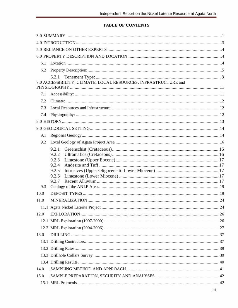
TABLE OF CONTENTS 3.0 SUMMARY .....................................................................................................................................1 4.0 INTRODUCTION .............................................................................................................................3 5.0 RELIANCE ON OTHER EXPERTS ..................................................................................................4 6.0 PROPERTY DESCRIPTION AND LOCATION ................................................................................4
6.1 Location .....................................................................................................................................4 6.2 Property Description: ...................................................................................................................5
6.2.1 Tenement Type: ........................................................................................................... 8 7.0 ACCESSIBILITY, CLIMATE, LOCAL RESOURCES, INFRASTRUCTURE and PHYSIOGRAPHY ................................................................................................................................ 11
7.1 Accessibility: ............................................................................................................................ 11 7.2 Climate: .................................................................................................................................... 12 7.3 Local Resources and Infrastructure: ............................................................................................ 12 7.4 Physiography: ........................................................................................................................... 12
8.0 HISTORY....................................................................................................................................... 13 9.0 GEOLOGICAL SETTING............................................................................................................... 14
9.1 Regional Geology...................................................................................................................... 14 9.2 Local Geology of Agata Project Area.......................................................................................... 16
9.2.1 Greenschist (Cretaceous) ........................................................................................... 16 9.2.2 Ultramafics (Cretaceous) ........................................................................................... 16 9.2.3 Limestone (Upper Eocene) ........................................................................................ 17 9.2.4 Andesite and Tuff ...................................................................................................... 17 9.2.5 Intrusives (Upper Oligocene to Lower Miocene) ...................................................... 17 9.2.6 Limestone (Lower Miocene) ..................................................................................... 17 9.2.7 Recent Alluvium ........................................................................................................ 17
9.3 Geology of the ANLP Area ........................................................................................................ 19 10.0 DEPOSIT TYPES ..................................................................................................................... 19 11.0 MINERALIZATION ................................................................................................................. 24
11.1 Agata Nickel Laterite Project ..................................................................................................... 24 12.0 EXPLORATION ....................................................................................................................... 26
12.1 MRL Exploration (1997-2000) ................................................................................................... 26 12.2 MRL Exploration (2004-2006) ................................................................................................... 27
13.0 DRILLING ............................................................................................................................... 37 13.1 Drilling Contractors: .................................................................................................................. 37 13.2 Drilling Rates: ........................................................................................................................... 39 13.3 Drillhole Collars Survey ............................................................................................................ 39 13.4 Drilling Results ......................................................................................................................... 40
14.0 SAMPLING METHOD AND APPROACH ................................................................................ 41 15.0 SAMPLE PREPARATION, SECURITY AND ANALYSES ....................................................... 42
15.1 MRL Protocols .......................................................................................................................... 42
Independent Report on the Nickel Laterite Resource at Agata North
iv
15.1.1 MRL Core Sampling.................................................................................................. 42 15.1.2 Rechecking of Laboratory Results............................................................................. 44
15.2 Laboratory Protocols ................................................................................................................. 46 15.2.1 McPhar Geoservices (Phil.), Inc. ............................................................................... 46 15.2.2 Intertek Testing Services Phils., Inc. ......................................................................... 48
16.0 DATA VERIFICATION............................................................................................................ 50 16.1 Internal QAQC (McPhar/Intertek) .............................................................................................. 50 16.2 External QAQC (MRL) ............................................................................................................. 52
16.2.1 Nickel Standards ........................................................................................................ 53 16.2.2 Field Duplicates ......................................................................................................... 55 16.2.3 Coarse Rejects............................................................................................................ 59 16.2.4 Pulp Rejects Analyzed by Primary Laboratory ......................................................... 60 16.2.5 Pulp Rejects Analyzed by Umpire Laboratory .......................................................... 62
17.0 ADJACENT PROPERTIES ....................................................................................................... 64 17.1 Tapian-San Francisco Property: .................................................................................................. 64
17.1.1 Gold Hill [C5] ............................................................................................................ 64 17.1.2 Cantikoy (C6) ............................................................................................................ 64 17.1.3 Canaga (C9) ............................................................................................................... 64 17.1.4 Waterfalls (C1) .......................................................................................................... 65
17.2 Tapian Main Property ................................................................................................................ 65 17.3 Tapian Extension....................................................................................................................... 66
17.3.1 Bolobolo..................................................................................................................... 66 17.4 Other Nickel Laterite Prospects: ................................................................................................. 67
18.0 MINERAL PROCESSING AND METALLURGICAL TESTING ............................................... 67 19.0 MINERAL RESOURCE ESTIMATE......................................................................................... 67
19.1 Data Set: ................................................................................................................................... 67 19.2 Raw Assay Statistics:................................................................................................................. 68 19.3 Compositing: ............................................................................................................................ 69 19.4 Surfaces and Domains: .............................................................................................................. 75 19.5 Data Manipulation: .................................................................................................................... 76 19.6 Specific Gravity, Bulk Density and Moisture Content: ................................................................. 76 19.7 Block Modelling and Grade Estimation:...................................................................................... 82 19.8 Conclusions: ............................................................................................................................. 84
20.0 OTHER RELEVANT DATA AND INFORMATION ................................................................. 84 21.0 INTERPRETATION AND CONCLUSIONS .............................................................................. 85
21.1 Agata North Nickel Laterite Project ............................................................................................ 85 21.2 Regional Prospects .................................................................................................................... 86
22.0 RECOMMENDATIONS ........................................................................................................... 87 22.1 Agata North Nickel Laterite Project ............................................................................................ 87 22.2 Regional Prospects .................................................................................................................... 87
23.0 REFERENCES ......................................................................................................................... 88
Independent Report on the Nickel Laterite Resource at Agata North
v
24.0 DATE AND SIGNATURES ...................................................................................................... 90 25.0 ADDITIONAL REQUIREMENTS FOR TECHNICAL REPORTS ON DEVELOPMENT PROPERTIES & PRODUCTION PROPERTIES .................................................................................... 92 26.0 ILLUSTRATIONS .................................................................................................................... 92
LIST OF FIGURES Figure 1: Philippine Map showing location of MRL Gold projects .................................................. 4 Figure 2: MRL Tenements and Projects in the Surigao Mineral District .......................................... 7 Figure 3: Geologic Map of Surigao Mineral District .....................................................................15 Figure 4: Agata Geologic Map ....................................................................................................18 Figure 5: Agata Compilation .......................................................................................................21 Figure 6: Model of spatial relationship between nickel laterite and porphyry targets........................21 Figure 7: Compilation Map Showing areas of Nickel Laterite Mineralization .................................23 Figure.8: Agata Projects Map showing areas of Nickel Laterite Mineralization. ..............................25 Figure 9: Cross section Line 10150N Linegraph. ..........................................................................26 Figure 10: Agata Soil (Gold) Map..............................................................................................29 Figure 11: Agata Soil (Copper) Map ..........................................................................................30 Figure 12: Agata Soil (Zinc) Map ..............................................................................................31 Figure 13: Agata Rock Geochemistry Map .................................................................................32 Figure 14: Agata Ground Magnetic Survey Map .........................................................................33 Figure 15: Agata Chargeability @ L=7 ......................................................................................35 Figure 16: Agata Resistivity @ L=7 ...........................................................................................36 Figure 17: ANLP Drillhole Location Map ..................................................................................38 Figure 18: Cross Section Line 10150N showing grades and thickness of laterite horizons..............40 Figure 19: Flowchart of Mcphar’s Sample Preparation for Laterite ..............................................47 Figure 20: McPhar’s Laterite Analysis Procedure Flowsheet .......................................................48 Figure 21: Intertek’s Sample Preparation Procedure for Laterite ..................................................49 Figure 22: Graphs of Laboratory Internal Recheck Assays..........................................................51 Figure 23: Graphs of Nickel Standards .......................................................................................53 Figure 24: Graphs of Field Duplicates Assays ............................................................................57 Figure 25: Graphs of Coarse Duplicates Assays ..........................................................................59 Figure 26: Graphs of Pulp Rejects analyzed by Primary Laboratory .............................................61 Figure 27: Graphs of Pulp Rejects Analyzed by Umpire Laboratory.............................................63 Figure 28: Tapian-San Francisco Compilation ............................................................................65 Figure 29: Tapian Main Compilation .........................................................................................66 Figure 30: Domain Surfaces and Composite Coding ...................................................................76 Figure 31: Agata North Test Pit Location Map ...........................................................................77 Figure 32: Graphs of Dry Bulk Density Measurements................................................................81 Figure 33: Graphs of Moisture Content ......................................................................................81 Figure 34: Block Model Configuration .......................................................................................82 Figure 35: Block Model Cross Section (N1027590) ....................................................................83 Figure 36: Block Model Classification .......................................................................................83
LIST OF TABLES Table 1: Original Mining Application Claims under MPSA 134-99-XIII........................................ 5 Table 2: Surigao-Agusan del Norte Tenements held by Mindoro: .................................................10 Table 3: Climatological Normals and Extremes 1961-2000 ..........................................................12 Table 4: Average Grades of Nickel Laterite Horizons ..................................................................25 Table 5: Drilling Rates ..............................................................................................................39
Independent Report on the Nickel Laterite Resource at Agata North
vi
Table 6: NAMRIA Tie Points Technical Description ...................................................................40 Table 7: Average Grades of Laterite Horizons at Line 10150N .....................................................41 Table 8: Core Recovery Percentages...........................................................................................42 Table 9: List of Sampling Intervals .............................................................................................43 Table 10: Numbers of Core, Reference and Recheck Samples Analyzed .........................................45 Table 11: Frequency of Check Sampling per Laterite Zone ............................................................46 Table 12: Frequency of Using Nickel Reference Materials .............................................................46 Table 13: Relationship of Original and Repeat Analyses ................................................................50 Table 14: Relationship of Field Duplicate and Original Assays ......................................................56 Table 15: Relationship of Coarse Rejects and Original Assays .......................................................59 Table 16: Data Set.......................................................................................................................68 Table 17: Drillhole Summary .......................................................................................................68 Table 18: Raw Assay Statistics ....................................................................................................68 Table 19: Compositing Data ........................................................................................................70 Table 20: Frequency Distribution Plots Ni% .................................................................................71 Table 21: Cumulative Probability Plots Ni% .................................................................................72 Table 22: Limonite Composite Statistics .......................................................................................73 Table 23: Saprolite Composite Statistics .......................................................................................74 Table 24: Domain Coding............................................................................................................75 Table 25: Specific Gravity Parameters ..........................................................................................76 Table 26: Summary of Bulk Density Measurements ......................................................................78 Table 27: Bulk Density Measurements on Ferruginous Laterite Materials .......................................78 Table 28: Bulk Density Measurements on Limonite Materials........................................................79 Table 29: Bulk Density Measurements on Saprolite Materials (Pit Samples) ...................................79 Table 30: Bulk Density Measurements on Saprolite Materials (Core Samples) ................................80 Table 31: Mineral Resource Classification ....................................................................................84 Table 32: Mineral Resource Estimation by Classification ..............................................................84 Table 33: Summary of Resource: Combined Limonite and Saprolite @ 0.8% Ni cutoff grade ..........86
LIST OF APPENDICES
Appendix 1: Notice of Relinquishment of portion of MPSA 134-99-XIII Appendix 2: Certified technical descriptions of NAMRIA Stations Appendix 3: ANLP QAQC Procedures Appendix 4: Certificates of Nickel Reference Materials
Independent Report on the Nickel Laterite Resource at Agata North
1
3.0 SUMMARY
On July 2008, Mindoro Resources Ltd. [Mindoro] requested the author to update the 43-101 Technical Report on its mineral resource at the Agata North Laterite Project (ANLP), which was filed on June 2008. That first report was written by this author. This current report discloses the updated results of the mineral resource estimation at the ANLP and describes results for all exploration carried out to date by MRL Gold Phils. Inc. (MRL) on its Agata Projects. MRL is a wholly-owned subsidiary of Mindoro. The project was explored under a Memorandum of Agreement between MRL and Minimax Mineral Exploration Corporation (Minimax). MRL has earned a 75% interest in all the Surigao projects (except the Mat-I Project) including the Agata Project. Minimax has also granted MRL an option to acquire additional 25% direct and indirect participating interest in such projects as the Agata Projects. The ANLP is one of the projects located within the Agata Projects, which is covered by the Mineral Production Sharing Agreement (MPSA) Contract Area of Minimax denominated as MPSA-134-99-XIII and approved by the Department of Environment and Natural Resources (DENR) on May 26, 1999. The Agata Projects area is situated along the southern part of the uplifted and fault-bounded Western Range on the northern end of the east Mindanao Ridge. At least six juxtaposed rock units underlie the area. These are greenschists; ultramafics; limestones; andesite and tuff; younger limestones; intrusives; and alluvium. Widespread occurrence of serpentinized harzburgite, serpentinized peridotite, serpentinites and localized lenses of dunite comprise the lithology in the resource area. Geological mapping showed favorable development of laterite along the broad ridges characterized by peneplane topography and underlain by ultramafic rocks. Nickeliferrous laterite mineralization is present over a broad region in the Agata Projects area. They are divided into two (2) major areas known as the ANLP and the ASLP. The former has an area of approximately 379 ha while the latter comprises about 235 ha. In the ANLP, drilling is concentrated in approximately thirty-five (35) percent of the interpreted nickel laterite mineralization to date. There are two distinct geomorphic features that have influenced laterite formation and consequent nickel enrichment in the Agata Project. The Eastern part of the delineated body has a moderate relief whose bedrocks are exposed in ridge tops and in the nearby creeks. On the other hand, the Western laterite occurs on a low relief terrain and with no exposures of bedrock on its hillcrests. In the Western area, the laterite is well developed and contains thick and highly mineralized limonite/saprolite and transition rocks. The Eastern Laterite Zones contain boulders across the laterite profile suggesting transport. Its limonite zone is usually thinner. The laterite profile in the ANLP consists of the ferruginous laterite, limonite zone, saprolite zone, and the saprolitic rock, arranged from surface going down. The limonite zone is characteristically iron oxide-rich where the predominant minerals are hematite and goethite while the saprolite zone is Mg-rich. Patches of garnierite were noted within the saprolite and saprolitic rock horizon. The bases for this report are the data that were produced and compiled by MRL. The assay data were collected from drilling activities in the area. Work on the current mineral resource estimation yielded the following:
• Preliminary statistical analysis on raw assays was carried out on 228 drill holes. Raw Assay data was analyzed above a cut-off grade of 0.8 Ni%. The 0.8 Ni% cut-off grade was
Independent Report on the Nickel Laterite Resource at Agata North
2
considered the lower bound for Nickel Laterite ore exploitable via Direct Shipping Ore contracts in the Asian refineries with consideration to current and short term forecast Nickel prices.
• The MineSight ® IDW Interpolation procedure was used to interpolate Nickel, Cobalt, Iron
and Phosphor grades. Inverse Distance Weighting (IDW) Power 2 was used for grade estimation. This method was considered acceptable given the tight constraints applied to limonite and saprolite domaining. The density of drilling and continuity of mineralization is sufficient to classify the estimated resource.
• Grades were interpolated in Ferruginous Laterite, Limonite and Saprolite domains only.
Saprock composites above 1.0 Ni % were excluded from surface domaining, statistical analysis and mineral resource estimation pending future variographic studies.
• Generally, Nickel grades in the Limonite horizon, increase and peak at a point about the
base of the Limonite. Nickel grades remain respectively high and thereafter diminish as the ore grades into basement/bedrock. Unfolding to this surface ensures that Nickel grades in both Limonite and Saprolite are preferentially honored in the mid section of the laterite profile which represents a greater proportion (50+%) of the body.
• The Bulk Density for Limonite and Saprolite were measured in places and has been set at
1.20 and 1.50 respectively, for the mineral resource estimates.
• Resource classification methodology for Limonite was based on the grid spacing as denoted in Table 31. Planar and elevation search ellipses for Saprolite were reduced by 1/3rd of the limonite search ellipse parameters given the undulating saprolite/bedrock contact and laterally erratic nature of metal grades in the saprolite domain. There is upside potential to increase indicated and inferred ore category tonnages following favorable outcome from a planned variographic study, in conjuction with the analysis of the results of twinning diamond holes and test pits, to increase search ellipse parameters and domain extents.
The summary of the initial resource @ 0.8% Ni cutoff grade is presented in the following table:
Classification Laterite Horizon Mil. WMT Mil. DMT Ni % Co % Fe %
Measured Limonite 0.85 0.55 1.07 0.117 44 Saprolite 0.58 0.47 1.30 0.031 13 Subtotal 1.43 1.02 1.17 0.078 30
Indicated Limonite 1.88 1.22 1.06 0.117 44 Saprolite 1.63 1.31 1.30 0.031 13 Subtotal 3.52 2.53 1.18 0.073 28
Measured & Indicated
Limonite 2.73 1.78 1.06 0.117 44 Saprolite 2.22 1.77 1.30 0.031 13
Total Measured + Indicated 4.95 3.55 1.18 0.074 28
Inferred Limonite 1.14 0.74 1.04 0.105 43 Saprolite 3.23 2.58 1.32 0.030 13
Total Inferred 4.37 3.33 1.26 0.047 20 • Mineral resources which are not mineral reserves do not have demonstrated economic viability. • The tonnage and nickel grades above have been rounded to the nearest 2nd decimal, and iron grades
to the nearest whole number, which may have resulted in minor discrepancies. • The estimate of mineral resources may be materially affected by environmental, permitting, legal,
title, taxation, socio-political, marketing, or other relevant issues.
Independent Report on the Nickel Laterite Resource at Agata North
3
• It is uncertain if further exploration will result in upgrading the Inferred mineral resource to an Indicated or Measured mineral resource or the Indicated mineral resource to a Measured Resource category.
The methodologies employed for this mineral resource estimate are considered acceptable for the purposes of definition and classification of a resource for a future ore reserve study to be carried out for ore amenable to direct shipping product. The current resource in relation to a Direct Shipping product could be further enhanced following the analysis of variographic study. 4.0 INTRODUCTION
This technical report was prepared at the request of Mr. J.A. Climie, CEO of Mindoro of Canada [TSX-Venture Exchange] and CEO and President of MRL Gold Phils., Inc. (MRL). It provides a nickeliferrous laterite updated resource estimate of the ANLP located within the Agata Projects MPSA in Agusan del Norte, Philippines (Figures 1 & 2). The report was wholly prepared by the author, a qualified person as defined by National Instrument 43-101. The Agata Projects, which host the Agata North Laterite Project (ANLP), is one of the subject properties covered by the Memorandum of Agreement (MOA) signed by Mindoro and Minimax in January 19, 1997 by virtue of which Mindoro (thru its wholly-owned operating subsidiary, MRL) is granted the exclusive and irrevocable right to earn the Option Interests in the said project. Also included in the MOA are the Tapian Main, Tapian San Francisco, and Mat-I projects and the various Extension Projects in the Surigao Mineral District; and Lahuy Island and Pan de Azucar Projects in Luzon and Visayas respectively. At present, Mindoro has earned a 75% interests in the Agata, Tapian Main, and Tapian San Francisco and the Extension Projects and it has a further option to acquire an additional 25% direct and indirect participating interest in projects, which will be designated later as Designated Development Projects in the Surigao Mineral District. The Agata Projects comprise various projects and prospects, namely, the ANLP; the Agata South Laterite Project [ASLP]; the North Porphyry Prospect; the South Porphyry Prospect; the Assmicor Porphyry and Gold Prospects; the American Tunnels Porphyry and Gold Prospects; the Limestone Gold Prospect; and a host of other gold and copper-gold prospects, which have not been evaluated in detail. The report provides a detailed summary of the geology and mineralization and discusses the results of the resource delineation exploration activity in the ANLP, to date. It also assesses historical data and discusses the results of the exploration programs carried out over the general Agata Project itself. This document is compiled from technical reports written by MRL, from reports held by the Mines and Geosciences Bureau of the Philippines (MGB), from published technical data, and from observations made by the MRL geologists. All sources of data used in this report are cited herein and are listed in Item 23. All work of MRL at the Agata Projects was carried out under the direct and close supervision of James A. Climie, P. Geol., also a qualified person, who carried out frequent and extensive site visits. The author has visited the project site in July 2007 and January 2008. During these visits, MRL geologists and mining engineers were present to assist and discuss protocols, observations, results and interpretations with the author/consultant. Likewise, various meetings were held off-site to broaden the discussions and consultations. Further exchange of ideas is also continuing through correspondence.
Independent Report on the Nickel Laterite Resource at Agata North
4
The ANLP is located about 47 km northeast of Butuan City or 73 km southwest of Surigao City (Figure 2). It is within the villages of Lawigan and Tinigbasan, municipality of Tubay, E. Morgado and La Paz, municipality of Santiago; and Colorado municipality of Jabonga all in the province of Agusan del Norte. This report is compliant to National Instrument 43-101 Standards of Disclosure for Mineral Projects. A follow-up infill drilling program in the ANLP was conducted from December 2007 to May 2008. The purpose of this exercise is to better define the deposit and to extend the resource. This was followed by a wider-spaced drilling from June 18, 2008 and is ongoing as of this writing. All of the drilling and assay results that came in as of August 1, 2008 are the basis for this current resource estimate. 5.0 RELIANCE ON OTHER EXPERTS
The author relied on the information given by Mindoro in terms of property rights or its validity, and cannot be held responsible for potential issues caused by irregularities. Nevertheless, these are supported by legal documents. Appendix 1 presents the Notice of Relinquishment of portion of MPSA 134-99-XIII.
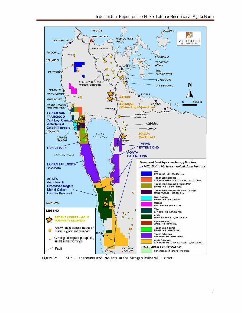
Figure 1: Philippine Map showing location of MRL Gold projects.
6.0 PROPERTY DESCRIPTION AND LOCATION 6.1 Location:
Independent Report on the Nickel Laterite Resource at Agata North
5
The Agata Projects are located within the northern part of Agusan del Norte province in Northeastern Mindanao, Republic of the Philippines. It lies within the Western Range approximately 10 kilometers south of Lake Mainit (Figures 1-2). The Agata Project falls within the political jurisdiction of the municipalities of Tubay, Santiago and Jabonga. The MPSA Contract Area, encompassing the Agata Projects, is bounded by geographical coordinates 9010’30” and 9019’30” north latitudes and 125029’30” to 125033’30” east longitudes. The ANLP is located in barangays Lawigan and Tinigbasan, municipality of Tubay, barangays E. Morgado (formerly Agata) and La Paz, municipality of Santiago, and barangay Colorado, municipality of Jabonga, all in the province of Agusan del Norte. It lies about 73 km southwest of Surigao City and 47 km northeast of Butuan City. The majority of MRL’s exploration activities on the project area are located in barangays Lawigan and E. Morgado. The ASLP, on the other hand, is located in barangays Binuangan, Tagpangahoy, and Tinigbasan, municipality of Tubay. Under a joint venture agreement with Delta Earthmoving, Inc. [Delta], a resource delineation drilling is being carried out by the latter in the ASLP. Their initial area of coverage is located in barangay Binuangan, Tubay. 6.2 Property Description:
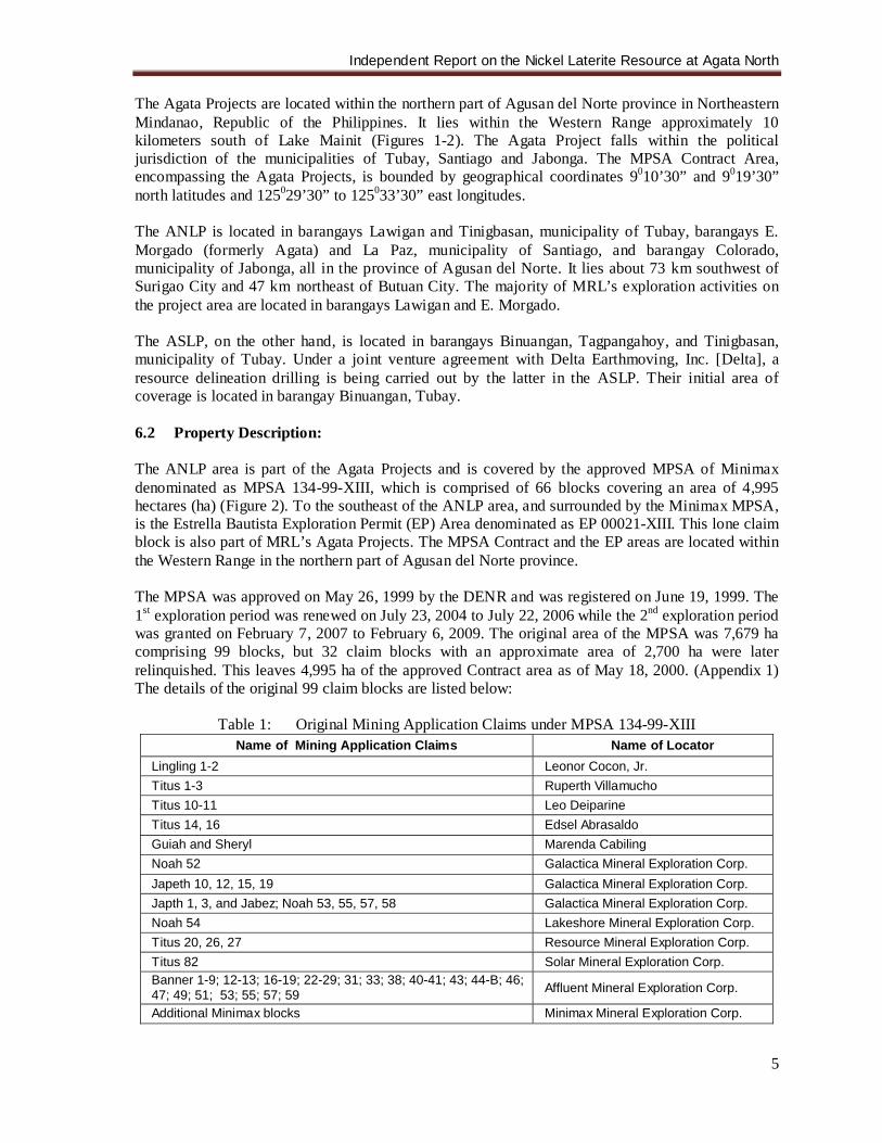
The ANLP area is part of the Agata Projects and is covered by the approved MPSA of Minimax denominated as MPSA 134-99-XIII, which is comprised of 66 blocks covering an area of 4,995 hectares (ha) (Figure 2). To the southeast of the ANLP area, and surrounded by the Minimax MPSA, is the Estrella Bautista Exploration Permit (EP) Area denominated as EP 00021-XIII. This lone claim block is also part of MRL’s Agata Projects. The MPSA Contract and the EP areas are located within the Western Range in the northern part of Agusan del Norte province. The MPSA was approved on May 26, 1999 by the DENR and was registered on June 19, 1999. The 1st exploration period was renewed on July 23, 2004 to July 22, 2006 while the 2nd exploration period was granted on February 7, 2007 to February 6, 2009. The original area of the MPSA was 7,679 ha comprising 99 blocks, but 32 claim blocks with an approximate area of 2,700 ha were later relinquished. This leaves 4,995 ha of the approved Contract area as of May 18, 2000. (Appendix 1) The details of the original 99 claim blocks are listed below:
Table 1: Original Mining Application Claims under MPSA 134-99-XIII Name of Mining Application Claims Name of Locator
Lingling 1-2 Leonor Cocon, Jr. Titus 1-3 Ruperth Villamucho Titus 10-11 Leo Deiparine Titus 14, 16 Edsel Abrasaldo Guiah and Sheryl Marenda Cabiling Noah 52 Galactica Mineral Exploration Corp. Japeth 10, 12, 15, 19 Galactica Mineral Exploration Corp. Japth 1, 3, and Jabez; Noah 53, 55, 57, 58 Galactica Mineral Exploration Corp. Noah 54 Lakeshore Mineral Exploration Corp. Titus 20, 26, 27 Resource Mineral Exploration Corp. Titus 82 Solar Mineral Exploration Corp. Banner 1-9; 12-13; 16-19; 22-29; 31; 33; 38; 40-41; 43; 44-B; 46; 47; 49; 51; 53; 55; 57; 59 Affluent Mineral Exploration Corp.
Additional Minimax blocks Minimax Mineral Exploration Corp.
Independent Report on the Nickel Laterite Resource at Agata North
6
On April 12, 1986, Leonor Cocon, Jr. executed a Special Power of Attorney in favor of Jessie Juansengfue involving his two (2) mining claims in Agata. This legal instrument was registered with the MGB-Regional Office No. XIII on March 10, 1987. On July 31, 1987, Jessie Juansengfue signed the said two (2) mining claims with Minimax through a Royalty Agreement with Option to Purchase. This was registered with the MGB-Regional Office No. XIII on August 5, 1987. On April 17, 1997, this agreement was amended via an Amendment to Royalty Agreement, which was registered with the MGB-Regional Office No. XIII on June 4, 1997. The Royalty Agreement was further amended through an Amendment to Royalty Agreement on November 23, 2005, which was subsequently registered with the MGB-XIII. On May 15, 1987, Marenda Cabiling executed and registered with the MGB-Regional Office a Special Power of Attorney in favor of Rod Manigos regarding her two (2) mining claims in Agata. Rod Manigos in turn, signed the subject mining claims with Minimax via a Royalty Agreement with Option to Purchase on August 4, 1987. The Agreement was registered with the MGB-Regional Office No. XIII [MGB-XIII] on August 5, 1987. The Royalty Agreement was amended via an Amendment to Royalty Agreement on April 17, 1997 and registered with the MGB-XIII on June 4, 1997. It was further amended on April 24, 2006 and subsequently registered with MGB-XIII. On December 4, 1987, Ruperth Villamucho, Leo Deiparine, and Edsel Abrasaldo executed a Special Power of Attorney regarding their mining claims in favor of Jose de Guzman. This was registered with the MGB-XIII on December 7, 1987. On February 7, 1997, Ruperth Villamucho, Leo Deiparine, and Edsel Abrasaldo, through their Attorney-in-Fact, executed a Deed of Assignment for their mining claims in favor of Minimax. This was registered with the MGB-XIII on February 28, 1997. On February 7, 1997, Resource Mineral Exploration Corporation executed a Deed of Assignment over its mining claims in favor of Minimax. On February 12, 1997, Galactica Mineral Exploration Corporation deeded the mining claims Japeth 10, 12, 15 and 19 via a Deed of Assigment in favor of Minimax. Likewise, on February 14, 1997, Solar Mineral Exploration Corporation made a Deed of Assignment regarding its mining claims in favor of Minimax. These Deeds were registered with the MGB-XIII on February 28, 1997. On August 18, 1997, Lakeshore Mineral Exploration Corporation, Affluent Mineral Exploration Corporation and Galactica Mineral Exploration Corporation (for the mining claims “Japeth 1,3”, “Jabez”, “Noah 52, 55, 57, and 58”) deeded their mining claims to Minimax. The Deed of Assignment was registered with MGB-XIII on October 3, 1997. During the processing of the Minimax MPSA Application, Minimax was able to expand the areas it originally applied for. The additional tenement blocks automatically became part of the MRL-Minimax MOA. On May 26, 1999, the Secretary of the DENR signed the Minimax MPSA application covering 7,679 ha comprising 99 claim blocks. The approved MPSA was registered on June 17, 1999.
Independent Report on the Nickel Laterite Resource at Agata North
7
Figure 2: MRL Tenements and Projects in the Surigao Mineral District
Independent Report on the Nickel Laterite Resource at Agata North
8
On May 18, 2000, 32 claim blocks with an area of approximately 2,700 ha were relinquished by Minimax, leaving 4,995 ha of the approved Contract Area (Appendix 1). On September 29, 2000, immediately after the Boyongan Porphyry Copper discovery, Minimax’s affiliate, Apical Mining Corporation filed an MPSA application covering 7,764 ha of ground adjacent to (north, southeast, and south of) Agata Projects. This property is known as the Agata Extension (Figure 2). The application was later converted to EPA and is in the advanced stage of processing by MGB-XIII. On October 26, 2004, MRL Gold was able to acquire, via an Agreement to Explore, Develop and Operate Mineral Property, one claim block of approximately 84 ha within the Agata Projects known as the Bautista Claim. The Agreement was signed between Estrella Bautista, claimowner, and MRL and was registered with MGB-XIII on November 4, 2004. The MPSA application of Bautista was converted into an EP application; the EP was approved on October 2, 2006 and is known as EP-00021-XIII. On May 20, 2008, an Environmental Compliance Certificate (ECC) was issued by the DENR to MRL for nickel laterite mineral production covering 600 ha within the Agata MPSA Contract area, including both the Agata North and Agata South projects. With the issuance of an MPSA covering the Agata Projects, it is given that the landuse classification of the area is for mineral production. Nevertheless, those outside the Contract area are essentially classified as timberland. There are no dwellers within the ANLP and ASLP drilling areas. The barangay (village) centers where the projects are located, are mostly populated by Christians. There are some indigenous peoples that live in the surrounding areas within and outside the Minimax MPSA Contract area. Sitio Coro, Brgy. Colorado is almost entirely populated by IPs while other IP groups have immersed with the Christians in barangays E. Morgado and La Paz, municipality of Santiago, and Brgy. Tagmamarkay, Tubay. MRL, through the assistance of the National Commission on Indigenous Peoples (NCIP) - Regional Office No. XIII, has recently signed a Memorandum of Agreement with the IPs living within the MPSA Contract Area albeit the latter have no Certificate of Ancestral Domains Claim (CADC) nor Certificate of Ancestral Domains Title (CADT) within the Contract area. The MOA calls for a 1% royalty on gross sales of mineral products to be given to the IPs as provided for in the Indigenous Peoples Reform Act (IPRA) of the Republic of the Philippines. An area of nickel laterite mineralization has been mapped at a regional scale in the ASLP located in the southern part of the Agata Projects and is the subject of a Mining Services Agreement between MRL, Minimax and Delta. No drilling or sampling has been carried out in this area prior to the negotiations with Delta. The southernmost area of the ASLP is 1 to 2 km north of the operating nickel laterite mine of SR Metals Inc., just to the south of the Agata Projects. Delta, at its sole cost and risk, carried out exploration of the ASLP and may select an area of up to 250 ha to advance to production if warranted. 6.2.1 Tenement Type: An MPSA is a form of Mineral Agreement, for which the government grants the contractor the exclusive right to conduct mining operations within, but not title over, the contract area during a defined period. Under this agreement, the Government shares in the production of the Contractor, whether in kind or in value, as owner of the minerals. In return, the Contractor shall provide the
Independent Report on the Nickel Laterite Resource at Agata North
9
necessary financing, technology, management and personnel for the mining project. Allowable mining operations include exploration, development and utilization of mineral resources. The approved MPSA has a term not exceeding 25 years from the date of the execution thereof and renewable for another term not exceeding 25 years. It gives the right to the Contractor to explore the MPSA area for a period of 2 years renewable for like periods but not to exceed a total term of 8 years, subject to annual review by the Director to evaluate compliance with the terms and conditions of the MPSA. The Contractor is required to strictly comply with the approved Exploration and Environmental Work Programs together with their corresponding budgets. These work programs are prepared by the Contractor as requirements in securing the renewal of the Exploration Period within the MPSA term. The Contractor is likewise required to submit quarterly and annual accomplishment reports under oath on all activities conducted in the Contract Area. All the reports submitted to the Bureau shall be subject to confidentiality clause of the MPSA. The Contractor is further required to pay at the same date every year reckoned from the date of the first payment, to the concerned Municipality an occupation fee over the Contract Area amounting to PhP 75.00 per hectare. If the fee is not paid on the date specified, the Contractor shall pay a surcharge of 25% of the amount due in addition to the occupation fees.
Independent Report on the Nickel Laterite Resource at Agata North
10
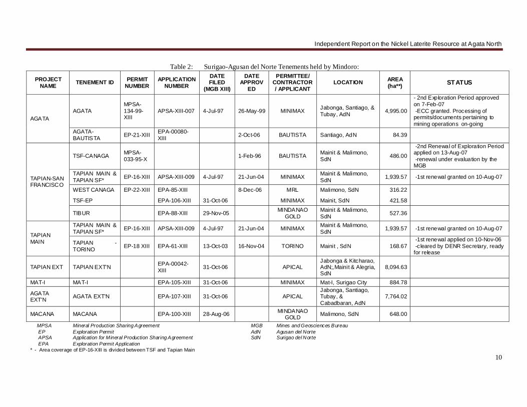
Table 2: Surigao-Agusan del Norte Tenements held by Mindoro:
PROJECT NAME TENEMENT ID PERMIT
NUMBER APPLICATION
NUMBER
DATE FILED
(MGB XIII)
DATE APPROV
ED
PERMITTEE/ CONTRACTOR/ APPLICANT
LOCATION AREA (ha**) STATUS
AGATA AGATA
MPSA-134-99-XIII
APSA-XIII-007 4-Jul-97 26-May-99 MINIMAX Jabonga, Santiago, & Tubay, AdN 4,995.00
- 2nd Exploration Period approved on 7-Feb-07 -ECC granted. Processing of permits/documents pertaining to mining operations on-going
AGATA-BAUTISTA EP-21-XIII EPA-00080-
XIII 2-Oct-06 BAUTISTA Santiago, AdN 84.39
TAPIAN-SAN FRANCISCO
TSF-CANAGA MPSA-033-95-X 1-Feb-96 BAUTISTA Mainit & Malimono,
SdN 486.00
-2nd Renewal of Exploration Period applied on 13-Aug-07 -renewal under evaluation by the MGB
TAPIAN MAIN & TAPIAN SF* EP-16-XIII APSA-XIII-009 4-Jul-97 21-Jun-04 MINIMAX Mainit & Malimono,
SdN 1,939.57 -1st renewal granted on 10-Aug-07
WEST CANAGA EP-22-XIII EPA-85-XIII 8-Dec-06 MRL Malimono, SdN 316.22
TSF-EP EPA-106-XIII 31-Oct-06 MINIMAX Mainit, SdN 421.58
TIBUR EPA-88-XIII 29-Nov-05 MINDANAO GOLD
Mainit & Malimono, SdN 527.36
TAPIAN MAIN
TAPIAN MAIN & TAPIAN SF* EP-16-XIII APSA-XIII-009 4-Jul-97 21-Jun-04 MINIMAX Mainit & Malimono,
SdN 1,939.57 -1st renewal granted on 10-Aug-07
TAPIAN -TORINO EP-18 XIII EPA-61-XIII 13-Oct-03 16-Nov-04 TORINO Mainit , SdN 168.67
-1st renewal applied on 10-Nov-06 -cleared by DENR Secretary, ready for release
TAPIAN EXT TAPIAN EXT'N EPA-00042-XIII 31-Oct-06 APICAL
Jabonga & Kitcharao, AdN;,Mainit & Alegria, SdN
8,094.63
MAT-I MAT-I EPA-105-XIII 31-Oct-06 MINIMAX Mat-I, Surigao City 884.78
AGATA EXT'N AGATA EXT'N EPA-107-XIII 31-Oct-06 APICAL
Jabonga, Santiago, Tubay, & Cabadbaran, AdN
7,764.02
MACANA MACANA EPA-100-XIII 28-Aug-06 MINDANAO GOLD Malimono, SdN 648.00
MPSA Mineral Production Sharing Agreement MGB Mines and Geosciences Bureau EP Exploration Permit AdN Agusan del Norte APSA Application for Mineral Production Sharing Agreement SdN Surigao del Norte EPA Exploration Permit Application * - Area coverage of EP-16-XIII is divided between TSF and Tapian Main
Independent Report on the Nickel Laterite Resource at Agata North
11
If the results of exploration reveal the presence of mineral deposits economically and technically feasible for mining operations, the Contractor, during the exploration period, shall submit to the Regional Director, copy furnished the Director, a Declaration of Mining Project Feasibility together with a Mining Project Feasibility Study, a Three Year Development and Construction or Commercial Operation Work Program, a complete geologic report of the area and an Environmental Compliance Certificate (ECC). Failure of the Contractor to submit a Declaration of Mining Project Feasibility during the Exploration Period shall be considered a substantial breach of the MPSA. Once the ECC is secured, the Contractor shall complete the development of the mine including construction of production facilities within 36 months from the submission of the Declaration of Mining Project Feasibility, subject to such extension based on justifiable reasons as the Secretary may approve, upon the recommendation of the Regional Director, through the MGB Director. Any portion of the contract area, which shall not be utilized for mining operations, shall be relinquished to the Government. The Contractor shall also show proof of its financial and technical competence in mining operations and environmental management. On February 2005, the Philippine Supreme Court decided with finality allowing for the 100% foreign ownership of the mineral tenement under the FTAA. An Exploration Permit (EP), on the other hand, is an initial mode of entry in mineral exploration allowing a Qualified Person to undertake exploration activities for mineral resources in certain areas open to mining in the country. Any corporation may be allowed a maximum area of 32,400 ha in the entire country. The term of an EP is for a period of two (2) years from date of its issuance, renewable for like periods but not to exceed a total term of four (4) years for nonmetallic mineral exploration or six (6) years for metallic mineral exploration. Renewal of the Permit is allowed if the Permittee has complied with all the terms and conditions of the Permit and he/she/it has not been found guilty of violation of any provision of “The Philippine Mining Act of 1995” and its implementing rules and regulations. Likewise, the conduct of a feasibility study and filing of the declaration of mining project feasibility are undertaken during the term of the Permit. 7.0 ACCESSIBILITY, CLIMATE, LOCAL RESOURCES, INFRASTRUCTURE and PHYSIOGRAPHY 7.1 Accessibility: The Agata North Laterite Project site is accessible by any land vehicle from either Surigao City or Butuan City thru the Pan-Philippine Highway. At the highway junction at Barangay Bangonay, Jabonga, access is through partly cemented, gravel-paved Jabonga Municipal road for approximately 4 km, then for another 6 km thru a farm-to-market road to barangay E. Morgado in the municipality of Santiago (Figure 2). From Manila, daily flights are available going to Butuan City. Moreover, commercial sea transport is available en-route to Surigao City and Nasipit (west of Butuan City) ports. An alternate route is available from the Pan-Philippine Highway via the Municipality of Santiago. From Santiago town proper, barangay E. Morgado can be accessed through a 1.5 km municipal-barangay road going to Brgy. La Paz, thence by pump boats, the travel time of which takes about 15 minutes via the Tubay River. The northern portion of the ANLP can be reached from barangay E. Morgado by hiking for about 1 hour thru existing foot trails (approximately 1.5 km).
Independent Report on the Nickel Laterite Resource at Agata North
12
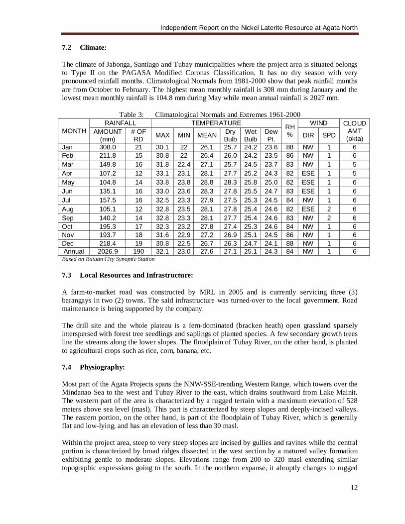
7.2 Climate: The climate of Jabonga, Santiago and Tubay municipalities where the project area is situated belongs to Type II on the PAGASA Modified Coronas Classification. It has no dry season with very pronounced rainfall months. Climatological Normals from 1981-2000 show that peak rainfall months are from October to February. The highest mean monthly rainfall is 308 mm during January and the lowest mean monthly rainfall is 104.8 mm during May while mean annual rainfall is 2027 mm.
Table 3: Climatological Normals and Extremes 1961-2000
MONTH RAINFALL TEMPERATURE RH
%
WIND CLOUD AMT (okta)
AMOUNT (mm)
# OF RD MAX MIN MEAN Dry
Bulb Wet Bulb
Dew Pt. DIR SPD
Jan 308.0 21 30.1 22 26.1 25.7 24.2 23.6 88 NW 1 6 Feb 211.8 15 30.8 22 26.4 26.0 24.2 23.5 86 NW 1 6 Mar 149.8 16 31.8 22.4 27.1 25.7 24.5 23.7 83 NW 1 5 Apr 107.2 12 33.1 23.1 28.1 27.7 25.2 24.3 82 ESE 1 5 May 104.8 14 33.8 23.8 28.8 28.3 25.8 25.0 82 ESE 1 6 Jun 135.1 16 33.0 23.6 28.3 27.8 25.5 24.7 83 ESE 1 6 Jul 157.5 16 32.5 23.3 27.9 27.5 25.3 24.5 84 NW 1 6 Aug 105.1 12 32.8 23.5 28.1 27.8 25.4 24.6 82 ESE 2 6 Sep 140.2 14 32.8 23.3 28.1 27.7 25.4 24.6 83 NW 2 6 Oct 195.3 17 32.3 23.2 27.8 27.4 25.3 24.6 84 NW 1 6 Nov 193.7 18 31.6 22.9 27.2 26.9 25.1 24.5 86 NW 1 6 Dec 218.4 19 30.8 22.5 26.7 26.3 24.7 24.1 88 NW 1 6 Annual 2026.9 190 32.1 23.0 27.6 27.1 25.1 24.3 84 NW 1 6
Based on Butuan City Synoptic Station 7.3 Local Resources and Infrastructure: A farm-to-market road was constructed by MRL in 2005 and is currently servicing three (3) barangays in two (2) towns. The said infrastructure was turned-over to the local government. Road maintenance is being supported by the company. The drill site and the whole plateau is a fern-dominated (bracken heath) open grassland sparsely interspersed with forest tree seedlings and saplings of planted species. A few secondary growth trees line the streams along the lower slopes. The floodplain of Tubay River, on the other hand, is planted to agricultural crops such as rice, corn, banana, etc. 7.4 Physiography: Most part of the Agata Projects spans the NNW-SSE-trending Western Range, which towers over the Mindanao Sea to the west and Tubay River to the east, which drains southward from Lake Mainit. The western part of the area is characterized by a rugged terrain with a maximum elevation of 528 meters above sea level (masl). This part is characterized by steep slopes and deeply-incised valleys. The eastern portion, on the other hand, is part of the floodplain of Tubay River, which is generally flat and low-lying, and has an elevation of less than 30 masl. Within the project area, steep to very steep slopes are incised by gullies and ravines while the central portion is characterized by broad ridges dissected in the west section by a matured valley formation exhibiting gentle to moderate slopes. Elevations range from 200 to 320 masl extending similar topographic expressions going to the south. In the northern expanse, it abruptly changes to rugged
Independent Report on the Nickel Laterite Resource at Agata North
13
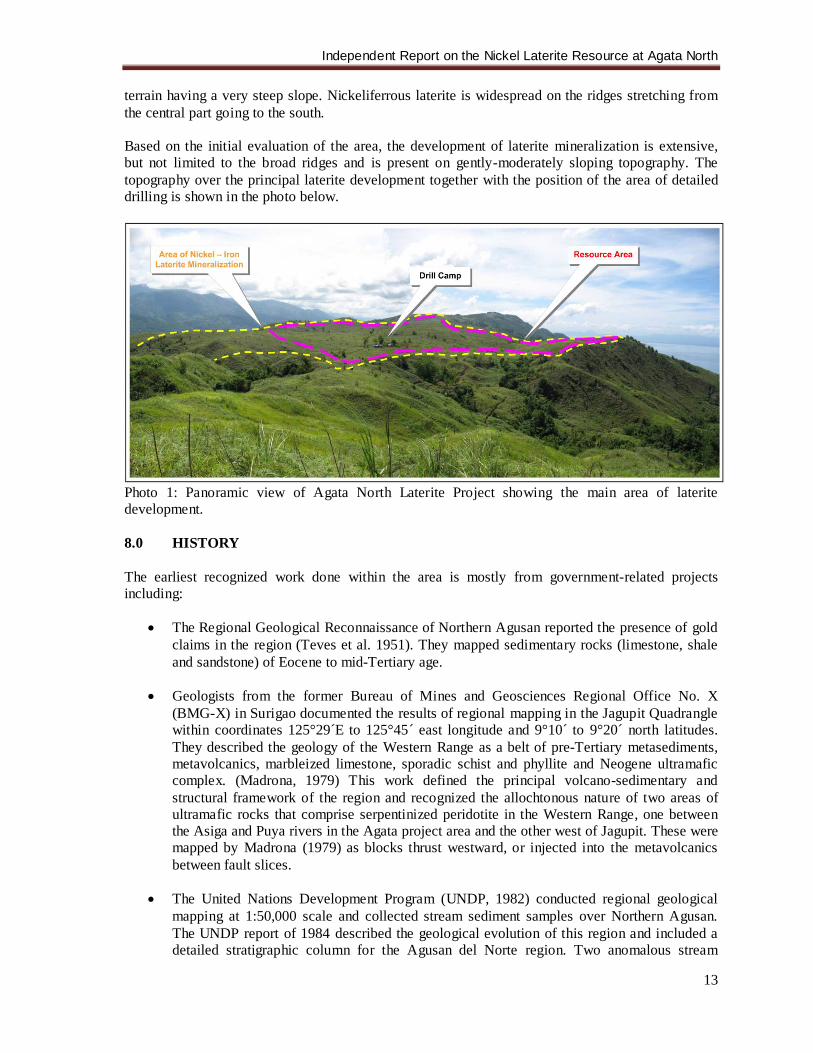
terrain having a very steep slope. Nickeliferrous laterite is widespread on the ridges stretching from the central part going to the south. Based on the initial evaluation of the area, the development of laterite mineralization is extensive, but not limited to the broad ridges and is present on gently-moderately sloping topography. The topography over the principal laterite development together with the position of the area of detailed drilling is shown in the photo below.
Photo 1: Panoramic view of Agata North Laterite Project showing the main area of laterite development. 8.0 HISTORY The earliest recognized work done within the area is mostly from government-related projects including:
• The Regional Geological Reconnaissance of Northern Agusan reported the presence of gold claims in the region (Teves et al. 1951). They mapped sedimentary rocks (limestone, shale and sandstone) of Eocene to mid-Tertiary age.
• Geologists from the former Bureau of Mines and Geosciences Regional Office No. X
(BMG-X) in Surigao documented the results of regional mapping in the Jagupit Quadrangle within coordinates 125°29´E to 125°45´ east longitude and 9°10´ to 9°20´ north latitudes. They described the geology of the Western Range as a belt of pre-Tertiary metasediments, metavolcanics, marbleized limestone, sporadic schist and phyllite and Neogene ultramafic complex. (Madrona, 1979) This work defined the principal volcano-sedimentary and structural framework of the region and recognized the allochtonous nature of two areas of ultramafic rocks that comprise serpentinized peridotite in the Western Range, one between the Asiga and Puya rivers in the Agata project area and the other west of Jagupit. These were mapped by Madrona (1979) as blocks thrust westward, or injected into the metavolcanics between fault slices.
• The United Nations Development Program (UNDP, 1982) conducted regional geological
mapping at 1:50,000 scale and collected stream sediment samples over Northern Agusan. The UNDP report of 1984 described the geological evolution of this region and included a detailed stratigraphic column for the Agusan del Norte region. Two anomalous stream
Independent Report on the Nickel Laterite Resource at Agata North
14
sediment sites were defined near the Agata project during this phase of work. The Asiga porphyry system that lies east of the Agata tenements was explored by Sumitomo Metal Mining Company of Japan in the 1970’s and 1980’s (Abrasaldo 1999).
La Playa Mining Corporation, financed by a German company in the late 1970’s, explored within the Agata Project area for chromiferrous laterite developed over weathered ultramafic rocks. There were five (5) test pits dug in the area. In 1987, Minimax conducted reconnaissance and detailed mapping and sampling right after gaining control over the area. Geological mapping at 1:1,000 scale was undertaken in the high-grading localities, and an aerial photographic survey was conducted and interpreted. MRL established a deal with Minimax in January 1997 and commenced exploration in the same year. Several artisanal miners are active within the project site since the 1980’s up to the present. These miners are conducting underground mining operations at the Assmicor and American Tunnels area and gold panning of soft, oxidized materials within Assmicor and Lao Prospect areas and of sediments in major streams including that of Tubay River. The region of small-scale mining activity was later named “Kauswagan de Oro” (translated: “progress because of gold”). The majority subsequently left the region for other high-grading areas in Mindanao. Just recently, a small group of copper “high-graders” emerged in the American Tunnels area mining direct-shipping grade copper ore from the said area. 9.0 GEOLOGICAL SETTING 9.1 Regional Geology The principal tectonic element of the Philippine archipelago is the elongate Philippine Mobile Belt (PMB – Rangin, 1991) which is bounded to the east and west by two major subduction zone systems, and is bisected along its north-south axis by the Philippine Fault (Figure 3). The Philippine Fault is a 2000 km long sinistral strike-slip wrench fault. In the Surigao district, this fault has played an important role in the development of the Late Neogene physiography, structure, magmatism and porphyry Cu-Au plus epithermal Au metallogenesis. There has been rapid and large-scale uplift of the cordillera in the Quaternary, and limestone of Pliocene age is widely exposed at 1000-2000 meters elevation (Mitchell and Leach 1991). A cluster of deposits on the Surigao Peninsula in the north consists chiefly of epithermal gold stockwork, vein and manto deposits developed in second-order splays of the Philippine Fault (Sillitoe 1988). The mineralization-associated igneous rocks in Surigao consist mostly of small plugs, cinder cones and dikes dated by K-Ar as mid-Pliocene to mid-Pleistocene (Mitchell and Leach 1991; Sajona et al. 1994). (B.D.Rohrlach, 2005) The basement rocks consist of the Concepcion greenschist and metamorphic rocks of Cretaceous age overthrusted by the pillowed Pangulanganan Basalts of Cretaceous to Paleogene age, which in turn, were overthrust by the Humandum Serpentinite. Its emplacement probably occurred during the Cretaceous time. This unit occupies a large part in the tenement area, which have high potential for nickel laterite mineralization. (Tagura, et.al., 2007) The Humandum Serpentinite is overlain by Upper Eocene interbedded limestone and terrigenous clastic sediments of the Nabanog Formation. These are in turn overlain by a mixed volcano-sedimentary package of the Oligocene Nagtal-O Formation, which comprises conglomeratic andesite, wacke with lesser pillow basalt and hornblende andesite, and the Lower Miocene Tigbauan Formation. The latter is comprised of conglomerates, amygdaloidal basalts, wackes and limestones. Intrusive events associated with the volcanism during this period resulted in the emplacement of plutons and stocks that are associated with porphyry copper-gold and precious metal epithermal mineralization in the region. (Tagura, et.al., 2007)
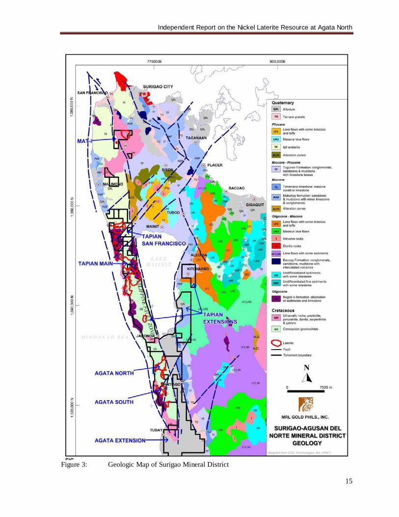
Independent Report on the Nickel Laterite Resource at Agata North
15
Figure 3: Geologic Map of Surigao Mineral District
Independent Report on the Nickel Laterite Resource at Agata North
16
Lower Miocene Kitcharao Limestone and the lower part of the Jagupit Formation overlie the Tigbauan Formation. The Jagupit Formation consists of conglomeratic sandstone, mudstone and minor limestone. The youngest stratigraphic unit is the Quaternary Alluvium of the Tubay River floodplain. Mineral deposits within the region are dominated by epithermal precious metal deposits and porphyry copper-gold. There is a rather close spatial and probably genetic association between epithermal precious metals and porphyry deposits. These deposits exhibit strong structural control. First order structures are those of the Philippine Fault system, which play a role in the localization of the ore deposits, while the second order structures that have developed as a result of the movement along the Philippine Fault system are the most important in terms of spatial control of ore deposition. (Tagura, et.al., 2007) Other mineral deposits are related to ultramafic rocks of the ophiolite suite and comprise lenses of chromite within harzburgite and lateritic nickel deposits that have developed over weathered ultramafic rocks. 9.2 Local Geology of Agata Project Area The Agata Projects area is situated along the southern part of the uplifted and fault-bounded Western Range on the northern end of the east Mindanao Ridge. The Western Range is bounded by two major strands of the Philippine Fault that lie on either side of the Tubay River topographic depression (B. Rohrlach, 2005). The western strand lies offshore on the western side of the Surigao Peninsula, whereas the eastern strand, a sub-parallel splay of the Lake Mainit Fault, passes through a portion of the property and separates the Western Range from the Central Lowlands to the east (Figure 4). These segments have juxtaposed lithologies consisting of at least six rock units including pre-Tertiary basement cover rocks, ophiolite complex, clastic limestone and late-stage Pliocene calc-alkaline intrusive rocks. (Tagura, et.al., 2007) 9.2.1 Greenschist (Cretaceous) The basement sequence on the property comprises greenschists, correlative to the Concepcion Greenschists (UNDP, 1984), which occur mostly in the central to southern portions of the Agata Project. This rock outcrops in Guinaringan, Bikangkang and Agata Creek as long, elongated bodies in the southern half of the tenement area. In the northern half, this unit is mapped as narrow, scattered erosional windows. The predominant minerals are quartz, albite, and muscovite with associated chlorite, epidote and sericite. In places, talc and serpentine are the main components. (Tagura, et.al., 2007) The exposure of the schist by the late Eocene implies a metamorphic age of Paleocene or older and a depositional age of Cretaceous (UNDP, 1984) 9.2.2 Ultramafics (Cretaceous) Ultramafic rocks unconformably overlie the basement schist and formed as conspicuously peneplaned raised ground on the property area. These are comprised of serpentinites, serpentinized peridotites, serpentinised harzburgites, and lesser dunite, which are fractured and cross-cut by fine networks of talc, magnesite and/or calcite veins. These rocks are usually grayish-green, medium- to coarse-grained, massive, highly-sheared and traversed by meshwork of serpentine and crisscrossed by talc, magnesite and calcite veinlets. The serpentinites in the Agata Projects correlate with the Humandum Serpentinite (B. Rohrlach, 2005). The Humandum Serpentinite was interpreted by UNDP (1984) to be emplaced over the Concepcion greenschists probably before the Oligocene, and before late Eocene deposition of the Nabanog Formation. MGB (2002) classified the Humandum
Independent Report on the Nickel Laterite Resource at Agata North
17
Serpentinite as a dismembered part of the Dinagat Ophiolite Complex, which is established to be of Cretaceous age. These rocks have potential for nickel due to nickel-enrichment in the weathering profile as observed in its deep weathering into a reddish lateritic soil. (B. Rohrlach, 2005). 9.2.3 Limestone (Upper Eocene) Several bodies of limestone correlative to the Nabanog Formation (UNDP 1984), were mapped in the project area. The easternmost limestone body lies in the Assmicor-Lao prospect region, in the central portion of the property and Guinaringan-Bikangkang area and at Payong-Payong area located at the western side. In the northern half of the property, these limestones occur as narrow scattered bodies probably as erosional remnants. In places, this unit exhibits well-defined beddings and schistosity and crisscrossed by calcite ± quartz veinlets. The limestones outcropping near intrusive bodies are highly-fractured with limonite and fine pyrite, associated with gold mineralization, in fractures and show green hue due to chloritization. In places, the limestone is interbedded with thin sandstone, siltstone, and shale beds. 9.2.4 Andesite and Tuff Sparsely distributed across the property are narrow bodies of andesite and tuff. Towards the vicinity of Peak 426 at the northwestern part, the andesite occurs as an imposing volcanic edifice. It is generally fine-grained to locally porphyritic in texture. The tuff grades from crystal tuff to lithic lapilli. Several exposures of this unit are described by Abrasaldo (1999) as being strongly fractured adjacent to northeast-trending faults. 9.2.5 Intrusives (Upper Oligocene to Lower Miocene) A series of intrusives of alkalic and calc-alkaline composition occur in close vicinity to Lake Mainit Fault. These include syenites, monzonites, monzodiorites and diorites that are closely associated with gold mineralization as most of the workings and mining activities are concentrated within the vicinity of these intrusive rocks. The syenites are well-observed in the American and Assmicor tunnels and consist mostly of potash feldspar. The monzonites are noted in the Lao Area, in the American Tunnel and occasionally along Duyangan Creek. Monzodiorite outcrops in the Kinatongan and Duyangan creeks and sparsely in the American Tunnel. Trachyte to trachyandesite porphyry is noted in the Kinatongan Creek. Diorites were observed in the Assmicor Tunnel, which occur mostly as dikes. The intrusions in the Lao and American Tunnel prospects have been tentatively correlated with the Mabaho Monzonite (UNDP, 1984). 9.2.6 Limestone (Lower Miocene) Correlatives of the Kitcharao limestone are scattered through large areas of the Agata Projects area. Minor outcrops of the Jagupit Formation lie in the eastern claim block adjacent to barangay Bangonay (Abrasaldo, 1999). 9.2.7 Recent Alluvium Quaternary Alluvium underlies the Tubay River floodplain, within the valley between the Western Range and the Eastern Highlands.
Independent Report on the Nickel Laterite Resource at Agata North
18
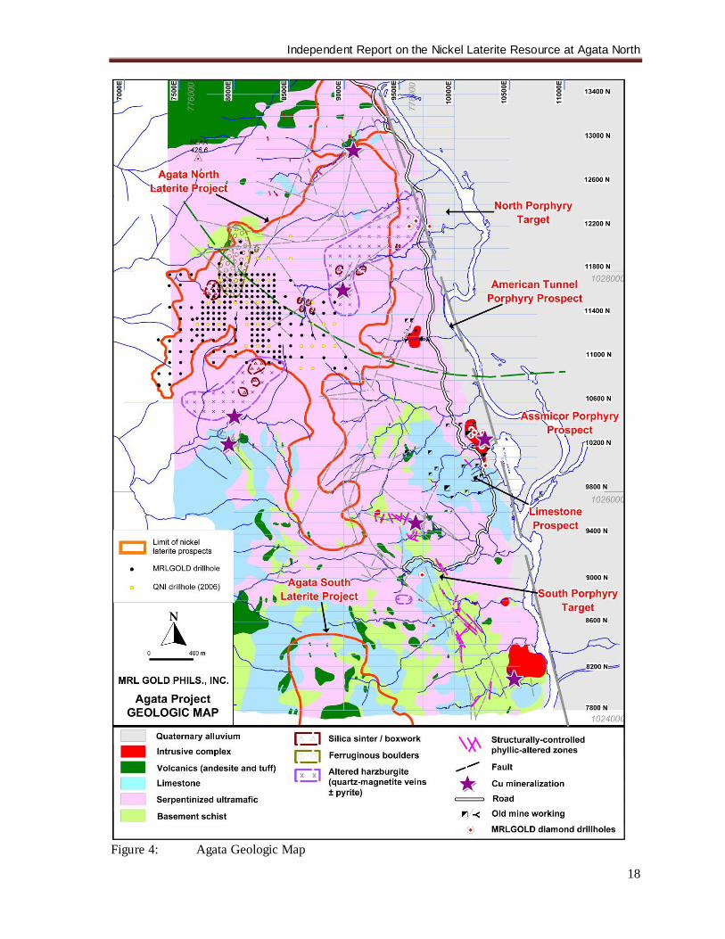
Figure 4: Agata Geologic Map
Independent Report on the Nickel Laterite Resource at Agata North
19
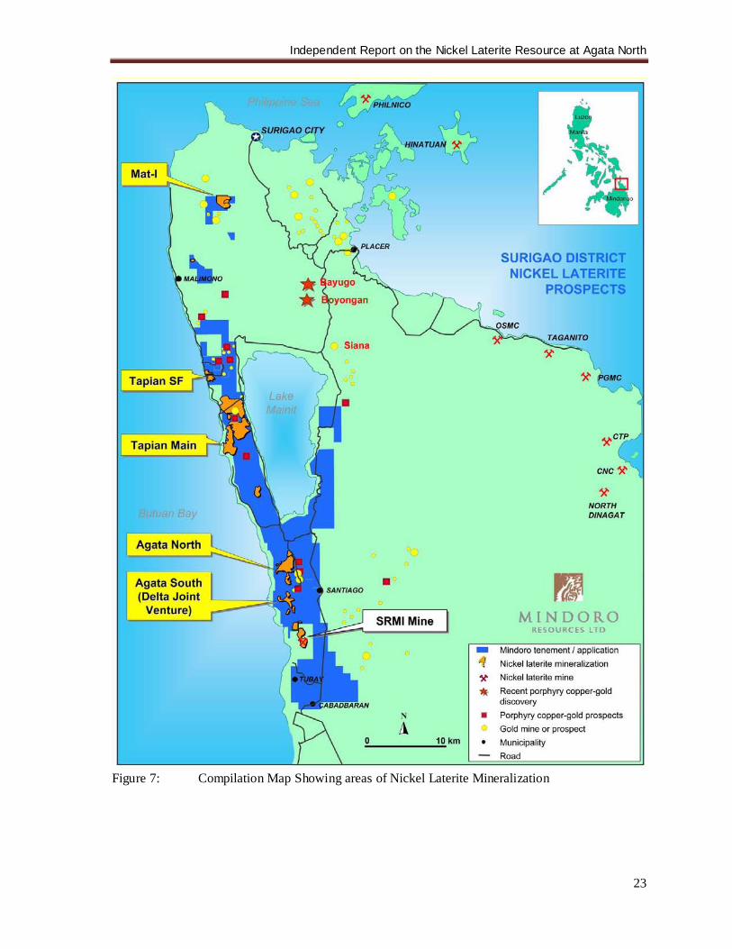
9.3 Geology of the ANLP Area The widespread occurrence of serpentinized harzburgite, serpentinized peridotite, and localized lenses of dunite comprise the lithology in the project area. These rocks are confined to broad ridges extending down to the footslopes. Lineaments trending NE are interpreted to be present in the area. Geological mapping in the project area showed favorable development of laterite along the broad ridges characterized by peneplane topography. These areas are where the drilling activities are concentrated. In areas with moderate to semi-rugged topography, erosion proceeds much faster than soil development, hence the laterite is thinner. To date, estimated area of laterite in the prospect area is approximately 379 ha. (Figures 5 & 8). In the Agata Project, there are two distinct geomorphic features that have influenced laterite formation and consequent nickel enrichment. The Eastern part of the delineated body has a moderate relief whose bedrocks are exposed in ridge tops and in the nearby creeks. On the other hand, the Western laterite occurs on a low relief terrain and with no exposures of bedrock on its hillcrests. In the Western area, the laterite is well developed and contains thick and highly mineralized limonite/saprolite and transition rocks. The Eastern Laterite Zones contain boulders across the laterite profile suggesting transport. Its limonite zone is usually thinner. (A. Buenavista, 2008) Test pits that were previously excavated by another company showed a maximum depth of 9.40 m and an average depth of 4.96 m. All these test pits have bottomed in limonite. Drilling done by QNI, Phils. (QNPH) and MRL showed thicker laterite profile than what was revealed by previous test pitting. 10.0 DEPOSIT TYPES The Surigao Mineral District is a host to several deposit types. The Philippine Fault has played an important role in the development of the Late Neogene physiography, structure, magmatism and porphyry Cu-Au plus epithermal Au metallogenesis. An intense clustering of porphyry Cu-Au and epithermal Au deposits occurs along the Eastern Mindanao Ridge. There is a strong structural control on the distribution of Au-Cu deposits in the Surigao district, and a clear association of deposits and mineral occurrences with high-level intrusives and subvolcanic bodies. Most of the centers of mineralization are located along NNW-SSE-trending second-order fault splays of the Philippine Fault, and where these arc-parallel structures are intersected by northeast-trending cross-faults. The Tapian-San Francisco property lies in a favorable structural setting at the district-scale, at the intersection between multiple strands of a NE-trending cross-structure and the Lake Mainit Fault. This same NE-trending structural axis encapsulates both the Boyongan porphyry deposit and the Placer epithermal gold deposits. (B. Rohrlach, 2005) Most of the known hydrothermal gold mineralization within the district is of low-sulfidation epithermal character developed in second-order splays of the Philippine Fault. The mineralization is predominantly of Pliocene age and is spatially and temporally associated with the Mabuhay andesitic volcanism. Epithermal mineralization tends to be confined to the Mabuhay Clastics and associated andesitic stocks, lavas and pyroclastics, and in older rocks immediately beneath the unconformity at the base of the Mabuhay Clastics. The principal low-sulfidation epithermal-type, carbonate-replacement-type and porphyry-type deposits and occurrences include: vein-type (Tabon-Tabon vein, Plancoya vein); bulk-mineable stringer stockworks (Placer, Motherlode, Mapaso, Nabago); stratabound ore or carbonate-hosted (Siana mine); surface workings in argillized zones (Mapawa, Hill 664, Manpower, Layab, Gumod); placer gold (Malimono-Masgad region); porphyry Cu-Au
Independent Report on the Nickel Laterite Resource at Agata North
20
(Boyongan, Bayugo, Asiga and Madja); high-level porphyry-style alteration (Masgad, Malimono, Tapian-San Francisco) and high sulfidation (Masapelid Island). (B.D. Rohrlach, 2005) The principal deposit types that are being explored for in the Mindoro tenement holdings in the Surigao Mineral District are:
Porphyry Cu-Au of calc-alkaline or alkaline affinity: TSF, TM & Ag Low-sulfidation epithermal Au: TM, TSF, Ag High-sulfidation epithermal Cu-Au: TSF Carbonate-hosted Disseminated Au-Ag Ore: Ag Skarn Au-(Cu): Ag, TSF Nickeliferrous Laterite: Ag, TSF, TM, Mat-i
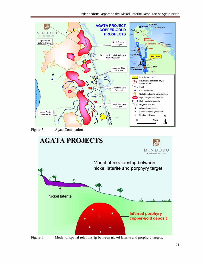
The first five deposit types collectively belong to the broad family of magmatic-hydrothermal Cu-Au deposits that form above, within and around the periphery of high-level intrusive stocks of hydrous, oxidized, calc-alkaline to potassic alkaline magmas that are emplaced at shallow levels in the crust of active volcanic arcs. These different deposit types form at different structural levels of magmatic intrusive complexes, and their character is governed by a multiplicity of factors that include depth of magmatic degassing, degassing behavior, host-rock lithology and structural preparation. (B.D. Rohrlach, 2005) The Tapian-San Francisco, Tapian Main and Agata properties have high potential for the discovery of both porphyry Cu-Au style mineralization at depth and epithermal style mineralization at shallower levels. The Agata Projects area has high potential for the presence of one or more porphyry-type Cu-Au hydrothermal systems associated with 3 principal targets, and multiple satellite targets, that are associated with zones of high IP chargeability. Porphyry-style mineralization has been encountered previously in the Agata region by shallow drill holes in targets that are associated with modest IP chargeability anomalies. The Agata Projects possess multiple conceptual target styles such as porphyry, epithermal, Carlin-type and Ni-laterite (Figure 5). Occurrences of nickel and cobalt-bearing iron-rich laterites developed on ultramafic rocks are reported from several areas of the Surigao del Norte province (Louca 1995). Laterites developed on ultramafic rocks comprising serpentinized peridotite occur within the Agata project area, and potential exists within the Tapian Main, Tapian-San Francisco and Mat-i properties for these deposit types, in as much as ultramafic rocks are present on these areas. (B. Rohrlach, 2005) The spatial relationship of the nickel laterite and the underlying porphyry Cu-Au mineralization prospects is illustrated in Figure 6. There is no geological relationship.
Independent Report on the Nickel Laterite Resource at Agata North
21
Figure 5: Agata Compilation
Figure 6: Model of spatial relationship between nickel laterite and porphyry targets.
Independent Report on the Nickel Laterite Resource at Agata North
22
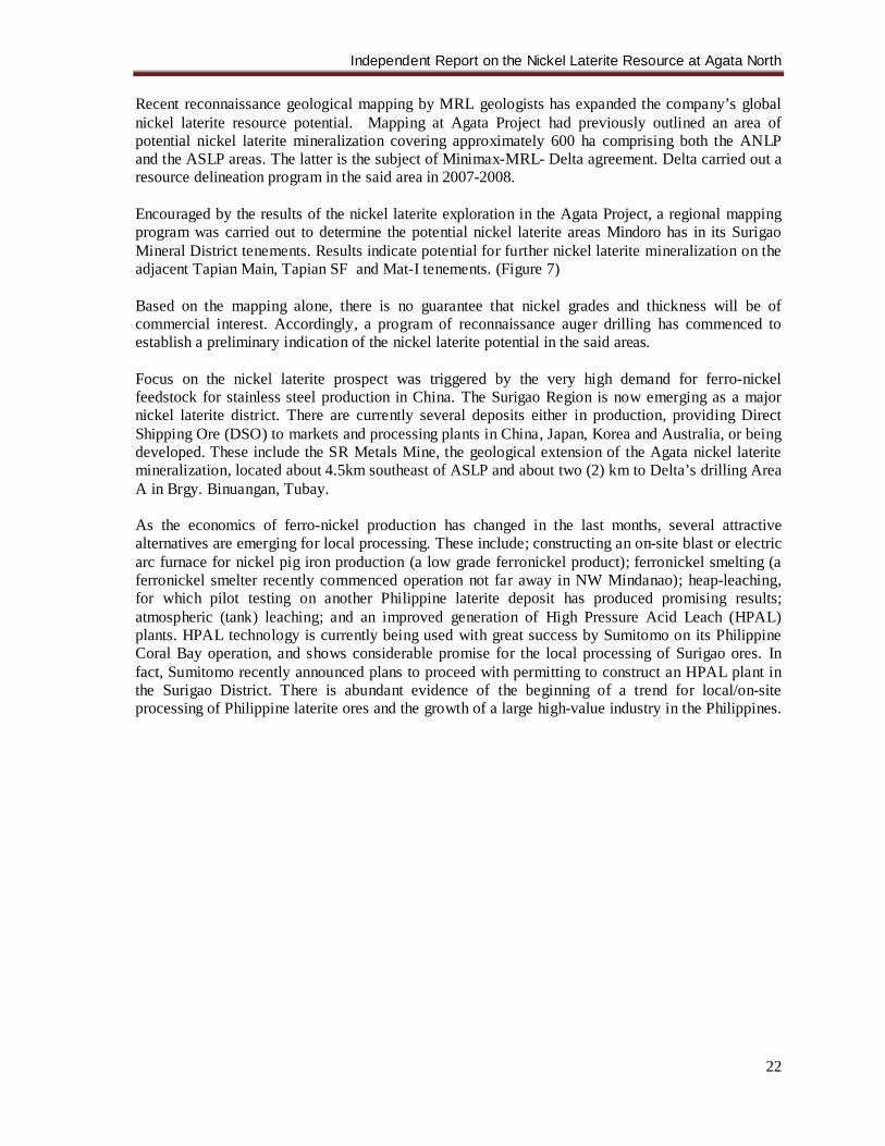
Recent reconnaissance geological mapping by MRL geologists has expanded the company’s global nickel laterite resource potential. Mapping at Agata Project had previously outlined an area of potential nickel laterite mineralization covering approximately 600 ha comprising both the ANLP and the ASLP areas. The latter is the subject of Minimax-MRL- Delta agreement. Delta carried out a resource delineation program in the said area in 2007-2008. Encouraged by the results of the nickel laterite exploration in the Agata Project, a regional mapping program was carried out to determine the potential nickel laterite areas Mindoro has in its Surigao Mineral District tenements. Results indicate potential for further nickel laterite mineralization on the adjacent Tapian Main, Tapian SF and Mat-I tenements. (Figure 7) Based on the mapping alone, there is no guarantee that nickel grades and thickness will be of commercial interest. Accordingly, a program of reconnaissance auger drilling has commenced to establish a preliminary indication of the nickel laterite potential in the said areas. Focus on the nickel laterite prospect was triggered by the very high demand for ferro-nickel feedstock for stainless steel production in China. The Surigao Region is now emerging as a major nickel laterite district. There are currently several deposits either in production, providing Direct Shipping Ore (DSO) to markets and processing plants in China, Japan, Korea and Australia, or being developed. These include the SR Metals Mine, the geological extension of the Agata nickel laterite mineralization, located about 4.5km southeast of ASLP and about two (2) km to Delta’s drilling Area A in Brgy. Binuangan, Tubay. As the economics of ferro-nickel production has changed in the last months, several attractive alternatives are emerging for local processing. These include; constructing an on-site blast or electric arc furnace for nickel pig iron production (a low grade ferronickel product); ferronickel smelting (a ferronickel smelter recently commenced operation not far away in NW Mindanao); heap-leaching, for which pilot testing on another Philippine laterite deposit has produced promising results; atmospheric (tank) leaching; and an improved generation of High Pressure Acid Leach (HPAL) plants. HPAL technology is currently being used with great success by Sumitomo on its Philippine Coral Bay operation, and shows considerable promise for the local processing of Surigao ores. In fact, Sumitomo recently announced plans to proceed with permitting to construct an HPAL plant in the Surigao District. There is abundant evidence of the beginning of a trend for local/on-site processing of Philippine laterite ores and the growth of a large high-value industry in the Philippines.
Independent Report on the Nickel Laterite Resource at Agata North
23
Figure 7: Compilation Map Showing areas of Nickel Laterite Mineralization
Independent Report on the Nickel Laterite Resource at Agata North
24
11.0 MINERALIZATION 11.1 Agata Nickel Laterite Project Nickeliferrous laterite deposits are present over a broad region in the Agata Projects area (Figures 5, 7 & 8). They are divided into two (2) major areas known as the ANLP and the ASLP. Based on mapping, the former has an area of approximately 379 ha while the latter comprises about 235 ha. In the ANLP, drilling is concentrated only in less than thirty-five (35) percent of the interpreted nickel laterite mineralization to date. The laterites are developed over ultramafic rocks that lie along the Western Range. Three (3) rock types within the ultramafics are recognizable, namely, serpentinized harzburgite and serpentinized peridotite, with localized lenses of dunite. The ultramafic bodies are of probable Cretaceous age, and were emplaced as part of an ophiolite sequence during the Upper Eocene (Abrasaldo, 1999). Formation of the laterites is thought to have occurred during the Pliocene or early Pleistocene. The largest of the laterite bodies overlies the central ultramafic body and occupies an area that is ~9 km long and 0.1 to 3.2 km wide (Figure 4). The serpentinized harzburgite is dark brown to grayish black in color, massive, highly fractured and typically traversed by veinlets of serpentine. It is composed mainly of olivine with readily discernible sometimes well-formed pyroxene crystals. Serpentinization is evident by the rock’s waxy texture. Intense serpentinization renders a slippery feel along the rock’s surface. Petrographically, the harzburgite is actually a serpentinized wehrlite composed of olivine, clinopyroxene (augite) and chrome spinel (~1%). Olivine and clinopyroxene grains are commonly fractured and the wehrlites are typically traversed by fine meshworks of serpentine and chrome-spinel micro-veinlets. Initially, MRL undertook aerial photograph interpretations and field inspections, to define areas of potential laterite formation. The soil profile is intensely ferruginous in this region, and relic cobbles of intensely fractured and serpentinized ultramafic rock lie scattered throughout the region of observed laterite development. At higher elevations along the topographic divide, ferruginous pisolites and blocks of lateritic crust were observed developed on an ultramafic protolith. Nickel laterites are the products of laterization or intense chemical weathering of the ultramafic rocks, especially the olivine-rich varieties like harzburgite and dunite. This process results to the concentration of nickel and cobalt of the parent rock. Its formation is favored in stable terrains like plateaus or broad ridges and in humid climatic conditions with high rainfall and warm temperature. Latest exploration works in the area have revealed that nickel laterite likewise occurs along the slopes. The laterite profile in the ANLP consists of the ferruginous laterite, limonite zone, saprolite zone, and the saprolitic rock, arranged from surface going down. The degree of weathering gradually increases as the zone nears the surface. The limonite zone is characteristically iron oxide-rich where the predominant minerals are hematite and goethite while the saprolite zone is Mg-rich. Patches of garnierite were noted within the saprolite and saprolitic rock horizon. This was well-observed in a trench that was dug along the slopes that face the sea on the western portion of ANLP.
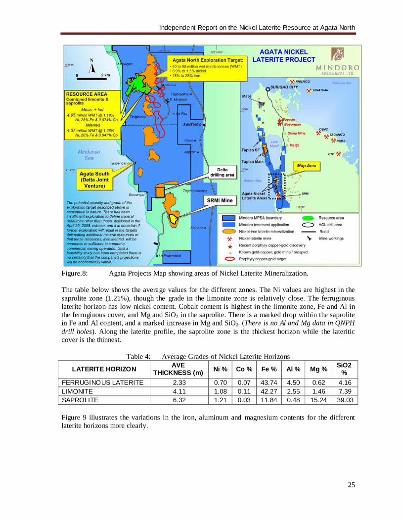
Independent Report on the Nickel Laterite Resource at Agata North
25
Figure.8: Agata Projects Map showing areas of Nickel Laterite Mineralization. The table below shows the average values for the different zones. The Ni values are highest in the saprolite zone (1.21%), though the grade in the limonite zone is relatively close. The ferruginous laterite horizon has low nickel content. Cobalt content is highest in the limonite zone, Fe and Al in the ferruginous cover, and Mg and SiO2 in the saprolite. There is a marked drop within the saprolite in Fe and Al content, and a marked increase in Mg and SiO2. (There is no Al and Mg data in QNPH drill holes). Along the laterite profile, the saprolite zone is the thickest horizon while the lateritic cover is the thinnest.
Table 4: Average Grades of Nickel Laterite Horizons
LATERITE HORIZON AVE THICKNESS (m) Ni % Co % Fe % Al % Mg % SiO2
% FERRUGINOUS LATERITE 2.33 0.70 0.07 43.74 4.50 0.62 4.16 LIMONITE 4.11 1.08 0.11 42.27 2.55 1.46 7.39 SAPROLITE 6.32 1.21 0.03 11.84 0.48 15.24 39.03 Figure 9 illustrates the variations in the iron, aluminum and magnesium contents for the different laterite horizons more clearly.
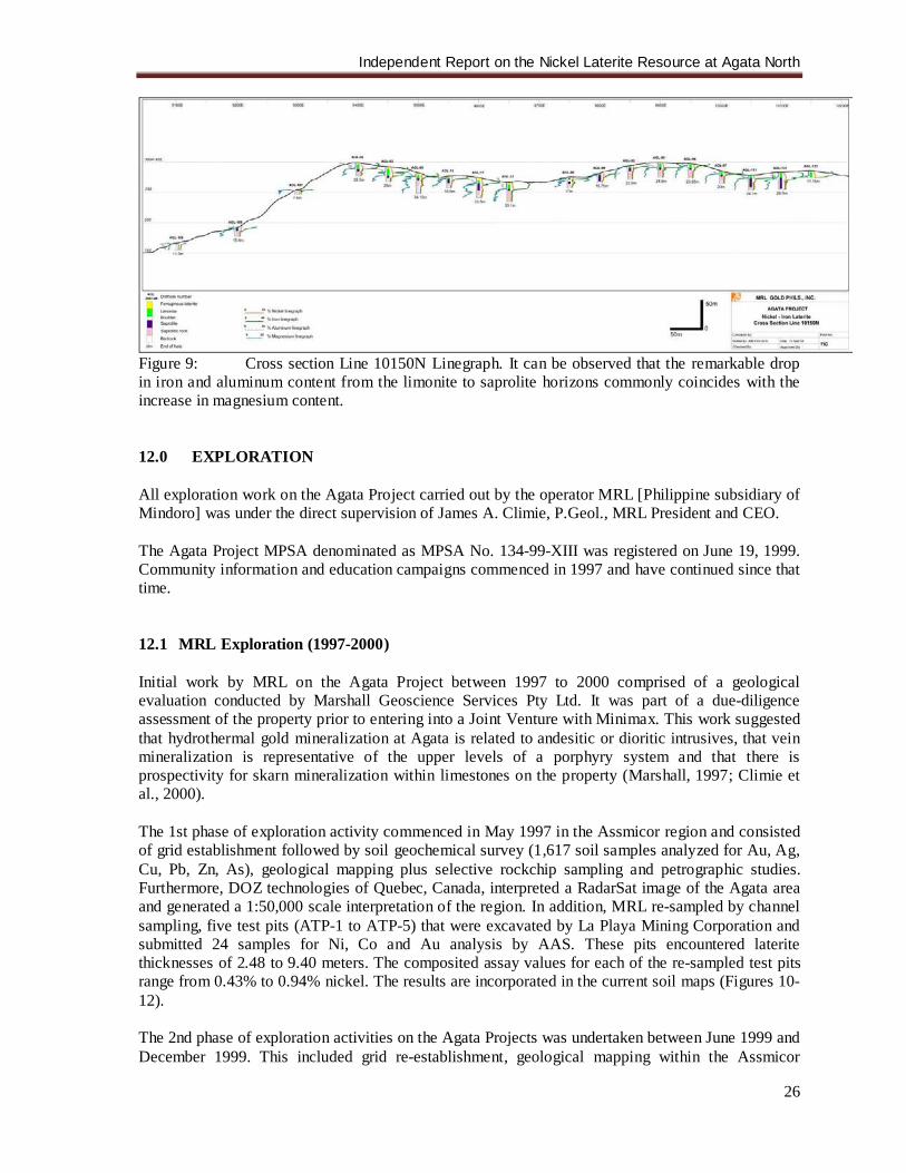
Independent Report on the Nickel Laterite Resource at Agata North
26
Figure 9: Cross section Line 10150N Linegraph. It can be observed that the remarkable drop in iron and aluminum content from the limonite to saprolite horizons commonly coincides with the increase in magnesium content. 12.0 EXPLORATION All exploration work on the Agata Project carried out by the operator MRL [Philippine subsidiary of Mindoro] was under the direct supervision of James A. Climie, P.Geol., MRL President and CEO. The Agata Project MPSA denominated as MPSA No. 134-99-XIII was registered on June 19, 1999. Community information and education campaigns commenced in 1997 and have continued since that time. 12.1 MRL Exploration (1997-2000) Initial work by MRL on the Agata Project between 1997 to 2000 comprised of a geological evaluation conducted by Marshall Geoscience Services Pty Ltd. It was part of a due-diligence assessment of the property prior to entering into a Joint Venture with Minimax. This work suggested that hydrothermal gold mineralization at Agata is related to andesitic or dioritic intrusives, that vein mineralization is representative of the upper levels of a porphyry system and that there is prospectivity for skarn mineralization within limestones on the property (Marshall, 1997; Climie et al., 2000). The 1st phase of exploration activity commenced in May 1997 in the Assmicor region and consisted of grid establishment followed by soil geochemical survey (1,617 soil samples analyzed for Au, Ag, Cu, Pb, Zn, As), geological mapping plus selective rockchip sampling and petrographic studies. Furthermore, DOZ technologies of Quebec, Canada, interpreted a RadarSat image of the Agata area and generated a 1:50,000 scale interpretation of the region. In addition, MRL re-sampled by channel sampling, five test pits (ATP-1 to ATP-5) that were excavated by La Playa Mining Corporation and submitted 24 samples for Ni, Co and Au analysis by AAS. These pits encountered laterite thicknesses of 2.48 to 9.40 meters. The composited assay values for each of the re-sampled test pits range from 0.43% to 0.94% nickel. The results are incorporated in the current soil maps (Figures 10-12). The 2nd phase of exploration activities on the Agata Projects was undertaken between June 1999 and December 1999. This included grid re-establishment, geological mapping within the Assmicor
Independent Report on the Nickel Laterite Resource at Agata North
27
Prospect and American Tunnels, ground magnetic survey, soil geochemistry (50 samples), rock/core sampling, petrography and drilling of 11 holes. (Climie et al., 2000). The soil sampling survey generated widespread Cu and Au soil anomalies. Soil Cu anomalies tend to be closely restricted to mapped intrusions at American Tunnels and Assmicor-Lao. Soil Au anomalies are more widespread and extend into the surrounding and overlying carbonate rocks. In contrast, soil As anomalies appear to be weakly developed over the intrusions but more strongly developed over carbonates. The Cu and Au soil anomalies associated with the Assmicor-Lao prospect region (Figures 10-11) are open to the east beneath the alluvial flood plain sediments of the Tubay River. The potential for an extension of the Assmicor mineralization to the immediate east beneath the Tubay River floodplain is strengthened by the observation that the dikes and intrusives encountered in drilling at Assmicor dip towards the east, that porphyry-like quartz veins were encountered in drillhole DH 99-11, which lies east of the Assmicor prospect, and the evidence of a resistivity anomaly developing on the edge of the IP survey east of the Assmicor prospect. Nineteen surface channel samples were collected in the Limestone Prospect area (Figure 13). Sixteen of these samples yielded grades ranging from 0.02 g/t Au to 0.85 g/t Au. Three of the samples graded 2.79 g/t Au over 3.7 meters, 3.77 g/t Au over 2 meters and 1.48 g/t Au over 3 meters. The channel samples indicate a zone of anomalous gold above 0.1 g/t in rock samples that extends over an area of 100m by 50m in oxidized limestone. Petrographic analyses by Comsti (1997) and Comsti (1998) reveal that the intrusive rocks at Agata consist of alkalic, silica-undersaturated plutonic rocks. These comprise of syenites and monzonites that display varying degreees of sericitic and propylitic alteration. Potassic feldspar is a primary mineral phase in many of these rocks. An in-house ground magnetic survey was conducted in 1999 (Figure 14). The magnetic data comprised a series of semi-continuous magnetic highs, with values >40250nT, that broadly coincide with the distribution of ultramafic rocks along the western margin of the Lao and Assmicor areas. The magnetic signature decreases gradually westward where the ultramafics are thought to be buried at deeper levels beneath the limestones. MRL drilled eleven (11) diamond drill holes into the Assmicor and Limestone prospects in 1999 and encountered significant Au intersections associated with limonitic stockworks in biotite monzodiorite intrusive. These include 18.8m @ 1.13 g/t Au and 24.2m @ 1.38 g/t Au in holes DH 99-05 and DH 99-06, respectively. The intrusives comprise larger biotite monzodiorite bodies that are cross-cut by younger diorite dikes, plagioclase diorite dikes, biotite diorites and quartz diorites. These dikes and intrusive bodies dip predominantly eastward, suggesting that a deeper magmatic source lies to the east, possibly along the trace of the Lake Mainit splay of the Philippine Fault, beneath the alluvial floodplain of the Tubay River. Drillhole DH 99-11, collared east of the Assmicor shaft, intersected porphyry-style quartz-magnetite veins in biotite diorite, quartz diorite and in hornblende-quartz diorite. 12.2 MRL Exploration (2004-2006) MRL undertook a third phase of exploration activity in 2004 on the Agata Project. This activity involved gridding, mapping and extensive grid-based pole-dipole induced polarization (IP) geophysical surveying along 30 east-west-oriented survey lines that extend from 7,800 mN to 13,400 mN. The IP data were acquired by Elliot Geophysics International using a Zonge GGT-10 transmitter, a Zonge GDP-32 receiver and a 7.5 KVA generator. A total of 77.10 km of grid were surveyed by pole-dipole IP. The dipole spacing used in the survey was 150 meters. The data were
Independent Report on the Nickel Laterite Resource at Agata North
28
modelled by Dr Peter Elliot of Elliot Geophysics International using inversion modeling (Figures 15-16). Induced polarization (IP) surveying on the Agata Project has identified numerous IP chargeability anomalies that form finger-like apophyses at shallow levels, and which amalgamate into larger anomalies at deeper levels. The IP chargeability anomalies tend to strengthen with depth in the core anomaly regions (Southern Target anomaly and Northern Target anomaly). The IP chargeability anomalies attain values that locally exceed 40 msecs, and routinely exceed 20 msecs on most of the IP pseudo-sections from Agata. Weaker modeled IP chargeability anomalies are associated with known mineralization at Assmicor (10-18 msec) and in other satellite positions adjacent to the two cores Northern and Southern target anomalies. There is an indication, from the four plan views of the IP chargeability data, that NNW to NW faults may be important in controlling the distribution and shape of many of the IP anomalies at Agata. Faults that lie along these trends are expected to lie in a dilational orientation in relation to the regional stress field associated with sinistral movement on the near north-trending Philippine Fault splay. A preliminary drilling activity in the Agata Project was carried out between November 2, 2005 and October 28, 2006. This was conducted under a joint-venture among MRL, Panoro Minerals Ltd. (Panoro), and Minimax. The prospects were highly recommended priority targets for drill evaluation as these prospects exhibit classic stacking of geophysical, geological and geochemical features associated with Philippine porphyry copper-gold systems. The preliminary drilling program was aimed to test the area of highest chargeabilities in the North and South Porphyry Targets. Great operational difficulties were encountered in extraordinarily bad ground conditions. A total of five drill holes with a combined length of only 756.45 meters were completed, four of which were drilled within the North Porphyry Target and one at South Porphyry Target. All five holes were prematurely terminated, not reaching target depths. The chargeability anomalies were interpreted to occur at around 375m below surface (N=4) based on IP geophysical inversion models. The deepest hole bottomed at only 251.20m, a long way from the 500-meter target. All drill holes have intersected and bottomed in strongly serpentinized ultramafics with very minimal pyrite mineralization. Dr. Peter Elliot, Consulting Geophysicist, affirmed that the serpentine was not the cause of the anomalies, and would only cause a weak IP anomaly. It would need to contain reasonable amount of sulphide and/or graphite. Deep drilling in such sheared ultramafics is very difficult but the targets are considered to have high potential for porphyry Cu-Au mineralization and further drill testing using alternative drill strategies was recommended. At the Assmicor Porphyry Prospect, the porphyry-style quartz-magnetite veins with pyrite, chalcopyrite and gold mineralization intersected in 1999 drill hole 11 clearly indicate a magmatic source to the east. The very strong and extensive gold and copper in soil anomalies also clearly point to an eastern magma source, and suggest that this may be significantly mineralized. The “open” resistivity in the prospect is interpreted as silicification associated with the postulated porphyry system (Tagura, et.al., 2005).
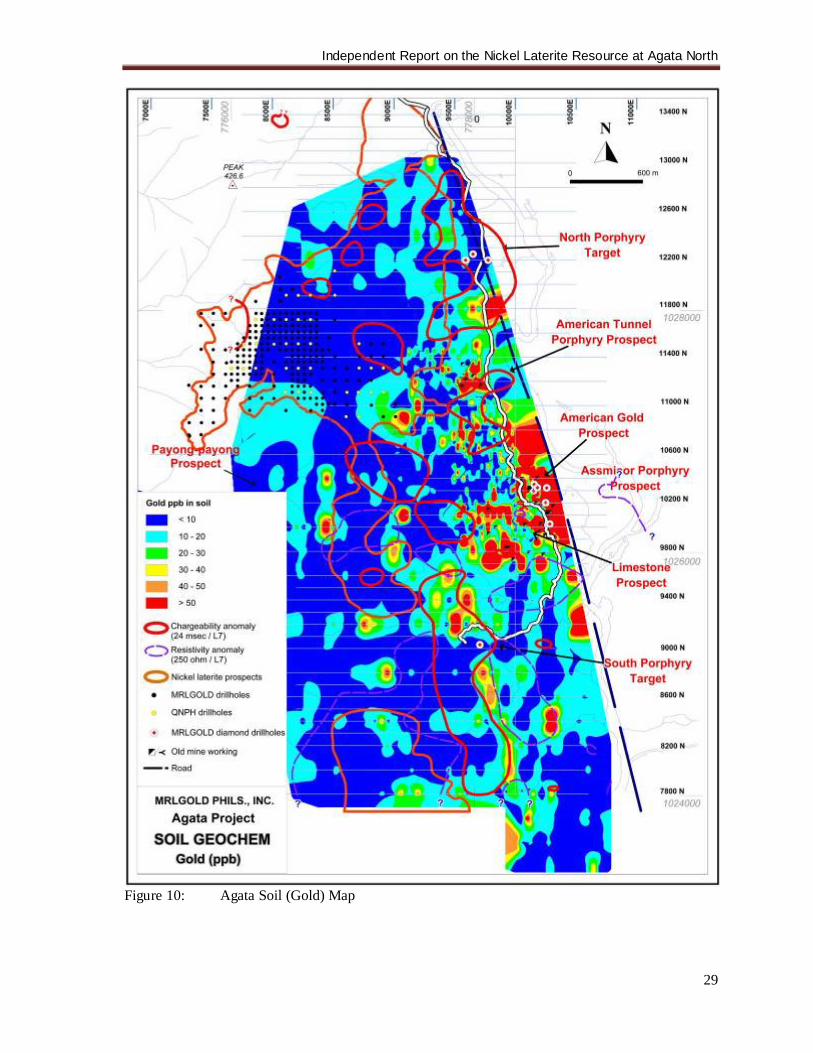
Independent Report on the Nickel Laterite Resource at Agata North
29
Figure 10: Agata Soil (Gold) Map

Independent Report on the Nickel Laterite Resource at Agata North
30
Figure 11: Agata Soil (Copper) Map
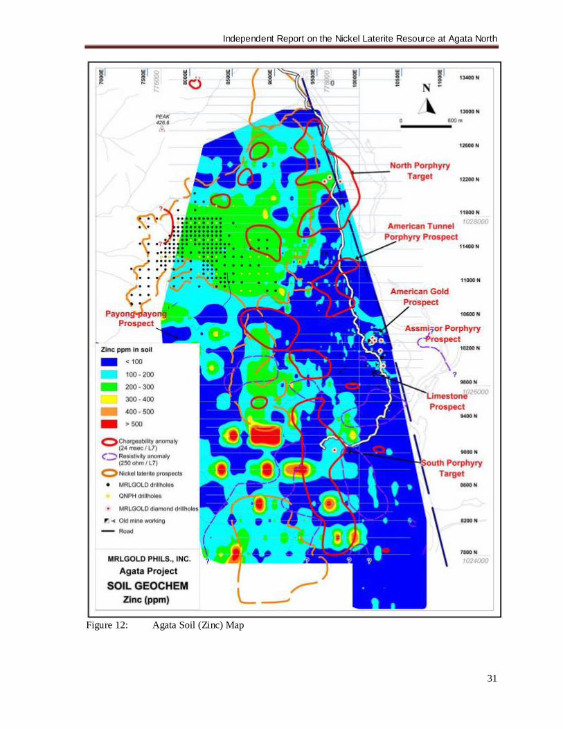
Independent Report on the Nickel Laterite Resource at Agata North
31
Figure 12: Agata Soil (Zinc) Map
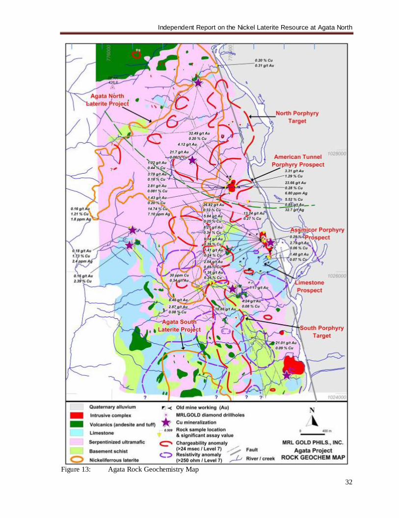
Independent Report on the Nickel Laterite Resource at Agata North
32
Figure 13: Agata Rock Geochemistry Map
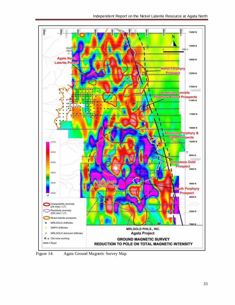
Independent Report on the Nickel Laterite Resource at Agata North
33
Figure 14: Agata Ground Magnetic Survey Map
Independent Report on the Nickel Laterite Resource at Agata North
34
In June 2004, Taganito Mining Corporation was selected from several interested parties and granted the non-exclusive right to assess the nickel laterite potential of the Agata Project. Taganito carried out two phases of evaluation and reported encouraging results. Forty-eight surface laterite and rock samples were collected from an area of about 300 ha within a much more extensive area of nickel laterite mineralization. Nickel contents range from very low to a high of 2.09%, with most of the values exceeding 0.5%. Taganito considered these values to be within the range that normally cap the secondary nickel enriched zone and have recommended a detailed geological survey and drilling. However, MRL elected to allow Queensland Nickel Phils., Inc. (QNPH) to proceed with a reconnaissance drill program in 2006. With respect to nickel laterite prospects, QNPH, a subsidiary of BHP-Billiton, conducted reconnaissance drilling over the ANLP from January 23, 2006 to April 26, 2006 at an initial drilling grid of 200m x 200m followed by in-fill drilling at 100-m grid spacing. A full report of the drilling program entitled “Evaluation of Preliminary Exploration on Agata Nickel Laterite Prospect of MRL Gold Philippines, Inc, Agusan del Norte, Philippines” was completed by QNPH in June 2006 and submitted to Mindoro immediately thereafter. A total of 35 holes were drilled over an area of approximately 80 ha, which is 21% of the 340-hectare ANLP. The drillhole locations are incorporated in the MRL’s AGL Drillhole Location Map (Figure 17). This drilling program was subsequent to a Memorandum of Understanding (MOU) signed between MRL and QNPH on December 5, 2005. The MOU allowed QNPH to conduct exploration in the property, which also include technical review and geological mapping. It was intended to evaluate and establish resource potential of the area and as a possible Yabulu Refinery ore source, and to present a resource model. To evaluate the potential of the ANLP for the Chinese market, MRL commissioned Denny Ambagan to re-evaluate QNPH’s data with the aim of estimating low-grade resources for the Chinese market. Ambagan is a geologist, who worked for Crew Minerals in its Lagonoy and Mindoro nickel laterite exploration areas for three years. An in-house estimate was tabled. Both QNPH’s and Ambagan’s resource estimates are non-NI-43-101-compliant, and not herein released. They served as guide in setting the exploration target for MRL’s succeeding drilling programs.
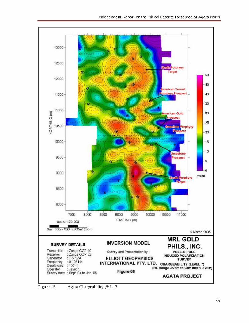
Independent Report on the Nickel Laterite Resource at Agata North
35
Figure 15: Agata Chargeability @ L=7
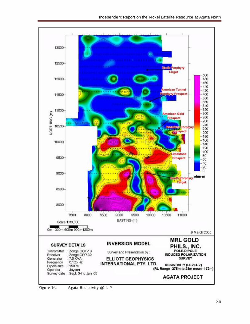
Independent Report on the Nickel Laterite Resource at Agata North
36
Figure 16: Agata Resistivity @ L=7
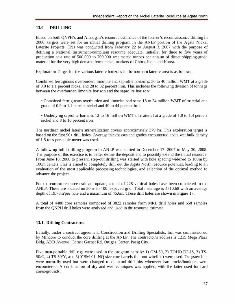
Independent Report on the Nickel Laterite Resource at Agata North
37
13.0 DRILLING Based on both QNPH’s and Ambagan’s resource estimates of the former’s reconnaissance drilling in 2006, targets were set for an initial drilling program in the ANLP portion of the Agata Nickel Laterite Projects. This was conducted from February 22 to August 3, 2007 with the purpose of defining a National Instrument-compliant resource adequate, initially, for three to five years of production at a rate of 500,000 to 700,000 wet metric tonnes per annum of direct shipping-grade material for the very high demand ferro-nickel markets of China, India and Korea. Exploration Target for the various laterite horizons in the northern laterite area is as follows: Combined ferruginous overburden, limonite and saprolite horizons: 30 to 40 million WMT at a grade of 0.9 to 1.1 percent nickel and 28 to 32 percent iron. This includes the following division of tonnage between the overburden/limonite horizon and the saprolite horizon:
• Combined ferruginous overburden and limonite horizons: 18 to 24 million WMT of material at a grade of 0.9 to 1.1 percent nickel and 40 to 44 percent iron.
• Underlying saprolite horizon: 12 to 16 million WMT of material at a grade of 1.0 to 1.4 percent nickel and 8 to 10 percent iron.
The northern nickel laterite mineralization covers approximately 379 ha. This exploration target is based on the first 90+ drill holes. Average thicknesses and grades encountered and a wet bulk density of 1.5 tons per cubic meter was used. A follow-up infill drilling program in ANLP was started in December 17, 2007 to May 30, 2008. The purpose of this exercise is to better define the deposit and to possibly extend the initial resource. From June 18, 2008 to present, step-out drilling was started with hole spacing widened to 100m by 100m centers This is aimed to completely drill out the Agata North resource potential; leading to an evaluation of the most applicable processing technologies, and selection of the optimal method to advance the project. For the current resource estimate update, a total of 228 vertical holes have been completed in the ANLP. These are located on 50m- to 100m-spaced grid. Total meterage is 4510.68 with an average depth of 19.78m/per hole and a maximum of 46.6m. These drill holes are shown in Figure 17. A total of 4480 core samples composed of 3822 samples from MRL drill holes and 658 samples from the QNPH drill holes were analyzed and used in the resource estimate. 13.1 Drilling Contractors: Initially, under a contract agreement, Construction and Drilling Specialists, Inc. was commissioned by Mindoro to conduct the core drilling at the ANLP. The contractor’s address is 1215 Mega Plaza Bldg, ADB Avenue, Corner Garnet Rd, Ortigas Center, Pasig City. Five man-portable drill rigs were used in the program namely: 1) GM-50, 2) TOHO D2-JS, 3) TS-50/G, 4) TS-50/Y, and 5) YBM-01. NQ size core barrels (but not wireline) were used. Tungsten bits were normally used but were changed to diamond drill bits whenever hard rocks/boulders were encountered. A combination of dry and wet techniques was applied, with the latter used for hard cores/grounds.
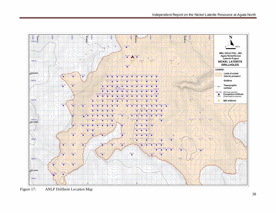
Independent Report on the Nickel Laterite Resource at Agata North
38
Figure 17: ANLP Drillhole Location Map
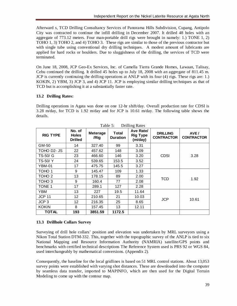
Independent Report on the Nickel Laterite Resource at Agata North
39
Afterward s, TCD Drilling Consultancy Services of Panorama Hills Subdivision, Cupang, Antipolo City was contracted to continue the infill drilling in December 2007. It drilled 48 holes with an aggregate of 773.12 meters. Four man-portable drill rigs were brought in namely: 1.) TONE 1, 2) TOHO 1, 3) TOHO 2, and 4) TOHO 3. These rigs are similar to those of the previous contractor but with single tube using conventional dry drilling techniques. A modest amount of lubricants are applied for hard rocks or boulders. Due to sluggishness of the drilling, the services of TCD were terminated. On June 18, 2008, JCP Geo-Ex Services, Inc. of Camella Tierra Grande Homes, Lawaan, Talisay, Cebu continued the drilling. It drilled 45 holes up to July 18, 2008 with an aggregate of 811.45 m. JCP is currently continuing the drilling operations at ANLP with its four (4) rigs. These rigs are: 1.) KOKIN, 2) YBM, 3) JCP 3, and 4) JCP 11. JCP is employing similar drilling techniques as that of TCD but is accomplishing it at a substantially faster rate. 13.2 Drilling Rates: Drilling operations in Agata was done on one 12-hr shift/day. Overall production rate for CDSI is 3.28 m/day, for TCD is 1.92 m/day and for JCP is 10.61 m/day. The following table shows the details.
Table 5: Drilling Rates
RIG TYPE No. of Holes Drilled
Meterage /Rig
Total Duration
Ave Rate/ Rig Type (m/day)
DRILLING CONTRACTOR
AVE / CONTRACTOR
GM-50 14 327.40 99 3.31
CDSI 3.28 TOHO D2- JS 22 457.62 148 3.09 TS-50/ G 23 466.60 146 3.20 TS-50/ Y 24 539.65 153.5 3.52 YBM-01 17 475.75 145.5 3.27 TOHO 1 9 145.47 109 1.33
TCD 1.92 TOHO 2 13 178.15 89 2.00 TOHO 3 9 160.4 77 2.08 TONE 1 17 289.1 127 2.28 YBM 13 227 19.5 11.64
JCP 10.61 JCP 11 12 210.65 21 10.03 JCP 3 12 216.35 25 8.65 KOKIN 8 157.45 13 12.11
TOTAL 193 3851.59 1172.5 13.3 Drillhole Collars Survey Surveying of drill hole collars’ position and elevation was undertaken by MRL surveyors using a Nikon Total Station DTM-332. This, together with the topographic survey of the ANLP is tied to six National Mapping and Resource Information Authority (NAMRIA) satellite/GPS points and benchmarks with certified technical descriptions The Reference System used is PRS 92 or WGS 84, used interchangeably by mathematical conversions. (Appendix 2). Consequently, the baseline for the local gridlines is based on 51 MRL control stations. About 13,053 survey points were established with varying shot distances. These are downloaded into the computer by seamless data transfer, imported to MAPINFO, which are then used for the Digital Terrain Modeling to come up with the contour map.
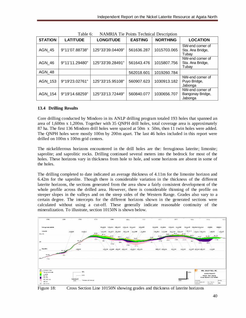
Independent Report on the Nickel Laterite Resource at Agata North
40
Table 6: NAMRIA Tie Points Technical Description
STATION LATITUDE LONGITUDE EASTING NORTHING LOCATION
AGN_45 9°11'07.88738" 125°33'39.04409" 561636.287 1015703.065 SW-end corner of Sta. Ana Bridge, Tubay
AGN_46 9°11'11.29480" 125°33'39.28491" 561643.476 1015807.756 NW-end corner of Sta. Ana Bridge, Tubay
AGN_48 562018.601 1019260.784
AGN_153 9°19'23.02761" 125°33'15.95108" 560907.623 1030913.182 NW-end corner of Puyo Bridge, Jabonga
AGN_154 9°19'14.68259" 125°33'13.72449" 560840.077 1030656.707 NW-end corner of Bangonay Bridge, Jabonga
13.4 Drilling Results Core drilling conducted by Mindoro in its ANLP drilling program totaled 193 holes that spanned an area of 1,600m x 1,200m. Together with 35 QNPH drill holes, total coverage area is approximately 87 ha. The first 136 Mindoro drill holes were spaced at 50m x 50m, then 11 twin holes were added. The QNPH holes were mostly 100m by 200m apart. The last 46 holes included in this report were drilled on 100m x 100m grid centers. The nickeliferrous horizons encountered in the drill holes are the: ferruginous laterite; limonite; saprolite; and saprolitic rocks. Drilling continued several meters into the bedrock for most of the holes. These horizons vary in thickness from hole to hole, and some horizons are absent in some of the holes. The drilling completed to date indicated an average thickness of 4.11m for the limonite horizon and 6.42m for the saprolite. Though there is considerable variation in the thickness of the different laterite horizons, the sections generated from the area show a fairly consistent development of the whole profile across the drilled area. However, there is considerable thinning of the profile on steeper slopes in the valleys and on the steep sides of the Western Range. Grades also vary to a certain degree. The intercepts for the different horizons shown in the generated sections were calculated without using a cut-off. These generally indicate reasonable continuity of the mineralization. To illustrate, section 10150N is shown below.
Figure 18: Cross Section Line 10150N showing grades and thickness of laterite horizons
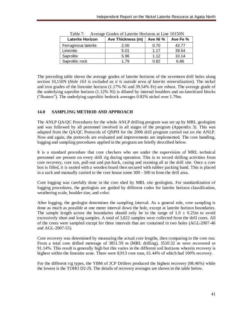
Independent Report on the Nickel Laterite Resource at Agata North
41
Table 7: Average Grades of Laterite Horizons at Line 10150N
Laterite Horizon Ave Thickness (m) Ave Ni % Ave Fe % Ferruginous laterite 2.00 0.70 43.77 Limonite 5.01 1.17 39.54 Saprolite 5.96 1.12 10.14 Saprolitic rock 1.79 0.82 6.86
The preceding table shows the average grades of laterite horizons of the seventeen drill holes along section 10,150N (Hole 163 is excluded as it is outside area of laterite mineralization). The nickel and iron grades of the limonite horizon (1.17% Ni and 39.54% Fe) are robust. The average grade of the underlying saprolite horizon (1.12% Ni) is diluted by internal boulders and un-lateritized blocks ("floaters"). The underlying saprolitic bedrock averages 0.82% nickel over 1.79m. 14.0 SAMPLING METHOD AND APPROACH The ANLP QA/QC Procedures for the whole ANLP drilling program was set up by MRL geologists and was followed by all personnel involved in all stages of the program (Appendix 3). This was adapted from the QA/QC Protocols of QNPH for the 2006 drill program carried out on the ANLP. Now and again, the protocols are evaluated and improvements are implemented. The core handling, logging and sampling procedures applied in the program are briefly described below. It is a standard procedure that core checkers who are under the supervision of MRL technical personnel are present on every drill rig during operation. This is to record drilling activities from core recovery, core run, pull-out and put-back, casing and reaming all at the drill site. Once a core box is filled, it is sealed with a wooden board then secured with rubber packing band. This is placed in a sack and manually carried to the core house some 300 - 500 m from the drill area. Core logging was carefully done in the core shed by MRL site geologists. For standardization of logging procedures, the geologists are guided by different codes for laterite horizon classification, weathering scale, boulder size, and color. After logging, the geologist determines the sampling interval. As a general rule, core sampling is done as much as possible at one meter interval down the hole, except at laterite horizon boundaries. The sample length across the boundaries should only be in the range of 1.0 ± 0.25m to avoid excessively short and long samples. A total of 3,822 samples were collected from the drill cores. All of the cores were sampled except for three intervals that are contained in two holes (AGL-2007-46 and AGL-2007-55). Core recovery was determined by measuring the actual core lengths, then comparing to the core run. From a total core drilled meterage of 3851.59 m (MRL drilling), 3510.32 m were recovered or 91.14%. This result is generally high but this varies in the different soil horizons wherein recovery is highest within the limonite zone. There were 8,913 core runs, 61.44% of which had 100% recovery. For the different rig types, the YBM of JCP Drillers produced the highest recovery (98.46%) while the lowest is the TOHO D2-JS. The details of recovery averages are shown in the table below.
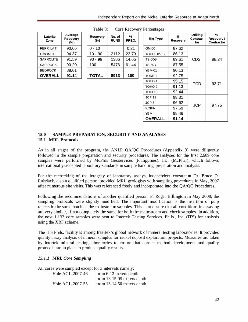
Independent Report on the Nickel Laterite Resource at Agata North
42
Table 8: Core Recovery Percentages Laterite
Zone
Average Recovery
(%) Recovery
(%) No. of RUNS
% FREQ. Rig Type %
Recovery
Drilling Contrac-
tor
% Recovery / Contractor
FERR. LAT. 90.05 0 - 10 0.21 GM-50 87.62
CDSI 88.24 LIMONITE 94.37 10 - 90 2112 23.70 TOHO D2-JS 86.13 SAPROLITE 91.59 90 - 99 1306 14.65 TS-50G 89.61 SAP ROCK 90.20 100 5476 61.44 TS-50Y 87.55 BEDROCK 88.01 YBM-01 90.13 OVERALL 91.14 TOTAL 8913 100 TONE 1 92.75
TCD 92.71 TOHO 1 95.15 TOHO 2 91.13 TOHO 3 92.44 JCP 11 98.31
JCP 97.75 JCP 3 96.62 KOKIN 97.69 YBM 98.46 OVERALL 91.14
15.0 SAMPLE PREPARATION, SECURITY AND ANALYSES 15.1 MRL Protocols As in all stages of the program, the ANLP QA/QC Procedures (Appendix 3) were diligently followed in the sample preparation and security procedures. The analyses for the first 2,689 core samples were performed by McPhar Geoservices (Philippines), Inc. (McPhar), which follows internationally-accepted laboratory standards in sample handling, preparation and analysis. For the rechecking of the integrity of laboratory assays, independent consultant Dr. Bruce D. Rohrlach, also a qualified person, provided MRL geologists with sampling procedures in May, 2007 after numerous site visits. This was referenced freely and incorporated into the QA/QC Procedures. Following the recommendations of another qualified person, F. Roger Billington in May 2008, the sampling protocols were slightly modified. The important modification is the insertion of pulp rejects in the same batch as the mainstream samples. This is to ensure that all conditions in assaying are very similar, if not completely the same for both the mainstream and check samples. In addition, the next 1,133 core samples were sent to Intertek Testing Services, Phils., Inc. (ITS) for analysis using the XRF scheme. The ITS Phils. facility is among Intertek’s global network of mineral testing laboratories. It provides quality assay analysis of mineral samples for nickel deposit exploration projects. Measures are taken by Intertek mineral testing laboratories to ensure that correct method development and quality protocols are in place to produce quality results. 15.1.1 MRL Core Sampling All cores were sampled except for 3 intervals namely:
Hole AGL-2007-46 from 6-12 meters depth from 13-15.05 meters depth Hole AGL-2007-55 from 13-14.50 meters depth
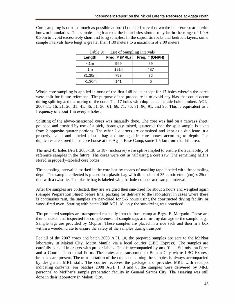
Independent Report on the Nickel Laterite Resource at Agata North
43
Core sampling is done as much as possible at one (1) meter interval down the hole except at laterite horizon boundaries. The sample length across the boundaries should only be in the range of 1.0 ± 0.30m to avoid excessively short and long samples. In the saprolitic rocks and bedrock layers, some sample intervals have lengths greater than 1.30 meters to a maximum of 2.00 meters.
Table 9: List of Sampling Intervals Length Freq. # (MRL) Freq. # (QNPH)
<1m 969 89 1m 1914 487
≤1.30m 798 76 >1.30m 141 6
Whole core sampling is applied in most of the first 148 holes except for 17 holes wherein the cores were split for future reference. The purpose of the procedure is to avoid any bias that could occur during splitting and quartering of the core. The 17 holes with duplicates include hole numbers AGL-2007-11, 16, 21, 26, 31, 41, 46, 51, 56, 61, 66, 71, 76, 81, 86, 91, and 96. This is equivalent to a frequency of about 1 in every 5 holes. Splitting of the above-mentioned cores was manually done. The core was laid on a canvass sheet, pounded and crushed by use of a pick, thoroughly mixed, quartered, then the split sample is taken from 2 opposite quarter portions. The other 2 quarters are combined and kept as a duplicate in a properly-sealed and labeled plastic bag and arranged in core boxes according to depth. The duplicates are stored in the core house at the Agata Base Camp, some 1.5 km from the drill area. The next 45 holes (AGL 2008-138 to 187, inclusive) were split-sampled to ensure the availability of reference samples in the future. The cores were cut in half using a core saw. The remaining half is stored in properly-labeled core boxes. The sampling interval is marked in the core box by means of masking tape labeled with the sampling depth. The sample collected is placed in a plastic bag with dimension of 35 centimeters (cm) x 25cm tied with a twist tie. The plastic bag is labeled with the hole number and sample interval. After the samples are collected, they are weighed then sun-dried for about 5 hours and weighed again (Sample Preparation Sheet) before final packing for delivery to the laboratory. In cases where there is continuous rain, the samples are pan-dried for 5-6 hours using the constructed drying facility or wood-fired oven. Starting with batch 2008 AGL 18, only the sun-drying was practiced. The prepared samples are transported manually into the base camp at Brgy. E. Morgado. These are then checked and inspected for completeness of sample tags and for any damage to the sample bags. Sample tags are provided by Mcphar. These samples are placed in a rice sack and then in a box within a wooden crate to ensure the safety of the samples during transport. For all of the 2007 cores and batch 2008 AGL 10, the prepared samples are sent to the McPhar laboratory in Makati City, Metro Manila via a local courier (LBC Express). The samples are carefully packed in craters with proper labels. This is accompanied by an official Submission Form and a Courier Transmittal Form. The crates are transported to Butuan City where LBC Express branches are present. The transportation of the crates containing the samples is always accompanied by designated MRL staff. The courier receives the package and provides MRL with receipts indicating contents. For batches 2008 AGL 1, 3 and 6, the samples were delivered by MRL personnel to McPhar’s sample preparation facility in General Santos City. The assaying was still done in their laboratory in Makati City.

Independent Report on the Nickel Laterite Resource at Agata North
44
Counting and cross-checking of samples vis-à-vis the McPhar Submission Form are done by McPhar supervisors. Notice is given to MRL only if there are discrepancies, otherwise it is understood that sample preparation and analysis will be carried out as requested. A sample tracking, quality control, and reporting system is maintained between MRL and McPhar. For batches 2008 AGL 13, 16, 18 and onwards, the core samples were delivered to Intertek’s sample preparation facility in Surigao City. Once prepared, Intertek-Surigao sends the samples to their assay laboratory in Muntinlupa City, Metro Manila. The core sampling and logging facility is under the supervision of Mindoro geologist or mining engineer at all times. This facility is about 300-500 m from the drill pads. The other core storage facility at Brgy. E. Morgado base camp is likewise supervised by either a geologist or mining engineer at all times. A civilian guard secures the base camp premises during the night. The ANLP drilling was directly under the supervision of James A. Climie, P. Geol., a geologist and President and CEO of Mindoro. 15.1.2 Rechecking of Laboratory Results In addition to stringent sampling protocols, QA/QC procedures were also employed following Dr. B. Rohrlach’s and F.R. Billington’s guidelines. Standard reference materials, field duplicates, coarse rejects and pulp rejects were analyzed to check the validity/accuracy of the laboratory results. A total of 760 analyses of such samples were collected. The details are shown in Table 10. Selection of check samples are spread throughout all holes and in various laterite horizons. For the 2008 samples standards, field duplicates and pulp rejects were inserted, but no coarse rejects were sent yet nor are there any pulp rejects analyzed by an umpire laboratory. For 2007 samples, the field duplicates totaled 117 (5.27%). Normally, 1 in every 20 core samples is duplicated. A total of 41 field duplicates have been analyzed for the 2008 samples to date. The duplicate sample is selected to ascertain that the full range of different laterite horizons is systematically covered. The samples were selected to cover the full range of Ni grades at Agata, and to extensively cover the different stages and spatial distribution of the drill program, so as to provide a representative check on the reliability of the original sample splitting process undertaken by MRL at the drill site. Its distribution for each laterite horizon is shown in Table 11. Originally, splitting method is the same as for obtaining duplicates for storage but 1/4 part of the prepared sample represents the field duplicate while the 3/4 part is the regular sample. For the half-core sampling, the field duplicates are taken by cutting the remaining ½ core into 2. These samples are sent to the laboratory in the same batch and were treated in the same way as the normal core samples. A set of 24 coarse reject samples, comprising 1.08 % of the 2221 core samples, were submitted to McPhar for resampling and assaying. Resampling was done by taking a duplicate split off the reject and then placing it back into the assay stream for analysis. Again, as in all duplicates, the submitted samples were chosen to cover the natural range of assays. The reanalysis of the coarse reject samples was undertaken as an internal check on the crushing and sub-sampling procedures of McPhar to ensure that the samples taken for analysis were representative of the bulk sample. For the recent samples, coarse rejects will be submitted in the future to the corresponding laboratory (either Mcphar or Intertek) where the original samples were analyzed. Again for the 2007 to May 2008 core samples, selected pulp rejects generated from sample preparation at Mcphar were sent to (Intertek of Jakarta, Indonesia, and another set of pulp rejects were resent to Mcphar. This is to establish reproducibility of analysis and determine the presence or
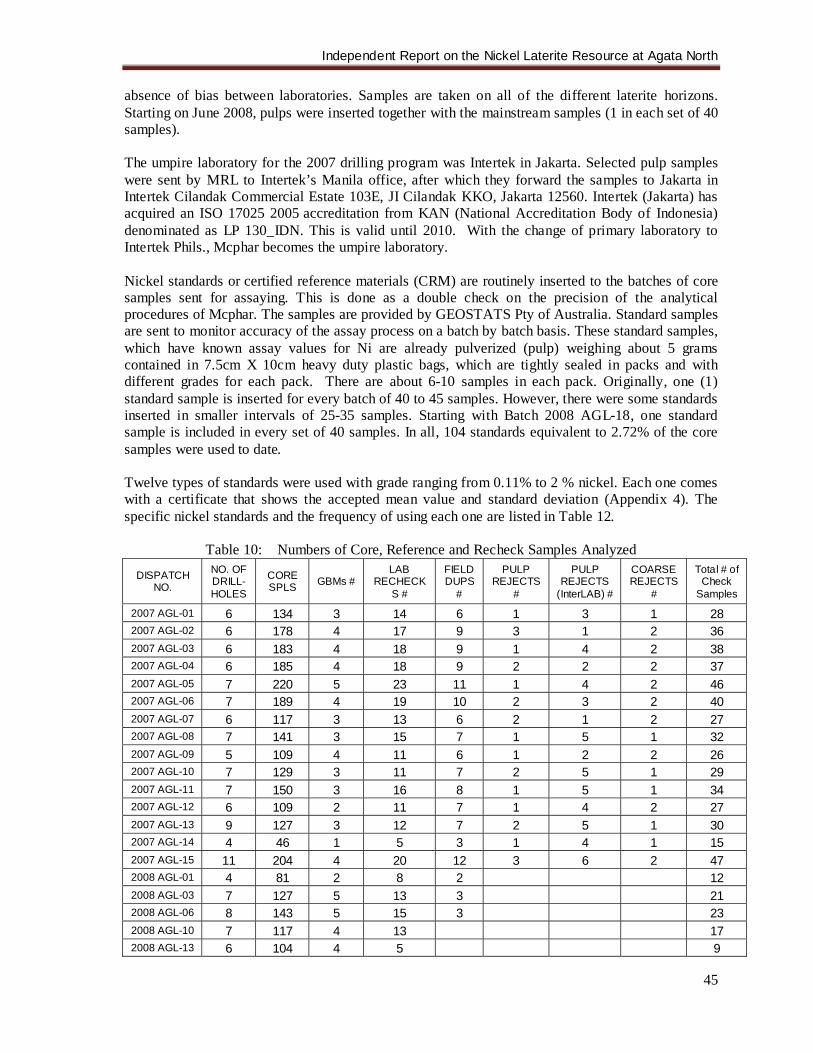
Independent Report on the Nickel Laterite Resource at Agata North
45
absence of bias between laboratories. Samples are taken on all of the different laterite horizons. Starting on June 2008, pulps were inserted together with the mainstream samples (1 in each set of 40 samples). The umpire laboratory for the 2007 drilling program was Intertek in Jakarta. Selected pulp samples were sent by MRL to Intertek’s Manila office, after which they forward the samples to Jakarta in Intertek Cilandak Commercial Estate 103E, JI Cilandak KKO, Jakarta 12560. Intertek (Jakarta) has acquired an ISO 17025 2005 accreditation from KAN (National Accreditation Body of Indonesia) denominated as LP 130_IDN. This is valid until 2010. With the change of primary laboratory to Intertek Phils., Mcphar becomes the umpire laboratory. Nickel standards or certified reference materials (CRM) are routinely inserted to the batches of core samples sent for assaying. This is done as a double check on the precision of the analytical procedures of Mcphar. The samples are provided by GEOSTATS Pty of Australia. Standard samples are sent to monitor accuracy of the assay process on a batch by batch basis. These standard samples, which have known assay values for Ni are already pulverized (pulp) weighing about 5 grams contained in 7.5cm X 10cm heavy duty plastic bags, which are tightly sealed in packs and with different grades for each pack. There are about 6-10 samples in each pack. Originally, one (1) standard sample is inserted for every batch of 40 to 45 samples. However, there were some standards inserted in smaller intervals of 25-35 samples. Starting with Batch 2008 AGL-18, one standard sample is included in every set of 40 samples. In all, 104 standards equivalent to 2.72% of the core samples were used to date. Twelve types of standards were used with grade ranging from 0.11% to 2 % nickel. Each one comes with a certificate that shows the accepted mean value and standard deviation (Appendix 4). The specific nickel standards and the frequency of using each one are listed in Table 12.
Table 10: Numbers of Core, Reference and Recheck Samples Analyzed
DISPATCH NO.
NO. OF DRILL-HOLES
CORE SPLS GBMs #
LAB RECHECK
S #
FIELD DUPS
#
PULP REJECTS
#
PULP REJECTS
(InterLAB) #
COARSE REJECTS
#
Total # of Check
Samples
2007 AGL-01 6 134 3 14 6 1 3 1 28 2007 AGL-02 6 178 4 17 9 3 1 2 36 2007 AGL-03 6 183 4 18 9 1 4 2 38 2007 AGL-04 6 185 4 18 9 2 2 2 37 2007 AGL-05 7 220 5 23 11 1 4 2 46 2007 AGL-06 7 189 4 19 10 2 3 2 40 2007 AGL-07 6 117 3 13 6 2 1 2 27 2007 AGL-08 7 141 3 15 7 1 5 1 32 2007 AGL-09 5 109 4 11 6 1 2 2 26 2007 AGL-10 7 129 3 11 7 2 5 1 29 2007 AGL-11 7 150 3 16 8 1 5 1 34 2007 AGL-12 6 109 2 11 7 1 4 2 27 2007 AGL-13 9 127 3 12 7 2 5 1 30 2007 AGL-14 4 46 1 5 3 1 4 1 15 2007 AGL-15 11 204 4 20 12 3 6 2 47 2008 AGL-01 4 81 2 8 2 12 2008 AGL-03 7 127 5 13 3 21 2008 AGL-06 8 143 5 15 3 23 2008 AGL-10 7 117 4 13 17 2008 AGL-13 6 104 4 5 9
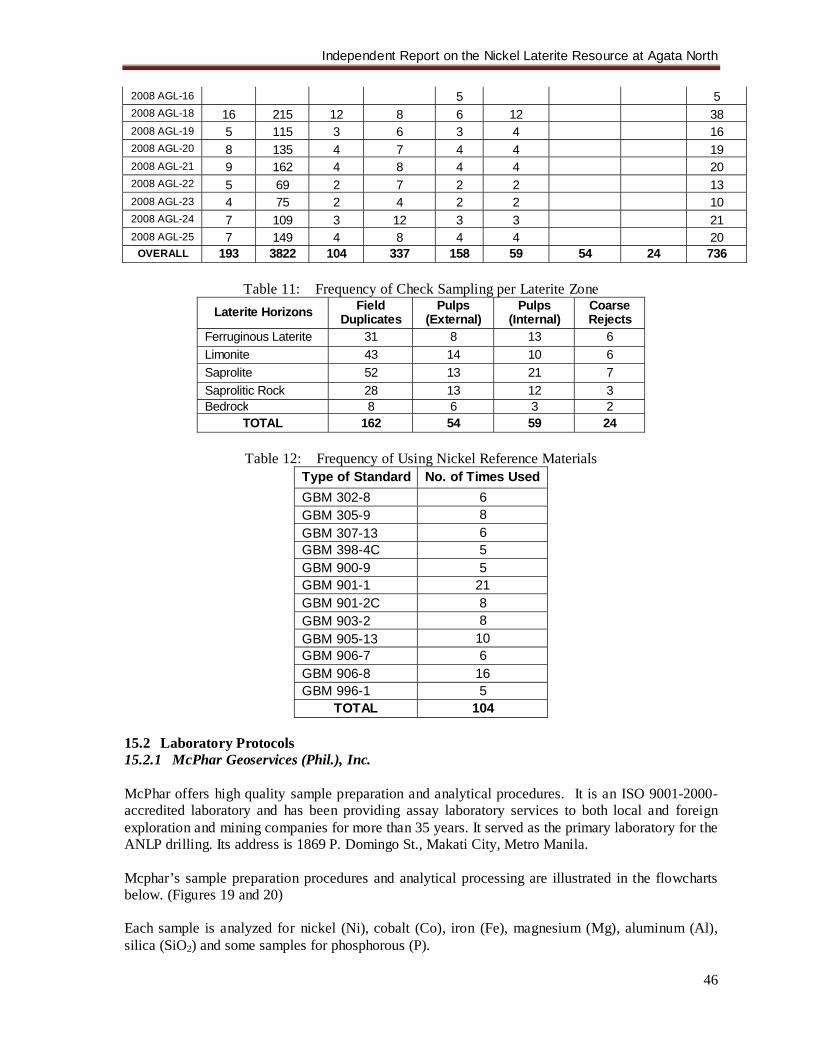
Independent Report on the Nickel Laterite Resource at Agata North
46
2008 AGL-16 5 5 2008 AGL-18 16 215 12 8 6 12 38 2008 AGL-19 5 115 3 6 3 4 16 2008 AGL-20 8 135 4 7 4 4 19 2008 AGL-21 9 162 4 8 4 4 20 2008 AGL-22 5 69 2 7 2 2 13 2008 AGL-23 4 75 2 4 2 2 10 2008 AGL-24 7 109 3 12 3 3 21 2008 AGL-25 7 149 4 8 4 4 20
OVERALL 193 3822 104 337 158 59 54 24 736
Table 11: Frequency of Check Sampling per Laterite Zone Laterite Horizons Field
Duplicates Pulps
(External) Pulps
(Internal) Coarse Rejects
Ferruginous Laterite 31 8 13 6 Limonite 43 14 10 6 Saprolite 52 13 21 7 Saprolitic Rock 28 13 12 3 Bedrock 8 6 3 2
TOTAL 162 54 59 24
Table 12: Frequency of Using Nickel Reference Materials Type of Standard No. of Times Used GBM 302-8 6 GBM 305-9 8 GBM 307-13 6 GBM 398-4C 5 GBM 900-9 5 GBM 901-1 21 GBM 901-2C 8 GBM 903-2 8 GBM 905-13 10 GBM 906-7 6 GBM 906-8 16 GBM 996-1 5
TOTAL 104 15.2 Laboratory Protocols 15.2.1 McPhar Geoservices (Phil.), Inc. McPhar offers high quality sample preparation and analytical procedures. It is an ISO 9001-2000-accredited laboratory and has been providing assay laboratory services to both local and foreign exploration and mining companies for more than 35 years. It served as the primary laboratory for the ANLP drilling. Its address is 1869 P. Domingo St., Makati City, Metro Manila. Mcphar’s sample preparation procedures and analytical processing are illustrated in the flowcharts below. (Figures 19 and 20) Each sample is analyzed for nickel (Ni), cobalt (Co), iron (Fe), magnesium (Mg), aluminum (Al), silica (SiO2) and some samples for phosphorous (P).
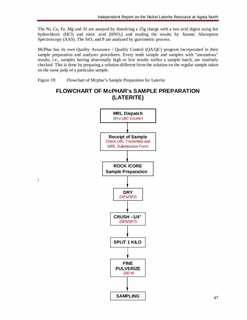
Independent Report on the Nickel Laterite Resource at Agata North
47
The Ni, Co, Fe, Mg and Al are assayed by dissolving a 25g charge with a two acid digest using hot hydrochloric (HCl) and nitric acid (HNO3) and reading the results by Atomic Absorption Spectroscopy (AAS). The SiO2 and P are analyzed by gravimetric process. McPhar has its own Quality Assurance / Quality Control (QA/QC) program incorporated in their sample preparation and analyses procedures. Every tenth sample and samples with "anomalous" results, i.e., samples having abnormally high or low results within a sample batch, are routinely checked. This is done by preparing a solution different from the solution on the regular sample taken on the same pulp of a particular sample. Figure 19: Flowchart of Mcphar’s Sample Preparation for Laterite
FLOWCHART OF McPHAR’s SAMPLE PREPARATION (LATERITE)
\
MRL Dispatch (thru LBC Courier)
Receipt of Sample Check LBC Transmittal and MRL Submission Form
CRUSH –1/4” (SP6/SP7)
FINE PULVERIZE
-200 M
SAMPLING
SPLIT 1 KILO
ROCK /CORE Sample Preparation
DRY (SP1/SP2)
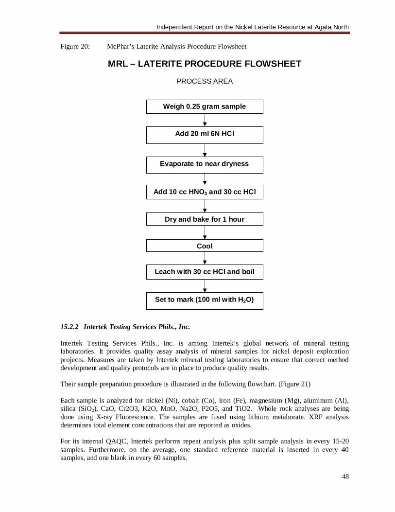
Independent Report on the Nickel Laterite Resource at Agata North
48
Figure 20: McPhar’s Laterite Analysis Procedure Flowsheet
MRL – LATERITE PROCEDURE FLOWSHEET
PROCESS AREA
15.2.2 Intertek Testing Services Phils., Inc. Intertek Testing Services Phils., Inc. is among Intertek’s global network of mineral testing laboratories. It provides quality assay analysis of mineral samples for nickel deposit exploration projects. Measures are taken by Intertek mineral testing laboratories to ensure that correct method development and quality protocols are in place to produce quality results. Their sample preparation procedure is illustrated in the following flowchart. (Figure 21) Each sample is analyzed for nickel (Ni), cobalt (Co), iron (Fe), magnesium (Mg), aluminum (Al), silica (SiO2), CaO, Cr2O3, K2O, MnO, Na2O, P2O5, and TiO2. Whole rock analyses are being done using X-ray Fluorescence. The samples are fused using lithium metaborate. XRF analysis determines total element concentrations that are reported as oxides. For its internal QAQC, Intertek performs repeat analysis plus split sample analysis in every 15-20 samples. Furthermore, on the average, one standard reference material is inserted in every 40 samples, and one blank in every 60 samples.
Weigh 0.25 gram sample
Add 20 ml 6N HCl
Evaporate to near dryness
Add 10 cc HNO3 and 30 cc HCl
Dry and bake for 1 hour
Cool
Leach with 30 cc HCl and boil
Set to mark (100 ml with H2O)
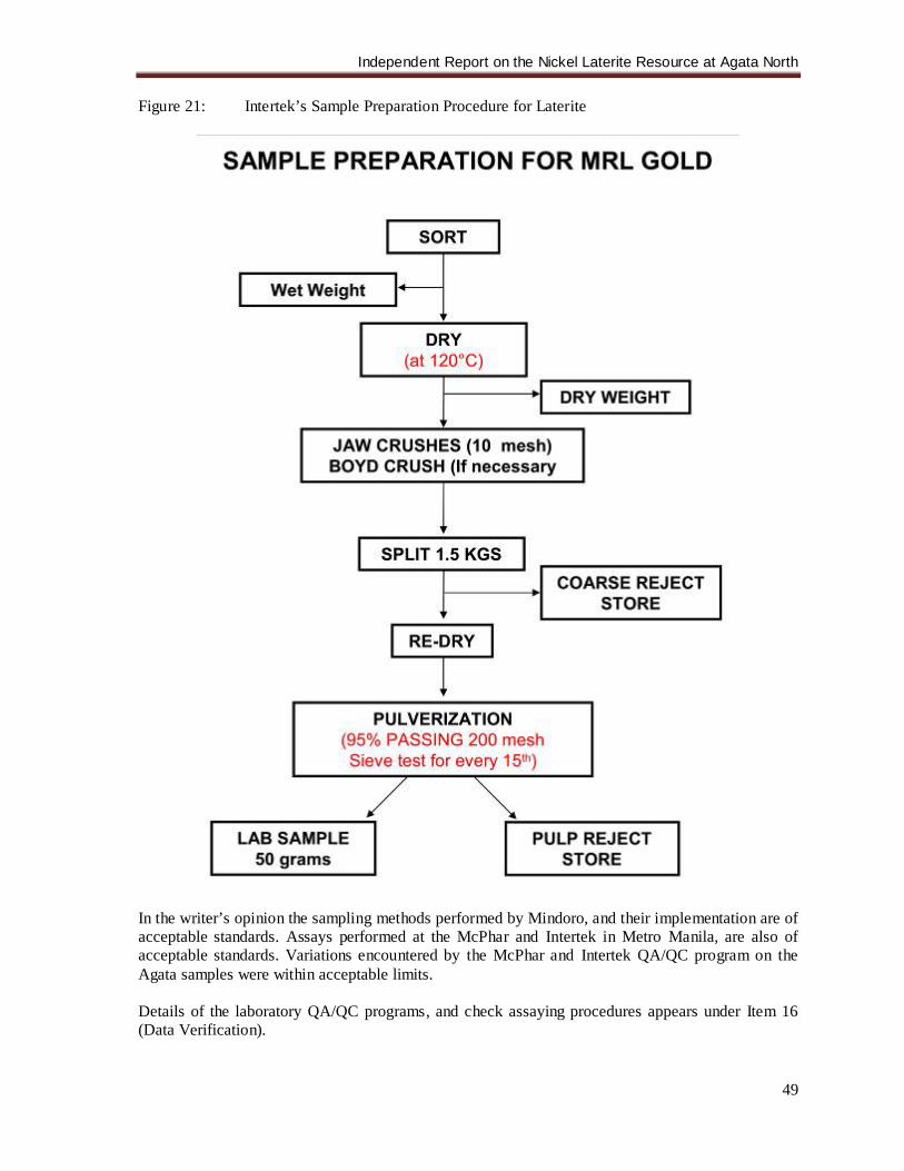
Independent Report on the Nickel Laterite Resource at Agata North
49
Figure 21: Intertek’s Sample Preparation Procedure for Laterite
In the writer’s opinion the sampling methods performed by Mindoro, and their implementation are of acceptable standards. Assays performed at the McPhar and Intertek in Metro Manila, are also of acceptable standards. Variations encountered by the McPhar and Intertek QA/QC program on the Agata samples were within acceptable limits. Details of the laboratory QA/QC programs, and check assaying procedures appears under Item 16 (Data Verification).
Independent Report on the Nickel Laterite Resource at Agata North
50
16.0 DATA VERIFICATION The writer, in his visits to the field, drill sites and Manila Office of Mindoro, has observed and verified the datasets provided by Mindoro against original field sheets and official Analytical Results. Selected core trays were visually inspected against the logs. Selected Drill hole collars were likewise inspected during field visits and cross checked against survey plans and topographic data. The details of the laboratory QA/QC programs and check assaying procedures are presented below. 16.1 Internal QAQC (McPhar/Intertek) The laboratories of Mcphar Geoservices and Intertek Testing Phils., Inc. in Manila were installed with a Quality Assurance/Quality Control program incorporated in their sample preparation and analyses procedures. McPhar and Intertek laboratories both regularly conduct duplicate analysis of Ni and other elements as a check on analytical reproducibility. Repeats are routinely conducted on all elements being analyzed and are typically on every 10th sample for McPhar and on every 20th sample for Intertek. All in all there are 337, (8.82%) repeat analyses that are spread evenly throughout the entire database. Figure 22 shows excellent correlation for all of the elements analyzed with R² = 0.99, and Ni-1 and Ni-2 correlation being 0.999. The Relative Percentage Errors (RPE) are all below 1% as shown in the table below, showing consistent and high precision repeatability. Negative values indicate that the repeat analysis is higher.
Table 13: Relationship of Original and Repeat Analyses Ni % Co % Fe % Al % Mg % SiO2 %
Mcphar RE % 0.05 -0.26 -0.15 -0.08 -0.28 0.03 Orig = Recheck 98 204 4 98 23 16 Orig < Recheck 84 38 146 94 137 120 Orig > Recheck 90 30 122 80 112 136
Intertek RE % -0.09 0.75 0.15 -0.11 0.01 -0.08 Orig = Recheck 27 16 0 0 0 1 Orig < Recheck 20 22 31 26 34 35 Orig > Recheck 18 27 34 39 31 29
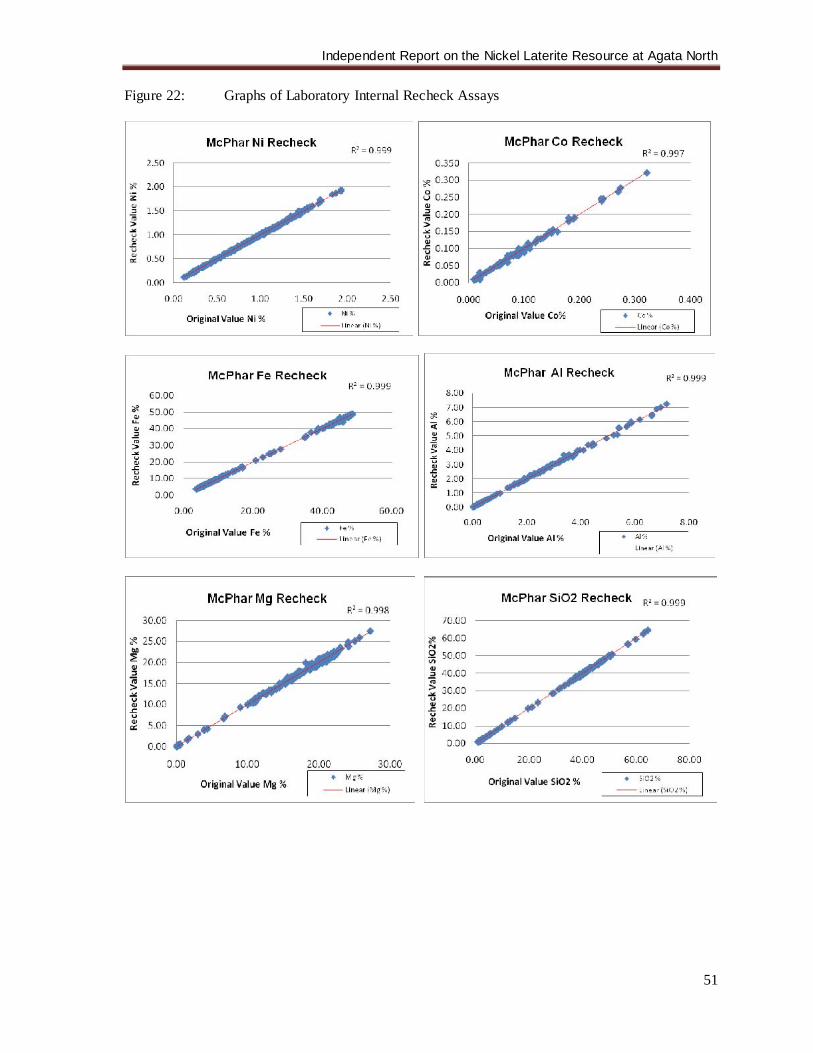
Independent Report on the Nickel Laterite Resource at Agata North
51
Figure 22: Graphs of Laboratory Internal Recheck Assays
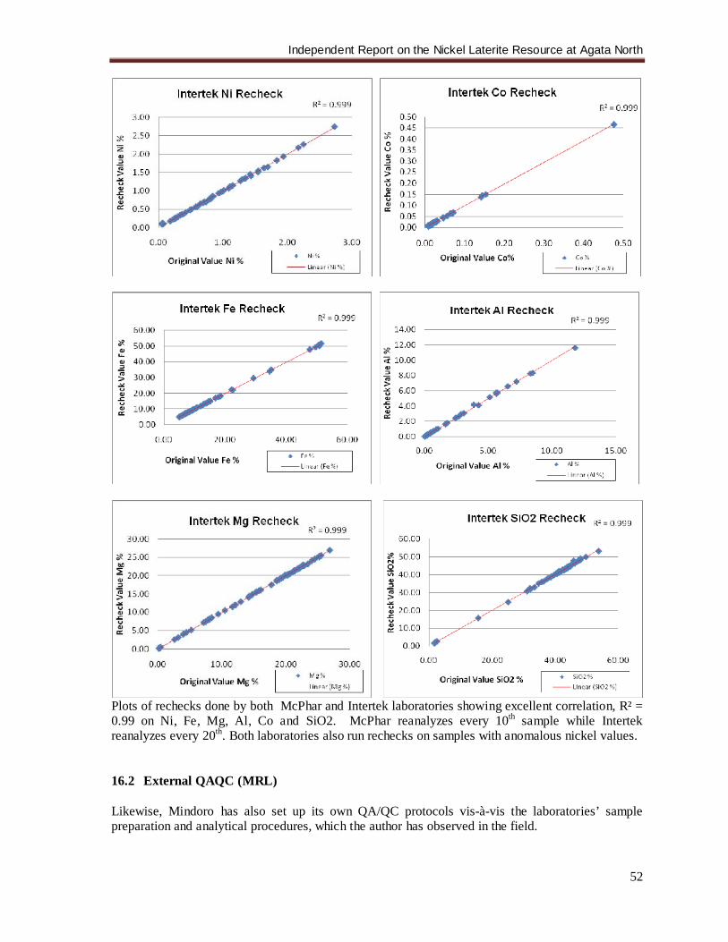
Independent Report on the Nickel Laterite Resource at Agata North
52
Plots of rechecks done by both McPhar and Intertek laboratories showing excellent correlation, R² = 0.99 on Ni, Fe, Mg, Al, Co and SiO2. McPhar reanalyzes every 10th sample while Intertek reanalyzes every 20th. Both laboratories also run rechecks on samples with anomalous nickel values. 16.2 External QAQC (MRL) Likewise, Mindoro has also set up its own QA/QC protocols vis-à-vis the laboratories’ sample preparation and analytical procedures, which the author has observed in the field.
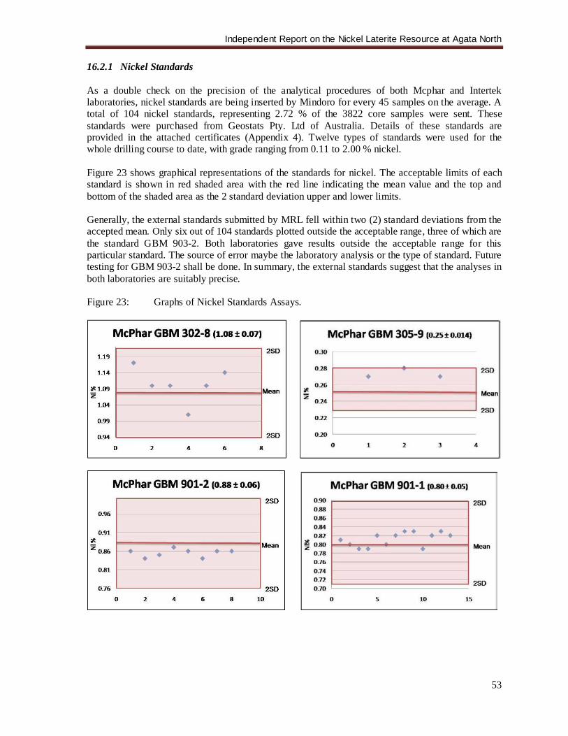
Independent Report on the Nickel Laterite Resource at Agata North
53
16.2.1 Nickel Standards As a double check on the precision of the analytical procedures of both Mcphar and Intertek laboratories, nickel standards are being inserted by Mindoro for every 45 samples on the average. A total of 104 nickel standards, representing 2.72 % of the 3822 core samples were sent. These standards were purchased from Geostats Pty. Ltd of Australia. Details of these standards are provided in the attached certificates (Appendix 4). Twelve types of standards were used for the whole drilling course to date, with grade ranging from 0.11 to 2.00 % nickel. Figure 23 shows graphical representations of the standards for nickel. The acceptable limits of each standard is shown in red shaded area with the red line indicating the mean value and the top and bottom of the shaded area as the 2 standard deviation upper and lower limits. Generally, the external standards submitted by MRL fell within two (2) standard deviations from the accepted mean. Only six out of 104 standards plotted outside the acceptable range, three of which are the standard GBM 903-2. Both laboratories gave results outside the acceptable range for this particular standard. The source of error maybe the laboratory analysis or the type of standard. Future testing for GBM 903-2 shall be done. In summary, the external standards suggest that the analyses in both laboratories are suitably precise. Figure 23: Graphs of Nickel Standards Assays.
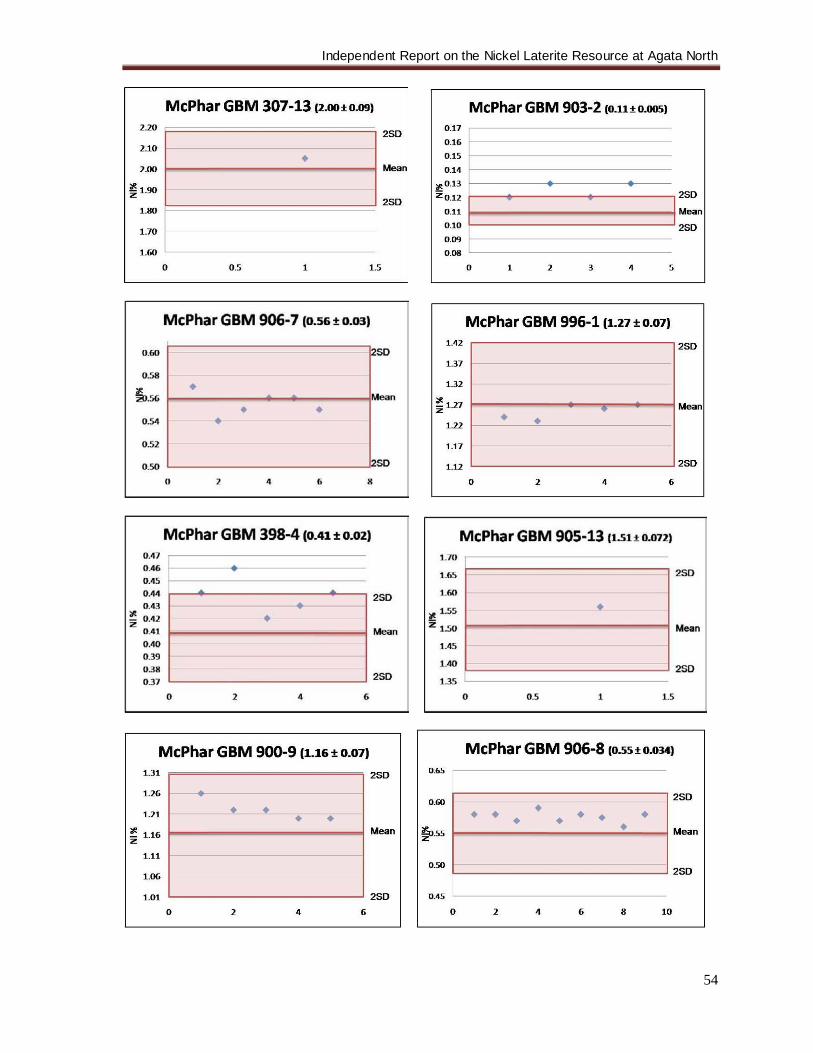
Independent Report on the Nickel Laterite Resource at Agata North
54
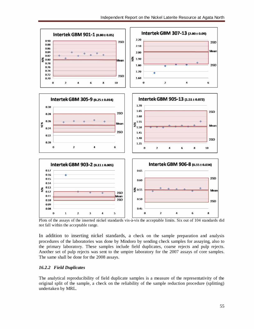
Independent Report on the Nickel Laterite Resource at Agata North
55
Plots of the assays of the inserted nickel standards vis-à-vis the acceptable limits. Six out of 104 standards did not fall within the acceptable range. In addition to inserting nickel standards, a check on the sample preparation and analysis procedures of the laboratories was done by Mindoro by sending check samples for assaying, also to the primary laboratory. These samples include field duplicates, coarse rejects and pulp rejects. Another set of pulp rejects was sent to the umpire laboratory for the 2007 assays of core samples. The same shall be done for the 2008 assays. 16.2.2 Field Duplicates The analytical reproducibility of field duplicate samples is a measure of the representativity of the original split of the sample, a check on the reliability of the sample reduction procedure (splitting) undertaken by MRL.
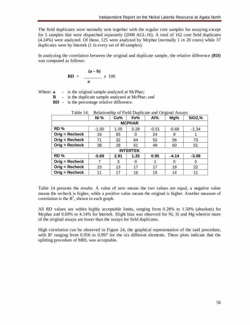
Independent Report on the Nickel Laterite Resource at Agata North
56
The field duplicates were normally sent together with the regular core samples for assaying except for 5 samples that were dispatched separately (2008 AGL-16). A total of 162 core field duplicates (4.24%) were analyzed. Of these, 125 were analyzed by Mcphar (normally 1 in 20 cores) while 37 duplicates were by Intertek (1 in every set of 40 samples). In analyzing the correlation between the original and duplicate sample, the relative difference (RD) was computed as follows: (a – b) RD = ________ x 100
a Where: a - is the original sample analyzed at McPhar;
B - is the duplicate sample analyzed at McPhar; and RD - is the percentage relative difference.
Table 14: Relationship of Field Duplicate and Original Assays
Ni % Co% Fe% Al% Mg% SiO2,% MCPHAR
RD % -1.50 1.05 0.28 -0.51 -0.68 -1.34 Orig = Recheck 16 65 0 24 9 1 Orig < Recheck 71 32 64 52 56 73 Orig > Recheck 38 28 61 49 60 51
INTERTEK RD % -0.69 2.91 1.35 0.95 -4.14 -3.08 Orig = Recheck 7 3 0 1 0 0 Orig < Recheck 15 13 17 17 19 22 Orig > Recheck 11 17 16 15 14 11
Table 14 presents the results. A value of zero means the two values are equal, a negative value means the recheck is higher, while a positive value means the original is higher. Another measure of correlation is the R2, shown in each graph. All RD values are within highly acceptable limits, ranging from 0.28% to 1.50% (absolute) for Mcphar and 0.69% to 4.14% for Intertek. Slight bias was observed for Ni, Si and Mg wherein more of the original assays are lower than the assays for field duplicates.
High correlation can be observed in Figure 24, the graphical representation of the said procedure, with R² ranging from 0.956 to 0.997 for the six different elements. These plots indicate that the splitting procedure of MRL was acceptable.
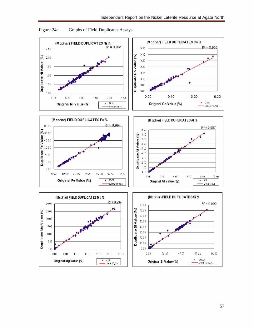
Independent Report on the Nickel Laterite Resource at Agata North
57
Figure 24: Graphs of Field Duplicates Assays
Independent Report on the Nickel Laterite Resource at Agata North
58
Plots of the field duplicate samples analyzed by Mcphar and Intertek Laboratories show good correlation, with R² ranging from 0.956 to 0.997 for the six different elements.
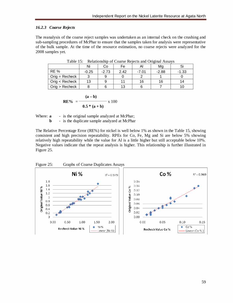
Independent Report on the Nickel Laterite Resource at Agata North
59
16.2.3 Coarse Rejects The reanalysis of the coarse reject samples was undertaken as an internal check on the crushing and sub-sampling procedures of McPhar to ensure that the samples taken for analysis were representative of the bulk sample. At the time of the resource estimation, no coarse rejects were analyzed for the 2008 samples yet.
Table 15: Relationship of Coarse Rejects and Original Assays Ni Co Fe Al Mg Si RE % -0.25 -2.73 2.42 -7.01 -2.88 -1.33 Orig = Recheck 3 9 0 2 1 0 Orig < Recheck 13 9 11 16 16 14 Orig > Recheck 8 6 13 6 7 10
(a – b) RE% = _____________________ x 100
0.5 * (a + b) Where: a - is the original sample analyzed at McPhar;
b - is the duplicate sample analyzed at McPhar The Relative Percentage Error (RE%) for nickel is well below 1% as shown in the Table 15, showing consistent and high precision repeatability. RPEs for Co, Fe, Mg and Si are below 5% showing relatively high repeatability while the value for Al is a little higher but still acceptable below 10%. Negative values indicate that the repeat analysis is higher. This relationship is further illustrated in Figure 25. Figure 25: Graphs of Coarse Duplicates Assays
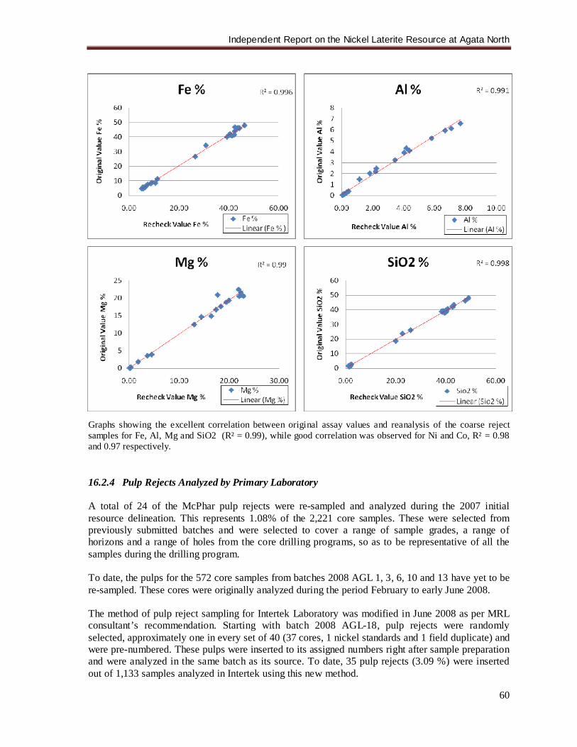
Independent Report on the Nickel Laterite Resource at Agata North
60
Graphs showing the excellent correlation between original assay values and reanalysis of the coarse reject samples for Fe, Al, Mg and SiO2 (R² = 0.99), while good correlation was observed for Ni and Co, R² = 0.98 and 0.97 respectively. 16.2.4 Pulp Rejects Analyzed by Primary Laboratory A total of 24 of the McPhar pulp rejects were re-sampled and analyzed during the 2007 initial resource delineation. This represents 1.08% of the 2,221 core samples. These were selected from previously submitted batches and were selected to cover a range of sample grades, a range of horizons and a range of holes from the core drilling programs, so as to be representative of all the samples during the drilling program. To date, the pulps for the 572 core samples from batches 2008 AGL 1, 3, 6, 10 and 13 have yet to be re-sampled. These cores were originally analyzed during the period February to early June 2008. The method of pulp reject sampling for Intertek Laboratory was modified in June 2008 as per MRL consultant’s recommendation. Starting with batch 2008 AGL-18, pulp rejects were randomly selected, approximately one in every set of 40 (37 cores, 1 nickel standards and 1 field duplicate) and were pre-numbered. These pulps were inserted to its assigned numbers right after sample preparation and were analyzed in the same batch as its source. To date, 35 pulp rejects (3.09 %) were inserted out of 1,133 samples analyzed in Intertek using this new method.
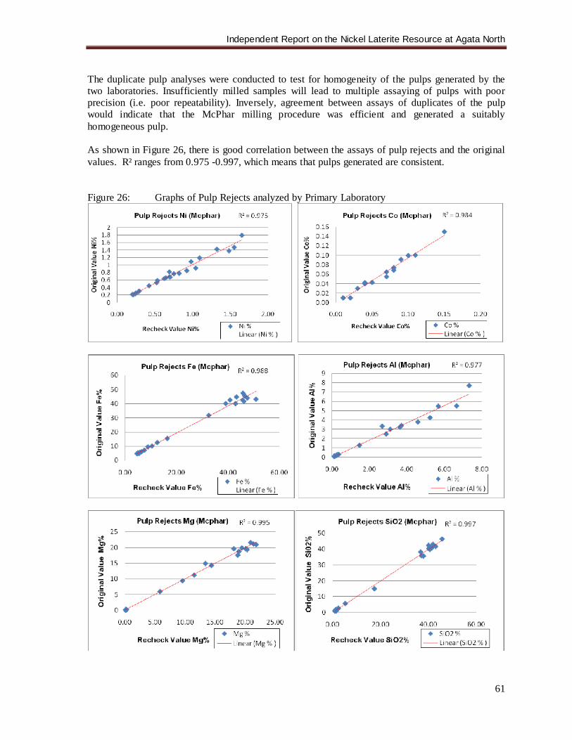
Independent Report on the Nickel Laterite Resource at Agata North
61
The duplicate pulp analyses were conducted to test for homogeneity of the pulps generated by the two laboratories. Insufficiently milled samples will lead to multiple assaying of pulps with poor precision (i.e. poor repeatability). Inversely, agreement between assays of duplicates of the pulp would indicate that the McPhar milling procedure was efficient and generated a suitably homogeneous pulp. As shown in Figure 26, there is good correlation between the assays of pulp rejects and the original values. R² ranges from 0.975 -0.997, which means that pulps generated are consistent. Figure 26: Graphs of Pulp Rejects analyzed by Primary Laboratory
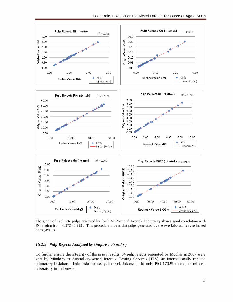
Independent Report on the Nickel Laterite Resource at Agata North
62
The graph of duplicate pulps analyzed by both McPhar and Intertek Laboratory shows good correlation with R² ranging from 0.975 -0.999 . This procedure proves that pulps generated by the two laboratories are indeed homogenous. 16.2.5 Pulp Rejects Analyzed by Umpire Laboratory To further ensure the integrity of the assay results, 54 pulp rejects generated by Mcphar in 2007 were sent by Mindoro to Australian-owned Intertek Testing Services [ITS], an internationally reputed laboratory in Jakarta, Indonesia for assay. Intertek-Jakarta is the only ISO 17025-accredited mineral laboratory in Indonesia.

Independent Report on the Nickel Laterite Resource at Agata North
63
The analytical procedure conducted by Intertek was by use of XRF. The results show a high correlation between McPhar’s original assay and that of Intertek for the pulps. Figure 27 shows the graphs of the duplicates analyzed by Intertek Laboratory. Figure 27: Graphs of Pulp Rejects Analyzed by Umpire Laboratory
McPhar original results plotted against Intertek rechecks conducted on McPhar pulps. The inter-laboratory agreement on the pulp sample is high (R² = 0.994 for Ni). The writer has verified drill hole locations, sampling and assay procedures, examined mineralized material in the field and in drill core, as well as the geological and assay databases during his various site visits in the Agata Project and meetings with MRL staff. With these factors, as well as the evaluation of the results of assay rechecking, the writer is satisfied that all data can be relied upon.
Independent Report on the Nickel Laterite Resource at Agata North
64
17.0 ADJACENT PROPERTIES The Tapian-San Francisco and Tapian Main properties have high potential for the discovery of both porphyry Cu-Au style mineralization at depth and epithermal style mineralization at shallower levels. 17.1 Tapian-San Francisco Property: The Tapian-San Francisco property comprises claim blocks under one MPSA, two Exploration Permits and two EP Applications (MPSA-033-95-X, EP No. 016-XIII, EP-022-XIII, EPA-106-XIII, and EPA-088-XIII). It has very high potential for the presence of a porphyry Cu-Au system on the property associated with extensive IP chargeability anomalies that underlie surficial zones of high-resistivity, widespread Cu and Au anomalism, surface artisanal workings, widespread hydrothermal alteration, and mineralization. This is located in extremely favorable structural location near the Philippine Fault, cut by cross-faults extending from Boyongan and Bayugo porphyry Cu-Au deposits 8km to NE. (Figure 28) 17.1.1 Gold Hill [C5] Gold Hill Target demonstrates a crude circular-shaped strong chargeability anomaly covering 600m by 500m that is probably part of a much more extensive chargeability anomaly [sulphides] at depth. It is capped by resistivity anomaly. It is underlain by andesitic volcanics with limestone and intrusive dikes and is proximal to a large intrusive complex. Prevailing alteration is pervasive high temperature propylitic alteration with areas of strong argillic alteration [and phyllic?]. This is an area of historic artisanal gold mining that contains abundant epithermal Au-Cu showings and high-grade, massive sulphide/precious metal prospect and has coincident strong Cu-Au-arsenic (As)-Pb-Zn soil anomalies. 17.1.2 Cantikoy (C6) Cantikoy Target exhibits a crude “pear-shaped” strong chargeability anomaly over 600m by 500m that is probably part of a much more extensive chargeability anomaly [sulphides] at depth. Further, it is capped by resistivity anomaly. It is underlain by andesitic volcanics with multi-phase intrusive stocks and dikes. High temperature propylitic alteration with structurally-controlled zones of intense phyllic alteration and localized potassic alteration are prevalent. It contains overprinting epithermal mineralization as well as porphyry-related Cu-Au mineralization. The latter was located in several areas including a trench of 25m at 1% Cu and 0.5 g/t Au. This is supported by extensive strong coincident soil Cu-Au-Zn soil anomalies. 17.1.3 Canaga (C9) An arcuate-shaped strong chargeability anomaly over 400m by 300m, that is probably part of a much more extensive chargeability anomaly [sulphides] at depth and flanked by resistivity anomalies, characterizes the Canaga Prospect. Its rock suite includes dominantly recrystallised limestone and andesitic volcanics with high-temperature propylitic alteration. Multi-phase intrusive stocks and dikes nearby exhibit phyllic and potassic alteration. Porphyry-related Cu-Au mineralization is associated with volcanics and intrusives, including a trench of 15m at 1% Cu. This is likewise supported by coincident soil Cu-Au soil anomalies. In 2006, a reconnaissance drilling program was carried out at C6 and C9 and 3 drill holes for a total of 1,176m were completed. The drilling intersected a series of narrow monzonite, monzonite porphyry, diorite porphyry, porphyritic dacite, and porphyritic andesite intrusive sills/dikes, with
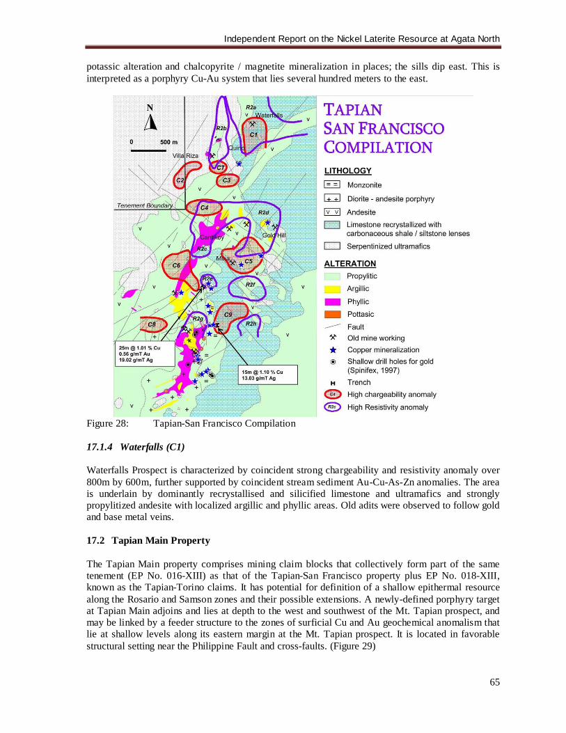
Independent Report on the Nickel Laterite Resource at Agata North
65
potassic alteration and chalcopyrite / magnetite mineralization in places; the sills dip east. This is interpreted as a porphyry Cu-Au system that lies several hundred meters to the east.
Figure 28: Tapian-San Francisco Compilation 17.1.4 Waterfalls (C1) Waterfalls Prospect is characterized by coincident strong chargeability and resistivity anomaly over 800m by 600m, further supported by coincident stream sediment Au-Cu-As-Zn anomalies. The area is underlain by dominantly recrystallised and silicified limestone and ultramafics and strongly propylitized andesite with localized argillic and phyllic areas. Old adits were observed to follow gold and base metal veins. 17.2 Tapian Main Property The Tapian Main property comprises mining claim blocks that collectively form part of the same tenement (EP No. 016-XIII) as that of the Tapian-San Francisco property plus EP No. 018-XIII, known as the Tapian-Torino claims. It has potential for definition of a shallow epithermal resource along the Rosario and Samson zones and their possible extensions. A newly-defined porphyry target at Tapian Main adjoins and lies at depth to the west and southwest of the Mt. Tapian prospect, and may be linked by a feeder structure to the zones of surficial Cu and Au geochemical anomalism that lie at shallow levels along its eastern margin at the Mt. Tapian prospect. It is located in favorable structural setting near the Philippine Fault and cross-faults. (Figure 29)
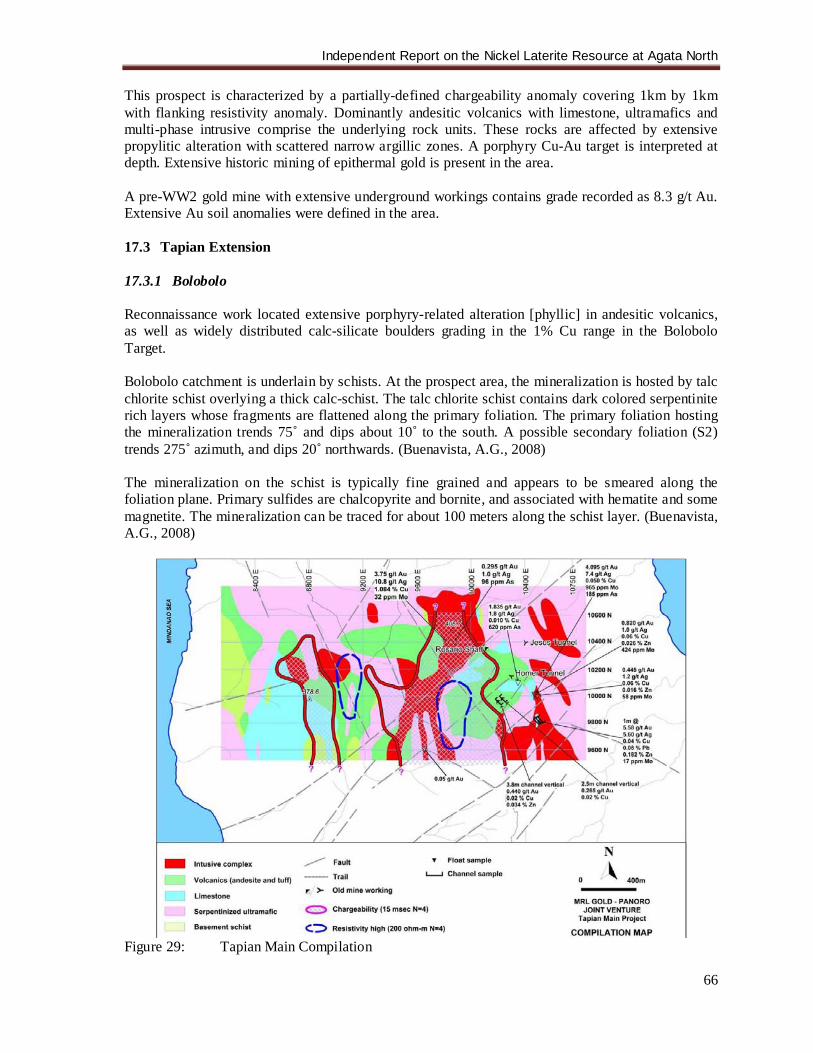
Independent Report on the Nickel Laterite Resource at Agata North
66
This prospect is characterized by a partially-defined chargeability anomaly covering 1km by 1km with flanking resistivity anomaly. Dominantly andesitic volcanics with limestone, ultramafics and multi-phase intrusive comprise the underlying rock units. These rocks are affected by extensive propylitic alteration with scattered narrow argillic zones. A porphyry Cu-Au target is interpreted at depth. Extensive historic mining of epithermal gold is present in the area. A pre-WW2 gold mine with extensive underground workings contains grade recorded as 8.3 g/t Au. Extensive Au soil anomalies were defined in the area. 17.3 Tapian Extension 17.3.1 Bolobolo Reconnaissance work located extensive porphyry-related alteration [phyllic] in andesitic volcanics, as well as widely distributed calc-silicate boulders grading in the 1% Cu range in the Bolobolo Target. Bolobolo catchment is underlain by schists. At the prospect area, the mineralization is hosted by talc chlorite schist overlying a thick calc-schist. The talc chlorite schist contains dark colored serpentinite rich layers whose fragments are flattened along the primary foliation. The primary foliation hosting the mineralization trends 75˚ and dips about 10˚ to the south. A possible secondary foliation (S2) trends 275˚ azimuth, and dips 20˚ northwards. (Buenavista, A.G., 2008) The mineralization on the schist is typically fine grained and appears to be smeared along the foliation plane. Primary sulfides are chalcopyrite and bornite, and associated with hematite and some magnetite. The mineralization can be traced for about 100 meters along the schist layer. (Buenavista, A.G., 2008)
Figure 29: Tapian Main Compilation
Independent Report on the Nickel Laterite Resource at Agata North
67
17.4 Other Nickel Laterite Prospects: Recent reconnaissance geological mapping has expanded the global nickel laterite resource potential of Mindoro. While the ANLP and ASLP potential nickel laterite mineralization covers approximately 600 ha, results of the regional mapping program indicate potential for a further nickel laterite mineralization on the adjacent Tapian Main, Tapian SF and Mat-I tenements (Figure 7). The presence of lateritic soils is manifested by the development of thick, purple-colored clayey soils over favorable ultramafic rocks. Based on the mapping alone, there is no guarantee that nickel grades and thickness will be of commercial interest. Accordingly, a program of reconnaissance auger drilling has commenced to give a preliminary indication of nickel content and laterite thickness. The Mat-I tenement is covered by Exploration Permit Application of Minimax denominated as EPA-105-XIII with an area of 884 ha. These nickel laterite prospects lie along the same mineralization trend as that of San Roque Metals, Inc. (SRMI) Mine, which is immediately adjacent to Agata South prospect. Also found within the Surigao District are producing nickel laterite mines such as Hinatuan and Taganito. These mines are providing direct shipping grade ore to markets and processing plants in China, Japan, Korea and Australia. There are also plans to put the large Nonoc nickel laterite deposit back into production. This is located in an island just to the north of Surigao City. 18.0 MINERAL PROCESSING AND METALLURGICAL TESTING No mineral processing or metallurgical testing has been done on the ANLP to date. The short term plans are to conduct a direct shipping ore operation if warranted. However, it is management's strong conviction that the real future for the Agata project is for enhanced value, local processing. It is believed that it has the potential to outline sufficient resources to support this concept. Several attractive alternatives are emerging, which include:, at the low technology end of the spectrum, constructing a blast or electric furnace for nickel pig iron production (low grade ferro-nickel product which is increasingly entrenching itself as a substitute for refined nickel in stainless steel production), atmospheric leaching for which pilot testing on another Philippine laterite has produced promising results, and a new generation of High Pressure Acid Leach (HPAL) plants. The new generation HPAL plants are being used by Sumitomo on its Philippine Coral Bay operation. In view of this, a series of metallurgical tests will be undertaken. As a start, the first batch of samples taken from test pits was recently dispatched to En Lin Steel Phils. Corp. in the Cavite Economic Zone, Cavite, Philippines for initial pressure acid leach tests. 19.0 MINERAL RESOURCE ESTIMATE
19.1 Data Set: The data set used as a basis for the resource interpretation, statistical analysis, grade estimation and resource classification was sourced from a Microsoft Excel ® spreadsheet (ANLP_ASSAYS_DATABASE_RAW_1Aug2008.xls date stamped 1 August 2008) provided by MRL in August 1, 2008. The spreadsheets contained collar, survey, assay and lithology data.
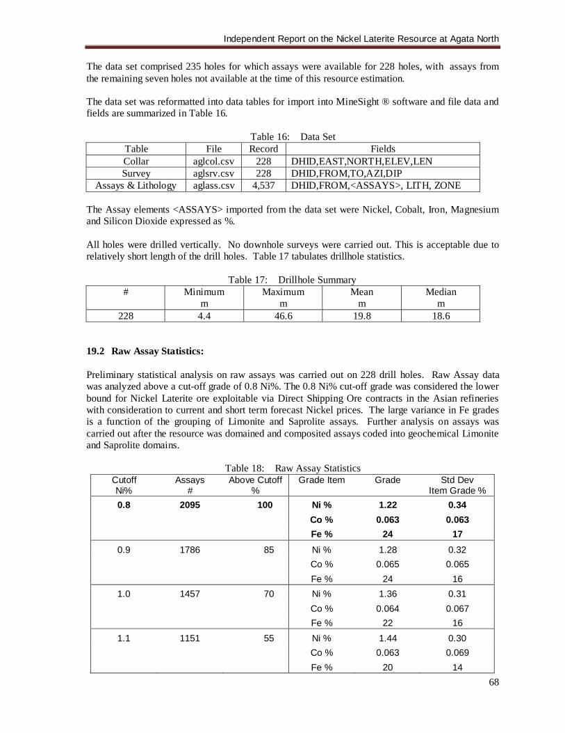
Independent Report on the Nickel Laterite Resource at Agata North
68
The data set comprised 235 holes for which assays were available for 228 holes, with assays from the remaining seven holes not available at the time of this resource estimation. The data set was reformatted into data tables for import into MineSight ® software and file data and fields are summarized in Table 16.
Table 16: Data Set Table File Record Fields Collar aglcol.csv 228 DHID,EAST,NORTH,ELEV,LEN Survey aglsrv.csv 228 DHID,FROM,TO,AZI,DIP
Assays & Lithology aglass.csv 4,537 DHID,FROM,<ASSAYS>, LITH, ZONE The Assay elements <ASSAYS> imported from the data set were Nickel, Cobalt, Iron, Magnesium and Silicon Dioxide expressed as %. All holes were drilled vertically. No downhole surveys were carried out. This is acceptable due to relatively short length of the drill holes. Table 17 tabulates drillhole statistics.
Table 17: Drillhole Summary #
Minimum m
Maximum m
Mean m
Median m
228 4.4 46.6 19.8 18.6 19.2 Raw Assay Statistics: Preliminary statistical analysis on raw assays was carried out on 228 drill holes. Raw Assay data was analyzed above a cut-off grade of 0.8 Ni%. The 0.8 Ni% cut-off grade was considered the lower bound for Nickel Laterite ore exploitable via Direct Shipping Ore contracts in the Asian refineries with consideration to current and short term forecast Nickel prices. The large variance in Fe grades is a function of the grouping of Limonite and Saprolite assays. Further analysis on assays was carried out after the resource was domained and composited assays coded into geochemical Limonite and Saprolite domains.
Table 18: Raw Assay Statistics
Cutoff Ni%
Assays #
Above Cutoff %
Grade Item
Grade
Std Dev Item Grade %
0.8 2095 100 Ni % 1.22 0.34 Co % 0.063 0.063 Fe % 24 17
0.9 1786 85 Ni % 1.28 0.32 Co % 0.065 0.065 Fe % 24 16
1.0 1457 70 Ni % 1.36 0.31 Co % 0.064 0.067 Fe % 22 16
1.1 1151 55 Ni % 1.44 0.30 Co % 0.063 0.069 Fe % 20 14
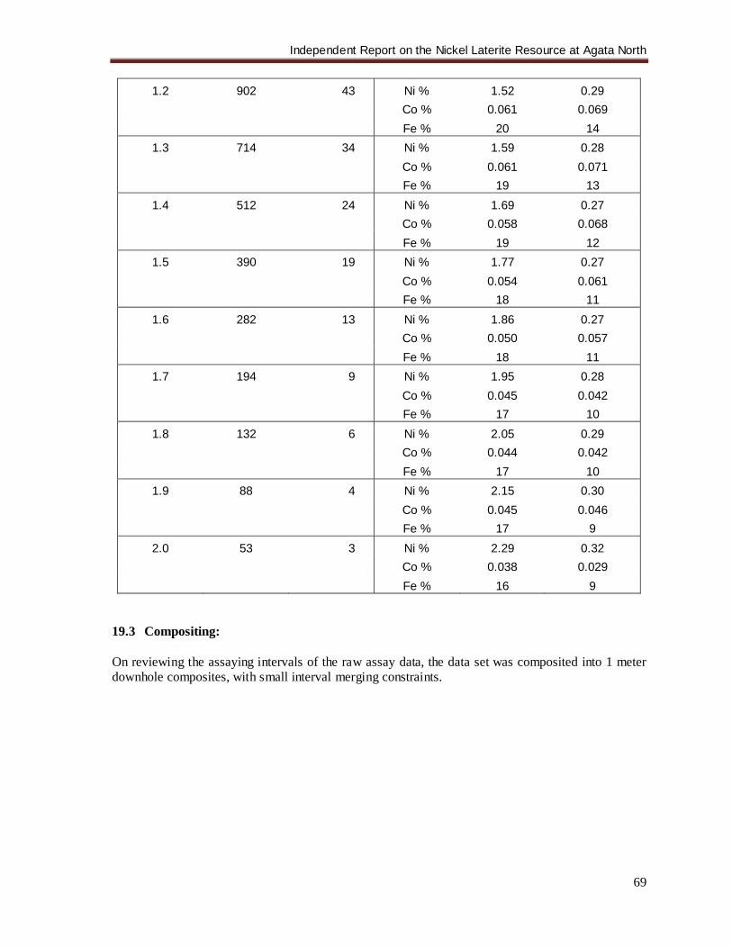
Independent Report on the Nickel Laterite Resource at Agata North
69
1.2 902 43 Ni % 1.52 0.29 Co % 0.061 0.069 Fe % 20 14
1.3 714 34 Ni % 1.59 0.28 Co % 0.061 0.071 Fe % 19 13
1.4 512 24 Ni % 1.69 0.27 Co % 0.058 0.068 Fe % 19 12
1.5 390 19 Ni % 1.77 0.27 Co % 0.054 0.061 Fe % 18 11
1.6 282 13 Ni % 1.86 0.27 Co % 0.050 0.057 Fe % 18 11
1.7 194 9 Ni % 1.95 0.28 Co % 0.045 0.042 Fe % 17 10
1.8 132 6 Ni % 2.05 0.29 Co % 0.044 0.042 Fe % 17 10
1.9 88 4 Ni % 2.15 0.30 Co % 0.045 0.046 Fe % 17 9
2.0 53 3 Ni % 2.29 0.32 Co % 0.038 0.029 Fe % 16 9
19.3 Compositing: On reviewing the assaying intervals of the raw assay data, the data set was composited into 1 meter downhole composites, with small interval merging constraints.
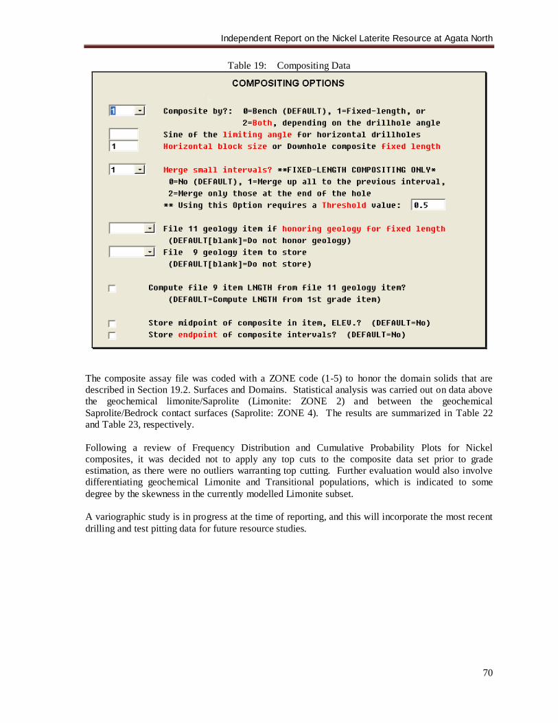
Independent Report on the Nickel Laterite Resource at Agata North
70
Table 19: Compositing Data
The composite assay file was coded with a ZONE code (1-5) to honor the domain solids that are described in Section 19.2. Surfaces and Domains. Statistical analysis was carried out on data above the geochemical limonite/Saprolite (Limonite: ZONE 2) and between the geochemical Saprolite/Bedrock contact surfaces (Saprolite: ZONE 4). The results are summarized in Table 22 and Table 23, respectively. Following a review of Frequency Distribution and Cumulative Probability Plots for Nickel composites, it was decided not to apply any top cuts to the composite data set prior to grade estimation, as there were no outliers warranting top cutting. Further evaluation would also involve differentiating geochemical Limonite and Transitional populations, which is indicated to some degree by the skewness in the currently modelled Limonite subset. A variographic study is in progress at the time of reporting, and this will incorporate the most recent drilling and test pitting data for future resource studies.
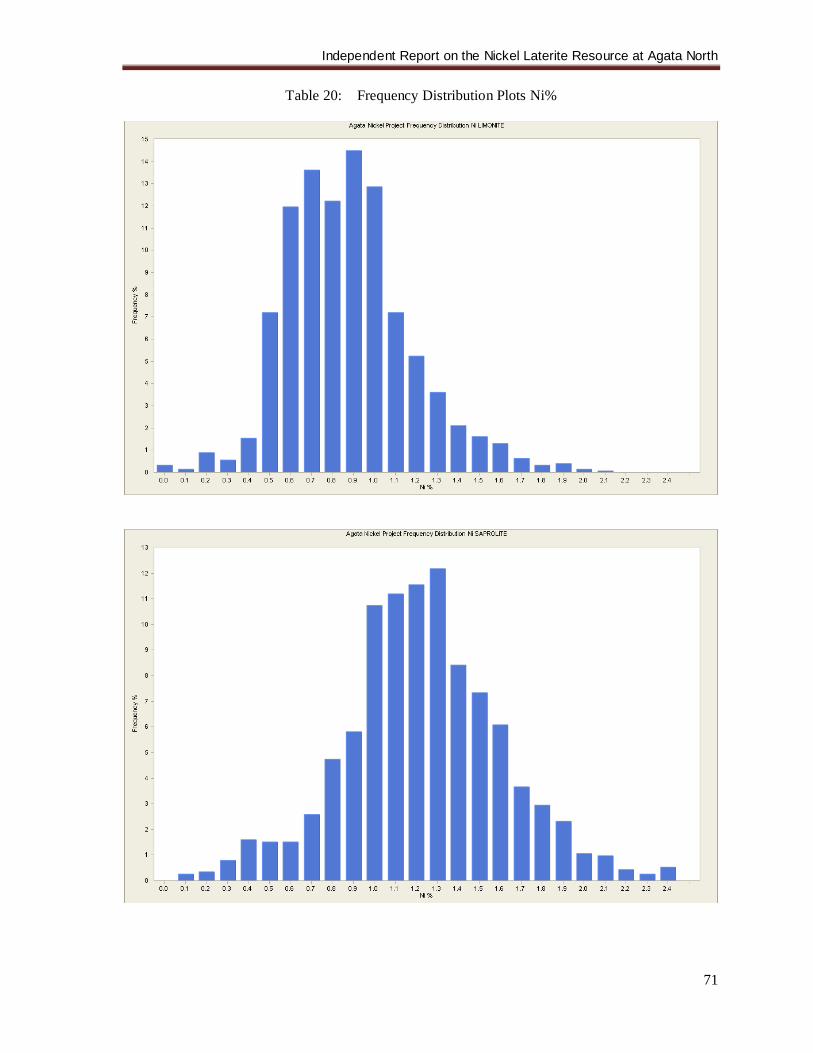
Independent Report on the Nickel Laterite Resource at Agata North
71
Table 20: Frequency Distribution Plots Ni%
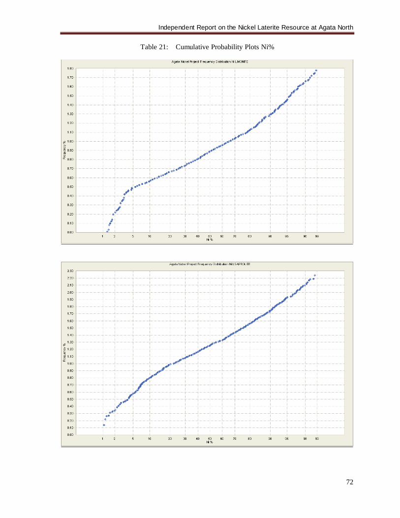
Independent Report on the Nickel Laterite Resource at Agata North
72
Table 21: Cumulative Probability Plots Ni%
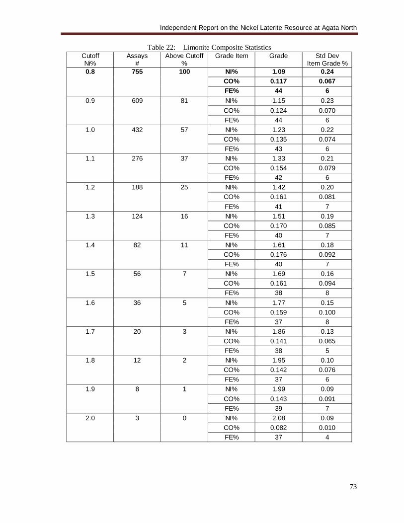
Independent Report on the Nickel Laterite Resource at Agata North
73
Table 22: Limonite Composite Statistics Cutoff Ni%
Assays #
Above Cutoff %
Grade Item
Grade
Std Dev Item Grade %
0.8 755 100 NI% 1.09 0.24 CO% 0.117 0.067 FE% 44 6
0.9 609 81 NI% 1.15 0.23 CO% 0.124 0.070 FE% 44 6
1.0 432 57 NI% 1.23 0.22 CO% 0.135 0.074 FE% 43 6
1.1 276 37 NI% 1.33 0.21 CO% 0.154 0.079 FE% 42 6
1.2 188 25 NI% 1.42 0.20 CO% 0.161 0.081 FE% 41 7
1.3 124 16 NI% 1.51 0.19 CO% 0.170 0.085 FE% 40 7
1.4 82 11 NI% 1.61 0.18 CO% 0.176 0.092 FE% 40 7
1.5 56 7 NI% 1.69 0.16 CO% 0.161 0.094 FE% 38 8
1.6 36 5 NI% 1.77 0.15 CO% 0.159 0.100 FE% 37 8
1.7 20 3 NI% 1.86 0.13 CO% 0.141 0.065 FE% 38 5
1.8 12 2 NI% 1.95 0.10 CO% 0.142 0.076 FE% 37 6
1.9 8 1 NI% 1.99 0.09 CO% 0.143 0.091 FE% 39 7
2.0 3 0 NI% 2.08 0.09 CO% 0.082 0.010 FE% 37 4
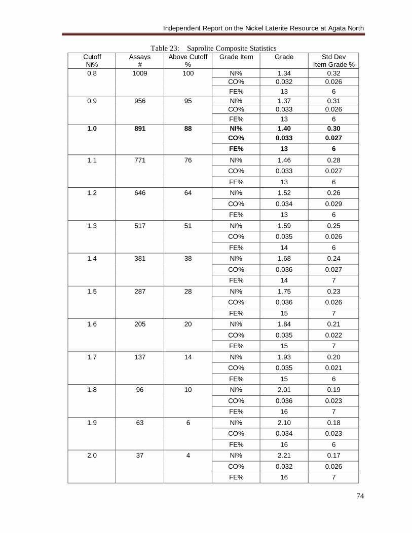
Independent Report on the Nickel Laterite Resource at Agata North
74
Table 23: Saprolite Composite Statistics Cutoff Ni%
Assays #
Above Cutoff %
Grade Item
Grade
Std Dev Item Grade %
0.8 1009 100 NI% 1.34 0.32 CO% 0.032 0.026 FE% 13 6
0.9 956 95 NI% 1.37 0.31 CO% 0.033 0.026 FE% 13 6
1.0 891 88 NI% 1.40 0.30 CO% 0.033 0.027 FE% 13 6
1.1 771 76 NI% 1.46 0.28 CO% 0.033 0.027 FE% 13 6
1.2 646 64 NI% 1.52 0.26 CO% 0.034 0.029 FE% 13 6
1.3 517 51 NI% 1.59 0.25 CO% 0.035 0.026 FE% 14 6
1.4 381 38 NI% 1.68 0.24 CO% 0.036 0.027 FE% 14 7
1.5 287 28 NI% 1.75 0.23 CO% 0.036 0.026 FE% 15 7
1.6 205 20 NI% 1.84 0.21 CO% 0.035 0.022 FE% 15 7
1.7 137 14 NI% 1.93 0.20 CO% 0.035 0.021 FE% 15 6
1.8 96 10 NI% 2.01 0.19 CO% 0.036 0.023 FE% 16 7
1.9 63 6 NI% 2.10 0.18 CO% 0.034 0.023 FE% 16 6
2.0 37 4 NI% 2.21 0.17 CO% 0.032 0.026 FE% 16 7
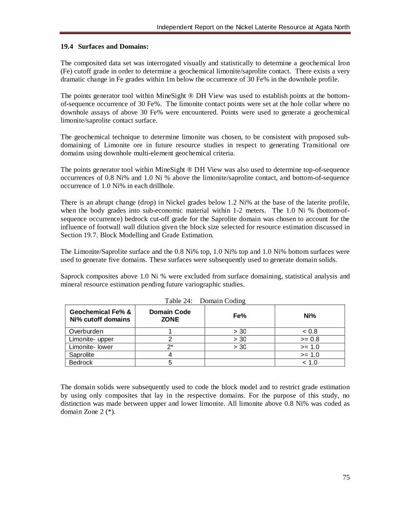
Independent Report on the Nickel Laterite Resource at Agata North
75
19.4 Surfaces and Domains: The composited data set was interrogated visually and statistically to determine a geochemical Iron (Fe) cutoff grade in order to determine a geochemical limonite/saprolite contact. There exists a very dramatic change in Fe grades within 1m below the occurrence of 30 Fe% in the downhole profile. The points generator tool within MineSight ® DH View was used to establish points at the bottom-of-sequence occurrence of 30 Fe%. The limonite contact points were set at the hole collar where no downhole assays of above 30 Fe% were encountered. Points were used to generate a geochemical limonite/saprolite contact surface. The geochemical technique to determine limonite was chosen, to be consistent with proposed sub-domaining of Limonite ore in future resource studies in respect to generating Transitional ore domains using downhole multi-element geochemical criteria. The points generator tool within MineSight ® DH View was also used to determine top-of-sequence occurrences of 0.8 Ni% and 1.0 Ni % above the limonite/saprolite contact, and bottom-of-sequence occurrence of 1.0 Ni% in each drillhole. There is an abrupt change (drop) in Nickel grades below 1.2 Ni% at the base of the laterite profile, when the body grades into sub-economic material within 1-2 meters. The 1.0 Ni % (bottom-of-sequence occurrence) bedrock cut-off grade for the Saprolite domain was chosen to account for the influence of footwall wall dilution given the block size selected for resource estimation discussed in Section 19.7. Block Modelling and Grade Estimation. The Limonite/Saprolite surface and the 0.8 Ni% top, 1.0 Ni% top and 1.0 Ni% bottom surfaces were used to generate five domains. These surfaces were subsequently used to generate domain solids. Saprock composites above 1.0 Ni % were excluded from surface domaining, statistical analysis and mineral resource estimation pending future variographic studies.
Table 24: Domain Coding Geochemical Fe% & Ni% cutoff domains
Domain Code ZONE
Fe%
Ni%
Overburden 1 > 30 < 0.8 Limonite- upper 2 > 30 >= 0.8 Limonite- lower 2* > 30 >= 1.0 Saprolite 4 >= 1.0 Bedrock 5 < 1.0
The domain solids were subsequently used to code the block model and to restrict grade estimation by using only composites that lay in the respective domains. For the purpose of this study, no distinction was made between upper and lower limonite. All limonite above 0.8 Ni% was coded as domain Zone 2 (*).
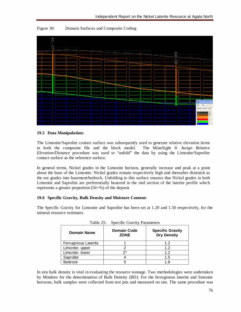
Independent Report on the Nickel Laterite Resource at Agata North
76
Figure 30: Domain Surfaces and Composite Coding
19.5 Data Manipulation: The Limonite/Saprolite contact surface was subsequently used to generate relative elevation items in both the composite file and the block model. The MineSight ® Assign Relative Elevation/Distance procedure was used to “unfold” the data by using the Limonite/Saprolite contact surface as the reference surface. In general terms, Nickel grades in the Limonite horizon, generally increase and peak at a point about the base of the Limonite. Nickel grades remain respectively high and thereafter diminish as the ore grades into basement/bedrock. Unfolding to this surface ensures that Nickel grades in both Limonite and Saprolite are preferentially honored in the mid section of the laterite profile which represents a greater proportion (50+%) of the deposit. 19.6 Specific Gravity, Bulk Density and Moisture Content: The Specific Gravity for Limonite and Saprolite has been set at 1.20 and 1.50 respectively, for the mineral resource estimates.
Table 25: Specific Gravity Parameters
Domain Name Domain Code ZONE
Specific Gravity Dry Density
Ferruginous Laterite 1 1.2 Limonite- upper 2 1.2 Limonite- lower 2* 1.2 Saprolite 4 1.5 Bedrock 5 1.8
In situ bulk density is vital in evaluating the resource tonnage. Two methodologies were undertaken by Mindoro for the determination of Bulk Density (BD). For the ferruginous laterite and limonite horizons, bulk samples were collected from test pits and measured on site. The same procedure was

Independent Report on the Nickel Laterite Resource at Agata North
77
done for the saprolite zone but was supplemented with another method, i.e., the collection and measurement of drill core samples. For BD measurements done on site, large samples ranging in volume from 0.005 m3 to 0.08 m3 were collected from twenty test pits. The locations of these test pits are distributed around the drilling area (Figure 31). The bulk samples were measured for volume, wet weight, and dry weight. The description of the methodology is detailed in the ANLP QA/QC Procedures (Appendix 3) The BD and moisture content were computed with the following formulas.
Weight (kg) Bulk Density = _______________ ÷ 1000 (kg/ton) Volume (m3)
Weight wet – Weight dry % Moisture Content = __________________ x 100
Weight wet
For the drill cores, relatively solid/uncrumpled portions of 10cm-20cm lengths were selected from drill holes that are spatially distributed and coated in paraffin wax to preserve the moisture. These were then dispatched to McPhar Laboratories wherein the samples were measured using the water displacement method. It is standard practice for Mcphar to check the wax coating and perform re-waxing if needed.
Figure 31: Agata North Test Pit Location Map
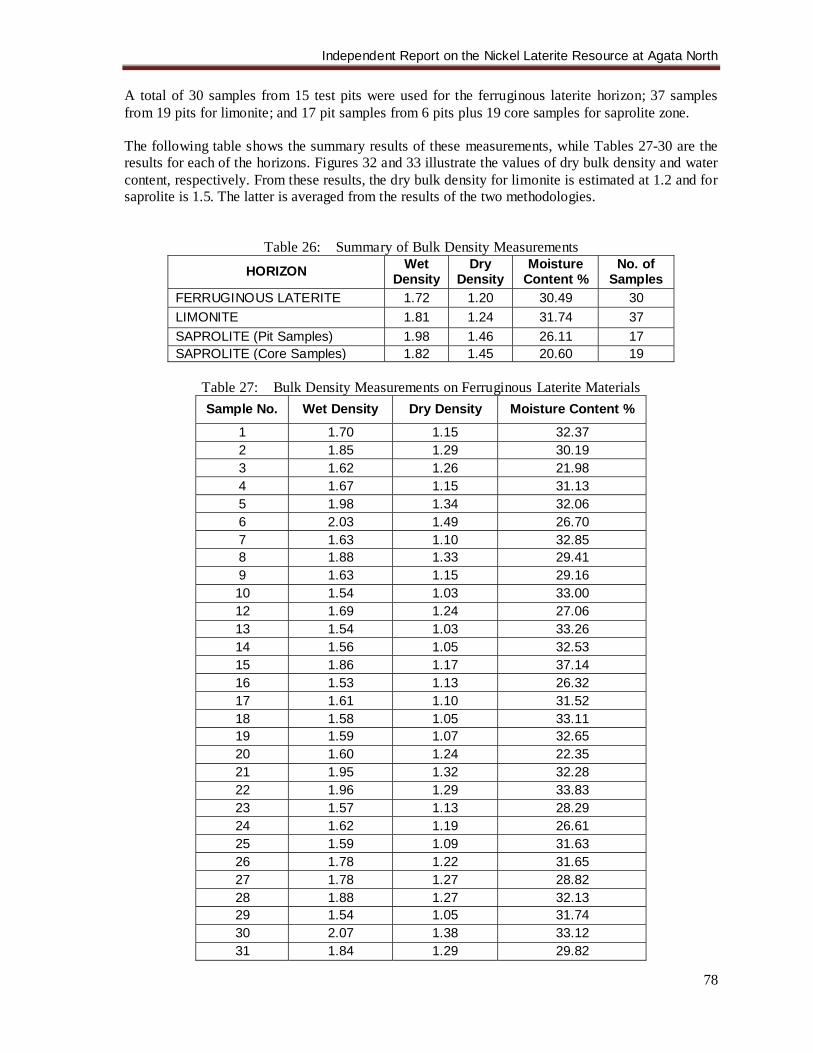
Independent Report on the Nickel Laterite Resource at Agata North
78
A total of 30 samples from 15 test pits were used for the ferruginous laterite horizon; 37 samples from 19 pits for limonite; and 17 pit samples from 6 pits plus 19 core samples for saprolite zone. The following table shows the summary results of these measurements, while Tables 27-30 are the results for each of the horizons. Figures 32 and 33 illustrate the values of dry bulk density and water content, respectively. From these results, the dry bulk density for limonite is estimated at 1.2 and for saprolite is 1.5. The latter is averaged from the results of the two methodologies.
Table 26: Summary of Bulk Density Measurements
HORIZON Wet Density
Dry Density
Moisture Content %
No. of Samples
FERRUGINOUS LATERITE 1.72 1.20 30.49 30 LIMONITE 1.81 1.24 31.74 37 SAPROLITE (Pit Samples) 1.98 1.46 26.11 17 SAPROLITE (Core Samples) 1.82 1.45 20.60 19
Table 27: Bulk Density Measurements on Ferruginous Laterite Materials Sample No. Wet Density Dry Density Moisture Content %
1 1.70 1.15 32.37 2 1.85 1.29 30.19 3 1.62 1.26 21.98 4 1.67 1.15 31.13 5 1.98 1.34 32.06 6 2.03 1.49 26.70 7 1.63 1.10 32.85 8 1.88 1.33 29.41 9 1.63 1.15 29.16 10 1.54 1.03 33.00 12 1.69 1.24 27.06 13 1.54 1.03 33.26 14 1.56 1.05 32.53 15 1.86 1.17 37.14 16 1.53 1.13 26.32 17 1.61 1.10 31.52 18 1.58 1.05 33.11 19 1.59 1.07 32.65 20 1.60 1.24 22.35 21 1.95 1.32 32.28 22 1.96 1.29 33.83 23 1.57 1.13 28.29 24 1.62 1.19 26.61 25 1.59 1.09 31.63 26 1.78 1.22 31.65 27 1.78 1.27 28.82 28 1.88 1.27 32.13 29 1.54 1.05 31.74 30 2.07 1.38 33.12 31 1.84 1.29 29.82
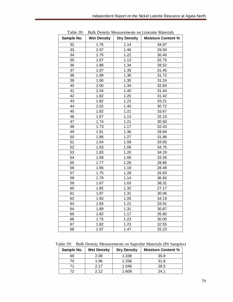
Independent Report on the Nickel Laterite Resource at Agata North
79
Table 28: Bulk Density Measurements on Limonite Materials
Sample No. Wet Density Dry Density Moisture Content % 32 1.76 1.14 34.97 33 2.07 1.46 29.50 34 1.75 1.22 30.40 35 1.67 1.13 32.75 36 1.88 1.34 28.52 37 1.97 1.35 31.45 38 1.99 1.36 31.72 39 1.90 1.30 31.24 40 2.00 1.34 32.83 41 2.04 1.40 31.44 42 1.82 1.25 31.42 43 1.82 1.22 33.21 44 2.02 1.40 30.72 45 1.82 1.21 33.67 46 1.67 1.13 32.10 47 1.74 1.21 30.50 48 1.73 1.17 32.43 49 1.91 1.36 28.84 50 1.86 1.27 31.86 51 1.64 1.09 33.65 52 1.63 1.06 34.75 53 1.83 1.20 34.29 54 1.58 1.06 33.35 55 1.77 1.26 28.86 56 1.66 1.19 28.48 57 1.75 1.28 26.83 58 1.79 1.14 36.50 59 1.67 1.03 38.31 60 1.82 1.32 27.17 61 1.87 1.31 30.06 62 1.60 1.05 34.19 63 1.83 1.21 33.91 64 1.89 1.31 30.87 65 1.82 1.17 35.80 66 1.75 1.23 30.00 67 1.82 1.23 32.55 68 1.97 1.47 25.23
Table 29: Bulk Density Measurements on Saprolite Materials (Pit Samples) Sample No. Wet Density Dry Density Moisture Content %
69 2.08 1.338 35.8 70 1.96 1.336 31.8 71 2.17 1.548 28.5 72 2.12 1.609 24.1
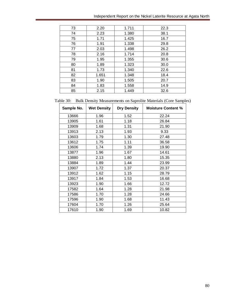
Independent Report on the Nickel Laterite Resource at Agata North
80
73 2.20 1.711 22.3 74 2.23 1.380 38.1 75 1.71 1.425 16.7 76 1.91 1.338 29.8 77 2.03 1.498 26.2 78 2.16 1.714 20.8 79 1.95 1.355 30.6 80 1.89 1.323 30.0 81 1.73 1.340 22.6 82 1.651 1.348 18.4 83 1.90 1.505 20.7 84 1.83 1.558 14.9 85 2.15 1.449 32.6
Table 30: Bulk Density Measurements on Saprolite Materials (Core Samples)
Sample No. Wet Density Dry Density Moisture Content %
13666 1.96 1.52 22.24 13905 1.61 1.18 26.84 13909 1.68 1.31 21.90 13913 2.13 1.93 9.33 13603 1.79 1.30 27.48 13612 1.75 1.11 36.58 13606 1.74 1.39 19.90 13877 1.96 1.67 14.61 13880 2.13 1.80 15.35 13884 1.89 1.44 23.99 13907 1.72 1.37 20.37 13912 1.62 1.15 28.79 13917 1.84 1.53 16.68 13923 1.90 1.66 12.72 17582 1.64 1.28 21.98 17586 1.70 1.28 24.66 17596 1.90 1.68 11.43 17604 1.70 1.26 25.64 17610 1.90 1.69 10.82
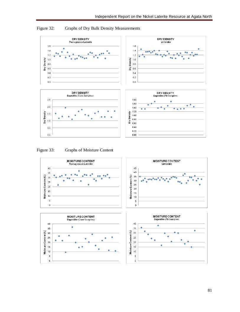
Independent Report on the Nickel Laterite Resource at Agata North
81
Figure 32: Graphs of Dry Bulk Density Measurements
Figure 33: Graphs of Moisture Content
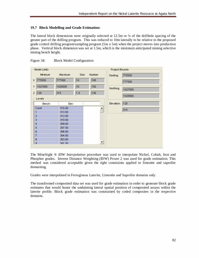
Independent Report on the Nickel Laterite Resource at Agata North
82
19.7 Block Modelling and Grade Estimation: The lateral block dimensions were originally selected at 12.5m or ¼ of the drillhole spacing of the greater part of the drilling program. This was reduced to 10m laterally to be relative to the proposed grade control drilling program/sampling program (5m x 5m) when the project moves into production phase. Vertical block dimension was set at 1.5m, which is the minimum anticipated mining selective mining bench height. Figure 34: Block Model Configuration
The MineSight ® IDW Interpolation procedure was used to interpolate Nickel, Cobalt, Iron and Phosphor grades. Inverse Distance Weighting (IDW) Power 2 was used for grade estimation. This method was considered acceptable given the tight constraints applied to limonite and saprolite domaining. Grades were interpolated in Ferruginous Laterite, Limonite and Saprolite domains only. The transformed composited data set was used for grade estimation in order to generate block grade estimates that would honor the undulating lateral spatial position of composited assays within the laterite profile. Block grade estimation was constrained by coded composites in the respective domains.
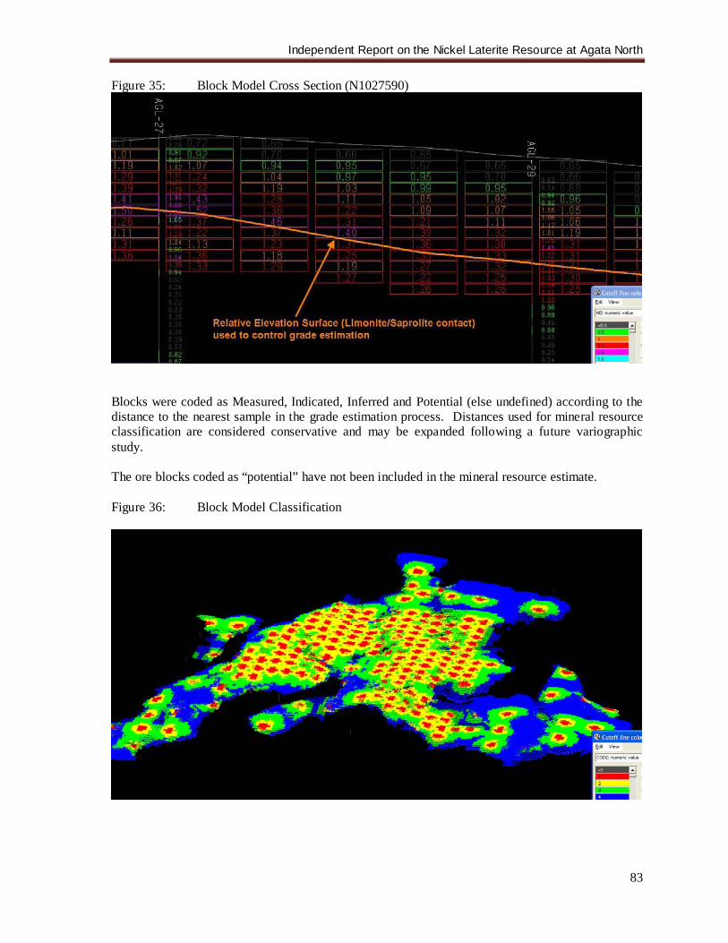
Independent Report on the Nickel Laterite Resource at Agata North
83
Figure 35: Block Model Cross Section (N1027590)
Blocks were coded as Measured, Indicated, Inferred and Potential (else undefined) according to the distance to the nearest sample in the grade estimation process. Distances used for mineral resource classification are considered conservative and may be expanded following a future variographic study. The ore blocks coded as “potential” have not been included in the mineral resource estimate. Figure 36: Block Model Classification
Independent Report on the Nickel Laterite Resource at Agata North
84
Resource classification methodology for Limonite was based on the grid spacing as denoted in Table 31. Planar and elevation search ellipses for Saprolite were reduced by 1/3rd of the limonite search ellipse parameters given the undulating saprolite/bedrock contact and laterally erratic nature of metal grades in the saprolite domain. There is upside potential to increase indicated and inferred ore category tonnages following favorable outcome from a planned variographic study, in conjuction with the analysis of the results of twinning diamond holes and test pits, to increase search ellipse parameters and domain extents.
Table 31: Mineral Resource Classification Classification Code Search Ellipse
(Planar, Elevation) Minimum Samples
Maximum Samples Grid
LIMONITE SAPROLITE m m # # m x m Measured 1 <34,<4 <22,<3 3 24 25x25 Indicated 2 <68,<7 <46,<5 3 24 50x50 Inferred 3 <136,<14 <90,<9 3 24 100x100 Potential 4 >136,<14 >90,<9 3 24 >100
Table 32: Mineral Resource Estimation by Classification
Category Laterite Horizon
ORE ORE Ni Co Fe MC DBD WBD M dmt M wmt % % % % kg/m3 kg/m3
Measured LIMONITE 0.55 0.85 1.07 0.117 44 35 1.20 1.85 SAPROLITE 0.47 0.58 1.30 0.031 13 20 1.50 1.87 Subtotal 1.02 1.43 1.17 0.078 30 28 1.34 1.86
Indicated LIMONITE 1.22 1.88 1.06 0.117 44 35 1.20 1.85 SAPROLITE 1.31 1.63 1.30 0.031 13 20 1.50 1.87 Subtotal 2.53 3.52 1.18 0.073 28 27 1.36 1.86
Measured & Indicated
LIMONITE 1.78 2.73 1.06 0.117 44 35 1.20 1.85 SAPROLITE 1.77 2.22 1.30 0.031 13 20 1.50 1.87 Total 3.55 4.95 1.18 0.074 28 28 1.35 1.86
Inferred LIMONITE 0.74 1.14 1.04 0.105 43 35 1.20 1.85 SAPROLITE 2.58 3.23 1.32 0.030 13 20 1.50 1.88 Total 3.33 4.37 1.26 0.047 20 23 1.43 1.87
19.8 Conclusions: The methodologies employed for this mineral resource estimate are considered acceptable for the purposes of definition and classification of a resource for a future ore reserve study to be carried out for ore amenable to direct shipping product. The current resource in relation to a Direct Shipping product could be further enhanced following the analysis of variographic study. 20.0 OTHER RELEVANT DATA AND INFORMATION There are no other pertinent data.
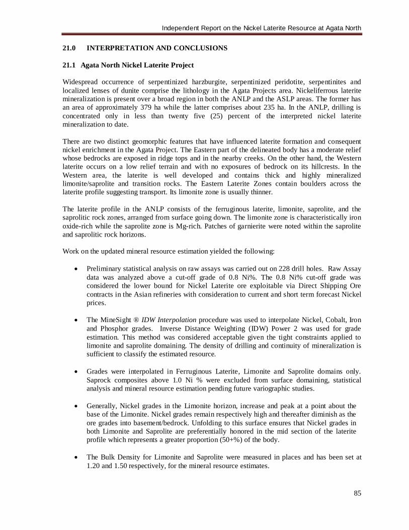
Independent Report on the Nickel Laterite Resource at Agata North
85
21.0 INTERPRETATION AND CONCLUSIONS 21.1 Agata North Nickel Laterite Project Widespread occurrence of serpentinized harzburgite, serpentinized peridotite, serpentinites and localized lenses of dunite comprise the lithology in the Agata Projects area. Nickeliferrous laterite mineralization is present over a broad region in both the ANLP and the ASLP areas. The former has an area of approximately 379 ha while the latter comprises about 235 ha. In the ANLP, drilling is concentrated only in less than twenty five (25) percent of the interpreted nickel laterite mineralization to date. There are two distinct geomorphic features that have influenced laterite formation and consequent nickel enrichment in the Agata Project. The Eastern part of the delineated body has a moderate relief whose bedrocks are exposed in ridge tops and in the nearby creeks. On the other hand, the Western laterite occurs on a low relief terrain and with no exposures of bedrock on its hillcrests. In the Western area, the laterite is well developed and contains thick and highly mineralized limonite/saprolite and transition rocks. The Eastern Laterite Zones contain boulders across the laterite profile suggesting transport. Its limonite zone is usually thinner. The laterite profile in the ANLP consists of the ferruginous laterite, limonite, saprolite, and the saprolitic rock zones, arranged from surface going down. The limonite zone is characteristically iron oxide-rich while the saprolite zone is Mg-rich. Patches of garnierite were noted within the saprolite and saprolitic rock horizons. Work on the updated mineral resource estimation yielded the following:
• Preliminary statistical analysis on raw assays was carried out on 228 drill holes. Raw Assay data was analyzed above a cut-off grade of 0.8 Ni%. The 0.8 Ni% cut-off grade was considered the lower bound for Nickel Laterite ore exploitable via Direct Shipping Ore contracts in the Asian refineries with consideration to current and short term forecast Nickel prices.
• The MineSight ® IDW Interpolation procedure was used to interpolate Nickel, Cobalt, Iron
and Phosphor grades. Inverse Distance Weighting (IDW) Power 2 was used for grade estimation. This method was considered acceptable given the tight constraints applied to limonite and saprolite domaining. The density of drilling and continuity of mineralization is sufficient to classify the estimated resource.
• Grades were interpolated in Ferruginous Laterite, Limonite and Saprolite domains only.
Saprock composites above 1.0 Ni % were excluded from surface domaining, statistical analysis and mineral resource estimation pending future variographic studies.
• Generally, Nickel grades in the Limonite horizon, increase and peak at a point about the
base of the Limonite. Nickel grades remain respectively high and thereafter diminish as the ore grades into basement/bedrock. Unfolding to this surface ensures that Nickel grades in both Limonite and Saprolite are preferentially honored in the mid section of the laterite profile which represents a greater proportion (50+%) of the body.
• The Bulk Density for Limonite and Saprolite were measured in places and has been set at
1.20 and 1.50 respectively, for the mineral resource estimates.
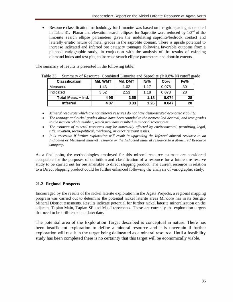
Independent Report on the Nickel Laterite Resource at Agata North
86
• Resource classification methodology for Limonite was based on the grid spacing as denoted in Table 31. Planar and elevation search ellipses for Saprolite were reduced by 1/3rd of the limonite search ellipse parameters given the undulating saprolite/bedrock contact and laterally erratic nature of metal grades in the saprolite domain. There is upside potential to increase indicated and inferred ore category tonnages following favorable outcome from a planned variographic study, in conjuction with the analysis of the results of twinning diamond holes and test pits, to increase search ellipse parameters and domain extents.
The summary of results is presented in the following table:
Table 33: Summary of Resource: Combined Limonite and Saprolite @ 0.8% Ni cutoff grade Classification Mil. WMT Mil. DMT Ni% Co% Fe%
Measured 1.43 1.02 1.17 0.078 30 Indicated 3.52 2.53 1.18 0.073 28
Total Meas. + Ind. 4.95 3.55 1.18 0.074 28 Inferred 4.37 3.33 1.26 0.047 20
• Mineral resources which are not mineral reserves do not have demonstrated economic viability. • The tonnage and nickel grades above have been rounded to the nearest 2nd decimal, and iron grades
to the nearest whole number, which may have resulted in minor discrepancies. • The estimate of mineral resources may be materially affected by environmental, permitting, legal,
title, taxation, socio-political, marketing, or other relevant issues. • It is uncertain if further exploration will result in upgrading the Inferred mineral resource to an
Indicated or Measured mineral resource or the Indicated mineral resource to a Measured Resource category.
As a final point, the methodologies employed for this mineral resource estimate are considered acceptable for the purposes of definition and classification of a resource for a future ore reserve study to be carried out for ore amenable to direct shipping product. The current resource in relation to a Direct Shipping product could be further enhanced following the analysis of variographic study. 21.2 Regional Prospects Encouraged by the results of the nickel laterite exploration in the Agata Projects, a regional mapping program was carried out to determine the potential nickel laterite areas Mindoro has in its Surigao Mineral District tenements. Results indicate potential for further nickel laterite mineralization on the adjacent Tapian Main, Tapian SF and Mat-I tenements. These are currently the exploration targets that need to be drill-tested at a later date. The potential area of the Exploration Target described is conceptual in nature. There has been insufficient exploration to define a mineral resource and it is uncertain if further exploration will result in the target being delineated as a mineral resource. Until a feasibility study has been completed there is no certainty that this target will be economically viable.
Independent Report on the Nickel Laterite Resource at Agata North
87
22.0 RECOMMENDATIONS 22.1 Agata North Nickel Laterite Project
• Continue the follow-up drilling program covering both in-fill and extensions into the undrilled areas (to the east, north and south). This is to possibly extend the current inferred resource and upgrade some into indicated or measured.
• Conduct more petrographic/mineragraphic studies on the parent rocks (ultramafics). • Carry out metallurgical test work. • Develop mine plans based on the geometry of the body.
22.2 Regional Prospects
• Conduct reconnaissance to detailed geological mapping on other laterite prospect areas. • Program a systematic auger drilling activity to cover these areas in order to determine the
viability of conducting a more detailed resource-delineation drilling program. This will likewise discriminate which of the various areas have potential or not.
Independent Report on the Nickel Laterite Resource at Agata North
88
23.0 REFERENCES Abrasaldo, E.M. 1999. Exploration Report Agata Project June 1997-April 1998. MRL Gold Phils.,
Inc., Internal Company Report (unpubl) Ambagan, D. 2007. Notes on Resource Estimation of Agata Nickel Laterite Project of MRL Gold
Phils., Inc., Internal Report., (unpubl). January 2007. Aurelio, M.A. and Peña R.E. 2002. Geology and Mineral Resources of the Philippines, Volume 1:
Geology. (eds) Aurelio, M.A. and Peña, R.E., Department of Environment and Natural Resources, Mines and Geosciences Bureau, Philippines.
Bailey, D.G. 2003. Surigao Property Group, Northeastern Mindanao, Geology and Exploration
Potential. Bailey Geological Consultants (Canada), Technical Report for Panoro Minerals Ltd. Buenavista, A.G. 2008. Notes on the Geology and Mineralization in the Surigao Western Range.
MRL Gold Phils., Inc. Internal Report, February 2008. Buenavista, A.G. 2008. Geochemistry of the Agata Nickeliferrous Laterite Deposit. MRL Gold
Phils., Inc. Internal Report, May 2008. Climie, J.A., et,al. 2000. Accomplishment Report for the Period: June to December 1999. MRL
Gold Phils., Inc., Internal Company Report (unpubl). January 2000. Climie, J.A., et,al. 2005. Interim Exploration Program Report, Surigao Joint Venture Projects:
March 1 to June 20, 2005. MRL Gold Phils., Inc., Internal Company Report (unpubl). July 2005.
De Luna, R., et.al., 2004. Report on the Reconnaissance Geologic Survey of the Nickeliferrous
Laterite Deposits at Barangay Tapian, Mainit, Surigao del Norte and Barangay E. Morgado, Santiago, Agusan del Norte. Taganito Mining Corp. Report, July 2004.
Elliott, P.J. 2005. Report on IP and Magnetic Surveys Over the: Agata Prospect, Sand Francisco
Project, Philippines. MRL Gold Phils., Inc. and Panoro Minerals Ltd,, Company Report, June 2005
Fang, E.F.E and C.A. Matilac. 2006. Evaluation of Preliminary Exploration on Agata Nickel Laterite
Prospect of MRL Gold Phils., Inc., QNPH Report, June 2006 Fetiza, I.A. Jr 1999. Exploration Report: Tapian-San Francisco Project, May 1997 - May 1998. MRL
Gold Philippines Inc. Internal Company Report (unpubl.). Marshall, N.J., 1997. Geological Report on the Agata, Mat-I, Nabago and Tapian Gold Prospects,
Northern Mindanao, Republic of the Philippines. Marshall Geoscience Services Pty. Ltd., Australia.
Mitchell, A.H.G. and Leach, T.M. 1991. Epithermal gold in the Philippines: Island arc
metallogenesis, geothermal systems and geology. Academic Press Geology Series. Rangin, C. 1991. The Philippine Mobile Belt: A complex plate boundary. Journal of Southeast Asian
Earth Sciences, 6 (3/4), pp. 209-220.
Independent Report on the Nickel Laterite Resource at Agata North
89
Rohrlach, B.D. 2005. Independent Geological Report on the Surigao Property Group, Northern Mindanao, Philippines. MRL Gold Phils., Inc. and Panoro Minerals Ltd., Company Report, April 2005
Sajona, F.G., et.al., 1994. Magmatic response to abrupt changes in geodynamic settings: Pliocene-
Quaternary calc-alkaline and Nb-enriched lavas from Mindanao (Philippines). Tectonophysics, 237(1-2), pp. 47-72.
Sillitoe, R.H. 1988. Geotectonic setting of western Pacific gold deposits. In: M.J. Bartholomew.
D.W. Hyndman, D.W. Mogk, and R. Mason, (eds), 8th International Conference on Basement Tectonics, 8, pp. 665-678. Kluwer Publishers, Butte, Montana.
Tagura, F. et. al. 2005. Surigao Interim Report (March 1 to June 20, 2005). MRL Gold Phils., Inc.
Internal Company Report (unpubl.), August 2005 Tagura, F. et. al. 2006. Comprehensive Report, MPSA-134-99-XIII, Agata Tenement Blocks. MRL
Gold Phils., Inc. Internal Company Report (unpubl.), 2006 Tagura, F. et. al. 2006. Report on the Preliminary Drill Evaluation on Canaga (MPSA-33-95-X),
Malimono, Surigao del Norte. MRL Gold Phils., Inc. Internal Company Report (unpubl.), September 2006
Tagura, F. et. al. 2007. Report on Agata Drilling Program, Agusan del Norte, Philippines (Phase 1
Year 2 Expenditure Period 2005-2006), MRL Gold Phils., Inc. Internal Company Report (unpubl.), January 2007
UNDP. 1984. Geology of Northern Agusan, Mindanao, United Nations Technical Report No. 2,
DP/UN/PHI-79-004/6, New York. UNDP. 1987. Geology and Gold Mineralization of Surigao del Norte, United Nations Technical
Report No. 4, DP/UN/PHI-85-001/4, New York.
Independent Report on the Nickel Laterite Resource at Agata North
24. DATE AND SIGNATURES
CERTIFICATE OF QUALIFICATION
I, Dallas M. Cox of 52 Somerville Street Bendigo Victoria, Australia 3350, hereby certify that:
1. I am a Professional Mining Engineer employed as a private consultant under a sole trader business
registered under Crystal Sun Consulting, with Australian Business Number ABN 28 818 090 933.
2. I am responsible for the preparation of the technical report titled “Independent Geological Report on
the Nickel Laterite Resource at Agata Northern Laterite Area, Agata Projects, Agusan del Norte
Province, Northern Mindanao, Philippines” (the “Technical Report”) and dated 19 September 2008.
3. I am a member in good standing of the Australian Institute of Mining and Metallurgy with
membership number 201098.
4. I am a graduate of the University of New South Wales, Kensington with a degree in Mining
Engineering.
5. I have practiced my profession for 28 years including 22 years as a degree qualified Mining Engineer.
I have been operating as an Independent Consulting Mining Engineer since July 2004.
7. I certify that by reason of my education, affiliation with a professional association (as defined by NI
43-101) and past relevant work experience, I fulfill the requirements to be a “qualified person” for the
purposes of NI 43-101. I am an independent qualified person as defined by NI 43-101 and by the
companion policy 43-101CP to National Instrument 43-101.
8. This technical report is based on my review of available published data and company reports, and
personal visits to the property. I have spent in excess of 20 days working on the property and various
off-site meetings/consultations with geologists and mining engineers on the property. My visits were
on the July 2007 and January 2008. It is my professional opinion that the Agata Property shows
strong development potential and that further exploration of this property is warranted.
10. I have read N.I. 43-101 and Form 101F1. The technical report has been prepared in compliance with
both of these documents.
11. I, Dallas Cox, do not expect to receive any interest (direct, indirect or contingent) in the properties
described herein, nor in the securities of Mindoro Resources or any of their affiliates. I am
independent of the issuer under all criteria of Section 1.5 of National Instrument 43-101.
12. I am not aware of any material fact or material change with respect to the subject matter of this
technical report which is not reflected in this report, the omission to disclose which would make this
report misleading.
13. I consent to the filing of the Technical report with any stock exchange and other regulatory authority
and any publication by them for regulatory purposes. I consent to the filing of extracts from the
technical report in the written disclosure which was filed on August 12th
, 2008 (the press release). I
also consent to the inclusion of parts of the Technical Report as electronic publication on the
companies’ websites that are accessible to the public.
Independent Report on the Nickel Laterite Resource at Agata North
14. I have read the written disclosure filed on August 12th
, 2008, and do not believe that there area any
misinterpretations.
Signed in Manila, Philippines. Dated 20 September 2008
__________________________
Signature of Qualified Person
Dallas M. Cox BE(Min) AusIMM __________________________
Name of Qualified Person
Independent Report on the Nickel Laterite Resource at Agata North
92
25.0 ADDITIONAL REQUIREMENTS FOR TECHNICAL REPORTS ON DEVELOPMENT PROPERTIES & PRODUCTION PROPERTIES The Agata Property (MPSA 134-99-XIII) is not a development property as defined by NI 43-101(F1), nor is it a property which is under mineral production. Hence, no further information is needed. 26.0 ILLUSTRATIONS Relevant maps, figures, photos or graphs were inserted in the appropriate sections of this report.
Appendix 1
Notice of Relinquishment of Portion of MPSA 134-99-XIII
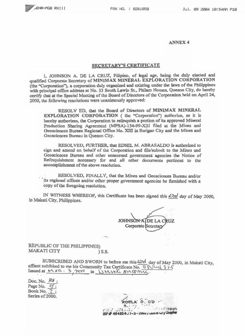
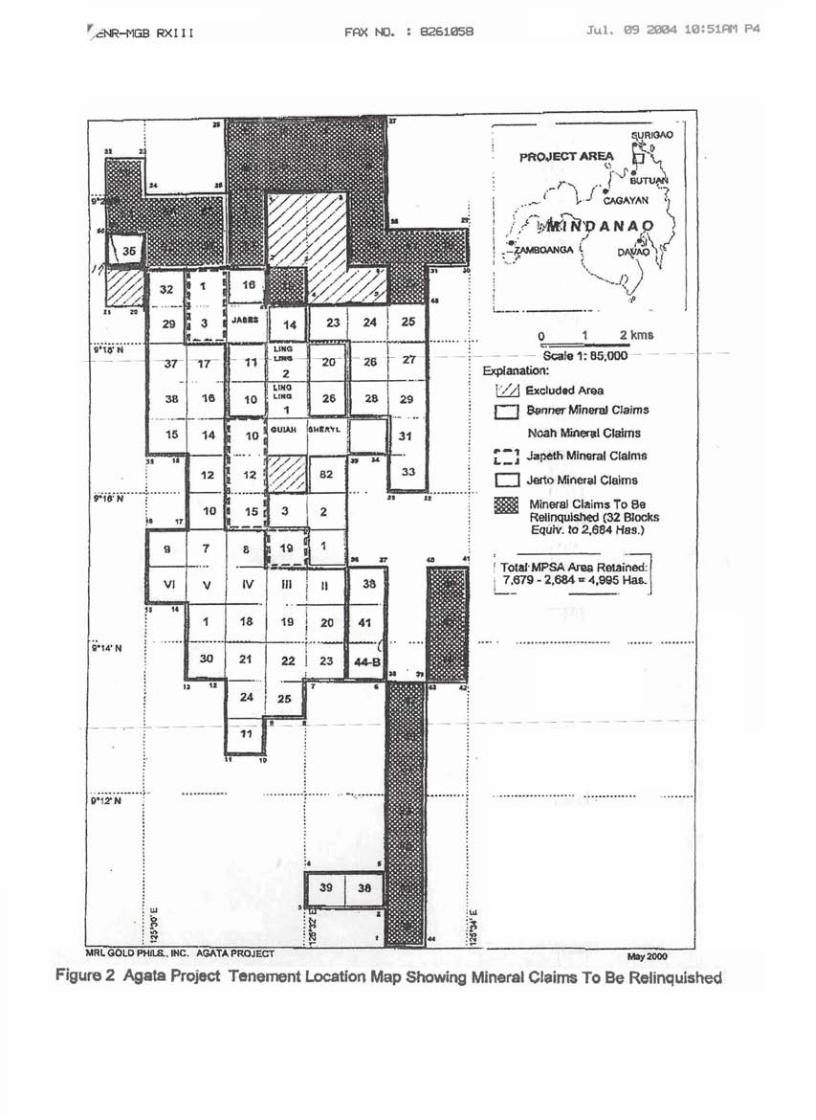
Appendix 2
Certified Technical Descriptions for NAMRIA Control Stations
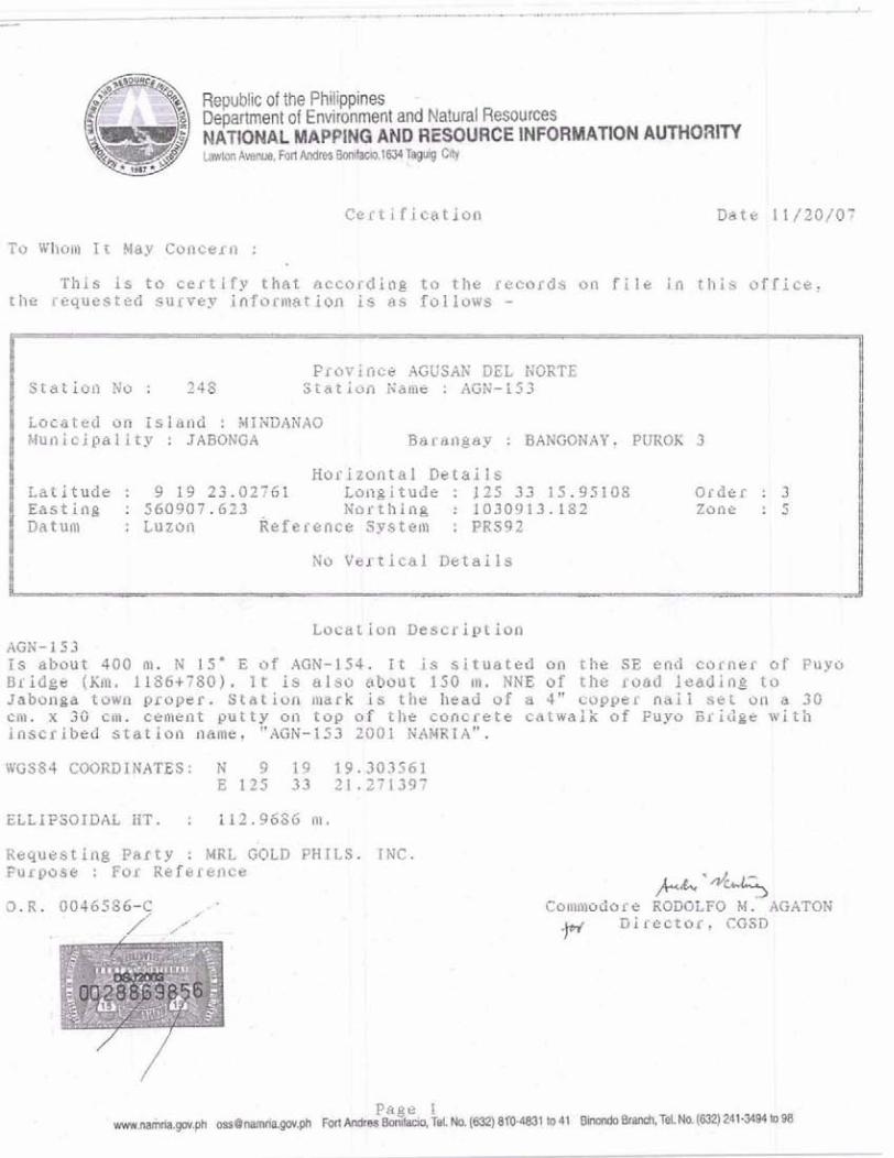
Republic of the Philippine9 +
Department of Environment and Natural Resources NAWtdAL MAPPING AND RESOURCE INFORMATION AUHORl'l'Y Lawton hnue, Fort Wres E M k b . 1 ~ T ~ l q City
Certification Date 11 / 2 0 / 0 7
To Whom I t May Coacern :
This is t o certify t h a t according t o t h e records on file i n Chis o f f i c e , t h e requested survey Infbr lnat lon is as folfows -
Province AGUSAK DEL NORTE Station No : 248 Statlon Name : AGN-153
Located on Island : MfNDANAO i4nnic ipal l ty : JABONGA Barsngay : BANGONAY, PtfROK 3
Horizontal Details Latitude : 9 19 23.02761 Longitude : 125 33 15,95108 Order : 3 Eastima : 560907.623 Northing : 1030913.182 Zone : 5
~ e f e s e n c e System : PRS92
No Vertlcal Details
Locatl~n Description AGN-153 . 1s about 400 m..N IS* E of AGM-154. I t Is situated on the EE end corner of Puyo Bridge (Km. 1186+780). I t is sLso about 150 m. kNG of the road leading t o Jabonga town proper,. Station. mark is t h e head of a 4 " copper nai 1 se t on a 30 em. ,x 390' c~n- eealsnt putty on t o p of t h e eoncrete catwalk of Puyo Bridge w i t h inscribed statlon name, "AGN-153 2001 NAMRIA",
ELLIPSOIDAL HT. : 112 -9686 ni.
Requesting Party : MRL GOLD PRILS. TNC. Purpose t For Reference
+%A-
Comfi~odar e RUDOLF0 M. AGATON
v Directorr CGSD
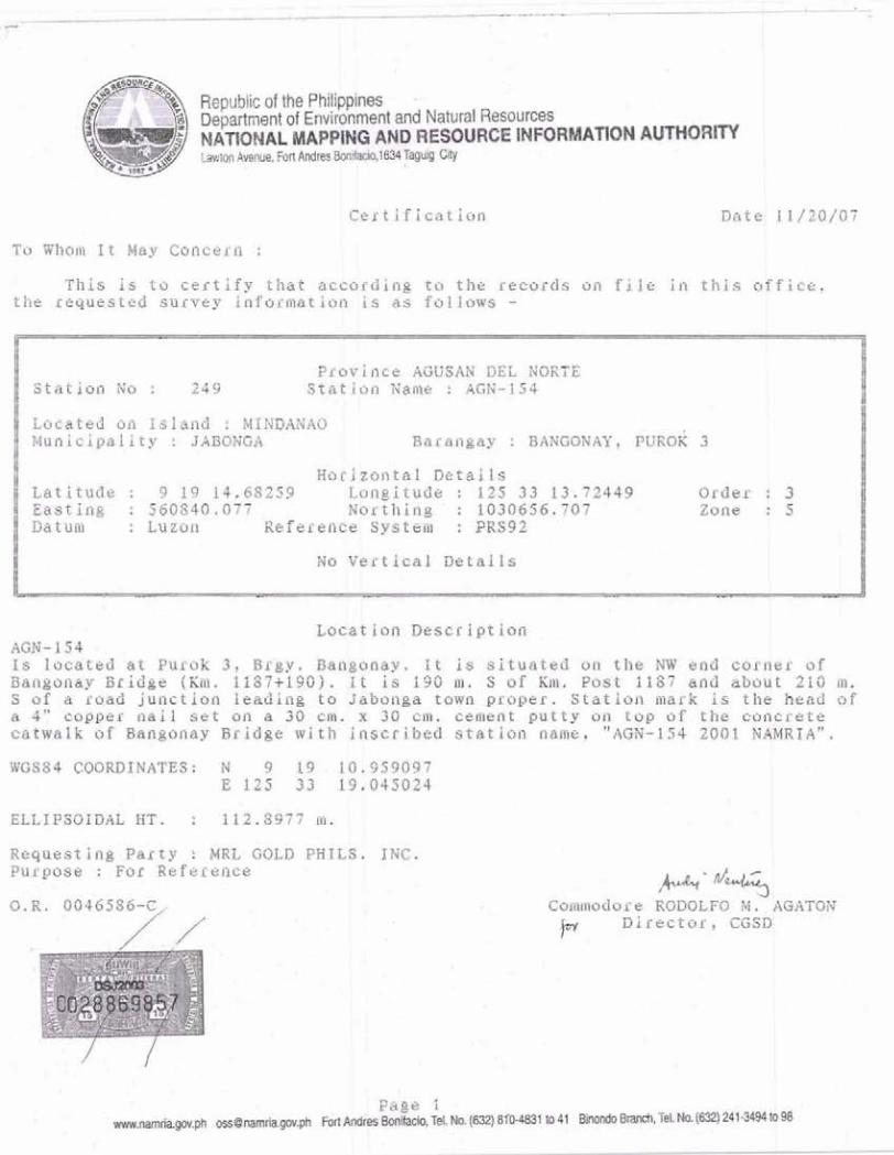
7 NATIONAL MAPPING AND RESOURCE IYFORMA'TION AUTWORM tawion Avenue. Fal AndresXhikio,,l83il fapig City
Certification Date 11/20/07
To Whom I t May Concern :
Thls is to c e r t i f y that according t o t h e records on f i l e i n t h i s o f f i c e , t h e requested survey information is as follows -
Provlilce AGUSAH DEL XORTE Station No : 249 S t a t i o n Name : AGN-IS4
Located an Island : MfNDANnO Municipality : SABDNGA Barsngay : BANGONAY+ P U R O ~ 3
Horizontal Details Latitude : 9 19 14.68259 Longitude : 125 3 3 1 3 . 7 2 4 4 9 Order : 3 E q s t in$ : 560840 ., 0 7 7 Northing' : 1030656.707 Zoi~e : 5
Reference System : PRS92
No Vertical DstalZs
Locatiofi DesCrlption AGE- 1 5 4 Is located at Purok 3 , Brgy. Bangonay. I t 1s s i t u a t e d on t h e NW and corner of 3angoflay B r i d g e (KO), 1 1 8 7 t 1 9 G ) . I t i s 190 01, S of Rm. Post 1187 and about 210 w A S of s road junction leading t o Jabonga town prapkr. Stailon inark is the head of a 4>co@per nadt s e t on a 30 cm. x 30 em. cement putty on top of the concrete cktwalk of Bangonay BrAdge with' Inscribed.. station name, "AGN-154 2001 NBMRIA".
WGS84 COORDINATES: N 9 1 4 . 1 0 . 9 5 9 0 9 7 E 125 33 19.045024
ELLIPSOIDAL HT, : 112.5377 f i ~ ,
Raquasting.Party : MRL GOLD PHILS. ING. Purpose : For Reference
Conmodor e RODOLFO M . AGATON p Director, CGSD
Page 1 m.&iarn.ph o s s O n m , p h ~ o n ~ r m m B o n W o , T d . N o . ~ ~ 8 ~ 1 t o 4 1 ~hodo~aooh,l.*la4241mbt#I
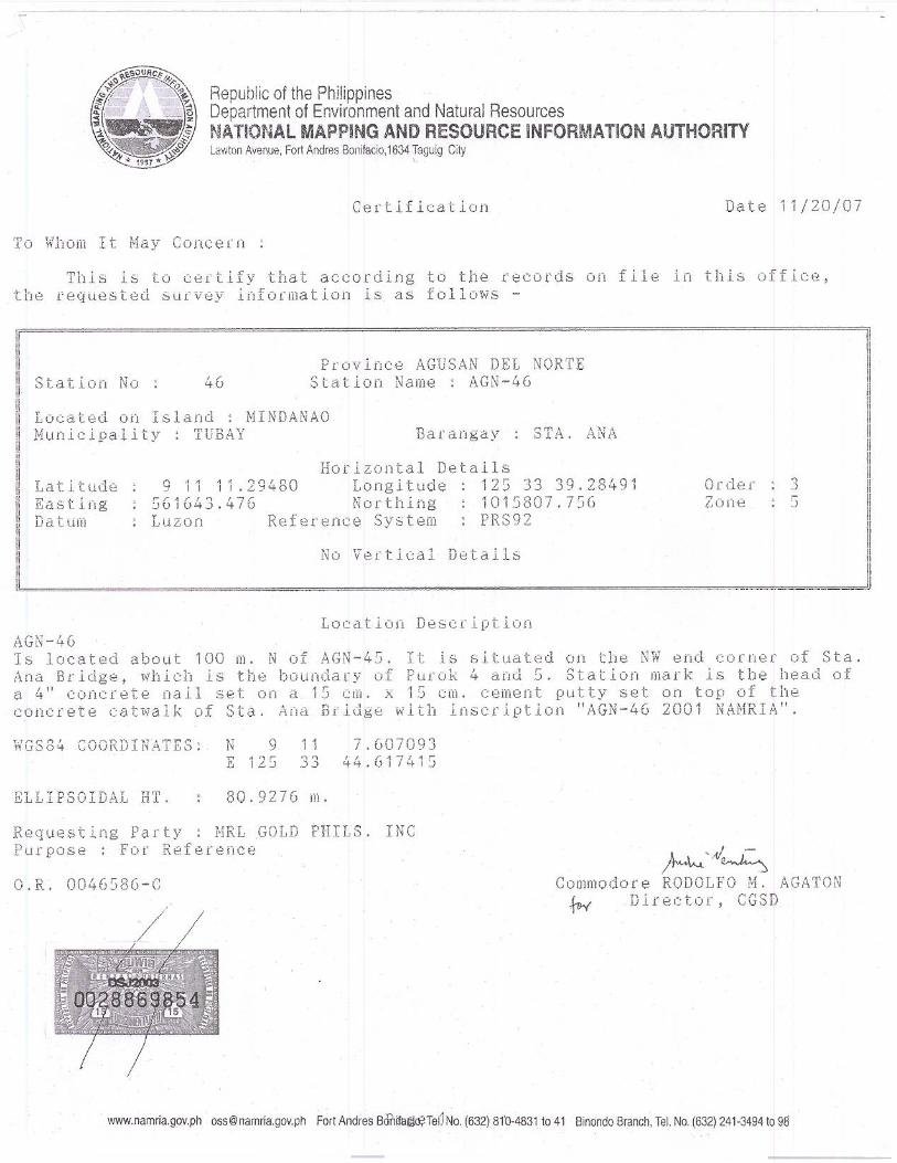
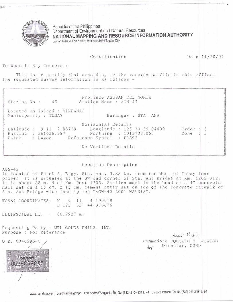
Appendix 3
ANLP QA/QC Procedures
1
MNDORO RESOURCES LIMITED [MRL GOLD PHILS., INC.]
AGATA NICKEL LATERITE PROJECT
QUALITY ASSURANCE AND QUALITY CONTROL PROCEDURES
MRL Gold Phils., Inc. Agata Project Exploration Staff
2
Table of Contents 1. INTRODUCTION ......................................................................................................................................... 3 2. GEOLOGIC MAPPING ................................................................................................................................ 4 3. TRENCHING ................................................................................................................................................ 4 4. SURVEYING ................................................................................................................................................ 5
4.1 Grid Lines Survey .................................................................................................................................... 5 4.2 Topographic Surveying ............................................................................................................................ 6
5. DRILLING ..................................................................................................................................................... 6 6. CORE SECURITY ...................................................................................................................................... 10 7. CORE LOGGING ........................................................................................................................................ 11
7.1 Logging Codes ....................................................................................................................................... 11 7.2 Weathering Scale ................................................................................................................................... 12 7.3 Boulder Size ........................................................................................................................................... 12 7.4 Color Code ............................................................................................................................................. 12
8. CORE SAMPLING ..................................................................................................................................... 13 9. TRANSPORT OF SAMPLES ..................................................................................................................... 14 10. ASSAYING ............................................................................................................................................... 15 11. ASSAY DATA QUALITY ANALYSIS ................................................................................................... 16
11.1 Duplicate Samples ........................................................................................................................... 16 11.2 Standard Samples ............................................................................................................................. 16 11.3 Check Samples ................................................................................................................................. 16
12. Bulk Density and Moisture Content Determination ................................................................................... 17 13. Documentation ........................................................................................................................................... 18 14. Data Management ...................................................................................................................................... 20
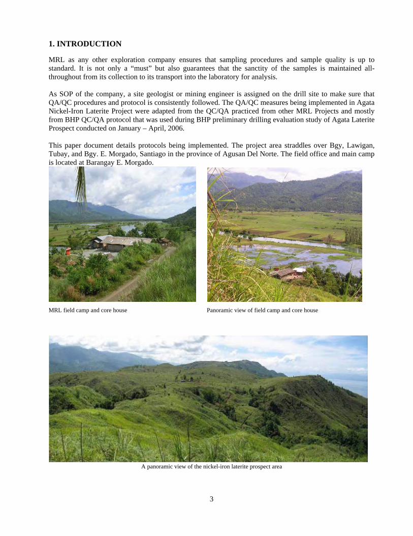
3
1. INTRODUCTION MRL as any other exploration company ensures that sampling procedures and sample quality is up to standard. It is not only a “must” but also guarantees that the sanctity of the samples is maintained all-throughout from its collection to its transport into the laboratory for analysis. As SOP of the company, a site geologist or mining engineer is assigned on the drill site to make sure that QA/QC procedures and protocol is consistently followed. The QA/QC measures being implemented in Agata Nickel-Iron Laterite Project were adapted from the QC/QA practiced from other MRL Projects and mostly from BHP QC/QA protocol that was used during BHP preliminary drilling evaluation study of Agata Laterite Prospect conducted on January – April, 2006. This paper document details protocols being implemented. The project area straddles over Bgy, Lawigan, Tubay, and Bgy. E. Morgado, Santiago in the province of Agusan Del Norte. The field office and main camp is located at Barangay E. Morgado.
MRL field camp and core house Panoramic view of field camp and core house
A panoramic view of the nickel-iron laterite prospect area
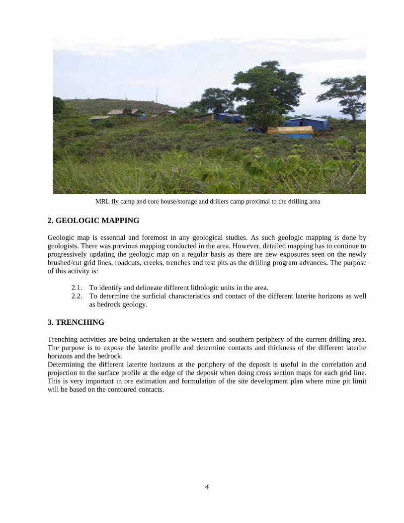
4
MRL fly camp and core house/storage and drillers camp proximal to the drilling area 2. GEOLOGIC MAPPING Geologic map is essential and foremost in any geological studies. As such geologic mapping is done by geologists. There was previous mapping conducted in the area. However, detailed mapping has to continue to progressively updating the geologic map on a regular basis as there are new exposures seen on the newly brushed/cut grid lines, roadcuts, creeks, trenches and test pits as the drilling program advances. The purpose of this activity is:
2.1. To identify and delineate different lithologic units in the area. 2.2. To determine the surficial characteristics and contact of the different laterite horizons as well
as bedrock geology. 3. TRENCHING Trenching activities are being undertaken at the western and southern periphery of the current drilling area. The purpose is to expose the laterite profile and determine contacts and thickness of the different laterite horizons and the bedrock. Determining the different laterite horizons at the periphery of the deposit is useful in the correlation and projection to the surface profile at the edge of the deposit when doing cross section maps for each grid line. This is very important in ore estimation and formulation of the site development plan where mine pit limit will be based on the contoured contacts.
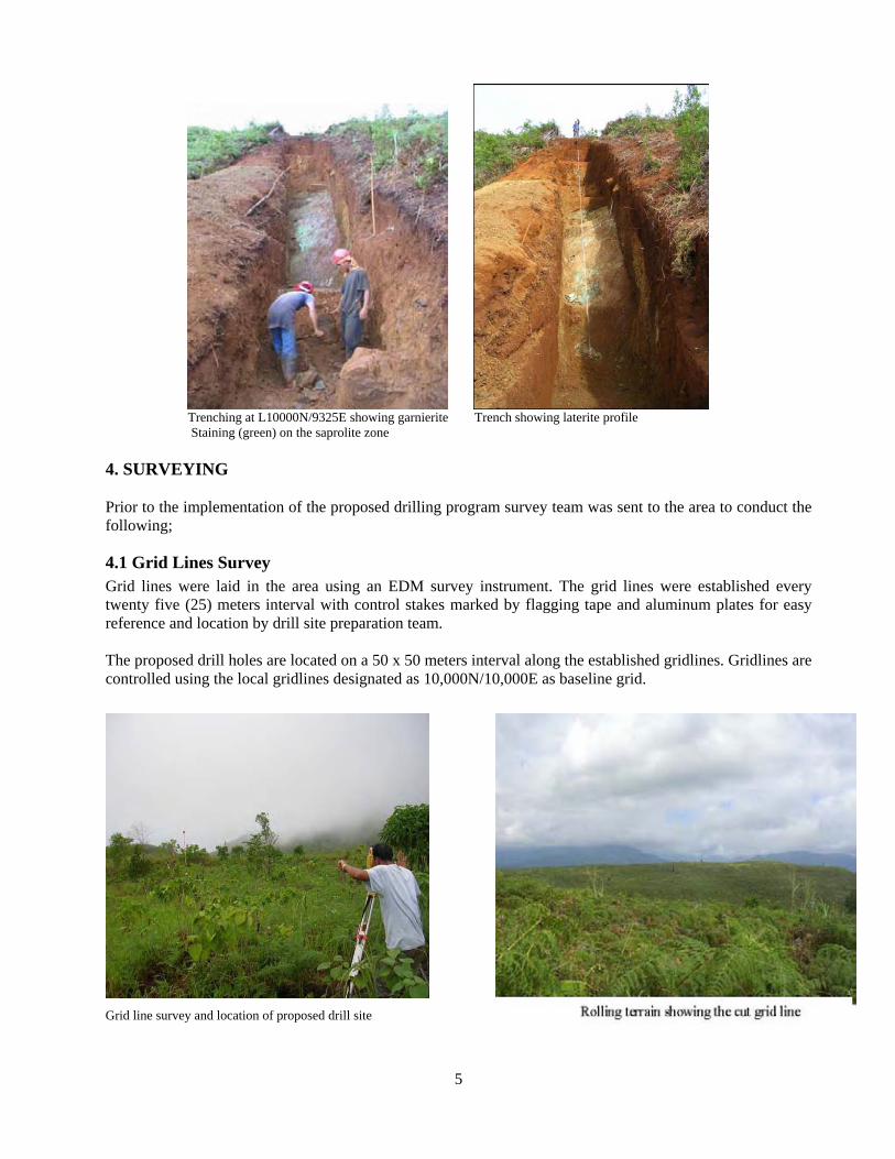
5
Trenching at L10000N/9325E showing garnierite Trench showing laterite profile Staining (green) on the saprolite zone 4. SURVEYING Prior to the implementation of the proposed drilling program survey team was sent to the area to conduct the following;
4.1 Grid Lines Survey Grid lines were laid in the area using an EDM survey instrument. The grid lines were established every twenty five (25) meters interval with control stakes marked by flagging tape and aluminum plates for easy reference and location by drill site preparation team. The proposed drill holes are located on a 50 x 50 meters interval along the established gridlines. Gridlines are controlled using the local gridlines designated as 10,000N/10,000E as baseline grid.
Grid line survey and location of proposed drill site
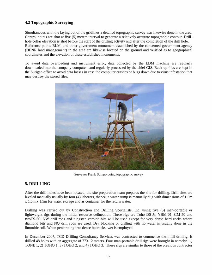
6
4.2 Topographic Surveying Simultaneous with the laying out of the gridlines a detailed topographic survey was likewise done in the area. Control points are shot at five (5) meters interval to generate a relatively accurate topographic contour. Drill-hole collar elevation is shot before the start of the drilling activity and after the completion of the drill hole. Reference points BLM, and other government monument established by the concerned government agency (DENR land management) in the area are likewise located on the ground and verified as to geographical coordinates and the elevation of these established monuments. To avoid data overloading and instrument error, data collected by the EDM machine are regularly downloaded into the company computers and regularly processed by the chief GIS. Back-up files are kept in the Surigao office to avoid data losses in case the computer crashes or bugs down due to virus infestation that may destroy the stored files.
Surveyor Frank Sumpo doing topographic survey 5. DRILLING After the drill holes have been located, the site preparation team prepares the site for drilling. Drill sites are leveled manually usually by four (4) laborers, thence, a water sump is manually dug with dimensions of 1.5m x 1.5m x 1.5m for water storage and as container for the return water. Drilling was carried out by Construction and Drilling Specialists, Inc. using five (5) man-portable or lightweight rigs during the initial resource delineation. These rigs are Toho DS-Js, YBM-01, GM-50 and twoTS-50. NW drill rods and tungsten carbide bits will be used except for very dense hard rocks where diamond bits and NQ drill rods are used. Dry blocking or drilling with no water is usually done in the limonitic soil. When penetrating into dense bedrocks, wet is employed. In December 2007, TCD Drilling Consultancy Services was contracted to commence the infill drilling. It drilled 48 holes with an aggregate of 773.12 meters. Four man-portable drill rigs were brought in namely: 1.) TONE 1, 2) TOHO 1, 3) TOHO 2, and 4) TOHO 3. These rigs are similar to those of the previous contractor
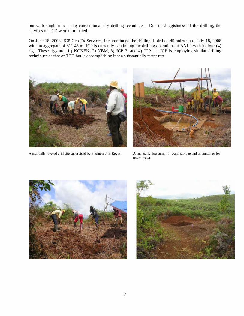
7
but with single tube using conventional dry drilling techniques. Due to sluggishness of the drilling, the services of TCD were terminated. On June 18, 2008, JCP Geo-Ex Services, Inc. continued the drilling. It drilled 45 holes up to July 18, 2008 with an aggregate of 811.45 m. JCP is currently continuing the drilling operations at ANLP with its four (4) rigs. These rigs are: 1.) KOKEN, 2) YBM, 3) JCP 3, and 4) JCP 11. JCP is employing similar drilling techniques as that of TCD but is accomplishing it at a substantially faster rate.
A manually leveled drill site supervised by Engineer J. B Reyes A manually dug sump for water storage and as container for return water.
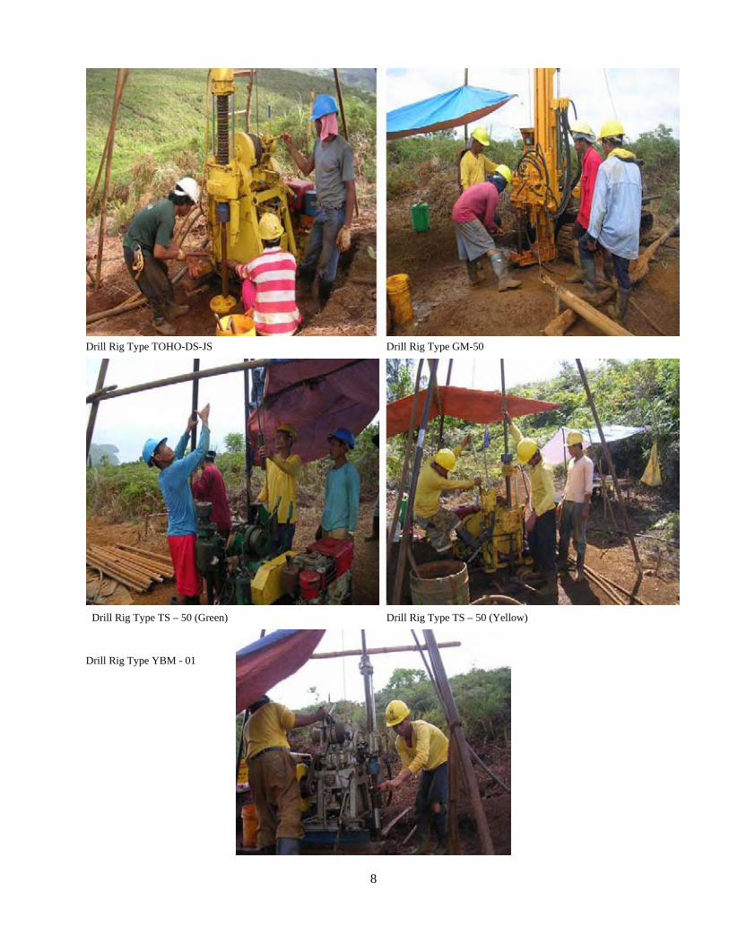
8
Drill Rig Type TOHO-DS-JS Drill Rig Type GM-50
Drill Rig Type TS – 50 (Green) Drill Rig Type TS – 50 (Yellow)
Drill Rig Type YBM - 01
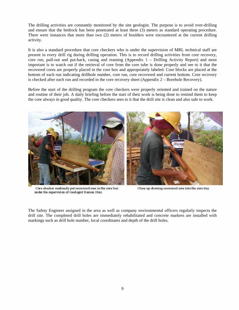
9
The drilling activities are constantly monitored by the site geologist. The purpose is to avoid over-drilling and ensure that the bedrock has been penetrated at least three (3) meters as standard operating procedure. There were instances that more than two (2) meters of boulders were encountered at the current drilling activity. It is also a standard procedure that core checkers who is under the supervision of MRL technical staff are present in every drill rig during drilling operation. This is to record drilling activities from core recovery, core run, pull-out and put-back, casing and reaming (Appendix 1 – Drilling Activity Report) and most important is to watch out if the retrieval of core from the core tube is done properly and see to it that the recovered cores are properly placed in the core box and appropriately labeled. Core blocks are placed at the bottom of each run indicating drillhole number, core run, core recovered and current bottom. Core recovery is checked after each run and recorded in the core recovery sheet (Appendix 2 – Borehole Recovery). Before the start of the drilling program the core checkers were properly oriented and trained on the nature and routine of their job. A daily briefing before the start of their work is being done to remind them to keep the core always in good quality. The core checkers sees to it that the drill site is clean and also safe to work.
The Safety Engineer assigned in the area as well as company environmental officers regularly inspects the drill site. The completed drill holes are immediately rehabilitated and concrete markers are installed with markings such as drill hole number, local coordinates and depth of the drill holes.
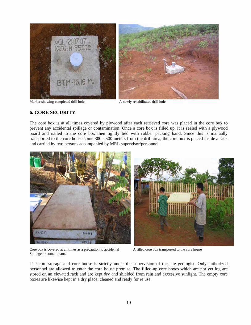
10
Marker showing completed drill hole A newly rehabilitated drill hole 6. CORE SECURITY The core box is at all times covered by plywood after each retrieved core was placed in the core box to prevent any accidental spillage or contamination. Once a core box is filled up, it is sealed with a plywood board and nailed to the core box then tightly tied with rubber packing band. Since this is manually transported to the core house some 300 - 500 meters from the drill area, the core box is placed inside a sack and carried by two persons accompanied by MRL supervisor/personnel.
Core box is covered at all times as a precaution to accidental A filled core box transported to the core house Spillage or contaminant. The core storage and core house is strictly under the supervision of the site geologist. Only authorized personnel are allowed to enter the core house premise. The filled-up core boxes which are not yet log are stored on an elevated rack and are kept dry and shielded from rain and excessive sunlight. The empty core boxes are likewise kept in a dry place, cleaned and ready for re use.
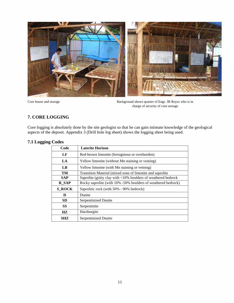
11
Core house and storage Background shows quarter of Engr. JB Reyes who is in charge of security of core storage
7. CORE LOGGING Core logging is absolutely done by the site geologist so that he can gain intimate knowledge of the geological aspects of the deposit. Appendix 3 (Drill hole log sheet) shows the logging sheet being used.
7.1 Logging Codes Code Laterite Horizon
LF Red-brown limonite (ferruginous or overburden)
LA Yellow limonite (without Mn staining or veining)
LB Yellow limonite (with Mn staining or veining) TM Transition Material (mixed zone of limonite and saprolite SAP Saprolite (gritty clay with <10% boulders of weathered bedrock
R_SAP Rocky saprolite (with 10% -50% boulders of weathered bedrock) S_ROCK Saprolitic rock (with 50% - 90% bedrock)
D Dunite SD Serpentinized Dunite SS Serpentinite HZ Harzburgite
SHZ Serpentinized Dunite
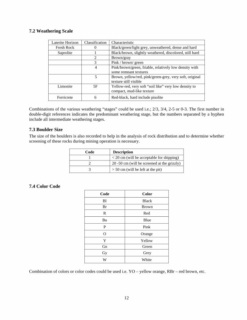
12
7.2 Weathering Scale
Laterite Horizon Classification Characteristic Fresh Rock 0 Black/green/light grey, unweathered, dense and hard Saprolite 1 Black/brown, slightly weathered, discolored, still hard
2 Brown/gray 3 Pink / brown/ green 4 Pink/brown/green, friable, relatively low density with
some remnant textures 5 Brown, yellow/red, pink/green-grey, very soft, original
texture still visible Limonite 5F Yellow-red, very soft “soil like” very low density to
compact, mud-like texture Ferricrete 6 Red-black, hard include pisolite
Combinations of the various weathering “stages” could be used i.e.; 2/3, 3/4, 2-5 or 0-3. The first number in double-digit references indicates the predominant weathering stage, but the numbers separated by a hyphen include all intermediate weathering stages.
7.3 Boulder Size The size of the boulders is also recorded to help in the analysis of rock distribution and to determine whether screening of these rocks during mining operation is necessary.
Code Description 1 < 20 cm (will be acceptable for shipping) 2 20 -50 cm (will be screened at the grizzly) 3 > 50 cm (will be left at the pit)
7.4 Color Code Code Color
Bl Black Br Brown R Red
Bu Blue
P Pink
O Orange
Y Yellow Gn Green Gy Grey
W White Combination of colors or color codes could be used i.e. YO – yellow orange, RBr – red brown, etc.
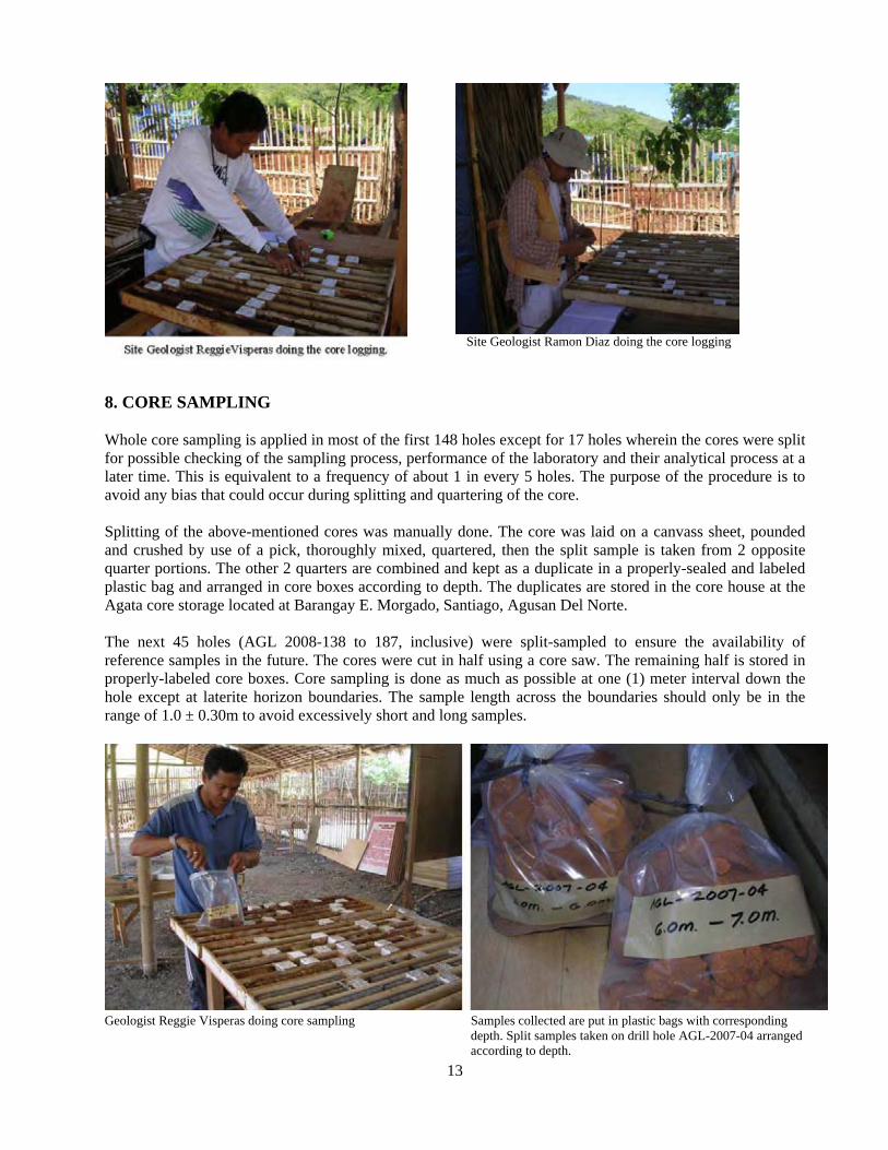
13
Site Geologist Ramon Diaz doing the core logging
8. CORE SAMPLING Whole core sampling is applied in most of the first 148 holes except for 17 holes wherein the cores were split for possible checking of the sampling process, performance of the laboratory and their analytical process at a later time. This is equivalent to a frequency of about 1 in every 5 holes. The purpose of the procedure is to avoid any bias that could occur during splitting and quartering of the core. Splitting of the above-mentioned cores was manually done. The core was laid on a canvass sheet, pounded and crushed by use of a pick, thoroughly mixed, quartered, then the split sample is taken from 2 opposite quarter portions. The other 2 quarters are combined and kept as a duplicate in a properly-sealed and labeled plastic bag and arranged in core boxes according to depth. The duplicates are stored in the core house at the Agata core storage located at Barangay E. Morgado, Santiago, Agusan Del Norte. The next 45 holes (AGL 2008-138 to 187, inclusive) were split-sampled to ensure the availability of reference samples in the future. The cores were cut in half using a core saw. The remaining half is stored in properly-labeled core boxes. Core sampling is done as much as possible at one (1) meter interval down the hole except at laterite horizon boundaries. The sample length across the boundaries should only be in the range of 1.0 ± 0.30m to avoid excessively short and long samples.
Geologist Reggie Visperas doing core sampling Samples collected are put in plastic bags with corresponding depth. Split samples taken on drill hole AGL-2007-04 arranged according to depth.
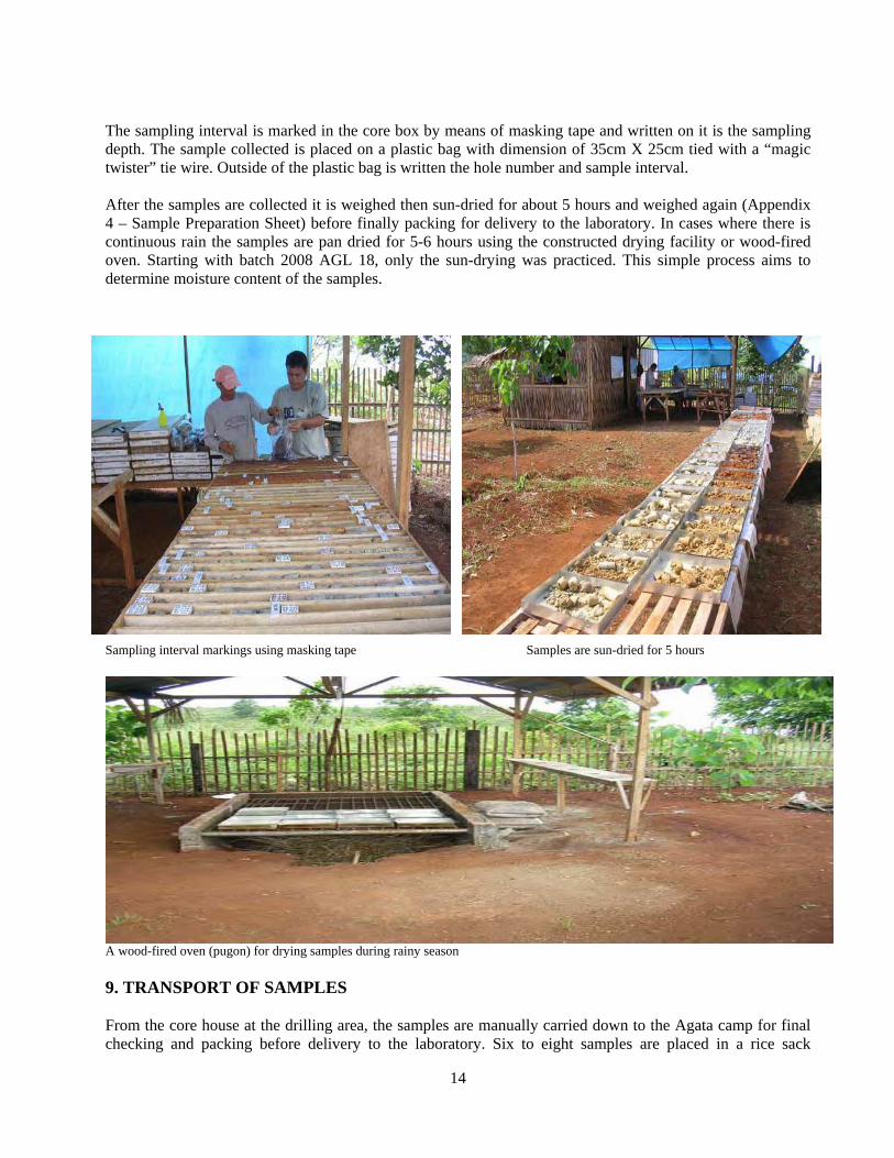
14
The sampling interval is marked in the core box by means of masking tape and written on it is the sampling depth. The sample collected is placed on a plastic bag with dimension of 35cm X 25cm tied with a “magic twister” tie wire. Outside of the plastic bag is written the hole number and sample interval. After the samples are collected it is weighed then sun-dried for about 5 hours and weighed again (Appendix 4 – Sample Preparation Sheet) before finally packing for delivery to the laboratory. In cases where there is continuous rain the samples are pan dried for 5-6 hours using the constructed drying facility or wood-fired oven. Starting with batch 2008 AGL 18, only the sun-drying was practiced. This simple process aims to determine moisture content of the samples.
Sampling interval markings using masking tape Samples are sun-dried for 5 hours
A wood-fired oven (pugon) for drying samples during rainy season 9. TRANSPORT OF SAMPLES From the core house at the drilling area, the samples are manually carried down to the Agata camp for final checking and packing before delivery to the laboratory. Six to eight samples are placed in a rice sack
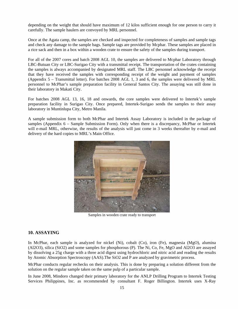
15
depending on the weight that should have maximum of 12 kilos sufficient enough for one person to carry it carefully. The sample haulers are convoyed by MRL personnel. Once at the Agata camp, the samples are checked and inspected for completeness of samples and sample tags and check any damage to the sample bags. Sample tags are provided by Mcphar. These samples are placed in a rice sack and then in a box within a wooden crate to ensure the safety of the samples during transport. For all of the 2007 cores and batch 2008 AGL 10, the samples are delivered to Mcphar Laboratory through LBC-Butuan City or LBC-Surigao City with a transmittal receipt. The transportation of the crates containing the samples is always accompanied by designated MRL staff. The LBC personnel acknowledge the receipt that they have received the samples with corresponding receipt of the weight and payment of samples (Appendix 5 – Transmittal letter). For batches 2008 AGL 1, 3 and 6, the samples were delivered by MRL personnel to McPhar’s sample preparation facility in General Santos City. The assaying was still done in their laboratory in Makati City. For batches 2008 AGL 13, 16, 18 and onwards, the core samples were delivered to Intertek’s sample preparation facility in Surigao City. Once prepared, Intertek-Surigao sends the samples to their assay laboratory in Muntinlupa City, Metro Manila. A sample submission form to both McPhar and Intertek Assay Laboratory is included in the package of samples (Appendix 6 – Sample Submission Form). Only when there is a discrepancy, McPhar or Intertek will e-mail MRL, otherwise, the results of the analysis will just come in 3 weeks thereafter by e-mail and delivery of the hard copies to MRL’s Main Office.
Samples in wooden crate ready to transport
10. ASSAYING In McPhar, each sample is analyzed for nickel (Ni), cobalt (Co), iron (Fe), magnesia (MgO), alumina (Al2O3), silica (SiO2) and some samples for phosphorous (P). The Ni, Co, Fe, MgO and Al2O3 are assayed by dissolving a 25g charge with a three acid digest using hydrochloric and nitric acid and reading the results by Atomic Absorption Spectroscopy (AAS).The SiO2 and P are analyzed by gravimetric process. McPhar conducts regular rechecks on their analysis. This is done by preparing a solution different from the solution on the regular sample taken on the same pulp of a particular sample. In June 2008, Mindoro changed their primary laboratory for the ANLP Drilling Program to Intertek Testing Services Philippines, Inc. as recommended by consultant F. Roger Billington. Intertek uses X-Ray
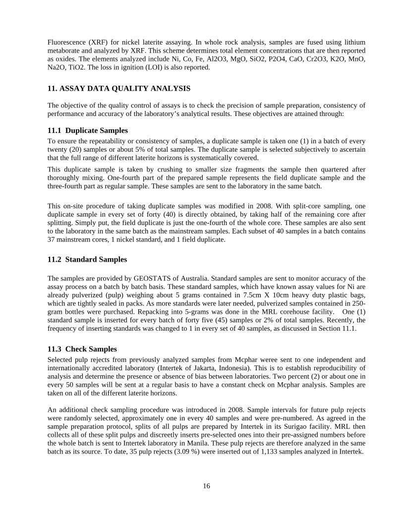
16
Fluorescence (XRF) for nickel laterite assaying. In whole rock analysis, samples are fused using lithium metaborate and analyzed by XRF. This scheme determines total element concentrations that are then reported as oxides. The elements analyzed include Ni, Co, Fe, Al2O3, MgO, SiO2, P2O4, CaO, Cr2O3, K2O, MnO, Na2O, TiO2. The loss in ignition (LOI) is also reported.
11. ASSAY DATA QUALITY ANALYSIS The objective of the quality control of assays is to check the precision of sample preparation, consistency of performance and accuracy of the laboratory’s analytical results. These objectives are attained through:
11.1 Duplicate Samples To ensure the repeatability or consistency of samples, a duplicate sample is taken one (1) in a batch of every twenty (20) samples or about 5% of total samples. The duplicate sample is selected subjectively to ascertain that the full range of different laterite horizons is systematically covered. This duplicate sample is taken by crushing to smaller size fragments the sample then quartered after thoroughly mixing. One-fourth part of the prepared sample represents the field duplicate sample and the three-fourth part as regular sample. These samples are sent to the laboratory in the same batch. This on-site procedure of taking duplicate samples was modified in 2008. With split-core sampling, one duplicate sample in every set of forty (40) is directly obtained, by taking half of the remaining core after splitting. Simply put, the field duplicate is just the one-fourth of the whole core. These samples are also sent to the laboratory in the same batch as the mainstream samples. Each subset of 40 samples in a batch contains 37 mainstream cores, 1 nickel standard, and 1 field duplicate.
11.2 Standard Samples The samples are provided by GEOSTATS of Australia. Standard samples are sent to monitor accuracy of the assay process on a batch by batch basis. These standard samples, which have known assay values for Ni are already pulverized (pulp) weighing about 5 grams contained in 7.5cm X 10cm heavy duty plastic bags, which are tightly sealed in packs. As more standards were later needed, pulverized samples contained in 250-gram bottles were purchased. Repacking into 5-grams was done in the MRL corehouse facility. One (1) standard sample is inserted for every batch of forty five (45) samples or 2% of total samples. Recently, the frequency of inserting standards was changed to 1 in every set of 40 samples, as discussed in Section 11.1.
11.3 Check Samples Selected pulp rejects from previously analyzed samples from Mcphar weree sent to one independent and internationally accredited laboratory (Intertek of Jakarta, Indonesia). This is to establish reproducibility of analysis and determine the presence or absence of bias between laboratories. Two percent (2) or about one in every 50 samples will be sent at a regular basis to have a constant check on Mcphar analysis. Samples are taken on all of the different laterite horizons.
An additional check sampling procedure was introduced in 2008. Sample intervals for future pulp rejects were randomly selected, approximately one in every 40 samples and were pre-numbered. As agreed in the sample preparation protocol, splits of all pulps are prepared by Intertek in its Surigao facility. MRL then collects all of these split pulps and discreetly inserts pre-selected ones into their pre-assigned numbers before the whole batch is sent to Intertek laboratory in Manila. These pulp rejects are therefore analyzed in the same batch as its source. To date, 35 pulp rejects (3.09 %) were inserted out of 1,133 samples analyzed in Intertek.
17
12. Bulk Density and Moisture Content Determination The bulk density and moisture content is essential in ore reserves estimation. There are several alternatives of measuring density, ranging from laboratory test on small scale sampling and estimation based on bulk sampling. Two methodologies are to be undertaken by Mindoro for the determination of Bulk Density (BD). For the ferruginous laterite and limonite horizons, bulk samples are collected from test pits and measured on site. The same procedure will be done for the saprolite zone but to be supplemented with another method, i.e., the collection and measurement of drill core samples. The test pits are designed with an optimal dimension of 0.9m x 1.4m with the wider section oriented in the north-south direction. Old test pits, on the other hand, have dimensions of 0.7m x 1.2m. The narrower side is extended by0.5m extension to expose a fresh wall for the sampling. For BD measurements to be done on site, large samples ranging in volume from 0.005 m3 to 0.08 m3 will be collected from test pits. The locations of these test pits must be distributed around the drilling area. To secure representative samples for the BD tests, small pits or “boxes” and channels will be excavated or chiseled into test pit walls. Pre-fabricated plywood with square holes measuring 0.40m x 0.40m and 0.20m x 0.20m are used as guides in excavating and chiseling of the pit faces to ensure volume accuracy. The plywood guides are then nailed to the pit walls to be sampled. Once nailed, chiseling of the area outlined by the plywood guide begins from the center of the “boxes” chipping towards the “boxes’” boundaries. To ensure consistency of the volume excavated, knife putties are used to smoothen the edges of the “box”. Level bars and square boxes are regularly utilized to achieve a more or less perfect sampling dimension desired. The chipped samples chiseled from the box falls freely onto a clean canvass placed at the bottom of the pit. There were instances that the final dimension of the excavation in the pit walls became irregular due to the presence of boulders or rocks that were hard to chisel. In such cases, the final dimension was determined by carefully measuring the height, width and breadth. These were done by MRL geologists themselves in conjunction with their test pit logging. The bulk samples will be measured for volume, wet weight, and dry weight. The samples are to be contained in plastic bags and weighed using a 16-kg capacity, Korean made (“Choongang” brand), “Ohaus”-type single beam field weighing balances equipped with a 5-gram graduation beam. The weighing scales are placed in tables exclusively used for this purpose. The weighing instruments are cleaned and calibrated regularly. The weight of the plastic bags are to be subtracted from the weighed samples to arrive at the actual weight of the samples. After determining the wet weight, the samples will be spread evenly in a canvass and sun-dried for initial drying. Thence, these samples will undergo heating in constructed fire wood/charcoal-fired heating facilities for four to six hours. The samples should be regularly “stirred” to ensure even drying. The dried samples are cooled naturally for about 20 minutes, after which they are collected onto plastic bags for final weighing.
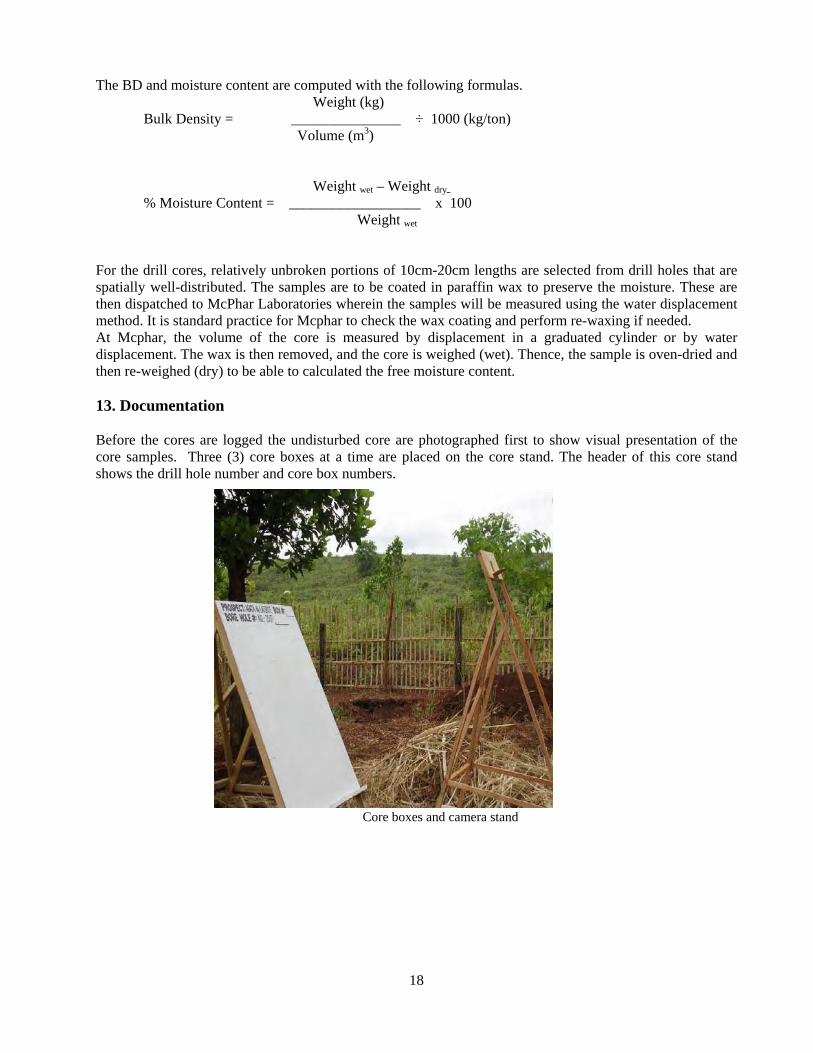
18
The BD and moisture content are computed with the following formulas. Weight (kg)
Bulk Density = _______________ ÷ 1000 (kg/ton) Volume (m3)
Weight wet – Weight dry % Moisture Content = __________________ x 100
Weight wet
For the drill cores, relatively unbroken portions of 10cm-20cm lengths are selected from drill holes that are spatially well-distributed. The samples are to be coated in paraffin wax to preserve the moisture. These are then dispatched to McPhar Laboratories wherein the samples will be measured using the water displacement method. It is standard practice for Mcphar to check the wax coating and perform re-waxing if needed. At Mcphar, the volume of the core is measured by displacement in a graduated cylinder or by water displacement. The wax is then removed, and the core is weighed (wet). Thence, the sample is oven-dried and then re-weighed (dry) to be able to calculated the free moisture content. 13. Documentation Before the cores are logged the undisturbed core are photographed first to show visual presentation of the core samples. Three (3) core boxes at a time are placed on the core stand. The header of this core stand shows the drill hole number and core box numbers.
Core boxes and camera stand
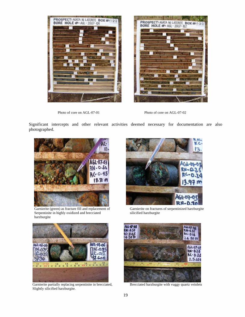
19
Photo of core on AGL-07-01 Photo of core on AGL-07-02
Significant intercepts and other relevant activities deemed necessary for documentation are also photographed.
Garnierite (green) as fracture fill and replacement of Garnierite on fractures of serpentinized harzburgite Serpentinite in highly oxidized and brecciated silicified harzburgite harzburgite
Garnierite partially replacing serpentinite in brecciated, Brecciated harzburgite with vuggy quartz veinlets Slightly silicified harzburgite.
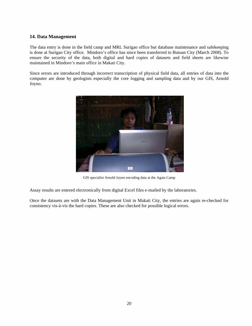
20
14. Data Management The data entry is done in the field camp and MRL Surigao office but database maintenance and safekeeping is done at Surigao City office. Mindoro’s office has since been transferred to Butuan City (March 2008). To ensure the security of the data, both digital and hard copies of datasets and field sheets are likewise maintained in Mindoro’s main office in Makati City. Since errors are introduced through incorrect transcription of physical field data, all entries of data into the computer are done by geologists especially the core logging and sampling data and by our GIS, Arnold Joyno.
GIS specialist Arnold Joyno encoding data at the Agata Camp
Assay results are entered electronically from digital Excel files e-mailed by the laboratories. Once the datasets are with the Data Management Unit in Makati City, the entries are again re-checked for consistency vis-à-vis the hard copies. These are also checked for possible logical errors.
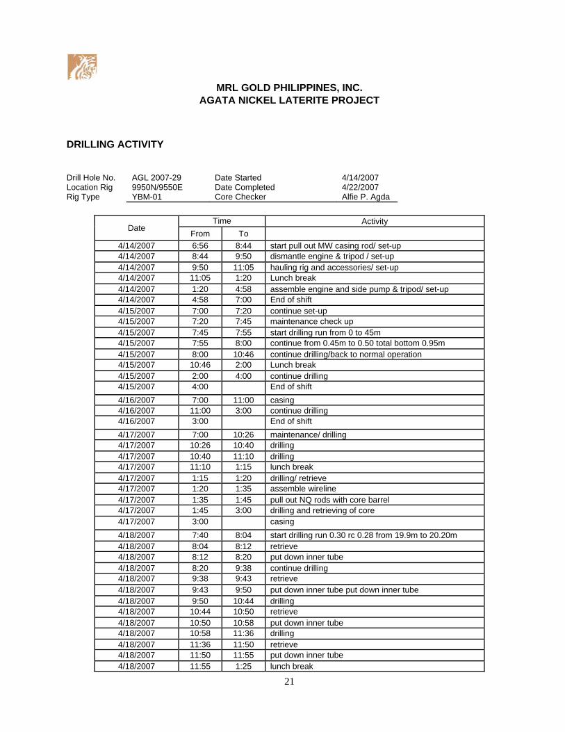
21
MRL GOLD PHILIPPINES, INC.
AGATA NICKEL LATERITE PROJECT
DRILLING ACTIVITY
Drill Hole No. Location Rig Rig Type
AGL 2007-29 9950N/9550E YBM-01
Date Started Date Completed Core Checker
4/14/2007 4/22/2007 Alfie P. Agda
Date Time Activity
From To 4/14/2007 6:56 8:44 start pull out MW casing rod/ set-up 4/14/2007 8:44 9:50 dismantle engine & tripod / set-up 4/14/2007 9:50 11:05 hauling rig and accessories/ set-up 4/14/2007 11:05 1:20 Lunch break 4/14/2007 1:20 4:58 assemble engine and side pump & tripod/ set-up 4/14/2007 4:58 7:00 End of shift 4/15/2007 7:00 7:20 continue set-up 4/15/2007 7:20 7:45 maintenance check up 4/15/2007 7:45 7:55 start drilling run from 0 to 45m 4/15/2007 7:55 8:00 continue from 0.45m to 0.50 total bottom 0.95m 4/15/2007 8:00 10:46 continue drilling/back to normal operation 4/15/2007 10:46 2:00 Lunch break 4/15/2007 2:00 4:00 continue drilling 4/15/2007 4:00 End of shift 4/16/2007 7:00 11:00 casing 4/16/2007 11:00 3:00 continue drilling 4/16/2007 3:00 End of shift 4/17/2007 7:00 10:26 maintenance/ drilling 4/17/2007 10:26 10:40 drilling 4/17/2007 10:40 11:10 drilling 4/17/2007 11:10 1:15 lunch break 4/17/2007 1:15 1:20 drilling/ retrieve 4/17/2007 1:20 1:35 assemble wireline 4/17/2007 1:35 1:45 pull out NQ rods with core barrel 4/17/2007 1:45 3:00 drilling and retrieving of core 4/17/2007 3:00 casing 4/18/2007 7:40 8:04 start drilling run 0.30 rc 0.28 from 19.9m to 20.20m 4/18/2007 8:04 8:12 retrieve 4/18/2007 8:12 8:20 put down inner tube 4/18/2007 8:20 9:38 continue drilling 4/18/2007 9:38 9:43 retrieve 4/18/2007 9:43 9:50 put down inner tube put down inner tube 4/18/2007 9:50 10:44 drilling 4/18/2007 10:44 10:50 retrieve 4/18/2007 10:50 10:58 put down inner tube 4/18/2007 10:58 11:36 drilling 4/18/2007 11:36 11:50 retrieve 4/18/2007 11:50 11:55 put down inner tube 4/18/2007 11:55 1:25 lunch break
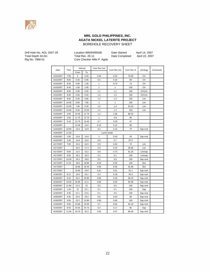
22
MRL GOLD PHILIPPINES, INC. AGATA NICKEL LATERITE PROJECT
BOREHOLE RECOVERY SHEET Drill Hole No. AGL 2007-29 Location 9950N/9550E Date Started April 14, 2007 Total Depth 34.0m Total Rec. 20.11 Date Completed April 22, 2007 Rig No. YBM-01 Core Checker Alfie P. Agda
Date Time Interval Core Run (m)
Core Rec (m) Core Rec % Lithology Comments From To
4/15/2007 7:55 0 0.45 0.45 0.34 75.55 OV
4/15/2007 8:05 0.45 0.95 0.5 0.34 68 OV
4/15/2007 8:35 0.95 1.95 1 0.73 73 OV
4/15/2007 8:45 1.95 2.95 1 1 100 OV
4/15/2007 9:05 2.95 4.05 1.1 1.1 100 OV/Lim
4/15/2007 9:30 4.05 5.55 1.5 1.5 100 OV/Lim
4/15/2007 9:50 5.55 6.85 1.3 1.3 100 Lim
4/15/2007 10:05 6.85 7.85 1 1 100 Lim
4/15/2007 10:30 7.85 9.35 1.5 1.4 93.33 Lim
4/15/2007 10:46 9.35 10.55 1.2 1.2 100 Lim
4/15/2007 2:00 10 55 11 75 1.2 1.06 88 33
4/15/2007 2:40 11.75 12.75 1 0.9 90
4/15/2007 3:10 12.75 13.45 0.7 0.33 47
4/15/2007 13.45 13.6 0.15 0.12 80
4/16/2007 10:00 13.6 13.8 0.2 0.15 75 Sap rock
4/16/2007 11:30 Lunch break
4/16/2007 1:00 13.8 14.8 1 0.43 43 Sap rock
4/16/2007 2:35 14.8 15.6 0.8 0.7 87.5
4/17/2007 7:00 15.6 16.5 0.9 0.63 70 Lim
4/17/2007 16.5 17.4 0.9 0.33 36.66 Lim
4/17/2007 8:00 12.4 10.2 0.8 0.73 91.25 Lim/sap
4/17/2007 9:25 18.2 18.3 0.1 0.1 100 Lim/sap
4/17/2007 10:30 18.3 18.8 0.5 0.5 100 Sap rock
4/17/2007 11:01 18.8 18.85 0.05 0.05 100 Shz
4/17/2007 18.85 19.45 0.55 0.55 91.66 Shz
4/17/2007 19.45 19.9 0.41 0.41 91.1 Sap rock
4/18/2007 8:12 19.9 20.2 0.3 0.28 93.3 Sap rock
4/18/2007 9:43 20.2 20.85 0.65 0.45 69.23 Sap rock
4/18/2007 10:50 20.85 21.5 0.65 0.62 95.38 Sap rock
4/18/2007 11:50 21.5 22 0.5 0.5 100 Sap rock
4/18/2007 1:43 22 22.1 0.1 0.1 100 Sap
4/18/2007 3:35 22.1 22.6 0.1 0.5 100 Sap rock
4/18/2007 4:35 22.6 23.2 0.6 0.54 90 Sap rock
4/18/2007 5:55 23.2 23.85 0.65 0.65 100 Sap rock
4/19/2007 9:05 23.85 24.55 0.7 0.64 91.42 Sap rock
4/19/2007 9:45 24.55 24.75 0.2 0.17 85 Sap
4/19/2007 11:05 24.75 25.3 0.55 0.47 85.45 Sap rock
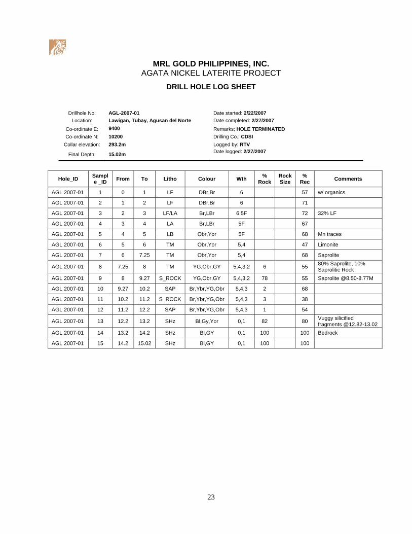
23
MRL GOLD PHILIPPINES, INC.
AGATA NICKEL LATERITE PROJECT
DRILL HOLE LOG SHEET
Drillhole No: AGL-2007-01 Date started: 2/22/2007 Location: Lawigan, Tubay, Agusan del Norte Date completed: 2/27/2007
Co-ordinate E: 9400 Remarks; HOLE TERMINATED Co-ordinate N: 10200 Drilling Co.: CDSI
Collar elevation: 293.2m Logged by: RTV
Final Depth: 15.02m Date logged: 2/27/2007
Hole_ID Sample _ID From To Litho Colour Wth %
Rock Rock Size
% Rec Comments
AGL 2007-01 1 0 1 LF DBr,Br 6 57 w/ organics
AGL 2007-01 2 1 2 LF DBr,Br 6 71
AGL 2007-01 3 2 3 LF/LA Br,LBr 6.5F 72 32% LF
AGL 2007-01 4 3 4 LA Br,LBr 5F 67
AGL 2007-01 5 4 5 LB Obr,Yor 5F 68 Mn traces
AGL 2007-01 6 5 6 TM Obr,Yor 5,4 47 Limonite
AGL 2007-01 7 6 7.25 TM Obr,Yor 5,4 68 Saprolite
AGL 2007-01 8 7.25 8 TM YG,Obr,GY 5,4,3,2 6 55 80% Saprolite, 10% Saprolitic Rock
AGL 2007-01 9 8 9.27 S_ROCK YG,Obr,GY 5,4,3,2 78 55 Saprolite @8.50-8.77M
AGL 2007-01 10 9.27 10.2 SAP Br,Ybr,YG,Obr 5,4,3 2 68
AGL 2007-01 11 10.2 11.2 S_ROCK Br,Ybr,YG,Obr 5,4,3 3 38
AGL 2007-01 12 11.2 12.2 SAP Br,Ybr,YG,Obr 5,4,3 1 54
AGL 2007-01 13 12.2 13.2 SHz Bl,Gy,Yor 0,1 82 80 Vuggy silicified fragments @12.82-13.02
AGL 2007-01 14 13.2 14.2 SHz Bl,GY 0,1 100 100 Bedrock
AGL 2007-01 15 14.2 15.02 SHz Bl,GY 0,1 100 100
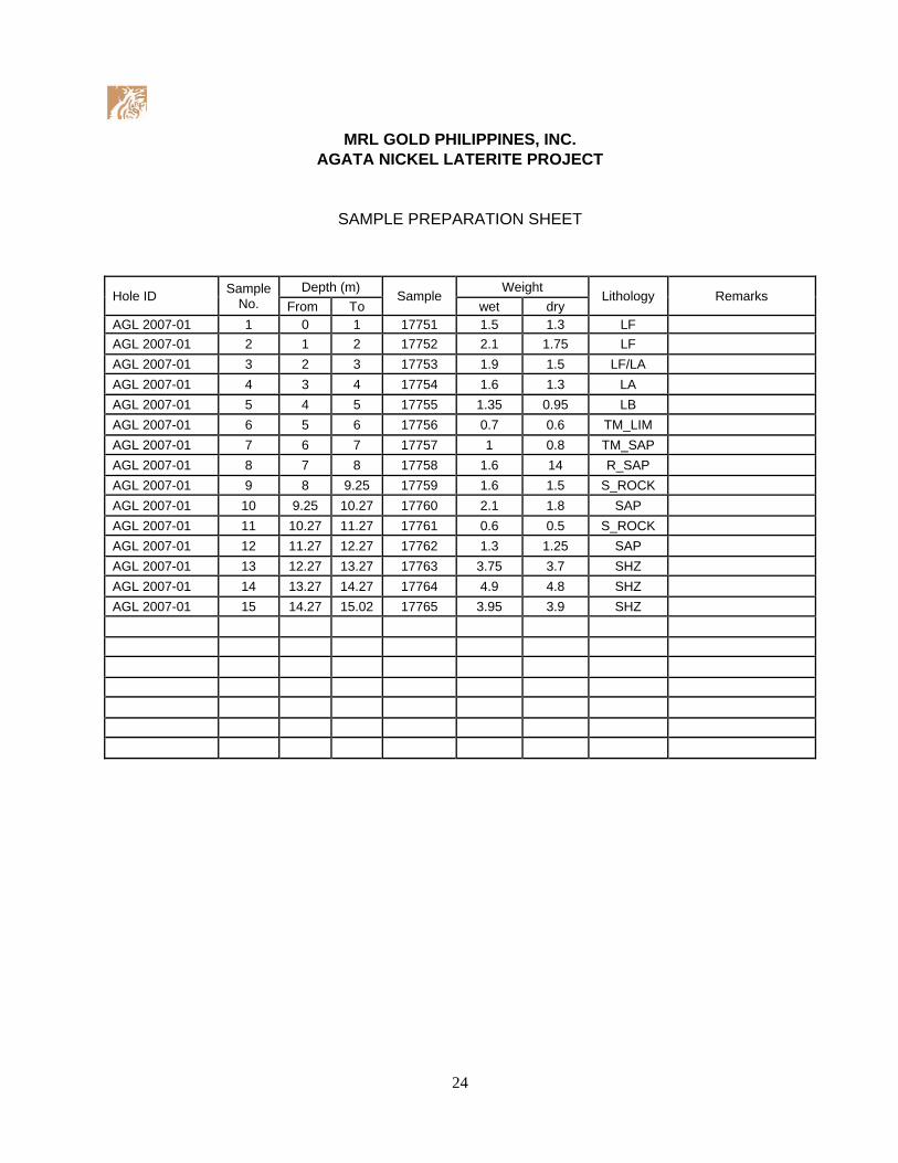
24
MRL GOLD PHILIPPINES, INC.
AGATA NICKEL LATERITE PROJECT
SAMPLE PREPARATION SHEET
Hole ID Sample No.
Depth (m) Sample
Weight Lithology Remarks
From To wet dry AGL 2007-01 1 0 1 17751 1.5 1.3 LF AGL 2007-01 2 1 2 17752 2.1 1.75 LF
AGL 2007-01 3 2 3 17753 1.9 1.5 LF/LA AGL 2007-01 4 3 4 17754 1.6 1.3 LA
AGL 2007-01 5 4 5 17755 1.35 0.95 LB AGL 2007-01 6 5 6 17756 0.7 0.6 TM_LIM
AGL 2007-01 7 6 7 17757 1 0.8 TM_SAP AGL 2007-01 8 7 8 17758 1.6 14 R_SAP
AGL 2007-01 9 8 9.25 17759 1.6 1.5 S_ROCK AGL 2007-01 10 9.25 10.27 17760 2.1 1.8 SAP
AGL 2007-01 11 10.27 11.27 17761 0.6 0.5 S_ROCK AGL 2007-01 12 11.27 12.27 17762 1.3 1.25 SAP
AGL 2007-01 13 12.27 13.27 17763 3.75 3.7 SHZ AGL 2007-01 14 13.27 14.27 17764 4.9 4.8 SHZ
AGL 2007-01 15 14.27 15.02 17765 3.95 3.9 SHZ
25
M R L G O L D P H I L S . , I N C .
TRANSMITTAL RECEIPT FOR COURIER
DATE : March 29, 2007
ATTENTION: LBC Express, P. Burgos St., Butuan City Please acknowledge
receipt of the following (in duplicate copies):
1 Crate #1 (28 bags) 55 kg. Tracking no. 6019694795 2 Crate #2 (25 bags) 62 kg. Tracking no. 6019694617 3 Crate #3 (27 bags) 66 kg. Tracking no. 6019694637 4 Crate #4 (26 bags) 74 kg. Tracking no. 6019694735 5 Crate #5 (22 bags) 44 kg. Tracking no. 6019695586 6 Crate #6 (15 bags) 35 kg. Tracking no. 6019694775 Dispatched by: Danilo F. Odtojan Date and time: 3/29/07 5:40 pm
Delivered by: Danilo F. Odtojan Date and time: 3/29/07 5:40 pm
Received by: (LBC personnel) Rico A. Orjansa Date and time received: 3/29/07 5:40 pm
Please use separate sheet when necessary.
D:\MRL-SURIGAO PROJECT\DOCUMENTS\FORMS\LBC_BXU_TR_24Mar07.doc
Eledia Apt., Tuazon Village, Barangay Luna, Surigao City Telefax No.: (6386)826-2658 • www.mindoro.com
26
Form No. SMP - 001
SAMPLE SUBMISSION FORM TO : McPhar Assay Laboratory BJS Compound 1869 P. Domingo Street Makati, Metro Manila
Tel. No. 896-1656 / 896-1681 / 896-7973 Fax No. 890-0290 email [email protected]
FROM : MRL Gold Phils., Inc. Unit 17b, Pearl of the Orient Bldg. 1318 Roxas Blvd. corner P. Faura, Ermita Manila Elidia Apt., Tuazon Vill., KM.3, Surigao City
Tel. No. 02 5258869 / 086 8262658 Fax No. email No. of Samples: 195 CORE DISPATCH No. 2007 AGL 02
SAMPLE DESCRIPTION NO. SAMPLE TYPE
PREPARATION INSTRUCTIONS
SEE McPHAR REF. DOC NO. SMP-003 SECTIONS
SP1 TO SP9
ELEMENTS REQUIRED
ASSAY METHOD(S) SEE McPHAR REF. DOC NO. SMP-003
OTHER INSTRUCTION
Box # 1
17894 - 17910 17 core
Ni, Co, Fe, Mg and Al,
Dissolving a 25g: charge with a two acid digest. (using hydrochloric and nitric acid) and reading the results by atomic absorption spectroscopy (AAS)
Box # 2
17911 - 17937 27 core
Box # 3
17938 - 17960 23 core
Box # 4 17961 - 17988 28 core
Si Si Analysis by a gravimeter process.
Box # 5
17989 - 17800 12 core
17501 - 17519 19 core
For Density Analysis : After Density Analysis return to tag no. From : 17585 back to 17563 17586 back to 17565 17587 back to 17570 17588 back to 17581
Box # 6 17520 - 17545 26 core
Box # 7
17546 - 17562 17 core
Box # 8 Note : All samples must be analyzed for the 6 elements as indicated 17563 - 17588 26 core
Reporting Send results and invoice to person indicated below Send results and invoice to : Fax results to :
E-mail : [email protected]/[email protected]
Submitted by Ferland Tagura Date 14-Apr-07
TEL: 896-1656; 896-1681; 896-7973 FAX: (63-2) 815-8195; (63-2) 761-2080 FAX: (63-2) 890-0290 e-mail: [email protected] email: [email protected]

Appendix 4
Certificates for Nickel Reference Materials from Geostats Pty., Australia

GEOSTATS PTY LTDSample and Assay Monitoring Services
Certified Base Metal Reference Material Product Code
GBM302-8Certified Control Values
Base Metal AnalysesElement Grade Standard Deviation No of Analyses Confidence IntervalNickel (ppm) 10775 668 51 +/- 183.3Copper (ppm) 89 10 61 +/- 2.5Zinc (ppm) 132 53 57 +/- 13.8Lead (ppm) 13 7 31 +/- 2.5Arsenic (ppm) 29 12 44 +/- 3.5Cobalt (ppm) 483 31 49 +/- 8.7Silver (ppm) 1.5 1.2 18 +/- 0.55
CRM Details
Neutron ActivationAnalysis Results (ppm)
Control Statistic Details Antimony 1.25Control statsitics were produced from results accumulated in the : Arsenic 33.10
April-2002 Geostats Pty Ltd Laboratory Round Robin Program. Barium -100.0018 laboratories (at least) tested this material for base metal content. Bromine 19.201 laboratories tested this material using Neutron Activation Analysis. Cadmium nr
Cerium 4.61Caesium 1.47
Source Material Chromium 13300.00Prior to homogenisation and testing, this material was sourced from Cobalt 508.00Nickel Laterite - Eastern Goldfields Europium -0.50
Gold ppb 34.40Hafnium -0.50
Colour Designation Iridium ppb -20.00Moderate yellowish brown Iron % 18.70
Lanthanum 3.71Lutetium -0.20
Usage Molybendum 49.80This product is for use in the mining industry as reference materials for monitoring and testing Nickel nrthe accuracy of laboratory assaying. Rubidium -20.00
Samarium 0.82Preparation and Packaging Scandium 15.70All standards are dried in an oven for a minimum of 12 hours at 110C. The dry material is then Selenium -5.00pulverised to better than 75 micron (nominal mean of 45 micron) using an Air Classifier. The Sodium % 0.27material is then homogenised and stored in a sealed, stable container ready for final packaging. Tantalum -1.00
Tellurium -5.00Materials are statistically sampled from stores, then packaged into either heat sealed, air tight, Terbium nrplastic pulp packets or screw top sealed plastic containers ready for distribution. All packaging Thorium 1.08has been chosen to ensure minimal contamination from outside sources during shipment, use Tin nrand storage. Tungsten -2.00
Uranium -2.00Ytterbium -0.50
Assay Testwork Zinc 172.00All standards are tested thoroughly in the Geostats bi-annual laboratory survey. This involves Zirconium -500.00assaying by a minimum of 50 reputable laboratories selected from across the world. Results Calcium% -1.00are compiled into a comprehensive report detailing statistics for each standard. Assay Potassium % -0.20distributions are checked and processed statistically, producing monitoring statistics for these Silver -5.00standards. Materials are tested regularly to ensure stability and homogeneity. Mercury nr
Neodymium nrStrontium nr
10A Marsh Close, O'Connor, Western Australia 6163Phone : +61 8 9314 2566, Fax : +61 8 9314 3699
e-mail : [email protected], [email protected] http://www.geostats.com.au
Geo
stat
s Pt
y Lt
d, C
ertif
ied
Bas
e M
etal
Ref
eren
ce M
ater
ial,
Prod
uct C
ode
:G
BM
302-
8
GEOSTATS PTY LTDSample and Assay Monitoring Services
Certified Base Metal Reference Material Product Code
GBM398-4Certified Control Values
Base Metal AnalysesElement Grade Standard Deviation No of Analyses Confidence IntervalNickel (ppm) 4071 187 104 +/- 35.9Copper (ppm) 3891 195 147 +/- 31.5Zinc (ppm) 5117 229 127 +/- 39.8Lead (ppm) 11714 776 122 +/- 137.8Arsenic (ppm) 12 9 72 +/- 2.1Cobalt (ppm) 1974 125 56 +/- 32.7Silver (ppm) 48.7 5.1 126 +/- 0.89
CRM Details
Neutron ActivationAnalysis Results (ppm)
Control Statistic Details Antimony 12.25Control statsitics were produced from results accumulated in the : Arsenic 6.93
April-1998 Geostats Pty Ltd Laboratory Round Robin Program. Barium -100.0056 laboratories (at least) tested this material for base metal content. Bromine 1.561 laboratories tested this material using Neutron Activation Analysis. Cadmium nr
Cerium 9.52Caesium 24.90
Source Material Chromium 2050.00Prior to homogenisation and testing, this material was sourced from Cobalt 2010.00Low grade Cu,Pb,Zn from surface with laterite Europium -0.50
Gold ppb 166.00Hafnium 22.30
Colour Designation Iridium ppb -20.00Pale reddish brown Iron % 4.69
Lanthanum 3.73Lutetium -0.30
Usage Molybendum 847.50This product is for use in the mining industry as reference materials for monitoring and testing Nickel nrthe accuracy of laboratory assaying. Rubidium 686.50
Samarium 1.33Preparation and Packaging Scandium 7.26All standards are dried in an oven for a minimum of 12 hours at 110C. The dry material is then Selenium -5.00pulverised to better than 75 micron (nominal mean of 45 micron) using an Air Classifier. The Sodium % 1.47material is then homogenised and stored in a sealed, stable container ready for final packaging. Tantalum -2.00
Tellurium -10.00Materials are statistically sampled from stores, then packaged into either heat sealed, air tight, Terbium nrplastic pulp packets or screw top sealed plastic containers ready for distribution. All packaging Thorium 1.25has been chosen to ensure minimal contamination from outside sources during shipment, use Tin nrand storage. Tungsten 4.21
Uranium -2.00Ytterbium 1.40
Assay Testwork Zinc 4725.00All standards are tested thoroughly in the Geostats bi-annual laboratory survey. This involves Zirconium 743.00assaying by a minimum of 50 reputable laboratories selected from across the world. Results Calcium% 1.54are compiled into a comprehensive report detailing statistics for each standard. Assay Potassium % 2.91distributions are checked and processed statistically, producing monitoring statistics for these Silver 45.00standards. Materials are tested regularly to ensure stability and homogeneity. Mercury nr
Neodymium nrStrontium nr
10A Marsh Close, O'Connor, Western Australia 6163Phone : +61 8 9314 2566, Fax : +61 8 9314 3699
e-mail : [email protected], [email protected] http://www.geostats.com.au
Geo
stat
s Pt
y Lt
d, C
ertif
ied
Bas
e M
etal
Ref
eren
ce M
ater
ial,
Prod
uct C
ode
:G
BM
398-
4
GEOSTATS PTY LTDSample and Assay Monitoring Services
Certified Base Metal Reference Material Product Code
GBM901-1Certified Control Values
Base Metal AnalysesElement Grade Standard Deviation No of Analyses Confidence IntervalNickel (ppm) 8037 489 59 +/- 124.8Copper (ppm) 57 10 58 +/- 2.6Zinc (ppm) 97 17 62 +/- 4.2Lead (ppm) 13 9 37 +/- 2.9Arsenic (ppm) 6 3 26 +/- 1.2Cobalt (ppm) 1346 77 55 +/- 20.4Silver (ppm) 1.2 1.1 22 +/- 0.46
CRM Details
Neutron ActivationAnalysis Results (ppm)
Control Statistic Details Antimony -0.20Control statsitics were produced from results accumulated in the : Arsenic 6.67
October-2001 Geostats Pty Ltd Laboratory Round Robin Program. Barium 379.0022 laboratories (at least) tested this material for base metal content. Bromine 4.571 laboratories tested this material using Neutron Activation Analysis. Cadmium nr
Cerium 10.60Caesium -1.00
Source Material Chromium 6450.00Prior to homogenisation and testing, this material was sourced from Cobalt 1370.00Nickel Laterite Kalgoorlie Region Europium -0.50
Gold ppb -5.00Hafnium -0.50
Colour Designation Iridium ppb -20.00Pale Brown Iron % 14.30
Lanthanum 6.43Lutetium -0.20
Usage Molybendum 57.30This product is for use in the mining industry as reference materials for monitoring and testing Nickel nrthe accuracy of laboratory assaying. Rubidium 40.10
Samarium 0.72Preparation and Packaging Scandium 11.20All standards are dried in an oven for a minimum of 12 hours at 110C. The dry material is then Selenium -5.00pulverised to better than 75 micron (nominal mean of 45 micron) using an Air Classifier. The Sodium % 0.11material is then homogenised and stored in a sealed, stable container ready for final packaging. Tantalum -1.00
Tellurium -5.00Materials are statistically sampled from stores, then packaged into either heat sealed, air tight, Terbium nrplastic pulp packets or screw top sealed plastic containers ready for distribution. All packaging Thorium -0.50has been chosen to ensure minimal contamination from outside sources during shipment, use Tin nrand storage. Tungsten -2.00
Uranium -2.00Ytterbium -0.50
Assay Testwork Zinc -100.00All standards are tested thoroughly in the Geostats bi-annual laboratory survey. This involves Zirconium -500.00assaying by a minimum of 50 reputable laboratories selected from across the world. Results Calcium% -1.00are compiled into a comprehensive report detailing statistics for each standard. Assay Potassium % -0.20distributions are checked and processed statistically, producing monitoring statistics for these Silver -5.00standards. Materials are tested regularly to ensure stability and homogeneity. Mercury nr
Neodymium nrStrontium nr
10A Marsh Close, O'Connor, Western Australia 6163Phone : +61 8 9314 2566, Fax : +61 8 9314 3699
e-mail : [email protected], [email protected] http://www.geostats.com.au
Geo
stat
s Pt
y Lt
d, C
ertif
ied
Bas
e M
etal
Ref
eren
ce M
ater
ial,
Prod
uct C
ode
:G
BM
901-
1
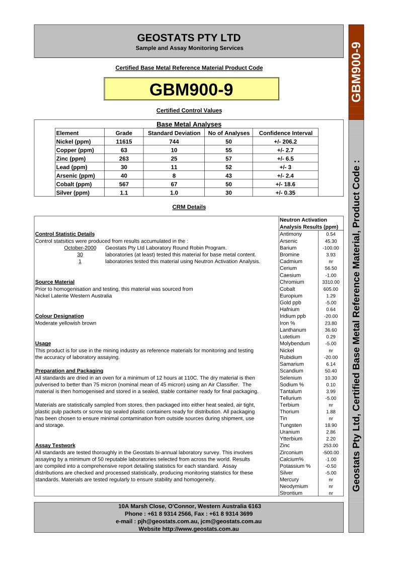
GEOSTATS PTY LTDSample and Assay Monitoring Services
Certified Base Metal Reference Material Product Code
GBM900-9Certified Control Values
Base Metal AnalysesElement Grade Standard Deviation No of Analyses Confidence IntervalNickel (ppm) 11615 744 50 +/- 206.2Copper (ppm) 63 10 55 +/- 2.7Zinc (ppm) 263 25 57 +/- 6.5Lead (ppm) 30 11 52 +/- 3Arsenic (ppm) 40 8 43 +/- 2.4Cobalt (ppm) 567 67 50 +/- 18.6Silver (ppm) 1.1 1.0 30 +/- 0.35
CRM Details
Neutron ActivationAnalysis Results (ppm)
Control Statistic Details Antimony 0.54Control statsitics were produced from results accumulated in the : Arsenic 45.30
October-2000 Geostats Pty Ltd Laboratory Round Robin Program. Barium -100.0030 laboratories (at least) tested this material for base metal content. Bromine 3.931 laboratories tested this material using Neutron Activation Analysis. Cadmium nr
Cerium 56.50Caesium -1.00
Source Material Chromium 3310.00Prior to homogenisation and testing, this material was sourced from Cobalt 605.00Nickel Laterite Western Australia Europium 1.29
Gold ppb -5.00Hafnium 0.64
Colour Designation Iridium ppb -20.00Moderate yellowish brown Iron % 23.80
Lanthanum 36.60Lutetium 0.29
Usage Molybendum -5.00This product is for use in the mining industry as reference materials for monitoring and testing Nickel nrthe accuracy of laboratory assaying. Rubidium -20.00
Samarium 6.14Preparation and Packaging Scandium 50.40All standards are dried in an oven for a minimum of 12 hours at 110C. The dry material is then Selenium 10.30pulverised to better than 75 micron (nominal mean of 45 micron) using an Air Classifier. The Sodium % 0.10material is then homogenised and stored in a sealed, stable container ready for final packaging. Tantalum 3.99
Tellurium -5.00Materials are statistically sampled from stores, then packaged into either heat sealed, air tight, Terbium nrplastic pulp packets or screw top sealed plastic containers ready for distribution. All packaging Thorium 1.88has been chosen to ensure minimal contamination from outside sources during shipment, use Tin nrand storage. Tungsten 18.90
Uranium 2.86Ytterbium 2.20
Assay Testwork Zinc 253.00All standards are tested thoroughly in the Geostats bi-annual laboratory survey. This involves Zirconium -500.00assaying by a minimum of 50 reputable laboratories selected from across the world. Results Calcium% -1.00are compiled into a comprehensive report detailing statistics for each standard. Assay Potassium % -0.50distributions are checked and processed statistically, producing monitoring statistics for these Silver -5.00standards. Materials are tested regularly to ensure stability and homogeneity. Mercury nr
Neodymium nrStrontium nr
10A Marsh Close, O'Connor, Western Australia 6163Phone : +61 8 9314 2566, Fax : +61 8 9314 3699
e-mail : [email protected], [email protected] http://www.geostats.com.au
Geo
stat
s Pt
y Lt
d, C
ertif
ied
Bas
e M
etal
Ref
eren
ce M
ater
ial,
Prod
uct C
ode
:G
BM
900-
9

GEOSTATS PTY LTDSample and Assay Monitoring Services
Certified Base Metal Reference Material Product Code
GBM901-2Certified Control Values
Base Metal AnalysesElement Grade Standard Deviation No of Analyses Confidence IntervalNickel (ppm) 8830 606 118 +/- 109.3Copper (ppm) 306 28 134 +/- 4.8Zinc (ppm) 125 43 134 +/- 7.3Lead (ppm) 16 10 90 +/- 2.1Arsenic (ppm) 69 12 98 +/- 2.4Cobalt (ppm) 314 35 118 +/- 6.4Silver (ppm) 1.2 1.2 43 +/- 0.35
CRM Details
Neutron ActivationAnalysis Results (ppm)
Control Statistic Details Antimony 1.59Control statsitics were produced from results accumulated in the : Arsenic 74.35
October-2001 Geostats Pty Ltd Laboratory Round Robin Program. Barium -100.0043 laboratories (at least) tested this material for base metal content. Bromine 28.901 laboratories tested this material using Neutron Activation Analysis. Cadmium nr
Cerium 3.02Caesium 1.66
Source Material Chromium 11750.00Prior to homogenisation and testing, this material was sourced from Cobalt 340.50Nickel Laterite Ore Eastern Goldfields Europium -0.50
Gold ppb 23.50Hafnium -0.50
Colour Designation Iridium ppb -20.00Grayish orange Iron % 18.35
Lanthanum 1.62Lutetium -0.20
Usage Molybendum -20.00This product is for use in the mining industry as reference materials for monitoring and testing Nickel nrthe accuracy of laboratory assaying. Rubidium 26.75
Samarium 0.30Preparation and Packaging Scandium 13.15All standards are dried in an oven for a minimum of 12 hours at 110C. The dry material is then Selenium -5.00pulverised to better than 75 micron (nominal mean of 45 micron) using an Air Classifier. The Sodium % 0.43material is then homogenised and stored in a sealed, stable container ready for final packaging. Tantalum -1.00
Tellurium -5.00Materials are statistically sampled from stores, then packaged into either heat sealed, air tight, Terbium nrplastic pulp packets or screw top sealed plastic containers ready for distribution. All packaging Thorium -0.50has been chosen to ensure minimal contamination from outside sources during shipment, use Tin nrand storage. Tungsten 2.88
Uranium -2.00Ytterbium -0.50
Assay Testwork Zinc 169.00All standards are tested thoroughly in the Geostats bi-annual laboratory survey. This involves Zirconium -500.00assaying by a minimum of 50 reputable laboratories selected from across the world. Results Calcium% -1.00are compiled into a comprehensive report detailing statistics for each standard. Assay Potassium % -0.20distributions are checked and processed statistically, producing monitoring statistics for these Silver -5.00standards. Materials are tested regularly to ensure stability and homogeneity. Mercury nr
Neodymium nrStrontium nr
10A Marsh Close, O'Connor, Western Australia 6163Phone : +61 8 9314 2566, Fax : +61 8 9314 3699
e-mail : [email protected], [email protected] http://www.geostats.com.au
Geo
stat
s Pt
y Lt
d, C
ertif
ied
Bas
e M
etal
Ref
eren
ce M
ater
ial,
Prod
uct C
ode
:G
BM
901-
2
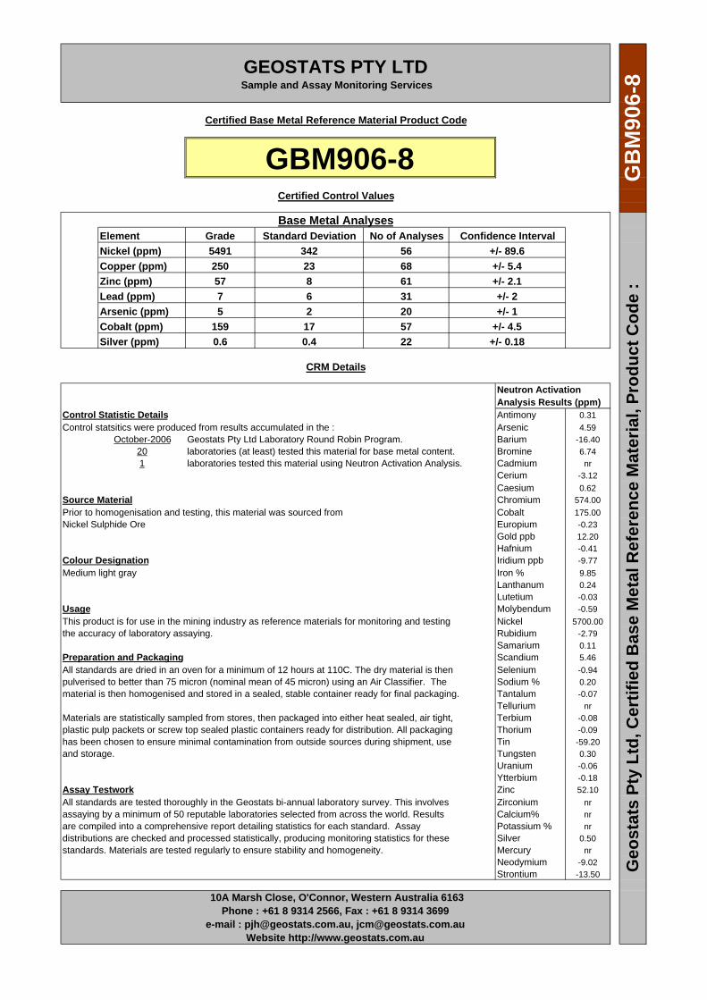
GEOSTATS PTY LTDSample and Assay Monitoring Services
Certified Base Metal Reference Material Product Code
GBM906-8Certified Control Values
Base Metal AnalysesElement Grade Standard Deviation No of Analyses Confidence IntervalNickel (ppm) 5491 342 56 +/- 89.6Copper (ppm) 250 23 68 +/- 5.4Zinc (ppm) 57 8 61 +/- 2.1Lead (ppm) 7 6 31 +/- 2Arsenic (ppm) 5 2 20 +/- 1Cobalt (ppm) 159 17 57 +/- 4.5Silver (ppm) 0.6 0.4 22 +/- 0.18
CRM Details
Neutron ActivationAnalysis Results (ppm)
Control Statistic Details Antimony 0.31Control statsitics were produced from results accumulated in the : Arsenic 4.59
October-2006 Geostats Pty Ltd Laboratory Round Robin Program. Barium -16.4020 laboratories (at least) tested this material for base metal content. Bromine 6.741 laboratories tested this material using Neutron Activation Analysis. Cadmium nr
Cerium -3.12Caesium 0.62
Source Material Chromium 574.00Prior to homogenisation and testing, this material was sourced from Cobalt 175.00Nickel Sulphide Ore Europium -0.23
Gold ppb 12.20Hafnium -0.41
Colour Designation Iridium ppb -9.77Medium light gray Iron % 9.85
Lanthanum 0.24Lutetium -0.03
Usage Molybendum -0.59This product is for use in the mining industry as reference materials for monitoring and testing Nickel 5700.00the accuracy of laboratory assaying. Rubidium -2.79
Samarium 0.11Preparation and Packaging Scandium 5.46All standards are dried in an oven for a minimum of 12 hours at 110C. The dry material is then Selenium -0.94pulverised to better than 75 micron (nominal mean of 45 micron) using an Air Classifier. The Sodium % 0.20material is then homogenised and stored in a sealed, stable container ready for final packaging. Tantalum -0.07
Tellurium nrMaterials are statistically sampled from stores, then packaged into either heat sealed, air tight, Terbium -0.08plastic pulp packets or screw top sealed plastic containers ready for distribution. All packaging Thorium -0.09has been chosen to ensure minimal contamination from outside sources during shipment, use Tin -59.20and storage. Tungsten 0.30
Uranium -0.06Ytterbium -0.18
Assay Testwork Zinc 52.10All standards are tested thoroughly in the Geostats bi-annual laboratory survey. This involves Zirconium nrassaying by a minimum of 50 reputable laboratories selected from across the world. Results Calcium% nrare compiled into a comprehensive report detailing statistics for each standard. Assay Potassium % nrdistributions are checked and processed statistically, producing monitoring statistics for these Silver 0.50standards. Materials are tested regularly to ensure stability and homogeneity. Mercury nr
Neodymium -9.02Strontium -13.50
10A Marsh Close, O'Connor, Western Australia 6163Phone : +61 8 9314 2566, Fax : +61 8 9314 3699
e-mail : [email protected], [email protected] http://www.geostats.com.au
Geo
stat
s Pt
y Lt
d, C
ertif
ied
Bas
e M
etal
Ref
eren
ce M
ater
ial,
Prod
uct C
ode
:G
BM
906-
8

GEOSTATS PTY LTDSample and Assay Monitoring Services
Certified Base Metal Reference Material Product Code
GBM906-7Certified Control Values
Base Metal AnalysesElement Grade Standard Deviation No of Analyses Confidence IntervalNickel (ppm) 5562 276 58 +/- 71.1Copper (ppm) 362 25 66 +/- 6.1Zinc (ppm) 51 11 64 +/- 2.8Lead (ppm) 8 4 41 +/- 1.1Arsenic (ppm) 25 4 41 +/- 1.4Cobalt (ppm) 210 14 57 +/- 3.6Silver (ppm) 0.9 0.3 44 +/- 0.1
CRM Details
Neutron ActivationAnalysis Results (ppm)
Control Statistic Details Antimony 0.68Control statsitics were produced from results accumulated in the : Arsenic 25.90
October-2006 Geostats Pty Ltd Laboratory Round Robin Program. Barium -16.0041 laboratories (at least) tested this material for base metal content. Bromine 3.051 laboratories tested this material using Neutron Activation Analysis. Cadmium nr
Cerium -3.74Caesium -0.16
Source Material Chromium 1360.00Prior to homogenisation and testing, this material was sourced from Cobalt 223.00Oxide / transition Ni cap rock Europium 0.34
Gold ppb 17.50Hafnium -0.32
Colour Designation Iridium ppb 13.90Pale yellowish brown Iron % 9.68
Lanthanum 2.11Lutetium 0.07
Usage Molybendum -0.58This product is for use in the mining industry as reference materials for monitoring and testing Nickel 5700.00the accuracy of laboratory assaying. Rubidium -2.69
Samarium 0.61Preparation and Packaging Scandium 5.29All standards are dried in an oven for a minimum of 12 hours at 110C. The dry material is then Selenium -1.14pulverised to better than 75 micron (nominal mean of 45 micron) using an Air Classifier. The Sodium % 0.10material is then homogenised and stored in a sealed, stable container ready for final packaging. Tantalum 0.14
Tellurium nrMaterials are statistically sampled from stores, then packaged into either heat sealed, air tight, Terbium -0.09plastic pulp packets or screw top sealed plastic containers ready for distribution. All packaging Thorium 1.02has been chosen to ensure minimal contamination from outside sources during shipment, use Tin -57.80and storage. Tungsten 0.74
Uranium 0.71Ytterbium 0.65
Assay Testwork Zinc 31.40All standards are tested thoroughly in the Geostats bi-annual laboratory survey. This involves Zirconium nrassaying by a minimum of 50 reputable laboratories selected from across the world. Results Calcium% nrare compiled into a comprehensive report detailing statistics for each standard. Assay Potassium % nrdistributions are checked and processed statistically, producing monitoring statistics for these Silver 0.50standards. Materials are tested regularly to ensure stability and homogeneity. Mercury nr
Neodymium 12.50Strontium -12.80
10A Marsh Close, O'Connor, Western Australia 6163Phone : +61 8 9314 2566, Fax : +61 8 9314 3699
e-mail : [email protected], [email protected] http://www.geostats.com.au
Geo
stat
s Pt
y Lt
d, C
ertif
ied
Bas
e M
etal
Ref
eren
ce M
ater
ial,
Prod
uct C
ode
:G
BM
906-
7

GEOSTATS PTY LTDSample and Assay Monitoring Services
Certified Base Metal Reference Material Product Code
GBM996-1Certified Control Values
Base Metal AnalysesElement Grade Standard Deviation No of Analyses Confidence IntervalNickel (ppm) 12700 748 47 +/- 213.8Copper (ppm) 661 60 64 +/- 14.7Zinc (ppm) 77 11 51 +/- 3Lead (ppm) 13 9 35 +/- 3Arsenic (ppm) 29 7 38 +/- 2.2Cobalt (ppm) nr nr nr nrSilver (ppm) 1.4 1.1 25 +/- 0.43
CRM Details
Neutron ActivationAnalysis Results (ppm)
Control Statistic Details Antimony 0.89Control statsitics were produced from results accumulated in the : Arsenic 29.40
October-1996 Geostats Pty Ltd Laboratory Round Robin Program. Barium -100.0025 laboratories (at least) tested this material for base metal content. Bromine 3.601 laboratories tested this material using Neutron Activation Analysis. Cadmium nr
Cerium 2.63Caesium -1.00
Source Material Chromium 1760.00Prior to homogenisation and testing, this material was sourced from Cobalt 386.00Cap ore, South West mineral field Europium -0.50
Gold ppb 18.20Hafnium -0.50
Colour Designation Iridium ppb -20.00Light brownish gray Iron % 15.80
Lanthanum 3.37Lutetium -0.20
Usage Molybendum -5.00This product is for use in the mining industry as reference materials for monitoring and testing Nickel nrthe accuracy of laboratory assaying. Rubidium -20.00
Samarium 1.08Preparation and Packaging Scandium 6.25All standards are dried in an oven for a minimum of 12 hours at 110C. The dry material is then Selenium -5.00pulverised to better than 75 micron (nominal mean of 45 micron) using an Air Classifier. The Sodium % 0.08material is then homogenised and stored in a sealed, stable container ready for final packaging. Tantalum -1.00
Tellurium nrMaterials are statistically sampled from stores, then packaged into either heat sealed, air tight, Terbium nrplastic pulp packets or screw top sealed plastic containers ready for distribution. All packaging Thorium -0.50has been chosen to ensure minimal contamination from outside sources during shipment, use Tin nrand storage. Tungsten -2.00
Uranium -2.00Ytterbium 1.04
Assay Testwork Zinc -100.00All standards are tested thoroughly in the Geostats bi-annual laboratory survey. This involves Zirconium nrassaying by a minimum of 50 reputable laboratories selected from across the world. Results Calcium% nrare compiled into a comprehensive report detailing statistics for each standard. Assay Potassium % -0.20distributions are checked and processed statistically, producing monitoring statistics for these Silver -5.00standards. Materials are tested regularly to ensure stability and homogeneity. Mercury nr
Neodymium nrStrontium nr
10A Marsh Close, O'Connor, Western Australia 6163Phone : +61 8 9314 2566, Fax : +61 8 9314 3699
e-mail : [email protected], [email protected] http://www.geostats.com.au
Geo
stat
s Pt
y Lt
d, C
ertif
ied
Bas
e M
etal
Ref
eren
ce M
ater
ial,
Prod
uct C
ode
:G
BM
996-
1
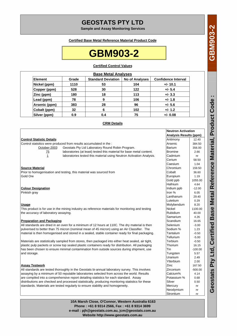
GEOSTATS PTY LTDSample and Assay Monitoring Services
Certified Base Metal Reference Material Product Code
GBM903-2Certified Control Values
Base Metal AnalysesElement Grade Standard Deviation No of Analyses Confidence IntervalNickel (ppm) 1110 53 104 +/- 10.1Copper (ppm) 528 30 122 +/- 5.4Zinc (ppm) 180 18 113 +/- 3.3Lead (ppm) 78 9 106 +/- 1.8Arsenic (ppm) 383 28 96 +/- 5.6Cobalt (ppm) 32 6 102 +/- 1.2Silver (ppm) 0.9 0.4 75 +/- 0.08
CRM Details
Neutron ActivationAnalysis Results (ppm)
Control Statistic Details Antimony 12.40Control statsitics were produced from results accumulated in the : Arsenic 384.50
October-2003 Geostats Pty Ltd Laboratory Round Robin Program. Barium 356.0075 laboratories (at least) tested this material for base metal content. Bromine 2.661 laboratories tested this material using Neutron Activation Analysis. Cadmium nr
Cerium 58.50Caesium 1.04
Source Material Chromium 159.50Prior to homogenisation and testing, this material was sourced from Cobalt 36.60Gold Ore Europium 1.19
Gold ppb 1055.00Hafnium 4.64
Colour Designation Iridium ppb -12.00Pinkish gray Iron % 6.05
Lanthanum 29.40Lutetium 0.29
Usage Molybendum 8.20This product is for use in the mining industry as reference materials for monitoring and testing Nickel 1100.00the accuracy of laboratory assaying. Rubidium 40.00
Samarium 4.26Preparation and Packaging Scandium 16.65All standards are dried in an oven for a minimum of 12 hours at 110C. The dry material is then Selenium -3.00pulverised to better than 75 micron (nominal mean of 45 micron) using an Air Classifier. The Sodium % 1.23material is then homogenised and stored in a sealed, stable container ready for final packaging. Tantalum -0.50
Tellurium -5.00Materials are statistically sampled from stores, then packaged into either heat sealed, air tight, Terbium -0.50plastic pulp packets or screw top sealed plastic containers ready for distribution. All packaging Thorium 16.15has been chosen to ensure minimal contamination from outside sources during shipment, use Tin -100.00and storage. Tungsten 5.57
Uranium 2.49Ytterbium 2.00
Assay Testwork Zinc 167.50All standards are tested thoroughly in the Geostats bi-annual laboratory survey. This involves Zirconium -500.00assaying by a minimum of 50 reputable laboratories selected from across the world. Results Calcium% 4.14are compiled into a comprehensive report detailing statistics for each standard. Assay Potassium % 0.68distributions are checked and processed statistically, producing monitoring statistics for these Silver 0.50standards. Materials are tested regularly to ensure stability and homogeneity. Mercury nr
Neodymium nrStrontium nr
10A Marsh Close, O'Connor, Western Australia 6163Phone : +61 8 9314 2566, Fax : +61 8 9314 3699
e-mail : [email protected], [email protected] http://www.geostats.com.au
Geo
stat
s Pt
y Lt
d, C
ertif
ied
Bas
e M
etal
Ref
eren
ce M
ater
ial,
Prod
uct C
ode
:G
BM
903-
2
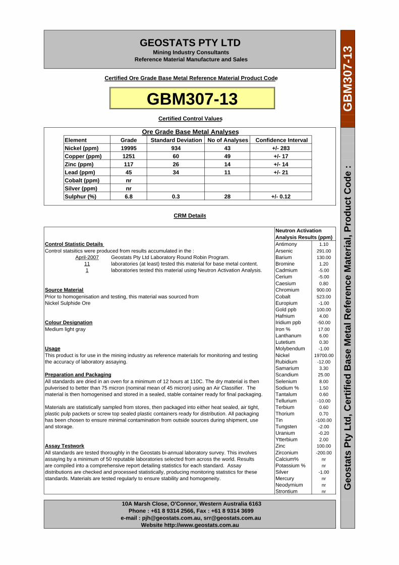
GEOSTATS PTY LTDMining Industry Consultants
Reference Material Manufacture and Sales
Certified Ore Grade Base Metal Reference Material Product Code
GBM307-13Certified Control Values
Ore Grade Base Metal AnalysesElement Grade Standard Deviation No of Analyses Confidence IntervalNickel (ppm) 19995 934 43 +/- 283Copper (ppm) 1251 60 49 +/- 17Zinc (ppm) 117 26 14 +/- 14Lead (ppm) 45 34 11 +/- 21Cobalt (ppm) nr Silver (ppm) nr Sulphur (%) 6.8 0.3 28 +/- 0.12
CRM Details
Neutron ActivationAnalysis Results (ppm)
Control Statistic Details Antimony 1.10Control statsitics were produced from results accumulated in the : Arsenic 291.00
April-2007 Geostats Pty Ltd Laboratory Round Robin Program. Barium 130.0011 laboratories (at least) tested this material for base metal content. Bromine 1.201 laboratories tested this material using Neutron Activation Analysis. Cadmium -5.00
Cerium -5.00Caesium 0.80
Source Material Chromium 900.00Prior to homogenisation and testing, this material was sourced from Cobalt 523.00Nickel Sulphide Ore Europium -1.00
Gold ppb 100.00Hafnium 4.00
Colour Designation Iridium ppb -50.00Medium light gray Iron % 17.00
Lanthanum 6.00Lutetium 0.30
Usage Molybendum -1.00This product is for use in the mining industry as reference materials for monitoring and testing Nickel 19700.00the accuracy of laboratory assaying. Rubidium -12.00
Samarium 3.30Preparation and Packaging Scandium 25.00All standards are dried in an oven for a minimum of 12 hours at 110C. The dry material is then Selenium 8.00pulverised to better than 75 micron (nominal mean of 45 micron) using an Air Classifier. The Sodium % 1.50material is then homogenised and stored in a sealed, stable container ready for final packaging. Tantalum 0.60
Tellurium -10.00Materials are statistically sampled from stores, then packaged into either heat sealed, air tight, Terbium 0.60plastic pulp packets or screw top sealed plastic containers ready for distribution. All packaging Thorium 0.70has been chosen to ensure minimal contamination from outside sources during shipment, use Tin -100.00and storage. Tungsten -2.00
Uranium -0.20Ytterbium 2.00
Assay Testwork Zinc 100.00All standards are tested thoroughly in the Geostats bi-annual laboratory survey. This involves Zirconium -200.00assaying by a minimum of 50 reputable laboratories selected from across the world. Results Calcium% nrare compiled into a comprehensive report detailing statistics for each standard. Assay Potassium % nrdistributions are checked and processed statistically, producing monitoring statistics for these Silver -1.00standards. Materials are tested regularly to ensure stability and homogeneity. Mercury nr
Neodymium nrStrontium nr
10A Marsh Close, O'Connor, Western Australia 6163Phone : +61 8 9314 2566, Fax : +61 8 9314 3699
e-mail : [email protected], [email protected] http://www.geostats.com.au
Geo
stat
s Pt
y Lt
d, C
ertif
ied
Bas
e M
etal
Ref
eren
ce M
ater
ial,
Prod
uct C
ode
:G
BM
307-
13
GEOSTATS PTY LTDSample and Assay Monitoring Services
Certified Base Metal Reference Material Product Code
GBM305-9Certified Control Values
Base Metal AnalysesElement Grade Standard Deviation No of Analyses Confidence IntervalNickel (ppm) 2536 142 53 +/- 38.3Copper (ppm) 561 19 54 +/- 5.1Zinc (ppm) 105 12 57 +/- 3Lead (ppm) 113 11 54 +/- 2.9Arsenic (ppm) 217 21 48 +/- 6Cobalt (ppm) 46 6 52 +/- 1.5Silver (ppm) 0.8 0.4 33 +/- 0.14
CRM Details
Neutron ActivationAnalysis Results (ppm)
Control Statistic Details Antimony 3.07Control statsitics were produced from results accumulated in the : Arsenic 220.00
April-2005 Geostats Pty Ltd Laboratory Round Robin Program. Barium 120.0033 laboratories (at least) tested this material for base metal content. Bromine 2.701 laboratories tested this material using Neutron Activation Analysis. Cadmium -3.70
Cerium 41.10Caesium 3.94
Source Material Chromium 193.00Prior to homogenisation and testing, this material was sourced from Cobalt 50.50South West Mineral composite gold ores Europium 0.73
Gold ppb 3460.00Hafnium 5.96
Colour Designation Iridium ppb -4.60Grayish orange Iron % 6.25
Lanthanum 21.70Lutetium 0.17
Usage Molybendum 71.50This product is for use in the mining industry as reference materials for monitoring and testing Nickel 2500.00the accuracy of laboratory assaying. Rubidium 131.00
Samarium 2.70Preparation and Packaging Scandium 15.00All standards are dried in an oven for a minimum of 12 hours at 110C. The dry material is then Selenium -1.20pulverised to better than 75 micron (nominal mean of 45 micron) using an Air Classifier. The Sodium % 0.52material is then homogenised and stored in a sealed, stable container ready for final packaging. Tantalum 1.00
Tellurium -3.90Materials are statistically sampled from stores, then packaged into either heat sealed, air tight, Terbium -0.20plastic pulp packets or screw top sealed plastic containers ready for distribution. All packaging Thorium 8.87has been chosen to ensure minimal contamination from outside sources during shipment, use Tin -67.00and storage. Tungsten 25.00
Uranium 2.70Ytterbium 0.87
Assay Testwork Zinc 100.00All standards are tested thoroughly in the Geostats bi-annual laboratory survey. This involves Zirconium 260.00assaying by a minimum of 50 reputable laboratories selected from across the world. Results Calcium% nrare compiled into a comprehensive report detailing statistics for each standard. Assay Potassium % 1.00distributions are checked and processed statistically, producing monitoring statistics for these Silver -1.20standards. Materials are tested regularly to ensure stability and homogeneity. Mercury -0.15
Neodymium 12.20Strontium nr
10A Marsh Close, O'Connor, Western Australia 6163Phone : +61 8 9314 2566, Fax : +61 8 9314 3699
e-mail : [email protected], [email protected] http://www.geostats.com.au
Geo
stat
s Pt
y Lt
d, C
ertif
ied
Bas
e M
etal
Ref
eren
ce M
ater
ial,
Prod
uct C
ode
:G
BM
305-
9
GEOSTATS PTY LTDSample and Assay Monitoring Services
Certified Ore Grade Base Metal Reference Material Product Code
GBM905-13Certified Control Values
Ore Grade Base Metal AnalysesElement Grade Standard Deviation No of Analyses Confidence IntervalNickel (ppm) 15137 716 44 +/- 211Copper (ppm) 98 11 25 +/- 4Zinc (ppm) 418 42 27 +/- 16Lead (ppm) 28 22 13 +/- 12Cobalt (ppm) nr Silver (ppm) nr Sulphur (%) nr
CRM Details
Neutron ActivationAnalysis Results (ppm)
Control Statistic Details Antimony 1.00Control statsitics were produced from results accumulated in the : Arsenic 61.60
October-2005 Geostats Pty Ltd Laboratory Round Robin Program. Barium -50.0013 laboratories (at least) tested this material for base metal content. Bromine 5.601 laboratories tested this material using Neutron Activation Analysis. Cadmium -5.00
Cerium 61.00Caesium -0.50
Source Material Chromium 4590.00Prior to homogenisation and testing, this material was sourced from Cobalt 768.00Nickel laterite ore Europium 2.00
Gold ppb 15.00Hafnium -1.00
Colour Designation Iridium ppb -50.00Light brown Iron % 31.40
Lanthanum 52.00Lutetium 0.30
Usage Molybendum 2.00This product is for use in the mining industry as reference materials for monitoring and testing Nickel 14200.00the accuracy of laboratory assaying. Rubidium -5.00
Samarium 7.50Preparation and Packaging Scandium 70.70All standards are dried in an oven for a minimum of 12 hours at 110C. The dry material is then Selenium 16.00pulverised to better than 75 micron (nominal mean of 45 micron) using an Air Classifier. The Sodium % 0.14material is then homogenised and stored in a sealed, stable container ready for final packaging. Tantalum 4.10
Tellurium -10.00Materials are statistically sampled from stores, then packaged into either heat sealed, air tight, Terbium 1.10plastic pulp packets or screw top sealed plastic containers ready for distribution. All packaging Thorium 2.80has been chosen to ensure minimal contamination from outside sources during shipment, use Tin -100.00and storage. Tungsten 23.00
Uranium 5.80Ytterbium 4.00
Assay Testwork Zinc 360.00All standards are tested thoroughly in the Geostats bi-annual laboratory survey. This involves Zirconium -200.00assaying by a minimum of 50 reputable laboratories selected from across the world. Results Calcium% nrare compiled into a comprehensive report detailing statistics for each standard. Assay Potassium % nrdistributions are checked and processed statistically, producing monitoring statistics for these Silver -2.00standards. Materials are tested regularly to ensure stability and homogeneity. Mercury nr
Neodymium nrStrontium nr
10A Marsh Close, O'Connor, Western Australia 6163Phone : +61 8 9314 2566, Fax : +61 8 9314 3699
e-mail : [email protected], [email protected] http://www.geostats.com.au
GB
M90
5-13
Geo
stat
s Pt
y Lt
d, C
ertif
ied
Bas
e M
etal
Ref
eren
ce M
ater
ial,
Prod
uct C
ode
: