Embed Size (px)
Citation preview
SELECTED THOUGHTS ON 'LATERITE'
SELECTED THOUGHTS ON 'LATERITE'
TONY EGGLETON1 AND GRAHAM TAYLOR2
Coopemtive Research Centrefor landscape Evolution and Mineml Explomtion
lAustmlian National University, ACT 0200
2University oj Canberra, ACT 2600
Abstract: 'laterite' is a word that has come to mean almost anything the user decides Its application ranges from
strict conformity to Buchanan's original definition, to any outcrop of ferruginous rock We first consider the
meanings of the word and conclude its use be discontinued We consider the ways that deeply weathered profiles
with an iron-rich upper crust develop, using examples from Weipa, the Darling Ranges and Charters Towers From
this it is eVident that while some ferruginous crusts are genetically related to their underlying weathering profiles
others are not and thus the concept of a lateritic profile is flawed The implications of three genetic models:
• seasonal tropical weathering profiles;
e lateral migration; and,
• valley bottom
for the development of ferruginous crusts (,laterite', ferricrete or bauxite) are discussed and the implications of
each for landscape evolution and the age of ferruginisation conSidered We conclude With, not a universal law of
'laterite', but rather better 'laterite' lore
This paper represents an opening salvo of what we hope will be an on-going discussion and clearing of the air
regarding 'laterite' and other ferruginous materials
Preamble
We hand you a piece of rock containing visible crystals of feldspar, quartz and biotite and ask, "What is it?" You
reply, "granite", and we can all agree that it is indeed granite We are using a common language and thus we
can have meaningful communication
We now hand you a piece of rock containing red-brown rounded bits cemented in a red-brown rusty looking stuff
"What is it?" we ask One answers, "laterite", another answers 'ferricrete'
We now hand you a rock composed of quartz grains and a few rounded red-brown lumps also cemented by red-brown
rusty looking stuff "What is this then?" "Ferricrete" one replies; 'laterite' says another Next we are in the field
together and come to a weathering profile consisting of rounded loose Fe-rich gravels over Fe-cemented Fe-rich
gravels which lie on red and white mottled clays and sands that grade down into white clays and sands and eventually
into fresh granite The question arises, "What are we looking at here?" Many might answer "A laterite"
We are now confused The rocks we showed you were cemented by Fe-rich material and yet some called it
'laterite' and others ferricrete, and when we examined the weathering profile some called this a 'laterite' also
Although we have been in the field together and looked at lots of rocks and outcrops we are obviously not
communicating otherwise we would not be confused about what you mean when you use the word 'laterite' Nor
do we understand how 'laterite' and 'ferricrete' differ because they look similar
The difference between the materials lies not in them but in us How we use these words depends on who taught us,
where we study, our experience, and our beliefs If we are to advance our science we must speak the same language
And that language must evoke the same or similar images of how these features may have come to be the way they
are. For example, if we mention schist, you will immediately have a mental picture of a rock with metamorphic minerals
and a well-developed schisosity Not only that but your mind will also conjure images of regional metamorphism,
pressures, temperatures and mineral growth by solid state diffusion So the use of a word to describe a rock also
carries genetiC links, which we as geoscientists use to communicate whole sets of information and ideas
'Laterite' and 'lateritic profile' are words But they convey different meanings and connotations to different
professionals Are they then useful words?
209
TONY EGGLETON AND GRAHAM TAYLOR
INTRODUCTION
This paper is the beginning of what we hope to be a series
of articles raising issues with respect to the nature and
origin of ferruginous regolith materials It is also designed
to provide some insights to lessons learned by the
authors as they have tussled with ferruginous problems
The confusion over whether 'laterite' refers to a material
or a group of materials organised in a particular way derives
from the misuse of a word originally coined to describe a
material by extending its use to describe a profile in which
this material commonly occurs in its type area, Kerala in
southwestem India In Australia many of these problems
originate with the very good early work done in a geological
environment very different from today's For example the,
then modern, geomorphic ideas of Davis (1889) held sway
for a long time and strongly influenced the work of
Australian geologists like David, Jutson and Woolnough,
who in turn influenced subsequent generations until about
the late 1960's, and some still hold to those paradigms
Additionally, because various authors have attributed
particular genetic connotations to the occurrence of
'laterite profiles', further confusion has resulted
regarding the geological meaning of 'laterite profiles'
This in turn has lead to confusion over the age and
environments of formation of the profiles
In this paper we attempt to:
• throw some light on the use of the word 'laterite' to
describe a material;
• comment on whether a 'lateritic profile' is the result
of in situ weathering or otherwise;
• look briefly at ferruginous weathering materials at
some localities; and,
• summarise the examples to evaluate some models
for the genesis of ferruginous accumulations
associated with weathering profiles in Australia
The word 'laterite'
Buchanan (1807), to whom the term 'laterite' is
attributed, described it as follows (from Oilier & Pain
1996):
"It is a diffused in great masses, without any
appearance of stratification, and is placed over
the granite that forms the basis of Malayala It is
210
full of cavities and pores, and contains a very
large quantity of iron in the form of red and yellow
ochres In the mass, while excluded from air, it is
so soft that any iron instrument readily cuts it,
and it is cut into square masses with a pick axe
and immediately cut into the shape wanted with a
trowel or large knife It soon becomes as hard as
brick, and resists the air and water much better
than any bricks I have seen it in Indian
There is no doubt that if we accept the precedence of
Buchanan the material called 'laterite' is a massive
softish material containing diffuse hematite and goethite
There is little doubt that the idea of any ferruginised
regolith material being called 'laterite' is not in keeping
with precedent This does not however, make the term
redundant, but simply restricts its use to soft materials
containing diffuse Fe-oxides
Despite matters of precedent, the word 'laterite is used to
describe almost any materials rich in Fe-oxides, particularly
hard materials There is however little consistency in its use
For example, Anand (1997) uses 'laterite' to describe
residual ferruginous materials and 'ferricrete' to indicate
'secondary' ferruginous materials The distinction being that
the former is ferruginised in Situ material while the latter is
ferruginised transported material Pain et al (1991) do not
use the term at all, but rather use ferricrete to describe any
Fe-oxide cemented regolith materials Hunt et al (1977)
saw 'laterites' as pedological modifications of earlier Fe-rich
zones of the underlying Mesozoic rocks Hunt (1980)
recommended the term 'laterite' no longer be used
Bourman (1995a, 1995b) is firmly of the opinion that
'laterite' is a term which has become redundant and he refers
to all regolithic Fe-oxide cemented materials as ferricrete
The idea of 'laterite profiles' and laterisation
Buchanan (1807) described 'laterite' as being part of a
weathering profile containing dispersed Fe-oxides
overlying granite We begin by using the expression
'lateritic profile' as a preliminary indication of the
phenomenon of laterisation
'Lateritic profiles' have been described in Australia from
many parts of the country The aspects of these, which
we include for the purposes of this discussion, are:
• with or without an uppermost, varyingly hard, Fe
oxide- and/or alumina-rich regolith which commonly
has a pisolitic part;
• beneath this a region which has a patchy distribution
of Fe-oxyhydroxides, commonly referred to as a
mottled zone or mottled horizon;
• beneath this a region which is largely devoid of Fe
oxyhydroxides, and which commonly is clay-rich,
referred to by some as a pallid zone or a bleached
zone, and by others as a plasmic horizon;
• beneath this saprolite; and,
• beneath this rock
There is no presumption in this description of a regolith
profile that the upper regions are alteration products of
the lower region Some (e g Milnes et al 1985,
Bourman et al 1987, Oilier & Galloway 1990, Oilier &
Pain 1996) suggest that rarely, if ever, is the ferruginous
upper part conformable over the lower parts Others
(from Jutson 1914 and Walther 1915, 1916 to Anand et
al 1997) consider the upper regions to represent the
deeply weathered equivalent of the underlying rocks
TuB OLD MASTBRS
In 1914, Jutson defined 'laterite' as: A rock which usually
forms in dry climates as a cap on the surface of other
rocks generally containing iron An essential constituent
of laterites is an iron compound, but silica and other
substances may be present
Walther (1915, 1916) gives extensive descriptions and
interpretations of 'laterite', including the Western
Australian 'laterites' His (1916) definition includes his
recognition that:
"the primary laterite is not a rock but rather a
weathering blanket"
In his 1915 paper "Laterite in Western Australia" he
wrote:
"The question arises first of all, what should be
called "laterite"? Which rock was given the name
by Buchanan in his time as the original rock can
not be ascertained today - in any case Buchanan
described it as "red clay used for brick
production", and compared it to the "terra
SELECTED THOUGHTS ON 'LATERITE'
211
lapidea" of previous authors Certainly he did not
mean the hard iron crust of the overlying unit of
the described profile Considering the facts that
white, yellow, violet-red matt/ed, red and brown
red plastiC clays lie one upon another without
sharp boundary in the laterite profiles I have
investigated, it appears to me expedient to
deSignate the whole phenomenon as laterisation
(lateritisation is linguistically incorrect)
The geological mappers of east India over the
past 50 years have laid the emphasis on the
surficial iron crust, and describe only this as
laterite; later observers have repeatedly followed
this interpretation - alone, I hold this diagnosis to
be incorrect It contradicts first of all the rule of
priority, also it selects an admittedly frequent but
by no means universal aspect of the laterite
profile, and puts this so to the fore that numerous
just as important and just as wide-spread
elements of the fully described profile are not
included in the definition"
"The geological age and formation of laterite" followed
this paper in (1916) In this he declares:
"Then the issue is the primary laterite is not a
rock but rather a weathering blanket"
According to Walther:
"Foote [ working in India] defined lateritic rocks In
two groups The high plain laterite is a primary
weathering product and always occurs in its
original position A hard iron crust from 1-2
metres thick, which is resistant to denudation,
overlies red and red-mottled clays under which
the coloured iron salts disappear and give way to
a white body
The iron crust mostly forms an overhanging top
layer, deep caverns open occasionally beneath it
and gigantic blocks have slid down the hill slope
The pale clay under the iron crust has a thickness
of about 30-50 metres The variegated upper
part I will call the mottled zone, the de-coloured
lower part the pallid (pale) zone
After all, there can be no doubt, that the whole
pallid zone with the overlying mottled zone
besides the iron crust arises from the weathering
of the underlying rocks"
TONY EGGLETON AND GRAHAM TAYLOR
Walther absolutely considered that 'laterite'
encompasses a variety of materials, generally involving
three distinct aspects (crust, mottled zone, and pallid
zone), but not necessarily involving all three He argues
that one cannot go on the iron crust alone:
"The iron crust is not always developed as it is
described as a continuous sheet Following
Jutson (sadly I have not seen such occurrences
myself), the iron-enriched greenstones have an
especially hard and thick iron crust, over granites
(there is) a silcrete blanket Also their (the crusts
over granites) structure often appears not to be
so cohesive that it can withstand erosion If it
becomes eroded, then depending on the depth
of denudation comes to light the red upper zone,
the coloured mottled zone or the white pallid
zone If one should follow such outcrops from
one to another, then one will be irresolute as to
which one should be called "laterite" "
Furthermore, he deSCribes 'laterite' where no iron crust
is present
observes:
For example, in the 1916 paper he
"In Ceylon by Mount Lavinia I saw one metre
brown loam, 2 m brick red mottled laterite, 2 m
light red to grey decomposed gneiSS, 3 m of
fresh grey gneiss"
Here there is no mention of an iron crust, either hard or
soft And later he writes:
'/'in especially interesting outcrop at the rapids of
the Kalu Ganga offered me the opportunity to
observe the first true veins of graphite Here one
sees in a 12 m deep open cast mine, the mottled
zone of a laterised gneiss, and contrasting
effectively with the variegated mottled clay wall,
the branching coal black altered graphite Here
there can be no doubt that the thick clay body
weathered (= laterised) cumulatively in situ"
The development of mottled clay is, to Walther, the
development of 'laterite' We reiterate that Walther saw
'laterite' encompasses the whole profile, not simply the
hard Fe-rich crust
TIm NEW MASTERS
The most recent 'authority' would appear to be the
compilation by Aleva (1994) It draws heavily on
schellmann (1983) for its definition of 'laterite'
212
" laterites are mineral assemblages which have
formed as a result of intensive subaerial
weathering of rocks"
" laterites are primarily to be regarded as rocks"
"They belong to the group of residual rocks "
" they should be defined according to the same
criteria as other rocks, i e on the basis of their
genesis and of their mineral content"
"all the severely weathered varieties should be
Included in the laterite group"
"They consist predominantly of mineral
assemblages of goethite, hematite, aluminium
hydroxides, kaolinite minerals and quartz The
5i02 (AI203+Fe203) ratio of a laterite must be
lower than that of the kaolinised parent rock in
which all the alumina of the parent rock is present
in the form of kaolinite, all the iron in the form of
Iron OXides, and which contains no more silica than
is fixed in the kaolinite plus the primary quartz "
It is quite clear from this that schellmann treats 'laterite' as
a material, not a profile It is also clear that the definition
embraces anything (nore weathered than saprolite
Both Walther (1915, 1916) and schellmann (1983),
while clearly recognising the common development of a
triad of crust, mottled zone and pallid zone, do not
consider this triad to be essential to the definition:
'laterite' is defined by what it is:
(schellmann) "all the severely weathered varieties";
and, (Walther) "laterite is not a rock but rather a weathering blanket"
However, just as clearly, they are in complete opposition
about the way to define 'laterite' Walther (1915, 1916)
says it is NOT a rock, schellmann (1983) says it certainly
is The International Soil Reference and Information
Centre in Aleva's (1994) compilation adopted
schellmann's view of 'laterite' Yet that recent work is
qUite contradictory within itself Having completely
opted for the Schell mann (1983) definition (p 14),
several of the examples given contradict that definition
schellmann's definition is consistent with that of Millot
(1964), who grouped those parts of the profile between
saprolite and soil as 'laterite' (Aleva Fig 3A) But this is
contrary to Aleva's own examples of 'laterite' profiles
(Aleva Fig 3B), which include only the upper part of the
profile above saprolite as 'laterite', having a mottled zone
and a plasmic zone between 'laterite' and saprolite The
same view is presented in Aleva (his Figure 9A),
attributed to Anand etal (1991): 'laterite' is only a small
part of the profile, below the soil and above the mottled
zone It appears that in Aleva's compilation, 'laterite' is
being used in three ways "The typical laterite profile"
comprises (from the top) soil, 'laterite', mottled zone,
plasmic zone, saprolite, saprock and bedrock Of these
components, according to the Schellmann definition
accepted by Aleva, the plasmic zone, the mottled zone
and the 'laterite' are themselves all 'laterite' Thus:
• the plasmic zone is 'laterite';
• the mottled zone is 'laterite';
• the 'laterite' is 'laterite'; and,
• a profile may be 'laterite'
One may be forgiven for concluding that Aleva's
compilation falls somewhat short of helpful clarity (ie
completely confuses the issue)
Oilier and co-workers have provided a useful approach to
using the word 'laterite' Their main recommendation seems
to be not to use the word at all, and if you must then to
confine its use to the kinds of materials reported by Buchanan
(1807) Oilier's definition is generally in agreement with
Buchanan (1807) and Walther (1915, 1916) who
emphasised again and again the importance of the red
colouration For example, Walther in his 1915 publication:
Following the procedure by Buchanan, who put
the main emphaSIS on the red colour, it is
therefore appropriate in the narrow sense to
characterise red weathering masses as laterite"
Oilier's definition only includes a part of the material
Schellmann calls 'laterite', and it excludes the
ferruginous (or aluminous) crust, which is just the part
that almost every geologist in Australia describes as
'laterite' Oilier recommends in several publications the
use of ferricrete for any iron-cemented regolith Pain &
Oilier (1992) use lateritic profile in the same way as
other workers, except they do not use the word 'laterite'
to describe any part of the profile The ferruginous crust,
should there be one, they describe as ferricrete
Ferricrete is a word introduced by Lamplugh (1902)
According to the AGI Glossary of Geology (Jackson
1997), ferricrete is (a) a sandstone or conglomerate
consisting of surficial sand and gravel cemented into a
hard mass by iron salts derived from the oxidation of
percolating solutions of iron salts (b) A ferruginous
duricrust Most recent Australian authors appear to have
accepted definition (b)
SELECTED THOUGHTS ON 'LATERITE'
213
Bourman (1993) seems to agree with Pain & Oilier (1992)
in preferring not to use the word 'laterite' He wrote:
"The term 'laterite' may ultimately disappear, to
be replaced by ferricrete, ferruginous
duricrust
It appears that Bourman is equating 'laterite' with the
upper ferricrete crust
McFarlane (1983 )uses 'laterite' in much the same way
as is found in the compilation of Aleva (1994):
"The typical laterite profile is said to comprise
laterite overlYing mottled and pallid zones
that is, to McFarlane, 'laterite' is both a profile and a material
Davy (1979) defined 'laterite' for the purposes of his
study of Darling Range bauxite as
"a general term for surface or near surface
material composed largely of iron and/or
aluminium sesqui-oxides Though bauxite is a better known term for aluminous laterite, the
general term, laterite, will be used for both
varieties except in discussions of their origins,
when it will be restricted to the dominantly
ferruginous variety"
Davy's usage has elements of Schellmann's definition in
not being restricted to ferricrete or bauxite: "near surface
material composed largely of iron and/or aluminium
sesqui-oxides", but seems to lean somewhat toward
restricting the term to kaolin-poor material This is not
surprising, as Davy found almost no kaolin in his Darling
Range profiles Granite saprolite is overlain by quartz
sesquioxide regolith, all of which can be classed as
'laterite' on Schellmann's definition, though strict
adherence to Schellmann contradicts some of Davy's
field classifications The lack of kaolinite is unusual for
the Darling Range bauxite Giedans (1973) writes :"the
principal source material of baUXite is kaolinite" and
Hickman et al (1992) describe kaolinite as "present
throughout the profile" and indicate it constitutes of the
order of 15% of the granitic derived basal clay
'Laterite' is not a useful word to describe a hard
ferruginous duricrust and we suggest the word not be
used for such materials
SOME AUSTRALIAN 'LATERITES'
THE YILGARN PLATEAU
Western Yilgarn (Darling Ranges)
Many so-called 'laterite profiles', referred to by Oilier &
Pain (1996) as Walther profiles, are found in southwestem
Westem Australia from the Darling Range escarpment
TONY EGGLETON AND GRAHAM TAYLOR
eastward through the wheat belt 'Laterite' (largely as
bauxite) mantles the hills and slopes across the Darling
Ranges, conforming very much to the topography
(Geidans, 1973, Hickman et al 1992) East of the Darling
Ranges the 'laterites' take the form of mesas or
breakaways with Fe-oxide cemented resistant flat upper
surfaces, the softer parts of the profile below providing the
steeper slopes of "breakaways" Jutson (1914) concluded
from the conformity of the mesa surfaces that they
represented the dissected remnants of a former
peneplain, now uplifted to form the "Great Plateau"
Weathering of the peneplain produced a broadly extensive
'laterite' "as thin surface caps on the underlying rocks"
The present landscape he interpreted to have resulted
from erosion which has since removed most of that prior
plain, leaving lateritic surfaced remnants as evidence of its
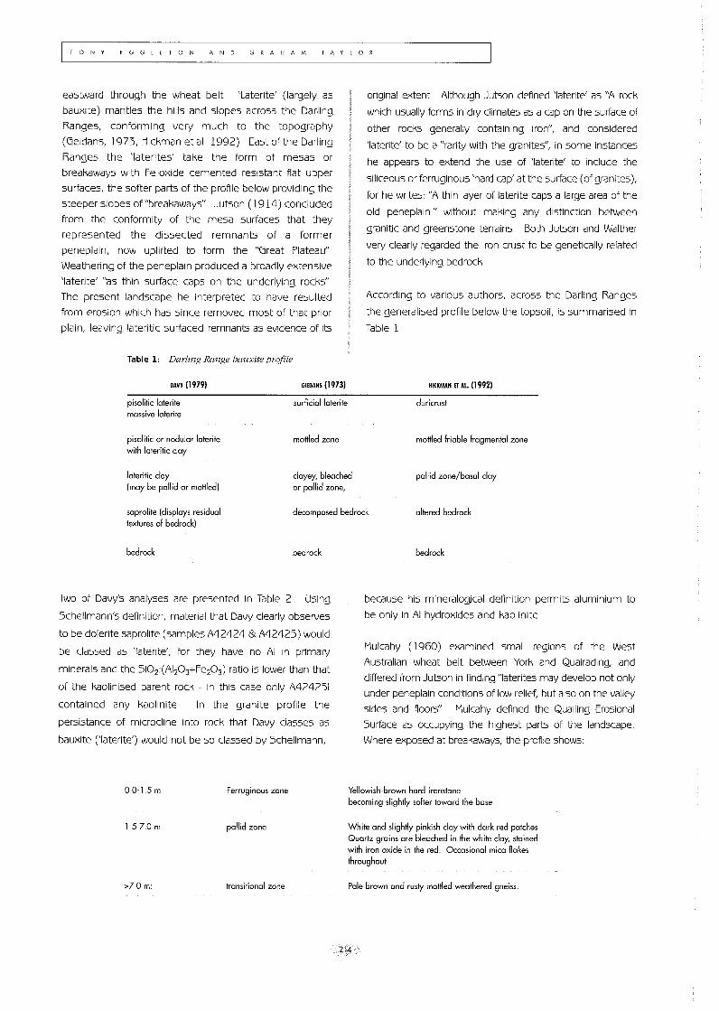
Table 1: Darling Range bauxite profile
DAVY (1979)
pisolitic loterite massive laterite
pisolitic or nodular laterite with lateritic clay
GIEDANS (1973)
surficial laterite
married zone
original extent Although Jutson defined 'laterite' as "A rock
which usually forms in dry climates as a cap on the surface of
other rocks generally containing iron", and considered
'laterite' to be a "rarity with the granites", in some instances
he appears to extend the use of 'laterite' to include the
siliceous or ferruginous 'hard cap' at the surface (of granites),
for he writes: "A thin layer of laterite caps a large area of the
old peneplain" without making any distinction between
granitic and greenstone terrains Both Jutson and Walther
very clearly regarded the iron crust to be genetically related
to the underlying bedrock
According to various authors, across the Darling Ranges
the generalised profile below the topsoil, is summarised in
Table 1
HICKMAN ET AI. (1992)
duricrust
morrled friable fragmental zone
lateritic clay (may be pallid or mottled)
clayey, bleached or pallid zone,
pallid zone/basal clay
saprolite (displays residual textures of bedrock)
decomposed bedrock altered bedrock
bedrock bedrock
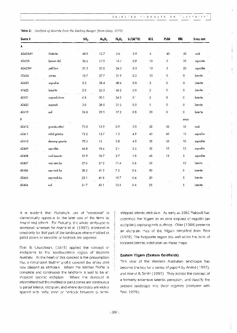
Two of Davy's analyses are presented in Table 2 Using
Schellmann's definition, material that Davy clearly observes
to be dolerite saprolite (samples A42424 & A4242S) would
be classed as 'laterite', for they have no AI in primary
minerals and the Si02:(AI203+Fe203) ratiO is lower than that
of the kaolinised parent rock - in this case only A4242S1
contained any kaolinite In the granite profile the
persistance of microcline into rock that Davy classes as
bauxite (,laterite') would not be so classed by Schell mann,
00-15 m Ferruginous zone
1 5-7.0 m pallid zone
>70 m: transitional zone
bedrock
because his mineralogical definition permits aluminium to
be only in AI hydroXides and kaolinite
Mulcahy (1960) examined small regions of the West
Australian wheat belt between York and Quairading, and
differed from Jutson in finding "laterites may develop not only
under peneplain conditions of low relief, but also on the valley
sides and floors" Mulcahy defined the Quailing Erosional
Surface as occupying the highest parts of the landscape
Where exposed at breakaways, the profile shows:
Yellowish-brown hard ironstone becoming slightly softer toward the base
White and slightly pinkish clay with dark red patches Quartz grains are bleached in the white clay, stained with iron oxide in the red Occasional mica flakes throughout
Pale brown and rusty mottled weathered gneiss
214
S E lEe TED THOUGHTS o N I L ATE R ! TE'
Table 2: Analyses a/Bauxite from the Darling Ranges (from Davy, 1979)
SAMPLE # SI02 Al203
A
42425UN Dolerite 480 127
424251 brown dol 30.5 175
42425W yell/brn 21.3 210
42424 cortex 107 277
42423 saprolite 2.3 284
42422 bauxite 20 23.3
42421 caprock base 68 301
42420 caprock 30 385
42419 soil 368 295
42412 granite,wthrd 735 139
42411 wthd granite 732 137
42410 decomp granite 705 15
42409 saprolite 66.8 184
42408 nod bauxite 539 267
42407 nod cern bx 276 372
42406 cap-rock bx 282 41.2
42405 cap-rock bx 22.1 418
42404 soil 247 42.1
It is eVident that Mulcahy's use of "erosional" is
diametrically opposite to the later use of the term by
Anand and others For Mulcahy, the whole landscape is
erosional, whereas for Anand et al (1997), erosional is
used only for that part of the landscape where mottled or
pallid zones or saprolite or bedrock are exposed
Finkl & Churchward (1973) applied the concept of
etchplains to the southwestern region of Western
Australia At the heart of this concept is the presumption
that a continuous Walther profile covered the entire area
now classed as etch plain Where the Walther Profile is
complete and continuous the landform is said to be an
incipient lateritic etchplain Where the duricrust is
intermittent but the mottled or pallid zones are continuous
is partial lateritic etch plain, and where duricrusts are Widely
spaced with pallid zone or bedrock between is semi-
FE203 SI/(Al+FE) QTZ PLAG HBl SCHELL DEFN
36 29 5 40 50 rock
167 0.9 10 5 35 saprolite
24.5 05 10 5 20 saprolite
319 02 10 0 0 laterite
406 0.0 2 0 0 laterite
462 00 2 0 0 laterite
342 01 5 0 0 laterite
310 0.0 5 0 0 laterile
172 08 35 0 0 laterite
mica
09 5.0 35 55 10 rock
1 3 49 40 60 10 saprolite
28 40 55 35 10 saprolite
2.1 33 50 25 10 saprolite
37 18 45 15 5 saprolite
114 06 25 10 laterite
7.2 06 30 5 laterite
107 0.4 20 5 laterite
135 04 25 5 laterite
stripped lateritic etchplain As early as 1961 Mabbutt had
described the Yilgarn as an area stripped of regolith (an
etchplain) exposing rock surfaces Oilier (1984) presents
an etchplain map of the Yilgarn simplified from Finkl
(1979) The Kalgoorlie region sits well within the zone of
incipient lateritic ectchplain on these maps
215
Eastern Yilgarn (Eastern Goldfields)
This view of the Western Australian landscape has
become the key for a series of papers by Anand (1997),
and Anand & Smith (1992) They accept the concept of
a formerly extensive lateritic peneplain, and classify the
present landscape into three regimes (compare with
Finkl 1979):
I
TONY EGGLETON AND GRAHAM TAYLOR
residual
erosional
depositional
where the full lateritic profile is
preserved
where the duricrust has been lost but
parts of the mottled zone, pallid zone,
saprolite or bedrock are exposed, and,
where the products of the erosion of
the adjacent lateritic profile have been
deposited
Pain & Oilier (1995b) suggest a very different
interpretation of the evolution of this landscape They
note that few of the ironstone mesas actually are flat;
rather they dip gently away from the breakaway Drilling
through the back-slope at some distance from the
ironstone edge of the breakaways discloses sediment,
not a Walther profile Such observations, argue Pain &
Oilier, do not conform to the concept of a former
extensive lateritised land surface, and rather suggest
valley-flanking deposits However Finkl & Churchward
(1973) did not suggest that the surface before etching
was flat In their idealised cross-sections few of the
lateritic duricrusts are flat-lying over any of the etch-plain
types In the Darling Range dipping lateritic bauxite
duricrust is commonplace where bauxite mantles the
whole undulating landscape Both Geidans (1973) and
Hickman et al (1992) emphasise that across the Darling
Range residual bauxite profiles are thickest on the
slopes and thinnest at the crests Thus the most
extensive Western Australian duricrusts are neither
completely continuous nor remotely planar The detailed
mapping of the Darling Range bauxite reveals that they
are thickest on the hill slopes, which might suggest that
with prolonged erosion, the remnants would be these
thickest, valley flanking duricrusts
Another, but controversial, view is expressed by
Glassford & Semeniuk (1995) who suggest that the
eastern Yilgarn lateritic profiles are a composite of in situ
weathering and sedimentary deposits The contend that
the profile consists of in situ saprolite overlain by aeolian
and fluvial facies which now form the mottled and pallid
zones of the "traditional laterite profile" The 'laterite',
ferricrete and bauxite they contend is formed from
altered sandy duststones While this is a radical view it
has not been tested and their ideas bear some
resemblance to the view of Oilier & Galloway (1990)who
contend most lateritic (or Walther) profiles contain within
them unconformities Brimhall et al (1991) also
advocates significant aeolian accession to the profiles of
the Yilgarn
216
CAPE YORK, QUEENSLAND
Pain & Oilier (1992) describe a range of ferricretes from
Cape York, including deposits on valley flanks, around
shallow depressions (melon holes) and at plateau edges
or scarps Uumpups or breakaways) Many of these
ferricretes are of quite limited size, sometimes
extending as narrow belts along water courses, or "no
more than a few tens of metres back from the scarp
edge" Some such ferricretes have mottled regolith
below them and pallid regolith below that, with saprOlite
and bedrock lower still That is, some Cape York
ferricretes are part of a lateritic profile as defined by
Aleva and as Pain & Oilier define it
Pain & Oilier also refer to more extensive ferricretes
within the Weipa bauxite weathering profile They report
three levels of ferricrete; one within the zone of bauxite
pisoliths, a second within the otherwise pallid zone
consisting largely of kaolin, and a third lying at the top of
recognisable Cretaceous Rolling Downs Group fine
sandstone COMALCO mapping and mining shows that
the upper ferricrete (or ironstone) is a continuous
horizon of varying hardness and cementation According
to Foster (1997):
"The ironstone band at Weipa is composed of irregular
nodules of ferruginised kaolin in a matrix of loose
pisoliths and sandy clay The nodules may be up to 15
cm in diameter and they contain hematite, goethite,
kaolinite and quartz Hematite and goethite are most
prevalent in this zone Induration of the ironstone into a
vermiform structure sometimes occurs"
The vermiform ironstone is commonly found around
creeks and near the coast (Campbell, 1990) The
ironstone grades down into a sandy mottled zone that
contains weakly ferruginised patches and mottles
(Morgan 1991, Evans 1975)
"In places the ironstone is rock hard, but mostly it is not
greatly more resistant to bulldozing than the bauxite"
Adjacent to the Mission River the pisolitic bauxite has
been eroded leaving the more resistant ferricrete as
outcrop The lowest of the three ferricretes at Weipa is
probably part of a paleosol described by Ie Gleuher et al
(1994) occurring below an unconformity between the
Cretaceous Rolling Downs Group and the Palaeogene
Bulimba Formation Both the upper ferricrete and lower
paleosol can be regarded as similar in origin; having
formed at, or near, the top of a typical 'laterite profile'
CHARTERS TOWERS REGION, QUEENSLAND
Flat lying Tertiary sediments of the Palaeogene Southern
Cross and Neogene Campaspe Formations are exposed
as cliffs at the edges of plateaux and mesas in the
Charters Towers region of Queensland The upper edges
of these cliffs are typically very red in colour, with patchily
red (mottled) quartz-sand rich regolith a few metres
below, grading paler in colour with depth, to kaolinised
regolith In many instances the sediments are difficult to
distinguish from granitic saprolite which forms the
landscape of the regions between the mesas and
plateaux (e g Rivers et al 1995)
Models for laterite development
Because all these regolith profiles have some similar
characteristics, they are generally given the same name
(laterite or lateritic) and are generally thought to have
the same mode of formation But just what this mode is
varies according to the particular experience of the
protagonist We present three models for the
development of regolith profiles such as these, and
SELECTED THOUGHTS ON 'LATERiTE'
conclude that the processes of all three are involved to
varying extents in the establishment of a Walther profile
Modell. Lateritic (Walther) profiles develop beneath an
extensive, flat-lying land surface under a climate that is
seasonally wet
If this model is correct, one should first investigate
places where these conditions obtain, to see if lateritic
profiles do indeed develop The Weipa plateau of
northern Cape York, Queensland provides such a test
At Weipa and Andoom, and in the surrounding country,
there is a major bauxite and kaolinite resource A
number of publications have described the regolith of
the region; the following description is based on that
work and five years of research that we have undertaken
The bulk of our results are based on examination of
Comalco Limited's bauxite and kaolinite workings, on four
air-core drill holes and on regional mapping and
reconnaissance
Profile wt%oxide cumulnth't'- wt%
hlluxit" pi,qolilhs.
f<:fllJglT10U5 klloUnjte:
kaolinite
snnd) day
snprolite
Ro-lJing DOWM Fmn
C heln<llite + goethl!~ +aontlsc
Figure 1 Profile and geochemistry from the Jacaranda dnll hole at Andoom near Weipa, northern Queensland
217
ITONY EGGLETON AND GRAHAM TAYLOR
JACARAI'IDA PROFILE (FIGURE 1) Below a thin (75 cm) grey skeletal soil is up to 4 m of
pisolitic bauxite, uncemented except for some near
surface patches which are weakly cemented by
boehmite and lesser amounts of hematite
The lower boundary of bauxite is marked by a transition
over a distance of 50 cm from pisoliths to a hard,
cemented layer of ferruginous kaolinitic nodules
(ironstone) that corresponds to the wet season
watertable high This layer marks the limit of bauxite
mining (Figure 2b) Below the "iron-stone" is as m thick
zone of mottled ferruginous kaolinite, which grades
downward into a clay rich layer of the order of 10 m thick
This part of the profile is colour mottled in white, purplish
brown and fawn The clay-rich zone grades from about
20 m depth to 25 m into a sandy clay-rich saprolite,
which in turn grades to the blue-green unweathered
Rolling Downs Formation at about 30 m
The major element chemistry of this profile is presented
in Figure 1 The region of iron enrichment; the iron-stone
at the base of the bauxite and the ferruginous kaolinite
region below are clearly shown by the marked rise in
Fe203 and concomitant fall in silica and alumina
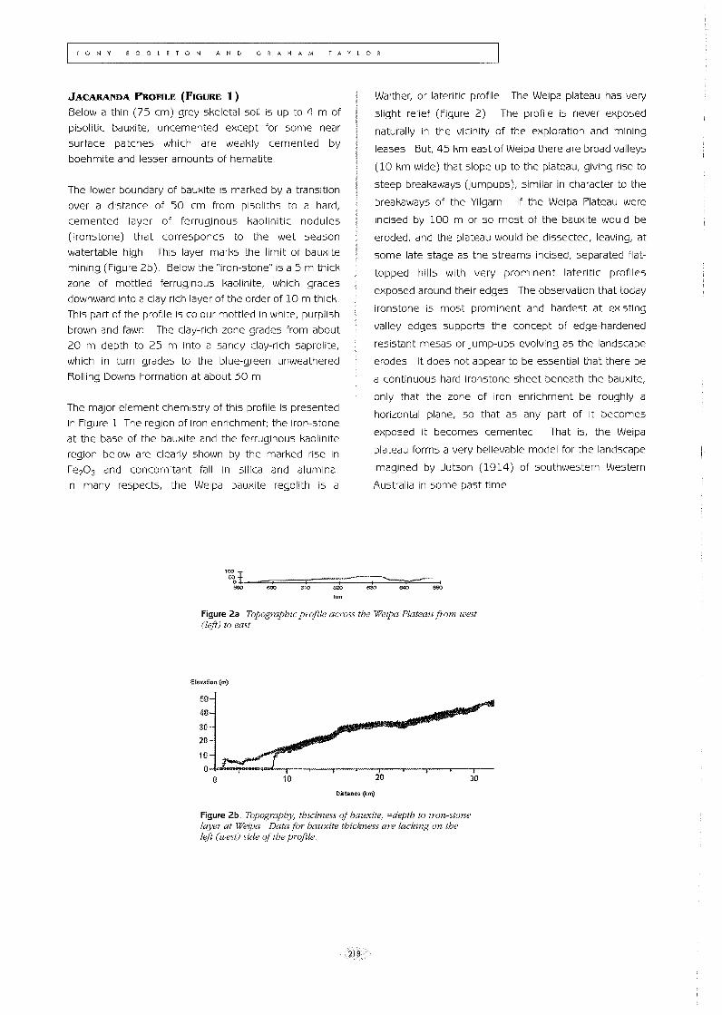
In many respects, the Weipa bauxite regolith is a
Walther, or lateritic profile The Weipa plateau has very
slight relief (Figure 2) The profile is never exposed
naturally in the vicinity of the exploration and mining
leases But, 45 km east of Weipa there are broad valleys
(10 km wide) that slope up to the plateau, giving rise to
steep breakaways Uumpups), similar in character to the
breakaways of the Yilgarn If the Weipa Plateau were
incised by 100 m or so most of the bauxite would be
eroded, and the plateau would be dissected, leaving, at
some late stage as the streams incised, separated flat
topped hills with very prominent lateritic profiles
exposed around their edges The observation that today
ironstone is most prominent and hardest at existing
valley edges supports the concept of edge-hardened
resistant mesas or jump-ups evolving as the landscape
erodes It does not appear to be essential that there be
a continuous hard ironstone sheet beneath the bauxite,
only that the zone of iron enrichment be roughly a
horizontal plane, so that as any part of it becomes
exposed it becomes cemented That is, the Weipa
plateau forms a very believable model for the landscape
imagined by Jutson (1914) of southwestern Western
Australia in some past time
':0590I_==~====~====~====~~~~~~ .I- I I I f-~[ 600 610 620 630 640 650
km
Figure 2a Topographic projile across the Weipa Plateau from west (left) to east
Elevation (m)
50-
40
30-
20
10
10
Dst!nce t)<m)
I 20
I 30
Figure 2b, Topography, thickness oj bauxite, =depth to iron-stone layer at Weipa Data for bauxite thickness are lacking on the left (west) side oj the profile
218
Model 2 latertticprofiles develap by the deep weathermg aj flatlying rocks; with the iron-stane carapace develaping by lateral migratian aj iran in salutian, which an emergence at scarps precipitates as iron oxyhydroxlde cement
TuE CHARTERS TOWERS REGION
To the west and to the south east of Charters Towers,
Queensland, flat-lying Palaeogene and Neogene
sediments overlie Paleozoic rocks, largely granites and
volcanics and form low relief plains and mesas The
Tertiary sediments comprise the fluvial facies Southern
Cross Formation, its suggested equivalent, the Suttor
Formation and overlying Campaspe Formations
(Henderson 1996) These sediments generally
terminate at escarpments 2-30 m high, below which is a
gently undulating landscape of Paleozoic bedrock and its
regolith of saprolite, lithosols or red brown earths Some
of the scarps have gently dipping back-slopes extending
a kilometre westward, beyond which is a landscape
underlain by essentially horizontal Palaeogene and
Neogene sediments for many 10's km Other scarp
faces rise to forward dipping surfaces, while others
border essentially horizontal plateaux
The upper-most 1-8 m of most of the scarps are composed
of strongly rubified gravels and sands of evidently fluvial
origin, based on the evidence of rounded quartz pebbles
and sand grains, together with mostly angular quartz sand
and gravel Some exposures show graded stratification and
crossbedding A few scarps, by contrast, are formed of
indurated granitic saprolite (Rivers 1993)
The rubified upper few metres of the scarps contain
quartz, kaolin, hematite and goethite Although the
redness and hardness of these scarp edges suggests
the use of the term "ironstone", much of the hardness is
caused by an alumino-silica cement
Generally topographically lower than the duricrusted
mesas and plateaux surfaces, extensive pisolitic
ironstone sheets and vermiform ironstone provide a
second tier in a stepped landscape
Underlying both the rubified regolith and nodular and
vermiform ironstones, are 1-10 m of mottled saprolite,
developed in either granite, Palaeogene and Neogene
sediments or paleosols Thickness and morphological
variations of these mottle horizons is common across
the landscape The mottles vary from 3-10 cm red/white
units to 05 -1 cm elongated mottles along biogenic
channels, the latter is responsible for the hardness at the
base of red earths With depth, the extent of mottling
and amount of hematite decrease, grading to a pale
coloured kaolin-rich sandy regolith overlying granitic or
sedimentary saprolite
SELECTED THOUGHTS ON 'LATERITE'
219
The conformity of the elevation of mesa and plateau
surfaces, and their stratigraphic horizontality, are strong
indications that the Palaeogene and Neogene sediments
formed an extensive sheet across the Charters Towers
region, and that erosion has removed them in those areas
where the Paleozoic bedrock is exposed An alternate
view is that the sediments only occurred in broad shallow
channels having PaleOZOiC bedrock as the interfluves If
this were so, the valley sediments must have become
sufficiently indurated before inciSion for them to be more
weathering reSistant than the interfluves, leading to a
reversal of topography Rivers et al (1995) interpretation
of the regolith at Puzzler Walls follows the latter model of
landscape evolution in that region
Argument in favour of one or other of these models may
be entirely semantic The present higher parts of a
partly eroded sediment sheet must have originally been
deposited low in the topography Similarly fluvial
sediments that were never laterally extenSive were
confined to a valley Thus a landscape inversion model
could be applied to any eminence on the Palaeogene
and Neogene sediments
The evidence in the Charters Towers region is that at
some time during the Cainozoic there was a more
extensive deposit of flat-lying sediments At their
margins, these sediments now have escarpments which
show many features of a Walther profile, sufficiently so
that it may be concluded that the whole landscape was
formerly an extensive lateritic plain, as in the Jutson
(1914) model for the Yilgarn
Detailed examination of the landscape and regolith on the
Tertiary sediments away from the escarpments (Rivers
1993) cannot sustain this model Behind the escarpment
edge induration only extends for 10-50 m, occurs only as
minor patches below red earths Red earths, 2-15 m thick
grade downward into mottled fluvial sediment saprolite
with fresh sediments below It appears that the
duricrusted 'lateritic profiles' of the escarpments only
occur exactly there, and we conclude from this that it is
the escarpment that leads to the hardening of the surface
lateritic profile, and not vice-versa In this model,
hydromorphic activity carries Fe, Si and AI in solution from
the interior to the exposed margins (as argued by Ruxton
& Taylor, 1982 and Taylor and Ruxton, 1987, where
cementing agents preCipitate forming a slabby ferricrete
similar to those described by Bourman (1989)
TONY EGGLETON AND GRAHAM TAYLOR
There are two ways the induration occurs at the edges:
• the in situ hardening of the lower regions of the red
earths due to drying out once they are incised;
and/or,
• as a result of Fe-AI-Si migration towards the edges
due to a more conducive hydraulic gradient created
in response to incision
The simple drying out and consequent hardening of the
lower parts of the red earth profiles is possible
considering the almost year round mOisture presence
within them is eliminated when they are incised, and
ferrihydrite converts to hematite on drying out
Continuing development of red and yellow earths induces
dissolution of quartz and kaolin and also Fe-oxides
depending on profile hydrology, and all these ions in the
interior move downwards slowly into a regional
groundwater flow system As a result of incision at the
edge, the hydraulic gradient is locally increased towards
the edge and the ions are rapidly carried in local
groundwater to the edge rather than to the deeper
system The ions carried in solution travel along the local
groundwater interface and either crystallise at the edge
upon oxidation of Fe2+ with a consequent drop in pH, or
to a fall in the threshold of supersaturation followed by
recrystallization after transport from tight pores in the
interior to the more porous environment created at the
incision point In fact, both the drying out hardening and
precipitation at the edges is likely to occur at some depth
in the profile « 1 m) Consequently the upper loose
surface or soil is eroded leaving the slope towards the
escarpment, or when inward drainage evolved with time,
a slope away from the escarpment This lateral migration
and precipitation model only operates on local recharge
or groundwater systems which are connected and not in
the regional flow systems which operate much deeper
and discharge at the base or into the major rivers
Although the main ferricrete at Weipa is controlled by the wet
season watertable, escarpments cut into the profile there
also cement by similar processes to those just described
The difference between the main processes of
cementation is probably climatically controlled At Weipa
the seasonal fluctuations of the watertable have formed
an extensive ferricrete; at Charters Towers intermittent
rain only established local groundwater flows
This model provides a very different method for the
development of laterite at breakaways from that of Model 1
It does not imply a former extensive duricrust, but rather it
implies that the duricrust forms in response to a particular
landscape environment, and that such a weathering profile
is essentially in equilibrium with the extant climate
Model 3 Lateritic profiles develop in the landscape as part oj a catena later erosion Cif bedrock causes the hardest part (ironstone) to become outstanding, leading to topographic reversal
Pain et al (1994) describe ferruginised gravely stream
sediments lying on slightly weathered metamorphic rock
in eastern Cape York northern Queensland These
sediments are well-cemented alluvium but are not in any
sense associated with any lateritic or Walther profile
They clearly result from Fe2+ in groundwater seepage
oxidising on exposure to the atmosphere and cementing
the sediments
Pain & Oilier (199Sa), also on Cape York, document
valley ferricretes (,laterites') formed by the cementation
of alluvium where the ferruginisation has progressively
moved downvalley as the headwaters have experienced
relief inversion In this case the ferricrete is obviously
diachronous Again there is no significant weathering
profile underlying the ferricrete or 'laterite'
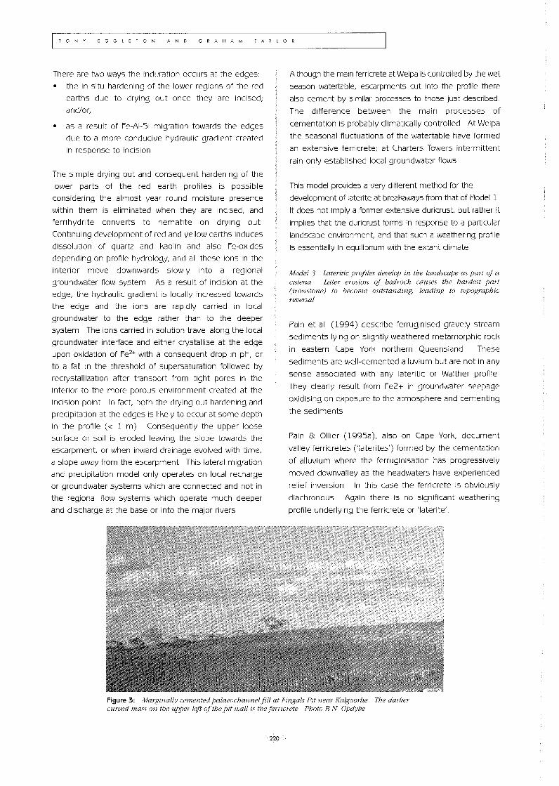
Figure 3: Margznally cemented palaeochannel fill at Fingals Pit near Kalgoorlie The darker curved mass on the upper left oj the pit wall is the ferric rete Photo B N Opdyke
220
At Fingals Pit northwest of Kalgoorlie a similar situation is
observed where a palaeochannel filled by sands and
gravel at the top of a hill is cemented at its margins by
ferricrete (Figure 3)
Milnes et al (1985) followed by Oilier and Galloway
(1990) suggest that the ferricrete found on top of
mottled and pallid saprolite is always unconformable, and
hence is not genetically related to the underlying profile
They further suggest that ferricretes, once formed, are
resistant to weathering, and in time may become the
high point in the landscape, and that this may happen in
adjacent places at different times Multiple generation of
ferricrete, according to Oilier & Galloway, makes
correlation between them absurd
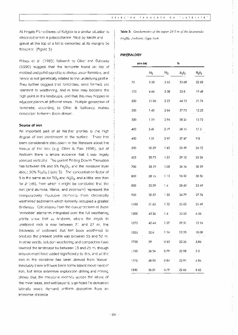
Source of iron
An important part of all Walther profiles is the high
degree of iron enrichment at the surface There has
been considerable discussion in the literature about the
source of the iron (e g Oilier & Pain 1996), but at
Andoom there is ample evidence that it was largely
sourced vertically The parent Rolling Downs Formation
has between 6% and 8% Fe203, and the ironstone layer
about 30% Fe203 (Table 3) The concentration factor of
5 is the same as for Ti02 and A1 20 3, and a little less than
for Zr (x6), from which it might be concluded that the
iron (and alumina, titania, and zirconium) represent the
comparatively insoluble elements from chemically
weathered sediments which formerly occupied a greater
thickness Calculations from the concentrations of these
'immobile' elements integrated over the full weathering
profile show that at Andoom, where the depth to
unaltered rock is now between 21 and 27 m, the
thickness of sediment that has been weathered to
produce the present profile was between 35 and 52 m
In other words, solution weathering and compaction have
lowered the landscape by between 15 and 25 m, though
erosion must have added significantly to this, and all the
iron in the ironstone has been derived from 'above'
Inevitably there will have been some lateral movement of
iron, but since extensive exploration drilling and mining
shows that the ironstone extends across the whole of
the mine lease, and well beyond, significant Fe derivation
laterally would demand uniform derivation from an
immense distance
SELECTED THOUGHTS ON 'LATERITE'I
221
Table 3: Geochemistry oj the upper 185m of the Jacaranda
Profile, Andoom, Cape York
MINERALOGY
DEPTH (CM) %
SI02 T102 Al203 FE203
75 553 265 5368 2282
125 666 258 528 19.48
200 1106 2.23 4413 2176
250 143 284 5775 12.22
350 122 294 58.24 1272
400 2.41 279 5815 173
450 131 297 5747 98
550 2029 163 3549 24.72
625 2875 123 2912 25.26
700 28.19 1.08 2616 3059
800 2815 1.12 2652 3056
850 3209 14 2843 2369
950 3052 133 2679 27.76
1100 3162 1 32 2563 25.49
1200 45.26 14 3353 6.56
1275 42.44 127 2951 1316
1525 526 116 2525 1008
1700 59 0.83 2226 586
1750 5836 079 2298 5.3
1775 5895 084 22.94 484
1850 5651 0.79 22.66 862
TONY EGGLETON AND GRAHAM TAYLOR
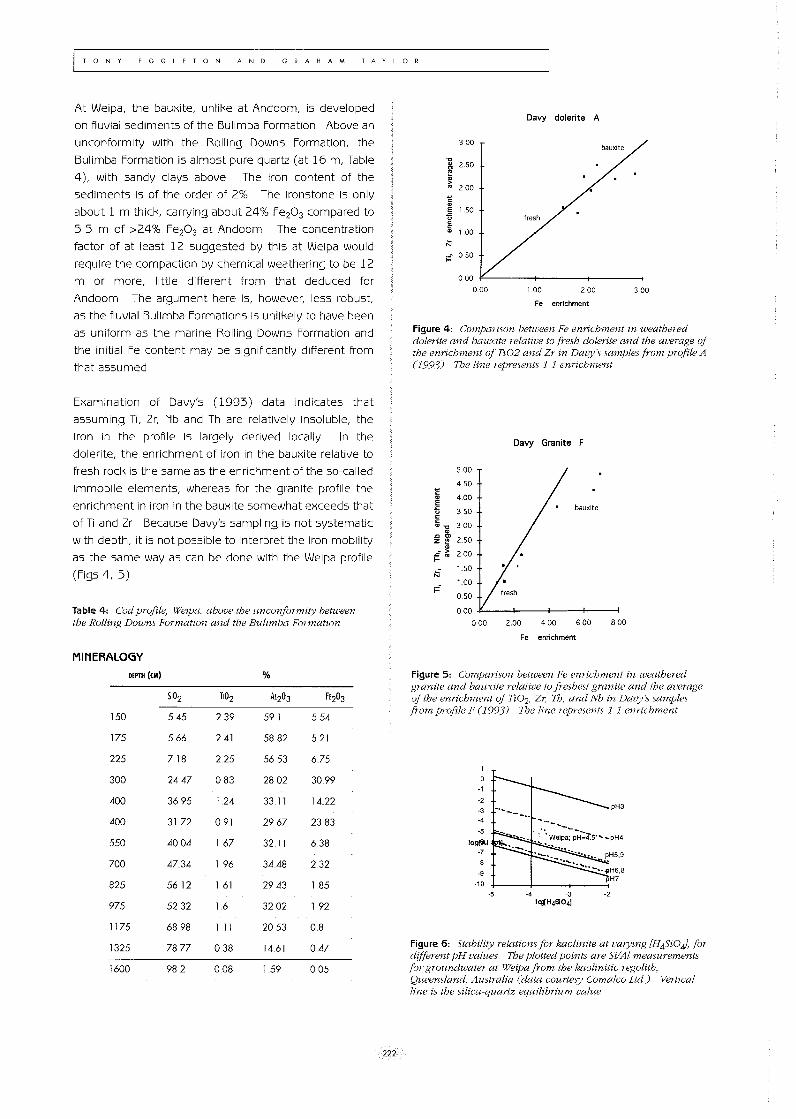
At Weipa, the bauxite, unlike at Andoom, is developed
on fluvial sediments of the Bulimba Formation Above an
unconformity with the Rolling Downs Formation, the
Bulimba Formation is almost pure quartz (at 16 m, Table
4), with sandy clays above The iron content of the
sediments is of the order of 2% The ironstone is only
about 1 m thick, carrying about 24% Fe203 compared to
5 5 m of >24% Fe203 at Andoom The concentration
factor of at least 12 suggested by this at Weipa would
require the compaction by chemical weathering to be 12
m or more, little different from that deduced for
Andoom The argument here is, however, less robust,
as the fluvial Bulimba Formations is unlikely to have been
as uniform as the marine Rolling Downs Formation and
the initial Fe content may be significantly different from
that assumed
Examination of Davy's (1993) data indicates that
assuming Ti, Zr, Nb and Th are relatively insoluble, the
iron in the profile is largely derived locally In the
dolerite, the enrichment of iron in the bauxite relative to
fresh rock is the same as the enrichment of the so-called
immobile elements, whereas for the granite profile the
enrichment in iron in the bauxite somewhat exceeds that
of Ti and Zr Because Davy's sampling is not systematic
with depth, it is not possible to interpret the iron mobility
as the same way as can be done with the Weipa profile
(Figs 4, 5)
Table 4: Cod profile, Weipa, above the unconformity between the Rolling Downs Formation and the Bulimba FormatIOn
MINERALOGY
DEPTH (eM) %
51°2 Ti02 Al203 FE203
150 545 239 591 554
175 566 241 5882 521
225 7.18 225 5653 675
300 24.47 083 2802 3099
400 3695 1.24 3311 1422
400 3172 091 2967 2383
550 4004 167 32.11 6.38
700 4734 196 3448 2.32
825 5612 161 2943 185
975 5232 1.6 3202 192
1175 6898 111 2053 08
1325 7877 038 14.61 047
1600 982 008 1 59 0.05
222
300
" ~ 2 SO
~ 200
~
~ '.50 "5 § " '00
;:: 050
Davy dolerite A
0.00 ~----t------t-------i
000 , 00 200 300
Fe enrichment
Figure 4: Comparzson between Fe enrichment in weathered dolerite and bauxite relative to fresh dolerite and the average oj the enrichment of Tz02 and Zr in Davy's samples from profile A (1993) The line represents 1 1 enrichment
Davy Granite F
500
450 ~
" 4.00 " E bauxite "5 350
" " 300 "" " .c '" 2.50 Z E " .c~ 200
t-
N ' 50
;:: 100
050
000
000 2.00 400 600 800
Fe enrichment
Figure 5: Comparison between Fe enrichment in weathered granite and bauxIte relatIVe to freshest granite and the average oj the enrichment of Ti02, Zr; Th, and Nb in Davy:s samples from profile F (1993) The line represents 1 1 enrichment
Figure 6: Stability relationsIor kaolinite at varyrng [H4Si0J, for different pH values The plotted pOints are Si/Al measurements for groundwater at Weipa from the kaolinitic regolith, Queensland, Australia (data courtesy Comalco ltd) VertIcal line is the Silica-quartz equilibrium value
Age of laterites.
At Weipa, the eVidence is qUite compelling that the lower
part of the bauxite/laterite profile is more or less in
equilibrium with the present climate The various
components of the profile conform closely to the current
water-table fluctuations, and the groundwater is in
equilibrium with its mineralogy (Figure 6) Also ferrihydrite
can be seen to be precipitating where water emerges at
the end of the wet season and hematite hydrates to
goethite in the wet season around the margins of ponds
and reverts in dry seasons There is no doubt that the Fe
minerals are "active' under the present conditions
The bauxite itself, which forms the upper 2-3 metres of the
deposit, shows some signs of undergoing retrograde
weathering, ie, resilication of the gibbsite, for the pisoliths are
coated with a thin kaolinite shell, possibly the result of reaction
between aeolian of organically derived silica and gibbsite It
may be concluded that this deposit is evolving, although it is
impossible to say how long it has been developing except in
the most general way since it clearly postdates the mid
Cretaceous at Andoom and the Palaeogene at Weipa
Hickman et al (1992) summarise many authors' views
on the evolution of the Darling Range bauxite in relation
to the topography, without committing to a preferred
interpretation Their final comment on the matter is to
note that "Terril's theory" (1948, 1956) implies that the
topography at the time of lateritisation closely resembled
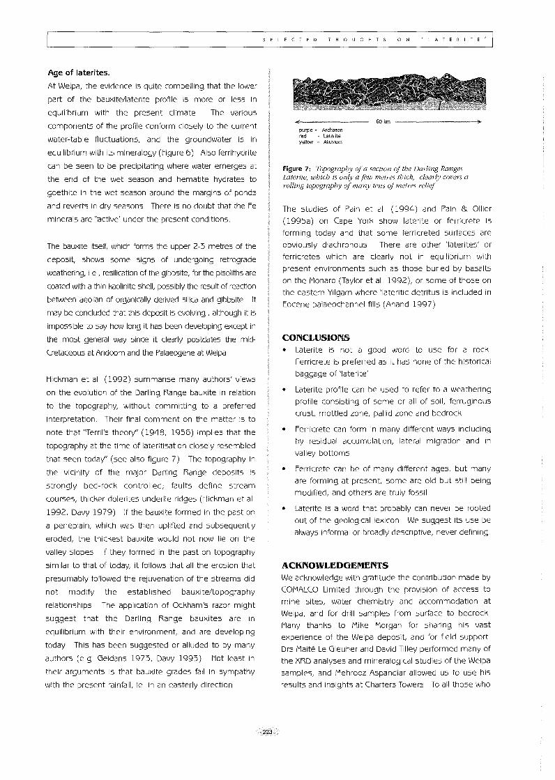
that seen today" (see also figure 7) The topography in
the viCinity of the major Darling Range deposits is
strongly bed-rock controlled; faults define stream
courses, thicker dolerites underlie ridges (Hickman et al
1992, Davy 1979) If the bauxite formed in the past on
a peneplain, which was then uplifted and subsequently
eroded, the thickest bauxite would not now lie on the
valley slopes If they formed in the past on topography
similar to that of today, it follows that all the erosion that
presumably followed the rejuvenation of the streams did
not modify the established bauxite/topography
relationships The application of Ockham's razor might
suggest that the Darling Range bauxites are in
equilibrium with their environment, and are developing
today This has been suggested or alluded to by many
authors (e.g Geidans 1973, Davy 1993) Not least in
their arguments is that bauxite grades fall in sympathy
with the present rainfall, ie in an easterly direction
SELECTED THOUGHTS ON 'LATERITE'
223
purple" Archaean red - Laterite yellow - Allu\lium
60km
Figure 7: Topography oj a section oj the Darling Ranges Laterite, which is only a few metres thick, clearly covers a rolling topography of many tens oj metres reliej
The studies of Pain et al (1994) and Pain & Oilier
(1995a) on Cape York show laterite or ferricrete is
forming today and that some ferricreted surfaces are
obviously diachronous There are other 'laterites' or
ferricretes which are clearly not in equilibrium with
present environments such as those buried by basalts
on the Monaro (Taylor et al 1992), or some of those on
the eastern Yilgarn where 'lateritic detritus is included in
Eocene palaeochannel fills (Anand 1997)
CONCLUSIONS • Laterite is not a good word to use for a rock
Ferricrete is preferred as it has none of the historical
baggage of 'laterite'
• Laterite profile can be used to refer to a weathering
profile consisting of some or all of soil, ferruginous
crust, mottled zone, pallid zone and bedrock
• Ferricrete can form in many different ways including
by residual accumulation, lateral migration and in
valley bottoms
• Ferricrete can be of many different ages, but many
are forming at present, some are old but still being
modified, and others are truly fossil
• Laterite is a word that probably can never be rooted
out of the geological lexicon We suggest its use be
always informal or broadly descriptive, never defining
ACKNOWLEDGEMENTS We acknowledge with gratitude the contribution made by
COMALCO Limited through the provision of access to
mine sites, water chemistry and accommodation at
Weipa, and for drill samples from surface to bedrock
Many thanks to Mike Morgan for sharing his vast
experience of the Weipa depOSit, and for field support
Drs Maite Le Gleuher and David Tilley performed many of
the XRD analyses and mineralogical studies of the Weipa
samples, and Mehrooz Aspandiar allowed us to use his
results and insights at Charters Towers To all those who
TONY EGGLETON AND GRAHAM TAYLOR
have helped form our prejudices we offer our sincere
thanks and hope that you don't see some of yourself in
what you have just read We also thank constructive
comment from colleagues, in particular Professor Bob
Bourman and Steve Hill This work was made possible
by ARC Grant A39232594, and by the Australian
Government's Cooperative Research Centres Program
REFERENCES
Aleva, G J J 1994 Laterites Concepts, geology,
morphology and chemistry IS RIC, Wageningen
Anand, R R 1997 Distribution, classification and
evolution of ferruginous materials over greenstones
on the Yilgarn Craton - implications for mineral
exploration State of the Regolith - Geological Society
of Australia Special Publication 20: 175-193
Anand, R and Smith, R 1992 Regolith-landform
evolution and geochemical dispersion in lateritic
regolith about the Mt Gibson gold deposits, Western
Australia Exploration Research News / CSIRO
Division of Exploration Geoscience (6): 2-4
Anand, R R, Butt, C R M, Robertson, I D M and
Smith, R E 1991 Examples of laterite profiles -
Western Australia In: Aleva, G J J (compiler),
Laterites Concepts, geology, morphology and
chemistry ISRIC, Wageningen p 55-66
Anand, R R, Phang, C, Wildman, J E and Lintern, M
J 1997 Genesis of some calcretes in the southern
Yilgarn Craton, Western Australia; implications for
mineral exploration Australian Journal of Earth
Sciences 44(1): 87-103
Bourman, R P 1989 Investigations of ferricretes and
weathered zones in parts of southern and
southeastern Australia - a reassessment of the
'laterite' concept Ph D Thesis, University of
Adealide, Adelaide (unpubl )
Bourman, R P 1993 Perennial problems in the study of
laterite: A review Australian Journal of Earth Sciences
40: 387-401
Bourman, R P 1995a A review of laterite studies in
southern South Australia Transactions of the Royal
Society of South Australia 119(1): 1-28
Bourman, R P 1995b Towards distinguishing
transported and in Situ ferricretes: data from
southern Australia AGSO Journal of Australian
Geology and GeophYSICS 16(3): 231-242
224
Bourman, R P, Milnes, A Rand Oades, J M 1987
Investigations of ferricretes and related surficial
ferruginous materials in parts of southern and
eastern Australia Zeitschrift fur Geomorphologie,
Suppl Bd 64: 1-24
Brimhall, G H, Lewis, C J, Ford, C , Bratt, .J , Taylor, G
and Warin, 0 1991 Quantitative geochemical
approach to pedogenesis: importance of parent
material reduction, volumetric expansion, and aeolian
influx in lateritization Geoderma 51: 51-91
Buchanan, F H 1807 A journey from Madras through
the Countries of Mysore, Kanara and Malabar v 1-3
East India Co , London
Campbell, I D 1990 Study of the Weipa bauxite
pisoliths in thin section Comalco Technical Report,
W T R 90/22
Davis, W M 1889 Methods and models in geographic
teaching The American Naturalist pp 566-583
Davy, R 1979 A study of laterite profiles in relation to
bedrock in the Darling Range near Perth, W,4.. Geological
SUNey of Western Australia, Report No 8 87 P
Evans, H J 1975 Weipa bauxite deposit, Queensland
Monograph Series - Australasian Institute of Mining
and Metallurgy, n 5, p 959-963 In: C L Knight
(ed ), Economic geology of Australia and Papua New
Guinea; 1, Metals Australasian Institute of Mining and
Metallurgy, Melbourne, Victoria, Australia
Finkl, C W, Jr 1979 Stripped (etched) landsurfaces in
southern Western Australia Australian Geographical
Studies 17(1): 33-52
Finkl, C W, Jr and Churchward, H M 1973 The etched
landsurfaces of southwestern Australia Journal of the
Geological Society of Australia 20(3): 295-307
Foster, L D 1996 Sedimentary reworking across the
Weipa bauxite deposit Hons Thesis, Australian
National University (unpubl )
Geidans, L 1973 Bauxitic laterites of the south western
part of Western Australia Western Australia
Conference Papers; Sedimentary Mineral Deposits, p
173-182 Australas Inst Min Metall, Parkville,
Victoria
Glassford, D K and Semeniuk, V 1995 Desert-aeolian
origin of late Cenozoic regolith in arid and semi-arid
southwestern Australia Palaeogeography,
Palaeoclimatology, Palaeoecology 114(2-4): 131-166
Henderson, R A 1996 Tertiary units and landscape
development in the Townsville-Mackay hinterland,
North Queensland Abstracts - Geological Society of
Australia 41: 190
Hickman, A H, Smurthwaite, A J, Brown, I M and
Davy, R 1992 Bauxite mineralization in the Darling
Range, Western Australia Geological Survey of
Western Australia Report 33
Hunt, P A, Mitchell, P B, and Paton, T R 1977
"Laterite profiles" and "lateritic ironstones" on the
Hawkesbury Sandstone, Australia Geoderma 19(2):
105-121
Hunt, P A, Bishop, P and Schmidt, P W 1980
Palaeomagnetic study of chemical remagnetisation in
the Hawkesbury Sandstone and its implications In:
Truswell, M and Abell, R S (eds), The Cainozoic
evolution of continental south-eastern Australia BMR
Geology and Geophysics Record 1980/67
Jackson, J A 1997 Glossary of Geology American
Geological Institute
Jutson, J T 1914 An outline of the physiographical
geology (phYSiography) of Western Australia, 2nd
edition Geological Survey of Western Australia
Bulletin 95
Lamplugh, G W 1902 Calcrete Geological Magazine
9,575
Le Gleuher, M, Campbell, I D, Eggleton, R A and
Taylor, G 1994 EVidence for a buried palaeosol in
the Weipa region, North Queensland Abstracts -
Australian Regolith Conference '94, Broken Hill,
Australia AGSO Record 1994/56
Mabbutt, J A 1961 'Basal surface' or 'weathering front'
Proceedings of the Geological Association 72(3): 24-25
McFarlane, M J 1983 Laterites In: A S Goudie and K
pye (eds ), Chemical sediments and geomorphology
Academic Press, London, pp 7-58
Millot, G 1964 Geologie des argiles; alterations,
sedimentologie, geochimie 499 p
Milnes, A R, Bourman, R P and Northcote, K H 1985
Field relationships of ferricretes and weathered zones
in southern South Australia; a contribution to
"laterite" studies in Australia Australian Journal of
Soil Research 23(4): 441-465
Morgan, C M 1991 Notes on the geology of the
Comalco Bauxite Orebodies Comalco Mineral
Products, Informal Presentation
SELECTED THOUGHTS ON 'LATERITE'
225
Mulcahy, M J 1960 Laterites and lateritic soils in south
westem Australia Journal ofsoi/science 11: 441-465
Oilier, C D 1969 Weathering 1st Ed Elsevier Publ Co,
America 304 p
Oilier, C D 1984 Weathering 2nd Ed Longman Inc,
London
Oilier, C D and Galloway, R W 1990 The laterite
profile, ferricrete and unconformity Catena 17(2):
97-109
Oilier, C D and Pain, C F 1996 Regolith, soils and
landforms Wiley, London 316pp
Pain, C F and Oilier, C D 1992 Ferricrete in Cape York
Peninsula, north Queensland BMR Journal of
Australian Geology & Geophysics 13(3): 207 -212
Pain, C F and Oilier, C D 1995a Regolith stratigraphy:
principles and problems AGsO Journal of Geology
and Geophysics 16(3): 335-345
Pain, C F and Oilier, C D 1995b Inversion of relief; a
component of landscape evolution Geomorphology
12(2): 151-165
Pain, C F, Chan, R, Craig, M , Hazell, M , Kamprad, J
and Wilford, J 1991 RTMAP BMR Regolith Database
Field Handbook BMR Record 1991/29
Pain, C F, Henderson, R A and Davis, B K 1994
Regolith on Cape York Peninsula; a progress report
Extended conference abstracts; New developments
in geology and metallogeny; northern Tasman
orogeniC zone Contributions of the Economic
Geology Research Unit SO: 77-78
Rivers, C J 1993 Regolith development, geochemistry
and landscape evolution of the Puzzler Walls,
Charters Towers, North Queensland Hons Thesis,
Australian National University (unpubl )
Rivers, C J, Eggleton, R A and Beams, S D 1995
Ferricretes and deep weathering profiles of the
Puzzler Walls, Charters Towers, North Queensland
AGsO Journal of Geology and Geophysics 16(3):
203-212
Ruxton, B P and Taylor, G 1982 The Cainozoic geology
of the Middle Shoal haven Plain Journal of the
Geological Society of Australia 29(1-2): 239-246
Schellmann, W 1983 A new definition of laterite Natural
Resources and Development, Tubingen Vol 18,
pp 7-21
TONY EGGLETON AND GRAHAM TAYLOR
Taylor, G and Ruxton, B P 1987 A duricrust catena in
south-east Australia Zeitschrift fur Geomorphologie
31(4): 385-410
Taylor, G , Eggleton, R A, Holzhauer, C C, Maconachie,
LA, Gordon, M , Brown, M C and McQueen, K G
1992 Cool climate lateritic and bauxitic weathering
Journal of Geology 100(6): 669-677
Terrill, S E 1948 Notes on laterite in the Darling Ranges
near Perth, Western Australia Royal Society of
Western Australia Journal 34: 105-ll3
Terrill, S E 1956 Laterite and materials of similar
appearance in South-Western Australia; Presidential
Address, July 1954: Journal of the Royal Society of
Western Australia 40: 4-14
Walther, J 1915 Laterit in West Australien Zeitschrift
der Deutschen Geologischen Gesellschaft 676: 113-
140
Walther, J 1916 Das geologische Alter und die Bildung
des Laterits Petermanns Geographischer
Mitteilungen 62: 1-7,46-53
226