Embed Size (px)
Citation preview
Coastal Dynamics 2013 Paper No.
SUBTIDAL FLOW STRUCTURE IN TIDALLY MODULATED INLETS
Thomas C. Lippmann1, James D. Irish1, John Hunt1
Abstract Observations of the vertical structure of subtidal currents were obtained on the inner shelf within Hampton and New River inlets located on the eastern U.S. seaboard. Currents on the inner shelf have complex vertical variation with speeds that attenuate over the water column and rotate with increasing depth up to 180 deg, and are strongly influenced by local winds. Within the primary inlet channels, subtidal currents are directed seaward and have reduced vertical structure, do not depend on local wind forcing, and are closely aligned with bathymetric contours. However, at New River, surface currents aligned with a secondary channel 300 m to the north are directed landward, and have stronger vertical structure with near-bottom flows often heading in the opposite direction. The observed subtidal circulation provides a means to grossly estimate fresh water discharge, and has implications to morphologic evolution in the inlet. Key words: Inlet Dynamics, Subtidal Currents, Vertical Structure, Boundary Layer Flow Introduction The scales of bathymetric change in shallow water near river mouths and inlets ranges significantly in both time and space. This variability is, in part, a result of complex fluid-sediment interactions near the seabed, and is driven at both large and small scales by tides, surface gravity waves, wind driven flows, large scale geostrophic currents, and river discharges. It has long been known that mean flow in shallow water has strong vertical structure owing to the presence of the sea bed and its “roughness” elements. It has also long been recognized that tidal flows on the continental shelf exhibit strong vertical variation in amplitude, phase (relative to the surface, for example), and rotation, a result dependent partially on Coriolis but primarily on the presence of the tidal flow boundary layer (Prandle, 1982). Adding to the complexity are influences by non-tidal currents, generally driven by changes in weather patterns near the coast, and of particular interest herein, by local winds. Much work has been done to characterize subtidal currents on the continental slope (e.g., Noble and Ramp, 2000) near river mouths (e.g., Lentz, 1995), on the inner shelf (e.g., Beardsley, et al., 1985), within estuaries (e.g., Wong and Garvine, 1984; Wong and Valle-Levinson, 2002), and in other coastal environements such as coral reefs (e.g., Taebi, et al., 2011). In this work we present observations of subtidal current structure on the inner shelf outside the river mouths and within the channels of two inlets. Subtidal current speeds and directions are compared qualitatively to observation of local winds. Results indicate a complex vertical structure that varies across the shelf and into the inlet where horizontally varying subtidal circulation is evident. Methods Field measurements were acquired at two dynamic, tidally modulated inlets. Each experiment took place over a four-week period, the first at Hampton/Seabrook Inlet in New Hampshire in the fall of 2011, and the second at New River Inlet in southern North Carolina in the spring of 2012. Three bottom-mounted, upward-looking acoustic Doppler current profilers (ADCPs) were deployed outside the inlet mouth on the inner shelf and within the inlet channel. Currents were sampled in 0.1 – 0.5 m bins continuously at 1 – 1.6 hz for 30 days and were used to examine the vertical structure of the mean currents. The vertical structure
1Center for Coastal and Ocean Mapping, University of New Hampshire, 24 Colovos Rd., Durham, NH 03824, USA,
Coastal Dynamics 2013 Paper No.
of the currents are examined as a function of cross-shelf location and in the presence of temporally varying coastal winds. Details of the field instrumentation and deployments can be found in Lippmann, et al. (2013), and are only summarized herein.
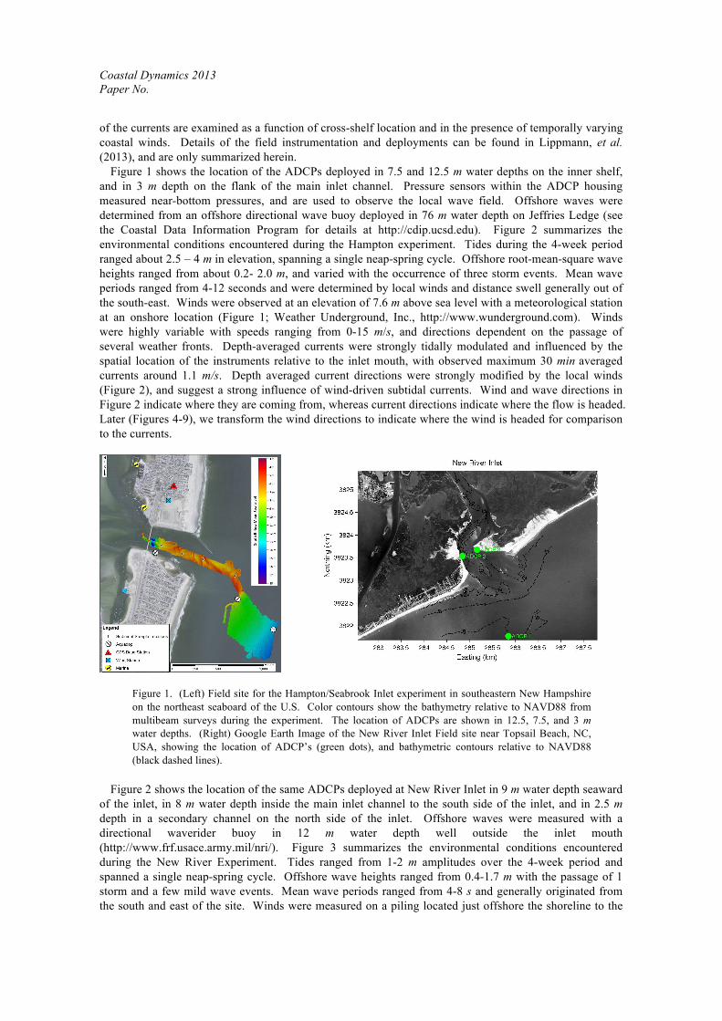
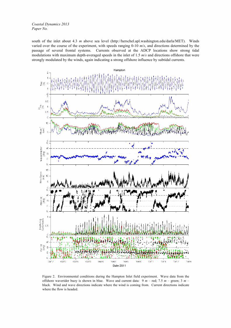
Figure 1 shows the location of the ADCPs deployed in 7.5 and 12.5 m water depths on the inner shelf, and in 3 m depth on the flank of the main inlet channel. Pressure sensors within the ADCP housing measured near-bottom pressures, and are used to observe the local wave field. Offshore waves were determined from an offshore directional wave buoy deployed in 76 m water depth on Jeffries Ledge (see the Coastal Data Information Program for details at http://cdip.ucsd.edu). Figure 2 summarizes the environmental conditions encountered during the Hampton experiment. Tides during the 4-week period ranged about 2.5 – 4 m in elevation, spanning a single neap-spring cycle. Offshore root-mean-square wave heights ranged from about 0.2- 2.0 m, and varied with the occurrence of three storm events. Mean wave periods ranged from 4-12 seconds and were determined by local winds and distance swell generally out of the south-east. Winds were observed at an elevation of 7.6 m above sea level with a meteorological station at an onshore location (Figure 1; Weather Underground, Inc., http://www.wunderground.com). Winds were highly variable with speeds ranging from 0-15 m/s, and directions dependent on the passage of several weather fronts. Depth-averaged currents were strongly tidally modulated and influenced by the spatial location of the instruments relative to the inlet mouth, with observed maximum 30 min averaged currents around 1.1 m/s. Depth averaged current directions were strongly modified by the local winds (Figure 2), and suggest a strong influence of wind-driven subtidal currents. Wind and wave directions in Figure 2 indicate where they are coming from, whereas current directions indicate where the flow is headed. Later (Figures 4-9), we transform the wind directions to indicate where the wind is headed for comparison to the currents.
Figure 1. (Left) Field site for the Hampton/Seabrook Inlet experiment in southeastern New Hampshire on the northeast seaboard of the U.S. Color contours show the bathymetry relative to NAVD88 from multibeam surveys during the experiment. The location of ADCPs are shown in 12.5, 7.5, and 3 m water depths. (Right) Google Earth Image of the New River Inlet Field site near Topsail Beach, NC, USA, showing the location of ADCP’s (green dots), and bathymetric contours relative to NAVD88 (black dashed lines).
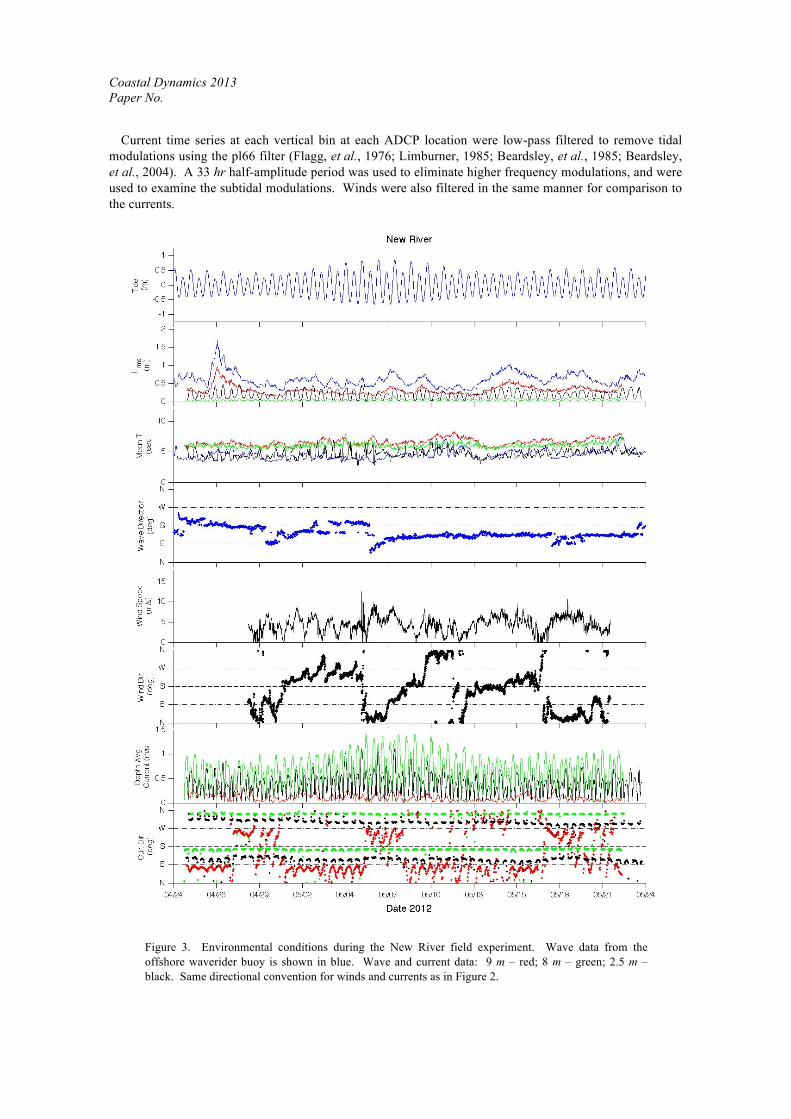
Figure 2 shows the location of the same ADCPs deployed at New River Inlet in 9 m water depth seaward
of the inlet, in 8 m water depth inside the main inlet channel to the south side of the inlet, and in 2.5 m depth in a secondary channel on the north side of the inlet. Offshore waves were measured with a directional waverider buoy in 12 m water depth well outside the inlet mouth (http://www.frf.usace.army.mil/nri/). Figure 3 summarizes the environmental conditions encountered during the New River Experiment. Tides ranged from 1-2 m amplitudes over the 4-week period and spanned a single neap-spring cycle. Offshore wave heights ranged from 0.4-1.7 m with the passage of 1 storm and a few mild wave events. Mean wave periods ranged from 4-8 s and generally originated from the south and east of the site. Winds were measured on a piling located just offshore the shoreline to the
Coastal Dynamics 2013 Paper No.
south of the inlet about 4.3 m above sea level (http://herschel.apl.washington.edu/darla/MET). Winds varied over the course of the experiment, with speeds ranging 0-10 m/s, and directions determined by the passage of several frontal systems. Currents observed at the ADCP locations show strong tidal modulations with maximum depth-averaged speeds in the inlet of 1.5 m/s and directions offshore that were strongly modulated by the winds, again indicating a strong offshore influence by subtidal currents.
Figure 2. Environmental conditions during the Hampton Inlet field experiment. Wave data from the offshore waverider buoy is shown in blue. Wave and current data: 9 m – red; 7.5 m – green; 3 m – black. Wind and wave directions indicate where the wind is coming from. Current directions indicate where the flow is headed.
Coastal Dynamics 2013 Paper No.
Current time series at each vertical bin at each ADCP location were low-pass filtered to remove tidal modulations using the pl66 filter (Flagg, et al., 1976; Limburner, 1985; Beardsley, et al., 1985; Beardsley, et al., 2004). A 33 hr half-amplitude period was used to eliminate higher frequency modulations, and were used to examine the subtidal modulations. Winds were also filtered in the same manner for comparison to the currents.
Figure 3. Environmental conditions during the New River field experiment. Wave data from the offshore waverider buoy is shown in blue. Wave and current data: 9 m – red; 8 m – green; 2.5 m – black. Same directional convention for winds and currents as in Figure 2.

Coastal Dynamics 2013 Paper No.
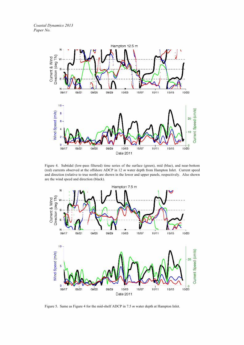
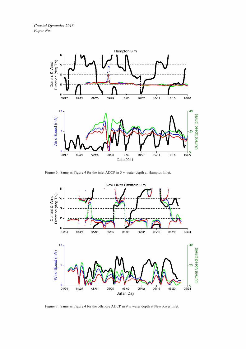
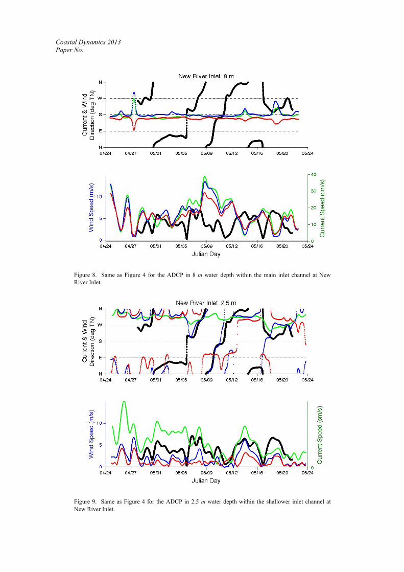
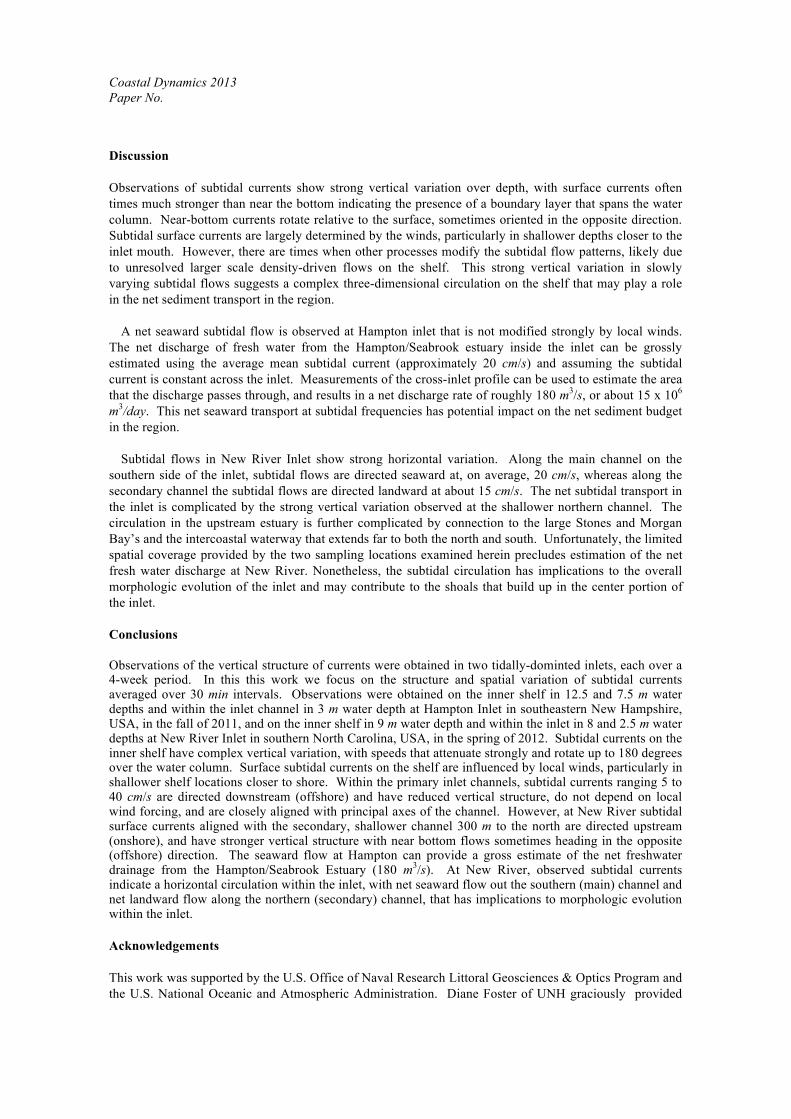
Results Subtidal current speed and direction observed near the surface, at mid water column depths, and near the bottom at the offshore ADCP location in 12.5 m depth at Hampton Inlet are shown in Figure 4. Also shown in the figure are wind speeds and direction. To directly compare to currents, the wind directions now indicate where the winds are headed (opposite to that shown in Figure 2). Surface current speeds at this location range 1-15 cm/s, and although are observed to follow the gross behavior of the wind speeds, have periods with phase lags relative to wind changes and magnitudes that do not appear to be wind related. Surface current directions do not always follow the general behavior of the wind. Mid and near-bottom currents generally follow the surface but are weaker, with average near-bottom flows of 5 cm/s. The current direction generally rotates with increasing depth, deviating significantly from the surface by as much as 180 deg indicating strong influences from bottom drag and other non wind-driven sources (e.g., shelf currents or large scale density driven flows). Closer to shore at Hampton, just outside the inlet in 7.5 m water depths, surface currents more closely follow the winds in both speed and direction (Figure 5). Surface current speeds ranging 2-25 cm/s are larger than those in deeper water, and strongly decay with depth in a similar fashion. Rotational changes with depth are not as pronounced, with near-bottom flows within 10-20 deg of the surface flows. Inside the inlet at Hampton, surface currents speeds are only slightly modulated by the winds, and have directions that vary over a much narrower range (Figure 6). Subtidal currents are aligned with the general direction of the inlet channel, and flow eastward out of the inlet with average speeds of about 20 cm/s. At New River, subtidal currents on the inner shelf in 9 m water depth (Figure 7) follow variations in the wind speed and direction more closely than at Hampton. Surface current speeds are similar to Hampton, ranging 1-20 cm/s, and again decay strongly with depth. Near bottom currents change direction similarly to surface currents, with much less deviation over depth. Inside the inlet in 8 m water depth of the main channel, currents do not follow wind patterns, and are aligned with the bathymetric contours (Figure 8). Subtidal inlet currents in this main channel are directed seaward and have stronger flows that vary from 4-40 cm/s. Currents within the shallower (2.5 m water depth), secondary inlet channel to the north side of the inlet, are also generally aligned with the bathymetric contours. Current speeds here are more strongly modulated by the winds, and have directional changes over the water column that vary as much as 180 deg, with near-bottom currents headed in the opposite direction as the surface flows. Surface currents are similar, ranging about 2-40 cm/s but are directed landward, opposite to that observed in the deeper channel to the south side of the inlet.
Coastal Dynamics 2013 Paper No.
Figure 4. Subtidal (low-pass filtered) time series of the surface (green), mid (blue), and near-bottom (red) currents observed at the offshore ADCP in 12 m water depth from Hampton Inlet. Current speed and direction (relative to true north) are shown in the lower and upper panels, respectively. Also shown are the wind speed and direction (black).
Figure 5. Same as Figure 4 for the mid-shelf ADCP in 7.5 m water depth at Hampton Inlet.
Coastal Dynamics 2013 Paper No.
Figure 6. Same as Figure 4 for the inlet ADCP in 3 m water depth at Hampton Inlet.
Figure 7. Same as Figure 4 for the offshore ADCP in 9 m water depth at New River Inlet.
Coastal Dynamics 2013 Paper No.
Figure 8. Same as Figure 4 for the ADCP in 8 m water depth within the main inlet channel at New River Inlet.
Figure 9. Same as Figure 4 for the ADCP in 2.5 m water depth within the shallower inlet channel at New River Inlet.
Coastal Dynamics 2013 Paper No.
Discussion Observations of subtidal currents show strong vertical variation over depth, with surface currents often times much stronger than near the bottom indicating the presence of a boundary layer that spans the water column. Near-bottom currents rotate relative to the surface, sometimes oriented in the opposite direction. Subtidal surface currents are largely determined by the winds, particularly in shallower depths closer to the inlet mouth. However, there are times when other processes modify the subtidal flow patterns, likely due to unresolved larger scale density-driven flows on the shelf. This strong vertical variation in slowly varying subtidal flows suggests a complex three-dimensional circulation on the shelf that may play a role in the net sediment transport in the region.
A net seaward subtidal flow is observed at Hampton inlet that is not modified strongly by local winds. The net discharge of fresh water from the Hampton/Seabrook estuary inside the inlet can be grossly estimated using the average mean subtidal current (approximately 20 cm/s) and assuming the subtidal current is constant across the inlet. Measurements of the cross-inlet profile can be used to estimate the area that the discharge passes through, and results in a net discharge rate of roughly 180 m3/s, or about 15 x 106 m3/day. This net seaward transport at subtidal frequencies has potential impact on the net sediment budget in the region.
Subtidal flows in New River Inlet show strong horizontal variation. Along the main channel on the
southern side of the inlet, subtidal flows are directed seaward at, on average, 20 cm/s, whereas along the secondary channel the subtidal flows are directed landward at about 15 cm/s. The net subtidal transport in the inlet is complicated by the strong vertical variation observed at the shallower northern channel. The circulation in the upstream estuary is further complicated by connection to the large Stones and Morgan Bay’s and the intercoastal waterway that extends far to both the north and south. Unfortunately, the limited spatial coverage provided by the two sampling locations examined herein precludes estimation of the net fresh water discharge at New River. Nonetheless, the subtidal circulation has implications to the overall morphologic evolution of the inlet and may contribute to the shoals that build up in the center portion of the inlet. Conclusions Observations of the vertical structure of currents were obtained in two tidally-dominted inlets, each over a 4-week period. In this this work we focus on the structure and spatial variation of subtidal currents averaged over 30 min intervals. Observations were obtained on the inner shelf in 12.5 and 7.5 m water depths and within the inlet channel in 3 m water depth at Hampton Inlet in southeastern New Hampshire, USA, in the fall of 2011, and on the inner shelf in 9 m water depth and within the inlet in 8 and 2.5 m water depths at New River Inlet in southern North Carolina, USA, in the spring of 2012. Subtidal currents on the inner shelf have complex vertical variation, with speeds that attenuate strongly and rotate up to 180 degrees over the water column. Surface subtidal currents on the shelf are influenced by local winds, particularly in shallower shelf locations closer to shore. Within the primary inlet channels, subtidal currents ranging 5 to 40 cm/s are directed downstream (offshore) and have reduced vertical structure, do not depend on local wind forcing, and are closely aligned with principal axes of the channel. However, at New River subtidal surface currents aligned with the secondary, shallower channel 300 m to the north are directed upstream (onshore), and have stronger vertical structure with near bottom flows sometimes heading in the opposite (offshore) direction. The seaward flow at Hampton can provide a gross estimate of the net freshwater drainage from the Hampton/Seabrook Estuary (180 m3/s). At New River, observed subtidal currents indicate a horizontal circulation within the inlet, with net seaward flow out the southern (main) channel and net landward flow along the northern (secondary) channel, that has implications to morphologic evolution within the inlet. Acknowledgements This work was supported by the U.S. Office of Naval Research Littoral Geosciences & Optics Program and the U.S. National Oceanic and Atmospheric Administration. Diane Foster of UNH graciously provided
Coastal Dynamics 2013 Paper No.
the Nortek Aquapro current profiler used in the shallow locations during each experiment. Jim Thomson of the University of Washington Applied Physics Laboratory graciously provided the wind data from RIVET. Wave buoy data for Hampton were provided by the Coastal Data Information Program, and for New River by the U.S. Army Corps of Engineers Field Research Facility (FRF). Assistance at the Hampton and New River field experiments was generously provided by many individuals, including Emily Terry, Ben Smith, Shawn Shellito, Lindsay McKenna, Meagan Wengrove, Sylvia Rodriguez-Abudo, Garrett Mitchell, and Christy Fandel of UNH, Edie Gallagher of Franklin & Marshall University, and Jesse McNinch, Jason Pipes, and Mark Preisser of the FRF. We also acknowledge the support from the various research teams participating in the New River RIVET experiment, and the coordination efforts at the New River field site by Steve Elgar, Greg Schmidt, and Jeff Hemler. References Beardsley, R. C., R. Limeburner, and L. K. Rosenfeld, 1985. Introduction to the CODE-2 moored array and large-scale
data report. CODE-2: Moored Array and Large-Scale Data Report, edited by C. A. Alessi et al., WHOI Technical report, 1–36.
Bearcsley, R. C., D. C. Chapman, and K. H. Brink, 1985, The nantucket shoals flux experiment (NSFE79). Part I: A basic description of the curent and temperature variability. J. Phys. Oceanogra., 15: 713-748.
Beardsley, R. C., R. Limeburner, and W. B. Owens, 2004. Drifter measurements of surface currents near Marguerite Bay on the western Antarctic Peninsula shelf during austral summer and fall, 2001 and 2002. Deep-Sea Research II, 51: 1947–1964
Flagg, C. N., Vermersch, J. A., and Beardsley, R. C., 1976. 1974 MIT New England shelf dynamics experiment (March 1974). Data Report, Part II: the moored array, MIT Report 76-1.
Lentz, S. J., 1995. The Amazon River plume during AMASSEDS: subtidal current variability and the importance of wind forcing. J. Geophys. Res., 100(C2): 2377-2390.
Limeburner, R., 1985. CODE-2: moored array and large-scale data report, WHOI Technical Report 85-35, 234. Lippmann, T. C., J. Irish, and J. Hunt, 2013. Observations of the vertical structure of tidal currents in tow inlets. In:
Conley, D. C., Masselink, G., Russell, P. E., and O’Hare, T. J. (eds.), Proceedins 12th Intern. Coastal Symposium (Plymouth, England), J. Coastal Res., 65: in press.
Noble, M. A., and S. R. Ramp, 2000. Subtidal currents over the central California slope: evidence for offshore veering of the undercurrent and for direct, wind-driven slope currents. Deep Sea Res. II, 47: 871-906.
Prandle, D., 1982. The vertical structure of tidal currents and other oscillatory flows. Cont. Shelf Res., 1(2), 191-207. Taebi, S., R. J. Lowe, C. B. Pattiaratchi, G. N. Ivey, G. Symonds, and R. Brinkman, 2011. Nearshore circulation in a
tropical fringing reef system. J. Geophys. Res., 116 (C022016), doi:10.1029/2010JC006439, 1-15. Wong, K.-C., and R. W. Garvine, 1984. Observations of wind-induced, subtidal variability in the Delaware estuary. J.
Geophys. Res., 89(C6): 10,589-10,597. Wong, K.-C., and A. Valle-Levinson, 2002. On the relative importance of the remote and local wind effects on
subtidal exchange at the entrance to the Chesapeake Bay. J. Marine Res., 60, 477-498.