Embed Size (px)
DESCRIPTION
Debating Spatial Archaeology
Citation preview
DEBATING SPATIAL ARCHAEOLOGYInternational Workshop on Landscape and Spatial Analysis in ArchaeologySantander, June 8th - 9th, 2012
DebatingSpatialArcheology
Santander
2012
AbstractBook
Colaboration:
Sponsored by:
Alejandro García (IIIPC)Jesús García (UC)Alfredo Maximiano (IIIPC)Joseba Ríos (IIIPC)
2
Contents:
Organization: ............................................................................................................................. 5
Foreword: .................................................................................................................................. 8
Ian Johnson: No Space without Time / Every Event has a Footprint ........................................ 9
Pilar Diarte Blasco & María Sebastián López: Landscape and human structure in the Middle
Ebro Basin. From Prehistory to roman world. ......................................................................... 10
Joan Negre Pérez & Rocío Gómez Martínez: Beyond Prediction: Artificial Neural Networks
and Multiscalar Approaches applied to the study of historical dynamics .............................. 14
Fabian Bognanni, Emanuel Montanari, Facundo Gómez Romero y Carlos Landa: Spatial
analysis at La Verde battlefield (1874, Buenos Aires province, Argentina) ............................ 15
Enrico R. Crema: The importance of being local: ecological fallacy and unit issues in
archaeological spatial analysis ................................................................................................ 18
Gary Nobles: The use of grid excavation techniques: A new methodological approach applied
to old data ............................................................................................................................... 20
Bernardo Rondelli, Carla Lancelotti, Alessandra Pecci, Fernada Inserra, Andrea Luca Balbo,
Javier Ruiz Perez, Charusmitha Gadekar, Marco Madella, Ajithprasad P. &Miguel Angel Cau
Ontiveros: Spatial uncertainty in archaeological interpretation: an ethnoarchaeological
experiment .............................................................................................................................. 24
Michal Birkenfeld and Nigel Goring-Morris: Stratigraphy and spatial analysis at pre-pottery
neolithic b Kfar Hahoresh, Israel. Using GIS applications in Inter-site analyses ..................... 25
Jöris, Olaf, Monika Brasser, Frank Gelhausen, Sonja Grimm, Daniela Holst, Lutz Kindler, Frank
Moseler, Martin Street, Elaine Turner & Sabine Gaudzinski-Windheuser: The Revolution of
Hominin Spatial Behaviour: Spatial Analyses of Palaeolithic/Mesolithic Sites in Diachronic
Perspective .............................................................................................................................. 26
Aleix Eixea, Valentín Villaverde, João Zilhão, Alfred Sanchis, ................................................. 30
Juan Vicente Morales & Cristina Real: Using spaces in Abrigo de la Quebrada (Chelva,
Valencia). Variations in the Middle Paleolithic levels IV and VIII ............................................ 30
Amèlia Bargalló, María Gema Chacón & Bruno Gómez: The role of the limestone in the
Middle Palaeolithic technological behaviours through the refitting and the spatial patterning
analysis: the level O of the Abric Romaní site (Capellades, Barcelona, Spain) ....................... 33
Solène Caux: Aurignacian Landscape Use and Technological Organization: an example based
on the management of ‘grain de mil’ flint. ............................................................................. 36
María Sebastián, Rafael Domingo & Lourdes Montes: The Arba de Biel area: a landscape use
from 15000 to 4000 calBP. ...................................................................................................... 38
Michal Birkenfeld: A Question of Territory: Pre-Pottery Neolithic Settlement Systems in the
Lower Galilee, Israel. ............................................................................................................... 40
Rodrigo Villalobos García, Germán Delibes de Castro, Miguel Ángel Moreno Gallo & Javier
Basconcillos Arce: The megalithic “golden crescent”. An approach to one space in Northern
Burgos which hosted the adoption and evolution of megalithism ......................................... 41

3
Ángel D. Bastos Zarandieta, Daniel J. Martín-Arroyo Sánchez, María del Mar Castro García &
Lázaro G. Lagóstena Barrios: Rethinking the boundaries of Baetica: a historiographic critic
from space display .................................................................................................................. 43
Antunes Nicolas, William Banks & Francesco D’Errico: Evaluating Viking eco-cultural niche
variability between the Medieval Climate Optimum and the Little Ice Age ........................... 45
Javier Ordoño Daubagna: From place to surface: exploring Paleolithic spatial behavior
through Archaeology ............................................................................................................... 47
Jorge Martínez‐Moreno, Rafael Mora Torcal & Xavier Roda Gilabert: The micro‐spatial
dimension of the human behavior: How reliable is the toss/drop model to analyze spatial
pattern organization? .............................................................................................................. 49
Irene Ortiz Nieto‐Márquez, Javier Baena Preysler & María Gema Chacón: GIS Spatial
distribution analysis in raw material quarrying sites: the example of El Cañaveral (Madrid,
Spain) ....................................................................................................................................... 51
Mae Goder, Erella Hovers & Rivka Rabinovich: A GIS approach to Neandertal spatial
behavior: A case study from Amud Cave ................................................................................ 54
Ravid Ekshtain, Ilan Sharon, Yonaton Goldsmith & Michal Birkenfeld: Marking old territories:
Using ArcGIS models for raw material survey areas in the Levantine Middle Paleolithic. A
case study from Qafzeh cave, Israel ........................................................................................ 56
Enrique Cerrillo Cuenca, José Ángel Martínez del Pozo, Raquel Liceras Garrid & Enrique
Cerrillo Martín de Cáceres: How efficiently did they walk? An essay on the characterisation
of traditional routes by Least Cost Path analysis and non-dimensional variables .................. 58
Youssef Bobkot, Marisa Ruiz-Gálvez, Mercedes Farjas, Eduardo Galán, Hipólito Collado,
Paloma de la Peña, Jorge de Torres, Blanca Ruiz, Pablo de la Presa, Antonio Rubinos, José
María Señorán & Carlos Nieto: Traditional wisdom and landscape management. A Longue
durée history of human exploitation of a critical resource. The case of the Oukaimeden
valley (High Atlas, Morocco) ................................................................................................... 61
Kristen Patricia Mann: Social Living: addressing spatial variability in households at Early Iron
Age Zagora on Andros, Greece ................................................................................................ 63
Jesús Bermejo Tirado: Biopolitical Archaeology of Roman domestic spaces: A syntactical
approach ................................................................................................................................. 65
Sandra L. López Varela: Predictive Modeling in Heritage Management and Land-use Plans in
Mexico ..................................................................................................................................... 67
Elisabet López i Garriga: Volumetric study of megalithic tombs of the Eastern Pyrenees ..... 69
Paula Ortega Martínez: Visibility, a new point of view to the study of Paleolithic Art. A
preliminary study .................................................................................................................... 71
Vicente Bayarri Cayón & Elena Castillo López: Geometric characterization and analysis of
complex elements through the integration of different geomatics techniques. Application to
caves. ....................................................................................................................................... 72
Alejandro García & Miguel Ángel Fano: Palaeolithic sites beyond the archaeological deposits
................................................................................................................................................. 74

4
Lourdes Montes, Rafael Domingo, Manuel Bea, Julia Justes, Leyre Alconchel & Pilar Sánchez:
Prehistory and Middle Age. Shepherds and burials in the Upper Vero Basin (Sobrarbe,
Huesca) .................................................................................................................................... 76
Jesús García-Sanchez & Armando Ezquerro Cordón: New techniques for artefact survey: GIS-
GPS methodology to study Roman intra- site contexts. ......................................................... 78
Alfredo Maximiano Castillejo & Alfredo Prieto Iglesias: Recognition Pre-Historical Canoeists
Passages in Fuego–Patagonia Region: First steps in Geo-computing approach for a peculiar
archaeological evidence in Time and Space. ........................................................................... 80
Lucyna Domaoska, Sweryn Rzepecki, Monika Michałowicz: Wilkostowo 23/24 – the
settlement of the TRB culture in central Poland ..................................................................... 83
Vicente O., Gòmez A., Barcía C., Molist M: Study of the spatial variability of Caserna de Sant
Pau del Camp (Barcelona): old excavations, new approaches ................................................ 84

5
Organization: Organization Committee:
Alejandro García (IIIPC)
Jesús García (UC)
Alfredo Maximiano (IIIPC)
Joseba Ríos (CENIEH)
Scientific Committee
J. Vicent García (CCHS-CSIC)
M. Santonja Gómez (CENIEH)
M.R. González Morales (IIIPC)
I. Grau Mira (AU)
E. Cerrillo Cuenca (IA-CSIC)
D. Wheatley (University of Southampton)
R. Ontañón Pereda (Consejería de Cultura, Gobierno de Cantabria)
H.P.Blankholm (University of Tromsø)
Holley Moyes (University of California, Merced)
J. Baena Preysler (UAM)
Mercedes Farjás (UPM)

6
8th June AUTHORS TITLE
9:30 - 9:45
WELCOME
9:45 - 10:30
Djindjian, F. Inaugural Conference
ISSUE: Beyond archaeological spatial datasets
10:30 - 10:45
Ian Johnson No Space without Time / Every Event has a Footprint
10:45 - 11:00
Pilar Diarte Blasco & María Sebastián López
Landscape and Human Structure in the midle Ebro basin.
11:00 - 11:15
Joan Negre Pérez & Rocío Gómez Martínez
Beyond Prediction: Artificial Neural Networks and Multiscalar …
11:15 - 12:00
COFFEE BREAK AND POSTERS SESSION
12:00 - 12:15
Fabian Bognani et al. Spatial analysis at La Verde battlefield
12:15 - 12:30
Enrico R. Crema The importance of being local
12:30 - 12:45
Gary Nobles The use of grid excavation techniques
12:45 - 13:00
Katia F. Achino et al. The pile dwelling of Villaggio delle macine
13:00 - 13:15
Bernardo Rondelli et al. Spatial uncertainty in archaeological interpretation
13:15 - 13:30
Michal Birkenfeld & Nigel Goring
Stratigraphy and spatial analysis a pre-pottery
13:30 - 16:00
LUNCH BREAK
ISSUE: The use of space from an evolutionary perspective
16:00 - 16:15
Olaf Jöris et al. The Revolution of Hominin Spatial Behaviour
16:15 - 16:30
Penny Spikins et al. Early modern human dispersals out of Africa
16:30 - 16:45
Aleix Eixea et al. Using spaces in Abrigo de la Quebrada
16:45 - 17:00
Amèlia Bargalló et al. The role of the limestone in the Middle Palaeolithic technological
17:00 - 17:15
Solene Caux Aurignacian Landscape Use and Technological Organisation
17:15 - 17:30
COFFEE BREAK
17:30 - 17:45
María Sebastián et al. The Arba de Biel area: a landscape use from 15000 to 4000 calBP
17:45 - 18:00
Michal Birkenfeld A Question of Territory
18:00 - 18:15
Rodrigo Villalobos et al. The megalithic “golden crescent”.
18:15 - 18:30
Ángel D. Bastos et al. Rethinking the boundaries of Baetica
18:30 - 18:45
Nicolas Antunes et al. Evaluating Viking eco-cultural niche variability
18:45 - 19:00
DISCUSSION

7
9th June AUTHORS TITLE
ISSUE: People beyond the numbers
9:30 - 9:45
Javier Ordoño From place to surface
9:45 - 10:00
Jorge Martínez Moreno et al. The micro‐spatial dimension of the human behaviour
10:00 - 10:15
Irene Ortiz et al. GIS Spatial distribution analysis in raw material quarrying sites
10:15 - 10:30
Mae Goder et al. A GIS approach to Neandertal spatial behavior
10:30 - 10:45
Ravid Ekshtain et al. Marking old territories
10:45 - 11:30
COFFEE BREAK AND POSTERS SESSION
11:30 - 11:45
Enrique Cerrillo et al. How efficiently did they walk
11:45 - 12:00
Y. Bobkot et al. Traditional wisdom and landscape management
12:00 - 12:15
Kristen Patricia Mann Social Living
12:15 - 12:30
Jesús Bermejo Tirado Biopolitical Archaeology of Roman domestic spaces
12: 30 - 12:45
Sandra López Varela Predictive Modeling in Heritage Management
12:45 - 13:30
DISCUSSION
13:30 - 15:30
LUNCH BREAK
15:30 - 17:00
ROUND TABLE
Posters AUTHORS TITLE
- Elisabet López Volumetric study of megalithic tombs of the Eastern Pyrenees
- Paula Ortega Visibility, a new point of view to the study of Paleolithic Art
- Vicente Bayarri & Elena Castillo Geometric characterization and Analysis of complex elements
- Alejandro Garcia & Miguel A. Fano
Palaeolithic sites beyond the archaeological deposits
- Lourdes Montes et al. Prehistory and Middle Age
- Jesús García & Armando Ezquerro
New techniques for artefact survey
- Alfredo Maximiano & Alfredo Prieto
Recognition Pre-Historical Canoeists Passages in Fuego Region
O. Vicente et al
Study of the spatial variability of Caserna de Sant Pau del
Camp
Lucyna Domaoska et al.
Wilkostowo 23/24 – the settlement of the TRB
culture in central Poland
8
Foreword:
The study of spatiality is one of the most important issues in Archaeology. Since the very first
moments of the discipline, the understanding of spatial relations has been a key factor for
interpreting past social dynamics. The importance of spatial analyses has led to the
appearance of specific issues within Archaeology, such as Landscape Archaeology, Spatial
Statistics, Cognitive Archaeology, etc., all of which can broadly be included within the Spatial
Archaeology issue. On the other hand, in recent years there has been great improvement in
recording methods and analysis tools, mainly thanks to the generalization of GIS, which has
contributed to the development of spatial analyses.
However, these methodological improvements and conceptual developments have not always
had an accompanying parallel theoretical dissertation about the real application of spatial
analyses to archaeological interpretations; spatial analyses usually focus on geographic data
and cartographic outcomes which have to be inserted into a previously defined, fixed
framework valid in its own right, instead of really trying to link those results with the proposed
interpretations. In these cases, space is automatically assumed to be a fully significant concept,
either from an economic or relational perspective, but without a serious discussion of what it
really means with relation to each particular case.
The main aim of the Debating Spatial Archaeology International Workshop is to provide a
debate forum where archaeologists can discuss what space means in Archaeology, how it is
perceived and interpreted by archaeologists, and why. Keeping in mind the need for a
connection between methodology issues, analysis results and interpretations, participants are
encouraged not only to analyze spatial variability, but to point out the probable reasons for
such variability from in terms of social space, as well as to discuss how their spatial analyses
can improve the understanding of social and historical dynamics within their case studies.

Abstracts

Debating Spatial Archaeology, Santander 2012
1
No Space without Time / Every Event has a Footprint
Ian Johnson 1
1 Arts eResearch, University of Sydney (Australia)
Spatial archaeologists have long wrestled with, or brushed under the carpet, the
thorny issues of contemporaneity and palimpsests of evidence. Time is often
controlled by mapping and analysing separate time slices or periods and then
comparing results between slices; only rarely is it possible to integrate spatial and
temporal information to examine the processes behind change.
By contrast, historians often treat space as incidental to specific events or to broader
social and cultural trends. Timelines are common, whether verbal or visual, and are
most often aspatial, focussing on a limited area or simply ignoring the spatial
dimension altogether (indeed the ability to highlight the contemporaneity of widely
scattered events is often seen as an advantage). Time is generally recorded as an
attribute of events – either as a specific date or a date range. These attributes rarely
address issues of uncertain interpretation, gradual change or shifts in the spatial
dimension, let alone all three together; they are generally handled through textual
description.
In this poster I will present work we have been doing within the Heurist collaborative
database (heuristscholar.org) to model spatially extensive events – from deposits
within a site to regional periods - using dating evidence linked to spatial footprints
through interpretation records. This methodology means that the dating of an event is
no longer based on specific date attributes, nor its spatial extent on a single hard-
edged GIS outline, but both are based on an aggregation or envelope of multiple
spatio-temporal records which may also include differing interpretations of the
evidence.
We have also developed methods within Heurist to derive the aggregate dating of an
event from the relationships between an event and other entities, for example through
aggregating the dating of periods related to the finds related to the deposits which
constitute a phase of deposition in a site. This will be illustrated with material from the
excavations at Zagora, Greece.
Finally I will present linked map + timeline visualisations of a web of linked search
results which render spatial and temporal information derived from related entities. I
will present the case that such linking is essential to both the spatial and temporal
domain – there can be no spatial footprint independent of time, nor dating
independent of spatial location; nor can events be described by a single date range
and/or a single footprint.
Debating Spatial Archaeology, Santander 2012
1
LANDSCAPE AND HUMAN STRUCTURE IN THE MIDLE EBRO BASIN. FROM
PREHISTORY TO ROMAN WORLD.
Pilar Diarte Blasco 1 y María Sebastián López
1University of Zaragoza. (Spain); 2CCHS-CSIC, c/ Albasanz 26-28. 28037, Madrid (Spain).
The history of the Mediterranean landscape is, to some extent, the history of
erosive processes and soil loss. A relatively important amount of research has been
devoted to their study, especially the determination of its climatic vs. anthropic origin.
After the Neolithic, however, it is difficult to isolate climatic events as triggers of global
cultural changes in the Mediterranean (Jalut et al. 1997; Carrión et al. 2000). The
‘Younger Fill’ (Higg and Vita-Finzi 1972) debate was a significant landmark in this
regard1. The current mostly shared view is that the interplay of decision-making
humans and their environment created the Mediterranean landscape as we know
Butzer 2005). Therefore, human labour dialectically involved in historical, contingent
and non-dramatic processes of interdependence with the environment, would be the
driving force of history in the Mediterranean.
It is argued in this paper that archaeological sites, when observed ‘in place’ at a
regional scale, can reflect the basic dynamics of landscape construction and use. We
present a case study from the Ebro middle Basin, arguing that the location of the
archaeological sites in this area allows us to ‘map’ the social and economic landscape
of the people that made it.
In this context, we hypothesize that archaeological sites can be observed as the
‘monumental’ side within a dual process of landscape construction: on the one hand,
rock art is a ‘cultural’ action on the landscape; on the other hand, people were actively
modifying the Mediterranean landscape, created, as we know it, through its active
‘degradation’, probably starting in the Early Neolithic. The archaeological sites places
that were made at that time are still in use, in association with particular economic
activities, remnants of a fading traditional way of life.
1 Defenders of the existence of the Younger Fill lean onto environmental factors as major forces that
shape the Mediterranean (Vita-Finzi 1969). Its opponents see no Younger Fill but a non-synchronic accumulation of human-induced sporadic episodes of soil erosion (Van Andel et al. 1990; Walsh 1999; Horden and Purcell 2000).
Debating Spatial Archaeology, Santander 2012
2
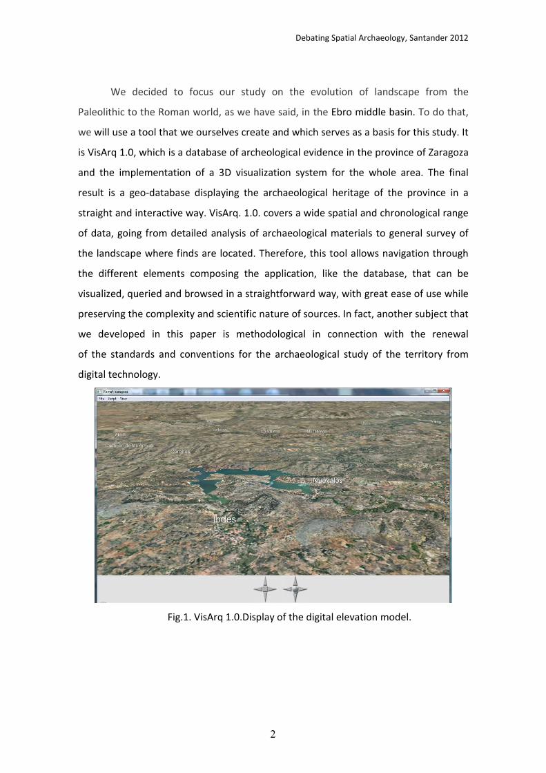
We decided to focus our study on the evolution of landscape from the
Paleolithic to the Roman world, as we have said, in the Ebro middle basin. To do that,
we will use a tool that we ourselves create and which serves as a basis for this study. It
is VisArq 1.0, which is a database of archeological evidence in the province of Zaragoza
and the implementation of a 3D visualization system for the whole area. The final
result is a geo-database displaying the archaeological heritage of the province in a
straight and interactive way. VisArq. 1.0. covers a wide spatial and chronological range
of data, going from detailed analysis of archaeological materials to general survey of
the landscape where finds are located. Therefore, this tool allows navigation through
the different elements composing the application, like the database, that can be
visualized, queried and browsed in a straightforward way, with great ease of use while
preserving the complexity and scientific nature of sources. In fact, another subject that
we developed in this paper is methodological in connection with the renewal
of the standards and conventions for the archaeological study of the territory from
digital technology.
Fig.1. VisArq 1.0.Display of the digital elevation model.
Debating Spatial Archaeology, Santander 2012
3
We realize that is an ambitious project, especially due to the patterns change of
settlement from Prehistory to the Roman world changed considerably, unlike what
happens between the Roman and Medieval world, where we see that there is more
continuity. However, we believe that although it is a risky project, the detailed
knowledge of the archaeological reality of the Ebro middle basin can afford a first
approach to this issue.
Key words: Ebro middle basin, landscape, uplands, archaeological sites, land use,
pastoralism, town planning.
References:
BUTZER, K., 1988. Cattle and Sheep from Old to New Spain: Historical Antecedents. Annals of the Association of American Geographers 78 (1): 29-56.
BUTZER, K., 1996. Ecology in the long view: settlement histories, agrosystemic strategies, and ecological performance. Journal of Field Archaeology 23 (2): 141-150.
BUTZER, K., 2005. Environmental history in the Mediterranean world: cross-disciplinary investigation of cause-and-effect for degradation and soil erosion. Journal of
Archaeological Science 32: 1773-1800. CARRIÓN, J.S., MUNUERA, M., NAVARRO, C. and SÁEZ, F., 2000. Paleoclimas e historia
de la vegetación cuaternaria en España a través del análisis polínico. Viejas falacias y nuevos paradigmas. Complutum 11: 115-142.
DAVIS, G.W. and RICHARDSON, D. (eds.), 1995. Mediterranean-type ecosystems. The
function of biodiversity. Berlin: Springer. DAVIS, G.W. and RUTHERFORD, M.C., 1995. Ecosystem function of biodiversity: can we
learn from the collective experience of MTE research?. In G.W. Davis and D.M. Richardson (eds.), Mediterranean-type ecosystems. The function of biodiversity: 335-350. Berlin: Ecological Studies 109. Springer.
HIGGS. E. S. and VITA- FINZI, C. 1972. Prehistoric economies: a territorial approach. En E.S. HIGGIS (Ed): , Papers in Economic Prehistory. Cambridge, Cambridge University
Press pp.27-36.
Barker, G. and Bintliff, J., 1999. Geoarchaeology in Mediterranean landscape archaeology: concluding comments. In Leveau, P., Trément, F., Walsh, K. and Barker, G. (eds.) environmental reconstruction in mediterranean landscape archaeology, Oxford: The Archaeology of Mediterranean Landscapes 2, Oxbow
Books, 207-210. Blondel, J. and Aronson, J., 1995. "Biodiversity and ecosystem function in the
Mediterranean Basin: human and non-human determinants". In G.W. Davis and
D.M. Richardson (eds.), Mediterranean-type ecosystems. The function of
biodiversity, Berlin: Ecological Studies 109. Springer, 43-119.
Debating Spatial Archaeology, Santander 2012
4
JALUT, G., ESTEBAN, A., RIERA MORA I MORA, S., FONTUGNE, M., MOOK, R., BONNET, L. and GAUQUELIN, T., 1997. Holocene climatic changes in the western Mediterranean : installation of the Mediterranean climate. Comptes Rendus de
l’Academie de Sciences de Paris, Sciences de la terre et des planètes 325, pp.327-334.
KEAY, K. 2010. "Iberia and Italia: Issues and challenges in the comparative study of Roman urbanism" in Corsi, C. & Vermeulen, F. (eds.) Changing Landscapes. The impact of Roman towns in the Western Mediterranean. Proceedings of the International Colloquium, Castelo de Vide - Marvão 15th-17th May 2008. Bologna, Ante Quem, pp.27-46.
PALET, J.M.; FIZ, I. and ORENGO, H.A. 2010. Modelación y conceptualización del paisaje romano en el Ager Tarraconensis: Tarraco y la centuriación del territorio’ in Corsi, C. & Vermeulen, F. (eds.) Changing Landscapes. The impact of Roman towns in the Western Mediterranean. Proceedings of the International Colloquium, Castelo de Vide - Marvão 15th-17th May 2008. Bologna, Ante Quem, pp. 167-184

Debating Spatial Archaeology, Santander 2012
1
Beyond Prediction: Artificial Neural Networks and Multiscalar Approaches applied to
the study of historical dynamics
Joan Negre Pérez1 y Rocío Gómez Martínez
2
1 Universitat Autònoma de Barcelona
2 University of Edinburgh
The eruption of new technologies in scientific research has contributed to an improvement in results,
however they have also been abused, especially in disciplines not used to applying these technologies,
such as Archaeology. One of the most common mistakes is not to consider the basis of these techniques,
but to directly apply them on problems that are similar to those they were created for. This is the case,
for example, of GIS technologies within spatial analysis issues. In this communication we consider the
combined use of different tools as a means of analyzing a specific historical problem: the transformation
of a given settlement spatial distribution and its connection with cultural process, through the example
of the formation of an Islamic medieval society.
There are diverse methodological tools that enable us to approach these problems. In the first place, we
highlight the use of Artificial Neural Networks (ANN) as a very effective set of tools in order to generate
predictive models of settlement distribution and thus to locate new sites. But we would also like to think
about other possibilities this technique offers when willing to expand our samples in order to observe
spatial patterns that might be blurred by time and material record destruction. Once these patterns
have been separately analyzed, Ripley´s K function becomes one of the most useful tools for their
analysis and diachronic comparison, as it presents the divergence with regard to the expected pattern.
Other space-related mathematical functions that will be used include density calculations with respect
to gravitational centers such as cities, as well as the aggregation/dispersion index that is developed on
the basis of the Nearest Neighbour in a given cost distance surface. As we can see, these techniques not
only involve the need for learning procedures developed by exact sciences, but also mean the need for
restating the importance of archaeological data formalization and its scientific processing, a
comprehensive paradigm shift in our discipline.
Both the application of this methodology and the analysis of its results would have been extremely hard
if it were not for the existence of GIS technologies, that make management of databases and their link
to the spatial factor an easier task. Thanks to them, we can now emphasize the important part space
plays in historical explanation, how data can be extracted from them (which was hidden at first glance),
and later be transformed into highly explicative information. The research of the Islamization process in
the Iberian Peninsula has barely make any progress in years, due to its excessive reliance on approaches
emphasizing artistic, political and economical changes. Therefore, spatial analysis can contribute with a
new perspective, a new way of approaching territory analysis, bearing in mind that it is also part of a
series of historical processes that have to be explained.
Barceló, J.A. 2005. "Multidimensional Spatial Analysis in Archaeology. Beyond the GIS paradigm." In Takao, U. (ed.) Reading the Historical Spatial Information in the World. Studies for Human Cultures
and Civilizations based on Geographic Information System. Kyoto: International Institute for Japanese
Studies.
Macchi, G. 2009. Spazio e Misura. Siena: Edizioni dell’Università
Bevan, A. & Connoly, J. 2006. "Multiscalar approaches to settlement distributions". In Lock, G.
and Molyneux (eds.) Confronting scale in Archaeology: Issues of Theory and Practice, New York, NY:
Springer New York, 217-234.
Deravignone, L. and Macchi, G. 2006. "Artificial Neural Networks in Archaeology". Archeologia e
calcolatori 17: 121-136.

Debating Spatial Archaeology, Santander 2012
1
Spatial analysis at La Verde battlefield (1874, Buenos Aires province, Argentina)
Fabian Bognanni1, Emanuel Montanari
2, Facundo Gómez Romero
3 y Carlos Landa
4
1Becario Doctoral CONICET - Programa de Arqueología Histórica y Estudios Pluridisciplinarios
(PROARHEP), Dpto. de Ciencias Sociales, Universidad Nacional de Luján (UNLu) 2
Instituto de Arqueología, Facultad de Filosofía y Letras (UBA) 3
Docente y investigador. Departamento de Arqueología. Facultad de Ciencias Sociales. Universidad
Nacional del Centro de la Provincia de Buenos Aires. 4
Becario Post-doctoral CONICET – Instituto de Arqueología, Facultad de Filosofía y Letras (UBA).
Introduction
On November 26, 1874, near "Estancia La Verde" (currently 25 de Mayo, Buenos Aires
province, Argentina) took place a battle between ahead government forces (leaded by
Lieutenant Colonel Inocencio Arias), and revolutionary army, (General Bartolomé
Mitre). This event lasted at least three hours, and it resulted in several casualties
threw, sealing the fate of the revolutionary movement.
The archaeological work is referred specifically to the topographic survey of the
battlefield. This allows us to define sectors of variable visibility and/or archaeological
accessibility. Tasks were carried out using non-invasive prospecting tools, such as
metal detector. Several metal remains were found. In some cases, these were traces of
weapons used in battle, such as fragments of rifle bayonet, cartridges and lead bullets
of different caliber and remains of military uniforms (e.g. buttons, buckles and Kepi
numbers).
Aims
This paper set up a comparison between different information sources, such
as historical documents, twentieth century aerial photographs and/or satellite
images of the battlefield. This allowed inquiring about two issues: first, establish
correlations between various contemporary authors.
Second, we made equivalences between these charts and the battlefield. Also, this
makes it possible to do a critical analysis about the battlefield drawings and their
authors (related to each side) and, in turn, is possible to define congruence
strategies for fieldwork related with prospecting and excavation.
To perform these analyzes, we are working with free software called
Map Analyst 1.3.6. (http://mapanalyst.org/index.html). Although is not a GIS tool, it
has particular characteristics that allow to do spatial analysis. This program permits
extrapolate information from old maps to modern ones, and vice versa, allowing
locating certain features or elements that are represented in the many sketches of the
battle. Based on this technology, the former maps are "transported" to modern

Debating Spatial Archaeology, Santander 2012
2
images, where we could acknowledgment different events with a higher degree of
accuracy in localizations.
Figure 1. Composition of different maps made by Lt. José I. Arias in 1875 (MGM 1875) and
Florencio del Mármol in 1876 (Mármol1876). Down
Figure 2. Estimated spatial comparison of the three maps analyzed using Map
Analyst: Arias (in yellow); Mármol (in white) and the so-called 25 de Mayo (in black).

Debating Spatial Archaeology, Santander 2012
3
References
Archivo histórico de 25 de Mayo. Biblioteca municipal Juan Francisco Ibarra.
Florencio del Mármol. 1876. Noticias y documentos sobre la revolución de 1874.
Imprenta de M. Biedma. Buenos Aires. Argentina.
Ministerio de Guerra y Marina (MGM). 1875. Tomo I. Archivo Museo Mitre. Buenos Aires.
Argentina.
Landa, C., Montanari, E. and Gómez Romero, F. 2011. “El fuego fue certero y bien dirigido
(…)” Inicio de las investigaciones Arqueológicas en el sitio campo de batalla de La Verde (Partido
de 25 de Mayo, Provincia de Buenos Aires). Arqueología Histórica en Argentina y Cuba. Luján
Ramos, M., Helfer, V., Gonzáles Toralbo, C., Luque, C. and Senesi, R. 2011. "Sitio Vuelta de Obligado: expectativas de análisis espacial respecto de la batalla. Temas y problemas de la Arqueología Histórica" In M. Ramos; A. Tapia; F. Bognanni; M. Fernández; V. Helfer; C. Landa; M. Lanza; E. Montanari; E. Néspolo y V. Pineau (eds.) Programa de Arqueología Histórica y Estudios Pluridisciplinarios (PROARHEP), Departamento de Ciencias Sociales. Universidad Nacional de Luján, 145-162.

Debating Spatial Archaeology, Santander 2012
1
The importance of being local: ecological fallacy and unit issues in archaeological
spatial analysis
Enrico R. Crema1
1 Institute of Archaeology, UCL, 31-34 Gordon Square - London - WC1H 0PY, London
(UK)
Robert Dunnell (1992) once suggested how the notion of site is more harmful than
useful and therefore should be abandoned. While such statement could be regarded as
extremism, anyone dealing with spatial data has at least once faced the dilemma of
how to define their unit of analysis, or has been unsatisfied on how this has been
defined by others. Many acknowledge the problem, but its implication is often ignored
when the actual analysis is computed and rarely breaches the level of archaeological
narratives.
The kernel of such problem is that very often we adopt aggregate units, artificial
grouping of individual entities (artefacts, features, etc.) that, either formally or
informally, transforms and filters the empirical reality before being analytically treated.
This process often leads to the problem of ecological fallacy (Harris 2006), where we
erroneously make inference on an individual observation (e.g. an artefact or a feature)
based on aggregates (e.g. a site or a settlement). In spatial analyses, the adoption of
such aggregate units might hinder variations in the spatial structure of its components.
For instance, inter-distances between different classes of artefacts might significantly
vary within the same “site” and resemble closer similarities to what has been
considered to be external to it.
Aggregate units are however very often necessary compromise that we must adopt to
reduce the complexity of the observed data. Thus a site can be translated from a
continuous density surface of artefacts to a polygonal extent, and ultimately to a point
data. The justification of such process is usually found in the assumption that in the
macro-scale, errors and uncertainties of the micro and meso-scale can be safely
ignored.
This paper seeks to: 1) verify such assumption by examining how in some contexts
critical information is “lost in translation”; and 2) explore two possible solutions to the
problem.
The first consist of creating multiple sets of aggregate units, each based on a different
criterion of aggregation. Each set is independently assessed, and the distribution of the
results is examined by means of a sensibility analysis. Convergence in the outcome will
support higher confidence in how we describe the observed pattern, which will hence
be weakly related to how we define the aggregate units. Divergence will instead
indicate the opposite, suggesting the necessity to revise how we define these units.
Debating Spatial Archaeology, Santander 2012
2
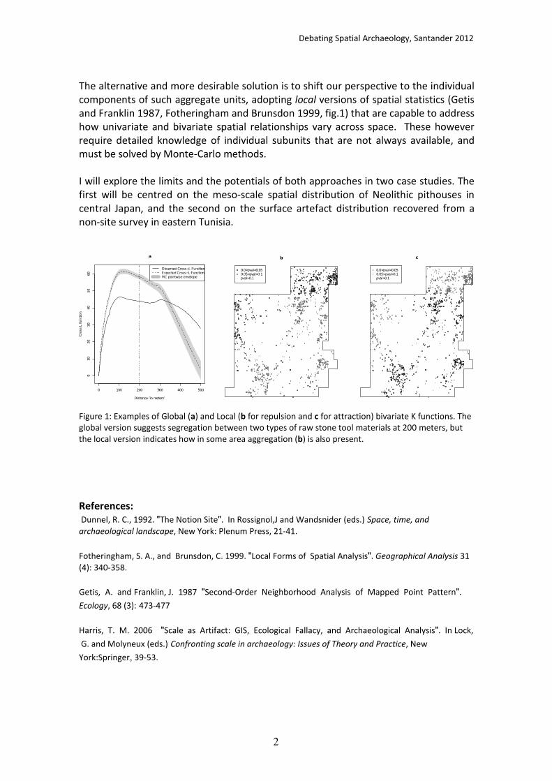
The alternative and more desirable solution is to shift our perspective to the individual
components of such aggregate units, adopting local versions of spatial statistics (Getis
and Franklin 1987, Fotheringham and Brunsdon 1999, fig.1) that are capable to address
how univariate and bivariate spatial relationships vary across space. These however
require detailed knowledge of individual subunits that are not always available, and
must be solved by Monte-Carlo methods.
I will explore the limits and the potentials of both approaches in two case studies. The
first will be centred on the meso-scale spatial distribution of Neolithic pithouses in
central Japan, and the second on the surface artefact distribution recovered from a
non-site survey in eastern Tunisia.
Figure 1: Examples of Global (a) and Local (b for repulsion and c for attraction) bivariate K functions. The
global version suggests segregation between two types of raw stone tool materials at 200 meters, but
the local version indicates how in some area aggregation (b) is also present.
References:
Dunnel, R. C., 1992. "The Notion Site". In Rossignol,J and Wandsnider (eds.) Space, time, and
archaeological landscape, New York: Plenum Press, 21-41.
Fotheringham, S. A., and Brunsdon, C. 1999. "Local Forms of Spatial Analysis". Geographical Analysis 31
(4): 340-358.
Getis, A. and Franklin, J. 1987 "Second-Order Neighborhood Analysis of Mapped Point Pattern".
Ecology, 68 (3): 473-477
Harris, T. M. 2006 "Scale as Artifact: GIS, Ecological Fallacy, and Archaeological Analysis". In Lock,
G. and Molyneux (eds.) Confronting scale in archaeology: Issues of Theory and Practice, New
York:Springer, 39-53.

Debating Spatial Archaeology, Santander 2012
1
The use of grid excavation techniques: A new methodological approach applied to
old data
Gary Nobles 1
1 University of Groiningen (The Netherlands).
Spatial analysis is a complex subject with multiple ways of obtaining similar results, but
all ultimately depends upon the way the original data was acquired. Point Pattern
analysis has much use in archaeology however the collection of point patterns in the
field can be time consuming and fequently problematic. Grid collection methods
however, can speed up the process of although this method also has many problems,
for instance: grid size, spit depths and how to analyse the data. A Dutch
multidisciplinary project titled: “Unlocking Noord-Hollands Late Neolithic Treasure
Chest” has applied relatively new analyses to two Late Neolithic settlement sites.
These sites (Keinsmerbrug and Mienakker) were excavated in the 1980s and 1990s, the
re-analysis of the find distributions with Getis and Ord’s Gi* (Hot Spot) and Moran’s Ii
(Outlier Analysis) spatial statistics has helped to reveal insights into the social use of
space within these settlements. Not only were dwelling structures identified but also
activity areas, phasing of activities and events have been possible to some extent. Both
the methodology and results of this analysis will be presented. For further information
regarding the wider project please visit www.singlegrave.nl
Debating Spatial Archaeology, Santander 2012
1
The pile dwelling of Villaggio delle macine:
an analysis of the spatial differentiation of social activities
Katia Francesca Achino, Micaela Angle2, Juan Anton Barcelò
3
¹ Universitat Autonoma de Barcelona, [email protected]
2 Soprintendenza per i Beni Archeologici del Lazio, [email protected]
3 Universitat Autonoma de Barcelona, [email protected]
The Villaggio delle macine is located in Alban Lake (Castelgandolfo, RM), into which it
was still immersed at the moment of discovery, in 1984; this site is an exceptional case
of pile dwelling for the central Tyrrhenian Italian area, dated to Latest Early Bronze age
-–Early Middle Bronze age (XIX-XVI BC.) for it available datasets and width: it evolved
with an almost continuous palisade which covers about one hectare. Since 1984
excavation campaigns carried out nearby the site and in 2009, after a further lake’s
waters drop, two survey campaigns have given start to a study intended to analyze the
dispersion of archaeological artefact, distinct for typologies (pottery, game, lithic tools
and piles), in attempt to establish if differentiations related to the activities carried out
were identifiable, and to identify possible structures or specialized areas. The study has
led to interesting preliminary results, showing the specialized areas presence in
pursuance of particular activities: it has been possible to individuate sectors devoted to
cereal and crop blending and milling, waste areas, sectors for treatment of game
remains, ateliers in which all lithic cháine operatoire’s stages were present and fields
related with activities of consumption, preservation and cooking. However these
results are incomplete and need to be enforced, related to the other datasets available
from the excavation campaign and following surveys, to obtain a complete overview.
Next step of the research will then consist in the comprehension of relationships
between the various functional areas, in order to highlight any connection between
the different practices. From the data available so far, it seems that hunting
(particularly deer hunting) was the most practiced activity near the village.
Aims
In this context we would like to understand to what extent the remaining domestic
agricultural practices carried out on site were relevant: for example, it would be
interesting to verify if these activities were carried out seasonally or permanently
throughout the year; this would help to understand the territorial exploitation and
frequentation modalities and to develop a more precise idea of the role that the village
itself used to have, compared to remaining settlements that were found in surrounding
areas. With this aims we would proceed to observe the material effects of the
depositional and post-depositional processes on social actions, which usually bias the
distribution and density of archaeological record. Therefore, to understand the
activities played at the village, we will have to apply the theories of stochastic
processes, that are the base of geostatistics: the spatial process that produced the
observed frequencies, is composed by a deterministic part and a stochastic variation. It
is a set of statistical methods used to describe spatial relationships among sample data

Debating Spatial Archaeology, Santander 2012
2
and to apply this analysis to the prediction of spatial and temporal phenomena. To
simulate the models of social interaction, we might use the multimodal distribution
and also probabilistic maps to understand the density probability function of
archaeological artefacts associated to each location. Furthermore, we could study the
spatial variation of archaeological variables through the measure of spatial correlation
or self-correlation, with variogram and kriging.
References:
Angle, M. 2007. Comune di Castel Gandolfo. Villaggio delle Macine, in Belardelli, C (eds.) Repertorio dei
siti protostorici del Lazio. Province di Roma, Viterbo e Frosinone, Firenze: All’Insegna del Giglio
Angle,M., Lugli, F.A and Zarattini, A. 2002. Lago Albano: il “Villaggio delle macine”, in Roma Città del
Lazio, Catalogo della mostra, ed. S. Rizzo, Roma: De Luca Editori d’Arte, 52-56.
Barceló, J.A. and Maximiano, A. 2008. Some notes distributional analysis spatial data, in A. Posluschny, K. Lambers, I. Herzog (eds.) Layers of Perception. Proceedings of the 35th International Conference on
Computer Applications and Quantitative Methods in Archaeology, Bonn: Hablet, 413-417.
Haining, R. 2003. Spatial data analysis. Theory and practice, Cambridge: Cambridge University Press.
Lloyd, C.D and Atkinson, P.M. 2004: "Archaeology and geostatistics", Journal of Archaeological Science
31: 151-165.

Debating Spatial Archaeology, Santander 2012
1
Spatial uncertainty in archaeological interpretation:
an ethnoarchaeological experiment
Bernardo Rondelli1
Carla Lancelotti2, Alessandra Pecci
3, Fernada Inserra
4, Andrea Luca
Balbo1, Javier Ruiz Perez
4, Charusmitha Gadekar
5, Marco Madella
1,6, Ajithprasad P
5,
Miguel Angel Cau Ontiveros3,6
1 Institució Milà i Fontanals, Spanish National Research Council (IMF-CSIC), Spain
2 Instituto de Historia, Spanish National Research Council (CCHHS – CSIC), Spain
3 ERAAUB, Department of Prehistory, Ancient History and Archaeology, University of Barcelona, Spain
4 Department of Prehistory, Ancient History and Archaeology, University of Barcelona, Spain
5 Department of Ancient History and Archaeology, MS University of Baroda, Vadodara, India.
6 Catalan Institution for Research and Advanced Studies (ICREA), Spain
This paper describes a spatial ethnoarchaeological approach aiming at: a) evaluating
the understanding of spatial patterns of domestic activities within farmer groups and
b) to determine the level of uncertainty of this type of data when correlated to the
archaeological interpretation.
Archaeological interpretation of domestic activities is mainly related with sampling
strategies and semi-quantitative analysis (archaeobotany, chemical residue,
micromorphology, etc.). However a systematic evaluation of sampling strategies
reliability and realism (reality exists independently of observers) is often missing in
archaeological investigations, due to the difficulty of measuring the uncertainty.
Ethnoarchaeology is a consolidated approach that might be oriented to a) the creation
of reference collections for the interpretation of archaeological record (analogical
reasoning) and b) the improvement of field research strategies for the detection of
anthropic markers (reflexive reasoning). In this paper we propose a spatial, semi-
quantitative ethnoarchaeological approach in order to try to tackle the problem of
uncertainty in sampling strategies.
To achieve this, a regular sampling strategy aimed at obtaining semi-quantitative data
for botanical micro-remains (phytoliths and micro-charcoal) and for chemical
compounds present in the floors (analysed with ICP-AES and spot tests) has been
applied to a traditional farmer compound of Northern Gujarat (India). Samples of the
superficial layer of a plastered mud floor were collected every 50 cm and analysed for
multiproxy data. Data resulted from the analyses have been I) integrated in a
geodatabase, II) explored using geostatistical methods, and successively III) correlated
with the building’s structure and domestic activities ethnographically mapped. In this
paper we present the results obtained by the analyses of multi-element chemical
signatures and lipid analyses. Data were analysed spatially at different scales and the
result evaluated in terms of representativeness of the correlated activity. The results
obtained allow a critical evaluation of the uncertainty in detecting anthropic markers
and propose critical elements for future investigations.
Debating Spatial Archaeology, Santander 2012
1
Stratigraphy and spatial analysis atpre-pottery neolithic b kfar hahoresh,
Israel.
using GIS applications in Inter-site analyses
Michal BIRKENFELD and Nigel GORING_MORRIS 1
1 Department of Prehistory, Institute of Archaeology, Hebrew University of Jerusalem, Israel
The Pre-Pottery Neolithic B period in the Southern Levant (PPNB; ca. 8,500-6,400
calBC) represents the culmination of the Neolithization process in the region. This
process witnessed some of the more fundamental changes in human social and
economic strategies: the emergence of large sedentary village communities, and the
shift from food procurement to food production.
Other aspects of the material culture, such as mortuary customs supply further
evidence for new social structures; variations in burial customs and the presence of
grave goods, were suggested to reflect developments relating to increasing inequality
and the possible emergence of social ranking.
The PPNB site of Kfar HaHoresh is located in the Nazareth Hills of the Lower Galilee.
Fifteen field seasons at the site revealed a long and intricate stratigraphical sequence,
and provided a uniquely rich and varied material record, including more than 65
human burials. These finds have led the excavators to hypothesise the site may have
functioned as a mortuary site, a cult locale in which neighbouring villagers may have
buried their dead and performed at least part of their ritual and ceremonial lives. The
unique character of Kfar HaHoresh provides an opportunity to explore ritual aspects of
Near Eastern PPNB society as a whole and of the Neolithic communities of the Lower
Galilee in particular. Moreover, since the site's occupation persisted throughout the
entire sequence of the PPNB (i.e. Early through Late PPNB, ~1750 years), it raises the
possibility of evaluating how these processes of change developed.
During excavation it became apparent that several phases show clear spatial
distributions of activities, including cemetery areas, cultic installations, production
areas and midden deposits. However, shifts in the spatial organization of activities
played a major role in shaping the stratigraphic sequence on-site: different areas were
occupied more or less intensively at different stages, creating ‘spiral’ depositional
processes, in which two immediately adjacent loci or artefact clusters can belong to
very different stratigraphic contexts. This is compounded by later pits and erosion, by
changes in the inclination of the slope during the occupation. All of these factors pose
difficulties when looking for manifestations of human behavior, and require special
methods and analytical tools.

Debating Spatial Archaeology, Santander 2012
2
Aims
In this paper we present a methodological approach aimed at dividing the bulk of the
excavated features into analytical units. This approach allows us to recreate the spatial
extent of each stratigraphic unit, even when visual identification of relatively
featureless areas during excavation was difficult or not possible. Furthermore, it
facilitates correlations of the stratigraphic and spatial data with the artefact datasets.
This enables the creation of a more synthetic approach to stratigraphic analysis,
allowing more detailed and cognizant spatial and contextual analyses.
This methodology, which is based on GIS applications, emphasizes a three-dimensional
approach to the analysis of the spatial distributions of both the architectural remains
and the small finds, facilitating subsequent contextual analyses and thus highlights
new possibilities of using GIS in intra-site contexts.
References:
Goring-Morris, A.N. "The Quick and the Dead: The Social Context of Aceramic Neolithic
Mortuary Practices as Seen from Kfar Hahoresh." In Kuijt, I. (ed.) Life in
Neolithic Farming Communities: Social Organization, Identity, and
Differentiation, New York: Kluwer Academic\Plenum, 2000, 103-136.
Debating Spatial Archaeology, Santander 2012
1
The Revolution of Hominin Spatial Behaviour:
Spatial Analyses of Palaeolithic/Mesolithic Sites in Diachronic Perspective
Monrepos Archaeological Research Centre and Museum
for the Evolution of Hominin Behaviour 1
1 Jöris, Olaf, Monika Brasser, Frank Gelhausen, Sonja Grimm, Daniela Holst, Lutz Kindler, Frank Moseler,
Martin Street, Elaine Turner, and Sabine Gaudzinski-Windheuser, Monrepos Archaeological Research
Centre and Museum for the Evolution of Hominin Behaviour. Schloss Monrepos, 56567 Neuwied
(Germany)
Hominin socio-economic behaviour relates directly to the use of space. This
interdependence is mirrored in on-site activities as well as in land-use strategies. In
diachronic perspective, spatial analysis of archaeological finds, structures and features
thus serves as the basis for understanding the evolution of hominin behaviour.
However, it is not before the beginning of the European Upper Palaeolithic that
spatially differentiated units reflect an organization of space beyond ephemeral
activities. This new form of structuring of sites and territories is interpreted as a
modern human invention reflecting novel conventions in spatial organisation. Until
today our lifes are governed by this spatiality. Nevertheless, the consequences of this
“revolution of spatial behaviour” have yet not been fully explored.
Research undertaken during the last decades at the Monrepos Archaeological Research
Centre and Museum for the Evolution of Hominin Behaviour (formerly
“Forschungsbereich Altsteinzeit - Department of Palaeolithic Research” of the Römisch-
Germanisches Zentralmuseum Mainz) has been aiming to a large degree at
understanding the parameters involved in the evolution of spatial behaviour. We
address the underlying historical processes diachronically through the contextualized
and interdisciplinary study of Palaeolithic and Mesolithic material remains. Our
research strategy constitutes the interface between chronology and chorology,
adaptive strategies and social organization, providing the synergies necessary for
understanding the process of becoming human.
Precisely dated and well-documented sites that form the basis of our studies provide
spatial data of finds and features in high resolution. The sites addressed by the
Monrepos Archaeological Research Centre and Museum for the Evolution of Hominin
Behaviour span the period from the Lower Palaeolithic until the Mesolithic with the
majority of sites being open-air localities in Central Europe. All these have revealed
well-defined in-situ situations of living-floor character with excellent preservation of
organic matter, allowing for the integration of results from the specific sub-disciplines
within Palaeolithic and Mesolithic research (e.g. lithic and archaeozoological analyses).
Together with the application of geo-statistical methods (e.g. GIS, refitting) they allow
the reconstruction of past hominin daily-life activities in their spatial context.
The sites used in our current analysis have mostly been dug on a large scale, often
comprising agglomerations of different occupational units. Most prominent are the
following sites:

Debating Spatial Archaeology, Santander 2012
2
Lower Palaeolithic: Bilzingsleben
Middle Palaeolithic: Neumark-Nord
Upper Palaeolithic: Breitenbach; Gönnersdorf; Andernach; Ölknitz
Final Palaeolithic: a group of sites (Niederbieber, Kettig, Andernach, Bad Breisig)
embedded in the Late Glacial landscape preserved under the volcanic
deposits of the Laacher See eruption
Mesolithic: Bedburg-Königshoven; Duvensee
Our analysis document both similarities and differences in the organisation of space at
different scales as concerns both site-internal organisation and land-use patterns. In
diachronic perspective comparison of these offers the possibility to distinguish
between site-specific functional / economical variability on the one hand and overall
evolutionary trends on the other, when placed in context against the available
ecological, environmental and climatic data.
Here, we will report the major results of our research established this far, outlining the
principal changes underlying the revolution of hominin spatial behaviour. We will try to
present an agenda for future research.
References:
Gaudzinski-Windheuser, S., Jöris, O., Sensburg, M., Street, M. and Turner, E. (eds.), in press.
Site-internal spatial organization of hunter-gatherer societies: Case studies from the European
Palaeolithic and Mesolithic. RGZM-Tagungen. Mainz: Verlag des Römisch-Germanischen
Zentralmuseums.
Street, M., Gelhausen, F., Grimm, S., Moseler, F., Niven, L., Sensburg, M., Turner,E., Wenzel, S. and Jöris. O. 2006. "L’occupation de bassin de Neuwied (Rhénanie centrale, Allemagne) par les Magdaléniens
et les groupes à Federmesser (aziliens)". Bulletin de la Société préhistorique française 103:
753-780.

Debating Spatial Archaeology, Santander 2012
1
Early modern human dispersals out of Africa:
Testing mechanisms using agent based modelling
Penny Spikins1, Alison Heppenstall
2, Andrew Needham
1 and Andy Evans
2
1 Department of Archaeology, King’s Manor, University of York, YO1 7EP, UK
2 School of Geography, University of Leeds, Leeds LS2 9JT, UK
Early modern human dispersals out of Africa: Testing mechanisms using agent based
modelling
Explanations for the dispersal of early modern humans out of Africa remain a key area
of debate. Archaeological and genetic evidence allow us to map the movement of
populations both within and out of Africa following a population bottleneck prior to
70,000 years ago. Such dispersals across Asia and into Australia, north into the
Americas and into Europe were remarkable - notably rapid, often across difficult and
risky terrain such as semi-deserts and deltas and into areas already occupied by archaic
human groups. Why early modern humans should have been such apparently
determined colonisers of new environments, whilst earlier archaic groups largely
expanded only slowly and into familiar ecological niches remains unclear.
Here we define three potential models which might explain population expansion, and
consider how well each matches our archaeological and genetic signatures.
1). Population Increase. The first model is based on population increase in modern
humans species forcing expansion as resources dwindle.
2). Coastal Colonisation. The second model is based on movements along the coast
exploiting coastal resources (Foley and Lahr 1994).
3). Conflict and Expulsions. The third model is based on ethnographic evidence for
conflict and expulsion events in modern hunter-gatherers creating ‘splinter groups’
forced into occupying new terrain.
Fig. 1: Different scenarios for mechanisms of dispersal in early modern humans
The first two models are relatively familiar, with population increase following a
paradigm based on animal ecology, and coastal colonisation following Foley and Lahr

Debating Spatial Archaeology, Santander 2012
2
(1994) whereas the third derives from studies of recent hunter-gather social dynamics
and counter dominance in such societies (Boehm et al 1993, Spikins 2008). The
implication of the third model is that subtle evolutionary changes in socio-emotional
construction created not only highly collaborative societies with more long distance
contacts but also more dynamic social patterns in modern humans than earlier species
in which internal conflicts force movements from which there is ‘no going back’.
Dispersal would, in this scenario, be a side effect of other social changes rather than a
reflection of human ‘success’ as a species.
References: Boehm, C., Barclay, H. B., Dentan, R. K., Dupre, M-C., Hill, J. D., Kent, S., Knauft, B. M., Otterbein, K. F.,
and Rayner, S. 1993. «Egalitarian behaviour and reverse dominance hierarchy», Current Anthropology
34 (3): 227-254
Lahr, M.M. and Foley, R. 1994. «Multiple dispersals and modern human origins». Evolutionary
Anthropoogy 3: 48–60
Spikins, P. A. 2008. «The Bashful and the Boastful: Prestigious leaders and social change in Mesolithic
Societies», Journal of World Prehistory 2008 (3-4): 173-193

Debating Spatial Archaeology, Santander 2012
1
USING SPACES IN ABRIGO DE LA QUEBRADA (CHELVA, VALENCIA).
VARIATIONS IN THE MIDDLE PALEOLITHIC LEVELS IV AND VIII
Aleix Eixea 1, Valentín Villaverde
1, João Zilhão
2, Alfred Sanchis
3,
Juan Vicente Morales 1 , Cristina Real
1
1 Departament de Prehistòria i Arqueologia, Universitat de Valencia. Blasco Ibáñez 28, 46010 Valencia.
Correos e.: [email protected], [email protected], [email protected],
2 ICREA - Departament de Prehistòria, Història Antiga i Arqueologia. Universitat de Barcelona.
C/ Montalegre 6. 08001 Barcelona. Correo e.: [email protected]
3 Museu de Prehistòria de València. Servei d’investigació Prehistòrica (SiP). Diputació de València.
C/ Corona 36. 46003 Valencia. Correo e.: [email protected]
Spatial analysis is a key research topic in current studies of the Middle Paleolithic of
Valencia. Such sites as Cova del Bolomor (Sañudo and Fernández Peris, 2007), Cova
Negra (Villaverde et al., 2008a), El Salt and Abric del Pastor (Galván et al., 2001;
Marrero et al., 2011), and Abrigo de la Quebrada (Eixea, 2010; Eixea et al., in press)
provide a regional framework. The focus of these studies is palimpsest formation and
the problems involved in disentangling the different types of human occupations and
kinds of activities subsumed therein.
Our Abrigo de la Quebrada research contributes new data on the organization of the
inhabited space by Stage 3 Neandertal groups of the central region of the
Mediterranean littoral of Iberia. Among the different factors considered,
sedimentation rates and changes in the rhythm and nature of the occupations
contribute most to the explanation of the site’s archeological record.
The Abrigo de la Quebrada is located on the left side of the Barranco de Ahillas
(Chelva). The rockshelter is 38 m long, and the distance between back wall and drip
line varies between 2 and 9 m. The ground surface is rather flat, with a slight dip to
the South. As it faces NW and is inset in a very narrow canyon with vertical walls, the
rockshelter receives little direct sunlight. The area so far excavated extends over 21
m². Eight archeological levels have been recognized. AMS radiocarbon dates obtained
on ABA-treated charcoal samples range from 40.5 to 43.9 ka 14
C BP for level III, while
ABOx-treated charcoal samples yielded results of >50.8 ka 14
C BP for the same level
and of >51.6 ka 14
C BP for the upper part of level IV.

Debating Spatial Archaeology, Santander 2012
2
Fig. 1. Stratigrafic profile picture in Abrigo de la Quebrada.
The excavation proceeded through the traditional subdivision of the excavated surface
in square meter units. All lithics and faunal remains were three-dimensionally piece-
plotted (x, y, z) with a total station. Each level was excavated in ~5 cm-thick spits with
respect for the natural boundaries with over- and underlying stratigraphic units. Each
square meter was subdivided in units of 25x25 cm to which all sieve finds can be
referred. Due to the unavailability of water, sediments were dry-sieved only using
sieving batteries with two mesh sizes (4 and 2 mm).
The high density of the finds and their 3D plotting allows the carrying out of spatial
analysis in connection with fire-related features: hearths and ash-stained areas. The
overlap in both features and find distributions is suggestive of a repeated use of the
place and of low sedimentation rates (Villaverde et al., 2008b; Eixea, 2010).
Here, we present results for levels IV and VIII, which seemingly correspond to two
different types of occupation with very different find densities, which translate into
distinct distributions. Level IV is a typical palimpsest with abundant combustion and
knapping debris and faunal remains, where only the distribution of the least common
of find categories is revealing of the underlying structure—one where hearths are at
the center of discrete scatters. Level VIII features a much lower density of finds with a
well defined distribution, the center of which is also a hearth. The higher
sedimentation rates pertaining at the time of formation of level VIII underpin the
difference with the pattern apparent in level IV.

Debating Spatial Archaeology, Santander 2012
3
References:
Eixea, Aleix. 2010. El Abrigo de la Quebrada (Chelva, Valencia). Análisis microespacial del nivel IV.
Diploma de Estudios Avanzados. Departamento de Prehistoria y Arqueología. Universidad de Valencia.
Valencia. 258 p.
Eixea, A., Villaverde, V., Zilhão, J., Sanchis, A., Morales, J.V., and Real, C. In press. "l nivel IV del Abrigo de
la Quebrada (Chelva, Valencia). Análisis microespacial y valoración del uso del espacio en los yacimientos
del Paleolítico medio valenciano". Mainaké XXXIII.
Galván, B, Hernández, C., Alberto, V., Francisco, I., and Rodríguez, A. 2001. «Las sociedades
cazadoras-recolectoras neandertalianas en los Valles de Alcoy (Alicante, España). El Salt como un centro
de intervención referencial». Revista Tabona 10: 33-77.
Marrero, E., Hernández, C., and Galván, B. 2011. "El análisis espacial en el estudio de las secuencias de
facies arqueosedimentarias. Criterios para identificar eventos de ocupación en yacimientos del
Paleolítico Medio: El Salt y el Abric del Pastor (Alcoy, Alicante, España)". Recerques del Museu d'Alcoi 20:
7-32.
Sañudo, P. and Fernández Peris, J. 2007. "Análisis espacial del nivel IV de la Cova del Bolomor (La
Valldigna, Valencia)". Saguntum 39: 9-27.
Villaverde, V., Martínez-Valle, R., and Blasco, R. 2008. "Análisis de la industria lítica y de la economía:
aproximación al uso del espacio". In: Historia de Xàtiva. Vol. II: Los tiempos prehistóricos.
Villaverde, V., Eixea, A., and Zilhão, J. 2008. "Aproximación a la industria lítica del Abrigo de la Quebrada
(Chelva, Valencia)". Treballs d’Arqueologia 14: 213-228.

Debating Spatial Archaeology, Santander 2012
1
The role of the limestone in the Middle Palaeolithic technological
behaviours through the refitting and the spatial patterning analysis: the
level O of the Abric Romaní site (Capellades, Barcelona, Spain)
Amèlia Bargalló (1-2), María Gema Chacón (1-2-3), Bruno Gómez (1-2)
(1) IPHES, Institut Català de Paleoecologia Humana i Evolució Social, C/Escorxador s/n, 43003 Tarragona, Spain
(2) Àrea de Prehistòria, Universitat Rovira i Virgili (URV), Avinguda de Catalunya 35, 43002 Tarragona, Spain
(3) UMR7194 – Département de Préhistoire, Muséum National d’Histoire Naturelle, 1, rue René Panhard, 75013 Paris, France
The limestone is one of the raw materials called “secondary”, on the one hand because
of quality and aptitude to knapping processes and on the other hand because normally
their procurement areas are locals. This is the “current” idea when the chert is the
principal raw material used in a site or in an archaeological level, especially when it
belongs to the Middle Paleolithic. However, this premise it is not always true.
The limestone documented in the level O of the Abric Romaní site (Capellades,
Barcelona, Spain) mainly comes from outcrops of the Prelitoral mountain range, from
Palaeogene formations of the Ebro Bassin, or from the deposits of Anoia river terraces.
The procurement area for this raw material is less than 1 km.
The goals of this study are:
1) To study of limestone refitting. This study allow us to understand the criteria
applied in the technological production, the processes of cores volumetric
reduction, the knapping method used, and to identify the existence of definite
operative chain of production used specifically for the limestone.
2) To analyse spatial patterning of the limestone lithic assemblage. This analysis
allows us to recognize their accumulation areas and the possible relationships
between them. In this way we can identify if there are specific activity areas at
the site for the use of this stone.
3) To compare the spatial patterning of the limestone assemblage with the
others anthropic evidences at the site (fauna, hearths and wood remains).
This interdisciplinary point of view of crossing data provides information about
their role in the general subsistence activities developed at the site.
Debating Spatial Archaeology, Santander 2012
2
The results of the refitting and spatial pattern study of the limestone from Level O
permitted to document the various specific functions for depending of its used:
- Limestone lithic assemblage: We documented limestone lithics remains
(cores and knapping products) flaked with similar knapping methods that were
employed on chert (mainly raw material used in the lithic assemblage).
- Limestone used in percussion activities: Utilisation as hammerstones, either
for the development of lithic knapping activities or other activities related to
the exploitation of animal carcasses and vegetal resources.
- Heated limestone: On all the surface of level O we identified burned
limestone remains. Some of these are located into the hearths and others are
scattered all over the settlement area. Sometimes these limestone blocs are
used to delimit the hearths (eg. concave or cuvettes hearths). Other times they
were documented within the hearths as if they had been definitely refused.
These last limestone remains show specific type of fractures that could be
evidence of an utilisation to heat water, make soups (bouillon gras), cook meat,
etc...
The analysis of the limestone remains from Abric Romaní level O show that their role
was very important, not only in the organization of the technological behaviour, but
also in the other subsistence activities developed by the Neanderthal groups that
occupied the site around 55 ka BP.
Debating Spatial Archaeology, Santander 2012
1
Aurignacian Landscape Use and Technological Organisation:
an example based on the management of ‘grain de mil’ flint.
Solène Caux 1
1 Univ. Bordeaux, CNRS, MCC, INRAP, PACEA, UMR 5199, F-33400 Talence, France.
Primary Headings:
Investigating the relationship between prehistoric hunter-gatherers and their
environment is instrumental for understanding the evolution of Palaeolithic mobility
patterns and land use. While numerous studies have highlighted the difficulties that
the notion of 'territory' entails, the actual space exploited by prehistoric populations
lies at the intersection of the 'provisioning' territory, where different types of
resources were procured (siliceous raw materials, subsistence resources, etc…), and
the 'cultural' territory of groups who shared the same ideas, economic organisation or
symbolic values (Jaubert and Barbaza 2005).
During the 1980's, prehistorians began to take an active interest in describing
different types of siliceous raw materials and in doing so, determining their geographic
and geologic origin in order to then map potential raw material sources in the
landscape. This is especially the case for the Aquitaine Basin of southwestern France,
where several different models of social organization, mobility patterns and landscape
use have been proposed based on a combination of raw material distributions and the
techno-economic analysis of numerous archaeological collections (e.g. Demars 1980,
Geneste 1985, etc.). Other studies have emphasized stark contrasts in raw material
procurement patterns between the Middle and Upper Palaeolithic and have important
implications for the evolution of hunter-gatherer behavioural flexibility and spatial
organisation.
Aims
Although numerous types of flint from the Aquitaine Basin have already been
characterised, the origin and distribution of others remain poorly documented, in
particular, a type of flint known as “grain de mil” whose provenance remains a matter
debate amongst prehistorians (Morala et al. 2005, Simonnet 2007). Interestingly, this flint
seems to have been treated in a particular manner, with the forms and distances in
which it was transported varying between cultures, especially during the Aurignacian.
Our analysis, following a series of new raw material surveys, focuses on different
Aurignacian assemblages from across the Aquitaine Basin containing this specific type
of flint, with particular emphasis on several different phases of this techno-complex at
Abri Pataud (Dordogne, France). After first presenting a new characterisation of this
type of flint and a consideration of its geological origins, we will discuss the different
forms (cores, tools, waste products, etc.) and in what technological stages ‘grain de
mil’ flint is found in the assemblages studied and how its representation varies through
time and space.
Debating Spatial Archaeology, Santander 2012
2
These results lead to a discussion of the possible causes influencing this
variability and their ramifications for Aurignacian techno-economic behaviour and
landscape use. Finally, the cultural and environmental mechanisms conditioning
hunter-gatherer provisioning territories, raw material transfers and spatial dynamics
will be discussed.
References:
Demars, P. 1980 – Les matières premières siliceuses utilisées au Paléolithiques supérieur dans le Bassin de
Brive. Thèse de Doctorat, Université Bordeaux 1 : Bordeaux.
Geneste, J. 1985. Analyse lithique d’industries moustériennes du Périgord : une approche
technologique de comportement des groupes humains au Paléolithique moyen. Thèse de Doctorat,
Université Bordeaux 1 : Bordeaux.
Jaubert, J. and Barbaza, M. (dir.) 2005. Territoires, déplacement, mobilité, échange durant la
Préhistoire. Terre et hommes du Sud. Comité des Travaux Historiques et Scientifiques. Paris.
Morala, A., Turq, A. and Lenoir, M. 2005. "Production et utilisation de supports normalisés
lamino-lamellaires dans la chaîne opératoire des grattoirs Caminade du site du Pigeonnier à Gensac
(Gironde, France)". In Le Brun Ricalens,F., Bordes, J.G and Bon, F. (eds) Productions lamellaires
attribuées à l’Aurignacien : Chaînes opératoires et perspectives technoculturelles. Liège,
ArchéoLogiques, 257-271.
Simonnet, R. 2007. "Le silex « Grains de Mil ». Localisation des gîtes". In Frontières naturelles et
frontières culturelles dans les Pyrénées préhistoriques. 101-102, Publican Editiones univ. De Cantabria.
Santander.

Debating Spatial Archaeology, Santander 2012
1
THE ARBA DE BIEL AREA: A LANDSCAPE USE FROM 15000 TO 4000 calBP
María Sebastián1,
Rafael Domingo 2
& Lourdes Montes2
1CCHS-CSIC, c/ Albasanz 26-28. 28037, Madrid (Spain);
2University of Zaragoza. (Spain).
Since 1999 a research project is being carried out in five sites from the upper Arba de
Biel basin (Legunova, Peña-14, Valcervera, Rambla de Legunova and Paco-Pons), that
has yielded up to date 13 different occupation levels, from which 11 are habitational
and 2 funerary. The material characterization of the identified cultural periods is
sustained by a series of 32 absolute dates that spread from the late Magdalenian to
Chalcolithic times (14910±170 to 4260±140 calPB).
The sites share the same characteristics: sandstone rockshelters of small size open to
the East or the Southeast, between 670 and 760 m of altitude (Paco-Pons circa 1.000),
next to the right margin of the Arba de Biel. This river runs from north to south
through an area characterised by the presence of sandstones in palaeochannels and
ochre lutites. The landscape is a smooth mountainside, with some minor heights,
covered by dense vegetation, which is favoured by a climatology that alternates
rigorous winters and tempered summers with a relatively high precipitation index, that
reaches 900 mm per annum. The mosaic-type vegetal cover is based mainly in limited
dryland agriculture and in spots of holm oaks, accompanied by boxes and other
bushes, as well as mature bank formations. This vegetal diversity supports an
important wildlife reserve (herbivores, small carnivores and rodents, and a wide
variety of birds and reptiles). The relief and the climatic conditions are well-suited,
nowadays and also in the past, to hunting and foraging and, in a much lesser way, to
sheepherding.
Fig. 1: Study area map.
The landscape, as part and also as a product of social action, is an interesting spatial
inference framework to carry out studies like ours, that try to analyze the spatial
distribution patterns of archaeological sites in the Arba de Biel basin. In this sense,
landscape is understood as a dynamic and complex construction, due to the

Debating Spatial Archaeology, Santander 2012
2
accumulation of three basic actions: the subsistence, social relations and cultural
perceptions (Parcero, 2002). We will analyze the landscape as an area of development
of these primary productive activities
The size and type of the sites, and their ecological surroundings allows us to interpret
those places as seasonally occupied loci destined to the exploitation of the diverse
local resources by parties of people separated from larger groups whose main
settlements would be located probably in the southern more open area. The
persistence among the resources of wild herbivores even in Neolithic times seems to
show that hunting is precisely the most valued resource in the zone, although we also
propose that during the Magdalenian the people obtained local flint (site of Legunova)
and that possibly there was a pioneer exploitation of copper that could explain the
hostile location of Paco-Pons.
Archaeological Computing Newsletter 59: 4-10.
postpaleolíticos en Biel, Zaragoza". Saldvie 9: 295-310.
References:
Domingo, R. y Montes, L. 2009, "Valcervera y Rambla de Legunova: dos asentamientos
Montes, L. 2005, "Abrigos de Legunova y Valcervera en Biel: campaña de 2004". Saldvie
5: 257-269.
Parcero, C. 2002. "Using GIS for the historical analysis of archaeological landscape".
Montes, L. 2002, "El abrigo epipaleolítico de Peña 14 (Biel, Zaragoza). Excavaciones
1999 y 2000". Saldvie 2: 67-73.

Debating Spatial Archaeology, Santander 2012
1
A Question of Territory: Pre-Pottery Neolithic Settlement Systems in the Lower
Galilee, Israel.
Michal BIRKENFELD 1
1 Department of Prehistory, Institute of Archaeology, Hebrew University of Jerusalem, Israel
Interactions between humans and their environments are complex. Specific locations
in the landscape are chosen for utilization based on a mixture of economic, cultural
and social factors. In addition to mundane, prosaic aspects, as resource distributions
and ease of access, perception and symbolism may also play parts in such decisions.
This paper presents preliminary results of research focusing on the Pre-Pottery
Neolithic B settlement system in the Lower Galilee, Northern Israel. In general, the
PPNB in the Southern Levant (ca. 8,500-6,400 calBC) represents a peak in
Neolithization processes, when settlements became larger and more densely
populated and exchange systems intensified. When scrutinized, the archaeological
record indicates that settlement and associated subsistence patterns display
considerable regional variability; adaptations to local conditions in different regions
contributed to the formation of distinct local patterns and a mosaic of different
subsistence types.
The Lower Galilee is a well-defined geographical unit, ~760 km2 in area, and provides
an excellent opportunity to carry out an integrated regional study (fig.1).
Archaeological research in the area has been extensive and includes recent, ongoing
and past excavations, as well as several surveying projects. So far, more than 40
archaeological locales dating to the PPN have been documented in the Galilee. Using
this dataset, spatial and locational analyses are conducted using GIS applications.
Aims
This paper deals with questions of territorial choices, site location choices, and how
they reflect society’s needs and adaptations. This is based on the assumption that the
distribution of archaeological elements relative to elements of the landscape provides
insights into human land-use strategies, and that these strategies can be explored to
clarify aspects of the economic and social organization of past societies. Thus, through
shedding light on local subsistence patterns and landscape utilization, we might reach
a better understanding of larger-scale processes and of the dynamics operating in
Neolithic settlement and expansion.

Debating Spatial Archaeology, Santander 2012
1
The megalithic “golden crescent”. An approach to one space in Northern Burgos
which hosted the adoption and evolution of megalithism
Rodrigo Villalobos García1, Germán Delibes de Castro1, Miguel Ángel Moreno Gallo2 y Javier Basconcillos Arce3
1 Departamento de Prehistoria, Arqueología, Antropología Social y CC. y TT. Historiográficas. Universidad
de Valladolid. Plaza del Campus s/n 47011 Valladolid (Spain) 2 Departamento de Ciencias Históricas y Geografía. Universidad de Burgos. C/ Villadiego s/n. 09001
Burgos (Spain) 3 Asociación Geocientífica de Burgos
One of us (M.M.G.) performed some years ago a geographical and statistical study aimed to distinguish the localization criteria of the megalithic sites in the province of Burgos. Different kinds of factors were considered, such as geologic, geomorphologic, climatic, faunistic or botanic ones. Some circumstances seemed to favour the presence of megalithic monuments: places located in regular limestone plateaus, distant from great rivers, and with both low insolation value and good precipitation balance. It also appears that all of these optima factors merge in one small area located in the Nocedo plateu (Valle de Sedano / Los Altos). As a result, this horn-shaped location was named the “golden crescent” (Moreno 2004). This space hosts some of the most representative dolmens of Burgos such as Las Arnillas, Nava Alta, El Moreco or Nava Negra (Delibes, Rojo & Represa 1993). Furthermore, new field surface surveys realized here since then have discovered some new mounds and Late Neolithic domestic sites.
1 La Nava Negra
The aim of this communication is to analyse why this privileged space looked so attractive for the Late Neolithic people and how the funerary and domestic sites were articulated. An approach over the megalithic space distribution in this region was made years ago (Rojo 1990). But now we count on with new archaeological data and useful GIS software tools. Accessibility, pathways, proximity to water sources, potential flood plains, optima agricultural fields and visual domain are some of the data that we intend to compare. This approach will help understand the circumstances that favoured the adoption of the megalithic funerary practices, and also how this phenomenon rooted and developed during the 5th, 4th and 3rd millennia cal BC in the Late Neolithic and Early Copper Age societies of Northern Burgos.
Debating Spatial Archaeology, Santander 2012
2
Main issue: � The use of space from an evolutionary perspective. References:
Delibes de Castro, Germán, Manuel Rojo Guerra and Ignacio Represa Bermejo. 1993. Dólmenes de La
Lora. Burgos. Valladolid: Junta de Castilla y León. Moreno Gallo, Miguel. 2004. Megalitismo y Geografía. Análisis de los factores de localización especial de
los Dólmenes de la provincial de Burgos. Valladolid: Universidad de Valladolid. Rojo Guerra, Manuel. 1990. «Monumentos megalíticos en la Lora Burgalesa: exégesis del emplazamiento». Boletín del Seminario de Estudios de Arte y Arqueología 56: 53-63.
Debating Spatial Archaeology, Santander 2012
1
Rethinking the boundaries of Baetica: a historiographic critic
from space display
Ángel D. Bastos Zarandieta; Daniel J. Martín-Arroyo Sánchez; María del Mar Castro García; Lázaro G. Lagóstena Barrios1
1 Seminario Agustín de Horozco de Estudios Económicos de Historia Antigua y Medieval. Facultad de
Filosofía y Letras de la Universidad de Cádiz. Avda. López Ulla, s/n. 11 003 Cádiz (España).
Previous considerations:
The development of new technologies on management of spatial information (GIS) allows the revision and improvement of the knowledge of Historical Geography. Not only is apprehension of space essential to the understanding of past and present human societies but it has also been taken into account for future projection on the administrative reform augustea. For such purposes, there is some data that, passed on and increased since antiquity, can be reinterpreted and now represented in an original manner. This seems to be, according to us, a long and laborious way, but it is a first step towards the creation of a new Historical Geography that would demarcate different political entities, while the research will not rule out the coexisting different hypothetical reconstructions. Once this first step is taken, we would have the framework to contextualize future archaeological projects. All this will lead us, in the future, to make a proposal of delimitation of Baetica by contrasting different historiographical models and revising historical sources (ancient geographers, epigraphy, monuments, boundaries of other politic and administrative entities…). A greater degree of adjustment will be achieved when we take into account, in a reasoned way, series of geographical accidents (mainly courses and dividing of waters of small or medium-sized dimensions) that have been neglected until the present day. Objectives:
This work fits into that first step proposed for a renewal of Historical Geography. It will therefore provide us not only with a first critical element on which future debates could be articulated, but it will also provide us with the methodology to build the foundation for future researches. We will seek to represent the proposals of different authors of current historiography as M. L. Cortijo Cerezo, P. Corrales Aguilar and J. Díaz Quidiello, as well as of its precedents, such as E. Albertini.
Methodology:
� Georeferencing. We will work on series of historical data vectorized and managed through the program ArcGIS. Among those ones, various proposals that historiography has made to try to solve this problem will be found. The information
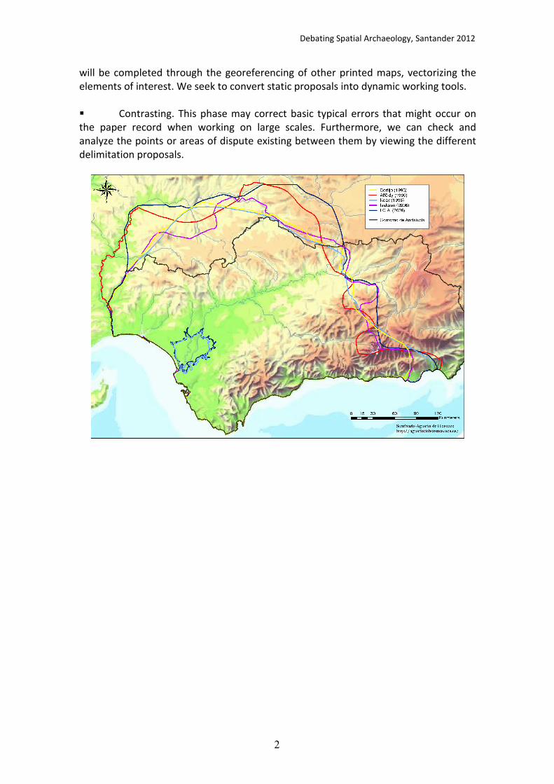
Debating Spatial Archaeology, Santander 2012
2
will be completed through the georeferencing of other printed maps, vectorizing the elements of interest. We seek to convert static proposals into dynamic working tools. � Contrasting. This phase may correct basic typical errors that might occur on the paper record when working on large scales. Furthermore, we can check and analyze the points or areas of dispute existing between them by viewing the different delimitation proposals.

Debating Spatial Archaeology, Santander 2012
1
Evaluating Viking eco-cultural niche variability between the Medieval Climate
Optimum and the Little Ice Age
Antunes Nicolas 1
,William Banks1, Francesco D’Errico
1
1 Univ. Bordeaux, CNRS, MCC, INRAP, PACEA, UMR 5199, F-33400 Talence, France.
Abstract:
For a variety of political and social reasons, Norwegian Viking populations colonized
Greenland, Iceland, and Vinland (Canada) from the ninth century until the end of the
fourteenth century. These migrations occurred during the Medieval Climate Optimum
(MCO), a period characterized by relatively warm climatic conditions that rendered
these regions favorable for Viking agricultural and pastoral practices.
Settlement of these regions declined during the fourteenth century for a number of
reasons. In Greenland, large areas were cleared to be used as cattle pastures and for
hay production, leading to a gradual deterioration of the environment making such
practices untenable. In addition, the disruption of trade networks between Greenland
and Norway, along with conflict with indigenous Inuit populations, took a toll on these
colonies. Finally, an abrupt climatic deterioration known as the Little Ice Age (LIA)
adversely affected agricultural productivity. Similarly, Icelandic settlements were
continually impacted by disease, famine, volcanism and social conflict, and the LIA only
exacerbated these problems.
While it has been argued that one should not rely on solely climatic factors to explain
these social and economic crises (Dugmore et al. 2012), one cannot ignore the fact
that the LIA had a profound effect on Viking populations. We know that settlement of
these regions for a number of centuries was made possible by favorable climatic
conditions and that habitat suitability played a major role in the establishment of these
farming communities.
In order to evaluate the influence of environment and changing climatic conditions on
Viking settlement over time, we apply genetic algorithm (GARP; Stockwell and Peters,
1999) and maximum entropy (Maxent: Phillips et al., 2006) techniques to estimate the
ecological niche exploited by colonizing Viking populations (i.e., their eco-cultural
niche: Banks et al., 2008) during the MCO and the LIA. These predictive modeling
methods allow one to determine which environmental factors most influenced the
Viking eco-cultural niche, as well as evaluate eco-cultural niche variability over time. By
quantifying tolerances of the Viking subsistence economy to climatic variability, we
evaluate the hypothesis that the onset of the LIA led to a to a contraction of the Viking
eco-cultural niche and ultimately to their abandonment of these regions.
References:
Banks, W.E., et al. 2008. "Human ecological niches and ranges during the LGM in Europe derived from
an application of eco-cultural niche modeling". Journal of Archaeological Science 35 (2): 481-491.

Debating Spatial Archaeology, Santander 2012
2
Dugmore, A.J., McGovern, T.H., Vésteinsson, O., Arneborg, J., Streeter, R. and Keller, C. 2012.
"Cultural adaptation, compounding vulnerabilities and conjunctures in Norse Greenland."
Proceedings of the National Academy of Sciences, 109 (10): 3658-3663
Phillips, S.J., Anderson, R.P. and Schapire, R.E. 2006. "Maximum entropy modeling of species
geographic distributions." Ecological modelling 190, (3-4): 231-259.
Stockwell, D. and Peters, D.P. 1999. "The GARP modelling system: problems and solutions to
automated spatial prediction". International Journal of Geographical Information Science 13 (2)
(1999): 143-158.

Debating Spatial Archaeology, Santander 2012
1
From place to surface: exploring palaeolithic spatial behavior through Archaeology
Javier Ordoño Daubagna 1
1 Department of Geography, Prehistory and Archaeology, University of the Basque Country. C/ Tomás y Valiente s/n. 01006 Vitoria-Gasteiz (Spain).
When analyzing from a macro scale human spatial behavior in past times, not a few impediments are usually found. The majority of them depend on the singular nature of archaeological record (scarcity of preserved evidences) and of the geographical context in which it is kept (problem of visibility). In the case of Palaeolithic, moreover, two major facts determine research on the relationship between human beings and their environment. First, the widespread theory that pre-agricultural societies did not make too much effort transforming their surrounding landscapes, not only in an economic but even in a symbolic or sacred sense (Bradley, 1998: 20). And second, the assumption that even if they had done it, the posterior millennial evolution and anthropic transformation of landscapes could have erased any evidence of human activity. Nowadays, although these assessments can be reformulated thanks to new discoveries (lithic raw material sources, open air rock art) and methodological improvements (survey, GIS), there are still many difficulties to transcend the local scale constituted by palaeolithic sites in spatial analysis. In fact, as we move away from a site, understood as a place or context for the mediation of physical, social, economic and symbolic processes instead of a mere location (Agnew, 2011: 317), we realize the trouble to discern its spatial association to outer sites, structures or objects, whose contemporaneity and/or same authorship uses to be, on practice, uninsurable. Therefore, archaeologists are forced to take sites as the starting point from which to analyze surface, the surrounding territory where external activities are presumed to have taken place. Research on this must be conducted through the analysis of different scales or levels (from local to semi-local, territorial, transterritorial) to be defined from a previous reflection on hunter-gatherer spatial behavior (Julien & Connet, 2005; Djindjian, 2009). Only then, the variables to be analyzed from spatial premises can be determined and weighted. Recent works (García Moreno, 2010) reflect this kind of procedures and show the value of some of those variables, especially locational ones (altitude, insolation, slope, visibility, etc.), in the analysis of palaeolithic spatial patterns. Assessing the possibilities of these type of approaches and designing a new methodological framework, based on a reflection from an archaeogeographic perspective, will be the main aim of this essay. References:
Agnew, J. A. 2011. "Space and place". In Agnew, J and Livingstone, D. (eds.) Handbook of
Geographical Knowledge, London: Sage, 316-330.

Debating Spatial Archaeology, Santander 2012
2
Bradley, R. 1998. The significance of monuments on the shaping of human experience in Neolithic and
Bronce Age Europe. London: Routledge.
Djindjian, F. 2009. "Le concept de territoires pour les chasseurs-cueilleurs du Paléolithique supérieur
européen". In Djindjian, F., Kozlowski, J. and Bicho, N. (eds.) Le concept de territoires dans le
Paléolithique supérieur européen. British Archaeological Reports International Series 1938. Oxford: Archaeopress, 3-25. García Moreno, A. 2010. Patrones de asentamiento y ocupación del territorio en el Cantábrico Oriental
al final del Pleistoceno. Una aproximación mediante SIG. Unpublished PhD Dissertation. Universidad de Cantabria. Santander.
Julien, M. and Connet, N. 2005. "Espaces, territoires et comportements des châtelperroniens et
aurignaciens de la Grotte du Renne à Arcy-Sur-Cure (Yonne)". In Vialou, D.Renault-Miskovsky, J. and
Patou-Mathis, M. (eds.) Comportements des hommes du moyen et supérieur en Europe: territoires et
milieux, Université de Liège: Études et Recherches Archéologiques de l'Université de Liège 111. Liège, 133-146.

Debating Spatial Archaeology, Santander 2012
1
The micro‐spatial dimension of the human behaviour: How reliable is the toss/drop model to analyze spatial pattern organization?
Jorge Martínez‐Morenoa, Rafael Mora Torcala,b, Xavier Roda Gilaberta,c
a‐ Centre d’Estudis del Patrimoni Arqueològic de la Prehistoria (CEPAP). Facultat de Filosofia i Lletres. Universidad Autònoma de Barcelona. 08193 Bellaterra. Spain.
b‐ ICREA Academia Program, Generalitat de Catalunya, Spain c‐ FPI‐MICINN Pre Doctoral fellowship, Ministerio de Ciencia e innovación, Spain.
Space management is a relevant category in characterizing past hunters‐gatherers groups, as has been suggested by diverse theoretic‐methodological perspectives. The spatial distribution of stone tools and bones, as well as the presence of hearths and building elements provide information about the extant interactions among group components (Binford, 1983). Hence, micro‐spatial analysis permits identifying activities which are the basis to analyze the settlement organization.
The palaeoethnographic approach has structured these analytic lines according to several techniques, in which artefacts and bones’ refitting allows establishing trajectories interpreted in terms of movements and task conducted by group members (Leroi‐Gourhan & Brezillon 1964). Conversely, diverse processual approaches (Simek, 1984) prevail the application of quantitative tests –nowadays highly sophisticated (geo‐statistics, GIS) ‐ in order to detect spatial relationship among archaeological categories. Nevertheless, explicitly or implicitly, an ethnoarchaeologic referent is essential to assess the reliability of spatial patterns (Kroll and Price (eds) 1991).
Fig. 1‐ Toss and drop model proposed
in Henry 2012 (modified).
The main aim is to analyze the
implications of the application of one of these ethnoarchaeological models within the spatial analysis. Toss‐drop model defined by L. Binford (1983) from his observations about Nunamiut, allowed him to challenge the proposed reconstruction of habitation 1 of Pincevent (Leroi‐Gourhan y Brezillon 1964). Based on quantitative finesses such as the ring and sector method (Stapert 1989), diverse authors draw similar conclusions. Lately, this method has been applied to the analysis of Tor Faraj Middle Palaeolithic site (Henri, 2012) (Fig. 1).
Debating Spatial Archaeology, Santander 2012
2
It is analyzed the heuristic of these models, within a theoretic‐empirical sphere.
This critical approach lead us to discuss concepts such as living‐floor/palimpsest, which definition constitutes an essential part in the identification of organization patterns and remarks the importance of considering the vertical distribution of artefacts (Villa, 2004). We propose generating archaeological alternatives which overcomes the gaps inherited in these ethnoarchaeological approaches. Keywords: methodology, micro‐spatial analysis, toss/drop model, archeostratigraphy References:
Binford, L.R. 1983. In Pursuit of the Past. Decoding the Archaeological Record. Henry, D. 2012. "The palimpsest problem, hearth pattern analysis and Middle Paleolithic site structure". Quaternary International 247: 246‐266.
Kroll, E., Price. T. (eds) 1991. The interpretation of archaeological spatial patterning. Plenum Press. New York
Leroi‐Gourhan, A.; M. Brezillon 1966. "L'habitation magdalenienne nº 1 de Pincevent
près Montereau (Seine‐et‐Marne)". Gallia Préhistorie 9: 263‐385. Simek, J. F. 1984. "Integrating pattern and context in spatial archaeology". Journal of Archaeological Science 11: 405‐420.
Stapert, D. 1989. "The ring and sector method : intrasite spatial analysis of
Stone Age sites, with special reference to Pincevent". Palaeohistoria 31: 1‐57. Villa, P. 2004. "Taphonomy and stratigraphy in European prehistory". Before Farmi
ng 1: 1‐20.

Debating Spatial Archaeology, Santander 2012
1
GIS Spatial distribution analysis in raw material quarrying sites: the example of
El Cañaveral (Madrid, Spain)
Irene Ortiz Nieto‐Márquez 1 Javier Baena Preysler2 María Gema Chacón3,4,5
1 Becaria FPU. Dep. de Prehistoria y Arqueología. Universidad Autónoma de Madrid. Campus Cantoblanco, 28049 Madrid. [email protected] 2 Dep. de Prehistoria y Arqueología. Universidad Autónoma de Madrid. Campus Cantoblanco, 28049 Madrid [email protected] 3 IPHES, Institut Català de Paleoecologia Humana i Evolució Social, C/Escorxador s/n, 43003 Tarragona, Spain [email protected] 4 Àrea de Prehistòria, Universitat Rovira i Virgili (URV), Avinguda de Catalunya 35, 43002 Tarragona, Spain 5 UMR7194 – Département de Préhistoire, Muséum National d’Histoire Naturelle, 1, rue René Panhard, 75013 Paris, France
The El Cañaveral archaeological site (Madrid, Spain) is an open air raw material
quarrying site, occupied during the Middle Paleolithic period. The archaeological context of the site is the tertiary basin of Madrid, part of a bigger morpho-structural unit called Tajo’s basin (Baena et al. 2011). This site was discovered thanks to some investigation projects headed by the Consejería de Cultura of the Region of Madrid. Later excavations were conducted by Arquex SL archaeological company and the Universidad Autónoma de Madrid team, determinate the presence and character of the archaeological remains.
Thanks to the discovering of a large number of lithic industry associated with raw material blanks, it was decided to start an open excavation in different areas. One of the main excavation was the Area 3. It is a 164 m2 area, where it was possible to document at first glance a great density of lithic material with different degrees of alteration, and high concentrations of horizontal position materials (Baena et al, 2008). For this reason, it was necessary to discriminate different knapping areas in whole excavation area, and also to determinate if this place is a palimpsest as a result of a continuous occupation place, or discrete layers happened. Likewise it was necessary to discover the postdepositional agents that could affect the original lithic distribution both in x and y axis and in z values. The spatial dimensions of refits could offer important information about formation process of the site. At the same time, refitting could provide basic information in terms of behavior dynamics of the Mousterian groups in the site (De la Torre, 2004).
Controlling refits dimensions is essential in the horizontal axis to determine related activities between clusters of knapping in order to evaluate its contemporarily or not, and in the vertical dispersion to answer stratigraphic ascriptions.
In order to do that, a spatial analysis of remains was built up using GIS
technology using information of refitted pieces. Computing and GIS developments open
1 2
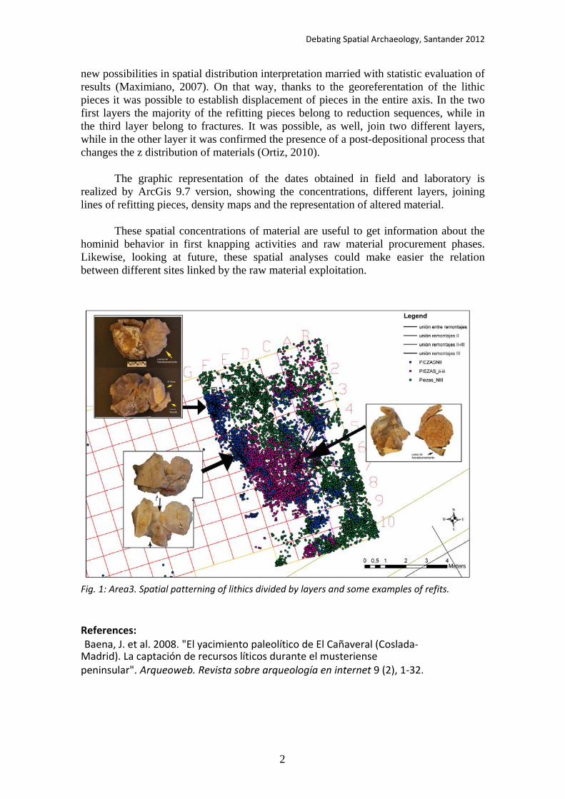
Debating Spatial Archaeology, Santander 2012
2
new possibilities in spatial distribution interpretation married with statistic evaluation of results (Maximiano, 2007). On that way, thanks to the georeferentation of the lithic pieces it was possible to establish displacement of pieces in the entire axis. In the two first layers the majority of the refitting pieces belong to reduction sequences, while in the third layer belong to fractures. It was possible, as well, join two different layers, while in the other layer it was confirmed the presence of a post-depositional process that changes the z distribution of materials (Ortiz, 2010).
The graphic representation of the dates obtained in field and laboratory is realized by ArcGis 9.7 version, showing the concentrations, different layers, joining lines of refitting pieces, density maps and the representation of altered material.
These spatial concentrations of material are useful to get information about the
hominid behavior in first knapping activities and raw material procurement phases. Likewise, looking at future, these spatial analyses could make easier the relation between different sites linked by the raw material exploitation.
Fig. 1: Area3. Spatial patterning of lithics divided by layers and some examples of refits. References: Baena, J. et al. 2008. "El yacimiento paleolítico de El Cañaveral (Coslada- Madrid). La captación de recursos líticos durante el musteriense peninsular". Arqueoweb. Revista sobre arqueología en internet 9 (2), 1-32.

Debating Spatial Archaeology, Santander 2012
3
Baena, J.et al. 2011. Searchers and Miners: first signs of flint exploitation in Madrid Region (Spain). In The 2nd International Conference of the UISPP Commission on Flint mining in Pre- and Protohistoric Times. BAR International Series. Archaeopress.
De la Torre, I., Martínez-Moreno, J., Mora, R. and Pizarro, J. 2004. "Los remontajes del nivel 10 de la Roca del Bous (Cataluña, España); una herramienta analítica para reconstruir los procesos de formación de los yacimientos". O Paleolítico, Actas do IV Congresso de arqueología peninsular., 397-406. Maximiano Castillejo, A. 2007. Teoría geostadística aplicada al análisis de la variabilidad espacial arqueológica intra-site. (Tesis de Doctorado, Universidad Autónoma de Barcelona). Ortiz, I. 2010, inédito. Dinámicas de la industria lítica. Análisis Espacial de los agregados del Área 3 en el yacimiento de El Cañaveral. (Coslada-Madrid). Tesis de Máster, Universidad Autónoma de Madrid. (ep)

Debating Spatial Archaeology, Santander 2012
1
A GIS approach to Neandertal spatial behavior: A case study from Amud Cave
Mae Goder 1, Erella Hovers
1, Rivka Rabinovich
1,2
1The Institute of Archaeology, The Hebrew University of Jerusalem (Israel)
2 The National Natural History Collections, The Institute of Earth Sciences,
The Hebrew University of Jerusalem; Israel
Background:
GIS has been used mostly for landscape archaeology and inter-site spatial mapping and
analysis, and to a lesser extent for intra-site spatial analysis. Despite the analytical
constraints typically originating from the limited size and distorted shapes of
excavation areas, the majority of onsite GIS work has been confined to using the
software’s visualization tools at the expense of more analytical studies (for some
exceptions see: Birkenfeld and Goring-Morris 2011; Mills 2009; Moyes 2002). Amud
Cave is a late Middle Paleolithic site in Israel (68-55 thousand years ago), presenting a
stratigraphic sequence of dense human occupations coupled with complex site
formation processes, While differential use of space has been documented for some
find classes in the cave, the digital treatment of the various data sets presents us with
methodological as well as archaeological challenges (Hovers et al., 2011).
Aims
The most recent excavations at the site ended in 1994, prior to the now-common
practice of applying digital methods of data collection, documentation and analysis
Consequently, our aims in this study are twofold: 1) developing a methodology to
translate analogical field documents to GIS files using ArcGIS generic software, and 2)
addressing the issue of spatial differences in artifact distributions and assessing their
anthropogenic or taphonomic origins.
Once digitization was complete, we used the nArcMap’s native statistical tools to
validate emerging spatial patterns of lithic artifacts, taking into account the constrains
of the shape and size of the excavated area. When integrated with geochemical, faunal
and lithic analysis results, this allows addressing questions about spatial behaviors of
the Neandertal occupants of Amud Cave, with special emphasis on trash disposal
behavior.
References:
Birkenfeld, M., and Goring-Moris., N. 2011. "A methodological approach, using GIS applications, to
stratigraphy and spatial analysis at PPNB Kfar HaHoresh". In Healey, E., Campbell, S. and Maeda, O.
(eds.) Studies in the State of the Stone Terminologies, Continuities and Contexts, Near Eastern Lithics
Studies in Early Near Eastern Production, Subsistence, and Environment 13, Berlin, 277-291.
Hovers, E., Malinsky-Buller A., Goder-Goldberger, M. and Ektshtain; R. 2011. Capturing a Moment:
Identifying Short-lived Activity Locations in Amud Cave, Israel. In Le Tensorer J.-M., Jagher R. and M. Otte M. (eds.) The Lower and Middle Palaeolithic in the Middle East and Neighbouring Regions,4.
Proceedings of the Basel symposium (mai 8-10 2008). ERAUL 126, Liège,101-114.

Debating Spatial Archaeology, Santander 2012
2
Mills, T. 2009. A GIS Approach to the Spatial Analysis of the Fincastle Bison Kill Site (D10x-5), MA Thesis,
University of Lethbridge, Alberta, Canada.
Moyes, H. 2002. "The use of GIS in the spatial analysis of an archaeological cave site". Journal of Cave
and Karst Studies 64(1): 9-16.
Debating Spatial Archaeology, Santander 2012
1
Marking old territories: Using ArcGIS models for raw material survey areas in the
Levantine Middle Paleolithic. A case study from Qafzeh cave, Israel
Ravid Ekshtain1 , Ilan Sharon
1 , Yonaton Goldsmith
1 , Michal Birkenfeld
1
1 The Institute of Archaeology. The Hebrew University of Jerusalem, Jerusalem 91905 (Israel)
In this study, we reconstruct size and shape of daily exploitation territories (Bailey and
Davidson 1983, Vita-Finzi and Higgs 1970) used in the Levantine Middle Paleolithic, in
order to shed light on raw material procurement strategies and mobility patterns. In
the Levant, the major raw material to be considered is flint. By investigating lithic
assemblages and mapping flint sources surrounding sites, we examine whether lithic
raw material sources are located within or outside such territories. This impacts on our
understanding of prehistoric land use strategies.
We approach the question of flint procurement by Middle Paleolithic groups through a
formal, top-down model. Ethnographic studies on hunter-gatherers suggest that site
exploitation territories tend to be confined within pedestrian travel distance of up to
ca. 120 minutes one-way. In a homogeneous and flat topography, this is equal to a
distance of 10 km. However, Levantine MP cave sites tend to be located in areas of
accentuated and diverse topographic features. To simulate site exploitation territories
we used topographic data (DEM) to create a model of a daily exploitation territory
around Middle Paleolithic sites, using ArcGIS. The model computes the boundary
around a site that designates 120 minutes of travel away from the site. The model’s
predictions about travel distances and the effects of topography were tested, with the
help of Hebrew University archaeology students who traversed a specific terrain in the
lower Galilee. This test enabled fine-tuning and calibration of the model‘s assumptions.
After calibration, the model was applied to several Levantine Middle Paleolithic sites.
Here we present a case study from Qafzeh Cave, located in the lower Galilee. Flint
artifacts from layer XIX in the terrace sequence, dated 88.6±3.2 (TL) - 106.0 (ESR)
(Valladas et al. 1988, Schwarcz et al., 1988) were analyzed typologically, technologically
(Hovers, 2009), and visually for raw material identification (this study). Several
different flint groups were identified. We surveyed the exploitation territory around
the cave, as defined by the calibrated model, in order to locate flint sources.
Comparison between the archaeological artifacts and the flint sources identified within
this territory allows several insights concerning the raw material strategies and
mobility patterns of the inhabitants of this site.

Debating Spatial Archaeology, Santander 2012
2
References:
Bailey and Davidson. 1983. "Site exploitation of territories and topography: two case studies from
Paleolithic Spain". Journal of Archaeological Science 10: 87-116.
Hovers, E. 2009. The Lithic Assemblages of Qafzeh Cave. New York: Oxford University Press.
Schwarcs, Grun, Vandermeersch, Bar- Yosef, Valladas, and E. Tchernov. 1988. "ESR dates for the
hominid burial site of Qafzeh in Israel". Journal of Human Evolution 17: 733-737.
Valladas, Reyss, Joron, Valladas, Bar- Yosef, and B. Vandermarch. 1988. "Thermoluminescence dating of
Mousterian 'Proto-CroMagnon' remains from Israel and the Origin of Modern man". Nature 331: 614-
616.
Vita-Finzi and Higgs. 1970. "Prehistoric Economy in the Mount Carmel Area of Palestine: Site catchment
analysis". Proceedings of the Prehistoric Society 36: 1-37.

Debating Spatial Archaeology, Santander 2012
1
D b n p A h o o n nd
How efficiently did they walk? An essay on the characterisation of traditional
routes by Least Cost Path analysis and non-dimensional variables
Enrique Cerrillo Cuenca 1, José Ángel Martínez del Pozo1, Raquel Liceras Garrido1, Enrique Cerrillo Martín de Cáceres2
1 Archaeological Institute of Mérida. Spanish Council for Scientific Research. Plaza de España, 15. 06800,
Mérida, Badajoz (Spain) 2University of Extremadura. History Department. Faculty of Philosophy and Letters. Av/ Universidad s/n,
10071 Cáceres (Spain).
The Least Cost Path (LCP) analysis has been widely applied in landscape research from
the very first period of GIS applications in Archaeology (Llobera 2000). Even there is a
previous literature about the calculation of optimal routes in Archaeology by non-
computational procedures. A certain number of algorithms have been used in
Archaeology: Naismith rule (Frizt and Carver 1998), Pandolf equation (Pandolf et al.
1977) or Tobler’s hiking function (Tobler 1993). In spite of this, some authors have
compared the results from these methods, the reality is that a little work have
been done on testing the modelling routes against traditional routes.
Our work has focused on the landscape of Tagus basin, in the surroundings of
Alconétar’s River Ford, whose role as a ford has remained stable over the past, since
it strongly depends on the topographical and geological setting of the region. One of
the main aims of the project is to reconstruct the patterns of movement
in the surroundings of the ford, since it can help to explain the distribution of
certain number of archaeological sites, ranging from megalithic monuments to roman
sites.
We understand routes as a landscape feature produced by agents, who determine
not only the track of the route, but some aspect that are socially accepted as the
time invested in cover it, and, of course, the cognitive experiences of the
travellers. Although experiences are a factor to not be forgotten in landscape
configuration, time and effort are the solely variables that we can model through
LCP. Comparing these pseudo-objective variables from pre-industrial routes with
that obtained from LCP analysis could be a way to test the suitability of LCP when
analysing past landscapes. We have faced the research in three directions:
1. Research on computing LCP in GIS. We have programmed our own module in GRASS
GIS (r.paths) to compute the routes the different algorithms in a common
background, easing the task to perform calculations with several algorithms
jointly. One of the advantages is that our module has been designed to perform
the “Moving without Destination” approach to model random movement (Fábrega
and Parcero 2007).
2. A non-dimensional way to characterise the internal complexity of the routes.

Debating Spatial Archaeology, Santander 2012
2
Being not just enough the results of the comparisons between modelled and
traditional routes, we have computed variables such as length, sinuosity or fractal
dimension to validate these comparisons. We see it as an advance to objectively
describe the results of different LCP methods with non-dimensional parameters,
rather than with lengt
and slope dependent variables as time or energy costs are. A brief statistical analysis
of the methods regarding to the internal complexity that they use to produce the
routes will be presented.
Fig. 1. An example of routes produced by our r.paths GRASS GIS module in the
surroundings of Araya fault, south of Alconetar’s River Ford, where several megalithic
sites have been identified.
3. Historic research on landscape. In our area of work we count with a rich historical
cartography and literature dating back from the 16th to 19th centuries, whose
routes are expressed in leagues, that is, the track of the route an individual can
cover in an hour. We have gathered all the historical information and we have
observed that distances are not altered over the time or the kind of cartography
(civil or military), what can denote a social consensus when perceiving the
journeys. A simple comparison between the information from these sources and
the variables derived from the modelled routes by LCP can offer a insight on what LCP
method adapts better to traditional paths.
To sum up, we offer a perspective of how LCP can help to explain the structure of
archaeological landscape in our study region, specially regarding to the distribution
of prehistoric sites.

Debating Spatial Archaeology, Santander 2012
3
Notes:
This paper advances some preliminary results of the project The formation of a
passage landscape (PRI09C058) funded by Extremadura’s Regional Government trough
the European Social Fund
Reference:
Fábrega P. and Parcero C. 2007. "Proposals for an archaeological analysis of
pathways and movement". Archeologia e Calcolatori 18:121-40.
Fritz S. and Carver S. 1998. "Accessibility as an important wilderness
indicator: Modelling Naismith's rule". In GISRUK'98
http://www.geog.leeds.ac.uk/papers/98-7/. Accessed 11 November
2010.
Llobera M. 2000. "Understanding movement: a pilot model towards the
sociology of movement". In Lock, G. (ed.) Beyond the Map: Archaeology and
Spatial
Technologies, NATO Science Series, Series A: Life Sciences 321, 65-84. Amsterdam.
Pandolf K. and Givoni B. Goldman R. 1977. "Predicting Energy Expenditure with
Loads While Standing or Walking Slowly". Journal of Applied Physiology 43 (4): 577–581.
Tobler, W. 1993. Three Presentations on Geographical Analysis and Modeling: Non-
isotropic modeling, speculations on the geometry of geography, global spatial analysis,
National Center for Geographic Information and Analysis.
http://citeseerx.ist.psu.edu/viewdoc/download?doi=10.1.1.33.5402&rep=rep1&type
= pdf. Accessed 11 November 2010.
Debating Spatial Archaeology, Santander 2012
Traditional wisdom and landscape management. A Longue durée history of human
exploitation of a critical resource. The case of the Oukaimeden valley (High Atlas, Morocco)*
Grupo ARPA* Youssef Bobkot
1, Marisa Ruiz-Gálvez
2, Mercedes Farjas
3, Eduardo Galán
4, Hipólito
Collado5, Paloma de la Peña
2, Jorge de Torres
2 Blanca Ruiz
6, Pablo de la Presa
3, Antonio Rubinos
7, José
María Señorán8, Carlos Nieto
2
1
Départment de Préhistoire. Institut National des Sciences de l’Archéologie et du Patrimoine, Rabat,
Marruecos 2
Prehistory Department, Complutense University. 3
Technical School of Engineers in
cartography, surveying and geodesy. Polytechnic University Madrid 4
National Archaeological Museum,
(Madrid, Spain) 5 Council of Extremadura’s Heritage, Mérida
6 Department of Geology. University of
Alcalá de Henares 7 Rocasolano Institute, C.S.I.C.
8 INCIPIT (Heritage Sciences' Institute. Padre Sarmiento
Institute (CSIC), Santiago de Compostela, España
Since 2008 an international and interdisciplinary team of archaeologists, geologists and 14c
and paleoenvironment specialists is working together, aiming at reconstructing the history of
the human occupation of an alpine valley in Morocco. This global approach includes an
intensive rock art survey, excavations in shelters and barrows and technological analysis of
lithic tools, as well as historical and etnoarchaeological information collected to be contrasted
with the archaeological data.
Information has been handled by means of a Geographic Information System and supported
by statistical analysis, particularly in correspondence analysis trough WINBASP and PAST
programs, developed as free software by Bonn University (BASP) and PALSTAT project. This
kind of statistical approach has been used to analyze the huge amount of rock engravings
documented - whose chronology is not accurately established – in order to find relationships
between their topographical position and the symbols, animals and items represented which
could have chronological implications.
We can build on these data that the first human occupation of this alpine valley, located at
2630 meters above the sea level, took place at a relatively late period. Within the nearly 25
14C dates we have, six are dated around the mid-fourth millennium cal BC, that is, at Late
Neolithic. These are oldest evidence of the human presence at the valley. Resources were
probably exploited on a seasonal regime as it is still today, due the marked altitude of the
valley and the ephemeral character of the archaeological dwellings we have dug up.
The first exploitation of this marginal area is related to the change of the monsoon regime
affecting North Africa, which resulted in a more contrasted climate, including a summer
drought period, that also lead southwards to the formation of the Saharan desert. Our
Paleoenvironmental data clearly show the impact of the human setting on this fragile
environment, with some areas evolving to a maquis at period of strong exploitation and others
of recovering, probably linked to a less marked human presence on it. Rock art too, with a
remarkable emphasis on weapons located at key points such as those which allow the access
to critical resources, betray a stronger pressure on critical resources. A significant amount of
these rock carvings of weapons can be considered to belong to the Bronze Age.
* Project funded by an I+d+i Project of the Spanish Ministry of Science and Innovation HAR2009-07169
and by the Spanish Ministry of Culture (IPCE calls 2008,2009,2010 and 2011)

Debating Spatial Archaeology, Santander 2012
Figure 1: Main engraving areas at Oukaïmeden valley
The GIS tool, on the other hand, has been used to develop a predictive model of the potential
distribution of archaeological sites, whether rock carvings dwelling areas, according to three
variables taken from data from our previous field surveys campaigns . These variables were
altitude, sunstroke and slope. The weighted values method was used for that matter. The
method is based on the definition of a set of variables that determine a prediction to obtain
and their classification according to their importance in this prediction. The reliability of the
model will be tested during our next field campaign of April 2012.
References:
David, B. and Thomas, J. (eds) 2008: Handbook of landscape archaeology. Walnut Creek, Left Coast Press.
Ruiz-Gálvez et al (in press): "Avance del estudio del poblamiento del Valle de Oukaïmeden (Alto Atlas,
Marruecos) y su relación con el Arte Prehistórico". Informes y Trabajos 7.
Ruiz-Gálvez et al (in press): "Rock Art, landscape and prehistoric settlement at the High Atlas
(Morocco)". In Contreras, F. and Melero, J. Proceedings of CAA’2010. Fusion of cultures. Granada.
Presa, P. de la 2010: Desarrollo e implementación de la metodología SIG para la catalogación de un
yacimiento arqueológico, Aplicación al yacimiento de Oukaïmeden (Alto Atlas, Marruecos). Proyecto de
fin de carrera para la obtención del Título de Ingeniero en Geodesia y Cartografía. UPM. ETS Ingenieros
en Topografía, Cartografía y Geodesia. (inédito).
Ruiz-Gálvez, M. L. et al 2009: Informe de la campaña 2009 en el Agdal de Oukaïmeden. Informes y
Trabajos 5. 222 - 242.

Debating Spatial Archaeology, Santander 2012
1
Social Living: addressing spatial variability in households at Early Iron Age
Zagora on Andros, Greece
Kristen Patricia Mann 1
1 Doctoral Candidate, University of Sydney, Department of Archaeology, Sydney, NSW 2006, Australia
Household archaeology and spatial variability:
Households have long been recognised as a vital component of the social fabric of past
societies. Consequently, investigations into the nature of past households frequently
examine the relationships between household form and function, behaviour and space
(Kent 1990). However, household space can often appear deceptively simple, inviting
unconscious assumptions about household composition and spatial use when drawing
inferences concerning human activities and social relationships from the material
record.
There is a definite need to question more directly how changes in spatial use or
arrangement within households can be related to variability in human behaviour.
Analytical tools such as GIS allow us to examine these issues through the use of spatial
modelling. However, scholars have only recently begun to contextualise spatial
analyses of households within a larger framework of anthropological theory at the
interpretive level (Souvatzi 2008).
Nevertheless, many archaeologists seem reluctant to directly address the issue of
behavioural variability when articulating the relationship between household
composition, activities and space. Indeed, the few studies that confront this issue are
often criticised for subverting the interpretive value of household archaeology.
We cannot remain wary of behavioural variability for fear it will compromise the
integrity of our interpretations. On the contrary, it is vital that we embrace the
variables and possibilities associated with ancient households. It is therefore
imperative that we seek to develop constructive methodologies for archaeological
analysis and interpretation that can account for the vast array of factors and choices
that may have shaped the material record.
Aims
The main aim of this presentation will be to discuss these issues the Early Iron Age
settlement of Zagora on Andros in Greece as a case study (Cambitoglou et. al. 1971;
1988). Zagora is uniquely placed in its ability to facilitate nuanced investigations of
space and human behaviour. The site has extensive household remains, undisturbed by
subsequent occupation, with clear evidence for an increase in spatial complexity
towards the end of the settlement’s occupation. The material presented is part of a
collaborative web-based research project, that allows a diversity of specialists to
immediately incorporate new research developments into their respective datasets;
thereby enhancing our ability to test current social models at a depth and efficiency
impossible for one scholar alone.
Debating Spatial Archaeology, Santander 2012
2
Spatial analysis, variability and social behaviour:
Using the Zagora material, this paper will discuss:
� The importance of first examining the range of potential uses for different
household spaces, and various factors involved in the patterning of behaviour and
activities, before interpreting spatial analyses results
� Using a GIS-integrated database to effectively question the relationship
between human activity, space and social organisation
� How to test methodological models that articulate behavioural variability
from patterns of artefact distribution and household spatial patterning
� The implications that spatial variability has in terms of social space. How can
we best use spatial analysis to investigate household relationships, social organisation
and diversity while accounting for behavioural variability?
� The ramifications of behavioural variability for interpreting the increase in
spatial complexity visible at Zagora during the 8th
century BC.
References: Cambitoglou, A.C., Coulton, J.J., Birmingham, J, and Green, J.R. 1971. Zagora 1: Excavation Season 1967;
Study Season 1968-69. Sydney: Sydney University Press.
Cambitoglou, A.C., Birchall, A., Coulton, J.J. and Green, J.R. 1988. Zagora 2: Excavation of a Geometric
Town on the Island of Andros. Excavation Season 1969; Study Season 1969-1970. Athens: Athens
Souvatzi, S. G. 2008. A Social Archaeology of Households in Neolithic Greece: An Anthropological
Approach. Cambridge/New York: Cambridge University Press.
Archaeological Society. Kent, S. 1990. "Activity areas and architecture: an interdisciplinary view of the relationship between use
of space and domestic built environments". In Kent, S (ed.) Domestic Architecture and the Use of Space:
An Interdisciplinary Cross-Cultural Study, Cambridge: Cambridge University Press, 1-8.
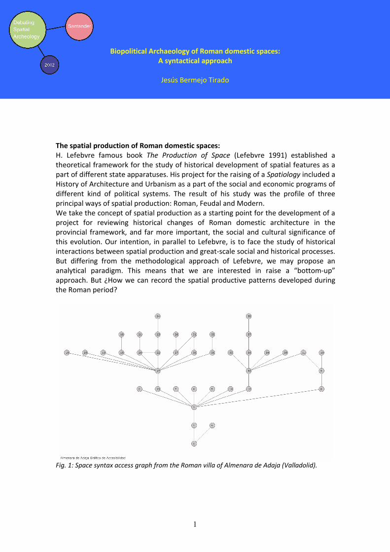
Debating Spatial Archaeology, Santander 2012
1
Biopolitical Archaeology of Roman domestic spaces:
A syntactical approach
Jesús Bermejo Tirado
The spatial production of Roman domestic spaces:
H. Lefebvre famous book The Production of Space (Lefebvre 1991) established a
theoretical framework for the study of historical development of spatial features as a
part of different state apparatuses. His project for the raising of a Spatiology included a
History of Architecture and Urbanism as a part of the social and economic programs of
different kind of political systems. The result of his study was the profile of three
principal ways of spatial production: Roman, Feudal and Modern.
We take the concept of spatial production as a starting point for the development of a
project for reviewing historical changes of Roman domestic architecture in the
provincial framework, and far more important, the social and cultural significance of
this evolution. Our intention, in parallel to Lefebvre, is to face the study of historical
interactions between spatial production and great-scale social and historical processes.
But differing from the methodological approach of Lefebvre, we may propose an
analytical paradigm. This means that we are interested in raise a “bottom-up”
approach. But ¿How we can record the spatial productive patterns developed during
the Roman period?
Fig. 1: Space syntax access graph from the Roman villa of Almenara de Adaja (Valladolid).
Debating Spatial Archaeology, Santander 2012
2
Space syntax and the biopolitical interpretation of Roman domestic houses
Recently, the application of space syntax-based methodologies has been
applied to the study of archaeologically recorded buildings (Grahame 2000, Fisher
2009, Bermejo Tirado 2009). The analytical tools developed in space syntax seminal
works (vid. Hillier & Hanson 1984, Hillier 1996, Hanson 1998) can be applied to obtain a
complete quantitative and topographical characterization of spaces. The data obtained
in this way can be used to develop inferences about the impact of social and
ideological issues encoded in the design of architectural space in the everyday life of
their inhabitants.
This paper aims to explain how to use these syntactical indexes to measure the impact
(or the resistance) of some Roman Ideological issues in the everyday of provincial
communities. The applications of this analytical perspective to the study of two
different regions (the High Duero Valley and the Inner area of Africa Proconsularis
province) will be used as illustration for this historical process.
References:
Bermejo Tirado, J. 2009. “Leyendo los espacios: una aproximación crítica a la sintaxis espacial como
herramienta de análisis arqueológico”. Arqueología de la Arquitectura 6: 47-62.
Fisher, K. D. 2009. “Placing social interaction: An integrative approach to analyzing past
built environments”. JAA 28: 439-457.
Grahame, M. 2000. Reading Space: Social Interaction and Identity in the Houses of Roman Pompeii. BAR
International Series 886. Oxford.
Hanson, J. 1998. Decoding Homes and Houses. Cambridge University Press. Cambridge.
Hiller, B. and Hanson, J. 1984. The Social logic of Space. Routledge. London.
Hillier, B. 1996. Space is the Machine. UCL. London.
Lefebvre, H. 1991. The Production of Space. Blackwell. Oxford.

Debating Spatial Archaeology, Santander 2012
1
Predictive Modeling in Heritage Management and Land-use Plans in Mexico 1
Sandra L. López Varela1
1 Universidad Autónoma del Estado de Morelos
Introduction
Mexico is a country that requires the construction and expansion of infrastructure to
increase the competitiveness of its economy. Building this highly competitive logistic
platform has had an impact on Mexico’s cultural and social heritage (Paredes Gudiño
2006). The people of Mexico have expressed their discontent, demanding their voices
to be heard and their right to participate in the design of infrastructure development
projects, as clearly stated during the construction of a COSTCO store on the grounds of
the hotel El Casino de la Selva in the State of Morelos. The National Institute of
Anthropology and History (INAH) lacks sufficient staff and adequate funding from the
federal government to fulfill its responsibility of protecting Mexico’s heritage in this
intensive building context. In the absence of a heritage management industry in
Mexico, the federal government is bounded by law to absorb the full costs of heritage
management, leaving the stewards of their resources in a vulnerable stage to prevent
the destruction of people’s valued and significant spaces.
Measuring the benefits and adversities of development projects is centered on the
environment, without accommodating the clear mandated responsibility to protect
Mexico’s heritage in the design of impact assessments. In Mexico, the use of
environmental sustainable principles holds great potential as a concept for
incorporating heritage values. In areas of concern to planning, land-use plans already
include spatial decision support systems (sDSS), use of information technologies for
data collection and consulting, deliberative processes, and predictive modeling in an
integrated spatial planning framework. In a setting in which data is absent, one can
only predict the presence of archaeological resources to mitigate infrastructure growth
with a predictive model (López Varela and Dore 2009).
Aims
In this presentation, we discuss the relevance of introducing an archaeological
perspective in land-use planning and brings to the attention of the archaeologist that
the exclusive use of a GIS, as a software tool, without further consideration of the
current management processes and definition of heritage, restricts its capacity to
protect Mexico’s heritage. Without a process that can be expanded and used to
minimize adverse effects on heritage resources or without contemplating the values
and knowledge of the people of Mexico, as demonstrated here, the quality of the GIS
dataset and structure is compromised. The discussion presented here promotes a

Debating Spatial Archaeology, Santander 2012
2
geographic information science considering the relationship between space-time and
nature-society (Conolly and Lake 2010), for managing the ideal cities of the future and
heritage.
Figure 1. Predictive model for the Municipio of Cuernavaca, showing sensitive areas for finding
cultural resources, (Courtesy of Statistical Research for the Municipio of Cuernavaca).
References
Paredes Gudiño B. 2006. The present situation of the archaeological patrimony in the southwest basin of Mexico. 71st Annual meeting of the Society for American Archaeology; San Juan, Puerto
Rico 2006.
López Varela SL, Dore CD. 2009. "Protecting Mexico’s Heritage Using Basic GIS Modeling. SAS
Bulletin". Newsletter of the Society for Archaeological Sciences 32(1):10-3.
Conolly J, and Lake M. 2010. Geographical Information Systems in Archaeology. Fourth Printing ed.
Cambridge: Cambridge University Press.

Debating Spatial Archaeology, Santander 2012
1
Volumetric study of megalithic tombs of the Eastern Pyrenees
Elisabet López i Garriga¹
¹Universitat Autònoma de Barcelona. Prehistory Department. 08193 Bellaterra (Spain).
Megalithic research in Catalonia has been one of the main lines of research that has
developed around the prehistory of this area. However, it was focused mainly on the
definition of architectural types and the development of chrono-cultural explanation
schemes, and in any case, the study of the material that could be documented inside.
The ability of megalithic evidences to generate relevant information is not limited in
these aspects. In this sense, we are developing a proposal that combines aspects
hitherto not considered in the study of megalithic in Catalonia, such as the volume of
built spaces (room, corridor and tumulus) and its location in geographic space. This
proposal is based on the assumption as the volumetric characteristics, so that work
invested in, and the situation in the geographical area of any megalith is directly
related to the structure and socio-economic characteristics of the community that built
and uses it.
The study presented is based on a careful analysis of a set of twenty-one megalithic
tombs situated on the eastern Pyrenees of Catalonia. The methodology focuses in an
accurate calculated volume of these built spaces to know the investment of labor
expended in its construction. Then, by performing a SIG, analyze the possible
relationship between different investments and different geographical locations.
The results presented by mathematical calculations and investment of work altogether
with SIG study allow the hypothesis of the existence of different social spaces in the
area of the eastern tip of the Iberian Peninsula.

Debating Spatial Archaeology, Santander 2012
2
References:
Yubero, M i Xavier, R. 2010. Models geogràfics, GIS i arqueologia. El cas d’estudi del
poblament prehistòric a la conca del riu Ripoll (Vallès, 5500-550 ane). Barcelona:
Societat Catalana d’Arqueologia.
Moreno, M. A. 2004. Megalitismo y geografia: análisis de los factores de localización
espacial de los dólmenes de la província de Burgos. Valladolid: Universidad de
Valladolid. Secretariado de Publicaciones e Intercambio Editorial.
Tarrús et al. "El fenomeno megalítico en el Pirineo Oriental de Cataluña". In El
Megalitismo en la Península Ibérica. Madrid: Ministerio de Cultura. Subdirección
General de Arqueología y Etnología, 1987.

Debating Spatial Archaeology, Santander 2012
1
Visibility, a new point of view to the study of Paleolithic Art.
A preliminary study
Paula Ortega Martínez 1
1 Dpto. Prehistoria Historia Antigua y Arqueología. Facultad de Geografía e Historia. Universidad de
Salamanca C/ Cervantes s/n 37008 Salamanca
Traditionally, the study of Paleolithic art was based on stylistic trends and techniques
to interpret the artistic sequence of this period. However, Paleolithic art is a part of the
archaeological record and must be analyzed as such. Beyond the stylistic value, such
record provides huge information about human groups of hunter-gatherers, as a
reflection of values and concepts of the societies that created it.
By understanding the elaboration of Paleolithic graphics as an embodiment of a
prehistoric concept in a specific space, we grasp the significance of showing or hiding
the motifs to the other individuals in their own group or to other human groups, as a
relevant factor in the choice of the stand and the location thereof (Criado 1993).
The aim of this poster is to assess the potential that Spatial Archaeology brings to the
study of this kind of archaeological record by means of visual prominence and
cumulative viewshed analysis. The main target is to create a scene on which we could
evaluate the viability of the analyzed tools in closed spaces, such as a cave gallery, and
thereafter, to apply the visibility tools on the parietal art record, exploring the
advantages and limitations of these spatial analysis enabled by basic software of
Geographic Information Systems, compared to other methods of study. (Llobera 2003)
The final goal is to find out if the desire of projection of these motifs was a relevant
factor for Paleolithic societies.
The chosen stage for this project is the sector 9 of the cave La Greiga (Pedraza,
Segovia). This cavity, where 90 figurative representations and 29 identifiable signs
attributed to an Upper Paleolithic Horizon have been documented show parallel
samples with parietal and furniture art of final Solutrean and Late Magdalenian , is
an ideal setting for the analysis of visual prominence and cumulative viewshed , since it
is a cave formed by different cave rooms and narrow passages having an unfavorable
development to be transited easily (Corchón 1997).
References:
LLobera, M 2003. "Extending GIS-based visual analysis: the concept of
visualscapes". International Journal Geographical Infromation Science 17(1): 25-48.
Criado, F. 1993: "Visibilidad e interpretación del registro arqueológico". Trabajos
de Prehistoria (50): 39-56.
Corchón, M.S. 1997. La cueva de La Griega, Pedraza, (Segovia) Memorias. Junta de Castilla y León. Conserjería de Educación y Cultura
Debating Spatial Archaeology, Santander 2012
1
GEOMETRIC CHARACTERIZATION AND ANALYSIS OF COMPLEX ELEMENTS THROUGH
THE INTEGRATION OF DIFFERENT GEOMATICS TECHNIQUES.
APPLICATION TO CAVES.
Vicente Bayarri Cayón 1 and Elena Castillo López
1 GIM Geomatics S.L. C/ Poeta José Luís Hidalgo nº5 (con frente a C/ Jesús Cancio). 39300 Torrelavega –
Cantabria. www.gim-geomatics.com. [email protected]
2Área de Ingeniería Cartográfica, Geodesia y Fotogrametría, E.T.S.I. Caminos, Canales y Puertos,
Universidad de Cantabria. Avda. Los Castros s/n, 39005, Santander. [email protected].
ABSTRACT:
Natural caves are an important part of the natural heritage of each country, those that have some representation of art are a fundamental part of heritage and both are or can become an excellent tourist resort and an excellent living laboratory for understanding their behavior. Some caves have different versions of cartography, which often do not coincide because of the different accuracy of the methods used and the complexity of them. The importance given to geomatics (although it has traditionally been given only to the topography) within speleology, is that any study after the discovery of a cavity needs a plane on which to rely. Hence the survey is one of the first tasks that are performed. The different geomatics sciences of field representation are, therefore, the first auxiliary techniques of speleology, that is, a fundamental basis on which support different multidisciplinary information from other sciences. Traditionally, topography was aimed at the final drawing of a plant, a longitudinal profile and some sections. Having an accurate and rigorous cartographic base of cavities facilitates the creation of projects to improve access, location of witnesses used in the monitoring of parameters such as temperature, humidity, gas concentration or calculation of position and intensity of lighting devices, in order to be less aggressive to the environment, in the case of those caves that have rock art The integration of traditional geomatics tools such as Global Navigation Satellite Systems (GNSS) and topographic total stations with more recent ones such as 3D laser scanners, allows a fast and accurate registration process of such complex elements in order to obtain a comprehensive documentation that covers everything from floor plans, elevation, longitudinal and transverse sections, dimensional analysis and calculation of heights of galleries or caps and to virtual reality systems. This article describes the necessary tasks in both the capture and treatment of the data to generate highly accurate metric documentation and details of such complex and unique places such are caves and cavities. References:
Barrera, S., Otaola, A., Bayarri, V. 2008, Explotación turística no intrusiva de la Cueva de Santimamiñe (Vizcaya) mediante realidad virtual. II congreso español sobre cuevas turísticas, Cuevatur 2008. 16-18 octubre de 2008. Fortea-Pérez J. 1993. La protección y conservación del arte rupestre paleolítico. Columbres (Asturias): Servicio de Publicaciones del Principado de Asturias.

Debating Spatial Archaeology, Santander 2012
2
Juberthie, C. 1995. Underground habitats and their protection. Council of Europe Publishing. UNESCO. Cave of Altamira and Paleolithic Cave Art of Northern Spain http://whc.unesco.org/en/list/310

Debating Spatial Archaeology, Santander 2012
1
Palaeolithic sites beyond the archaeological deposits
Alejandro García1 y Miguel Ángel Fano2
1 Cantabria International Institute for Prehistoric Research. University of Cantabria.
2 Departamento de Ciencias Humanas, Universidad de La Rioja.
Research on Palaeolithic hunter societies has tended to focus on the archaeological deposits formed by the everyday activity of the groups being studied. In contrast, the location and characteristics of the sites containing those deposits: caves and rock-shelters in the case of the northern Iberian Peninsula, have hardly been studied systematically through the application of particular methodologies. However, these sites, whatever activity might have been carried out in them, are also part of the archaeological record, since they were chosen by the hunter groups, and this choice cannot be ignored – whether it was as a dwelling, a place to process the prey, a midden, or a “shrine”. If understanding a Palaeolithic site involves a full comprehension of their local and regional context, as the mobile nature of these societies seems to require, the places where archaeological deposits are found obviously need to be understood precisely (García & Fano 2011). In this way, our inferences about the role played by the different sites in their social context would be more solid and overcome the common use of categories defined beforehand (e.g. base camp versus specialised camp sensu Binford 1980). Therefore, anthropological readings of spatial analyses are of vital importance for a real understanding of hunter society population dynamics. This poster aims to highlight the importance of information about the location and characteristics of the places where Palaeolithic deposits are conserved by using the case study of the Nalón Valley in Asturias.

Debating Spatial Archaeology, Santander 2012
2
References:
Lewis R. B. 1980. "Willow smoke and dogs' tails: Hunter-gatherer settlement systems and
archaeological site formation". American Antiquity 45 (1): 4-20.
García, A. & Fano, M.A 2011. "Los sitios paleolíticos en su paisaje: la cueva de El Horno en el contexto de
la cuenca del río Asón (Cantabria)". Zephyrus LXVII: 15-26.

Debating Spatial Archaeology, Santander 2012
1
Prehistory and Middle Age. Shepherds and burials in the Upper Vero Basin
(Sobrarbe, Huesca)
Lourdes Montes, Rafael Domingo, Manuel Bea, Julia Justes, Leyre Alconchel y Pilar
Sánchez 1
1 Area of Prehistory. University of Zaragoza.
During the Late Neolithic and the Chalcolithic the Upper basin of the Vero hosts a
detached ensemble of archaeological sites that indicate an intense territorial
exploitation: some occupational and sepulchral caves, megalithic tombs and even a
schematic rock-art shelter can be related to this phase. Curiously, we can trace again a
dense human occupation in the Early Middle Ages, with an initial presence dated in the
8th
century, and a slightly later net of fortifications and hamlets, that control the
border between the incipient kingdom of Aragon and the southern Muslim territories,
structured around the cities of Alquézar and Barbastro.
Landscape overview: in front La Capilleta dolmen; in the bottom right, Puntón de Sarsa (Image M.J. Calvo)
In both periods, and even nowadays, the agricultural economy is based more on
sheepherding than on farming, which is seriously limited due to the poor terrain
conditions, both climatic and orographic. During the last millennia, this territory seems
to have been a highly frequented area for people that we identify as sheepherders,
both in prehistoric as in middle ages times: the landscape is covered by a
Mediterranean vegetation adapted to a hard climate (with a precipitation index of up
to 900 mm per year, but severe temperatures; the altitudes in the lower zones are
Debating Spatial Archaeology, Santander 2012
2
around 850 m, and the two main chalcolithic caves, Drólica and Cristales, are up to
1200 m).
The spatial distribution of the sites seems no random at all. The prehistoric people
were buried in at least five different places in a small territory: three megalithic
structures and two inhumation caves. Their location is highly characterized: the
dolmens occupy strategic positions, near to a traditional communication way in a plain
area (Pueyoril), on the top of a small hill that controls a wide valley (Capilleta) and
other one (Balanzas) in the heart of a dense forest, known in the region as La Selva
(The Forest). The nearby funerary caves are opened in a high altitude zone, next to the
ancient way that communicates the south-Pyrenean depression (confluence of Ara and
Cinca rivers) to the flat, southern area of the Somontano region, but their location
might be described as “hidden”. Also, Drólica cave shows a main habitation occupation
whose most detached piece is an enormous Bell-Beaker vase up to a capacity of 50
litres. In a secondary way, we found a human inhumation in a marginal and
unoccupied corner. Los Cristales, meanwhile, is a small cave that opens through a
narrow corridor, whose function was only funerary: we found at least three individuals
contemporary to the human occupation of Drólica.
In the Early Middle Ages this area plays a notable role in the conflict between the
Muslim and the Christian population. In this context, we can place the early finding of
Foradada cave (human remains) and Drólica cave (a limited pottery set) related to the
8th century. Three centuries later this territory should be considered as a boundary
between the rising kingdom of Aragon, settled in the mountainous area of the
Pyrenees, and the well established Muslim territories to the South. There are many
military buildings (towers, fortified villages and small castles) that act as advanced
watch-posts such as Puntón de Sarsa, Sarsa de Surta, La Morería, Miravet, Arcusa,
Azaba… We can quote no less than ten of those constructions in a very reduced area.
References:
Montes, L. y Domingo, R. (in press) "La ocupación de las Sierras Exteriores durante el Calcolítico". In:
Utrilla, P. and C. Mazo, C. (eds.), La Peña de las Forcas (Graus, Huesca). Un asentamiento en la
confluencia del Ésera y el Isábena. Monografías Arqueológicas. Prehistoria 45. Universidad de
Zaragoza.
Montes, L. y Martínez-Bea, M. 2006 "El yacimiento campaniforme de Cueva Drólica (Sarsa de Surta,
Huesca)". Saldvie 6: 297-316.
Castán, A. 2006 "Arquitectura defensiva en la Edad Media. In: S. Pallaruelo (Coord.) Comarca de
Sobrarbe. Gobierno de Aragón." Colección Territorio 23. Zaragoza: 179-194.
Alconchel, L. (in press) "Paleoantropología del alto Vero en el Calcolítico: las cuevas Drólica y de
los Cristales y el dolmen de la Caseta de las Balanzas". Bolskan 24.

Debating Spatial Archaeology, Santander 2012
New techniques for artefact survey: GIS- GPS methodology to study Roman intra-site contexts.
Jesús García-Sanchez 1 & Armando Ezquerro Cordón 2
1 Area of Archaelogy. University of Cantabria Avda. Los Castros, s/n. 39005 Santander (Spain)2 Department of Prehistory and Archaeology. University of Salamanca C/ Cervantes s/n Salamanca (Spain)
The pattern distribution of survey collections has been traditionally analysed within units of different shapes and sizes. The inner spatiality of artefacts has been neglected due to several methodological reasons: firstly the huge amounts of pottery in surface scatters and secondly, the scarcity of adequate measuring techniques to dealt with such scatters. Sometimes sampling strategies were successfully developed to carry out such artefact collections over sites, resulting in appropriate results but in a loose of information and the need for interpolations (Banning 2002). Just recently the inner spatiality of single artefacts was tackled in a survey project using GPS techniques (Mayoral et al. 2009). We inspired our proposal in their work.
Fig. 1 Several artefact scatters recorded by CPM methodology in Tisosa (Sasamón, Burgos, Spain).
By developing a hand-held GPS methodology we want to study the spatiality of artefact distributions in site-oriented surveys. GPS allows user to select different kind of symbols for displaying different features, we are using that to record scatters in a continuous-path survey. Such technique is appropriate to record smooth densities surfaces with high-detail (including EGNOS correction). That densities of artefacts can be easily integrated within specific GIS software for being compare with other kind of georreferenced information as aerial
1

Debating Spatial Archaeology, Santander 2012
photography or geophysics (Gillings 1996). Furthermore the spatial attributes of large datasets leads us to develop geo-statistical analysis as Nearest Neighbour,Local Indicators of Spatial Association (Anselin 1995), or Getis-Ord's (1992) Hot Spot Analysis.
That methodology has been baptised as Code Per Material or CPM, due to the creation of a code-list to represent different kinds of artefacts, from building materials to table-wares. That code-list is open and some new codes can be incorporated during the survey, just common-sense communication between surveyors is required.Here, we present two cases of application of CPM in Roman sites. In this historical context several kind of artefact, mainly pottery, are feasible to detect and easily classifiable in the field. Firstly, Cardenas River survey (La Rioja, Spain) offers some Late Roman villas whose different spatial patters present differences of both use and occupation in the transitional period to Early Medieval Times.Secondly, an off-site survey (García-Sanchez 2010) in the surroundings of Sasamón (Burgos, Spain) leads to the detection of a large Early Roman building. CPM has produced information about the core area of such building and differential patterns of pottery distribution (see Figure 1) for evaluating human behaviour and N-transforms in the formation of archaeological record.
Banning, E.B. 2002. Archaeological Survey. Manuals in Archaeology Method, Theory and Technique. Nueva York: Kluwer Academic.
García Sánchez, J. 2010. Aggregation units to examine field survey data. First approach, in: Fusion of Cultures, Abstracts of the XXXVIII Annual Conference on Computer Applications and Quantitative Methods in Archaeology, ed. J. Melero, J Revelles, and P. Cano, 719. Granada.
Gillings, M. 1996. The Utility of the GIS Approach in the Collection, Management, Storage and Analysis of Surface Survey Data. In: The future of Surface Artefact Survey in Europe, ed. J. Bintliff, M. Kuna, and N. Venclová, 105–120. Sheffield: Sheffield Academic Press.
2
Anselin, Luc. 1995. "Local Indicators of Spatial Association—LISA". Geographical Analysis 27.(2): 93–115.
Getis, A. and J. K Ord. 1992. "The Analysis of Spatial Association by Use of Distance Statistics". Geographical Analysis 24 (3): 189–206.
Mayoral, V., E. Cerrillo and S. Celestino. 2009. "Métodos de prospección arqueológica intensiva en el marco de un proyecto regional: el caso de la comarca de La Serena (Badajoz)". Trabajos de Prehistoria 66 (1): 7–25.
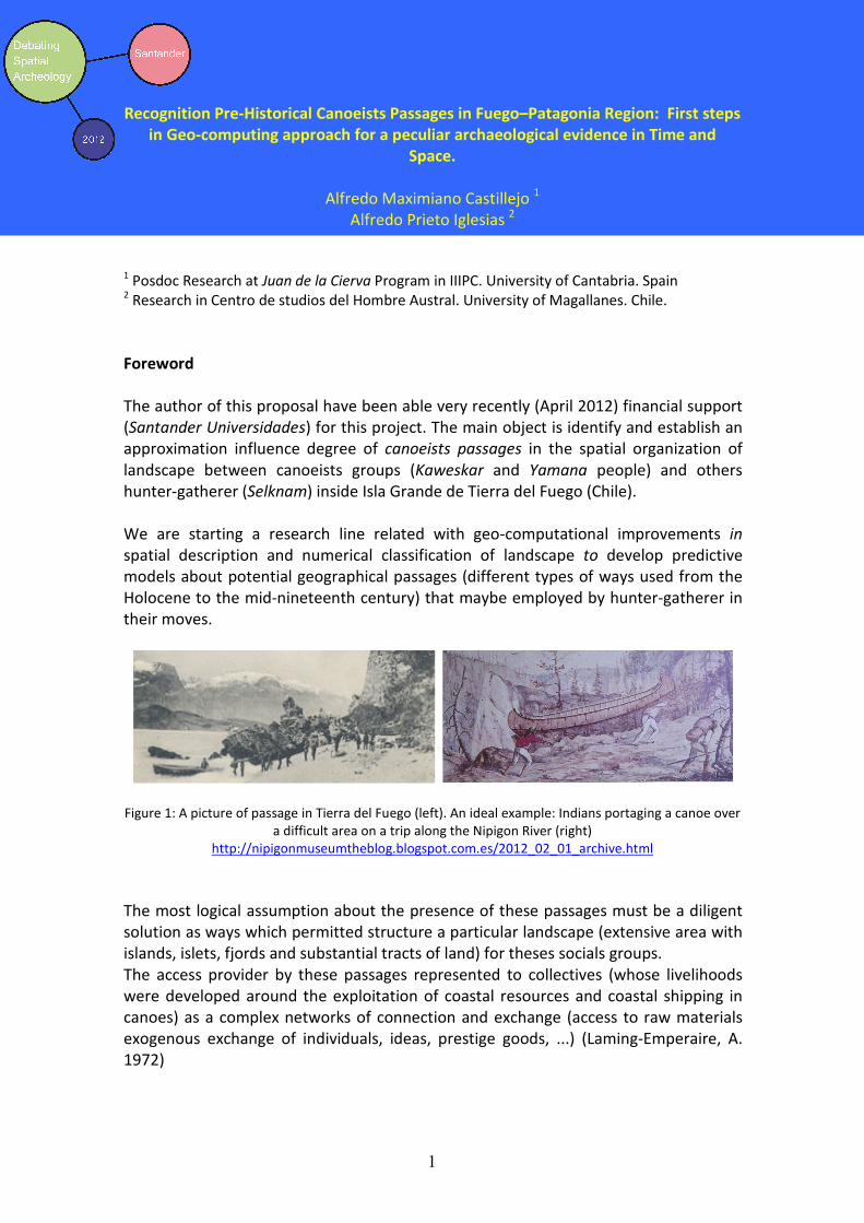
Debating Spatial Archaeology, Santander 2012
1
Recognition Pre-Historical Canoeists Passages in Fuego–Patagonia Region: First steps
in Geo-computing approach for a peculiar archaeological evidence in Time and
Space.
Alfredo Maximiano Castillejo 1
Alfredo Prieto Iglesias 2
1 Posdoc Research at Juan de la Cierva Program in IIIPC. University of Cantabria. Spain
2 Research in Centro de studios del Hombre Austral. University of Magallanes. Chile.
Foreword
The author of this proposal have been able very recently (April 2012) financial support
(Santander Universidades) for this project. The main object is identify and establish an
approximation influence degree of canoeists passages in the spatial organization of
landscape between canoeists groups (Kaweskar and Yamana people) and others
hunter-gatherer (Selknam) inside Isla Grande de Tierra del Fuego (Chile).
We are starting a research line related with geo-computational improvements in
spatial description and numerical classification of landscape to develop predictive
models about potential geographical passages (different types of ways used from the
Holocene to the mid-nineteenth century) that maybe employed by hunter-gatherer in
their moves.
Figure 1: A picture of passage in Tierra del Fuego (left). An ideal example: Indians portaging a canoe over
a difficult area on a trip along the Nipigon River (right)
http://nipigonmuseumtheblog.blogspot.com.es/2012_02_01_archive.html
The most logical assumption about the presence of these passages must be a diligent
solution as ways which permitted structure a particular landscape (extensive area with
islands, islets, fjords and substantial tracts of land) for theses socials groups.
The access provider by these passages represented to collectives (whose livelihoods
were developed around the exploitation of coastal resources and coastal shipping in
canoes) as a complex networks of connection and exchange (access to raw materials
exogenous exchange of individuals, ideas, prestige goods, ...) (Laming-Emperaire, A.
1972)

Debating Spatial Archaeology, Santander 2012
2
Archaeological problem, geo-computational solution and social interpretation
The principal problem in this project is the recognition of these archaeological complex
entities: Passages. In these circumstances, we have decided to work with spatial
predictions models (Mehrer & Wescott 2005; Kamermans et al 2010). For this, we
started working with a characterization of the geographical variables, archaeological
evidences and potential ethnographical information that could define these particular
sites (Chevallay, D. 1999). Examples of determinate variables to be taken into account
are: the variability in landscape across several geomorphologic and climatic events that
changed the appearance of coastline, the presence of a rugged terrain in the vicinity of
the potential passages, the presence/absence of seasonal ice, dense forests, rivers or
strong marine currents, the presence of archaeological remains (Curry, P. 1991) like
domestics structures (cabins...), open air sites, quarries, burial, artistic expressions,...
And why not, ideological factors involved (information obtained through ethnographic
data) with territoriality and fears...
Fig. 2: Geographic approximation working area. Right, MDT. Left, social groups distribution.
Under these variables, we´ll be generated an extensive Information System (using GIS
like a geo-database administrator, analytical platform and output visualization) where
we can implement systematic characterization of surfaces, modelling landscape and
set up a prediction of localization (with different degrees of probability) where may be
a passage. After these models, we visit determinate localization where checking the
validity of ours spatial predictions and adjust the system variables for a better re-
solution.
References:
Chevallay, D. 1999 Una ruta terrestre entre el seno Almirantazgo y el canal Beagle:
indicio de intercambios entre las etnias fueguinas (manuscrito inedito).
Curry, P. 1991 Distribución de sitios e implicaciones para la movilidad de los canoeros en el canal
Messier. En. Ans. Inst. Pat. Ser. Cs. Hs. Vol. 20: 145-154.

Debating Spatial Archaeology, Santander 2012
3
Kamermans, H. M.; E. van Leusen and Ph. Verange (eds) (2010) Archaeological Prediction and Risk
Management. Leiden University Press. Leiden.
Laming-Emperaire, A. 1972 Los sitios arqueológicos de los archipiélagos de Patagonia
Occidental. En: Ans. Inst. Pat. Vol.3: 87-96.
Mehrer, M. W.; K. L. Wescott, (eds) 2(006) GIS and archaeological site modeling. Boca Raton, FL.

Debating Spatial Archaeology, Santander 2012
1
Wilkostowo 23/24 – the settlement of the TRB culture
in central Poland
Lucyna Domańska1, Sweryn Rzepecki
1, Monika Michałowicz
1
1 University of Lodz
In the years 1999-2011an archaeological expedition of the Institute of Archaeology of
the University of Lodz led by Prof. L. Domańska and Dr Seweryn Rzepecki conducted
excavations at the site of Wilkostowo 23/24.
The aim of the excavations was to document the remains of a settlement of population
connected with the Neolithic TRB culture. Exceptionally well state of preservation of
the sources enabled realization of a wide-scale research programme. As a result, an
area of c. 10.109 m² was investigated. In the area several independent - isolated one
from another farmsteads, with which numerous economic features are connected was
discovered . On the grounds of hitherto obtained C14 indications the settlement
duration may be dated to a period c. 4000-3000 BC. During this time it was settled by
relatively well developed agricultural societies, occupying sandy soils. Corn agriculture
connected with animal husbandry - mainly cattle and pig - created the economic basis
of their existence. There are also prerequisites that may indicate the use of salt-
making.
The structure of archaeological material occurrence was an important challenge in
carrying out the excavations on the site under consideration. About a half of nearly 80
000 pottery fragments occurred within a quite destructed cultural layer. Similar
proportions apply to flint and stone products. This constrained the use of precise
methods of archaeological material registration (with the use of laser total station).
The obtained data next became the basis for conducting complex technological and
stylistic analyses of pottery, flint and stone artifacts, which are subsequently
connected with the use of spatial analysis GIS techniques. Reconstruction of patterns
of settlement activeness zone use by the inhabitants is an aim of these activities.
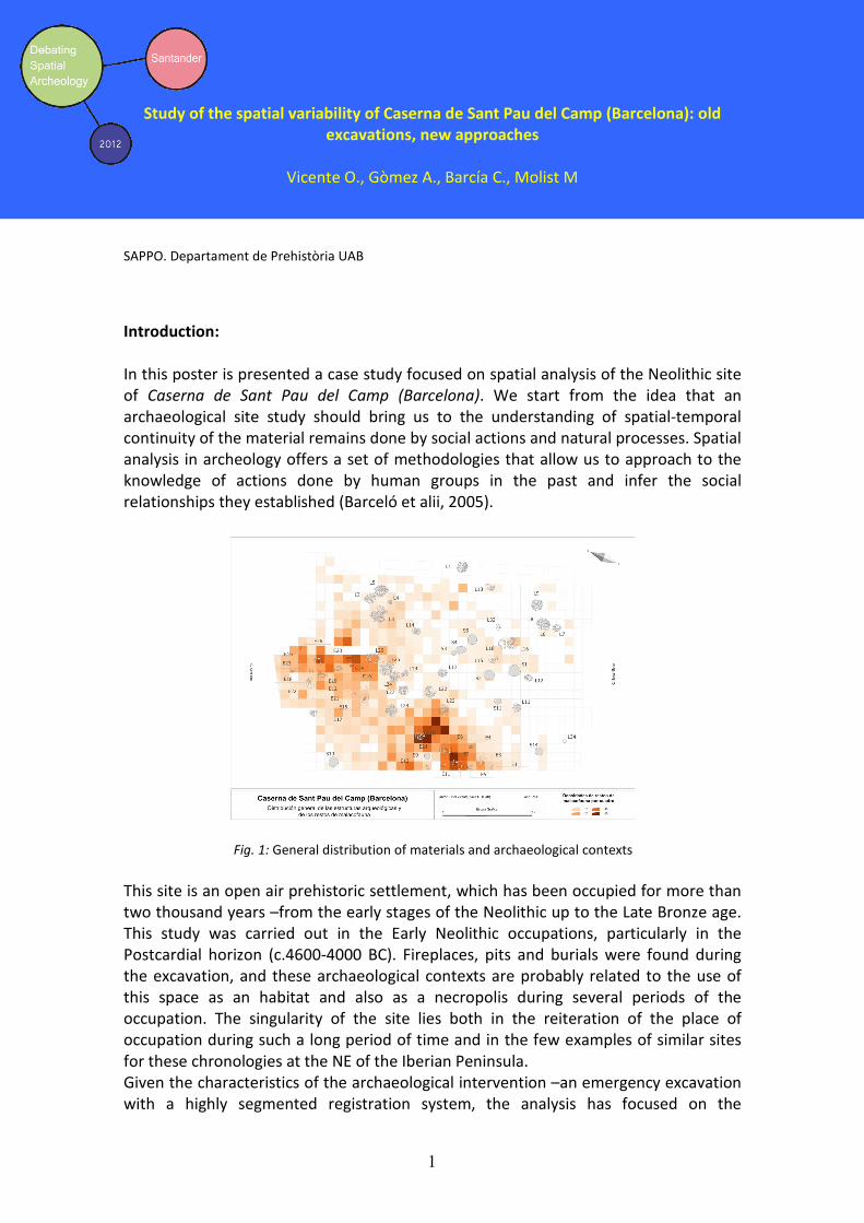
Debating Spatial Archaeology, Santander 2012
1
Study of the spatial variability of Caserna de Sant Pau del Camp (Barcelona): old
excavations, new approaches
Vicente O., Gòmez A., Barcía C., Molist M
SAPPO. Departament de Prehistòria UAB
Introduction:
In this poster is presented a case study focused on spatial analysis of the Neolithic site
of Caserna de Sant Pau del Camp (Barcelona). We start from the idea that an
archaeological site study should bring us to the understanding of spatial-temporal
continuity of the material remains done by social actions and natural processes. Spatial
analysis in archeology offers a set of methodologies that allow us to approach to the
knowledge of actions done by human groups in the past and infer the social
relationships they established (Barceló et alii, 2005).
Fig. 1: General distribution of materials and archaeological contexts
This site is an open air prehistoric settlement, which has been occupied for more than
two thousand years –from the early stages of the Neolithic up to the Late Bronze age.
This study was carried out in the Early Neolithic occupations, particularly in the
Postcardial horizon (c.4600-4000 BC). Fireplaces, pits and burials were found during
the excavation, and these archaeological contexts are probably related to the use of
this space as an habitat and also as a necropolis during several periods of the
occupation. The singularity of the site lies both in the reiteration of the place of
occupation during such a long period of time and in the few examples of similar sites
for these chronologies at the NE of the Iberian Peninsula.
Given the characteristics of the archaeological intervention –an emergency excavation
with a highly segmented registration system, the analysis has focused on the
Debating Spatial Archaeology, Santander 2012
2
digitization and geo referencing of archaeological items as well as in the particular and
interdisciplinary study of the remains. The studies have involved different kind of
specialists from several institutions.
During the study we used relational databases and Geographic Information Systems
for the analytical visualization of topological features found in the archaeological
record (materials, structures, etc..). Geostatistical approaches have also been used on
the analysis of distribution of the archaeological material. The poster attempts to
adapt a methodology in order to analyze spatial data that come from old excavations
and that have certain limited characteristics. We present the exposition of both the
problem and the heuristic approach used in the analysis of spatial variability of the
archaeological deposit.
Keywords: Geostatistical Approach, Analytical Visualization, empirical application
References:
Barceló J. A., Maximiano A., Vicente O. 2005 La Multidimensionalidad del Espacio
Arqueológico: Teoría, Matemáticas, Visualización. In La Aplicación de los SIG en la
Arqueología del paisaje. Grau Mira I., ed. Pp. 29–40. Serie Arqueología. Alicante:
Publicaciones de la Universidad de Alicante.
Maximiano A. 2007. Teoría geoestadística aplicada al análisis de la variabilidad
espacial arqueológica intrasite. Ph D. dissertation, Department of Prehistory.
Bellaterra, Universitat Autónoma de Barcelona.
Molist M., Vicente O., Farré R. 2008. El jaciment de la caserna de Sant Pau del Camp:
aproximació a la caracterització d’un assentament del neolitic antic. Quarhis 4. Pg 15-
24. Publicaciones del MUHBA.

83
Workshop will be held at the Tower C, just behind the Faculty of Letters and Philosophy of the
University of Cantabria. The faculty can be easily reached by car, since it is located in one of
Santander's major avenues and close to the S-20 highway; as well as walking from city centre
(a funicular in Rio de la Píla street prevents from walking along steep streets). Two bus lines
connects the Faculty to the rest of the city, including direct shuttles from train station.
http://www.spatialarchaeology.unican.es/images/plano%20bus%20santander.pdf

Colaboration: