Embed Size (px)
Citation preview
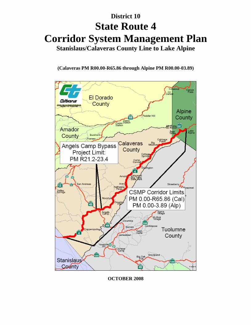
District 10
State Route 4 Corridor System Management Plan
Stanislaus/Calaveras County Line to Lake Alpine
(Calaveras PM R00.00-R65.86 through Alpine PM R00.00-03.89)
OCTOBER 2008
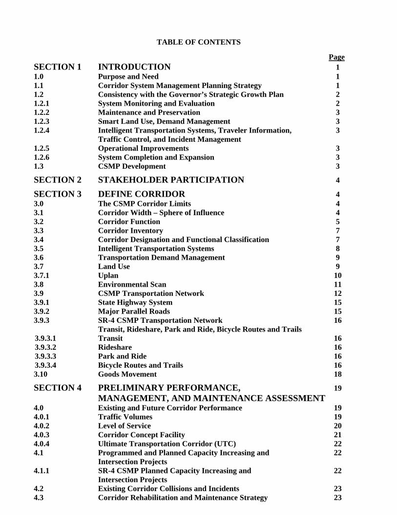
TABLE OF CONTENTS
Page SECTION 1 INTRODUCTION 1 1.0 Purpose and Need 1 1.1 Corridor System Management Planning Strategy 1 1.2 Consistency with the Governor’s Strategic Growth Plan 2 1.2.1 System Monitoring and Evaluation 2 1.2.2 Maintenance and Preservation 3 1.2.3 Smart Land Use, Demand Management 3 1.2.4 Intelligent Transportation Systems, Traveler Information, 3
Traffic Control, and Incident Management 1.2.5 Operational Improvements 3 1.2.6 System Completion and Expansion 3 1.3 CSMP Development 3
SECTION 2 STAKEHOLDER PARTICIPATION 4
SECTION 3 DEFINE CORRIDOR 4 3.0 The CSMP Corridor Limits 4 3.1 Corridor Width – Sphere of Influence 4 3.2 Corridor Function 5 3.3 Corridor Inventory 7 3.4 Corridor Designation and Functional Classification 7 3.5 Intelligent Transportation Systems 8 3.6 Transportation Demand Management 9 3.7 Land Use 9 3.7.1 Uplan 10 3.8 Environmental Scan 11 3.9 CSMP Transportation Network 12 3.9.1 State Highway System 15 3.9.2 Major Parallel Roads 15 3.9.3 SR-4 CSMP Transportation Network 16
Transit, Rideshare, Park and Ride, Bicycle Routes and Trails 3.9.3.1 Transit 16 3.9.3.2 Rideshare 16 3.9.3.3 Park and Ride 16 3.9.3.4 Bicycle Routes and Trails 16 3.10 Goods Movement 18
SECTION 4 PRELIMINARY PERFORMANCE, 19 MANAGEMENT, AND MAINTENANCE ASSESSMENT 4.0 Existing and Future Corridor Performance 19 4.0.1 Traffic Volumes 19 4.0.2 Level of Service 20 4.0.3 Corridor Concept Facility 21 4.0.4 Ultimate Transportation Corridor (UTC) 22 4.1 Programmed and Planned Capacity Increasing and 22 Intersection Projects 4.1.1 SR-4 CSMP Planned Capacity Increasing and 22 Intersection Projects 4.2 Existing Corridor Collisions and Incidents 23 4.3 Corridor Rehabilitation and Maintenance Strategy 23
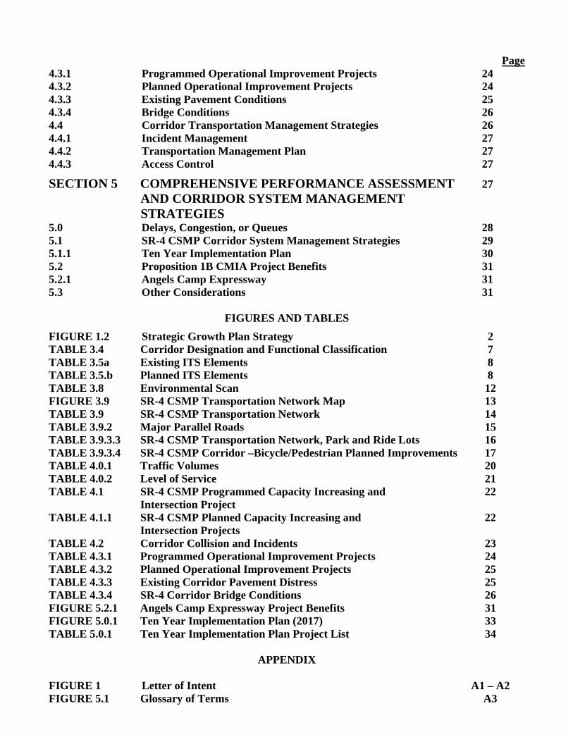
Page 4.3.1 Programmed Operational Improvement Projects 24 4.3.2 Planned Operational Improvement Projects 24 4.3.3 Existing Pavement Conditions 25 4.3.4 Bridge Conditions 26 4.4 Corridor Transportation Management Strategies 26 4.4.1 Incident Management 27 4.4.2 Transportation Management Plan 27 4.4.3 Access Control 27
SECTION 5 COMPREHENSIVE PERFORMANCE ASSESSMENT 27 AND CORRIDOR SYSTEM MANAGEMENT STRATEGIES 5.0 Delays, Congestion, or Queues 28 5.1 SR-4 CSMP Corridor System Management Strategies 29 5.1.1 Ten Year Implementation Plan 30 5.2 Proposition 1B CMIA Project Benefits 31 5.2.1 Angels Camp Expressway 31 5.3 Other Considerations 31
FIGURES AND TABLES
FIGURE 1.2 Strategic Growth Plan Strategy 2 TABLE 3.4 Corridor Designation and Functional Classification 7 TABLE 3.5a Existing ITS Elements 8 TABLE 3.5.b Planned ITS Elements 8 TABLE 3.8 Environmental Scan 12 FIGURE 3.9 SR-4 CSMP Transportation Network Map 13 TABLE 3.9 SR-4 CSMP Transportation Network 14 TABLE 3.9.2 Major Parallel Roads 15 TABLE 3.9.3.3 SR-4 CSMP Transportation Network, Park and Ride Lots 16 TABLE 3.9.3.4 SR-4 CSMP Corridor –Bicycle/Pedestrian Planned Improvements 17 TABLE 4.0.1 Traffic Volumes 20 TABLE 4.0.2 Level of Service 21 TABLE 4.1 SR-4 CSMP Programmed Capacity Increasing and 22 Intersection Project TABLE 4.1.1 SR-4 CSMP Planned Capacity Increasing and 22 Intersection Projects TABLE 4.2 Corridor Collision and Incidents 23 TABLE 4.3.1 Programmed Operational Improvement Projects 24 TABLE 4.3.2 Planned Operational Improvement Projects 25 TABLE 4.3.3 Existing Corridor Pavement Distress 25 TABLE 4.3.4 SR-4 Corridor Bridge Conditions 26 FIGURE 5.2.1 Angels Camp Expressway Project Benefits 31 FIGURE 5.0.1 Ten Year Implementation Plan (2017) 33 TABLE 5.0.1 Ten Year Implementation Plan Project List 34
APPENDIX FIGURE 1 Letter of Intent A1 – A2 FIGURE 5.1 Glossary of Terms A3
1
SECTION 1 INTRODUCTION The State Route 4 (SR-4) Corridor System Management Plan (CSMP) provides for the integrated management of travel modes and roadways to facilitate the efficient and effective mobility of people and goods within one of the most congested transportation corridors in Calaveras County. The CSMP presents an analysis of existing and future traffic conditions, and proposes traffic management strategies and transportation improvements to maintain and enhance mobility within the corridor. The corridor system management planning strategy integrates system planning and system management addressing state highways, local parallel roadways, regional transit services, and other regional modes pertinent to corridor mobility. The SR-4 CSMP is developed in concert with state, local and regional transportation goals, and addresses existing and future local and regional mobility and transportation system connectivity. The CSMP incorporates context sensitive transportation solutions, encourages the use of alternative transportation modes, and functions as a tool in which state and local partners can address future growth while maintaining individual and shared goals and objectives.
CSMPs are being developed throughout the state for corridors receiving funds from the Corridor Mobility Improvement Account (CMIA) and Highway 99 Bond Programs created by the passage of the Highway Safety, Traffic Reduction, Air Quality and Port Security Bond Act of 2006, approved by the voters as Proposition 1B on November 7, 2006. Proposition 1B, CMIA funds have been allocated for the Angels Camp Expressway project in Calaveras County. The precise limit of the SR-4 CSMP has been determined through a collaborative cooperative process that involves transportation planning organizations within the corridor (see Section 2 on Page 4). The SR-4 CSMP addresses segments along the corridor beginning at the Stanislaus County/Calaveras County Line and ending at Lake Alpine in Alpine County. 1.0 Purpose and Need Over the next 30 years, California’s population is expected to increase by an average of 500,000 residents per year. This means by 2020, the State’s population will reach nearly 44 million, and by 2030, nearly 48 million. The purpose of the CSMP is to identify projects and strategies that once implemented, will reduce congestion within the SR-4 CSMP corridor limits, enhance safety, and preserve the mobility gains of the CMIA investments. The preparation of this CSMP is a California Transportation Commission (CTC) requirement for the use of the Proposition 1B CMIA funds that have been allocated for Angels Camp Expressway project within the SR-4 corridor. 1.1 Corridor System Management Planning Strategy The corridor system management strategy exhibited in this CSMP is based on the integration of System Planning and System Management. System Planning is the long-range transportation planning process of Caltrans that evaluates the current and future operating conditions and deficiencies on the State transportation system. Improvements are recommended to maintain mobility by minimizing or alleviating the identified deficiencies. The CSMP considers the entire transportation system on and off the State Highway System (SHS), including the highways and local arterials, transit services, non-motorized modes of transportation such as bicycling and walking, goods movement, intelligent transportation systems (ITS), and local land use and environmental issues.
2
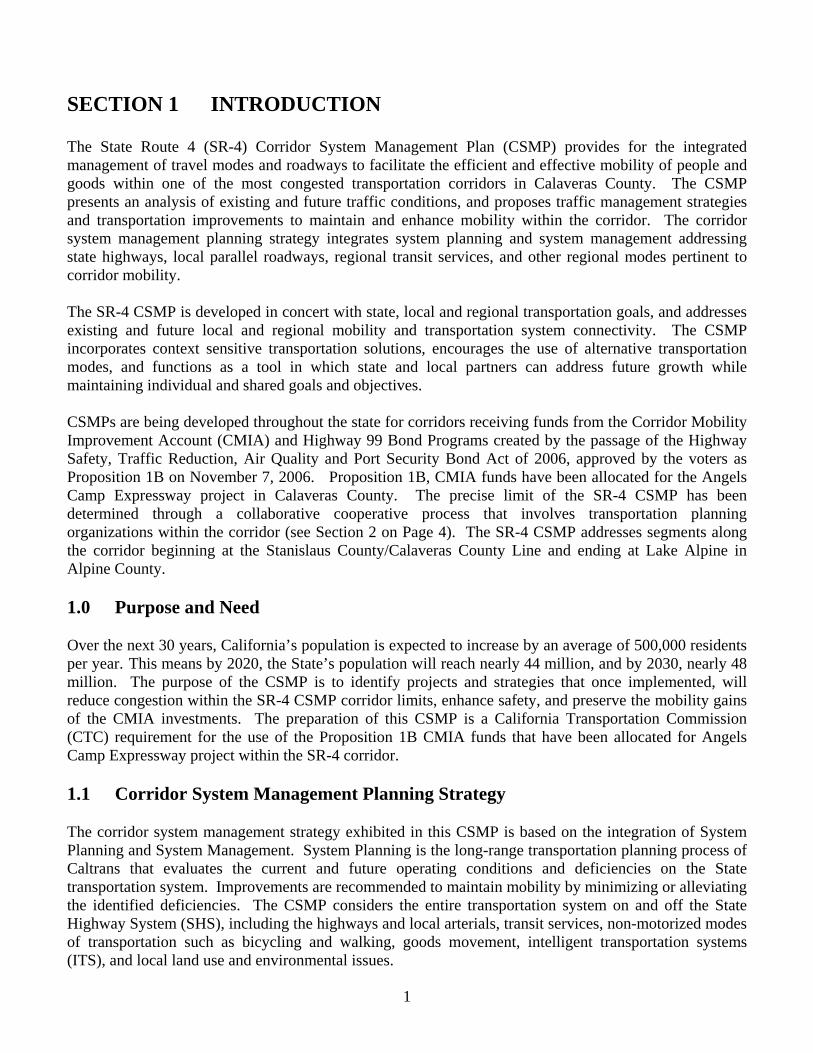
System Management is the process of maximizing the efficiency and effectiveness of the existing transportation infrastructure through use of proven methods and technologies, which generally involve low capital or no cost activities. A few examples include, traffic information collection and dissemination, incident management, use of local arterial roadways that are parallel with the highway corridor, and demand management strategies, such as transit and rideshare marketing, flexible work hour schedules, and telecommuting. The strategy of this CSMP requires a commitment by Caltrans, Calaveras Council of Governments (CCOG), the City of Angels, and Calaveras County to develop and implement the CSMP. The CSMP is a living document and will be updated periodically. 1.2 Consistency with the Governor’s Strategic Growth Plan The Governor’s Strategic Growth Plan is designed to decrease congestion, improve travel times, and increase safety while accommodating future growth in the population and economy. Corridor productivity can only be restored and maintained through a coordinated planning and management effort of all transportation partners. This CSMP identifies a number of elements essential to this goal. The “System Management Pyramid” can best visualize these elements. Each element, while represented separately, works as an essential part of the whole. The elements may be summarized as follows:
FIGURE 1.2: Strategic Growth Plan Strategy 1.2.1 System Monitoring and Evaluation Understanding how a corridor performs and why it performs the way it does is critical to developing appropriate strategies. The first step in this effort is to analyze the system that we now have available. This includes the identification of current bottlenecks (areas of congestion), their causes, and the impact that these individual bottlenecks have on the whole of corridor. System Monitoring and Evaluation is the foundation of this CSMP strategy. In order to reduce congestion and implement traffic management strategies, we must have precise knowledge of when and where congestion occurs. In order to identify when and where congestion occurs, improved detection is needed, the existing detection system needs to be maintained, and gaps in the detection network need to be filled.
3
1.2.2 Maintenance and Preservation Maintenance and preservation strategies are designed to protect the enormous public investment in the existing transportation system and to ensure a full return on system investments as well as reduce future maintenance and replacement costs. 1.2.3 Smart Land Use, Demand Management Land use decisions are the prerogative of local government. These decisions impact the transportation system. Appropriate planning can reduce this impact including preserving right-of-way to allow for future planned capacity enhancing projects. Land use and demand management strategies reduce travel demand, reduce delay, and increase transportation through sustainable and integrated land use decisions and innovative concepts to change traveler behavior. Land use and demand management have to do with reducing congestion by developing land uses that support shorter trips, increase the use of transit and alternative transportation modes, and improved pedestrian access. 1.2.4 Intelligent Transportation Systems, Traveler Information, Traffic Control, and Incident
Management ITS enhances safety and improves efficiency for the traveling public through innovative use of traffic control, traveler information, and improved incident management. Real time traveler information allows travelers to make more effective decisions regarding trip timing, route choices, and mode selection. Traffic control reduces congestion through the use of technologies such as system ramp metering, collision warning systems, and advanced traffic management systems. Incidents are the primary cause of unexpected and variable delay. Improved incident management reduces congestion and traveler delay. 1.2.5 Operational Improvements Operational improvements include the use of auxiliary lanes, and ramp improvements. Improved signs and lights, and other system refinements reduce delay, preserve and enhance existing services. 1.2.6 System Completion and Expansion System completion and expansion provides the connectivity originally envisioned for the SHS. Plans to complete and expand the system to expressway standards where feasible will improve the overall capacity of the transportation system to accommodate growing demands. 1.3 CSMP Development The CTC and Caltrans have identified six milestones in the development of the SR-4 CSMP, namely: 1. Define Corridor 2. Assemble Corridor Team 3. Develop Preliminary Corridor Performance Assessment
4
4. Develop a Comprehensive Corridor Performance Assessment 5. Identify Causality of Corridor Performance Degradation 6. Plan for the Completion and Adoption by the Regional Transportation Planning Agency SECTION 2 STAKEHOLDER PARTICIPATION The development and successful implementation of the CSMP is dependant upon the close participation and cooperation of all major stakeholders. In the case of the SR-4 CSMP, both internal and external stakeholders were identified and invited to participate in the development of this CSMP from the beginning of the CSMP development process. A project development team of key stakeholders was formed and they meet periodically to discuss, provide technical assistance, review, and comment on the development of the CSMP. The CSMP development team consists of representatives from the California Department of Transportation (Caltrans) District 10 Planning, Traffic Operations, Traffic Management, Traffic Safety, Maintenance, and Program Project Management. Team members also include representatives from the CCOG, Calaveras County, Calaveras Transit, City of Angels, and California Highway Patrol (CHP). The CCOG has provided a letter of intent that is included in the Appendix as Figure 1. This letter demonstrates their commitment and interest in actively participating in this collaborative effort. SECTION 3 DEFINE CORRIDOR A critical step in the CSMP process is the definition of the corridor transportation network, which will be the focus of CSMP corridor improvement and management activities. This section describes the individual modes and roadway components of this network and presents the rationale for their selection and inclusion. 3.0 The CSMP Corridor Limits The CSMP corridor limits of this report are the portions of SR-4 within Calaveras County from the Stanislaus County/Calaveras County Line to Lake Alpine in Alpine County. The corridor limits were identified to address not only the CMIA project in the City of Angels, but to address traffic impacts from local and regional travel along the CSMP corridor and in adjacent counties. 3.1 Corridor Width – Sphere of Influence In further defining the CSMP corridor, select parallel facilities, and all modes of transportation serving SR-4 are included. Within the CSMP corridor, SR-4 is concurrent with SR-49 through the main street of the City of Angels, SR-49 being the predominate route. SR-49 provides access from the town of Sonora to the town of San Andreas. Transit lines on the SR-4 CSMP corridor run from the town of Copperopolis to the town of Arnold, and there is an existing park and ride lot in Murphys. SR-4 is bicycle accessible along the entire CSMP corridor although there are portions that lack shoulders that make bicycle access problematic. A description of the land uses located within the SR-4 corridor sphere of influence and development projects impacting the CSMP corridor are provided in Section 3.7 on page 10.
5
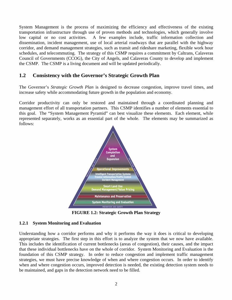
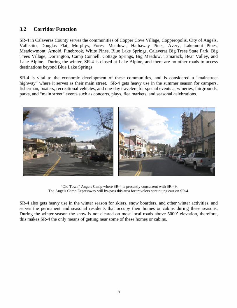
3.2 Corridor Function SR-4 in Calaveras County serves the communities of Copper Cove Village, Copperopolis, City of Angels, Vallecito, Douglas Flat, Murphys, Forest Meadows, Hathaway Pines, Avery, Lakemont Pines, Meadowmont, Arnold, Pinebrook, White Pines, Blue Lake Springs, Calaveras Big Trees State Park, Big Trees Village, Dorrington, Camp Connell, Cottage Springs, Big Meadow, Tamarack, Bear Valley, and Lake Alpine. During the winter, SR-4 is closed at Lake Alpine, and there are no other roads to access destinations beyond Blue Lake Springs. SR-4 is vital to the economic development of these communities, and is considered a “mainstreet highway” where it serves as their main street. SR-4 gets heavy use in the summer season for campers, fisherman, boaters, recreational vehicles, and one-day travelers for special events at wineries, fairgrounds, parks, and “main street” events such as concerts, plays, flea markets, and seasonal celebrations.
“Old Town” Angels Camp where SR-4 is presently concurrent with SR-49. The Angels Camp Expressway will by-pass this area for travelers continuing east on SR-4.
SR-4 also gets heavy use in the winter season for skiers, snow boarders, and other winter activities, and serves the permanent and seasonal residents that occupy their homes or cabins during these seasons. During the winter season the snow is not cleared on most local roads above 5000’ elevation, therefore, this makes SR-4 the only means of getting near some of these homes or cabins.
6
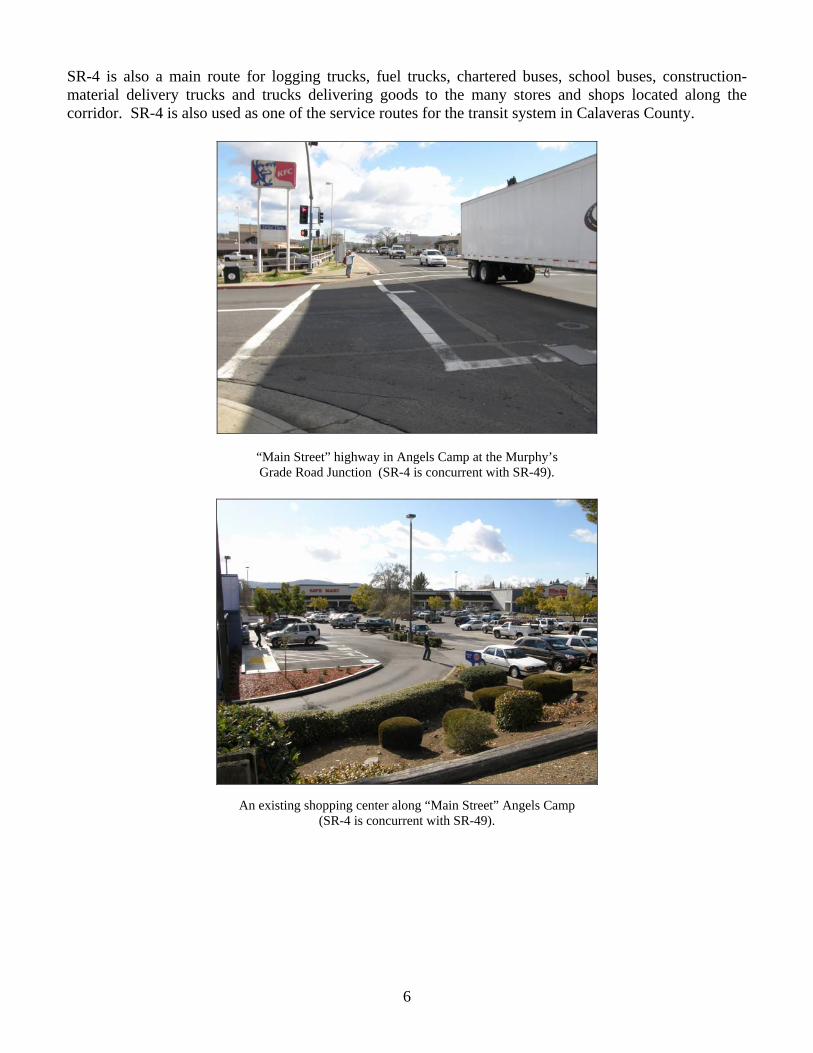
SR-4 is also a main route for logging trucks, fuel trucks, chartered buses, school buses, construction-material delivery trucks and trucks delivering goods to the many stores and shops located along the corridor. SR-4 is also used as one of the service routes for the transit system in Calaveras County.
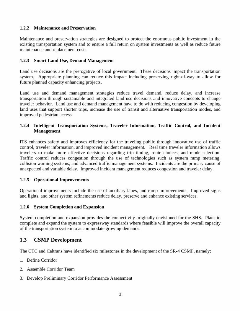
“Main Street” highway in Angels Camp at the Murphy’s Grade Road Junction (SR-4 is concurrent with SR-49).
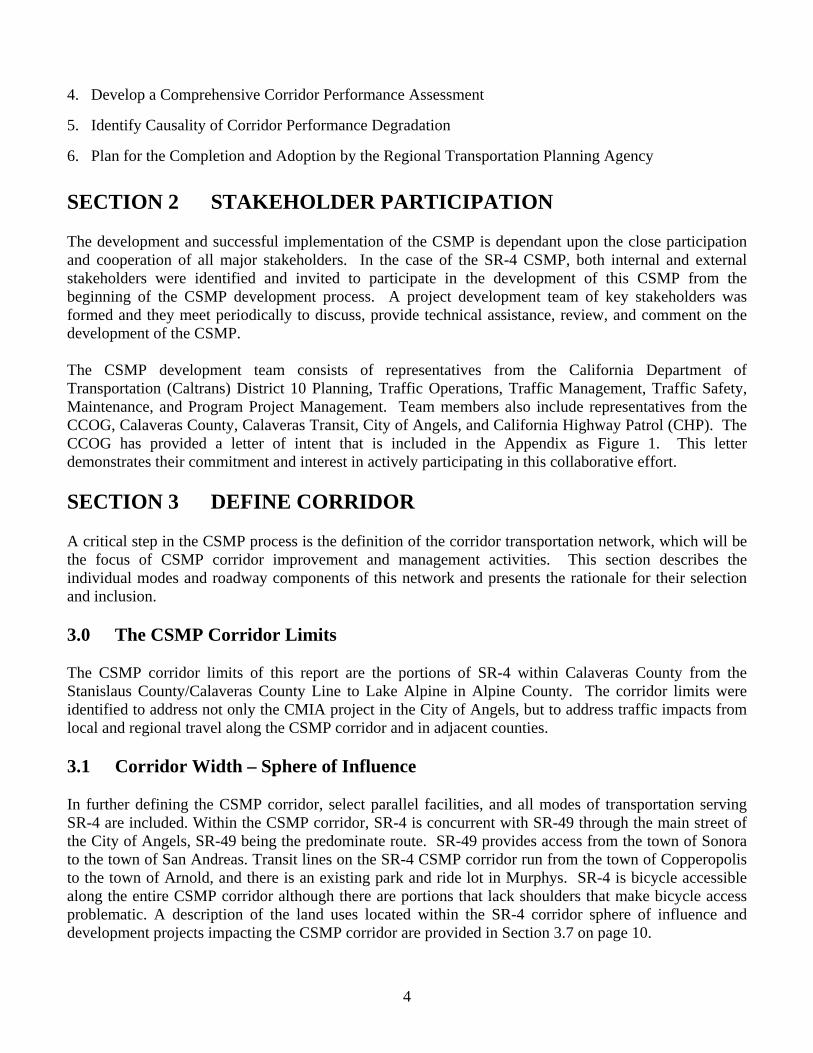
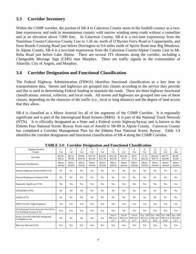
An existing shopping center along “Main Street” Angels Camp (SR-4 is concurrent with SR-49).
7
3.3 Corridor Inventory Within the CSMP corridor, the portion of SR-4 in Calaveras County starts in the foothill country as a two-lane expressway and ends in mountainous country with narrow winding steep roads without a centerline and at an elevation above 7,000 feet. In Calaveras County, SR-4 is a two-lane expressway from the Stanislaus County/Calaveras County Line to 1.56 mi. north of O’Byrnes Ferry Road in Copperopolis, and from Boards Crossing Road just before Dorrington to 0.6 miles north of Spicer Road near Big Meadows. In Alpine County, SR-4 is a two-lane expressway from the Calaveras County/Alpine County Line to Mt. Reba Road just before Lake Alpine. There are several ITS elements along the corridor, including a Changeable Message Sign (CMS) near Murphys. There are traffic signals in the communities of Altaville, City of Angels, and Murphys. 3.4 Corridor Designation and Functional Classification The Federal Highway Administration (FHWA) identifies functional classification as a key item in transportation data. Streets and highways are grouped into classes according to the service they provide and this is used in determining Federal funding to maintain the roads. There are three highway functional classifications: arterial, collector, and local roads. All streets and highways are grouped into one of these classes, depending on the character of the traffic (i.e., local or long distance) and the degree of land access that they allow. SR-4 is classified as a Minor Arterial for all of the segments of the CSMP Corridor. It is regionally significant and is part of the Interregional Road System (IRRS). It is part of the National Truck Network (NTN). It is officially designated as a State and a Federal scenic highway/byway and is known as the Ebbetts Pass National Scenic Byway from east of Arnold to SR-89 in Alpine County. Calaveras County has completed a Corridor Management Plan for the Ebbetts Pass National Scenic Byway. Table 3.4 identifies the corridor designation and functional classification of SR-4 along the CSMP Corridor.
TABLE 3.4: Corridor Designation and Functional Classification Segment Number
County 1
Cal 2
Cal 3
Cal 4
Cal 5
Cal 6
Cal 7
Cal 8
Cal 9
Cal 10 Cal
11 Cal
12 Alp
Post Mile R0.00- R8.14
R8.14- R9.90
R9.90- R10.30
R10.30- R16.40
R16.40- R21.20
R21.38- R23.40
R23.40- 29.37
29.37- 37.35
37.35-R42.62
R42.62- R47.07
R47.07- R65.86
R0.00- R3.89
Functional Classification Minor Arterial
Minor Arterial
Minor Arterial
Minor Arterial
Minor Arterial
Minor Arterial
Minor Arterial
Minor Arterial
Minor Arterial
Minor Arterial
Minor Arterial
Minor Arterial
National Highway System (NHS) (Y/N) No No No No No No No No No No No No
Freeway/Expressway System (Y/N) No No No No No No No No No No No No
Regionally Significant (Y/N) Yes Yes Yes Yes Yes Yes Yes Yes Yes Yes Yes Yes
STRAHNET (Y/N) No No No No No No No No No No No No
Lifeline (Y/N) No No No No No No No No No No No No
IRRS (Yes:HE= High Emphasis) Yes Yes Yes Yes Yes Yes Yes Yes Yes Yes Yes Yes NTN-National Truck Network (Yes:STAA, TA=Terminal Access) or No Yes Yes Yes Yes Yes Yes Yes Yes Yes Yes Yes Yes
Scenic (Yes:OD=Officially Designated, E=Eligible) or No No No No No No
Yes-E PM 21.4-
31.7
Yes-E PM 21.4-
31.7
Yes-E PM 21.4-
31.7
Yes - OD PM 41.6-
65.9
Yes - ODPM 41.6-
65.9
Yes - ODPM 41.6-
65.9
Yes - ODPM 0.00-
31.7
Bike Use Allowed (Y/N) Yes Yes Yes Yes Yes Yes Yes Yes Yes Yes Yes Yes
8
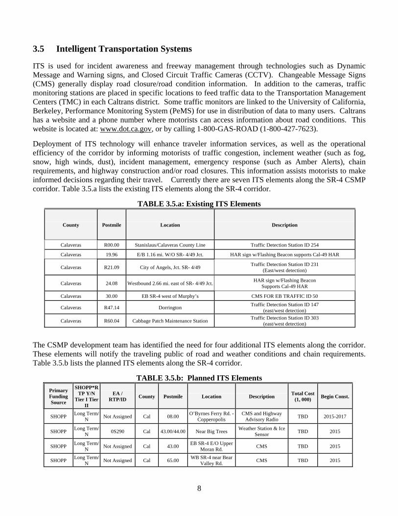
3.5 Intelligent Transportation Systems ITS is used for incident awareness and freeway management through technologies such as Dynamic Message and Warning signs, and Closed Circuit Traffic Cameras (CCTV). Changeable Message Signs (CMS) generally display road closure/road condition information. In addition to the cameras, traffic monitoring stations are placed in specific locations to feed traffic data to the Transportation Management Centers (TMC) in each Caltrans district. Some traffic monitors are linked to the University of California, Berkeley, Performance Monitoring System (PeMS) for use in distribution of data to many users. Caltrans has a website and a phone number where motorists can access information about road conditions. This website is located at: www.dot.ca.gov, or by calling 1-800-GAS-ROAD (1-800-427-7623). Deployment of ITS technology will enhance traveler information services, as well as the operational efficiency of the corridor by informing motorists of traffic congestion, inclement weather (such as fog, snow, high winds, dust), incident management, emergency response (such as Amber Alerts), chain requirements, and highway construction and/or road closures. This information assists motorists to make informed decisions regarding their travel. Currently there are seven ITS elements along the SR-4 CSMP corridor. Table 3.5.a lists the existing ITS elements along the SR-4 corridor.
TABLE 3.5.a: Existing ITS Elements
County Postmile Location Description
Calaveras R00.00 Stanislaus/Calaveras County Line Traffic Detection Station ID 254
Calaveras 19.96 E/B 1.16 mi. W/O SR- 4/49 Jct. HAR sign w/Flashing Beacon supports Cal-49 HAR
Calaveras R21.09 City of Angels, Jct. SR- 4/49 Traffic Detection Station ID 231 (East/west detection)
Calaveras 24.08 Westbound 2.66 mi. east of SR- 4/49 Jct. HAR sign w/Flashing Beacon Supports Cal-49 HAR
Calaveras 30.00 EB SR-4 west of Murphy’s CMS FOR EB TRAFFIC ID 50
Calaveras R47.14 Dorrington Traffic Detection Station ID 147 (east/west detection)
Calaveras R60.04 Cabbage Patch Maintenance Station Traffic Detection Station ID 303 (east/west detection)
The CSMP development team has identified the need for four additional ITS elements along the corridor. These elements will notify the traveling public of road and weather conditions and chain requirements. Table 3.5.b lists the planned ITS elements along the SR-4 corridor.
TABLE 3.5.b: Planned ITS Elements Primary Funding Source
SHOPP*RTP Y/N
Tier I Tier II
EA / RTP/ID County Postmile Location Description Total Cost
(1, 000) Begin Const.
SHOPP Long Term/ N Not Assigned Cal 08.00 O’Byrnes Ferry Rd. -
Copperopolis CMS and Highway
Advisory Radio TBD 2015-2017
SHOPP Long Term/ N 0S290 Cal 43.00/44.00 Near Big Trees Weather Station & Ice
Sensor TBD 2015
SHOPP Long Term/ N Not Assigned Cal 43.00 EB SR-4 E/O Upper
Moran Rd. CMS TBD 2015
SHOPP Long Term/ N Not Assigned Cal 65.00 WB SR-4 near Bear
Valley Rd. CMS TBD 2015
9
The major challenge to ITS deployment is funding. ITS elements are proposed through the State Highway Operations and Protection Program (SHOPP), which has minimal funding for ITS deployment. Caltrans D-10 requests the installation of ITS elements on State Transportation Improvement Program (STIP) projects, but more frequently than not, when project costs need to be reduced, ITS elements are the first to be eliminated. There needs to be more support from all project partners to promote and fund ITS elements on STIP projects. Technology advances are also a challenge for ITS deployment. Technology is always changing, which makes it very difficult to integrate with existing technologies; and the lack of power and communication in remote areas impedes implementation in rural areas. ITS operating, utility, and maintenance expenses are costly along with high bandwidth communications for video. It is also a challenge to sustain the level of expertise that is needed to operate and maintain the complex ITS equipment. 3.6 Transportation Demand Management Transportation Demand Management (TDM) is designed to reduce vehicle trips during peak hours. TDM is specifically targeted at the work force, commuters that generate the majority of peak hour traffic. Strategies include: Rideshare programs; transit usage; flex hours; van pools; bicycling and walking; telecommuting; and mixed land uses (jobs/housing balance). Incorporating these strategies would be part of land use decisions, the prerogative of local government. TDM programs could be required by local jurisdictions for any large commercial or office project and could be tied to incentives of some sort to encourage the development of such programs. 3.7 Land Use The population within Calaveras County is forecasted to increase by 44.5 percent between 2005 and 2025. Alpine County increased by 3.7 percent in a three-year period from 2005-2008. The volume of traffic ranges from 290 to 1420 vehicles per hour (2006) along the SR-4 CSMP corridor. Where SR-4 is concurrent with SR-49 through the City of Angels, it is the most congested area along the SR-4 CSMP corridor. In 2006, the City of Angels, ‘mainstreet’ segment averaged 720 vehicles per hour. The Angels Camp Expressway will reduce congestion on SR-49 through the City of Angels. The new expressway will begin at the north junction of SR-4/SR-49 and end east of the City of Angels at existing SR-4, .56 miles east of Rolleri Bypass Road. Once the new expressway is built, SR-4 from the south SR-49/SR-4 junction to its junction with the new expressway will be relinquished to the City of Angels. The City of Angels is currently working on a study to determine the feasibility of a roundabout at both the northern and southern intersections of SR-49 and SR-4 to improve the flow of traffic through the City of Angels. In addition, Caltrans District 10 and the City of Angels are developing a scope of work for an Access Management Plan (AMP) to address congestion and circulation on SR-49.
Proposed residential and commercial development will be significant along the SR-4 corridor. The following developments are proposed in Copperopolis, Murphys, Arnold, and Bear Valley: Copperopolis 1) In Copperopolis, approval of the Saddle Creek development required improvements to the Reeds
Turnpike/Little John Road intersection. Entitlements for new developments on Little John Road—most recently Oak Canyon Ranch (2,175 housing units) may require additional improvements (a signal or a roundabout). The intersection of SR-4 and O'Byrnes Ferry Road was recently improved to
10
increase left turn storage on the highway. Additional traffic passing through the intersection from new development (such as Tuscanny Hills, Sanguinetti Estates, Vista del Lago, Calypso Bay, Villa Marina, and the Copper Mill commercial area) may create traffic volumes that will trigger the need for additional improvements to the intersection. Improvements required as the result of local projects will be funded through either the Copperopolis Benefit Basin or by the specific development.
Copperopolis Benefit Basin - Copperopolis Roadway Impact Fee
The purpose of the Copperopolis Roadway Impact Fee program is to collect funds to offset the cost of roadway improvements that are necessary to provide adequate traffic infrastructure to serve new development that is anticipated within the Benefit Basin. The Benefit Basin funds may be combined with other funds that may be available to the County to pay for the required roadway improvements over and above the proportionate fare share of development. 2) Murphys
As a result of development near SR-4 in Murphys, a signal was installed at the intersection of Big Pines Road/Tom Bell Road with SR-4. Modification to the intersection’s geometrics is underway based upon increased traffic movement to and from Bret Hart Drive due to the Creekview Subdivision (eleven-single family residences and one five-acre multifamily residence). Other developments include Kautz Ironstone Vineyards, Murphys Oaks (46 lots), and an unnamed development on Tom Bell Road (15 to 20 lots) on both sides of the intersection, contributes to the impact to Big Pines Road/Tom Bell Road intersection.
3) Arnold
The approved Forest Meadows development near Arnold will construct 303 Dwelling Units (DU). Caltrans, District 10 reviewed the development and identified the need for a traffic signal at the intersection of Forest Meadows Drive and SR-4.
4) Bear Valley The Bear Valley Village project would replace the existing lodge and commercial center at Bear Valley. The existing land uses (53 hotel rooms and approximately 14,400 square feet of commercial floor area) would be replaced with 486 lodging units plus approximately 24,400 square feet of retail floor area, 9,000 square feet of restaurant floor area, and 30,000 square feet of amenity/service space. This is a net increase over the existing 433 units and 49,000 square feet of retail, restaurant, and amenity/service space. The proposed South Village project would be developed on the existing land currently used for Alpine County’s parking lots B and C. South Village is proposed to consist of a total of 156 units, along with 3,000 square feet of retail floor area. The net impact of the proposed project area in the winter would be an increase of 2,525 vehicles stops per day of which 244 would occur in the PM peak hour. The Bear Valley Village Traffic/Parking Impact Study does propose transportation improvements on SR-4 limited to the immediate project area.
3.7.1 UPlan Amador County Transportation Commission is the lead agency for the Tri-County Partnership, an ongoing Rural Collaborative Planning Project with Calaveras and Alpine County. The Partnership is working with the University of California at Davis to develop "UPlan," a geographic information system
11
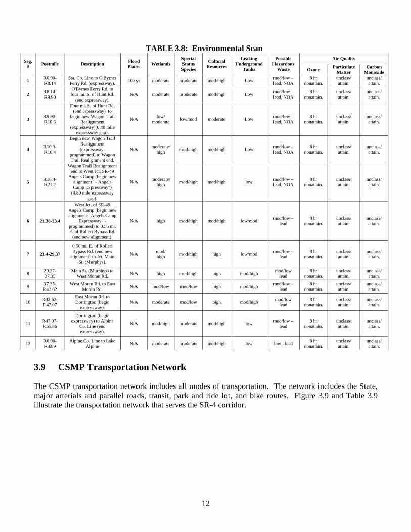
(GIS) modeling tool that can link land use and transportation in order to create alternative land use scenarios for growth and its spatial distribution for the next twenty years. Base models are currently being developed to include the Calaveras County General Plan Update alternatives and the county-wide traffic demand model with outcomes of various scenario model runs anticipated by the end of 2008. 3.8 Environmental Scan The National Environmental Policy Act (NEPA) and California Environmental Quality Act (CEQA) and other related federal and state environmental laws and regulations require environmental studies and public participation for all projects for which a public agency has a discretionary action. Resources and issues requiring environmental study may include historical structures, protected animals and plants, social and economic impacts, wildlife refuges and public parks, archaeological sites, hazardous waste, paleontological sites, air and water quality, and noise. Appropriate environmental studies would need to be conducted whenever any of the SR-4 CSMP improvements proposed are implemented if state or federal funding is involved. Project level analysis may be required and depending on the funding source may involve compliance with the National Environmental Policy Act and/or California Environmental Quality Act. Projects that may potentially cause an increase in traffic may require air quality and noise impact studies to determine if effects of increased traffic would cause a significant reduction of air quality and/or substantial increase in noise level. Hazardous waste studies may be indicated if the project area would include gas stations or other businesses that use or generate potential hazardous waste. Given the rich history of the City of Angels and communities along the corridor, structures should be evaluated to determine their historic value. Consideration should be given to effects on the communities, including residential and business properties, public parks and schools. A scan of potential environmental impacts has been completed along the corridor. See Table 3.8 for details on the environmental scan.
12
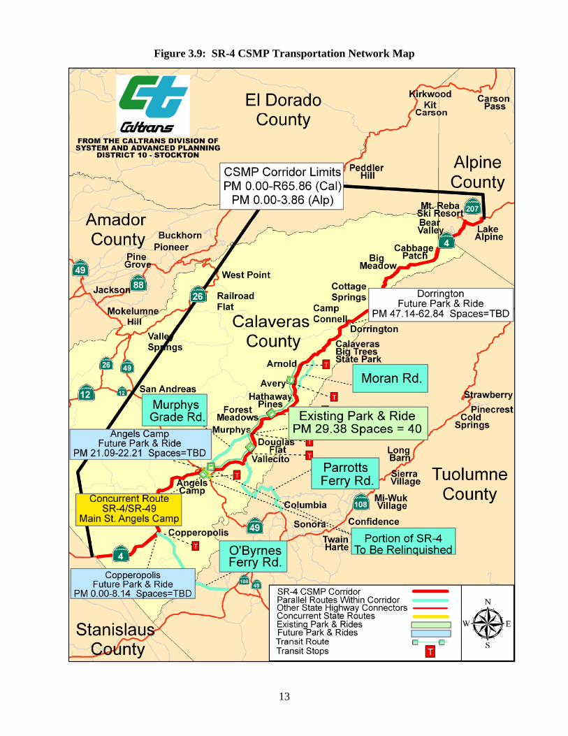
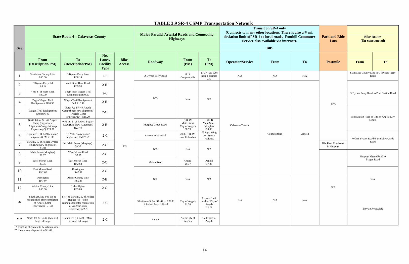
3.9 CSMP Transportation Network The CSMP transportation network includes all modes of transportation. The network includes the State, major arterials and parallel roads, transit, park and ride lot, and bike routes. Figure 3.9 and Table 3.9 illustrate the transportation network that serves the SR-4 corridor.
TABLE 3.8: Environmental Scan Air Quality Seg.
# Postmile Description Flood Plains Wetlands
Special Status Species
Cultural Resources
Leaking Underground
Tanks
Possible Hazardous
Waste Ozone Particulate Matter
Carbon Monoxide
1 R0.00-R8.14
Sta. Co. Line to O'Byrnes Ferry Rd. (expressway). 100 yr moderate moderate mod/high Low mod/low –
lead, NOA 8 hr
nonattain. unclass/ attain.
unclass/ attain.
2 R8.14-R9.90
O'Byrnes Ferry Rd. to four mi. S. of Hunt Rd.
(end expressway). N/A moderate moderate mod/high Low mod/low –
lead, NOA 8 hr
nonattain. unclass/ attain.
unclass/ attain.
3 R9.90-R10.3
Four mi. S. of Hunt Rd. (end espressway) to
begin new Wagon Trail Realignment
(expressway)(0.40 mile expressway gap).
N/A low/ moderate low/mod moderate Low mod/low –
lead, NOA 8 hr
nonattain. unclass/ attain.
unclass/ attain.
4 R10.3-R16.4
Begin new Wagon Trail Realignment (expressway-
programmed) to Wagon Trail Realignment end.
N/A moderate/ high mod/high mod/high Low mod/low –
lead, NOA 8 hr
nonattain. unclass/ attain.
unclass/ attain.
5 R16.4-R21.2
Wagon Trail Realignment end to West Jct. SR-49
Angels Camp (begin new alignment" - Angels Camp Expressway")
(4.80 mile expressway gap).
N/A moderate/ high mod/high mod/high low mod/low –
lead, NOA 8 hr
nonattain. unclass/ attain.
unclass/ attain.
6 21.38-23.4
West Jct. of SR-49 Angels Camp (begin new alignment-"Angels Camp
Expressway" - programmed) to 0.56 mi. E. of Rolleri Bypass Rd.
(end new alignment).
N/A high mod/high mod/high low/mod mod/low – lead
8 hr nonattain.
unclass/ attain.
unclass/ attain.
7 23.4-29.37
0.56 mi. E. of Rolleri Bypass Rd. (end new
alignment) to Jct. Main St. (Murphys).
N/A mod/ high mod/high high low/mod mod/low –
lead 8 hr
nonattain. unclass/ attain.
unclass/ attain.
8 29.37-37.35
Main St. (Murphys) to West Moran Rd. N/A high mod/high high mod/high mod/low
lead 8 hr
nonattain. unclass/ attain.
unclass/ attain.
9 37.35-R42.62
West Moran Rd. to East Moran Rd. N/A mod/low mod/low high mod/high mod/low –
lead 8 hr
nonattain. unclass/ attain.
unclass/ attain.
10 R42.62-R47.07
East Moran Rd. to Dorrington (begin
expressway). N/A moderate mod/low high mod/high mod/low
lead 8 hr
nonattain. unclass/ attain.
unclass/ attain.
11 R47.07-R65.86
Dorrington (begin expressway) to Alpine
Co. Line (end expressway).
N/A mod/high moderate mod/high low mod/low – lead
8 hr nonattain.
unclass/ attain.
unclass/ attain.
12 R0.00-R3.89
Alpine Co. Line to Lake Alpine N/A moderate moderate mod/high low low - lead 8 hr
nonattain. unclass/ attain.
unclass/ attain.
13
Figure 3.9: SR-4 CSMP Transportation Network Map
14
TABLE 3.9 SR-4 CSMP Transportation Network Transit on SR-4 only
(Connects to many other locations. There is also a ¾ mi. deviation limit off SR-4 to local roads. Foothill Commuter
Service also available via internet). State Route 4 – Calaveras County
Major Parallel Arterial Roads and Connecting Highways
Bus
Park and Ride Lots
Bike Routes (Un-constructed)
Seg
From (Description/PM)
To (Description/PM)
No. Lanes/ Facility
Type
Bike Access Roadway From
(PM) To
(PM) Operator/Service From To Postmile From To
1 Stanislaus County Line R00.00
O'Byrnes Ferry Road R08.14 2-E O’Byrnes Ferry Road 8.14
Copperopolis 11.37 (SR-120) near Yosemite
Jct. N/A N/A N/A
Stanislaus County Line to O’Byrnes Ferry Road
2 O'Byrnes Ferry Rd R8.14
4 mi. S. of Hunt Road R09.90 2-E
3 4 mi. S. of Hunt Road R09.90
Begin New Wagon Trail Realignment R10.30 2-C
4 Begin Wagon Trail Realignment R10.30
Wagon Trail Realignment End R16.40 2-E
O’Byrnes Ferry Road to Pool Station Road
5 Wagon Trail Realignment End R16.40
North Jct. SR-49 Angels Camp (begin new alignment"
- Angels Camp Expressway") R21.20
2-C
N/A N/A N/A
6 North Jct. of SR-49 Angels
Camp (begin New Alignment-"Angels Camp
Expressway") R21.20
0.56 mi. E. of Rolleri Bypass Road (End New Alignment)
R23.40 2-E Murphys Grade Road
(SR-49) Main Street
City of Angels 08.33
(SR-4) Main Street
Murphys 29.38
Pool Station Road to City of Angels City Limits
6 South Jct. SR-4/49 (existing alignment) PM 21.38
To Vallecito (existing alignment) PM 22.79 2-C Parrotts Ferry Road 20.39 (SR-49)
near Columbia
25.9 (existing SR-4) near Vallecito
N/A
7 0.56 mi. E. of Rolleri Bypass
Rd. (End New alignment) 23.40
Jct. Main Street (Murphys). 29.37 2-C Blackbart Playhouse
in Murphys
Rolleri Bypass Road to Murphys Grade Road
8 Main Street (Murphys) 29.37
West Moran Road 37.35 2-C
N/A N/A N/A
9 West Moran Road 37.35
East Moran Road R42.62 2-C Moran Road Arnold
29.37 Arnold 37.35
Murphys Grade Road to Blagen Road
10 East Moran Road R42.62
Dorrington R47.07 2-C
Calaveras Transit
Copperopolis
Arnold
11 Dorrington R47.07
Alpine County Line R65.86 2-E
12 Alpine County Line R00.00
Lake Alpine R03.89 2-C
N/A N/A N/A N/A
* South Jct. SR-4/49 (to be
relinquished after completion of Angels Camp
Expressway) 21.38
SR-4 to 0.56 mi. E. of Rolleri
Bypass Rd. (to be relinquished after completion
of Angels Camp Expressway) 22.79
2-C SR-4 from S. Jct. SR-49 to 0.56 E. of Rolleri Bypass Road
City of Angels 21.38
Approx. 1 mi. north of City of
Angels 22.79
** North Jct. SR-4/49 (Main St. Angels Camp)
South Jct. SR-4/49 (Main St. Angels Camp) 2-C
Yes
SR-49 North City of Angles
South City of Angels
N/A N/A N/A
N/A
Bicycle Accessible
* Existing alignment to be relinquished. ** Concurrent alignment w/SR-49.
Yes
Calaveras Transit
N/A
15
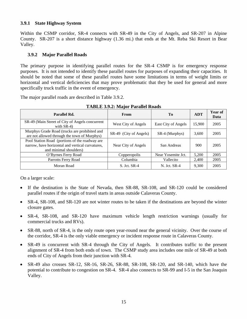
3.9.1 State Highway System Within the CSMP corridor, SR-4 connects with SR-49 in the City of Angels, and SR-207 in Alpine County. SR-207 is a short distance highway (1.36 mi.) that ends at the Mt. Reba Ski Resort in Bear Valley.
3.9.2 Major Parallel Roads The primary purpose in identifying parallel routes for the SR-4 CSMP is for emergency response purposes. It is not intended to identify these parallel routes for purposes of expanding their capacities. It should be noted that some of these parallel routes have some limitations in terms of weight limits or horizontal and vertical deficiencies that may prove problematic that they be used for general and more specifically truck traffic in the event of emergency. The major parallel roads are described in Table 3.9.2.
TABLE 3.9.2: Major Parallel Roads
Parallel Rd. From To ADT Year of Data
SR-49 (Main Street of City of Angels concurrent with SR-4) West City of Angels East City of Angels 15,900 2005
Murphys Grade Road (trucks are prohibited and are not allowed through the town of Murphys) SR-49 (City of Angels) SR-4 (Murphys) 3,600 2005
Pool Station Road (portions of the roadway are narrow, have horizontal and vertical curvatures,
and minimal shoulders) Near City of Angels San Andreas 900 2005
O’Byrnes Ferry Road Copperopolis Near Yosemite Jct. 5,200 2005 Parrotts Ferry Road Columbia Vallecito 2,400 2005
Moran Road S. Jct. SR-4 N. Jct. SR-4 9,300 2005
On a larger scale:
• If the destination is the State of Nevada, then SR-88, SR-108, and SR-120 could be considered parallel routes if the origin of travel starts in areas outside Calaveras County.
• SR-4, SR-108, and SR-120 are not winter routes to be taken if the destinations are beyond the winter closure gates.
• SR-4, SR-108, and SR-120 have maximum vehicle length restriction warnings (usually for commercial trucks and RVs).
• SR-88, north of SR-4, is the only route open year-round near the general vicinity. Over the course of the corridor, SR-4 is the only viable emergency or incident response route in Calaveras County.
• SR-49 is concurrent with SR-4 through the City of Angels. It contributes traffic to the present alignment of SR-4 from both ends of town. The CSMP study area includes one mile of SR-49 at both ends of City of Angels from their junction with SR-4.
• SR-49 also crosses SR-12, SR-16, SR-26, SR-88, SR-108, SR-120, and SR-140, which have the potential to contribute to congestion on SR-4. SR-4 also connects to SR-99 and I-5 in the San Joaquin Valley.
16
3.9.3 SR-4 CSMP Transportation Network Transit, Rideshare, Park and Ride, Bicycle Routes and Trails
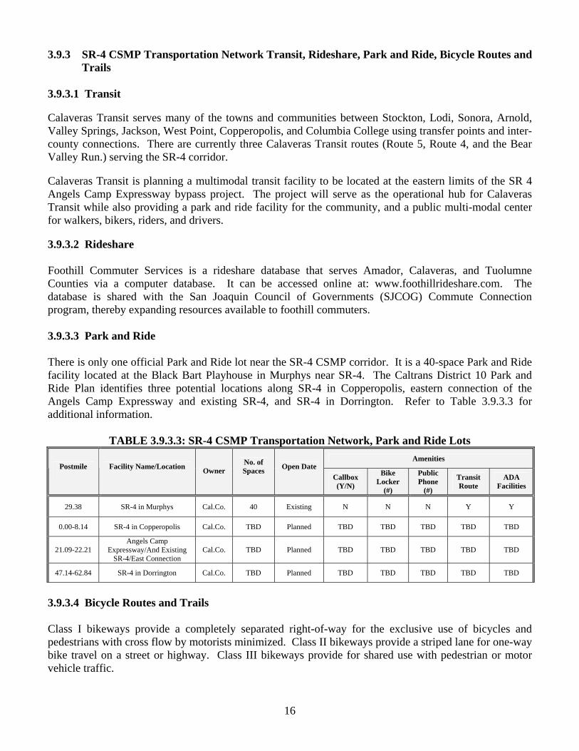
3.9.3.1 Transit Calaveras Transit serves many of the towns and communities between Stockton, Lodi, Sonora, Arnold, Valley Springs, Jackson, West Point, Copperopolis, and Columbia College using transfer points and inter-county connections. There are currently three Calaveras Transit routes (Route 5, Route 4, and the Bear Valley Run.) serving the SR-4 corridor. Calaveras Transit is planning a multimodal transit facility to be located at the eastern limits of the SR 4 Angels Camp Expressway bypass project. The project will serve as the operational hub for Calaveras Transit while also providing a park and ride facility for the community, and a public multi-modal center for walkers, bikers, riders, and drivers. 3.9.3.2 Rideshare Foothill Commuter Services is a rideshare database that serves Amador, Calaveras, and Tuolumne Counties via a computer database. It can be accessed online at: www.foothillrideshare.com. The database is shared with the San Joaquin Council of Governments (SJCOG) Commute Connection program, thereby expanding resources available to foothill commuters. 3.9.3.3 Park and Ride There is only one official Park and Ride lot near the SR-4 CSMP corridor. It is a 40-space Park and Ride facility located at the Black Bart Playhouse in Murphys near SR-4. The Caltrans District 10 Park and Ride Plan identifies three potential locations along SR-4 in Copperopolis, eastern connection of the Angels Camp Expressway and existing SR-4, and SR-4 in Dorrington. Refer to Table 3.9.3.3 for additional information.
TABLE 3.9.3.3: SR-4 CSMP Transportation Network, Park and Ride Lots
Amenities Postmile
Facility Name/Location
Owner No. of Spaces
Open Date
Callbox (Y/N)
Bike Locker
(#)
Public Phone
(#)
Transit Route
ADA Facilities
29.38 SR-4 in Murphys Cal.Co. 40 Existing N N N Y Y
0.00-8.14 SR-4 in Copperopolis Cal.Co. TBD Planned TBD TBD TBD TBD TBD
21.09-22.21 Angels Camp
Expressway/And Existing SR-4/East Connection
Cal.Co. TBD Planned TBD TBD TBD TBD TBD
47.14-62.84 SR-4 in Dorrington Cal.Co. TBD Planned TBD TBD TBD TBD TBD
3.9.3.4 Bicycle Routes and Trails Class I bikeways provide a completely separated right-of-way for the exclusive use of bicycles and pedestrians with cross flow by motorists minimized. Class II bikeways provide a striped lane for one-way bike travel on a street or highway. Class III bikeways provide for shared use with pedestrian or motor vehicle traffic.
17
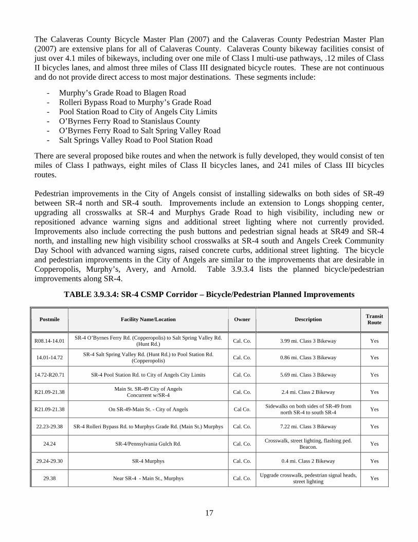
The Calaveras County Bicycle Master Plan (2007) and the Calaveras County Pedestrian Master Plan (2007) are extensive plans for all of Calaveras County. Calaveras County bikeway facilities consist of just over 4.1 miles of bikeways, including over one mile of Class I multi-use pathways, .12 miles of Class II bicycles lanes, and almost three miles of Class III designated bicycle routes. These are not continuous and do not provide direct access to most major destinations. These segments include:
- Murphy’s Grade Road to Blagen Road - Rolleri Bypass Road to Murphy’s Grade Road - Pool Station Road to City of Angels City Limits - O’Byrnes Ferry Road to Stanislaus County - O’Byrnes Ferry Road to Salt Spring Valley Road - Salt Springs Valley Road to Pool Station Road
There are several proposed bike routes and when the network is fully developed, they would consist of ten miles of Class I pathways, eight miles of Class II bicycles lanes, and 241 miles of Class III bicycles routes. Pedestrian improvements in the City of Angels consist of installing sidewalks on both sides of SR-49 between SR-4 north and SR-4 south. Improvements include an extension to Longs shopping center, upgrading all crosswalks at SR-4 and Murphys Grade Road to high visibility, including new or repositioned advance warning signs and additional street lighting where not currently provided. Improvements also include correcting the push buttons and pedestrian signal heads at SR49 and SR-4 north, and installing new high visibility school crosswalks at SR-4 south and Angels Creek Community Day School with advanced warning signs, raised concrete curbs, additional street lighting. The bicycle and pedestrian improvements in the City of Angels are similar to the improvements that are desirable in Copperopolis, Murphy’s, Avery, and Arnold. Table 3.9.3.4 lists the planned bicycle/pedestrian improvements along SR-4.
TABLE 3.9.3.4: SR-4 CSMP Corridor – Bicycle/Pedestrian Planned Improvements
Postmile Facility Name/Location Owner Description Transit Route
R08.14-14.01 SR-4 O’Byrnes Ferry Rd. (Copperopolis) to Salt Spring Valley Rd. (Hunt Rd.) Cal. Co. 3.99 mi. Class 3 Bikeway Yes
14.01-14.72 SR-4 Salt Spring Valley Rd. (Hunt Rd.) to Pool Station Rd. (Copperopolis) Cal. Co. 0.86 mi. Class 3 Bikeway Yes
14.72-R20.71 SR-4 Pool Station Rd. to City of Angels City Limits Cal. Co. 5.69 mi. Class 3 Bikeway Yes
R21.09-21.38 Main St. SR-49 City of Angels Concurrent w/SR-4 Cal. Co. 2.4 mi. Class 2 Bikeway Yes
R21.09-21.38 On SR-49-Main St. - City of Angels Cal Co. Sidewalks on both sides of SR-49 from north SR-4 to south SR-4 Yes
22.23-29.38 SR-4 Rolleri Bypass Rd. to Murphys Grade Rd. (Main St.) Murphys Cal. Co. 7.22 mi. Class 3 Bikeway Yes
24.24 SR-4/Pennsylvania Gulch Rd. Cal. Co. Crosswalk, street lighting, flashing ped. Beacon. Yes
29.24-29.30 SR-4 Murphys Cal. Co. 0.4 mi. Class 2 Bikeway Yes
29.38 Near SR-4 - Main St., Murphys Cal. Co. Upgrade crosswalk, pedestrian signal heads, street lighting Yes
18
T 3.10 Goods Movement SR-4, along with SR-12, SR-26, and SR-49, are the main routes in Calaveras County for goods movement. SR-4 between Rolleri Bypass Road and Murphys experienced the highest volumes of trucks at 535, of which 170 of them were 5-axle trucks. See Table 4.0.1 on Page 20. Logging trucks are a heavy user of SR-4 during the non-winter months, most of them on Sierra Pacific operations, since it is one of the routes that provide access to the timberlands. The drivers will make several round trips per day from logging operations in the Ebbetts Pass area to Sierra Pacific Industries (SPI) mills in Standard or Chinese Camp in Tuolumne County or to Camino, east of Placerville. SR-4 is also a main route for law enforcement and emergency vehicles (fire trucks, ambulance, paramedics). SR-4 directly connects to SR-49 within the CSMP corridor, SR-99 and I-5 in the San Joaquin Valley, and SR-89 not far from the Nevada State Line. It is part of the SHS that provides connectivity through the Sierras. SR-4 is part of the STAA truck network through the entire SR-4 CSMP corridor. Goods movement along the corridor includes logging trucks, highway material handling trucks (gravel, sand, boulders, etc.), commercial store delivery trucks, and United Parcel and FedEx delivery trucks. Calaveras County is aware of the importance of enhancing goods movement by continuing to consider trucking accommodations in all development and transportation plans impacting state and local facilities.
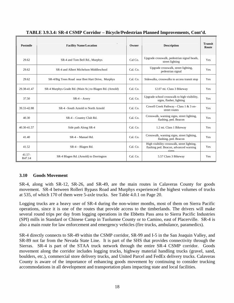
TABLE 3.9.3.4: SR-4 CSMP Corridor – Bicycle/Pedestrian Planned Improvements, Cont’d.
Postmile Facility Name/Location Owner Description Transit Route
29.62 SR-4 and Tom Bell Rd., Murphys Cal Co. Upgrade crosswalk, pedestrian signal heads, street lighting Yes
29.62 SR-4 and Albert Michelson Middleschool Cal. Co. Upgrade crosswalk, street lighting, pedestrian signal Yes
29.62 SR-4/Big Trees Road near Bret Hart Drive, Murphys Cal. Co. Sidewalks, crosswalks to access transit stop Yes
29.38-41.47 SR-4 Murphys Grade Rd. (Main St.) to Blagen Rd. (Arnold) Cal. Co. 12.07 mi. Class 3 Bikeway Yes
37.50 SR-4 – Avery Cal. Co. Upgrade school crosswalk to high visibility, signs, flasher, lighting Yes
39.33-42.88 SR-4 –South Arnold to North Arnold Cal. Co. Cowell Creek Pathway - Class 1 & 3 on-street routes Yes
40.30 SR-4 – Country Club Rd. Cal. Co. Crosswalk, warning signs, street lighting, flashing, ped. Beacon Yes
40.30-41.57 Side path Along SR-4 Cal. Co. 1.2 mi. Class 1 Bikeway Yes
41.40 SR-4 – Manuel Rd. Cal. Co. Crosswalk, warning signs, street lighting, flashing, ped. Beacon Yes
41.52 SR-4 – Blagen Rd. Cal. Co. High visibility crosswalk, street lighting, flashing ped. Beacon, advanced warning
signsYes
41.57- R47.14 SR-4 Blagen Rd. (Arnold) to Dorrington Cal. Co. 5.57 Class 3 Bikeway Yes
19
SECTION 4 PRELIMINARY PERFORMANCE, MANAGEMENT,
AND MAINTENANCE ASSESSMENT The Preliminary Performance, Management, and Maintenance Assessment is based on existing data from various sources, and addresses corridor-wide performance measures and identification of bottlenecks or causes of delay. The performance measures address several outcomes including mobility, reliability, safety, productivity, and preservation. Several measures are useful for each outcome, including:
Mobility – Delay, Travel Time
Reliability – Variation of Travel Time
Safety – Accidents, Accidents Rates
Productivity – Lost Lane Miles
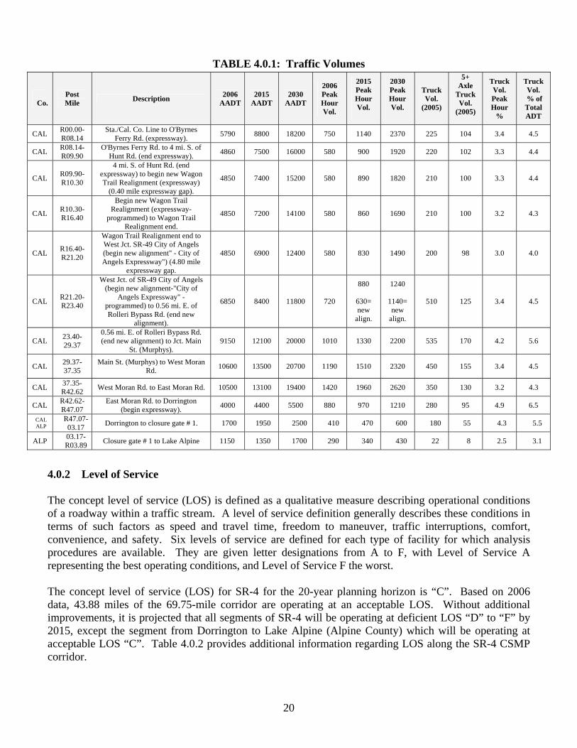
Preservation – Number and Locations of Distressed Lane Miles In general, the delays on conventional highways or expressways are due to too much traffic on a two-lane facility or due to signalization. Improvements can be addressed through operational improvements on the corridor, and where appropriate, corridor completion strategies to bring the existing conventional highway facility to expressway standards where feasible and cost effective. 4.0 Existing and Future Corridor Performance 4.0.1 Traffic Volumes The 2006 Average Annual Daily Traffic (AADT) on SR-4 ranged from 10,600 in Murphys to 1,150 at Alpine Lake. Within the same segments, the 2006 peak hour volumes ranged from 1,420 to 290. Truck Volumes In 2006, the Corridor experienced the highest truck volumes of 535 between Rolleri Bypass Road and the Junction of Main Street/SR-4 in Murphys. Of the 535 trucks, 170 of them were five-plus axle trucks. The 2006 truck volume peak hour percentage through this segment was 4.2%, and truck volume of total ADT represented 5.6%. Table 4.0.1 provides traffic volumes for the SR-4 CSMP corridor.
20
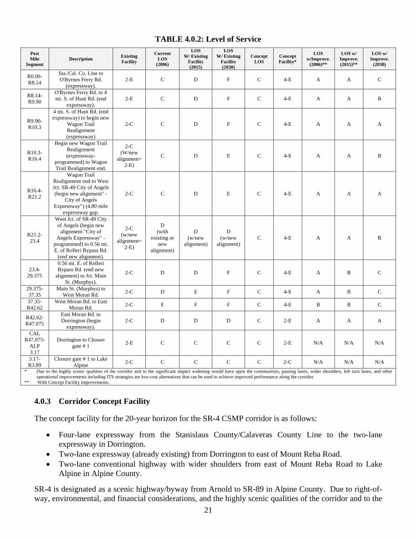
4.0.2 Level of Service The concept level of service (LOS) is defined as a qualitative measure describing operational conditions of a roadway within a traffic stream. A level of service definition generally describes these conditions in terms of such factors as speed and travel time, freedom to maneuver, traffic interruptions, comfort, convenience, and safety. Six levels of service are defined for each type of facility for which analysis procedures are available. They are given letter designations from A to F, with Level of Service A representing the best operating conditions, and Level of Service F the worst. The concept level of service (LOS) for SR-4 for the 20-year planning horizon is “C”. Based on 2006 data, 43.88 miles of the 69.75-mile corridor are operating at an acceptable LOS. Without additional improvements, it is projected that all segments of SR-4 will be operating at deficient LOS “D” to “F” by 2015, except the segment from Dorrington to Lake Alpine (Alpine County) which will be operating at acceptable LOS “C”. Table 4.0.2 provides additional information regarding LOS along the SR-4 CSMP corridor.
TABLE 4.0.1: Traffic Volumes
Co.
Post Mile Description 2006
AADT2015
AADT 2030
AADT
2006 Peak Hour Vol.
2015 Peak Hour Vol.
2030 Peak Hour Vol.
Truck Vol.
(2005)
5+ Axle
Truck Vol.
(2005)
Truck Vol. Peak Hour
%
Truck Vol.
% of Total ADT
CAL R00.00-R08.14
Sta./Cal. Co. Line to O'Byrnes Ferry Rd. (expressway). 5790 8800 18200 750 1140 2370 225 104 3.4 4.5
CAL R08.14-R09.90
O'Byrnes Ferry Rd. to 4 mi. S. of Hunt Rd. (end expressway). 4860 7500 16000 580 900 1920 220 102 3.3 4.4
CAL R09.90-R10.30
4 mi. S. of Hunt Rd. (end expressway) to begin new Wagon Trail Realignment (expressway)
(0.40 mile expressway gap).
4850 7400 15200 580 890 1820 210 100 3.3 4.4
CAL R10.30-R16.40
Begin new Wagon Trail Realignment (expressway-
programmed) to Wagon Trail Realignment end.
4850 7200 14100 580 860 1690 210 100 3.2 4.3
CAL R16.40-R21.20
Wagon Trail Realignment end to West Jct. SR-49 City of Angels (begin new alignment" - City of Angels Expressway") (4.80 mile
expressway gap.
4850 6900 12400 580 830 1490 200 98 3.0 4.0
CAL R21.20-R23.40
West Jct. of SR-49 City of Angels (begin new alignment-"City of
Angels Expressway" - programmed) to 0.56 mi. E. of Rolleri Bypass Rd. (end new
alignment).
6850 8400 11800 720
880
630= new
align.
1240
1140= new
align.
510 125 3.4 4.5
CAL 23.40-29.37
0.56 mi. E. of Rolleri Bypass Rd. (end new alignment) to Jct. Main
St. (Murphys). 9150 12100 20000 1010 1330 2200 535 170 4.2 5.6
CAL 29.37-37.35
Main St. (Murphys) to West Moran Rd. 10600 13500 20700 1190 1510 2320 450 155 3.4 4.5
CAL 37.35-R42.62 West Moran Rd. to East Moran Rd. 10500 13100 19400 1420 1960 2620 350 130 3.2 4.3
CAL R42.62-R47.07
East Moran Rd. to Dorrington (begin expressway). 4000 4400 5500 880 970 1210 280 95 4.9 6.5
CAL ALP
R47.07-03.17 Dorrington to closure gate # 1. 1700 1950 2500 410 470 600 180 55 4.3 5.5
ALP 03.17-R03.89 Closure gate # 1 to Lake Alpine 1150 1350 1700 290 340 430 22 8 2.5 3.1
21
TABLE 4.0.2: Level of Service
4.0.3 Corridor Concept Facility The concept facility for the 20-year horizon for the SR-4 CSMP corridor is as follows:
• Four-lane expressway from the Stanislaus County/Calaveras County Line to the two-lane expressway in Dorrington.
• Two-lane expressway (already existing) from Dorrington to east of Mount Reba Road. • Two-lane conventional highway with wider shoulders from east of Mount Reba Road to Lake
Alpine in Alpine County. SR-4 is designated as a scenic highway/byway from Arnold to SR-89 in Alpine County. Due to right-of-way, environmental, and financial considerations, and the highly scenic qualities of the corridor and to the
Post Mile
Segment Description Existing
Facility
Current LOS
(2006)
LOS W/ Existing
Facility (2015)
LOS W/ Existing
Facility (2030)
Concept LOS
Concept Facility*
LOS w/Improve.
(2006)**
LOS w/ Improve. (2015)**
LOS w/ Improve.
(2030)
R0.00-R8.14
Sta./Cal. Co. Line to O'Byrnes Ferry Rd.
(expressway). 2-E C D F C 4-E A A C
R8.14-R9.90
O'Byrnes Ferry Rd. to 4 mi. S. of Hunt Rd. (end
expressway). 2-E C D F C 4-E A A B
R9.90-R10.3
4 mi. S. of Hunt Rd. (end expressway) to begin new
Wagon Trail Realignment (expressway)
2-C C D F C 4-E A A A
R10.3-R16.4
Begin new Wagon Trail Realignment (expressway-
programmed) to Wagon Trail Realignment end.
2-C (W/new
alignment= 2-E)
C D E C 4-E A A B
R16.4-R21.2
Wagon Trail Realignment end to West Jct. SR-49 City of Angels (begin new alignment" -
City of Angels Expressway") (4.80 mile
expressway gap.
2-C C D E C 4-E A A A
R21.2-23.4
West Jct. of SR-49 City of Angels (begin new
alignment-"City of Angels Expressway" -
programmed) to 0.56 mi. E. of Rolleri Bypass Rd.
(end new alignment).
2-C (w/new
alignment= 2-E)
D (with
existing or new
alignment)
D (w/new
alignment)
D (w/new
alignment) C 4-E A A B
23.4-29.375
0.56 mi. E. of Rolleri Bypass Rd. (end new
alignment) to Jct. Main St. (Murphys).
2-C D D F C 4-E A B C
29.375-37.35
Main St. (Murphys) to West Moran Rd. 2-C D E F C 4-E A B C
37.35-R42.62
West Moran Rd. to East Moran Rd. 2-C E F F C 4-E B B C
R42.62-R47.075
East Moran Rd. to Dorrington (begin
expressway). 2-C D D D C 2-E A A A
CAL R47.075-
ALP 3.17
Dorrington to Closure gate # 1 2-E C C C C 2-E N/A N/A N/A
3.17-R3.89
Closure gate # 1 to Lake Alpine 2-C C C C C 2-C N/A N/A N/A
* Due to the highly scenic qualities of the corridor and to the significant impact widening would have upon the communities, passing lanes, wider shoulders, left turn lanes, and other operational improvements including ITS strategies are low-cost alternatives that can be used to achieve improved performance along the corridor.
** With Concept Facility improvements.
22
TABLE 4.1: SR-4 CSMP Programmed Capacity Increasing and Intersection Project
Primary Funding Source
RTP Y/N
Tier I Tier II
EA / RTP ID
County Begin Post Mile
End Post Mile
Location Description Total Cost ($1, 000)
Begin Const.
STIP, RIP Y 0E530 Cal 10.3 To be
determined
SR-4 Wagon Trail Realignment - west of SR-4/SR-49 Altaville (City
of Angels)
Two-lane expressway $40,000* TBD
*Preliminary estimate
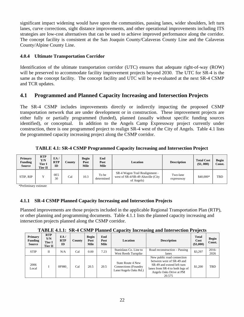
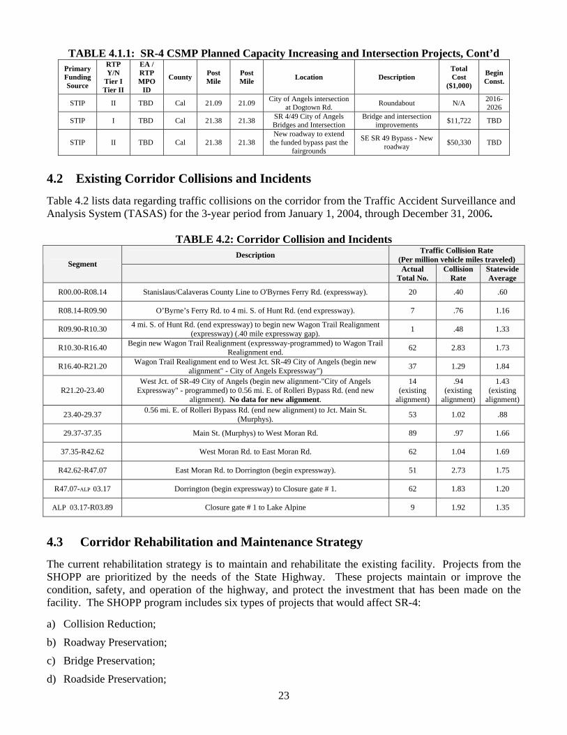
significant impact widening would have upon the communities, passing lanes, wider shoulders, left turn lanes, curve corrections, sight distance improvements, and other operational improvements including ITS strategies are low-cost alternatives that can be used to achieve improved performance along the corridor. The concept facility is consistent at the San Joaquin County/Calaveras County Line and the Calaveras County/Alpine County Line. 4.0.4 Ultimate Transportation Corridor Identification of the ultimate transportation corridor (UTC) ensures that adequate right-of-way (ROW) will be preserved to accommodate facility improvement projects beyond 2030. The UTC for SR-4 is the same as the concept facility. The concept facility and UTC will be re-evaluated at the next SR-4 CSMP and TCR updates. 4.1 Programmed and Planned Capacity Increasing and Intersection Projects The SR-4 CSMP includes improvements directly or indirectly impacting the proposed CSMP transportation network that are under development or in construction. These improvement projects are either fully or partially programmed (funded), planned (usually without specific funding sources identified), or conceptual. In addition to the Angels Camp Expressway project currently under construction, there is one programmed project to realign SR-4 west of the City of Angels. Table 4.1 lists the programmed capacity increasing project along the CSMP corridor.
4.1.1 SR-4 CSMP Planned Capacity Increasing and Intersection Projects Planned improvements are those projects included in the applicable Regional Transportation Plan (RTP), or other planning and programming documents. Table 4.1.1 lists the planned capacity increasing and intersection projects planned along the CSMP corridor.
TABLE 4.1.1: SR-4 CSMP Planned Capacity Increasing and Intersection Projects Primary Funding Source
RTP Y/N
Tier I Tier II
EA / RTP ID
County Begin Post Mile
End Post Mile
Location Description Total Cost
($1,000)
Begin Const.
STIP II N/A Cal 0.00 7.23 Stanislaus Co. Line to West Reeds Turnpike
Road reconstruction – Passing lanes $3,297 2016-
2026
2006 Local I 0F980_ Cal 20.5 20.5
State Route 4 New Connections (Foundry Lane/Angels Oaks Rd.)
New public road connection between west of SR-49 and SR-49 and extend left turn
lanes from SR-4 to both legs of Angels Oaks Drive at PM
20.575
$1,200 TBD
23
TABLE 4.1.1: SR-4 CSMP Planned Capacity Increasing and Intersection Projects, Cont’d
Primary Funding Source
RTP Y/N
Tier I Tier II
EA / RTP MPO
ID
County Post Mile
Post Mile Location Description
Total Cost
($1,000)
Begin Const.
STIP II TBD Cal 21.09 21.09 City of Angels intersection at Dogtown Rd. Roundabout N/A 2016-
2026
STIP I TBD Cal 21.38 21.38 SR 4/49 City of Angels Bridges and Intersection
Bridge and intersection improvements $11,722 TBD
STIP II TBD Cal 21.38 21.38 New roadway to extend
the funded bypass past the fairgrounds
SE SR 49 Bypass - New roadway $50,330 TBD
4.2 Existing Corridor Collisions and Incidents Table 4.2 lists data regarding traffic collisions on the corridor from the Traffic Accident Surveillance and Analysis System (TASAS) for the 3-year period from January 1, 2004, through December 31, 2006.
TABLE 4.2: Corridor Collision and Incidents Description Traffic Collision Rate
(Per million vehicle miles traveled) Segment Actual Total No.
Collision Rate
Statewide Average
R00.00-R08.14 Stanislaus/Calaveras County Line to O'Byrnes Ferry Rd. (expressway). 20 .40 .60
R08.14-R09.90 O’Byrne’s Ferry Rd. to 4 mi. S. of Hunt Rd. (end expressway). 7 .76 1.16
R09.90-R10.30 4 mi. S. of Hunt Rd. (end expressway) to begin new Wagon Trail Realignment (expressway) (.40 mile expressway gap). 1 .48 1.33
R10.30-R16.40 Begin new Wagon Trail Realignment (expressway-programmed) to Wagon Trail Realignment end. 62 2.83 1.73
R16.40-R21.20 Wagon Trail Realignment end to West Jct. SR-49 City of Angels (begin new alignment" - City of Angels Expressway") 37 1.29 1.84
R21.20-23.40 West Jct. of SR-49 City of Angels (begin new alignment-"City of Angels
Expressway" - programmed) to 0.56 mi. E. of Rolleri Bypass Rd. (end new alignment). No data for new alignment.
14 (existing
alignment)
.94 (existing
alignment)
1.43 (existing
alignment)
23.40-29.37 0.56 mi. E. of Rolleri Bypass Rd. (end new alignment) to Jct. Main St. (Murphys). 53 1.02 .88
29.37-37.35 Main St. (Murphys) to West Moran Rd. 89 .97 1.66
37.35-R42.62 West Moran Rd. to East Moran Rd. 62 1.04 1.69
R42.62-R47.07 East Moran Rd. to Dorrington (begin expressway). 51 2.73 1.75
R47.07-ALP 03.17 Dorrington (begin expressway) to Closure gate # 1. 62 1.83 1.20
ALP 03.17-R03.89 Closure gate # 1 to Lake Alpine 9 1.92 1.35
4.3 Corridor Rehabilitation and Maintenance Strategy The current rehabilitation strategy is to maintain and rehabilitate the existing facility. Projects from the SHOPP are prioritized by the needs of the State Highway. These projects maintain or improve the condition, safety, and operation of the highway, and protect the investment that has been made on the facility. The SHOPP program includes six types of projects that would affect SR-4: a) Collision Reduction;
b) Roadway Preservation;
c) Bridge Preservation;
d) Roadside Preservation;
24
e) Mobility Improvements; and
f) Mandates (storm water requirements and emergency-type projects)
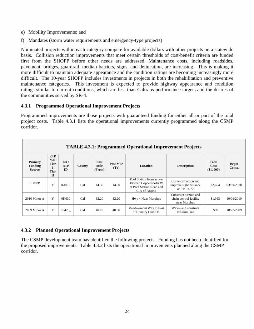
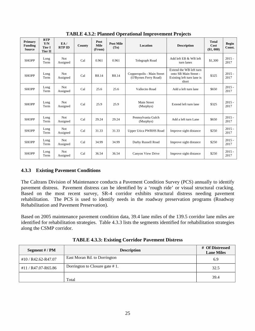
Nominated projects within each category compete for available dollars with other projects on a statewide basis. Collision reduction improvements that meet certain thresholds of cost-benefit criteria are funded first from the SHOPP before other needs are addressed. Maintenance costs, including roadsides, pavement, bridges, guardrail, median barriers, signs, and delineation, are increasing. This is making it more difficult to maintain adequate appearance and the condition ratings are becoming increasingly more difficult. The 10-year SHOPP includes investments in projects in both the rehabilitation and preventive maintenance categories. This investment is expected to provide highway appearance and condition ratings similar to current conditions, which are less than Caltrans performance targets and the desires of the communities served by SR-4. 4.3.1 Programmed Operational Improvement Projects Programmed improvements are those projects with guaranteed funding for either all or part of the total project costs. Table 4.3.1 lists the operational improvements currently programmed along the CSMP corridor. 4.3.2 Planned Operational Improvement Projects The CSMP development team has identified the following projects. Funding has not been identified for the proposed improvements. Table 4.3.2 lists the operational improvements planned along the CSMP corridor.
TABLE 4.3.1: Programmed Operational Improvement Projects
Primary Funding Source
RTP Y/N Tier
I Tier
II
EA / RTP ID
County Post Mile
(From)
Post Mile (To) Location Description
Total Cost
($1, 000)
Begin Const.
SHOPP Y 0A010 Cal 14.50 14.90
Pool Station Intersection Between Copperopolis W. of Pool Station Road and
City of Angels
Curve correction and improve sight distance
at PM 14.72 $2,654 03/01/2010
2010 Minor A Y 0K630 Cal 32.20 32.20 Hwy 4 Near Murphys Construct turnout and chain control facility
near Murphys $1,363 10/01/2010
2009 Minor A Y 0E420_ Cal 40.10 40.60 Meadowmont Way to East of Country Club Dr.
Widen and construct left-turn lane $891 10/23/2009
25
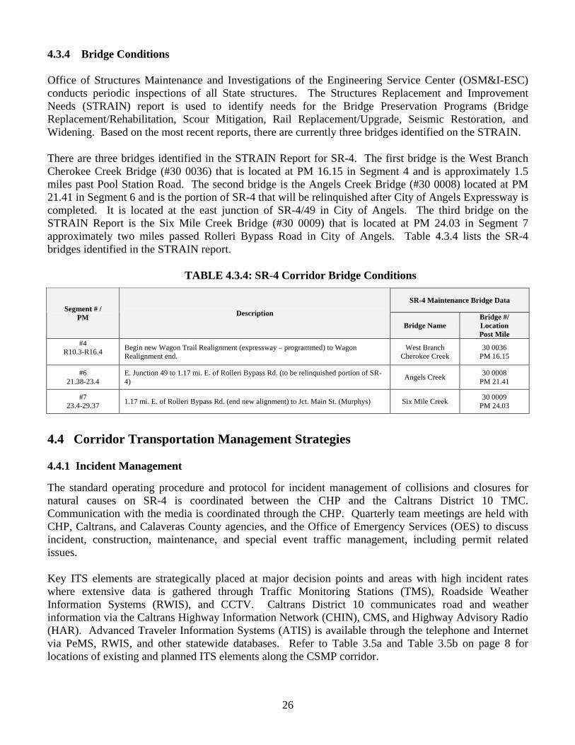
4.3.3 Existing Pavement Conditions
The Caltrans Division of Maintenance conducts a Pavement Condition Survey (PCS) annually to identify pavement distress. Pavement distress can be identified by a ‘rough ride’ or visual structural cracking. Based on the most recent survey, SR-4 corridor exhibits structural distress needing pavement rehabilitation. The PCS is used to identify needs in the roadway preservation programs (Roadway Rehabilitation and Pavement Preservation).
Based on 2005 maintenance pavement condition data, 39.4 lane miles of the 139.5 corridor lane miles are identified for rehabilitation strategies. Table 4.3.3 lists the segments identified for rehabilitation strategies along the CSMP corridor.
TABLE 4.3.3: Existing Corridor Pavement Distress
Segment # / PM Description # Of Distressed Lane Miles
#10 / R42.62-R47.07 East Moran Rd. to Dorrington 6.9
#11 / R47.07-R65.86 Dorrington to Closure gate # 1. 32.5
Total 39.4
TABLE 4.3.2: Planned Operational Improvement Projects
Primary Funding Source
RTP Y/N
Tier I Tier II
EA / RTP ID County
Post Mile
(From)
Post Mile (To) Location Description
Total Cost
($1, 000)
Begin Const.
SHOPP Long Term
Not Assigned Cal 0.961 0.961 Telegraph Road Add left EB & WB left
turn lanes $1,300 2015 - 2017
SHOPP Long Term
Not Assigned Cal R8.14 R8.14 Copperopolis - Main Street
(O'Byrnes Ferry Road)
Extend the WB left turn onto SB Main Street -
Existing left turn lane is short
$325 2015 - 2017
SHOPP Long Term
Not Assigned Cal 25.6 25.6 Vallecito Road Add a left turn lane $650 2015 -
2017
SHOPP Long Term
Not Assigned Cal 25.9 25.9 Main Street
(Murphys) Extend left turn lane $325 2015 - 2017
SHOPP Long Term
Not Assigned Cal 29.24 29.24 Pennsylvania Gulch
(Murphys) Add a left turn Lane $650 2015 - 2017
SHOPP Long Term
Not Assigned Cal 31.33 31.33 Upper Utica PWRHS Road Improve sight distance $250 2015 -
2017
SHOPP Long Term
Not Assigned Cal 34.99 34.99 Darby Russell Road Improve sight distance $250 2015 -
2017
SHOPP Long Term
Not Assigned Cal 36.54 36.54 Canyon View Drive Improve sight distance $250 2015 -
2017
26
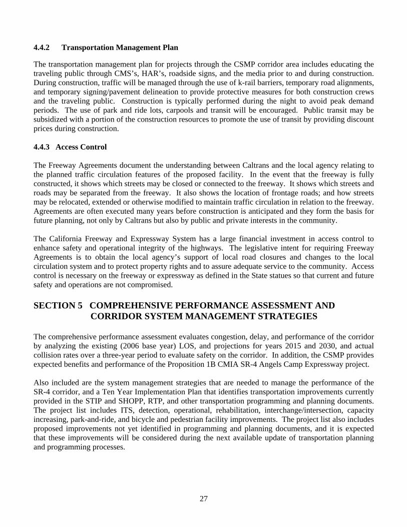
4.3.4 Bridge Conditions
Office of Structures Maintenance and Investigations of the Engineering Service Center (OSM&I-ESC) conducts periodic inspections of all State structures. The Structures Replacement and Improvement Needs (STRAIN) report is used to identify needs for the Bridge Preservation Programs (Bridge Replacement/Rehabilitation, Scour Mitigation, Rail Replacement/Upgrade, Seismic Restoration, and Widening. Based on the most recent reports, there are currently three bridges identified on the STRAIN.
There are three bridges identified in the STRAIN Report for SR-4. The first bridge is the West Branch Cherokee Creek Bridge (#30 0036) that is located at PM 16.15 in Segment 4 and is approximately 1.5 miles past Pool Station Road. The second bridge is the Angels Creek Bridge (#30 0008) located at PM 21.41 in Segment 6 and is the portion of SR-4 that will be relinquished after City of Angels Expressway is completed. It is located at the east junction of SR-4/49 in City of Angels. The third bridge on the STRAIN Report is the Six Mile Creek Bridge (#30 0009) that is located at PM 24.03 in Segment 7 approximately two miles passed Rolleri Bypass Road in City of Angels. Table 4.3.4 lists the SR-4 bridges identified in the STRAIN report.
TABLE 4.3.4: SR-4 Corridor Bridge Conditions
4.4 Corridor Transportation Management Strategies 4.4.1 Incident Management The standard operating procedure and protocol for incident management of collisions and closures for natural causes on SR-4 is coordinated between the CHP and the Caltrans District 10 TMC. Communication with the media is coordinated through the CHP. Quarterly team meetings are held with CHP, Caltrans, and Calaveras County agencies, and the Office of Emergency Services (OES) to discuss incident, construction, maintenance, and special event traffic management, including permit related issues. Key ITS elements are strategically placed at major decision points and areas with high incident rates where extensive data is gathered through Traffic Monitoring Stations (TMS), Roadside Weather Information Systems (RWIS), and CCTV. Caltrans District 10 communicates road and weather information via the Caltrans Highway Information Network (CHIN), CMS, and Highway Advisory Radio (HAR). Advanced Traveler Information Systems (ATIS) is available through the telephone and Internet via PeMS, RWIS, and other statewide databases. Refer to Table 3.5a and Table 3.5b on page 8 for locations of existing and planned ITS elements along the CSMP corridor.
SR-4 Maintenance Bridge Data Segment # /
PM Description
Bridge Name Bridge #/ Location Post Mile
#4 R10.3-R16.4
Begin new Wagon Trail Realignment (expressway – programmed) to Wagon Realignment end.
West Branch Cherokee Creek
30 0036 PM 16.15
#6 21.38-23.4
E. Junction 49 to 1.17 mi. E. of Rolleri Bypass Rd. (to be relinquished portion of SR-4) Angels Creek 30 0008
PM 21.41
#7 23.4-29.37 1.17 mi. E. of Rolleri Bypass Rd. (end new alignment) to Jct. Main St. (Murphys) Six Mile Creek 30 0009
PM 24.03
27
4.4.2 Transportation Management Plan The transportation management plan for projects through the CSMP corridor area includes educating the traveling public through CMS’s, HAR’s, roadside signs, and the media prior to and during construction. During construction, traffic will be managed through the use of k-rail barriers, temporary road alignments, and temporary signing/pavement delineation to provide protective measures for both construction crews and the traveling public. Construction is typically performed during the night to avoid peak demand periods. The use of park and ride lots, carpools and transit will be encouraged. Public transit may be subsidized with a portion of the construction resources to promote the use of transit by providing discount prices during construction. 4.4.3 Access Control The Freeway Agreements document the understanding between Caltrans and the local agency relating to the planned traffic circulation features of the proposed facility. In the event that the freeway is fully constructed, it shows which streets may be closed or connected to the freeway. It shows which streets and roads may be separated from the freeway. It also shows the location of frontage roads; and how streets may be relocated, extended or otherwise modified to maintain traffic circulation in relation to the freeway. Agreements are often executed many years before construction is anticipated and they form the basis for future planning, not only by Caltrans but also by public and private interests in the community. The California Freeway and Expressway System has a large financial investment in access control to enhance safety and operational integrity of the highways. The legislative intent for requiring Freeway Agreements is to obtain the local agency’s support of local road closures and changes to the local circulation system and to protect property rights and to assure adequate service to the community. Access control is necessary on the freeway or expressway as defined in the State statues so that current and future safety and operations are not compromised. SECTION 5 COMPREHENSIVE PERFORMANCE ASSESSMENT AND
CORRIDOR SYSTEM MANAGEMENT STRATEGIES The comprehensive performance assessment evaluates congestion, delay, and performance of the corridor by analyzing the existing (2006 base year) LOS, and projections for years 2015 and 2030, and actual collision rates over a three-year period to evaluate safety on the corridor. In addition, the CSMP provides expected benefits and performance of the Proposition 1B CMIA SR-4 Angels Camp Expressway project. Also included are the system management strategies that are needed to manage the performance of the SR-4 corridor, and a Ten Year Implementation Plan that identifies transportation improvements currently provided in the STIP and SHOPP, RTP, and other transportation programming and planning documents. The project list includes ITS, detection, operational, rehabilitation, interchange/intersection, capacity increasing, park-and-ride, and bicycle and pedestrian facility improvements. The project list also includes proposed improvements not yet identified in programming and planning documents, and it is expected that these improvements will be considered during the next available update of transportation planning and programming processes.
28
5.0 Delays, Congestion, or Queues The first effort in the management of a corridor is to identify its deficiencies compared to the required expected performance. The expected performance is the Concept Level of Service (LOS) “C” for the entire SR-4 CSMP Corridor. SR-4 is currently operating at an acceptable LOS of “C” up to the north SR-4/49 junction in the City of Angels. SR-4 then becomes deficient LOS “D” through “E” from the north SR-4/49 junction to east of Dorrington. SR-4 then reverts back to an acceptable LOS of “C” from east of Dorrington to Lake Alpine. By 2015, the corridor is expected to degrade to a LOS of “D-F” to the east end of Dorrington. This expectation does not take in consideration the expansion of the Bear Valley area and the Mount Reba Ski Resort nor any other land use changes. The most congested area on the SR-4 CSMP corridor is where existing SR-4 is concurrent with SR-49 (SR-49 being the dominate route) through the City of Angels. The main cause of congestion is the result of high volumes of traffic from two State highways converging on the same alignment as one two-lane conventional “mainstreet” highway through an area with many businesses, driveways, crosswalks, and on-street parking. The Angels Camp Expressway project will improve mobility and relieve traffic congestion by eliminating the necessity to drive through the City of Angels to reach other destinations on SR-4. The project will also reduce truck traffic through downtown City of Angels resulting in improved goods movement along the corridor. Between the communities of Copperopolis and City of Angels, there are curves, narrow shoulders, and poor intersection geometrics, causing the slowing and platooning of vehicles. The accident rate is higher than the State average along this segment. The programmed Wagon Trail project that is expected to go to construction in 2015 will improve the alignment through this segment. In addition, there is a programmed curve correction SHOPP project at Pool Station Road that is expected to go to construction in 2010. The 2007 CCOG RTP identifies plans to replace the Poole State Road Bridge. There are plans for a Class 3 Bikeway from Pool Station Road to the City of Angels City Limits. Through the town of Arnold, the corridor is experiencing increased traffic during special community and seasonal events. The CSMP development team has recommended that a CMS be located on the eastbound direction of SR-4 East of upper Moran Rd. to assist with traveler information. In addition, it is recommended that a TMS be installed to assist in monitoring the performance of the corridor in this area. The Arnold Rural Livable Community-Based Mobility Plan, in conjunction with the Arnold Community Plan, was developed to create a community-based plan addressing the current needs by studying traffic calming devices, increased pedestrian and bicycle safety, parking supply, economic development, land use refinement, and increased access to recreation opportunities and facilities. The plan includes project sequencing and identifies potential funding mechanisms as part of an overall plan for making Arnold a more livable community, particularly by addressing SR-4 as it traverses the community through downtown Arnold. SR-4 improvements identified in the plan are included in this CSMP. Bear Valley and the Mount Reba Ski Area experience congestion as a result of heavy seasonal recreational traffic. Heavy snow, slow moving traffic, chain installation, parking along the highway, all add to this congestion. The CSMP development team has also recommended a CMS to be located on the West bound side of SR-4 near Bear Valley Rd. at P.M. 65. In addition, the local California Highway Patrol will be in contact with the areas resorts to provide information regarding road conditions and chain requirements.
29
5.1 SR-4 CSMP Corridor System Management Strategies Analysis indicates that demand will continue to exceed capacity along portions of the SR-4 CSMP corridor. The concept facility for the 20-year horizon is a four-lane expressway from the Stanislaus County/Calaveras County Line to the two-lane expressway in Dorrington, two-lane expressway (already existing) from Dorrington to east of Mount Reba Road, and a two-lane conventional highway with wider shoulders from east of Mount Reba Road to Lake Alpine. SR-4 from Arnold to SR-89 in Alpine County is designated a State and Federal scenic highway/byway. Due to right-of-way, environmental, and financial considerations, and the highly scenic qualities of the corridor and to the significant impact widening would have upon the communities, operational improvements including ITS strategies are low-cost alternatives that can be used to achieve improved performance along the corridor, In order to manage the performance of the corridor and preserve the mobility gains of the SR-4 Proposition 1B investment, Caltrans District 10 and CCOG are committed to the following system management strategies: • Expansion of ITS elements to enhance incident management, traveler information, traffic detection,
and synchronization of traffic signals. There are seven existing ITS elements, and four planned ITS projects. There are plans for a weather station and ice sensor, two CMS signs, and a HAR placed in key locations. All four of the ITS projects would be used to warn travelers of changes in road conditions.
The existing and planned ITS infrastructure represents a wide collection of instrumentation some of
which combines several technologies in a single integrated system. The elements are placed in strategic locations to provide optimal benefit to the public or provide Caltrans TMC with data used to manage the corridor. The TMC uses the collected data to post advisories during incident management through CMS, HAR, or other media to alert approaching traffic to avoid possible secondary accidents, encourage diversion away from an incident, or dispatch Traffic Management Teams in the field.
ITS project improvements are categorized as short-term (0 - 4 years), mid-term (5 - 7 years) and long-
term (8 to 10 years). Long-term project goals for SR-4 include a HAR, and two CMS signs. Programmed, planned, and proposed ITS projects are listed in the Ten Year Implementation Plan and Project List on pages 33 and 34.
• Operational, rehabilitation, and maintenance improvements will include acceleration lanes, left turn
lanes, extend left turn lanes, passing lanes, bridge rail repair/replacement, traffic signals, off ramps connection, pavement rehabilitation, and repair slope/retaining wall. There are six programmed and twelve planned projects along the CSMP corridor.
The programmed and planned project improvements will provide safety and operational benefits at the
location of the improvements and contribute to the overall improved performance of the corridor. Improvements are categorized as short-term (0 - 4 years), mid-term (5 - 7 years) and long-term (8 to 10 years). Short and mid-term project goals for SR-4 include the operational improvements within the SR-4 CMIA project, and those currently programmed in the STIP and SHOPP. Long-term project goals include operational improvements not currently identified for funding. Programmed and planned operational, rehabilitation, and maintenance improvements are listed in the Ten Year Implementation Plan and Project List on pages 33 and 34.
30
• Support the findings of the Arnold Rural Livable Community-Based Mobility Plan. The plan includes project sequencing and identifies potential funding mechanisms for traffic calming devices, increased pedestrian and bicycle safety, parking supply, economic development, land use refinement, and increased access to recreational opportunities and facilities along SR-4 through downtown Arnold. SR-4 improvements identified in the plan are listed in the Ten Year Implementation Plan and Project List on pages 33 and 34.
• The management of collisions and closures for natural causes will continue to be coordinated between
the CHP and the Caltrans District 10 TMC. Communication with the media will continue to be coordinated by the CHP. Meetings will continue to be held twice a year with CHP, Caltrans, Calaveras County agencies, and the Office of Emergency Services to discuss incident, construction, maintenance, and special event traffic management, including permit related issues. In addition, the local CHP office will continue to communicate directly with the local resorts on weather and road conditions and chain control.
• Expansion of TDM practices including construction of new park-and-rides facilities with transit
connectivity, and continued work force vanpool and rideshare services through Foothill Commuter Services and Commute Connection. Planned park-and-ride improvements are listed in the Ten Year Implementation Plan and Project List on pages 33 and 34.
• Consider the connectivity of bike and pedestrian facilities in future transportation projects and
residential and commercial development along and crossing SR-4. Planned bicycle and pedestrian improvements are listed in the Ten Year Implementation Plan and Project List on pages 33 and 34.
• Maintain and support existing transit service and plans for future expansion along SR-4. • Caltrans District 10, City of Angels, Calaveras Council of Governments, and Calaveras County, in
conjunction with other local and regional agencies, began working on a scope of work to develop an AMP for SR-49 through City of Angels. The AMP will address congestion and circulation, including pedestrian and bicycle access issues currently affecting the corridor. The AMP also will evaluate turning movement controls or other alternative intersection configurations including but not limited to roundabouts. The AMP will assist in improving and preserving the performance of the SR-49 corridor as well as preserve the expected gains and benefits of the new SR-4 Angels Camp Expressway. It is anticipated that AMP will be completed by December 2009.
5.1.1 Ten Year Implementation Plan The SR-4 CSMP includes a Ten Year Implementation Plan that identifies transportation improvements and system management strategies currently provided in the STIP, SHOPP, 2007 CCOG RTP, and other transportation programming and planning documents along the SR-4 corridor. The project list includes ITS, detection, operational, rehabilitation, intersection, capacity increasing, park-and-ride, and bicycle and pedestrian facility improvements. • The project list also includes the previously discussed proposed improvements not yet identified in
programming and planning documents. It is expected that these improvements will be considered during the next available update of transportation planning and programming processes. Refer to the Ten Year Implementation Plan and Project List on pages 33 and 34.
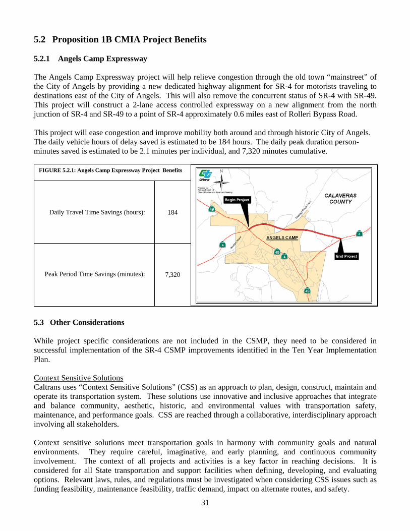
31
5.2 Proposition 1B CMIA Project Benefits 5.2.1 Angels Camp Expressway The Angels Camp Expressway project will help relieve congestion through the old town “mainstreet” of the City of Angels by providing a new dedicated highway alignment for SR-4 for motorists traveling to destinations east of the City of Angels. This will also remove the concurrent status of SR-4 with SR-49. This project will construct a 2-lane access controlled expressway on a new alignment from the north junction of SR-4 and SR-49 to a point of SR-4 approximately 0.6 miles east of Rolleri Bypass Road. This project will ease congestion and improve mobility both around and through historic City of Angels. The daily vehicle hours of delay saved is estimated to be 184 hours. The daily peak duration person-minutes saved is estimated to be 2.1 minutes per individual, and 7,320 minutes cumulative.
5.3 Angels Camp Expressway 5.3 Other Considerations While project specific considerations are not included in the CSMP, they need to be considered in successful implementation of the SR-4 CSMP improvements identified in the Ten Year Implementation Plan. Context Sensitive Solutions Caltrans uses “Context Sensitive Solutions” (CSS) as an approach to plan, design, construct, maintain and operate its transportation system. These solutions use innovative and inclusive approaches that integrate and balance community, aesthetic, historic, and environmental values with transportation safety, maintenance, and performance goals. CSS are reached through a collaborative, interdisciplinary approach involving all stakeholders. Context sensitive solutions meet transportation goals in harmony with community goals and natural environments. They require careful, imaginative, and early planning, and continuous community involvement. The context of all projects and activities is a key factor in reaching decisions. It is considered for all State transportation and support facilities when defining, developing, and evaluating options. Relevant laws, rules, and regulations must be investigated when considering CSS issues such as funding feasibility, maintenance feasibility, traffic demand, impact on alternate routes, and safety.
FIGURE 5.2.1: Angels Camp Expressway Project Benefits
Daily Travel Time Savings (hours):
Peak Period Time Savings (minutes):
184
7,320
32
Main Street Design and Operation In towns and cities across California, a State highway may serve as their main street. These communities desire that their main street be an economic, social and cultural asset as well as provide for the safe and efficient movement of people and goods. In urban areas, communities want transportation projects to provide opportunities for enhanced non-motorized travel and visual quality. In natural settings, projects can fit aesthetically into the surroundings by including contour grading, aesthetic bridge railings, and special architectural and structural elements. Addressing these needs will ensure that transportation solutions meet more than transportation objectives. Safety Conscious Planning Safety conscious planning is incorporated into all planning processes and complements context sensitive solutions. As in most projects, a need is established before a project can be built. Factors such as congestion, reoccurring collision patterns, poor LOS, narrow roads, non-standard alignments and operational problems, can facilitate safety improvements. The SR-4 CSMP can be used as a tool to proactively identify operational problems rather than reacting to safety problems. Suggested solutions for these problems should conform to the surrounding environment and meet the needs of the people within the community.
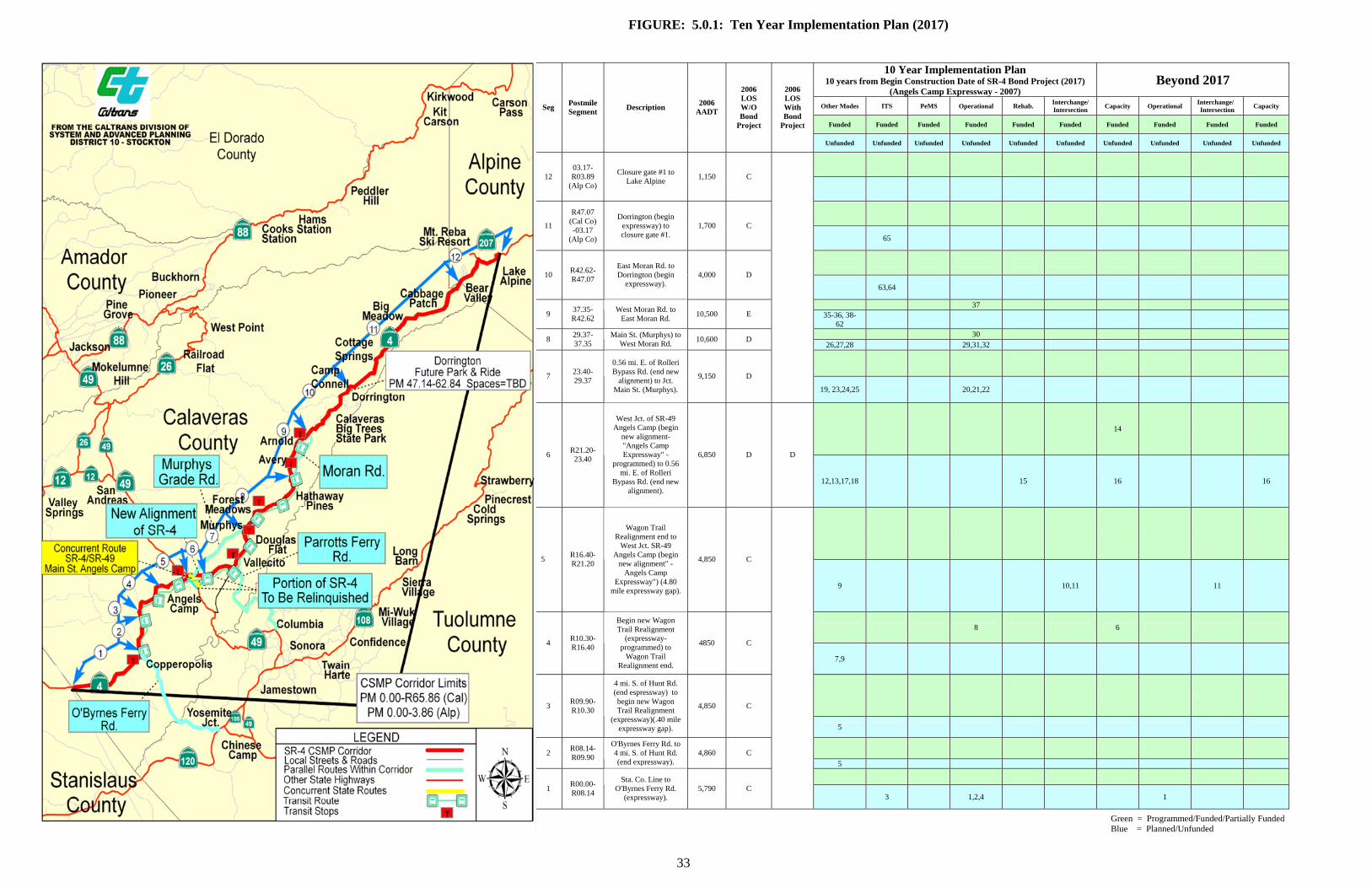
FIGURE: 5.0.1: Ten Year Implementation Plan (2017)
10 Year Implementation Plan 10 years from Begin Construction Date of SR-4 Bond Project (2017)
(Angels Camp Expressway - 2007) Beyond 2017
33
Other Modes ITS PeMS Operational Rehab. Interchange/ Intersection Capacity Operational Interchange/
Intersection Capacity
Funded Funded Funded Funded Funded Funded Funded Funded Funded Funded
Seg Postmile Segment Description 2006
AADT
2006 LOS W/O Bond
Project
2006 LOS With Bond
Project
Unfunded Unfunded Unfunded Unfunded Unfunded Unfunded Unfunded Unfunded Unfunded Unfunded
12
03.17-R03.89
(Alp Co)
Closure gate #1 to Lake Alpine 1,150 C
11
R47.07 (Cal Co) -03.17
(Alp Co)
Dorrington (begin expressway) to closure gate #1.
1,700 C 65
10 R42.62-
R47.07
East Moran Rd. to Dorrington (begin
expressway). 4,000 D
63,64
37 9 37.35-
R42.62 West Moran Rd. to
East Moran Rd. 10,500 E 35-36, 38-62
30 8 29.37-37.35
Main St. (Murphys) to West Moran Rd. 10,600 D
26,27,28 29,31,32
7 23.40-
29.37
0.56 mi. E. of Rolleri Bypass Rd. (end new
alignment) to Jct. Main St. (Murphys).
9,150 D
19, 23,24,25 20,21,22
14
6 R21.20-23.40
West Jct. of SR-49 Angels Camp (begin
new alignment-"Angels Camp Expressway" -
programmed) to 0.56 mi. E. of Rolleri
Bypass Rd. (end new alignment).
6,850 D D
12,13,17,18 15 16 16
5 R16.40-R21.20
Wagon Trail Realignment end to
West Jct. SR-49 Angels Camp (begin
new alignment" - Angels Camp
Expressway") (4.80 mile expressway gap).
4,850 C
9 10,11 11
8 6
4 R10.30-R16.40
Begin new Wagon Trail Realignment
(expressway-programmed) to
Wagon Trail Realignment end.
4850 C
7,9
3 R09.90-
R10.30
4 mi. S. of Hunt Rd. (end espressway) to begin new Wagon Trail Realignment
(expressway)(.40 mile expressway gap).
4,850 C
5
2 R08.14-R09.90
O'Byrnes Ferry Rd. to 4 mi. S. of Hunt Rd. (end expressway).
4,860 C 5
1 R00.00-
R08.14
Sta. Co. Line to O'Byrnes Ferry Rd.
(expressway). 5,790 C
3 1,2,4 1
Green = Programmed/Funded/Partially Funded Blue = Planned/Unfunded
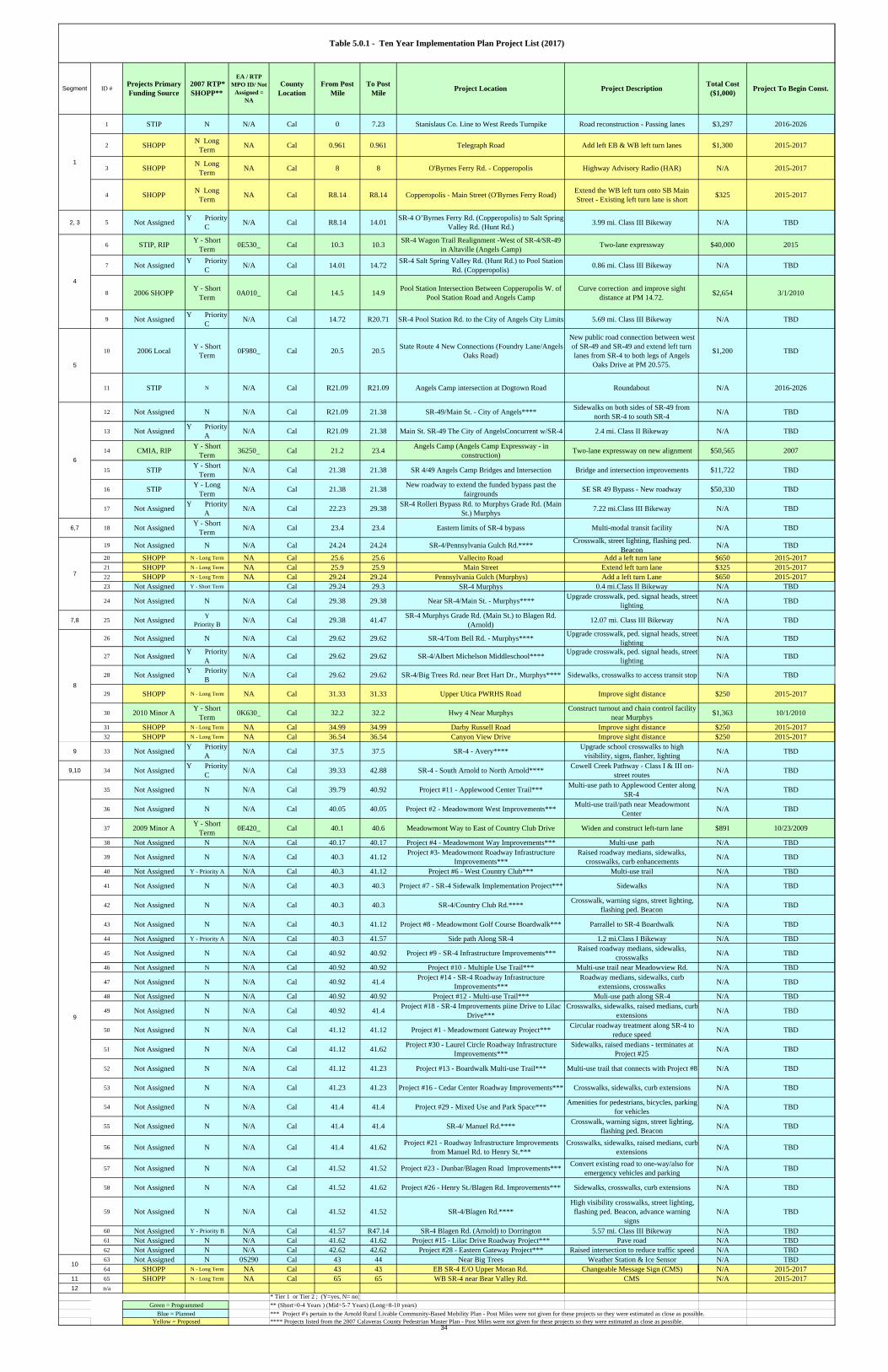
1 STIP N N/A Cal 0 7.23 Stanislaus Co. Line to West Reeds Turnpike Road reconstruction - Passing lanes $3,297 2016-2026
2 SHOPP N Long Term NA Cal 0.961 0.961 Telegraph Road Add left EB & WB left turn lanes $1,300 2015-2017
3 SHOPP N Long Term NA Cal 8 8 O'Byrnes Ferry Rd. - Copperopolis Highway Advisory Radio (HAR) N/A 2015-2017
4 SHOPP N Long Term NA Cal R8.14 R8.14 Copperopolis - Main Street (O'Byrnes Ferry Road) Extend the WB left turn onto SB Main
Street - Existing left turn lane is short $325 2015-2017
2, 3 5 Not Assigned Y Priority C N/A Cal R8.14 14.01 SR-4 O’Byrnes Ferry Rd. (Copperopolis) to Salt Spring
Valley Rd. (Hunt Rd.) 3.99 mi. Class III Bikeway N/A TBD
6 STIP, RIP Y - Short Term 0E530_ Cal 10.3 10.3 SR-4 Wagon Trail Realignment -West of SR-4/SR-49
in Altaville (Angels Camp) Two-lane expressway $40,000 2015
7 Not Assigned Y Priority C N/A Cal 14.01 14.72 SR-4 Salt Spring Valley Rd. (Hunt Rd.) to Pool Station
Rd. (Copperopolis) 0.86 mi. Class III Bikeway N/A TBD
8 2006 SHOPP Y - Short Term 0A010_ Cal 14.5 14.9 Pool Station Intersection Between Copperopolis W. of
Pool Station Road and Angels CampCurve correction and improve sight
distance at PM 14.72. $2,654 3/1/2010
9 Not Assigned Y Priority C N/A Cal 14.72 R20.71 SR-4 Pool Station Rd. to the City of Angels City Limits 5.69 mi. Class III Bikeway N/A TBD
10 2006 Local Y - Short Term 0F980_ Cal 20.5 20.5 State Route 4 New Connections (Foundry Lane/Angels
Oaks Road)
New public road connection between west of SR-49 and SR-49 and extend left turn lanes from SR-4 to both legs of Angels
Oaks Drive at PM 20.575.
$1,200 TBD
11 STIP N N/A Cal R21.09 R21.09 Angels Camp intersection at Dogtown Road Roundabout N/A 2016-2026
12 Not Assigned N N/A Cal R21.09 21.38 SR-49/Main St. - City of Angels**** Sidewalks on both sides of SR-49 from north SR-4 to south SR-4 N/A TBD
13 Not Assigned Y Priority A N/A Cal R21.09 21.38 Main St. SR-49 The City of AngelsConcurrent w/SR-4 2.4 mi. Class II Bikeway N/A TBD
14 CMIA, RIP Y - Short Term 36250_ Cal 21.2 23.4 Angels Camp (Angels Camp Expressway - in
construction) Two-lane expressway on new alignment $50,565 2007
15 STIP Y - Short Term N/A Cal 21.38 21.38 SR 4/49 Angels Camp Bridges and Intersection Bridge and intersection improvements $11,722 TBD
16 STIP Y - Long Term N/A Cal 21.38 21.38 New roadway to extend the funded bypass past the
fairgrounds SE SR 49 Bypass - New roadway $50,330 TBD
17 Not Assigned Y Priority A N/A Cal 22.23 29.38 SR-4 Rolleri Bypass Rd. to Murphys Grade Rd. (Main
St.) Murphys 7.22 mi.Class III Bikeway N/A TBD
6,7 18 Not Assigned Y - Short Term N/A Cal 23.4 23.4 Eastern limits of SR-4 bypass Multi-modal transit facility N/A TBD
19 Not Assigned N N/A Cal 24.24 24.24 SR-4/Pennsylvania Gulch Rd.**** Crosswalk, street lighting, flashing ped. Beacon N/A TBD
20 SHOPP N - Long Term NA Cal 25.6 25.6 Vallecito Road Add a left turn lane $650 2015-201721 SHOPP N - Long Term NA Cal 25.9 25.9 Main Street Extend left turn lane $325 2015-201722 SHOPP N - Long Term NA Cal 29.24 29.24 Pennsylvania Gulch (Murphys) Add a left turn Lane $650 2015-201723 Not Assigned Y - Short Term Cal 29.24 29.3 SR-4 Murphys 0.4 mi.Class II Bikeway N/A TBD
24 Not Assigned N N/A Cal 29.38 29.38 Near SR-4/Main St. - Murphys**** Upgrade crosswalk, ped. signal heads, street lighting N/A TBD
7,8 25 Not Assigned Y Priority B N/A Cal 29.38 41.47 SR-4 Murphys Grade Rd. (Main St.) to Blagen Rd.
(Arnold) 12.07 mi. Class III Bikeway N/A TBD
26 Not Assigned N N/A Cal 29.62 29.62 SR-4/Tom Bell Rd. - Murphys**** Upgrade crosswalk, ped. signal heads, street lighting N/A TBD
27 Not Assigned Y Priority A N/A Cal 29.62 29.62 SR-4/Albert Michelson Middleschool**** Upgrade crosswalk, ped. signal heads, street
lighting N/A TBD
28 Not Assigned Y Priority B N/A Cal 29.62 29.62 SR-4/Big Trees Rd. near Bret Hart Dr., Murphys**** Sidewalks, crosswalks to access transit stop N/A TBD
29 SHOPP N - Long Term NA Cal 31.33 31.33 Upper Utica PWRHS Road Improve sight distance $250 2015-2017
30 2010 Minor A Y - Short Term 0K630_ Cal 32.2 32.2 Hwy 4 Near Murphys Construct turnout and chain control facility
near Murphys $1,363 10/1/2010
31 SHOPP N - Long Term NA Cal 34.99 34.99 Darby Russell Road Improve sight distance $250 2015-201732 SHOPP N - Long Term NA Cal 36.54 36.54 Canyon View Drive Improve sight distance $250 2015-2017
9 33 Not Assigned Y Priority A N/A Cal 37.5 37.5 SR-4 - Avery**** Upgrade school crosswalks to high
visibility, signs, flasher, lighting N/A TBD
9,10 34 Not Assigned Y Priority C N/A Cal 39.33 42.88 SR-4 - South Arnold to North Arnold**** Cowell Creek Pathway - Class I & III on-
street routes N/A TBD
35 Not Assigned N N/A Cal 39.79 40.92 Project #11 - Applewood Center Trail*** Multi-use path to Applewood Center along SR-4 N/A TBD
36 Not Assigned N N/A Cal 40.05 40.05 Project #2 - Meadowmont West Improvements*** Multi-use trail/path near Meadowmont Center N/A TBD
37 2009 Minor A Y - Short Term 0E420_ Cal 40.1 40.6 Meadowmont Way to East of Country Club Drive Widen and construct left-turn lane $891 10/23/2009
38 Not Assigned N N/A Cal 40.17 40.17 Project #4 - Meadowmont Way Improvements*** Multi-use path N/A TBD
39 Not Assigned N N/A Cal 40.3 41.12 Project #3- Meadowmont Roadway Infrastructure Improvements***
Raised roadway medians, sidewalks, crosswalks, curb enhancements N/A TBD
40 Not Assigned Y - Priority A N/A Cal 40.3 41.12 Project #6 - West Country Club*** Multi-use trail N/A TBD
41 Not Assigned N N/A Cal 40.3 40.3 Project #7 - SR-4 Sidewalk Implementation Project*** Sidewalks N/A TBD
42 Not Assigned N N/A Cal 40.3 40.3 SR-4/Country Club Rd.**** Crosswalk, warning signs, street lighting, flashing ped. Beacon N/A TBD
43 Not Assigned N N/A Cal 40.3 41.12 Project #8 - Meadowmont Golf Course Boardwalk*** Parrallel to SR-4 Boardwalk N/A TBD
44 Not Assigned Y - Priority A N/A Cal 40.3 41.57 Side path Along SR-4 1.2 mi.Class I Bikeway N/A TBD
45 Not Assigned N N/A Cal 40.92 40.92 Project #9 - SR-4 Infrastructure Improvements*** Raised roadway medians, sidewalks, crosswalks N/A TBD
46 Not Assigned N N/A Cal 40.92 40.92 Project #10 - Multiple Use Trail*** Multi-use trail near Meadowview Rd. N/A TBD
47 Not Assigned N N/A Cal 40.92 41.4 Project #14 - SR-4 Roadway Infrastructure Improvements***
Roadway medians, sidewalks, curb extensions, crosswalks N/A TBD
48 Not Assigned N N/A Cal 40.92 40.92 Project #12 - Multi-use Trail*** Muli-use path along SR-4 N/A TBD
49 Not Assigned N N/A Cal 40.92 41.4 Project #18 - SR-4 Improvements piine Drive to Lilac Drive***
Crosswalks, sidewalks, raised medians, curb extensions N/A TBD
50 Not Assigned N N/A Cal 41.12 41.12 Project #1 - Meadowmont Gateway Project*** Circular roadway treatment along SR-4 to reduce speed N/A TBD
51 Not Assigned N N/A Cal 41.12 41.62 Project #30 - Laurel Circle Roadway Infrastructure Improvements***
Sidewalks, raised medians - terminates at Project #25 N/A TBD
52 Not Assigned N N/A Cal 41.12 41.23 Project #13 - Boardwalk Multi-use Trail*** Multi-use trail that connects with Project #8 N/A TBD
53 Not Assigned N N/A Cal 41.23 41.23 Project #16 - Cedar Center Roadway Improvements*** Crosswalks, sidewalks, curb extensions N/A TBD
54 Not Assigned N N/A Cal 41.4 41.4 Project #29 - Mixed Use and Park Space*** Amenities for pedestrians, bicycles, parking for vehicles N/A TBD
55 Not Assigned N N/A Cal 41.4 41.4 SR-4/ Manuel Rd.**** Crosswalk, warning signs, street lighting, flashing ped. Beacon N/A TBD
56 Not Assigned N N/A Cal 41.4 41.62 Project #21 - Roadway Infrastructure Improvements from Manuel Rd. to Henry St.***
Crosswalks, sidewalks, raised medians, curb extensions N/A TBD
57 Not Assigned N N/A Cal 41.52 41.52 Project #23 - Dunbar/Blagen Road Improvements*** Convert existing road to one-way/also for emergency vehicles and parking N/A TBD
58 Not Assigned N N/A Cal 41.52 41.62 Project #26 - Henry St./Blagen Rd. Improvements*** Sidewalks, crosswalks, curb extensions N/A TBD
59 Not Assigned N N/A Cal 41.52 41.52 SR-4/Blagen Rd.****High visibility crosswalks, street lighting, flashing ped. Beacon, advance warning
signsN/A TBD
60 Not Assigned Y - Priority B N/A Cal 41.57 R47.14 SR-4 Blagen Rd. (Arnold) to Dorrington 5.57 mi. Class III Bikeway N/A TBD61 Not Assigned N N/A Cal 41.62 41.62 Project #15 - Lilac Drive Roadway Project*** Pave road N/A TBD62 Not Assigned N N/A Cal 42.62 42.62 Project #28 - Eastern Gateway Project*** Raised intersection to reduce traffic speed N/A TBD63 Not Assigned N 0S290 Cal 43 44 Near Big Trees Weather Station & Ice Sensor N/A TBD64 SHOPP N - Long Term NA Cal 43 43 EB SR-4 E/O Upper Moran Rd. Changeable Message Sign (CMS) N/A 2015-2017
11 65 SHOPP N - Long Term NA Cal 65 65 WB SR-4 near Bear Valley Rd. CMS N/A 2015-201712 n/a
* Tier 1 or Tier 2 ; (Y=yes, N= no)** (Short=0-4 Years ) (Mid=5-7 Years) (Long=8-10 years)*** Project #'s pertain to the Arnold Rural Livable Community-Based Mobility Plan - Post Miles were not given for these projects so they were estimated as close as possible.**** Projects listed from the 2007 Calaveras County Pedestrian Master Plan - Post Miles were not given for these projects so they were estimated as close as possible.
4
7
8
6
5
Table 5.0.1 - Ten Year Implementation Plan Project List (2017)
Projects Primary Funding Source
2007 RTP* SHOPP**
Segment Project To Begin Const.From Post Mile
ID #
1
EA / RTP MPO ID/ Not
Assigned = NA
County Location
Total Cost ($1,000)
To Post Mile Project Location Project Description
Green = ProgrammedBlue = Planned
Yellow = Proposed
9
10
34
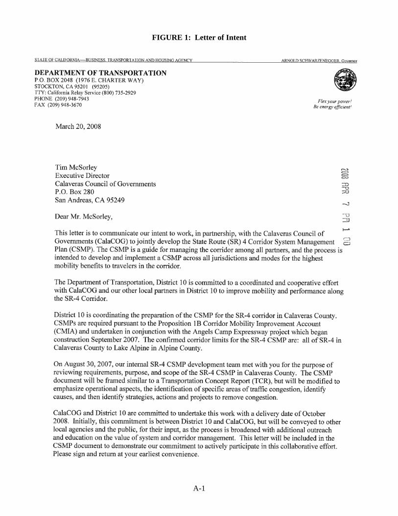
FIGURE 1: Letter of Intent
A-1
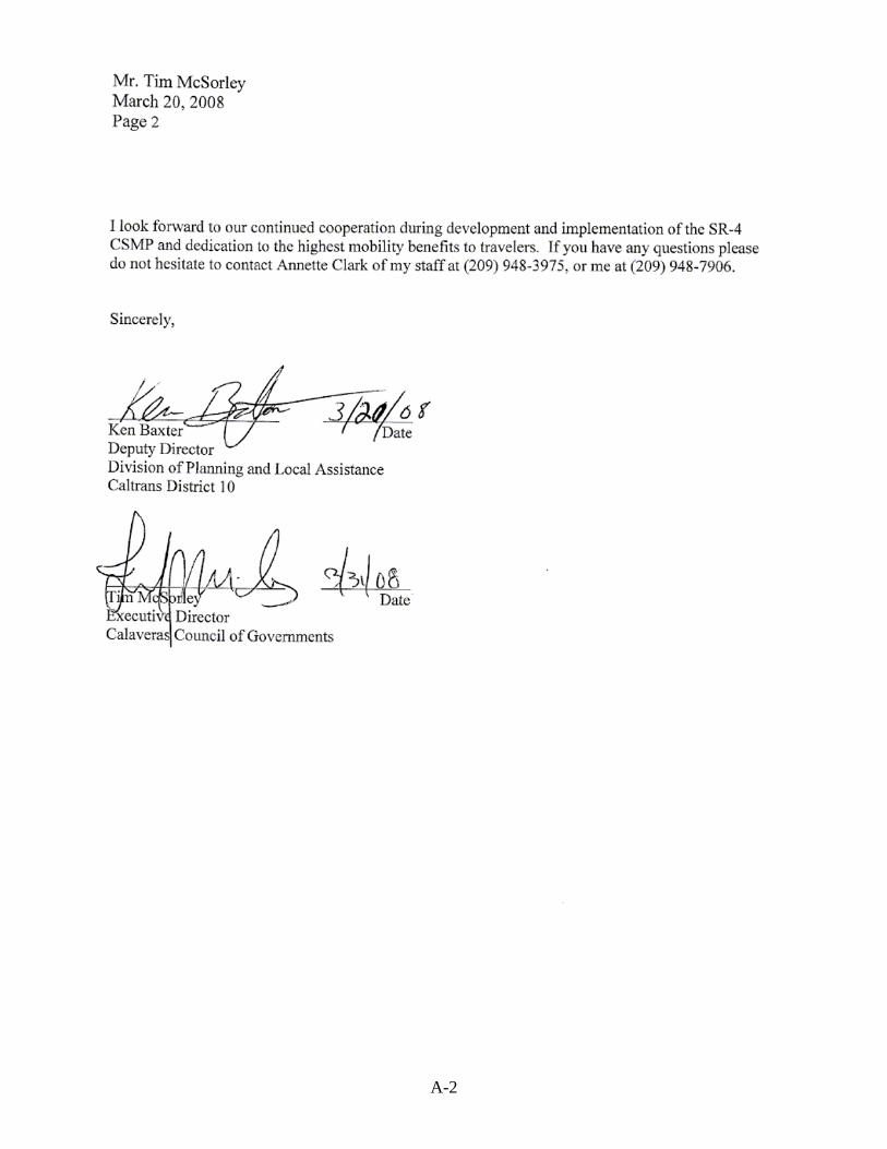
A-2
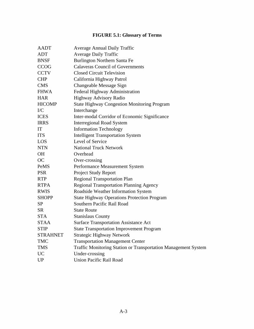
FIGURE 5.1: Glossary of Terms
AADT Average Annual Daily Traffic ADT Average Daily Traffic BNSF Burlington Northern Santa Fe CCOG Calaveras Council of Governments CCTV Closed Circuit Television CHP California Highway Patrol CMS Changeable Message Sign FHWA Federal Highway Administration HAR Highway Advisory Radio HICOMP State Highway Congestion Monitoring Program I/C Interchange ICES Inter-modal Corridor of Economic Significance IRRS Interregional Road System IT Information Technology ITS Intelligent Transportation System LOS Level of Service NTN National Truck Network OH Overhead OC Over-crossing PeMS Performance Measurement System PSR Project Study Report RTP Regional Transportation Plan RTPA Regional Transportation Planning Agency RWIS Roadside Weather Information System SHOPP State Highway Operations Protection Program SP Southern Pacific Rail Road SR State Route STA Stanislaus County STAA Surface Transportation Assistance Act STIP State Transportation Improvement Program STRAHNET Strategic Highway Network TMC Transportation Management Center TMS Traffic Monitoring Station or Transportation Management System UC Under-crossing UP Union Pacific Rail Road
A-3