Embed Size (px)
Citation preview

JointResearchCentre
Joint ResearchCentre (JRC)The European Commission’sin-house science service
Science for Disaster
RiskReduction
JRC thematic report
EUR 25589 EN

European CommissionJoint Research Centre
Legal NoticeNeither the European Commission nor any person acting on behalf of the Commission is responsible for the use which might be made of this publication.
Reproduction is authorised provided the source is acknowledged. A great deal of additional information on the European Union is available on the internet. It can be accessed through the Europa server (http://europa.eu/)
JRC 76764EUR 25589 EN
ISBN 978-92-79-27314-8 (pdf)ISBN 978-92-79-27315-5 (print) ISSN 1831-9424 (online)ISSN 1018-5593 (print) doi: 10.2788/65084 (online)
Luxembourg: Publications Office of the European Union, 2014
© European Union, 2014
Printed in The Netherlands
If you would like to learn more about the activities of the JRC, please contact:
Geraldine BarryEuropean Commission Joint Research CentreCommunication UnitHead of Unit
CDMA 04/1681050 BrusselsBelgium
BrusselsTel. +32 (0)2 29 74181Fax +32 (0)2 29 85523
IspraTel. +39 0332 78 9889Fax +39 0332 78 5409
Contact: https://ec.europa.eu/jrc/en/contactWebsite: https://ec.europa.eu/jrc/
Contents
Foreword by Vladimir Šucha, JRC Director-General 2
Introduction 4
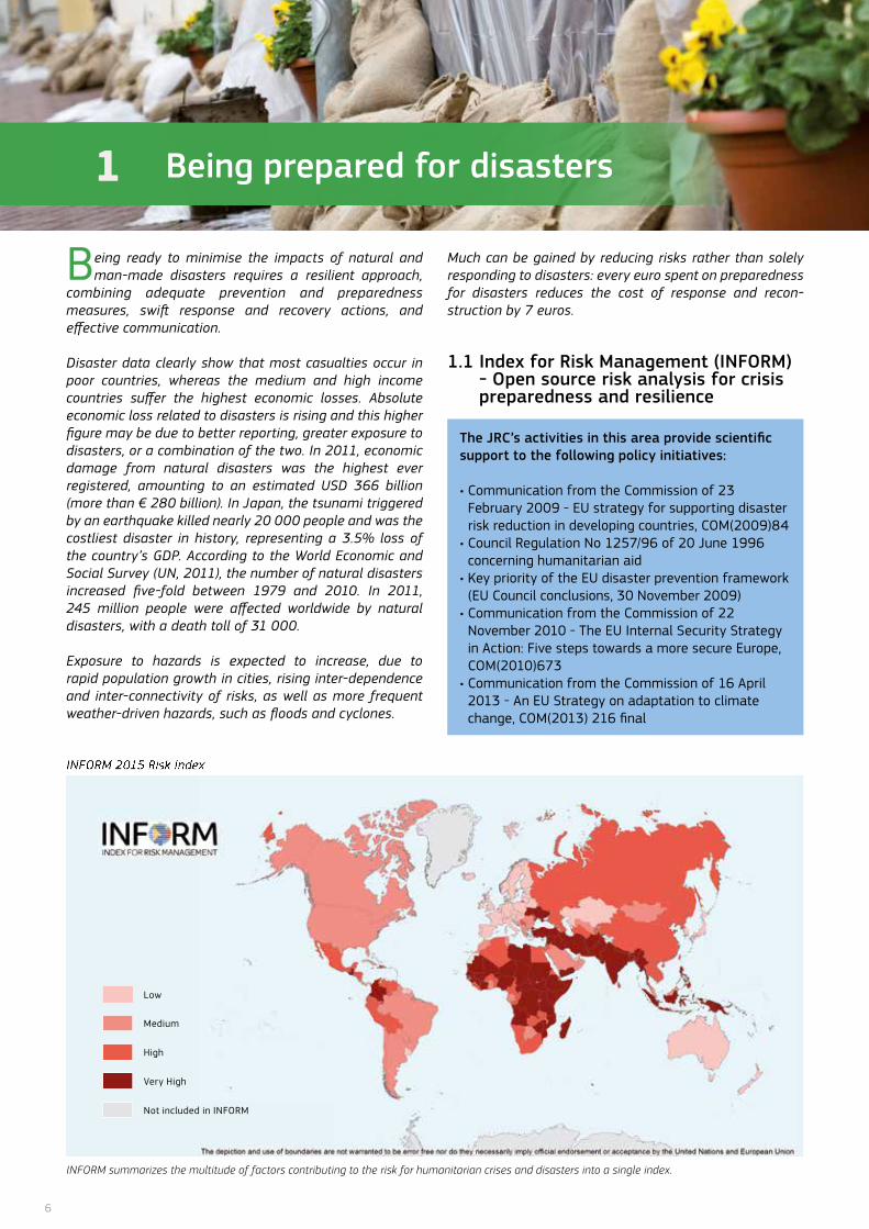
1 Being prepared for disasters 61.1 Index for Risk Management (InfoRM) - open source risk analysis for crisis preparedness and resilience 61.2 Identifying potential risks in the public health and socio-political domains 71.3 Preventing industrial and technological accidents 81.4 Towards safer buildings 101.5 Protecting critical infrastructures 121.6 Recording disaster losses 131.7 Better aid information – transparency to support preparedness and response 14
2 Monitoring and forecasting disasters and disaster alerts 152.1 Early warning on a global scale 152.2 flood forecasting and monitoring 162.3 Early warning on droughts 172.4 Tsunami alert system 192.5 Monitoring forest fires 20
3 Responding to disasters 223.1 Emergency mapping 223.2 Post-disaster and post-crisis needs assessment 23
4 Innovation in disaster risk reduction and response 254.1 Mapping human settlements 254.2 Role of social media 264.3 Community remote sensing 274.4 Unmanned Aerial Systems (UAS) for disaster response and recovery 28
Useful tools 29further reading 30Partners 36
2
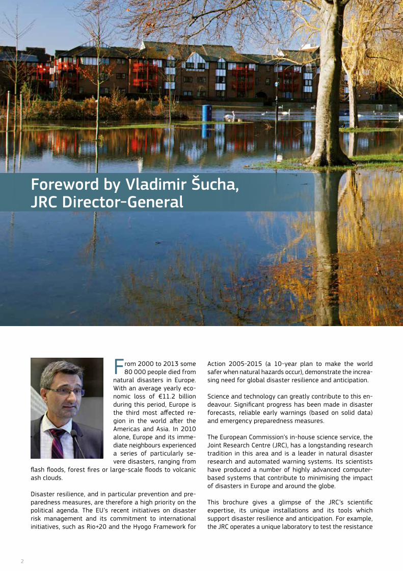
Foreword by Vladimir Šucha, JRC Director-General
from 2000 to 2013 some 80 000 people died from
natural disasters in Europe. With an average yearly eco-nomic loss of €11.2 billion during this period, Europe is the third most affected re-gion in the world after the Americas and Asia. In 2010 alone, Europe and its imme-diate neighbours experienced a series of particularly se-vere disasters, ranging from
flash floods, forest fires or large-scale floods to volcanic ash clouds.
Disaster resilience, and in particular prevention and pre-paredness measures, are therefore a high priority on the political agenda. The EU’s recent initiatives on disaster risk management and its commitment to international initiatives, such as Rio+20 and the Hyogo framework for
Action 2005-2015 (a 10-year plan to make the world safer when natural hazards occur), demonstrate the increa-sing need for global disaster resilience and anticipation.
Science and technology can greatly contribute to this en-deavour. Significant progress has been made in disaster forecasts, reliable early warnings (based on solid data) and emergency preparedness measures.
The European Commission’s in-house science service, the Joint Research Centre (JRC), has a longstanding research tradition in this area and is a leader in natural disaster research and automated warning systems. Its scientists have produced a number of highly advanced computer-based systems that contribute to minimising the impact of disasters in Europe and around the globe.
This brochure gives a glimpse of the JRC’s scientific expertise, its unique installations and its tools which support disaster resilience and anticipation. for example, the JRC operates a unique laboratory to test the resistance
3
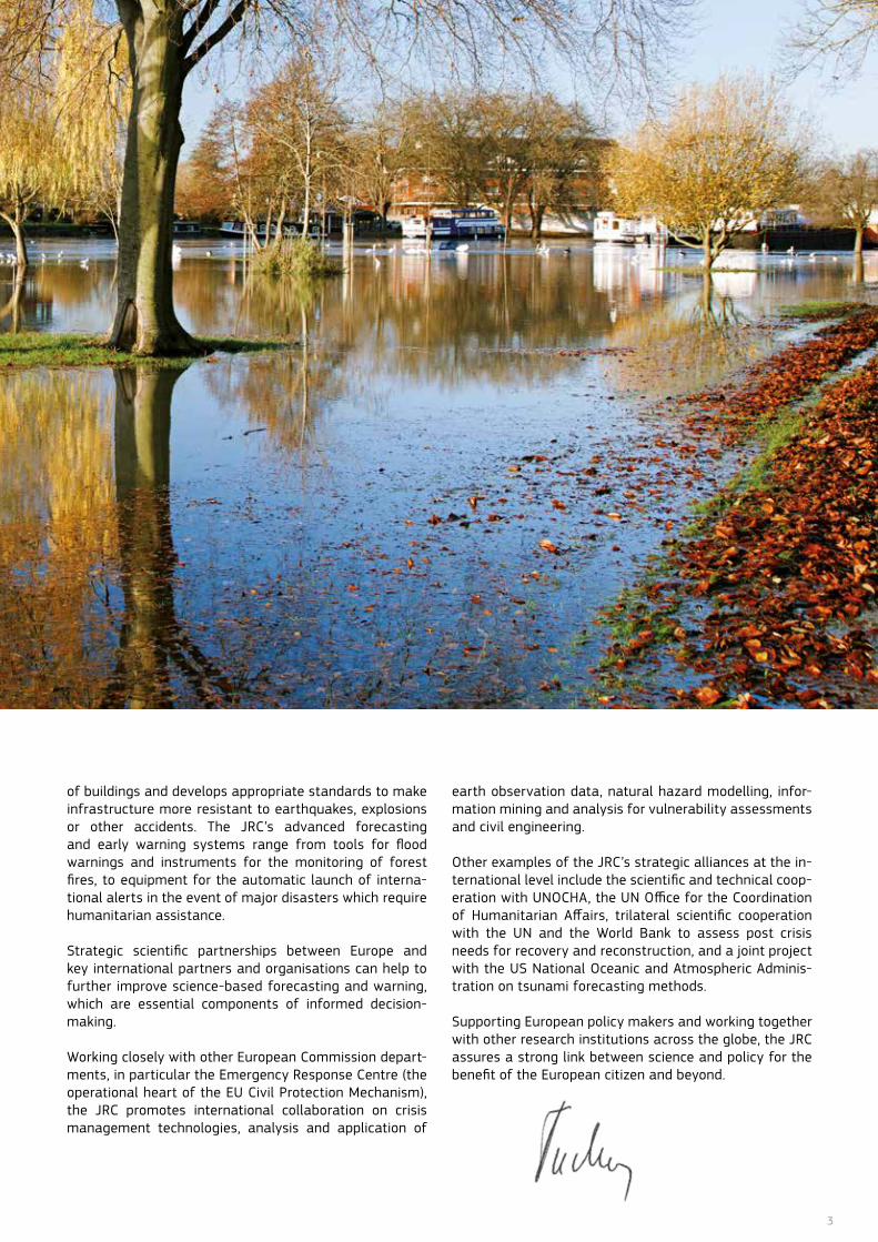
of buildings and develops appropriate standards to make infrastructure more resistant to earthquakes, explosions or other accidents. The JRC’s advanced forecasting and early warning systems range from tools for flood warnings and instruments for the monitoring of forest fires, to equipment for the automatic launch of interna-tional alerts in the event of major disasters which require humanitarian assistance.
Strategic scientific partnerships between Europe and key international partners and organisations can help to further improve science-based forecasting and warning, which are essential components of informed decision-making.
Working closely with other European Commission depart-ments, in particular the Emergency Response Centre (the operational heart of the EU Civil Protection Mechanism), the JRC promotes international collaboration on crisis management technologies, analysis and application of
earth observation data, natural hazard modelling, infor-mation mining and analysis for vulnerability assessments and civil engineering.
other examples of the JRC’s strategic alliances at the in-ternational level include the scientific and technical coop-eration with UnoCHA, the Un office for the Coordination of Humanitarian Affairs, trilateral scientific cooperation with the Un and the World Bank to assess post crisis needs for recovery and reconstruction, and a joint project with the US national oceanic and Atmospheric Adminis-tration on tsunami forecasting methods.
Supporting European policy makers and working together with other research institutions across the globe, the JRC assures a strong link between science and policy for the benefit of the European citizen and beyond.
4
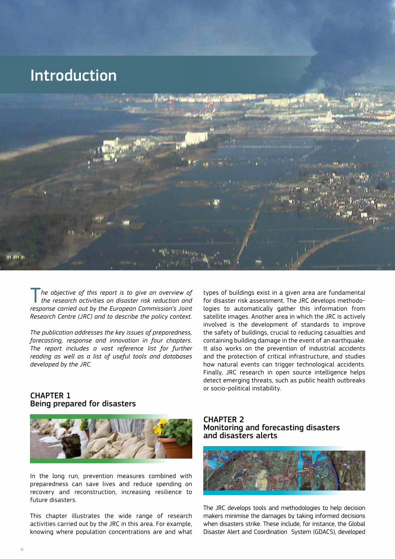
Introduction
The objective of this report is to give an overview of the research activities on disaster risk reduction and
response carried out by the European Commission’s Joint Research Centre (JRC) and to describe the policy context. The publication addresses the key issues of preparedness, forecasting, response and innovation in four chapters. The report includes a vast reference list for further reading as well as a list of useful tools and databases developed by the JRC.
CHAPTER 1 Being prepared for disasters
In the long run, prevention measures combined with preparedness can save lives and reduce spending on recovery and reconstruction, increasing resilience to future disasters.
This chapter illustrates the wide range of research activities carried out by the JRC in this area. for example, knowing where population concentrations are and what
types of buildings exist in a given area are fundamental for disaster risk assessment. The JRC develops methodo-logies to automatically gather this information from satellite images. Another area in which the JRC is actively involved is the development of standards to improve the safety of buildings, crucial to reducing casualties and containing building damage in the event of an earthquake. It also works on the prevention of industrial accidents and the protection of critical infrastructure, and studies how natural events can trigger technological accidents. finally, JRC research in open source intelligence helps detect emerging threats, such as public health outbreaks or socio-political instability.
CHAPTER 2 Monitoring and forecasting disasters and disasters alerts
The JRC develops tools and methodologies to help decision makers minimise the damages by taking informed decisions when disasters strike. These include, for instance, the Global Disaster Alert and Coordination System (GDACS), developed

5
together with the United nations. GDACS is a web-based platform which automatically sends alerts via SMS or email in the case where a major disaster needs international humanitarian intervention.
The European flood Awareness System (EfAS) comple- ments national forecasting systems by predicting the potential for floods up to ten days in advance. The JRC also provides forest fire danger predictions up to six days in advance through the European forest fire Information System (EffIS).
CHAPTER 3 Responding to disasters
The JRC provides rapid and relevant information depicting the situation after a disaster. It uses remote sensing technologies to support emergency mapping and post-disaster needs assessment. In this field, the JRC is the technical coordinator of the emergency management service of the Copernicus programme (the European Earth observation Programme).
CHAPTER 4 Innovation in disaster risk reduction and response
The last chapter addresses some of the emerging trends in disaster management and promising technologies that can help first responders and authorities. for example, social media such as Twitter have a notable potential for providing complementary information, but this is only useful if innovative approaches are developed in order to filter the content and to get the appropriate information within a short period of time.
6
1 Being prepared for disasters
Low
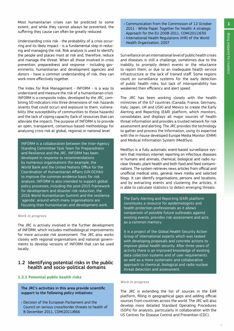
INFORM 2015 Risk Index
Medium
High
Very High
not included in InfoRM
Being ready to minimise the impacts of natural and man-made disasters requires a resilient approach,
combining adequate prevention and preparedness measures, swift response and recovery actions, and effective communication.
Disaster data clearly show that most casualties occur in poor countries, whereas the medium and high income countries suffer the highest economic losses. Absolute economic loss related to disasters is rising and this higher figure may be due to better reporting, greater exposure to disasters, or a combination of the two. In 2011, economic damage from natural disasters was the highest ever registered, amounting to an estimated USD 366 billion (more than € 280 billion). In Japan, the tsunami triggered by an earthquake killed nearly 20 000 people and was the costliest disaster in history, representing a 3.5% loss of the country’s GDP. According to the World Economic and Social Survey (UN, 2011), the number of natural disasters increased five-fold between 1979 and 2010. In 2011, 245 million people were affected worldwide by natural disasters, with a death toll of 31 000.
Exposure to hazards is expected to increase, due to rapid population growth in cities, rising inter-dependence and inter-connectivity of risks, as well as more frequent weather-driven hazards, such as floods and cyclones.
Much can be gained by reducing risks rather than solely responding to disasters: every euro spent on preparedness for disasters reduces the cost of response and recon-struction by 7 euros.
1.1 Index for Risk Management (INFORM) - Open source risk analysis for crisis preparedness and resilience
The JRC’s activities in this area provide scientific support to the following policy initiatives:
• Communication from the Commission of 23 february 2009 - EU strategy for supporting disaster risk reduction in developing countries, CoM(2009)84
• Council Regulation No 1257/96 of 20 June 1996 concerning humanitarian aid
• Key priority of the EU disaster prevention framework (EU Council conclusions, 30 november 2009)
• Communication from the Commission of 22 november 2010 - The EU Internal Security Strategy in Action: five steps towards a more secure Europe, CoM(2010)673
• Communication from the Commission of 16 April 2013 - An EU Strategy on adaptation to climate change, CoM(2013) 216 final
INFORM summarizes the multitude of factors contributing to the risk for humanitarian crises and disasters into a single index.
7
Being prepared for disasters
1Most humanitarian crises can be predicted to some extent, and while they cannot always be prevented, the suffering they cause can often be greatly reduced.
Understanding crisis risk - the probability of a crisis occur-ring and its likely impact - is a fundamental step in reduc-ing and managing the risk. Risk analysis is used to identify the people and places most at risk and, therefore, reduce and manage the threat. When all those involved in crisis prevention, preparedness and response - including gov-ernments, humanitarian and development agencies and donors - have a common understanding of risk, they can work more effectively together.
The Index for Risk Management - InfoRM - is a way to understand and measure the risk of a humanitarian crisis. InfoRM is a composite index, developed by the JRC, com-bining 50 indicators into three dimensions of risk: hazards (events that could occur) and exposure to them, vulnera-bility (the susceptibility of communities to those hazards) and the lack of coping capacity (lack of resources that can alleviate the impact). The purpose of InfoRM is to provide an open, transparent, consensus-based methodology for analysing crisis risk at global, regional or national level.
InfoRM is a collaboration between the Inter-Agency Standing Committee Task Team for Preparedness and Resilience and the JRC. InfoRM has been developed in response to recommendations by numerous organisations (for example, the World Bank and the United nations office for the Coordination of Humanitarian Affairs (Un oCHA)) to improve the common evidence basis for risk analysis. InfoRM is also intended to support global policy processes, including the post-2015 framework for development and disaster risk reduction, the 2016 World Humanitarian Summit and the resilience ‘agenda’, around which many organisations are focusing their humanitarian and development work.
Work in progress
The JRC is actively involved in the further development of InfoRM, which includes methodological improvements for more accurate risk assessment. The JRC also works closely with regional organisations and national govern-ments to develop versions of InfoRM that can be used locally.
1.2 Identifying potential risks in the public health and socio-political domains
1.2.1 Potential public health risks
The JRC’s activities in this area provide scientific support to the following policy initiatives:
• Decision of the European Parliament and the Council on serious cross/border threats to health of 8 December 2011, CoM(2011)866
Surveillance on an international level of public health crises and diseases is still a challenge, sometimes due to the inability to promptly detect events or the reluctance to report them, or due to an inadequate health service infrastructure or the lack of trained staff. Some regions count on surveillance systems for the early detection of public health risks, but lack of interoperability has weakened their efficiency and alert speed.
The JRC has been working closely with the health ministries of the G7 countries (Canada, france, Germany, Italy, Japan, UK and USA) and Mexico to create the Early Alerting and Reporting (EAR) platform, which monitors, consolidates and displays all major sources of health threat information and provides a trusted network for risk assessment and alerting. The JRC provides the technology to gather and process the information, using its expertise with the in-house developed Europe Media Monitor (EMM) and Medical Information System (MedISys).
MedISys is a fully automatic event-based surveillance sys-tem that monitors internet reporting on infectious diseases in humans and animals, chemical, biological and radio nu-clear threats, plant health and both food and feed contami-nations. The system retrieves news articles from official and unofficial medical sites, general news media and selected blogs. It can identify organisations, persons and locations, and by extracting events and clustering the articles, it is able to calculate statistics to detect emerging threats.
The Early Alerting and Reporting (EAR) platform constitutes a resource for epidemiologists and health protection professionals as it allows comparison of possible future outbreaks against existing events, provides risk assessment and acts as a common memory.
It is a project of the Global Health Security Action Group of international experts which was tasked with developing proposals and concrete actions to improve global health security. After three years of activity there is an improved knowledge of existing data collection systems and of user requirements as well as a more systematic and collaborative approach to chemical, biological and radio nuclear threat detection and assessment.
Work in progress
The JRC is extending the list of sources in the EAR platform, filling in geographical gaps and adding official sources from countries across the world. The JRC will also develop more detailed Standard operating Procedures (SoPs) for analysts, particularly in collaboration with the US Centres for Disease Control and Prevention (CDC).
• Communication from the Commission of 12 October 2011 - White Paper. Together for Health: A strategic Approach for the EU 2008-2011, CoM(2011)630
• International Health Regulations (IHR) of the World Health organization, 2007
8
1.2.2 Potential socio-political threats
The JRC’s activities in this area provide scientific support to the following policy initiatives:
• Regulation (EU) No 230/2014 of the European Parliament and of the Council of 11 March 2014 establishing an instrument contributing to stability and peace.
• Conflict prevention – Council conclusions (2011)11820• Communication from the Commission of 26
october 2010 - Towards a stronger European disaster response: the role of civil protection and humanitarian aid, CoM(2010)600
• Communication from the Commission of 23 february 2009 - EU strategy for supporting disaster risk reduction in developing countries, CoM(2009)84
The JRC supports humanitarian agencies of the United nations to identify potential socio-political threats. Hu-manitarian crises are often caused by conflict and an ear-ly warning of such conflicts is very useful in planning in-vestment, programme development and response.
Conflict early warning has tended to use an analytical, struc-tural approach in which a country is assessed against various indicators including poverty, crime, infant mortality and cor-ruption among others. The outcome is a list of states at risk
In close collaboration with the World food Program (WfP), the JRC developed the Humanitarian Early Warning System (HEWS), a tool able to identify precursors of conflict and to gather relevant data from the Europe Media Monitor (EMM). This system allows humanitarian organisations to identify possible conflict situations and then monitor those events which change the likelihood of conflict. Attention focuses on the precursor events and users can collaboratively modify the risk assessment of a situation based on how these precursors change.
furthermore, HEWS defines the risk associated with a particular threat of conflict in relation to the likely humanitarian impact. Every analysis in HEWS is logged and in this way, the evolution of the risk assessment can be measured over time and tracked against the news flow.
With the information provided by the HEWS system, deci-sion-makers have an idea on the likelihood of either being required to intervene or having to significantly scale up their intervention in a certain country.
HEWS is an important tool for the Inter-Agency Standing Committee comprising both non-Un and Un partners (including UnICEf, UnHCR, WfP, WHo and oCHA), as it allows them to collaborate and share information on the risks of potential humanitarian crises. The partners’ risk assessments may differ but they are comparable as they are based on the same structure and process within HEWS.
Work in progress
The JRC is working to extend the scope of the HEWS pro-ject to encompass other partners: HEWS will be opened up so that multiple teams or institutions can work sepa-rately and collaboratively on the same system. A partner-ship has been established with the African Union to develop the Conflict Analysis and Alerting System (CAAS).
The HEWS project members are also improving the functionality, capabilities and the way log information is extracted. for example, users will be able to see all actions related to a warning problem, all actions taken by a particular user or all updated risk assessments.
Improved mapping capabilities in HEWS will also allow violent events to be mapped and tracked over time. Trends can be identified and anomalies spotted.
1.3 Preventing industrial and technological accidents
The JRC’s activities in this area provide scientific support to the following policy initiatives:
• Directive 2012/18/EU of 4 July 2012 - Control of major accidents involving dangerous substances amending and subsequently repealing Council Directive 96/82/EC
• Council Directive 2008/114/EC of 8 December 2008 on the identification and designation of European critical infrastructures and assessment of the need to improve their protection
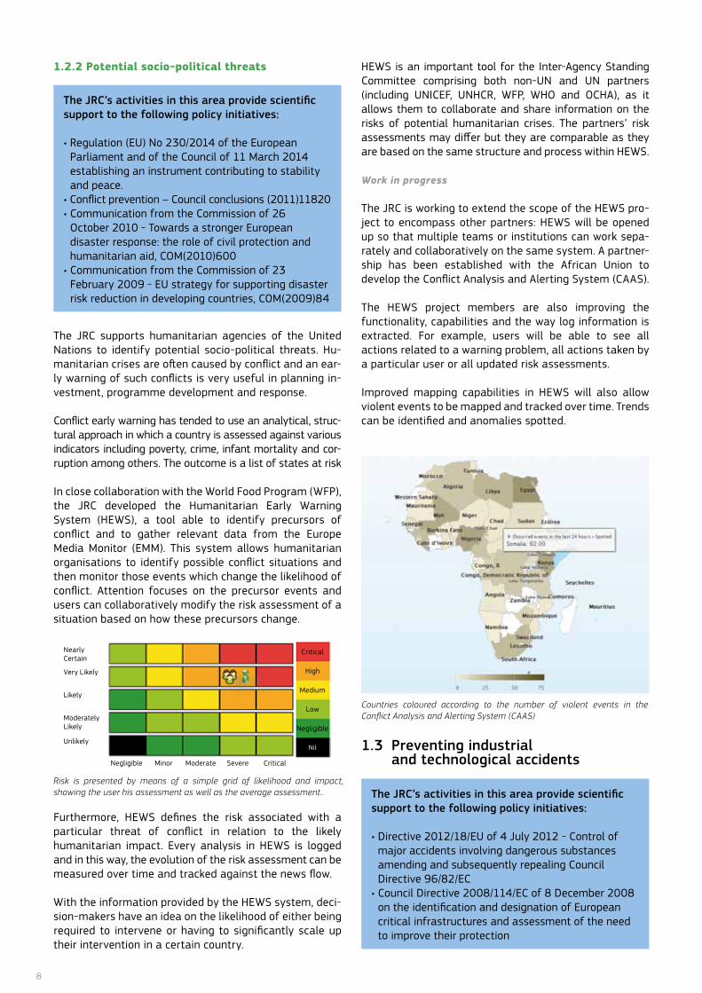
Risk is presented by means of a simple grid of likelihood and impact, showing the user his assessment as well as the average assessment..
nearly Certain
Very Likely
Likely
ModeratelyLikely
Unlikely
Moderate Severe CriticalMinornegligible
Critical
High
Medium
Low
negligible
nil
Countries coloured according to the number of violent events in the Conflict Analysis and Alerting System (CAAS)
9
1.3.1 Accident reporting and analysis, risk assessment and capacity building
Since 2010, major industrial accidents in Europe have been responsible for approximately 27 deaths, 170 injuries, evacuation or shelter-in-place of several thousand citizens and damages to property and the environment, accounting for millions of euros. outside Europe, industrial accidents continue to reap catastrophic consequences; In 2013 a massive explosion at an ammonium nitrate fertilizer storage and distribution facility in the USA fatally injured twelve volunteer firefighters, two members of the public and caused hundreds of injuries. Moreover, 3000 people suspected as injured from hydrofluoric acid inhalation in the Republic of Korea (October 2012); 26 workers killed at a natural gas plant in Mexico (September 2012) and 41 deaths at an oil refinery in Venezuela (August 2012).
The JRC’s research focuses on lessons learned to under-stand causes and trends in industrial accidents in the EU and worldwide in order to support enforcement and monitoring by national authorities.
The JRC’s Major Accident Hazards Bureau (MAHB) assists operators and authorities in answering several questions fundamental to reducing industrial risks and the consequences of industrial accidents. Why do major industrial accidents continue to happen in Europe? Where should attention and resources be focused on to reduce industrial risks? What is the possibility that an industrial accident occurs on a particular site? What would be the consequences? What is the current best practice for managing industrial risks in terms of preparedness and response to accidents and how can one verify that they have been applied in a timely way?
EU countries also rely on the JRC as the reference centre for benchmarking models and tools and for applications of risk assessment in specific locations. The JRC has, for example, developed its own area risk assessment platform (the ARIPAR/ADAM suite), which provides Member States the means to evaluate and improve their technical approaches and policy strategies for designating land-use and emergency planning and public information zones.
The JRC is also the EU’s centre for exchange of best risk management practice for industrial accident prevention and preparedness. It engages in a wide array of support and training activities within the EU, candidate and third countries, publishing expert recommendations on good practice for compliance to Seveso inspections (according to the directive which obliges all operators to take all necessary measures, both technical and organisational, to prevent accidents and limit their consequences). Recent work included good practice recommendations on such topics as petroleum refineries, petroleum storage depots, safety management systems, and safety reports, and emergency planning and response. In support of Commission policies in neighbouring and developing countries, the JRC provides technical support to capacity building in non-EU countries in collaboration with other international organisations.
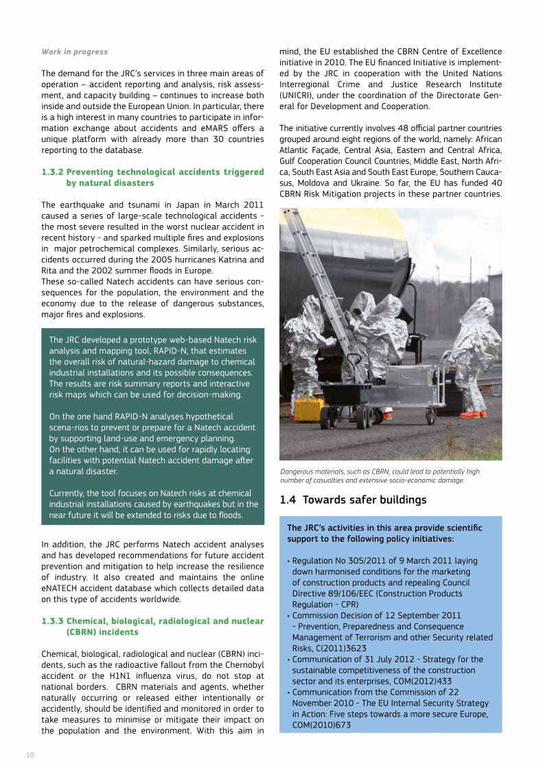
The JRC manages the EU’s Major Accident Reporting System (eMARS) – a collection of over 900 industrial accident reports, the majority of which are major industrial accidents occurring in the European Union since 1984. The eMARS database is one of the five open-source lessons-learned databases for this topic in the world and has the widest geographical coverage.
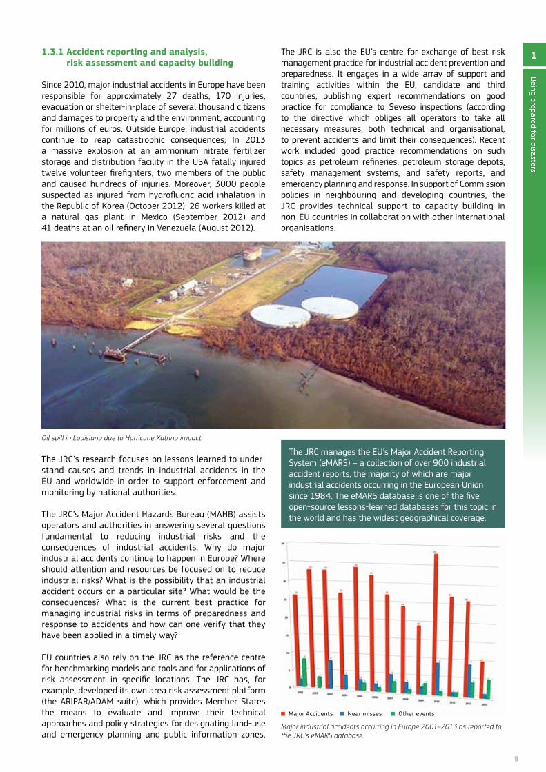
Oil spill in Louisiana due to Hurricane Katrina impact.
Being prepared for disasters
1
Major industrial accidents occurring in Europe 2001–2013 as reported to the JRC’s eMARS database.
Major Accidents near misses other events
10
Work in progress
The demand for the JRC’s services in three main areas of operation – accident reporting and analysis, risk assess-ment, and capacity building – continues to increase both inside and outside the European Union. In particular, there is a high interest in many countries to participate in infor-mation exchange about accidents and eMARS offers a unique platform with already more than 30 countries reporting to the database.
1.3.2 Preventing technological accidents triggered by natural disasters
The earthquake and tsunami in Japan in March 2011 caused a series of large-scale technological accidents - the most severe resulted in the worst nuclear accident in recent history - and sparked multiple fires and explosions in major petrochemical complexes. Similarly, serious ac-cidents occurred during the 2005 hurricanes Katrina and Rita and the 2002 summer floods in Europe. These so-called natech accidents can have serious con-sequences for the population, the environment and the economy due to the release of dangerous substances, major fires and explosions.
Extensive work is being performed at the JRC to better understand the impact of natural hazards on chemical infrastructures. The JRC is developing risk analysis methodologies and tools to improve knowledge know-ledge on damage and failure dynamics, as well as on the consequences in terms of safety and supply security.
The JRC developed a prototype web-based natech risk analysis and mapping tool, RAPID-n, that estimates the overall risk of natural-hazard damage to chemical industrial installations and its possible consequences. The results are risk summary reports and interactive risk maps which can be used for decision-making.
on the one hand RAPID-n analyses hypothetical scena-rios to prevent or prepare for a natech accident by supporting land-use and emergency planning. on the other hand, it can be used for rapidly locating facilities with potential natech accident damage after a natural disaster.
Currently, the tool focuses on natech risks at chemical industrial installations caused by earthquakes but in the near future it will be extended to risks due to floods.
In addition, the JRC performs natech accident analyses and has developed recommendations for future accident prevention and mitigation to help increase the resilience of industry. It also created and maintains the online enATECH accident database which collects detailed data on this type of accidents worldwide.
1.3.3 Chemical, biological, radiological and nuclear (CBRN) incidents
Chemical, biological, radiological and nuclear (CBRn) inci-dents, such as the radioactive fallout from the Chernobyl accident or the H1n1 influenza virus, do not stop at national borders. CBRn materials and agents, whether naturally occurring or released either intentionally or accidently, should be identified and monitored in order to take measures to minimise or mitigate their impact on the population and the environment. With this aim in
mind, the EU established the CBRn Centre of Excellence initiative in 2010. The EU financed Initiative is implement-ed by the JRC in cooperation with the United nations Interregional Crime and Justice Research Institute (UnICRI), under the coordination of the Directorate Gen-eral for Development and Cooperation.
The initiative currently involves 48 official partner countries grouped around eight regions of the world, namely: African Atlantic façade, Central Asia, Eastern and Central Africa, Gulf Cooperation Council Countries, Middle East, north Afri-ca, South East Asia and South East Europe, Southern Cauca-sus, Moldova and Ukraine. So far, the EU has funded 40 CBRn Risk Mitigation projects in these partner countries.
1.4 Towards safer buildings
The JRC’s activities in this area provide scientific support to the following policy initiatives:
• Regulation No 305/2011 of 9 March 2011 laying down harmonised conditions for the marketing of construction products and repealing Council Directive 89/106/EEC (Construction Products Regulation - CPR)
• Commission Decision of 12 September 2011 - Prevention, Preparedness and Consequence Management of Terrorism and other Security related Risks, C(2011)3623
• Communication of 31 July 2012 - Strategy for the sustainable competitiveness of the construction sector and its enterprises, CoM(2012)433
• Communication from the Commission of 22 november 2010 - The EU Internal Security Strategy in Action: five steps towards a more secure Europe, CoM(2010)673
Dangerous materials, such as CBRN, could lead to potentially high number of casualties and extensive socio-economic damage.
11
Being prepared for disasters
1• Communication from the Commission of 28 october 2010 - An Integrated Industrial Policy for the Globalisation Era Putting Competitiveness and Sustainability at Centre Stage, CoM(2010)614
• Communication from the Commission of 26 october 2010 - Towards a stronger European disaster response: the role of civil protection and humanitarian aid, CoM(2010)600
• Communication from the Commission of 23 february 2009 - A Community approach on the prevention of natural and man-made disasters, CoM(2009)82
• Communication from the Commission of 5 March 2008 on reinforcing the Union’s Disaster Response Capacity, CoM(2008)130
The research carried out at the JRC is oriented towards the protection of buildings from natural as well as man-made hazards.
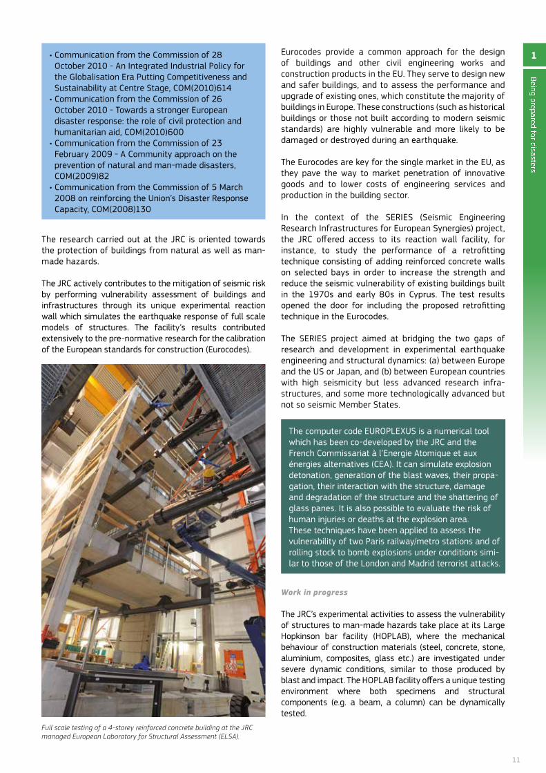
The JRC actively contributes to the mitigation of seismic risk by performing vulnerability assessment of buildings and infrastructures through its unique experimental reaction wall which simulates the earthquake response of full scale models of structures. The facility’s results contributed extensively to the pre-normative research for the calibration of the European standards for construction (Eurocodes).
Eurocodes provide a common approach for the design of buildings and other civil engineering works and construction products in the EU. They serve to design new and safer buildings, and to assess the performance and upgrade of existing ones, which constitute the majority of buildings in Europe. These constructions (such as historical buildings or those not built according to modern seismic standards) are highly vulnerable and more likely to be damaged or destroyed during an earthquake.
The Eurocodes are key for the single market in the EU, as they pave the way to market penetration of innovative goods and to lower costs of engineering services and production in the building sector.
In the context of the SERIES (Seismic Engineering Research Infrastructures for European Synergies) project, the JRC offered access to its reaction wall facility, for instance, to study the performance of a retrofitting technique consisting of adding reinforced concrete walls on selected bays in order to increase the strength and reduce the seismic vulnerability of existing buildings built in the 1970s and early 80s in Cyprus. The test results opened the door for including the proposed retrofitting technique in the Eurocodes.
The SERIES project aimed at bridging the two gaps of research and development in experimental earthquake engineering and structural dynamics: (a) between Europe and the US or Japan, and (b) between European countries with high seismicity but less advanced research infra-structures, and some more technologically advanced but not so seismic Member States.
The computer code EURoPLEXUS is a numerical tool which has been co-developed by the JRC and the french Commissariat à l’Energie Atomique et aux énergies alternatives (CEA). It can simulate explosion detonation, generation of the blast waves, their propa-gation, their interaction with the structure, damage and degradation of the structure and the shattering of glass panes. It is also possible to evaluate the risk of human injuries or deaths at the explosion area. These techniques have been applied to assess the vulnerability of two Paris railway/metro stations and of rolling stock to bomb explosions under conditions simi-lar to those of the London and Madrid terrorist attacks.
Work in progress
The JRC’s experimental activities to assess the vulnerability of structures to man-made hazards take place at its Large Hopkinson bar facility (HoPLAB), where the mechanical behaviour of construction materials (steel, concrete, stone, aluminium, composites, glass etc.) are investigated under severe dynamic conditions, similar to those produced by blast and impact. The HoPLAB facility offers a unique testing environment where both specimens and structural components (e.g. a beam, a column) can be dynamically tested.
Full scale testing of a 4-storey reinforced concrete building at the JRC managed European Laboratory for Structural Assessment (ELSA).
12
The use of explosives is avoided and the simulator is based on innovative fast actuators. The results will contribute to the better understanding of building progressive collapse (damage and failure disproportionate to the initial cause).
The JRC has also started the SAfECLADDInG project, which bring together the national associations of precast produc-ers from several European seismic-prone countries. full-scale tests are being carried out to study the performance of innovative solutions for the design of connections of peripheral cladding elements of precast buildings, which if not correctly designed, may represent a severe hazard, as it was dramatically observed during the recent earth-quakes in Italy. The results obtained will allow rules for the seismic design of precast buildings to be developed, which are currently missing in the construction practice and might be included in the future editions of the Eurocodes.
1.5 Protecting critical infrastructures
The JRC’s activities in this area provide scientific support to the following policy initiatives:
Directive 2008/114/EC of 8 December 2008 on the identification and designation of European Critical Infrastructures and the assessment of the need to improve their protection.
Improving resilience of critical infrastructures, such as railway systems, energy networks or power plants, has become a priority for authorities around the globe in the aftermath of the 9/11, Madrid and London attacks. Tradi-tional risk reduction efforts are not always sufficient. Some threats cannot be foreseen and reducing all possi-ble risks to a minimum is not always cost-effective. Atten-tion has thus shifted towards resilience in order to reas-sure service continuity.
JRC research helps to shape legislation which takes into consideration resilience. A lot remains to be done in the domain of interdependencies assessment, cascading ef-fects, recovery mechanisms and associated costs. In ad-dition, the link between resilience and risk assessment methodologies is still missing. The JRC has a holistic view of the interconnected European infrastructures and can provide recommendations for assessing their resilience at European level. An all-hazards approach is adopted, in-cluding man-made and natural hazards, as well as emerg-ing threats (e.g. space weather impact on power grids).
The JRC also coordinates the European Reference network for Critical Infrastructure Protection (ERnCIP), which provides a framework for co-operation between experimental installation experts and other stakeholders. The activities include sharing information on threats against critical infrastructures and their vulnerabilities, collaborating on appropriate measures to mitigate risk and boost resilience, carrying out critical infrastructure-related security experiments, as well as testing new technologies, developing and harmonising testing methodologies, agreeing on evaluation, qualification and quality assurance methods, and proposing standards. In 2012 an inventory database with a web portal was developed to record, characterise and manage data and information concerning experimental capabilities.
The JRC has set up a framework to assess the performance of technological systems and quantify the economic impact of disruption of these critical infrastructures on society. It is cur-rently being transformed into a platform based on GIS (Geo-graphical Information System) where users are able to use their data and models to visualise the output on a GIS layer.
Work in progress
future research work will focus on improving the resilience assessment methodologies of techno-economical systems and integrating them into a common framework. The JRC will also further develop the GIS based platform for resilience as-sessment of critical infrastructures, and its online deploy-ment, and analyse the effect of disruption of key resources, supply chains and the links with critical infrastructures.
Space weather: a threat for critical infrastructures
Severe space weather events may trigger strong ionospheric scintillation that could disrupt satellite communications and, in particular, critical position-ing, navigation and timing (PnT) services, such as in aviation, and precise timing and synchronisation of telecom networks. Another important effect of a se-vere solar storm is the disruption of power grids due to the high currents induced on the power lines.
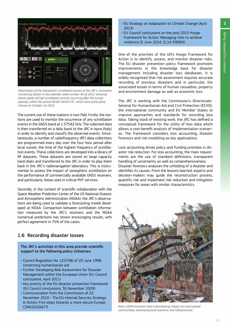
The JRC started to study the impact of ionospheric scintillation on global satellite navigation systems (GnSS), focusing on the impact of space weather events on critical services relying on GnSS. In this context, the JRC deployed a first monitoring station in Peru at the Jicamarca Radio observatory and opened a second one in Vietnam.
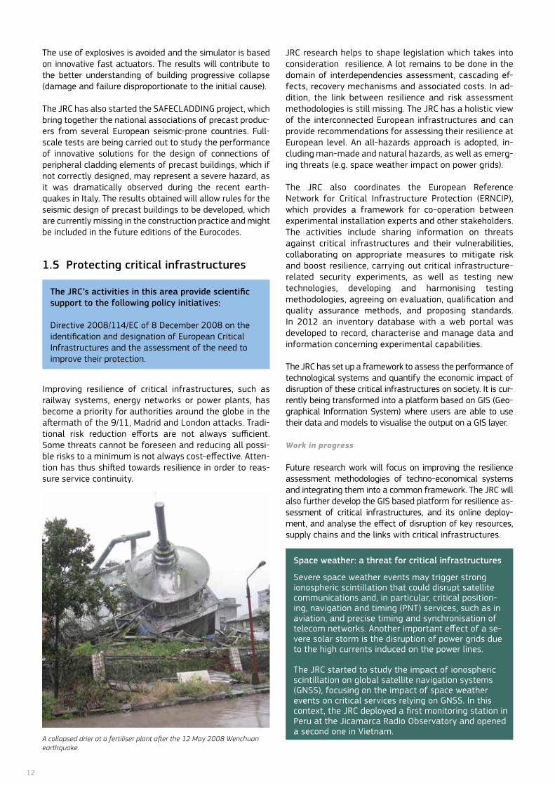
A collapsed drier at a fertiliser plant after the 12 May 2008 Wenchuan earthquake.
13
The current use of these stations is two-fold. firstly, the sta-tions are used to monitor the occurrence of any scintillation events in the GnSS band at 1.57542 GHz. The collected data is then transferred on a daily basis to the JRC in Ispra (Italy) in order to identify and classify the observed events. Simul-taneously, a number of radiofrequency (Rf) data collections are programmed every day over the four hour period after local sunset, the time of the highest frequency of scintilla-tion events. These collections are developed into a library of Rf datasets. These datasets are stored on large capacity hard-disks and transferred to the JRC in order to play them back in the JRC’s radionavigation laboratory. This is instru-mental to assess the impact of ionospheric scintillation on the performance of commercially available GnSS receivers, and particularly, those used in critical PnT services.
Secondly, in the context of scientific collaboration with the Space Weather Prediction Center of the US national oceanic and Atmospheric Administration (noAA), the JRC’s observa-tions are being used to validate a forecasting model devel-oped at noAA. Comparison between scintillation informa-tion measured by the JRC’s receivers and the noAA numerical predictions has shown encouraging results, with perfect agreement in 75% of the cases.
1.6 Recording disaster losses
one of the priorities of the Un’s Hyogo framework for Action is to identify, assess, and monitor disaster risks. The EU disaster prevention policy framework promotes improvements in the knowledge base for disaster management including disaster loss databases. It is widely recognised that risk assessment requires accurate recording of previous disasters and in particular, the associated losses in terms of human casualties, property and environment damage as well as economic loss.
The JRC is working with the Commission’s Directorate-General for Humanitarian Aid and Civil Protection (ECHo), the international community and EU Member States to improve approaches and standards for recording loss data. Taking stock of existing work, the JRC has defined a conceptual framework for the utility of loss data which allows a cost-benefit analysis of implementation scenari-os. The framework considers loss accounting, disaster forensics and risk modelling as key applications.
Loss accounting drives policy and funding priorities in dis-aster risk reduction. for loss accounting, the main require-ments are the use of standard definitions, transparent handling of uncertainty as well as comprehensiveness.Disaster forensics analyses the unfolding of a disaster and identifies its causes. from the lessons learned, experts and decision-makers may guide the reconstruction process, quantify risk and implement risk reduction and mitigation measures for areas with similar characteristics.
Being prepared for disasters
1
Asia’s 2004 tsunamis had a devastating impact on rural coastal communities, destroying local economy and infrastructure.
Observation of the ionospheric scintillation events at the JRC’s Jicamarca monitoring station in the calendar week number 40 of 2012, showing clearly peaks of high scintillation activity occurring after the sunset typically within the period 00:00-04:00 UTC, which were particularly intense on October 1st 2012.
• EU Strategy on Adaptation to Climate Change (April 2013)
• EU Council conclusions on the post 2015 Hyogo framework for Action: Managing risks to achieve resilience (5 June 2014, CL14-099En)
The JRC’s activities in this area provide scientific support to the following policy initiatives:
• Council Regulation No 1257/96 of 20 June 1996 concerning humanitarian aid
• Further Developing Risk Assessment for Disaster Management within the European Union (EU Council conclusions, April 2011)
• Key priority of the EU disaster prevention framework (EU Council conclusions, 30 november 2009)
• Communication from the Commission of 22 november 2010 - The EU Internal Security Strategy in Action: five steps towards a more secure Europe, CoM(2010)673
14
Risk modelling aims to improve risk assessments and forecast methods. Loss data are used to infer vulnerabilities and to identify sectorial areas for disaster risk reduction and mitigation measures.
The aim is to have consistent databases that can be aggre-gated up to a global level for statistical analysis. Depending on the scale (detail of recording) and scope (geographic cov-erage), technical requirements will be more or less stringent, and costs of implementation will vary accordingly.
Work in progress
The JRC has worked closely with EU countries and the in-ternational community (including the United nations, Integrated Research for Disaster Risk, scientific organisa-tions and national disaster management authorities) to as-sess the state of the art in disaster loss data collection, recording and analysis. Current practices were analysed to establish practical guidelines on minimum requirements and best practices compatible with existing mandates, or-ganisational structures and aspirations of the EU countries. The JRC will continue to work with a wide group of experts to propose common standards for disaster loss data recording. The requirements cover very detailed (at asset level) as well as coarse scale recording (by province, region or nation). This effort will allow the EU to consistently and comprehensively report on loss data and mitigation efforts for the post-2015 Un framework for disaster risk reduction.
1.7 Better aid information – transparency to support preparedness and response
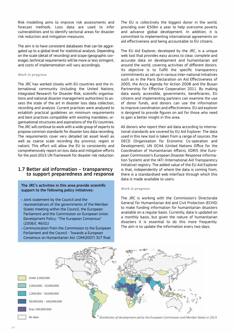
The EU is collectively the biggest donor in the world, providing over €50bn a year to help overcome poverty and advance global development. In addition, it is committed to implementing international agreements on aid effectiveness and being accountable to EU citizens.
The EU Aid Explorer, developed by the JRC, is a unique web tool that provides easy access to clear, complete and accurate data on development and humanitarian aid around the world, covering activities of different donors. Its objective is to fulfill the specific transparency commitments as set up in various inter-national initiatives such as in the Paris Declaration on Aid Effectiveness of 2005, the Accra Agenda for Action 2008 and the Busan Partnership for Effective Cooperation 2011. By making data easily accessible, governments, beneficiaries, EU citizens and implementing partners can examine the use of donor funds, and donors can use the information to improve coordination and effectiveness. EU aid explorer is designed to provide figures on aid for those who need to gain a better insight in this area.
All donors who report their aid data according to interna-tional standards are covered by EU Aid Explorer. The data used in this new tool is taken from a range of sources: the oECD (organisation for Economic Co-operation and Development), Un oCHA (United nations office for the Coordination of Humanitarian Affairs), EDRIS (the Euro-pean Commission’s European Disaster Response Informa-tion System) and the IATI (International Aid Transparency Initiative) registry. The added value of the EU Aid Explorer is that, independently of where the data is coming from, there is a standardised web interface through which this data is made available to users.
Work in progress
The JRC is working with the Commission’s Directorate General for Humanitarian Aid and Civil Protection (ECHo) to make funding information for humanitarian disasters available on a regular basis. Currently, data is updated on a monthly basis, but given the nature of humanitarian disasters it is essential to do this more frequently. The aim is to update the information every two days.
The JRC’s activities in this area provide scientific support to the following policy initiatives:
• Joint statement by the Council and the representatives of the governments of the Member States meeting within the Council, the European Parliament and the Commission on European Union Development Policy: “The European Consensus” (2006/C 46/01)
• Communication from the Commission to the European Parliament and the Council - Towards a European Consensus on Humanitarian Aid. CoM(2007) 317 final
Under 2,000,000
2,000,000 - 10,000,000
1,000,001 - 50,000,000
50,000,001 - 100,000,000
over 100,000,000
no data Distribution of development aid by the European Commission and Member States in 2013.

15
The European Commission adopted a series of initiatives to address the increasing complexity of natural and
man-made disasters such as cross-border issues, unpredict-ability and inter-connectedness. Revised EU civil protection laws, for example, aim to create a European emergency response capacity and set up an EU response centre for the coordination of the EU’s civilian disaster response. At EU level, the countries are bound to assist each other in the event of a terrorist attack or a natural or man-made disaster. For this reason, the EU aims to better prepare for crises and manage them more efficiently, both in the area of prevention and response. One way to do this is with the Global Monitor-ing for Environment and Security (GMES) tool which provides emergency mapping and an early warning service to support the decision-making of public authorities during all cycles of disasters management.
Through its extensive applied research on monitoring, forecasting, early warning and alerting, the JRC has played a pivotal role in enhancing the analytical capability of the European Commission and EU countries as well as strategic partners in the international community such as the United Nations.
2.1 Early warning at the global scale
With the recent advances in global connectivity, information technology and Earth observation, scientific measurements of natural disasters, such as extreme weather, earthquakes or volcanic eruptions data, are becoming available in near real-time. These measurements can be ingested into detailed hazard models to identify the affected areas in near real-time. In turn, this information can be used to estimate the impact of the hazard on the local population and economy. The JRC has been developing such systems in direct support of the global humanitarian community since 2004.
originally carried out to support the European Commission’s Humanitarian office (ECHo), this research effort was soon done in collaboration with the United nations office for Coordination of Humanitarian Affairs (oCHA). When sudden onset disasters happen, there are essential elements required to mobilise the international search and rescue community: a fast alert, automatic im-pact assessments (closely linked to the need for in-ternational deployment) and comprehensive situa-tion reports. Information from the Un and the JRC’s monitoring capacities were merged into the Glob-al Disaster Alert and Coordination System (GDACS).
2 Monitoring and forecasting disasters and disaster alerts
The JRC’s activities in this area provide scientific support to the following policy initiatives:
• Communication from the Commission of 26 october 2010 – Towards a stronger European disaster response: the role of civil protection and humanitarian assistance, CoM(2010)600
• Communication from the Commission of 23 february 2009 - EU Strategy for supporting disaster risk reduction in developing countries, CoM(2009)84
• EU strategy for cooperation in Disaster Management with non-EU Countries, International and Regional organisations GDACS, a co-operation framework between the
United nations, the European Commission, and disas-ter managers worldwide is used for improved alerts, information exchange, and coordination in the first phase after major sudden-onset disasters. It provides a unique multi-hazard alert service to more than 20 000 registered professional emergency managers.
The JRC has developed impact models that not only take into account the strength of an earthquake, tsu-nami, cyclone or flood, but also the affected popula-tion and the capacity of the affected country to cope with the disaster.
The JRC-managed Global Disaster Alert and Coordination System (GDACS) is used to send high level alerts in the first phase after a major sudden-onset disaster.
16
GDACS has pioneered the use of a simple traffic light system to communicate risk. In this way, GDACS only sends “red alerts” (the highest level) for disasters that threaten to overwhelm the local response capacity and that will therefore trigger requests for assistance from the international humanitarian community, including the European Union. for this purpose, GDACS maintains global databases on population, socio-economic and vulnerability indicators, which are input in real-time models.
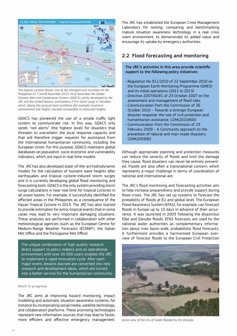
The JRC has also developed state-of-the-art hydrodynamic models for the calculation of tsunami wave heights after earthquakes and tropical cyclone-induced storm surges and it is currently developing global flood monitoring and forecasting tools. GDACS is the only system providing storm surge calculations in near-real time for tropical cyclones in all ocean basins. for example, it successfully identified the affected areas in the Philippines as a consequence of the Hayan Tropical Cyclone in 2013. The JRC has also started to provide estimation for extra-tropical events that in some cases may lead to very important damaging situations. These analyses are performed in collaboration with other meteorological agencies (such as the European Centre for Medium-Range Weather forecasts (ECMWf), the Italian Met office and the Portuguese Met office).
Work in progress
The JRC aims at improving hazard monitoring, impact modelling and automatic situation awareness systems, for instance by incorporating social media, satellite technology, and collaboration platforms. These promising technologies represent new information sources that may lead to faster, more efficient and effective emergency management.
The JRC has established the European Crisis Management Laboratory for testing, comparing and benchmarking mature situation awareness technology in a real crisis room environment, to demonstrate its added value and encourage its uptake by emergency authorities.
2.2 Flood forecasting and monitoring
Although appropriate planning and protection measures can reduce the severity of floods and limit the damage they cause, flood disasters can never be entirely prevent-ed. floods are also often a transnational concern, which represents a major challenge in terms of coordination of national and international aid.
The JRC’s flood monitoring and forecasting activities aim to help increase preparedness and provide support during flood crises. The JRC has set up systems to forecast the probability of floods at EU and global level. The European flood Awareness System (EfAS), for example, can forecast floods in Europe up to 10 days in advance of their occur-rence. It was launched in 2003 following the disastrous Elbe and Danube floods. EfAS forecasts are used by the national water authorities as complementary informa-tion about river basin-wide, probabilistic flood forecasts. It furthermore provides a harmonised European over-view of forecast floods to the European Civil Protection Aerial view of the city of Galati flooded by the Danube.
The unique combination of high quality research, direct support to policy makers and an operational environment with over 20 000 users enables the JRC to implement a rapid innovation cycle. After each major event, lessons learned are converted into new research and development ideas, which are turned into a better service for the humanitarian community.
The JRC’s activities in this area provide scientific support to the following policy initiatives:
• Regulation No 911/2010 of 22 September 2010 on the European Earth Monitoring Programme (GMES) and its initial operations (2011 to 2013)
• Directive 2007/60/EC of 23 October 2007 on the assessment and management of flood risks
• Communication from the Commission of 26 october 2010 – Towards a stronger European disaster response: the role of civil protection and humanitarian assistance, CoM(2010)600
• Communication from the Commission of 23 february 2009 – A Community approach on the prevention of natural and man-made disasters, CoM(2009)82
The tropical cyclone Haiyan, one of the strongest ever recorded, hit the Philippines on 7 and 8 November 2013. On 6 November the Global Disaster Alert and Coordination System (GDACS), jointly developed by the JRC and the United Nations, estimated a 2.9 m storm surge in Tacloban, which, taking into account local conditions (for example maximum astronomical tide height), resulted comparable to measured heights.
17
Mechanism, which contributes to improved preparedness for and management of major emergencies at national and European levels. EfAS became a fully operational system in 2012, providing updated forecasts twice a day throughout the whole year.
The Global flood Detection System (GfDS) has been developed in collaboration with the Dartmouth flood observatory (US). It is a real-time satellite-based flood monitoring system, providing virtual information about all major rivers in the world, as well as daily updated regional flood maps. This information on the impact and extent of floods occurring across borders is particularly useful for rivers on which little monitoring information is available (e.g. in namibia).
The GfDS uses a procedure based on microwave remote sensing satellite observations to estimate the volumes of surface waters and generate daily regional flood maps. Contrary to optical (photographic) imagery, microwave remote sensing imagery can provide daily information anywhere in the world, regardless of weather conditions. The JRC is working on combining innovative forecasting and monitoring tools to support emergency response and humanitarian aid interventions in affected global regions.
Work in progress In collaboration with the Global Disaster Alert and Coordination System, the JRC is integrating its global flood activities into a single multi-hazard information platform that will help monitor, forecast and manage the risks associated with global natural hazards.
2.3 Early warning on droughts
Drought and water scarcity are important threats to environment and society, and their occurrence is likely to increase under climate change. This risk has been widely recognised in recent years and the need for timely information and for the implementation of mitigation and adaptation measures has triggered action at different political levels. The JRC researches and develops monitoring, assessment and forecasting methods for these phenomena from regional to global scales.
As a consequence of recurrent droughts and situations of water scarcity in many parts of Europe, in 2007 the Commis-sion called for action on drought monitoring and mitigation.
Monitoring and forecasting disasters and disaster alerts
2
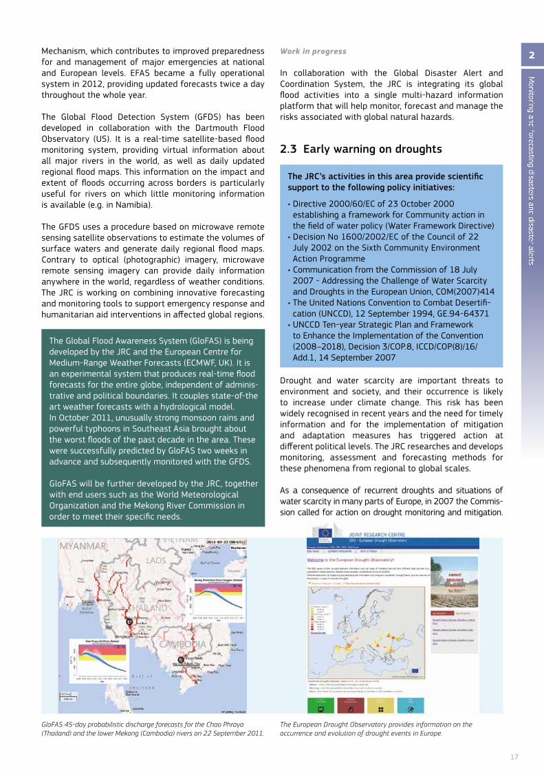
The Global flood Awareness System (GlofAS) is being developed by the JRC and the European Centre for Medium-Range Weather Forecasts (ECMWF, UK). It is an experimental system that produces real-time flood forecasts for the entire globe, independent of adminis-trative and political boundaries. It couples state-of-the art weather forecasts with a hydrological model. In october 2011, unusually strong monsoon rains and powerful typhoons in Southeast Asia brought about the worst floods of the past decade in the area. These were successfully predicted by GlofAS two weeks in advance and subsequently monitored with the GfDS.
GlofAS will be further developed by the JRC, together with end users such as the World Meteorological organization and the Mekong River Commission in order to meet their specific needs.
GloFAS 45-day probabilistic discharge forecasts for the Chao Phraya (Thailand) and the lower Mekong (Cambodia) rivers on 22 September 2011.
The European Drought Observatory provides information on the occurrence and evolution of drought events in Europe.
The JRC’s activities in this area provide scientific support to the following policy initiatives:
• Directive 2000/60/EC of 23 October 2000 establishing a framework for Community action in the field of water policy (Water framework Directive)
• Decision No 1600/2002/EC of the Council of 22 July 2002 on the Sixth Community Environment Action Programme
• Communication from the Commission of 18 July 2007 - Addressing the Challenge of Water Scarcity and Droughts in the European Union, CoM(2007)414
• The United Nations Convention to Combat Desertifi-cation (UnCCD), 12 September 1994, GE.94-64371
• UNCCD Ten-year Strategic Plan and Framework to Enhance the Implementation of the Convention (2008–2018), Decision 3/COP.8, ICCD/COP(8)/16/Add.1, 14 September 2007

18
The JRC responded to this need by developing the prototype of a European Drought observatory (EDo) and by performing research and development on drought monitoring and forecasting in Europe, Africa, Latin America and on a global scale. EDo is an important tool for real-time monitoring, assessing and forecasting droughts at different spatial scales across the entire European continent. It is implemented in close collaboration with international, national, and regional authorities.
Another aspect of the JRC’s work in this area is its contribution to the development and testing of advanced drought indicators under the Common Implementation Strategy of the Water framework Directive.
While droughts cause significant economic and environmental damages in developed countries, in less developed countries they can cause major human catastrophes. The JRC shares its experience in drought monitoring, assessment and forecasting in Europe with Africa and Latin America.
The magnitude of the problem and the expected increase in the frequency, extent and severity of droughts under climate change, demands a change from the current reactive, crisis-management approach towards a more pro-active, risk-management approach. This requires adequate and timely information on which to base decisions. Drought forecasting and monitoring tools help to increase the lead time which enables the implementation of effective drought mitigation measures, thus reducing societal vulnerability to drought.
In addition, besides the immediate negative effects of recurrent droughts and often persistent situations of water scarcity, long-term impacts can lead to the irreversible damage of natural ecosystems which play a key role in sustaining human societies.
The JRC’s research and development work in this field is an important contribution to the prevention of serious
negative effects on both human society and the natural environment.
Work in progress
The JRC will further develop the European Drought obser-vatory (EDo) towards a fully operational tool for drought monitoring, assessment and forecasting in Europe, and it will contribute to the development of a Global Drought Early Warning System through active collaboration with the international community, and to the development of Global Monitoring networks and Early Warning Systems for drought and desertification, specifically in Europe, Africa and Latin America. The JRC will also work on methodologies for medium to long-range drought forecasting in Europe and on a global scale, in order to improve the basis for timely implementation of mitigation strategies. It will continue to develop, test and improve benchmarks and indicators for monitoring and assessing drought and water scarcity.
The JRC will finalise a global drought analysis for the new World Atlas of Desertification (WAD) both as a digital information portal and as a printed reference atlas. The WAD is expected to become the foundation for better addressing desertification and climate change, and combining mitigation and adaptation options, especially with respect to water management, food security, resource efficiency and poverty-reduction strategies.
The first internet portal of the European Drought observatory (EDo) was published in 2011, providing up-to-date information on the occurrence and evolu-tion of drought events in Europe. EDo includes a map server that provides access to a suite of drought indi-cators, documentation, search facilities and analysis tools. In 2011 and 2012, six issues of EDo’s ‘Drought news for Europe and Africa’ were published, following the evolution of the spring drought in north-western Europe and the devastating drought in the Greater Horn of Africa.
Dried river bed in Kenya.

19
2.4 Tsunami alert system
The 2004 Indian ocean tsunami and the 2011 Japanese tsunami caused over 250 000 and 25 000 casualties respectively. While the earthquakes that cause tsunamis cannot be predicted, it is possible to provide early tsunami alerts if there is enough time between the wave creation at the seismic source and the wave propagation and impact at the potentially affected coast.
Several tsunami warning systems are currently in operation around the world. The UnESCo-IoC (Intergovernmental oceanographic Commission) relies only on seismic signals and provides information on the expected arrival times of the tsunami wave along coastal areas. other national systems are more advanced. for example, the Japanese system relies on pre-calculated tsunami scenarios, allowing it to give a first alert within 3 minutes of an earthquake that scores more than 6.5 on the Richter scale.
However, the JRC has developed and operates the only worldwide operational automatic alerting system to give information on the potential tsunami height. This alert system is based on pre-calculated tsunami scenarios and the alerts can be fed into international or national warn-ing systems. The JRC’s tsunami assessment modelling system is part of the EU-Un Global Disaster Alert and Coordination System (GDACS) and evaluates potential consequences of tsunamis of seismic origin.
Tsunami Alerting Device (TAD) in Setubal (Portugal). Testing is performed in collaboration with the local Civil Protection authorities.
Maximum estimated height and travel time of the Tohoku Tsunami as calculated by the JRC.
Monitoring and forecasting disasters and disaster alerts
2The JRC s tsunami assessment modelling system includes four main components: a global tsunami sce-nario database, an online tsunami calculation system, a tsunami analysis tool and a tsunami alerting device.
The Global Tsunami Scenario Database (GSD) is a set of 136 000 calculations performed using a theoreti-cal model, with epicentres established around histori-cal tsunami events. It provides a preliminary, im-mediate estimate of the consequences of a tsunami as soon as the epicentre is known. It identifies the locations potentially affected as well as the predicted wave height. In parallel, the Tsunami online Calcula-tion System (oCS) is invoked to allow a more detailed assessment of the extent and impact of the tsunami, e.g. potential affected coastlines and expected time of arrival of the tsunami wave.
The Tsunami Analysis Tool (TAT) is a decision-support system to allow operators to rapidly analyse in real-time unfolding tsunami events in order to estimate their potential impact, with a view to prepare and transmit subsequent warning messages. It allows a direct comparison in real-time of scenario databases (GSD) or online calculations (oCS) with sea level measurements through international communication channels. The tool is currently adopted by Portugal, Turkey, Greece and Romania as a supporting tool for tsunami analyses. other agreements are being established with other countries (Italy, Egypt).
The Tsunami Alerting Device (TAD) has been designed for installation in tsunami-prone coastal areas. The TAD delivers warning messages to the population at risk as quickly as possible. A prototype is currently in operation in Setubal (Portugal).
The JRC’s activities in this area provide scientific support to the following policy initiatives:
• Council Regulation No 1257/96 of 20 June 1996 concerning humanitarian aid
• Council Decision 2007/779/EC of 8 November 2007 establishing a Community Civil Protection Mechanism
• Communication from the Commission of 22 november 2010 - The EU Internal Security Strategy in Action: five steps towards a more secure Europe, CoM(2010)673
20
Work in progress
Scientific challenges for the JRC include improving the timeliness and accuracy of tsunami alerts to the humanitarian and emergency responder communities, as well as to the affected population, and improving the impact analysis of tsunamis through quicker coastal inundation analysis. The JRC is also faced with the task of convincing national and international responders that the use of modelling in complement to seismic analysis can significantly reduce the possibility of false alerts.
The JRC will also continue to collaborate with several institutions in order to enhance the time availability of earthquake information and thus increase the time for the operators to manage the event.
These challenges will translate into ameliorating the tsunami scenario database, the analytical tools and the Tsunami Alerting Device.
The Tsunami database will be improved by considering a more advanced characterisation of the seismic sources and considering more values for the initial depth (now fixed at 5 km). The Tsunami Analysis Tool will be refined in terms of user interface, robustness and efficiency. The improved processing chain will allow the online publication of the results of simulated tsunami wave heights and arrival times, and will permit comparison with measured values.The Tsunami Alerting Device, installed in Setubal, will be connected directly with a sea level measurement device, which will alert the panel as soon as predefined sea level thresholds are exceeded. Interest has been expressed to install the device in other locations such as Crete, Greece.
2.5 Monitoring forest fires
forest fires contribute to global emissions and are the cause of deforestation and forest degradation in many areas around the world. In Europe, they cause extensive environmental and economic losses, and often human casualties. About 65 000 fires occur in the EU every year, burning approximately half a million hectares. Despite large investments in national fire prevention campaigns and equipment, the annual losses due to forest fires in Europe are estimated at approximately €2 billion.
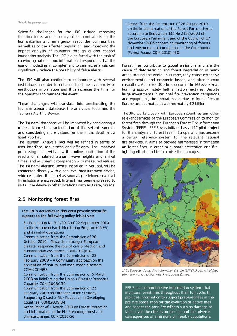
The JRC works closely with European countries and other relevant services of the European Commission to monitor forest fires through the European forest fire Information System (EffIS). EffIS was initiated as a JRC pilot project for the analysis of forest fires in Europe, and has become a central reference system for the relevant national fire services. It aims to provide harmonised information on forest fires, in order to support prevention and fire-fighting efforts and to minimise the damages.
The JRC’s activities in this area provide scientific support to the following policy initiatives:
• EU Regulation No 911/2010 of 22 September 2010 on the European Earth Monitoring Program (GMES) and its initial operations
• Communication from the Commission of 26 october 2010 – Towards a stronger European disaster response: the role of civil protection and humanitarian assistance, CoM(2010)600
• Communication from the Commission of 23 february 2009 – A Community approach on the prevention of natural and man-made disasters, CoM(2009)82
• Communication from the Commission of 5 March 2008 on Reinforcing the Union’s Disaster Response Capacity, CoM(2008)130
• Communication from the Commission of 23 february 2009 on European Union Strategy Supporting Disaster Risk Reduction in Developing Countries, CoM(2009)84
• Green Paper of 1 March 2010 on Forest Protection and Information in the EU: Preparing forests for climate change, CoM(2010)66
EffIS is a comprehensive information system that monitors forest fires throughout their full cycle. It provides information to support preparedness in the pre-fire stage, monitor the evolution of active fires and assess the post-fire effects such as damage to land cover, the effects on the soil and the adverse consequences of emissions on nearby populations.
• Report from the Commission of 26 August 2010 on the implementation of the forest focus scheme according to Regulation (EC) No 2152/2003 of the European Parliament and of the Council of 17 november 2003 concerning monitoring of forests and environmental interactions in the Community (forest focus), CoM(2010) 430
JRC’s European Forest Fire Information System (EFFIS) shows risk of fires (from low - green to high – dark red) across Europe.
21
The JRC has worked in close collaboration with the food and Agriculture organization of the United nations (fAo) on extending EffIS to northern Africa and the Middle East, thereby enlarging the network to 33 member countries.
The JRC is also working on the extension of EffIS to a global scale towards a Global Wildfire Information System (GWIS). This work is carried out in the context of GEoSS (Global Earth observation System of Systems) with a network of research partners from around the world (e.g. Canada, USA, Australia, South Africa) and in collaboration with the European Centre for Medium-Range Weather forecasts (ECMWf). The GWIS, which is coordinated by the JRC, will provide a significant con-tribution to the assessment of the fires’ effects at the global scale and their effect on global environmental and atmospheric cycles.
Work in progress
The JRC is working on the consolidation of EffIS in Europe, north Africa and the Middle East, and on the enhancement of EffIS modules on fire danger prediction, in collaboration with the European Centre for Medium-Range Weather forecasts. It likewise works on the development of a Global Wildfire Information System in close collaboration with the fAo.
In addition, the JRC is striving to improve the estimation of the socio-economic impact of forest fires in Europe. It is also analysing fire regimes under foreseen climate change scenarios, modelling forest fire smoke plumes and assessing their effects on human health.
Monitoring and forecasting disasters and disaster alerts
2furthermore, EffIS provides essential information to support international collaboration on forest fire-fighting activities, which is channelled through the Emergency Response Centre of Civil Protection at the European Commission’s Humanitarian office (DG ECHo). Information gathered by EffIS is used for making decisions to protect populations and critical infrastructure.
22
3.1 Emergency mapping
Emergency mapping is the collective term for the use of airborne and satellite imagery together with existing cartographic information and mapping technology to support decision makers in all cycles of disaster and crisis response.
The users may be responders, like civil protection or humanitarian aid actors, or government and private organisations in charge of planning prevention or reconstruction. The European Commission is an important actor in the emergency management domain, for instance, through the European Response Coordination Centre, which is coordinating the EU Member States’ response to disasters and crises both inside and outside Europe.
The European Commission’s Copernicus programme (previously known as the Global Monitoring of Environment and Security (GMES) programme) includes dedicated services for emergency mapping and early warning systems. These services are available to Member
States’ organisations and international non-governmental agencies active in emergency response.
The JRC has an important role in the technical supervision of the Copernicus emergency services. It has built up its expertise in emergency mapping over a number of years, and has focused primarily on methodological development and quality and performance evaluation in the use of airborne and satellite imagery. The aim is to understand the exact requirements of the various emergency actors for different emergency phases, and to match these with imaging capabilities and analysis efforts.
Emergency mapping covers a wide range of natural and man-made disasters, such as large fires, flooding, earthquakes, storms and industrial accidents. Therefore, a one-size-fits-all methodology does not exist: testing and documenting what is possible and what is not is essential in defining how technology can support the information needs of emergency managers.
Timeliness and quality are two key factors in the successful take-up of emergency mapping. The JRC works for instance on the use of automated image analysis and interpretation techniques, fast parallel computer processing set-ups and the integration of existing digital geographical data sets to streamline and accelerate map production. new technologies, such as the use of low-cost airborne platforms, smart mobile devices and crowd mapping, are essential to support emergency mapping.
The JRC is a key actor in setting quality standards and it facilitates networks of both scientific and operational experts to share knowledge in this domain, applying it directly in the operational Copernicus context.
Emergency mapping has potential to also support risk modelling and exposure mapping through the use of very high resolution imagery in combination with other data sets. The JRC works closely with the Un and the World Bank in this field to define the technical needs.
The EU is committed to improving its response capacity after disasters and to support international co-opera-
tion in assessing recovery needs and planning recovery measures. Significant progress has been made since the signature of the joint European Commission, United Na-tions (UN) and the World Bank (WB) Declaration on Post Crisis and Post Disaster Needs Assessments (PCNAs/PD-NAs) in September 2008. Joint methodologies, hand-books, implementation tools, and training have been developed and used to support the assessment missions.
TheJRC has contributed to the joint EC-UN-WB PDNA hand-book, to training for staff participating in PDNA missions as well as to damage assessments in support of PDNAs.
3 Responding to disasters
The JRC’s activities in this area provide scientific support to the following policy initiatives:
• Regulation (EU) No 377/2014 of the European Parliament and of the Council of 3 April 2014 establishing the Copernicus Programme
• Council Decision 2007/779/EC, Euratom of 8 november 2007 establishing a Community Civil Protection Mechanism (recast)
• Communication from the Commission of 23 february 2009 on the EU Strategy Supporting Disaster Risk Reduction in Developing Countries, CoM(2009)84
The JRC carries out research on the use of Very High Resolution Synthetic Aperture Radars (VHR-SAR) to determine damage to buildings after earthquakes. SAR is especially interesting to use when weather circumstances make it difficult or impossible to count on optical sensor systems. TerraSAR-X and CosmoS-kymed are two European VHR-SAR satellite sensors which can collect imagery at 1 metre resolution.
23
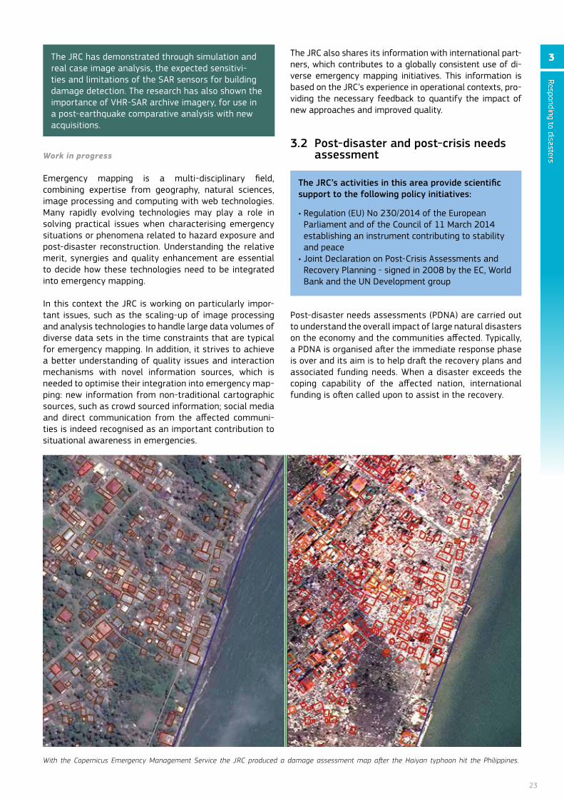
Work in progress
Emergency mapping is a multi-disciplinary field, combining expertise from geography, natural sciences, image processing and computing with web technologies. Many rapidly evolving technologies may play a role in solving practical issues when characterising emergency situations or phenomena related to hazard exposure and post-disaster reconstruction. Understanding the relative merit, synergies and quality enhancement are essential to decide how these technologies need to be integrated into emergency mapping.
In this context the JRC is working on particularly impor-tant issues, such as the scaling-up of image processing and analysis technologies to handle large data volumes of diverse data sets in the time constraints that are typical for emergency mapping. In addition, it strives to achieve a better understanding of quality issues and interaction mechanisms with novel information sources, which is needed to optimise their integration into emergency map-ping: new information from non-traditional cartographic sources, such as crowd sourced information; social media and direct communication from the affected communi-ties is indeed recognised as an important contribution to situational awareness in emergencies.
The JRC also shares its information with international part-ners, which contributes to a globally consistent use of di-verse emergency mapping initiatives. This information is based on the JRC’s experience in operational contexts, pro-viding the necessary feedback to quantify the impact of new approaches and improved quality.
3.2 Post-disaster and post-crisis needs assessment
Post-disaster needs assessments (PDnA) are carried out to understand the overall impact of large natural disasters on the economy and the communities affected. Typically, a PDnA is organised after the immediate response phase is over and its aim is to help draft the recovery plans and associated funding needs. When a disaster exceeds the coping capability of the affected nation, international funding is often called upon to assist in the recovery.
The JRC’s activities in this area provide scientific support to the following policy initiatives:
• Regulation (EU) No 230/2014 of the European Parliament and of the Council of 11 March 2014 establishing an instrument contributing to stability and peace
• Joint Declaration on Post-Crisis Assessments and Recovery Planning - signed in 2008 by the EC, World Bank and the Un Development group
The JRC has demonstrated through simulation and real case image analysis, the expected sensitivi-ties and limitations of the SAR sensors for building damage detection. The research has also shown the importance of VHR-SAR archive imagery, for use in a post-earthquake comparative analysis with new acquisitions.
With the Copernicus Emergency Management Service the JRC produced a damage assessment map after the Haiyan typhoon hit the Philippines.
Responding to disasters
3
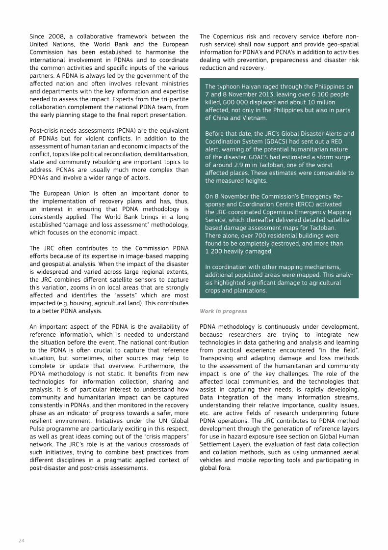
24
Since 2008, a collaborative framework between the United nations, the World Bank and the European Commission has been established to harmonise the international involvement in PDnAs and to coordinate the common activities and specific inputs of the various partners. A PDnA is always led by the government of the affected nation and often involves relevant ministries and departments with the key information and expertise needed to assess the impact. Experts from the tri-partite collaboration complement the national PDnA team, from the early planning stage to the final report presentation.
Post-crisis needs assessments (PCnA) are the equivalent of PDnAs but for violent conflicts. In addition to the assessment of humanitarian and economic impacts of the conflict, topics like political reconciliation, demilitarisation, state and community rebuilding are important topics to address. PCnAs are usually much more complex than PDnAs and involve a wider range of actors.
The European Union is often an important donor to the implementation of recovery plans and has, thus, an interest in ensuring that PDnA methodology is consistently applied. The World Bank brings in a long established “damage and loss assessment” methodology, which focuses on the economic impact.
The JRC often contributes to the Commission PDnA efforts because of its expertise in image-based mapping and geospatial analysis. When the impact of the disaster is widespread and varied across large regional extents, the JRC combines different satellite sensors to capture this variation, zooms in on local areas that are strongly affected and identifies the “assets” which are most impacted (e.g. housing, agricultural land). This contributes to a better PDnA analysis.
An important aspect of the PDnA is the availability of reference information, which is needed to understand the situation before the event. The national contribution to the PDnA is often crucial to capture that reference situation, but sometimes, other sources may help to complete or update that overview. furthermore, the PDnA methodology is not static. It benefits from new technologies for information collection, sharing and analysis. It is of particular interest to understand how community and humanitarian impact can be captured consistently in PDnAs, and then monitored in the recovery phase as an indicator of progress towards a safer, more resilient environment. Initiatives under the Un Global Pulse programme are particularly exciting in this respect, as well as great ideas coming out of the “crisis mappers” network. The JRC’s role is at the various crossroads of such initiatives, trying to combine best practices from different disciplines in a pragmatic applied context of post-disaster and post-crisis assessments.
The Copernicus risk and recovery service (before non-rush service) shall now support and provide geo-spatial information for PDnA’s and PCnA’s in addition to activities dealing with prevention, preparedness and disaster risk reduction and recovery.
Work in progress
PDnA methodology is continuously under development, because researchers are trying to integrate new technologies in data gathering and analysis and learning from practical experience encountered “in the field”. Transposing and adapting damage and loss methods to the assessment of the humanitarian and community impact is one of the key challenges. The role of the affected local communities, and the technologies that assist in capturing their needs, is rapidly developing. Data integration of the many information streams, understanding their relative importance, quality issues, etc. are active fields of research underpinning future PDnA operations. The JRC contributes to PDnA method development through the generation of reference layers for use in hazard exposure (see section on Global Human Settlement Layer), the evaluation of fast data collection and collation methods, such as using unmanned aerial vehicles and mobile reporting tools and participating in global fora.
The typhoon Haiyan raged through the Philippines on 7 and 8 november 2013, leaving over 6 100 people killed, 600 000 displaced and about 10 million affected, not only in the Philippines but also in parts of China and Vietnam.
Before that date, the JRC’s Global Disaster Alerts and Coordination System (GDACS) had sent out a RED alert, warning of the potential humanitarian nature of the disaster. GDACS had estimated a storm surge of around 2.9 m in Tacloban, one of the worst affected places. These estimates were comparable to the measured heights.
on 8 november the Commission’s Emergency Re-sponse and Coordination Centre (ERCC) activated the JRC-coordinated Copernicus Emergency Mapping Service, which thereafter delivered detailed satellite-based damage assessment maps for Tacloban. There alone, over 700 residential buildings were found to be completely destroyed, and more than 1 200 heavily damaged.
In coordination with other mapping mechanisms, additional populated areas were mapped. This analy-sis highlighted significant damage to agricultural crops and plantations.

25
Earlier in this report, examples were provided on how ICT increasingly contributes to reducing disaster
risks and impacts through early warning systems and remote sensing. This chapter describes how ICT also ensures more sophisticated disaster preparedness, response and recovery solutions. Rapid advances in imaging sensors and information technologies offer for the first time the possibility to identify, map, and analyse with unprecedented detailed facts and figures of the global human settling phenomena. Social media, crowd sourcing and community sensing were extensively used in the immediate aftermath of the Haiti earthquake in 2010, and helped communities by giving them the tools to actively engage in the disaster management process. This transformation of responsibi-lities may suggest that we are entering a new phase in disaster management, the era of citizen or community disaster management. However, trust, reliability and sustainability will remain the biggest challenges to overcome before techniques such as social media, community sensing and crowd sourcing become mainstream in disaster management. Finally, images acquired with Unmanned Aerial Systems now enable more detailed damage assessment.
4.1 Mapping human settlements
There is a lack of information on where and under what conditions people live, especially in developing countries. Likewise, little is known about the location of buildings, roads and infrastructure for societal functions and where economic activities take place. When a disaster strikes, global actors, such as international organisations and the EU, often do not know where to act first, because there is no updated nor globally-consistent available information about human settlements.
Satellite imagery is increasingly used to identify human settlements from which population, living conditions and safety can then be inferred. Visual access can be achieved through data streaming technologies embedded in public platforms. Translating these images into valuable information just using visual interpretation is practically unfeasible, and that is where automatic information extraction through pattern analysis techni-ques can contribute to bridge the gap.
4 Innovation in disaster risk reduction and response
Information from the Global Human Settlements Layer (GHSL) over London: black areas are classified as not built-up, while different colours point to automatically detected built-up structures with different morphological characteristics.
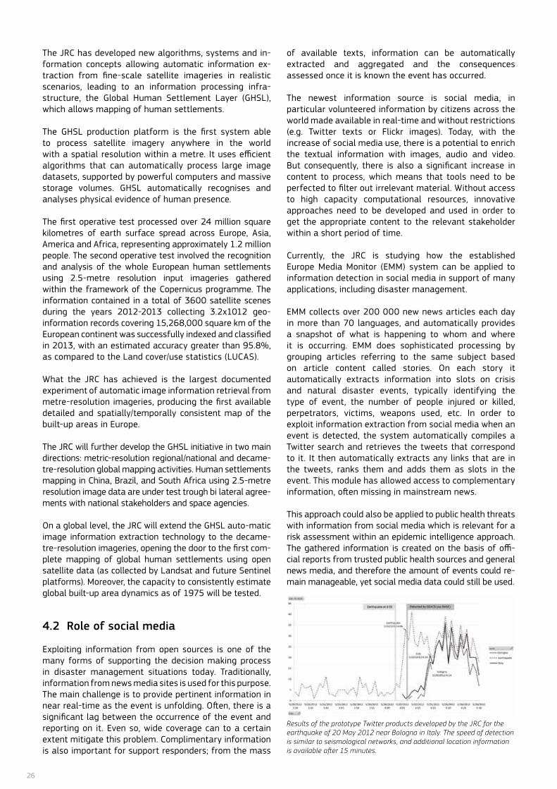
26
The JRC has developed new algorithms, systems and in-formation concepts allowing automatic information ex-traction from fine-scale satellite imageries in realistic scenarios, leading to an information processing infra-structure, the Global Human Settlement Layer (GHSL), which allows mapping of human settlements.
The GHSL production platform is the first system able to process satellite imagery anywhere in the world with a spatial resolution within a metre. It uses efficient algorithms that can automatically process large image datasets, supported by powerful computers and massive storage volumes. GHSL automatically recognises and analyses physical evidence of human presence.
The first operative test processed over 24 million square kilometres of earth surface spread across Europe, Asia, America and Africa, representing approximately 1.2 million people. The second operative test involved the recognition and analysis of the whole European human settlements using 2.5-metre resolution input imageries gathered within the framework of the Copernicus programme. The information contained in a total of 3600 satellite scenes during the years 2012-2013 collecting 3.2x10¹² geo-information records covering 15,268,000 square km of the European continent was successfully indexed and classified in 2013, with an estimated accuracy greater than 95.8%, as compared to the Land cover/use statistics (LUCAS).
What the JRC has achieved is the largest documented experiment of automatic image information retrieval from metre-resolution imageries, producing the first available detailed and spatially/temporally consistent map of the built-up areas in Europe.
The JRC will further develop the GHSL initiative in two main directions: metric-resolution regional/national and decame-tre-resolution global mapping activities. Human settlements mapping in China, Brazil, and South Africa using 2.5-metre resolution image data are under test trough bi lateral agree-ments with national stakeholders and space agencies.
on a global level, the JRC will extend the GHSL auto-matic image information extraction technology to the decame-tre-resolution imageries, opening the door to the first com-plete mapping of global human settlements using open satellite data (as collected by Landsat and future Sentinel platforms). Moreover, the capacity to consistently estimate global built-up area dynamics as of 1975 will be tested.
4.2 Role of social media
Exploiting information from open sources is one of the many forms of supporting the decision making process in disaster management situations today. Traditionally, information from news media sites is used for this purpose. The main challenge is to provide pertinent information in near real-time as the event is unfolding. often, there is a significant lag between the occurrence of the event and reporting on it. Even so, wide coverage can to a certain extent mitigate this problem. Complimentary information is also important for support responders; from the mass
of available texts, information can be automatically extracted and aggregated and the consequences assessed once it is known the event has occurred.
The newest information source is social media, in particular volunteered information by citizens across the world made available in real-time and without restrictions(e.g. Twitter texts or flickr images). Today, with the increase of social media use, there is a potential to enrich the textual information with images, audio and video. But consequently, there is also a significant increase in content to process, which means that tools need to be perfected to filter out irrelevant material. Without access to high capacity computational resources, innovative approaches need to be developed and used in order to get the appropriate content to the relevant stakeholder within a short period of time.
Currently, the JRC is studying how the established Europe Media Monitor (EMM) system can be applied to information detection in social media in support of many applications, including disaster management.
EMM collects over 200 000 new news articles each day in more than 70 languages, and automatically provides a snapshot of what is happening to whom and where it is occurring. EMM does sophisticated processing by grouping articles referring to the same subject based on article content called stories. on each story it automatically extracts information into slots on crisis and natural disaster events, typically identifying the type of event, the number of people injured or killed, perpetrators, victims, weapons used, etc. In order to exploit information extraction from social media when an event is detected, the system automatically compiles a Twitter search and retrieves the tweets that correspond to it. It then automatically extracts any links that are in the tweets, ranks them and adds them as slots in the event. This module has allowed access to complementary information, often missing in mainstream news.
This approach could also be applied to public health threats with information from social media which is relevant for a risk assessment within an epidemic intelligence approach. The gathered information is created on the basis of offi-cial reports from trusted public health sources and general news media, and therefore the amount of events could re-main manageable, yet social media data could still be used.
Results of the prototype Twitter products developed by the JRC for the earthquake of 20 May 2012 near Bologna in Italy. The speed of detection is similar to seismological networks, and additional location information is available after 15 minutes.
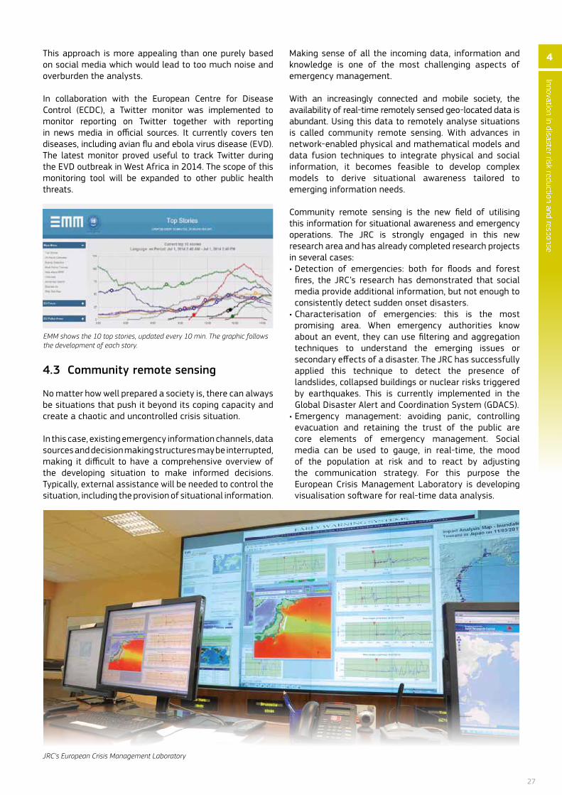
27
This approach is more appealing than one purely based on social media which would lead to too much noise and overburden the analysts.
In collaboration with the European Centre for Disease Control (ECDC), a Twitter monitor was implemented to monitor reporting on Twitter together with reporting in news media in official sources. It currently covers ten diseases, including avian flu and ebola virus disease (EVD). The latest monitor proved useful to track Twitter during the EVD outbreak in West Africa in 2014. The scope of this monitoring tool will be expanded to other public health threats.
4.3 Community remote sensing
no matter how well prepared a society is, there can always be situations that push it beyond its coping capacity and create a chaotic and uncontrolled crisis situation.
In this case, existing emergency information channels, data sources and decision making structures may be interrupted, making it difficult to have a comprehensive overview of the developing situation to make informed decisions. Typically, external assistance will be needed to control the situation, including the provision of situational information.
Making sense of all the incoming data, information and knowledge is one of the most challenging aspects of emergency management.
With an increasingly connected and mobile society, the availability of real-time remotely sensed geo-located data is abundant. Using this data to remotely analyse situations is called community remote sensing. With advances in network-enabled physical and mathematical models and data fusion techniques to integrate physical and social information, it becomes feasible to develop complex models to derive situational awareness tailored to emerging information needs.
Community remote sensing is the new field of utilising this information for situational awareness and emergency operations. The JRC is strongly engaged in this new research area and has already completed research projects in several cases:• Detection of emergencies: both for floods and forest
fires, the JRC’s research has demonstrated that social media provide additional information, but not enough to consistently detect sudden onset disasters.
• Characterisation of emergencies: this is the most promising area. When emergency authorities know about an event, they can use filtering and aggregation techniques to understand the emerging issues or secondary effects of a disaster. The JRC has successfully applied this technique to detect the presence of landslides, collapsed buildings or nuclear risks triggered by earthquakes. This is currently implemented in the Global Disaster Alert and Coordination System (GDACS).
• Emergency management: avoiding panic, controlling evacuation and retaining the trust of the public are core elements of emergency management. Social media can be used to gauge, in real-time, the mood of the population at risk and to react by adjusting the communication strategy. for this purpose the European Crisis Management Laboratory is developing visualisation software for real-time data analysis.
EMM shows the 10 top stories, updated every 10 min. The graphic follows the development of each story.
Innovation in disaster risk reduction and response
4
JRC’s European Crisis Management Laboratory
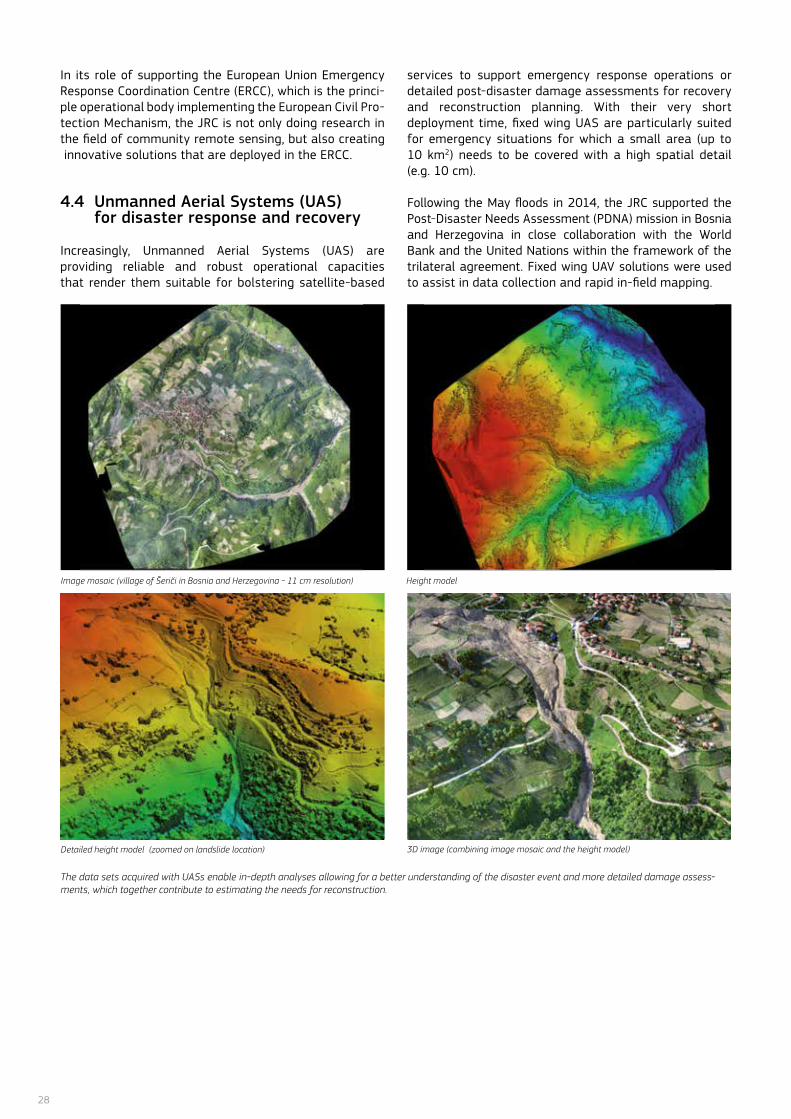
28
Detailed height model (zoomed on landslide location) 3D image (combining image mosaic and the height model)
In its role of supporting the European Union Emergency Response Coordination Centre (ERCC), which is the princi-ple operational body implementing the European Civil Pro-tection Mechanism, the JRC is not only doing research in the field of community remote sensing, but also creating innovative solutions that are deployed in the ERCC.
4.4 Unmanned Aerial Systems (UAS) for disaster response and recovery
Increasingly, Unmanned Aerial Systems (UAS) are providing reliable and robust operational capacities that render them suitable for bolstering satellite-based
services to support emergency response operations or detailed post-disaster damage assessments for recovery and reconstruction planning. With their very short deployment time, fixed wing UAS are particularly suited for emergency situations for which a small area (up to 10 km2) needs to be covered with a high spatial detail (e.g. 10 cm).
following the May floods in 2014, the JRC supported the Post-Disaster needs Assessment (PDnA) mission in Bosnia and Herzegovina in close collaboration with the World Bank and the United nations within the framework of the trilateral agreement. fixed wing UAV solutions were used to assist in data collection and rapid in-field mapping.
The data sets acquired with UASs enable in-depth analyses allowing for a better understanding of the disaster event and more detailed damage assess-ments, which together contribute to estimating the needs for reconstruction.
Image mosaic (village of Šeriči in Bosnia and Herzegovina - 11 cm resolution) Height model
29
1. Being prepared for disasters
Index for Risk Management – Open source risk analysis for crisis preparedness and resilience• InfoRM: www.inform-index.org
Better aid information – transparency to support preparedness and response• EU Aid Explorer: https://euaidexplorer.jrc.ec.europa.eu/
Identifying potential threats in the public health and socio-political domains • Medical Information System (MedIsys):
http://medisys.newsbrief.eu • Europe Media Monitor (EMM):
http://emm.newsbrief.eu
Preventing industrial and technological accidents • EU’s Major Accident Reporting System (Emars):
https://emars.jrc.ec.europa.eu• Chemical, biological, radiological and nuclear Centres
of Excellence: http://www.cbrn-coe.eu/• eNatech database on technological accidents triggered
by natural disasters: http://enatech.jrc.ec.europa.eu• Rapid-N: http://rapidn.jrc.ec.europa.eu/
Towards safer buildings• EURCODES, European standards for the construction
sector: http://eurocodes.jrc.ec.europa.eu/• SERIES “Seismic Engineering Research Infrastructures
for European Synergies”: www.series.upatras.gr/• SYNER-G “Systemic Seismic Vulnerability and Risk Analysis
for Buildings, Lifeline networks and Infrastructures Safety Gain”: http://www.vce.at/SYNER-G/
• EUROPLEXUS, computer code for the simulation of fast transient fluid-structure interaction problems: http://europlexus.jrc.ec.europa.eu/
Protecting critical infrastructures• ERNCIP, European reference Network for Critical
Infrastructure Protection https://erncip.jrc.ec.europa.eu/
2. Monitoring, forecasting and alerting disasters
Early warning on a global scale• Global Disaster Alert and Coordination System (GDACS):
http://www.gdacs.org• Global Flood Detection System (GFDS):
http://www.gdacs.org/flooddetection
Floods forecasting and monitoring• Floods portal: http://floods.jrc.ec.europa.eu/• European Floods Awareness System (EFAS):
http://www.efas.eu/• Global Flood Detection System (GFDS):
http://www.gdacs.org/flooddetection• Integrated flood map:
http://dma.jrc.it/map?application=floods
• Climate change impact assessment in floods: http://floods.jrc.ec.europa.eu/climate-change-impact-assessment.html
Early warning on droughts • European Drought Observatory (EDO):
http://edo.jrc.ec.europa.eu
Tsunami alert system• Global Disaster Alert and Coordination System (GDACS):
http://www.gdacs.org
Monitoring forest fires • European Forest Fires Information System (EFFIS):
http://effis.jrc.ec.europa.eu
3. Responding to disasters
Emergency mapping • Copernicus Emergency Management Service:
http://emergency.copernicus.eu/• Global Atlas on crisis areas:
http://global-atlas.jrc.ec.europa.eu 4. Innovation in disaster risk reduction
and response
Mapping human settlements• Global Human Settlement Layer:
http://ghslsys.jrc.ec.europa.eu
Useful tools

30
1. Being prepared for disasters Identifying potential threats in the public health and socio-political domains
How to maximise event-based surveillance web-systems: the example of ECDC/JRC collaboration to improve the performance of MedISys. Mantero J., Belyaeva E., authors Linge J., editor. (2011).EUR 24763 En. Luxembourg: Publications office of the European Union. doi: 10.2788/69804.
Tracking Media Reports on the Shiga toxin-producing Escheri-chia coli o104:H4 outbreak in Germany. Linge J.P., Mantero J., fuart f., Belyaeva J., Atkinson M., van der Goot E. (2012). eHealth conference, Malaga. Kostkova P., Szomszor M., and fowler D. (Eds.): eHealth 2011, LnICST 91, pp. 178–185. doi: 10.1007/978-3-642-29262-0_26.
A Modular Collaborative Web-Based framework for Humanitarian Crisis Management. Annunziato A., Doherty B., Khanh H. (2012). International Journal of Information Systems for Crisis Response and Management (IJISCRAM), 4(2), 1-21. doi: 10.4018/jiscrm.2012040101.
An Early Warning System in Support of Humanitarian Emergen-cy Preparedness. Khanh H., Doherty B., Annunziato A., Atkinson M. (2012). JRC69918.
Preventing industrial and technological accidents
Land Use Planning Guidelines in the Context of Article 12 of the Seveso II Directive 96/82/Ec as amended by Directive 105/2003/Ec, also defining a Technical Database with Risk Data and Risk Scenarios, to be used for Assessing the Compatibility between Seveso Establishments and Residential and other Sensitive Areas listed in Article 12. Christou M. D., Struckl M., Biermann T. (editors). Luxembourg: Publications office of the European Union, 2006 –40 pp., EUR 22634 En.
Implementing art. 12 of Seveso II Directive, overwiev of Road-maps for Land Use Planning in Selected Member States. Basta C, Struckl M., Christou M. Luxembourg: Publications office of the European Union, 2008 – 82 pp., EUR 23519 En.
Guidance on the Preparation of a Safety Report to Meet the Requirements of Directive 96/82/EC as Amended by Directive 2003/105/EC (Seveso II). Fabbri L., Struckl M., Wood M. (editors). Luxembourg: Publications office of the European Union, 2005, 48 pp., EUR 22113 En.
necessary Measures for Preventing Major Accidents at Pe-troleum Storage Depots: Key Points and Conclusions. Mutual Joint Visit for Seveso Inspections, 7-9 December 2005, Brus-sels, Belgium. Goethals M., Borgonjon I., and Wood M. (editors), Published jointly by the European Commission’s Joint Research Centre, and federal Public Service Employment, Labour and So-cial Dialogue, Chemical Risks Inspection Division, 2008 – 92 pp., EUR 22804 En.
Improving Major Hazard Control at Petroleum Oil Refineries Key Points and Conclusions. Murray A., Wood M. and Beckett V. (edi-tors), Mutual Joint Visit on Seveso Inspections in Petroleum oil Refineries, 8-10 March 2006, Liverpool, UK, Jointly published by the European Commission’s Joint Research Centre and the United Kingdom Health and Safety Executive, EUR 23265 EN.
Enforcement of Seveso II: an Analysis of Compliance Drivers and Barriers in Five Industrial Sectors Key Points and Conclu-sions. van der Stegen E., Wood M., fabbri L. (editors), Jointly published by the European Commission’s Joint Research Cen-tre and the Dutch Ministry of Social Affairs and Employment. Luxembourg: Publications office of the European Union, EUR 23249 EN. doi: 10.2788/68014
The role of safety reports in preventing accidents key points and conclusions. Gilbert Y., Aho J., Ahonen L., Wood M., Lahde A.M. A joint publication of the European Commission’s Joint Research Centre and the Finnish Safety and Chemicals Agency (TUKES). Luxem-bourg: Publications office of the European Union 2012 – 138 pp., EUR 25490 EN. doi: 10.2788/45867
Natech risk reduction in the European Union. Krausmann E., Baranzini D. Journal of Risk Research, Vol. 15, no. 8, 2012, pp. 1027-1047. doi: 10.1080/13669877.2012.666761.
RAPID-n: Rapid natech risk assessment and mapping frame-work. Girgin S., Krausmann E. Journal of Loss Prevention in the Process Industries, 26, 2013, pp. 949-960.
Major industrial accidents triggered by earthquakes, floods and lightning: Results of a database analysis. Krausmann E., Renni E., Cozzani V., Campedel M. natural Hazards, Vol. 59, no. 1, 2011, pp. 285-300. doi: 10.1007/s11069-011-9754-3.
Industrial accidents triggered by natural hazards: an emerg-ing risk issue. Krausmann E., Cozzani V., Salzano E., Renni E. natural Hazards and Earth System Sciences, Vol. 11, 2011, pp. 921–929. doi: 10.5194/nhess-11-921-2011.
Analysis of tsunami impact scenarios at an oil refinery. Cruz A.M., Krausmann E., Franchello G. Natural Hazards, Vol. 58, 2011, pp. 141-162. doi: 10.1007/s11069-010-9655-x.
The impact of the 12 May 2008 Wenchuan earthquake on in-dustrial facilities. Krausmann E., Cruz A.M., Affeltranger B. Jour-nal of Loss Prevention in the Process Industries, Vol. 23, 2010, pp. 242-248. doi: 10.1016/j.jlp.2009.10.004.
Hazardous-materials releases from offshore oil and gas fa-cilities and emergency response following Hurricanes Katrina and Rita. Cruz A.M., Krausmann E. Journal of Loss Preven-tion in the Process Industries, Vol. 22, no. 1, 2009, pp. 59-65. doi: 10.1016/j.jlp.2008.08.007.
natech disasters: When natural hazard trigger technological accidents, Krausmann E., Cruz A.M. (eds.). Special Issue, Natural Hazards, Vol. 46, no. 2, 2008.ISnn 0921-030X.
Towards safer buildings
Pre-normative Research needs to Achieve Improved Design Guidelines for Seismic Protection, Pinto Vieira A., Taucer f., Dimova S. (2007). EUR22858 En.
EURoCoDES: EU Policy Issues, Implementation and further De-velopment. Geradin M., Pinto Vieira, A., Dimova, S. and Tsion-is, G. (2010). Codes in Structural Engineering - Developments and needs for International Practice, The International Asso-ciation for Bridge and Structural Engineering (IABSE), Cavtat, Dubrovnik-neretva County (Croatia), pp. 189-196, JRC56504.
Further reading
31
Seismic Retrofitting of RC frames with RC Infilling. Chrys-ostomou C. Z., Kyriakides N., Kotronis P., Poljanšek P., Taucer F., Roussis P. and Kosmopoulos A. (2012). Proceedings of the 15th World Conference on Earthquake Engineering, Lisbon, http://www.iitk.ac.in/nicee/wcee/article/WCEE2012_4144.pdf
Experimental and numerical investigations of laminated glass subjected to blast loading. Larcher M, Solomos G, Casadei f, Gebbeken n. (2012). Int. J. Impact Engineering 39, pp. 42-50. doi: 10.1016/j.ijimpeng.2011.09.006
Experimental and numerical simulation activities for the assessment of explosion effects in a train station. Solomos G., Casadei f., Gian-nopoulos G., Larcher M. (2011). Internal Security 3 (1); pp. 49-62.
Experimental investigation of high strain-rate behaviour of glass. Peroni M, Solomos G, Pizzinato E, Larcher M. (2011). Protect 2011; 30 August 2011; Lugano (Switzerland). Applied Mechanics & Materials 82; pp. 63-68. doi: 10.4028/www.scientific.net/AMM.82.63.
Can Venting Areas Mitigate the Risk Due to Air Blast Inside Rail-way Carriages. Larcher M., Casadei f., Solomos G., Gebbeken n. (2011). Int. J. of Protective Structures Vol.2, no.2, pp.221–230. doi: 10.1260/2041-4196.2.2.221.
Simulation terroristischer Anschläge in Massenverkehrsmit-teln. Larcher M., Solomos G., Casadei f., Gebbeken n. (2011). Bautechnik Vol.88, Heft 4 (2011) pp.225–232. doi: 10.1002/bate.201110023.
Determination of the risk due to explosions in railway systems. Larcher M., Casadei f., Giannopoulos G., Solomos G., Planchet J –L., Rochefrette A. (2011). Proc. IMechE Vol. 224 Part f: J. Rail and Rapid Transit, pp.373-382. doi: 10.1243/09544097JRRT385.
Influence of venting areas on the air blast pressure inside tu-bular structures like railway carriages. Larcher M., Casadei f., Solomos G. (2010). Journal of Hazardous Materials 183, pp. 839–846. doi: 10.1016/j.jhazmat.2010.07.103.
Risk analysis of explosions in trains by fluid-structure calcu-lations. Larcher M., Casadei f., Solomos G. (2010). Journal of Transportation Security, published online: 28 Jan.2010, Vol.3, pp. 57-71. doi: 10.1007/s12198-010-0038-z.
Risk assessment of the fatality due to explosion in land mass transport infrastructure by fast transient dynamic analysis. Giannopoulos G., Larcher M., Casadei f., Solomos G. (2010). Journal of Hazardous Materials 173, pp. 401–408. doi: 10.1007/s12198-010-0038-z.
Mechanical Characterisation of Concrete in Tension and Com-pression at High Strain Rate Using a Modified Hopkinson Bar. Cadoni E., Solomos G., Albertini C. (2009). Magazine of Concrete Research 61 (3); pp. 221-230. doi: 10.1680/macr.2006.00035.
Rebar pullout testing under dynamic Hopkinson bar induced impulsive loading. Solomos G., Berra M. (2010). Materials and Structures, published online: 17 feb. 2009, Vol.43, pp.247–260. doi: 10.1617/s11527-009-9485-z.
Protecting critical infrastructures
Risk assessment methodologies for Critical Infrastruc-ture Protection. Part I: A state of the art. Giannopou-los G., filippini R., Schimmer M. (2011). Luxembourg:
Publications office of the European Union, EUR25398. doi: 10.2788/22260.Regional economic assessment of Critical Infrastructure failure in the EU: A combined systems engineering and economic mod-el. Jonkeren o., Ward D., Dorneanu B., Giannopoulos G. (2011). ERSA conference papers Proceedings, 21-25 August 2012, Bratislava, Slovakia, http://ideas.repec.org/s/wiw/wiwrsa.html
Interdependencies and Resilience assessment methodology for CI. Giannopoulos G., filippini G. (2012). JRC75761.
Summary Report of the ‘Core functionalities’ phase of the ERn-CIP Project. David W. and Naouma K. (2012), JRC69636.
Inventory Development documentation. Kourti N., Borsos F., Cavestro J., Conti M., Cyra L., d’Amico F., Di Piazza A., Kashiani Rad D. (2012). JRC74733.
Natech risk reduction in the European Union. Krausmann E., Baranzini D. (2012). Journal of Risk Research, Vol. 15, no. 8, pp. 1027-1047. doi: 10.1080/13669877.2012.666761.
RAPID-n: Rapid natech risk assessment and mapping frame-work. Girgin S., Krausmann E. Journal of Loss Prevention in the Process Industries, 26, 2013, pp. 949-960..
Major industrial accidents triggered by earthquakes, floods and lightning: Results of a database analysis. Krausmann E., Renni E., Cozzani V., Campedel M. (2011). natural Hazards, Vol. 59, No. 1, pp. 285-300. doi: 10.1007/s11069-011-9754-3.
Industrial accidents triggered by natural hazards: an emerging risk issue. Krausmann E., Cozzani V., Salzano E., Renni E. (2011). natural Hazards and Earth System Sciences, Vol. 11, pp. 921–929. doi: 10.5194/nhess-11-921-2011.
Analysis of tsunami impact scenarios at an oil refinery. Cruz A.M., Krausmann E., Franchello G. (2011). Natural Hazards, Vol. 58, pp. 141-162. doi: 10.1007/s11069-010-9655-x.
The impact of the 12 May 2008 Wenchuan earthquake on industrial facilities, Krausmann E., Cruz A.M., Affeltranger B. (2010). Journal of Loss Prevention in the Process Industries, Vol. 23, pp. 242-248. doi: 10.1016/j.jlp.2009.10.004.Hazardous-materials releases from offshore oil and gas fa-cilities and emergency response following hurricanes Katrina and Rita. Cruz A.M., Krausmann E. (2009). Journal of Loss Prevention in the Process Industries, Vol. 22, no. 1, pp. 59-65. doi: 10.1016/j.jlp.2008.08.007.
natech disasters: When natural hazard trigger technological accidents. Krausmann E., Cruz A.M. (editors) (2008). Special Issue, natural Hazards, Vol. 46, no. 2, ISSn 0921-030X.
Scintillation Parameter Estimation Using Unmodified Profes-sional GnSS Receivers: A feasibility Study. Symeonidis D., fortuny-Guasch J., o’Driscoll C., Belenguer-Martinez A. (2011). Proceedings of the 24th International Technical Meeting of The Satellite Division of the Institute of navigation (Ion GnSS 2011), Portland, oR, September 2011, pp. 2580-2587.
Recording disaster losses
Recording Disaster Losses: Recommendations for a European approach. De Groeve T., Poliansek K., Ehrlich D. (2013). Luxem-bourg: Publications office of the European Union. EUR 26111. doi: 10.2788/98653 (online).
32
2. Monitoring, Forecasting and Alerting
Early warning on a global scale
flood monitoring and mapping using passive microwave remote sensing: application in namibia. De Groeve T. (2010). Geomatics, natural Hazards and Risk 1.1, pp 19-35. doi: 10.1080/19475701003648085.
near real-time global disaster impact analysis. De Groeve T., Annunzaito A., Kugler Z., Vernaccini L., (2009). Information Sys-tems for Emergency Management, Van de Walle B., Turoff M., Hiltz R. (editors). ISBn 978-0-7656-2164-4.
The JRC Tsunami Assessment Modelling System. Annunziato A. (2007). EUR 23063 En.
The Samoa Tsunami of 29 September 2009 – Early Warning System and Inundation Assessment. franchello G., Annunziato A., (2012). Science of Tsunami Hazard, vol. 31, no.1, pp. 19-61. ISSn 8755-6839.
Floods forecasting and monitoring
The European flood Alert System EfAS - Part 2: Statistical skill assessment of probabilistic and deterministic operational forecasts. Bartholmes J. C., Thielen J., Ramos M. H., Gentilini S. (2009). Hydrology and Earth System Sciences, Vol. 13, pp. 141-153. doi: 10.5194/hess-13-141-2009.
Early flood detection and mapping for humanitarian response. De Groeve T., Riva P. (2009). Proceedings of the 6th International ISCRAM Conference, Gothenburg, Sweden, May 2009. ISBn 978-91-633-4715-3.
Global real-time detection of major floods using passive micro-wave remote sensing. De Groeve T., Riva P. (2009). Proceedings of the 33rd International Symposium on Remote Sensing of En-vironment Stresa, Italy, May 2009. ISBn 978-0-932913-13-5.
flood monitoring and mapping using passive microwave remote sensing in namibia. De Groeve T. (2010). Geo-matics, natural Hazards and Risk, Vol. 1 (1), pp. 19-35. doi: 10.1080/19475701003648085.
Quality Control, Validation and User feedback of the European flood Alert System (EfAS). De Roo A., Thielen J., Salamon P., Bogner K., Nobert S., Cloke H.L., Demeritt D., Younis J., Kalas M., Bodis K., Muraro D., Pappenberger F. (2011). International Jour-nal of Digital Earth, Vol. 4 (sup1), pp. 77-90. doi: 10.2788/46126.The European flood Alert System. Part 1: Concept and develop-ment. Thielen Del-Pozo J., Bartholmes J., Ramos M.H., De Roo A. (2009). Hydrology and Earth System Sciences, Vol. 13, pp. 125-140. doi: 10.5194/hess-13-125-2009.
Ensemble flood forecasting in Africa: A feasibility Study in the Juba-Shabelle River Basin. Thiemig V., Pappenberger f., Thielen Del-Pozo J., Gadain H., De Roo A., Del Medico M., Bodis K., Muthusi F. (2010). Atmospheric Science Letters, Vol. 11 (2), pp. 132-138. doi: 10.1002/asl.270. Early warning on droughts
Drought and Drought Mitigation in Europe. Vogt J.V., Somma F. (editors) (2000). Kluwer Academic Publishers, Dordrecht/ Boston/London, 325 pp. ISBN 0-7923-6589-5.
JRC Experience on the Development of Drought Information Systems. Horion S., Carrão H., Singleton A., Barbosa P., Vogt J.V. (2012). Luxembourg: Publications office of the European Union. 70 pp. ISBN 978-92-79-23202-2. doi: 10.2788/15724.
Toward Global Drought Warning Capability. Expanding Inter-national Cooperation for the Development of a framework for Monitoring and forecasting. Pozzi W., Sheffield J., Heim R., Brewer M.J., Vogt J.V., de Roo A., Cripe D., Lloyd-Hughes B., Mo K., Wagner W., Svoboda M., Westerhoff R., van Dijk A., Pulwarty R., Stefanski R., Bettio L., nicholson M., nuñez L., van Beek R., Bierkens M., Schubert S., Lawford R., Goncalves L. G. (2013). Bulletin of the American Meteorological Society, vol. 94 p. 776–785. doi: 10.1175/BAMS-D-11-00176.1.
forecasting Drought in Europe with the Standardized Precipitation Index. Singleton A. (2012). Luxembourg: Publica-tions office of the European Union, 66 pp., ISBn 978-92-79-23394-4. doi: 10.2788/16495.
Special Issue on Understanding Dryland Degradation Trends. Winslow M., Akhtar-Schuste M., Martius C., Stringer L.C., Thomas R.J., Vogt J.V. (2011). Land Degradation and Develop- ment, 22(2), pp. 145-302. http://onlinelibrary.wiley.com/doi/10.1002/ldr.v22.2/issuetoc
Tsunami alert system
Global Disaster Alert and Coordination System: for more effec-tive and efficient humanitarian response. De Groeve T. (2007). pp. 324-334. 14th Conference of the International Emergency Management Society, Trogir, Croatia.
The Tsunami Assessment Modelling System by the Joint Research Centre. Annunziato A. (2007). Science of Tsunami Hazards, Vol. 26(2), pp. 70-92. ISSn 8755-6839.
Shoreline tracking and implicit source terms for a well balanced inundation model. franchello G. (2010). International Journal for numerical Methods in fluid, Vol. 63, pp. 1123-1146. doi: 10.1002/fld.2121.
Monitoring forest fires
forest fires in Europe, north Africa and Middle East 2011. Schmuck G., San-Miguel-Ayanz J., Camia A., Schulte E. (2012). The European forest fire information System in the context of environmental policies of the European Union, forest Policy and Economics. Luxembourg: Publications office of the European Union. ISBN 978-92-79-26175-6. doi: 10.2788/44558.
Comprehensive monitoring of wildfires in Europe: the European forest fire Information System (EffIS). San-Miguel-Ayanz J., Schulte E., Schmuck G., Camia A., Strobl P., Liberta G., Giovando C., Boca R., Sedano F., Kempeneers P., McInerney D., Withmore C., Santos de oliveira S., Rodrigues M., Durrant T., Corti P., oehler f., Vilar L., Amatulli G. (2012). Approaches to Managing Disaster - Assessing Hazards, Emergencies and Disaster Impacts, Tiefenbacher J. (editor), pp. 87-105, InTech, ISBn 978-953-51-0294-6.

33
3. Responding to disasters
Emergency mapping
Distributed Geospatial Data Processing functionality to Sup-port Collaborative and Rapid Emergency Response. Brunner D., Lemoine G., Thoorens f., Bruzzone L. (2009). IEEE JSTARS, Vol. 2, No. 1, p. 33-46. doi: 10.1109/JSTARS.2009.2015770.
Earthquake Damage Assessment of Buildings Using VHR op-tical and SAR Imagery. Brunner D., Lemoine G., Bruzzone L. (2010). IEEE TGRS, Vol. 48, no. 5, p. 2403-2420. doi 10.1109/TGRS.2009.2038274.
Validation Protocol for Emergency Response Geo-information Products. Broglia M., Corbane C., Carrion D., Lemoine G., Pesa-resi M. (2010). Luxembourg: Publications office of the European Union. ISBN 978-92-79-16428-6. doi 10.2788/63690.
fast Surface Height Determination Using Multi-angular World-View-2 ortho Ready Urban Scenes. Lemoine G., Bielski C., Syry-czynski J. (2012). IEEE JSTARS, Vol 5., no. 1, p. 80-88. doi 10.1109/JSTARS.2011.2180366.
Post-disaster and post-crisis needs assessment
A Comprehensive Analysis of Building Damage in the January 12, 2010 M w 7 Haiti Earthquake using High-Resolution Satellite and Aerial Imagery. Corbane C., Saito K., Del’Oro L., et al (2011).
Photogrammetric Engineering and Remote Sensing, Vol 77, no 10, p 997-1009. JRC65321.
Comparison of damage assessment maps derived from very high spatial resolution satellite and aerial imagery of the Haiti 2010 earthquake impact area. Corbane C., Carrion D., Lemoine G. and Broglia M. (2011). Earthquake Spectra, Vol 27, no S1, 199-218. doi. 10.1193/1.3630223.
Relationship between the spatial distribution of SMS messages reporting needs and building damage in 2010 Haiti disaster. Corbane C., Lemoine G., Kauffmann M. (2012). Natural Hazards and Earth System Sciences, Vol 12, p. 255-265. doi: 10.5194/nhess-12-255-2012.
4. Innovation in disaster risk reduction and response
Mapping human settlements
A Global Human Settlement Layer From Optical HR/VHR RS Data: Concept and first Results, Pesaresi M. and others (2013). In IEEE Journal of Selected Topics in Applied Earth observations and Remote Sensing Issue, Vol. 6, no 5, pp 1-30. doi: 10.1109/JSTARS.2013.2271445.
A methodology to quantify built-up structures from optical VHR imagery. Pesaresi M., Ehrlich D. (2009). In Global Mapping of Human Settlement: Experiences, Datasets, and Prospects, CRC Press, Taylor and francis Group, pp. 27-58. ISBn 978-1-4200-8339-2.
Toward global automatic built-up area recognition using optical VHR imagery. Pesaresi M., Ehrlich D., Caravaggi I., Kauffmann M., Louvrier C., Kauffmann M. (2011). In IEEE Journal of selected topics in applied earth observation and Remote sensing Vol 4, pp. 923-934. doi: 10.1109/JSTARS.2011.2162579.
Can Earth observation Help to Improve Information on Population. Ehrlich D., Lang S., Laneve G., Mubareka S., Schneiderbauer S., Tiede D. In Remote Sensing from Space. Supporting International Peace and Security. Jasani B., Pesaresi M., Schneiderbauer S., Zeug G. Editors., chapter 14, pp. 211-237. Springer Verlag, Berlin. ISBn 978-1-4020-8483-6.
optical satellite imagery for quantifying spatio-temporal dimensions of physical exposure in disaster risk assessments. Ehrlich D., Tenerelli P. (2012). In natural Hazards, September 2013, Volume 68, Issue 3, pp 1271-1289. doi: 10.1007/s11069-012-0372-5.
Using high resolution satellite data for the identification of ur-ban natural disaster risk. Deichmann U., Ehrlich D., Zeug G., Small C. (2011). World Bank Report, pp. 80. http://www.gfdrr.org/sites/gfdrr.org/files/publication/using_high_resolution_data.pdf
Assessing Disaster Risk of Building Stock. Ehrlich D., Zeug G. (2008). doi: 10.2788/83294. Luxembourg: Publications Office of the European Union.
Identifying damage caused by the 2008 Wenchuan earthquake from VHR remote sensing data. Ehrlich D., Guo H., Molch K., Ma J., Pesaresi M. (2009). International Journal of Digital Earth 2 (4); p. 309-326. doi: 10.1080/17538940902767401.
Anisotropic Rotation Invariant Built-up Presence Index: Applica-tions to SAR Data. Gamba P., Pesaresi M., Molch K., Gerharding-er A., Lisini G. (2008). Conference Proceedings: The 2008 IEEE International Geoscience and Remote Sensing Symposium - Abstracts of Symposium Presentations. Piscataway (United States of America). IEEE; 2008. p. 1-2. ISBn 978-1-4244-2808-3.
Multitemporal Analysis of Multisensor Data: Information Theo-retical Approaches. Gueguen L., Cui S., Schwarz G., Datcu M. (2010). Conference Proceedings: Proceedings of 2010 IEEE International Geoscience and Remote Sensing Symposium (IGARSS) - ISBn: 978-1-4244-9566-5. Institute of Electrical and Electronics Engineers (IEEE); p. 2559-2562. doi: 10.1109/IGARSS.2010.5651902.
Urbanization analysis by mutual information based change detection between SPoT 5 panchromatic images. Gueguen L., Pesaresi M., Ehrlich D., Lu L. (2011). In Conference Proceedings: L. Bruzozne, f. Bovolo, editors. 2011 6th International Work-shop on the Analysis of Multi-temporal Remote Sensing Images (Multi-Temp) Proceedings. ISBn: 978-1-4577-1203-6. Insti-tute of Electrical and Electronics Engineers (IEEE); p. 157-160. doi: 10.1109/Multi-Temp.2011.6005072.
Characterizing and Counting Roofless Buildings in Very High Resolution optical Images. Gueguen L, Pesaresi M, Gerhardinger A, Soille P. (2012). IEEE Geoscience and Remote Sensing Letters 9 (1); p. 114-118. doi: 10.1109/LGRS.2011.2161750.
An interactive image mining tool handling gigapixel images. Gueguen L., Pesaresi M., Soille P. (2011). 2011 IEEE Interna-tional Geoscience and Remote Sensing Symposium (IGARSS); 24 July 2011; Vancouver (Canada). 2011 IEEE International Geosci-ence and Remote Sensing Symposium Proceedings ; p. 1581-1584. doi: 10.1109/IGARSS.2011.6049373.
Multi scale Harris corner detector based on Differential Morpho-logical Decomposition. Gueguen L., Pesaresi M. (2011). Pattern Recognition Letters 32 (14); 2011. p. 1714-1719. doi: 10.1016/j.patrec.2011.07.021.
34
Change detection based on information measure. Gueguen L., Soille P., Pesaresi M. (2011). IEEE Transactions on Geoscience and Remote Sensing 49 (11); p. 4503-4515. doi: 10.1109/TGRS.2011.2141999.
Differential Morphological Decomposition Segmentation: A Multi-Scale object Based Image Description. Gueguen L., Soille P., Pesa-resi M. (2010). Conference Proceedings: Pattern Recognition (ICPR), 2010 20th International Conference on Pattern Recognition. ISBn: 978-1-4244-7542-1. Washington (United States of America): IEEE Computer Society; p. 938-941. doi: 10.1109/ICPR.2010.235.
Structure extraction and characterization from Differential Morphological Decomposition. Gueguen L., Soille P., Pesaresi M. (2011). Conference Proceedings: Soille P., Gueguen L., D’Elia S., Marchetti P.G., Colaiacomo L., Datcu M., editors. The sev-enth conference on image information mining: Geospatial in-telligence from earth observation. ISBn 978-92-79-19708-6. Luxembourg: Publications office of the European Union; p. 53-58. doi: 10.2788/69291.
frequent and dependent connectivities. Gueguen L., Soille P. (2011). Mathematical Morphology and Its Applications to Image and Signal Processing: 10th International Symposium, Soille P., Pesaresi M., ouzounis G. (editors). ISMM 2011, Verbania-Intra, Italy, July 6-8, 2011 Proceedings. Heidelberg (Germany): Springer; p. 120-131. doi: 10.1007/978-3-642-21569-8_11.
Social Media (Web 2.0) and Crisis Information: Case Study Gaza 2008-09. Halkia S., Dandoulaki M. (2010). In: Asimakopoulou E, Bessis n, editors. Advanced ICTs for Disaster Management and Threat Detection: Collaborative and Distributed frameworks. Hershey, PA (USA): IGI Global; p. 143-163. doi: 10.4018/978-1-61520-987-3.
Towards a Classification Scheme for Analysis of Settlement in Africa by VHR satellite imagery. Halkia S., Ehrlich D., Pesaresi M. (2009). In Conference Proceedings: Proceedings of the 33rd International Symposium on Remote Sensing of Environment, Sustaining the Millennium Development Goals. ISBn: 978-0-932913-13-5. Vol. I, II. Tucson, AZ (United States of Amer-ica): International Center for Remote Sensing of Environment (ICRSE); p. 653-656.
Post-Event Damage Assessment Using Morphological Methodolo- gy on 0.5m Resolution Satellite Data. Jenerowicz M., Kemper T., Pesaresi M., Soille P. (2010). In Conference Proceedings: Geo-Information for Disaster Management - Remote Sensing And Geo-Information for Environmental Emergencies. ISBn 978-88-903132-3-3. Torino (Italy): Politecnico di Torino; p. 1-5.
An automated procedure for detection of IDP`s dwellings us-ing VHR satellite imagery. Jenerowicz M., Kemper T., Soille P. (2011). In Conference Proceedings: L. Bruzzone, editor. Image and Signal Processing for Remote Sensing XVII. Vol. 8180. Bellingham, Washington (USA): SPIE; p. 818004-818004-8. doi: 10.1117/12.898187.
Monitoring changes in the Menik farm IDP camps in Sri Lanka using multi-temporal very high resolution satellite data. Kem-per T., Jenerowicz M., Gueguen L., Poli D., Soille P. (2011). Inter-national Journal of Digital Earth 4 (Supplement 1); p. 91-106. doi: 10.1080/17538947.2010.512430.
Enumeration of dwellings in Darfur Camps from GeoEye-1 sat-ellite images using mathematical morphology. Kemper T, Jene-rowicz M., Soille P., Pesaresi M. (2011). IEEE Journal of Selected
Topic in Applied Earth observations and Remote Sensing 4 (1); p. 8-15. doi: 10.1109/JSTARS.2010.2053700.
Helping to Locate Slums Using Earth observation and Geoinfor-mation Technologies. Kemper T., Pesaresi M. (2008). In: Lopez Moreno E., editor. State of the World`s Cities 2008/2009 - Harmonious Cities. London (United Kingdom): Earthscan; p. 18.
Supporting slum mapping using very high resolution satellite data. Kemper T, Wania A, Pesaresi M. (2009). In Conference Proceedings: 33rd International Symposium on Remote Sensing of Environment, Sustaining the Millennium Development Goals. ISBn 978-0-932913-13-5. Vol. Volumes I and II. Tuscon, Arizo-na (United States of America): International Center for Remote Sensing of Environment (ICRSE); p. 480-483. Different Approaches for IDP Camp Analyses in West Darfur (Sudan) - a status report. Kranz O., Gstaiger V., Lang S., Tiede D., Zeug G., Kemper T., Vega Ezquieta P., Clandillon S. (2010). In Conference Proceedings: Geo-Information for Disaster Manage-ment - Remote Sensing and Geo-Information for Environmental Emergencies. ISBn 978-88-903132-3-3. Torino (Italy): Politec-nico di Torino; p. 1-6.
Monitoring Refugee/IDP Camps to Support International Relief Action. Kranz O., Zeug G., Tiede D., Clandillon S., Bruckert D., Kemper T., Lang S., Caspard M. (2010). In: Orhan ALTAN, Robert BACKHAUS, Piero BOCCARDO, Sisi ZLATANOVA, editors. Geoin-formation for Disaster and Risk Management - Examples and Best Practices. Copenhagen (Denmark): Joint Board of Geospa-tial Information Societies (JB GIS); p. 51-56.
The value of rapid damage assessment for efficient earthquake response. Moltchanova E., Khabarov N., Obersteiner M., Ehrlich D., Moula M. (2011). Safety Science 49 (8-9); p. 1164-1171. doi: 10.1016/j.ssci.2011.03.008.
Interactive collection of training samples from the Max-Tree structure. ouzounis G., Gueguen L. (2011). In Conference Pro-ceedings: Proceedings of the 2011 18th IEEE International Con-ference on Image Processing (ICIP). Institute of Electrical and Electronics Engineers (IEEE); p. 1449-1452. doi: 10.1109/ICIP.2011.6115714.
Differential area profiles: decomposition properties and efficient computation. ouzounis G., Pesaresi M., Soille P. (2012). IEEE Transactions on Pattern Analysis and Machine Intelligence 34 (8); p. 1533-1548. doi: 10.1109/TPAMI.2011.245.
Rubble detection from VHR aerial imagery data using differ-ential morphological profiles. ouzounis G., Soille P., Pesaresi M. (2011). In Conference Proceedings: Proceedings of the 34th International Symposium for Remote Sensing of the Environ-ment. International Center for Remote Sensing of Environment (ICRSE). http://www.isprs.org/proceedings/2011/ISRSE-34/
Differential Area Profiles. ouzounis G., Soille P. (2010). In Conference Proceedings: Proceedings of the 20th International Conference on Pattern Recognition - ICPR 2010. ISBn: 978-0-7695-4109-9. IEEE Computer Society; p. 4085-4088. doi: 10.1109/ICPR.2010.993.
Pattern Spectra from Partition Pyramids and Hierarchies. ou-zounis G., Soille P. (2011). In Conference Proceedings: Soille P., Pesaresi M., ouzounis G., editors. Mathematical Morphology and Its Application to Signal and Image Processing. ISBn 978-3-642-21568-1, ISSn 0302-9743. Vol. 6671. Berlin (Germany): Springer Verlag; p. 108-119. doi: 10.1007/978-3-642-21569-8_10.

35
Hyperconnected Attribute filters Based on k-flat Zones. ouzou-nis G., Wilkinson M. (2011). IEEE Transactoins on Pattern Analy-sis and Machine Intelligence 33 (2); p. 224-239. doi: 10.1109/TPAMI.2010.74.
Detection of Urban features Using Morphological Based Seg-mentation and Very High-Resolution Remotely Sensed Data. Pesaresi M., Kanellopoulos I. (1999). In: Kanellopoulos I., Wilkin-son G., Moons T., editors. Machine Vision and Advanced Image Processing in Remote Sensing. Springer. ISBn 978-3-540-65571-8. p. 271-284.
A new Approach for the Morphological Segmentation of High-Resolution Satellite Imagery. Pesaresi M., Benediktsson J. (2001). IEEE Transactions on Geoscience and RS 39 (2); doi: 10.1109/36.905239. Texture Analysis for Urban Pattern Recognition Using fine-Resolution Panchromatic Satellite Imagery. Pesaresi M. (2000). Geographical and Environmental Modelling 4 (1); p. 47-67.
A Robust Built-up Area Presence Index by Anisotropic Rota-tion-invariant Textural Measure. Pesaresi M., Gerhardinger A., Kayitakire F. (2008). IEEE Journal of Selected Topics in Applied Earth observations and Remote Sensing 1 (3); p. 180-192. doi: 10.1109/JSTARS.2008.2002869.
Improved textural built-up presence index for automatic rec-ognition of human settlements in arid regions with scattered vegetation. Pesaresi M., Gerhardinger A. (2011). IEEE Journal of Selected Topics in Applied Earth observations and Remote Sensing 4 (1); p. 16-26. doi: 10.1109/JSTARS.2010.2049478.
Toward Global Automatic Built-Up Area Recognition Using opti-cal VHR Imagery. Pesaresi M., Ehrlich D., Caravaggi I., Kauff-mann M., Louvrier C. (2011). IEEE of Selected Topics in Applied Earth observations and Remote Sensing 4 (4); p. 923-934. doi: 10.1109/JSTARS.2011.2162579.
A methodology to quantify built-up structures from op-tical VHR imagery. Pesaresi M., Ehrlich D. (2009). In: Gamba P., Herold M., editors. Global Mapping of Human Settlement: Experiences, Datasets, and Prospects. CRC Press, Taylor and francis Group; ISBn-10: 1420083392. p. 27-58.
Automatic Information Retrieval from Meter and Sub-Me-ter Resolution Satellite Image Data in Support to Crisis Management. Pesaresi M., Gueguen L., Kemper T., Lemoine G. (2010). In Conference Proceedings: 2010 IEEE International Geoscience and Remote Sensing Symposium Proceedings. ISBn 978-1-4244-9566-5. Piscataway (United States of Amer-ica): Institute of Electrical and Electronics Engineers Inc. (IEEE); p. 1792-1795. doi: 10.1109/IGARSS.2010.5653039.
Quantitative estimation of settlement density and limits based on textural measurements. Pesaresi M., Halkia S., ouzounis G. (2011). In Conference Proceedings: Stilla U., Gamba P., Juer-gens C., Maktav D., editors. 2011 Joint Urban Remote Sensing Event (JURSE). ISBn: 978-1-4244-8657-1. Institute of Electri-cal and Electronics Engineers (IEEE); p. 89-93. doi: 10.1109/JURSE.2011.5764726.
GHSL/UA Integration: Feasibility Report. Application of the JRC GHSL Image Information Extraction Protocol in the frame of the Urban Atlas product specifications. Pesaresi M., Halkia S. (2012). EUR 25328 En. Luxembourg:: Publications office of the European Union. doi: 10.2788/26820.
Digital surface modelling and 3D information extraction from spaceborne very high resolution stereo pairs. Poli D., Caravaggi I. (2012). EUR 25234 En. Luxembourg: Publications office of the European Union. doi: 10.2788/15526.
Benchmarking and quality analysis of DEM gener-ated from high and very high resolution optical stereo satellite data. Reinartz P., Pablo D., Krauss T., Poli D., Jacobsen K., Buyuksalih G. (2010). In Conference Proceedings: Interna-tional Archives of Photogrammetry and Remote Sensing. ISSn: 1682-1777. Vol. XXXVIII. Enschede (The netherlands): ITC.
Constrained Connectivity and Transition Regions. Soille P., Grazzini J. (2009). M.H.f. Wilkinson and J.B.T.M. Roerdink, edi-tor. Mathematical Morphology and Its Application to Signal and Image Processing in Lecture notes in Computer Science. Berlin (Germany): Springer-Verlag; 2009. p. 59-69. doi: 10.1007/978-3-642-03613-2_6.
Preventing chaining through transitions while favouring it within homogeneous regions. Soille P. (2011). Mathematical Morphology and Its Applications to Image and Signal Process-ing: 10th International Symposium, Soille P., Pesaresi M., ou-zounis G., editors. ISMM 2011, Verbania-Intra, Italy, July 6-8, 2011 Proceedings. Heidelberg (Germany): Springer; p. 96-107. doi: 10.1007/978-3-642-21569-8_9.
Recent Developments in Morphological Image Processing for Remote Sensing. Soille P. (2009). Conference Proceedings: Bruz-zone L., Benediktsson J., and Serpico S., editors. Image and Sig-nal Processing for Remote Sensing XV - ISBn 9780819477828. Vol. 7477. Bellingham (United States of America): SPIE. doi: 10.1117/12.836024.
Analysis of built-up spatial pattern at different scales: can scattering affect map accuracy? Tenerelli P., Ehrlich D. (2011). International Journal of Digital Earth 4; p. 107-116. doi: 10.1080/17538947.2010.512431.
Advances in Connectivity and Connected Attribute filters. Wilkinson M., ouzounis G. (2010). Advances in Imaging and Electron Physics. Hawkes P. W., editor. Elsevier; p. 211-275. doi: 10.1016/S1076-5670(10)61005-1.
Concurrent Computation of Differential Morphological Profiles on Giga-Pixel Images. Wilkinson M., Soille P., Pesaresi M., ouzounis G. (2011). Conference Proceedings: Soille P., Pesaresi M., ouzounis G., editors. Mathematical Morphology and Its Applica-tion to Signal and Image Processing. ISBn 978-3-642-21568-1, ISSn 0302-9743. Vol. 6671. Berlin (Germany): Springer Verlag; p. 331-342. doi: 10.1007/978-3-642-21569-8_29.
Population Growth and Its Expression in Spatial Built-up Patterns: The Sana a, Yemen Case Study. Zeug G., Eckert S. (2010). Remote Sensing 2; p. 1014-1034. doi: 10.3390/rs2041014.
36
Canadian Forest Service, US Forest Service, University of Maryland, US - Centre for
Disease Control and Prevention (CDC), US - Centro Nacional di Vigilanza Epidemiologica y
Control de Enfermedades (CENAVECE), Mexico - Chinese Academy of Sciences, Center for
Earth Observation and Digital Earth (CAS/CEODE), People’s Republic of China - Chinese-
Brazil Earth Resource Satellite (CBERS) Programme - Commissariat à l’énergie atomique
(CEA) - Commonwealth Scientific and Industrial Research Organisation (CSIRO), Canberra,
Alice Springs, Australia - Council for Scientific and Industrial Research (CSIR), South
Africa - Dartmouth Flood Observatory, US - Dinder Center for Environmental Research,
Sudan - Drought Management Centre for South-Eastern Europe (DMCSEE) - Ernst Mach
Institut - European Centre for Medium-Range Weather Forecast (ECMWF) - European
Committee for Standardisation (CEN) - European External Action Service (EEAS) - Forest
Europe (Ministerial Conference for the Protection of Forests in Europe) - German Research
Centre for Geosciences (GFZ) - Health Protection Agency (HPA) - Institut Agronomique
et Vétérinaire Hassan II, Morocco - Institut de Veille Sanitaire (INVS) - Instituto Nacional
de Pesquisas Espaciais (INPE) - Inter-Agency Standing Committee of the United Nations
(IASC) - International Association of Public Transport (UITP) - International Atomic Energy
Agency (IAEA) - International Union of Railways (UIC) - Istituto Superiore di Sanità (ISS)
- Jicamarca Radio Observatory, Peruvian Institute of Geophysics, Peru - Joint UNEP/
OCHA Environment Unit - Mediterranean Agronomic Institute of Zaragoza - National
Drought Mitigation Centre (NDMC), Lincoln, Nebraska, US - National Institute of Infectious
Diseases (NIID), Japan - National Oceanic and Atmospheric Administration (NOAA), US -
Nile Basin Capacity Building Network, Egypt - Nile Forecast Center, Egypt - Organisation
for Economic Co-operation and Development (OECD) - Politecnico di Milano - Public
Health Canada, Canada - RATP - Robert Koch Institute (RKI) - TNO - United Nations
Development Programme (UNDP) - United Nations Educational, Scientific and Cultural
Organization (UNESCO) - United Nations Environment Programme (UNEP) - United Nations
Food and Agriculture Organization (FAO) - United Nations Interregional Crime and Justice
Research Institute (UNICRI) - United Nations Office for Coordination of Humanitarian
Affairs (UN-OCHA) - United Nations Refugee Agency (UNHCR) - United Nations University
(UNU) - United Nations World Food Programme (WFP) - UNOSAT - UNITAR/UNOSAT -
VTT Technical Research Centre of Finland - World Bank Global Facility for Disaster Risk
Reduction - World Health Organisation (WHO) - World Meteorological Organisation (WMO)
The JRC works in close contact with a vast array of institutions,
research networks and science-led public and private partners
and is continuously strengthening co-operation on global
issues with international partners and organisations. In the
area of disaster risk reduction and response, cooperation is
developed worldwide, with close collaboration with universities,
international agencies and research bodies. A representative
sample of these partners can be found on this page.

Abstract
This report aims at giving a comprehensive overview of the work of the Commission’s in-house science service, the Joint Research Centre (JRC), in relation to disaster risk reduction and response. The JRC develops tools and methodologies to help in all phases of disaster management, from preparedness and risk assessment to recovery and reconstruction through to forecasting and early warning.
European CommissionJoint Research CentreLuxembourg: Publications office of the European Union, 2014
2014 – 36pp. – 21.0 x 29.7cm
EUR – Scientific and Technical Research SeriesISSn 1831-9424 (online), ISSn 1018-5593 (print) ISBn 978-92-79-27314-8 (pdf)ISBn 978-92-79-27315-5 (print) doi: 10.2788/65084 (online)
Picture credits All images copyright European Union except:foreword: © Elena Moiseeva - fotolia.comIntroduction: © U.S. navyPage 6: © Michael Schütze - fotolia.com Page 9: © Louisiana Department of Environmental Quality, national oceanic and Atmospheric Administration, USdepartment of CommercePage 10: © benjy21 - fotolia.comPage 12: © E. KrausmannPage 21: © gilitukha - fotolia.comPage 25: © agsandrew - fotolia.com
LB-nA-25589-En
-n