Embed Size (px)
Citation preview

ELABORATION OF MAPS FOR CLIMATIC
AND SEISMIC ACTIONS FOR STRUCTURAL DESIGN IN THE BALKAN REGION
27-28 October 2015, Zagreb
Current status of the elaboration of maps for
climatic and seismic actions
in Serbia
Dušan Pajović,
Institute for Standardization of Serbia

ELABORATION OF MAPS FOR CLIMATIC AND SEISMIC ACTIONS FOR STRUCTURAL DESIGN IN THE BALKAN REGION
27-28 October 2015, Zagreb
Overview
• Progress in adoption
• Elaboration of maps for climatic actions
• Elaboration of maps for seismic actions
• Progres in the training

ELABORATION OF MAPS FOR CLIMATIC AND SEISMIC ACTIONS FOR STRUCTURAL DESIGN IN THE BALKAN REGION
27-28 October 2015, Zagreb
Progress in adoption
• Eurocode 1
• naSRPS EN 1991-1-1/NA:2015
• naSRPS EN 1991-1-7/NA:2015
• naSRPS EN 1991-3/NA:2015
• naSRPS EN 1991-4/NA:2015
*National annexes will be published by the end of November 2015.

ELABORATION OF MAPS FOR CLIMATIC AND SEISMIC ACTIONS FOR STRUCTURAL DESIGN IN THE BALKAN REGION
27-28 October 2015, Zagreb
Progress in adoption
Eurocode 2 COMPLETED
• *National annex for SRPS EN 1992-1-1:2015 will be published by the end of November 2015.
Eurocode 4 COMPLETED
• *National annex for SRPS EN 1994-2:2015 will be published by the end of November 2015.

ELABORATION OF MAPS FOR CLIMATIC AND SEISMIC ACTIONS FOR STRUCTURAL DESIGN IN THE BALKAN REGION
27-28 October 2015, Zagreb
Elaboration of maps for climatic actions
• - Republic Hydrometeorological Service of Serbia
• - Projection of 3D-model terrain of Serbia
• - 242 000 points
• - significant influence of terrain orography
• - 27 main meteorological stations

ELABORATION OF MAPS FOR CLIMATIC AND SEISMIC ACTIONS FOR STRUCTURAL DESIGN IN THE BALKAN REGION
27-28 October 2015, Zagreb
Elaboration of maps for climatic actions Snow load
- Only main meteorological stations measure density of snow
(27 MMS)
- Series of maximum weights of snow was formed from data since 1975.– 2010.
- Dominant influence of altitude
- Terrain model with values of altitude in grid points on 30”x 30” latitude and longitude
- Limitations: number of stations and their distribution cannot meet complexity of orography; need for data exchange with the neighbour counties

ELABORATION OF MAPS FOR CLIMATIC AND SEISMIC ACTIONS FOR STRUCTURAL DESIGN IN THE BALKAN REGION
27-28 October 2015, Zagreb
Elaboration of maps for climatic actions Wind actions
- Only main meteorological stations measure wind direction and wind velocity (27 MMS)
• - Analysys of data for period from 1981.– 2010.
• - Altitude don’t have main inffluence; area with strong east and south-east wind
• - Choice between Gumbel model with Kriging geostatic metod and non-hydostatic meso model (some values are significantly different)
• - Modified map is expected

ELABORATION OF MAPS FOR CLIMATIC AND SEISMIC ACTIONS FOR STRUCTURAL DESIGN IN THE BALKAN REGION
27-28 October 2015, Zagreb
Elaboration of maps for climatic actions Thermal actions
• - Annual minimum and annual maximum shade air temperatures are for return period of 50 years
• - 68 meteorogical stations
• - Period 1981-2010
• - Gumbel distribution
• - Linear correlation minimum temperature – altitude:
• 0-400m, 400-800m, over 800m
• - Orography influence taken in acount

ELABORATION OF MAPS FOR CLIMATIC AND SEISMIC ACTIONS FOR STRUCTURAL DESIGN IN THE BALKAN REGION
27-28 October 2015, Zagreb
Elaboration of maps for seismic hazard
- - Maps are prepared for ground acceleration on type A ground, for return periods of 95, 475 and 975 years
- - Compilation of Catalog:
- Reimpretation of historical earthquakes M ≥ 3.5
- Magnitude unification
- Defining levels and periods of completing catalog
- Catalog declasterisation
ELABORATION OF MAPS FOR CLIMATIC AND SEISMIC ACTIONS FOR STRUCTURAL DESIGN IN THE BALKAN REGION
27-28 October 2015, Zagreb
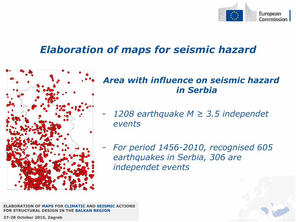
Elaboration of maps for seismic hazard
Area with influence on seismic hazard in Serbia
- 1208 earthquake M ≥ 3.5 independet events
- For period 1456-2010, recognised 605 earthquakes in Serbia, 306 are independet events

ELABORATION OF MAPS FOR CLIMATIC AND SEISMIC ACTIONS FOR STRUCTURAL DESIGN IN THE BALKAN REGION
27-28 October 2015, Zagreb
Elaboration of maps for seismic hazard
• Seismic zones
• 19 seismic zones based on seismotectinic characteristics:
• dominant eartquake mechanism
• fault planes azimuth
• max Magnitude
• earthquake repitability parameter “b”

ELABORATION OF MAPS FOR CLIMATIC AND SEISMIC ACTIONS FOR STRUCTURAL DESIGN IN THE BALKAN REGION
27-28 October 2015, Zagreb
Elaboration of maps for seismic hazard
• Numerical hazard values calculations
• - Hazard is based on the mean value of area
• - Averaging is based on eliptic area with given dimensions
• - max and min magnitudes are given
• - Given grid dimensions for calculations

ELABORATION OF MAPS FOR CLIMATIC AND SEISMIC ACTIONS FOR STRUCTURAL DESIGN IN THE BALKAN REGION
27-28 October 2015, Zagreb
Elaboration of maps for seismic hazard
• Limitations
• - Maps are based on earthquake events only
• - There is not enough data about faults slip rate
• - There is not adequate fault map

ELABORATION OF MAPS FOR CLIMATIC AND SEISMIC ACTIONS FOR STRUCTURAL DESIGN IN THE BALKAN REGION
27-28 October 2015, Zagreb
Progress in the training
• Activities:
• - The introduction of the Eurocodes in civil engineering - Design of concrete structures according to Eurocode 2 (accredited course for professors in secondary schools)
• - Serbian Chamber of Engineers organize webinars in english and lectures by local professors
• - Faculty of Civil Engineering prepares study program for Eurocode 2 with accompanying literature
• - Study program for Eurocode 3 is active
• - Handbook for Eurocode 3 is published

ELABORATION OF MAPS FOR CLIMATIC AND SEISMIC ACTIONS FOR STRUCTURAL DESIGN IN THE BALKAN REGION
27-28 October 2015, Zagreb
Thank You for attention