Embed Size (px)
Citation preview

Page 10‐1
Chapter 10 Chapter 10
Natural Resources Natural Resources This Chapter provides an overview of natural resources in the Borough and their importance to Borough planning. Current resource protection measures are discussed in addition to a plan to maintain, protect, and enhance natural resources both within and beyond the Borough boundaries.
This Chapter provides an overview of natural resources in the Borough and their importance to Borough planning. Current resource protection measures are discussed in addition to a plan to maintain, protect, and enhance natural resources both within and beyond the Borough boundaries.
This chapter also establishes policies supporting future applications to state, federal, and private grant programs that fund natural resource improvement projects. This chapter also establishes policies supporting future applications to state, federal, and private grant programs that fund natural resource improvement projects.
Chapter Organization Chapter Organization
Land and Biotic Resources Inventory, p. 10‐1• Geology, p. 10‐2 • Topography and Slopes, p. 10‐3 • Soils, p. 10‐4 • Wetlands, p. 10‐7 • Woodlands and Street Trees, p. 10‐9 • Natural Diversity and Sustainability, p. 10‐11 Land and Biotic Resource Plan, p. 10‐14
Water Resources Inventory, p. 10‐18 • Watersheds, Headwaters, and Streams, p. 10‐19 • Floodplains, p. 10‐21 • Surface Water Quantity and Quality, p. 10‐22 • Groundwater Quantity and Quality, p. 10‐26 Water Resources Plan, p. 10‐29 Integrated Natural Resource Planning, p. 10‐31 • Existing Programs and Initiatives, p. 10‐31 Integrated Natural Resource Plan, p. 10‐32 Appendix, p. 10‐34
LAND AND BIOTIC RESOURCES INVENTORY
Land resources include the underlying geology, soils which form at the surface, and the topography which is shaped by the weathering process and human development. Land resources need to be well‐managed and properly developed to avoid negative impacts such as erosion and water degradation. Such impacts can be costly to reverse, impacting the Borough’s budget, local economy, and local environment. See Figure 10‐3 and 10‐4 for a visual depiction of these resources.
Biotic resources include plants, animals, and ecosystems such as forests and wetlands. Street trees and vegetated public lands are also a form of biotic resources which can significantly improve real estate values and add to the Borough’s quality of life. Biotic resource planning is also important to the control of animal borne vector diseases such as West Nile and Lyme, as well as other health and environmental issues resulting from exotic invasive plants and overpopulated species.

NNNRRR Chapter 10 – Natural Resources Kennett Square Borough Comprehensive Plan
Page 10‐2
GEOLOGY
Overview The geologic formations that underlie Kennett Square Borough significantly influence its topography and soil characteristics which, in turn, influence drainage, difficulty of excavation, the soundness of foundations, and groundwater supplies. Ground water is discussed later in this chapter.
Existing Conditions The Borough is underlain by five geological formations, all of which lie in bands that extend in an east‐west direction. These five formations are described in Figure 10‐1 and displayed in Figure 10‐3. All of these formations are composed of typically hard metamorphic rocks such as marble, quartzite, schist, gneiss, and amphibolite, a type of rock which is similar to gneiss. The Cockeysville Marble is of particular interest as this formation is prone to issues dealing with contaminants reaching groundwater aquifers in addition to potential for sinkholes or subsidence.
Figure 10‐1: Characteristics of Geological Formations in Kennett Square Borough Geologic Formation and Description* Weathering and Foundation Suitability Drainage and PermeabilityCockeysville Marble (ck) ‐ White, medium to coarse grained marble and light‐grey fine grained banded marble, often containing light brown flakes.
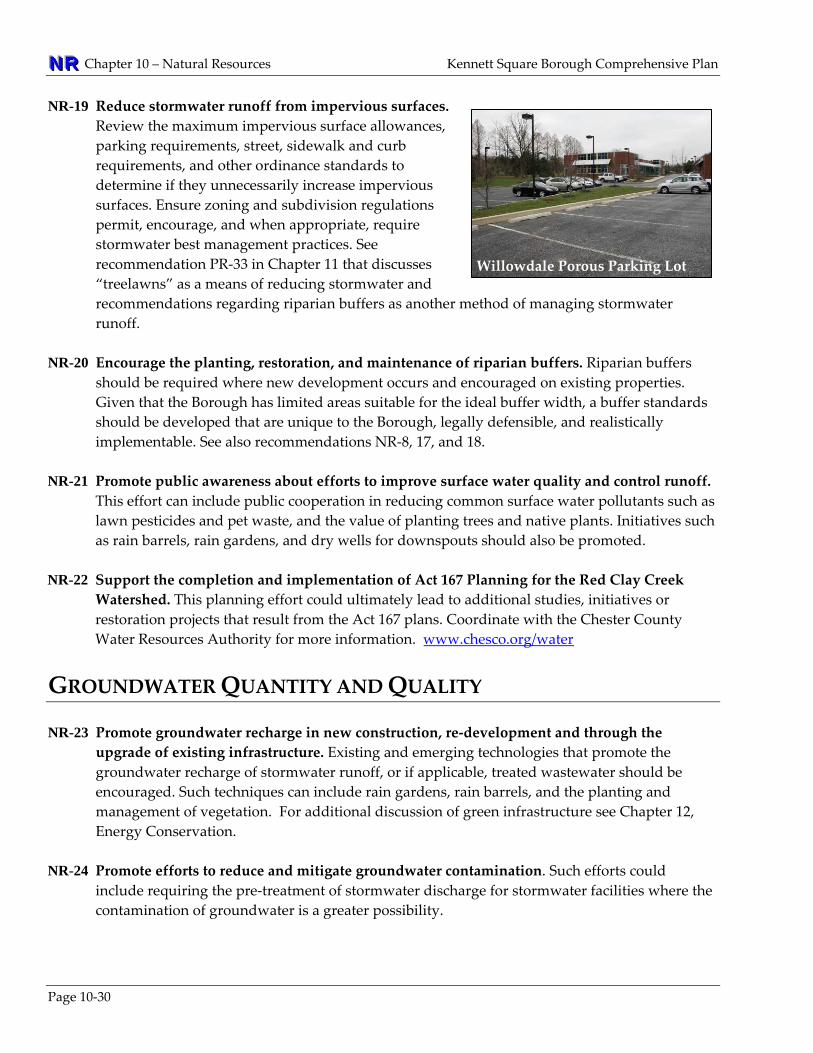
Weathering is moderately resistant. Ease of excavation is difficult. Bedrock pinnacles may be encountered. Cut slope stability is good. Foundation stability is good. Sinkhole and bedrock pinnacle investigations should be made.
Good surface and subsurface drainage. Joint and solution channels produce a secondary porosity of moderate to high magnitude. High permeability.
Felsic Gneiss, granultie facies (Ybfg) ‐ Variable composition: medium to dark‐gray coarse‐grained to light‐gray fine to medium grained gneiss, with quartz bearing rocks in some locations.
Weathering is highly resistant. Ease of excavation is difficult. Cut slope stability is good. Foundation stability is good.
Good surface drainage. Joints provide very low secondary porosity. Low permeability.
Mafic gneiss amphibolite facies (ma) ‐ Dark grey, medium to coarse grained amphibolite.
Weathering is moderately to poorly resistant. Ease of excavation is moderately easy to moderately difficult. Cut slope stability is fair. Foundation stability is good.
Good surface drainage. Joint and bedding plane openings produce secondary porosity of mod. to high magnitude. Low permeability.
Setters Quartzite (st) ‐ White to light grey schist, lower part darker.
Weathering is highly resistant. Ease of excavation is difficult except where highly weathered. Cut slope stability is good. Foundation stability is good.
Good surface drainage. Secondary porosity of low magnitude. Low permeability.
Wissahickon Schist (ws) ‐ Light‐ to medium‐grey, schist and gneiss. Moderately high metamorphic grade, mostly in the amphibolite facies.
Weathering is mod. resistant. Ease of excavation is mod. easy to difficult in un‐weathered rock. Cut slope stability is fair. Foundation stability is good.
Good surface drainage. Joint and cleavage openings provide low secondary porosity. Permeability is low.
Source: *Geology, Hydrology, and Groundwater Quality of Chester County, CCWRA and USGS, 1994. Engineering Characteristics of the Rocks of Pennsylvania, PA Topographic and Geologic Survey, 1982.

Kennett Square Borough Comprehensive Plan Chapter 10 – Natural Resources NNNRRR
Page 10‐3
Planning and Protection Efforts The existing geology provisions in the Borough’s ordinances include: Subdivision and Land Development Ordinance (last amended in October 2006) • Does not specifically address geology. Zoning Ordinance (last amended February 2006) • Section 23‐29.c.21: Requires that unique environmentally significant features be protected from
disruption by mineral extraction.
Issues/Analysis – In recent years a number of multi‐story buildings have been constructed in the Borough. Such projects can require excavation down to the bedrock. This raises concerns regarding the Cockeysville Marble which is prone to solution cavities and possible sinkhole formation. Underground cavities also increase the potential for pollutants to enter groundwater located within the Cockeysville formation. The seriousness of these concerns led nearby East Marlborough, Pennsbury, and New Garden townships to establish a groundwater protection districts in their zoning ordinances.
In the coming years, Kennett Square Borough may also experience an increased use of geothermal heat pumps. Because heat pumps are closed systems that do not interact with the geology or groundwater, it is not anticipated that there will be a need to regulate these activities at the Borough level.
TOPOGRAPHY AND SLOPES
Overview An evaluation of topography and steep slopes is important when determining the appropriate location for new development. The improper development of steep slopes can result in environmental damage such as soil erosion, flooding, and the sedimentation of surface waters, which can prove quite costly to reverse. Ideally, steep slopes should be undeveloped and managed as woodlands or meadows.
Existing Conditions As Figure 10‐3 indicates, much of Kennett Square Borough is located on high ground, which is common for towns founded in the 19th Century. Union Street follows a ridge line separating the watershed of the East and West Branches of the Red Clay Creek. Most of the Borough north of the rail line and west of Broad Street is a hill top with no streams. The southern part of the Borough, along the aptly named Ridge Road, is a ridge trending east‐west much like the underlying mafic gneiss formation. Figure 10‐3 also shows that the Borough is gently rolling to flat, with limited steep and moderately steep slopes located mostly along streams, just east of North Mill Street, and in scattered areas at the base of the southern ridge.
NNNRRR Chapter 10 – Natural Resources Kennett Square Borough Comprehensive Plan
Planning and Protection Efforts The existing steep slope provisions in the Borough’s ordinances include: Subdivision and Land Development Ordinance (last amended in October 2006) • Section 18‐9.e: Requires that a tentative sketch plan include steep slopes. • Section 18‐9.j: Requires that a tentative sketch plan identify ‐ within 100 feet of land being subdivided
or developed ‐ steep slopes. • Section 18‐10.c.1: Requires that a preliminary plan meet the same requirements of Section 18‐9.j. • Section 18‐10.c.2: Requires that a preliminary plan identify ‐ within the land to be subdivided ‐ steep
slopes of less than 15 percent, slopes of 15 to 25 percent, slopes in excess of 25 percent. • Section 18‐25.a: Requires that no permanent excavation of fill be made with a face steeper than three
horizontal to one vertical, except under specific conditions detailed in Section 18‐25. • Section 18‐29.a: Limits earthmoving disturbance and changes to the landscape that would damage
preserved open space or historic sites. Zoning Ordinance (last amended February 2006) • Section 23‐25: Establishes the SS Steep slope overlay district compliant with Section 23‐48 • Section 23‐48.e.2: Permits a maximum disturbance of 30 percent of slopes of 15 to 20 percent, and a
maximum disturbance of 15 percent of slopes of 20 to 25 percent.
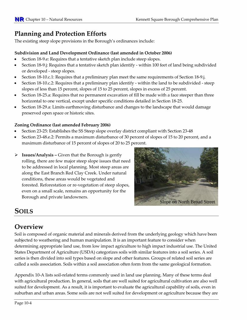
Slope on North Broad Street
Issues/Analysis – Given that the Borough is gently rolling, there are few major steep slope issues that need to be addressed in local planning. Most steep areas are along the East Branch Red Clay Creek. Under natural conditions, these areas would be vegetated and forested. Reforestation or re‐vegetation of steep slopes, even on a small scale, remains an opportunity for the Borough and private landowners.
SOILS
Overview Soil is composed of organic material and minerals derived from the underlying geology which have been subjected to weathering and human manipulation. It is an important feature to consider when determining appropriate land use, from low impact agriculture to high impact industrial use. The United States Department of Agriculture (USDA) categorizes soils with similar features into a soil series. A soil series is then divided into soil types based on slope and other features. Groups of related soil series are called a soils association. Soils within a soil association often form from the same geological formation. Appendix 10‐A lists soil‐related terms commonly used in land use planning. Many of these terms deal with agricultural production. In general, soils that are well suited for agricultural cultivation are also well suited for development. As a result, it is important to evaluate the agricultural capability of soils, even in suburban and urban areas. Some soils are not well suited for development or agriculture because they are
Page 10‐4
Kennett Square Borough Comprehensive Plan Chapter 10 – Natural Resources NNNRRR
Page 10‐5
wet or have a shallow water table. However, these soils can have great ecological and economic value in terms of supporting wetlands that reduce flooding and improve water quality.
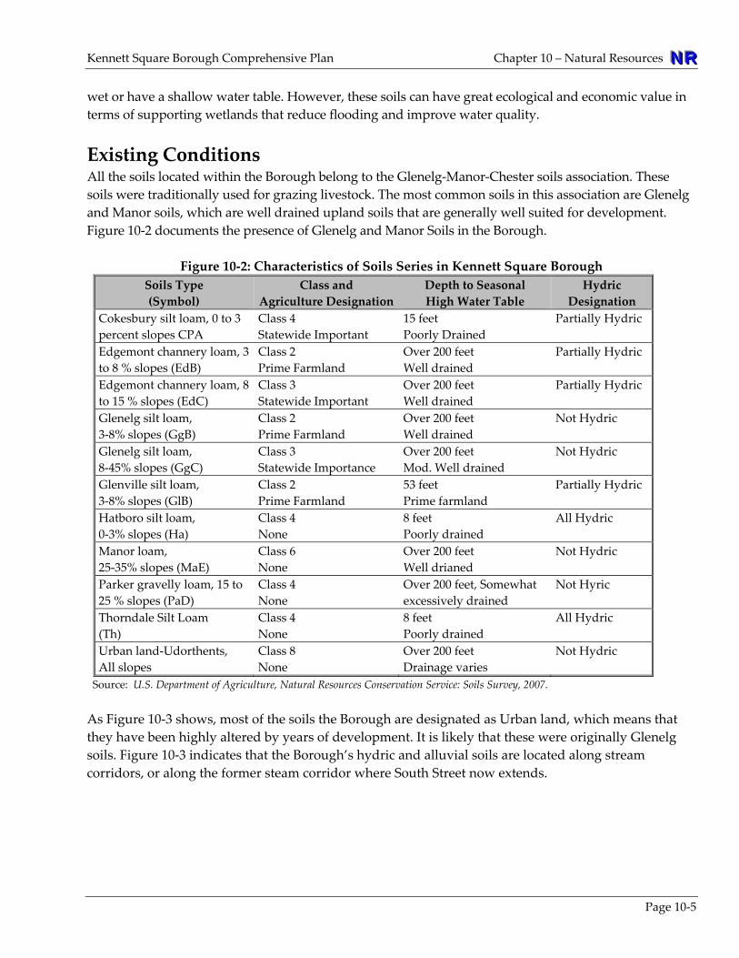
Existing Conditions All the soils located within the Borough belong to the Glenelg‐Manor‐Chester soils association. These soils were traditionally used for grazing livestock. The most common soils in this association are Glenelg and Manor soils, which are well drained upland soils that are generally well suited for development. Figure 10‐2 documents the presence of Glenelg and Manor Soils in the Borough.
Figure 10‐2: Characteristics of Soils Series in Kennett Square Borough Soils Type (Symbol)
Class andAgriculture Designation
Depth to Seasonal High Water Table
Hydric Designation
Cokesbury silt loam, 0 to 3 percent slopes CPA
Class 4 Statewide Important
15 feet Poorly Drained
Partially Hydric
Edgemont channery loam, 3 to 8 % slopes (EdB)
Class 2 Prime Farmland
Over 200 feet Well drained
Partially Hydric
Edgemont channery loam, 8 to 15 % slopes (EdC)
Class 3 Statewide Important
Over 200 feet Well drained
Partially Hydric
Glenelg silt loam, 3‐8% slopes (GgB)
Class 2 Prime Farmland
Over 200 feet Well drained
Not Hydric
Glenelg silt loam, 8‐45% slopes (GgC)
Class 3 Statewide Importance
Over 200 feet Mod. Well drained
Not Hydric
Glenville silt loam, 3‐8% slopes (GlB)
Class 2 Prime Farmland
53 feet Prime farmland
Partially Hydric
Hatboro silt loam, 0‐3% slopes (Ha)
Class 4 None
8 feet Poorly drained
All Hydric
Manor loam, 25‐35% slopes (MaE)
Class 6 None
Over 200 feet Well drianed
Not Hydric
Parker gravelly loam, 15 to 25 % slopes (PaD)
Class 4 None
Over 200 feet, Somewhat excessively drained
Not Hyric
Thorndale Silt Loam (Th)
Class 4 None
8 feet Poorly drained
All Hydric
Urban land‐Udorthents, All slopes
Class 8 None
Over 200 feet Drainage varies
Not Hydric
Source: U.S. Department of Agriculture, Natural Resources Conservation Service: Soils Survey, 2007. As Figure 10‐3 shows, most of the soils the Borough are designated as Urban land, which means that they have been highly altered by years of development. It is likely that these were originally Glenelg soils. Figure 10‐3 indicates that the Borough’s hydric and alluvial soils are located along stream corridors, or along the former steam corridor where South Street now extends.

NNNRRR Chapter 10 – Natural Resources Kennett Square Borough Comprehensive Plan
Page 10‐6
Planning and Protection Efforts The soils provisions in the Borough’s ordinances include: Subdivision and Land Development Ordinance (last amended in October 2006) • Section 18‐29.c: Requires preservation of topsoil and the seeding of slopes of less than 10 percent,
and planting groundcover on slopes of 20 percent or more. • Section 18‐32: Requires sediment and erosion control to be in compliance with DEP codes. Zoning Ordinance (last amended February 2006) • Section 23‐26.c.3.C: Addresses continuity of landscaping in the MSD Main Street Development
overlay district. • Section 23‐24: Establishes FP Flood overlay district that addresses sedimentation and stream bank
degradation Stormwater ordinance (adopted in 2006)
Issues/Analysis – Most of the soils underlying the Borough are urban soils that have been graded and modified through decades of development. It is likely that the original soils were productive agricultural soils that were also well suited for development. As a result the soils within the Borough would be well suited both for redevelopment and vegetation including street trees and natural restoration areas. Because the Borough is a small town that has largely been developed, the Borough’s soil regulations have never been extensive. Given that the Borough is a headwaters area, there are opportunities to update regulations to ensure they address increasingly stringent stormwater concerns and issues.

Kennett Square Borough Comprehensive Plan Chapter 10 – Natural Resources NNNRRR
Figure 10‐3: Land Resources
WETLANDS
Page 10‐7
Overview Wetlands are ecosystems that include swamps, marshes, and the edges of many ponds and streams. Wetlands also include wet meadows or wet forested areas that most people would not regard as “wet.” In Chester County, any area dominated by phragmites, cattails, or skunk cabbage is likely to be a wetland. Under Section 404 of the Federal Clean Water Act of 1977, as amended, wetlands are protected by the Army Corps of Engineers and the Pennsylvania Department of Environmental Protection. According to federal guidelines, a wetland must have all of the features described below:

NNNRRR Chapter 10 – Natural Resources Kennett Square Borough Comprehensive Plan
Page 10‐8
• Wetland hydrology develops when water stays in a soil long enough to create anaerobic conditions that limit the types of plants that can grow there. “Anaerobic” conditions occur when all the dissolved oxygen is removed from water, usually due to the decomposition of organic matter.
• Hydric soils are soils that are saturated, flooded, or ponded long enough during the growing season (usually in spring) to develop anaerobic conditions in the upper part, which is the soil layer closest to the surface. The USDA publishes a listing of these soils in Hydric Soils of the United States.
• Hydrophytic vegetation is plant life that grows in shallow water, on wet soil, or another wet substrate, such as sand, that is at least periodically deficient in oxygen because of excessive water content. The US Fish and Wildlife Service publishes a National List of Plants that Occur in Wetlands.
Wetlands improve surface and ground water quality by removing suspended and dissolved materials and chemicals. This natural water filtration processing occurs as water passes through wetland soils and though the roots and stems of the individual wetland plants. Wetlands also help control flooding by storing water during times of heavy rain, snowmelt, or high‐water discharge from adjacent streams. The root systems of wetland plants effectively control erosion by anchoring the soils along riverbanks and the shores of lakes and ponds. As a result, wetlands provide both ecological and economic benefits.
Existing Conditions Figure 10‐4 shows wetland areas mapped by the National Wetlands Inventory (NWI) using aerial photography, as well as wetlands mapped by Chester County in 1992 using the Anderson Land Use system. Mapping indicates that the few wetlands in the Borough are all located along the East Branch of the Red Clay Creek. There may be the potential for a few additional wetlands in the remainder of the Borough as Figure 10‐4 shows hydric and alluvial soils occurring in the same overall location as the wetlands in addition to other areas. Hydric soils are sometimes areas that were former wetlands which were drained for agriculture or other uses. Further studies of these areas may reveal additional unmapped wetlands. The Borough’s wetlands have been invaded to some degree by non‐native species. If left unchecked, species such as the European variety of common reed (phragmites australis) can eliminate most other plant species in a wetland. Invasive species are detrimental to the water processing function of wetlands, diminishing their ecological and economic benefits.
Planning and Protection Efforts The wetlands provisions in the Borough’s ordinances include: Subdivision and Land Development Ordinance (last amended in October 2006) • Section 18‐9.j: Requires that a tentative sketch plan identify ‐ within 100 feet of land being
subdivided or developed ‐ wetlands. • Section 8‐10.c.1: Requires that a preliminary plan meet the same requirements of Section 18‐9.j. • Section 8‐10.c.2: Requires that a preliminary plan identify – within the land to be subdivided ‐
wetlands. Zoning Ordinance (last amended February 2006) • Section 23‐49: Prohibits construction within wetlands, within 15 feet of wetlands. Forbids structures
and impervious surfaces within the 100‐year floodplain, except as permitted by the PA DEP.
Kennett Square Borough Comprehensive Plan Chapter 10 – Natural Resources NNNRRR
Issues/Analysis – The Borough’s few wetlands are mostly located along the East Branch Red Clay Creek, which is also where the Borough’s woodlands are located. As a result, there is an opportunity for both these wetlands and their adjacent woodlands to be managed and perhaps expanded, through a single coordinated restoration effort. The area of hydric soils along South Street might also be a good location for wetlands to be restored or created. In coming years there may be opportunities for the Borough’s to update their wetlands identification and regulations using emerging mapping technologies. There are also new techniques for restoring wetlands that could be addressed in ordinances to better position the Borough to receive state and federal restoration grants.
WOODLANDS AND STREET TREES
Overview Woodlands and trees provide wildlife habitat, reduce ambient temperatures in the summer, and can increase real estate values. Tree roots reduce erosion on steep slopes and in floodplains. Streams shaded by trees have a wider diversity of plant and animal species that serve to purify water as part of their life cycles. Street trees improve air quality and reduce wind born dust. Key planning terms regarding trees include: • Edge Environment refers to the forest edge, where trees grow next to
open areas. These places are favored by species such as deer, which take cover in the forests, but search nearby open areas for food.
• Interior Forest refers to that part of a large forest which is at least 300
feet away from the edge of the forests. These deep forest areas support wildlife that prefer isolated habitat.
• Forested Riparian Buffer refers to a vegetated area along a stream in which trees were allowed to
grow, or were planted. This topic is discussed in more detail under Surface Water Quantity and Quality on page 10‐23.
• Street Trees, also called shade trees, may be planted along streets, in parking
lots, on homeowner association open space, or within the grounds of office parks and other campuses.
• Heritage Trees are usually individual older trees with historic or local
community significance.
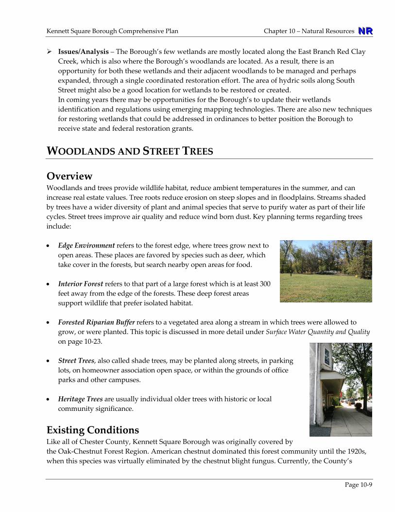
Existing Conditions Like all of Chester County, Kennett Square Borough was originally covered by the Oak‐Chestnut Forest Region. American chestnut dominated this forest community until the 1920swhen this species was virtually eliminated by the chestnut blight fungus. Currently, the County’s
,
Page 10‐9
NNNRRR Chapter 10 – Natural Resources Kennett Square Borough Comprehensive Plan
Page 10‐10
forests are classified as Mixed Oak Forest, dominated by oaks, mixed with tulip poplar, red mabeech. Typical understory shrubs include sassafras, spicebush, and varieties
ple and of viburnum.
As Figure 10‐4, shows, there are only two major stands of woodlands (forests) in Kennett Square Borough, both located along the East Branch Red Clay Creek north of the rail line. One major forest stand grows south of Cypress Street. The other stand is clustered in and around Anson B. Nixon Park, and extends north along the East Branch Red Clay Creek for approximately one mile. These two stands are deciduous and include areas that are 400‐ to 600‐feet thick, making it possible that they contain some interior forest condition. Within the Borough, street trees are abundant and shade trees are common in residential yards. Some of these trees are old, and may be approaching the end of their natural age. Like many older communities on the East Coast, it is possible that in coming years the Borough could experience a mass die off of older trees. No individual heritage trees have been identified in the Borough, but there are large “specimen trees” located in yards or public settings. These trees may be native or non‐native. Older planning documents refer to trees known as “Kennett Beeches” which are said to be rare and still grow in Anson B. Nixon Park.
Planning and Protection Efforts The woodlands and street tree provisions in the Borough’s ordinances include: Subdivision and Land Development Ordinance (last amended in October 2006) • Section 18‐9.e: Requires that a tentative sketch plan include woodlands. • Section 8‐10.c.3: Requires that a preliminary plan identify the locations, species and sizes of trees
standing along the outer limits of tree masses, and the location of quarries, marshland and other topographical features which may affect the location of proposed roads or buildings.
• Section 18‐18.d.6: Requires that all vegetation in a roadway right‐of‐way be less than one‐foot tall, and that street trees do not interfere with sight triangles at intersections and entranceways.
• Section 18‐29.b: Calls for the protection of all trees six inches in diameter at breast height, unless there is sound justification. It also calls for the relocation of noteworthy vegetation if practicable.
• Section 18‐29.d: Permits a plan to be submitted ‐ for projects where there is a conscientious effort to preserve existing natural integrity ‐ to preserve woodlands and trees in lieu of landscaping requirements.
Zoning Ordinance (last amended February 2006) • Section 23‐9.g: Permits forestry use by right in all zoning districts as required by Section 603(f) of
Act 247. The Pennsylvania Municipalities Planning Code (MPC). • Section 23‐9.l.6: Requires a 15‐foot tall vegetative screening on the side and back of property
adjacent to a residential or institutional district. Also sets a minimum height for installed trees and minimum expected height at maturity.
• Section 23‐19.i: In the C‐2 district, calls for the same lighting requirements as 23‐9‐l.4, and the same vegetation requirements as 23‐9‐l.6
• Section 23‐19.k: In the OI‐1 district, calls for the same lighting requirements as 23‐9‐l.4, and the same vegetation requirements as 23‐9‐l.6

Kennett Square Borough Comprehensive Plan Chapter 10 – Natural Resources NNNRRR
• Section 23‐26.c.3.C: Addresses continuity of landscaping in the MSD Main Street Development overlay district.
• Section 23‐29.b.3: For conditional uses, calls for the same vegetation requirements as 23‐9‐l.6 • Section 23‐41: Requires a planting plan for all areas not used for buildings or other paved surfaces. • Section 23‐46: Requires all land uses to minimize impacts to forested areas and other natural
features.
Issues/Analysis – Although the Borough is small, there are opportunities for installing additional street trees, protecting and expanding remaining forested areas, and installing or enhancing riparian buffers along creeks, streams, and wetlands. Planting trees is a proven way to sequester carbon, which reduces greenhouse gasses. The Borough may be able to obtain financial benefits from planting trees through a carbon trading market.
NATURAL DIVERSITY AND SUSTAINABILITY
Overview Natural diversity and sustainability refers to the ability of natural ecosystems to maintain themselves as healthy living systems. A sustainable environment supports a diversity of plants and animals, which in turn promotes public health and a strong economy. For example, the presence of healthy vegetation can reduce flooding and improve water quality, thus reducing costs for homeowner insurance and public infrastructure upgrades. On the detrimental side, the loss of fresh water mussels in Chester County has resulted in a decrease in stream water quality. Aggressive non‐native plant species such as Japanese knotweed, multiflora rose, and mile‐a‐minute can shade out or parasitize native trees, effecting native habitat and effective flood resistant species. Furthermore, the advent of animal‐born vector illnesses such as Lyme and West Nile now make it necessary to address wildlife management, such as deer control, as part of disease prevention. High deer populations pose a threat to woodlands. The unnaturally high populations of deer in this region excessively browse the buds and seedlings of native tree species, preventing forests from being able to regenerate. The high deer population also facilitates the spread and potential for Lyme disease.
Existing Conditions The Federal Endangered Species Act of 1973 list a species as “endangered” when it is in danger of extinction, or “threatened” when it is likely to become endangered. Similarly, Pennsylvania legislation (PA Title 25, Chapter 82 , PA Title 30 Chapter 75, and PA Title 34, Chapter 133) jointly designate species as either “Pennsylvania Endangered” or “Pennsylvania Threatened.” Furthermore, plants that are rare, vulnerable, or probably extinct are listed as “Species of Special Concern.” The Pennsylvania Natural Heritage Program maintains the Pennsylvania Natural Diversity Inventory (PNDI), which maps the locations of potential habitat of species protected by the state and federal legislation noted above.
Page 10‐11

NNNRRR Chapter 10 – Natural Resources Kennett Square Borough Comprehensive Plan
Page 10‐12
A cursory PNDI evaluation for the Borough was conducted using the PNDI on‐line mapping system in June of 2010. This evaluation indicated a “potential impact” to two species: • Yadkin River Panic‐grass, Panicum yadkininese, PA Special Concern Species • Autumn Bluegrass, Poa autumnalis, PA Endangered These species are located at one or more locations in the northeast part of the Borough. Only a field view can determine the presence of these species. No species were listed on PNDI in the remainder of the Borough. Kennett Square Borough is similar to most communities in the eastern United States in that it has lost much of its pristine habitat and original biological diversity. Native grasses have largely been replaced by non‐native lawn grasses, such as Kentucky‐bluegrass which is a European‐Asian hybrid. Non‐native Norway maples and Paulonia trees are common in forested areas and along roadways. Ground cover such as Japanese knotweed, lesser celandine, and garlic mustard, aggressively shade out native plants. When native plants disappear, it can reduce the population of the animals that feed or nest in them. The development of land can actually increase the population of some species. House mosquitoes breed more successfully in old tires and clogged gutters than in wetlands where there are birds and bats that eat mosquitoes. Railroad corridors are a preferred habitat for Norway rats, and densely placed houses are preferred by house mice. These rodents cannot survive in the wild. Squirrels, deer, Canada geese, and other “habituated” wild species flourish in developed landscapes with a mix of open lawn and trees. Deer populations have grown so large they are now referred to as an “un‐naturalized” species. The Borough contains limited in‐stream habitats for aquatic species. According to PA Chapter 93: Water Quality Standards, there are no designated Exceptional Value or High Quality streams in the Borough. However, Chapter 93 lists all of the streams in the Borough as TSF (Trout Stocking – Maintenance of stocked trout from February 15 to July 31 and maintenance and propagation of fish species and additional flora and fauna which are indigenous to a warm habitat.) The Borough includes no streams on the PA Fish & Boat Commission Listing of Surveyed Streams Having Verified Trout Reproduction.
Planning and Protection Efforts The natural diversity and sustainability provisions in the Borough’s ordinances include: Subdivision and Land Development Ordinance (last amended in October 2006) • Section 18‐9.j: Requires that a tentative sketch plan identify ‐ within 100 feet of land being
subdivided or developed ‐ any natural features impacting the ability of the applicant to subdivide or develop the land in question.
• Section 8‐10.c.2: Requires that a preliminary plan identify ‐ within the land to be subdivided ‐ any natural features impacting the ability of the applicant to subdivide or develop the land in question.

Kennett Square Borough Comprehensive Plan Chapter 10 – Natural Resources NNNRRR
Zoning Ordinance (last amended February 2006) • Section 23‐46.a: Requires all uses to be developed in a manner consistent with any natural amenities
present on site. According to Linking Landscapes (2002), the County’s adopted open space plan, there is one County‐designated Wildlife Biodiversity Corridor within the Borough, as shown on Figure 10‐4. This corridor is an area with a high potential to be restored as a regional wildlife corridor.
Issues/Analysis – The Borough is largely developed with limited opportunities to substantially improve natural diversity. Thus, any major natural resource initiatives could be addressed though public‐private partnerships. Even small efforts can improve wildlife habitat and result in increased biodiversity. The steep wooded hillsides in the north of the Borough could be improved through forest management, which could be as simple as removing non‐native plants. Currently, the habitat in the Borough supports deer, geese, ticks, and house mosquitoes. Thus, it may be prudent for the Borough to regularly update animal control efforts so that it can employ new advances in wildlife management.
Figure 10‐4: Biotic Resources
Page 10‐13

NNNRRR Chapter 10 – Natural Resources Kennett Square Borough Comprehensive Plan
Page 10‐14
LAND AND BIOTIC RESOURCE PLAN
GEOLOGY, SOILS, AND STEEP SLOPES The following recommendations are provided as tools to limit the disturbance of geologic formations and soils to promote soil stability, and to prevent excessive soil erosion, sinkhole formation, and the degradation of groundwater, surface water, and stream valleys. Recommendations regarding the protection of seasonal high water table soils, low‐lying hydric an alluvial soils, and protection of soils from stormwater erosion are presented under Water Resources Recommendations.
Geology, Soil, and Soils Erosion NR-1 Consider the adoption of provisions to protect the Cockeysville Marble Formation. This effort
would include adopting a zoning overlay district to address the impact of development on groundwater quality. The overlay district should follow the boundaries of underlying carbonate rock formations. Requirements would include a field inventory and in some cases test prior to development for land underlain by carbonate geology. Some land uses such as underground tanks holding know water pollutants, may be prohibited. Support studies and mapping efforts that focus on better understanding groundwater and geological features of the Cockeysville Marble Formation may be necessary prior to adoption of these regulations or may be required by them.
NR-2 Promote best management practices (BMPs) to protect soil from erosion and reduce
sedimentation into streams. Consider updating ordinances to reflect the latest advances in soil erosion and sedimentation BMPs that support the use of BMP’s during and after the construction phase. The Chester County Conservation District (CCCD) reviews any construction project that disturbs once acre or more of land and is available to review municipal erosion and sedimentation standards to ensure they are in compliance with DEP regulations, and are appropriate for an urban setting. The Borough should coordinate with CCCD on subdivision and land development applications and ordinance revisions.
Steep Slopes NR-3 Protect, enhance, and restore wooded or vegetated steep slopes to protect soil stability and
reduce flooding. Consider updating ordinances to include disturbance limitations and limitations on the clearing of vegetation on steep slopes to promote soil stability and prevent excessive soil erosion and stormwater runoff. Additional considerations include more detailed requirements for vegetation installed on steep slopes with a preference for trees and woody plants with strong roots. The Borough should also support programs, such as those administered by the County Conservation District, which serve to stabilize steep slopes in both new and existing developments, including re‐vegetation and stream bank stabilization.
Kennett Square Borough Comprehensive Plan Chapter 10 – Natural Resources NNNRRR
Page 10‐15
NATIVE VEGETATION, WETLANDS, AND WILDLIFE HABITAT The following recommendations are provided as tools to promote native plants and natural diversity, and to protect, restore, and maintain areas that provide wildlife habitat. Habitats may include stream valleys, steep slopes, floodplains, woodlands, wetlands, hedgerows, and sites that harbor unique ecosystems or threatened and endangered species. Recommendations regarding public gardens, urban forestry, and street trees are presented under Street Trees and Urban Greening Recommendations on page 10‐15.
Native Vegetation NR-4 Promote sustainable plant communities and the restoration of vegetated areas dominated by
non‐native or invasive native species. Consider updating ordinances to:
• require the use of native plant species in natural settings • promote the use of native plants in landscaping and new development • include listing of plants that are native • include a listing of plants that are appropriate or adaptable to specific planting
situations, such as plants well suited for a commercial main street or for underneath overhead lines
• include a listing of noxious or invasive plant to be prohibited Support efforts, studies, and requirements that focus on restoring sustainable native plant communities and managing or removing invasive or noxious plants. Invasive species should be managed and if possible, eradicated in forests, wooded lots, meadows, wetlands, steep slopes, floodplains, and riparian buffers. Native plants should be promoted in residential yards, nonresidential landscaped areas, and other graded areas such as railroad rights‐of‐way and stormwater retention basins.
Wetlands NR-5 Continue to protect, manage, and restore wetlands, and promote wetland hydrology and
sustainable wetland plant communities. Consider updating ordinances to include a minimum 50‐foot non‐disturbance margin beyond the boundary of delineated wetlands and allow environmentally sensitive exceptions for the disturbance of the wetland margin. Such exceptions could include the removal of invasive plant species and regulated activities permitted by the Commonwealth. Consider updating ordinances to require that both wetlands and hydric soils be identified on tentative and preliminary sketch plans. Hydric soils are prone to support small wetlands that may not be included on readily available wetlands maps generated from aerial photography. Support efforts to restore wetlands and wetland hydrology; remove invasive plants from wetlands; and create wetlands in areas with wet soils that can support wetland plants.
NNNRRR Chapter 10 – Natural Resources Kennett Square Borough Comprehensive Plan
Page 10‐16
Forests and Wood Lots NR-6 Protect, restore, expand, and manage forested areas and wood lots, especially on naturally
sensitive areas. Consider updating ordinances to recognize forests and wood lots as an environmentally sensitive feature which should not be disturbed, and should be replaced if disturbance is unavoidable. Consider including a definition of tree resources to include forests, wood lots, wooded riparian buffers, forested wetlands, and vegetated steep slopes. Support efforts to establish and maintain wooded greenways, steep slopes, public lands, and common open space within developments. Support efforts to reforest un‐forested public and private lands that would better function for the community and the ecology if they were forested.
NR-7 Revise and focus all currently dispersed forestry and street tree ordinance provisions in one
or two sections. The Borough’s ordinances address woodlands and street trees in a number of sections. Subdivision ordinance sections dealing with vegetation requirements all include the same text (Sections 23‐9‐l.6, 23‐19.i, 23‐19.k, and 23‐29.b.3). As a result, there is an opportunity for the Borough to revise and focus all its currently dispersed forestry and street tree provision into one or two ordinance sections.
Riparian Buffers NR-8 Encourage the restoration and maintenance of riparian buffers along streams, water bodies,
and where appropriate, wetlands. Consider updating ordinances to include riparian buffer requirements. Ordinances should designate the East Branch Red Clay Creek and the Unnamed Tributary at South Street as environmentally sensitive features. Scientific consensus indicates that a riparian buffer should be a minimum of 100 feet wide to provide the ideal stream protection benefits. When there is insufficient land to accommodate a 100‐foot buffer, one with an average width of 50‐feet is considered acceptable. Given that the Borough has limited open land, a unique buffer standard should be considered where a 100 or 50 foot buffer is not realistic. The minimum standard should be a 15‐foot no mow/low mow zone and tree plantings along stream banks. The Borough should also participate in a unified regional approach to preserving and restoring riparian buffers in conjunction with the Red Clay Valley Association.
The Borough should take steps to educate property owners adjacent to streams and creeks as to the importance of riparian buffers as a preemptive measure to enforcing potential riparian buffer requirements. Support the expansion or installation of riparian buffers such as at Anson B. Nixon Park, the area to the east of the Kennett Community Pool, and industrial areas such as just west of the Kennett Community Park. Voluntary establishment of buffers should be encouraged in addition to assistance with funding, grants, and coordination with organizations to facilitate riparian buffers.
NR-9 Secure funding for additional street trees where they are lacking in addition to planting or
enhancement of riparian buffers. There are now increasing funding opportunities for planting trees, most notably the state‐funded TreeVitalize program administered by the Pennsylvania Horticultural Society. These programs focus on reforesting riparian buffers; planting new and
Kennett Square Borough Comprehensive Plan Chapter 10 – Natural Resources NNNRRR
Page 10‐17
appropriate species of street trees; or planting trees on public property. As a result, there are opportunities for the Borough take advantage of these funding sources and to conduct outreach with private landowners to make them aware of these programs.
STREET TREES AND URBAN GREENING The following recommendations are provided as tools to maintain, restore, and expand street trees, tree stands, public gardens, and other vegetated areas throughout the Borough to promote air quality, improve the economy, and maintain the small town quality‐of‐life. NR-10 Promote the planting and maintenance of appropriate street trees and shade trees. Consider
updating ordinances to include a section dedicated to street trees and shade trees. This section could include a listing of tree species (See Appendix 10‐B) that are appropriate for different settings, such as main streets, wet areas, and within corridors with overhead or underground utilities. Support efforts to promote urban forestry in residential, commercial and all other private and public developed settings, including parking lots, parks, buffer plantings, and on residential properties.
NR-11 Update tree planting and tree replacement standards to ensure the long‐term survival of
planted trees. Consider updating ordinances to establish one section dedicated to proper tree planting standards, which can then be referenced in other sections. Consider updating ordinances to include provisions for the installation or replacement of street trees. Support efforts to improve the survival rate of tree saplings based on current sylviculture practices made available from organizations such as the Chester County Conservation District.
NR-12 Educate and inform the public about maintaining trees and selecting and planting the proper
tree or vegetation for a given location. Such an effort can be implemented through the Borough Web site or through cooperation with other organizations. Proper tree selection can avoid damage to sidewalks or utility lines cause by planting fast or tall growing trees in areas with infrastructure. A suggested plant list for street trees and general landscaping is presented in Appendix 10‐B. The planting of native species by homeowners and businesses should be encouraged. Investigate funding opportunities to plant new and appropriate species of trees along public streets, on public property, or on private property by landowners.
WILDLIFE MANAGEMENT AND HABITAT PROTECTION The following recommendations are provided as tools to manage animal species, and to promote a diversity of native wildlife while minimizing negative animal‐based impacts to the environment or public health and safety. Wildlife management can apply to “un‐naturalized” species who adapt well to urban areas. Animal species include terrestrial and aquatic wildlife, and insects. Natural diversity is also enhanced through other recommendations throughout this Chapter such as the protection and enhancement of riparian buffers, native species, woodlands, steep slopes, wetlands, and floodplains.

NNNRRR Chapter 10 – Natural Resources Kennett Square Borough Comprehensive Plan
Page 10‐18
NR-13 Protect, restore, and manage locally important habitats, unique habitats, migration corridors, and plant and animal species that are, or become, designated as rare, threatened, or endangered by federal or state agencies. Consider updating ordinances to include the protection of “locally important habitats,” such as stream corridors and woodland that are locally important but have no state or federal designation. The East Branch White Clay Creek should be considered as a local designation. Consider updating ordinances to recognize Pennsylvania Natural Diversity Index sites that are mapped and updated on line or using new technologies. Support efforts to plan, fund, and establish noteworthy habitats, though programs such as TreeVitalize, and efforts by non‐profit land trusts and recreational groups like KAPA.
NR-14 Promote beneficial species and consider methods to address the control of wildlife species
and the promotion of beneficial species. Support efforts to manage animal species in order to protect human health and safety. Wildlife, such as white tailed deer and Canada geese, whose high population densities have become un‐naturalized, need to have their population controlled. These species also need to have their health maintained. Support efforts to promote beneficial species, such as providing bird houses and bat boxes for insect eating species. The Borough should coordinate with local deer management efforts including communication with Kennett Township and London Britain Township. In particular, deer control and Lyme disease control efforts may be most appropriate in Anson B. Nixon Park in coordination with the Kennett Area Park Authority.
NR-15 Reduce inappropriate or excessive lighting that can negatively impact plants and animals.
Consider updating ordinances to include “dark sky” lighting regulations to reduce glare, particularly towards the sky, through requirements such as full cut‐off lighting fixtures and similar best management practices. Support efforts for public lighting that provides for public safety but is also sensitive to the environment and consistent with the traditional lighting in historic neighborhoods.
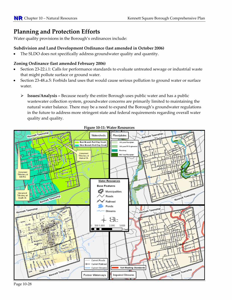
WATER RESOURCES INVENTORY Water resources from streams and ponds, groundwater, and stormwater runoff significantly impact the natural environment and the human community. Maintaining good water quality supports wildlife and reduces the cost of clean drinking water. The quantity of water is equally important. Excessive stormwater runoff can lead to flooding, erosion, and sedimentation. Likewise, streams that receive too much or too little water can erode, resulting in potentially unsafe flooding during storms. When evaluating water resources, it is essential to focus on a number of landscape features that influence the quality and quantity of surface water, groundwater, and stormwater runoff. Floodplains are landforms which can control floodwaters. Groundwater is evaluated based on the water bearing characteristics of the underlying geology. Riparian buffers, which are landscapes that include trees, shrubs, or meadow grasses, serve to protect both the quality and quantity of the streams they surround. Because watersheds cross political boundaries, watershed management is most effective when carried out on a regional level. For example, conditions within a municipality can impact flooding and water
Kennett Square Borough Comprehensive Plan Chapter 10 – Natural Resources NNNRRR
pollution in downstream communities and likewise be affected by issues upstream. See Figure 10‐11 for a depiction of Water Resources.
WATERSHEDS, HEADWATERS, AND STREAMS
Page 10‐19
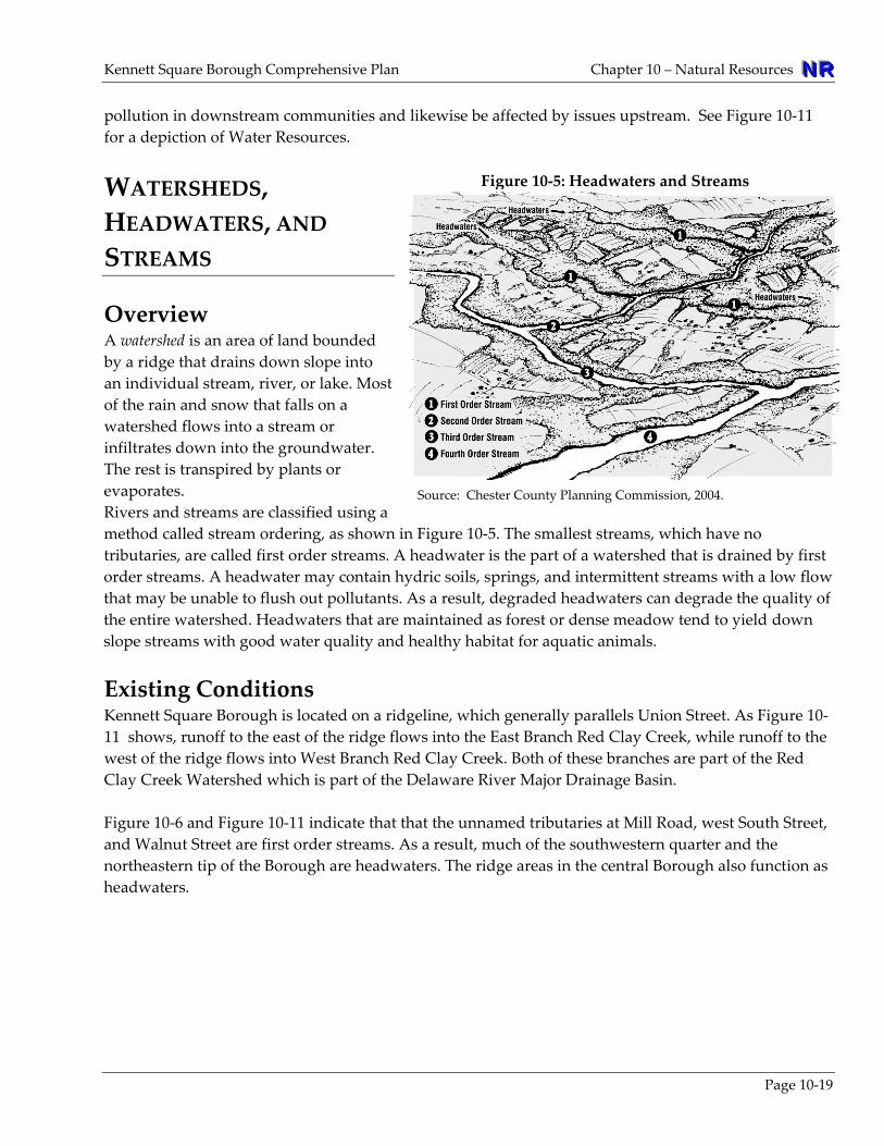
Overview A watershed is an area of land bounded by a ridge that drains down slope into an individual stream, river, or lake. Most of the rain and snow that falls on a watershed flows into a stream or infiltrates down into the groundwater. The rest is transpired by plants or evaporates. Rivers and streams are classified using a method called stream ordering, as shtributaries, are called first order streams. A headwater is the part of a watershed that is drained by first order streams. A headwater may contain hydric soils, springs, and intermittent streams with a low flothat may be unable to flush out pollutants. As a result, degraded headwaters can degrade the qthe entire watershed. Headwaters that are maintained as forest or dense meadow tend to yieldslope streams with good water quality and healthy habitat for aquatic animals.
Figure 10‐5: Headwaters and Streams
Source: Chester County Planning Commission, 2004.
own in Figure 10‐5. The smallest streams, which have no
w uality of down
xisting Conditions ted on a ridgeline, which generally parallels Union Street. As Figure 10‐
igure 10‐6 and Figure 10‐11 indicate that that the unnamed tributaries at Mill Road, west South Street,
ion as
EKennett Square Borough is loca11 shows, runoff to the east of the ridge flows into the East Branch Red Clay Creek, while runoff to the west of the ridge flows into West Branch Red Clay Creek. Both of these branches are part of the Red Clay Creek Watershed which is part of the Delaware River Major Drainage Basin. Fand Walnut Street are first order streams. As a result, much of the southwestern quarter and the northeastern tip of the Borough are headwaters. The ridge areas in the central Borough also functheadwaters.

NNNRRR Chapter 10 – Natural Resources Kennett Square Borough Comprehensive Plan
Page 10‐20
Figure 10‐6: Streams within Kennett Square Borough Name
(Length in Borough)
Location
First Order stream
Minor Watershed(% of watershed in the Borough)
Watershed (% in the Borough)
MajorDrainageBasin
East Branch Red Clay Creek ( 8,000 feet)
From Nixon Park in Kennett Twp., southward to north of South East Street in Kennett Twp.
No East Branch Red Clay Creek
(52%)
Red Clay Creek (100%)
DelawareRiver Basin
Unnamed Tributary at Walnut St. (1,400 feet)
From north of Walnut Street, from East Branch Red Clay Creek, northeast into Kennett Township.
Yes East Branch Red Clay Creek
(52%)
Red Clay Creek (100%)
Delaware River Basin
Unnamed Tributary at South St. (2,300 feet)
From north of South Street and east of Grant Way. East into Kennett Township.
Yes West Branch Red Clay Creek
(48%)
Red Clay Creek (100%)
Delaware River Basin
Unnamed Tributary at Mill Rd. (400 feet)
From east of Mill Road and north of Meadwcreek Lane, south east into Kennett Square.
Yes West Branch Red Clay Creek
(48%)
Red Clay Creek (100%)
Delaware River Basin
Source: Chester County Planning Commission, 2009
The Pennsylvania Stormwater Planning Act of 1977 (Act 167) requires stormwater management plans to be completed for all watersheds to identify stormwater and flooding problems within a given watershed and develop strategies to address them. Act 167 requires municipalities to adopt minimum ordinance provisions that standards establish a consistent set of minimum stormwater management design standards to be applied throughout the entire watershed covered by the plan. Although none of Kennett Square’s watersheds are currently addressed by an Act 167 Plan, a County Act 167 Plan is being developed. Further discussion of Stormwater issues is included in Chapter 8, Community Facilities and Services.
Planning and Protection Efforts The watersheds, headwaters, and stream provisions in the Borough’s ordinances include: Subdivision and Land Development Ordinance (last amended in October 2006) • Section 18‐9.j: Requires that a tentative sketch plan identify ‐ within 100 feet of land being
subdivided or developed ‐ watercourses and bodies of water. • Section 18‐10.c.1: Requires that a preliminary plan meet the same requirements of Section 18‐9.j. • Section 18‐10.c.2: Requires that a preliminary plan identify ‐ within the land to be subdivided ‐
watercourses and bodies of water. Zoning Ordinance (last amended February 2006) • Section 23‐44.a.1: Requires a homeowners association to be responsible for stormwater control
facilities on their commonly owned property. • Section 23‐24: Establishes FP Flood overlay district addresses stream bank degradation.

Kennett Square Borough Comprehensive Plan Chapter 10 – Natural Resources NNNRRR
Planning efforts dealing with the quantity and quantity of streams, surface water runoff, and groundwater are addressed below under Surface Water Quality and Quantity on page 10‐21.
Issues/Analysis – Kennett Square Borough has only a few streams, but much of the Borough is a headwaters area. Given the density of development in the Borough, there are few opportunities to preserve headwaters in an open meadow condition. Thus, the focus should be on maintaining and improving the conditions of already built landscapes through stormwater management and implementing riparian buffers. There are opportunities for the Borough to work with surrounding municipalities to improve the overall health of the Red Clay Creek Watershed. These initiatives include restoring and reforesting stream corridors, promoting permeable materials, and the use of downspout rain‐barrels that reduce the volume of stormwater runoff. A watershed‐wide multi‐municipal approach could be attractive to grant funding programs, but will require regional cooperation.
FLOODPLAINS
Overview A floodplain is the portion of a stream valley adjacent to the channel that is created by erosion and sediment deposited from the stream and covered with water when the stream overflows its banks at flood stage. The Federal Emergency Management Agency (FEMA) technically defines the 100‐year floodplain as “the flood elevation that has a one percent chance of being equaled or exceeded each year.” FEMA’s definition of a floodplain is subdivided into two parts: the floodway and the flood fringe, as show in Figure 10‐7.
Figure 10‐7: Floodplain Cross‐Section
Source: Chester County Planning Commission, 2004.
According to FEMA, the floodway must be reserved to carry the base floodwaters without increasing the base flood elevation more than one foot. This area should be the most strictly regulated portion of the floodplain. Any obstructions within the floodway that might raise the base flood elevation should be prohibited. The remainder of the 100‐year floodplain beyond the floodway, known as the flood fringe, may be developed if structures are elevated or appropriately flood‐proofed. However, many communities choose to prohibit all or most development within the entire 100‐year floodplain. Vegetated floodplain areas, such as forested riparian buffers and grasslands, help to catch and filter sediment from floodwaters and reduce the velocity of sediment‐laden water. The vegetation in
Page 10‐21

NNNRRR Chapter 10 – Natural Resources Kennett Square Borough Comprehensive Plan
Page 10‐22
floodplains also filters stormwater runoff by collecting and holding nutrients and pollutants. Floodplains attract wildlife because they provide drinking water, a diversity of wetland plants, and they are largely buffered from human activity, noises, and odors. Because they are linear, floodplain can serve as wildlife migration routes, or open spaces that wind though communities.
Existing Conditions As Figure 10‐11 indicates, the only mapped floodplains within the Borough are along the East Branch Red Clay Creek north of State Street and south of Cypress Street. As Figure 10‐11 shows, the floodplain complexes within the Borough are mostly 100‐year floodplain fringed with 500‐year floodplain. As the figure shows, the 100‐year floodplain within the Borough has no base flood elevation determined. The Borough also contains areas of alluvial soils. These soils are typically associated with flood prone areas, and are found within and near the floodplain complexes along East Branch Red Clay Creek. Hydric soils are also found north of South Street from Union Street west. As Figure 10‐11 shows, this area was previously a stream valley, and so may be prone to flooding issues even though it is not mapped as floodplain. The floodplains in the southeastern part of the Borough are hydrologically connected to a floodplain to the south in Kennett Township. Therefore, floodplain conditions in the Borough could have a significant impact on landowners downstream.
Planning and Protection Efforts The floodplain provisions in the Borough’s Subdivision and Zoning ordinances include: Subdivision and Land Development Ordinance (last amended in October 2006) • Section 18‐9.j: Requires that a tentative sketch plan identify ‐ within 100 feet of land being
subdivided or developed ‐ floodplains. • Section 18‐10.c.1: Requires that a preliminary plan meet the same requirements of Section 18‐9.j. • Section 18‐10.c.2: Requires that a preliminary plan identify ‐ within the land to be subdivided ‐
floodplains. Zoning Ordinance (last amended February 2006) • Section 23‐24: FP Floodplain Overlay District
Issues/Analysis – There are significant areas of floodplain within the Borough and in general, the current municipal regulations are up to date. However, there are opportunities to restore un‐vegetated floodplains in the Borough. Current ordinances should be reviewed to ensure that they do not discourage such restoration.
SURFACE WATER QUANTITY AND QUALITY
Overview Surface water and groundwater are interconnected into the hydrologic system which should be regarded as one unit. For example, a pollutant that spills on the surface of the ground may seep into soil and later appear a nearby stream or well. Similarly, when stormwater runoff is piped away from a

Kennett Square Borough Comprehensive Plan Chapter 10 – Natural Resources NNNRRR
property, it does not get a chance to infiltrate and recharge the groundwater below. Instead, stromwater runoff flushes pollutants directly into streams which increase both the water volume and level of pollutants of water bodies. This balancing of surface water and groundwater is called the water balance. Streams and other water bodies can be negatively impacted when they contain too little or too much water. When too little water flows into a stream, it can kill the aquatic plants and animals that help purify the water and hold the stream bank in place. Too much water can result in erosion and sedimentation, which also degrades water quality. Water quality refers to the state of water represented by the combination of productivity, chemistry, cleanliness and recreation potential. Water quality can be degraded by pollution, or by the elimination of aquatic plants and animals that naturally purify water. Streams with low water quality can pose a public health threat to drinking water supplies and reduce opportunities for water‐based recreation. Streams with too much or two little water quantity can result in erosion of property or create an eyesore that reduces property values. Simply put, the maintenance of water quality and quantity provides both ecological and economic benefits. Surface water quality and quantity are impacted by the conditions of the lands that drain into streams. Vegetated lands help to purify water and reduce flooding as noted previously in this chapter under Wetlands and Woodlands and Street Trees. Vegetated land adjacent to a stream is called a riparian buffer.
Riparian Buffers A riparian buffer is an vegetated area adjacent to a body of water that is managed to maintain the integrity of the stream channels and shorelines. Figure 10‐8 illustrates the characteristics of a riparian buffer. The benefits of riparian buffers include: prevention of erosion and sedimentation, filtration of nutrients and other chemicals, and the protection of water quality. Forested buffers also provide wildlife habitat, reduce ambient temperatures, and serve as windbreaks. Further discussion of riparian buffers is located under Woodlands and Street Trees.
Figure 10‐8: Riparian Buffer
Note: The structure of a riparian buffer can be divided into three parts: the undisturbed forest, managed forest, and filter (grasses) zone.
Page 10‐23

NNNRRR Chapter 10 – Natural Resources Kennett Square Borough Comprehensive Plan
Existing Conditions The watersheds in and around Kennett Square Borough are now, or will likely be, the subject of a number of water resources initiatives (See Figure 10‐9). Some of these initiatives, such as Act 167, are mandated. Implementation of riparian buffers is likely to assist in improving water quality and may be required in the future as a means to address these initiatives. The most current aerial photography for the Borough (2005) and field verification indicates that not all of the stream segments in the Borough are forested. Forested areas include the Red Clay Creek within Anson B. Nixon Park, west of the Fire Department, south of Birch Street, and east of Walnut Street.
Issues/Analysis – While there are stream segments within the Borough that are within forested areas or exist with riparian buffer conditions, there are significant stream sections that do not have buffers. The installation of appropriate riparian buffers for all stream sections should be explored.
Surface Water Conditions The Borough is largely comprised of headwaters that drain into the surrounding watersheds. Thus, there is potential that pollution generated in the Borough could impact downstream communities in addition to flooding problems. Figure 10‐9 provides a list of programs that regulate water quality and quantity in addition to the current status of each initiative with respect to the Borough.
Figure 10‐9: Key Water Resource Planning Initiatives Term Impaired Waters – The Federal Clean Water Act of 1977 requires states to list all “impaired waters,” which refers
to waters that do not meet the state’s use designations even after required pollution controls are put into place. The Pennsylvania Department of Environmental Protection compiles the PA state impaired waters list, which includes the reason for impairment, which may be non‐point sources like agricultural runoff, or point sources such as industrial or sewage discharges. In Chester County, the Brandywine Valley Association has promoted the restoration of impaired waters in the Brandywine Watershed through its “Red Streams Blue” program.
Total Maximum Daily Load (TMDL) – The state must determine the conditions that would return impaired streams to a point that meets water quality standards. As a part of this effort, DEP determines the amount of pollutants the stream is capable of receiving while still maintaining the water quality standards. A TMDL is calculated for each stream to determine what quantity (or loading) of pollutants can be assimilated by the stream without impairing the designated use. Pollutants that need to be addressed and the “allocation” responsibility for reducing pollutants to an acceptable level are then assigned to the sources of the pollutants. Once a TMDL plan is in place, the stream is removed from the impaired stream list.
Act 167 Stormwater Management Planning – PA Act 167 of 1978, the Stormwater Management Act, provides for the regulation of land and water use for flood control and stormwater management purposes. Act 167 calls for the eventual completion of stormwater management plan for all watersheds within the state.
Municipal Separate Storm Sewer Systems (MS4) – Stormwater runoff often drains to MS4s and gets discharged into streams without treatment. The federal Clean Water Act National Pollutant Discharge Elimination System (NPDES) Stormwater Program was designed to prevent pollutants from being carried into water bodies by stormwater. NPDES stormwater permit regulations apply to operators of MS4s in urbanized areas.
Chapter 93 Water Quality Use Designations ‐ Pennsylvania complied with the Federal Water Pollution Control
Page 10‐24
Kennett Square Borough Comprehensive Plan Chapter 10 – Natural Resources NNNRRR
Page 10‐25
Act of 1972 by establishing water quality standards in Chapter 93, “Water Quality Standards,” of the DEP’s Protectionʹs Rules and Regulations. Chapter 93 designates the protected water uses – such as trout stocking, irrigation or potable water supply – for each stream in the state. Chapter 93 also provides specific water quality criteria, such as pH, alkalinity or bacteria levels, that are necessary to protect these uses.
Chapter 93 Specially Protected Waters ‐ Chapter 93 lists waterways or “waters” with outstanding ecological or recreation value as either ʺExceptional Value (EV)ʺ or ʺHigh Quality (HQ).” EV waters must be protected to maintain existing quality. They may include waters of parks and natural areas or waters used as an unfiltered potable water supply. HQ Waters are excellent quality waters that must be protected, but the water quality can be lowered for necessary social and economic development if all existing uses of the stream are protected.
Waters Supporting Trout – Because trout prefer water cooler than 70 degrees Fahrenheit and are sensitive to pollution, the PA Fish and Boat Commission (FBC) has compiled a “Listing of Surveyed Streams having Verified Trout Reproduction.” Only sections of streams are listed, not the entire stream.
The Borough status regarding the above initiatives is: • Impaired Waters ‐ According to the current DEP listing impaired waters with the exception a 500
foot section of the unnamed tributary at west South Street, all of the streams in the Borough are designated as “not meeting standards.” There is no designation for this stream segment, but recent field visits have observed the stream flows through a largely developed, un‐forested area, suggesting it may also be impaired.
• TMDL ‐ Currently, a TMDL has been calculated for the streams in the Borough. However, the
Brandywine Valley Association, with assistance from the County and other stakeholders, is developing a Restoration and TMDL Implementation Plan for the Pennsylvania portion of the Christina Basin, including the Red Clay Creek watershed. This plan will be watershed based and portions of the plan can be used as the TMDL implementation plan for the municipal MS4 requirements.
The initial phase of the plan will focus on the East Branch Brandywine Creek and will be submitted to DEP and EPA for their approval. This phase of the plan will be the basis for the plans developed for the rest of the Christina Basin. This plan will list BMPs, basin retrofits and stream restoration activities which will improve water quality. The overall goal of the Plan is to remove streams from DEP’s impaired streams list.
• Act 167 – None of the Borough’s watersheds are currently addressed by an Act 167 Plan. However,
a County‐wide Act 167 Plan is being developed by the Chester County Water Resources Authority (WRA) so that municipalities will not need to develop individual watershed plans.
• MS4 Permit ‐ The Borough is designated by DEP as a municipality requiring an MS4 permit. • Chapter 93 Designation ‐ According to Chapter 93, all of the streams in the Borough are designated
as “TSF ‐ Trout Stocking.” None of the Borough’s watersheds are designated as being EV or HQ. • Stormwater Ordinance ‐ The Borough adopted a stormwater ordinance in 2006, that will need to be
updated to include the minimum standards set forth in the County‐wide Act 167 plan.
NNNRRR Chapter 10 – Natural Resources Kennett Square Borough Comprehensive Plan
Page 10‐26
Planning and Protection Efforts The surface water quality and quantity provisions in the Borough’s ordinances include: Subdivision and Land Development Ordinance (last amended in October 2006) • Section 18‐32: Calls for sediment and erosion control to be in compliance with DEP codes. Zoning Ordinance (last amended February 2006) • Section 23‐22.i.1.F: Calls for performance standards to evaluate untreated sewage or industrial waste
that might pollute surface or ground water. • Section 23‐24: Establishes FP Flood overlay district addresses water quality and quality,
sedimentation, stream bank degradation
Issues/Analysis – With a minor exception, all of the Borough’s streams are designated as impaired. Given the current regulatory environment, and the pace of development and redevelopment in the region surrounding Kennett Square Borough, it is likely that there will be more activity in terms of surface water planning. As a result, the Borough may need to review and revise its ordinances to determine compliance with these initiatives. In addition, coordination with the municipalities within the region will be necessary to ensure progress is made on a watershed basis and to take proactive measures towards improving water quality. Installing and enhancing riparian buffers and requiring stormwater best management practices in ordinance provisions are two important measures the Borough may take towards increasing water quality.
GROUND WATER QUANTITY AND QUALITY
Overview Groundwater is the water located underground that saturates the spaces between particles of sand, gravel, silt, and clay, or that fills the crevices or fractures in rocks. Groundwater may exist near the surface or it may occur at depths of hundreds or thousands of feet. The underground units in which the groundwater occurs are called “aquifers.” Aquifers are major sources of drinking water as well as for agricultural, commercial, and other purposes.
Existing Conditions Public water supply is provided by the Borough, only a few properties are not connected to the Borough water supply system. Key water sources are a deep well in East Marlborough Township, a new well on the Yeatman tract, and an interconnection with the Chester Water Authority. The aquifer well yields from the geological formations which underlay the Borough are: • Cockeysville Mable ‐ Yields of up to 1,000 gal/min or more are obtainable. • Felsic and Intermediate Gneiss ‐ Median yield is less than 20 gal/minute, yields of 35 gal/min or
more may be obtainable from wells properly sited and developed. • Mafic gneiss ‐ Median yield is less than 20 gal/minute. Yields or 35 gal/min or more may be
obtainable from wells properly sited and developed.
Kennett Square Borough Comprehensive Plan Chapter 10 – Natural Resources NNNRRR
Page 10‐27
• Setters Quarzite ‐ Median yield is 20 gal/min. • Wissahickon Formation (Bradywine Terrane) ‐ Median yield is 20 gal/min.
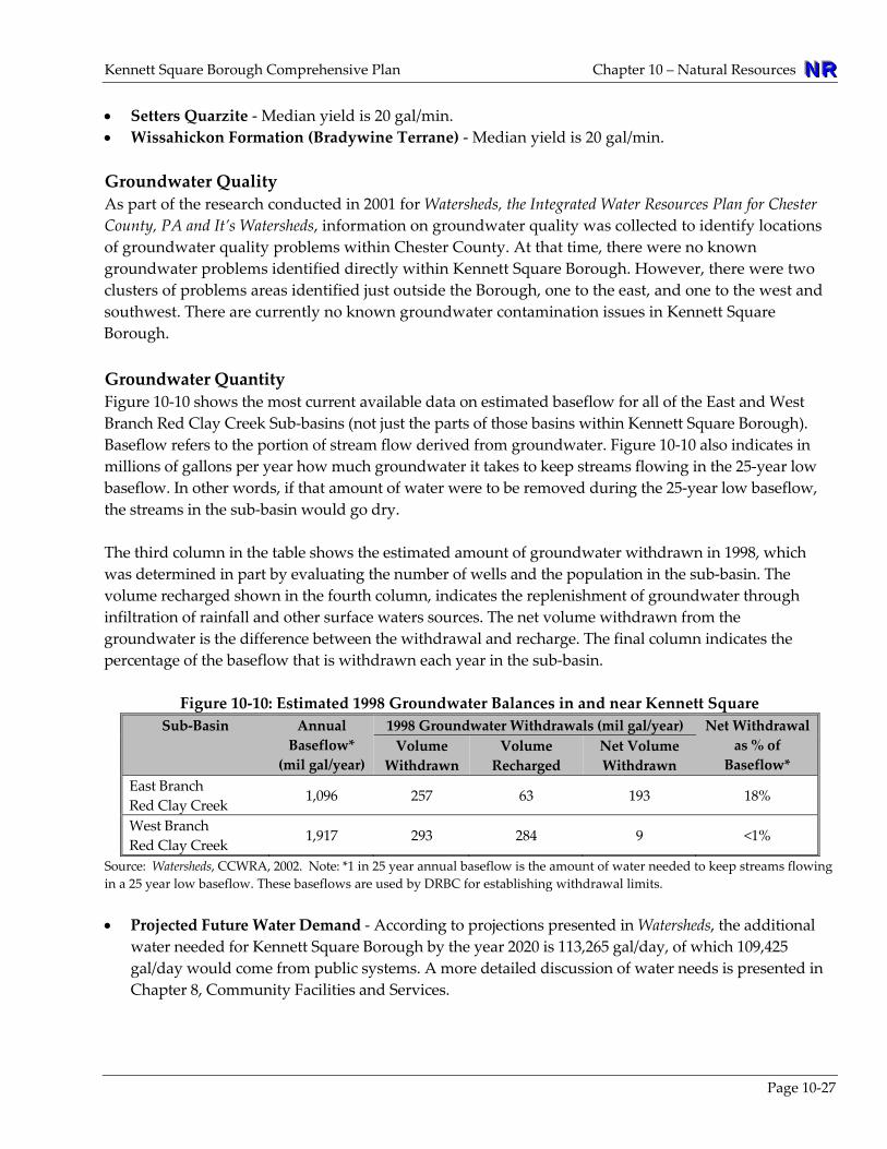
Groundwater Quality As part of the research conducted in 2001 for Watersheds, the Integrated Water Resources Plan for Chester County, PA and It’s Watersheds, information on groundwater quality was collected to identify locations of groundwater quality problems within Chester County. At that time, there were no known groundwater problems identified directly within Kennett Square Borough. However, there were two clusters of problems areas identified just outside the Borough, one to the east, and one to the west and southwest. There are currently no known groundwater contamination issues in Kennett Square Borough. Groundwater Quantity Figure 10‐10 shows the most current available data on estimated baseflow for all of the East and West Branch Red Clay Creek Sub‐basins (not just the parts of those basins within Kennett Square Borough). Baseflow refers to the portion of stream flow derived from groundwater. Figure 10‐10 also indicates in millions of gallons per year how much groundwater it takes to keep streams flowing in the 25‐year low baseflow. In other words, if that amount of water were to be removed during the 25‐year low baseflow, the streams in the sub‐basin would go dry. The third column in the table shows the estimated amount of groundwater withdrawn in 1998, which was determined in part by evaluating the number of wells and the population in the sub‐basin. The volume recharged shown in the fourth column, indicates the replenishment of groundwater through infiltration of rainfall and other surface waters sources. The net volume withdrawn from the groundwater is the difference between the withdrawal and recharge. The final column indicates the percentage of the baseflow that is withdrawn each year in the sub‐basin.
Figure 10‐10: Estimated 1998 Groundwater Balances in and near Kennett Square
Sub‐Basin Annual Baseflow* (mil gal/year)
1998 Groundwater Withdrawals (mil gal/year) Net Withdrawal as % of Baseflow*
Volume Withdrawn
Volume Recharged
Net Volume Withdrawn
East Branch Red Clay Creek 1,096 257 63 193 18%
West Branch Red Clay Creek 1,917 293 284 9 <1%
Source: Watersheds, CCWRA, 2002. Note: *1 in 25 year annual baseflow is the amount of water needed to keep streams flowing in a 25 year low baseflow. These baseflows are used by DRBC for establishing withdrawal limits. • Projected Future Water Demand ‐ According to projections presented in Watersheds, the additional
water needed for Kennett Square Borough by the year 2020 is 113,265 gal/day, of which 109,425 gal/day would come from public systems. A more detailed discussion of water needs is presented in Chapter 8, Community Facilities and Services.
NNNRRR Chapter 10 – Natural Resources Kennett Square Borough Comprehensive Plan
Planning and Protection Efforts Water quality provisions in the Borough’s ordinances include:
Subdivision and Land Development Ordinance (last amended in October 2006) • The SLDO does not specifically address groundwater quality and quantity.
Zoning Ordinance (last amended February 2006) • Section 23‐22.i.1: Calls for performance standards to evaluate untreated sewage or industrial waste
that might pollute surface or ground water. • Section 23‐48.a.5: Forbids land uses that would cause serious pollution to ground water or surface
water.
Issues/Analysis – Because nearly the entire Borough uses public water and has a public wastewater collection system, groundwater concerns are primarily limited to maintaining the natural water balance. There may be a need to expand the Borough’s groundwater regulations in the future to address more stringent state and federal requirements regarding overall water quality and quality.
Figure 10‐11: Water Resources
Page 10‐28
Kennett Square Borough Comprehensive Plan Chapter 10 – Natural Resources NNNRRR
WATER RESOURCES PLAN The Borough’s streams, floodplains, and wetlands are largely located within riparian corridors, all of which are largely developed, except the areas in and around Nixon Park. The Borough also contains headwaters which flow into surrounding municipalities. Therefore, the Borough’s ordinances should accommodate regional water resource planning efforts as a way to be a good neighbor to its downstream communities, avoid potential lawsuits, and also to pursue stream corridor and floodplain restoration grants. The following recommendations are intended to improve water resources.
WATERSHEDS, HEADWATERS, AND STREAMS NR-16 Work with surrounding municipalities on projects that will improve the overall health of the
Red Clay Creek Watershed and the protection of headwater areas including swales. Target the first order streams for establishing forested riparian buffer networks. When development or redevelopment is proposed in headwater areas, particular attention should be paid to preventing negative impacts such as erosion and sedimentation of streams and pre‐treating water discharged from stormwater facilities. Such a multi‐municipal approach could be attractive to grant funding programs, but will also require regional cooperation.
FLOODPLAINS NR-17 Consider not allowing structures or disturbance within the 100‐year floodplain. The
Borough’s current floodplain regulations allow for building in the floodplain if construction meets the stated requirements. Maintaining floodplains in their natural state reduces flood hazards, preserves their value as greenways and wildlife habitat, and reduces the potential for damages and costs associated with flood events. Floodplain areas are also appropriate for the installation and/or maintenance of riparian buffers in addition to woodands, parks, recreation, and open space areas. See Chapter 11, Parks, Recreation, and Open Space for more information. See also NR‐8 regarding vegetated or forested riparian buffers used for floodplain restoration as riparian buffers are a means for improving water quality and slowing stormwater runoff.
SURFACE WATER QUANTITY AND QUALITY NR-18 Encourage the restoration of impaired streams as a
priority for surface water protection. This effort can be achieved through the restoration and maintenance of riparian buffers, the continued implementation of the Borough’s stormwater management policies, and coordination with regional watershed protection efforts.
“Clean water is the cornerstone of healthy communities. It is
impossible to overstate the value and importance of clean water for people, fish and wildlife. Our health, quality of life, economy and ecosystem depend on it.”
American Rivers
Page 10‐29
NNNRRR Chapter 10 – Natural Resources Kennett Square Borough Comprehensive Plan
NR-19 Reduce stormwater runoff from impervious surfaces. Review the maximum impervious surface allowances, parking requirements, street, sidewalk and curb requirements, and other ordinance standards to determine if they unnecessarily increase impervious surfaces. Ensure zoning and subdivision regulations permit, encourage, and when appropriate, require stormwater best management practices. See recommendation PR‐33 in Chapter 11 that discusses “treelawns” as a means of reducing stormwater and recommendations regarding riparian buffers as another method of managing stormwater runoff.
Willowdale Porous Parking Lot
NR-20 Encourage the planting, restoration, and maintenance of riparian buffers. Riparian buffers should be required where new development occurs and encouraged on existing properties. Given that the Borough has limited areas suitable for the ideal buffer width, a buffer standards should be developed that are unique to the Borough, legally defensible, and realistically implementable. See also recommendations NR‐8, 17, and 18.
NR-21 Promote public awareness about efforts to improve surface water quality and control runoff.
This effort can include public cooperation in reducing common surface water pollutants such as lawn pesticides and pet waste, and the value of planting trees and native plants. Initiatives such as rain barrels, rain gardens, and dry wells for downspouts should also be promoted.
NR-22 Support the completion and implementation of Act 167 Planning for the Red Clay Creek
Watershed. This planning effort could ultimately lead to additional studies, initiatives or restoration projects that result from the Act 167 plans. Coordinate with the Chester County Water Resources Authority for more information. www.chesco.org/water
GROUNDWATER QUANTITY AND QUALITY NR-23 Promote groundwater recharge in new construction, re‐development and through the
upgrade of existing infrastructure. Existing and emerging technologies that promote the groundwater recharge of stormwater runoff, or if applicable, treated wastewater should be encouraged. Such techniques can include rain gardens, rain barrels, and the planting and management of vegetation. For additional discussion of green infrastructure see Chapter 12, Energy Conservation.
NR-24 Promote efforts to reduce and mitigate groundwater contamination. Such efforts could
include requiring the pre‐treatment of stormwater discharge for stormwater facilities where the contamination of groundwater is a greater possibility.
Page 10‐30
Kennett Square Borough Comprehensive Plan Chapter 10 – Natural Resources NNNRRR
Page 10‐31
INTEGRATED NATURAL RESOURCE PLANNING Natural resources exist as an interconnected system which, which taken as a whole, forms the natural environment. Plants and animals rely on soil and water bodies which are ultimately formed by the interaction of the climate on the underlying geology. Currently there are a number of initiatives and programs that pursue improving the natural environment and human quality‐of‐life by taking a more holistic “systems” approach to natural resources planning. These efforts tend to be regional in scope, and focus not on just one natural resource, but rather related natural resources. Many of these programs are funded through grants. There is value in addressing these programs in a comprehensive plan as a way to formally document Borough understanding and support for them.
EXISTING PROGRAMS AND INITITAITVES The following programs and initiatives are actively ongoing in the Borough or wider region, or could be expanded within the Borough: • Watersheds: An Integrated Water Resources Management Plan for Chester County, Pennsylvania
and Its Watersheds was adopted by the Chester County Commissioners on September 17, 2002 as the water resources element of the county’s comprehensive plan. This plan provides scientifically‐sound goals, objectives, and strategies for accommodating existing land uses and planned growth while maintaining the County’s water resources. Most importantly for Kennett Square Borough, the plan includes numerous implementation strategies for municipalities to more effectively protect and manage their water resources while accommodating planned growth and redevelopment. Watersheds is a good source of information regarding water resource planning and protection strategies and is available to review on the web on the Chester County Water Resources Department website: www.chesco.org/water
• TreeVitalize is a public‐private partnership whose mission is to restore tree cover, educate citizens
about planting trees, and build capacity among local governments to understand, protect and restore their urban trees. This program has been active in southeastern Pennsylvania since 2004 and was expanded to a statewide program in 2009. The program provides trees for planting, technical assistance, and funding to support tree planting in neighborhoods (street and park trees) and along streams (forest buffers). This program offers grants to communities to plant trees, or plant material can be provided directly. The program also fosters discussion and collaboration around broader policies and best practices that affect tree cover in the region.
• The Act 537 Plan for Kennett Square Borough ‐ This Act 537 Plan, completed in 1998, notes that all
of Kennett Square Borough is served by public sewers. Although this plan provides alternatives for wastewater disposal, it does not address how wastewater disposal will impact the “water balance,” which is discussed above in the introduction to Water Resources.
• Water Resource Planning – There are a number of ongoing water quality‐related initiatives that are
regional in context. These are described above under “Water Quantity and Quality,” and include
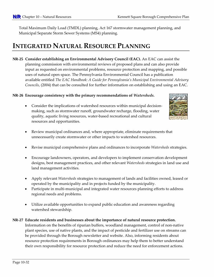
NNNRRR Chapter 10 – Natural Resources Kennett Square Borough Comprehensive Plan
Total Maximum Daily Load (TMDL) planning, Act 167 stormwater management planning, and Municipal Separate Storm Sewer Systems (MS4) planning.
INTEGRATED NATURAL RESOURCE PLANNING NR-25 Consider establishing an Environmental Advisory Council (EAC). An EAC can assist the
planning commission with environmental reviews of proposed plans and can also provide input as requested on environmental problems, resource protection and mapping, and possible uses of natural open space. The Pennsylvania Environmental Council has a publication available entitled The EAC Handbook: A Guide for Pennsylvania’s Municipal Environmental Advisory Councils, (2004) that can be consulted for further information on establishing and using an EAC.
NR-26 Encourage consistency with the primary recommendations of Watersheds.
• Consider the implications of watershed resources within municipal decision‐making, such as stormwater runoff, groundwater recharge, flooding, water quality, aquatic living resources, water‐based recreational and cultural resources and opportunities.
• Review municipal ordinances and, where appropriate, eliminate requirements that
unnecessarily create stormwater or other impacts to watershed resources.
• Revise municipal comprehensive plans and ordinances to incorporate Watersheds strategies. • Encourage landowners, operators, and developers to implement conservation development
designs, best management practices, and other relevant Watersheds strategies in land use and land management activities.
• Apply relevant Watersheds strategies to management of lands and facilities owned, leased or
operated by the municipality and in projects funded by the municipality. • Participate in multi‐municipal and integrated water resources planning efforts to address
regional needs and problems. • Utilize available opportunities to expand public education and awareness regarding
watershed stewardship. NR-27 Educate residents and businesses about the importance of natural resource protection.
Information on the benefits of riparian buffers, woodland management, control of non‐native plant species, use of native plants, and the impact of pesticide and fertilizer use on streams can be provided through the Borough newsletter and website. Also, informing residents about resource protection requirements in Borough ordinances may help them to better understand their own responsibility for resource protection and reduce the need for enforcement actions.
Page 10‐32

Kennett Square Borough Comprehensive Plan Chapter 10 – Natural Resources NNNRRR
Page 10‐33
NR-28 Balance the protection of natural resources with property owner’s rights. The Borough recognizes that the desire to protect natural resources must be balanced with the rights of its residents and property owners. The intent of resource protection standards is not to prevent residents from using their property as legally permitted. The implementation of the recommended resource protection measures will stay within the limits of what has been established as legally acceptable while promoting reasonable environmental protection and best management practices.
NR-29 Require that Act 537 Sewage Facilities Plans can only be deemed in compliance with the
Borough’s Comprehensive Plan if the 537 Plan evaluates potential impacts to watershed water balances. This evaluation would involve estimating how much potable water (for drinking and other uses) is withdrawn from a watershed and comparing it with the amount of treated wastewater that is then discharged back into that watershed. Coordination with the Chester County Water Resources should be considered for more information.
NR-30 Support regional efforts to improve, restore, and maintain conditions within headwaters,
Exceptional Value (EV) waters, and High Quality (HQ) waters. Supporting regional efforts by assisting government and civic groups to pursue initiatives and/or funding for water resource improvement projects. Examples include riparian buffer plantings and stream bank stabilization. These efforts should include coordination with regional organizations such as the Red Clay Valley Association and the Kennett Area Region Planning Commission.

NNNRRR Chapter 10 – Natural Resources Kennett Square Borough Comprehensive Plan
Page 10‐34
APPENDIX
Appendix 10‐A: Key Soils Terms Used in Land Planning Term Land Capability Class (or Soil Class) is define by USDA Natural Resources Conservation Service (NRCS),as: • Class 1 soils have slight limitations that restrict their use. • Class 2 soils have moderate limitations that reduce the choice of plants or require moderate conservation
practices. • Class 3 soils have severe limitations that reduce the choice of plants or require special conservation practices,
or both. • Class 4 soils have very severe limitations that restrict the choice of plants or require very careful management,
or both. • Class 5 soils have little or no hazard of erosion but have other limitations, impractical to remove, that limit
their use mainly to pasture, range, forestland, or wildlife food and cover. • Class 6 soils have severe limitations that make them generally unsuited to cultivation and that limit their use
mainly to pasture, range, forestland, or wildlife food and cover. • Class 7 soils have very severe limitations that make them unsuited to cultivation and that restrict their use
mainly to grazing, forestland, or wildlife. • Class 8 soils have limitations that preclude their use for commercial plant production and limit their use to
recreation, wildlife, or water supply or for esthetic purposes Prime Farmland has the best characteristics for agriculture and is available for such use. In Chester County,
Prime Farmland includes all Class 1 soils and most Class 2 soils. Farmland of Statewide Importance includes all Class 3 soils and a few Class 2 soils. These soils do not meet the
criteria for prime farmland, but nearly meet the requirements. Prime Agricultural Land is defined in PA Act 247, The Municipalities Planning Code, Section 107(a) as land “used
for agricultural purposes that contains soils of the first, second and third class”. Prime Agricultural Land should not be confused with Prime Farmland.
Hydric Soils are poorly drained and commonly remain wet during the spring growing season, so much so that they undergo anaerobic chemical changes which make them distinct from better drained upland soils. These soils are typically found in low‐lying areas, at the fringes of floodplains, and sometimes in upland depressions. Hydric soils often have a shallow water table depth, making them sensitive to alteration and susceptible to contamination of ground water. Hydric soil areas can serve as indicators of poor drainage. Development in these areas is generally not appropriate for on‐lot sewage systems.
Alluvial Soils are those soils which have been eroded, transported, and deposited by flooding over time and, as a result, generally indicate a strong potential for flooding. In addition to the FEMA mapping, alluvial soils indicate a strong potential for floodprone areas. Most areas of alluvial soils are narrow and found immediately adjacent to streams.
Soils with a Seasonal High Water Table remain wet during part of the year, usually spring or after periods of heavy rainfall when the ground becomes saturated. Due to low permeability, low run‐off rates, and sub‐surface saturation, these soils have a shallow depth to groundwater that presents limitations for on‐site sewage systems, buildings with basements, and road construction. There is no specific designation for what constitutes a “high” water table soil, but in general soils whose water table could meet a building foundation are considered high.
Source: USDA Natural Resources Conservation Service and PA Act 247, The Municipalities Planning Code

Kennett Square Borough Comprehensive Plan Chapter 10 – Natural Resources NNNRRR
Page 10‐35
Appendix 10‐B: Common Shade Trees, Street Trees, and Shrubs Street Trees (*Denotes native Species)
Scientific Name Common Name Scientific Name Common Name Acer rubrum* Red Maple Platanus occidentalis* American Sycamore Acer saccharum* Sugar Maple Pyrus calleryana Callery Pear Celtis occidentalis* Hackberry Quercus rubra* Red Oak Fraxinus Americana* White Ash Tilia americana American Linden Fraxinus pennsylvanica* Green Ash Tilia cordata Littleleaf Linden Gingko biloba (male) Gingko Ulmus x ‘Homesteadʹ Homestead Elm Nyssa sylvatica* Black Gum Ulmus parviflora Chinese Elm Platanus acerifolia London Plane Tree Zelkova serrata Japanese Zelkova
Shade Trees (Street trees can also be used as shade Trees)Betula nigra* River Birch Quercus coccinea* Scarlett Oak Cladastris lutea Yellowwood Quercus palustris* Pin Oak Gymnocladus dioicus* Kentucky Coffee Tree Quercus phellos* Willow Oak Koelreuteria paniculata Golden Rain Quercus rubra* Red Oak Liriodendron tulipifera* Tulip Poplar Sassafras albidum* Sassafras Liquidambar styraciflua* Sweet Gum Sophora japonica Japanese Pagoda Quercus alba* White Oak Taxodium distichum* Bald Cypress
Evergreen TreesAbies Concolor Concolor Fir Picea omorika Serbian Spruce Ilex opaca* American Holly Pinus strobus* Eastern White Pine Juniperus virginiana* Eastern Red Cedar Pseudotsuga menziesii Douglas Fir Picea abies Norway Spruce Thuja occidentalis Eastern Arborvitae Picea glauca White Spruce Tsuga canadensis* Canadian Hemlock
Ornamental TreesAmelanchiar canadensis* Serviceberry Koelreuteria paniculata Golden Rain Tree Betula nigra* River Birch Magnolia soulangeana Saucer Magnolia Carpinus caroliniana* Ironwood Magnolia virginiana* Sweetbay Magnolia Cercis canadensis* Redbud Malus species Crabapple Chionanthus virginicus* Fringetree Oxydendrum arboreum* Sourwood Cornus florida* Flowering Dogwood Prunus cerasifera Purpleleaf Plum Cornus kousa Chinese Dogwood Prunus sargentii Sargent Cherry Cornus mas Cornelian Dogwood Prunus subhirtella Weeping Cherry Halesia carolina* Carolina Silverbell Pyrus calleryana Flowering Pear Koelreuteria paniculata Golden Rain Tree
Native Deciduous ShrubsAesculus parviflora* Bottlebrush Buckeye Hydrangea quercifolia* Oakleaf Hydrangea Aronia arbutifolia* Red Chokeberry Itea virginica* Sweetspire Callicarpa Americana* Beautyberry Ilex verticillata* Winterberry Calycanthus floridus* Carolina Allspice Lindera benzoin* Spicebush Clethra species* Summersweet Potentilla fruticosa* Bush Cinquefoil Cornus stolonifera* Redosier Dogwood Vaccinium species* Blueberry Fothergilla species* Fothergilla Viburnum dentatum* Arrowwood Hamamelis virginiana* Common Witchhazel Viburnum trilobum* American Cranberry
Native Evergreen ShrubsIlex glabra* Inkberry Myrica pennsylvanica* Bayberry Kalmia latifolia* Mountain Laurel Rhodo. Maximum* Rhododendron Source: Chester County Planning Commission, 2009. Note: Species marked with an asterisk are native species. This lists presents common species and there may be other appropriate species that are not listed.

NNNRRR Chapter 10 – Natural Resources Kennett Square Borough Comprehensive Plan
Page 10‐36
This page intentionally left blank.