Embed Size (px)
Citation preview
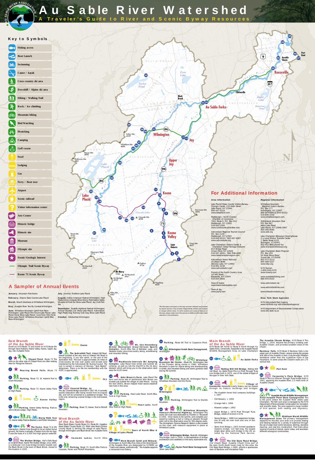
For Additional InformationArea Information
Lake Placid/Essex County Visitors BureauOlympic Center, 216 Main StreetLake Placid, NY 12946800-447-5224www.lakeplacid.com
Plattsburgh / North Country Chamber of Commerce7061 Route 9, P.O. Box 310Plattsburgh, NY 12901518-563-1000www.northcountrychamber.com
Adirondack Regional Tourism CouncilP.O. Box 2149Plattsburgh, NY 12901518-846-8016 / 800-487-6867www.adirondacks.org
Lake Champlain Visitors Center & Champlain Valley Heritage Network814 Bridge RoadCrown Point, NY 12928518-597-4646 / 866-THE-LAKEwww.lakechamplainregion.com
Adirondack Scenic Railroad19 Depot StreetSaranac Lake, NY 12983518-891-3238www.adirondackrr.com
Friends of the North Country Area1A Mill StreetKeeseville, NY 12944518-834-9606
Town of Keenewww.keene-keenevalley.com
Town of Jaywww.jayny.com
Regional Information
Whiteface Mountain Regional Visitor’s BureauP.O. Box 277Wilmington, NY 12997888-WHITEFACE (944-8332)518-946-2255www.whitefaceregion.com
Adirondack Mountain ClubP.O. Box 867Heart Lake RoadLake Placid, NY 12946-0867800-395-8080www.adk.org
Lake Champlain Bikeways Clearinghousec/o Local Motion Trailside Center1 Steele Street #103Burlington, VT 05401802-652-BIKE phone/faxwww.champlainbikeways.org
Lake Champlain Basin ProgramP.O. Box 20454 West Shore RoadGrand Isle, VT 05458802-372-3213800-468-5227www.lcbp.org
NYS Tourism1-800-CALL-NYSwww.iloveny.com
www.ausablefyfishing.com888-944-8332
www.adirondack.net
www.adirondacklinks.com
www.bikeadirondacks.org
New York State Agencies
NYS Adirondack Park Agencywww.northnet.org/adirondackparkagency/
NYS Department of Environmental Conservationwww.dec.state.ny.us
The information portrayed on this map has been collected and providedby several sources. It has not been independently verified and is subjectto change without notice. To verify locations and access to features onthis map, please contact one of the sources of additional information listedelsewhere in this publication.
January, Mountain Fest-Keene
February, Empire State Games-Lake Placid
March, March Madness at Whiteface-Wilmington
May, Ausable River Two-fly Contest-Wilmington
June, Whiteface Mountain Uphill Foot Race-Wilmington; Lake Placid Film Forum-Lake Placid; LakePlacid Horse Show-Lake Placid; I Love New York HorseShow-Lake Placid; Whiteface Mountain Uphill BikeRace-Wilmington
July, Ironman Triathlon-Lake Placid
August, Native American Festival-Wilmington; HighPeaks Arts & Antiques Show-Marcy Field-Keene Valley;Miracles of Gold Ice Show-Lake Placid; Jay Craft Fair-Jay
September, Scottish Highland Festival-Wilmington;Annual Olympic Car Show-Lake Placid; AdirondackHigh Peaks Dog Training Club Dog Show-Lake Placid
October, Oktoberfest-Wilmington
Au Sable River WatershedA Traveler’s Guide to River and Scenic Byway Resources
Key to Symbols
Fishing access
Boat Launch
Swimming
Canoe / kayak
Cross country ski area
Downhill / Alpine ski area
Hiking / Walking Trail
Rock / Ice climbing
Mountain biking
Bird Watching
Picnicking
Camping
Golf course
Food
Lodging
Gas
Ferry / Boat tour
Airport
Scenic railroad
Visitor information center
Arts Center
Historic bridge
Historic site
Museum
Olympic site
Scenic/Geologic Interest
Olympic Trail Scenic Byway
Route 73 Scenic Byway
East Branchof the Au Sable RiverNorth on NYS Route 73 and North on NYS Route 9Nthrough Saint Huberts, Keene Valley, Keene, Upper Jay,Jay, into AuSable Forks
1 Chapel Pond, Route 73 Thecliffs on the other side of Chapel Pond are often nestingsites for Peregrine Falcons.
2 Roaring Brook Falls, Route 73
3 Parking, Route 73, St. Huberts Trail toGiant Mountain.
4 Parking, Route 73, Keene Valley Trailsto High Peaks.
5 Keene Valley
6 Parking, Keene Valley Parking, Trails toJohn’s Brook Lodge, High Peaks.
7 Marcy Field, Route73, Keene Valley Trails to Blueberry and Porter Mountains.
8 The Kame, Route 73 & 9Nintersection, Keene Once thought to be an Indian burialground, the Kame is actually a feature from the Ice Age;it was the base of a 5,000 foot high glacial waterfall.
9 The Walton Bridge, Hull's Falls Roadto Gristmill Road, Keene The Walton Bridge, circa 1890,is a lenticular iron truss bridge formerly located overthe Black Brook in the town of Black Brook, moved tothis location in 1925.
10 Keene
11 The Jackrabbit Trail, Alstead Hill Road,Keene Located at the very end of Alstead Hill Road isthe beginning, if you like uphill, or the end of theJackrabbit Trail. This trail is approximately 35 miles ofcross-country ski trail over public and private landmaintained by the Adirondack Ski Touring Council. Thetrail is named in memory of Herman "Jack Rabbit"Johannsen. There is no fee but membership with theASTC is appreciated.
12 Jay
13 Covered Bridge, JayThe Jay Covered Bridge was built in 1857-58. It currentlyawaits restoration after being moved from its originalsite, and will be converted to a pedestrian bridge. Thisis the only remaining covered bridge in the Adirondackregion.
14 Parking, Route 73, Keene, Trail to PitchoffMountain.
West Branchof the Au Sable RiverRiver Road (Essex County Route 21), Route 86, HaseltonRoad (Essex County Route 12), Silver Lake Road (ClintonCounty Route 1) skirting the village of Lake Placid,through Wilmington and Black Brook into AuSable Forks
15 Cascade Lakes , Nor th E lba
16 Parking, Route 73, North Elba Trails toCascade, Porter and Pitchoff Mountains.
17 Mt. Van HovenbergWinter Recreation Area/Verizon SportsComplex, North Elba Site of Bobsled, Luge, andSkeleton tracks, plus cross country skiing, snowshoeingand mountain biking.
18 MacKenzie-Intervale Ski JumpingComplex, Lake Placid View winter and summer skijumping, as well as ride the chairlift to the 26 storyelevator which will bring you to the observation deckatop the K120 tower.
19 John Brown's Farm, Lake Placid Thefarm and burial site of abolitionist John Brown arelocated just outside the village of Lake Placid. Duringthe mid-1800’s, Brown helped freed slaves establishnew lives in this area.
20 Parking, Heart Lake Road, North Elba,Trails to High Peaks.
21 Heart Lake, NorthElba Trails to High Peaks.
22
Town of North Elba &Village of Lake Placid
23 West Branch Catch and Release,Wilmington & North Elba Five miles of the West Branchof the Ausable River are designated by NYSDEC as“Catch and release, artificials only.” The Ausable supportsa renowned trout fishery.
24 Parking, Route 86 Trail to Copperas Pond.
25 Wilmington Notch State Campground,Wilmington
26 WhitefaceMountain Ski Center, Route 86, Wilmington Siteof the Olympic skiing events in 1980, WhitefaceMountain is open for Alpine skiing and snowboardingin winter, plus mountain biking and scenic gondola ridesduring the summer.
27 Parking, Route 86, Wilmington Trail toWhiteface Mountain and the Flume.
28 Wilmington
29 Parking, Wilmington Trail to MarbleMountain.
30 Whiteface MountainVeteran's Memorial Highway, Wilmington Thisscenic toll route was dedicated by Franklin D. Rooseveltin 1935. Drive nearly to the summit, and complete yourascent by walking a trail or riding an elevator throughsolid rock to the observation area for 360-degree views.The Atmospheric Science Research Station is also locatedon this road, with research equipment in place atWhiteface’s peak.
31 Wilmington Bridge, Route 86, WilmingtonThis bridge, built in 1935, is representative of bridgearchitecture and aesthetics in the early automobile era.
32 Taylor Pond State Campground,Silver Lake Road
Main Branchof the Au Sable RiverNYS Route 9N North to Route 9 North through AuSable Forks, Clintonville, Keeseville to the Ausable MarshWildlife Management Area on Lake Champlain
33 Au Sable Forks
34 Rolling Mill Hill Bridge, Rolling MillHill Road, Au Sable Forks This is a Pratt Through Trussiron bridge built in 1879, one of the oldest bridges ofthis type in New York State.
35 Village ofKeeseville Keeseville’s early history can be viewedthrough its historic buildings and bridges:
- The Ausable Horse Nail company buildingsc. 1847
- Old Brewery c. 1850
- Grange Hall c. 1856
- Masonic Lodge c. 1852
- Upper Bridge c. 1878 Pratt Through TrussBridge, oldest of its kind in NYS.
- Swing Bridge c. 1888 Iron suspension bridge,one of only ten ever built and one of twosurviving.
- Stone Arch Bridge c. 1843 Arched sandstonemasonry bridge, 110 feet long, the largestsingle span stone arch bridge in the US, asnoted by the National Park Service.
36 The Old State Road Bridge,Old Chasm Road, Ausable Chasm Once part ofthe main North-South travel route for this area, theOld State Road Bridge, c.1890, affords a spectacularview of Rainbow and Horseshoe Falls.
The Ausable Chasm Bridge, NYS Route 9 Thisbridge, c. 1934, became the primary crossing overAusable Chasm, and provides excellent views of theChasm.
Rainbow Falls, NYS Route 9 Rainbow Falls is theupper part of Ausable Chasm, unique among the gorgesand falls of the Ausable in that it cuts through Potsdamsandstone rather than the crystalline rocks of themountains. In some areas the Chasm’s walls are 175vertical feet.
37 Port Kent
38 Carpenter's Flats Bridge, NYSRoute 9 This is a Warren Through Truss bridge built in1941, spanning the Ausable River 2.5 miles north ofAusable Chasm.
39
Ausable Marsh Wildlife ManagementArea/Ausable Point State Campground Thisis the point where the Ausable River meets LakeChamplain. The 580 acre area is managed by the NYSDepartment of Environmental Conservation for recreationand scientific study. The area supports a large numberof bird species, both nesting and migratory.
40 Wickham Marsh WildlifeManagement Area The primary managementobjective for this 862 acre area is to provide nestingand feeding habitat for a variety of waterfowl throughthe use of water level control structures, ditching, shorelineclearing, and nest box construction. Foot trails allowviewing of points of interest, scenic vistas, and seventeendifferent ecological communities.
A Sampler of Annual Events
AU
SA
BLE
RIVER ASSOCIATION
C L I N T O N C O U N T Y
E S S E X C O U N T Y
East BranchAusable Lakes, St. Huberts, Keene Valley, Keene, Upper Jay, Jay
The outlet of Lower Ausable Lake is where the East Branch begins its bouldery descentto the tiny hamlet of Saint Huberts, collecting the drainage waters from some of theAdirondack’s highest peaks, including Marcy, Gothics, Skylight, and Nippletop. As itmoves on to Keene Valley, the river levels off, broadens, and meanders through thisscenic valley area, paralleled by NY State Route 73, a New York State designated scenicbyway. Upon reaching Keene, the East Branch cascades through Hull’s Falls beforecontinuing beyond these busy hamlets and flowing towards Upper Jay. One of twohistoric bridges along this branch of the Ausable can be found near Hull’s Falls.
The East Branch’s journey to Upper Jay finds it winding through a broad valley floor,turning freely and providing for beautiful views of the river, fields, and the SentinelMountain Range. NY State Route 9N follows the river’s course, leading through the townof Jay, settled in the late 1700’s. The Jay Covered Bridge, which crosses the East Branch,has been the subject of innumerable artists and historians. Past and present, Jay hasbeen a haven for artists and writers. James Thurber, the notable humorist, set part ofhis short story, “Josephine Has Her Day,” in Madden’s Country Store in the mythicaltown of Dale, which was actually Jay. Asgaard Farm near Au Sable Forks, home ofpainter and illustrator Rockwell Kent, can still be viewed by passersby, preserved prettymuch as seen in his paintings.
The East Branch meanders on to its confluence with the West Branch in the hamlet ofAu Sable Forks.
West BranchMt. Van Hoevenberg, Lake Placid, Wilmington, Black Brook
Marcy and South Meadow Brooks in the High Peaks Range converge to give rise to theWest Branch of the Ausable River. Waters from Algonquin, Wright, Colden, and TableTop mountains are carried by the West Branch over rocky terrain, emerging from thewilderness just before the Olympic Ski Jumps along NYS Route 73. Here the landscapeflattens to a valley, allowing the river to slow and wind, picking up the Chubb Riverdrainage beyond the ski jumps as it flows past the village of Lake Placid.
As the West Branch reaches NYS Route 86 beyond Lake Placid, on its way throughNorth Elba to Wilmington, it starts to take on a different character. Confined by mountainson either side as it winds along Route 86, the river begins a steep descent which includesa series of falls. Monument Falls, Wilmington Notch, High Falls Gorge, and the Flumemove the water of the West Branch quickly and dramatically through to the town ofWilmington, where it is slowed by the Wilmington Dam, forming Lake Everest.
Continuing on towards its confluence with the East Branch, the West Branch picks upanother major tributary, Black Brook, and squeezes through a scenic flume beforereaching Au Sable Forks.
Main BranchAu Sable Forks, Keeseville, Lake Champlain
As the East and West Branches converge in the hamlet of Au Sable Forks, the MainBranch becomes a broad, rocky, river that also represents the boundary between ClintonCounty to the north and Essex County to the south.
First settled in 1825, Au Sable Forks maintains one of many historic bridges that crossthe Ausable River between here and Lake Champlain. As settlements sprang up alongthe river, bridges were important connectors in areas divided by water.
The Ausable makes its way northeastward from Au Sable Forks, with NYS Route 9Nwinding alongside, passing through the hamlet of Clintonville before reaching the villageof Keeseville. Historic bridges join this village that is split in two by the river, and manybuildings built in the mid-1800’s line its banks.
Venturing further in its quest to meet Lake Champlain, a mile downstream of Keesevillethe Main Branch cuts through the gorges and falls known as Ausable Chasm. Withwalls as high as 175 feet, the water of the Ausable creates a spectacular and tumultuousscene before settling into a calm passage to the lake. The river empties into LakeChamplain with a flourish of wildlife along the delta, at the Ausable Marsh WildlifeManagement Area.
Au Sable River Watershed
Au Sable River AssociationP.O. Box 217Elizabethtown, NY 12932518-873-3752www.ausableriver.org
AU
SA
BLE
RIVER ASSOCIATION
The Au Sable River Association was formed in August 1998 by residents of the watershed.The ASRA is a membership based organization which is working to improve the naturaland cultural resources of the Au Sable River, its watershed, and the quality of life forresidents. The ASRA brings together landowners, town governments, other non-profits,and State and Federal Agencies to identify problems and needs and implement solutions.We are a resource for residents and towns, providing assistance and information on arange of issues from water quality to stream restoration. We view the watershed in itsentirety and cooperate with all interested parties to improve the health of the watershedand the quality of life for the residents and visitors.
We have a growing membership of residents and friends of the watershed. Our memberssupport us by volunteering time and resources. We have a volunteer Board of Directorsand a paid part-time Director. For more information about the ASRA or to become amember please contact us: Au Sable River Association, P.O. Box 217, Elizabethtown,NY 12932, 518-873-3752, www.ausableriver.org
This map is the product of a cooperative effort of the NYS Adirondack Park Agency andthe Au Sable River Association. It was made possible by a grant to the Agency fromthe NYS Scenic Byways Program through the Federal Highway Administration and theTransportation Equity Act for the 21st Century of 1998, administered by the NYSDepartment of Transportation. Additional funding support was provided by the LakeChamplain Basin Program.
The ASRA would like to thank the following for their time, effort and information:Boquet River Association, Essex County Planning Office, Friends of the North Country
Photos courtesy of Nathan Farb
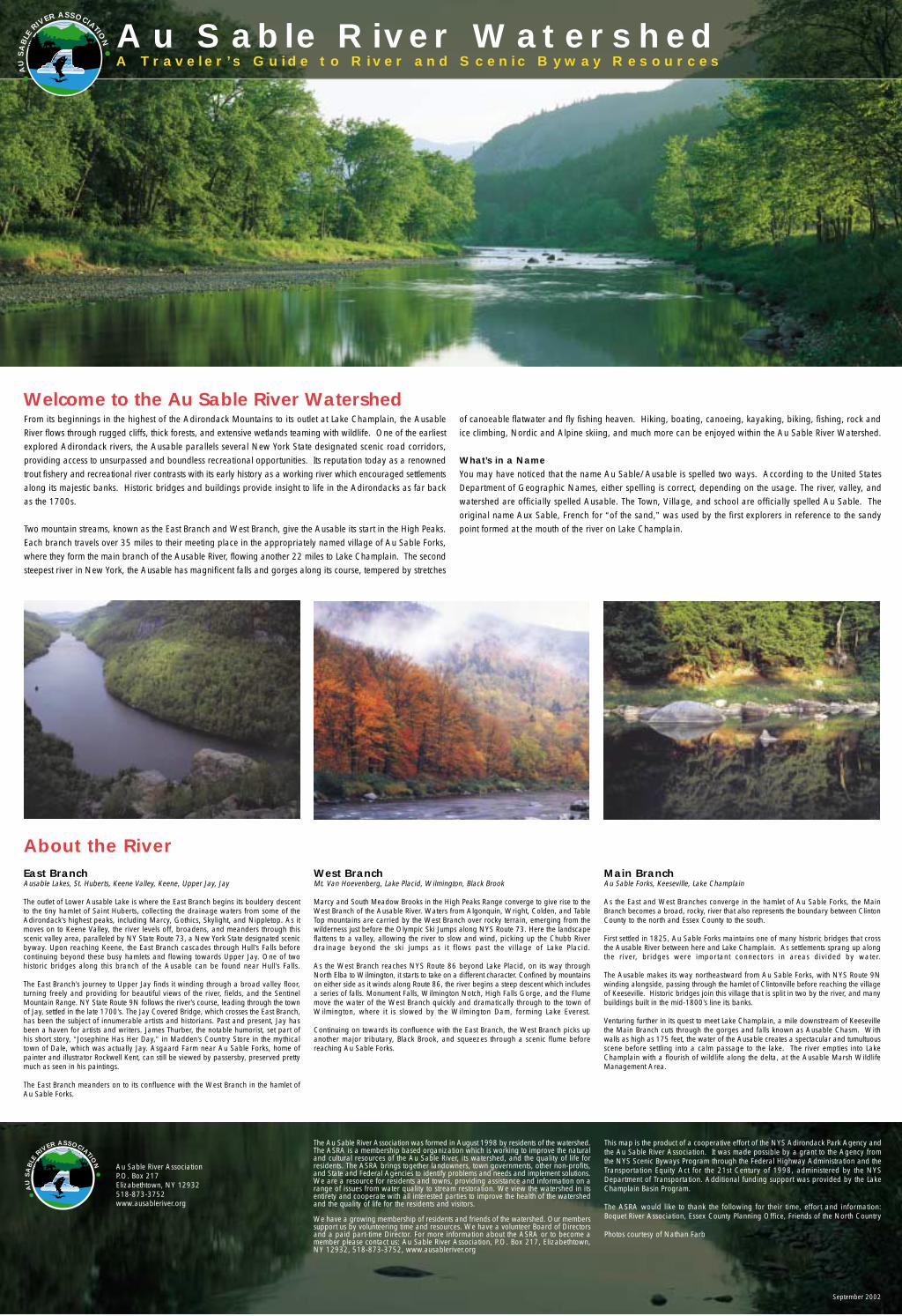
From its beginnings in the highest of the Adirondack Mountains to its outlet at Lake Champlain, the AusableRiver flows through rugged cliffs, thick forests, and extensive wetlands teaming with wildlife. One of the earliestexplored Adirondack rivers, the Ausable parallels several New York State designated scenic road corridors,providing access to unsurpassed and boundless recreational opportunities. Its reputation today as a renownedtrout fishery and recreational river contrasts with its early history as a working river which encouraged settlementsalong its majestic banks. Historic bridges and buildings provide insight to life in the Adirondacks as far backas the 1700s.
Two mountain streams, known as the East Branch and West Branch, give the Ausable its start in the High Peaks.Each branch travels over 35 miles to their meeting place in the appropriately named village of Au Sable Forks,where they form the main branch of the Ausable River, flowing another 22 miles to Lake Champlain. The secondsteepest river in New York, the Ausable has magnificent falls and gorges along its course, tempered by stretches
of canoeable flatwater and fly fishing heaven. Hiking, boating, canoeing, kayaking, biking, fishing, rock andice climbing, Nordic and Alpine skiing, and much more can be enjoyed within the Au Sable River Watershed.
What’s in a NameYou may have noticed that the name Au Sable/Ausable is spelled two ways. According to the United StatesDepartment of Geographic Names, either spelling is correct, depending on the usage. The river, valley, andwatershed are officially spelled Ausable. The Town, Village, and school are officially spelled Au Sable. Theoriginal name Aux Sable, French for “of the sand,” was used by the first explorers in reference to the sandypoint formed at the mouth of the river on Lake Champlain.
About the River
Welcome to the Au Sable River Watershed
A Traveler ’s Guide to River and Scenic Byway Resources
AU
SA
BLE
RIVER ASSOCIATION
September 2002