Embed Size (px)
DESCRIPTION
Weinland Park Community Mobility Plan
Citation preview
Prepared For: City of Columbus, Division of Mobility Options
Prepared By: Stantec Consulting Services Inc.
Interim Final Plan September 2011
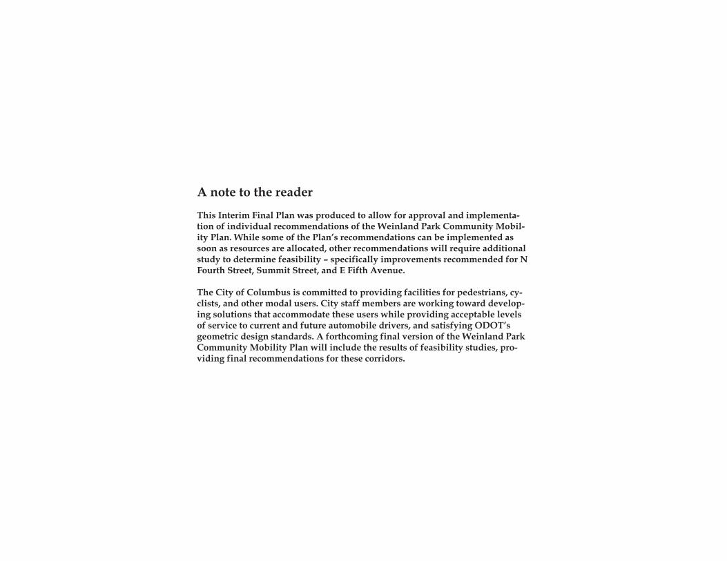
A note to the reader
This Interim Final Plan was produced to allow for approval and implementa-tion of individual recommendations of the Weinland Park Community Mobil-ity Plan. While some of the Plan’s recommendations can be implemented as soon as resources are allocated, other recommendations will require additional study to determine feasibility – specifically improvements recommended for N Fourth Street, Summit Street, and E Fifth Avenue.
The City of Columbus is committed to providing facilities for pedestrians, cy-clists, and other modal users. City staff members are working toward develop-ing solutions that accommodate these users while providing acceptable levels of service to current and future automobile drivers, and satisfying ODOT’s geometric design standards. A forthcoming final version of the Weinland Park Community Mobility Plan will include the results of feasibility studies, pro-viding final recommendations for these corridors.
Acknowledgements
MayorMichael B. Coleman
Columbus City CouncilMichael C. MentelHearcel F. CraigAndrew J. GintherA. Troy MillerEileen Y. PaleyCharleta B. TavaresPriscilla R. Tyson
Department of Public ServiceMark Kelsey, Director
Division of Mobility OptionsRandall J. Bowman, AdministratorWilliam A. Lewis, Chief Mobility EngineerNicholas J. Popa, Bikeways and Community Mobility ManagerTerry L. Stewart, Project EngineerJodi M. Stefanik, EIT
Project TeamStantec Consulting Services Inc.HKI Associates, Inc.Mid-Ohio Regional Planning CommissionUniversity Area Enrichment AssociationWalkable Communities, Inc.
University Area CommissionIan MacConnell Ron HupmanSusan Keeny Sara MatthiesenDavid Hegley John RisteterSeth Golding Charles RobolIan Studders Joaquin SerantesSharon Young Laura ShinnMiles Curtiss Dick TalbotPasquale Grado Doreen Uhas SaurerBill Graver Rimar VillasenorJoyce Hughes Tom Wildman
Mobility Plan Steering CommitteeLaura Bidwa Carl ShoolmanJohn Gideon Steve SimmonsJoyce Hughes Jeff StephensRory Krupp Pablo TanguayChris Orban Mark WagenbrennerJulia Orban
The project team would like to thank the residents of Weinland Park for their participation, persis-tence, and patience throughout the development of this plan. Special thanks are extended to the Wein-land Park Community Civic Association and its officers, particularly Joyce Hughes, President and Chris Orban, Traffic and Mobility Committe Chair for their leadership during the planning process.
Ack
now
ledg
emen
ts
i
Executive Summary iiiIntroduction 1
Mobility Planning 2The Community Mobility Planning Process 3Mobility Planning in Weinland Park 3
Issues and Concerns 93-1-1 Service Requests 10Communication Forums & Input Opportunities 12Public Involvement Comments 16
Existing Conditions 19Guiding Plans and Studies 20Automobiles 24Pedestrians 35Bicycles 44Transit 45
Recommended Solutions 47Toolbox of Treatments 48
Automobile Tools 48Pedestrian Tools 53Bicycle Tools 57Transit Tools 59Other Tools 61
Location Based Recommendations 63Neighborhood Improvements 63Corridor Improvements 65Site Specific Improvements 71
Prioritization and Implementation 83Plan Prioritization 84Implementation Strategy 86Updating the Plan 90Ta
ble
of C
onte
nts
ii
Located just north of downtown Columbus and south of The Ohio State University, Weinland Park is a densely populated community consisting primarily of single and multi-family residences. With a strong grid style street network and traversed by several north-south and east-west arterial streets, Weinland Park is well connected to the surrounding city and central Ohio region. This connectivity presents both opportunities and challenges for mobility within and through the neighborhood.
Historically, the need for vehicular traffic to access downtown from outlying areas of the city has been prioritized over other modes and the travel needs of local residents in Weinland Park. The result is that several streets, Summit and Fourth in particular, have become barriers to mobility, hindering multi-modal connectivity and segmenting the community. Prompted by resident concerns (expressed through 311 requests) as well as other issues such as high incidences of pedestrian crashes and traffic violations, the City initiated the Weinland Park Community Mobility Plan (WPCMP) to improve mobility conditions throughout the the neighborhood. The recommendations included in the WPCMP will work to achieve the following goals:
Balance the transportation system for moving people and goods by all modes • (pedestrian, bicycle, automobile, transit, truck, and rail)Reduce trafficviolations (speeding, failure toyield topedestrians, running red-• lights, etc)Recognize and strengthen the connection between land use and mobility• (coordination with other planning efforts)Promote distinct and vibrant neighborhoods•Addressissuesidentifiedbycommunityresidents•Recommend comprehensive yet implementable solutions•
Through a combination of extensive community input and technical data collection, the project team first worked to identify the existing conditions and most significant barriers to mobility in the neighborhood. The public input opportunities included several community open house and workshop meetings, neighborhood walk audits, resident surveys, meetings with stakeholder groups, and informal porch chats. These efforts resulted in the compilation of approximately 1,000 comments regarding mobility conditions in Weinland Park.
The most frequent concerns expressed by the public were for pedestrian safety when crossing High, Summit, and Fourth streets; issues with driving in Weinland Park (most of these related to conversion of Summit and Fourth streets from one to two-way operation); and concerns over driver behavior (predominantly speeding). These three categories accounted for over 50% of all comments recevied. Resident concerns were confirmed by traffic studies which identified excess vehicular capacity and speeding problems along
Exec
utiv
e Su
mm
ary
iii
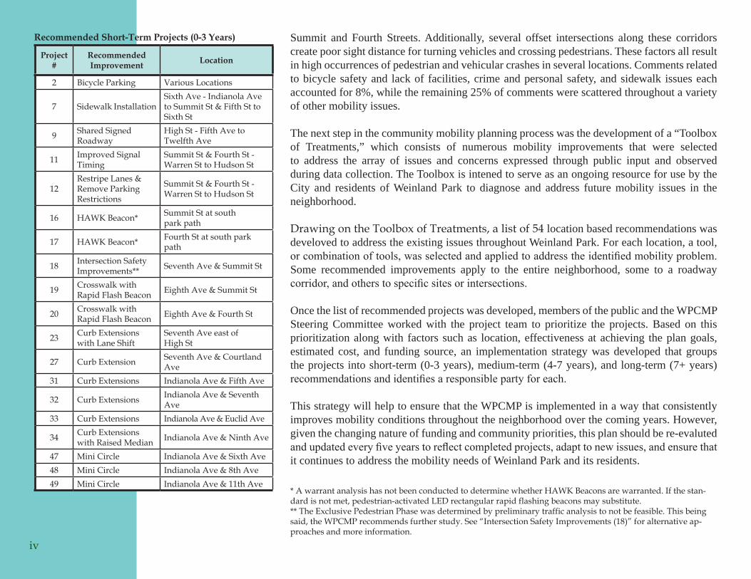
Recommended Short-Term Projects (0-3 Years)
Project #
Recommended Improvement Location
2 Bicycle Parking Various Locations
7 Sidewalk InstallationSixth Ave - Indianola Ave to Summit St & Fifth St to Sixth St
9 Shared Signed Roadway
High St - Fifth Ave to Twelfth Ave
11 Improved Signal Timing
Summit St & Fourth St - Warren St to Hudson St
12Restripe Lanes & Remove Parking Restrictions
Summit St & Fourth St - Warren St to Hudson St
16 HAWK Beacon* Summit St at south park path
17 HAWK Beacon* Fourth St at south park path
18 Intersection Safety Improvements** Seventh Ave & Summit St
19 Crosswalk with Rapid Flash Beacon Eighth Ave & Summit St
20 Crosswalk with Rapid Flash Beacon Eighth Ave & Fourth St
23 Curb Extensions with Lane Shift
Seventh Ave east of High St
27 Curb Extension Seventh Ave & Courtland Ave
31 Curb Extensions Indianola Ave & Fifth Ave
32 Curb Extensions Indianola Ave & Seventh Ave
33 Curb Extensions Indianola Ave & Euclid Ave
34 Curb Extensions with Raised Median Indianola Ave & Ninth Ave
47 Mini Circle Indianola Ave & Sixth Ave48 Mini Circle Indianola Ave & 8th Ave49 Mini Circle Indianola Ave & 11th Ave
Summit and Fourth Streets. Additionally, several offset intersections along these corridors create poor sight distance for turning vehicles and crossing pedestrians. These factors all result in high occurrences of pedestrian and vehicular crashes in several locations. Comments related to bicycle safety and lack of facilities, crime and personal safety, and sidewalk issues each accounted for 8%, while the remaining 25% of comments were scattered throughout a variety of other mobility issues.
The next step in the community mobility planning process was the development of a “Toolbox of Treatments,” which consists of numerous mobility improvements that were selected to address the array of issues and concerns expressed through public input and observed during data collection. The Toolbox is intened to serve as an ongoing resource for use by the City and residents of Weinland Park to diagnose and address future mobility issues in the neighborhood.
Drawing on the Toolbox of Treatments, a list of 54 location based recommendations was develoved to address the existing issues throughout Weinland Park. For each location, a tool, or combination of tools, was selected and applied to address the identified mobility problem. Some recommended improvements apply to the entire neighborhood, some to a roadway corridor, and others to specific sites or intersections.
Once the list of recommended projects was developed, members of the public and the WPCMP Steering Committee worked with the project team to prioritize the projects. Based on this prioritization along with factors such as location, effectiveness at achieving the plan goals, estimated cost, and funding source, an implementation strategy was developed that groups the projects into short-term (0-3 years), medium-term (4-7 years), and long-term (7+ years) recommendations and identifies a responsible party for each.
This strategy will help to ensure that the WPCMP is implemented in a way that consistently improves mobility conditions throughout the neighborhood over the coming years. However, given the changing nature of funding and community priorities, this plan should be re-evaluted and updated every five years to reflect completed projects, adapt to new issues, and ensure that it continues to address the mobility needs of Weinland Park and its residents.
iv
* A warrant analysis has not been conducted to determine whether HAWK Beacons are warranted. If the stan-dard is not met, pedestrian-activated LED rectangular rapid flashing beacons may substitute. ** The Exclusive Pedestrian Phase was determined by preliminary traffic analysis to not be feasible. This being said, the WPCMP recommends further study. See “Intersection Safety Improvements (18)” for alternative ap-proaches and more information.
Intr
oduc
tion
1
Mobility Planning
Through the Community Mobility Planning (CMP) Program, the City of Columbus is taking a new approach to transportation planning and engineering that acknowledges and responds to key changes in how residents view and use the transportation system. It recognizes the role that well designed facilities play in creating healthy and vibrant communities. Recent focuses on environmental awareness, rising fuel prices, and a renewed desire for urban living in Columbus have all combined to increase demand for multi-modal options and improved connectivity between business, retail, and residential areas. The Mobility Planning Program is one of many steps the City is taking to promote sustainable development, revitalize urban areas, and improve transportation options for all residents. Since 2008, the City has adopted a Complete Streets resolution, developed the Bicentennial Bikeways Plan, updated the City’s Bike Law to promote safe cycling and require the provision of bicycle facilities, been designated a Bicycle Friendly Community, and implemented the GreenSpot Program.
In general, traditional transportation planning methods analyze the street system to maximizeoperationalefficiencyformotorizedvehicles,oftenatamunicipalorregionalscale. Such plans have lead to the creation of auto-centric networks that often overlook or even determine the types of land uses that surround them, and frequently discourage or preclude travel by other modes. Often, older residential neighborhoods near the urban core bear the marks of such development patterns as interstates and arterial roads were built through them to connect new suburban developments to the central business district. Recognizing the importance of complete streets and the need for improved mobility, particularly in older urban neighborhoods, the City of Columbus developed the Community Mobility Planning Program to achieve the following goals:
Balance the transportation system for moving people and goods by all modes •(pedestrian, bicycle, automobile, transit, truck, and rail)Reducetrafficviolations(speeding, failuretoyieldtopedestrians,runningred-•lights, etc)Recognize and strengthen the connection between land use and mobility• (coordination with other planning efforts)Promote distinct and vibrant neighborhoods•Addressissuesidentifiedbycommunityresidents•Recommend comprehensive yet implementable solutions•
What are Complete Streets?Complete streets are designed and operated to enable safe access for all users. Pedestrians, bicyclists, motorists and transit riders of all ages and abilities must be able to safely move along and across a complete street. Some of the benefitsofcompletestreetsinclude:
Economic development•Better air quality•More vibrant streets and •communitiesImproved safety for all users•Enhanced accessibility•Lower transportation costs•Better health through increased •activity
2
The Community Mobility Planning Process
A planning process, that seeks to be inclusive of all travel modes and all users of the transportation network, was tailored to meet the needs of the Weinland Park neighborhood. The process was broken down into four basic phases:
Data Collection: this phase included all input gained from the public and stakeholders, technical data collection such as sidewalk and curb ramp inventories andtrafficcounts,andareviewofexistingplansandpolicies.Specificmobilityissues and locations of concernwere identified throughout theWeinland Parkcommunity. Toolbox of Treatments: as the first step in developing solutions, the team identified numerous solutions for each travel mode that could be applied to address the issues and concerns identified during the data collection phase.
Location Specific Recommendations: this phase involved analyzing the mobility conditions at each location of concern throughout the neighborhood and recommendingthemostappropriatetool(s)forthatspecificsite.Prioritization and Implementation: the final phase of the planning processinvolves the City working with the project Steering Committee, which consists of neighborhood residents and key stakeholders, to prioritize the recommendations and develop a strategy for implementation. The City and Steering Committee will continue with this phase of the project long after the plan document has been completed.
The plan study area (Exhibit 1) encompasses the entire Weinland Park neighborhood, which extends from High Street on the west to the CSX railroad tracks on the east and from Fifth Avenue on the south to Twelfth Avenue on the north. In addition to Weinland Park, the study area also incorporated Fourth and Summit Streets from I-670 to Hudson Street.
Mobility Planning in Weinland Park
Why Weinland Park?AftercompletingitsfirsttwocommunitymobilityplansintheLindenandFranklintonneighborhoods, the City of Columbus selected Weinland Park for its next plan. The community is an ideal location for mobility improvements for many reasons. Similar to Linden and Franklinton, Weinland Park has seen increased investment and redevelopment
Prioritization &Implementation
Toolbox of
Treatments
PublicInput
TechnicalData
ExistingPolicies
3
Community Figure 1: Mobility Planning Process
Wei
nlan
d Pa
rk C
omm
unit
y M
obili
ty P
lan
Stud
y A
rea
Exhi
bit 1
:
4
in recent years after long periods of disinvestment. It is located adjacent to The Ohio State University and the Short North and is less than one mile from downtown Columbus, all of which are major activity generators used by a wide range of people with different mobility needs. Weinland Park is also a densely populated neighborhood and, at one-half square mile in area, is conducive to travel by various modes.
Resident concerns recorded by the City of Columbus Call Center (3-1-1) as service requests, andotherissuessuchasahighnumberofpedestriancrashesandtrafficviolationshavealsopromptedCityofficialstotakeactionstoimprovemobilityinandaroundWeinlandPark. Many of the factors and concerns leading to the selection of Weinland Park for a CMP are discussed in more detail in the following sections and in subsequent chapters of this plan.
While the plan was initially intended to focus strictly on the Weinland Park neighborhood, the City received requests from adjacent neighborhoods to extend the study area along Summit and Fourth Streets. The entire corridor from I-670 to Hudson Street was included inthescopebecauseanychangestothesestreetsinWeinlandParkwouldimpacttrafficalong the rest of the corridor as well.
Weinland Park Transportation NetworkThe streets in Weinland Park are laid-out in a traditional grid network. High Street and the one-way pair of Fourth and Summit Streets serve as the main north/south arterial streets through the community, providing quick access to and from downtown Columbus. Fifth and Eleventh Avenues are the primary east/west arterial streets, providing access to High Street and I-71 and generally framing the neighborhood on the north and south. Seventh Avenue serves as a key route through the center of Weinland Park for local traffic;itconnectstoWeinlandParkElementarySchool,Krogergrocerystore,andHighStreet. The rest of the street network consists of residential streets running both north/south and east/west.
This arrangement is highly conducive to neighborhood mobility as block sizes are small and direct connections are easily made to area destinations. In contrast to conventional suburban development, where loop and cul-de-sac streets create long circuitous routes, the streets in Weinland Park are better at facilitating a direct route for pedestrians, bicyclists, and transit as well as cars. The grid network also provides numerous entry and exit points to and from the neighborhood and offers multiple parallel routes of travel, thus reducing the importance of any one intersection or roadway. It is because of the
5
The grid network in Weinland Park Figure 2: (left) is far more conducive to multi-modal travel than the suburban style loop and cul-de-sac development shown in this southwest Columbus neighborhood (right).
existing transportation framework and mix of land uses in Weinland Park that this area is a good location for mobility improvements. A better balance of transportation modes can be achieved simply through repairing, upgrading, and supplementing the existing infrastructure, rather than requiring a redesign of the street network.History and Character of the NeighborhoodThe Weinland Park neighborhood began to take shape in the late 19th and early 20th centuries as part of Columbus’ Near North area. At the turn of the century, the industrial revolutionbroughtaninfluxoffactoriesandjobstotheCity.TheareathatnowconstitutesWeinland Park developed as a mixture of industrial properties along the railroad tracks which serve as the neighborhood’s eastern boundary, and residences for the factory employees . Businesses such as Columbus Coated Fabrics, D.L. Auld Company (later purchased by 3M), and Timken Roller Bearings provided employment to many area residents and helped Weinland Park to become a stable working class neighborhood in the early and mid 1900’s. To this day Weinland Park, by and large, retains its roots as a working class community.
Like so many urban neighborhoods across the country, Weinland Park saw a decline in home ownership and stability following World War II as families left the urban core for the suburbs. This out-migration, partnered with industrial decline, led to decades of disinvestment, concentrated poverty, and increased crime in the community. By 1990, Weinland Park had one of the highest concentrations of subsidized housing in the county, and suffered from rising unemployment along with gang and drug activity.
Since the mid-1990’s, renewed attention and investment has been focused on the Weinland Parkneighborhoodbypublic,private,andnon-profitorganizations.Activeanddedicatedcommunity groups like the Weinland Park Community Civic Association, long-standing organizations like the Godman Guild, newer groups such as Campus Partners and Community Properties of Ohio, and public agencies such as the City of Columbus and MORPC have all begun working in concert to effect positive and sustainable changes in Weinland Park. Their efforts generally focused on crime prevention, increasing home ownership, and improving and deconcentrating Section 8 housing.
6
Did you know?Since 1898, the Godman Guild has continually adapted to meet the needs of Columbus communities. Over the years, it has provided services ranging from public baths, to neighborhood organizing, to career and computer training courses.
Located at the corner of Fifth Ave and Figure 3: Fourth St, D.L. Auld (later 3M) was a major employer in the area for nearly 100 years.
The Godman Guild moved to its cur-Figure 4: rent location on the corner of Sixth Ave and Sixth St in Weinland Park in 1994.
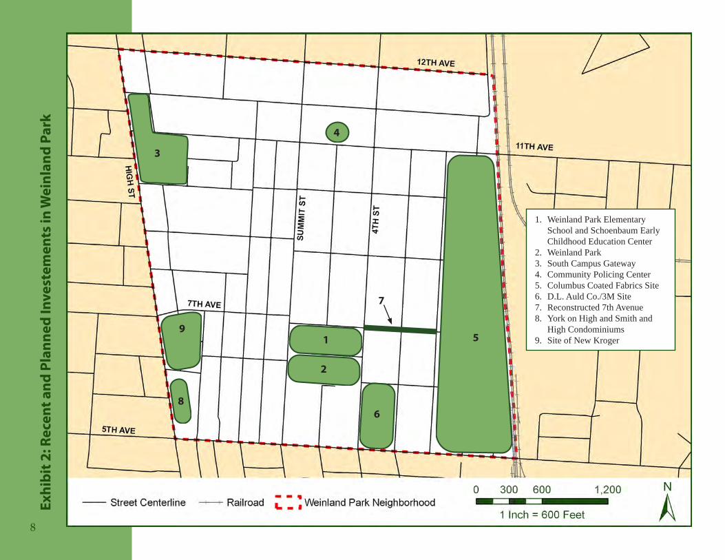
Future Investments and Development in Weinland ParkNot only does the character and design of Weinland Park make it a good candidate for multi-modal improvements, but it is also an area in transition. With the aforementioned planning and investment activity occurring in the neighborhood, it is likely that Weinland Park will undergo substantial changes in the next 5-10 years. Some of the recent and upcoming efforts in the community include (See Exhibit 2):
New Weinland Park Elementary School and Schoenbaum Early Childhood •Education CenterRedesign of Weinland Park•South Campus Gateway development•Community Policing and Pride Center on Eleventh Avenue•Clean-up and redevelopment of the Columbus Coated Fabrics site•Clean-up and redevelopment of the D.L. Auld Company/3M site•Seventh Avenue improvements including new sidewalks (built with Urban •Infrastructure Recovery Funds)York on High and Smith and High Condos on High Street north of Fifth Avenue•Reconstruction of the Kroger grocery store at its current location at Seventh Avenue •and High StreetWeinland Park Business Plan – Joint effort of Campus Partners, Columbus •Foundation, and JP Morgan Chase Foundation.United Way Building Vibrant Neighborhoods Program – Weinland Park is one •offiveColumbusneighborhoods inwhich theUnitedWaywill focusefforts toimprove neighborhood safety and ensure safe and decent housing
As current residents and agencies work for improvements in the neighborhood and new residents and businesses move in, this is an ideal opportunity to improve the safety and function of the transportation system for all users, but for pedestrians, cyclists, and transit riders in particular.
7
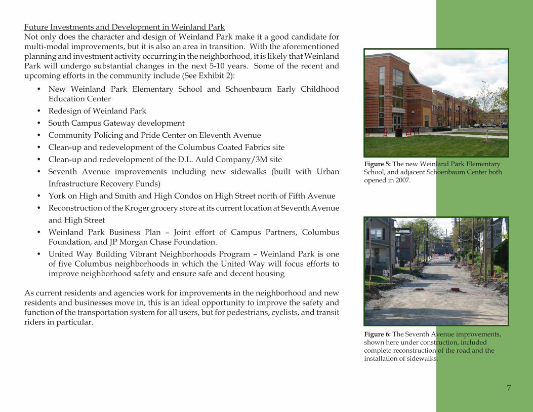
The new Weinland Park Elementary Figure 5: School, and adjacent Schoenbaum Center both opened in 2007.
The Seventh Avenue improvements, Figure 6: shown here under construction, included complete reconstruction of the road and the installation of sidewalks.
Rece
nt a
nd P
lann
ed In
vest
emen
ts in
Wei
nlan
d Pa
rkEx
hibi
t 2:
1
2
3
4
5
6
7
8
9
Weinland Park Elementary 1. School and Schoenbaum Early Childhood Education CenterWeinland Park2. South Campus Gateway3. Community Policing Center4. Columbus Coated Fabrics Site5. D.L. Auld Co./3M Site6. Reconstructed 7th Avenue7. York on High and Smith and 8. High CondominiumsSite of New Kroger9.
8
Issu
es a
nd C
once
rns
In order for the project team to successfully study and recommend solutions to the mobilityissuesoftheWeinlandParkcommunity,itwasimportanttofirstidentifyandbegin to understand what those problems are. The most effective way of gaining this understanding was through input from neighborhood residents and stakeholders. This process began before the project was even initiated with the tabulation of 311 service requests, and continued through the entire planning process. The project team sought to engeage the community and capitalize on the knowledge and input of residents to identify key locations of concern to study, develop solutions, and prioritize the recommendations.
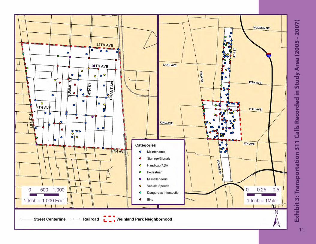
3-1-1 Service Requests
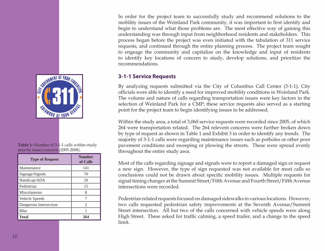
By analyzing requests submitted via the City of Columbus Call Center (3-1-1), City officialswereabletoidentifyaneedforimprovedmobilityconditionsinWeinlandPark.The volume and nature of calls regarding transportation issues were key factors in the selectionofWeinlandPark foraCMP; theseservicerequestsalsoservedasastartingpoint for the project team to begin identifying issues to be addressed.
Within the study area, a total of 3,060 service requests were recorded since 2005, of which 264 were transportation related. The 264 relevent concerns were further broken down by type of request as shown in Table 1 and Exhibit 3 in order to identify any trends. The majority of 3-1-1 calls were regarding maintenance issues such as potholes or other poor pavement conditions and sweeping or plowing the streets. These were spread evenly throughout the entire study area.
Most of the calls regarding signage and signals were to report a damaged sign or request a new sign. However, the type of sign requested was not available for most calls so conclusions couldnot bedrawnabout specificmobility issues. Multiple requests forsignal timing changes at the Summit Street/Fifth Avenue and Fourth Street/Fifth Avenue intersections were recorded.
Pedestrian related requests focused on damaged sidewalks in various locations. However, two calls requested pedestrian safety improvements at the Seventh Avenue/Summit Street intersection. All but two of the calls concerned with vehicle speeds were along HighStreet.Theseaskedfortrafficcalming,aspeedtrailer,andachangetothespeedlimit.
Type of Request Number of Calls
Maintenance 141Signage/Signals 70Handicap/ADA 20Pedestrian 15Miscelaneous 8Vehicle Speeds 7Dangerous Intersection 2Bike 1Total 264
10
Number of 3-1-1 calls within study Table 1: area by issue/concern (2005-2008).
Tran
spor
tati
on 3
11 C
alls
Rec
orde
d in
Stu
dy A
rea
(200
5 - 2
007)
Exhi
bit 3
:
11
Communication Forums and Input Opportunities
With one of the primary goals of the Community Mobility Planning Program being to address transportation issues identified by community residents, public input and involvement played a vital role throughout the planning process. From the initial development of plan goals, to the identification of mobility issues, to the selection and prioritization of solutions, residents of the Weinland Park community and area stakeholders were involved throughout the planning process. All public involvement materials from the project are included in Appendix B.
The City conducted numerous public involvement events, in a variety of venues and formats, in order gain participation from as wide a range of residents as possible. At the outset of the planning process, a Communication Plan (See Appendix B) was created to act as a guide for public involvement throughout the project. The goals and objectives of the Communications Plan are to identify activities that are:
Engaging and informational to the public, stakeholders, and the project team•Comprehensive in nature•Result-oriented•Inclusive of other government organizations•
In order to ensure members of the community were made aware of and had the opportunitytoparticipateintheplanningprocess,multiplemethodsofnotificationwereused for all of the scheduled public events. A project website was established on which all meeting materials and additional project information was made available. Prior to each event, the City issued press releases, posters were hung in businesses and community facilitiesthroughouttheneighborhood,andfliersweredistributedduringdoorknockingcampaigns by team members and representatives from the Weinland Park Community Civic Association. Additionally, emails were sent out on multiple listservs and to any resident or stakeholder who provided their contact information.
The following is a brief description of the approaches the City took to engage and facilitate discussions with the public during the planning process:
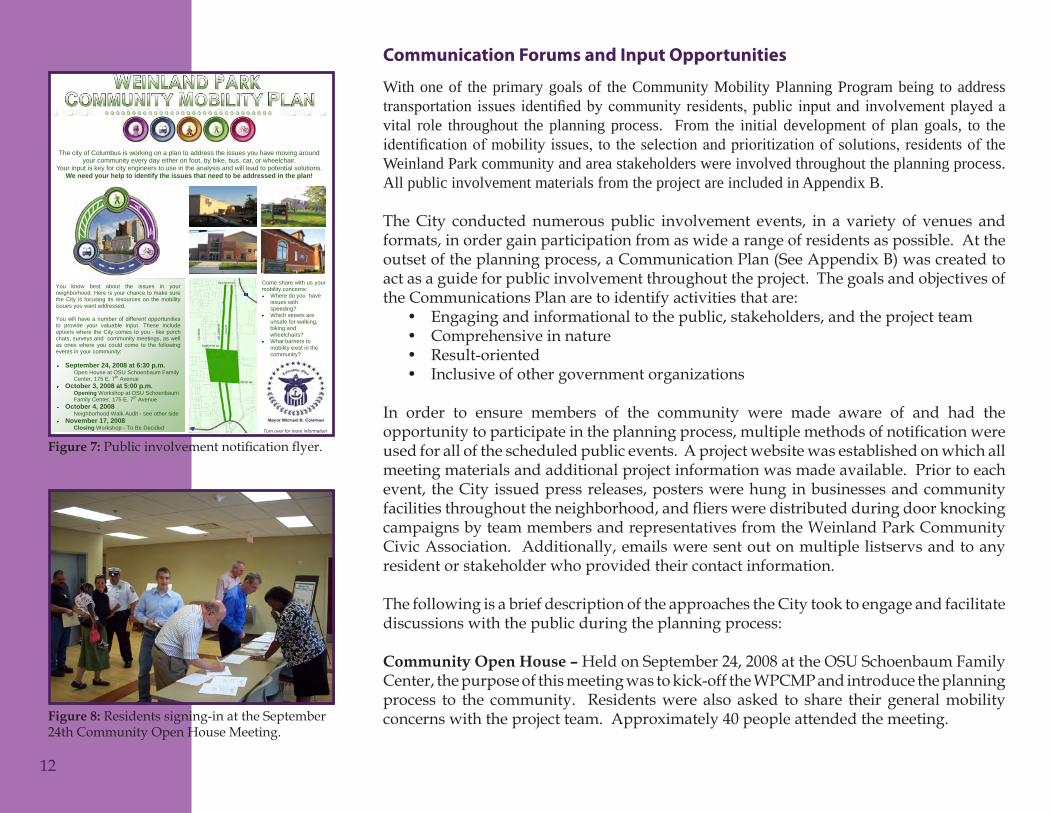
Community Open House – Held on September 24, 2008 at the OSU Schoenbaum Family Center, the purpose of this meeting was to kick-off the WPCMP and introduce the planning process to the community. Residents were also asked to share their general mobility concerns with the project team. Approximately 40 people attended the meeting.
You know best about the issues in your neighborhood. Here is your chance to make sure the City is focusing its resources on the mobility issues you want addressed. You will have a number of different opportunities to provide your valuable input. These include options where the City comes to you - like porch chats, surveys and community meetings, as well as ones where you could come to the following events in your community:
The city of Columbus is working on a plan to address the issues you have moving around your community every day either on foot, by bike, bus, car, or wheelchair.
Your input is key for city engineers to use in the analysis and will lead to potential solutions. We need your help to identify the issues that need to be addressed in the plan!
September 24, 2008 at 6:30 p.m. Open House at OSU Schoenbaum Family Center, 175 E. 7th Avenue
October 3, 2008 at 5:00 p.m. Opening Workshop at OSU Schoenbaum Family Center, 175 E. 7th Avenue
October 4, 2008 Neighborhood Walk Audit - see other side
November 17, 2008 Closing Workshop - To Be Decided
Come share with us your mobility concerns:
Where do you have issues with speeding? Which streets are unsafe for walking, biking and wheelchairs? What barriers to mobility exist in the community?
Turn over for more information
12
Publicinvolvementnotificationflyer.Figure 7:
Residents signing-in at the September Figure 8: 24th Community Open House Meeting.
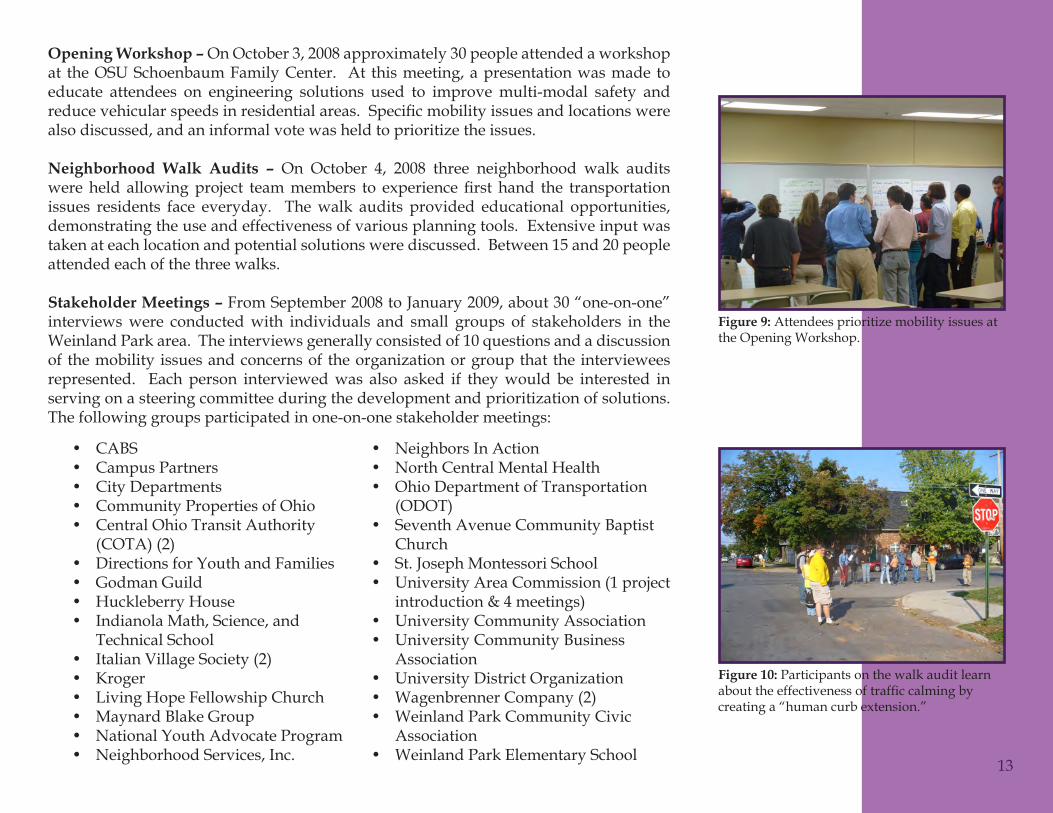
Opening Workshop – On October 3, 2008 approximately 30 people attended a workshop at the OSU Schoenbaum Family Center. At this meeting, a presentation was made to educate attendees on engineering solutions used to improve multi-modal safety and reducevehicularspeedsinresidentialareas.Specificmobilityissuesandlocationswerealso discussed, and an informal vote was held to prioritize the issues.
Neighborhood Walk Audits – On October 4, 2008 three neighborhood walk audits wereheld allowingproject teammembers to experiencefirst hand the transportationissues residents face everyday. The walk audits provided educational opportunities, demonstrating the use and effectiveness of various planning tools. Extensive input was taken at each location and potential solutions were discussed. Between 15 and 20 people attended each of the three walks.
Stakeholder Meetings – From September 2008 to January 2009, about 30 “one-on-one” interviews were conducted with individuals and small groups of stakeholders in the Weinland Park area. The interviews generally consisted of 10 questions and a discussion of the mobility issues and concerns of the organization or group that the interviewees represented. Each person interviewed was also asked if they would be interested in serving on a steering committee during the development and prioritization of solutions. The following groups participated in one-on-one stakeholder meetings:
Neighbors In Action•North Central Mental Health•Ohio Department of Transportation •(ODOT)Seventh Avenue Community Baptist •ChurchSt. Joseph Montessori School•University Area Commission (1 project •introduction & 4 meetings)University Community Association•University Community Business •AssociationUniversity District Organization•Wagenbrenner Company (2)•Weinland Park Community Civic •AssociationWeinland Park Elementary School•
CABS•Campus Partners•City Departments•Community Properties of Ohio•Central Ohio Transit Authority •(COTA) (2)Directions for Youth and Families•Godman Guild•Huckleberry House•Indianola Math, Science, and •Technical SchoolItalian Village Society (2)•Kroger•Living Hope Fellowship Church•Maynard Blake Group•National Youth Advocate Program•Neighborhood Services, Inc.•
13
Attendees prioritize mobility issues at Figure 9: the Opening Workshop.
Participants on the walk audit learn Figure 10: abouttheeffectivenessoftrafficcalmingbycreating a “human curb extension.”
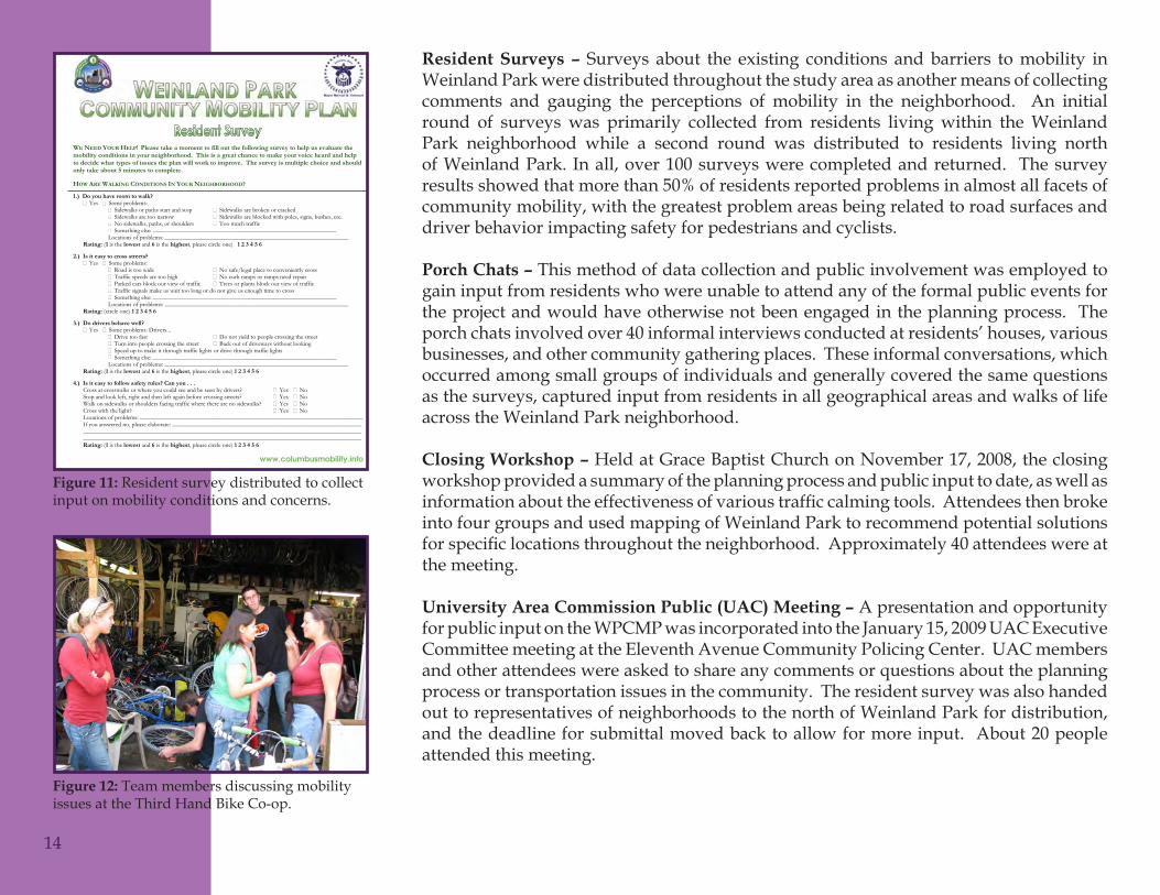
Resident Surveys – Surveys about the existing conditions and barriers to mobility in Weinland Park were distributed throughout the study area as another means of collecting comments and gauging the perceptions of mobility in the neighborhood. An initial round of surveys was primarily collected from residents living within the Weinland Park neighborhood while a second round was distributed to residents living north of Weinland Park. In all, over 100 surveys were completed and returned. The survey results showed that more than 50% of residents reported problems in almost all facets of community mobility, with the greatest problem areas being related to road surfaces and driver behavior impacting safety for pedestrians and cyclists.
Porch Chats – This method of data collection and public involvement was employed to gain input from residents who were unable to attend any of the formal public events for the project and would have otherwise not been engaged in the planning process. The porch chats involved over 40 informal interviews conducted at residents’ houses, various businesses, and other community gathering places. These informal conversations, which occurred among small groups of individuals and generally covered the same questions as the surveys, captured input from residents in all geographical areas and walks of life across the Weinland Park neighborhood.
Closing Workshop – Held at Grace Baptist Church on November 17, 2008, the closing workshop provided a summary of the planning process and public input to date, as well as informationabouttheeffectivenessofvarioustrafficcalmingtools.Attendeesthenbrokeinto four groups and used mapping of Weinland Park to recommend potential solutions forspecificlocationsthroughouttheneighborhood.Approximately40attendeeswereatthe meeting.
University Area Commission Public (UAC) Meeting – A presentation and opportunity for public input on the WPCMP was incorporated into the January 15, 2009 UAC Executive Committee meeting at the Eleventh Avenue Community Policing Center. UAC members and other attendees were asked to share any comments or questions about the planning process or transportation issues in the community. The resident survey was also handed out to representatives of neighborhoods to the north of Weinland Park for distribution, and the deadline for submittal moved back to allow for more input. About 20 people attended this meeting.
www.columbusmobility.info
14
Resident survey distributed to collect Figure 11: input on mobility conditions and concerns.
Team members discussing mobility Figure 12: issues at the Third Hand Bike Co-op.
Stakeholder Update Meeting – On May 28, 2009 a project update meeting was held at the Eleventh Avenue Community Policing Center. All stakeholders who, during the initial interviews, expressed an interest in continued involvement in the project were invited to attend. Team members presented the results of the public input process and the technical data analyses along with the preliminary “toolbox of solutions” and location specificrecommendationsforeachtool.
Final Community Open House – A second community open house meeting was held on June 24, 2009 at the OSU Schoenbaum Family Center. The team presented the results of the public input and technical study portions of the plan and were shown the preliminary solutions recommended for the neighborhood. Attendees had the opportunity to discuss questions and concerns regarding the plan with City engineers and to rank the solutions based on which they felt should be given the highest priority. These rankings are summarized in the Prioritization and Implementation chapter.
Several attendees expressed concern that safety issues on Summit and Fourth Streets, whichhadbeenremovedfromthescopeoftheplanduetouncertaintyoffuturetrafficdemand and the potential for light rail, were not adequately addressed. Based on input received at this meeting, the City determined that Summit and Fourth Streets would again be included in the plan and that more detailed analyses of the corridor should be done in order to adequately address the Community’s concerns.
Steering Committee Meetings - A Steering Committee was formed from interested residents and stakeholders to help prioritize the recommended solutions and develop an implementation strategy. Summaries of these meetings are discussed in the Prioritization and Implementation chapter.
15
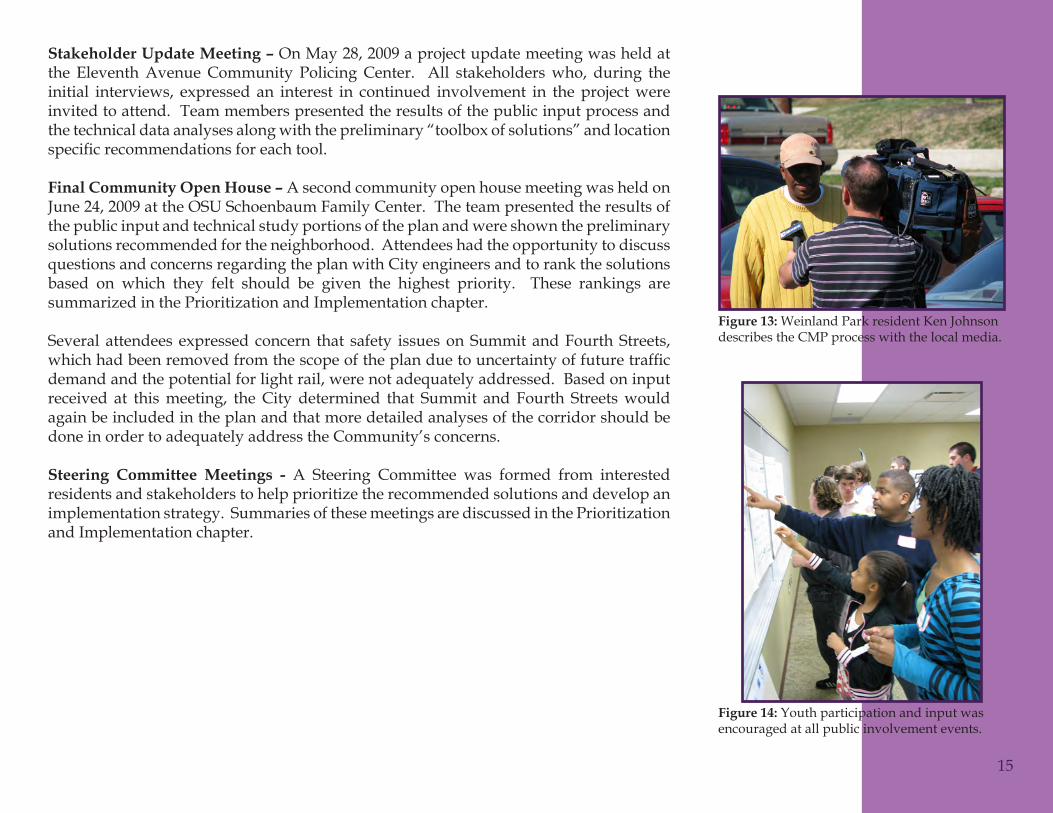
Weinland Park resident Ken Johnson Figure 13: describes the CMP process with the local media.
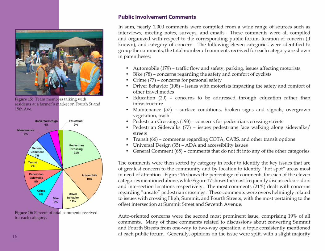
Youth participation and input was Figure 14: encouraged at all public involvement events.
Public Involvement Comments
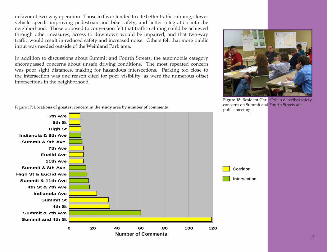
In sum, nearly 1,000 comments were compiled from a wide range of sources such as interviews, meeting notes, surveys, and emails. These comments were all compiled and organized with respect to the corresponding public forum, location of concern (if known), and categoryof concern. The following eleven categorieswere identified togroupthecomments;thetotalnumberofcommentsreceivedforeachcategoryareshownin parentheses:
Automobile(179)–trafficflowandsafety,parking,issuesaffectingmotorists•Bike (78) – concerns regarding the safety and comfort of cyclists•Crime (77) – concerns for personal safety•Driver Behavior (108) – issues with motorists impacting the safety and comfort of •other travel modesEducation (20) – concerns to be addressed through education rather than •infrastructureMaintenance (57) – surface conditions, broken signs and signals, overgrown •vegetation, trashPedestrian Crossings (193) – concerns for pedestrians crossing streets•Pedestrian Sidewalks (77) – issues pedestrians face walking along sidewalks/•streetsTransit (66) – comments regarding COTA, CABS, and other transit options•Universal Design (35) – ADA and accessibility issues•GeneralComment(65)–commentsthatdonotfitintoanyoftheothercategories•
The comments were then sorted by category in order to identify the key issues that are of greatest concern to the community and by location to identify “hot spot” areas most in need of attention. Figure 16 shows the percentage of comments for each of the eleven categories mentioned above, while Figure 17 shows the most frequently discussed corridors and intersection locations respectively. The most comments (21%) dealt with concerns regarding “unsafe” pedestrian crossings. These comments were overwhelmingly related to issues with crossing High, Summit, and Fourth Streets, with the most pertaining to the offset intersection at Summit Street and Seventh Avenue.
Auto-oriented concerns were the second most prominent issue, comprising 19% of all comments. Many of these comments related to discussions about converting Summit andFourthStreetsfromone-waytotwo-wayoperation;atopicconsistentlymentionedat each public forum. Generally, opinions on the issue were split, with a slight majority
Figure 1: Comments by Category
Universal Design4%
Education2%
Maintenance6%
General Comment
7%
Transit7%
Pedestrian Sidewalks
8%
Automobile19%
Pedestrian Crossing
21%
Driver Behavior
11%Bike 8%
Crime8%
16
Team members talking with Figure 15: residents at a farmer’s market on Fourth St and 18th Ave.
Percent of total comments received Figure 16: for each category.
infavoroftwo-wayoperation.Thoseinfavortendedtocitebettertrafficcalming,slowervehicle speeds improving pedestrian and bike safety, and better integration into the neighborhood.Thoseopposedtoconversionfeltthattrafficcalmingcouldbeachievedthrough other measures, access to downtown would be impaired, and that two-way trafficwouldresultinreducedsafetyandincreasednoise.Othersfeltthatmorepublicinput was needed outside of the Weinland Park area.
In addition to discussions about Summit and Fourth Streets, the automobile category encompassed concerns about unsafe driving conditions. The most repeated concern was poor sight distances, making for hazardous intersections. Parking too close to the intersection was one reason cited for poor visibility, as were the numerous offset intersections in the neighborhood.
Figure 2: Comments by Key Location
0 20 40 60 80 100 120
Summit and 4th StSummit & 7th Ave
4th StSummit St
Indianola Ave4th St & 7th Ave
Summit & 11th AveHigh St & Euclid Ave
Summit & 8th Ave 11th Ave
Euclid Ave7th Ave
Summit & 9th Ave Indianola & 8th Ave
High St5th St
5th Ave
Number of Comments 17
Resident Chris Orban describes safety Figure 18: concerns on Summit and Fourth Streets at a public meeting.Locations of greatest concern in the study area by number of commentsFigure 17:
Corridor
Intersection
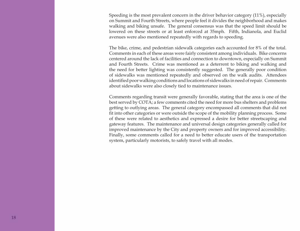
Speeding is the most prevalent concern in the driver behavior category (11%), especially on Summit and Fourth Streets, where people feel it divides the neighborhood and makes walking and biking unsafe. The general consensus was that the speed limit should be lowered on these streets or at least enforced at 35mph. Fifth, Indianola, and Euclid avenues were also mentioned repeatedly with regards to speeding.
The bike, crime, and pedestrian sidewalk categories each accounted for 8% of the total. Comments in each of these areas were fairly consistent among individuals. Bike concerns centered around the lack of facilities and connection to downtown, especially on Summit and Fourth Streets. Crime was mentioned as a deterrent to biking and walking and the need for better lighting was consistently suggested. The generally poor condition of sidewalks was mentioned repeatedly and observed on the walk audits. Attendees identifiedpoorwalkingconditionsandlocationsofsidewalksinneedofrepair.Commentsabout sidewalks were also closely tied to maintenance issues.
Comments regarding transit were generally favorable, stating that the area is one of the bestservedbyCOTA;afewcommentscitedtheneedformorebussheltersandproblemsgetting to outlying areas. The general category encompassed all comments that did not fitintoothercategoriesorwereoutsidethescopeofthemobilityplanningprocess.Someof these were related to aesthetics and expressed a desire for better streetscaping and gateway features. The maintenance and universal design categories generally called for improved maintenance by the City and property owners and for improved accessibility. Finally, some comments called for a need to better educate users of the transportation system, particularly motorists, to safely travel with all modes.
18
Exis
ting
Con
diti
ons
Guiding Plans and Studies
Prior to the evaluation of current mobility conditions in Weinland Park, all existing plans and studies for the study area were reviewed. These resources provided a better understanding of the current conditions in the area and served as a basis from which the Community Mobility Plan would be developed. Each document is listed below along with a brief summary of the pertinent information to this plan.
Columbus Comprehensive Plan (1993)As the guiding plan for development of the entire City, this plan is very general in scope. With relation to community mobility, the following recommendations apply:
Incentralcityneighborhoodsconsiderpoliciestoslowtrafficanddiscourageheavy•non-local through traffic on local streets. Ways to achieve this include closingsectionsofalleystodiscouragethroughtrafficandmaintainingnarrowstreetsthatare characteristic of neighborhoodsExpand existing transportation options and take a long-range perspective to future •changes in transportation needs and technologiesCOTA’s planning efforts should identify major transit corridors for busway and/•or light-rail developmentImprove pedestrian, bicycle, and vehicular linkages between neighborhoods to •promote a stronger link between residential areas and activity centersDevise standard streetscape improvements and standards to reinforce identity•
Columbus Thoroughfare Plan (1993) ThismapidentifiesandclassifiesallstreetsintheCitythatarecollectorroadsandabove.Itmakesrecommendationsforthetotalnumberoflanes,directionoftraffic(one-ortwo-way), and the minimum right-of-way width for each. The following streets in the study area are listed on the Thoroughfare Plan:
HighStreetandFifthAvenue(4-2D)-fourlanesoftwo-waytrafficdividedbya•median and a 120-foot right-of-wayHudson Street and Eleventh Avenue east of Grant Avenue (4-2) - four lanes of •two-waytrafficanda100-footright-of-waySummit and Fourth Streets (3-1) - three one-way travel lanes and an 80-foot right-•of-wayEleventh and Chittenden Avenues west of Grant Avenue (2-1) - two one-way •travel lanes and a 60-foot right-of-wayThird, Seventeenth, and Lane Avenues (C) - these collector streets call for two or •threelaneswithtwo-waytrafficandaminimumright-of-waywidthof60feet
!!!
!!!!!!!!!!!!
!!!!!!!!!!!!!!!!!!!!!!!!!!!!!!!!!!!!!!!!!!!!!
!!!!!!!!!!!!
!!!!!!!!!!!!!!!!!!!!!!!!!!!!!!!!!!!!!!!!!!!!!!!!!!!!!!!!!!!!!!!!!!!!!!!!!!!!!
!!!!!!!!!!!!!!!!!!!!!!!!!!!!!!!!!!!!!!!!!!!!!!!!!!!!!!!!!!!!!!!!!!!!!!!!!!!
!!!!!!!!!!!!!!!!
!!!!!!!!!!!!!!!!!
!!!!!!!!!!!!!!!!!!!!!!!!!!!!!
!!!!
!!!!!!!!!!!!!!!!!!!
!!!!!!!
!!!!!!!!!!!!!!!!!!!!!!!!!!!!!!!!!!!!!!!!!!!!!!!!!!!!!!!!!!!!!!!!!!!!!!!!!!!!!!!!!!!!!!!!!!!!!!!!!!!!!!!!!!!!!!!!!!!!!!!!!!!!!!!!!!!!!!!!!!!!!!!!!!!!!!!!!!!!!!!
!!!!!!!!!!! ! ! !
! ! ! !! ! !! ! ! ! ! ! !! ! ! ! ! ! ! ! ! ! ! ! ! ! ! ! ! !! ! !! ! !! !! !!!!!!!!!!!!!!!!!!!!!!!!! ! ! ! ! ! ! ! ! ! ! ! ! ! ! ! ! ! ! ! ! !!!
!!!!
!!!! ! ! ! ! !! ! ! !! ! ! ! !
!! !! !!
!!!!!!
!!!!!!
!!! !!! ! ! ! ! ! ! ! ! ! ! ! ! ! ! ! ! ! ! ! ! ! ! ! ! ! ! ! ! ! ! ! ! ! ! ! ! ! ! ! ! ! ! ! ! ! ! ! !! ! ! ! ! ! !!
!!!!!!!!!!!!!!!
! ! ! ! ! ! ! ! ! ! ! !!!!! !!!!!!!!!!!!!!!!!! ! ! ! ! ! ! ! ! ! ! ! ! ! ! ! ! ! ! ! ! ! ! ! ! ! ! ! ! ! ! ! ! !
!!!!!!!!!
!!!!!! ! ! ! !! ! ! ! ! ! ! !!! !!!!!!!!!!! !!! ! ! !!
!!! ! ! !!!!! !!!!!!!!!!!!!!!!!!!!!!!!!!!!!!!!!!!!
!!!!!!!!!!!!!!!
!!!!!!!!!!!!!!!!!!!!!!!!!!!!!!!!!!!!!!!!!!!!!
!!!!!!!!!!!!!!!!!!!!!!!!!!!!!!!!!!!!!!!!!
!!!!!!!!!!!!!!!!!!!!!!!!!!!!!!!!!!!!!!!!!!!!!!!!!!!!!!!!!!!
!!!!!!!!!!!!!!!!!!!!!!!!!
!!!!!!!!!
!!!!!!
!!!!
!!!!!!!!!!!!!!!!!!!!!!!!!!!!
!!!!!!!
!!!!!!!
!!!!!!
!!!!!!!!!
!!!!!!!!!!!!!!!!! ! ! ! ! ! ! ! ! ! ! ! ! ! ! ! ! ! ! ! ! !!!!!!!!!
!!!!!!!!!!!!!!!!!!!!!!!!!!!!!!!!!!!!!!!!!!!!!!!!!!!!
!!!!!!!!!!!!!!!!!!!!!!
!!!!!!!!!!!!!!!!!!!!!!!!!!!!!!!!!!!!!!!!!!!!!!!!!!!!!!!!!!!!!!!!!!!!!!!!!!!!!!!!!!!!!!!!!!!!!!!!!
!!
o
o
o
o
o
o
I 70
I71
I 270 MORSE
I 670
SR315
HIG
HFIFTH
SUNBURY
SR 161
KAR
L
STEL
ZER
BRIC
E
PAR
SON
S
CLIME
LIVINGSTON
FEDER
LANE
BIXBY
ROHR
DU
BLIN
US33
ALU
MC
REE
K
BROAD ST (US 40)
WILLIAMS
KE
NN
Y
HAGUE
JAM
ES
AV
ER
Y
ALKIRE
MAIN ST (US 40)
WILSO
N
HAYES
HARD
BROAD ST (SR 16)
OH
IO
SA
WM
ILL
HO
LT
WAG
GO
NER
WINCHESTER
CLE
VE
LAN
D
HO
OV
ER
POST
HALL
SULLIVANT
OLE
NTA
NG
YR
IVE
R
BETHEL
RE
ED
ROBERTS
LOC
KBO
UR
NE
LEAP
GA
NTZ
CAS
SAD
Y
HAM
ILTO
NR
D(S
R31
7)
HAYDEN RUN
AGLER
LONG
EAKIN
RINGS
WEBER CLARK STATE
JOY
CE
HA
MIL
TON
PARK
TAYLOR
SP
RIN
G
BRAND
HIG
HS
T(U
S23
)
REFUGEE RD
MAI
ZE
PON
TIUS
LEE
POWELL
DIX
ON
GROVEPORT
FREBIS
STYG
LER
CENTRAL COLLEGE
KITZ
MIL
LER
HO
UC
HA
RD
WILC
OX
JAC
KS
ON
PIK
ER
D(S
R10
4)
BA
BB
ITT
DYER
FRANK RD (SR 104)
EBR
IGH
TN
OE
-BIX
BY
HAR
LEM
RENNER
ROWE
CANAL
FERRIS
LONDON-GROVEPORT (SR 665)
LITHOPOLIS
ELLIOTT
CO
SG
RA
Y
TUSS
IC
MAIN
CO
OPER
DU
BLINR
D(SR
745)
SIN
CLA
IR
MOCK
MO
RR
ISO
N
STIMMEL
TUSSING
GA
LLO
WAY
SUMMIT VIEW
STAT
EST
(SR
3)
BEVELHEIMER
LONG
DU
BLIN
TAYL
OR
I 670MAIN
I 71 US 33
ROBERTS
SUN
BUR
Y
FIFTH BROAD ST (SR 16)
Columbus Thoroughfare Plan
I 70
I 670I71
OH
IO
HIG
HFR
ON
T
LONG
SR315
MAIN
WHITTIER
NEIL
SECOND
PA
RS
ON
S
CH
AM
PIO
N
GR
AN
T
LIVINGSTON
FOU
RTH
ST
(US
23)
I-670 S
TC
LAIR
BRYDEN
BROAD ST (US 40)
TOWN ST (US 62)
LEONARD
MOUND
SOU
DER
GOODALE
MT VERNON
GLEN
WO
OD
NE
ILA
VE
HAR
MO
N
SPRING
JOYC
E
MCKINLEY
COLE
HIG
HST
(US
23)
DUBLIN RD (US 33)
NO
RTH
WEST
MAR
CO
NI
FRO
NT
GR
AN
T
I 71
SOU
DER
MAIN
SR315
I 670
SR31
5
Downtown
TYPEFREEWAY6-2DS6-2D
6-24-2DS4-2D
4-23-12-1CScenic BywayColumbus 2010 Planning Area
This map is a re-creation of the 1993 Columbus Thoroughfare Plan, adopted by City Council on December 6,1993. Changes from the 1993 map include 1) Thoroughfare Plan amendments adopted by City Council on April21, 2004 and June 21, 2004 to reflect the Noe Bixby Road Scenic Byway designation and the roadway network ofthe Interim Hayden Run Corridor Plan, and 2) edits to reflect changes in existing road conditions. All informationon this map is believed to be accurate, but in the case where a discrepancy exists from the 1993 ThoroughfarePlan (other than the Hayden Run Corridor and the Noe Bixby Scenic Byway areas), the 1993 Thoroughfare Planhardcopy map remains the official map. While the Thoroughfare Plan indicates classifications for roads outside ofthe Columbus corporate limits, the city of Columbus does not have jurisdiction over these roads.
0̄ 4 82 Miles
City of ColumbusMichael B. Coleman, MayorDevelopment DepartmentMark Barbash, DirectorPublic Service DepartmentHenry Guzman, Director
20
Southbound traffic on Summit St Figure 19: during morning rush hour.
Columbus Thoroughfare Plan map.Figure 20:
University Neighborhoods Revitalization Plan (1996)Developed by Campus Partners as a joint effort of the City of Columbus and The Ohio State Univeristy (OSU), this plan provides a comprehensive vision and strategy to revitalize the neighborhoods surrounding the Ohio State campus, including Weinland Park. Recommendations of the plan include:
Maintain one-way operation on Summit and Fourth Streets in the near term, •while implementing traffic calming measures, removing parking restrictions,recalibratingtrafficsignals,andincreasingspeedenforcement.Inthelongterm,reevaluate two-way operationExamine closures on some local streets in Weinland Park to limit cut-through •trafficandcreatedefensiblespaceEnhance the role of High Street as a major transit corridor•Provide a more effective public transportation/transit system•Enhance and improve pedestrian and bicycle movement to, from, and within the •University Neighborhoods
A Plan for High Street: Creating a 21st Century Main Street (2000)This plan focuses on design concepts and implementation strategies for High Street in the University District, with particular focus on the development of a Campus Gateway Project. It calls for re-establishing High Street as the Main Street of the area, emphasizing its role as a traffic artery, an economic development generator, and public gatheringspace. In terms of mobility, the plan calls for wider sidewalks and on-street parking along HighStreet,andare-configurationoftheEleventhAvenue/HighStreetintersection.TheSouth Campus Gateway incorporates all of these recommendations.
University/High Street Development & Design Guidelines (2002)These design guidelines, called for by the two aforementioned University District plans, areintendedtoguidetheimplementationofstrategiesidentifiedinthosetwodocuments.Theydictateapedestrian-orienteddevelopmentstylewithfirstfloorretailuses,smallsetbacks, wide sidewalks, and pedestrian scale signage and lighting.
21
A Plan for High Street cover.Figure 21:
University/High Street Figure 22: Development & Design Guidelines cover.
Downtown Columbus Circulation Study (2004, not adopted)Thisstudyanalyzedexistingandfuturetrafficpatternsalongnumerouscorridorsinandaround downtown Columbus. Numerous one-way pairs, including Summit and Fourth Streets, were evaluated for potential conversion to two-way operation as a part of this study. The following is a summary of the assumptions and recommendations made for Summit and Fourth Streets in the study:
Existingtrafficvolumes(2000)wereprojectedto2030usinggrowthfactorsof40%•and 20% for the AM and PM peak hours respectivelyThree scenarios (existing conditions, one-way with reduced lane widths, and two-•way) were analyzedThe reduced lane width and two-way scenarios assumed light rail operation along •the corridorThe one-way scenario maintained permanent parking on one side and off-peak •parking on the other side of both streets and included a bike lane on both streets, while the two-way option maintained the off-peak parking but eliminated the permanent parking from both streets and did not include bicycle facilitiesVehicle delays were comparable for the two new scenarios. They were higher •thantheexistingconfiguration,butwerecomparabletooneanotherThe one-way reduced, lane width scenario was recommended over the two-way •scenario because it allowed shorter pedestrian crossing distances and wait times, allowed for bus/light rail stops in the permanent parking lane, limited impacts to on-street parking, and provided bicycle lanes
Weinland Park Neighborhood Plan (2006)This is a comprehensive plan for the Weinland Park community that addresses all aspects of the neighborhood, including transportation and mobility. The public infrastructure section of the plan emphasizes multi-modal accommodation and safety improvements (Appendix C). Some of the recommendations include:
Take a multi-agency approach to calming Summit and Fourth Streets•Designstreetstomovetrafficwhilerecognizingtheprimarilyresidentialnatureof•the neighborhood and need for overall safetyEncourage cooperative transit agreements between COTA and OSU•When developing and implementing transportation facilities, place the needs of •residents, employees, and visitors to Weinland Park above those of persons merely traveling through the neighborhoodApplicationofappropriate trafficcalming techniquesonstreets throughout the•neighborhood
22
Weinland Park Neighborhood Plan Figure 23: cover
New lighting within the public right-of-way shall be attractive, pedestrian-scale, •and resistant to vandalismPriority of improvements shall be placed on areas near Weinland Park, the •elementary school, and the Schoenbaum Early Childhood Education Center
MORPC Regional Bicycle Transportation Facilities Plan (2006)This document provides a regional perspective of the bicycle network in Central Ohio. It highlights bicycle usage, safety concerns, existing facilities, and recommends future improvements to the overall network. The plan includes the following information that relates to the project area:
Two general groups of riders: Group A (advanced) and B/C (beginner/children) •must be considered in the planning and design of bicycle facilitiesHigh Street and Fifth Avenue are two of the ten highest bicycle crash corridors in •the regionSummit and Fourth Streets are the only two existing bikeways in the study area•High, Summit, and Fourth Streets and Fifth Avenue are recommended as “short •connectors”accordingtoMORPC’sbikewayfunctionalclassification
Columbus Pedestrian Thoroughfare Plan (2007, not adopted)This document provides a guide to developing appropriate pedestrian facilities along keyroutesthroughouttheCity(AppendixC).Streetsareclassifiedfrom1(highest)to5(lowest) and given a recommended sidewalk width and clear walking zone. Each street alsoreceivesahigh/medium/lowratingfortrafficspeedandvolumetodeterminetherecommended lateral separation and vertical buffer to ensure safety and comfort. All of the streets within Weinland Park that are included in that plan (High, Summit, and Fourth Streets and Fifth, Tenth, and Eleventh Avenues) were rated as Class 1 or 2, which have recommended sidewalk widths of 12 to 18 feet and 8 to 12 feet respectively.
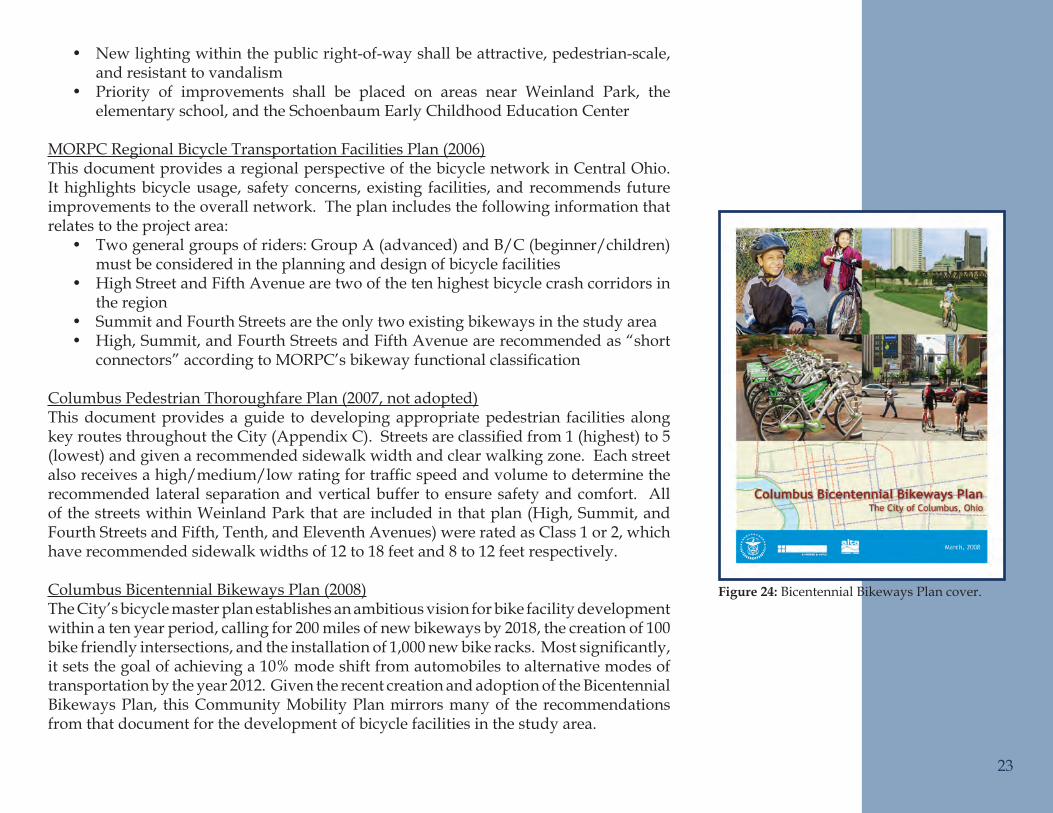
Columbus Bicentennial Bikeways Plan (2008)The City’s bicycle master plan establishes an ambitious vision for bike facility development within a ten year period, calling for 200 miles of new bikeways by 2018, the creation of 100 bikefriendlyintersections,andtheinstallationof1,000newbikeracks.Mostsignificantly,it sets the goal of achieving a 10% mode shift from automobiles to alternative modes of transportation by the year 2012. Given the recent creation and adoption of the Bicentennial Bikeways Plan, this Community Mobility Plan mirrors many of the recommendations from that document for the development of bicycle facilities in the study area.
23
Bicentennial Bikeways Plan cover.Figure 24:
Automobiles
Road NetworkAs was discussed earlier, the streets in and around Weinland Park are laid out in a grid network. The neighborhood is bounded by arterial streets on the north (Eleventh Avenue), south (Fifth Avenue), and west (High Street). Fourth and Summit Streets, which run north-south through the center of the neighborhood, are a one-way pair that also function as arterial roadways. Two east-west collector streets (Chittenden and Seventh Avenues) and one north-south collector (Indianola Avenue) provide further connectivity to the arterial roads and key locations throughout the neighborhood for area residents. The remaining streets in Weinland Park are residential in nature and generally serve only those users who live on them. These three different types of roadways create a system that serves a wide range of motorists, from those traveling through Weinland Park, to those making strictly local trips within the neighborhood.
Within the study area, the pavement width of Summit and Fourth Streets ranges from 40 to 52 feet, with the majority of each being 46 feet wide. Currently, the typical section for Summit and Fourth Streets, between Warren Street and Eleventh Avenue, includes a permanent parking lane that is not striped, two variable width travel lanes, and one lane that functions as a travel lane during the peak hour and a parking lane for the remainder of the day. From Weinland Park to Hudson Street, Summit Street is wider both roads widen to provide three travel lanes with permanent on-street parking on both sides. Fourth Street has the same section from Weinland Park to Wyandotte Avenue where it narrows to three travel lanes and one unmarked permanent parking lane. Both Summit and Fourth Streets have 35mph speed limits.
Through the study area, the Summit and Fourth Street corridor is the most prominent feature of the transportation network. This one-way pair carries US 23 north of downtown Columbus and is heavily used by commuters going to and from downtown from northern suburbs such as Clintonville and Worthington; however, the importance of Summit and Fourth Streets as access routes to and from downtown has diminished in recent years. With the completion of I-670, motorists can easily travel between I-71 and SR 315, both of which provide freeway access to communities north of downtown.
Between Fifth and Ninth Avenues, High Street is 48 feet wide with two travel lanes in each direction and a center turn lane. North of Ninth Avenue, it widens between intersections to provide on-street parking on one or both sides of the street, but remains 50 feet wide at intersections through the use of curb extensions. The speed limit on High Street is 25 mph. Fifth Avenue is 44 feet in width, has two lanes in each direction, and a posted speed of 25mph. With the exception of some sections of residential street that are one-way, all other streets in the study area have one travel lane in each 24
direction and a speed limit of 25mph. Most streets also have on-street parking on at least one side of the road.
Although it runs north-south along the entire eastern edge of Weinland Park, Grant Avenue is not included in the analyses or recommendations of this plan. As part of the project to redevelop the Columbus Coated Fabrics site, the entire road within Weinland Park is being reconstructed. The improved Grant Avenue will consist of one travel lane in each direction, on-street parking on both sides of the road, curb extensions at intersections, and a posted speed of 25mph (See Appendix D). Construction of the Grant Avenue improvements is scheduled to begin in 2010.
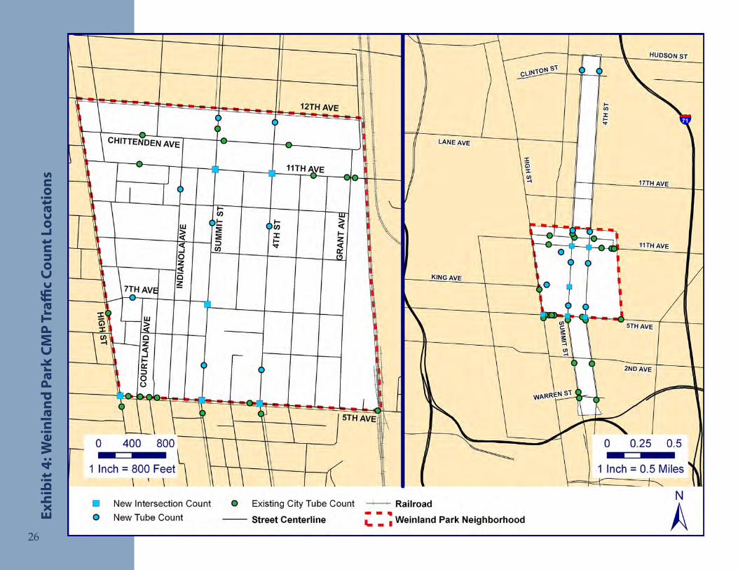
Existing Volumes, Capacity, and SpeedsExistingtrafficvolumesandspeedsinWeinlandParkandalongtheSummitandFourthStreetcorridorswereanalyzedinordertogainthenecessaryunderstandingoftrafficconditionstodevelopmobilityrecommendationsfortheneighborhood.Trafficcountsconducted by the City between 2003 and 2007 were supplemented with new counts at key locations (Exhibit 4). The vehicular speed and volume information collected during these counts was then analyzed to determine if and where any capacity and/or speedingproblemsexist.AsummaryofthetrafficcountsisincludedinAppendixE.
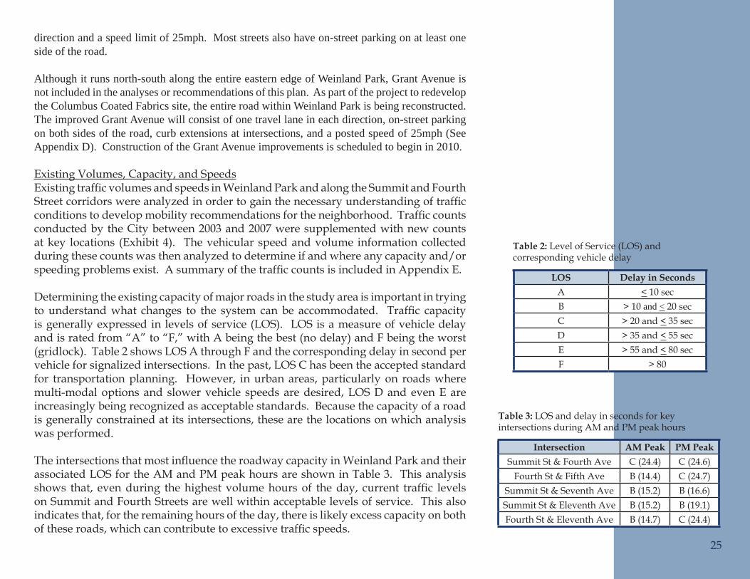
Determining the existing capacity of major roads in the study area is important in trying to understandwhat changes to the system can be accommodated. Traffic capacityis generally expressed in levels of service (LOS). LOS is a measure of vehicle delay and is rated from “A” to “F,” with A being the best (no delay) and F being the worst (gridlock). Table 2 shows LOS A through F and the corresponding delay in second per vehicle for signalized intersections. In the past, LOS C has been the accepted standard for transportation planning. However, in urban areas, particularly on roads where multi-modal options and slower vehicle speeds are desired, LOS D and even E are increasingly being recognized as acceptable standards. Because the capacity of a road is generally constrained at its intersections, these are the locations on which analysis was performed.
TheintersectionsthatmostinfluencetheroadwaycapacityinWeinlandParkandtheirassociated LOS for the AM and PM peak hours are shown in Table 3. This analysis shows that, evenduring thehighestvolumehoursof theday, current traffic levelson Summit and Fourth Streets are well within acceptable levels of service. This also indicates that, for the remaining hours of the day, there is likely excess capacity on both oftheseroads,whichcancontributetoexcessivetrafficspeeds.
25
LOS Delay in SecondsA < 10 secB > 10 and < 20 secC > 20 and < 35 secD > 35 and < 55 secE > 55 and < 80 secF > 80
Intersection AM Peak PM PeakSummit St & Fourth Ave C (24.4) C (24.6)
Fourth St & Fifth Ave B (14.4) C (24.7)Summit St & Seventh Ave B (15.2) B (16.6)Summit St & Eleventh Ave B (15.2) B (19.1)Fourth St & Eleventh Ave B (14.7) C (24.4)
Level of Service (LOS) and Table 2: corresponding vehicle delay
LOS and delay in seconds for key Table 3: intersections during AM and PM peak hours
26
Wei
nlan
d Pa
rk C
MP
Traffi
c Co
unt L
ocat
ions
Exhi
bit 4
:
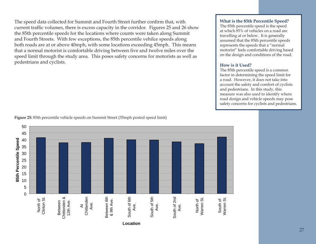
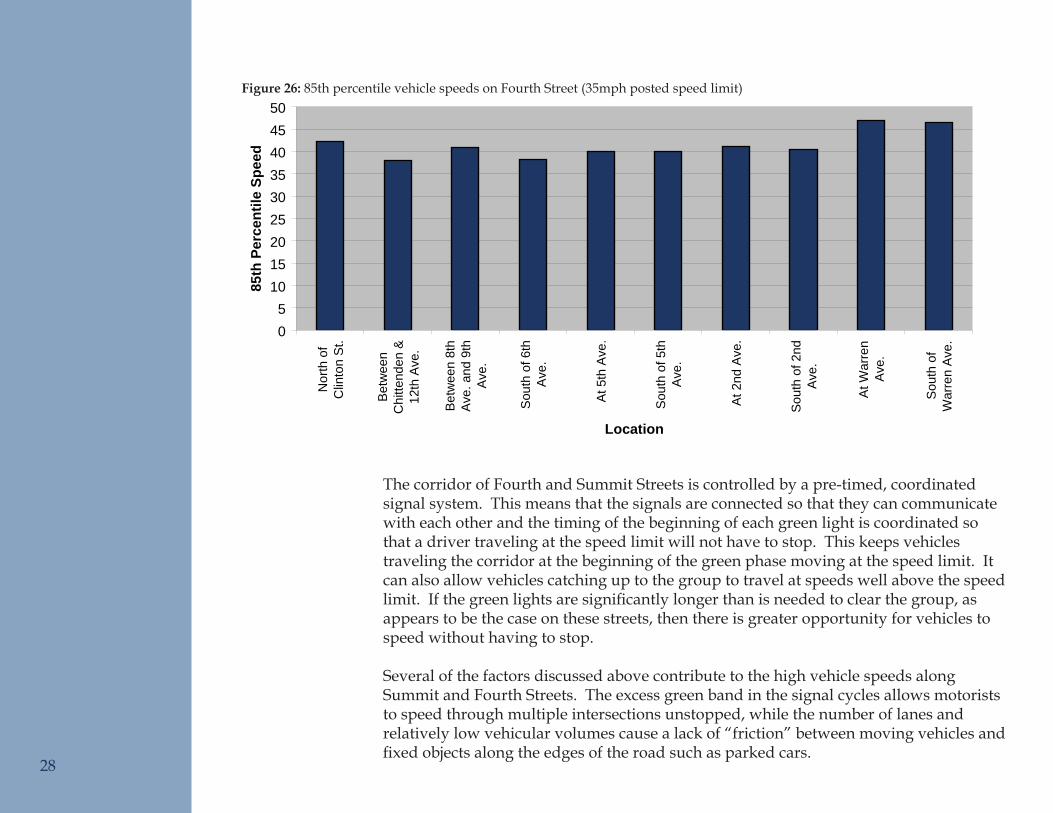
ThespeeddatacollectedforSummitandFourthStreetfurtherconfirmthat,withcurrenttrafficvolumes,thereisexcesscapacityinthecorridor.Figures25and26showthe 85th percentile speeds for the locations where counts were taken along Summit and Fourth Streets. With few exceptions, the 85th percentile vehilce speeds along both roads are at or above 40mph, with some locations exceeding 45mph. This means thatanormalmotoristiscomfortabledrivingbetweenfiveandtwelvemilesoverthespeed limit through the study area. This poses safety concerns for motorists as well as pedestrians and cyclists.
27
85th Percentile Speeds on Summit Street
05
101520253035404550
Nor
th o
fC
linto
n S
t.
Bet
wee
nC
hitte
nden
&12
th A
ve.
At
Chi
ttend
enA
ve.
Bet
wee
n 8t
h&
9th
Ave
.
Sou
th o
f 6th
Ave
.
Sou
th o
f 5th
Ave
.
Sou
th o
f 2nd
Ave
.
Nor
th o
fW
arre
n S
t.
Sou
th o
fW
arre
n S
t.Location
85th
Per
cent
ile S
peed
What is the 85th Percentile Speed?The 85th percentile speed is the speed at which 85% of vehicles on a road are travelling at or below. It is generally assumed that the 85th percentile speeds represents the speeds that a “normal motorist” feels comfortable driving based on the design and conditions of the road.
How is it Used? The 85th percentile speed is a common factor in determining the speed limit for a road. However, it does not take into account the safety and comfort of cyclists and pedestrians. In this study, this measure was also used to identify where road design and vehicle speeds may pose safety concerns for cyclists and pedestrians.
85th percentile vehicle speeds on Summit Street (35mph posted speed limit)Figure 25:
28
The corridor of Fourth and Summit Streets is controlled by a pre-timed, coordinated signal system. This means that the signals are connected so that they can communicate with each other and the timing of the beginning of each green light is coordinated so that a driver traveling at the speed limit will not have to stop. This keeps vehicles traveling the corridor at the beginning of the green phase moving at the speed limit. It can also allow vehicles catching up to the group to travel at speeds well above the speed limit.Ifthegreenlightsaresignificantlylongerthanisneededtoclearthegroup,asappears to be the case on these streets, then there is greater opportunity for vehicles to speed without having to stop.
Several of the factors discussed above contribute to the high vehicle speeds along Summit and Fourth Streets. The excess green band in the signal cycles allows motorists to speed through multiple intersections unstopped, while the number of lanes and relatively low vehicular volumes cause a lack of “friction” between moving vehicles and fixedobjectsalongtheedgesoftheroadsuchasparkedcars.
85th percentile vehicle speeds on Fourth Street (35mph posted speed limit)Figure 26:
85th Percentile Speeds on Fourth Street
05
101520253035404550
Nor
th o
fC
linto
n S
t.
Bet
wee
nC
hitte
nden
&12
th A
ve.
Bet
wee
n 8t
hA
ve. a
nd 9
thA
ve.
Sou
th o
f 6th
Ave
.
At 5
th A
ve.
Sou
th o
f 5th
Ave
.
At 2
nd A
ve.
Sou
th o
f 2nd
Ave
.
At W
arre
nA
ve.
Sou
th o
fW
arre
n A
ve.
Location
85th
Per
cent
ile S
peed
29
85th Percentile Speed on Streets with 25 MPH Posted Speed Limit
0
5
10
15
20
25
30
35
40
45
Chi
ttend
en A
vebe
twee
n 4t
h S
tan
d G
rant
Ave
Chi
ttend
en A
vebe
twee
n H
igh
St
and
Sum
mit
St
11th
Ave
bet
wee
n4t
h S
t and
Gra
ntA
ve
11th
Ave
bet
wee
nH
igh
St a
ndS
umm
it S
t
5th
Ave
at 4
th S
t
5th
Ave
at M
t.P
leas
ant A
ve
5th
Ave
bet
wee
nC
leve
land
Ave
and
4th
St
5th
Ave
Eas
t of
Hig
h S
t
5th
Ave
Eas
t of M
t.P
leas
ant A
ve
5th
Ave
Wes
t of
Mt.
Ple
asan
t Ave
Hig
h S
t Sou
th o
f5t
h A
ve
Hig
h S
t Sou
th o
fK
ing
Ave
Location
85th
Per
cent
ile S
peed
Vehicular CrashesThe most recent three-year crash data (2005-2007) was obtained from the Ohio Department of Public Safety and reviewed to identify trends that might indicate locations in need of safety improvements. A total of 1,571 crashes were recorded during that period within the study area. Of those, 1,036 occurred within the Weinland Park neighborhood, and the other 535 occurred along Summit and Fourth Streets to the north and south of the neighborhood.
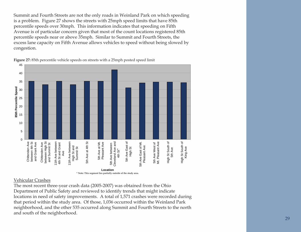
Summit and Fourth Streets are not the only roads in Weinland Park on which speeding is a problem. Figure 27 shows the streets with 25mph speed limits that have 85th percentile speeds over 30mph. This information indicates that speeding on Fifth Avenue is of particular concern given that most of the count locations registered 85th percentile speeds near or above 35mph. Similar to Summit and Fourth Streets, the excess lane capacity on Fifth Avenue allows vehicles to speed without being slowed by congestion.
85th percentile vehicle speeds on streets with a 25mph posted speed limitFigure 27:
*
* Note: This segment lies partially outside of the study area.
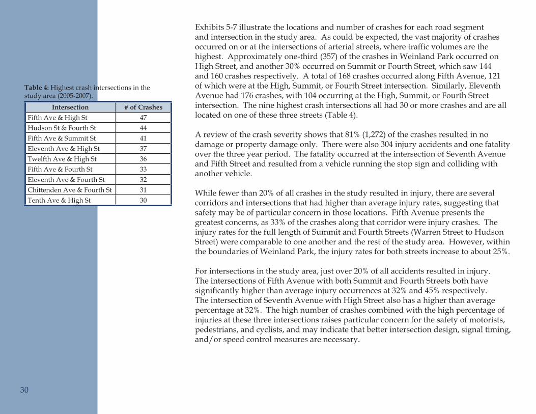
Exhibits 5-7 illustrate the locations and number of crashes for each road segment and intersection in the study area. As could be expected, the vast majority of crashes occurredonorattheintersectionsofarterialstreets,wheretrafficvolumesarethehighest. Approximately one-third (357) of the crashes in Weinland Park occurred on High Street, and another 30% occurred on Summit or Fourth Street, which saw 144 and 160 crashes respectively. A total of 168 crashes occurred along Fifth Avenue, 121 of which were at the High, Summit, or Fourth Street intersection. Similarly, Eleventh Avenue had 176 crashes, with 104 occurring at the High, Summit, or Fourth Street intersection. The nine highest crash intersections all had 30 or more crashes and are all located on one of these three streets (Table 4).
A review of the crash severity shows that 81% (1,272) of the crashes resulted in no damage or property damage only. There were also 304 injury accidents and one fatality over the three year period. The fatality occurred at the intersection of Seventh Avenue and Fifth Street and resulted from a vehicle running the stop sign and colliding with another vehicle.
While fewer than 20% of all crashes in the study resulted in injury, there are several corridors and intersections that had higher than average injury rates, suggesting that safety may be of particular concern in those locations. Fifth Avenue presents the greatest concerns, as 33% of the crashes along that corridor were injury crashes. The injury rates for the full length of Summit and Fourth Streets (Warren Street to Hudson Street) were comparable to one another and the rest of the study area. However, within the boundaries of Weinland Park, the injury rates for both streets increase to about 25%.
For intersections in the study area, just over 20% of all accidents resulted in injury. The intersections of Fifth Avenue with both Summit and Fourth Streets both have significantlyhigherthanaverageinjuryoccurrencesat32%and45%respectively.The intersection of Seventh Avenue with High Street also has a higher than average percentage at 32%. The high number of crashes combined with the high percentage of injuries at these three intersections raises particular concern for the safety of motorists, pedestrians, and cyclists, and may indicate that better intersection design, signal timing, and/or speed control measures are necessary.
Intersection # of CrashesFifth Ave & High St 47Hudson St & Fourth St 44Fifth Ave & Summit St 41Eleventh Ave & High St 37Twelfth Ave & High St 36Fifth Ave & Fourth St 33Eleventh Ave & Fourth St 32Chittenden Ave & Fourth St 31Tenth Ave & High St 30
Highest crash intersections in the Table 4: study area (2005-2007).
30
31
Reco
rded
Veh
icul
ar C
rash
es (2
005-
2007
) -
Exhi
bit 5
: Su
mm
it a
nd F
ourt
h St
reet
s N
orth
ern
Sect
ion
32
Reco
rded
Veh
icul
ar C
rash
es (2
005-
2007
) - W
einl
and
Park
Exhi
bit 6
:
33
Reco
rded
Veh
icul
ar C
rash
es (2
005-
2007
) -
Exhi
bit 7
: Su
mm
it a
nd F
ourt
h St
reet
s So
uthe
rn S
ecti
on

Geometric IssuesThe intersection of Ninth Avenue with Indianola Avenue, and the intersections of Summit Street with both Seventh and Eighth Avenues are all offset. This means that two legs of the intersection do not line up across from each other creating safety issues for drivers and pedestrians. Problems include poor visibility of vehicles and pedestrians, and confusing signing and vehicle priority for drivers. The most extreme example of this issue in Weinland Park is the intersection of Seventh Avenue and Summit Street. Confusion regarding vehicle priority and driver expectations is created whenthelightturnsgreenforboththeeastboundandwestboundtrafficatthesametime.Westboundvehiclesturninglefthavedifficultydeterminingwhethervehiclesturning right onto Summit Street from Seventh Avenue are continuing east on Seventh Avenue or south on Summit Street. Further exacerbating the problem, obstructions at theintersectionmakeitdifficultfordriverstoseepedestrianscrossingthestreet.Thesefactors combine to create a confusing condition for motorists to manuever.
TheintersectionofHighStreetandSeventh/KingAvenuecontainsanabruptdeflectionfor vehicles traveling east and west. The change in direction in the middle of the intersectionmakesitdifficulttoseeoncomingvehicleswhileturningleft,andtoseehazardsonthefarsideoftheintersection.Thesegeometricdeficienciesarelikelyakeycontributing factor to the high number and above average percentage of injury crashes that occur at this intersection.
34
Pedestrians
SidewalksDuring October 2008, a sidewalk inventory was performed that graded the condition of all 22.1 miles of sidewalk and all 818 curb ramps in the study area. While the City of Columbus does have existing standards regarding sidewalks for the purposes of code enforcement, it does not currently have an inventory rating system. Therefore, a sidewalk and curb ramp rating system developed and used by the City of Richmond, Virginia was utilized for this study. This system was selected because it is easy to record and update and it can be conducted by a person with little to no engineering or code enforcement knowledge, thus allowing members of the community to assist in maintaining the sidewalk ratings in the future.
The rating system assigns grades from “A” (best) to “F” (worst) for a section of sidewalk depending on the number of demerits present (Table 5). The individual conducting the inventoryidentifiesminordemerits(thosethatmaybeaninconveniencetomobility)and major demerits (those that may make a section of sidewalk impassable, particularly for someone using a mobility aid) in order to determine the appropriate grade. For this inventory, examples of minor demerits include cracks that are less than one inch, obstructions that slightly narrow the sidewalk, sidewalk widths that are below standard but more are than three feet, and some trash and/or debris. Examples of serious demerits include cracks and heaving that are greater than one inch, obstructions or sidewalk widths that provide less than three feet of passable space (minimum required for wheelchairs and some strollers), and substantial trash and/or debris. Similarly, the curb ramp rating system assigns ratings of O (outstanding), S (satisfactory), or U (unsatisfactory) depending on the number of demerits present (Table 6).
Grade Level of Service Criteria
A ExcellentNew or recently improved: continuous for whole block, uniform material (brick, concrete), even surface with no ponding, no trash/debris/dirt, no cracking/heaving/spalling, no roots or grass present, and having an overall aesthetically pleasing appearance
B Good Exhibits only 1-2 minor demerits but overall still viewed as above averageC Fair Exhibits 2-3 minor demerits or 1 major demerit and overall viewed as averageD Poor Exhibits 4-5 minor or 2-3 major demerits and overall viewed as below averageE Very Poor Exhibits more than 3 major demerits and overall viewed as well below averageF Failing A sidewalk in total disrepair/terrible condition/impassible for those using mobility aidsM Missing No sidewalk present
UC Under Construction N/A 35
Rating system used for neighborhood sidewalk inventoryTable 5:
Example of an Figure 28: “A” rated sidewalk.
Example of a “C” rated sidewalk.Figure 29:
Grade Level of Service CriteriaO Above Average Curb cut present and in good to excellent conditionS Average Curb cut/handicap access ramp present but in fair condition
U Failing/No Ramp Curb cut/handicap access ramp present but in failing condition (severely cracked or broken) or no ramp present
UC Under Construction N/A
Sidewalks were divided into sections by breaks at streets and alleys. This resulted in sections of varying lengths, meaning that a longer section would be more likely to have demerits than a shorter section. This variation was minimized by photographing everysectionandreviewingeachgradeoncetheentireinventoryhadbeencompleted;however, given the variation in length of sidewalk sections and the observational nature of the grading system, the inventory must be viewed in the proper context. It is not intended to be used for code enforcement, but rather as a tool to identify the overall state of the sidewalk network in the neighborhood and to help prioritize the need for repair and replacement efforts.
As shown in Table 7, 65% of the sidewalks in the Weinland Park and along the Fourth and Summit Street corridors received a rating of poor (D) or worse. This means that three-quarters of the sidewalks in the study area have at least two serious faults that may make them impassable for some pedestrians. Exhibits 8-10 shows each section of sidewalk that was inventoried and the rating it received. In general, High Street has the best sidewalk conditions in the neighborhood, while all of the other arterials are badly in need of repair, with “D” and “E” being the most common ratings. Of particular concern along Summit and Fourth Streets are the presence of major obstructions (i.e. – utility poles, sign posts, debris) that reduce the clear walking zone to less than three feet, making the route impassible for anyone using a mobility aid. With the completion of the Seventh Avenue improvements in late 2008 and the upcoming reconstruction of Grant Avenue, a small section of Sixth Avenue just east of Fifth Street is the only location in Weinland Park with no existing or planned sidewalk.
Similar to the sidewalk inventory, Table 8 shows that many of the curb ramps in Weinland Park are also in need of repair or replacement, with the greatest number (41%) receiving a rating of unsatisfactory.
Grade Number of Segments
Percent Within Study Area
A 9 2%B 32 8%C 75 19%D 160 41%E 83 21%F 13 3%M 8 2%UC 16 4%
Grade Number of Ramps Percent Within Study Area
O 195 24%S 281 34%U 334 41%
UC 8 1%
36
Rating system used for neighborhood curb ramp inventoryTable 6:
Number of sidewalk segments by gradeTable 7:
Number of curb ramps by gradeTable 8:
Example of an “E” rated sidewalk.Figure 30:
Side
wal
k In
vent
ory
- Ex
hibi
t 8:
Sum
mit
and
Fou
rth
Stre
ets
Nor
ther
n Se
ctio
n
37
Side
wal
k In
vent
ory
- Wei
nlan
d Pa
rkEx
hibi
t 9:
38
39
Side
wal
k In
vent
ory
- Ex
hibi
t 10:
Su
mm
it a
nd F
ourt
h St
reet
s So
uthe
rn S
ecti
on
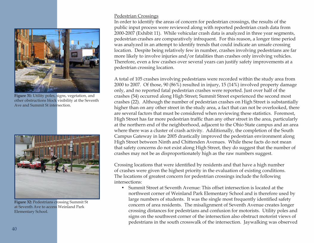
Pedestrian CrossingsIn order to identify the areas of concern for pedestrian crossings, the results of the public input process were reviewed along with reported pedestrian crash data from 2000-2007 (Exhibit 11). While vehicular crash data is analyzed in three year segments, pedestrian crashes are comparatively infrequent. For this reason, a longer time period was analyzed in an attempt to identify trends that could indicate an unsafe crossing location. Despite being relatively few in number, crashes involving pedestrians are far more likely to involve injuries and/or fatalities than crashes only involving vehicles. Therefore, even a few crashes over several years can justify safety improvements at a pedestrian crossing location.
A total of 105 crashes involving pedestrians were recorded within the study area from 2000 to 2007. Of those, 90 (86%) resulted in injury, 15 (14%) involved property damage only, and no reported fatal pedestrian crashes were reported. Just over half of the crashes(54)occurredalongHighStreet;SummitStreetexperiencedthesecondmostcrashes (22). Although the number of pedestrian crashes on High Street is substantially higher than on any other street in the study area, a fact that can not be overlooked, there are several factors that must be considered when reviewing these statistics. Foremost, HighStreethasfarmorepedestriantrafficthananyotherstreetinthearea,particularlyat the northern end of the neighborhood, adjacent to the Ohio State campus and an area where there was a cluster of crash activity. Additionally, the completion of the South Campus Gateway in late 2005 drastically improved the pedestrian environment along High Street between Ninth and Chittenden Avenues. While these facts do not mean that safety concerns do not exist along High Street, they do suggest that the number of crashes may not be as disproportionately high as the raw numbers suggest.
Crossinglocationsthatwereidentifiedbyresidentsandthathaveahighnumberof crashes were given the highest priority in the evaluation of existing conditions. The locations of greatest concern for pedestrian crossings include the following intersections:
Summit Street at Seventh Avenue: This offset intersection is located at the •northwest corner of Weinland Park Elementary School and is therefore used by largenumbersofstudents.Itwasthesinglemostfrequentlyidentifiedsafetyconcern of area residents. The misalignment of Seventh Avenue creates longer crossing distances for pedestrians and confusion for motorists. Utility poles and signs on the southwest corner of the intersection also obstruct motorist views of pedestrians in the south crosswalk of the intersection. Jaywalking was observed
40
Utility poles, signs, vegetation, and Figure 31: other obstructions block visibility at the Seventh Ave and Summit St intersection.
Pedestrians crossing Summit St Figure 32: at Seventh Ave to access Weinland Park Elementary School.
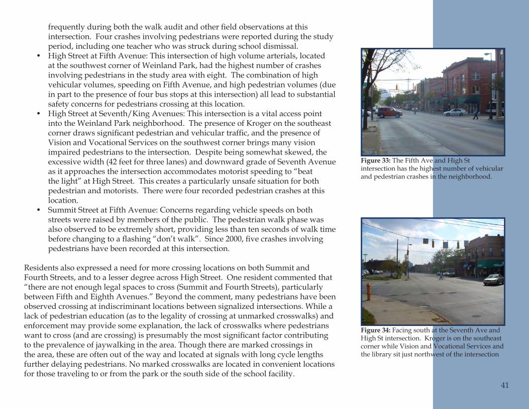
frequentlyduringboththewalkauditandotherfieldobservationsatthisintersection. Four crashes involving pedestrians were reported during the study period, including one teacher who was struck during school dismissal.High Street at Fifth Avenue: This intersection of high volume arterials, located •at the southwest corner of Weinland Park, had the highest number of crashes involving pedestrians in the study area with eight. The combination of high vehicular volumes, speeding on Fifth Avenue, and high pedestrian volumes (due in part to the presence of four bus stops at this intersection) all lead to substantial safety concerns for pedestrians crossing at this location.High Street at Seventh/King Avenues: This intersection is a vital access point •into the Weinland Park neighborhood. The presence of Kroger on the southeast cornerdrawssignificantpedestrianandvehiculartraffic,andthepresenceofVision and Vocational Services on the southwest corner brings many vision impaired pedestrians to the intersection. Despite being somewhat skewed, the excessive width (42 feet for three lanes) and downward grade of Seventh Avenue as it approaches the intersection accommodates motorist speeding to “beat the light” at High Street. This creates a particularly unsafe situation for both pedestrian and motorists. There were four recorded pedestrian crashes at this location.Summit Street at Fifth Avenue: Concerns regarding vehicle speeds on both •streets were raised by members of the public. The pedestrian walk phase was also observed to be extremely short, providing less than ten seconds of walk time beforechangingtoaflashing“don’twalk”.Since2000,fivecrashesinvolvingpedestrians have been recorded at this intersection.
Residents also expressed a need for more crossing locations on both Summit and Fourth Streets, and to a lesser degree across High Street. One resident commented that “there are not enough legal spaces to cross (Summit and Fourth Streets), particularly between Fifth and Eighth Avenues.” Beyond the comment, many pedestrians have been observed crossing at indiscriminant locations between signalized intersections. While a lack of pedestrian education (as to the legality of crossing at unmarked crosswalks) and enforcement may provide some explanation, the lack of crosswalks where pedestrians wanttocross(andarecrossing)ispresumablythemostsignificantfactorcontributingto the prevalence of jaywalking in the area. Though there are marked crossings in the area, these are often out of the way and located at signals with long cycle lengths further delaying pedestrians. No marked crosswalks are located in convenient locations for those traveling to or from the park or the south side of the school facility.
41
The Fifth Ave and High St Figure 33: intersection has the highest number of vehicular and pedestrian crashes in the neighborhood.
Facing south at the Seventh Ave and Figure 34: High St intersection. Kroger is on the southeast corner while Vision and Vocational Services and the library sit just northwest of the intersection
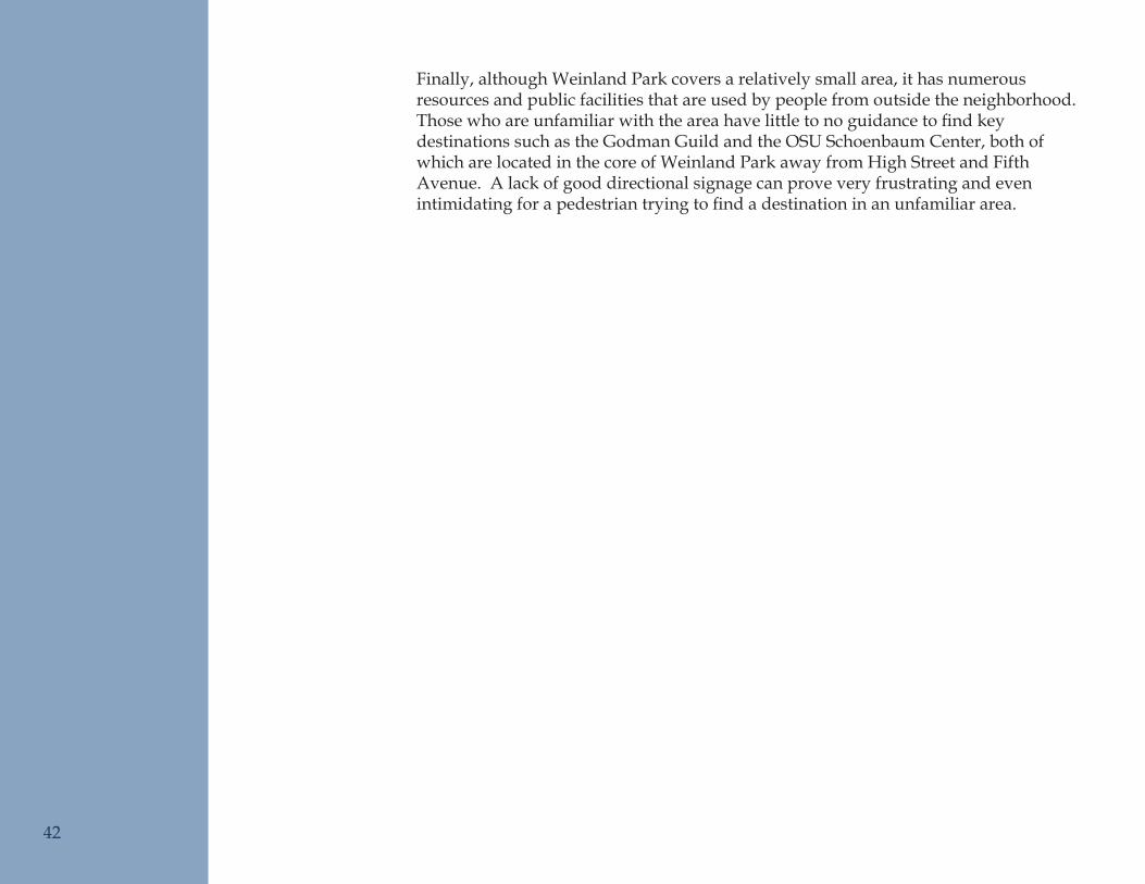
Finally, although Weinland Park covers a relatively small area, it has numerous resources and public facilities that are used by people from outside the neighborhood. Thosewhoareunfamiliarwiththeareahavelittletonoguidancetofindkeydestinations such as the Godman Guild and the OSU Schoenbaum Center, both of which are located in the core of Weinland Park away from High Street and Fifth Avenue. A lack of good directional signage can prove very frustrating and even intimidatingforapedestriantryingtofindadestinationinanunfamiliararea.
42
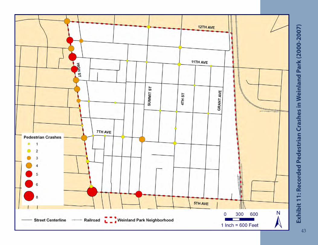
Reco
rded
Ped
estr
ian
Cras
hes
in W
einl
and
Park
(200
0-20
07)
Exhi
bit 1
1:
43
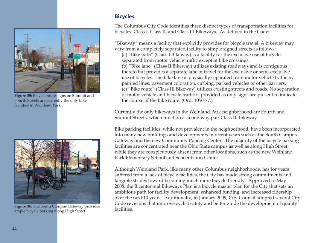
Bicycles
TheColumbusCityCodeidentifiesthreedistincttypesoftransportationfacilitiesforbicycles:ClassI,ClassII,andClassIIIBikeways.AsdefinedintheCode:
“Bikeway” means a facility that explicitly provides for bicycle travel. A bikeway may vary from a completely separated facility to simple signed streets as follows:
(a) “Bike path” (Class I Bikeway) is a facility for the exclusive use of bicycles separatedfrommotorvehicletrafficexceptatbikecrossings.(b) “Bike lane” (Class II Bikeway) utilizes existing roadways and is contiguous thereto but provides a separate lane of travel for the exclusive or semi-exclusive useofbicycles.Thebikelaneisphysicallyseparatedfrommotorvehicletrafficbypainted lines, pavement coloration, curbing, parked vehicles or other barriers.(c) “Bike route” (Class III Bikeway) utilizes existing streets and roads. No separation ofmotorvehicleandbicycletrafficisprovidedasonlysignsarepresenttoindicatethe course of the bike route. (Ord. 1050-77.)
Currently the only bikeways in the Weinland Park neighborhood are Fourth and Summit Streets, which function as a one-way pair Class III bikeway.
Bike parking facilities, while not prevalent in the neighborhood, have been incorporated into many new buildings and developments in recent years such as the South Campus Gateway and the new Community Policing Center. The majority of the bicycle parking facilities are concentrated near the Ohio State campus as well as along High Street, while they are conspicuously absent from other locations, such as the new Weinland Park Elementary School and Schoenbaum Center.
Although Weinland Park, like many other Columbus neighborhoods, has for years suffered from a lack of bicycle facilities, the City has made strong commitments and tangible strides toward becoming much more bicycle friendly. Approved in May 2008, the Bicentennial Bikeways Plan is a bicycle master plan for the City that sets an ambitious path for facility development, enhanced funding, and increased ridership over the next 10 years. Additionally, in January 2009, City Council adopted several City Code revisions that improve cyclist safety and better guide the development of quality facilities.
44
Bicycle route signs on Summit and Figure 35: Fourth Streets are currently the only bike facilities in Weinland Park .
The South Campus Gateway provides Figure 36: ample bicycle parking along High Street.
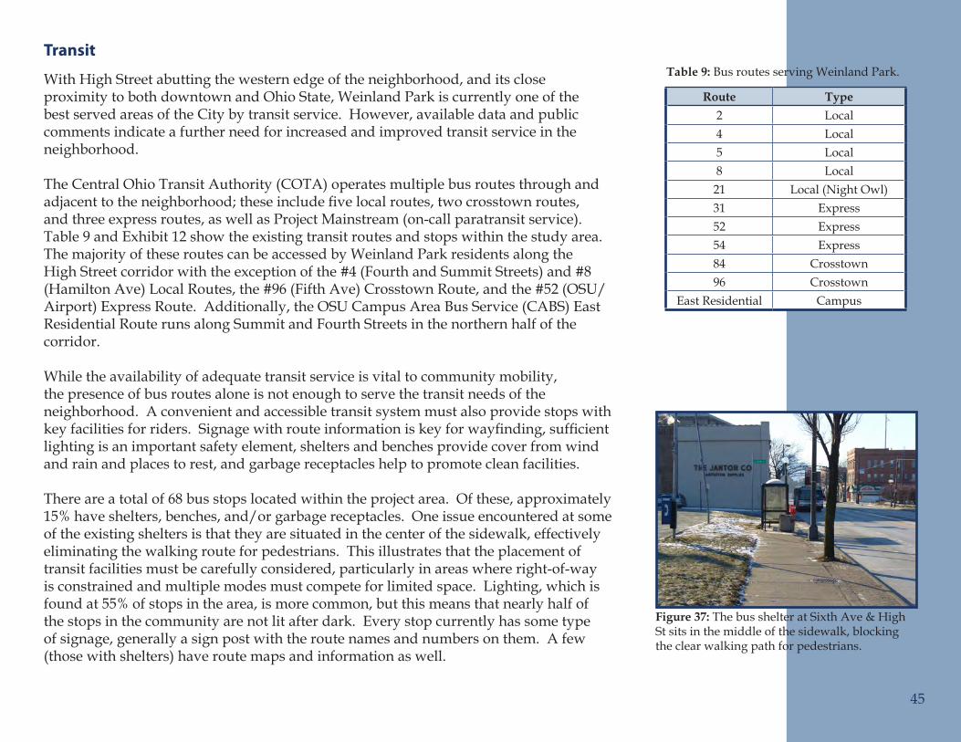
Transit
With High Street abutting the western edge of the neighborhood, and its close proximity to both downtown and Ohio State, Weinland Park is currently one of the best served areas of the City by transit service. However, available data and public comments indicate a further need for increased and improved transit service in the neighborhood.
The Central Ohio Transit Authority (COTA) operates multiple bus routes through and adjacenttotheneighborhood;theseincludefivelocalroutes,twocrosstownroutes,and three express routes, as well as Project Mainstream (on-call paratransit service). Table 9 and Exhibit 12 show the existing transit routes and stops within the study area. The majority of these routes can be accessed by Weinland Park residents along the High Street corridor with the exception of the #4 (Fourth and Summit Streets) and #8 (Hamilton Ave) Local Routes, the #96 (Fifth Ave) Crosstown Route, and the #52 (OSU/Airport) Express Route. Additionally, the OSU Campus Area Bus Service (CABS) East Residential Route runs along Summit and Fourth Streets in the northern half of the corridor.
While the availability of adequate transit service is vital to community mobility, the presence of bus routes alone is not enough to serve the transit needs of the neighborhood. A convenient and accessible transit system must also provide stops with keyfacilitiesforriders.Signagewithrouteinformationiskeyforwayfinding,sufficientlighting is an important safety element, shelters and benches provide cover from wind and rain and places to rest, and garbage receptacles help to promote clean facilities.
There are a total of 68 bus stops located within the project area. Of these, approximately 15% have shelters, benches, and/or garbage receptacles. One issue encountered at some of the existing shelters is that they are situated in the center of the sidewalk, effectively eliminating the walking route for pedestrians. This illustrates that the placement of transit facilities must be carefully considered, particularly in areas where right-of-way is constrained and multiple modes must compete for limited space. Lighting, which is found at 55% of stops in the area, is more common, but this means that nearly half of the stops in the community are not lit after dark. Every stop currently has some type of signage, generally a sign post with the route names and numbers on them. A few (those with shelters) have route maps and information as well.
Route Type2 Local4 Local5 Local8 Local21 Local (Night Owl)31 Express52 Express54 Express84 Crosstown96 Crosstown
East Residential Campus
45
Bus routes serving Weinland Park.Table 9:
The bus shelter at Sixth Ave & High Figure 37: St sits in the middle of the sidewalk, blocking the clear walking path for pedestrians.
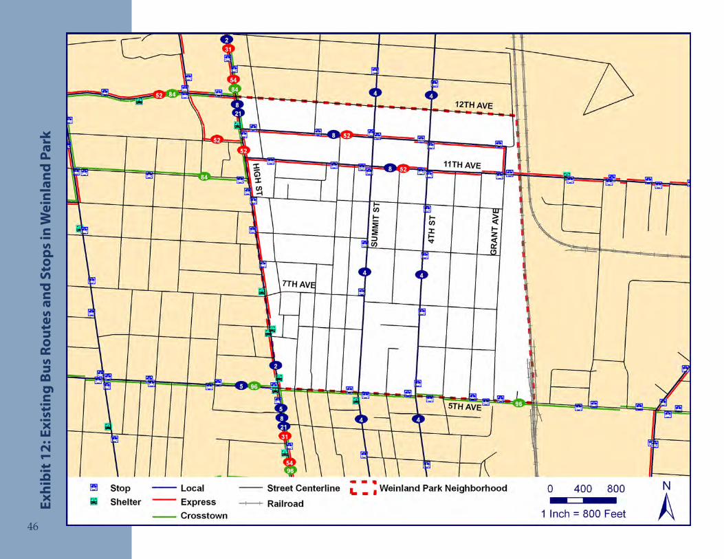
Exis
ting
Bus
Rou
tes
and
Stop
s in
Wei
nlan
d Pa
rkEx
hibi
t 12:
46
Reco
mm
ende
d So
luti
ons
The recommendations chapter of this plan is divided into two sections, a “Toolbox of Treatments” and location based recommendations. The Toolbox of Treatments describes numerous mobility improvements, grouped by travel mode. These tools were selected to address the numerous issues and concerns expressed through public input and observed during the planning process. The Toolbox is intended to serve as an ongoing resource for use by the City and residents of Weinland Park to diagnose and address future mobility issues in the neighborhood. Each tool includes a description of its intended use and effects, pros and cons to consider, and a planning-level cost estimate (or range of costs) for installation. Actual costs may widely vary based on whether the improvement is completed at the same time as others to take advantage of economies of scale.
The Location Based Recommendations section applies the tools from the Toolbox of Treatmentstospecificlocationsthroughoutthestudyarea.Foreachlocation,themost appropriate tool, or combination of tools, was selected and applied to address theidentifiedmobilityproblems.Someoftherecommendedimprovementsapplytotheentireneighborhood,sometoaroadwaycorridor,andotherstospecificsitesor intersections. For each location, there is an explanation of the recommended improvement(s)andajustificationforwhythattoolwasselected.
Toolbox of Treatments
Automobile ToolsCurb ExtensionsCurb extensions are improvement measures that are used in locations with on-street parking to improve pedestrian crossings and help control vehicle speeds by narrowing the roadway. Also called bump-outs, chokers, or curb bulbs, curb extensions can be installed at intersections or mid-block to reduce or reinforce lane widths by bringing the curb line out into the parking lane and closer to the travel lane (Figure 38).
When used at intersections, curb extensions improve both pedestrian and driver safety. Crossing distances are shortened and pedestrians are made more visible to drivers by moving them out from behind parked cars. Driver safety is improved by slowing vehicle speeds and by preventing vehicles from parking too close to the intersection, thus improving sight conditions. At mid-block locations they are most effective at reinforcing lane widths where on-street parking is allowed but not heavily used, and at
48
Intersection curb extensions improve Figure 38: the visibility of pedestrians by preventing cars from parking too close to the intersection.
Example of an intersection curb Figure 39: extension in Hilliard, Ohio. It narrows the roadway through the intersection and shortens the crossing distance for pedestirans.
improving the visibility and safety of pedestrians at mid-block crossings.
When considering the installation of curb extensions at an intersection, it is important to consider the turning radius required by large vehicles such as buses, emergency vehicles, and trucks. They must also not encroach into the travel lane or bike lanes. The installation of mid-block curb extensions does require the removal of some on-street parking, and thus may not be appropriate on streets where parking is in high demand.
Curb extensions can range from $2,000 to $20,000 per corner depending on aesthetic treatments, street furniture and lighting, and drainage considerations.
Mini CirclesAminicircleisaraisedislandplacedinanexistingintersectionaroundwhichtrafficcirculates. This tool improves intersection safety for vehicles and pedestrians by reducing vehicle speeds to 15mph or less. Vehicles circulate counterclockwise around thecircle,reducingpotentialconflicts(Figure40).Atmanystopcontrolledresidentialintersections,minicircleshavereplacedstopsigns,resultinginreducedspeeds,trafficviolations, and crashes.
Along a street corridor, mini circles can be used in combination with curb extensions tocalmtrafficbyalternatelyaddingfeaturestothecenterandtheoutsideoftheroad(Figure 41). The ability of large vehicles such as buses, emergency vehicles, and trucks to navigate the intersection must be considered in the design of a mini circle. These vehicles can generally be accommodated with a truck apron or by allowing them to turn left in front of the circle. Adequate signage is also important to ensure drivers properly navigate the intersection.
Minicirclesarerelativelyeasyandcheaptoinstallaslittletonomodificationtotheexisting intersection is required. A landscaped mini-circle generally costs about $6,000. Maintenance responsibilities for the landscaping can also be taken on by property owners or a neighborhood association to help defray the costs of the improvement, particularly when the mini circle serves as a gateway feature into a residential area.
49
Because all vehicles circulate the mini Figure 40: circle in the same direction, entering vehicles only need to look left for oncoming traffic.
Mini circles can be installed along Figure 41: with curb extensions to provide maximum speed control at an intersection.
Raised MediansThistrafficcalmingmeasurecontrolsvehiclespeedsbyintroducingaraisedbarrierin the middle of a street, forcing drivers to the outside. Medians narrow the roadway (eitherphysicallyorvisually),providemotoristswithleft-turnpocketsoutoftheflowoftraffic,andserveasacrossingrefugeforpedestrians.Addinglandscapingand/orgateway signage to a median also serves as a cue to drivers that they are in a pedestrian environment where high speeds are not appropriate. Similar to mini circles, medians canbeusedincombinationwithcurbextensionstocalmtrafficalongastreetcorridor.Landscaping in a median must not obstruct the view of motorists on the road, particularly from pedestrians using the median as a crossing refuge. On streets without a center turn lane, on-street parking will likely have to be removed in order to maintain adequatelanewidths;therefore,mediansmaynotbeanappropriatetreatmentonstreets where parking is in high demand.
Raised medians tend to be higher cost measures, costing between $15,000 and $30,000 per 100 feet. Cost can be minimized by installing two small medians with a break in the middle for a pedestrian refuge (Figure 43). This also ensures that persons using mobility aids and pushing strollers can easily navigate the crossing. As with mini circles, landscaping maintenance can be taken on by property owners or a neighborhood association to help reduce costs.
On-Street ParkingTheprovisionofon-streetparkingpresentsmultiplemobilitybenefitstomotoristsaswell as users of other transportation modes. The availability of ample on-street parking improves convenience for residents and other motorists with destinations in the area, particularly in many urban neighborhoods where off-street parking is scarce or non-existent. Additionally, on-street parking helps to control vehicle speeds by creating some “friction” along the sides of a road. The presence of cars parked on the street forces drivers to slow down and raises their peripheral awareness. Finally, on-street parking creates a vertical barrier between the sidewalk and roadway, which improves both the safety and comfort of pedestrians. In commercial locations where parking is in particularly high demand, metered parking can be installed and function as a source of revenue for the City.
The cost to implement on-street parking in areas where it is restricted is often minimal, requiring only the removal of parking restriction signs and/or installation of parking signs. The cost of a new parking sign is approximately $300 installed.
50
Example of two small landscaped Figure 42: medians with a break for pedestrians.
By angling the median break, Figure 43: pedestrians and cyclists can better see oncoming traffic before crossing.
Onstreet parking provides a Figure 44: barrier between pedestrians and traffic on the road.
Road DietA road diet is a tool that can be used to slow vehicle speeds by narrowing a roadway corridor either visually, by narrowing travel lanes, or by reducing the number of travel lanes, generally from four (two lanes in each direction) to three (one lane in each direction with either a two-way left turn lane or a median). The extra space created by a road diet is then often dedicated to improving multi-modal travel along the corridor through the creation of bike lanes, wider sidewalks, on-street parking, or landscaped buffers.Themobilitybenefitsofroaddietscanincludelowervehiclespeeds,improvedsafety and comfort for pedestrians and cyclists, shorter crossing distances, and improved visibility and access to businesses.
Roaddietsofferbenefitsformotoristsaswellaspedestriansandbicyclists.Byeliminating turning movements from the left through travel lane in each direction, motorist behavior becomes more predictable. Reducing the road to one lane in each direction also prevents the faster moving vehicles from weaving to pass slower moving vehicles.Aroaddietcangenerallybeimplementedonroadswithaveragedailytraffic(ADT) volumes of up to 18,000 with little impact to roadway capacity, although ADT’s of over 20,000 can be converted following detailed analysis.
Road diets can quickly and effectively be implemented for very little cost (as little as $5,000/mile) by simply re-striping the road and altering signal operations. They can also be completed as long-term projects that include construction of landscaped medians, curb extensions, new pedestrian scale lighting, and gateway signage. These longer-term, more complex projects can cost up to $100,000 per mile.
Improved Lane StripingRestripingaroadwaytobetterdefineandnarrowthelanesisalowcostbuteffectivesolution to improving safety. Narrowing the lanes to 10 or 11 feet can effectively slow vehicle speeds while providing room for on-street parking and/or bike lanes. When consideringachangeinroadstriping,itisimportanttoconsiderthelaneconfigurationatintersectionsandpotentialimpactsonthelevelofserviceoftheroad,assignificantchangescouldpushunwantedtrafficontolocalstreets.Additionally,theinteractionofbicycleswithtrafficandparkedcarsmustbeconsidered.Generally,thecosttoremoveold lane striping and restripe new lanes is between $5,000 and $10,000 per mile.
51
Before - two travel lanes in each direction
After - one travel lane in each direction, one bike lane in each direction, and one center turn lane/landscaped median
Before and after images of a street Figure 45: that received a road diet. The street width remained the same and, aside from the median, all changes were made through lane striping.
Improved Signal TimingSignaltimingofroadwayscanhaveasignificantinfluenceontrafficoperations.Bytiming the lights so that a vehicle traveling the speed limit proceeds without stopping, coordinatedsignaltimingcanbeveryefficientforautomobiletravel.Thedownsideofextremelyefficientautotravelisthatitcanadverselyaffectadjacentpropertiesandpeople.Justasariverflowingtooswiftlyerodesitsbanksandpresentsamajorbarrier,a road along which large numbers of cars travel too quickly erodes away the adjacent communityandmakessafecrossingsdifficult.
On one way streets, signal timing can be optimized so that it has an even greater effectonroadwayefficiency.Typically,roadwaypairswereconvertedfromtwowayoperation to one way operation to take advantage of the vehicle progression through the corridor, moving large numbers of vehicles very quickly.
Longgreentimes,accompaniedbyvehicleflowsbelowcapacitycreateasituationwhere vehicles can travel well above the speed limit. By shortening the cycle length, the free green time is reduced so that vehicles are rewarded for traveling at or below the speed limit rather than above it. This improvement is very inexpensive as the only cost is the staff hours required to re-time the signals.
52
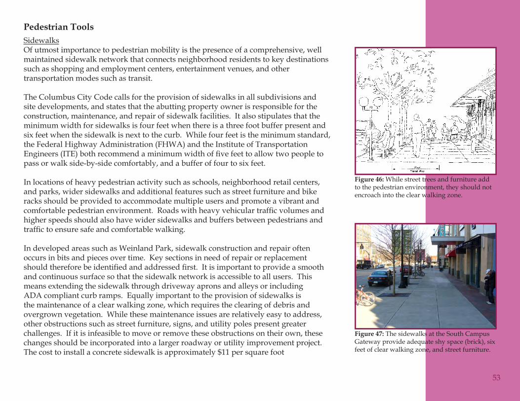
Pedestrian ToolsSidewalksOf utmost importance to pedestrian mobility is the presence of a comprehensive, well maintained sidewalk network that connects neighborhood residents to key destinations such as shopping and employment centers, entertainment venues, and other transportation modes such as transit.
The Columbus City Code calls for the provision of sidewalks in all subdivisions and site developments, and states that the abutting property owner is responsible for the construction, maintenance, and repair of sidewalk facilities. It also stipulates that the minimum width for sidewalks is four feet when there is a three foot buffer present and six feet when the sidewalk is next to the curb. While four feet is the minimum standard, the Federal Highway Administration (FHWA) and the Institute of Transportation Engineers(ITE)bothrecommendaminimumwidthoffivefeettoallowtwopeopletopass or walk side-by-side comfortably, and a buffer of four to six feet.
In locations of heavy pedestrian activity such as schools, neighborhood retail centers, and parks, wider sidewalks and additional features such as street furniture and bike racks should be provided to accommodate multiple users and promote a vibrant and comfortablepedestrianenvironment.Roadswithheavyvehiculartrafficvolumesandhigher speeds should also have wider sidewalks and buffers between pedestrians and traffictoensuresafeandcomfortablewalking.
In developed areas such as Weinland Park, sidewalk construction and repair often occurs in bits and pieces over time. Key sections in need of repair or replacement shouldthereforebeidentifiedandaddressedfirst.Itisimportanttoprovideasmoothand continuous surface so that the sidewalk network is accessible to all users. This means extending the sidewalk through driveway aprons and alleys or including ADA compliant curb ramps. Equally important to the provision of sidewalks is the maintenance of a clear walking zone, which requires the clearing of debris and overgrown vegetation. While these maintenance issues are relatively easy to address, other obstructions such as street furniture, signs, and utility poles present greater challenges. If it is infeasible to move or remove these obstructions on their own, these changes should be incorporated into a larger roadway or utility improvement project. The cost to install a concrete sidewalk is approximately $11 per square foot
53
While street trees and furniture add Figure 46: to the pedestrian environment, they should not encroach into the clear walking zone.
The sidewalks at the South Campus Figure 47: Gateway provide adequate shy space (brick), six feet of clear walking zone, and street furniture.
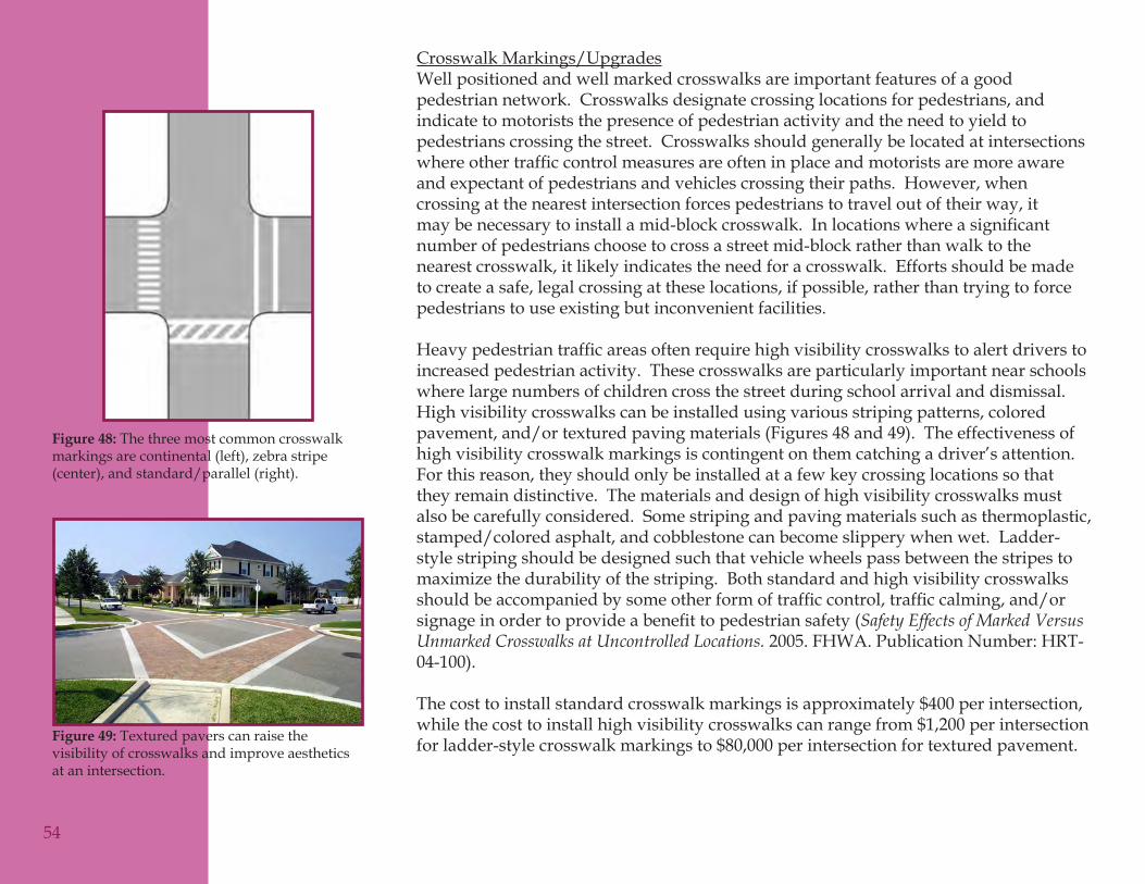
Crosswalk Markings/UpgradesWell positioned and well marked crosswalks are important features of a good pedestrian network. Crosswalks designate crossing locations for pedestrians, and indicate to motorists the presence of pedestrian activity and the need to yield to pedestrians crossing the street. Crosswalks should generally be located at intersections whereothertrafficcontrolmeasuresareofteninplaceandmotoristsaremoreawareand expectant of pedestrians and vehicles crossing their paths. However, when crossing at the nearest intersection forces pedestrians to travel out of their way, it maybenecessarytoinstallamid-blockcrosswalk.Inlocationswhereasignificantnumber of pedestrians choose to cross a street mid-block rather than walk to the nearest crosswalk, it likely indicates the need for a crosswalk. Efforts should be made to create a safe, legal crossing at these locations, if possible, rather than trying to force pedestrians to use existing but inconvenient facilities.
Heavypedestriantrafficareasoftenrequirehighvisibilitycrosswalkstoalertdriverstoincreased pedestrian activity. These crosswalks are particularly important near schools where large numbers of children cross the street during school arrival and dismissal. High visibility crosswalks can be installed using various striping patterns, colored pavement, and/or textured paving materials (Figures 48 and 49). The effectiveness of high visibility crosswalk markings is contingent on them catching a driver’s attention. For this reason, they should only be installed at a few key crossing locations so that they remain distinctive. The materials and design of high visibility crosswalks must also be carefully considered. Some striping and paving materials such as thermoplastic, stamped/colored asphalt, and cobblestone can become slippery when wet. Ladder-style striping should be designed such that vehicle wheels pass between the stripes to maximize the durability of the striping. Both standard and high visibility crosswalks shouldbeaccompaniedbysomeotherformoftrafficcontrol,trafficcalming,and/orsignageinordertoprovideabenefittopedestriansafety(Safety Effects of Marked Versus Unmarked Crosswalks at Uncontrolled Locations. 2005. FHWA. Publication Number: HRT-04-100).
The cost to install standard crosswalk markings is approximately $400 per intersection, while the cost to install high visibility crosswalks can range from $1,200 per intersection for ladder-style crosswalk markings to $80,000 per intersection for textured pavement.
54
The three most common crosswalk Figure 48: markings are continental (left), zebra stripe (center), and standard/parallel (right).
Textured pavers can raise the Figure 49: visibility of crosswalks and improve aesthetics at an intersection.
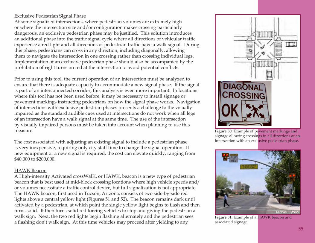
Exclusive Pedestrian Signal PhaseAt some signalized intersections, where pedestrian volumes are extremely high orwheretheintersectionsizeand/orconfigurationmakescrossingparticularlydangerous,anexclusivepedestrianphasemaybejustified.Thissolutionintroducesanadditionalphaseintothetrafficsignalcyclewherealldirectionsofvehiculartrafficexperiencearedlightandalldirectionsofpedestriantraffichaveawalksignal.Duringthis phase, pedestrians can cross in any direction, including diagonally, allowing them to navigate the intersection in one crossing rather than crossing individual legs. Implementation of an exclusive pedestrian phase should also be accompanied by the prohibitionofrightturnsonredattheintersectiontoavoidpotentialconflicts.
Prior to using this tool, the current operation of an intersection must be analyzed to ensure that there is adequate capacity to accommodate a new signal phase. If the signal is part of an interconnected corridor, this analysis is even more important. In locations where this tool has not been used before, it may be necessary to install signage or pavement markings instructing pedestrians on how the signal phase works. Navigation of intersections with exclusive pedestrian phases presents a challenge to the visually impaired as the standard audible cues used at intersections do not work when all legs of an intersection have a walk signal at the same time. The use of the intersection by visually impaired persons must be taken into account when planning to use this measure.
The cost associated with adjusting an existing signal to include a pedestrian phase is very inexpensive, requiring only city staff time to change the signal operation. If new equipment or a new signal is required, the cost can elevate quickly, ranging from $40,000 to $200,000.
HAWK BeaconA High-intensity Activated crossWalK, or HAWK, beacon is a new type of pedestrian beacon that is best used at mid-block crossing locations where high vehicle speeds and/orvolumesnecessitateatrafficcontroldevice,butfullsignalizationisnotappropriate.TheHAWKbeacon,firstusedinTucson,Arizona,consistsoftwoside-by-sideredlights above a central yellow light (Figures 51 and 52). The beacon remains dark until activatedbyapedestrian,atwhichpointthesingleyellowlightbeginstoflashandthenturns solid. It then turns solid red forcing vehicles to stop and giving the pedestrian a walksign.Next,thetworedlightsbeginflashingalternatelyandthepedestrianseesaflashingdon’twalksign.Atthistimevehiclesmayproceedafteryieldingtoany
55
Example of pavement markings and Figure 50: signage allowing crossings in all directions at an intersection with an exclusive pedestrian phase.
Example of a HAWK beacon and Figure 51: associated signage.
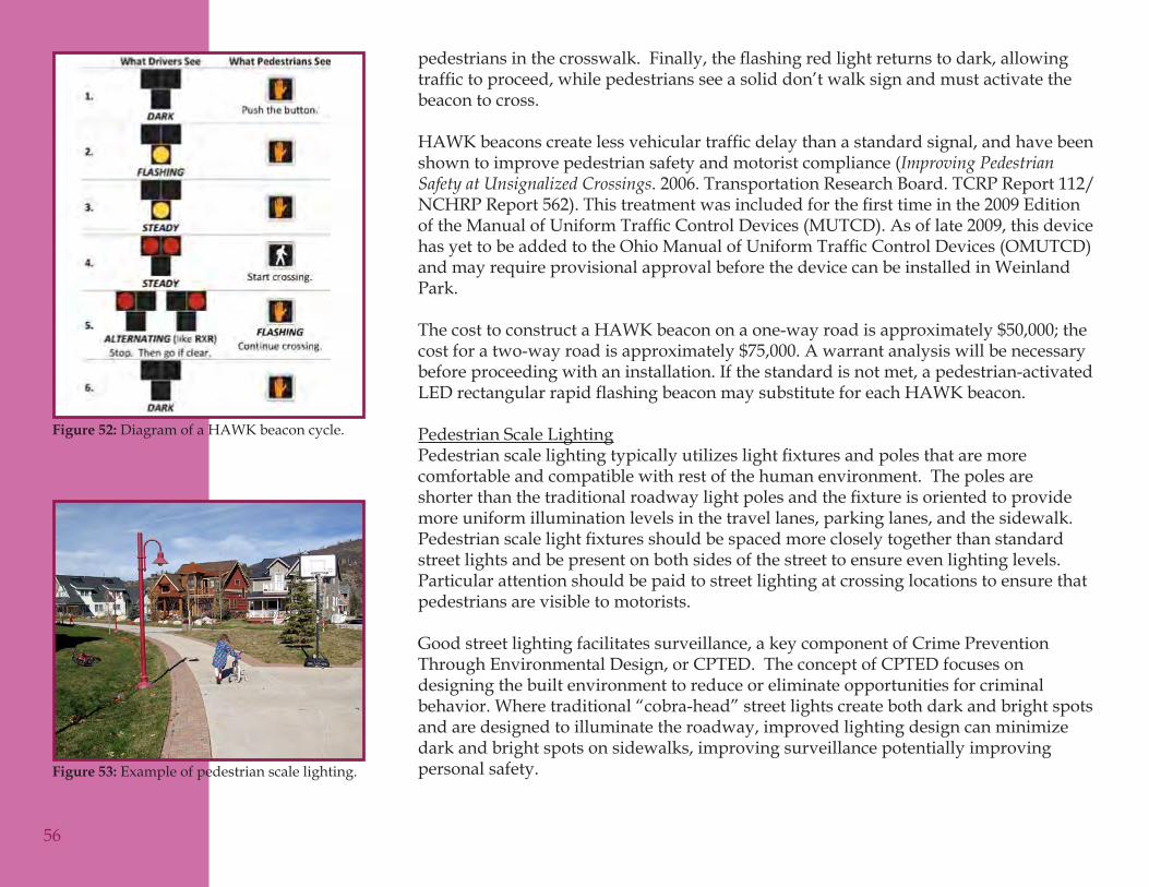
pedestriansinthecrosswalk.Finally,theflashingredlightreturnstodark,allowingtraffictoproceed,whilepedestriansseeasoliddon’twalksignandmustactivatethebeacon to cross.
HAWKbeaconscreatelessvehiculartrafficdelaythanastandardsignal,andhavebeenshown to improve pedestrian safety and motorist compliance (Improving Pedestrian Safety at Unsignalized Crossings. 2006. Transportation Research Board. TCRP Report 112/NCHRPReport562).Thistreatmentwasincludedforthefirsttimeinthe2009EditionoftheManualofUniformTrafficControlDevices(MUTCD).Asoflate2009,thisdevicehasyettobeaddedtotheOhioManualofUniformTrafficControlDevices(OMUTCD)and may require provisional approval before the device can be installed in Weinland Park.
ThecosttoconstructaHAWKbeacononaone-wayroadisapproximately$50,000;thecost for a two-way road is approximately $75,000. A warrant analysis will be necessary before proceeding with an installation. If the standard is not met, a pedestrian-activated LED rectangular rapid flashing beacon may substitute for each HAWK beacon.
Pedestrian Scale LightingPedestrianscalelightingtypicallyutilizeslightfixturesandpolesthataremorecomfortable and compatible with rest of the human environment. The poles are shorterthanthetraditionalroadwaylightpolesandthefixtureisorientedtoprovidemore uniform illumination levels in the travel lanes, parking lanes, and the sidewalk. Pedestrianscalelightfixturesshouldbespacedmorecloselytogetherthanstandardstreet lights and be present on both sides of the street to ensure even lighting levels. Particular attention should be paid to street lighting at crossing locations to ensure that pedestrians are visible to motorists.
Good street lighting facilitates surveillance, a key component of Crime Prevention Through Environmental Design, or CPTED. The concept of CPTED focuses on designing the built environment to reduce or eliminate opportunities for criminal behavior. Where traditional “cobra-head” street lights create both dark and bright spots and are designed to illuminate the roadway, improved lighting design can minimize dark and bright spots on sidewalks, improving surveillance potentially improving personal safety.
56
Diagram of a HAWK beacon cycle.Figure 52:
Example of pedestrian scale lighting.Figure 53:
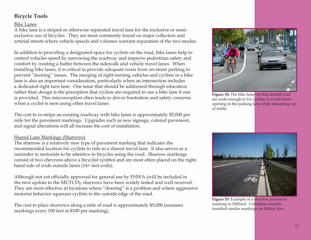
Bicycle ToolsBike LanesA bike lane is a striped or otherwise separated travel lane for the exclusive or semi-exclusive use of bicycles. They are most commonly found on major collectors and arterial streets where vehicle speeds and volumes warrant separation of the two modes.
In addition to providing a designated space for cyclists on the road, bike lanes help to control vehicles speed by narrowing the roadway and improve pedestrian safety and comfort by creating a buffer between the sidewalk and vehicle travel lanes. When installing bike lanes, it is critical to provide adequate room from on-street parking to prevent “dooring” issues. The merging of right-turning vehicles and cyclists in a bike lane is also an important consideration, particularly when an intersection includes a dedicated right turn lane. One issue that should be addressed through education rather than design is the perception that cyclists are required to use a bike lane if one is provided. This misconception often leads to driver frustration and safety concerns when a cyclist is seen using other travel lanes.
The cost to re-stripe an existing roadway with bike lanes is approximately $5,000 per mile for the pavement markings. Upgrades such as new signage, colored pavement, and signal alterations will all increase the cost of installation.
Shared Lane Markings (Sharrows)The sharrow is a relatively new type of pavement marking that indicates the recommended location for cyclists to ride in a shared travel lane. It also serves as a reminder to motorists to be attentive to bicycles using the road. Sharrow markings consist of two chevrons above a bicyclist symbol and are most often placed on the right-hand side of wide outside lanes (14+ feet wide).
AlthoughnotyetofficiallyapprovedforgeneralusebyFHWA(willbeincludedinthe next update to the MUTCD), sharrows have been widely tested and well received. They are most effective in locations where “dooring” is a problem and where aggressive motorist behavior squeezes cyclists to the outside edge of the road.
The cost to place sharrows along a mile of road is approximately $5,000 (assumes markings every 100 feet at $100 per marking).
57
The bike lanes on this arterial road Figure 54: are wide enough to for cyclists to avoid doors opening in the parking lane while remaining out of traffic.
Example of a sharrow pavement Figure 55: marking in Hilliard. Columbus recently installed similar markings on Milton Ave.
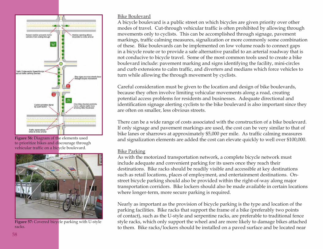
Bike BoulevardA bicycle boulevard is a public street on which bicycles are given priority over other modesoftravel.Cut-throughvehiculartrafficisoftenprohibitedbyallowingthroughmovements only to cyclists. This can be accomplished through signage, pavement markings,trafficcalmingmeasures,signalizationormorecommonlysomecombinationof these. Bike boulevards can be implemented on low volume roads to connect gaps in a bicycle route or to provide a safe alternative parallel to an arterial roadway that is not conducive to bicycle travel. Some of the most common tools used to create a bike boulevard include: pavement marking and signs identifying the facility, mini-circles andcurbextensionstocalmtraffic,anddivertersandmedianswhichforcevehiclestoturn while allowing the through movement by cyclists.
Careful consideration must be given to the location and design of bike boulevards, because they often involve limiting vehicular movements along a road, creating potential access problems for residents and businesses. Adequate directional and identificationsignagealertingcycliststothebikeboulevardisalsoimportantsincetheyare often on smaller, less obvious streets.
There can be a wide range of costs associated with the construction of a bike boulevard. If only signage and pavement markings are used, the cost can be very similar to that of bikelanesorsharrowsatapproximately$5,000permile.Astrafficcalmingmeasuresand signalization elements are added the cost can elevate quickly to well over $100,000.
Bike ParkingAs with the motorized transportation network, a complete bicycle network must include adequate and convenient parking for its users once they reach their destinations. Bike racks should be readily visible and accessible at key destinations such as retail locations, places of employment, and entertainment destinations. On-street bicycle parking should also be provided within the right-of-way along major transportation corridors. Bike lockers should also be made available in certain locations where longer-term, more secure parking is required.
Nearly as important as the provision of bicycle parking is the type and location of the parking facilities. Bike racks that support the frame of a bike (preferably two points of contact), such as the U-style and serpentine racks, are preferable to traditional fence style racks, which only support the wheel and are more likely to damage bikes attached to them. Bike racks/lockers should be installed on a paved surface and be located near
58
Diagram of the elements used Figure 56: to prioritize bikes and discourage through vehicular traffic on a bicycle boulevard.
Covered bicycle parking with U-style Figure 57: racks.
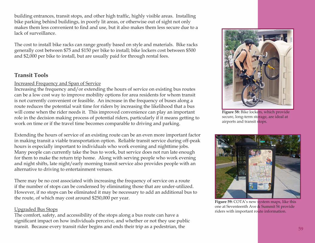
buildingentrances,transitstops,andotherhightraffic,highlyvisibleareas.Installingbike parking behind buildings, in poorly lit areas, or otherwise out of sight not only makesthemlessconvenienttofindanduse,butitalsomakesthemlesssecureduetoalack of surveillance.
The cost to install bike racks can range greatly based on style and materials. Bike racks generallycostbetween$75and$150perbiketoinstall;bikelockerscostbetween$500and $2,000 per bike to install, but are usually paid for through rental fees.
Transit ToolsIncreased Frequency and Span of ServiceIncreasing the frequency and/or extending the hours of service on existing bus routes can be a low cost way to improve mobility options for area residents for whom transit is not currently convenient or feasible. An increase in the frequency of buses along a route reduces the potential wait time for riders by increasing the likelihood that a bus will come when the rider needs it. This improved convenience can play an important role in the decision making process of potential riders, particularly if it means getting to work on time or if the travel time becomes comparable to driving and parking.
Extending the hours of service of an existing route can be an even more important factor in making transit a viable transportation option. Reliable transit service during off-peak hours is especially important to individuals who work evening and nighttime jobs. Many people can currently take the bus to work, but service does not run late enough for them to make the return trip home. Along with serving people who work evening and night shifts, late night/early morning transit service also provides people with an alternative to driving to entertainment venues.
There may be no cost associated with increasing the frequency of service on a route if the number of stops can be condensed by eliminating those that are under-utilized. However, if no stops can be eliminated it may be necessary to add an additional bus to the route, of which may cost around $250,000 per year.
Upgraded Bus StopsThe comfort, safety, and accessibility of the stops along a bus route can have a significantimpactonhowindividualsperceive,andwhetherornottheyusepublictransit. Because every transit rider begins and ends their trip as a pedestrian, the 59
Bike lockers, which provide Figure 58: secure, long-term storage, are ideal at airports and transit stops.
COTA’s new system maps, like this Figure 59: one at Seventeenth Ave & Summit St provide riders with important route information.
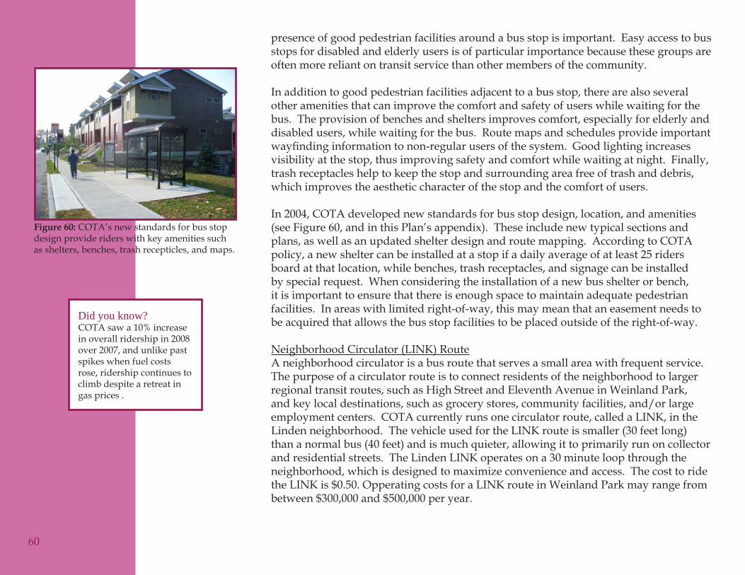
presence of good pedestrian facilities around a bus stop is important. Easy access to bus stops for disabled and elderly users is of particular importance because these groups are often more reliant on transit service than other members of the community.
In addition to good pedestrian facilities adjacent to a bus stop, there are also several other amenities that can improve the comfort and safety of users while waiting for the bus. The provision of benches and shelters improves comfort, especially for elderly and disabled users, while waiting for the bus. Route maps and schedules provide important wayfindinginformationtonon-regularusersofthesystem.Goodlightingincreasesvisibility at the stop, thus improving safety and comfort while waiting at night. Finally, trash receptacles help to keep the stop and surrounding area free of trash and debris, which improves the aesthetic character of the stop and the comfort of users.
In 2004, COTA developed new standards for bus stop design, location, and amenities (see Figure 60, and in this Plan’s appendix). These include new typical sections and plans, as well as an updated shelter design and route mapping. According to COTA policy, a new shelter can be installed at a stop if a daily average of at least 25 riders board at that location, while benches, trash receptacles, and signage can be installed by special request. When considering the installation of a new bus shelter or bench, it is important to ensure that there is enough space to maintain adequate pedestrian facilities. In areas with limited right-of-way, this may mean that an easement needs to be acquired that allows the bus stop facilities to be placed outside of the right-of-way.
Neighborhood Circulator (LINK) RouteA neighborhood circulator is a bus route that serves a small area with frequent service. The purpose of a circulator route is to connect residents of the neighborhood to larger regional transit routes, such as High Street and Eleventh Avenue in Weinland Park, and key local destinations, such as grocery stores, community facilities, and/or large employment centers. COTA currently runs one circulator route, called a LINK, in the Linden neighborhood. The vehicle used for the LINK route is smaller (30 feet long) than a normal bus (40 feet) and is much quieter, allowing it to primarily run on collector and residential streets. The Linden LINK operates on a 30 minute loop through the neighborhood, which is designed to maximize convenience and access. The cost to ride the LINK is $0.50. Opperating costs for a LINK route in Weinland Park may range from between $300,000 and $500,000 per year.
Did you know?COTA saw a 10% increase in overall ridership in 2008 over 2007, and unlike past spikes when fuel costs rose, ridership continues to climb despite a retreat in gas prices .
60
COTA’s new standards for bus stop Figure 60: design provide riders with key amenities such as shelters, benches, trash recepticles, and maps.
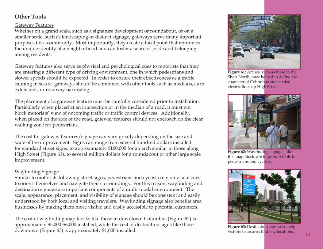
Other ToolsGateway FeaturesWhether on a grand scale, such as a signature development or roundabout, or on a smaller scale, such as landscaping or distinct signage, gateways serve many important purposes for a community. Most importantly, they create a focal point that reinforces the unique identity of a neighborhood and can foster a sense of pride and belonging among residents.
Gateway features also serve as physical and psychological cues to motorists that htey are entering a different type of driving environment, one in which pedestrians and slowerspeedsshouldbeexpected.Inordertoensuretheireffectivenessasatrafficcalming measure, gateways should be combined with other tools such as medians, curb extensions, or roadway narrowing.
The placement of a gateway feature must be carefully considered prior to installation. Particularly when placed at an intersection or in the median of a road, it must not blockmotorists’viewofoncomingtrafficortrafficcontroldevices.Additionally,when placed on the side of the road, gateway features should not encroach on the clear walking zone for pedestrians.
The cost for gateway features/signage can vary greatly depending on the size and scale of the improvement. Signs can range from several hundred dollars installed for standard street signs, to approximately $100,000 for an arch similar to those along High Street (Figure 61), to several million dollars for a roundabout or other large scale improvement.
WayfindingSignageSimilar to motorists following street signs, pedestrians and cyclists rely on visual cues toorientthemselvesandnavigatetheirsurroundings.Forthisreason,wayfindinganddestination signage are important components of a multi-modal environment. The scale, appearance, placement, and visibility of signage should be consistent and easily understoodbybothlocalandvisitingtravelers.Wayfindingsignagealsobenefitsareabusinesses by making them more visible and easily accessible to potential customers.
ThecostofwayfindingmapkioskslikethoseindowntownColumbus(Figure62)isapproximately $5,000-$6,000 installed, while the cost of destination signs like those downtown (Figure 63) is approximately $1,000 installed.
61
Arches, such as these in the Figure 61: Short North, once helped to define the character of Columbus and carried electric lines up High Street.
Wayfinding signage, like Figure 62: this map kiosk, are important tools for pedestrians and cyclists.
Destination signs also help Figure 63: visitors to an area find key locations.
Streetscape ImprovementsThe presence of landscaping and street furniture (benches, trash receptacles, bus stops, etc.) along a road can improve safety for all users while greatly enhancing the pedestrian environment and aesthetics of a corridor. A street that is lined with trees and other landscaping appears narrower to motorists than the same street without any vegetation. This induces slower vehicle speeds and helps differentiate the vehicular and pedestrian environments. More concretely, street trees and other vertical treatments such as benches and planters provide a physical barrier between vehicles andpedestrians,whichreducesthepotentialforconflictsbetweenthetwomodes.
A welcoming pedestrian environment should include benches and other furniture that improves comfort and encourages interaction and activity on the street. These features, alongwithaestheticlandscapeenhancementshavepositivebenefitsforadjacentproperties as well, adding vibrancy to commercial and residential areas. Landscaping can also reduce the environmental impacts of a road corridor by capturing and treating stormwateron-siteratherthanallowingittoflowdirectlyintothesewer.
Inurbanareas,whereright-of-wayisoftentight,itcanbedifficulttoidentifyadequatespace for streetscape improvements. Street furniture and landscaping should not be installedattheexpenseoftheclearwalkingzone;however,inmanylocationsthiscan be overcome by combining them with other improvements such as medians, mini-circles, and curb extensions. Continued maintenance cost is another issue that must be considered in the planning and budgeting of improvements. The cost of streetscape improvements can range from as little at $1,000 to over $10,000 depending on the planting materials and use of street furniture. As suggested with previous tools, some of the maintenance costs can be offset by having residents take-on upkeep responsibilities for the landscaping.
62
Location Based Recommendations
The following location based recommendations apply the previously discussed tools tospecificareasandsitesinWeinlandPark.Descriptionsareprovidedforeachrecommended project and a number is assigned in parentheses. The project number corresponds with Table 10, which lists, for each recommendation, number, suggested tool, location, travel mode impacted, and relevent comment categories that the improvement will address. Finally, Exhibits 14-17 are maps that illustrate the type and location of the recommended improvements, with the corresponding number listed next to each.
Neighborhood ImprovementsSidewalk maintenance and replacement program (1)Given the number of resident concerns related to poor sidewalk conditions, the extensive needforimprovementsidentifiedduringthesidewalkinventory,andtheimportanceofcreating a safe and continuous network, sidewalk improvements should be addressed at a neighborhood scale. In Columbus, installation and maintenance of sidewalks is the responsibility of the adjacent property owner. In Weinland Park, this has resulted in inconsistent sidewalk conditions, with some owners performing necessary maintenance and others allowing the sidewalk to fall into disrepair.
In order to achieve a consistently high quality sidewalk network it is recommended that an assessment program be instituted throughout the neighborhood. Upon agreement by a certain percentage of property owners in the neighborhood (generally 60%) an assessment would be applied to each property. The funds generated by the assessment would then be used to pay for sidewalk improvements using the City’s existing contracts to reduce costs. The sidewalk inventory completed for this plan should be used to prioritize the improvements, with those sections rated F (impassible or complete disrepair)beingcompletedfirst.Thekeybenefitofaneighborhood-wideassessmentprogram is that the cost of sidewalk improvements is spread among all property owners. This reduces the impacts on any given resident, and, over several years, will result in improvedsidewalkconditionsthroughouttheentireneighborhood,whichbenefitsallresidents.
As an alternative to developing a neighborhood assessment program, the Weinland Park Community Civic Association could begin a systematic code enforcement initiativetoimprovesidewalks.Specificstreetscouldbeselectedbythecommunityfor code enforcement efforts by the City as a way to spur property owners to repair
63
their sidewalks. A certain percentage of residents on the street should agree to the enforcement efforts to ensure it is supported. Existing City contracts could be used to repair sidewalks along selected streets using this approach as well.
Bicycle Parking (2)Convenient and secure bicycle parking is needed throughout Weinland Park. Numerous comments highlighted the lack of bike parking, particularly at major destinations, in the neighborhood. Bike racks should be installed in highly visible locations, preferably near the main entrance of the following facilities/businesses:
COTA stop at Fifth Avenue and High Street•Third Hand Bike Co-op – Fifth Avenue between Summit and Fourth Streets •Godman Guild – corner of Sixth Avenue and Sixth Street •Weinland Park – between Fourth and Summit Streets•Weinland Park Elementary – corner of Seventh Avenue and Fourth Street•Schoenbaum Family Center – corner of Seventh Avenue and Summit Street•Kroger – southeast corner of Seventh Avenue and High Street•Dollar Tree plaza – northeast corner of Seventh Avenue and High Street•Indianola Park – Indianola Avenue between Eighth and Ninth Avenues•Directions for Youth and Families – corner of Ninth and Indianola Avenues•Kelly’s Carry-Out – corner of Eleventh Avenue and Fourth Street•
The City of Columbus currently installs bike racks within the public right-of-way upon request using its 311 Call Center. Residents or business owners can simply place a request and, as long as adequate right-of-way exists, a rack will be installed. This service can be used to install racks at some of the above listed locations, as well as other high demand locations in the neighborhood.
Gateway Features (3)The installation of gateway features/signs is recommended for the key entrances to Weinland Park along arterial and collector streets to reinforce the neighborhood setting and encourage slower vehicle speeds. Uniform entrance features should be installed at the following intersections:
Fifth Avenue at High Street•Fifth Avenue at the railroad bridge•Fourth Street at Fifth Avenue•Seventh Avenue at High Street•Summit Street at Twelfth Avenue•Eleventh Avenue at the railroad bridge•64
The University Area Commission has been working on a project to develop gateway signage for the entire district for several years. Gateway features at these locations for Weinland Park are consistent with those efforts, and could be completed as a part of that project. Arches would be ideal gateway features for the neighborhood as they would provide continuity with other gateway signs installed in adjacent neighborhoods and would maintain a link to the history of th area.
Wayfinding/DestinationSignage(4)ThepresenceofwayfindingsignagethroughoutWeinlandParkwillhelpguidepedestrians, cyclists, and motorists alike to key destinations in and around the area. AwayfindingsystemshouldbedevelopedfortheentireUniversityAreatoprovidecontinuity for users and to ensure the inclusion of all important businesses and attractions in the area. Examples of some destinations in Weinland Park could include the South Campus Gateway, Weinland Park, Indianola Park, and the Godman Guild, along with anyotherbusinessesand/orfacilitiesidentifiedbythecommunity.
Neighborhood Circulator (LINK) Route (5)A COTA LINK route through Weinland Park would add transit connections from the residential areas of the neighborhood to nearby retail, employment, and community destinations. Additionally, the circulator would connect residents to larger transit routes, thus improving access to other areas of the City. A potential route for the circulator is shown in Exhibit 13.
Corridor ImprovementsRoad Diet and Bicycle Lanes on Fifth Avenue (6)This improvement will help to alleviate the observed speeding problem and improve pedestrian and bike safety along Fifth Avenue by narrowing the corridor for vehicles and providing additional space for other modes. This recommendation would likely reduce the number of through automobile travel lanes from four to two.
Preliminarytrafficanalysesindicatesthatthecombinationofaroaddiet(utilizingexisting pavement) and the reduction of the cycle length at the intersections of Fifth Avenue and both Fourth and Summit streets would result in the intersections not having sufficientcapacityforpeak-hourvolumes.Furtherstudyisneededtodeterminewhatwouldbeneededtobedonetoensuresufficientcapacityattheseintersectionstoallowa road diet to be implemented on Fifth Avenue as well as other improvements along the Fourth and Stummit streets corridor.
65
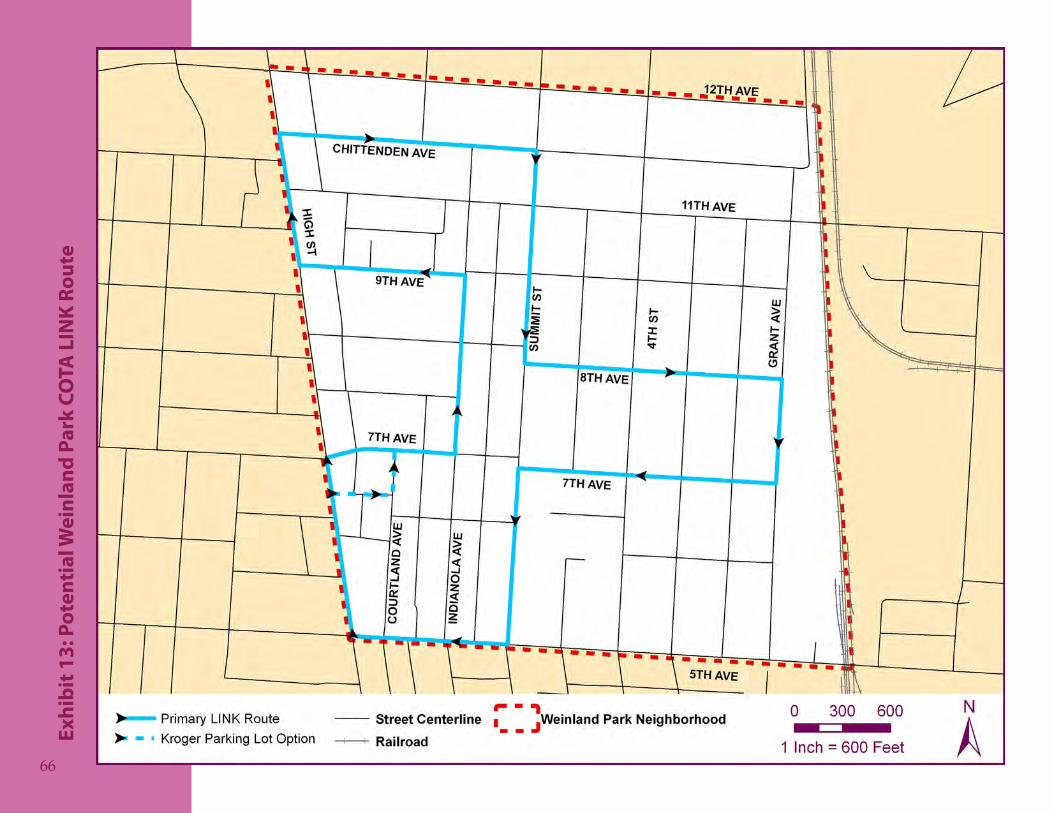
Pote
ntia
l Wei
nlan
d Pa
rk C
OTA
LIN
K Ro
ute
Exhi
bit 1
3:
66
The Bicentennial Bikeways Plan calls for the installation of bike lanes on Fifth Avenue, a need that was also raised during the public input stage of the project. Implementation of theroaddietonFifthAvenuemayresultinthespacenecessarytoinstallafive-footbikelane in each direction. The bike lane will not only provide cyclists with dedicated space on the road, but will also help to control vehicle speeds and provide a buffer between vehiculartrafficandpedestriansonthesidewalk.
Sidewalk Installation on Sixth Avenue (7)Installing new sidewalk along Sixth Avenue from Indianola Avenue to Summit Street and from Fifth Street to Sixth Street will complete the sidewalk network in Weinland Park. These improvements will make connections to key pedestrian destinations including Weinland Park and Godman Guild from the residential areas of the neighborhood.
Sharrows on Eleventh Avenue (8)The addition of sharrows along Eleventh Avenue between High Street and Grant Avenue will create an east-west bike route on the north side of Weinland Park. This improvement is recommended in the Bicentennial Bikeways Plan and was expressed as a need in public comments.
Shared Signed Roadway on High Street (9)The bike safety improvements along High Street coincide with the recommendations of the Bicentennial Bikeways Plan, which include the installation of sharrows, “Share the Road” signage, and a public education campaign. Given the high volume of vehicles and cyclists, this is a high priority project for the City and some of these improvements are already in place.
Bicycle Boulevard on Pearl Street and Courtland Avenue (10)The conversion of Pearl Street and Courtland Avenue to a bike boulevard from Fifth Avenue to Twelfth Avenue would provide cyclists with an alternative route to High, Summit, and Fourth Streets, all of which are high volume and higher speed streets. The BicentennialBikewaysPlancallsforabikeboulevardonPearlStreet;however,itwouldonly extend as far south as Seventh Avenue. Continuing the facility south to Fifth Avenue on Courtland Avenue will connect the bike boulevard with the bike lanes to be installed on Fifth Avenue, thus creating a more continuous network. It also allows for the extension of the bike boulevard further south into the short north along Pearl Street.
67
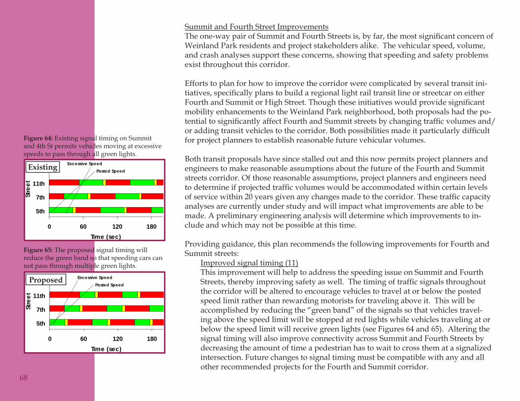
Summit and Fourth Street ImprovementsTheone-waypairofSummitandFourthStreetsis,byfar,themostsignificantconcernofWeinland Park residents and project stakeholders alike. The vehicular speed, volume, and crash analyses support these concerns, showing that speeding and safety problems exist throughout this corridor.
Efforts to plan for how to improve the corridor were complicated by several transit ini-tiatives,specificallyplanstobuildaregionallightrailtransitlineorstreetcaroneitherFourthandSummitorHighStreet.Thoughtheseinitiativeswouldprovidesignificantmobility enhancements to the Weinland Park neighborhood, both proposals had the po-tentialtosignificantlyaffectFourthandSummitstreetsbychangingtrafficvolumesand/oraddingtransitvehiclestothecorridor.Bothpossibilitiesmadeitparticularlydifficultfor project planners to establish reasonable future vehicular volumes.
Both transit proposals have since stalled out and this now permits project planners and engineers to make reasonable assumptions about the future of the Fourth and Summit streets corridor. Of those reasonable assumptions, project planners and engineers need todetermineifprojectedtrafficvolumeswouldbeaccommodatedwithincertainlevelsofservicewithin20yearsgivenanychangesmadetothecorridor.Thesetrafficcapacityanalyses are currently under study and will impact what improvements are able to be made. A preliminary engineering analysis will determine which improvements to in-clude and which may not be possible at this time.
Providing guidance, this plan recommends the following improvements for Fourth and Summit streets:
Improved signal timing (11) This improvement will help to address the speeding issue on Summit and Fourth Streets,therebyimprovingsafetyaswell.Thetimingoftrafficsignalsthroughoutthe corridor will be altered to encourage vehicles to travel at or below the posted speed limit rather than rewarding motorists for traveling above it. This will be accomplished by reducing the “green band” of the signals so that vehicles travel-ing above the speed limit will be stopped at red lights while vehicles traveling at or below the speed limit will receive green lights (see Figures 64 and 65). Altering the signal timing will also improve connectivity across Summit and Fourth Streets by decreasing the amount of time a pedestrian has to wait to cross them at a signalized intersection. Future changes to signal timing must be compatible with any and all other recommended projects for the Fourth and Summit corridor.
68
Existing Signal Timing
0 60 120 180
5th
7th
11th
Stre
et
Time (sec)
Posted SpeedExcessive Speed
Upgraded Signal Timing
0 60 120 180
5th
7th
11th
Stre
et
Time (sec)
Posted SpeedExcessive Speed
Existing signal timing on Summit Figure 64: and 4th St permits vehicles moving at excessive speeds to pass through all green lights.
The proposed signal timing will Figure 65: reduce the green band so that speeding cars can not pass through multiple green lights.
Existing
Proposed
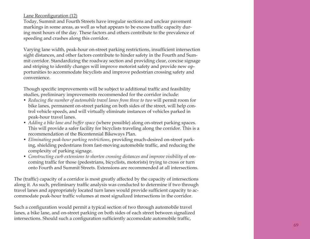
LaneReconfiguration(12) Today, Summit and Fourth Streets have irregular sections and unclear pavement markingsinsomeareas,aswellaswhatappearstobeexcesstrafficcapacitydur-ing most hours of the day. These factors and others contribute to the prevalence of speeding and crashes along this corridor.
Varyinglanewidth,peak-houron-streetparkingrestrictions,insufficientintersectionsight distances, and other factors contribute to hinder safety in the Fourth and Sum-mit corridor. Standardizing the roadway section and providing clear, concise signage and striping to identify changes will improve motorist safety and provide new op-portunities to accommodate bicyclists and improve pedestrian crossing safety and convenience.
Thoughspecificimprovementswillbesubjecttoadditionaltrafficandfeasibilitystudies, preliminary improvements recommended for the corridor include:
Reducing the number of automobile travel lanes from three to two• will permit room for bike lanes, permanent on-street parking on both sides of the street, will help con-trol vehicle speeds, and will virtually eliminate instances of vehicles parked in peak-hour travel lanes.Adding a bike lane and buffer space• (where possible) along on-street parking spaces. This will provide a safer facility for bicyclists traveling along the corridor. This is a recommendation of the Bicentennial Bikeways Plan.Eliminating peak-hour parking restrictions• , providing much-desired on-street park-ing,shieldingpedestriansfromfast-movingautomobiletraffic,andreducingthecomplexity of parking signage.Constructing curb extensions to shorten crossing distances and improve visibility• of on-comingtrafficforthose(pedestrians,bicyclists,motorists)tryingtocrossorturnonto Fourth and Summit Streets. Extensions are recommended at all intersections.
The(traffic)capacityofacorridorismostgreatlyaffectedbythecapacityofintersectionsalongit.Assuch,preliminarytrafficanalysiswasconductedtodetermineiftwothroughtravellanesandappropriatelylocatedturnlaneswouldprovidesufficientcapacitytoac-commodatepeak-hourtrafficvolumesatmostsignalizedintersectionsinthecorridor.
Suchaconfigurationwouldpermitatypicalsectionoftwothroughautomobiletravellanes, a bike lane, and on-street parking on both sides of each street between signalized intersections.Shouldsuchaconfigurationsufficientlyaccomodateautomobiletraffic,
69
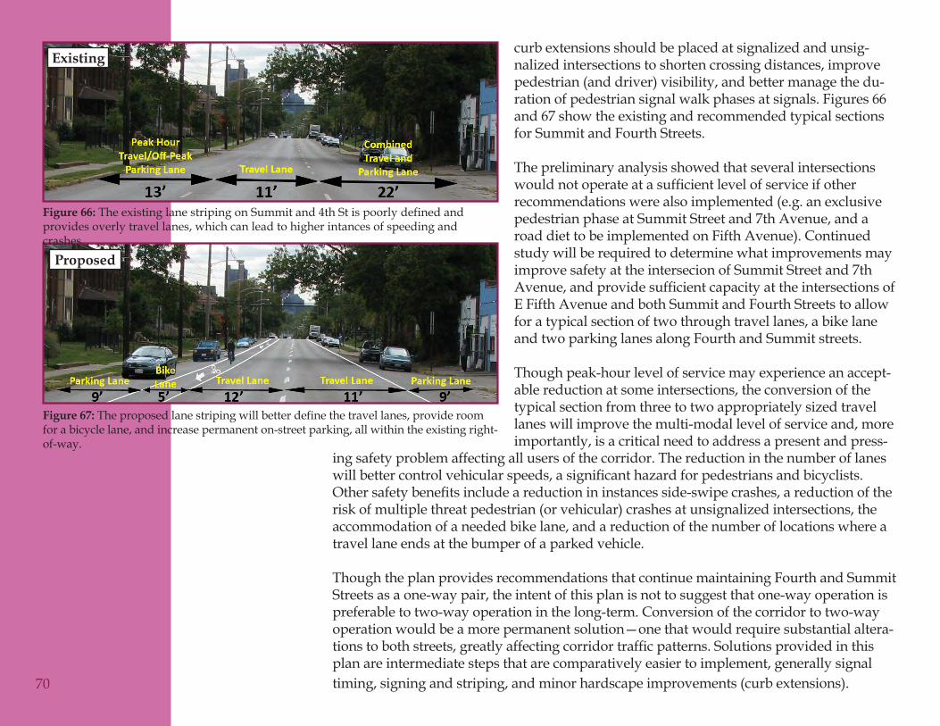
ing safety problem affecting all users of the corridor. The reduction in the number of lanes willbettercontrolvehicularspeeds,asignificanthazardforpedestriansandbicyclists.Othersafetybenefitsincludeareductionininstancesside-swipecrashes,areductionoftherisk of multiple threat pedestrian (or vehicular) crashes at unsignalized intersections, the accommodation of a needed bike lane, and a reduction of the number of locations where a travel lane ends at the bumper of a parked vehicle.
Though the plan provides recommendations that continue maintaining Fourth and Summit Streets as a one-way pair, the intent of this plan is not to suggest that one-way operation is preferable to two-way operation in the long-term. Conversion of the corridor to two-way operation would be a more permanent solution—one that would require substantial altera-tionstobothstreets,greatlyaffectingcorridortrafficpatterns.Solutionsprovidedinthisplan are intermediate steps that are comparatively easier to implement, generally signal timing, signing and striping, and minor hardscape improvements (curb extensions).
curb extensions should be placed at signalized and unsig-nalized intersections to shorten crossing distances, improve pedestrian (and driver) visibility, and better manage the du-ration of pedestrian signal walk phases at signals. Figures 66 and 67 show the existing and recommended typical sections for Summit and Fourth Streets.
The preliminary analysis showed that several intersections wouldnotoperateatasufficientlevelofserviceifotherrecommendations were also implemented (e.g. an exclusive pedestrian phase at Summit Street and 7th Avenue, and a road diet to be implemented on Fifth Avenue). Continued study will be required to determine what improvements may improve safety at the intersecion of Summit Street and 7th Avenue,andprovidesufficientcapacityattheintersectionsofE Fifth Avenue and both Summit and Fourth Streets to allow for a typical section of two through travel lanes, a bike lane and two parking lanes along Fourth and Summit streets.
Though peak-hour level of service may experience an accept-able reduction at some intersections, the conversion of the typical section from three to two appropriately sized travel lanes will improve the multi-modal level of service and, more importantly, is a critical need to address a present and press-
70
The existing lane striping on Summit and 4th St is poorly defined and Figure 66: provides overly travel lanes, which can lead to higher intances of speeding and crashes
The proposed lane striping will better define the travel lanes, provide room Figure 67: for a bicycle lane, and increase permanent on-street parking, all within the existing right-of-way.
Existing
Proposed
Site Specific ImprovementsTextured Pavement Crosswalks at the High Street/Fifth Avenue Intersection (13)Since 2000, this intersection has had the highest number of pedestrian crashes in the study area.Duetotrafficvolumesandright-of-wayconstraints,alterationstothetrafficsignaland/orintersectionconfigurationarenotcurrentlyfeasible.Changingthecrosswalkstotextured pavers will raise the visibility of the intersection for motorists, giving particular emphasis to the pedestrian crossing areas.
Raised Median on Fifth Avenue East of High Street (14)A raised median is recommended for Fifth Avenue at the western end of the study area. This median, of which should occur in combination with “Road Diet and Bicycle Lanes onFifthAvenue(6)”willproducenumerousbenefitstomobility.Specifically,themedianprovides an opportunity to serve as a gateway to the neighborhood and, as such, reduce trafficspeeds.Additionally,itcanprovideapedestriancrossingrefuge,reinforcethebikeboulevard and improve access management by allowing bikes to cross Fifth Avenue on Courtland Avenue, but preventing vehicles from doing the same. The median should begin just east of the westbound left turn lane on Fifth Avenue and extend east across Courtland Avenue. The entire median could be raised and landscaped, or it could be a combination of raised and painted median to help reduce costs.
HAWK Beacons on Summit and Fourth Streets at Weinland Park (16 & 17)These beacons are recommended to improve the safety of pedestrians crossing Summit and Fourth Streets to access the park, Weinland Park Elementary School, and the OSU Schoenbaum Center. Currently there are no marked crosswalks on Forth or Summit Streets between Fifth and Seventh Avenues. The HAWK signals will create controlled pedestrian crossings at the path along the south side of the park that will have less impact tovehiculartrafficthanfullpedestriansignals.
Projected pedestrian volumes at these new crossing locations are not known as there is no way to accurately predict the latent demand for a crossing that does not currently exist. Through further study, it may be possible to estimate potential usage by identifying the number of pedestrians crossing mid-block and those using adjacent crossing locations and then identifying their origins and destinations. This study could be completed as a part of the Safe Routes to School Travel Plan for Weinland Park Elementary School.
In this plan, HAWK beacons are recommended at these locations as a demonstration project. Based on their use in other cities, the mid-block location of the crossings, vehicle
71

Page Reserved forGraphic Rendering
72
73
speeds and volumes on Summit and Fourth Streets, and the presence of substantial pedestriandestinations,thebeaconswereidentifiedasanappropriatemeasure.Thereuse would be on an experimental basis until the MUTCD-approved beacons are included in the Ohio-MUTCD. Should warrants for the beacons not be met, highly visible pedestrian-activated LED Rectangular Rapid Flashing Beacon may substitute. These beacons should be located on curb extensions to be more visible to drivers, and include signage indicating motorists should yield to pedestrians in the crosswalk.
Intersection Safety Improvements at Summit Street/Seventh Avenue (18)This intersection was the most frequently noted problem location by residents, is the site of several pedestrian crashes, and is heavily used by children walking to school and the park. Problems at the intersection are linked to several factors notably that the intersection is off-set and there is a desire for users to cross through the middle of the offset intersection when walking toward High Street (Kroger). Whereas an exclusive pedestrian phasewasstudiedanddiscussedduringpublicinvolvement,preliminarytrafficanalysisindicates this method would result in excessive delay on Summit Street during the AM peak, resulting in queues for motorists and transit users starting north of 8th Avenue.
Continued study is necessary to develop a package of improvements that will eliminate oratleastreducepotentialconflictsbetweenpedestriansandvehicles.ThisPlanrecommends such improvements reduce the width (i.e. curb extensions) and length (e.g. consolidate to one of the two “T” intersections) size of the intersection, permit the placement of a crosswalk between the southwest and northeast corners of the current intersection, and include a leading pedestrian phase to improve the visibility of pedestrians). These improvements should coincide with a pedestrian education effort primarily targeted toward students at Weinland Park Elementary School. Such a program could be incorporated into a Safe Routes to School program.
Crosswalk, Improved Pedestrian Signage, and Pedestrian Refuge on High Street (21, 54)Through resident input, the need for a new marked pedestrian crossing of High Street at EuclidAvenue(21)wasidentifiedtoimprovesafeaccesstothelibraryonthewestsideof High Street. Similarly, a refuge island is recommended for an existing crosswalk at the intersection of E 6th Avenue and High Street, just south of Kroger (54).
The provision of a refuge island with ladder style crosswalk markings and high visibility signage at these locations (south leg of the intersection of Euclid Avenue and High Street, and the south leg of the intersection of E 6th Avenue and High Street) is recommended to

74
Page Reserved forGraphic Rendering
provide safer pedestrian crossings across High Street, and improve access to community amenities such as the library and other retail establishments in the area.
Raised Median on Eighth Avenue at Pearl Street (22)The installation of a raised median at this location will aid in the creation of a bike boulevard along Pearl Street by managing access. The intersection will become a right-in/right-out for vehicles, while a small break in the median will allow cyclists to make left turns and through movements on Pearl Street as well. This will reinforce the priority of cyclists on Pearl Street and encourage vehicles to use High Street.
Curb ExtensionsThese measures are recommended for numerous intersections throughout Weinland Park as a means of improving walkability by reducing pedestrian crossing distances. The curb extensions may provide some vehicular speed reduction on long straight stretches of road, particularly when used in conjunction with other tools. Preliminary analysisofvehicleturningmovementsindicatesthatbusesandfiretruckscannavigatethesedevicesevenonthelocalstreetsinWeinlandPark.However,thefinaldimensionsfor these improvements will need to be developed for each location individually during detailed design. Curb extensions are recommended at the following locations:
Seventh Avenue east of High Street (23) – North side of Seventh Avenue from •High Street to Pearl Street. This will better align the Seventh Avenue/High Street intersection and help control vehicle speeds. The lanes on Seventh Avenue will shift slightly to better align with King Avenue to the west of High Street. It will also shorten the crossing distance for pedestrians and help control the speed ofwestboundtrafficonSeventhAvenue.Speedingatthislocationwasraisedasaconcerninpubliccommentsandverifiedwithspeedandvolumecounts.Euclid Avenue east of High Street (24) – Both sides of Euclid Avenue for •approximately 300 feet. This section of road is overly wide for a local street (38 feet),whichencouragescut-throughtrafficandspeeding.Thecurbextensionswill narrow the west end of Euclid to match the width along the rest of the street (26 feet), creating a uniform width that is appropriate for a residential street.Ninth Avenue east of High Street (25) – South side of Ninth Avenue for •approximately 330 feet. This will narrow the eastbound travel lane on Ninth Avenue, which is currently 16 feet wide.Courtland Avenue at Sixth Avenue (26) – This split intersection is approximately •halfway between Fifth and Seventh Avenues. It is a good location for curb extensions as a way to break-up the long straight stretch that otherwise has no trafficcontrolsforvehiclesonCourtland.Theoffsetalignmentwillcreatea 75
chicane effect that will effectively control speeds. Curb extensions here will also help to emphasize Courtland Avenue as a bike boulevard.Courtland Avenue at Seventh Avenue (27) – Along the north side of Seventh •Avenue at this intersection. This will help shorten crossing distances and improve sight distance for pedestrians walking to Kroger. The curb extension should prevent parking in the crosswalk.Pearl Street at Eleventh Avenue (28) – All but the northwest corner (which is •required for a right turn lane) of this split intersection. They will control vehicle speeds and improve walkability along Eleventh Avenue and help to reinforce Pearl Street as a bicycle boulevard.Pearl Street at Chittenden Avenue (29) – The eastern two corners of the •intersection. Provides vehicular speed control and continues bicycle boulevard on Pearl Street.Pearl Street at Twelfth Avenue (30) – The eastern two corners of the intersection. •Provides vehicular speed control and enforces bicycle boulevard on Pearl Street.IndianolaAvenueatFifthAvenue(31)–Willhelptodefinethetransitionfrom•Fifth Avenue, a minor arterial street, to Indianola Avenue, which is residential in nature. They should only be located on the Indianola Avenue side of the corners toavoidconflictswiththenewbikelanes,whicharerecommendedasapartofthe Fifth Avenue road diet.Indianola Avenue at Seventh Avenue (32)•Indianola Avenue at Euclid Avenue (33) – The two western corners of the •intersection.Thiswillcontinuetrafficcalmingalongbothstreetsanddiscouragecut-thoughtrafficonEuclidAvenue.Indianola Avenue at Ninth Avenue (34) - The addition of curb bulbs in •combinationwitharaisedmedianwillprovideenforcedvehiclepathdeflectionand controlled speeds through this intersection.Indianola Avenue at Chittenden Avenue (35)•Indianola Avenue at Twelfth Avenue (36)•Hamlet Street at Seventh Avenue (37) – Two northern corners of the intersection. •Provides speed control and shortens the crossing distance at the entrance to Weinland Park Elementary School and the Schoenbaum Center.Hamlet Street at Eighth Avenue (38)•Hamlet Street at Eleventh Avenue (39)•FifthStreetatFifthAvenue(40)–HelpstodefinethetransitionfromFifth•Avenue, a minor arterial street, to Fifth Street, a residential street. They should onlybelocatedontheFifthStreetsideofthecornerstoavoidconflictswiththe
76
new bike lanes, which are recommended as a part of the Fifth Avenue road diet.Fifth Street at Sixth Avenue (41)•Fifth Street at Eighth Avenue (42)•Fifth Street at Eleventh Avenue (43)•Sixth Street at Seventh Avenue (44)•Sixth Street at Ninth Avenue (45)•Sixth Street at Eleventh Avenue (46)•IndianolaAvenueatEleventhAvenue(49)–Publiccommentsandtrafficcounts•identifiedspeedingalongIndianolaAvenue.
Mini CirclesThesetrafficcalmingmeasuresarerecommendedfornumerousintersectionsthroughout Weinland Park as a means of controlling vehicle speeds and improving intersection safety. They are most effective when alternated with curb extensions in order to break-up long straight stretches of road. As with the curb extensions, preliminary analysis indicates that these tools can be navigated by buses and emergency vehiclesintheneighborhood,butthefinaldimensionswillbesetduringdetaileddesign. Mini circles are recommended at the following locations:
IndianolaAvenueatSixthAvenue(47)–Publiccommentsandtrafficcounts•identifiedspeedingalongIndianolaAvenue.Willworkinconjunctionwithcurbextensionstocalmtrafficalongthecorridor.IndianolaAvenueatEighthAvenue(48)–Publiccommentsandtrafficcounts•identifiedspeedingalongIndianolaAvenue.Willworkinconjunctionwithcurbextensionstocalmtrafficalongthecorridor.Consultationwiththefiredepartment must occur during design to ensure that access is not impeded.Hamlet Street at Ninth Avenue (50)•Fifth Street at Seventh Avenue (51) – Addresses comments received regarding •speeding at this intersection.Fifth Street at Ninth Avenue (52)•Sixth Street at Eighth Avenue (53)•
77

Page Reserved forGraphic Rendering
78
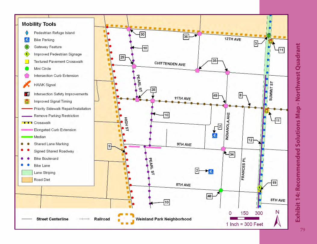
79
Reco
mm
ende
d So
luti
ons
Map
- N
orth
wes
t Qua
dran
tEx
hibi
t 14:
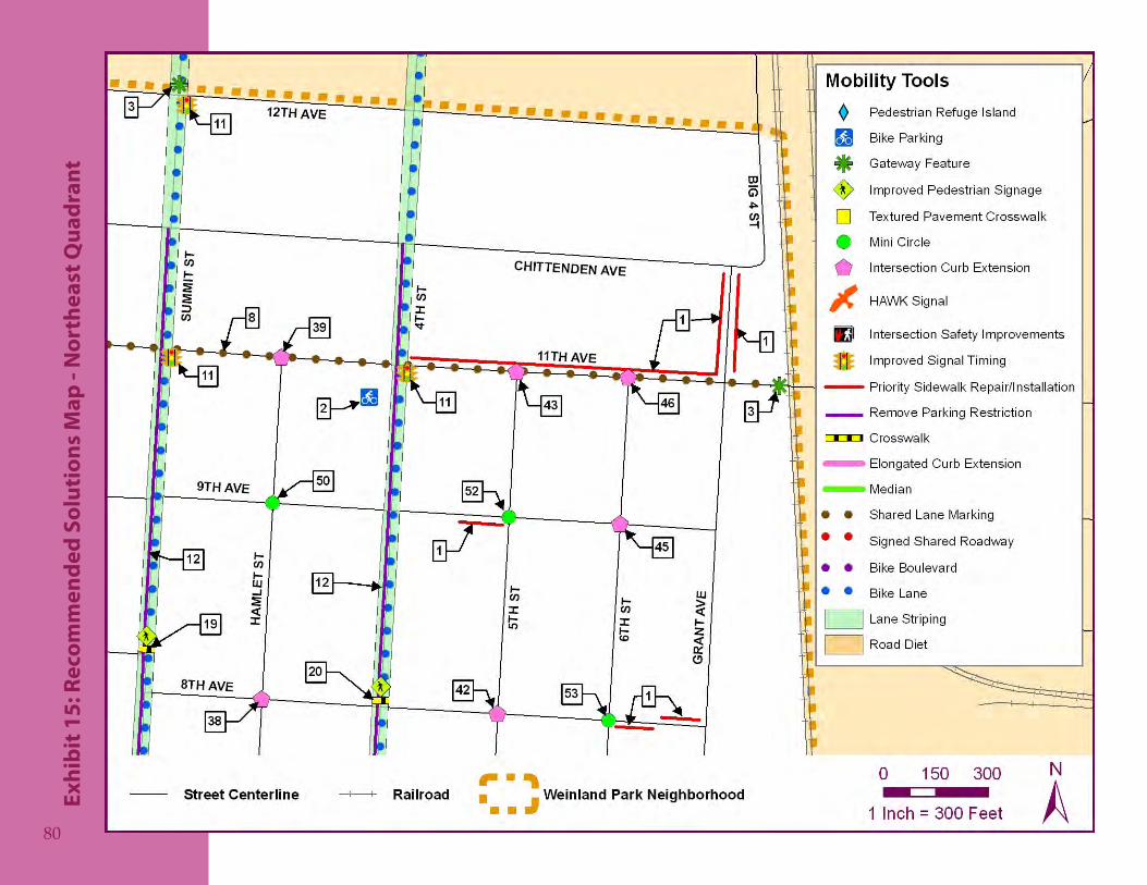
80
Reco
mm
ende
d So
luti
ons
Map
- N
orth
east
Qua
dran
tEx
hibi
t 15:
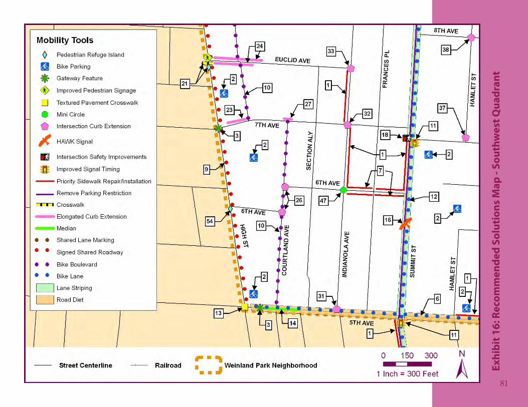
81
Reco
mm
ende
d So
luti
ons
Map
- So
uthw
est Q
uadr
ant
Exhi
bit 1
6:
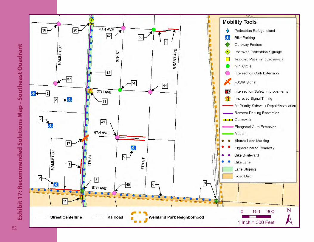
82
Reco
mm
ende
d So
luti
ons
Map
- So
uthe
ast Q
uadr
ant
Exhi
bit 1
7:
Prio
riti
zati
on a
nd
Impl
emen
tati
on
Possibly the most important part of any plan is the prioritization of recommendations and development of an implementation strategy. Without these key elements, it is unlikely that the improvements called for in the plan will ever come to fruition. During thisfinalstageoftheplanningprocess,membersoftheprojectteamandCitystaffworked closely with the Steering Committee, consisting of Weinland Park residents and stakeholders, to identify which mobility improvements are the most critical to the community and how to best implement those solutions over the coming years.
This stage also represents a transition of roles in the planning process. Up to this point, the City and the project team have guided the planning process through the identificationandanalysisofissuesandthedevelopmentofrecommendations.From this point forward, the community is responsible for working with the City to implement the plan according to the strategy set forth in this chapter.
Plan Prioritization
Aswiththeidentificationofcriticalmobilityconcernsandlocations,thecommunitywascalledupontoprioritizetherecommendedimprovements.Thefirststepinthis process was to gain preliminary input from the entire community regarding the recommendations called for by the project team. As previously mentioned in the Issues and Concerns chapter, a community open house meeting was held in June 2009 at which the draft recommendations were presented and attendees were given the opportunity to identify those which they felt should be given the highest priority, as well as those that they felt should be given the lowest priority. Several blank spaces also allowed residents to write-in improvements that they felt should be included.
Those improvements that garnered the most positive and negative support at the open house are shown in Table 10. Of those solutions, one that was written-in (converison of Summit and Fourth Streets to two-way operation) and two that were recommended by the team (curb extensions on Summit and Fourth Streets at Fifth Avenue) were deemed infeasible due to the need to consider light rail accommodation in the future. However, theyarestillshowninthistabletoreflectthelevelofsupporteachgained.
84
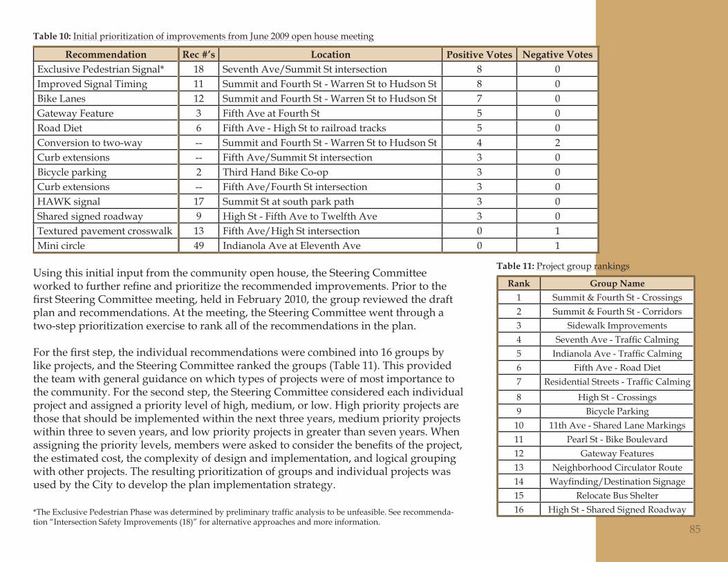
Recommendation Rec #’s Location Positive Votes Negative VotesExclusive Pedestrian Signal* 18 Seventh Ave/Summit St intersection 8 0Improved Signal Timing 11 Summit and Fourth St - Warren St to Hudson St 8 0Bike Lanes 12 Summit and Fourth St - Warren St to Hudson St 7 0Gateway Feature 3 Fifth Ave at Fourth St 5 0Road Diet 6 Fifth Ave - High St to railroad tracks 5 0Conversion to two-way -- Summit and Fourth St - Warren St to Hudson St 4 2Curb extensions -- Fifth Ave/Summit St intersection 3 0Bicycle parking 2 Third Hand Bike Co-op 3 0Curb extensions -- Fifth Ave/Fourth St intersection 3 0HAWK signal 17 Summit St at south park path 3 0Shared signed roadway 9 High St - Fifth Ave to Twelfth Ave 3 0Textured pavement crosswalk 13 Fifth Ave/High St intersection 0 1Mini circle 49 Indianola Ave at Eleventh Ave 0 1
Using this initial input from the community open house, the Steering Committee workedtofurtherrefineandprioritizetherecommendedimprovements.PriortothefirstSteeringCommitteemeeting,heldinFebruary2010,thegroupreviewedthedraftplan and recommendations. At the meeting, the Steering Committee went through a two-step prioritization exercise to rank all of the recommendations in the plan.
Forthefirststep,theindividualrecommendationswerecombinedinto16groupsbylike projects, and the Steering Committee ranked the groups (Table 11). This provided the team with general guidance on which types of projects were of most importance to the community. For the second step, the Steering Committee considered each individual project and assigned a priority level of high, medium, or low. High priority projects are those that should be implemented within the next three years, medium priority projects within three to seven years, and low priority projects in greater than seven years. When assigningtheprioritylevels,memberswereaskedtoconsiderthebenefitsoftheproject,the estimated cost, the complexity of design and implementation, and logical grouping with other projects. The resulting prioritization of groups and individual projects was used by the City to develop the plan implementation strategy.
85
Initial prioritization of improvements from June 2009 open house meetingTable 10:
Rank Group Name1 Summit & Fourth St - Crossings2 Summit & Fourth St - Corridors3 Sidewalk Improvements4 SeventhAve-TrafficCalming5 IndianolaAve-TrafficCalming6 Fifth Ave - Road Diet7 ResidentialStreets-TrafficCalming
8 High St - Crossings9 Bicycle Parking10 11th Ave - Shared Lane Markings11 Pearl St - Bike Boulevard12 Gateway Features13 Neighborhood Circulator Route14 Wayfinding/Destination Signage15 Relocate Bus Shelter16 High St - Shared Signed Roadway
Project group rankingsTable 11:
*The Exclusive Pedestrian Phase was determined by preliminary traffic analysis to be unfeasible. See recommenda-tion “Intersection Safety Improvements (18)” for alternative approaches and more information.
Implementation Strategy
In sum, the Weinland Park Community Mobility Plan includes 54 separate recommen-dations with a construction cost of approximately $2.5-$3 million. As with any plan, implementation of these projects will occur over a period of several years as fund-ing and other resources can be obtained. Because mobility improvements throughout Weinland Park will occur incrementally, it is critical to establish a plan for implementa-tion that will guide these efforts and consistently improve conditions throughout the community.
Tables 12-14 group the projects into short-term (0-3 years), medium-term (4-7 years), and long-term (7+ years) recommendations for development. These groupings were based on the following evaluation criteria:
Project location - • In identifying timeframes for project implementation, projects that address safety or other mobility concerns at key locations were given top priority.Projectsalongacorridor,particularlythoseaimedatcalmingtrafficspeeds, were also clustered together to maximize effectiveness. Additionally, an attempt was made to evenly spread improvements throughout the community while also considering other evaluation factors.Steering Committee input -• The group ranking and the individual project pri-ority assigned by the Steering Committee were considered in tandem. Those projects that were individually ranked as high priority and that were are a part of a highly ranked group were given the greatest preference. However, a project with a high group ranking but that was individually designated as low priority may be recommended for construction after a project from a lower ranked group thatwasindividuallyidentifiedasahighpriority.Effectiveness at achieving the plan goals • - Each project was evaluated for its ability to achieve the goals of the plan. Projects that will result in progress to-wardseveralgoalsandbenefitmultipletransportationmodeswereconsideredhighlyeffective,thosethatimproveonlyoneortwogoalsorbenefitonlyonemode of transportation were listed as medium, and those that work toward only onegoalandbenefitonlyonemodewerelistedaslowhavingloweffectiveness.Estimated cost and availability of funding from various sources • - The design and construction cost of improvements, along with potential funding sources were important factors in determining the implementation strategy. Numer-ousfundingsourceswereidentifiedtoexpeditetheimplementationofprojects.Those projects that rely on different funding sources could be recommended simultaneously, while those reliant on the same source were dispersed over time 86
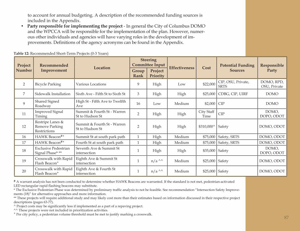
to account for annual budgeting. A description of the recommended funding sources is included in the Appendix.Party responsible for implementing the project• - In general the City of Columbus DOMO and the WPCCA will be responsible for the implementation of the plan. However, numer-ous other individuals and agencies will have varying roles in the development of im-provements.DefinitionsoftheagencyacronymscanbefoundintheAppendix.
Project Number
Recommended Improvement Location
Steering Committee Input
Effectiveness Cost Potential Funding Sources
Responsible PartyGroup
RankProject Priority
2 Bicycle Parking Various Locations 9 High Low $22,000 CIP, OSU, Private, SRTS
DOMO, RPD, OSU, Private
7 Sidewalk Installation Sixth Ave - Fifth St to Sixth St 3 High High $25,000 CDBG, CIP, UIRF DOMO
9 Shared Signed Roadway
High St - Fifth Ave to Twelfth Ave 16 Low Medium $2,000 CIP DOMO
11 Improved Signal Timing
Summit & Fourth St - Warren St to Hudson St 2 High High City Staff
Time CIP DOMO, DOPO, ODOT
12Restripe Lanes & Remove Parking Restrictions
Summit & Fourth St - Warren St to Hudson St 2 High High $310,000^ Safety DOMO, ODOT
16 HAWK Beacon#+ Summit St at south park path 1 High Medium $75,000 Safety, SRTS DOMO, ODOT17 HAWK Beacon#+ Fourth St at south park path 1 High Medium $75,000 Safety, SRTS DOMO, ODOT
18 Exclusive Pedestrian Signal Phase*, **
Seventh Ave & Summit St intersection 1 High High $35,000 Safety DOMO,
DOPO, ODOT
19 Crosswalk with Rapid Flash Beacon+
Eighth Ave & Summit St intersection 1 n/a ^^ Medium $25,000 Safety DOMO, ODOT
20 Crosswalk with Rapid Flash Beacon+
Eighth Ave & Fourth St intersection 1 n/a ^^ Medium $25,000 Safety DOMO, ODOT
87
Recommended Short-Term Projects (0-3 Years)Table 12:
# A warrant analysis has not been conducted to determine whether HAWK Beacons are warranted. If the standard is not met, pedestrian-activated LED rectangular rapid flashing beacons may substitute.* The Exclusive Pedestrian Phase was determined by preliminary traffic analysis to not be feasible. See recommendation “Intersection Safety Improve-ments (18)” for alternative approaches and more information.** These projects will require additional study and may likely cost more than their estimates based on information discussed in their respective project descriptions (pages 63-77). ^ Project costs may be significantly less if implemented as a part of a repaving project.^^ These projects were not included in prioritization activities. + Per city policy, a pedestrian volume threshold must be met to justify marking a crosswalk.
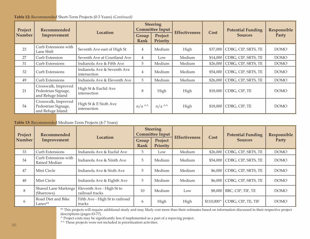
Project Number
Recommended Improvement Location
Steering Committee Input
Effectiveness Cost Potential Funding Sources
Responsible PartyGroup
RankProject Priority
23 Curb Extensions with Lane Shift Seventh Ave east of High St 4 Medium High $37,000 CDBG, CIP, SRTS, TE DOMO
27 Curb Extension Seventh Ave at Courtland Ave 4 Low Medium $14,000 CDBG, CIP, SRTS, TE DOMO31 Curb Extensions Indianola Ave & Fifth Ave 5 Medium Medium $26,000 CDBG, CIP, SRTS, TE DOMO
32 Curb Extensions Indianola Ave & Seventh Ave intersection 4 Medium Medium $54,000 CDBG, CIP, SRTS, TE DOMO
49 Curb Extensions Indianola Ave & Eleventh Ave 5 Medium Medium $26,000 CDBG, CIP, SRTS, TE DOMO
21Crosswalk, Improved Pedestrian Signage, and Refuge Island
High St & Euclid Ave intersection 8 High High $18,000 CDBG, CIP, TE DOMO
54Crosswalk, Improved Pedestrian Signage, and Refuge Island
High St & E Sixth Ave intersection n/a ^^ n/a ^^ High $18,000 CDBG, CIP, TE DOMO
Project Number
Recommended Improvement Location
Steering Committee Input
Effectiveness Cost Potential Funding Sources
Responsible PartyGroup
RankProject Priority
33 Curb Extensions Indianola Ave & Euclid Ave 5 Low Medium $26,000 CDBG, CIP, SRTS, TE DOMO
34 Curb Extensions with Raised Median Indianola Ave & Ninth Ave 5 Medium Medium $54,000 CDBG, CIP, SRTS, TE DOMO
47 Mini Circle Indianola Ave & Sixth Ave 5 Medium Medium $6,000 CDBG, CIP, SRTS, TE DOMO
48 Mini Circle Indianola Ave & Eighth Ave 5 Medium Medium $6,000 CDBG, CIP, SRTS, TE DOMO
8 Shared Lane Markings (Sharrows)
Eleventh Ave - High St to railroad tracks 10 Medium Low $8,000 BBC, CIP, TIF, TE DOMO
6 Road Diet and Bike Lanes**
Fifth Ave - High St to railroad tracks 6 High High $110,000^ CDBG, CIP, TE, TIF DOMO
88
Recommended Medium-Term Projects (4-7 Years)Table 13:
** This projects will require additional study and may likely cost more than their estimates based on information discussed in their respective project descriptions (pages 63-77). ^ Project costs may be significantly less if implemented as a part of a repaving project.^^ These projects were not included in prioritization activities.
Table 12: Recommended Short-Term Projects (0-3 Years) (Continued)
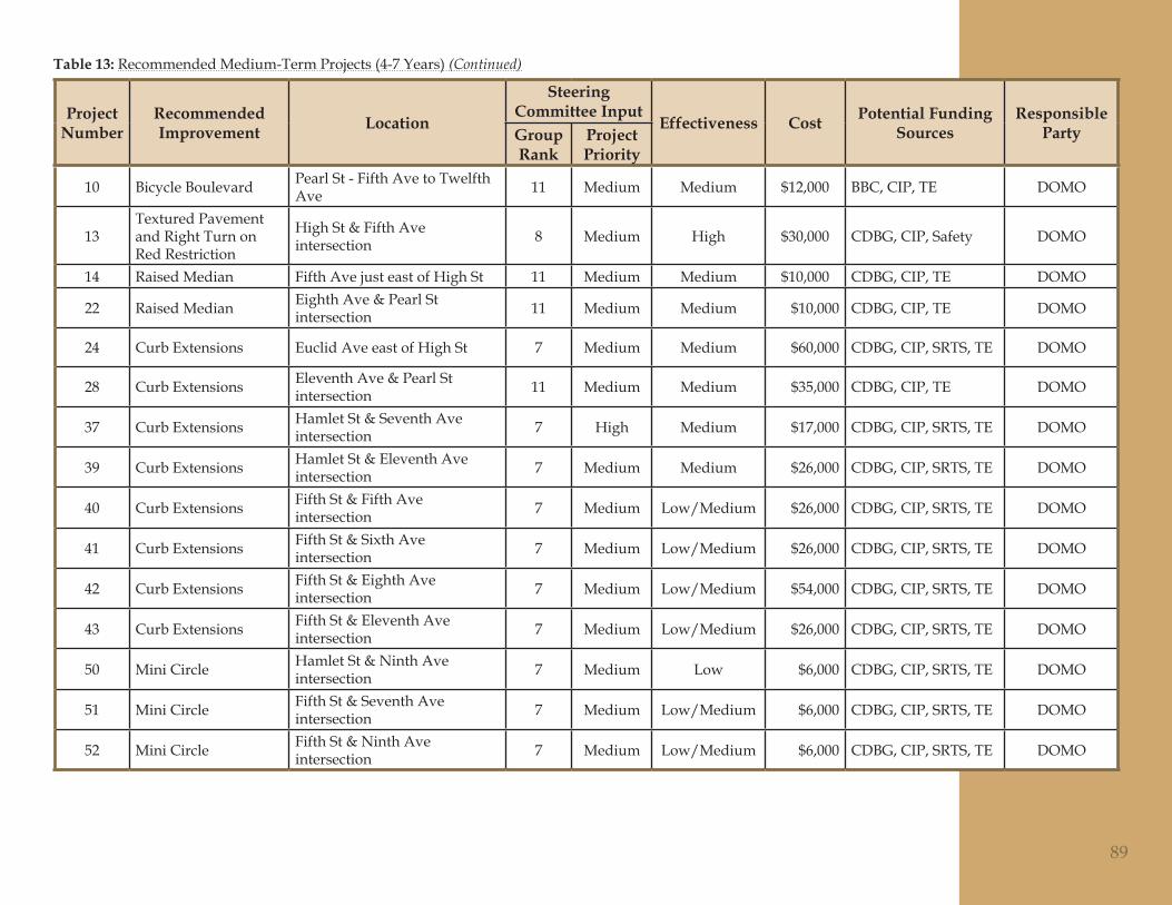
Project Number
Recommended Improvement Location
Steering Committee Input
Effectiveness Cost Potential Funding Sources
Responsible PartyGroup
RankProject Priority
10 Bicycle Boulevard Pearl St - Fifth Ave to Twelfth Ave 11 Medium Medium $12,000 BBC, CIP, TE DOMO
13Textured Pavement and Right Turn on Red Restriction
High St & Fifth Ave intersection 8 Medium High $30,000 CDBG, CIP, Safety DOMO
14 Raised Median Fifth Ave just east of High St 11 Medium Medium $10,000 CDBG, CIP, TE DOMO
22 Raised Median Eighth Ave & Pearl St intersection 11 Medium Medium $10,000 CDBG, CIP, TE DOMO
24 Curb Extensions Euclid Ave east of High St 7 Medium Medium $60,000 CDBG, CIP, SRTS, TE DOMO
28 Curb Extensions Eleventh Ave & Pearl St intersection 11 Medium Medium $35,000 CDBG, CIP, TE DOMO
37 Curb Extensions Hamlet St & Seventh Ave intersection 7 High Medium $17,000 CDBG, CIP, SRTS, TE DOMO
39 Curb Extensions Hamlet St & Eleventh Ave intersection 7 Medium Medium $26,000 CDBG, CIP, SRTS, TE DOMO
40 Curb Extensions Fifth St & Fifth Ave intersection 7 Medium Low/Medium $26,000 CDBG, CIP, SRTS, TE DOMO
41 Curb Extensions Fifth St & Sixth Ave intersection 7 Medium Low/Medium $26,000 CDBG, CIP, SRTS, TE DOMO
42 Curb Extensions Fifth St & Eighth Ave intersection 7 Medium Low/Medium $54,000 CDBG, CIP, SRTS, TE DOMO
43 Curb Extensions Fifth St & Eleventh Ave intersection 7 Medium Low/Medium $26,000 CDBG, CIP, SRTS, TE DOMO
50 Mini Circle Hamlet St & Ninth Ave intersection 7 Medium Low $6,000 CDBG, CIP, SRTS, TE DOMO
51 Mini Circle Fifth St & Seventh Ave intersection 7 Medium Low/Medium $6,000 CDBG, CIP, SRTS, TE DOMO
52 Mini Circle Fifth St & Ninth Ave intersection 7 Medium Low/Medium $6,000 CDBG, CIP, SRTS, TE DOMO
89
Table 13: Recommended Medium-Term Projects (4-7 Years) (Continued)
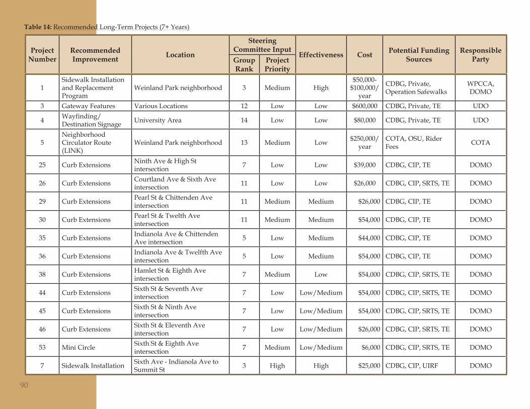
Project Number
Recommended Improvement Location
Steering Committee Input
Effectiveness Cost Potential Funding Sources
Responsible PartyGroup
RankProject Priority
1Sidewalk Installation and Replacement Program
Weinland Park neighborhood 3 Medium High$50,000-
$100,000/year
CDBG, Private, Operation Safewalks
WPCCA, DOMO
3 Gateway Features Various Locations 12 Low Low $600,000 CDBG, Private, TE UDO
4 Wayfinding/Destination Signage University Area 14 Low Low $80,000 CDBG, Private, TE UDO
5Neighborhood Circulator Route (LINK)
Weinland Park neighborhood 13 Medium Low $250,000/year
COTA, OSU, Rider Fees COTA
25 Curb Extensions Ninth Ave & High St intersection 7 Low Low $39,000 CDBG, CIP, TE DOMO
26 Curb Extensions Courtland Ave & Sixth Ave intersection 11 Low Low $26,000 CDBG, CIP, SRTS, TE DOMO
29 Curb Extensions Pearl St & Chittenden Ave intersection 11 Medium Medium $26,000 CDBG, CIP, TE DOMO
30 Curb Extensions Pearl St & Twelth Ave intersection 11 Medium Medium $54,000 CDBG, CIP, TE DOMO
35 Curb Extensions Indianola Ave & Chittenden Ave intersection 5 Low Medium $44,000 CDBG, CIP, TE DOMO
36 Curb Extensions Indianola Ave & Twelfth Ave intersection 5 Low Medium $54,000 CDBG, CIP, TE DOMO
38 Curb Extensions Hamlet St & Eighth Ave intersection 7 Medium Low $54,000 CDBG, CIP, SRTS, TE DOMO
44 Curb Extensions Sixth St & Seventh Ave intersection 7 Low Low/Medium $54,000 CDBG, CIP, SRTS, TE DOMO
45 Curb Extensions Sixth St & Ninth Ave intersection 7 Low Low/Medium $54,000 CDBG, CIP, SRTS, TE DOMO
46 Curb Extensions Sixth St & Eleventh Ave intersection 7 Low Low/Medium $26,000 CDBG, CIP, SRTS, TE DOMO
53 Mini Circle Sixth St & Eighth Ave intersection 7 Medium Low/Medium $6,000 CDBG, CIP, SRTS, TE DOMO
7 Sidewalk Installation Sixth Ave - Indianola Ave to Summit St 3 High High $25,000 CDBG, CIP, UIRF DOMO
90
Recommended Long-Term Projects (7+ Years)Table 14:

Updating the Plan
This implementation strategy should be used as a guide by the WPCCA and City of Columbus to develop mobility improvements over the life of the plan. However, the strategyshouldalsoremainflexibleandbeadaptedtochangingprioritiesandfundingavailabilityinthecomingyears.Approximatelyeveryfiveyears,theplanshouldbere-evaluatedtoreflectimprovementsthathavebeenmadeandtoensurethattheneedsof the community are still accurately addressed. The plan revision should include a re-prioritization of projects, addition of new projects, updated cost estimates, and consid-eration of changing funding sources and avialability.
91