Embed Size (px)
Citation preview

JOHNSON PARKCE 527 - SUSTAINABLE MOBILITYFINAL REPORT
TEAM: ELISSA MCDADE, DOUG MOODY, CLAY GRIGGS, DANIEL FOYE, AND PATRICK GILSTERJUNE 2013


CONTENTS
Executive Summary 1
Background and Approach 2
Goals and Objectives 3
Transportation Demand Management 4
Existing Roadway Conditions 6
Activity Centers and Zoning Changes 9
Pedestrian and Bicycle Connections 10
Reactions From Transportation Professionals 13
Understanding Turning Movement Volumes and Speed 14
2020 Design Concept 17
2035 Design Concept 19
Special Project Area 21
Case Study 23
Conclusion 25
JOHNSON PARKCE 527 - SUSTAINABLE MOBILITYFINAL REPORT
LIST OF FIGURES
FIGURE 1.1. Goals and Objectives 3
FIGURE 1.2. Existing Roadway Conditions 6
FIGURE 1.3. Existing Lane Dimensions for the Johnson & Ella Intersection 7
FIGURE 1.4. Existing Lane Dimensions for the Johnson & Bishop Intersection 7
FIGURE 1.5. Existing Lane Dimensions for the Johnson & Sydney Intersection 8
FIGURE 1.6. Activity Centers and Zoning Changes 9
FIGURE 1.7. Bicycle Boulevard Diverters 10
FIGURE 1.8. Proposed 2035 Intersection 11
FIGURE 1.9. Proposed 2035 Transit Stop 11
FIGURE 1.10. Proposed 2035 Bus Shelter 12
FIGURE 1.11. 2005 Turning Movement Data for the Johnson & Ella Intersection 15
FIGURE 1.12. 2005 Turning Movement Data for the Johnson & Bishop Intersection 15
FIGURE 1.13. 2020 Turning Movement Data for the Johnson & Ella Intersection 16
FIGURE 1.14. 2020 Turning Movement Data for the Johnson & Bishop Intersection 16
FIGURE 1.15. 2020 Design Concept - Proposed Striping Changes to Johnson Ave. 18
FIGURE 1.16. 2035 Design Concept - Proposed Infrastructure Changes to Johnson Ave. 20

1
JOHNSON PARK COMPLETE STREET - FINAL REPORTJUNE 2013
EXECUTIVE SUMMARYThe scope of this project is to envision Johnson Avenue between Sydney Street and Ella Street as a Complete Street. This project area offers the California Polytechnic University, San Luis Obispo Engineering students the opportunity to practice creating a streetscape that accomodates all modes of travel including pedestrian, bicycle, automobile and transit. Using various techniques our group created existing conditions maps to analyze conditions along Johnson Avenue and in the surrounding neighborhoods. Goals and objectives were identified using input from members of the community and formed after tours of the project site. This allowed our group to establish realistically feasible goals that could be implemented by the year 2020. Many of the 2020 goals for the complete street can be implemented at relatively low costs to the city without many infrastructure upgrades. An underlying vision for this project area is that the street right of way could be re-striped to provide for better distribution of the right-of-way between the different modes. It is our vision that creating 2035 infrastructure upgrades could include raised medians and landscaping to better define the streetscape and provide higher levels of protection for pedestrians and cyclists along Johnson Ave. It is our hope that this booklet will allow us to present an alternative street view that could one day be built along Johnson Avenue. Thank you for reviewing our current work.

2
JUNE 2013JOHNSON PARK COMPLETE STREET - FINAL REPORT
BACKGROUND AND APPROACHThe spring 2013 CE 527, Sustainable Mobility class was divided into two teams and given a transportation project. This project enabled the teams to create proposals for Johnson Avenue to become a complete street between Ella Street and Sydney Street. While considering local input, the following concepts were expected to be taken under consideration (listed in order of importance): land use, pedestrians, bicycles, public transit, and cars.
Johnson Avenue is located on the southeast side of San Luis Obispo, CA. This is a four lane arterial with the following facilities: a center two way turning lane; left hand turning pockets at all signalized intersections; 4-5 foot class-1 bicycle lanes adjacent to the travel lanes; and partial street parking. The posted speed limit for Johnson Avenue is 35mph, but speed spot studies taken in the project area reveal that the 85th percentile speed is 42mph.
This is a predominately residential neighborhood with trips being generated by a need to leave the area to travel to: places of employment; restaurants and entertainment; and shopping. Trip attractors in the project area include San Luis Obispo County facilities, medical facilities, schools (elementary, high school and adult school) and churches. This is a suburban feeling neighborhood that provides its residents with a disconnected network of hiking trails, bicycle lanes and pedestrian walkways.
Our team, the Residential Connectors, drew upon maps, documented traffic flow and accident data from the City of San Luis Obispo and personal knowledge of the study area to create initial traffic calming goals and objectives. We then spent a morning riding our bikes through the project area and surrounding neighborhood to modify, update or validate these goals and objectives. This experience, as well as some interviews conducted with neighborhood stakeholders, provided the launch-pad for our finalized project goals and objectives, and overall vision.
We discovered that the neighborhood surrounding Johnson Avenue was poorly served by the arterial running through it. With a current average daily traffic volume between 15,000 and 19,999, it has comparable volumes to South Street (between Higuera Street and Broad Street), but twice as much lane capacity. If put on a road diet similar to the one undertaken on South Street, Johnson Avenue could be more accommodating to all types of users, and become a facility that attracted the neighborhood instead of dividing it.
This design project, undertaken in phases, focuses on the creation of a complete street experience on Johnson Avenue for all users through: the reduction in roadway width for motorized vehicles; expansion of pedestrian facilities; addition of street trees and furniture; zoning changes to allow for neighborhood servicing commercial uses; and connection of bicycle facilities and networks.

3
JOHNSON PARK COMPLETE STREET - FINAL REPORTJUNE 2013
Figure 1.1. Goals & Objectives
GOALS AND OBJECTIVESThe goals and objectives, listed below, were established initially based on the project team’s ideas of what complete streets concepts could do within the neighborhood. Upon community involvement and a bicycle/walking tour of the project area, the project revised its goals and objects to better match the needs of residents and constraints due to the topography. The goals below offer broad views of what the project team would like to see implemented within the area to create a vibrant community that could evolve into its own destination neighborhood known as “Johnson Park.” By encouraging a broader spectrum of land uses along Johnson Avenue, the project team hopes to inspire more residents to walk or bicycle to neighborhood serving uses such as a small market, park, or coffee shop. Through changes to the physical street, the project team hopes to make the atmosphere along Johnson safer and more enjoyable for all users and abilities.

4
JUNE 2013JOHNSON PARK COMPLETE STREET - FINAL REPORT
TRANSPORTATION DEMAND MANAGEMENTOur Transportation Demand Management features encompassed many different aspects associated with pedestrian, bus, and bicycle modes of transportation. Through increased knowledge from the class, we used topics as well as outside sources to choose revisions that were both attainable and effective. Through programs such as Safe Routes to School and Rideshare Programs in conjunction with bicycle education and other incentives to use alternative modes of transportation, the neighborhood has the potential to become more sustainable and less dependent on cars.
Our first objective in Transportation Demand Management (TDM) was Safe Routes to School. These programs encourage walking and biking to school and conducting projects and activities to create a safer and more pleasant atmosphere for those who decide to pursue. By instilling the principles of healthy living and an active lifestyle at a young age, the program is fashioning a new mindset in children about sustainable modes of transportation and how it benefits themselves and the community. These Safe Routes would be determined once the new crosswalks were in place to create the safest and fastest way to get to and from Sinsheimer Elementary School from both across Johnson and the surrounding neighborhoods.
The Rideshare Program is another way to encourage sustainable techniques, but is broader and extends to both children as well as adults. It has many services that provide modes of travel that could move the same number of people while expending much fewer natural resources. Some of these options include organizing carpools and vanpools. Encompassed in the Rideshare Program are techniques such as matching commuters with similar people, places to meet, and ways to track your trips and savings. These programs and many more create ways for

5
JOHNSON PARK COMPLETE STREET - FINAL REPORTJUNE 2013
students and employees alike to get from start to destination with little to no inconvenience as well as reduce vehicular traffic on Johnson Avenue and the neighboring streets.
Next involves education and adjustment. Bicycle education is a great way to increase the number of bicyclists in the area as citizens learn how safe and fun it can be. The Bicycle Coalition specializes in this field and could be utilized to spread the word to the residents near Johnson Avenue. This can be accomplished through community meetings and school presentations to spread bicycle principles. In this way, students could bike to the high school and elementary school, and residents to work or retail knowing the safety precautions and rules. We would also like to extend the transit service hours so that no matter how early or late the work day is, there will be a way to get to the destination via bus. In this way, the employees or shoppers who may not have been able to compute by bus now have that opportunity.
Finally, business incentives for telecommuting would help decrease vehicular traffic and pollution while increasing sustainable transportation users. Although a prominently residential neighborhood, a vast majority of the populace has jobs and needs a way to get to them. By offering business incentives, these residents may feel it is enough of a reason to take a sustainable mode of transportation for work thus lowering vehicular traffic on Johnson Avenue. The hospital and elderly center and other businesses in the proximity also need ways to get to and from work and these business incentives would make sustainable modes more appealing.

6
JUNE 2013JOHNSON PARK COMPLETE STREET - FINAL REPORT
EXISTING ROADWAY CONDITIONSAs shown below, the existing Johnson right-of-way is 75 feet wide in the roadway and at transit stops and reduces to 74 feet at intersections.
In the roadway, at transit stops, and at intersections, there are 6 foot sidewalks on both sides.
Bike lanes are 5 feet wide at intersections, 4 feet wide in the roadway, and buses maneuver through and/or stop in the bike lane at transit stops.
In both the roadway and at transit stops, there are 4 automobile lanes (two in either direction), and each is 9.5 feet. At intersections, there are 4 lanes for automobile through traffic and one left turn lane.
Parking is available on the south-west side of Johnson between Fixlini and Bishop and on both side of Johnson from Bishop to Sydney.
Figure 1.2. Existing Roadway Conditions

7
JOHNSON PARK COMPLETE STREET - FINAL REPORTJUNE 2013
PA
TRIC
K G
ILS
TER
DA
NIE
L FO
YE
CLA
Y G
RIG
GS
DO
UG
LAS
MO
OD
YE
LIS
SA
MC
DA
DE
LANE DIMENSIONSS-1.1
DE
SIG
NE
D B
Y:
DE
SIG
N D
ATE
DR
AW
ING
NU
MB
ER
5/15
/201
3
1
RESIDENTIAL
CONNECTORS
LANE WIDTHS5.0
11.010.010.010.010.05.0
LANE WIDTHS5.0
10.011.010.011.010.05.0
LANE WIDTHS5.0
10.09.5
10.09.59.55.0
LANE WIDTHS8.04.09.59.59.59.54.08.0
ELLA ST.
JOHNSON AVE.
FIXLINI ST.
ELLA ST.
8.55.0
10.0
11.0
10.0
11.0
10.0
5.06.0
8.05.0
10.0
9.5
10.0
9.5
9.5
5.07.5
JOHNSON AVE.
PA
TRIC
K G
ILS
TER
DA
NIE
L FO
YE
CLA
Y G
RIG
GS
DO
UG
LAS
MO
OD
YE
LIS
SA
MC
DA
DE
LANE DIMENSIONSS-1.2
DE
SIG
NE
D B
Y:
DE
SIG
N D
ATE
DR
AW
ING
NU
MB
ER
5/15
/201
3
1
RESIDENTIAL
CONNECTORS
LANE WIDTHS6.0
10.010.010.010.011.06.0
LANE WIDTHS8.04.09.59.59.59.54.08.0
LANE WIDTHS5.0
10.510.59.5
10.510.55.0
BIS
HO
P S
T.
JOHNSON AVE.
BISHOP ST.
7.56.0
10.0
10.0
10.0
10.0
11.0
6.07.0
7.55.0
10.5
10.5
9.5
10.5
10.5
5.08.0
JOHNSON AVE.
SM
ITH
ST.
LANE WIDTHS5.0
10.510.510.510.55.08.0
Figure 1.3. Existing Lane Dimensions for the Johnson & Ella Intersection
Figure 1.4. Existing Lane Dimensions for the Johnson & Bishop Intersection

8
JUNE 2013JOHNSON PARK COMPLETE STREET - FINAL REPORT
PA
TRIC
K G
ILS
TER
DA
NIE
L FO
YE
CLA
Y G
RIG
GS
DO
UG
LAS
MO
OD
YE
LIS
SA
MC
DA
DE
LANE DIMENSIONSS-1.3
DE
SIG
NE
D B
Y:
DE
SIG
N D
ATE
DR
AW
ING
NU
MB
ER
5/15
/201
3
1
RESIDENTIAL
CONNECTORS
LANE WIDTHS5.0
10.510.510.010.510.55.0
LANE WIDTHS8.04.09.59.59.59.54.08.0
LANE WIDTHS8.05.09.5
10.010.09.55.08.0
SY
DN
EY
ST.
JOHNSON AVE.
SYDNEY ST.
6.55.0
10.5
10.5
10.0
10.5
10.5
5.07.0
7.55.0
10.5
10.5
10.0
10.5
10.5
5.07.5
JOHNSON AVE.
SM
ITH
ST.
LANE WIDTHS8.05.09.59.59.59.55.08.0
LANE WIDTHS5.0
10.510.510.010.510.55.0
Figure 1.5. Existing Lane Dimensions for the Johnson & Sydney Intersection

9
JOHNSON PARK COMPLETE STREET - FINAL REPORTJUNE 2013
ACTIVITY CENTERS AND ZONING CHANGES
School District/Adult School
French Hospital
First Baptist Church
Railroad CrossingBridge
Railroad Safety Trail Terrace Hill Sinsheimer Park Sinsheimer Elementary SLO Swim Center Laurel Lane Market Church
Medical Office Park
County Health Center
County Probation Office
Unused Open Space
Government Commercial Cultural/Historical High Density Residential Medium Density Residential
Neighborhood Commercial
Parks & Open Space
ZONE CHANGES BY 2020
JOHNSON AVE
ELLA ST
FLORA ST
FIXILINI ST
AUGUSTA ST
LAUR
EL LN
BISHOP ST
RAILROAD
SYDNEY ST
Figure 1.6. Activity Centers and Zoning Changes
ACTIVITY CENTERS AND ZONING CHANGESIn order to establish how and by whom the complete street would utilized, it was necessary to identify important sources of activity that are already community assests within the neighborhood. Along Johnson Avenue there are many existing businesses and services such as French Hospital, County Health Facilities, Medical Offices, and School District offices. However, most of the area is currently single-family or medium-density residential. There was only one neighborhood commercial serving use, Laurel Lane Market, that is located on another nearby street. It is for this reason, that the project team recommends converting certain parcels along Johnson Avenue to Neighborhood Commercial and/or Mixed Use. This would support the conversion of Johnson Avenue into a complete street because it would allow more commercial facilities for residents to walk or bike to within their neighborhood. The proposed rezoning of undeveloped land to Parks & Open Space with the creation of a new park could reestablish this neighborhood as “Johnson Park” and encourage use of alternate modes by residents to the park if connected in conjunction with completing the Bike Boulevard north of Johnson Ave.

10
JUNE 2013JOHNSON PARK COMPLETE STREET - FINAL REPORT
PEDESTRIAN AND BICYCLE CONNECTIONSThroughout the length of Johnson, our proposed design intends to create more desirable walking and cycling options. Walking is made more desirable by increasing sidewalk/pedestrian space, decreasing crossing distance, lowering traffic speeds, and including vegetation. Cycling is made more desirable by better protecting cyclists from automobile traffic and providing more route options with varying surroundings and topographies.
Our walkability goals are achieved by removing automobile lanes and reallocating some of the space to pedestrian infrastructure. Fewer lanes allow shorter crossing distances. More pedestrian space (especially with vegetation) allows for more desirable pedestrian conditions.
Sharrows are proposed on routes with substantially less automobile traffic than Johnson. Parallel bicycle routes to the north-east of Johnson on Flora and Fixlini were proposed. We proposed connecting these two routes via a class 1 bicycle route through the area where Bishop terminates, and we proposed redevelopment. On Fixlini, in addition to sharrows, we proposed diverters (as shown below) that allow for through bicycle traffic but direct automobile traffic off Fixlini at each intersection—Fixlini has problems with cut-through traffic from Johnson to access the high school, and these diverters could be part of the solution.
We also proposed sharrows perpendicular bicycle routes on Ella and Sydney and along a parallel route to the south-west of Johnson from Sydney to Sinsheimer Elementary—this route could be extended to continue along Augusta, to a short stint on Bishop, to Sierra Way, and finally connect with Ella.
Figure 1.7. Bicycle Boulevard Diverters

11
JOHNSON PARK COMPLETE STREET - FINAL REPORTJUNE 2013
A cycle track was proposed on Johnson Ave. As seen in Figure 1.5, in roadway sections, cyclists are separated from automobile traffic by a raised buffer, and pedestrians are separated from cyclists by an elevated sidewalk and trees.
At intersections, cyclists can activate a through green light shared with through autos via a loop detector or camera associated with the cycle track. Left turns can be made via an actuation button next to a cyclists stopped in the cycle track at an intersection. As noted in the transportation professional reactions below, future designs should probably separate the cycle track and crosswalks—this should reduce pedestrian/cyclist conflicts, but it also places automobiles stopped at the intersection further away, possibly impacting sight distance of drivers.
As seen below, at bus stops, we designed the cycle track and sidewalk to merge into a shared-zone. We started with the assumption that a pedestrian/cyclist interaction is better than a cyclist bus interaction; however, as can be ascertained from the transportation professional reactions below, this design needs refinement.
In our proposed 2035 design, we have a combined 24 feet pedestrian/bike of space available on both sides of Johnson. If we redistribute our space allocation so that each side of Johnson has 12 feet of pedestrian/bike space we could make
Figure 1.8. Proposed 2035 Intersection
Figure 1.9. Proposed 2035 Transit Stop

12
JUNE 2013JOHNSON PARK COMPLETE STREET - FINAL REPORT
the following changes to transit stops:
• Move the shelter a few feet further away from the bus pullout and near the middle of the pedestrian/bike space.
• Prior to the shelter, switch the positions of the cycle track and the sidewalk so that the cycle track wraps behind the shelter. In this configuration, the area from where bus riders interact with the pullout (including the shelter) all the way to where the pedestrian space and cycle-track cross would be pedestrian-only space. Where the sidewalk and cycle track cross, the cycle track would curve to slow cyclists, the oncoming shelter would slow cyclists, and pedestrians would have the right-of-way—this could be indicated by a crosswalk (or shared zone) and signage. If the shelter is 3 feet wide, this will leave 9 feet to distribute between the sidewalk space in front of the shelter and the cycle track that now wraps behind the shelter. A 5 foot sidewalk in front of the shelter and a 4 foot cycle track behind it seems reasonable.
• Another option is a similar configuration but with the shelter on the other side of the bus pull out. This eliminates the shelter as an object that would slow cyclists entering the bus pull out space, but this configuration remove the shelter as a sight obstacle between pedestrians in the pull out space and oncoming cyclists. This configuration makes it more difficult for bus operators to see if they have riders waiting as they approach the bus stop.
Adjustments would also need to be made to our proposed 2020 stripping changes to reflect this design change.
Figure 1.10. Proposed 2035 Bus Shelter

13
JOHNSON PARK COMPLETE STREET - FINAL REPORTJUNE 2013
REACTIONS FROM TRANSPORTATION PROFESSIONALS ON PEDESTRIAN & BICYCLE CONNECTIONSCycle Track“I have concerns about the cycle track @ intersections & bike speed as bus stops. But I also think that raised cycle tracks w/ the buffer will help people feel comfortable riding on the street.” – Kevin C.
“I notice that the cycle tracks coloring appears to overlap with the crosswalk zebra striping at many study area intersections. This creates an inherent conflict between bicyclists and pedestrians.” – Scott E.
“The ending of the cycle tracks onto the sidewalk at bus stop locations would seem to create a significant conflict between bicyclists, transit users (entering and exiting the bus), and pedestrians. In addition, these conflict would likely be exacerbated due to restricted sight distance when a bus is present. Unless the bicyclists are expected to dismount, the bicyclists would appear to also be riding on the sidewalk in these areas which is not legal in the City of SLO. Also, when a bus is not present, would bicyclists be expected to ride on the sidewalk with peds?” – Scott E.
“The interface between the cycle track and the bus stop is a bit concerning – what happens when a bus is stopped and 5 cyclists moving 20 mph are approaching?’ – James D.
“Not sold on the shared bike/ped areas.” – Bryan W.
Fixlini Traffic Diverters“Traffic diverters on Fixlini – consider a temporary trial” – Rich K.
“Fixlini bike boulevard is cool – diverters work nicely.” – Eric M.

14
JUNE 2013JOHNSON PARK COMPLETE STREET - FINAL REPORT
UNDERSTANDING TURNING MOVEMENT VOLUMES AND SPEED ON JOHNSON AVE2005 SLO City turning volumes were provided to both project teams at the start of the project. These provided volumes were for the intersections of Ella and Johnson, and Bishop and Johnson at morning and afternoon peak volumes in all directions (north, south, west, east and right, left, thru). A simple growth model was applied to these volumes to grow them 1% each year as projections for 2020 and 2035. This growth percentage is in accordance with the city growth model as stated in the City of San Luis Obispo General Plan.
The turning movement volumes were considered as we evaluated the possibility of putting Johnson Avenue on a road diet to reduce the roadway width devoted to the motor vehicle. At year 2020, our project sought to reduce the travel lanes on Johnson from two lanes in either direction with a middle turning lane to one lane in either direction with a middle turning lane. The projected turning volumes proved that maintenance of a left turn lane at the signalized intersections of Johnson/Ella and Johnson/Bishop would be essential to the maintenance of traffic level of service (LOS) on Johnson. For example, a projected 2020 PM peak northbound left turn volume at Johnson/Ella of 24 vehicles in combination with a PM peak southbound thru traffic volume of 1028 vehicles would ensure northbound traffic congestion unless a left turn lane continued to be available.
Spot speed studies from observations at the Johnson/Bishop intersection were provided by the San Luis Obispo Public Works department for an afternoon period on Friday, August 8, 2007 and a morning period on Tuesday, July 3, 2012. Although the posted speed limit on this road is 35mph, the 85th percentile recorded during these studies was 42mph. This results of this study indicated that the roadway has too much capacity and is unsafe for non-vehicular roadway users, such as pedestrians and bicyclists. This average speed further supported the decision to move forward with putting Johnson Avenue on a road diet to reduce speeds to the posted limit, and to equalize space devoted to motorized vehicle and non-motorized vehicle or pedestrian users.

15
JOHNSON PARK COMPLETE STREET - FINAL REPORTJUNE 2013
SB 685Left 2
Thru 626
Right 57
Left 43
Thru 876
Right 11Le
ft 20
Thru
1R
ight
17
Left 2Thru 1R
ight 5
NB 930EB
38
WB
8
SB 1021Left 14Thru 894
Left 21Thru 748
Right 6
Left 5Thru 0R
ight 8
NB 775
EB 1
05
WB
13
Thru
1R
ight
60
Right 113
Left
44
N
SB 459
Left 82
Thru 324
Right 53
Left 19
Thru 859
Right 44
Left
133
NB 922
WB
36
EB 1
50Th
ru 4
Right 23
Left 13Thru 0
SB 856
Left 31
Thru 704
Right 121
Left 54
Thru 479
Right 12
Left
96
NB 545
WB
152
EB 1
52Th
ru 0
Right 71
Left 76Thru 5
Rig
ht 1
3
Rig
ht 5
6
N
Figure 1.11. 2005 Turning Movement Data for the Johnson & Ella Intersection
Figure 1.12. 2005 Turning Movement Data for the Johnson & Bishop Intersection

16
JUNE 2013JOHNSON PARK COMPLETE STREET - FINAL REPORT
SB 788Left 2
Thru 720
Right 66
Left 43
Thru 1007
Right 13Le
ft 23
Thru
1R
ight
20
Left 2Thru 1R
ight 6
NB 1070EB
44
WB
9
SB 1174Left 16Thru 1028
Left 24Thru 860
Right 7
Left 6Thru 0R
ight 9
NB 891
EB 1
21
WB
15
Thru
1R
ight
69
Right 130
Left
51
N
SB 528
Left 94
Thru 373
Right 61
Left 22
Thru 988
Right 51
Left
153
NB 1060
WB
41
EB 1
73Th
ru 5
Right 26
Left 15Thru 0
SB 984
Left 36
Thru 810
Right 139
Left 62
Thru 551
Right 14
Left
110
NB 627
WB
175
EB 1
75Th
ru 0
Right 82
Left 87Thru 6
Rig
ht 1
5
Rig
ht 6
4
N
Figure 1.13. 2020 Turning Movement Data for the Johnson & Ella Intersection
Figure 1.14. 2020 Turning Movement Data for the Johnson & Bishop Intersection

17
JOHNSON PARK COMPLETE STREET - FINAL REPORTJUNE 2013
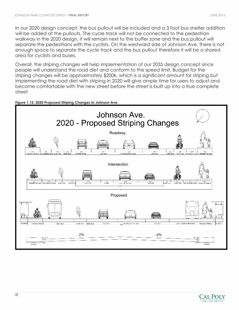
2020 DESIGN CONCEPTIn our 2020 Design Concept, the overall goal was to implement a mode shift that would simulate our 2035 concept. Our 2035 concept shows the whole street with the road diet implemented with extended sidewalks and medians, but in 2020 our plan is to set the concept in motion by striping the road diet, allowing users to become more comfortable with the new street. This option is also more financially feasible because the treatment mainly involves striping. Land uses will also be changed to fulfill the development in our 2035 design concept.
The reasons for reassigning the road space and proposing a road diet directly correlates with our goals and objectives. Our goals include providing a complete street structure while maintaining an adequate level of service. Using the traffic volumes on South St. in San Luis Obispo as well as Baxter Street in Athens, Georgia, a road diet is acceptable at this volume and the volume to capacity ratio will prove an adequate level of service.
Other factors that were considered in our 2020 design concept was to reduce the pedestrian crossing distance, therefore we provided room for a pedestrian crossing island in the concept. Safety of pedestrians was also addressed from the amount of pedestrian collisions found in the 2002-2011 Crash Data study provided. The cycle tracks also help provide safety for bicyclists from vehicular elements using a buffer zone, while also keeping them away from the door zone from on-street parking. Speed limit compliance was also a big factor since the 85th percentile speeds were 7 mph over the speed limit. Therefore decreasing lane width will conform vehicles to comply with the speed limit.
The striping involved with the road diet includes eliminating a lane from each side of the road, while still maintaining a dual left turn lane in the middle of both vehicle lanes. On the sidewalks, there will be a pedestrian expansion zone to mimic the extension of the sidewalk in 2035. This pedestrian expansion zone will be 4.5 feet for the main roadway, and at intersections the zone will be 5.5 feet. The cycle tracks are included in the 2020 design concept as well, and will be 5 feet throughout Johnson Ave. There are buffer zones between the cycle track and the middle section of the roadway, measuring 3 feet throughout.
On street parking will be relocated to only be on the east side of Johnson Avenue and be found throughout the street except at the intersections and bus pullouts. Lastly, there will be a median at the intersections and the transition approaches to the intersections, measuring 5 feet, as a barrier between the left turn vehicle lane at the intersection and oncoming traffic. It also serves as a refuge for pedestrians crossing the street and will also include pedestrian activation buttons.
18
JUNE 2013JOHNSON PARK COMPLETE STREET - FINAL REPORT
In our 2020 design concept, the bus pullout will be included and a 3 foot bus shelter addition will be added at the pullouts. The cycle track will not be connected to the pedestrian walkway in the 2020 design, it will remain next to the buffer zone and the bus pullout will separate the pedestrians with the cyclists. On the westward side of Johnson Ave, there is not enough space to separate the cycle track and the bus pullout therefore it will be a shared area for cyclists and buses.
Overall, the striping changes will help implementation of our 2035 design concept since people will understand the road diet and conform to the speed limit. Budget for the striping changes will be approximately $200k, which is a significant amount for striping but implementing the road diet with striping in 2020 will give ample time for users to adjust and become comfortable with the new street before the street is built up into a true complete street.
Figure 1.15. 2020 Proposed Striping Changes to Johnson Ave.

19
JOHNSON PARK COMPLETE STREET - FINAL REPORTJUNE 2013
2035 DESIGN CONCEPTThe 2035 Design Concept for Johnson Park seeks to change the streetscape on Johnson Avenue. Widened sidewalks, cycle tracks, street trees, street furniture and bus stop parklets remake the experience for all users. The reduction of one travel lane in either direction on Johnson, as well as the removal of parking on the west side of the street provide the approximately 27 feet of space necessary to permanently transform the Johnson Park streetscape from the 2020 restriping plan into long lasting capital changes that will benefit the Johnson Park neighborhood.
Roadway changes include an 11 foot wide two-way left turn lane. Bicycle lane changes along the roadway include the installation of a 3 foot wide raised cycle buffer zone and the installation of a 5 foot wide raise cycle track. Pedestrian walkways on the east and west sides of the street will be expanded from 6 feet to 10.5 feet. The first 3 feet of the pedestrian walkway that is directly adjacent to the cycle track will be devoted to street tree planting and street furniture; such as park benches, trash cans and bicycle racks.
Intersection changes include the installation of a 5 foot median that will double as a pedestrian refuge. The 2035 design also calls for the installation of pedestrian actuated crosswalk button to allow pedestrians who take longer than the crossing phase a chance to safely continue their journey at the next signal phase. Bicycle lane changes at the intersection include the installation of a 3 foot wide raised cycle buffer zone and the installation of a 5 foot wide raise cycle track. Pedestrian walkways on the east and west sides of the street will be expanded from 6 feet to 11.5 feet.
Bus pullout changes include the expansion of the pedestrian walkway on the east side of the street to 16 feet (due to the space devoted to parking on the roadway section of this design). This increased size would allow for a combination of the cycle track and the pedestrian walkway into a shared zone with the addition of a parklet that transit users can enjoy while they wait for their next bus. Pedestrians and runners would also enjoy this new feature, and find it a pleasant spot to stop and rest or talk to neighbors as they enjoy their neighborhood. The west side of the street would be redesigned to an 8 foot shared zone for pedestrian and bikes at the transit stop.

20
JUNE 2013JOHNSON PARK COMPLETE STREET - FINAL REPORT
During our final presentation, feedback and criticism of our design concept focused on concerns about the intersection of the cycle track with pedestrian uses at the bus pullout, and the intersection of the cycle track with the cross walk at the intersection.
In response to these criticisms, suggested future improvements of the Johnson Park 2035 design concept include a continued separation of relocation of the crosswalk along Johnson so that it connects with the pedestrian walkway and does not intersect with the cycle track. Our team would also restripe the cycle track through the intersection so that it is adjacent to the crosswalk.
*Design responses to the concerns about the shared walkway/cycle track at bus pullouts are addressed in detail in the Pedestrian and Bicycle Connections section of this report.
Figure 1.16. 2035 Proposed Infrastructure Changes to Johnson Ave.

21
JOHNSON PARK COMPLETE STREET - FINAL REPORTJUNE 2013
SPECIAL PROJECT AREA: JOHNSON & SYDNEY INTERSECTIONOur special project focused on the intersection of Johnson Avenue and Sydney Street. This is an un-signalized intersection that has a flashing crossing sign, which is only active during certain hours of the day, but is not user actuated. This crosswalk is important, because it is a route heavily used by school children crossing Johnson Avenue to walk down Sydney Street to Augusta Street and on to the Sinsheimer Elementary school. Due to the high speed of Johnson Avenue, and the lack of user control over the flashing crossing sign, the school has posted a crossing guard to help the children before and after school hours. The intersection is also characterized by a church parking lot on the south-east corner.
The project proposal for this intersection begins with modifying this roadway facility to accommodate Safe Routes to School. As part of the 2035 project timeframe, 5 foot wide medians would be added to the center of Johnson Avenue next to the left turn lanes. These would act as pedestrian refuges and incorporate the installation of pedestrian actuated crosswalk button to allow pedestrians who take longer than the crossing phase a chance to safely continue their journey at the next signal phase. Reflective yellow zebra crosswalks would be painted to allow safe and visible crossings across all four sides of the intersection. The existing flashing crossing sign would be updated to include a user actuated button. Advance warning crossing signs would also be installed 100 feet prior to the intersection, and would

22
JUNE 2013JOHNSON PARK COMPLETE STREET - FINAL REPORT
begin flashing when the user actuated buttons are pushed, to warn the approaching motor vehicles that they should slow in expectation of a pedestrian crossing at Sydney Street. Additionally, Sydney Street would be painted with sharrows and designated a class-3 bicycle lane.
The church parking lot would be rezoned as neighborhood commercial as part of our 2020 plan. And, our special project encourages the development of a neighborhood coffee shop or market in this location, with rooftop parking that can be shared with the church. This would serve as a neighborhood anchor and provide residents with a sorely needed local gathering place that they would be able to use without having to get in their cars and leave the neighborhood.

23
JOHNSON PARK COMPLETE STREET - FINAL REPORTJUNE 2013
CASE STUDY: BAXTER STREET IN ATHENS, GEORGIAThe case study is represented by Baxter Street in Athens-Clarke County, Georgia. This street was modified to accommodate sustainable modes of transportation while reducing vehicular traffic and speeds. Although it has a population of 102,000, the amount of vehicular traffic is very similar to that of our project area, Johnson Avenue. The ADT on Baxter Street is between 18,000 and 20,000vpd and on Johnson Avenue is between 15,000 and 20,000vpd as reported on the San Luis Obispo City Public Works page. By viewing the results of alterations to this street, the prospect of transforming Johnson can more easily be observed and conclusions obtained.
Baxter Street is located near the University of Georgia. Safety concerns for pedestrians and bicyclists were addressed in October of 1999 to deal with both the downtown area and students at the University. It was fashioned as a demonstration project to see what the impacts would be to traffic flow, speeds, and safety when reducing the number of lanes. The road is question was forty feet curb-to-curb with four 10-ft lanes. The road was transformed into a 12-ft two-way left-turn lane in the center with two 14-ft travel lanes extending from this which included 3-ft shared bicycle areas. Bicycle lanes needed to be at least 4-ft and given the limited width of the road, the decision was to just create a shared bicycle area to give the bicyclists more safety when traveling the street. These shared bicycle areas were striped thus creating the impression of a 3-ft bicycle lane and 11-ft vehicle lane.
Although this project was a less radical transformation than our Johnson Avenue proposal, its costs and benefits should still be quantified. The cost of the project for preparation, resurfacing,

24
JUNE 2013JOHNSON PARK COMPLETE STREET - FINAL REPORT
striping, signal modification, and design fees totaled $185,600. The number of crashes on this street decreased by 53 percent, decreased by 60 percent at signalized intersections, and traffic speeds reduced. There was also a 3.7 percent decrease in traffic volume which was relocated to a neighboring street and did not create dramatic vehicle congestion or safety problems there. Finally, the shared bicycle area provided a bicycle refuge which created a safer atmosphere for this sustainable mode of transportation.
This street is a fair representation of Johnson Avenue because it is reducing the street from 4 lanes to 2 lanes. The Athens-Clarke County did their best to accommodate bicyclists while not congesting traffic, although their street width was much narrower than ours. The cost was very minimal for this size of a project which strengthens our proposal on Johnson Avenue. As shown by this street modification, many positive outcomes occur because of the road diet and prove that it has great potential to decrease traffic volumes, speeds, and accidents within the project area.

25
JOHNSON PARK COMPLETE STREET - FINAL REPORTJUNE 2013
CONCLUSIONThe concept of Johnson Park incorporates more places for people in the neighborhood to go and slower traffic on Johnson Avenue while also creating a Complete Street. Johnson Avenue is currently a four lane arterial and many vehicles drive faster than the speed limit. Bike and transit elements in the area support their respective transportation modes but a road diet allows more real estate to support bus pullouts, medians, and cycle tracks with buffer zones to support bicycle safety from factors such as the door zone. Important elements such as maintaining level of service for vehicles and creating parallel transportation elements for all types of users was required to form the neighborhood feel in the area.
Our special project was a small neighborhood coffee shop or market at the intersection of Sydney St. and Johnson Ave. This design brings together the Complete Street element of Johnson Park by giving people places to meet, while also making the school crossing safer since more vehicles will be aware of the development and yield to the increase in pedestrian traffic. The transportation demand management objectives include Safe Routes to School which is supported by the special project area on Sydney and Sinsheimer Elementary a few blocks down from the intersection. Bicycle education supports the idea of a Complete Street by reducing vehicular traffic and also promoting use of parallel streets with sharrows, like Fixlini St. and Flora St. This design concept allows all types of users to be comfortable in alternative modes of transportation; confident and advanced users will use the cycle track on Johnson Ave. and less confident bicyclists can use the route on Flora St. and Fixlini St. To fully design a Complete Street, we adhered to all modes of transportation as well as all types of users in their respective modes.
The 2035 design concept is not perfect and still needs refinement. A major issue is the bus pullout and whether bicyclists will adhere to pedestrians in the shared zone or if routing the cycle track differently is more plausible. With the raised cycle track and extended sidewalks, crosswalk markings also become difficult to design due to sight distance constraints on the perpendicular streets, as well as regulations for crosswalk widths with the cycle track taking up a significant portion of the crosswalk.
Overall, reducing vehicular traffic with traffic calming measures helps reduce the dependence on vehicles, and also promoting alternative modes of transportation. Modern transit networks and bicycle planning efforts also encourage users to try alternative modes and lessen the use of their private vehicles. Our team developed the project area as a Complete Street to also support a neighborhood community feel which prepares the area for future development. Developing a community is essential to growth of a sustainable city and the Complete Street in Johnson Park aides in San Luis Obispo’s overall sustainability awareness and development.

WORKS CITEDCity of San Luis Obispo Public Works Department. Traffic Division Spot Speed Study. Johnson(Bishop/Laurel). Friday August 8, 2010.
City of San Luis Obispo Public Works Department. Traffic Division Spot Speed Study. Johnson(near Bishop). Thursday, July 3, 2012.
Clark, David E. Road Diets: Athens-Clarke County’s Experience in Converting 4-lane Roadways into 3-lane Roadways. http://www.ite.org/Membersonly/annualmeeting/2001/AB01H6101.pdf
National Center for Safe Routes to School. http://www.saferoutesinfo.org/about-us
Nelson, Angela. Ride Share Online. http://www.rideshareonline.com/