Embed Size (px)
Citation preview

July 2012
Village of Campton Hills Comprehensive Plan
The Chicago Metropolitan Agency for Planning (CMAP) is the region’s official comprehensive planning organization. Its GO TO 2040 planning campaign is helping the region’s seven counties and 284 communi-ties to implement strategies that address transportation, housing, economic development, open space, the environment, and other quality of life issues. See www.cmap.illinois.gov for more information.
Acknowledgements
Village BoardLaura AndersenSusan GeorgeJim Kopec Al LenkaitisMike MilletteJohn Strauss
Plan Commission & Subcommittee AssignmentsRolf Fredrick, Chair, Housing CommitteeCarolyn Higgins, SecretaryChristine Brauer, Land Use CommitteeStephany Impson, Natural Resources and Green Infrastructure CommitteeChuck Johnson, Transportation and Infrastructure CommitteeDavid Phillips, Water Resources CommitteeJohn Pree, Agriculture CommitteeJay Richardson, Economic Development Committee
Project Partners and CollaboratorsChicago Metropolitan Agency for PlanningJason NavotaKristin IhnchakErik PedersenCynthia Hernandez Adam Weiskind
Conservation Design ForumDavid YoccaSarah Alward
Teska AssociatesScott GoldsteinMalika Ramdas
Rempe-Sharpe Associates, Inc.Jim Bibby
Chicago Wilderness Sustainable Watershed Action Team Deanna GlosserNancy Williamson
FundersU.S. Department of Housing and Urban DevelopmentGrand Victoria FoundationKane County Small Cities Grant Program
Subcommittee ParticipantsRich AlexanderNeal Anderson Tracy AndersonBarry BotruffMarian Boveri, Historic Preservation Committee ChairRon D’Aversa Baret GalaunerTom JassoyJerome JohnsonKen Johnson Kathleen Judy-PurcellJohn KuparAl LenkaitisRic ManserGeorge McNultyMike MilletteJoy NelsonMichelle NoyesTom PalanskyJoe Powell Jack Shouba Stan WalczynskiBarbara WojnickiMatt Zerby
Village StaffNicki BrickmanChris Ranieri
Funding Acknowledgement The Village of Campton Hills and Chicago Metropolitan Agency for Planning would like to thank the U.S. Department of Housing and Urban Development (HUD) for funding the development and production of this plan. This project is funded through a HUD Sustainable Communities Regional Planning grant, which supports CMAP’s Local Technical Assistance (LTA) program.
The Village of Campton Hills Comprehensive Plan is the cumulative effort of many individuals, including residents and stakeholders who attended public meetings and workshops, who provided time and expertise to identify community values and priorities, planning issues, policies, and strategies to help successfully complete this plan. The Village of Campton Hills would like to thank all of the people who worked with the project team to identify and address the specific challenges and opportunities that will impact the future of the Village of Campton Hills.
Patsy Smith, Village President
3
Village of Campton Hills Comprehensive Plan
4
5
Table of Contents
Acknowledgements 2
Table of Contents 5
Letter from the Village President 7
Chapter 1. Introduction 9
Why does Campton Hills Need a Comprehensive Plan? 9
What is a Comprehensive plan? 10
Elements of a Comprehensive Plan 10
Planning Process 10
Public Participation and Community Outreach 11
Chapter 2. Regional and Local Context 13
History of Campton Hills 13
Image and Culture 15
Demographics and Employment 15
Regional and Sub-regional Context 16
Relationship with the GO TO 2040 Regional Comprehensive Plan 18
Chapter 3. Principles, Policies, and Strategies 21
A. Community Character 22
B. Open Space and Natural Resources 29
C. Water Resources 36
D. Food and Farming 44
E. Mixed-Use Centers 49
F. High-Quality Homes and Neighborhoods 54
G. Transportation and Accessibility 56
H. Community Services, Facilities, and Infrastructure 63
I. Managed Change 65
J. Community Health 74
Chapter 4. Funding and Information Resources 77
Acronyms 79
Appendix A: Existing Conditions Report A1
Appendix B: Stormwater Management B1
6
7
Dear Residents,I am pleased to introduce the revised Village of Campton Hills’ Comprehensive Land Use Plan to the community and our partners. This plan is the culmination of a year-long planning process that engaged the community in a conversation to help identify community values and priorities, create a vision of the future of Campton Hills, and establish a set of guiding principles, policies, and strategies intended to achieve the vision and protect our community assets. The revised plan evolved out of previous studies and planning efforts and the dedication of our elected and appointed officials, committee members, staff, and all who have worked together to ensure that our community continues to provide a high quality of life for its residents, business owners, and others.
Throughout the planning process, we heard from the public about the importance of protecting our natural resources and the characteristics that draw people to live and work in our wonderful community. This Plan highlights those resources and creates the framework that will guide decision-making in the future. And while this plan makes tremendous progress in establishing Campton Hills’ policy and future direction, it also calls for additional work to create the organizational and governing tools for implementing Village policies and achieving the community vision.
This Plan represents a true team effort. Everyone’s contribution was valuable and I am thankful to all who participated in the planning process for donating their time and energy. I especially want to acknowledge the partners, collaborators, consultants, and agencies for their generosity and expertise in making this project possible. I am also thankful to the many individuals who have shared their thoughts and values with the Village.
This Plan is an important milestone in maintaining our natural resources and the semi-rural character of our community. I hope that you will join me in working toward its implementation and the achievement of the community’s vision for Campton Hills.
Sincerely yours,
Patsy Smith, Village President
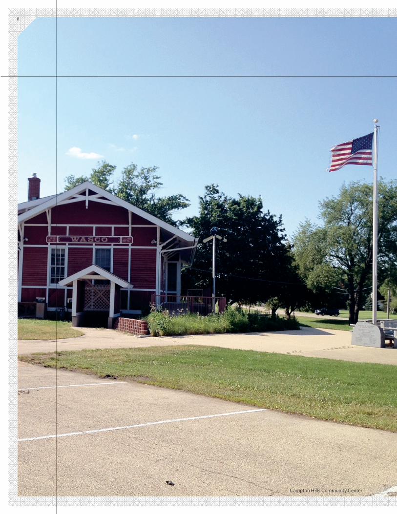
Campton Hills Community Center
8
9
Why Does Campton Hills Need a Comprehensive Plan?The village of Campton Hills possesses unique assets that provide a high quality of life for its residents, who have expressed a desire to protect the natural resources and rural character of the community.
Consisting primarily of residences, open space, and agricultural land, the village lies on the edge of the Chicago metropolitan region: to the east lie the river towns of St. Charles, South Elgin, and Geneva, and to the west are smaller villages surrounded by an expanse of agricultural land. The growth and development of the 1990’s and 2000’s, which pushed the suburban edge beyond Randall Road, has slowed significantly. Nonetheless, Campton Hills is intent on protecting its assets and character for current and future residents. An up-to-date comprehensive plan provides the context in which de-cisions affecting the future of Campton Hills can be made with some certainty that today’s choices contribute to achieving the long-term goals and vision of the community.
Campton Hills currently has a comprehensive plan and land use ordinances in place; however, these are largely adopted from other jurisdictions (Campton Township and Kane County) and lack the specificity and local input that the village needs. The current plan is fairly brief and consists primarily of broad policy statements rooted in a subset of community values. It also does not reflect the current realities, challenges, and opportunities of the village. As a result, Campton Hills sought out technical assistance from the Chicago Metropolitan Agency for Planning (CMAP) to help create a single, stand-alone comprehensive land use plan containing all of the Village policies and a vision for its future.
Campton Hills has undertaken a number of studies and planning initiatives over the past few years, primarily focused on the protec-tion and preservation of its natural resources and assets. This new comprehensive plan builds upon these initiatives, bringing them together to help shape a more cohesive, community-wide plan. The community’s physical, economic, and social character will be determined by decisions made today and in the future. Having an up-to-date plan that clearly articulates the desired character of the community will help at all levels of the decision-making process. This plan will serve as a guide for elected officials, municipal staff, community residents, business owners, and potential investors, allowing them to make informed administrative and implementation choices in community development decisions.
Chapter 1Introduction
INTRODUCTION
10 VILLAGE OF CAMPTON HILLS COMPREHENSIVE PLAN
A comprehensive plan outlines the vision for the community and the policies that will help to achieve that vision. In addition to providing a well-defined framework for the preservation and enhancement of community assets, the plan guides development and investment decisions in the best interest of community residents.
Typically, a comprehensive plan is written to provide guidance for a community to work towards its vision over a 10 to 20 year time period. Although the plan should be viewed as a long-term visioning document, it should also be thought of as a plan to be used daily by the community to assist in land use and development decisions. The comprehensive plan should also be flexible and adaptable to changing conditions. The municipality can choose to update its comprehensive plan at any time to match local needs, interests, or opportunities, but an update every 5 to 10 years is common to stay current.
What is a Comprehensive Plan?
Elements of a Comprehensive Plan
Comprehensive plans provide a vision and policy framework to guide decision making for the community. It forms the basis for establishing standards and regulations.
Zoning ordinances specify the type and intensity of land uses allowed on a given parcel, such as the type, size, and density of residential or commercial development.
Subdivision codes or ordinances specify development elements for a parcel: housing footprint minimums, distance from the house to the road, the width of the road, street configuration, open space requirements, and lot size.
Plans, Ordinances, and Codes
A comprehensive plan is composed of a series of distinct yet interre-lated elements defined within the Illinois Local Planning Assistance Act (Public Act 92-0768). The key elements addressed in the Campton Hills comprehensive plan are based upon those outlined in the State statute (the Campton Hills comprehensive plan section titles are in parenthesis):
• Land Use (Managed Change)
• Housing (Quality Homes and Neighborhoods)
• Natural Resources (Open Space and Natural Resources, Water Resources)
• Transportation and Circulation (Transportation and Accessibility)
• Economic Development (Mixed-use Centers)
• Implementation
In addition to the primary elements listed above, comprehensive plans have also begun to include additional elements that may either be unique sections in the plan, or may be incorporated as common themes that run throughout the document. Additional elements in the Campton Hills comprehensive plan include: community services, facilities, and infrastructure; community character; and food and farming.
Under the Illinois Municipal Code (65 ILCS) 5/11-12-5(1)), a municipal plan commission is responsible for preparing and recommending a “comprehensive plan for the present and future development or redevelopment of the municipality.” The code continues: “The plan may include reasonable requirements with reference to streets, al-leys, public grounds, and other improvements.”
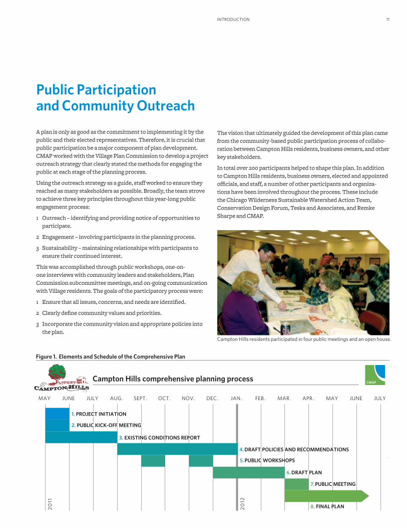
Planning ProcessThe process to create the village’s comprehensive plan lasted ap-proximately one year and included multiple steps. The process was crafted with assistance from Campton Hills elected officials and designed to include the input of village residents, business owners, and others. The key steps in the planning process are illustrated in Figure 1.
11INTRODUCTION
Public Participation and Community Outreach
A plan is only as good as the commitment to implementing it by the public and their elected representatives. Therefore, it is crucial that public participation be a major component of plan development. CMAP worked with the Village Plan Commission to develop a project outreach strategy that clearly stated the methods for engaging the public at each stage of the planning process.
Using the outreach strategy as a guide, staff worked to ensure they reached as many stakeholders as possible. Broadly, the team strove to achieve three key principles throughout this year-long public engagement process:
1 Outreach – identifying and providing notice of opportunities to participate.
2 Engagement – involving participants in the planning process.
3 Sustainability – maintaining relationships with participants to ensure their continued interest.
This was accomplished through public workshops, one-on-one interviews with community leaders and stakeholders, Plan Commission subcommittee meetings, and on-going communication with Village residents. The goals of the participatory process were:
1 Ensure that all issues, concerns, and needs are identified.
2 Clearly define community values and priorities.
3 Incorporate the community vision and appropriate policies into the plan.
Campton Hills comprehensive planning process
20
11
20
12
JUNE JULY SEPT.AUG.MAY JAN.OCT. DEC.NOV. MAR. APR. JUNEMAYFEB. JULY
3. EXISTING CONDITIONS REPORT
4. DRAFT POLICIES AND RECOMMENDATIONS
5. PUBLIC WORKSHOPS
6. DRAFT PLAN
7. PUBLIC MEETING
8. FINAL PLAN
1. PROJECT INITIATION
2. PUBLIC KICK-OFF MEETING
Figure 1. Elements and Schedule of the Comprehensive Plan
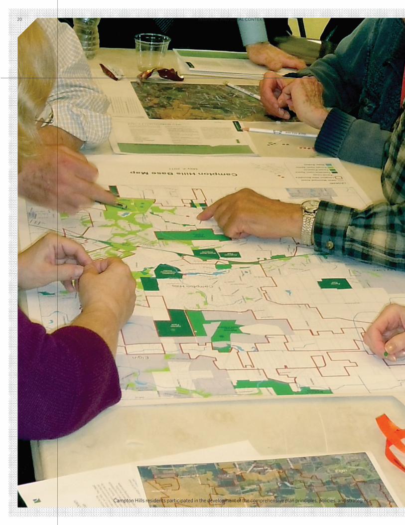
Campton Hills residents participated in four public meetings and an open house.
The vision that ultimately guided the development of this plan came from the community-based public participation process of collabo-ration between Campton Hills residents, business owners, and other key stakeholders.
In total over 200 participants helped to shape this plan. In addition to Campton Hills residents, business owners, elected and appointed officials, and staff, a number of other participants and organiza-tions have been involved throughout the process. These include the Chicago Wilderness Sustainable Watershed Action Team, Conservation Design Forum, Teska and Associates, and Remke Sharpe and CMAP.
12
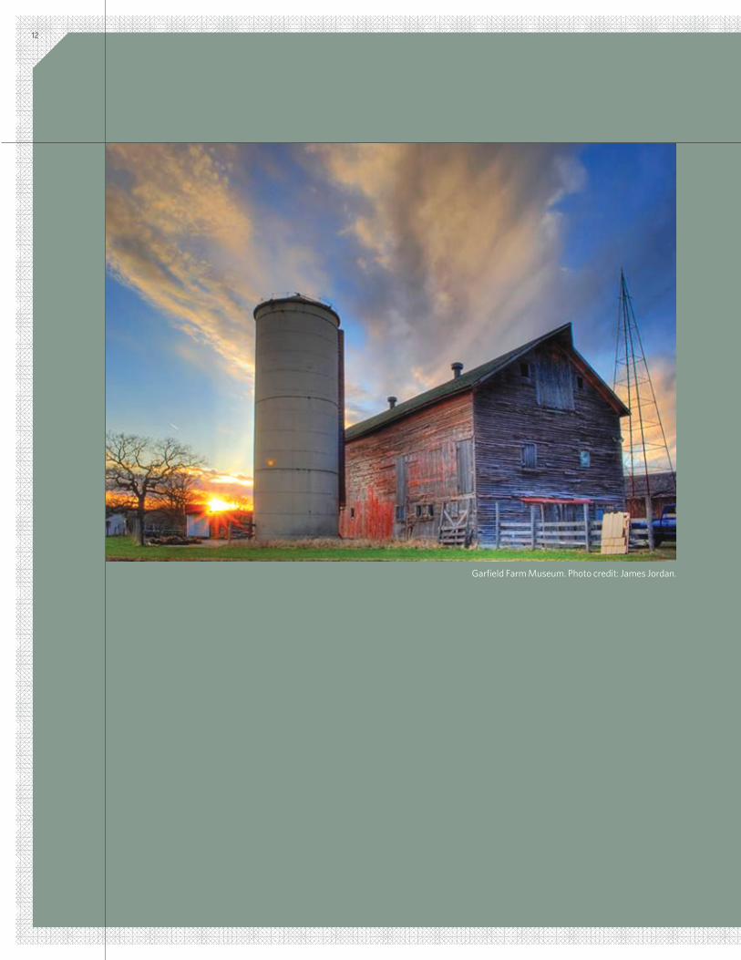
Garfield Farm Museum. Photo credit: James Jordan.
13REGIONAL AND LOCAL CONTEXT
History of Campton Hills Rich and fertile agricultural soils, hardwood forests for building material and fuel, and a nearby river for water and power were instrumental in the development and growth of Campton Township. Historians in the latter part of the 19th century reported that the natural beauty and fertility of soils in Campton Township was unsurpassed by any part of Kane County.
We now know that the region has some of the most fertile soils in the world, which helped sustain agriculture as the predominant land use in the Township until the early 1960s. It wasn’t until decades later that the number of acres of residential development matched the acres of farmland.
Cultivation of this fertile land was not easy for early settlers. The thick prairie grasses were tall and tough, often growing fifteen feet high according to one historian, and prairie fires left what looked like blackened waste in their wake. John Beatty, the first recorded settler who came to Campton in 1835, was one of the pioneers providing the all-important service of “prairie breaking” for $3.50 an acre. Beatty also staked a claim on land that was later known as the Burr Farm, and erected the first log cabin in Campton Township. The Robert Corron home, built in the early 1850s, is also still standing, located on what is now Corron Road.
Owing to the convenient location as a stopover for pioneers ven-turing from Chicago to the wilderness west of Kane County, the Township’s hotel and tavern businesses flourished. Inns also pro-vided a key to the transport of crops bound for European markets through Chicago, which by 1850 was the world’s largest grain port. In 1846, Timothy and Harriet Frost Garfield built an inn at the junction of Chicago-St. Charles-Sycamore Road and State Road on land they purchased in 1841. The 370 acre Garfield Farm and Tavern has been preserved and is one of the most intact historic sites in the country and the largest Illinois farm on the National Register of Historic Places.
The first roads running through the Township extended from Geneva to Rockford and from St. Charles to Oregon, Illinois. From 1886 to 1887, a railroad was built across the township, eventually
known as the Chicago and Great Western. Some historic accounts note that with the appearance of the railroads, the extensive wagon travel ceased, which led to a reduction in the number of taverns in Campton Township. (Another historic account, however, reported that the Chicago and Great Western railroad added largely to traffic moving through, and thus economic advantages of the township.) Following the abandonment of these rail lines due to being struc-turally unsafe, right-of-way was purchased and converted into the Great Western Trail, now used extensively for hiking, biking, and snowmobiling.
Wasco, a hamlet that now lies within the Campton Hills, was origi-nally settled by farmers from Massachusetts, New Hampshire, and later, farm families from Sweden. It is the site of a number of historic buildings. The U.S. Post Office, first located on Ferson Creek in 1836, was moved to its current location on Illinois Route 64 and has been restored to its original character. A town hall was erected in 1873 for meetings and voting. The Campton Town Hall, west of Wasco at Town Hall Road and Illinois Route 64, still stands today and has been on the National Register for Historic Places since 1980.
At the turn of the 20th century, the Great Western railroad depot located in Wasco made it possible for area farmers to ship milk to Chicago. When it was abandoned in the 1940s, the depot was sold to the Wasco American Legion, and in 1999 the depot was purchased by Campton Township. It is now used for community events and offices.
Additional historic buildings in Campton Hills include early home-steads, the Wasco Baptist Church (on Old LaFox Road since 1891), Wasco School (1906), and commercial buildings from the late 1920s. The Mather Building at the corner of Old LaFox and Illinois Route
Chapter 2 Regional and Local Context
14 VILLAGE OF CAMPTON HILLS COMPREHENSIVE PLAN
64 was an early farm machinery business during the late 1890s and early 1900s and a gas station through the 1980s. Most of the historic residences in Wasco were constructed between 1900 and 1920. The Santell Prairie home, built in 1923, was one of the residences that sprang up around the commercial area. Some of the other older homes have been converted to commercial uses or destroyed, while some have remained as farms, homes, or homesteads. Commercial buildings that still stand include Niko’s Lodge, which is the former Silverado, Old Farm Inn, and also used to be adjacent to a Model T and motorcycle racetrack. King’s Mill, which currently stands at the intersection of Wasco Road and Illinois Route 64, was once a saw mill near Corron and Burlington Roads built by the first minister and physician in Campton Township, and was later a post office and a cheese factory.
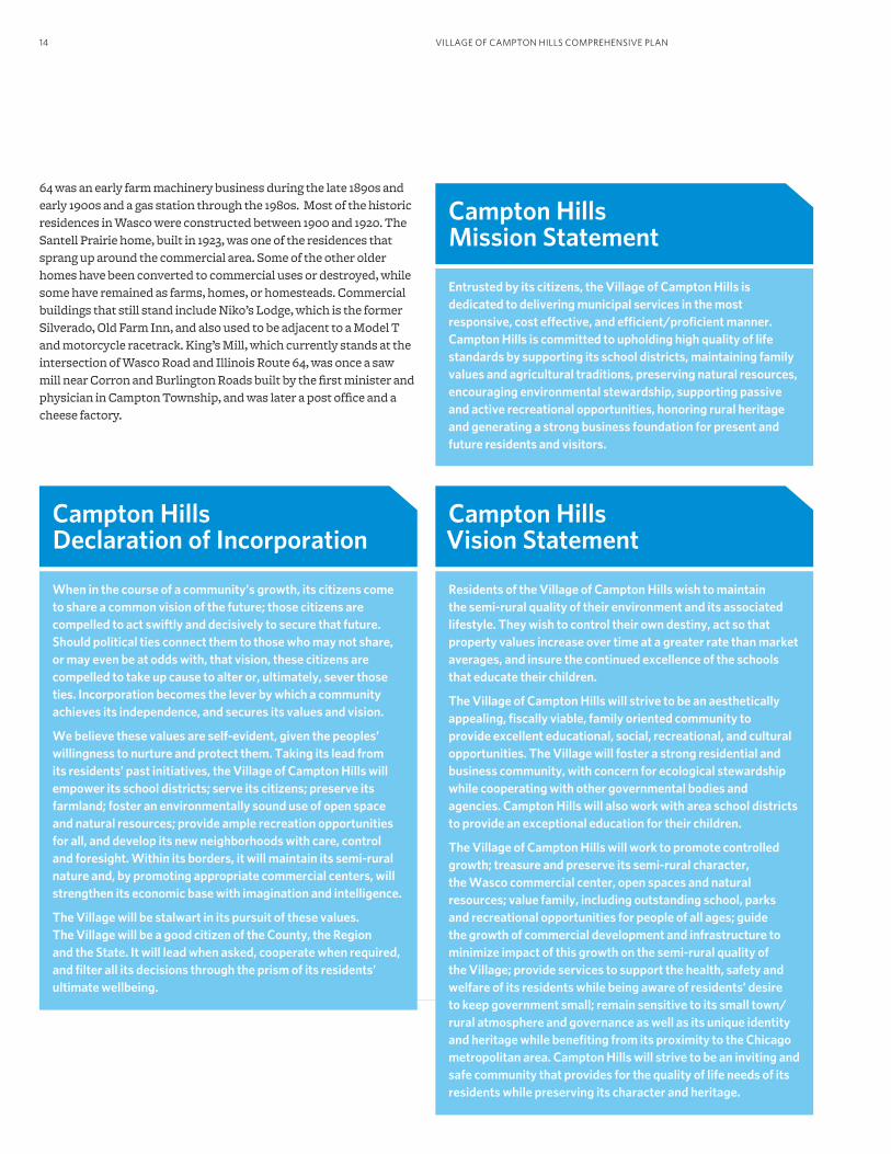
Campton Hills Declaration of Incorporation
When in the course of a community’s growth, its citizens come to share a common vision of the future; those citizens are compelled to act swiftly and decisively to secure that future. Should political ties connect them to those who may not share, or may even be at odds with, that vision, these citizens are compelled to take up cause to alter or, ultimately, sever those ties. Incorporation becomes the lever by which a community achieves its independence, and secures its values and vision.
We believe these values are self-evident, given the peoples’ willingness to nurture and protect them. Taking its lead from its residents’ past initiatives, the Village of Campton Hills will empower its school districts; serve its citizens; preserve its farmland; foster an environmentally sound use of open space and natural resources; provide ample recreation opportunities for all, and develop its new neighborhoods with care, control and foresight. Within its borders, it will maintain its semi-rural nature and, by promoting appropriate commercial centers, will strengthen its economic base with imagination and intelligence.
The Village will be stalwart in its pursuit of these values. The Village will be a good citizen of the County, the Region and the State. It will lead when asked, cooperate when required, and filter all its decisions through the prism of its residents’ ultimate wellbeing.
Campton Hills Vision Statement
Residents of the Village of Campton Hills wish to maintain the semi-rural quality of their environment and its associated lifestyle. They wish to control their own destiny, act so that property values increase over time at a greater rate than market averages, and insure the continued excellence of the schools that educate their children.
The Village of Campton Hills will strive to be an aesthetically appealing, fiscally viable, family oriented community to provide excellent educational, social, recreational, and cultural opportunities. The Village will foster a strong residential and business community, with concern for ecological stewardship while cooperating with other governmental bodies and agencies. Campton Hills will also work with area school districts to provide an exceptional education for their children.
The Village of Campton Hills will work to promote controlled growth; treasure and preserve its semi-rural character, the Wasco commercial center, open spaces and natural resources; value family, including outstanding school, parks and recreational opportunities for people of all ages; guide the growth of commercial development and infrastructure to minimize impact of this growth on the semi-rural quality of the Village; provide services to support the health, safety and welfare of its residents while being aware of residents’ desire to keep government small; remain sensitive to its small town/rural atmosphere and governance as well as its unique identity and heritage while benefiting from its proximity to the Chicago metropolitan area. Campton Hills will strive to be an inviting and safe community that provides for the quality of life needs of its residents while preserving its character and heritage.
Campton Hills Mission Statement
Entrusted by its citizens, the Village of Campton Hills is dedicated to delivering municipal services in the most responsive, cost effective, and efficient/proficient manner. Campton Hills is committed to upholding high quality of life standards by supporting its school districts, maintaining family values and agricultural traditions, preserving natural resources, encouraging environmental stewardship, supporting passive and active recreational opportunities, honoring rural heritage and generating a strong business foundation for present and future residents and visitors.
15REGIONAL AND LOCAL CONTEXT
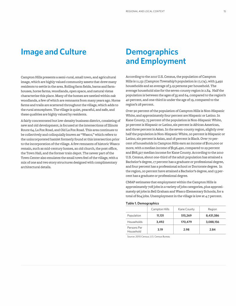
Image and Culture
Campton Hills presents a semi-rural, small town, and agricultural image, which are highly valued community assets that drew many residents to settle in the area. Rolling farm fields, barns and farm-houses, horse farms, woodlands, open space, and natural vistas characterize this place. Many of the homes are nestled within oak woodlands, a few of which are remnants from many years ago. Horse farms and trails are scattered throughout the village, which adds to the rural atmosphere. The village is quiet, peaceful, and safe, and these qualities are highly valued by residents.
A fairly concentrated but low-density business district, consisting of new and old development, is focused at the intersections of Illinois Route 64, La Fox Road, and Old La Fox Road. This area continues to be collectively and colloquially known as “Wasco,” which refers to the unincorporated hamlet formerly found at this intersection prior to the incorporation of the village. A few remnants of historic Wasco remain, such as mid-century homes, an old church, the post office, the Town Hall, and the former train depot. The newer part of the Town Center also emulates the small town feel of the village, with a mix of one and two story structures designed with complimentary architectural details.
Demographics and Employment According to the 2010 U.S. Census, the population of Campton Hills is 11,131 (Campton Township’s population is 17,174), with 3,492 households and an average of 3.19 persons per household. The average household size for the seven-county region is 2.84. Half the population is between the ages of 35 and 64, compared to the region’s 40 percent, and one-third is under the age of 19, compared to the region’s 28 percent.
Over 90 percent of the population of Campton Hills is Non-Hispanic White, and approximately four percent are Hispanic or Latino. In Kane County, 75 percent of the population is Non-Hispanic White, 30 percent is Hispanic or Latino, six percent is African American, and three percent is Asian. In the seven-county region, slightly over half the population is Non-Hispanic White, 20 percent is Hispanic or Latino, six percent is Asian, and 18 percent is Black. Over 70 per-cent of households in Campton Hills earn an income of $100,000 or more, with a median income of $136,490, compared to 29 percent and $68,327 median income for Kane County. According to the 2010 U.S. Census, about one-third of the adult population has attained a Bachelor’s degree, 17 percent has a graduate or professional degree, and four percent has a professional school or Doctorate degree. In the region, 20 percent have attained a Bachelor’s degree, and 13 per-cent has a graduate or professional degree.
CMAP estimates that employment within the Campton Hills is approximately 708 jobs in a variety of jobs categories, plus approxi-mately 96 jobs in Bell Graham and Wasco Elementary Schools, for a total of 804 jobs. Unemployment in the village is low at 4.7 percent.
Table 1. Demographics
Campton Hills Kane County Region
Population 11,131 515,269 8,431,386
Households 3,492 170,479 3,088,156
Persons Per Household
3.19 2.98 2.84
Source: 2010 Census, U.S. Census Bureau
VILLAGE OF CAMPTON HILLS COMPREHENSIVE PLAN16
KaneCounty
DuPageCounty
CookCounty
McHenry County
Kendall CountyWill
County
LakeCounty
Aurora
Elgin
Geneva
Batavia
St. Charles
Wayne
Hampshire
Sugar Grove
North Aurora
Elburn
Big Rock
South Elgin
Virgil
Burlington
Lily Lake
Pingree Grove
Maple Park
Kaneville
Sandwich
Campton Hills
§̈¦90
§̈¦88
!N
¢
0 5 Mile
DeKalbCounty
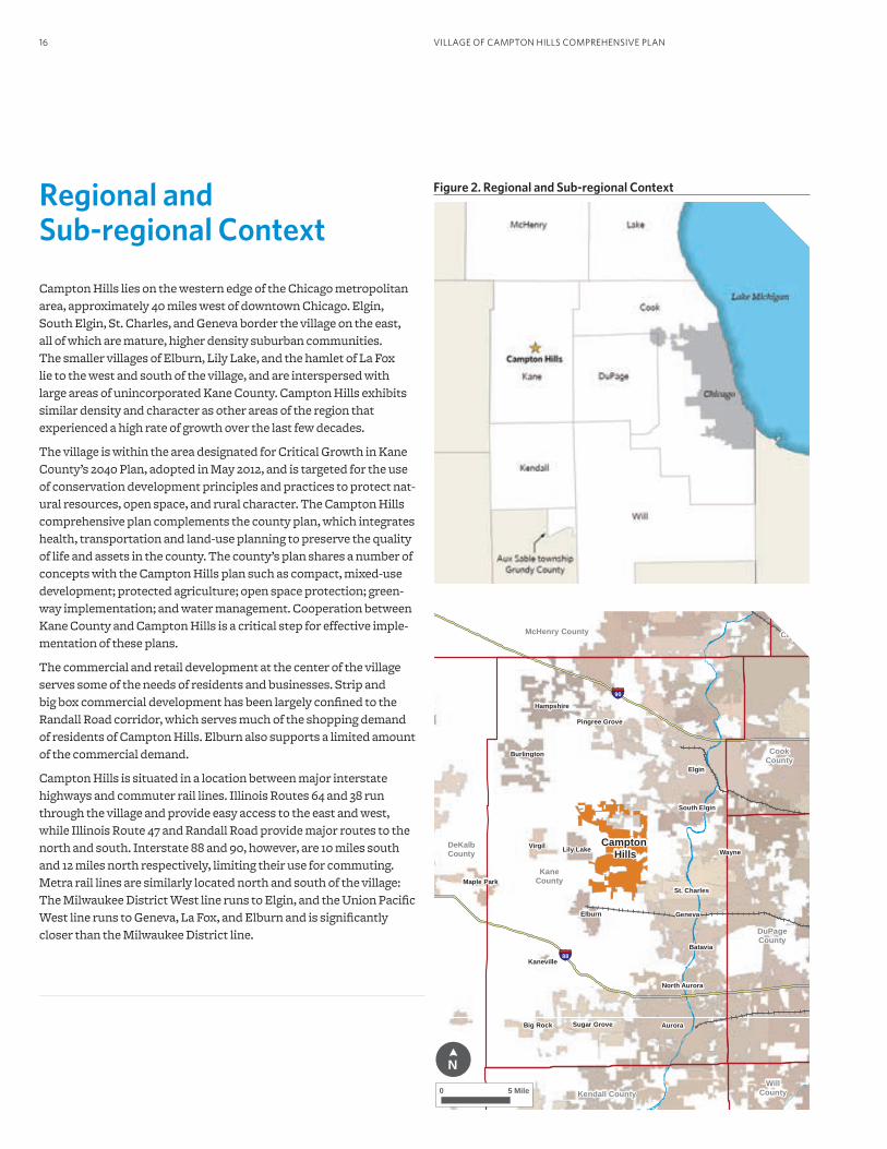
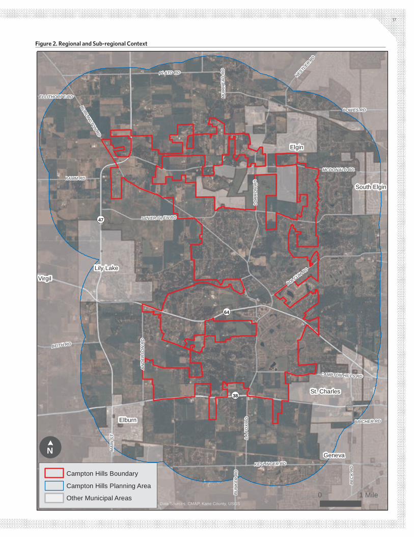
Figure 2. Regional and Sub-regional ContextRegional and Sub-regional Context Campton Hills lies on the western edge of the Chicago metropolitan area, approximately 40 miles west of downtown Chicago. Elgin, South Elgin, St. Charles, and Geneva border the village on the east, all of which are mature, higher density suburban communities. The smaller villages of Elburn, Lily Lake, and the hamlet of La Fox lie to the west and south of the village, and are interspersed with large areas of unincorporated Kane County. Campton Hills exhibits similar density and character as other areas of the region that experienced a high rate of growth over the last few decades.
The village is within the area designated for Critical Growth in Kane County’s 2040 Plan, adopted in May 2012, and is targeted for the use of conservation development principles and practices to protect nat-ural resources, open space, and rural character. The Campton Hills comprehensive plan complements the county plan, which integrates health, transportation and land-use planning to preserve the quality of life and assets in the county. The county’s plan shares a number of concepts with the Campton Hills plan such as compact, mixed-use development; protected agriculture; open space protection; green-way implementation; and water management. Cooperation between Kane County and Campton Hills is a critical step for effective imple-mentation of these plans.
The commercial and retail development at the center of the village serves some of the needs of residents and businesses. Strip and big box commercial development has been largely confined to the Randall Road corridor, which serves much of the shopping demand of residents of Campton Hills. Elburn also supports a limited amount of the commercial demand.
Campton Hills is situated in a location between major interstate highways and commuter rail lines. Illinois Routes 64 and 38 run through the village and provide easy access to the east and west, while Illinois Route 47 and Randall Road provide major routes to the north and south. Interstate 88 and 90, however, are 10 miles south and 12 miles north respectively, limiting their use for commuting. Metra rail lines are similarly located north and south of the village: The Milwaukee District West line runs to Elgin, and the Union Pacific West line runs to Geneva, La Fox, and Elburn and is significantly closer than the Milwaukee District line.
Elgin
Elburn
Geneva
Lily Lake
St. Charles
South Elgin
Virgil
¬«64
¬«47
¬«38
KESLINGER RD
BURLINGTON RD
MCDONALD RD
SILVER GLEN RD
PEC
K R
D
PLATO RD
BOWES RD
LA F
OX
RD
CO
RR
ON
RD
BOLCUM RD
MA
IN S
T
AN
DER
SON
RD
BEITH RD
RAMM RD
CAMPTON HILLS RD
NESTLER R
D
HUGHES RD BU
NK
ER R
D
BRICHER RD
ELLITHORPE RD MU
IRH
EAD
RD
IL-4
7
Data Sources: CMAP, Kane County, USGS
Campton Hills Boundary
Campton Hills Planning Area
Other Municipal Areas
!N
¢
0 1 Mile
17
Figure 2. Regional and Sub-regional Context
VILLAGE OF CAMPTON HILLS COMPREHENSIVE PLAN18
The comprehensive plan priority is to provide local decision guid-ance and support in addition to addressing community needs and desires in an effort to achieve the community vision. However, as part of the larger Chicago metropolitan economic region, the village both influences and is influenced by the region.
The Chicago Metropolitan Agency for Planning (CMAP) is the official regional planning organization for the northeastern Illinois counties of Cook, DuPage, Kane, Kendall, Lake, McHenry, and Will. CMAP developed and now guides the implementation of GO TO 2040, met-ropolitan Chicago’s first comprehensive regional plan in more than 100 years. To address anticipated population growth of more than 2 million new residents, GO TO 2040 establishes coordinated strate-gies that will help the region’s 284 communities address transporta-tion, housing, economic development, open space, the environment, and other quality-of-life issues. The plan contains four themes and 12 major recommendation areas:
Livable CommunitiesAchieve Greater Livability through Land Use and HousingManage and Conserve Water and Energy ResourcesExpand and Improve Parks and Open SpacePromote Sustainable Local Food
Human CapitalImprove Education and Workforce DevelopmentSupport Economic Innovation
Efficient GovernanceReform State and Local Tax PolicyImprove Access to InformationPursue Coordinated Investments
Regional MobilityInvest Strategically in TransportationIncrease Commitment to Public TransitCreate a More Efficient Freight Network
Relationship with the GO TO 2040 Regional Comprehensive Plan
The Livable Communities and Governance recommendations are most relevant to Campton Hills, particularly those that relate to:
• Collaborative planning and interjurisdictional communication
• Water and natural resource protection and enhancement
• Green infrastructure protection and enhancement
• Water and energy conservation and efficiency
• Trails enhancement
• Farmland protection
• Local tax capacity
• Consolidation of local services to improve efficiencies
GO TO 2040 states, “municipalities are critical to the success of GO TO 2040 because of their responsibility for land use decisions, which create the built environment of the region and determine the livabil-ity of its communities. The most important thing that a municipality can do to implement GO TO 2040 is to take this responsibility very seriously.” By undertaking a planning process to create a new com-prehensive plan, Campton Hills has taken responsibility for guiding its future, and demonstrated its commitment to helping shape the future of the region as well.
Since incorporation, Campton Hills has made significant progress towards protecting its natural resources and farmland by conduct-ing studies, creating committees and task forces to address issues and concerns, securing funding for technical assistance, and moving towards the creation and adoption of plans and ordinances. The township, county, and other entities have also been instrumental in protecting national resources and farmland through acquisition of property and easements.
One of the resources created as a result of the GO TO 2040 compre-hensive regional plan was MetroPulse, the regional indicators proj-ect for the metropolitan Chicago region (www.metropulsechicago.org). This website provides data and information for key indicators for measuring and tracking regional quality of life and can be used by policy makers, community leaders, media, and the general public to gather objective data that can inform their work.

19
Campton Hills residents participated in the development of the comprehensive plan principles, policies, and strategies.
20 REGIONAL AND LOCAL CONTEXT

21PRINCIPLES, POLICIES, AND STRATEGIES
1. Appendix A includes an Existing Conditions Report for Campton Hills. This report includes an assessment of the physical and socioeconomic conditions and characteristics of the Village as of January 2012. The Recommendations chapter of this plan summarizes the information included in the Existing Conditions Analysis for each topic area, however, additional details, maps, and data are included in the full report found in Appendix A.
2. The proposed time frame for implementation of recommended strategies should be revisited regularly by Campton Hills to assess progress and re-establish time frames and priorities.
Chapter 3 Principles, Policies, and StrategiesThis chapter of the plan presents the recommended strategies for achieving the vision of Campton Hills for 2030. The recommendations are categorized into nine topic areas, each of which includes the following information for each topic:
1. A summary of the existing conditions and characteristics of Campton Hills with respect to that particular topic area.1
2. The village principle or vision statement.
3. Village policies.
4. Proposed strategies for implementing Campton Hills policies and achieving the village principle, including a recommended2 time frame for implementation.
5. Ideas for implementation.
VILLAGE OF CAMPTON HILLS COMPREHENSIVE PLAN22
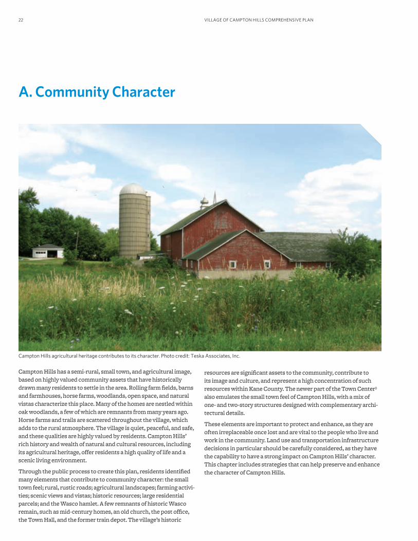
Campton Hills has a semi-rural, small town, and agricultural image, based on highly valued community assets that have historically drawn many residents to settle in the area. Rolling farm fields, barns and farmhouses, horse farms, woodlands, open space, and natural vistas characterize this place. Many of the homes are nestled within oak woodlands, a few of which are remnants from many years ago. Horse farms and trails are scattered throughout the village, which adds to the rural atmosphere. The village is quiet, peaceful, and safe, and these qualities are highly valued by residents. Campton Hills’ rich history and wealth of natural and cultural resources, including its agricultural heritage, offer residents a high quality of life and a scenic living environment.
Through the public process to create this plan, residents identified many elements that contribute to community character: the small town feel; rural, rustic roads; agricultural landscapes; farming activi-ties; scenic views and vistas; historic resources; large residential parcels; and the Wasco hamlet. A few remnants of historic Wasco remain, such as mid-century homes, an old church, the post office, the Town Hall, and the former train depot. The village’s historic
Campton Hills agricultural heritage contributes to its character. Photo credit: Teska Associates, Inc.
A. Community Character
resources are significant assets to the community, contribute to its image and culture, and represent a high concentration of such resources within Kane County. The newer part of the Town Center3 also emulates the small town feel of Campton Hills, with a mix of one- and two-story structures designed with complementary archi-tectural details.
These elements are important to protect and enhance, as they are often irreplaceable once lost and are vital to the people who live and work in the community. Land use and transportation infrastructure decisions in particular should be carefully considered, as they have the capability to have a strong impact on Campton Hills’ character. This chapter includes strategies that can help preserve and enhance the character of Campton Hills.
23PRINCIPLES, POLICIES, AND STRATEGIES
3. The Village of Campton Hills Comprehensive Plan makes a distinction between the Town Center and Mixed Use Centers. The Town Center refers to the area around the intersection of LaFox Road, Burlington Road, and Route 64 extending west to the hamlet of Wasco. Mixed Use Centers refer to a land use category that is characterized by a mix of uses that may include commercial, retail, office, institutional, and residential. The Town Center is designated on the Future Land Use Plan (Figure 12) as one of three Mixed Use Centers, but it is the only of these three Mixed Use Centers that is referred to as the Campton Hills Town Center.
4. At the time of writing this plan, the Village Plan Commission was in the process of developing and reviewing design guidelines. The Plan Commission should continue this process and incorporate the recommendations of this plan.
Village Principle and PoliciesThe principle below was identified through the public participation process as an overall theme for this topic area:
The natural assets, cultural heritage, and historic charac-ter of Campton Hills should be maintained and enhanced to preserve a rich sense of place.
The following policy statements serve as guiding tenets for this chapter. Each policy statement is addressed by at least one strategy below.
1. Future development, land use changes, and transportation improvements should be consistent with the semi-rural character of the community and preserve scenic views and vistas, natural assets, farmland, and open space. Development should attempt to preserve the “quiet, peaceful, and secluded” feel of some of the residential areas.
2. Architectural design, scale, materials, and details of new develop-ment should be consistent with existing and desired community character, consider the surrounding context of the new develop-ment, and evoke the “small town” look and feel of the community. Consider the development of building and construction guidelines4 that would require or encourage new construction to be consistent with rural character.
3. Identify and preserve the historic and cultural resources and heri-tage of Campton Hills as a community asset and a critical element of its sense of place.
4. Adopt structures (committees, standards, regulations, and pro-grams) designed to preserve and protect the historic and cultural resources, heritage, rural character, and scenic quality of the com-munity. Examples include a Historic Preservation Commission, Architectural Review Commission, corridor and streetscape guide-lines, historic districts, and a historic, cultural, and scenic resource inventory.
5. Develop a consistent and cohesive village identity, character, and sense of place, and promote community values as a community-building and promotional resource. Highlight and prioritize the distinctive qualities of the village that make it a desirable destina-tion with a distinct sense of place. These include historic resources, preserved farms, agricultural character, open space and recre-ation opportunities, and the small town look and feel.
6. Require the preservation of the dark sky as an element of desired community character.
Proposed StrategiesThe following strategies represent action steps to take toward addressing the principle and policies for Community Character. Further information related to the implementation of these strate-gies may be found in the Implementation Strategy section.
A1. Create a Historic Preservation Commission. Campton Hills currently has an intergovernmental agreement with Kane County that allows it to utilize the County’s Historic Preservation Ordinance and Commission to help protect its historic resources. However, it may be beneficial for Campton Hills to create its own Historic Preservation Commission to advocate for local resources if the County structure is inadequate to address the Village’s needs. Alternately, Campton Hills should create a body or committee with a scope that includes historic preservation and also review and implementation of design standards, sign and billboard ordinances, landscaping standards, the dark sky ordinance, and other recommendations related to preserving community character.
Preserving historic resources in the community was voiced as a high priority throughout the planning process. The role of the Commission or other body should include conducting surveys of known and potential historic properties within the village (see Strategy A2), applying for historic designation on behalf of indi-vidual properties or for the hamlet of Wasco (see Strategy A3), and reviewing applications to modify or improve designated proper-ties. Campton Hills can lead by example and seek landmark or historic status for qualifying Village-owned properties. The Historic Preservation Commission can also provide resources, such as contact information for public, private, and non-profit organizations involved in historic preservation; a list of volunteers interested in historic preservation and repairs; and information about historic authenticity and appropriate adaptive use. Collaboration with other jurisdictions and entities responsible for historic and cultural pres-ervation, such as Kane County and the Illinois Historic Preservation Agency, should be emphasized.
This short-term (0-2 year) strategy supports policies 3, 4, and 5.
VILLAGE OF CAMPTON HILLS COMPREHENSIVE PLAN24
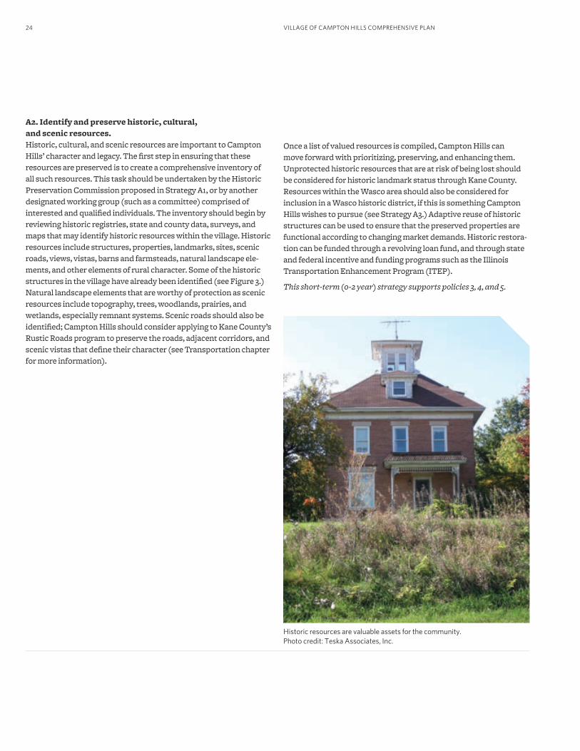
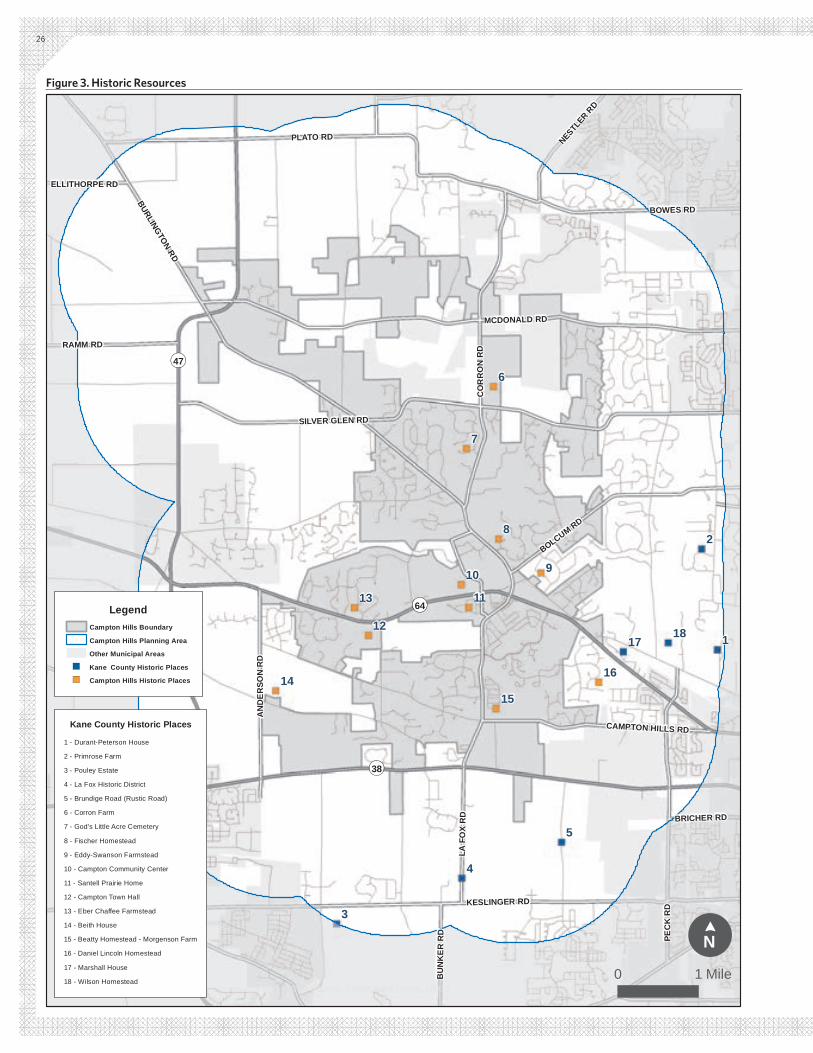
A2. Identify and preserve historic, cultural, and scenic resources.Historic, cultural, and scenic resources are important to Campton Hills’ character and legacy. The first step in ensuring that these resources are preserved is to create a comprehensive inventory of all such resources. This task should be undertaken by the Historic Preservation Commission proposed in Strategy A1, or by another designated working group (such as a committee) comprised of interested and qualified individuals. The inventory should begin by reviewing historic registries, state and county data, surveys, and maps that may identify historic resources within the village. Historic resources include structures, properties, landmarks, sites, scenic roads, views, vistas, barns and farmsteads, natural landscape ele-ments, and other elements of rural character. Some of the historic structures in the village have already been identified (see Figure 3.) Natural landscape elements that are worthy of protection as scenic resources include topography, trees, woodlands, prairies, and wetlands, especially remnant systems. Scenic roads should also be identified; Campton Hills should consider applying to Kane County’s Rustic Roads program to preserve the roads, adjacent corridors, and scenic vistas that define their character (see Transportation chapter for more information).
Historic resources are valuable assets for the community. Photo credit: Teska Associates, Inc.
Once a list of valued resources is compiled, Campton Hills can move forward with prioritizing, preserving, and enhancing them. Unprotected historic resources that are at risk of being lost should be considered for historic landmark status through Kane County. Resources within the Wasco area should also be considered for inclusion in a Wasco historic district, if this is something Campton Hills wishes to pursue (see Strategy A3.) Adaptive reuse of historic structures can be used to ensure that the preserved properties are functional according to changing market demands. Historic restora-tion can be funded through a revolving loan fund, and through state and federal incentive and funding programs such as the Illinois Transportation Enhancement Program (ITEP).
This short-term (0-2 year) strategy supports policies 3, 4, and 5.
25PRINCIPLES, POLICIES, AND STRATEGIES
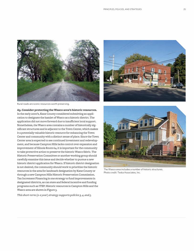
A3. Consider protecting the Wasco area’s historic resources. In the early 2000’s, Kane County considered submitting an appli-cation to designate the hamlet of Wasco as a historic district. The application did not move forward due to insufficient local support. Nonetheless, the Wasco area contains a number of historically sig-nificant structures and is adjacent to the Town Center, which makes it a potentially valuable historic resource for enhancing the Town Center and community with a distinct sense of place. Since the Town Center area is expected to see continued investment and redevelop-ment, and because Campton Hills lacks control over expansion and improvement of Illinois Route 64, it is important for the community to take protective action to preserve the historic Wasco fabric. The Historic Preservation Committee or another working group should carefully examine this issue and decide whether to pursue a new historic district application for Wasco. If historic district designation is not desired, the community should work to prioritize the historic resources in the area for landmark designation by Kane County or through a new Campton Hills Historic Preservation Commission. Tax Increment Financing is one strategy to fund improvements in designated districts, as can state and federal incentive and funding programs such as ITEP. Historic resources in Campton Hills and the Wasco area are shown in Figure 3.
This short-term (0-2 year) strategy supports policies 3, 4, and 5.
Rural roads are scenic resources worth preserving.
The Wasco area includes a number of historic structures. Photo credit: Teska Associates, Inc.
KESLINGER RD
BURLINGTON RD
MCDONALD RD
SILVER GLEN RD
PEC
K R
D
PLATO RD
BOWES RD
LA F
OX
RD
CO
RR
ON
RD
BOLCUM RD
BEITH RD
AN
DER
SON
RD
RAMM RD
CAMPTON HILLS RD
NESTLER R
D
BU
NK
ER R
D
BRICHER RD
ELLITHORPE RD
¬«64
¬«47
¬«38
2
1
9
8
7
6
5
4
3
1817
16
1514
13
12
11
10
Data Sources: CMAP, Kane County, USGS
!N
¢
0 1 Mile
LegendCampton Hills Boundary
Campton Hills Planning Area
Other Municipal Areas
") Kane County Historic Places
") Campton Hills Historic Places
Kane County Historic Places
1 - Durant-Peterson House
3 - Pouley Estate
4 - La Fox Historic District
5 - Brundige Road (Rustic Road)
6 - Corron Farm
7 - God's Little Acre Cemetery
8 - Fischer Homestead
9 - Eddy-Swanson Farmstead
10 - Campton Community Center
11 - Santell Prairie Home
12 - Campton Town Hall
13 - Eber Chaffee Farmstead
14 - Beith House
15 - Beatty Homestead - Morgenson Farm
16 - Daniel Lincoln Homestead
17 - Marshall House
18 - Wilson Homestead
2 - Primrose Farm
26
Figure 3. Historic Resources
27
A4. Adopt policies and regulations that are supportive of ex-isting community character.There are a variety of policies and regulations that Campton Hills should institute that would be supportive of existing community character and historic preservation. Most of these ideas fall under the umbrella of a zoning and subdivision code update, for which grants should be pursued. See the Managed Change recommenda-tions for further details on regulatory recommendations.
• Examine and update Campton Hills’ Historic Preservation Ordinance to be compatible with the comprehensive plan and ensure that it contains adequate protections for identified historic resources. The ordinance should include an approach for dealing with historically valuable properties that may be in jeopardy and a requirement that the Village receive notification about historic properties that are being neglected or in danger of demolition. The Campton Hills zoning code should use the permitting process, fines, and incentives (such as allowing variances, additional outbuildings, etc. in exchange for designation) to preserve historic, cultural, and scenic properties and resources. Proposed modifications to resources with potential historic or cultural significance should be reviewed by the Historic Preservation Commission, if applicable, or the Village Board if no such pertinent advisory body exists.
• Develop a set of community building and construction guidelines or design standards to protect and enhance character, aesthetics, historic features, and architectural harmony in designated areas of Campton Hills, primarily mixed-use centers. These design standards should include architectural design elements such as style, height, color, building material, ornamentation, and compatibility with the surrounding buildings, as well as site design elements such as paving materials, landscaping, and fencing material. Having a defined set of standards will ensure that new development is compatible with the existing character of Campton Hills. In areas requiring adherence to design standards, new development proposals should be reviewed by a governmental body (such as the Historic Preservation Commission or a newly created Architectural Review Board) to ensure compliance.
• Review and update policies and ordinances regarding signs and billboards (including electronic and electrically lighted signs), telecommunications facilities, and utilities to maintain consistency, provide an aesthetic view, and to be as unobtrusive as possible. Provisions should consider the location, size, height, material, and character of these structures.
PRINCIPLES, POLICIES, AND STRATEGIES
• Encourage the use of landscaping and vegetation to convey the historic, pre-settlement, or agricultural landscape and to frame, block, or enhance particular scenic views and vistas. Include planting guidelines for roadway corridors (and adjacent open space) that are compatible with the Illinois Department of Transportation (IDOT), Kane County Department of Transportation (KDOT), and Campton Township roadway and right-of-way guidelines.
• Encourage residents, landowners, and property owners to help maintain a high quality image for the village through activities such as proper upkeep, cleanliness, and maintenance.
• Adopt policy and lighting regulations that encourage the preservation of the dark sky as an element of community character.
This mid-term (3-6 year) strategy supports policies 1, 2, and 6.
A5. Provide educational opportunities related to historic and cultural assets.To encourage awareness of Campton Hills’ historic, cultural, and scenic resources, the village should provide various educational opportunities related to those resources. Topics include Campton Hills’ history and settlement, historic preservation, the landmark process, and the importance of community character. Information can be displayed in a physical location, such as within a village resource facility in the Town Center that could also serve to curate historic and cultural resources. It may also be helpful to post in-formation online, either on the Campton Hills web site or another designated site. The Village or Historic Preservation Commission should provide assistance and information to land and property owners interested in the landmark and preservation process. Educational opportunities can be enhanced by placing historic markers at sites of historic significance within the community.
This mid-term (3-6 year) strategy supports policies 3 and 5.
VILLAGE OF CAMPTON HILLS COMPREHENSIVE PLAN28
Implementation StrategyThe strategies proposed in this section are time-sensitive, as historic and cultural resources are currently at risk of being lost without action. Ideally, strategies will be undertaken within the next two years to ensure preservation of prioritized resources. Since creating a Historic Preservation Commission or other authority is a potential stepping stone toward accomplishing the other strategies in this chapter, this task should be a first priority. Other short-term strate-gies include identifying and prioritizing important resources and strategizing about how to preserve them. Central to this discussion
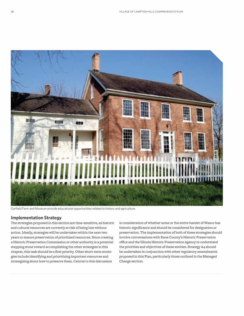
Garfield Farm and Museum provide educational opportunities related to history and agriculture.
is consideration of whether some or the entire hamlet of Wasco has historic significance and should be considered for designation or preservation. The implementation of both of these strategies should involve conversations with Kane County’s Historic Preservation office and the Illinois Historic Preservation Agency to understand the priorities and objectives of these entities. Strategy A4 should be undertaken in conjunction with other regulatory amendments proposed in this Plan, particularly those outlined in the Managed Change section.
29
B. Open Space and Natural Resources
PRINCIPLES, POLICIES, AND STRATEGIES
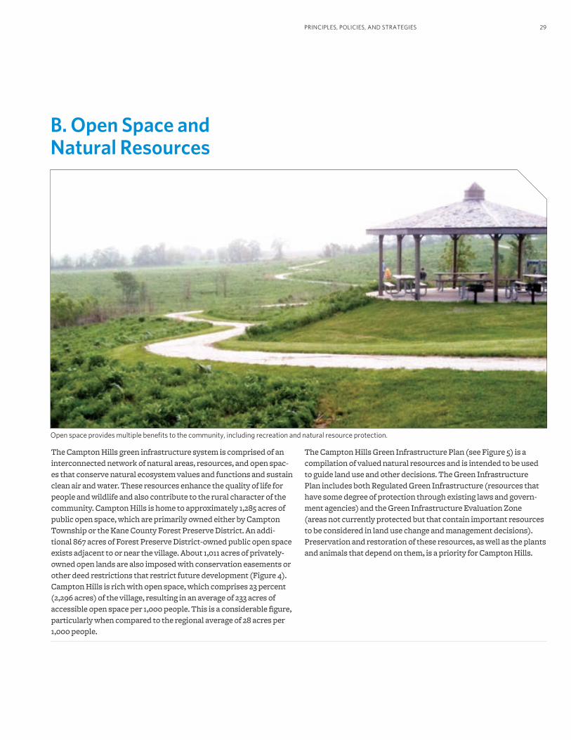
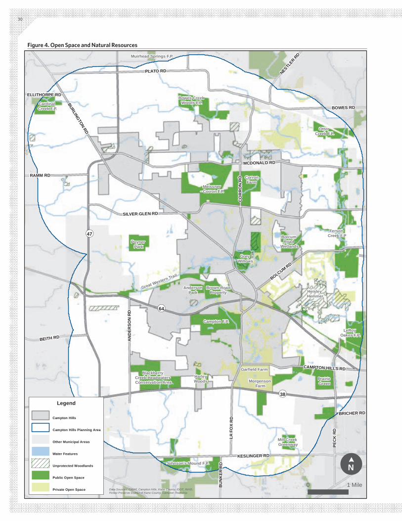
The Campton Hills green infrastructure system is comprised of an interconnected network of natural areas, resources, and open spac-es that conserve natural ecosystem values and functions and sustain clean air and water. These resources enhance the quality of life for people and wildlife and also contribute to the rural character of the community. Campton Hills is home to approximately 1,285 acres of public open space, which are primarily owned either by Campton Township or the Kane County Forest Preserve District. An addi-tional 867 acres of Forest Preserve District-owned public open space exists adjacent to or near the village. About 1,011 acres of privately-owned open lands are also imposed with conservation easements or other deed restrictions that restrict future development (Figure 4). Campton Hills is rich with open space, which comprises 23 percent (2,296 acres) of the village, resulting in an average of 233 acres of accessible open space per 1,000 people. This is a considerable figure, particularly when compared to the regional average of 28 acres per 1,000 people.
Open space provides multiple benefits to the community, including recreation and natural resource protection.
The Campton Hills Green Infrastructure Plan (see Figure 5) is a compilation of valued natural resources and is intended to be used to guide land use and other decisions. The Green Infrastructure Plan includes both Regulated Green Infrastructure (resources that have some degree of protection through existing laws and govern-ment agencies) and the Green Infrastructure Evaluation Zone (areas not currently protected but that contain important resources to be considered in land use change and management decisions). Preservation and restoration of these resources, as well as the plants and animals that depend on them, is a priority for Campton Hills.
¬«64
¬«47
¬«38
KESLINGER RD
BURLINGTON RD
MCDONALD RD
SILVER GLEN RD
PEC
K R
D
PLATO RD
BOWES RD
LA F
OX
RD
CO
RR
ON
RD
BOLCUM RD
BEITH RD AN
DER
SON
RD
RAMM RD
CAMPTON HILLS RD
FABYAN PKWY
NESTLER R
D
BU
NK
ER R
D
BRICHER RD
ELLITHORPE RD
Data Sources: CMAP, Campton Hills, Kane County, IDOT, INHD, Forest Preserve District of Kane County, Campton Township
0 1 Mile
!N
¢
Cardinal Creek F.P.
Bowes Creek Woods F.P.
CorronFarm
Meissner - Corron F.P.
Grey Willows
Great Western Trail
Blackberry Creek Headwaters Conservation Area
Garfield Farm
Morgenson Farm
LeRoy Oakes F.P.
Ferson Creek F.PBolcum
Road Wetlands
Muirhead Springs F.P.
Otter Creek F.P.
Johnson's Mound F.P.
Mill Creek Greenway
Campton F.P.
Prairie Green
Poyner Park
AndersonPark
Brown RoadProperty Heisley
Hemmer
HarleyWoods
Legend
Campton Hills
Campton Hills Planning Area
Other Municipal Areas
Water Features
Unprotected Woodlands
Public Open Space
Private Open Space
30
Figure 4. Open Space and Natural Resources
31PRINCIPLES, POLICIES, AND STRATEGIES
5. Green Infrastructure in the Village of Campton Hills, adopted as Ordinance 0-11-08 on April 19, 2011.
Village Principle and PoliciesThe principle below was identified through the public process as an overall theme for this topic area:
A network of interconnected open space, woodlands, and other natural resources are critical elements of Campton Hills’ green infrastructure system that provide multiple benefits to residents. These resources should be expanded and managed to support ecosystem health and other benefits.
The following policy statements serve as guiding tenets for this chapter. Each policy statement is addressed by at least one strategy below.
1. Design future development, land use changes, and transportation improvements to preserve open spaces, natural attributes of the land, and natural assets valued by the community.
2. Utilize and update the Green Infrastructure Report5 in policy, plan-ning, and regulatory initiatives, development planning and design, and decision-making processes.
3. Adopt structures (committees, standards, regulations, and pro-grams) designed to preserve and protect a network of appropriate-ly located, connected, and accessible natural resources, open space, natural areas, and green infrastructure connections to ensure their continued existence. Examples include land and easement acquisi-tion programs, conservation development principles and practices, and zoning categories designed to preserve valuable resources while preserving the development value of land.
4. Work with landowners, land managers, and partner agencies to en-courage and support the preservation, management, restoration, and enhancement of the ecological integrity, biodiversity, habitat, connections, and ecosystem functions (including hydrology) of en-vironmentally sensitive lands, natural ecosystems, and open space.
5. Provide diverse and accessible opportunities for outdoor recre-ation, exercise, and transportation to improve community health and as an element of Campton Hills’ high quality of life. This includes the development of pedestrian, bicycling, and equestrian trails that link key areas of the community and that link Campton Township, Forest Preserve District, and other open spaces to the Great Western Trail and to each other via trails, greenways, and other connections.
Proposed StrategiesThe strategies to follow represent action steps to take toward ad-dressing the identified principle and policies. Further information related to the implementation of these strategies may be found in the Implementation Strategy section.
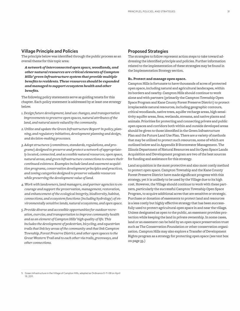
B1. Protect and manage open space.Campton Hills is fortunate to have thousands of acres of protected open space, including natural and agricultural landscapes, within its borders and nearby. Campton Hills should continue to work alone and with partners (primarily the Campton Township Open Space Program and Kane County Forest Preserve District) to protect irreplaceable natural resources, including geographic contours, critical woodlands, native trees, aquifer recharge areas, high sensi-tivity aquifer areas, fens, wetlands, streams, and native plants and animals. Priorities for protecting and connecting private and public open spaces and corridors both within and outside developed areas should be given to those identified in the Green Infrastructure Plan and the Future Land Use Plan. There are a variety of methods that may be utilized to protect such resources, some of which are outlined below and in Appendix B Stormwater Management. The Illinois Department of Natural Resources and its Open Space Lands Acquisition and Development program are two of the best sources for funding and assistance for this strategy.
Land acquisition is the most protective and also most costly method to protect open space. Campton Township and the Kane County Forest Preserve District have made significant progress with this strategy, yet it is unlikely to be used by the Village due to its high cost. However, the Village should continue to work with these part-ners, particularly the successful Campton Township Open Space Program, to acquire additional acres that are sensitive or strategic. Purchase or donation of easements to protect land and resources is a less costly but highly effective strategy that has been success-fully used to protect agricultural open space in and near the village. Unless designated as open to the public, an easement provides pro-tection while keeping the land in private ownership. In some cases, land or an easement can be held by an open space preservation trust such as The Conservation Foundation or other conservation organi-zation. Campton Hills may also explore a Transfer of Development Rights program as a strategy for protecting open space (see text box on page 33.)
¬«64
¬«47
¬«38
KESLINGER RD
BURLINGTON RD
MCDONALD RD
SILVER GLEN RD
PEC
K R
D
PLATO RD
BOWES RD
LA F
OX
RD
CO
RR
ON
RD
BOLCUM RD
AN
DER
SON
RD
BEITH RD
RAMM RD
CAMPTON HILLS RD
NESTLER R
D
HUGHES RD
BU
NK
ER R
D
BRICHER RD
ELLITHORPE RDIL
-47
Legend
Campton Hills Boundary
Campton Hills Planning Area
Other Municipal Areas
Water Features
Regulated Green Infrastructure
Green Infrastructure Evaluation ZoneData Sources: Kane County, CMAP, Campton Hills, IDOT, NAVTEQ
!N
¢
0 1 Mile
32
Figure 5. Green Infrastructure
33
6. Adapted from http://www.farmlandinfo.org/documents/27746/FS_TDR_1-01.pdf.
Protected lands should be managed for the purpose for which they were preserved. Campton Hills should work with landowners, land managers, homeowners associations, and partner agencies such as Kane County Forest Preserve District and Campton Township to en-courage and support not only the preservation of land, but also long-term management, stewardship, and enhancement of the structure, function, and health of natural systems. Grant funds can be used for management, but are typically dependent on the priorities and capacity of the funding agency or organization to award funds. For land dedicated as public or private open space by a developer, the Village can require that funds are set aside in a separate municipal fund designated for land and resource management.
As with most efforts that seek to encourage more sustainable and environmentally beneficial activities on private land, the Village should develop and conduct outreach education programs to increase understanding and awareness of the social, economic, and environmental importance of natural resource conservation and to encourage landowners and/or Homeowner’s Associations to protect, maintain and conserve natural resources and use water responsibly.
This ongoing strategy supports policies 2, 3, and 4.
PRINCIPLES, POLICIES, AND STRATEGIES
Transfer of Development Rights
Transfer of development rights6 programs allow landowners to transfer the right to develop one parcel of land (the parcel to be protected, or “sending” parcel) to a different parcel of land (the “receiving” parcel), typically located within a designated growth zone. In Campton Hills, the mixed-use centers could be designated as the receiving zones. When the rights are transferred from a sending parcel, the land is restricted with a permanent conservation easement.
TDR programs are based on the concept that property owners have a bundle of different rights, including the right to use land, sell it, and construct buildings on it. Some or all of these rights can be transferred or sold to another person. When a landowner sells property, generally all the rights are transferred to the buyer. TDR programs enable landowners to separate and sell the right to develop land from their other property rights.
Unique natural resources, such as this fen, should be prioritized for protection.
VILLAGE OF CAMPTON HILLS COMPREHENSIVE PLAN34
B2. Create plans and ordinances that support and protect valued resources during the development process.Campton Hills has taken initial steps to protect its natural re-sources and green infrastructure by creating and adopting a Green Infrastructure Plan. This plan should form the basis of Campton Hills’ policy for protecting its natural resources as well as its quality of life. The Village currently uses its land/cash ordinance to re-quire the donation of land or funds for open space and recreational purposes to provide for the need created by the development of new homes and neighborhoods. Review and update this ordinance regularly to ensure it meets the needs of the community. In the case of land donation, an appropriate land management and financing mechanism should also be established at or before the time of ac-ceptance. Examples include an escrow account, a dormant Special Service Area that is triggered if management responsibilities are not fulfilled by the designated party, or payment to a land management organization.
As Campton Hills updates and adopts development standards and ordinances to implement the policies outlined in this comprehen-sive plan, it should integrate sustainable/conservation development principles and practices to guide development in a way that protects the community’s irreplaceable natural resources. For instance, the Village should require development to minimize modification and alteration of the land and landscape as preparation for develop-ment including geographic contours, large trees, native vegeta-tion, and habitat areas. Allowing flexibility in lot size and density in subdivision regulations can be used to concentrate development to preserve the low density character of the community and open space while accommodating the needs of landowners. Campton Hills should also adopt zoning designations for areas where valued resources exist, either as stand-alone zoning categories or as standards within other zoning categories such as residential and commercial. Conservation, equestrian, and farmette development zoning categories (or a single category that captures these different types of developments) could accomplish this. Finally, the Village should require the incorporation of green infrastructure practices to manage storm water throughout the built environment. These con-cepts are also covered in the Water Resources and Managed Change sections of the plan.
Campton Hills should work with Campton Township and Kane County Forest Preserve District to create and implement a parks, open space, and recreation management plan for the protected landscapes in and around the community. At the appropriate time, and in collaboration with Campton Township, Campton Hills should also consider the establishment of an organizational structure to oversee the planning, development, and maintenance of recreational facilities within the community, such as a Parks Commission, Parks Department, or Park District. The management plan is a higher priority than the creation of an organizational structure; however, the Village may decide to create a committee or body to help lead the creation of the plan. This management plan component of Strategy B2 is mid-term (3-6 year) priority, and establishing protective devel-opment standards and regulations is a short-term (0-2 year) priority for which grants and technical assistance should be immediately pursued.
This short-term (0-2 year) strategy supports policies 1, 2, 3, and 5.
B3. Incorporate multiple uses into plans for open space.Open space can serve multiple purposes, including active and pas-sive recreation, stormwater management, flood control, habitat, groundwater protection and recharge, and green infrastructure. As Campton Hills works with Kane County and Campton Township on achieving open space goals, it should consider achieving multiple goals within local open space.
Specifically related to recreation, Campton Hills should strive to connect private and public open spaces and corridors and incorpo-rate such connections into open space plans. Connecting corridors, also known as greenways, should be targeted for passive recreation (e.g., bird watching and picnicking), active recreation (e.g., bicycle and pedestrian paths), and conservation purposes (e.g., buffers for water resources and wildlife habitat areas) throughout the village. These greenways can serve as transportation corridors when com-bined with plans for pedestrian, bicycling, and equestrian trails, and other connections that link key areas of the village to open spaces and the Great Western Trail. See the Transportation chapter for additional strategies and details. As with open space preservation strategies, the Illinois Department of Natural Resources (IDNR) and its Open Space Lands Acquisition and Development program are two of the best sources for funding and assistance. The Illinois Trails Grant Program of the IDNR is a source for trail and related facility development.
This mid-term (3-6 year) strategy supports policies 3 and 5.
35PRINCIPLES, POLICIES, AND STRATEGIES
Trees and landscaping are important to community character and natural resource protection.
B4. Create landscape standards that encourage the use of trees and native landscape elements.In order to make the developed areas of the village more compat-ible with its natural resources and to improve air and water quality, Campton Hills should promote the re-establishment, restoration, and use of trees and native, deep-rooted vegetation (trees, grasses, and flowers) through the creation and adoption of landscape stan-dards that include suggestions for natural landscape management. Existing landowners should be encouraged to convert areas of turf grass lawn to naturalized landscapes, particularly where those prop-erties are adjacent to or within 250 feet of natural areas and open space. The IDNR and Chicago Wilderness are potential sources of assistance for implementing this strategy.
This short-term (0-2 year) strategy supports policies 1, 3 and 4.
Implementation StrategyThe strategies proposed for protecting open space and natural resources primarily relate to updating components of zoning and de-velopment standards and regulations so that valuable resources are protected. These modifications should be pursued when the Village undertakes an overall code update and in coordination with other strategies that relate to codes and regulations. The recommendation in Strategy B2 to create a parks, recreation, and open space manage-ment plan is a mid-term priority that should follow, or coincide with the update to codes and regulations if funding is available. Ideally, the Village should begin to seek funding and technical assistance to update codes in the immediate future so that it could be adopted and enforced in 2013 if not sooner. In the meantime, the Village should use the Planned Unit Development process to achieve the open space and natural resource policies in the absence of appropriate regulations and standards.
VILLAGE OF CAMPTON HILLS COMPREHENSIVE PLAN36
C. Water Resources
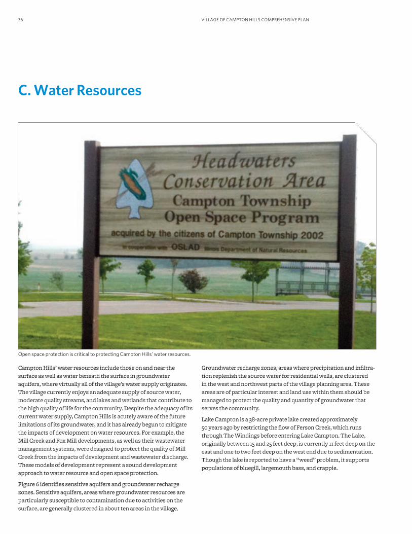
Open space protection is critical to protecting Campton Hills’ water resources.
Campton Hills’ water resources include those on and near the surface as well as water beneath the surface in groundwater aquifers, where virtually all of the village’s water supply originates. The village currently enjoys an adequate supply of source water, moderate quality streams, and lakes and wetlands that contribute to the high quality of life for the community. Despite the adequacy of its current water supply, Campton Hills is acutely aware of the future limitations of its groundwater, and it has already begun to mitigate the impacts of development on water resources. For example, the Mill Creek and Fox Mill developments, as well as their wastewater management systems, were designed to protect the quality of Mill Creek from the impacts of development and wastewater discharge. These models of development represent a sound development approach to water resource and open space protection.
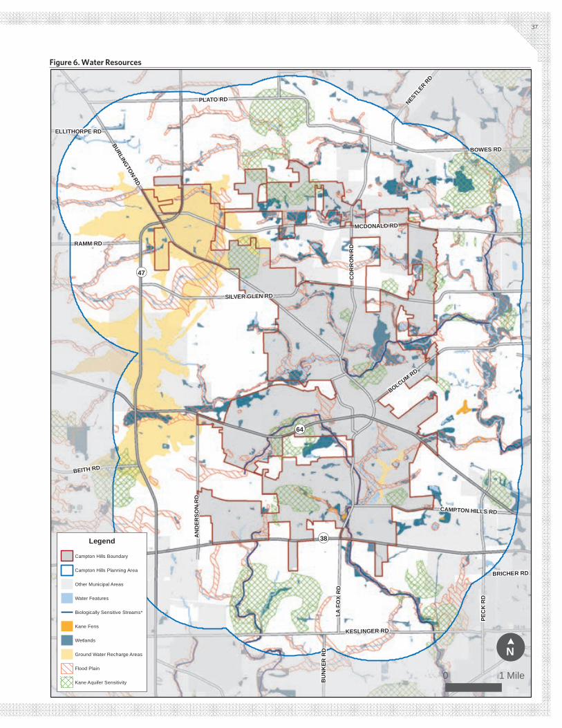
Figure 6 identifies sensitive aquifers and groundwater recharge zones. Sensitive aquifers, areas where groundwater resources are particularly susceptible to contamination due to activities on the surface, are generally clustered in about ten areas in the village.
Groundwater recharge zones, areas where precipitation and infiltra-tion replenish the source water for residential wells, are clustered in the west and northwest parts of the village planning area. These areas are of particular interest and land use within them should be managed to protect the quality and quantity of groundwater that serves the community.
Lake Campton is a 38-acre private lake created approximately 50 years ago by restricting the flow of Ferson Creek, which runs through The Windings before entering Lake Campton. The Lake, originally between 15 and 25 feet deep, is currently 11 feet deep on the east and one to two feet deep on the west end due to sedimentation. Though the lake is reported to have a “weed” problem, it supports populations of bluegill, largemouth bass, and crappie.
KESLINGER RD
BURLINGTON RD
MCDONALD RD
SILVER GLEN RD
PEC
K R
D
PLATO RD
BOWES RD
LA F
OX
RD
CO
RR
ON
RD
BOLCUM RD
AN
DER
SON
RD
BEITH RD
RAMM RD
CAMPTON HILLS RD
NESTLER R
D
BU
NK
ER R
D
BRICHER RD
ELLITHORPE RD
¬«64
¬«47
¬«38Legend
Campton Hills Boundary
Campton Hills Planning Area
Other Municipal Areas
Water Features
Biologically Sensitive Streams*
Kane Fens
Wetlands
Ground Water Recharge Areas
Flood Plain
Kane Aquifer Sensitivity
!N
¢
0 1 Mile
37
Figure 6. Water Resources
¬«64
¬«47
¬«38
KESLINGER RD
BURLINGTON RD
MCDONALD RD
SILVER GLEN RD
PEC
K R
D
PLATO RD
BOWES RD
LA F
OX
RD
CO
RR
ON
RD
BOLCUM RD
AN
DER
SON
RD
BEITH RD
RAMM RD
CAMPTON HILLS RD
NESTLER R
D
HUGHES RD
BU
NK
ER R
D
BRICHER RD
ELLITHORPE RD
FRWRD FPA
Elburn FPA
Wasco FPA
St. Charles FPA
Mill Creek WRD FPA Geneva
FPALegend
Campton Hills Boundary
Campton Hills Planning Area
Other Municipal Areas
State Highway
Arterials & Collectors
!N
¢
0 1 Mile
38
Figure 7. Wastewater Facility Planning Areas
39
Current conditions of the village’s stream network indicate mod-erately good biological condition but a potential problem related to fecal coliform, which is bacteria associated with animal waste contamination. Significant fecal coliform levels may render streams unsafe for contact with people but typically do not severely impact them for supporting aquatic life. While the source of the problem has not yet been determined, possibilities include stormwater runoff from natural and developed areas of the village, improper treatment of land-applied wastewater, septic systems, and the application of fertilizer on agricultural land.
Higher quality wetlands occur primarily along the edges and within the floodplains of creeks, while four fen complexes and recharge areas are within Campton Hills’ area of influence. These wetlands, especially the rare fens and recharge areas, are landscape elements that should be protected and enhanced.
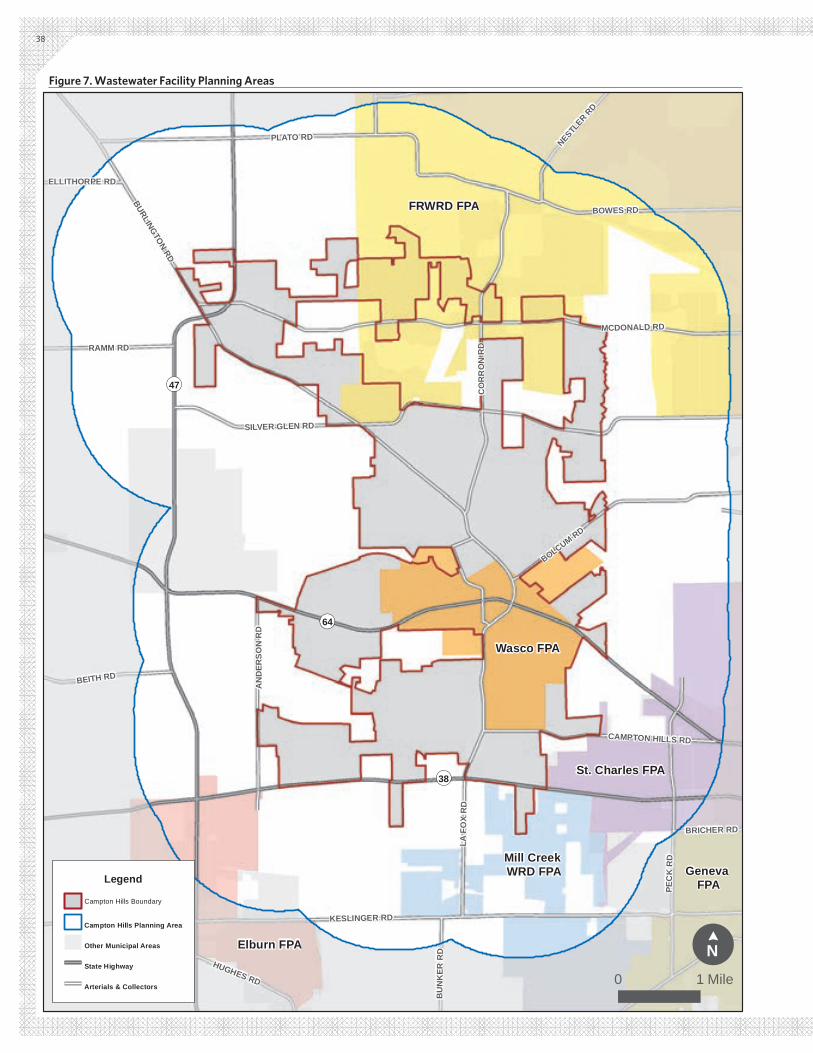
Wastewater service and capacity is an issue, as it relates to poten-tial impairment of area streams, and also influences development capacity and density within the Wasco Sanitary District service area, its facility planning area, and areas where well and septic facilities are required due to the lack of a centralized facility (see Figure 7). Alternatives to these traditional methods of treatment are available and should be explored.
Stormwater runoff is primarily handled by surface flow via road-side ditches, with a few locations with underground stormwater infrastructure, primarily in the Fox Mill, Fox Creek, Abbey Glen, Woodland Hills, and Wasco areas. Flooding is a localized nuisance, but does not appear to be a significant issue for the majority of the community. Nonetheless, drainage system maintenance and im-provement is an issue that needs to be addressed.
PRINCIPLES, POLICIES, AND STRATEGIES
Village Principle and PoliciesThe principle below was identified through the public process as an overall theme for this topic area:
Surface and ground water resources are critical to Campton Hills’ quality of life and should be stewarded and sustained over time.
The following policy statements serve as guiding tenets for protect-ing water resources. Each policy statement is addressed by at least one strategy below.
1. A clean, abundant supply of groundwater is a valuable but finite natural asset worthy of protection, sensible use, and conscious recharge. Future development, land use change, and transportation improvement decisions will consider the impact of development on wastewater treatment and water supply capacity of existing facili-ties and sources in order to ensure adequate quantity and quality for existing and future residents.
2. Wastewater treatment will be planned and implemented to ensure protection of public health, conservation of water and energy, and the quality of the community’s surface and groundwater resources.
3. Stormwater management will utilize site-specific best management practices and standards to minimize the quantity (rate and vol-ume) of surface runoff, improve water quality, encourage infiltra-tion and evapotranspiration, and support rainwater collection and reuse, which will help to reduce flooding and protect surface water resources.
4. Manage rain water as a valuable resource to reduce the use of potable water, recharge groundwater resources, protect property from damage, and improve the quality of our water resources.
5. Adopt structures (committees, standards, regulations, and pro-grams) designed to preserve and protect water resources in the community. Examples include a stormwater management plan, conservation development principles and practices, green infra-structure measures, and zoning requirements designed to preserve valuable resources.
6. Protect the infiltration capacity of groundwater recharge areas and prevent contamination of sensitive aquifers due to activities and uses on the land surface. This may be implemented through a combination of strategies such as zoning, economic incentives, the transfer of development potential to more appropriate areas, and/or the concentration of development potential on a portion of land available for development.
7. Protect and enhance the biological quality and integrity of surface water resources as critical components of the community’s green infrastructure system. These resources include streams, lakes, wet-lands, floodplains, and fens and fen recharge areas, particularly those classified as high quality.
8. Consider water conservation, multiple uses, and reuse strategies for stormwater, surface, and greywater resources to reduce the consumption of potable water and the demand for groundwater sources.
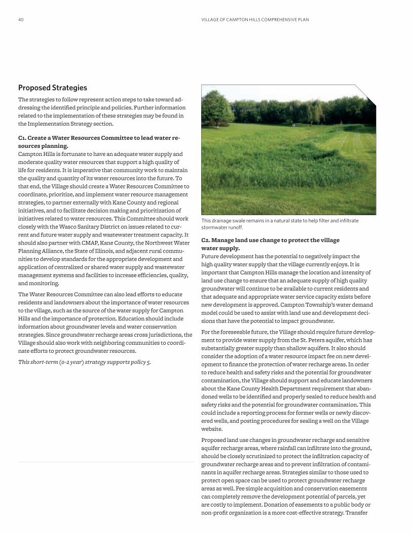
VILLAGE OF CAMPTON HILLS COMPREHENSIVE PLAN40
Proposed StrategiesThe strategies to follow represent action steps to take toward ad-dressing the identified principle and policies. Further information related to the implementation of these strategies may be found in the Implementation Strategy section.
C1. Create a Water Resources Committee to lead water re-sources planning. Campton Hills is fortunate to have an adequate water supply and moderate quality water resources that support a high quality of life for residents. It is imperative that community work to maintain the quality and quantity of its water resources into the future. To that end, the Village should create a Water Resources Committee to coordinate, prioritize, and implement water resource management strategies, to partner externally with Kane County and regional initiatives, and to facilitate decision making and prioritization of initiatives related to water resources. This Committee should work closely with the Wasco Sanitary District on issues related to cur-rent and future water supply and wastewater treatment capacity. It should also partner with CMAP, Kane County, the Northwest Water Planning Alliance, the State of Illinois, and adjacent rural commu-nities to develop standards for the appropriate development and application of centralized or shared water supply and wastewater management systems and facilities to increase efficiencies, quality, and monitoring.
The Water Resources Committee can also lead efforts to educate residents and landowners about the importance of water resources to the village, such as the source of the water supply for Campton Hills and the importance of protection. Education should include information about groundwater levels and water conservation strategies. Since groundwater recharge areas cross jurisdictions, the Village should also work with neighboring communities to coordi-nate efforts to protect groundwater resources.
This short-term (0-2 year) strategy supports policy 5.
C2. Manage land use change to protect the village water supply.Future development has the potential to negatively impact the high quality water supply that the village currently enjoys. It is important that Campton Hills manage the location and intensity of land use change to ensure that an adequate supply of high quality groundwater will continue to be available to current residents and that adequate and appropriate water service capacity exists before new development is approved. Campton Township’s water demand model could be used to assist with land use and development deci-sions that have the potential to impact groundwater.
For the foreseeable future, the Village should require future develop-ment to provide water supply from the St. Peters aquifer, which has substantially greater supply than shallow aquifers. It also should consider the adoption of a water resource impact fee on new devel-opment to finance the protection of water recharge areas. In order to reduce health and safety risks and the potential for groundwater contamination, the Village should support and educate landowners about the Kane County Health Department requirement that aban-doned wells to be identified and properly sealed to reduce health and safety risks and the potential for groundwater contamination. This could include a reporting process for former wells or newly discov-ered wells, and posting procedures for sealing a well on the Village website.
Proposed land use changes in groundwater recharge and sensitive aquifer recharge areas, where rainfall can infiltrate into the ground, should be closely scrutinized to protect the infiltration capacity of groundwater recharge areas and to prevent infiltration of contami-nants in aquifer recharge areas. Strategies similar to those used to protect open space can be used to protect groundwater recharge areas as well. Fee simple acquisition and conservation easements can completely remove the development potential of parcels, yet are costly to implement. Donation of easements to a public body or non-profit organization is a more cost-effective strategy. Transfer
This drainage swale remains in a natural state to help filter and infiltrate stormwater runoff.
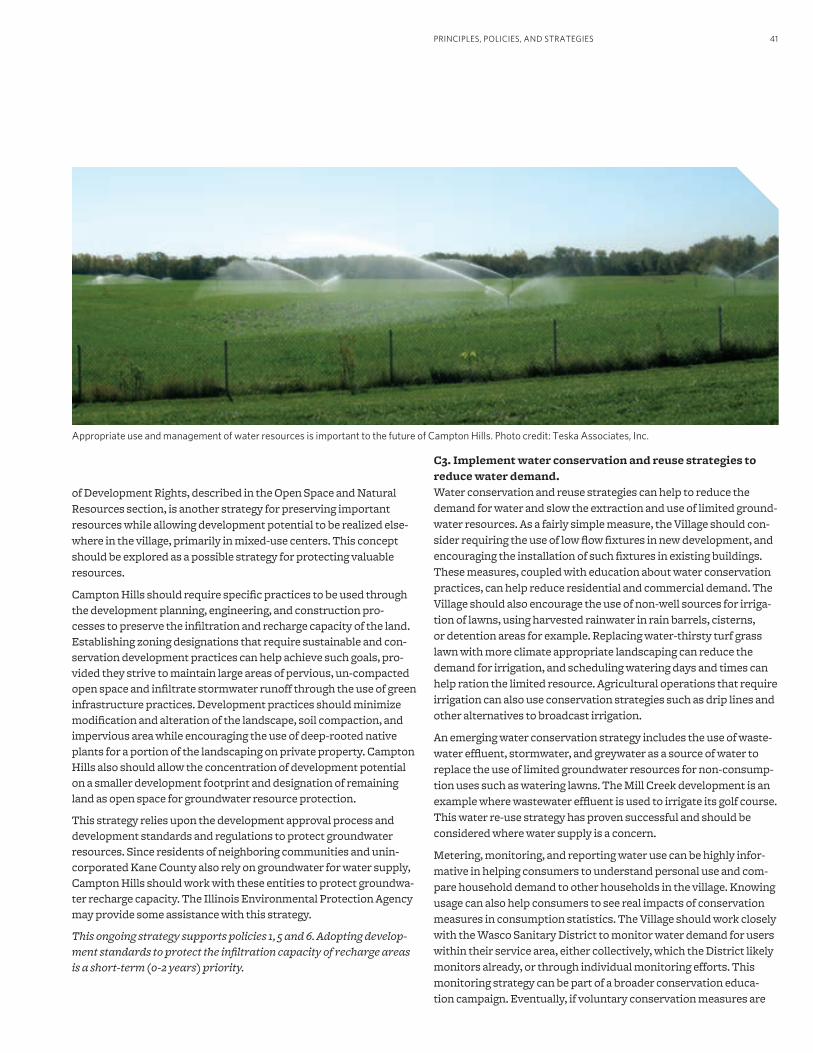
41
of Development Rights, described in the Open Space and Natural Resources section, is another strategy for preserving important resources while allowing development potential to be realized else-where in the village, primarily in mixed-use centers. This concept should be explored as a possible strategy for protecting valuable resources.
Campton Hills should require specific practices to be used through the development planning, engineering, and construction pro-cesses to preserve the infiltration and recharge capacity of the land. Establishing zoning designations that require sustainable and con-servation development practices can help achieve such goals, pro-vided they strive to maintain large areas of pervious, un-compacted open space and infiltrate stormwater runoff through the use of green infrastructure practices. Development practices should minimize modification and alteration of the landscape, soil compaction, and impervious area while encouraging the use of deep-rooted native plants for a portion of the landscaping on private property. Campton Hills also should allow the concentration of development potential on a smaller development footprint and designation of remaining land as open space for groundwater resource protection.
This strategy relies upon the development approval process and development standards and regulations to protect groundwater resources. Since residents of neighboring communities and unin-corporated Kane County also rely on groundwater for water supply, Campton Hills should work with these entities to protect groundwa-ter recharge capacity. The Illinois Environmental Protection Agency may provide some assistance with this strategy.
This ongoing strategy supports policies 1, 5 and 6. Adopting develop-ment standards to protect the infiltration capacity of recharge areas is a short-term (0-2 years) priority.
C3. Implement water conservation and reuse strategies to reduce water demand. Water conservation and reuse strategies can help to reduce the demand for water and slow the extraction and use of limited ground-water resources. As a fairly simple measure, the Village should con-sider requiring the use of low flow fixtures in new development, and encouraging the installation of such fixtures in existing buildings. These measures, coupled with education about water conservation practices, can help reduce residential and commercial demand. The Village should also encourage the use of non-well sources for irriga-tion of lawns, using harvested rainwater in rain barrels, cisterns, or detention areas for example. Replacing water-thirsty turf grass lawn with more climate appropriate landscaping can reduce the demand for irrigation, and scheduling watering days and times can help ration the limited resource. Agricultural operations that require irrigation can also use conservation strategies such as drip lines and other alternatives to broadcast irrigation.
An emerging water conservation strategy includes the use of waste-water effluent, stormwater, and greywater as a source of water to replace the use of limited groundwater resources for non-consump-tion uses such as watering lawns. The Mill Creek development is an example where wastewater effluent is used to irrigate its golf course. This water re-use strategy has proven successful and should be considered where water supply is a concern.
Metering, monitoring, and reporting water use can be highly infor-mative in helping consumers to understand personal use and com-pare household demand to other households in the village. Knowing usage can also help consumers to see real impacts of conservation measures in consumption statistics. The Village should work closely with the Wasco Sanitary District to monitor water demand for users within their service area, either collectively, which the District likely monitors already, or through individual monitoring efforts. This monitoring strategy can be part of a broader conservation educa-tion campaign. Eventually, if voluntary conservation measures are
PRINCIPLES, POLICIES, AND STRATEGIES
Appropriate use and management of water resources is important to the future of Campton Hills. Photo credit: Teska Associates, Inc.
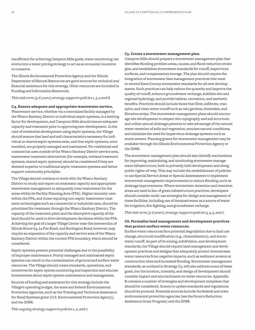
VILLAGE OF CAMPTON HILLS COMPREHENSIVE PLAN42
insufficient for achieving Campton Hills goals, water monitoring can evolve into a water pricing strategy to act as an economic incentive to conserve.
The Illinois Environmental Protection Agency and the Illinois Department of Natural Resources are good sources for technical and financial assistance for this strategy. Other resources are included in Funding and Information Resources.
This mid-term (3-6 years) strategy supports policies 1, 3, 4 and 8.
C4. Ensure adequate and appropriate wastewater service.Wastewater service, whether via a centralized facility managed by the Wasco Sanitary District or individual septic systems, is a limiting factor for development, and Campton Hills should ensure adequate capacity and treatment prior to approving new development. In the case of residential development using septic systems, the Village should ensure that land and soil characteristics necessary for indi-vidual or shared septic systems exist, and that septic systems, once installed, are properly managed and maintained. For residential and commercial uses outside of the Wasco Sanitary District service area, wastewater treatment alternatives (for example, wetland treatment systems, shared septic systems) should be considered if they are deemed superior to traditional septic treatment systems and better support community principles.
The Village should continue to work with the Wasco Sanitary District to study and report on treatment capacity and appropriate wastewater management to adequately treat wastewater for the areas within its Facility Planning Area (FPA). Higher intensity uses within the FPA, and those requiring non-septic wastewater treat-ment technologies such as commercial or industrial uses, should be prioritized for treatment through the Wasco Sanitary District. The capacity of the treatment plant and the absorptive capacity of the land should be used to drive development decisions within the FPA. Achieving the goal of a larger Village Center near the intersection of Illinois Route 64, La Fox Road, and Burlington Road, however, may require an expansion of the capacity and service area of the Wasco Sanitary District within the current FPA boundary, which should be considered.
Septic systems present potential challenges due to the possibility of improper maintenance. Poorly managed and maintained septic systems can result in the contamination of ground and surface water resources. The Village should create standards, operations, and incentives for septic system monitoring and inspection and educate homeowners about septic system maintenance and management.
Sources of funding and assistance for this strategy include the Village’s operating budget, the state and federal Environmental Protection Agencies, such as the Training and Technical Assistance for Small Systems grant (U.S. Environmental Protection Agency), and the IDNR.
This ongoing strategy supports policies 1, 2, and 7.
C5. Create a stormwater management plan.Campton Hills should prepare a stormwater management plan that identifies flooding problem areas, causes, and flood reduction strate-gies, and establishes stormwater standards for runoff, impervious surfaces, and compensatory storage. The plan should require the integration of stormwater best management practices that meet or exceed Kane County stormwater standards for all new develop-ments. Such practices can help reduce the quantity and improve the quality of runoff, enhance groundwater recharge, stabilize site and regional hydrology, and provide habitat, recreation, and aesthetic benefits. Practices should include those that filter, infiltrate, tran-spire, and clean water runoff such as rain gardens, bioswales, and filtration strips. The stormwater management plans should encour-age site development to respect site topography and soil structure, and utilize natural drainage patterns to take advantage of the natural water retention of soils and vegetation, emulate natural conditions, and minimize the need for impervious drainage systems such as storm sewers. Planning grants for stormwater management may be available through the Illinois Environmental Protection Agency or the IDNR.
The stormwater management plan should also identify mechanisms for improving, maintaining, and monitoring stormwater manage-ment infrastructure, both in privately held development and along public rights-of-way. This may include the establishment of policies to use Special Service Areas or Special Assessments to implement stormwater management improvements to reduce flooding, such as drainage improvements. Where stormwater detention and retention areas are used in lieu of green infrastructure practices, developers should consider multi-use strategies for design and management of these facilities, including use of detained water as a source of water for irrigation, fire-fighting, and groundwater recharge.
This mid-term (3-6 years) strategy supports policies 3, 4, 5, and 7.
C6. Formalize land management and development practices that protect surface water resources. Surface water resources face potential degradation due to land use change, structural modification (e.g., channelization), and storm-water runoff. As part of its zoning, subdivision, and development standards, the Village should require land management and devel-opment practices and designs that adequately protect downstream water resources from negative impacts, such as sediment erosion at construction sites and increased flooding. Stormwater management standards, as outlined in Strategy C5, will also address some of these goals, but the location, intensity, and design of development should consider impact and encroachment on water resources. Appendix B contains a number of strategies and development templates that should be considered. Grants to update standards and regulations should be pursued. Potential sources include the federal and state environmental protection agencies (see the Source Reduction Assistance Grant Program) and the IDNR.
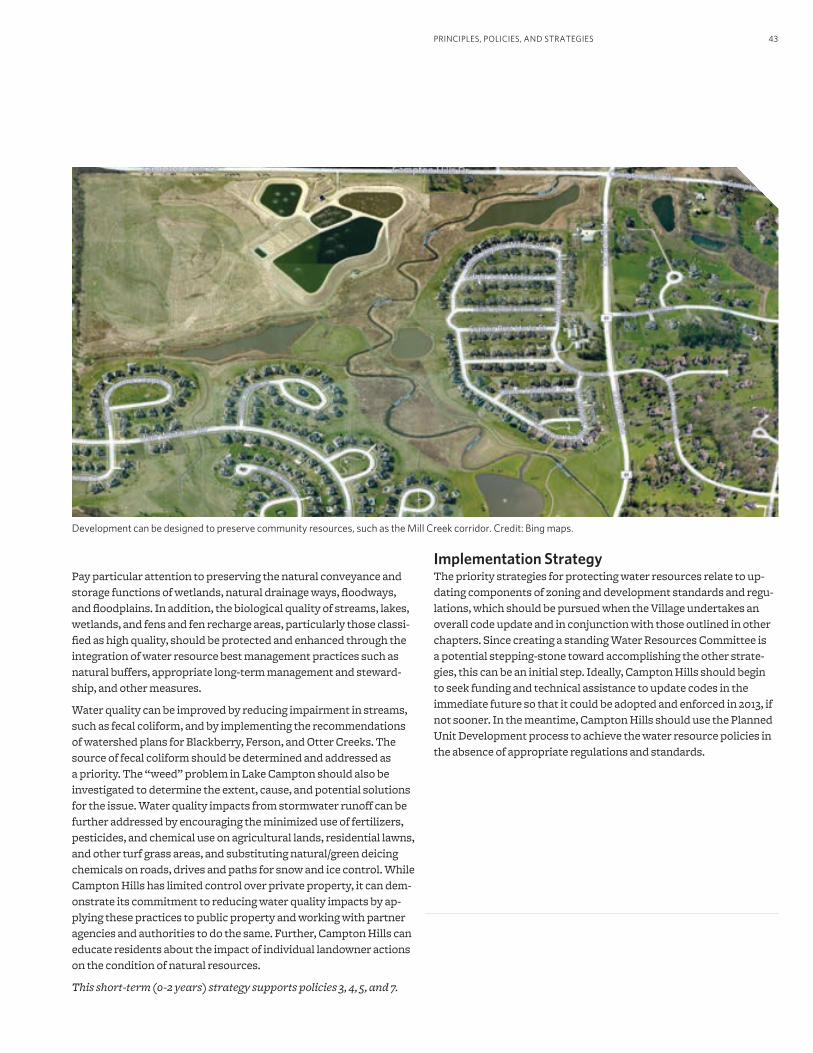
43
Development can be designed to preserve community resources, such as the Mill Creek corridor. Credit: Bing maps.
PRINCIPLES, POLICIES, AND STRATEGIES
Pay particular attention to preserving the natural conveyance and storage functions of wetlands, natural drainage ways, floodways, and floodplains. In addition, the biological quality of streams, lakes, wetlands, and fens and fen recharge areas, particularly those classi-fied as high quality, should be protected and enhanced through the integration of water resource best management practices such as natural buffers, appropriate long-term management and steward-ship, and other measures.
Water quality can be improved by reducing impairment in streams, such as fecal coliform, and by implementing the recommendations of watershed plans for Blackberry, Ferson, and Otter Creeks. The source of fecal coliform should be determined and addressed as a priority. The “weed” problem in Lake Campton should also be investigated to determine the extent, cause, and potential solutions for the issue. Water quality impacts from stormwater runoff can be further addressed by encouraging the minimized use of fertilizers, pesticides, and chemical use on agricultural lands, residential lawns, and other turf grass areas, and substituting natural/green deicing chemicals on roads, drives and paths for snow and ice control. While Campton Hills has limited control over private property, it can dem-onstrate its commitment to reducing water quality impacts by ap-plying these practices to public property and working with partner agencies and authorities to do the same. Further, Campton Hills can educate residents about the impact of individual landowner actions on the condition of natural resources.
This short-term (0-2 years) strategy supports policies 3, 4, 5, and 7.
Implementation StrategyThe priority strategies for protecting water resources relate to up-dating components of zoning and development standards and regu-lations, which should be pursued when the Village undertakes an overall code update and in conjunction with those outlined in other chapters. Since creating a standing Water Resources Committee is a potential stepping-stone toward accomplishing the other strate-gies, this can be an initial step. Ideally, Campton Hills should begin to seek funding and technical assistance to update codes in the immediate future so that it could be adopted and enforced in 2013, if not sooner. In the meantime, Campton Hills should use the Planned Unit Development process to achieve the water resource policies in the absence of appropriate regulations and standards.
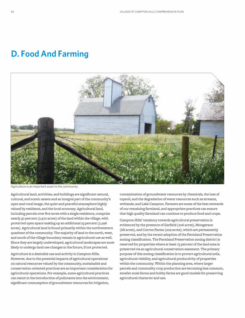
VILLAGE OF CAMPTON HILLS COMPREHENSIVE PLAN44
D. Food And Farming
Agriculture is an important asset to the community.
Agricultural land, activities, and buildings are significant natural, cultural, and scenic assets and an integral part of the community’s open and rural image, the quiet and peaceful atmosphere highly valued by residents, and the local economy. Agricultural land, including parcels over five acres with a single residence, comprise nearly 30 percent (2,972 acres) of the land within the village, with protected open space making up an additional 23 percent (2,296 acres). Agricultural land is found primarily within the northwestern quadrant of the community. The majority of land to the north, west, and south of the village boundary remain in agricultural use as well. Since they are largely undeveloped, agricultural landscapes are most likely to undergo land use changes in the future, if not protected.
Agriculture is a desirable use and activity in Campton Hills. However, due to the potential impacts of agricultural operations on natural resources valued by the community, sustainable and conservation-oriented practices are an important consideration for agricultural operations. For example, some agricultural practices can result in the introduction of pollutants into the environment, significant consumption of groundwater resources for irrigation,
contamination of groundwater resources by chemicals, the loss of topsoil, and the degradation of water resources such as streams, wetlands, and Lake Campton. Farmers are some of the best stewards of our remaining farmland, and appropriate practices can ensure that high quality farmland can continue to produce food and crops.
Campton Hills’ tendency towards agricultural preservation is evidenced by the presence of Garfield (206 acres), Mongerson (68 acres), and Corron Farms (209 acres), which are permanently preserved, and by the recent adoption of the Farmland Preservation zoning classification. The Farmland Preservation zoning district is reserved for properties where at least 75 percent of the land area is preserved via an agricultural conservation easement. The primary purpose of this zoning classification is to protect agricultural soils, agricultural viability, and agricultural productivity of properties within the community. Within the planning area, where larger parcels and commodity crop production are becoming less common, smaller scale farms and hobby farms are good models for preserving agricultural character and use.
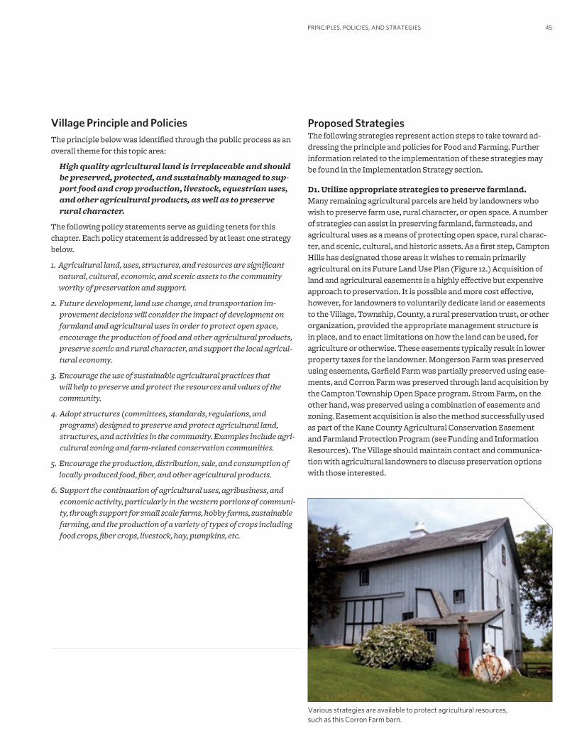
45
Proposed StrategiesThe following strategies represent action steps to take toward ad-dressing the principle and policies for Food and Farming. Further information related to the implementation of these strategies may be found in the Implementation Strategy section.
D1. Utilize appropriate strategies to preserve farmland.Many remaining agricultural parcels are held by landowners who wish to preserve farm use, rural character, or open space. A number of strategies can assist in preserving farmland, farmsteads, and agricultural uses as a means of protecting open space, rural charac-ter, and scenic, cultural, and historic assets. As a first step, Campton Hills has designated those areas it wishes to remain primarily agricultural on its Future Land Use Plan (Figure 12.) Acquisition of land and agricultural easements is a highly effective but expensive approach to preservation. It is possible and more cost effective, however, for landowners to voluntarily dedicate land or easements to the Village, Township, County, a rural preservation trust, or other organization, provided the appropriate management structure is in place, and to enact limitations on how the land can be used, for agriculture or otherwise. These easements typically result in lower property taxes for the landowner. Mongerson Farm was preserved using easements, Garfield Farm was partially preserved using ease-ments, and Corron Farm was preserved through land acquisition by the Campton Township Open Space program. Strom Farm, on the other hand, was preserved using a combination of easements and zoning. Easement acquisition is also the method successfully used as part of the Kane County Agricultural Conservation Easement and Farmland Protection Program (see Funding and Information Resources). The Village should maintain contact and communica-tion with agricultural landowners to discuss preservation options with those interested.
Various strategies are available to protect agricultural resources, such as this Corron Farm barn.
PRINCIPLES, POLICIES, AND STRATEGIES
Village Principle and PoliciesThe principle below was identified through the public process as an overall theme for this topic area:
High quality agricultural land is irreplaceable and should be preserved, protected, and sustainably managed to sup-port food and crop production, livestock, equestrian uses, and other agricultural products, as well as to preserve rural character.
The following policy statements serve as guiding tenets for this chapter. Each policy statement is addressed by at least one strategy below.
1. Agricultural land, uses, structures, and resources are significant natural, cultural, economic, and scenic assets to the community worthy of preservation and support.
2. Future development, land use change, and transportation im-provement decisions will consider the impact of development on farmland and agricultural uses in order to protect open space, encourage the production of food and other agricultural products, preserve scenic and rural character, and support the local agricul-tural economy.
3. Encourage the use of sustainable agricultural practices that will help to preserve and protect the resources and values of the community.
4. Adopt structures (committees, standards, regulations, and programs) designed to preserve and protect agricultural land, structures, and activities in the community. Examples include agri-cultural zoning and farm-related conservation communities.
5. Encourage the production, distribution, sale, and consumption of locally produced food, fiber, and other agricultural products.
6. Support the continuation of agricultural uses, agribusiness, and economic activity, particularly in the western portions of communi-ty, through support for small scale farms, hobby farms, sustainable farming, and the production of a variety of types of crops including food crops, fiber crops, livestock, hay, pumpkins, etc.
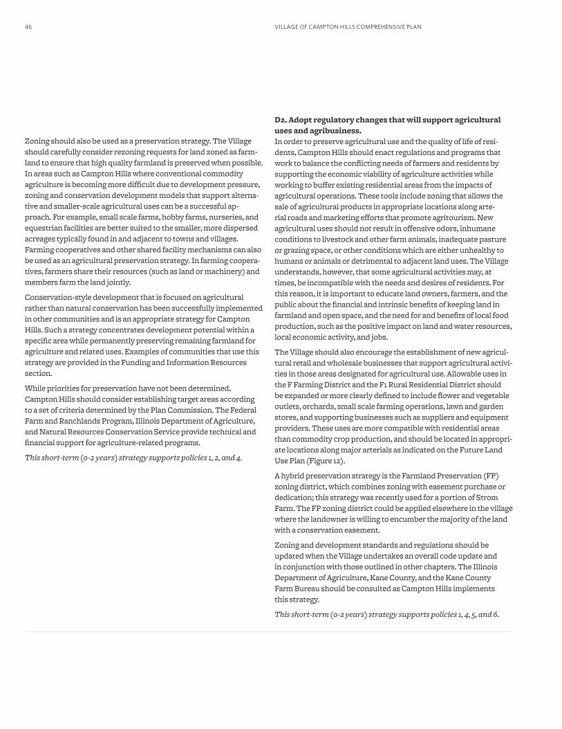
VILLAGE OF CAMPTON HILLS COMPREHENSIVE PLAN46
Zoning should also be used as a preservation strategy. The Village should carefully consider rezoning requests for land zoned as farm-land to ensure that high quality farmland is preserved when possible. In areas such as Campton Hills where conventional commodity agriculture is becoming more difficult due to development pressure, zoning and conservation development models that support alterna-tive and smaller-scale agricultural uses can be a successful ap-proach. For example, small scale farms, hobby farms, nurseries, and equestrian facilities are better suited to the smaller, more dispersed acreages typically found in and adjacent to towns and villages. Farming cooperatives and other shared facility mechanisms can also be used as an agricultural preservation strategy. In farming coopera-tives, farmers share their resources (such as land or machinery) and members farm the land jointly.
Conservation-style development that is focused on agricultural rather than natural conservation has been successfully implemented in other communities and is an appropriate strategy for Campton Hills. Such a strategy concentrates development potential within a specific area while permanently preserving remaining farmland for agriculture and related uses. Examples of communities that use this strategy are provided in the Funding and Information Resources section.
While priorities for preservation have not been determined, Campton Hills should consider establishing target areas according to a set of criteria determined by the Plan Commission. The Federal Farm and Ranchlands Program, Illinois Department of Agriculture, and Natural Resources Conservation Service provide technical and financial support for agriculture-related programs.
This short-term (0-2 years) strategy supports policies 1, 2, and 4.
D2. Adopt regulatory changes that will support agricultural uses and agribusiness.In order to preserve agricultural use and the quality of life of resi-dents, Campton Hills should enact regulations and programs that work to balance the conflicting needs of farmers and residents by supporting the economic viability of agriculture activities while working to buffer existing residential areas from the impacts of agricultural operations. These tools include zoning that allows the sale of agricultural products in appropriate locations along arte-rial roads and marketing efforts that promote agritourism. New agricultural uses should not result in offensive odors, inhumane conditions to livestock and other farm animals, inadequate pasture or grazing space, or other conditions which are either unhealthy to humans or animals or detrimental to adjacent land uses. The Village understands, however, that some agricultural activities may, at times, be incompatible with the needs and desires of residents. For this reason, it is important to educate land owners, farmers, and the public about the financial and intrinsic benefits of keeping land in farmland and open space, and the need for and benefits of local food production, such as the positive impact on land and water resources, local economic activity, and jobs.
The Village should also encourage the establishment of new agricul-tural retail and wholesale businesses that support agricultural activi-ties in those areas designated for agricultural use. Allowable uses in the F Farming District and the F1 Rural Residential District should be expanded or more clearly defined to include flower and vegetable outlets, orchards, small scale farming operations, lawn and garden stores, and supporting businesses such as suppliers and equipment providers. These uses are more compatible with residential areas than commodity crop production, and should be located in appropri-ate locations along major arterials as indicated on the Future Land Use Plan (Figure 12).
A hybrid preservation strategy is the Farmland Preservation (FP) zoning district, which combines zoning with easement purchase or dedication; this strategy was recently used for a portion of Strom Farm. The FP zoning district could be applied elsewhere in the village where the landowner is willing to encumber the majority of the land with a conservation easement.
Zoning and development standards and regulations should be updated when the Village undertakes an overall code update and in conjunction with those outlined in other chapters. The Illinois Department of Agriculture, Kane County, and the Kane County Farm Bureau should be consulted as Campton Hills implements this strategy.
This short-term (0-2 years) strategy supports policies 1, 4, 5, and 6.
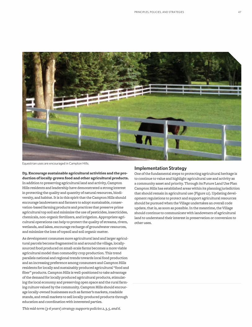
47PRINCIPLES, POLICIES, AND STRATEGIES
Equestrian uses are encouraged in Campton Hills.
D3. Encourage sustainable agricultural activities and the pro-duction of locally-grown food and other agricultural products. In addition to preserving agricultural land and activity, Campton Hills residents and leadership have demonstrated a strong interest in protecting the quality and quantity of natural resources, biodi-versity, and habitat. It is in this spirit that the Campton Hills should encourage landowners and farmers to adopt sustainable, conser-vation-based farming products and practices that preserve prime agricultural top soil and minimize the use of pesticides, insecticides, chemicals, non-organic fertilizers, and irrigation. Appropriate agri-cultural operations can help to protect the quality of streams, rivers, wetlands, and lakes, encourage recharge of groundwater resources, and minimize the loss of topsoil and soil organic matter.
As development consumes more agricultural land and larger agricul-tural parcels become fragmented in and around the village, locally-sourced food produced on small-scale farms becomes a more viable agricultural model than commodity crop production. This trend parallels national and regional trends towards local food production and an increasing preference among consumers and Campton Hills residents for locally and sustainably produced agricultural “food and fiber” products. Campton Hills is well-positioned to take advantage of the demand for locally produced agricultural products, stimulat-ing the local economy and preserving open space and the rural farm-ing culture valued by the community. Campton Hills should encour-age locally-owned businesses such as farmer’s markets, roadside stands, and retail markets to sell locally-produced products through education and coordination with interested parties.
This mid-term (3-6 years) strategy supports policies 2, 3, 5, and 6.
Implementation StrategyOne of the fundamental steps to protecting agricultural heritage is to continue to value and highlight agricultural use and activity as a community asset and priority. Through its Future Land Use Plan Campton Hills has established areas within its planning jurisdiction that should remain in agricultural use (Figure 12). Updating devel-opment regulations to protect and support agricultural resources should be pursued when the Village undertakes an overall code update, that is, as soon as possible. In the meantime, the Village should continue to communicate with landowners of agricultural land to understand their interest in preservation or conversion to other uses.
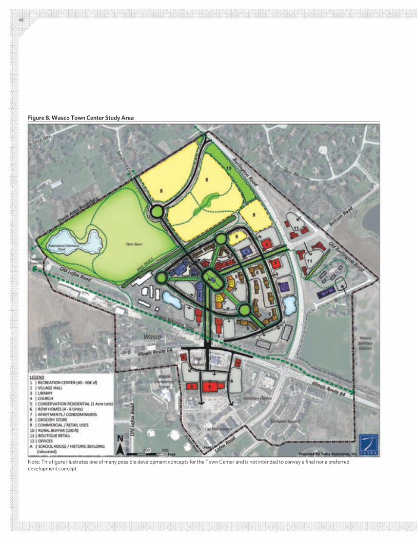
48
Figure 8. Wasco Town Center Study Area
Note: This figure illustrates one of many possible development concepts for the Town Center and is not intended to convey a final nor a preferred development concept.
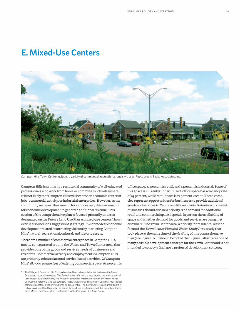
49PRINCIPLES, POLICIES, AND STRATEGIES
7. The Village of Campton Hills Comprehensive Plan makes a distinction between the Town Center and mixed-use centers. The Town Center refers to the area around the intersection of LaFox Road, Burlington Road, and Route 64 extending west to the hamlet of Wasco. Mixed Use Centers refer to a land use category that is characterized by a mix of uses that may include commercial, retail, office, institutional, and residential. The Town Center is designated on the Future Land Use Plan (Figure 12) as one of three Mixed Use Centers, but it is the only of these three Mixed Use Centers that is referred to as the Campton Hills Town Center.
Campton Hills Town Center includes a variety of commercial, recreational, and civic uses. Photo credit: Teska Associates, Inc.
E. Mixed-Use Centers
Campton Hills is primarily a residential community of well-educated professionals who work from home or commute to jobs elsewhere. It is not likely that Campton Hills will become an economic center of jobs, commercial activity, or industrial enterprises. However, as the community matures, the demand for services may drive a demand for economic development to generate additional revenue. This section of the comprehensive plan is focused primarily on areas designated on the Future Land Use Plan as mixed-use centers7, how-ever, it also includes suggestions (Strategy E6) for modest economic development related to attracting visitors by marketing Campton Hills’ natural, recreational, cultural, and historic assets.
There are a number of commercial enterprises in Campton Hills, mostly concentrated around the Wasco and Town Center area, that provide some of the goods and services needs of businesses and residents. Commercial activity and employment in Campton Hills are primarily oriented around service-based activities. Of Campton Hills’ 287,000 square feet of existing commercial space, 64 percent is
office space, 32 percent is retail, and 4 percent is industrial. Some of this space is currently underutilized: office space has a vacancy rate of 23 percent, while retail space is 17 percent vacant. These vacan-cies represent opportunities for businesses to provide additional goods and services to Campton Hills residents. Retention of current businesses should also be a priority. The demand for additional retail and commercial space depends in part on the availability of space and whether demand for goods and services are being met elsewhere. The Town Center area, a priority for residents, was the focus of the Town Center Plan and Wasco Study Area study that took place at the same time of the drafting of this comprehensive plan (see Figure 8). It should be noted that Figure 8 illustrates one of many possible development concepts for the Town Center and is not intended to convey a final nor a preferred development concept.
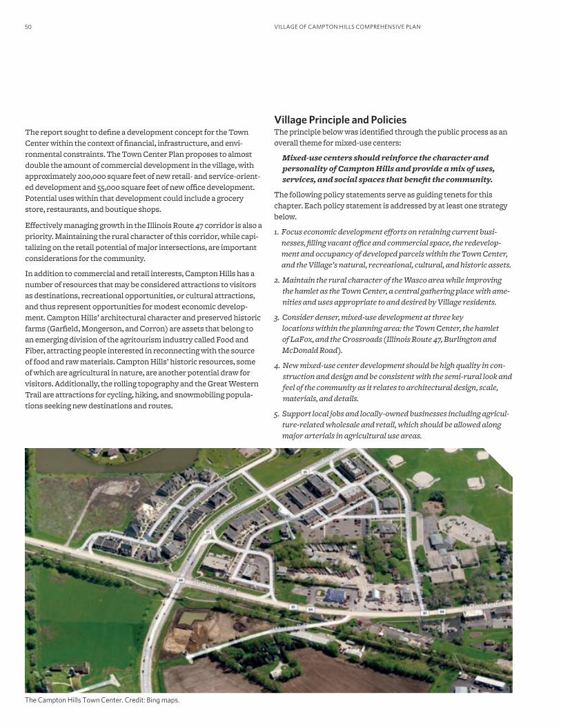
VILLAGE OF CAMPTON HILLS COMPREHENSIVE PLAN50
The report sought to define a development concept for the Town Center within the context of financial, infrastructure, and envi-ronmental constraints. The Town Center Plan proposes to almost double the amount of commercial development in the village, with approximately 200,000 square feet of new retail- and service-orient-ed development and 55,000 square feet of new office development. Potential uses within that development could include a grocery store, restaurants, and boutique shops.
Effectively managing growth in the Illinois Route 47 corridor is also a priority. Maintaining the rural character of this corridor, while capi-talizing on the retail potential of major intersections, are important considerations for the community.
In addition to commercial and retail interests, Campton Hills has a number of resources that may be considered attractions to visitors as destinations, recreational opportunities, or cultural attractions, and thus represent opportunities for modest economic develop-ment. Campton Hills’ architectural character and preserved historic farms (Garfield, Mongerson, and Corron) are assets that belong to an emerging division of the agritourism industry called Food and Fiber, attracting people interested in reconnecting with the source of food and raw materials. Campton Hills’ historic resources, some of which are agricultural in nature, are another potential draw for visitors. Additionally, the rolling topography and the Great Western Trail are attractions for cycling, hiking, and snowmobiling popula-tions seeking new destinations and routes.
The Campton Hills Town Center. Credit: Bing maps.
Village Principle and PoliciesThe principle below was identified through the public process as an overall theme for mixed-use centers:
Mixed-use centers should reinforce the character and personality of Campton Hills and provide a mix of uses, services, and social spaces that benefit the community.
The following policy statements serve as guiding tenets for this chapter. Each policy statement is addressed by at least one strategy below.
1. Focus economic development efforts on retaining current busi-nesses, filling vacant office and commercial space, the redevelop-ment and occupancy of developed parcels within the Town Center, and the Village’s natural, recreational, cultural, and historic assets.
2. Maintain the rural character of the Wasco area while improving the hamlet as the Town Center, a central gathering place with ame-nities and uses appropriate to and desired by Village residents.
3. Consider denser, mixed-use development at three key locations within the planning area: the Town Center, the hamlet of LaFox, and the Crossroads (Illinois Route 47, Burlington and McDonald Road).
4. New mixed-use center development should be high quality in con-struction and design and be consistent with the semi-rural look and feel of the community as it relates to architectural design, scale, materials, and details.
5. Support local jobs and locally-owned businesses including agricul-ture-related wholesale and retail, which should be allowed along major arterials in agricultural use areas.
51PRINCIPLES, POLICIES, AND STRATEGIES
Proposed StrategiesThe following strategies represent action steps to take toward ad-dressing the principle and policies for mixed-use centers. Further information related to the implementation of these strategies may be found in the Implementation Strategy section.
E1. Permit mixed-use centers in key locations.Future commercial and mixed-use development is proposed per the Future Land Use Plan for three primary areas: the Town Center, the hamlet of LaFox and the Metra station, and the intersection of Illinois Route 47, Burlington Road, and McDonald Road (also see Managed Change section). Providing additional commercial uses in these locations will help to improve residents’ access to goods and services and enhance economic development. Integrating other appropriate uses within these mixed-use centers will help create true mixed-use centers of economic and other activity, similar to the Wasco area. Potential uses for Mixed-Use Centers include retail, commercial, office, institutional (school, government, community, health care), recreational, park, plazas, and residential. The zoning code should be updated to establish the desired characteristics and uses for the three Mixed-Use Centers, as described in Strategy E2. It should be noted that none of the proposed Mixed-Use centers would be developed in isolation. As with most commercial uses, mixed-use centers require a certain density of nearby residents to be successful.
This short-term (0-2 years) strategy supports policies 1, 2, and 3.
E2. Revise and adopt regulations to enable the type of devel-opment proposed in the Town Center Plan.Campton Hills recently finalized the Town Center Plan and Wasco Study Area document, which sets forth a development plan for the Town Center area. The plan includes recommendations related to open space, conservation, and mobility, as well as civic, commercial (retail and office), and residential uses. The proposed uses for the Town Center area are outlined in Table 2. It should be noted that the Town Center Plan and Table 2 present one future scenario for the Town Center and do not represent the Village’s position on the design or characteristics of the Town Center. Changing economic and market conditions may dictate a different development program in the future. For example, Campton Hills may wish to prioritize retail use over office use as a strategy for generating additional rev-enue. The Village should consider integrating flexible space into the development program that could be adapted to uses that are in high demand according to market conditions.
The Town Center Plan focuses on fostering economic development while integrating natural resources and preserving as much open space as possible. As part of the Town Center development strategy, Campton Hills should consider infill and redevelopment of parcels within the general Wasco area. To ensure that Campton Hills at-tracts development that fits the vision of the Town Center Plan, the Village should first create a regulatory climate that is conducive to such development.
The Town Center Plan’s implementation section identifies several next steps to take in terms of regulatory revisions and other actions. The type of mixed-use commercial development that is promoted by the plan is not currently permitted under any of the Village’s zoning districts. Therefore, a new Town Center or mixed-use zoning district should be created that would enable such development. It is possible that this district, if crafted carefully, could apply to all of the identified mixed-use centers per Strategy E1, not just to the Town Center. Also, the Village should adopt and apply a set of design guidelines such as those outlined in the Town Center Plan to devel-opment applications in the Town Center and the two other mixed-use centers. Once these regulatory standards are in place, Campton Hills can begin to pursue appropriate developers.
This mid-term (3-6 years) strategy supports policies 1, 2, 3, and 4.
Table 2. Town Center Plan Proposed Uses
TYPE OF USE AREA/# OF DWELLING UNITS
COMMERCIAL USES
Grocery store 40,000 sq. ft.
Retail/restaurants 138,000 sq. ft.
Boutique retail 30,000 sq. ft.
Office 55,000 sq. ft.
Total 263,000 sq. ft.
CIVIC USES
Recreation Center 40,000 sq. ft.
Village Hall 20,000 sq. ft.
Library 5,000 sq. ft.
Church 10,000 sq. ft.
Open space/rural buffer 40 acres
Total 75,000 sq. ft. + 40 acres open space
RESIDENTIAL USES
Conservation residential 20 dwelling units
Row homes 60 dwelling units
Apartments/condominiums 120 dwelling units
Total 200 dwelling units
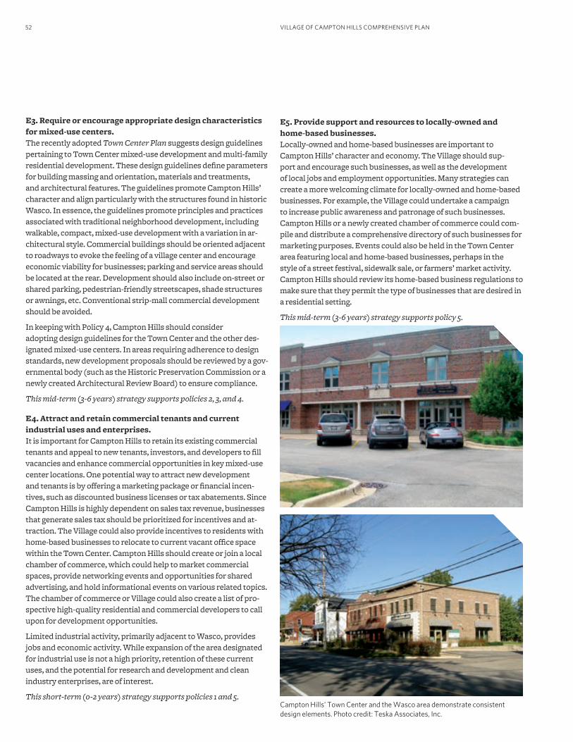
VILLAGE OF CAMPTON HILLS COMPREHENSIVE PLAN52
E3. Require or encourage appropriate design characteristics for mixed-use centers.The recently adopted Town Center Plan suggests design guidelines pertaining to Town Center mixed-use development and multi-family residential development. These design guidelines define parameters for building massing and orientation, materials and treatments, and architectural features. The guidelines promote Campton Hills’ character and align particularly with the structures found in historic Wasco. In essence, the guidelines promote principles and practices associated with traditional neighborhood development, including walkable, compact, mixed-use development with a variation in ar-chitectural style. Commercial buildings should be oriented adjacent to roadways to evoke the feeling of a village center and encourage economic viability for businesses; parking and service areas should be located at the rear. Development should also include on-street or shared parking, pedestrian-friendly streetscapes, shade structures or awnings, etc. Conventional strip-mall commercial development should be avoided.
In keeping with Policy 4, Campton Hills should consider adopting design guidelines for the Town Center and the other des-ignated mixed-use centers. In areas requiring adherence to design standards, new development proposals should be reviewed by a gov-ernmental body (such as the Historic Preservation Commission or a newly created Architectural Review Board) to ensure compliance.
This mid-term (3-6 years) strategy supports policies 2, 3, and 4.
E4. Attract and retain commercial tenants and current industrial uses and enterprises.It is important for Campton Hills to retain its existing commercial tenants and appeal to new tenants, investors, and developers to fill vacancies and enhance commercial opportunities in key mixed-use center locations. One potential way to attract new development and tenants is by offering a marketing package or financial incen-tives, such as discounted business licenses or tax abatements. Since Campton Hills is highly dependent on sales tax revenue, businesses that generate sales tax should be prioritized for incentives and at-traction. The Village could also provide incentives to residents with home-based businesses to relocate to current vacant office space within the Town Center. Campton Hills should create or join a local chamber of commerce, which could help to market commercial spaces, provide networking events and opportunities for shared advertising, and hold informational events on various related topics. The chamber of commerce or Village could also create a list of pro-spective high-quality residential and commercial developers to call upon for development opportunities.
Limited industrial activity, primarily adjacent to Wasco, provides jobs and economic activity. While expansion of the area designated for industrial use is not a high priority, retention of these current uses, and the potential for research and development and clean industry enterprises, are of interest.
This short-term (0-2 years) strategy supports policies 1 and 5. Campton Hills’ Town Center and the Wasco area demonstrate consistent design elements. Photo credit: Teska Associates, Inc.
E5. Provide support and resources to locally-owned and home-based businesses.Locally-owned and home-based businesses are important to Campton Hills’ character and economy. The Village should sup-port and encourage such businesses, as well as the development of local jobs and employment opportunities. Many strategies can create a more welcoming climate for locally-owned and home-based businesses. For example, the Village could undertake a campaign to increase public awareness and patronage of such businesses. Campton Hills or a newly created chamber of commerce could com-pile and distribute a comprehensive directory of such businesses for marketing purposes. Events could also be held in the Town Center area featuring local and home-based businesses, perhaps in the style of a street festival, sidewalk sale, or farmers’ market activity. Campton Hills should review its home-based business regulations to make sure that they permit the type of businesses that are desired in a residential setting.
This mid-term (3-6 years) strategy supports policy 5.
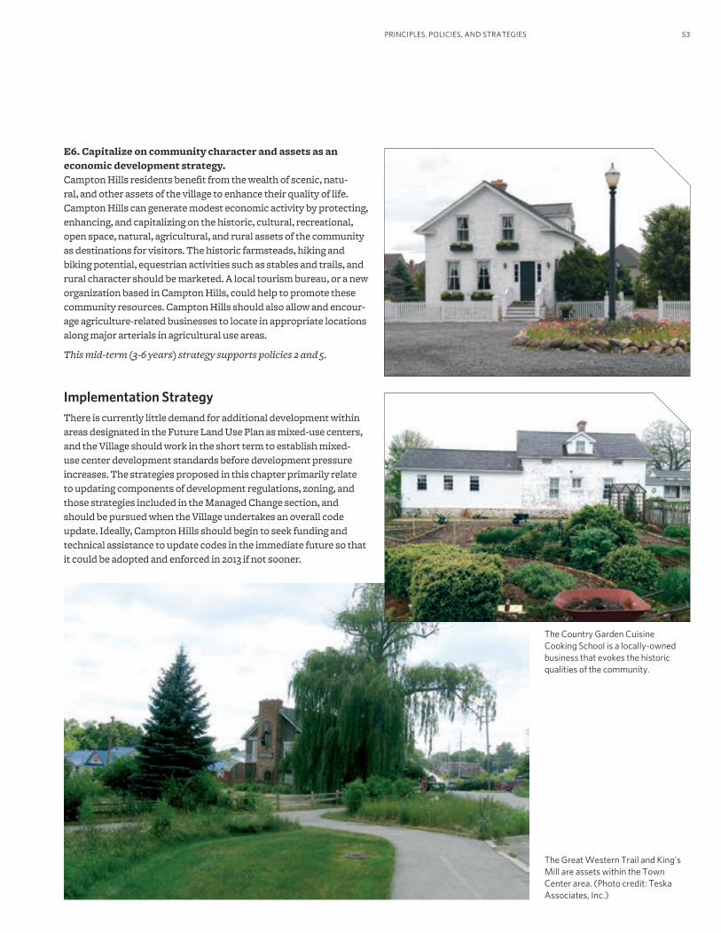
53PRINCIPLES, POLICIES, AND STRATEGIES
The Country Garden Cuisine Cooking School is a locally-owned business that evokes the historic qualities of the community.
E6. Capitalize on community character and assets as an economic development strategy. Campton Hills residents benefit from the wealth of scenic, natu-ral, and other assets of the village to enhance their quality of life. Campton Hills can generate modest economic activity by protecting, enhancing, and capitalizing on the historic, cultural, recreational, open space, natural, agricultural, and rural assets of the community as destinations for visitors. The historic farmsteads, hiking and biking potential, equestrian activities such as stables and trails, and rural character should be marketed. A local tourism bureau, or a new organization based in Campton Hills, could help to promote these community resources. Campton Hills should also allow and encour-age agriculture-related businesses to locate in appropriate locations along major arterials in agricultural use areas.
This mid-term (3-6 years) strategy supports policies 2 and 5.
Implementation StrategyThere is currently little demand for additional development within areas designated in the Future Land Use Plan as mixed-use centers, and the Village should work in the short term to establish mixed-use center development standards before development pressure increases. The strategies proposed in this chapter primarily relate to updating components of development regulations, zoning, and those strategies included in the Managed Change section, and should be pursued when the Village undertakes an overall code update. Ideally, Campton Hills should begin to seek funding and technical assistance to update codes in the immediate future so that it could be adopted and enforced in 2013 if not sooner.
The Great Western Trail and King’s Mill are assets within the Town Center area. (Photo credit: Teska Associates, Inc.)
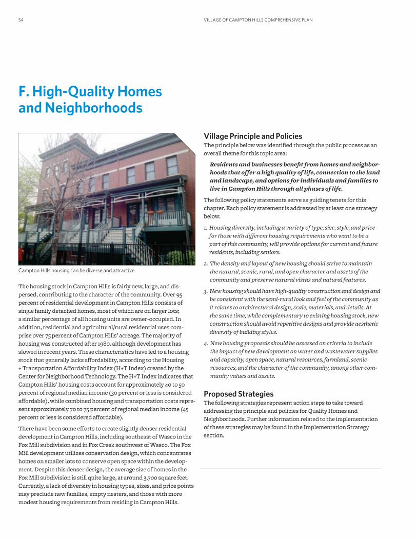
VILLAGE OF CAMPTON HILLS COMPREHENSIVE PLAN54
F. High-Quality Homes and Neighborhoods
Campton Hills housing can be diverse and attractive.
Village Principle and PoliciesThe principle below was identified through the public process as an overall theme for this topic area:
Residents and businesses benefit from homes and neighbor-hoods that offer a high quality of life, connection to the land and landscape, and options for individuals and families to live in Campton Hills through all phases of life.
The following policy statements serve as guiding tenets for this chapter. Each policy statement is addressed by at least one strategy below.
1. Housing diversity, including a variety of type, size, style, and price for those with different housing requirements who want to be a part of this community, will provide options for current and future residents, including seniors.
2. The density and layout of new housing should strive to maintain the natural, scenic, rural, and open character and assets of the community and preserve natural vistas and natural features.
3. New housing should have high-quality construction and design and be consistent with the semi-rural look and feel of the community as it relates to architectural design, scale, materials, and details. At the same time, while complementary to existing housing stock, new construction should avoid repetitive designs and provide aesthetic diversity of building styles.
4. New housing proposals should be assessed on criteria to include the impact of new development on water and wastewater supplies and capacity, open space, natural resources, farmland, scenic resources, and the character of the community, among other com-munity values and assets.
Proposed StrategiesThe following strategies represent action steps to take toward addressing the principle and policies for Quality Homes and Neighborhoods. Further information related to the implementation of these strategies may be found in the Implementation Strategy section.
The housing stock in Campton Hills is fairly new, large, and dis-persed, contributing to the character of the community. Over 95 percent of residential development in Campton Hills consists of single family detached homes, most of which are on larger lots; a similar percentage of all housing units are owner-occupied. In addition, residential and agricultural/rural residential uses com-prise over 75 percent of Campton Hills’ acreage. The majority of housing was constructed after 1980, although development has slowed in recent years. These characteristics have led to a housing stock that generally lacks affordability, according to the Housing + Transportation Affordability Index (H+T Index) created by the Center for Neighborhood Technology. The H+T Index indicates that Campton Hills’ housing costs account for approximately 40 to 50 percent of regional median income (30 percent or less is considered affordable), while combined housing and transportation costs repre-sent approximately 70 to 75 percent of regional median income (45 percent or less is considered affordable).
There have been some efforts to create slightly denser residential development in Campton Hills, including southeast of Wasco in the Fox Mill subdivision and in Fox Creek southwest of Wasco. The Fox Mill development utilizes conservation design, which concentrates homes on smaller lots to conserve open space within the develop-ment. Despite this denser design, the average size of homes in the Fox Mill subdivision is still quite large, at around 3,700 square feet. Currently, a lack of diversity in housing types, sizes, and price points may preclude new families, empty nesters, and those with more modest housing requirements from residing in Campton Hills.
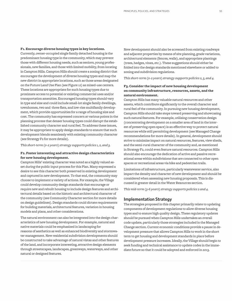
55PRINCIPLES, POLICIES, AND STRATEGIES
F1. Encourage diverse housing types in key locations.Currently, owner-occupied single family detached housing is the predominant housing type in the community, which may prevent those with different housing needs, such as seniors, young profes-sionals, new families, and those with limited mobility, from locating in Campton Hills. Campton Hills should create a zoning district that encourages the development of diverse housing types and map the new district in appropriate locations, such as those areas designated on the Future Land Use Plan (see Figure 12) as mixed-use centers. These locations are appropriate for such housing types due to proximate access to potential or existing commercial uses and/or transportation amenities. Encouraged housing types should vary in type and size and could include small-lot single family dwellings, townhomes, two and three flats, and low-rise multifamily develop-ment, which provide opportunities for a range of housing size and cost. The community has expressed concern at various points in the planning process that denser housing types could disrupt the estab-lished community character and rural feel. To address these issues, it may be appropriate to apply design standards to ensure that such development blends seamlessly with existing community character (see Strategy F2 for more details).
This short-term (0-2 years) strategy supports policies 1, 2, and 3.
F2. Foster interesting and attractive design characteristics for new housing development.Campton Hills’ existing character was noted as a highly valued as-set during the public input process for this Plan. Many expressed a desire to see this character both preserved in existing development and captured in new development. To that end, the community may choose to implement a variety of actions. For example, the Village could develop community design standards that encourage or require new and rebuilt housing to include design features and archi-tectural details based on the historic and architectural character of the community (see Community Character section for more details on design guidelines). Design standards could dictate requirements for building materials, architectural features, variation in housing models and plans, and other considerations.
The natural environment can also be integrated into the design char-acteristics of new housing development. For example, natural and native materials could be emphasized in landscaping for reasons of aesthetics as well as enhanced biodiversity and stormwa-ter management. New residential subdivision developments should be constructed to take advantage of natural vistas and other features of the land, and incorporate interesting, attractive design elements through streetscapes, landscapes, greenways, waterways, and other natural or designed features.
New development should also be screened from existing roadways and adjacent properties by means of site planning, grade variations, architectural elements (fences, walls), and appropriate plantings (trees, hedges, vines, etc.). These suggestions should either be folded into the design standards mentioned elsewhere or added to zoning and subdivision regulations.
This short-term (0-2 years) strategy supports policies 2, 3, and 4.
F3. Consider the impact of new housing development on community infrastructure, resources, assets, and the natural environment.Campton Hills has many valuable natural resources and other assets, which contribute significantly to the overall character and rural feel of the community. In pursuing new housing development, Campton Hills should take steps toward preserving and showcasing such natural features. For example, utilizing conservation design (concentrating development on a smaller area of land in the inter-est of preserving open space) is an effective way to protect natural resources while still permitting development (see Managed Change recommendations for more details). In general, development should strive to minimize impact on natural resources, features, view sheds, and the semi-rural character of the community and, as mentioned in Strategy F2, could even feature natural resources. Campton Hills should also encourage the dedication of active and passive recre-ational areas within subdivisions that are connected to other open spaces or recreational areas via bike and pedestrian trails.
Limitations of infrastructure, particularly wastewater service, also impact the density and character of new development and should be considered when assessing new housing proposals. This is dis-cussed in greater detail in the Water Resources section.
This mid-term (3-6 years) strategy supports policies 2 and 4.
Implementation StrategyThe strategies proposed in this chapter primarily relate to updating components of development regulations to allow diverse housing types and to ensure high quality design. These regulatory updates should be pursued when Campton Hills undertakes an overall code update, particularly those strategies included in the Managed Change section. Current economic conditions provide a pause in de-velopment pressure that allows Campton Hills to work in the short term to get housing and development standards in place before development pressure increases. Ideally, the Village should begin to seek funding and technical assistance to update codes in the imme-diate future so that it could be adopted and enforced in 2013.
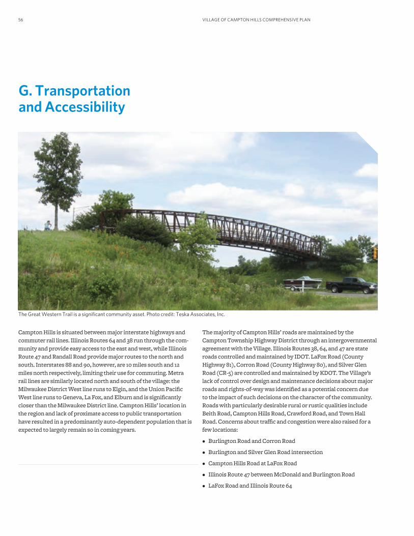
VILLAGE OF CAMPTON HILLS COMPREHENSIVE PLAN56
G. Transportation and Accessibility
The Great Western Trail is a significant community asset. Photo credit: Teska Associates, Inc.
Campton Hills is situated between major interstate highways and commuter rail lines. Illinois Routes 64 and 38 run through the com-munity and provide easy access to the east and west, while Illinois Route 47 and Randall Road provide major routes to the north and south. Interstates 88 and 90, however, are 10 miles south and 12 miles north respectively, limiting their use for commuting. Metra rail lines are similarly located north and south of the village: the Milwaukee District West line runs to Elgin, and the Union Pacific West line runs to Geneva, La Fox, and Elburn and is significantly closer than the Milwaukee District line. Campton Hills’ location in the region and lack of proximate access to public transportation have resulted in a predominantly auto-dependent population that is expected to largely remain so in coming years.
The majority of Campton Hills’ roads are maintained by the Campton Township Highway District through an intergovernmental agreement with the Village. Illinois Routes 38, 64, and 47 are state roads controlled and maintained by IDOT. LaFox Road (County Highway 81), Corron Road (County Highway 80), and Silver Glen Road (CR-5) are controlled and maintained by KDOT. The Village’s lack of control over design and maintenance decisions about major roads and rights-of-way was identified as a potential concern due to the impact of such decisions on the character of the community. Roads with particularly desirable rural or rustic qualities include Beith Road, Campton Hills Road, Crawford Road, and Town Hall Road. Concerns about traffic and congestion were also raised for a few locations:
• Burlington Road and Corron Road
• Burlington and Silver Glen Road intersection
• Campton Hills Road at LaFox Road
• Illinois Route 47 between McDonald and Burlington Road
• LaFox Road and Illinois Route 64
57PRINCIPLES, POLICIES, AND STRATEGIES
During public workshops, 75 percent of participants reported that they primarily drive to work while just five percent reported that they use public transportation or multiple modes of transportation. Transit is unlikely to become a major community asset in the com-munity due to the low residential density and consequent lack of a critical mass of riders to warrant such transit investment. However, there are some transit options for those who live or work in Campton Hills. The Milwaukee District West and Union Pacific West Metra lines are within a reasonable distance of the village, with the LaFox Metra station on the Union Pacific West line being the closest. Additionally, Kane County is considering a future Bus Rapid Transit line on Randall Road, which could have stations at Illinois Route 38, Illinois Route 64, Silver Glen Road, McDonald Road, and/or Bowes Road.
Campton Hills’ scenic countryside and rolling hills contribute to its desirability as a location for cycling and walking for transportation as well as for recreation. The seventeen-mile Great Western Trail runs east-west through the village and is a primary regional trail within the Northeastern Illinois Regional Greenways and Trails Plan system. The Great Western Trail connects Campton Hills and its central commercial area to forest preserves and open spaces and links to Kane County’s Mid-County Trail and the Fox River Trail, both of which are east of the village. Area roadways, most of which are unmarked as cycling routes, are frequently used by cyclists, which may present safety concerns. Additionally, sidewalks are uncommon in most areas of Campton Hills. Pedestrians interested in walking for recreation, exercise, or transportation may have no other option than to walk in the street, which represents an impedi-ment to enhanced walkability. A few issues with biking and walking were identified by workshop participants:
• Biking along Campton Hills Drive, Beith Road, Town Hall Road, and Illinois Route 64 are challenging and dangerous.
• Illinois Route 64 could use a pedestrian crossing sign near the downtown and sidewalks where none exist.
• Better bike access is needed to enter Anderson Park near Brown Road and the Great Western Trail and to link from Campton Hills Road and LaFox Road to the Great Western Trail.
Village Principle and PoliciesThe principle below was identified through the public process as an overall theme for transportation and accessibility:
Village residents should be able to drive, walk, or bike safely and conveniently throughout the community for daily needs and recreation.
The following policy statements serve as guiding tenets for Transportation and Accessibility. Each policy statement is ad-dressed by at least one strategy below.
1. A broad range of accessible transportation options is necessary to enable residents and visitors to easily and safely move within the community, to recreate, to fulfill daily needs, and to connect to area roads, paths and trails. Plans for development will address the most appropriate infrastructure necessary to enhance the connection and the accessibility to transportation options.
2. Preserve the safe and efficient movement of people and vehicles within and through the village while protecting its semi-rural atmosphere and the rural and scenic character of roadways.
3. Minimize the negative impact of current transportation systems, planned transportation improvements, and future land use change on quality of life, community values and assets, and traffic.
4. Transportation improvement projects are opportunities to achieve multiple community goals while infrastructure improve-ments are being made. These may include water management, alternative transportation, landscaping, or scenic improvements.
5. Consider access and connections to transit facilities in future transportation planning.
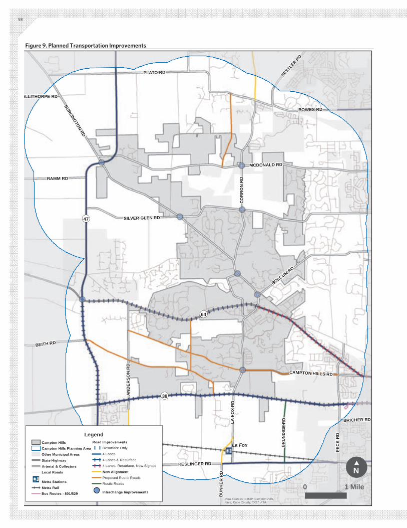
BR
UN
DIG
E R
D
¬«64
¬«47
¬«38
RAN
DA
LL R
D
KESLINGER RD
BURLINGTON RD
MCDONALD RD
SILVER GLEN RD
PEC
K R
D
PLATO RD
BOWES RD
LA F
OX
RD
COR
RO
N R
D
BOLCUM RD
MA
IN S
T
HUGHES RD
AND
ERSO
N R
D
BEITH RD
RAMM RD
FABYAN PKWY
CAMPTON HILLS RD
NESTLER R
D
BUN
KER
RD
BRICHER RD
ELLITHORPE RDIL
-47
La Fox
ElburnLegendCampton HillsCampton Hills Planning Area
Other Municipal Areas
State Highway
Arterial & CollectorsLocal Roads
Æb Metra Stations
Metra RailBus Routes - 801/529
Road ImprovementsResurface Only
4 Lanes
4 Lanes & Resurface
4 Lanes, Resurface, New Signals
New AlignmentProposed Rustic Roads
Rustic Roads
Interchange Improvements
!N
¢
0 1 MileData Sources: CMAP, Campton Hills, Pace, Kane County, IDOT, RTA
58
Figure 9. Planned Transportation Improvements
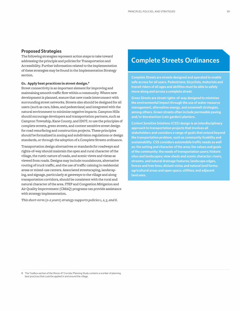
59
8. The Toolbox section of the Illinois 47 Corridor Planning Study contains a number of planning best practices that could be applied in and around the village.
Proposed StrategiesThe following strategies represent action steps to take toward addressing the principle and policies for Transportation and Accessibility. Further information related to the implementation of these strategies may be found in the Implementation Strategy section.
G1. Apply best practices in street design.8 Street connectivity is an important element for improving and maintaining smooth traffic flow within a community. Where new development is planned, ensure that new roads interconnect with surrounding street networks. Streets also should be designed for all users (such as cars, bikes, and pedestrians) and integrated with the natural environment to minimize negative impacts. Campton Hills should encourage developers and transportation partners, such as Campton Township, Kane County, and IDOT, to use the principles of complete streets, green streets, and context sensitive street design for road resurfacing and construction projects. These principles should be formalized in zoning and subdivision regulations or design standards, or through the adoption of a Complete Streets ordinance.
Transportation design alternatives or standards for roadways and rights-of-way should maintain the open and rural character of the village, the rustic nature of roads, and scenic views and vistas as viewed from roads. Designs may include roundabouts, alternative routing of truck traffic, and the use of traffic calming in residential areas or mixed-use centers. Associated streetscaping, landscap-ing, and signage, particularly at gateways to the village and along transportation corridors, should be consistent with the rural and natural character of the area. ITEP and Congestion Mitigation and Air Quality Improvement (CMAQ) programs can provide assistance with strategy implementation.
This short-term (0-2 years) strategy supports policies 1, 2, 5, and 6.
Complete Streets Ordinances
Complete Streets are streets designed and operated to enable safe access for all users. Pedestrians, bicyclists, motorists and transit riders of all ages and abilities must be able to safely move along and across a complete street.
Green Streets are street rights-of-way designed to minimize the environmental impact through the use of water resource management, alternative energy, and snowmelt strategies, among others. Green streets often include permeable paving and/or bioretention (rain garden) planters.
Context Sensitive Solutions (CSS) design is an interdisciplinary approach to transportation projects that involves all stakeholders and considers a range of goals that extend beyond the transportation problem, such as community livability and sustainability. CSS considers automobile traffic needs as well as: the setting and character of the area; the values and goals of the community; the needs of transportation users; historic sites and landscapes; view sheds and scenic character; rivers, streams, and natural drainage features; landscape edges, fences and tree lines; distant vistas and natural land forms; agricultural areas and open space; utilities; and adjacent land uses.
PRINCIPLES, POLICIES, AND STRATEGIES
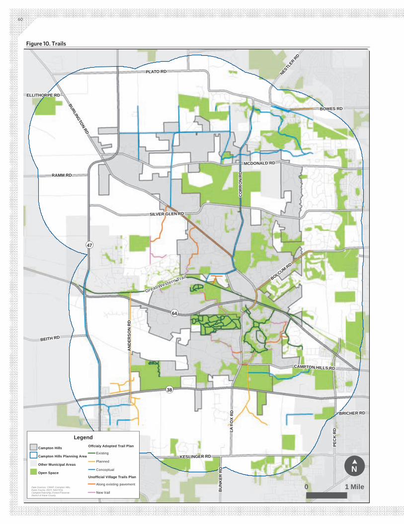
KESLINGER RD
BURLINGTON RD
MCDONALD RD
SILVER GLEN RD
PEC
K R
D
PLATO RD
BOWES RD
LA F
OX
RD
CO
RR
ON
RD
BOLCUM RD
AN
DER
SON
RD
BEITH RD
RAMM RD
CAMPTON HILLS RD
NESTLER R
D
BU
NK
ER R
D
BRICHER RD
ELLITHORPE RDIL
-47
¬«64
¬«47
¬«38
Legend
Campton Hills
Campton Hills Planning Area
Other Municipal Areas
Open Space
Offcialy Adopted Trail Plan
Existing
Planned
Conceptual
Unofficial Village Trails Plan
Along existing pavement
New trailData Sources: CMAP, Campton Hills, Kane County, IDOT, NAVTEQ, CamptonTownship, Forest Preserve-District of Kane County
Great Western Trail
!N
¢
0 1 Mile
60
Figure 10. Trails
61PRINCIPLES, POLICIES, AND STRATEGIES
G2. Work closely with transportation agencies to ensure the transportation system is supportive of the goals and long-range vision of the community. Transportation facilities greatly impact the character and qual-ity of life of the community. In many instances, the Campton Hills has limited control over the types of modifications that are made in the public right-of-way. It is important to have a clear vision for key roadways and to work with partner transportation agencies to ensure that the vision is clearly expressed when roadway improve-ments are proposed by the Township, County, or State. Planned transportation improvements are shown in Figure 9. At a minimum, specific corridors requiring particular attention during planning for improvements include:
• Illinois Route 64 from approximately Randall Road to LaFox / Burlington Road;
• Illinois Route 64 from approximately LaFox / Burlington Road to Illinois Route 47;
• Illinois Route 38 from approximately Randall Road to Illinois Route 47; and
• Illinois Route 47 from Illinois Route 38 to Plato Road.
The Village should continue to work with the State, County, and Township departments of transportation to create a road system that serves the interests of all users and the community. It is par-ticularly important for Campton Hills to work closely with IDOT to minimize the impact of a widened and/or improved Illinois Route 64 through the Wasco area on the character and mobility of the Town Center and the hamlet of Wasco. Expansion of Illinois Route 64 to four lanes between Hidden Oaks Road and Brown Road is inconsis-tent with the future vision and goals, and the village wishes to mini-mize the adverse impact of any widening of Illinois Route 64 west of Burlington Road.
This ongoing strategy supports policies 2 and 5.
G3. Create and implement a non-motorized transportation plan.Non-motorized transportation options, such as bicycling, walking, and horseback riding, are desired by the community. Existing and planned bicycle and trail facilities in and around the village are in-cluded in an unofficial Village of Campton Hills Trails Plan and three officially adopted plans: the Kane and Northern Kendall Counties Bicycle Map, the Forest Preserve District of Kane County Forest Preserves Map, and the Northeastern Illinois Regional Greenways and Trails Plan, all of which include the Great Western Trail that runs through Campton Hills. Existing and recommended bicycle and trail routes from these four plans within the village planning area are identified in Figure 10. This should form the foundation of an official non-motorized transportation plan (or at minimum an adopted trails map) that identifies on- and off-road bicycle routes, multi-use trails, and other amenities. Routes should consider connecting, at a minimum, destinations and neighborhoods, the Great Western Trail, the LaFox Metra station, Campton Hills properties and facilities, and
the Town Center with planned and existing trails and destinations in and around the village. New transportation projects, subdivisions, and commercial / Town Center development should be strongly encouraged to include pedestrian, equestrian, and bicycle trails, fa-cilities, and design considerations. Bicycling facilities should also be coordinated with bicycle plans and road improvement plans at the state, county, and township levels. All transportation improvements should ensure the safety of all users.
Campton Hills should pursue funding to construct trails and other non-motorized transportation facilities, such as through ITEP, CMAQ, Recreational Trails, and the Illinois Trails Grant Program (ITGP). Additional resources are included in Funding and Information Resources.
This short-term (0-2 years) strategy supports policies 1, 2, 3, and 6.
G4. Improve public safety and walkability through transpor-tation improvements.As mentioned in the introduction of this chapter, sidewalks are not prevalent in most areas of Campton Hills, which often leads pedestrians to walk in the street, if they walk at all. The lack of sidewalk facilities results in a less than welcoming environment for walking and also leads to safety concerns, as pedestrians are more likely to come into contact with automobiles. Campton Hills should prioritize public safety for those moving throughout the commu-nity regardless of the mode of transportation. For automobiles, this should include continuing to establish speed limits, sight lines, and traffic signals where appropriate. For pedestrians, sidewalks and crosswalks should be integrated into new residential development, in and around new mixed-use centers, and particularly sidewalks should be prioritized for areas in and around Wasco and the Town Center. Campton Hills should seek to minimize the number of curb cuts along major arterials to limit the potential for pedestrian-ve-hicle conflicts. The Village should consider funding pedestrian and
The Great Western Trail is a critical element of the regional trail network. Photo credit: Teska Associates, Inc.
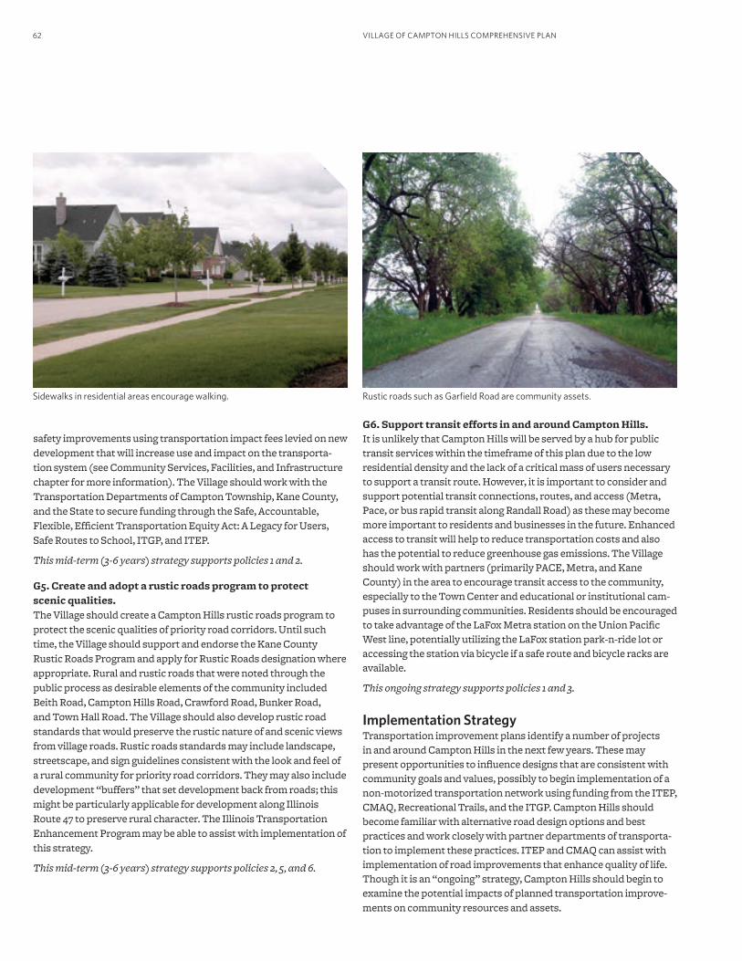
VILLAGE OF CAMPTON HILLS COMPREHENSIVE PLAN62
safety improvements using transportation impact fees levied on new development that will increase use and impact on the transporta-tion system (see Community Services, Facilities, and Infrastructure chapter for more information). The Village should work with the Transportation Departments of Campton Township, Kane County, and the State to secure funding through the Safe, Accountable, Flexible, Efficient Transportation Equity Act: A Legacy for Users, Safe Routes to School, ITGP, and ITEP.
This mid-term (3-6 years) strategy supports policies 1 and 2.
G5. Create and adopt a rustic roads program to protect scenic qualities.The Village should create a Campton Hills rustic roads program to protect the scenic qualities of priority road corridors. Until such time, the Village should support and endorse the Kane County Rustic Roads Program and apply for Rustic Roads designation where appropriate. Rural and rustic roads that were noted through the public process as desirable elements of the community included Beith Road, Campton Hills Road, Crawford Road, Bunker Road, and Town Hall Road. The Village should also develop rustic road standards that would preserve the rustic nature of and scenic views from village roads. Rustic roads standards may include landscape, streetscape, and sign guidelines consistent with the look and feel of a rural community for priority road corridors. They may also include development “buffers” that set development back from roads; this might be particularly applicable for development along Illinois Route 47 to preserve rural character. The Illinois Transportation Enhancement Program may be able to assist with implementation of this strategy.
This mid-term (3-6 years) strategy supports policies 2, 5, and 6.
Sidewalks in residential areas encourage walking.
G6. Support transit efforts in and around Campton Hills.It is unlikely that Campton Hills will be served by a hub for public transit services within the timeframe of this plan due to the low residential density and the lack of a critical mass of users necessary to support a transit route. However, it is important to consider and support potential transit connections, routes, and access (Metra, Pace, or bus rapid transit along Randall Road) as these may become more important to residents and businesses in the future. Enhanced access to transit will help to reduce transportation costs and also has the potential to reduce greenhouse gas emissions. The Village should work with partners (primarily PACE, Metra, and Kane County) in the area to encourage transit access to the community, especially to the Town Center and educational or institutional cam-puses in surrounding communities. Residents should be encouraged to take advantage of the LaFox Metra station on the Union Pacific West line, potentially utilizing the LaFox station park-n-ride lot or accessing the station via bicycle if a safe route and bicycle racks are available.
This ongoing strategy supports policies 1 and 3.
Implementation StrategyTransportation improvement plans identify a number of projects in and around Campton Hills in the next few years. These may present opportunities to influence designs that are consistent with community goals and values, possibly to begin implementation of a non-motorized transportation network using funding from the ITEP, CMAQ, Recreational Trails, and the ITGP. Campton Hills should become familiar with alternative road design options and best practices and work closely with partner departments of transporta-tion to implement these practices. ITEP and CMAQ can assist with implementation of road improvements that enhance quality of life. Though it is an “ongoing” strategy, Campton Hills should begin to examine the potential impacts of planned transportation improve-ments on community resources and assets.
Rustic roads such as Garfield Road are community assets.
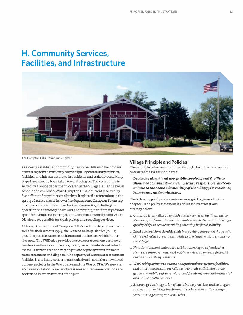
63PRINCIPLES, POLICIES, AND STRATEGIES
The Campton Hills Community Center.
H. Community Services, Facilities, and Infrastructure
As a newly established community, Campton Hills is in the process of defining how to efficiently provide quality community services, facilities, and infrastructure to its residents and stakeholders. Many steps have already been taken toward doing so. The community is served by a police department located in the Village Hall, and several schools and churches. While Campton Hills is currently served by five different fire protection districts, it rejected a referendum in the spring of 2011 to create its own fire department. Campton Township provides a number of services for the community, including the operation of a cemetery board and a community center that provides space for events and meetings. The Campton Township Solid Waste District is responsible for trash pickup and recycling services.
Although the majority of Campton Hills’ residents depend on private wells for their water supply, the Wasco Sanitary District (WSD) provides potable water to residents and businesses within its ser-vice area. The WSD also provides wastewater treatment service to residents within its service area, though most residents outside of the WSD service area and rely on private septic systems for waste-water treatment and disposal. The capacity of wastewater treatment facilities is a primary concern, particularly as it considers new devel-opment projects in the Wasco area and the Wasco FPA. Wastewater and transportation infrastructure issues and recommendations are addressed in other sections of the plan.
Village Principle and PoliciesThe principle below was identified through the public process as an overall theme for this topic area:
Decisions about land use, public services, and facilities should be community-driven, fiscally responsible, and con-tribute to the economic stability of the Village, its residents, businesses, and institutions.
The following policy statements serve as guiding tenets for this chapter. Each policy statement is addressed by at least one strategy below.
1. Campton Hills will provide high quality services, facilities, infra-structure, and amenities desired and/or needed to maintain a high quality of life to residents while protecting its fiscal stability.
2. Land use decisions should result in a positive impact on the quality of life and values of residents while protecting the fiscal stability of the Village.
3. New development endeavors will be encouraged to fund infra-structure improvements and public services to prevent financial burden on existing residents.
4. Work with partners to ensure adequate infrastructure, facilities, and other resources are available to provide satisfactory emer-gency and public safety services, and freedom from environmental and public health hazards.
5. Encourage the integration of sustainable practices and strategies into new and existing development, such as alternative energy,
water management, and dark skies.
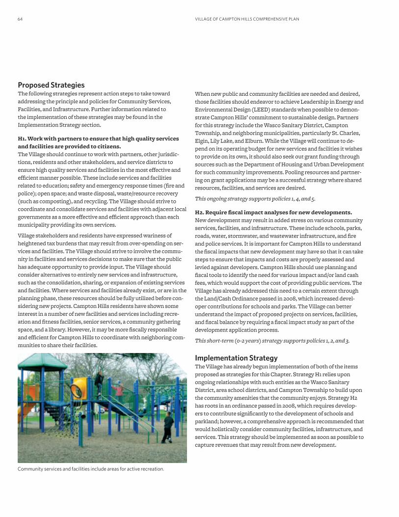
VILLAGE OF CAMPTON HILLS COMPREHENSIVE PLAN64
Proposed StrategiesThe following strategies represent action steps to take toward addressing the principle and policies for Community Services, Facilities, and Infrastructure. Further information related to the implementation of these strategies may be found in the Implementation Strategy section.
H1. Work with partners to ensure that high quality services and facilities are provided to citizens.The Village should continue to work with partners, other jurisdic-tions, residents and other stakeholders, and service districts to ensure high quality services and facilities in the most effective and efficient manner possible. These include services and facilities related to education; safety and emergency response times (fire and police); open space; and waste disposal, waste/resource recovery (such as composting), and recycling. The Village should strive to coordinate and consolidate services and facilities with adjacent local governments as a more effective and efficient approach than each municipality providing its own services.
Village stakeholders and residents have expressed wariness of heightened tax burdens that may result from over-spending on ser-vices and facilities. The Village should strive to involve the commu-nity in facilities and services decisions to make sure that the public has adequate opportunity to provide input. The Village should consider alternatives to entirely new services and infrastructure, such as the consolidation, sharing, or expansion of existing services and facilities. Where services and facilities already exist, or are in the planning phase, these resources should be fully utilized before con-sidering new projects. Campton Hills residents have shown some interest in a number of new facilities and services including recre-ation and fitness facilities, senior services, a community gathering space, and a library. However, it may be more fiscally responsible and efficient for Campton Hills to coordinate with neighboring com-munities to share their facilities.
Community services and facilities include areas for active recreation.
When new public and community facilities are needed and desired, those facilities should endeavor to achieve Leadership in Energy and Environmental Design (LEED) standards when possible to demon-strate Campton Hills’ commitment to sustainable design. Partners for this strategy include the Wasco Sanitary District, Campton Township, and neighboring municipalities, particularly St. Charles, Elgin, Lily Lake, and Elburn. While the Village will continue to de-pend on its operating budget for new services and facilities it wishes to provide on its own, it should also seek out grant funding through sources such as the Department of Housing and Urban Development for such community improvements. Pooling resources and partner-ing on grant applications may be a successful strategy where shared resources, facilities, and services are desired.
This ongoing strategy supports policies 1, 4, and 5.
H2. Require fiscal impact analyses for new developments.New development may result in added stress on various community services, facilities, and infrastructure. These include schools, parks, roads, water, stormwater, and wastewater infrastructure, and fire and police services. It is important for Campton Hills to understand the fiscal impacts that new development may have so that it can take steps to ensure that impacts and costs are properly assessed and levied against developers. Campton Hills should use planning and fiscal tools to identify the need for various impact and/or land cash fees, which would support the cost of providing public services. The Village has already addressed this need to a certain extent through the Land/Cash Ordinance passed in 2008, which increased devel-oper contributions for schools and parks. The Village can better understand the impact of proposed projects on services, facilities, and fiscal balance by requiring a fiscal impact study as part of the development application process.
This short-term (0-2 years) strategy supports policies 1, 2, and 3.
Implementation StrategyThe Village has already begun implementation of both of the items proposed as strategies for this Chapter. Strategy H1 relies upon ongoing relationships with such entities as the Wasco Sanitary District, area school districts, and Campton Township to build upon the community amenities that the community enjoys. Strategy H2 has roots in an ordinance passed in 2008, which requires develop-ers to contribute significantly to the development of schools and parkland; however, a comprehensive approach is recommended that would holistically consider community facilities, infrastructure, and services. This strategy should be implemented as soon as possible to capture revenues that may result from new development.
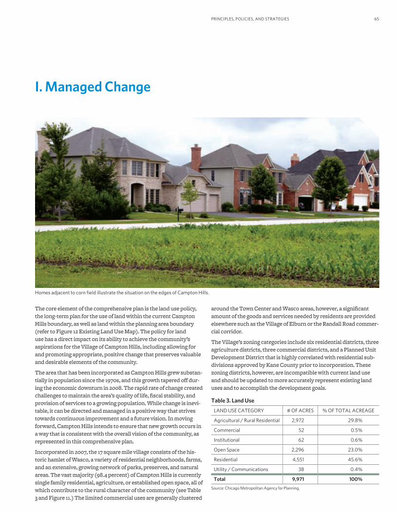
65
I. Managed Change
PRINCIPLES, POLICIES, AND STRATEGIES
around the Town Center and Wasco areas, however, a significant amount of the goods and services needed by residents are provided elsewhere such as the Village of Elburn or the Randall Road commer-cial corridor.
The Village’s zoning categories include six residential districts, three agriculture districts, three commercial districts, and a Planned Unit Development District that is highly correlated with residential sub-divisions approved by Kane County prior to incorporation. These zoning districts, however, are incompatible with current land use and should be updated to more accurately represent existing land uses and to accomplish the development goals.
Table 3. Land Use
LAND USE CATEGORY # OF ACRES % OF TOTAL ACREAGE
Agricultural / Rural Residential 2,972 29.8%
Commercial 52 0.5%
Institutional 62 0.6%
Open Space 2,296 23.0%
Residential 4,551 45.6%
Utility / Communications 38 0.4%
Total 9,971 100%
Source: Chicago Metropolitan Agency for Planning.
The core element of the comprehensive plan is the land use policy, the long-term plan for the use of land within the current Campton Hills boundary, as well as land within the planning area boundary (refer to Figure 12 Existing Land Use Map). The policy for land use has a direct impact on its ability to achieve the community’s aspirations for the Village of Campton Hills, including allowing for and promoting appropriate, positive change that preserves valuable and desirable elements of the community.
The area that has been incorporated as Campton Hills grew substan-tially in population since the 1970s, and this growth tapered off dur-ing the economic downturn in 2008. The rapid rate of change created challenges to maintain the area’s quality of life, fiscal stability, and provision of services to a growing population. While change is inevi-table, it can be directed and managed in a positive way that strives towards continuous improvement and a future vision. In moving forward, Campton Hills intends to ensure that new growth occurs in a way that is consistent with the overall vision of the community, as represented in this comprehensive plan.
Incorporated in 2007, the 17 square mile village consists of the his-toric hamlet of Wasco, a variety of residential neighborhoods, farms, and an extensive, growing network of parks, preserves, and natural areas. The vast majority (98.4 percent) of Campton Hills is currently single family residential, agriculture, or established open space, all of which contribute to the rural character of the community (see Table 3 and Figure 11.) The limited commercial uses are generally clustered
Homes adjacent to corn field illustrate the situation on the edges of Campton Hills.
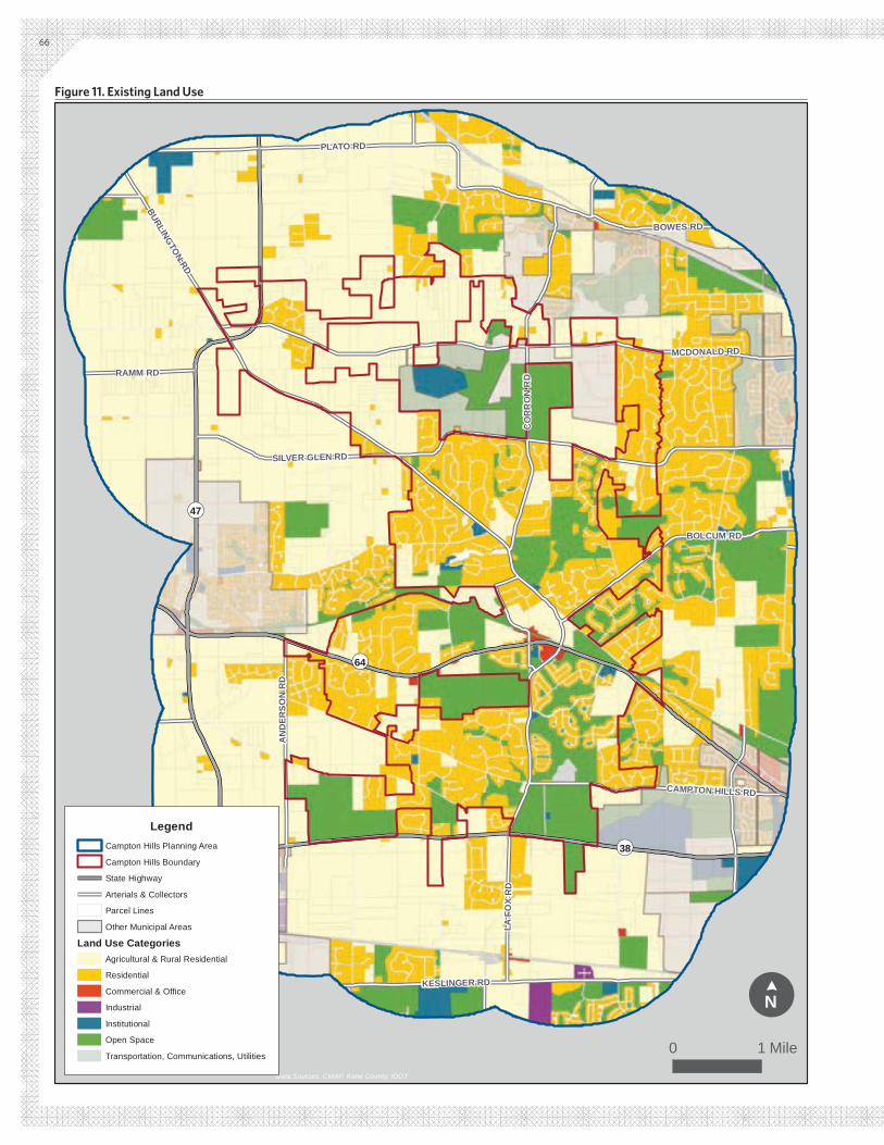
¬«64
¬«47
¬«38
KESLINGER RD
BURLINGTON RD
MCDONALD RD
SILVER GLEN RD
PLATO RD
BOWES RD
DR X
OF AL
DR
NO
RR
OC
BOLCUM RD
DR
NOS
RED
NA
RAMM RD
CAMPTON HILLS RD
Data Sources: CMAP, Kane County, IDOT
LegendCampton Hills Planning Area
Campton Hills Boundary
State Highway
Arterials & Collectors
Parcel Lines
Other Municipal Areas
Land Use CategoriesAgricultural & Rural Residential
Residential
Commercial & Office
Industrial
Institutional
Open Space
Transportation, Communications, Utilities
!N
¢
0 1 Mile
66
Figure 11. Existing Land Use
67PRINCIPLES, POLICIES, AND STRATEGIES
9. The green infrastructure designations are based on large-scale GIS (Geographic Information Systems) data from Kane County and other sources and represent the general location of regulated and valuable resources. Due to its general nature, however, it should be used as general guidance for the location of these resources and more detailed, site-specific analysis should be conducted as part of land use changes, transportation improvement, or development proposals.
Village Principle and PoliciesThe principle below was identified through the public process as an overall theme for this topic area:
Positive, community-driven change can result from proactive policies aligned with the community vision and principles.
The following policy statements serve as guiding tenets for Managed Change and guiding land use decision-making in Campton Hills. Each policy statement is addressed by at least one strategy below.
1. The land use types and associated descriptions and requirements established by the community should help to preserve and enhance the values and resources of Campton Hills.
2. The potential growth and development/redevelopment that is represented by the arrangement of various land uses on the Future Land Use Map should be a realistic scenario feasible over the next twenty years, while at the same time reinforcing Campton Hills’ collective vision for the future.
3. Village actions and development decisions should follow a logical, prudent sequence or timing to ensure continuous improvement to the community, and to provide essential services to all village citizens at any point in time.
4. The Village’s development standards, codes, and ordinances should support the stated policies of the comprehensive plan and facilitate implementation and realization of the community’s col-lective vision.
5. Land use and development decisions shall foster economic resil-iency and be made with consideration of the fiscal impact of poten-tial changes; the preservation and enhancement of the economic viability of the Village shall remain a priority.
Proposed StrategiesThe following strategies represent action steps to take toward ad-dressing the principle and policies for Managed Change and land use. Further information related to the implementation of these strategies may be found in the Implementation Strategy section.
I1. Use the Green Infrastructure Plan as a land use planning framework.Campton Hills has adopted a Green Infrastructure Plan that forms a strong foundation for the Future Land Use Map (Figure 12) and policies. The village’s network of parks and open space is one of its most valued and defining features, and properly deployed and managed green infrastructure provides environmental, eco-nomic, and social benefits to village residents. The Future Land Use Map identifies three categories of green infrastructure for the planning area9:
Regulated Green Infrastructure includes land and resources within the planning area that are either protected open space or regulated landscapes (such as wetlands and floodplains) and therefore prevented from development. These areas will remain as open space in perpetuity.
Green Infrastructure Evaluation Zone includes other environ-mentally sensitive areas that are important to the community, primarily groundwater recharge areas and large areas of hydric soils. These areas are intended to protect open space and environ-mentally sensitive resources by requiring appropriate regulatory provisions and development standards be followed when land use changes are proposed.
Ecological Networks, which were not part of the original Green Infrastructure Plan, are primarily corridors along creeks and waterways, significant water drainage routes, and primary and secondary roadways. Ecological networks are intended to provide a fine-grained network of ecological connections beyond that shown in the Green Infrastructure Plan, and to help reinforce the open, natural character of the community. These areas are intended to remain as open space and to preserve valuable landscape features, scenic views, and the rural character of roads. Implementation of the land use policies will require the creation of appropriate regulatory provisions and development standards specific to these areas.
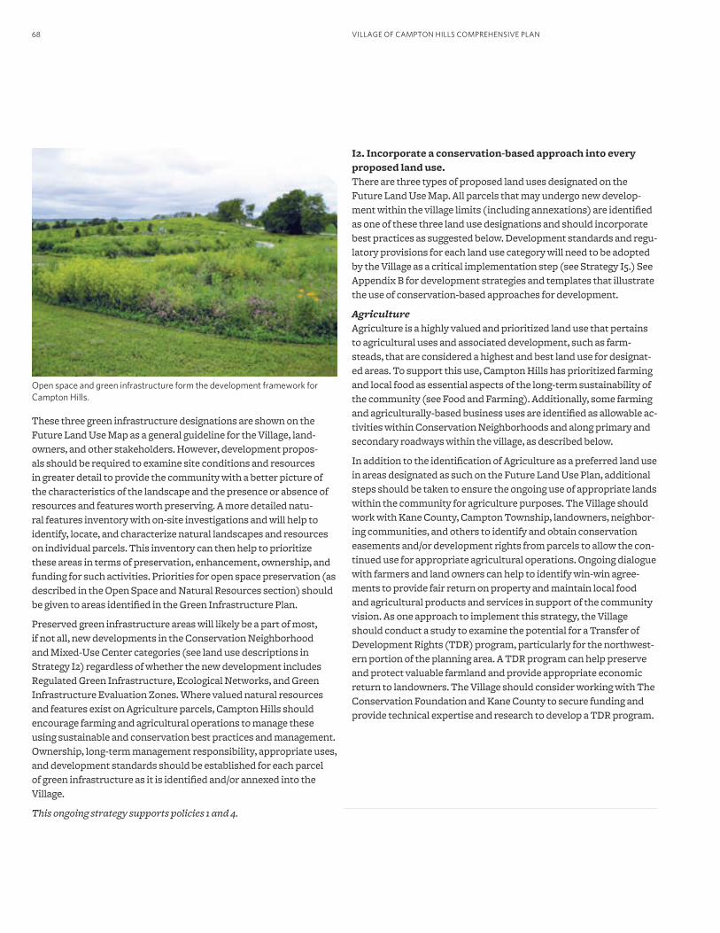
VILLAGE OF CAMPTON HILLS COMPREHENSIVE PLAN68
These three green infrastructure designations are shown on the Future Land Use Map as a general guideline for the Village, land-owners, and other stakeholders. However, development propos-als should be required to examine site conditions and resources in greater detail to provide the community with a better picture of the characteristics of the landscape and the presence or absence of resources and features worth preserving. A more detailed natu-ral features inventory with on-site investigations and will help to identify, locate, and characterize natural landscapes and resources on individual parcels. This inventory can then help to prioritize these areas in terms of preservation, enhancement, ownership, and funding for such activities. Priorities for open space preservation (as described in the Open Space and Natural Resources section) should be given to areas identified in the Green Infrastructure Plan.
Preserved green infrastructure areas will likely be a part of most, if not all, new developments in the Conservation Neighborhood and Mixed-Use Center categories (see land use descriptions in Strategy I2) regardless of whether the new development includes Regulated Green Infrastructure, Ecological Networks, and Green Infrastructure Evaluation Zones. Where valued natural resources and features exist on Agriculture parcels, Campton Hills should encourage farming and agricultural operations to manage these using sustainable and conservation best practices and management. Ownership, long-term management responsibility, appropriate uses, and development standards should be established for each parcel of green infrastructure as it is identified and/or annexed into the Village.
This ongoing strategy supports policies 1 and 4.
Open space and green infrastructure form the development framework for Campton Hills.
I2. Incorporate a conservation-based approach into every proposed land use.There are three types of proposed land uses designated on the Future Land Use Map. All parcels that may undergo new develop-ment within the village limits (including annexations) are identified as one of these three land use designations and should incorporate best practices as suggested below. Development standards and regu-latory provisions for each land use category will need to be adopted by the Village as a critical implementation step (see Strategy I5.) See Appendix B for development strategies and templates that illustrate the use of conservation-based approaches for development.
AgricultureAgriculture is a highly valued and prioritized land use that pertains to agricultural uses and associated development, such as farm-steads, that are considered a highest and best land use for designat-ed areas. To support this use, Campton Hills has prioritized farming and local food as essential aspects of the long-term sustainability of the community (see Food and Farming). Additionally, some farming and agriculturally-based business uses are identified as allowable ac-tivities within Conservation Neighborhoods and along primary and secondary roadways within the village, as described below.
In addition to the identification of Agriculture as a preferred land use in areas designated as such on the Future Land Use Plan, additional steps should be taken to ensure the ongoing use of appropriate lands within the community for agriculture purposes. The Village should work with Kane County, Campton Township, landowners, neighbor-ing communities, and others to identify and obtain conservation easements and/or development rights from parcels to allow the con-tinued use for appropriate agricultural operations. Ongoing dialogue with farmers and land owners can help to identify win-win agree-ments to provide fair return on property and maintain local food and agricultural products and services in support of the community vision. As one approach to implement this strategy, the Village should conduct a study to examine the potential for a Transfer of Development Rights (TDR) program, particularly for the northwest-ern portion of the planning area. A TDR program can help preserve and protect valuable farmland and provide appropriate economic return to landowners. The Village should consider working with The Conservation Foundation and Kane County to secure funding and provide technical expertise and research to develop a TDR program.
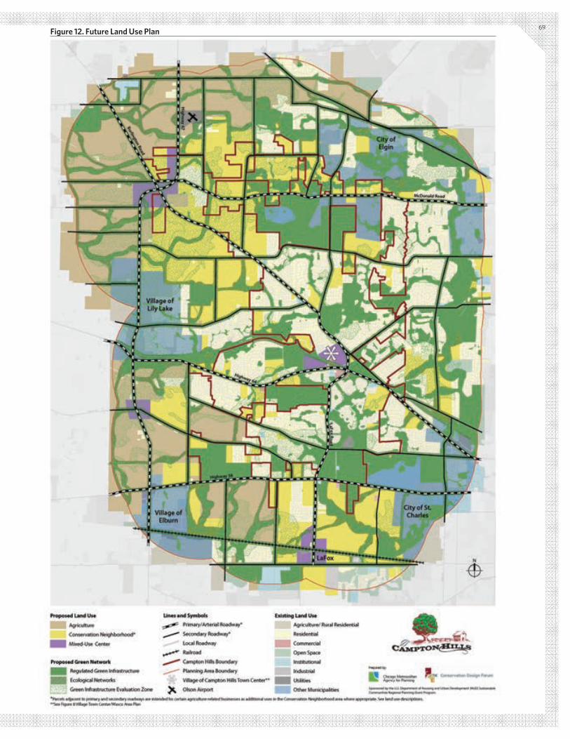
69Figure 12. Future Land Use Plan
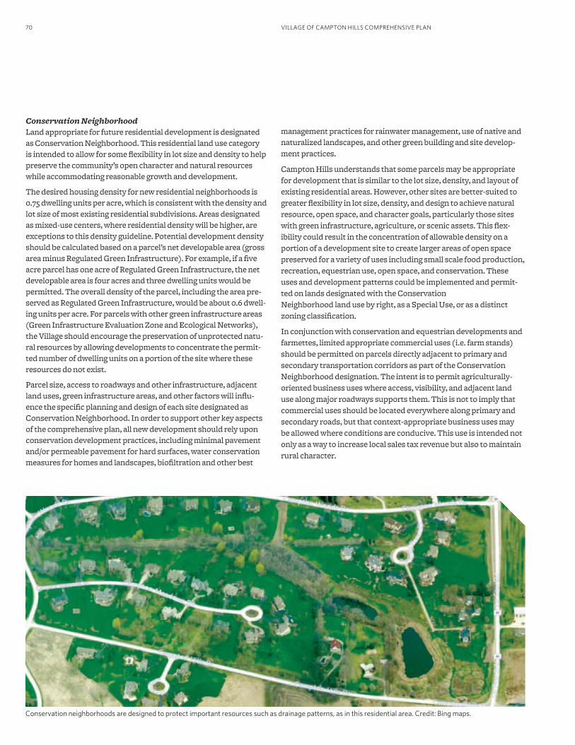
VILLAGE OF CAMPTON HILLS COMPREHENSIVE PLAN70
Conservation Neighborhood Land appropriate for future residential development is designated as Conservation Neighborhood. This residential land use category is intended to allow for some flexibility in lot size and density to help preserve the community’s open character and natural resources while accommodating reasonable growth and development.
The desired housing density for new residential neighborhoods is 0.75 dwelling units per acre, which is consistent with the density and lot size of most existing residential subdivisions. Areas designated as mixed-use centers, where residential density will be higher, are exceptions to this density guideline. Potential development density should be calculated based on a parcel’s net developable area (gross area minus Regulated Green Infrastructure). For example, if a five acre parcel has one acre of Regulated Green Infrastructure, the net developable area is four acres and three dwelling units would be permitted. The overall density of the parcel, including the area pre-served as Regulated Green Infrastructure, would be about 0.6 dwell-ing units per acre. For parcels with other green infrastructure areas (Green Infrastructure Evaluation Zone and Ecological Networks), the Village should encourage the preservation of unprotected natu-ral resources by allowing developments to concentrate the permit-ted number of dwelling units on a portion of the site where these resources do not exist.
Parcel size, access to roadways and other infrastructure, adjacent land uses, green infrastructure areas, and other factors will influ-ence the specific planning and design of each site designated as Conservation Neighborhood. In order to support other key aspects of the comprehensive plan, all new development should rely upon conservation development practices, including minimal pavement and/or permeable pavement for hard surfaces, water conservation measures for homes and landscapes, biofiltration and other best
management practices for rainwater management, use of native and naturalized landscapes, and other green building and site develop-ment practices.
Campton Hills understands that some parcels may be appropriate for development that is similar to the lot size, density, and layout of existing residential areas. However, other sites are better-suited to greater flexibility in lot size, density, and design to achieve natural resource, open space, and character goals, particularly those sites with green infrastructure, agriculture, or scenic assets. This flex-ibility could result in the concentration of allowable density on a portion of a development site to create larger areas of open space preserved for a variety of uses including small scale food production, recreation, equestrian use, open space, and conservation. These uses and development patterns could be implemented and permit-ted on lands designated with the Conservation Neighborhood land use by right, as a Special Use, or as a distinct zoning classification.
In conjunction with conservation and equestrian developments and farmettes, limited appropriate commercial uses (i.e. farm stands) should be permitted on parcels directly adjacent to primary and secondary transportation corridors as part of the Conservation Neighborhood designation. The intent is to permit agriculturally-oriented business uses where access, visibility, and adjacent land use along major roadways supports them. This is not to imply that commercial uses should be located everywhere along primary and secondary roads, but that context-appropriate business uses may be allowed where conditions are conducive. This use is intended not only as a way to increase local sales tax revenue but also to maintain rural character.
Conservation neighborhoods are designed to protect important resources such as drainage patterns, as in this residential area. Credit: Bing maps.
71PRINCIPLES, POLICIES, AND STRATEGIES
CommercialCommercial land uses, which are typically designated for specific ar-eas on land use plans, are not identified on the Future Land Use Plan (Figure 12) for specific areas outside of Mixed-Use Centers. Rather, commercial uses that are appropriate to the existing character and land use context along primary and secondary roads may be allowed in areas designated as future Conservation Neighborhoods, as described above. It is anticipated that these commercial uses will be agriculture-related in nature, many of which are already allowed in the Farming zoning categories, such as produce stands and nurser-ies. The specific uses should be determined as part of Strategy I5.
Mixed-use CentersThree general locations (the Town Center, the LaFox Metra Station, and the Illinois Route 47 intersections with Burlington Road, McDonald Road, and Beith Road) are designated as mixed-use centers that should allow a mix of uses appropriate for each location. Potential uses could include retail, commercial, office, institutional (school, government, community, and health care), recreation, and residential uses (also see Mixed-use Center section policies and strategies). Residential uses within mixed-use centers may include small lot single family homes, row houses, townhouses, and mul-tifamily units that would result in a higher residential density than that anticipated for conservation neighborhoods and for existing residential areas. Mixed-use centers are the primary areas where access to goods and services will be located and are most appropri-ate adjacent to significant transportation facilities and intersec-tions. These areas will offer convenient amenities and services to residents, financial support in the form of sales tax revenue, housing choices for residents of different ages and abilities, and other benefits. This land use is also intended to support local businesses, entrepreneurs, and employment opportunities. The mixed-use cen-ter land use category should be implemented through the creation of appropriate development standards, regulatory provisions, and best practices.
This ongoing strategy supports policies 1, 2, and 4.
I3. Locate, prioritize, and sequence growth in a logical and connected fashion based upon contiguity and existing infrastructure. Locating compact, contiguous development where transportation facilities, infrastructure, utilities, and services already exist is a more efficient, more fiscally responsible, and less impactful form of development than scattered and haphazard development. In order to maximize the utilization and return on investment of community assets, services, and facilities, new development and annexations should prioritize infill development and sites adjacent to current village boundaries over other sites. New annexations and growth should be phased based upon this strategy to maximize the level of service for the least cost to the Village. Pre-annexation agreements with property owners within the planning jurisdiction should be pursued at the appropriate time.
New development should only be permitted and supported at a rate that can be sustained and serviced by existing school, roadway, water, services, and other infrastructure capacities. To ensure an on-going balance of land uses that helps to preserve the fiscal stability of the Village while providing for the needs of residents and land-owners, Campton Hills should consider the potential impact of such change on infrastructure such as traffic and transportation, sewer and water, schools, fiscal balance, natural resources, stormwater management, and other services and facilities. New development that exceeds these capacities should plan for and provide for these services and facilities in a manner approved by the Village. Impact fees or other methods should be considered to ensure that new development pays for infrastructure and service needs of additional population and activity without burdening existing residents and businesses (see Community Services, Facilities, and Infrastructure section). Conservation neighborhood and mixed-use center land uses should be linked to potable water availability and to soil com-patibility, thus avoiding the shared expense of centralized sewer and water systems except where homes and businesses are more con-centrated and shared sewer and water systems have been deemed safe, practical, and appropriate.
This ongoing strategy supports policies 2, 3, and 5.
VILLAGE OF CAMPTON HILLS COMPREHENSIVE PLAN72
I4. Perform additional planning studies where necessary to further the intent of the comprehensive plan.This plan sets forth the foundation and planning framework for the entire village planning area. It is based upon the collective voice of the community participants, staff, appointed and elected officials, and others involved in the process. While its mission and philosophy are clear, it does not provide all of the detail necessary to fully realize the community vision or provide detailed direction to those who will plan, design, engineer, review and approve all new development. Consequently, some areas and projects warrant more detailed sub-area planning analysis, particularly those identified as mixed-use centers.
A detailed planning study should be performed for the area around the Illinois Route 47/Burlington Road intersection that considers the County’s proposed transportation improvements, which cur-rently include the creation of a roundabout to manage traffic moving through the intersection. The Village has already undertaken a detailed planning study for the Town Center that used an open, inclusive community process (see Mixed-use Centers section). Studies should also be performed to more closely examine water recharge areas and water supply, and to better define development parameters and standards in critical aquifer recharge zones.
This mid-term (3-6 year) strategy supports policies 2, 3, and 5.
I5. Update development standards, codes, ordinances, and guidelines to be consistent with the comprehensive plan and vision.Specific regulatory provisions and standards need to be developed as a next step following the adoption of this comprehensive plan to specify site development and building practices consistent with Campton Hills priorities. These updates should cover development criteria for the proposed land use types (agriculture, conservation neighborhood, mixed-use center, as well as commercial enterprises associated with agriculture and conservation neighborhoods) and also ensure that existing development patterns match code provi-sions. This is a significant task that will give clear direction to land owners, developers, and consultants who may be proposing land use changes, and will also provide well-defined criteria for staff and appointed and elected officials to evaluate development proposals. These standards should reinforce all of Campton Hills’ stated priori-ties, including the preservation, incorporation, and showcasing of natural features in development projects. Development standards should reinforce preservation of natural topography, soils, and vege-tation to the degree possible to protect land, water, and soil relation-ships that are essential for sustaining plant and animal habitats, and should include buffers between natural areas and water resources and more intensive development or use (e.g., agriculture) areas. Site design and building standards should reflect and address issues related to existing soil characteristics to avoid problems associated with poor soils and high or perched water tables. Where sites have been previously altered, standards should encourage or require the restoration of natural conditions to the extent possible as appropri-ate for the proposed development plan.
Currently, land use and zoning in the village are not consistent and zoning should be updated to more accurately represent existing land uses and to accomplish development goals. Consolidation of the cur-rent zoning districts should be considered and additional districts may need to be created, such as a mixed-use zoning district and con-servation neighborhood district. The revised code should prescribe the type of development that is desired within each zoning district so that the desired result is achieved through the zoning code alone and not through the planned unit development process.
The use of low impact and sustainable development practices and strategies in new development and re-development is strongly encouraged. Education and information about the benefits and practices for sustainable building and site development should be shared with developers and the public. Numerous tools, guidelines, and resources are currently available to help define and substanti-ate specific codes, including best management practices for water and landscapes, Leadership in Energy and Environmental Design (LEED) rating systems criteria, Sustainable Site Initiative, One Planet Communities, Living Building Challenge, Dark Sky standards, and others.
This short-term (0-2 year) strategy supports policies 1 and 4.
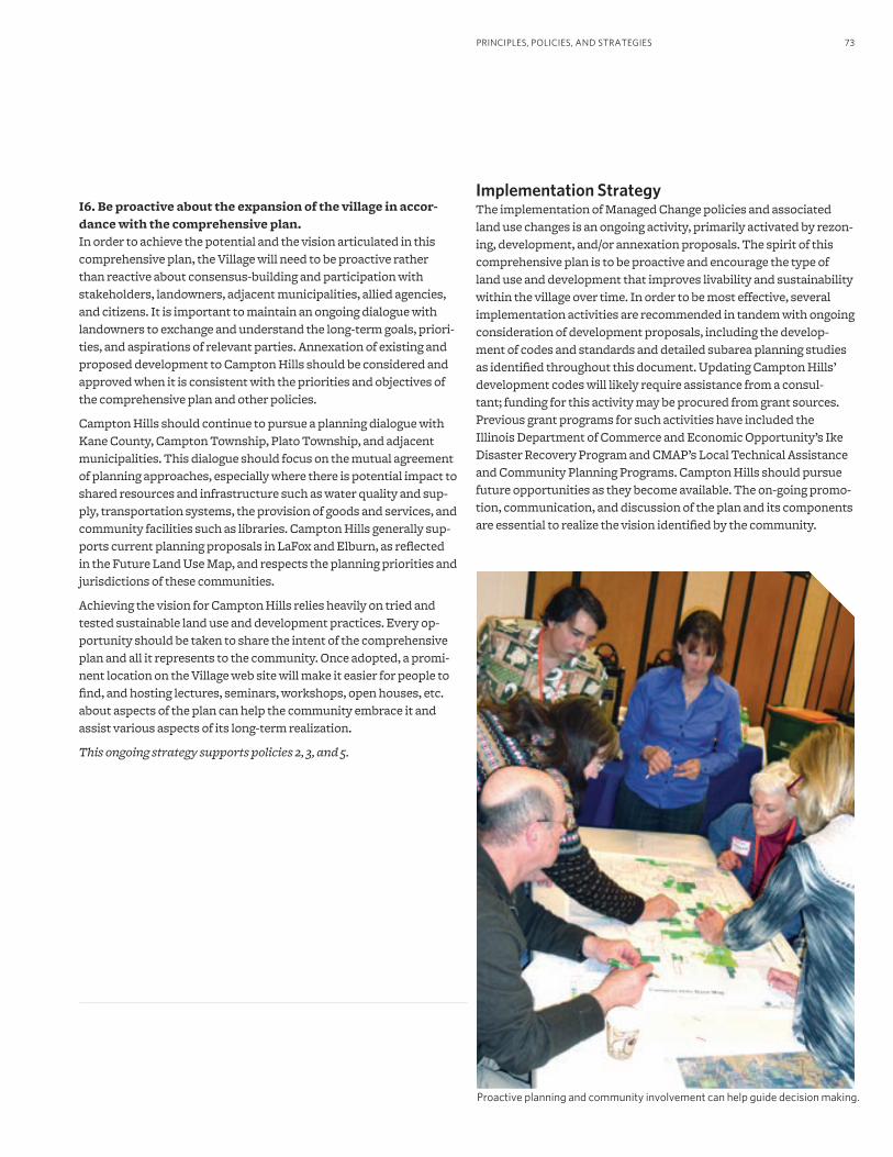
73PRINCIPLES, POLICIES, AND STRATEGIES
Implementation StrategyThe implementation of Managed Change policies and associated land use changes is an ongoing activity, primarily activated by rezon-ing, development, and/or annexation proposals. The spirit of this comprehensive plan is to be proactive and encourage the type of land use and development that improves livability and sustainability within the village over time. In order to be most effective, several implementation activities are recommended in tandem with ongoing consideration of development proposals, including the develop-ment of codes and standards and detailed subarea planning studies as identified throughout this document. Updating Campton Hills’ development codes will likely require assistance from a consul-tant; funding for this activity may be procured from grant sources. Previous grant programs for such activities have included the Illinois Department of Commerce and Economic Opportunity’s Ike Disaster Recovery Program and CMAP’s Local Technical Assistance and Community Planning Programs. Campton Hills should pursue future opportunities as they become available. The on-going promo-tion, communication, and discussion of the plan and its components are essential to realize the vision identified by the community.
I6. Be proactive about the expansion of the village in accor-dance with the comprehensive plan. In order to achieve the potential and the vision articulated in this comprehensive plan, the Village will need to be proactive rather than reactive about consensus-building and participation with stakeholders, landowners, adjacent municipalities, allied agencies, and citizens. It is important to maintain an ongoing dialogue with landowners to exchange and understand the long-term goals, priori-ties, and aspirations of relevant parties. Annexation of existing and proposed development to Campton Hills should be considered and approved when it is consistent with the priorities and objectives of the comprehensive plan and other policies.
Campton Hills should continue to pursue a planning dialogue with Kane County, Campton Township, Plato Township, and adjacent municipalities. This dialogue should focus on the mutual agreement of planning approaches, especially where there is potential impact to shared resources and infrastructure such as water quality and sup-ply, transportation systems, the provision of goods and services, and community facilities such as libraries. Campton Hills generally sup-ports current planning proposals in LaFox and Elburn, as reflected in the Future Land Use Map, and respects the planning priorities and jurisdictions of these communities.
Achieving the vision for Campton Hills relies heavily on tried and tested sustainable land use and development practices. Every op-portunity should be taken to share the intent of the comprehensive plan and all it represents to the community. Once adopted, a promi-nent location on the Village web site will make it easier for people to find, and hosting lectures, seminars, workshops, open houses, etc. about aspects of the plan can help the community embrace it and assist various aspects of its long-term realization.
This ongoing strategy supports policies 2, 3, and 5.
Proactive planning and community involvement can help guide decision making.
VILLAGE OF CAMPTON HILLS COMPREHENSIVE PLAN74
J. Community Health
Related StrategiesThe following strategies relate to improving community health and are drawn from other sections of the plan. Please refer to the refer-enced strategy for additional details and ideas for implementation.
Open Space and Natural ResourcesB1. Protect and manage open space.
B4. Create landscape standards that encourage the use of trees and native landscape elements.
Water ResourcesC2. Manage land use change to protect the village water supply.
C4. Ensure adequate and appropriate wastewater service.
C6. Formalize land management and development practices that protect surface water resources.
Food and FarmingD3. Encourage sustainable agricultural activities and the production
of locally-grown food and other agricultural products.
Mixed-use CentersE1. Permit mixed-use centers in key locations.
High Quality Homes and NeighborhoodsF1. Encourage diverse housing types in key locations.
Transportation and AccessibilityG1. Apply best practices in street design.
G3. Create and implement a non-motorized transportation plan.
G4. Improve public safety and walkability through transportation improvements.
G6. Support transit efforts in and around Campton Hills.
Managed ChangeI1. Use the Green Infrastructure Plan as a land use planning
framework.
Many factors and behaviors affect health including the physical environment, social and economic factors, as well as health care services. In fact, studies find that 60 to 70 percent of an individual’s health status is determined by social and environmental conditions and behavior, compared to health care (10 percent) and genetics (20 to 30 percent.)
Land use and transportation planning are highly correlated with these social, environmental, and behavioral factors. For example, neighborhoods designed to facilitate walking or biking encour-age people to walk or bike to their destinations instead of drive. Conventional land use patterns generally require residents to drive to destinations, and limited or no walking/biking infrastructure ad-ditionally minimizes opportunities for alternative means of travel. This plan recommends strategies whereby Campton Hills’ leader-ship can encourage development that provides amenities for walk-ing and biking. Local polices that increase opportunities for physical activity improve the health of residents and eventually lead to a decrease in chronic diseases related to being overweight or obese. Open space is correlated with better air and water quality and active recreation. Local food production and consumption is correlated with better nutrition as well as a stronger local economy.
Campton Hills is interested in with land use and transportation deci-sions that encourage our social, economic, and built environments to contribute to good health and to encourage behaviors that lead to healthy lives and a high quality of life. Campton Hills supports efforts to improve the overall health of the community and its resi-dents using strategies drawn from other sections of this comprehen-sive plan. The strategies that follow support a number of objectives as they relate to health, including:
• Active living
• Fresh, locally produced food
• A healthy, green environment
• Parks, trails, and open space
• Clean and abundant air, land, and water resources
• Transportation options and designs that support healthy lifestyles
• Land use patterns and community design that support healthy lifestyles

75
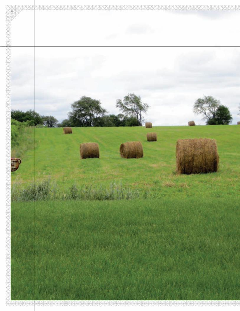
76
77FUNDING AND INFORMATION RESOURCES
Community Character National Register of Historic Places: http://www.nps.gov/nr/
Illinois Historic Preservation Agency (IL HPA): http://www.illinoishistory.gov/ps/community.htm
Kane County Rustic Roads: http://www.co.kane.il.us/roads/brochure.pdf
Kane County 2030 Land Resource Management Plan: http://www.co.kane.il.us/development/2030/issues/historic.pdf
Illinois Transportation Enhancement Program: http://www.dot.il.gov/opp/itep.html
“County, Pingree Grove Reach Historic Agreement.” http://www.countyofkane.org/Pages/Newsletter/2011-05/PinegreeGroveHistoricPreservation.aspx
International Dark-Sky Association: http://www.darksky.org
Open Space, Natural Resources, and Water ResourcesEcological Planning and Design Directory: http://www.chicagowilderness.org/sustainable/directory_documents.php
EPA Water Quality Scorecard: Incorporating Green Infrastructure Practices at the Municipal, Neighborhood, and Site Scale: http://www.epa.gov/smartgrowth/water_scorecard.htm
Fox Valley Land Foundation: http://www.fvlf.org
The Conservation Foundation: http://www.theconservationfoundation.org
Kane County Stormwater Management Plan: http://www.co.kane.il.us/kcstorm/DEV_StormwaterPlan.pdf
Kane County Water Resources Division: http://www.co.kane.il.us/water_resource.asp
Northeastern Illinois Regional Water Supply/Demand Plan and resources: http://www.cmap.illinois.gov/water-2050/
Water Sense: http://www.epa.gov/watersense/
What Our Water’s Worth: http://www.chicagolandh2o.org
Campton Township Well and Septic Information Center: http://camptontownship.com/c_t/Main/wellwater/Well_Water_Main.htm
Chapter 4 Funding and Information Resources
Hydrogeology, Water Use, and Simulated Ground-Water Flow and Availability in Campton Township, Kane County, Illinois, USGS Scientific Investigations Report 2006-5076. http://pubs.usgs.gov/sir/2006/5076/
Training and Technical Assistance for Small Systems grant: http://water.epa.gov/grants_funding/sdwa/smallsystemsrfa.cfm
Illinois Trails Grant Program: http://dnr.state.il.us/ocd/newtrail2.htm
Open Space Lands Acquisition and Development program: http://dnr.state.il.us/ocd/newoslad1.htm
The Catalog of Federal Funding Sources for Watershed Protection: http://cfpub.epa.gov/fedfund/
Source Reduction Assistance Grant Program: http://www.epa.gov/p2/pubs/grants/
EPA Water Grants and Projects: http://water.epa.gov/grants_funding/
Urban Subwatershed Restoration Manual Series: http://www.cwp.org/categoryblog/92-urban-subwatershed-restoration-manual-series.html#Manual 3
Food and Farming Building Communities with Farms: http://www.prairiecrossing.com/libertyprairiefoundation/LPF-Publication9-10.pdf
Kane County Protected Agriculture – Limited Development Concept: http://www.countyofkane.org/Documents/Quality%20of%20Kane/2040%20Plan/agricultureFoodFarm.pdf
Kane County Farmland Protection Program: http://www.countyofkane.org/Documents/Quality%20of%20Kane/commLivability/FarmlandPreservationLocalFoods.pdf and http://www.openlands.org/farmland-protection/your-community/kane-county-illinois.html
American Farmland Trust: http://www.farmland.org
Kane County Farm Bureau: http://www.kanecountyfarmbureau.com
Illinois Department of Agriculture: http://www.agr.state.il.us
Natural Resource Conservation Service: http://www.nrcs.usda.gov/wps/portal/nrcs/main/national/home
VILLAGE OF CAMPTON HILLS COMPREHENSIVE PLAN78
Federal Farm and Ranchlands Program: http://www.nrcs.usda.gov/wps/portal/nrcs/main/national/programs/easements/farmranch
Prairie Crossing: http://www.prairiecrossing.com
Serosun Farms: http://www.serosunfarms.com
Serenbe Community: http://www.serenbecommunity.com
Bundoran Farm: http://www.bundoranfarm.com
Hidden Springs: http://www.hiddensprings.com
South Village: http://www.southvillage.com
Tryon Farm: http://www.tryonfarm.com
Mixed-use Centers, Quality Homes and NeighborhoodsKane County Economic Development Advisory Board: http://www.co.kane.il.us/kcedc/kanecountyed/programs.asp
Illinois Department of Commerce and Economic Opportunity: http://www.ildceo.net/dceo/
Illinois Department of Commerce and Economic Opportunity funding opportunities: http://www.ildceo.net/dceo/Bureaus/Business_Development/Grants/
Illinois Department of Employment Security: www.ides.state.il.us
Federal Economic Development Administration: http://www.eda.gov
The 3/50 Project: http://www.the350project.net/home.html
St. Charles Design Review Standards and Guidelines: http://st-charlesil.gov/sites/default/files/codebook/title-17/t17-ch06.pdf
Transportation and Accessibility Campton Township Highway District: http://www.camptontown-ship.com/main/Highway/H_main_e.htm
Kane County Department of Transportation: http://www.co.kane.il.us/DOT/
Illinois Department of Transportation: http://www.dot.state.il.us
Northeastern Illinois Regional Greenways and Trails Plan: http://www.cmap.illinois.gov/bike-ped/greenways-and-trails
Great Western Trail: http://www.kaneforest.com/recreation/trails/greatWestern.aspx
Complete Streets: http://www.completestreets.org
Green Streets: http://www.lowimpactdevelopment.org/greenstreets/
Context Sensitive Solutions: http://contextsensitivesolutions.org
Kane County Rustic Roads program brochure. http://www.co.kane.il.us/roads/brochure.pdf
Illinois Trails Grant Program: http://dnr.state.il.us/ocd/newtrail2.htm
Illinois Transportation Enhancement Program: http://www.dot.il.gov/opp/itep.html
Illinois 47 Corridor Planning Study: http://www.co.kane.il.us/dot/planning.aspx
Congestion Mitigation and Air Quality Improvement Program: http://www.cmap.illinois.gov/congestion-mitigation-and-air-quality and http://www.fhwa.dot.gov/environment/air_quality/cmaq/
Safe Routes to Schools: http://www.saferoutesinfo.org
Safe, Accountable, Flexible, Efficient Transportation Equity Act: A Legacy for Users: http://www.fhwa.dot.gov/safetealu/summary.htm
Community Services, Facilities, and Infrastructure “Ordinance No. O-08-09: Dedication of Lands for Public and/or Cash Contributions.” Accessed February 28, 2012. http://villageofcamptonhills.org/Ordinances/O-08-09%20Amended%20Land-Cash.pdf
Management Policies in Local Government Finance: www.icma.org
Managed Change Conservation Development Examples
Prairie Crossing: http://www.prairiecrossing.com
Serosun Farms: http://www.serosunfarms.com
Serenbe Community: http://www.serenbecommunity.com
Bundoran Farm: http://www.bundoranfarm.com
Hidden Springs: http://www.hiddensprings.com
South Village: http://www.southvillage.com
Tryon Farm: http://www.tryonfarm.com
Light Imprint Handbook: http://lightimprint.org
Conservation Development in Practice: http://www.chicagowil-derness.org/files/2013/3087/0446/Conservation_Dev_in_Practice.pdf
Transfer of Development Rights resources: http://www.realtor.org/library/library/fg804 ; http://govern-ment.cce.cornell.edu/doc/html/transfer%20of%20develop-ment%20rights%20programs.htm; http://www.farmlandinfo.org/documents/27746/FS_TDR_1-01.pdf
General Data and Funding SourcesKane County 2040 Plan: http://www.co.kane.il.us/development/
MetroPulse (regional indicators and data): http://www.metropulsechicago.org
U.S. EPA Smart Growth publications, tools, grants, and funding: http://www.epa.gov/smartgrowth/index.htm
The Fund Book: http://fundbook.org/available-grants/
Grants.gov: www.grants.gov
Catalog of Federal Domestic Assistance: https://www.cfda.gov
Donor’s Forum: http://www.donorsforum.org
AcronymsADID Advanced Identification Wetlands
CMAP Chicago Metropolitan Agency for Planning
CMAQ Congestion Management and Air Quality Improvement program
CSS Context Sensitive Solutions
FP Farmland Preservation
FPA Facility Planning Area
FEMA Federal Emergency Management Agency
GIS Geographic Information Systems
H+T Index Housing + Transportation Affordability Index
IDNR Illinois Department of Natural Resources
IDOT Illinois Department of Transportation
INHD Illinois Natural Heritage Database
ITEP Illinois Transportation Enhancement Program
ITG Illinois Trails Grant program
KDOT Kane County Department of Transportation
LEED Leadership in Energy and Environmental Design
TDR Transfer of Development Rights
USGS United States Geological Survey
WSD Wasco Sanitary District
Image courtesy of Teska Associates, Inc.
233 South Wacker Drive, Suite 800 Chicago, IL 60606
312 454 0400 [email protected]
www.cmap.illinois.gov
FY12-0147