Embed Size (px)
Citation preview
University of Central Florida University of Central Florida
STARS STARS
Electronic Theses and Dissertations, 2004-2019
2014
The Spatial Relationship Between Labor, Cultural Migration, and The Spatial Relationship Between Labor, Cultural Migration, and
the Development of Folk Music in the American South: A Digital the Development of Folk Music in the American South: A Digital
Visualization Project Visualization Project
Robert Clarke University of Central Florida
Part of the Public History Commons
Find similar works at: https://stars.library.ucf.edu/etd
University of Central Florida Libraries http://library.ucf.edu
This Masters Thesis (Open Access) is brought to you for free and open access by STARS. It has been accepted for
inclusion in Electronic Theses and Dissertations, 2004-2019 by an authorized administrator of STARS. For more
information, please contact [email protected].
STARS Citation STARS Citation Clarke, Robert, "The Spatial Relationship Between Labor, Cultural Migration, and the Development of Folk Music in the American South: A Digital Visualization Project" (2014). Electronic Theses and Dissertations, 2004-2019. 4696. https://stars.library.ucf.edu/etd/4696
THE SPATIAL RELATIONSHIP BETWEEN LABOR, CULTURAL MIGRATION, AND
THE DEVELOPMENT OF FOLK MUSIC IN THE AMERICAN SOUTH: A DIGITAL
VISUALIZATION PROJECT
by
ROBERT L. CLARKE B.A. University of Central Florida, 2011
A thesis submitted in partial fulfillment of the requirements for the degree of Master of Arts
in the Department of History in the College of Arts and Humanities
at the University of Central Florida Orlando, Florida
Spring Term 2014
© 2014 Robert L. Clarke
ii
ABSTRACT
This Digital/Public History visualization thesis project explores how three factors—
Atlantic migration patterns, demographics, and socio-economic systems—influenced the
development of folk music in the southern United States from the 18th century through the 20th
century. A large body of written scholarship exists addressing plantation economies, the slave
trade, and folk music. Digital technology, however, creates new opportunities for analyzing the
geo-temporal aspects contained within the numerous archival resources such as census and
migration records, field recordings, economic data, diaries, and other personal records. The
written portion of the thesis addresses the historiography, research findings, and the process of
creating the visualization product. The digital component employs open-source archives and
MapScholar, a visualization tool developed at the University of Virginia, to reveal the spatial
dimensions of three distinct regions—The greater Chesapeake (Virginia/North Carolina/), the
coastal lowlands and sea islands of the Gullah Corridor (Charleston/Savannah), and Louisiana
(New Orleans). The end result is an educational and potential research tool that affords viewers a
more dynamic perspective on the relationship between agricultural slave labor, migration
patterns, and folk music than is possible with text alone.
iii

For Vickie
iv
ACKNOWLEDGMENTS
Any Master’s thesis is a culmination of years of study, research, and hard work. I am
blessed to have the guidance of some extremely dedicated individuals, without whose expertise
this project would not have been possible. When I decided to return to academic life after many
years to pursue a graduate degree, I was fortunate to have met Professor Carl Creasman at
Valencia College, whose leadership in the classroom continues to inspire me. While at UCF, my
professors were always there to not only teach, but also act as a sounding board for ideas, and to
offer critical advice. It is much appreciated.
I owe a special acknowledgment to my committee members, Drs. Ezekiel Walker, Luis
Martínez-Fernández, and Scot French. Dr. Walker taught me how to become a better writer and
is one of the kindest people I have ever met. Dr. Martínez-Fernández shared his vast knowledge
of Caribbean history, music, and culture and I greatly enjoy our conversations on education and
photography. I also want to thank my committee chair, Dr. French, for all his mentorship
throughout my digital humanities career and guidance while navigating the “promises and perils”
of creating a digital history project.
A number of individuals outside of UCF provided key assistance. Among them were
Aaron Spelbring, Archivist at the Avery Research Center at the College of Charleston, South
Carolina and Grace Morris Cordial, Historical Resources Coordinator at the Beaufort County
Library. Both offered hours of help, providing boxes of records pertaining to Gullah history and
allowing me to make digital copies. A special thanks goes to Bill Ferster and Max Edelson from
the University of Virginia for their guidance while creating the MapScholar site. Bill generously
v

carved time out of his busy schedule for numerous Google Hangout and Skype calls and
provided valuable feedback.
I also wish to acknowledge the debt I owe to my family for all their love and guidance.
My stepson, Freddie, and stepdaughter, Corrine, offered countless words of encouragement. My
sisters, Courtney and Hollis, listened to me rant through my successes and struggles, and my
mother, Sandy, has always shown unconditional love and support for my endeavors. My father,
Robert, who sadly passed away just weeks before my thesis defense, instilled the values of hard
work and service in his family and we are eternally grateful. Finally, to my dear wife, Vickie,
who endured reading every paper I have written, every sleepless night I spent studying, and
whose love and support inspire me to become a better person, I love you.
vi
TABLE OF CONTENTS
LIST OF FIGURES ....................................................................................................................... ix
CHAPTER ONE: INTRODUCTION ............................................................................................. 1
CHAPTER TWO: LITERATURE REVIEW ................................................................................. 4
African Slave Trade ........................................................................................................................................................... 4
The Gullah-Geechee Corridor ...................................................................................................................................... 16
The Chesapeake Region ................................................................................................................................................. 20
Louisiana .............................................................................................................................................................................. 22
Digital Scholarship ........................................................................................................................................................... 23
Spatial Turn ................................................................................................................................................................... 33
CHAPTER THREE: METHODOLOGY ..................................................................................... 36
Background ......................................................................................................................................................................... 36
Process .................................................................................................................................................................................. 39
Ask a Question .............................................................................................................................................................. 39
Search for Information.............................................................................................................................................. 40
Structure the Information ....................................................................................................................................... 45
Envision the Answer .................................................................................................................................................. 48
Represent the Visualization .................................................................................................................................... 49
Tell a Story ..................................................................................................................................................................... 50
CHAPTER FOUR: RESULTS ..................................................................................................... 51
CONCLUSION ............................................................................................................................. 59
Future Research ................................................................................................................................................................ 63
vii

APPENDIX: PERMISSIONS ....................................................................................................... 65
LIST OF REFERENCES .............................................................................................................. 68
viii
LIST OF FIGURES
Figure 1: “The Great Chicago Fire and the Web of Memory,” http://www.greatchicagofire.org/26
Figure 2: “The Valley of the Shadow,” http://valley.lib.virginia.edu/.......................................... 28
Figure 3: The Google Spreadsheet used in creating this project. ................................................. 37
Figure 4: The David Rumsey Map Collection .............................................................................. 41
Figure 5: The Library of Congress "American Memory" homepage ........................................... 42
Figure 6: The SHIVA Interface .................................................................................................... 46
Figure 7: The Google spreadsheet mob fields. ............................................................................. 47
Figure 8: Project Title Page .......................................................................................................... 52
Figure 9: South Carolina Road Map, 1927 ................................................................................... 54
Figure 10: South Carolina Road Map, 1940 ................................................................................. 55
Figure 11: 2005 Beaufort County road map showing extent of development .............................. 56
Figure 12: Population density increase of Beaufort County, 1800-2000...................................... 57
ix
CHAPTER ONE: INTRODUCTION
The goal of this thesis project is to provide fresh perspective regarding the development
of folk music in American South using digital technology. I chose the Chesapeake, Gullah, and
New Orleans areas because each represents a point where various migration patterns and cultural
traditions intersected. The folk music that developed in each one featured distinct characteristics,
in part due to economic systems that influenced demographic patterns. In the tobacco-growing
region of the Chesapeake area, for instance, the slave population experienced a natural growth
rate sooner than in the harsher rice and sugar producing locales.1 This in turn led to changes in
forced migration patterns. Over time, the blending of Scots-Irish fiddle and African banjo
musical traditions produced a mix of folk tunes played by black musicians and adopted by whites
during the eighteenth and nineteenth centuries. During the twentieth century, musicians
incorporated instruments originally brought to the Americas by the Spanish to form bluegrass
music. The lowland coastal areas and sea islands of South Carolina and Georgia, known as the
Gullah Corridor, saw a different pattern emerge as white masters imported Africans with specific
knowledge of rice cultivation. Living in relative isolation on large rice plantations, slaves
developed a body of labor songs, spirituals, “shouts,” and dances. Many cultural survivals
retained during the Middle Passage still resonate in the region today. In New Orleans, where
sugar became the dominant agricultural commodity, French, Spanish, African, and Caribbean
traditions blended to form the unique zydeco and later Jazz traditions. Higher slave mortality
rates than in the Chesapeake or Carolinas led to a constant influx of new arrivals from the
1 Ira Berlin and Philip D. Morgan, Cultivation and Culture: Labor and the Shaping of Slave Life in the Americas (Charlottesville, VA: University of Virginia Press, 1993), 4, 7.
1
Caribbean and Africa. The “intimacy of the races,” as John Blassingame put it, produced a folk
culture that reflected more Caribbean influence than in other Southern areas.2
These trends, while well documented in books and journals, have yet to be presented
together in an interactive visualization. Such a project will offer a new perspective on cultural
development and allow the viewer to interact directly with primary source material. As the ever-
emerging field of Digital Humanities gains increasing acceptance within academia, developers
are creating a wide variety of tools to help scholars access archived resources and visualize
historical arguments over time and space. Recent articles by the National Council on Public
History and the American Historical Association reveal the growing number of software
packages specifically designed for the digital historian.3 Technology conferences such as THAT
Camp (The Humanities and Technology Camp) bring computer programmers, historians,
archivists, and collaborators together to discuss ideas and envision new ways to communicate
outside traditional texts.4 As a result, scholars have many archiving and mapping tools from
which to choose, including Omeka (in conjunction with the Neatline mapping plugin), Arc
Explorer, ArcGIS, Google Maps, Map Hub, and GeoCommons, among many others.5
At the outset of this project, the goal was to build a digital archive of primary source
material within the Omeka platform, then extract the geo-temporal data using the Neatline
mapping plugin, thus creating a visualization that showed the relationship between plantation
2 John W. Blassingame, Black New Orleans, 1860-1880 (Chicago,: University of Chicago Press, 1973), xvi. 3 For an extensive list of software programs and instruction, see Miriam Posner, “How Did They Make That?,” Miriam Posner's Blog, August 29, 2013, http://miriamposner.com/blog/how-did-they-make-that/. (accessed September 11, 2013). 4 http://thatcamp.org/about/ (accessed September 29, 2013) 5 Bamboo DiRT (Digital Research Tools, “Tools,” http://dirt.projectbamboo.org/categories/mapping (accessed August 29, 2013).
2
economies and the culture that formed as a result. Past experience with Omeka suggested this as
a viable option for the end product. As the work progressed, however, it became apparent that
while Omeka is an outstanding industry-standard archive tool used by many universities and
museum professionals for creating repositories, its primary strength lies in the archival features.
The program also requires a level of institutional support outside the scope of this endeavor.
After researching alternatives, the University of Virginia’s new MapScholar platform emerged as
a more effective solution.
MapScholar is a collaborative effort of the SHANTI (Sciences, Humanities, and Arts
Network of Technological Initiatives) Project at the University of Virginia. Developed by Max
Edelson and Bill Ferster, the tool acts as a gateway that brings together primary source material
residing in separate digital archives on the World Wide Web using a spreadsheet, such as Google
Docs. Scholars can create a collection and then present it in an interactive visualization. This
“loose collection of parts,” as Ferster puts it, addresses the institutional support issue of a full
software program such as Omeka. MapScholar resides in the Cloud and runs in any web browser
without the need for special programming. The Methodology chapter of this paper features a full
discussion of this framework while the Results chapter provides screenshots of the completed
digital project, along with explanations of the functionality.
3
CHAPTER TWO: LITERATURE REVIEW
African Slave Trade
Before one can discuss labor and its relationship to the development of folk music, it is
important to understand the forces that brought various cultures together in the Americas and the
major themes in the scholarship. The major debate in the historiography of African Diaspora
began during the middle of the twentieth century and still reverberates today. The core question
scholars grappled with was whether or not the slave trade completely stripped displaced Africans
of their cultural forms, or if not, to what degree were they able to retain any continuity of their
African past during enslavement and eventual emancipation.
At the heart of the controversy were two American scholars, Melville J. Herskovits and E.
Franklin Frazier.6 Herskovits was an anthropologist who began his research during the 1920s at a
time when pseudo-scientific racism, eugenics, and notions of white supremacy were at a peak.
His early work sought to discredit the work of those who used cranial measurements and
physical attributes to create a racial hierarchy based on biological classifications. Using the same
methods as the “scientists,” Herskovits noted that black and mulatto subjects shared many of the
same physical traits, thus it was impossible to clearly categorize a person as belonging to a
distinct biological race. He argued that African-Americans were in reality a mixed population
group made up of varying degrees of black, white, and Indian backgrounds. Instead of race,
Herskovits stressed that what truly defined a person was cultural identity and environment, not
6 Christine Chivallon, The Black Diaspora of the Americas: Experiences and Theories out of the Caribbean (Kingston: Ian Randle Publishers, 2011), 77.
4
genetics. He spent the rest of his career studying African and African-American cultures and
their influence in the Americas.7
In 1941, Herskovits published his seminal work The Myth of the Negro Past, where he
argued there was an enduring African influence on African-American culture. According to
Herskovits, the erroneous view held by whites claimed that black Americans had no distinct past
and thus fueled racial prejudice. This myth consisted of several key components. First, whites
viewed the Negro as a childlike character that easily adapted to unsatisfactory social situations
and happily accepted them. Second, only the inferior Africans were enslaved, while the more
intelligent ones evaded capture. Third, since tribal and language connections were severed during
enslavement, there was no possibility that new forms of communication could have formed.
Lastly, even if slaves were able to retain some of their “savage and low” customs, whites
believed that exposure to European ways would, and did, cause them to yearn for and adopt their
master’s culture. Thus, in the white man’s view, the Negro had no “real” past and should
welcome Western white ways.8
Herskovits rejected these assumptions. He argued that the process of acculturation
contained three components—retention (or survivals), syncretism, and reinterpretation.
Retention referred to those elements of African culture that survived the Middle Passage. During
his field research in West Africa, the Caribbean islands, and North America, Herskovits noted
the similarities of language characteristics, music, religious practices, family structure, and folk
customs, notably in the Gullah region of the South Carolina/Georgia lowlands. This phenomenon
7 Jerry Gershenhorn, Melville J. Herskovits and the Racial Politics of Knowledge (Lincoln, NE: University of Nebraska Press, 2004), 4. 8 Melville J. Herskovits, The Myth of the Negro Past, paperback ed. (Boston: Beacon Press, 1958), 1, 292-298.
5
formulated his view that many “Africanisms” indeed survived the transatlantic journey. Once in
the Americas, syncretism blended African traditions with new elements from the New World.
Reinterpretation occurred when these hybrid customs underwent adaptation and evolution to suit
the needs of successive generations. It also referred to the process by which Africans could take
European customs and redefine them in terms of their African worldview.9 Religion and music
were two key areas where this occurred and subjects that later historians studied in-depth.
E. Franklin Frazier acknowledged that evidence of Herskovits’s theory could be found
outside the United States in places such as the West Indies and parts of South America, where
cultural practices still reflected African roots. Nevertheless, he argued that in the United States,
“African traditions and practices did not take root and survive.” Frazier believed that any
memories of Africa were quickly forgotten during enslavement and any traditions that did
remain, only did so during the first generation. As evidence, he pointed to twentieth-century
black society in the United States, stating, “as regards the Negro family, there is no reliable
evidence that African culture has had any influence on its development.”10 Yet in his footnotes,
he admits that within the Sea Islands (Gullah), that “we probably have ‘in the Praise House’ a
fusion of African traits of culture with the practices of Western civilization.”11
Lorenzo Dow Turner made the case for this connection with his groundbreaking book,
Africanisms in the Gullah Dialect, published in 1949. Turner’s work not only laid the foundation
for subsequent scholarship of the Gullah region, it had far reaching implications for
understanding other creole cultures throughout the Caribbean and Americas. Hailed as the first
9 Herskovits, The Myth of the Negro Past, xxii, xxiii, 110, 111, 213, 214. 10 E. Franklin Frazier, The Negro Family in the United States (Chicago, IL: University of Chicago Press, 1940), 5–7. 11 Ibid., 9.
6
professionally trained African-American linguist, Turner conducted research on the Sea Islands
in 1932 and 1933 as part of the Linguistic Atlas of the United States and Canada project. He
interviewed native Gullah speakers from several islands collecting recordings of stories, songs,
and testimony.12
After analyzing his data, Turner questioned the prevailing thinking that the Gullah
language was nothing more than a “low version” of English learned from indentured servants
and slave masters. He began studying African languages and comparing them with other creole
languages in Jamaica, Haiti, Louisiana, and South America, finding similarities in each one with
direct African roots. Turner concluded that, in fact, the Gullah language contained far deeper
African origins than previously thought. He identified over four thousand words with ties to
West African languages of the Twi, Dahomeans, Mandingo, Yoruba, Ibo, Ovimbunu, and the
northern tribes of Nigeria. The majority were words used in conversation and personal names,
while others were primarily found in songs, stories, and prayers.13
Turner’s work had significant impact within the academic community. He provided the
first solid evidence of African linguistic survivals, debunking several widely held myths about
Gullah culture and, along with Melville J. Herskovits, inspired a more Afrocentric approach to
African-American studies.14 Prior to Turner’s Africanisms, common myths regarded the Gullah
language as little more than an uneducated mixing of poor English with a few African words.15
12 Turner, Lorenzo Dow, Africanisms in the Gullah Dialect (Columbia, SC: University of South Carolina Press, 2002), xix, 291–292. 13 Ibid., 31. 14 Ibid., xxv. 15 Ibid., 5.
7
Turner heavily criticized his contemporaries who provided analysis of Gullah without
studying African languages at all. He cited Columbia University’s George Phillip Krapp’s
insistence that “not a single detail of Negro pronunciation or syntax can be proved to have any
other than an English origin.” Other writers considered the Gullahs “slovenly and careless of
speech,” or argued that since the slaves were illiterate, masters had to resort to a form of “baby
talk,” which formed the basis of the creole language. Turner debunks A.E. Gonzales’s assertion
that “the words, of course, are not African, for the African brought over or retained only a few
words from his jungle-tongue, and even these few are by no means authenticated…” 16 Had these
scholars compared Gullah with West African languages, perhaps they might have seen more
similarities.
Not only did Turner’s book reveal the inaccuracy and shallowness of these derogatory
assessments, it stands as reference manual for those who study Gullah culture today. Roughly
forty-five pages of Africanisms provide Turner’s analysis. The rest of the nearly three hundred
pages list the translated words, texts, and songs he collected.
French anthropologist Roger Bastide also wrote many volumes during the post-war
period including his 1971 work, African Civilizations in the New World. Bastide’s research built
upon Herskovits’s theories, yet he also acknowledged Frazier’s counter-argument that slavery
had wiped out many remnants of African culture in some communities.17 He defined two core
communities at opposite ends of the African-American spectrum—the African Society and the
Negro Society, each with its own customs, folklore, and religious interpretations.18
16 Turner, Africanisms in the Gullah Dialect, 7–9. 17 Roger Bastide, African Civilizations in the New World (New York: Harper and Row, 1971), 3. 18 Ibid, 23, 24.
8
According to Bastide, the African societies were those where old traditions were retained
in spite of the pressures of the new environment. Examples could be found in the Maroon
communities of Jamaica, Haiti, parts of Cuba, and South America. Because of the large numbers
of Africans relative to white masters, the slave culture in the Caribbean was able to maintain
many of the African survivals and adapt them to their new reality. One could argue this
happened in the Gullah Corridor as well. By contrast, Bastide distinguished Negro society as one
that succumbed to the pressure of the slave environment and experienced a collective memory
loss. In addition to extreme disenfranchisement, racial segregation put these enclaves into
isolation and at the mercy of a much larger white population. As a result, this group was forced
to “invent new forms of social life in response to isolation, their type of work, and new
requirements.”19 Bastide believed this was more evident in the United States, lending credence to
Frazier’s argument that black Americans had been stripped of their African cultural roots. He did
acknowledge, however, that a broad spectrum existed between these two extremes along with a
varying degree of “creolization.”
Bastide also defined three “layers” of folklore among these groups. The first was the pure,
traditional African folklore that included dances, stories, songs, even voodoo, all of which were
transmitted from Africa on slave ships and had survived in the Americas. The second was Negro
folklore, which developed spontaneously in the context of the New World. This layer melded
European elements, at times forced by white masters, with older African traditions. They were
then reinterpreted into a new form and adapted to the cultural environment. The third aspect was
19 Bastide, African Civilizations in the New World, 43.
9
a white folklore, something Bastide argued some blacks absorbed in order to drive assimilation
or create better working conditions during enslavement.20
In 1976, shortly after Bastide’s work, anthropologists Sidney W. Mintz and Richard Price
published An Anthropological Approach to the Afro-American Past: A Caribbean Perspective,
the first of two essays examining Creole culture in the Caribbean and the birth of African-
American culture. Although somewhat rooted in the Herskovits model, Mintz and Price sought
to refine the theories of earlier scholars and present a more nuanced picture of African-American
culture in light of new developments in African Studies. They argued that in order to understand
African-American or Creole culture, one must first examine the conditions that brought the
European and African populations in contact with each other and how the migrations of enslaved
Africans occurred.21
While Herskovits asserted that the region of West Africa contained a more or less
homogenous culture, Mintz and Price noted that by the mid-1970s, historians and anthropologists
had discovered that West Africa was actually more culturally diverse than earlier scholars
believed. The numerous tribes may have shared similar perspectives on the universe or
supernatural principles, but their responses varied to the point where one could not identify a
widespread “culture” in the Western sense of the word; that is a “body of shared beliefs and
values among an organized group.”22 Where Mintz and Price did agree with Herskovits was that
during the shared experience of enslavement, similar principles enabled the diverse population to
formulate a creole culture based on the various African elements transferred from the Old World.
20 Roger Bastide, African Civilisations in the New World (New York: Harper & Row, 1971), 171,179,181. 21 Sidney W. Mintz and Richard Price, An Anthropological Approach to the Afro-American Past: A Caribbean Perspective (Philadelphia: ISHI, 1976), 43. 22 Ibid., 5
10
Language was another important cultural aspect that Mintz and Price examined. They
stressed that while Europeans of the same language groups and cultures migrated en masse to
various regions in the New World, African slaves did not share a common language among
themselves since they originated from many diverse groups. Mintz and Price contended that
since the slaves did not have a “continuing speech community, the distinct languages eventually
fell into disuse and were supplanted by a mix of European, African, and Native American
dialects” commonly referred to as pidgin. Subsequent generations grew up hearing pidgin and
gradually expanded the vocabulary until it became the native language, at which time it became
Creole.”23 They argued that a similar process occurred with other cultural aspects such as
religion, music, and folklore.
John W. Blassingame shared this belief in his 1979 edition of The Slave Community:
Plantation Life in the Antebellum South. His work examined the life experiences of the
plantation slaves and builds upon many of the ideas put forth by Herskovits, Bastide, and Mintz
and Price. Yet, he stressed that for most of the historiography concerning the Antebellum South,
scholars had focused the vast majority of their research on the planters and the Southern way of
life. Up to that point, the slave’s experience had not been the subject of serious scholarship.24
Contrary to popular belief, Blassingame asserted, slaves spent much of their time “free from
direct surveillance by whites, controlled important aspects of their lives, and had relative
freedom of thought.” He argued this allowed the slaves to create a culture of their own that has
23 Mintz and Price, An Anthropological Approach to the Afro-American Past, 11. 24 John W. Blassingame, The Slave Community: Plantation Life in the Antebellum South, revised ed. (New York: Oxford University Press, 1979), xi. This book was first published in 1972.
11
“contributed to American life and thought.”25 Blassingame used slave narratives,
autobiographies, planter memoirs, and travelers’ accounts to provide a glimpse into the slaves’
social system. Among the many African survivals Blassingame identified, two key areas of his
research were religion and music, aspects of slave culture that were intimately linked. By making
their own cultural forms such as folktales, songs, spirituals, and dances that were distinct from
those of their master’s traditions, slaves were able to achieve a certain degree of personal
autonomy and self-identity.26 Blassingame’s work is also valuable for the many musical verses
and dance rituals that he outlines based upon the slaves’ own words and the travelers’ accounts
he studied.
Writing during the same period as Blassingame, in 1980 Ira Berlin published, “Time,
Space, and the Evolution of Afro-American Society on British Mainland North America,” in the
American Historical Review. Berlin argued that vastly different conditions in the colonies
produced three distinct slave systems—the Northern (New England), the Chesapeake, and the
South Carolina/Georgia lowlands. According to Berlin, previous scholarship did not fully
explore the concepts of time and space within these societies, but rather treated them as static
environments. He stressed that each region had different crops, labor needs, and demographics
that influenced how the slave community developed in each area over time.27
Berlin observed that in the Northern colonies, the black population initially became
divided between those who labored on small rural farms and those who lived in urban
25 Blassingame, The Slave Community, xii. 26 Ibid., 105. 27 Ira Berlin, “Time, Space, and the Evolution of Afro-American Society on British Mainland North America,” The American Historical Review 85, no. 1 (February 1, 1980): 44–78, doi:10.2307/1853424. pp. 44, 45. (accessed February 17, 2013)
12
environments as house servants and maritime workers. Some eventually became property owners
and developed stable family relationships. In many cases, blacks and whites worked in close
proximity to each other, resulting in more cultural parallels than in the other regions and, over
time, creolization produced a unified Afro-American population.28 This contrasted with the
Southern plantation system that developed in Gullah region of lowland South Carolina and
Georgia.
According to Berlin, spatial dynamics became an influential factor in the way black
society developed in the South. In the Gullah region, the mass of slaves labored in the rice and
indigo fields, physically removed from their white masters, many of whom oversaw their
plantations from the comfort of Charleston, Savannah, and Beaufort, among other places. Since
African knowledge of rice production was crucial to economic development, most plantation
owners sought to import slaves only from the West African rice cultivating regions. These slaves
maintained many of their African cultural traits due to their relative isolation from whites once
on the rice plantations. Berlin notes that space also played a key role in the development urban
black communities, but with the opposite effect. Their close proximity to whites, intermarriage,
and business relationships created a creole culture vastly different than their plantation
counterparts.29
In the Chesapeake, where tobacco eventually became the staple crop, Berlin sees time as
the determining factor in the formation of Afro-American culture. Africans came to the area
early on and eventually became a self-sustaining population by the time plantation society
28 Berlin, “Time, Space, and Evolution of Afro-American Society on British Mainland North America,” 49, 54. 29 Ibid., 61, 62.
13
developed. He argues this reduced African imports and the cultural divide between Africans and
creoles eventually disappeared, leaving a single, unified Afro-American culture in the region.30
Berlin further explored the relationship between plantation economies and slave societies
in the 1993 work, Cultivation and Culture: Labor and the Shaping of Slave Life in the Americas,
a collection of essays he edited with Philip D. Morgan. The book expands the analysis of
Berlin’s earlier work to include sections on Louisiana, Georgia, and the Caribbean. The various
authors examine coffee, sugar, cotton, tobacco, and rice production and demonstrate the direct
connection between the types of work the slaves engaged in and the cultural characteristics
developed in each society. Aspects include gender roles, family life, music, religion, and private
economies as well as the master-slave relationship in each system.31
The evidence is clear that Africans brought a varying degree of cultural elements with
them during the Middle Passage. The degree to which these “Africanisms” were able to survive
and transform, however, varies depending on the region in question. Berlin and Morgan maintain
that in the United States, the sugar producing Gulf Coast was the most demanding labor system,
with high mortality rates and low familial ties. South Carolina’s rice economy was slightly less
harsh, and the tobacco producing Chesapeake was considerably less lethal, with eventual natural
population increase and a stronger sense of community. They argue that the nature of slave life,
30 Ibid., 68. 31 Ira Berlin and Philip D. Morgan, Cultivation and Culture: Labor and the Shaping of Slave Life in the Americas, Carter G Woodson Institute Series in Black Studies (Charlottesville, VA: University Press of Virginia, 1993), 7,8.
14
including music and folk traditions, can be linked to the various forms of commodity
production.32
John Thornton’s Africa and Africans in the Making of the Atlantic World, 1400-1800
gives perhaps the most balanced analysis of the Atlantic slave trade. He argues that Africans
were not simply passive victims of the slave trade, but active participants on both sides of the
ocean, particularly where cultural transformation is concerned. Thornton concludes that slaves
adapted to their new circumstances and surroundings, gradually creating new traditions by
blending old with new. He also maintains that contrary to some nationalist scholars’ arguments,
in some cases, Africans freely adopted some European ways while in Africa without coercion if
those ways fit within their worldview. Christianity was one example of this phenomenon. Both
Christianity and African religions had multiple spirits (gods and saints), their religious leaders
received “revelations” from these beings, and both had a certain level of mysticism attached to
them. When Africans were exposed to Christianity, it blended with their beliefs. That synthesis
of new and old cultures continued in the Americas.33
Thornton stressed that the rate of transformation varied, based on the type of cultural
aspect in question. Language, kinship structure, and social structure were areas he identified as
being relatively stable. Even when thrown into new environments, change occurred gradually
because these traits were rooted in complex shared systems. He observed that other cultural traits,
such as art, music, dance, and cooking are more likely to undergo a faster transformation when
32 Ira Berlin and Philip D. Morgan, Cultivation and Culture: Labor and the Shaping of Slave Life in the Americas, Carter G Woodson Institute Series in Black Studies (Charlottesville: University Press of Virginia, 1993). 7, 40. 33 John K. Thornton, Africa and Africans in the Making of the Atlantic World, 1400-1800, 2nd ed. (Cambridge ; New York: Cambridge University Press, 1998), 7, 8, 26, 206, 255, 259.
15
exposed to the “aesthetic” aspects of another culture because one does not have to live within the
system to appreciate them.34
The Gullah-Geechee Corridor
The Gullah-Geechee Corridor refers to a roughly thirty mile wide coastal region of the
United States that runs approximately from Wilmington, North Carolina southward to
Jacksonville, Florida. In recent years, the Gullah region has increasingly attracted tourists,
businesses, and scholars, all wanting to celebrate (and some argue exploit) this unique cultural
landscape.35 Because much of the population lived on the coastal Sea Islands, traditions handed
down from generation to generation remained relatively unchanged until the 1930s, when
bridges and new roads began bringing tourists and development. Much like the Appalachian
Mountain region, poverty was typical and outsiders often considered the Gullah dialect and
customs as a badge of shame rather than a source of pride. As in the mountains, anthropologists,
folklorists, and ethnomusicologists became the first scholars to recognize the cultural
significance of the Gullah Corridor and begin documenting it.
34 John K. Thornton, Africa and Africans in the Making of the Atlantic World, 1400-1800, 208. 35 Marquetta L. Goodwine, ed., The Legacy of Ibo Landing: Gullah Roots of African American Culture (Atlanta, GA: Clarity Press, Inc., 1998), 9, 201. Goodwine cautions that some outsiders choose to treat Gullahs as “specimens” rather than an active, fluid cultural community with rich traditions. She argues that the community must play an active role in preservation and study, otherwise researchers border on exploitation. She states, “We are tired of having to defend ourselves concerning the supposed analysis of Gullah culture that has been and is still being promoted within academic arenas by people that have no connection to our community other than having come in for a few days, weeks or months to do research and to “study” us. She welcomes those who come to help and give something back to the community in exchange for academic pursuits.
16
Lydia Parrish was one such person. Born into a New Jersey Quaker community in 1871,
Parrish grew up hearing the descendants of runaway slaves sing the old songs. While visiting the
Georgia Sea Islands in 1909, she heard some of these same pieces performed and decided to
collect and preserve as many as possible. Parrish moved to St. Simon’s island and eventually
gained the trust of the local African-American community. Her work brought her into contact
with Lorenzo Dow Turner, who was researching the Gullah language. Turner helped Parrish
transcribe the collection of spirituals, work songs, and ring shouts, later published as Slave Songs
of the Georgia Sea Islands in 1942. The book has been reprinted many times since then.36
While Parrish produced a valuable collection and resource, she lacked formal training
and held a paternalistic view of the Gullah people, claiming that the “ultimate future of this
music lies with the Plantation owners and those who mold public taste.” She believed the best
way to preserve the music was for white planters to organize “barbeques” that would “bring out
the best talent.” 37 Yet, while folklorists today strive to give their subjects more agency than
Parrish allowed, her passion and determination to preserve the songs comes through in her
writing and Slave Songs of the Georgia Sea Islands remains a good reference of Gullah music.
In the 1950s, another musician and folklorist named Guy Carawan began visiting the
Gullah region in an effort to preserve its cultural roots. Carawan and his wife, Candie, worked at
the Highlander Folk School on John’s Island; developed to increase literacy and promote
citizenship education. Carawan used music programs to foster pride in the unique Gullah
heritage. Conducting oral histories, recording songs, and establishing music festivals, Carawan
36 Lydia Parrish, Slave Songs of the Georgia Sea Islands (Athens: University of Georgia Press, 1992), xv,xix,xxv. 37 Ibid., 14,19.
17
amassed a valuable collection that showcases the history of the John’s Island community, while
photographer Robert Yellin documented the process. In 1966, they published Ain’t You Got a
Right to the Tree of Life?, documenting the lives and cultural history of the John’s Island
community. 38 Both the Carawan and Yellin collections are now archived at the College of
Charleston’s Avery Research Center, located in Charleston, South Carolina and were used in
developing this thesis project.39
During the 1970s scholarly interest in the Gullah Corridor increased as African-American
Studies programs grew. Peter H. Wood’s 1974 work, Black Majority: Negroes in Colonial South
Carolina From 1670 through the Stono Rebellion, was one of the first to study slavery from the
slave’s perspective. Wood stressed that earlier scholarship tended to treat slavery as a “static
institution” and dealt mainly with the nineteenth and twentieth centuries when presenting
African-American history. Wood’s goal was to explore the black experience in colonial South
Carolina, limiting himself to pre-1739 resources. He overturned the previous assumption that
slaves arrived as unskilled workers and argued that ‘the role of the black majority was active, not
passive. Negro slaves played a significant and often determinative part in the evolution of the
colony.” Through his research, Wood discovered that not only were slaves in lowland South
Carolina sought for their knowledge of rice production, but also their ability to withstand malaria
38 Candie Carawan and Guy Carawan, Ain’t You Got a Right to the Tree of Life?: People of John’s Island, South Carolina - Their Faces, Their Words and Their Songs (Athens, GA: The Univ. of Georgia Press, 1994). 39 The Avery Research Center is located 125 Bull Street, Charleston, S.C. I spent two weeks during August of 2013 conducting research there as well as visiting John’s Island and St. Helena Island near Beaufort, S.C. to research the Praise Houses. The recordings were not digitized, but I was able to listen and read the transcriptions. I was able to digitize many of the Yellin photographs, and they appear in the MapScholar project along with maps and slave auction notices from the Walter Pantovic Collection.
18
(due to carrying the sickle-cell trait).40 Black Majority became an important stepping-stone for
further scholarly studies of the Gullah region.
Taking Wood’s research on rice production further, Daniel C. Littlefield published Rice
and Slaves: Ethnicity and the Slave Trade in Colonial South Carolina in 1981. As the title
suggests, Littlefield sought to explore Wood’s assertion on a deeper level. He found that not only
was there a preference for slaves with rice knowledge, but European colonists were more aware
of the ethnic differences among Africans than previously thought.41 Littlefield felt this was a
necessary concept for scholars to grasp as researching ethnicity could lead to further insights
regarding the African side of slavery and cultural survivals, as opposed to considering Africa as a
whole. More importantly, he concluded that his research overturned the myth that Africans “had
nothing to offer but labor and rhythm.” His work proved that Africans contributed more
technical expertise to the growth of the United States than past historians had given them
credit.42
Seeking to explore the personal aspect of the Gullah region’s slave communities,
historian Charles Joyner began conducting oral histories of slave descendants in 1969 and
continued research for almost a decade. In 1984, he published Down By the Riverside, an in-
depth study of the All Saint’s Parrish area near Georgetown, South Carolina. Along with diaries,
personal letters, plantation records, and census data, Joyner created a compelling picture of a
particular slave society and gave voice to those who had become statistics in history books. One
40 Peter H. Wood, Black Majority: Negroes in Colonial South Carolina From 1670 through the Stono Rebellion (New York, NY: Alfred A. Knopf, 1974), xiv, xvii, xviii. 41 Daniel C. Littlefield, Rice and Slaves: Ethnicity and the Slave Trade in Colonial South Carolina (Baton Rouge, LA: Louisiana State University Press, 1981), 6, 7, 114. 42 Ibid., 176, 177.
19
of Joyner’s research goals was to find out the “how” and “why” of the transformation in slave
folk life. Through the personal stories he reconstructed, Joyner validated the connection between
the isolated plantation conditions and the ability for African traits to survive in the Gullah
region.43 Through his work, we can see how individuals in this community connected to the
broader subject of the slave trade and South Carolina’s plantation economy.
Daniel C. Littlefield’s assertion that researching ethnicity might yield a better
understanding of cultural survivals was borne out in William S. Pollizter’s 1999 work, The
Gullah People and Their African Heritage. Pollizter documented the ethnic origins of the
population and explored connections between Africa and Gullah. He examined aspects such as
health care, belief systems, agriculture, language, and family structures to give a valuable survey
of Gullah culture.
The Chesapeake Region
The Chesapeake receives much attention in the aforementioned volumes on the Atlantic
Slave Trade, particularly in the works of Ira Berlin. Allan Kulikoff’s Tobacco and Slaves: The
Development of Southern Cultures in the Chesapeake, 1680-1800, however, provides an in-depth
analysis of the Chesapeake region and the relationship between tobacco and socio-economic
development during the eighteen century.
43 Charles W. Joyner, Down By the Riverside: A South Carolina Slave Community, 25th anniversary (Urbana, IL: University of Illinois Press, 2009), xix, 37.
20
In a stark comparison to Charles Joyner’s All Saint’s Parrish study, Kulikoff argues that
in Virginia, “a large white population, declining proportions of Africans among slaves, conflicts
between African and creole slaves, and small plantation sizes discouraged the formation of a
separate African American culture for generations.”44 He echoed Ira Berlin’s observation that as
a natural increase in the slave population occurred and larger plantations became the norm,
eventually a unified Afro-American community developed within the context of a larger, white
majority.45
Kulikoff’s approach addresses the race, class, and gender aspects of the Chesapeake,
giving equal time to white and black laborers. He demonstrates that the two races developed their
social structures in close proximity and each had an impact on the other in almost every aspect of
their lives.
For an overview of black folk music in the Chesapeake area, two volumes are worth
noting. The first is Dena J. Epstein’s Sinful Tunes and Spirituals: Black Folk Music to the Civil
War. While not strictly confined to the this region, Epstein emphasizes the development of
instrumentation as well as the spirituals, work songs, and dance music within the black
community. She examines the origin of instrument terminology, especially for the banjo, and use
of the fiddle, explaining how these two instruments adapted over time. Epstein also explores how
black and white musical traditions intersected and the impact this had on each other’s music.46
44 Allan Kulikoff and Institute of Early American History and Culture (Williamsburg Va), Tobacco and Slaves : The Development of Southern Cultures in the Chesapeake, 1680-1800 (Chapel Hill: Published for the Institute of Early American History and Culture, Williamsburg, Virginia by the University of North Carolina Press, 1986), 345-46. 45 Ibid., 318, 319. 46 Dena J. Polacheck Epstein, Sinful Tunes and Spirituals: Black Folk Music to the Civil War, Music in American Life (Urbana, IL: University of Illinois Press, 1977), 112, 344-345, 360-362.
21
Cecilia Conway’s African Banjo Echoes in Appalachia: A Study of Folk Traditions
provides another useful study of music acculturation. Conway focuses squarely on the banjo and
its transformation from an African instrument to its adoption by white minstrels and later
mountain musicians. However, she gives also gives attention to the Virginia connection and the
various playing styles that developed over the region, by both black and white players.47
Louisiana
Gwendolyn Midlo Hall argues that Africans maintained ethnic identities and cultural
links between America and Africa and these bonds impacted particular regions in the United
States. In Slavery and African Ethnicities: Restoring the Links, Hall asserts that documentary
evidence proves that Africans were “clustered” into ethnic enclaves through trade relationships,
slave owner preference, or simply ocean currents that linked certain African and American
ports.48 While she sees validity in the Mintz-Price theory of creolization, she contends that the
early arrivals dominated the process and newcomers had to adjust to the new culture. This goes
against Roger Bastide’s opposite claim that the newcomers were the dominant force.49 Hall’s
work Africans in Colonial Louisiana also examines creolization, but with a specific emphasis on
Louisiana during the French and Spanish periods. She maintains that all newcomers, European
and African, adapted and reinterpreted their cultural elements according to the environments they
47 Cecelia Conway, African Banjo Echoes in Appalachia: A Study of Folk Traditions, 1st ed., Publications of the American Folklore Society New Series (Knoxville, TN: University of Tennessee Press, 1995), xxiii, 73, 172-173. 48 Gwendolyn Midlo Hall, Slavery and African Ethnicities in the Americas : Restoring the Links (Chapel Hill: University of North Carolina Press, 2005), xv, 22, 168. 49 Ibid, 168-169.
22
encountered.50 This process is still evident today with the many styles of Jazz and Caribbean
inspired rhythms.
John Blassingame’s 1973 work Black New Orleans 1860-1800 analyzes the black social
and economic life during Reconstruction and is a good companion piece to Hall’s work on
Louisiana. Blassingame argues that New Orleans was a cosmopolitan city, with black and white
cultures integrating more than other parts of the South during this period. This carried over to
music, where Blassingame contends African-Americans influenced all other forms of music in
the city.51
Digital Scholarship
Digital History refers to the use of computer technology, the Internet, and software to
represent the past in an electronic medium. These tools allow scholars to “create a framework
through the technology,” giving audiences a chance to engage sources and historical narratives in
a way that traditional books and exhibits alone cannot do.52 The goal of the digital historian
reaches beyond simply digitizing analog records and texts. The real power of digital history is
the ability to analyze primary source material from a different perspective and form relationships
that may not be apparent in the written word or large analog archive. The results may reinforce,
add to, or perhaps challenge the existing historiography of a given subject. Like traditional texts,
50 Hall, Gwendolyn Midlo Hall, Africans in Colonial Louisiana : The Development of Afro-Creole Culture in the Eighteenth Century (Baton Rouge: Louisiana State University Press, 1992), xiv. 51 Blassingame, Black New Orleans, 1860-1880, 140. 52 Douglas Seefeldt and William G. Thomas, “What is Digital History? A Look at Some Exemplar Projects,” Perspectives on History, (May, 2009) http://www.historians.org/perspectives/ (issues/2009/0905/0905for8.cfm (accessed November, 12, 2012).
23
a digital history project presents evidence and can formulate a narrative, yet the structure is such
that by filtering the data in different combinations, alternative interpretations are also possible.
From a Public History perspective, this is an exciting development. By sharing authority and
allowing the audience direct access to primary source material, scholars give history consumers
the opportunity to engage in the process of discovery and form their own conclusions.53
Compared to other academic disciplines, historians were relatively slow to incorporate
digital tools into their scholarship for a variety of reasons. The proliferation of new history-based
blogs and Internet hubs such as Wikipedia seemed to threaten the hegemony of the traditional
gatekeepers of the historical record—the professional historians who produced scholarly
monographs within academia. Some questioned the validity of these outlets, where anyone with
a computer could post information as “fact.” Skeptics pointed to the abundance of questionable
non-peer-reviewed “evidence” found on the Internet. For some traditional scholars, a lack of
training and unfamiliarity with new technology made the rapidly developing digital realm seem
daunting.54 This is gradually changing as improved technology makes it more feasible to create
digital projects, universities become more interdisciplinary, and educators adapt to teach a
generation of students who were “born digital.” Nevertheless, one of the central debates in the
53 Carl Smith, “Can You Do Serious History on the Web,” Perspectives on History, (February, 1998) http://www.historians.org/perpectives/issues/1998/9802/9802COM.CFM (accessed November 13,2012). Anne Kelly Knowles and Amy Hillier, Placing History : How Maps, Spatial Data, and Gis Are Changing Historical Scholarship, 1st ed. (Redlands, Calif.: ESRI Press, 2008), 5. Richard White, “What Is Spatial History?,” The Spatial History Lab, no. Feb, 2010 (February 2010), http://www.stanford.edu/group/spatialhistory/media/images/publication/what%20is%20spatial%20history%20pub%20020110.pdf., paragraph 3. Ian Gregory, “A Map Is Just a Bad Graph: Why Spatial Statistics Are Important in Historical GIS,” in Placing History: How Maps, Spatial Data, and GIS Are Changing Historical Scholarship, ed. Anne Kelly Knowles (Redlands, CA: ESRI Press, 2008), 124. 54 Daniel J Cohen and Roy Rosenzweig, Digital History: A Guide to Gathering, Preserving, and Presenting the Past on the Web (Philadelphia: University of Pennsylvania Press, 2006), 1.; Edward L. Ayers, “Does Digital Scholarship Have a Future?,” Educase Review Online, accessed October 1, 2013, http://www.educause.edu/ero/article/does-digital-scholarship-have-future. (accessed October 1, 2013)
24
Digital Humanities remains whether or not digital projects, such as visualizations, serve as real
scholarship.
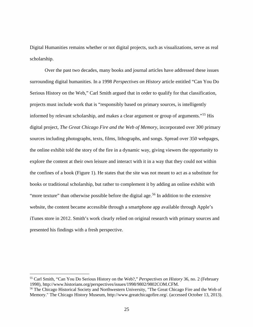
Over the past two decades, many books and journal articles have addressed these issues
surrounding digital humanities. In a 1998 Perspectives on History article entitled “Can You Do
Serious History on the Web,” Carl Smith argued that in order to qualify for that classification,
projects must include work that is “responsibly based on primary sources, is intelligently
informed by relevant scholarship, and makes a clear argument or group of arguments.”55 His
digital project, The Great Chicago Fire and the Web of Memory, incorporated over 300 primary
sources including photographs, texts, films, lithographs, and songs. Spread over 350 webpages,
the online exhibit told the story of the fire in a dynamic way, giving viewers the opportunity to
explore the content at their own leisure and interact with it in a way that they could not within
the confines of a book (Figure 1). He states that the site was not meant to act as a substitute for
books or traditional scholarship, but rather to complement it by adding an online exhibit with
“more texture” than otherwise possible before the digital age.56 In addition to the extensive
website, the content became accessible through a smartphone app available through Apple’s
iTunes store in 2012. Smith’s work clearly relied on original research with primary sources and
presented his findings with a fresh perspective.
55 Carl Smith, “Can You Do Serious History on the Web?,” Perspectives on History 36, no. 2 (February 1998), http://www.historians.org/perspectives/issues/1998/9802/9802COM.CFM. 56 The Chicago Historical Society and Northwestern University, "The Great Chicago Fire and the Web of Memory." The Chicago History Museum, http://www.greatchicagofire.org/. (accessed October 13, 2013).
25
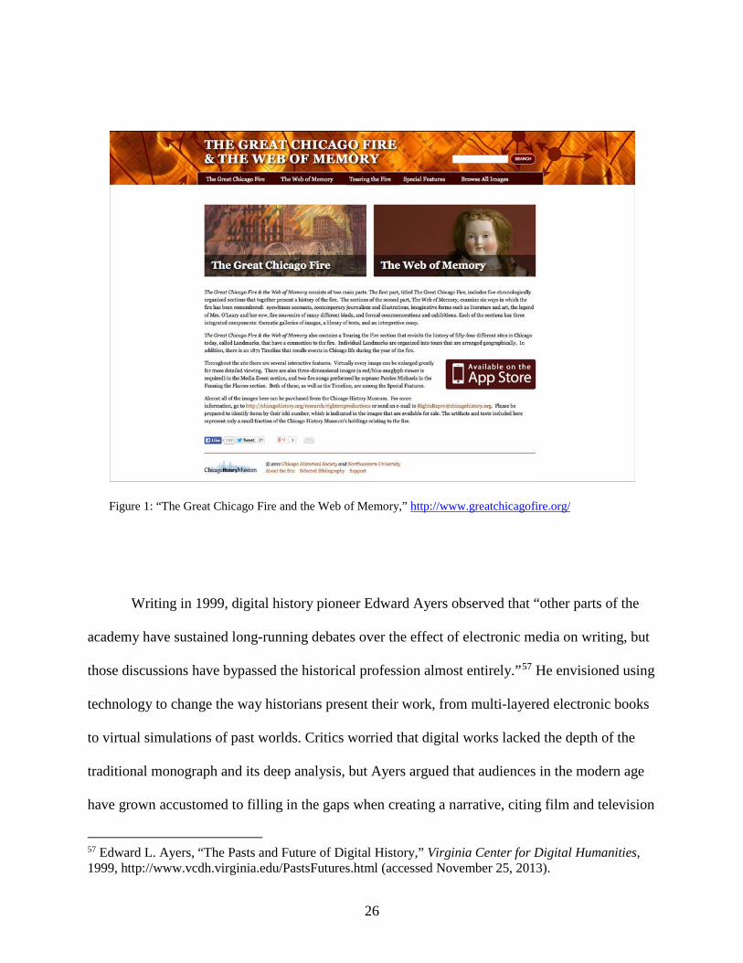
Figure 1: “The Great Chicago Fire and the Web of Memory,” http://www.greatchicagofire.org/
Writing in 1999, digital history pioneer Edward Ayers observed that “other parts of the
academy have sustained long-running debates over the effect of electronic media on writing, but
those discussions have bypassed the historical profession almost entirely.”57 He envisioned using
technology to change the way historians present their work, from multi-layered electronic books
to virtual simulations of past worlds. Critics worried that digital works lacked the depth of the
traditional monograph and its deep analysis, but Ayers argued that audiences in the modern age
have grown accustomed to filling in the gaps when creating a narrative, citing film and television
57 Edward L. Ayers, “The Pasts and Future of Digital History,” Virginia Center for Digital Humanities, 1999, http://www.vcdh.virginia.edu/PastsFutures.html (accessed November 25, 2013).
26
as examples, yet historians failed to take advantage of new technology that could further the
profession. He observed that computers offer historians a greater ability to search archives and
data than ever before, allowing them to discover new connections among different media. This
“hypertextual” history, as Ayers called it, could be a catalyst in creating more multidimensional
narratives that include a blending of social science methods, yet Ayers recognized that some see
this as a threat to standard practice. He stressed that historians need to embrace the new direction
and lead the charge in shaping future historical narratives; otherwise the profession risks
continued “erosion of authority” and missed opportunities to create new and dynamic history.58
Ayers’ own Valley of the Shadow project demonstrated the possibilities of digital
scholarship (Figure 2). Using thousands of primary documents including private letters, diaries,
newspaper articles, and census records, the team created an online archive comparing Augusta
County, Virginia and Franklin County, Pennsylvania, two communities on opposing sides of the
Civil War. The result brought to life individual voices that were otherwise obscured in archives
and allowed site visitors to interact with the documents from multiple perspectives and discover
how these communities experienced the war.59
58 Edward L. Ayers, "The Past and Future of Digital History." 59 “The Valley of the Shadow: Two Communities in the American Civil War,” University of Virginia Library, http://valley.lib.virginia.edu/ (accessed October 31, 2013)
27
Figure 2: “The Valley of the Shadow,” http://valley.lib.virginia.edu/
Historian David Staley’s 2003 book, Computers, Visualization, and History: How New
Technology Will Transform Our Understanding of the Past provided useful insights into the
changes occurring within and outside of the profession. Staley pointed out that traditionally,
historians equated the only “serious history” with “written history.” When properly researched
and constructed, he argued, visualizations are not only as useful as monographs, but they can
communicate concepts and spatial relationships that written text alone cannot.60 He defined
60 David J. Staley, Computers, Visualization, and History: How New Technology Will Transform Our Understanding of the Past (Armonk, N.Y.: M.E. Sharpe, 2003), 5.
28
visualization as “any graphic that organizes meaningful information in multidimensional spatial
form.”61
In their 2006 book, Digital History: A Guide to Gathering, Preserving, and Presenting
the Past on the Web, Daniel J. Cohen and Roy Rosenzweig explored some of the “promises and
perils” facing digital historians. Although technology underwent changes since its publication,
the theories they addressed remain relevant. The authors identified seven advantages of digital
scholarship over analogue methods that merit further discussion: capacity, accessibility,
flexibility, diversity, manipulability, interactivity, and hypertextuality (non-linearity). They also
observed five potential problems that digital historians may encounter: quality, durability,
readability, passivity, and inaccessibility.62
The first advantage Cohen and Rosenzweig identify is the storage capacity technology
offers digital historians. The ability to archive thousands of documents, photos, books,
newspapers, and other media on a single hard drive or website has opened the door to new ways
of approaching the historical record. As computers become faster and capacity increases, more
data can be digitized and duplicated that might otherwise be forgotten, neglected, or perhaps lost
over time.63
The capacity to store this data leads to the second advantage of digital history—
accessibility. Online access to previously closed, restricted, or distant archives makes primary
and secondary sources available in a way not possible before. The rise of the Internet also
provides scholars with a new way of presenting their research, making it instantly accessible
61 David J. Staley, Computers, Visualization, and History, 3. 62 Cohen and Rosenzweig, Digital History, 3. 63 Ibid., 3
29
anywhere in the world. Cohen and Rosenzweig stress the cost-effectiveness of electronic
publishing allows historians to reach a wider audience than they could with traditional printing
alone. They state the openness of the web has implications for the general public as well, citing
the ability of community historical societies, students, and genealogists to connect worldwide.64
The third advantage lies in digital history’s flexibility. Combining sounds, pictures, and
texts in multiple ways allows for a more dynamic understanding of the past. Audiences can
engage the material on a two-way basis, rather than with the author-pupil approach inherent in
books. Cohen and Rosenzweig contend this fourth advantage of interactivity helps foster
collaboration, shared authority, and “multiple forms of historical dialogue.”65 They also note that
being able to engage directly with data in different ways demonstrates the manipulability of
digital media. Being able to quickly search large quantities of text, extract hidden information
from databases, or compare multimedia sources over time may lead to new patterns or
discoveries that eluded traditional scholarship.66 Finally, they stress the diversity and
hypertextuality of digital history. The ability for professional as well as amateur historians to
easily publish information on the web opens up scholarship to a more diverse audience and can
give voice to those with previously marginalized histories. Being able to consume history in a
non-linear, or hypertextual, manner allows these multiple perspectives to emerge from the same
sources, as opposed to one “grand narrative.”67
Despite the many advantages inherent in digital history, Cohen and Rosenzweig are quick
to point out that scholars face some possible pitfalls as well. First, the durability of some sources
64 Cohen and Rosenzweig, Digital History, 4. 65 Ibid., 4, 5, and 7. 66 Ibid., 7. 67 Ibid., 8.
30
is not yet known. Letters and diaries often prove invaluable to researchers reconstructing past
events, but the question of how to archive records such as email, “tweets”, and text messages
mean that vast amounts of communication may be lost to future historians. They cite the daily
loss of federal government records as just one example. Even if archivists could save all digital
sources, rapid technological change brings with it the possibility these files could not be opened.
Second, some forms of digital scholarship may present problems of readability. The
authors note that most scholarly books and articles typically follow a common organizational
structure with an introduction, argument, and conclusion. By contrast, the hypertextual nature of
digital scholarship, while an advantage, can sometimes be challenging to navigate and thus
obscure the scholar’s thesis or make following a narrative confusing.68
A third potential problem Cohen and Rosenzweig recognized stems from the nature of
technology itself, noting that “computers are good at ‘yes’ and ‘no,’ but historians prefer words
like ‘maybe,’ ‘perhaps,’ and ‘it’s more complicated than that.” They wonder if some websites
might actually encourage a form of passivity rather than inspire critical thinking, arguing some
are little more than an online version of television. This leads to the fourth concern—quality.
Like conventional historical sources, digital resources vary in terms of quality and authenticity.
The authors point to the abundance of sub-par or inaccurate information posted online and stress
that historians must “establish a new structure of historical legitimation and authority.” Finally,
they argue that the biggest threat of the digital age may paradoxically be inaccessibility. While
the digitization of archival records is a boon to historical research, Cohen and Rosenzweig worry
that Internet monopolies, disparities in computer ownership, and copyright issues could erode the
68 Cohen and Rosenzweig, Digital History, 11.
31
access created in the digital era. They argue that historians must lead the way in confronting
these issues to ensure the web retains its openness and for the advantages of digital history to
outweigh its potential pitfalls.69
Rosenzweig further examined the issues of authenticity and the nature of open-source
scholarship in his 2006 article, “Can History be Open Source? Wikipedia and the Future of the
Past.” He noted that the history profession is rooted in individual authorship and the concept of
collective contribution seems to go against the professional norms of most scholars. Yet, the
Wikipedia relies on crowd-sourced material contributed by anyone from amateurs to
professionals, making the entries freely available for use on other locations, even commercially.
This new model of authorship presents both opportunities and concerns for scholars. As
Rosenzweig points out, despite the democratization of information within the site, Wikipedia
only presents the “conventional and accepted wisdom” of a particular subject, even if incomplete
or containing inaccuracies. The rules do not allow for original research or interpretations that
dispute the consensus viewpoint. This presents a problem for historians, who by nature strive to
“break new ground” and receive peer recognition, either for tenured academic positions or
acknowledgment of their scholarly contributions. Rosenzweig believed that historians have a
responsibility to embrace the potential of open-source collaboration. He argued that instead of
bemoaning the quality of web-based information, scholars should seize the opportunity to
contribute to the rapidly expanding online knowledge base.70
69 Cohen and Rosenzweig, Digital History, 15. 70 Roy Rosenzweig, “Can History Be Open Source? Wikipedia and the Future of the Past,” The Journal of American History 93, no. 1 (June 2006): 117–46. Stable URL: http://www.jstor.org/stable/4486062 (accessed October 7, 2013).
32
Yet six years later, the profession still seemed skeptical of Wikipedia. In the February
2012 issue of Perspectives on History, then-AHA president William Cronon echoed
Rosenzweig’s call for scholars to embrace the site and contribute information rather than lament
the erosion of an “intellectual monopoly they once took for granted.” Cronon stressed that while
Wikipedia was not always the best example of scholarly work, the website did provide a useful
service as a gateway to a given subject. In addition, the democratization process gave voice to
those previously marginalized within traditional academia. He argued that the best way for
historians to maintain scholarly authority in this increasingly de-centralized digital world was to
improve upon the website’s entries. Cronon’s advice was, “If you can’t beat ‘em, join ‘em.”71
Spatial Turn
At the core of this thesis project is the concept of spatial history. Simply put, spatial
history examines human movement through both relational and physical space over time.72 This
project tracks the migrations of various groups from one geographic space to another, but it also
explores the cultural adaptations over time in the constructed spaces these groups created.
Historians have always focused on change over time, but with the advent of computers
and new technologies such as GIS, space has become an important part of studying history.
According to Edward Ayers, this so-called Spatial Turn, has been more of an “evolutionary
71 William Cronon, “Scholarly Authority in a Wikified World,” Perspectives on History, no. February, 2012 (February 2012), http://www.historians.org/publications-and-directories/perspectives-on-history/february-2012/scholarly-authority-in-a-wikified-world. (accessed October 7, 2013). 72 Richard White, “What Is Spatial History,” para. 7.
33
process rather than an abrupt revolution.”73 In his article, “Turning Toward Place, Space, and
Time,” Ayers traces the beginning of this shift to the 1970s, when geographers first began using
computer models and GIS to explore spaces and maps.
Richard White identified three concepts of space in his 2010 article, “What is Spatial
History?” The first was spatial practice, or the “movement of people, goods, and information
through time and constructed spaces.”74 This is represented in the plantation economies of the
South by the slave trade, the transfer of musical traditions, and the agricultural knowledge
exchanged in each region. The second form was representations of space, signified by how
plantations were designed, how communities were constructed, and how zoning affected the
urban landscapes. In other words, these are constructed spaces defined by human action.75 The
last form was representational space, meaning the symbolic associations of particular places.76
Examples of this type include the Praise House throughout the Gullah region or People’s Square
in New Orleans.
In Placing History: How Maps, Spatial Data, and GIS are Changing Historical
Scholarship, Anne Kelly Knowles stressed that virtually all primary sources contain some sort of
geographic and temporal information that can be used to reveal geo-spatial relationships of
historical evidence.77 For instance, one primary source archive for this project contains the 2300
WPA ex-slave narratives collected during the 1930s and analyzed by historians for years. The
73 Edward L. Ayers, “Turning Toward Place, Space, and Time,” in The Spatial Humanities: GIS and the Future of Humanities Scholarship, ed. David J. Bodenhamer, Trevor M. Harris, and John Corrigan (Bloomington, IN: Indiana University Press, 2010), 3. 74 Richard White, “What is Spatial History?”, Para 8, 17. 75 Ibid., Para 10. 76 Ibid., para13. 77 Anne Kelly Knowles, ed., Placing History: How Maps, Spatial Data, and GIS Are Changing Historical Scholarship, 1st ed. (Redlands, CA: ESRI Press, 2008), 18..
34
records list the dates and places these interviews were conducted. Mapping this information is
one way to examine spatial qualities. But within the text and audio of the recordings, another
movement becomes evident when the subjects describe their enslavement in, say, South Carolina
and their migration to other parts of the country during Reconstruction.
35
CHAPTER THREE: METHODOLOGY
Background
In 2012, Max Edelson and Bill Ferster from the University of Virginia received a
National Endowment for the Humanities (NEH) grant to develop MapScholar.78Their objective
was to create a tool that scholars could use to build compelling visualizations without the need
for costly software programs or extensive institutional support. As opposed to standalone
software packages, MapScholar employs open-source technology that acts as a portal to link
multimedia from other online sources such as Google Earth/Maps, Flickr, You Tube, and digital
archive collections. Ferster refers to this concept as a “loose collection of parts.”79The ability to
leverage the power of these fully developed commercial products within the platform eliminates
the need to replicate them, develop continuous updates, or provide vast bandwidth storage.
The MapScholar framework addresses several of the hurdles facing digital historians.
First, the program is free and easily accessible, unlike some other programs such as Omeka or
ArcGIS that require specific operating systems, webhosting subscriptions, and institutional
support to make them run effectively. With MapScholar, there is no special programming to
learn as the framework integrates with a spreadsheet, such as Google Docs, to create the
visualization. The system completely runs in the Cloud, so there are no downloads or hardware
requirements necessary. Once a user creates the data spreadsheet (stored online), they copy and
paste its hyperlink at the end of the MapScholar URL in any web browser to create the
78 To read more about this grant, visit the MapScholar website, http://mapscholar.org/mapscholar-wins-neh-digital-humanities-implementation-grant-3-2/ 79 Quote from discussions with Bill Ferster.
36
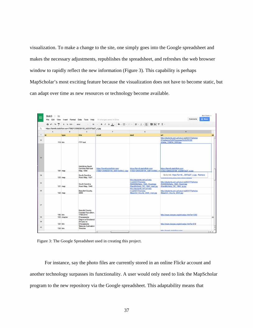
visualization. To make a change to the site, one simply goes into the Google spreadsheet and
makes the necessary adjustments, republishes the spreadsheet, and refreshes the web browser
window to rapidly reflect the new information (Figure 3). This capability is perhaps
MapScholar’s most exciting feature because the visualization does not have to become static, but
can adapt over time as new resources or technology become available.
Figure 3: The Google Spreadsheet used in creating this project.
For instance, say the photo files are currently stored in an online Flickr account and
another technology surpasses its functionality. A user would only need to link the MapScholar
program to the new repository via the Google spreadsheet. This adaptability means that
37
visualizations never need be obsolete, as MapScholar can incorporate new web applications on
the fly without upgrading the program or downloading a special plugin.
As with any new digital tool, however, digital historians may face some initial challenges
with MapScholar. As of this writing, the platform is nearing completion, meaning that new
capabilities are being added and adapted in an effort to improve the sites. Scholars attempting to
build a site may find this frustrating, since these changes can occur quickly while the final
product is completed. Currently, there is a lack of comprehensive documentation and what does
exist is somewhat out-of-date. This issue will be resolved soon, however, as the University of
Virginia began creating tutorials during the spring 2014 semester as part of the NEH grant. Full
documentation should be available by fall 2014 when the application goes live in the classroom.
In addition, one of MapScholar’s major benefits—the ability to act as a hub for other web
applications—means that it relies on multiple parts to function correctly. If, for example, the
Library of Congress website is down for maintenance or budget cuts (as happened during this
process), those resources are unavailable when loading the visualization. If Flickr has a hiccup,
those images may not load correctly when needed. Finally, longevity of a MapScholar site
requires that hyperlinks contained within the Google spreadsheet be updated if the original files
move, otherwise the site will display an error message. Users must be mindful when transferring
media linked to the site, as these links will need to be changed. That being said, all digital
technology contains an inherent obsolescence that creates issues for the digital historian.
38
Process
Creating a visualization requires a basic knowledge of computer skills in addition to the
time necessary to input data. This may require additional training and collaboration with
technology experts in or outside the historical field. Bill Ferster from the University of Virginia
provided valuable feedback and guidance throughout this project’s development. His recently
published Interactive Visualizations: Insight Through Inquiry proves a good resource for those
wishing to create digital history projects. The book is structured around the ASSERT acronym
model—Ask a question, Search for information, Structure that information, Envision the answer,
Represent the visualization, and Tell a story. This framework provides a solid platform for digital
humanists wishing to provide an alternative to text-only based interpretations and forms the
methodology employed during this project.80At the same time, ASSERT reflects traditional
scholarship in its research methods and use of primary source material to form a compelling
historical argument. What follows is an examination of how this project addressed each of these
areas and an explanation of the build-out process.
Ask a Question
The idea that specific slave plantation systems influenced cultural development is not a
new theory. Ira Berlin, Eugene Genovese, and Charles Joyner, to name a few, have explored the
80 Bill Ferster, Interactive Visualization: Insight Through Inquiry (Cambridge, MA: MIT Press, 2013), 40-41.
39
connection in their many published volumes. The aspect I sought to address was how to tell the
story in a more dynamic way using the new digital tools available today. The story of cultural
development and expression is a fascinating one, but music can sometimes get lost in translation
through books. It is one thing to read about a song, but quite another to hear it and compare it to
other regions.
This project addressed three main questions. First, what is the geo-temporal relationship
between agricultural production and the development of black folk music in different regions of
the southern United States? If there is indeed a connection, how can the story be told digitally in
a more engaging manner than possible with text alone? After surveying the available
technologies, I decided to use the MapScholar platform to create the digital project as this
seemed to offer the best combination of functionality, efficiency, and presentation. With the
digital tool selected, the third issue was how best to structure the various forms of primary source
material and build out the visualization. Using maps, audio recordings, census data, and video,
the result shows how regional music developed over time due to migration patterns, spatial
influences, and crop production.
Search for Information
As more universities and government archives digitize their collections, the number of
online primary sources available to researchers increases. Many are available for inclusion in a
digital project under the “Fair Use” clause and I relied on several of these repositories for this
40
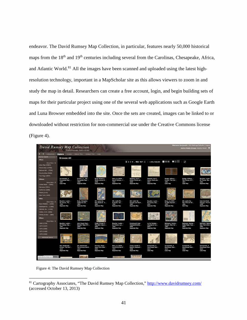
endeavor. The David Rumsey Map Collection, in particular, features nearly 50,000 historical
maps from the 18th and 19th centuries including several from the Carolinas, Chesapeake, Africa,
and Atlantic World.81 All the images have been scanned and uploaded using the latest high-
resolution technology, important in a MapScholar site as this allows viewers to zoom in and
study the map in detail. Researchers can create a free account, login, and begin building sets of
maps for their particular project using one of the several web applications such as Google Earth
and Luna Browser embedded into the site. Once the sets are created, images can be linked to or
downloaded without restriction for non-commercial use under the Creative Commons license
(Figure 4).
Figure 4: The David Rumsey Map Collection
81 Cartography Associates, “The David Rumsey Map Collection,” http://www.davidrumsey.com/ (accessed October 13, 2013)
41
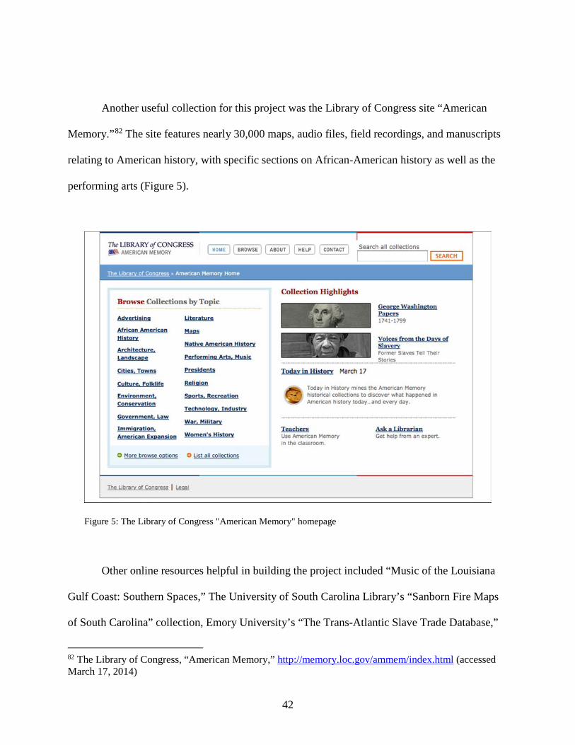
Another useful collection for this project was the Library of Congress site “American
Memory.”82 The site features nearly 30,000 maps, audio files, field recordings, and manuscripts
relating to American history, with specific sections on African-American history as well as the
performing arts (Figure 5).
Figure 5: The Library of Congress "American Memory" homepage
Other online resources helpful in building the project included “Music of the Louisiana
Gulf Coast: Southern Spaces,” The University of South Carolina Library’s “Sanborn Fire Maps
of South Carolina” collection, Emory University’s “The Trans-Atlantic Slave Trade Database,”
82 The Library of Congress, “American Memory,” http://memory.loc.gov/ammem/index.html (accessed March 17, 2014)
42
and Dr. Gewndolyn Hall’s “Afro-Louisiana History and Genealogy, 1718-1820,” housing a
database that includes slave ship records, family names, and ethnicity statistics for the Louisiana
region. It is important to note that the slave ship manifests and slave origins cannot be considered
one hundred percent accurate, due to the nature of the slave trade and falsification of documents.
Therefore, these numbers represent general trends and not absolute numbers of ethnicities.83
After studying the secondary literature on the Gullah region and searching online
databases, it became obvious I needed to schedule a trip to South Carolina to conduct original
research in this area. I spent the week of August 11-August 18, 2013 in Charleston and
surrounding areas exploring Gullah culture. The first stop was the College of Charleston’s Avery
Research Center for African American History and Culture in downtown Charleston, South
Carolina. The Center features two collections in particular that proved to be good resources. The
first, The John’s Island Culture Collection, contained the original manuscripts, oral history
recordings, and notes collected by Guy and Candie Carawan during their time living in the
John’s Island community in early 1960s. The collection also houses the original Robert Yellin
photographs from the same time period. Both Carawan and Yellin granted permission for
scholars wishing to include the items in their work, but unfortunately, the Center does not have
available funds to digitize these materials. Nevertheless, they allow researchers to create their
own files from the collection. I was able to convert more than two-dozen images for use in the
MapScholar site and listen to the original oral histories of the people featured in the photographs.
83 Allen Tullos, Emory University. “Southern Spaces: Music of the Louisiana Gulf Coast,” http://www.southernspaces.org/2004/music-louisiana-gulf-coast (accessed January 14, 2014); The University of South Carolina Library, Digital Collections, “Sanborn Fire Insurance Maps of South Carolina,” (accessed August 12, 2013); Dr. Gwendolyn Hall, Louisiana Slave Database, “Afro-Louisiana History and Genealogy, 1719-1820,” http://www.ibiblio.org/laslave/ (accessed October 15, 2013).
43
The interviews were previously transcribed, but the Avery Center lacked the technology to
convert the original tapes to audio files. The other notable discovery at the Avery Research
Center was the Walter Pantovic Collection of maps, early newspapers from the 1800s, and
runaway slave and auction notices. Reading these notices confirmed Peter Wood’s assertion that
South Carolina planters were knowledgeable of and desired certain ethnicities for rice production.
I was able to scan some of these items to include on the site. The Atlantic World map featured in
that section came from this collection.
I then conducted an interview with Alphonso Brown—musician, author, and owner of
Gullah Tours in Charleston. We discussed music, the enduring nature of Gullah culture in the
face of recent land development on the Sea Islands, and the rebirth of Gullah pride. He suggested
I make a visit to St. Helena Island near Beaufort to tour the Praise Houses and see the Penn
Center, opened in 1862 as an exclusively African-American school and now serving as a Gullah
cultural center. I was able to photograph the Penn Center and the Praise Houses and see first-
hand what life is like today on the island. In contrast to Hilton Head or similar places that have
been overrun with development and tourists, St. Helena embraces and is striving to preserve its
Gullah roots. While in Beaufort, I visited the special collections department at the Beaufort
County Library, known for its wealth of Gullah History. The archivist, Grace Morris Cordial,
provided many good study resources and although most were secondary in nature, they were
valuable in gaining a deeper understanding of Gullah culture.
44
Structure the Information
With the research trip completed, it was time to begin building the site. In its current
stage of development, MapScholar relies on the use of a Google Spreadsheet to reference the
various online resources (refer back to Figure 3 above). During the second phase, plans include
developing a wizard and tutorial that will help guide scholars as they input images and other files,
but this will not roll out until the official launch during fall 2014. In the meantime, most of the
instructional material for this project came directly from a series of conversations, Skype video
calls, and emails with Bill Ferster as the program developed.
After locating the desired resources on the web and processing the research trip files, the
next step required uploading any image or multimedia files locally stored on a hard drive to an
online repository. In this case, a Flickr account seemed the best option because of its easy access
and ability to store images in “sets,” helping with organization. Flickr also allows users to link to
multiple sizes of the same image, a useful feature as will become apparent when discussing the
spreadsheet setup. Once the images are online, MapScholar can access them via the Google Doc
directly, or through another type of element known as a SHIVA layer.
SHIVA is an acronym for the SHANTI Interactive Visualization Application, developed
by the University of Virginia’s Science, Humanities & Arts Network of Technological Initiative
(SHANTI). Essentially, it is a web application designed to create elements, or layers, which can
be referenced in the main Google Spreadsheet (Figure 6).
45
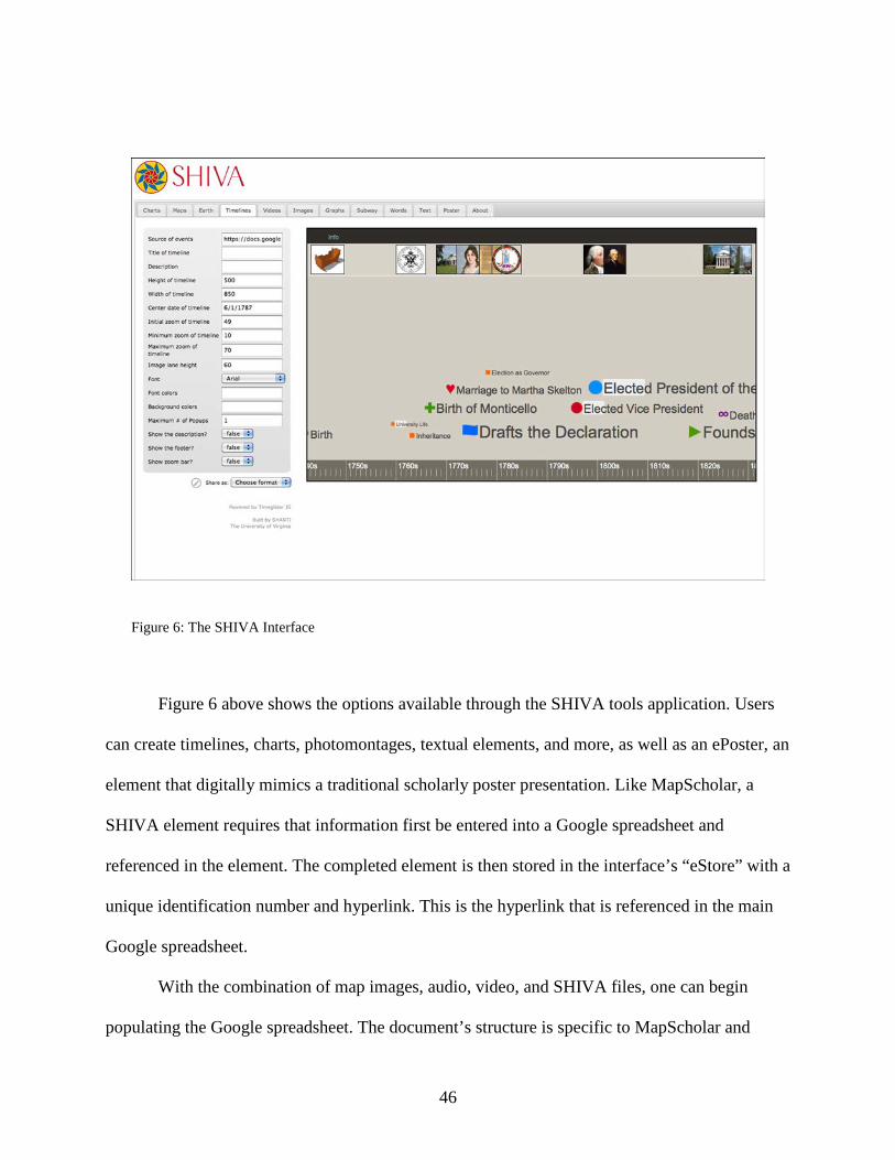
Figure 6: The SHIVA Interface
Figure 6 above shows the options available through the SHIVA tools application. Users
can create timelines, charts, photomontages, textual elements, and more, as well as an ePoster, an
element that digitally mimics a traditional scholarly poster presentation. Like MapScholar, a
SHIVA element requires that information first be entered into a Google spreadsheet and
referenced in the element. The completed element is then stored in the interface’s “eStore” with a
unique identification number and hyperlink. This is the hyperlink that is referenced in the main
Google spreadsheet.
With the combination of map images, audio, video, and SHIVA files, one can begin
populating the Google spreadsheet. The document’s structure is specific to MapScholar and
46
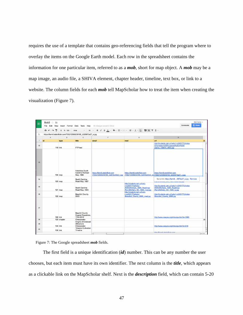
requires the use of a template that contains geo-referencing fields that tell the program where to
overlay the items on the Google Earth model. Each row in the spreadsheet contains the
information for one particular item, referred to as a mob, short for map object. A mob may be a
map image, an audio file, a SHIVA element, chapter header, timeline, text box, or link to a
website. The column fields for each mob tell MapScholar how to treat the item when creating the
visualization (Figure 7).
Figure 7: The Google spreadsheet mob fields.
The first field is a unique identification (id) number. This can be any number the user
chooses, but each item must have its own identifier. The next column is the title, which appears
as a clickable link on the MapScholar shelf. Next is the description field, which can contain 5-20
47
words giving context to the mob and is used to help create a narrative. The tags column can
contain a series of comma-separated words or phrases that help search or group particular mobs.
The following three fields—small, medium, and url—all contain links to the map images stored
in an image repository such as Flickr. This is where Flickr’s ability to generate different sizes of
the same file without loading three unique images is beneficial, as MapScholar uses each one to
display the map effectively. The small link links to the lowest resolution file and is used to
generate image thumbnails in the MapScholar home view. The medium file is used when
clicking on the particular map, and the url field links to the highest resolution image. This is the
image that loads when a user wants to zoom in and see a map’s detail. For sound, video, or
SHIVA layers, the url field is where the hyperlink to that element resides. The next series of
fields—status, start, end, north, south, east, west, rotation, goto, and base—tell MapScholar
how to display the particular mob. Status simply determines whether an item, such as a chapter
heading, will be displayed open or closed when the site launches or whether an audio/video file
will automatically play when its link is clicked. The other fields contain the geo-referencing
coordinates that overlay the map image in Google Earth and how it reacts when selected in the
shelf.
Envision the Answer
Once the source material was selected, the focus shifted to how to best address the
research question, in this case how to visually show the relationship between cultivation and folk
music. The evidence was clear that in the Gullah region, rice production led to the creation of a
48
predominately African population along the coast and islands. They retained many of the
language traits and songs from West Africa due to their relative isolation from the smaller yet
dominant society. In the Chesapeake, the tobacco industry employed many European indentured
servants in the early years of the colony, but as the plantation system became the norm the black
population increased. Close proximity between the two races led to acculturation, with each
adopting some of the other’s music and instrumentation. Even today, some of the old-time and
Bluegrass music heard in the region among white musicians directly stems from black tradition.
In New Orleans, the cosmopolitan nature of the city due to its diverse colonial period and
Caribbean influence brought with sugar plantation slaves, led to its unique musical forms of
zydeco and creole music. Evidence today can be seen in the Mardi Gras celebrations that bear a
striking resemblance to the Carnival traditions of the Caribbean and South America, where sugar
was the dominant agricultural product.
Represent the Visualization
The next step in the process was to actually create, or represent, the visualization. In
order to populate the MapScholar site, one must first construct the Google Spreadsheet as
outlined above, linking to the various online repositories, websites, and multimedia files. Once
that is complete, the user navigates to the MapScholar website using any web browser such as
Google Chrome, Safari, or Firefox. After the skeleton site loads, one simply opens up the
spreadsheet and copies the url link and pastes it to the end of the MapScholar string, using a “?”
symbol as a connector. The user’s data with then populate, revealing the intended website.
49
Changes or future updates can be occur quickly by making the appropriate correction in the
Google doc, republishing it to the web, and refreshing the web browser window. The new
information will appear instantaneously. This is one of the platform’s strengths, as it requires no
programming or help of an I.T. department to upload to the server overnight or other
cumbersome manner.
Tell a Story
One of the goals of any scholarly work, whether a traditional text or a digital product, is
to translate research into an argument, or story. By design, the original version of MapScholar
featured an “Atlas” view, a reference to its mapping capabilities. The perspective listed the
elements in the right column under chapter headings. Over the course of the project, I tried to
determine how I would tell a story with a list of items with little context. After discussing with
matter with Bill Ferster, he suggested their newly developed “Book” view, allowing a more
narrative approach to the visualization. Users still have the option of navigating via the “Atlas”
default view, thereby exploring the data in their own way, but the “Book” view gives the creator
the opportunity to develop a guided experience through the use of pages. In the Results chapter
that follows, I explain the completed site and through screenshots discuss the functionality and
significance of the various elements.
50
CHAPTER FOUR: RESULTS
The completed MapScholar site (Figure 8) features maps, audio, timelines, and
photographs that show how the rice, sugar, and tobacco economies influenced the choice of slave
imports and the culture that developed in each region.84 The spatial dimension is represented by
three aspects: geographic spaces (maps) and human movement between them, representative or
constructed spaces such as the Gullah Corridor, which does not appear on a map by name yet
refers to an undefined area where people shared cultural traits, and representational space
reflected in the Praise Houses of John’s Island and St. Helena Island, where the building itself is
a physical space but the sense of community and what these buildings meant culturally extends
far past their four walls.
84 To view the completed digital portion of this project, click on the link or copy and paste into any web browser, http://www.viseyes.org/mapscholar/?https://docs.google.com/spreadsheet/ccc?key=0Aj-hGmF_mBl8dEdtS3AwbE5FaW9BdG9tSXBaenlWeUE&usp=drive_web#gid=0
51
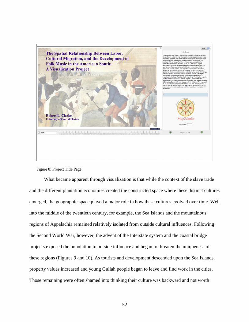
Figure 8: Project Title Page
What became apparent through visualization is that while the context of the slave trade
and the different plantation economies created the constructed space where these distinct cultures
emerged, the geographic space played a major role in how these cultures evolved over time. Well
into the middle of the twentieth century, for example, the Sea Islands and the mountainous
regions of Appalachia remained relatively isolated from outside cultural influences. Following
the Second World War, however, the advent of the Interstate system and the coastal bridge
projects exposed the population to outside influence and began to threaten the uniqueness of
these regions (Figures 9 and 10). As tourists and development descended upon the Sea Islands,
property values increased and young Gullah people began to leave and find work in the cities.
Those remaining were often shamed into thinking their culture was backward and not worth
52
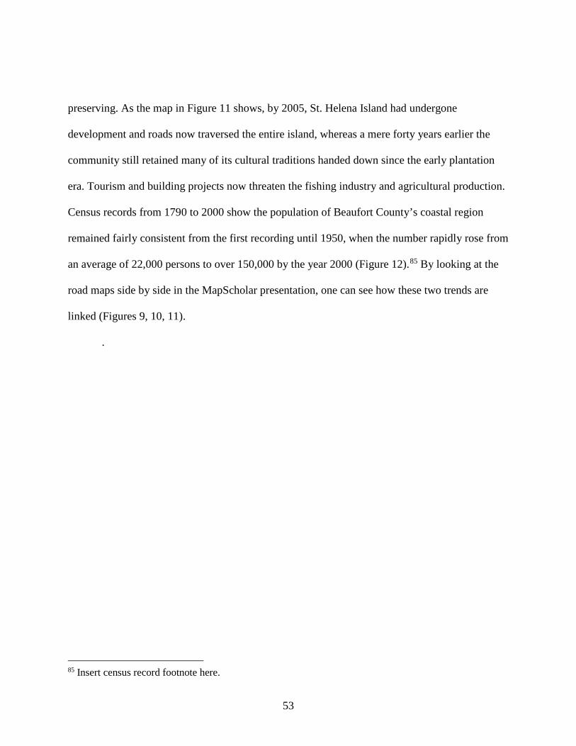
preserving. As the map in Figure 11 shows, by 2005, St. Helena Island had undergone
development and roads now traversed the entire island, whereas a mere forty years earlier the
community still retained many of its cultural traditions handed down since the early plantation
era. Tourism and building projects now threaten the fishing industry and agricultural production.
Census records from 1790 to 2000 show the population of Beaufort County’s coastal region
remained fairly consistent from the first recording until 1950, when the number rapidly rose from
an average of 22,000 persons to over 150,000 by the year 2000 (Figure 12).85 By looking at the
road maps side by side in the MapScholar presentation, one can see how these two trends are
linked (Figures 9, 10, 11).
.
85 Insert census record footnote here.
53
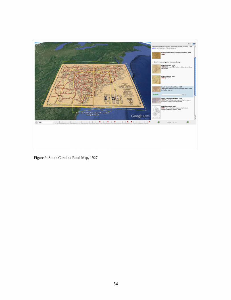
Figure 9: South Carolina Road Map, 1927
54

Figure 10: South Carolina Road Map, 1940
55
Figure 11: 2005 Beaufort County road map showing extent of development
56

Figure 12: Population density increase of Beaufort County, 1800-2000
In the Chesapeake region, the close proximity of European indentured servants, African
slaves, and white masters produced a society where a gradual mixing of cultural traits occurred,
particularly where music was concerned. Audio recordings reveal the similarities between
African-American instrumentals that include banjo and fiddle and those of their white
counterparts. The maps of the area show how certain areas in the western region were isolated
through mountains and cut by rivers. This meant the rural population spent years in isolation
before the advent of the interstate system and myriad roads exposed them to outside influences.
In the eastern part, maps show increasing population density through the development of towns.
57
By the time of the tobacco plantation society became established, the cross-cultural exchange of
musical traditions had already occurred.
In the Louisiana region, French and British colonial maps give clues as to the
multicultural nature of the region when viewed as a collection. Census records reveal a relatively
mixed population of European, African, and Afro-Caribbean inhabitants that eventually formed
the creole culture New Orleans became synonymous with. The music combines the French
creole language with the rhythms found in Haiti, Cuba, and South America. This can be linked to
the sugar industry, which demanded a certain type of labor. Its harsh nature resulted in shorter
life spans than in the Chesapeake or Gullah, requiring a constant influx of new imports.
58
CONCLUSION
The goal of this thesis project was to provide fresh perspective regarding the
development of folk music in three regions of the American South using digital technology. The
MapScholar site communicates this dynamically through images, audio, and video components.
This has many advantages for end-users, as they are not confined to one interpretation of
research and analysis. They can engage the primary sources directly, making them active
participants in the story. No longer is the author the sole mediator—the audience can follow the
author’s narrative or explore on the evidence on their own. Surveys have shown that when
people can personally interact with historical sources, ranging from family photos, museum
pieces, or documentaries, they are more likely to take an interest in the subject.86 In the tech-
savvy world of today’s born-digital generation, a program like MapScholar has educational
possibilities as a useful tool in the classroom.
A common refrain heard in history departments from undergraduates is that history was
“boring” in their past academic career. Today’s youth are bombarded with video, audio, and
instantly available data. This may be the only way some receive information. The expectation
that all learning should come from books is not realistic in today’s academic climate. The
challenge is how to develop critical-thinking skills, analysis of historical events, and exchange of
ideas among a growing number of students whose sole reference source may be a computer or
handheld device. This is where a digital tool like MapScholar can provide a context for historical
dialogue.
86 Roy Rosenzweig and David P Thelen, The Presence of the Past: Popular Uses of History in American Life (New York: Columbia University Press, 1998), 18,19.
59
For example, say the topic is a military campaign or land development over time. A
single historic map of a battle or a specific plot map is only one reference point. A static map
may be a valuable historic artifact in and of itself, but when combined with a collection of maps,
then it becomes part of a larger narrative. An educator could ask students to assemble a group of,
say, ten to fifteen historic maps ranging over a fifty-year period within MapScholar and engage
them in critical analysis of primary resources. What can these maps disclose regarding changing
ideas of land use or how can these maps tell the story of why a particular army emerged as a
victor? MapScholar’s ability to geo-reference these sources onto a Google Earth layer enables
viewers to see these maps in relief, revealing topographical features not visible in the two-
dimensional version.
As with any creative endeavor, this project evolved in directions unforeseen at the outset.
At various times throughout the process, these developments were encouraging, while at other
times they presented challenges to overcome. As exciting as it was to create an original project
with a cutting-edge technology, one of the biggest challenges was that because MapScholar was
still in the beta development stage, the program had glitches to correct. At times, items did not
function as expected and new features were added throughout the process. In addition, the
documentation was somewhat outdated or incomplete early on, requiring many emails and
troubleshooting calls with the developers. In many ways, the research and completed
MapScholar site reflects both the “promises and perils” of digital humanities put forth by Dan
Cohen and Roy Rosenzweig in 2006.87 From a historiographical context, this raises the questions
87 Cohen and Rosenzweig, Digital History. See pages 28-31 of this paper for a full discussion.
60
of how their observations translate to digital history as of this writing (2014) and how does the
MapScholar platform address these issues?
Cohen and Rosenzweig argued that digital history promised to increase accessibility of
historical sources and allow more people to research unexplored topics. There have been many
technological advances over the past decade; the development of tablets and smartphones alone
allows easier access to Internet data than ever before. Web applications such as Kindle and
Google Books make thousands of electronic texts available at low cost for students, while online
databases such as JSTOR and EBSCO put journal articles, newspapers, and government
documents at the fingertips of researchers. Open-source digital archives allow access to more
primary sources in a range of different media than just ten years ago. MapScholar takes full
advantage of these technologies and highlights the flexibility and interactivity they spoke of by
allowing the audience multiple ways to view the sources and form conclusions. Since the
platform leverages the power of the Cloud and links to other web applications, it demonstrates
the flexibility of digital tools in terms of setup, operation, and adaptability over time.
However, even with these developments, the perils they presented still remain. Cohen
and Rosenzweig stressed that digital historians faced issues of quality, readability, inaccessibility,
and durability. Throughout this project’s development, each one of these factors presented
hurdles to overcome and proved that these aspects still remain an inherent part of doing digital
history.
The issue of quality surfaced early on in the process. One of MapScholar’s viewing
features allows users to zoom in on a particular map, revealing great detail. This requires a very
high-resolution file. Some of the media found in digital collections are presented for web-
61
viewing only, meaning that they have a low resolution for faster page loading. Even though these
images may be ideal to include in the story, they represent poor choices for a MapScholar site. In
other instances, an item may have been digitized using older technology or outdated file systems,
which hamper the readability of the source. At other times, a particular web browser can only
read a particular type of audio file, which requires linking to two different file types so that users
can interact with the site on a variety of browsers. An example of this occurred when trying to
include song files of the John’s Island community. The Firefox web browser can only read an
audio file with an “ogg” extension, while Safari and Google Chrome require and mp.3 file. This
means that both files must be represented in the Google spreadsheet.
The issue of inaccessibility came up a few times during development. During the learning
process, some files would not show up when clicked on within the visualization. After spending
hours trying to resolve the issue and consulting with Bill Ferster, a simple hash mark in the web
link became the solution. At another point, a slow or weak Internet connection resulted in the site
not behaving as planned when linked to, as was the case during a conference presentation as well
as the thesis defense.
Finally, the problem of durability still remains. A digital project such as this one requires
some form of archival capability. Since there is not a program to download and install, the
question of how this site will live on after the thesis is complete is still debated. The solution in
this instance became a screencast of a user demonstrating the MapScholar site and explaining the
various features. In this way, if for some reason MapScholar ceases to exist or links become
broken, there is a record of the thesis project results.
62
These issues are not unique to this project and, as such, require that institutions that
choose to have digital history departments develop solutions for students who explore these new
technologies. During the course of the project, questions of where any uploaded files would
reside, how to translate the digital portion of the thesis into a traditional paper, and how to
submit a digital project for review surfaced. It became apparent that while great inroads have
occurred within the history department, more collaboration with technology experts are required
to resolve these issues.
Future Research
While my MapScholar site shows the spatial relationship between cultivation and culture
in the three regions chosen, there is still more work to be done. Currently, the Gullah Corridor
section is built out more than the Chesapeake and New Orleans sections. The intention is to fully
develop all three sections over the next six months and showcase the site at conferences and link
to the Visual Eyes website. Some specific layer additions include sugar and tobacco production
timelines, more maps showing ethnic origins in the Chesapeake and New Orleans, and an
“ePoster” communicating the life of “Priscilla,” a young slave girl from Sierra Leone who
arrived in Charleston during the 1700s. What makes her story so compelling is that not only is
her life documented through slave records during the Middle Passage, her master’s family kept
records of all her descendants. One such person still lives in the Charleston area and traveled
Sierra Leone to discover her roots. This is rare for many African-Americans, as most have no
genealogical record beyond slavery.
63

Future sections will look at the Caribbean more fully and perhaps map out Cuba, Haiti,
and Barbados, showing how sugar impacted these regions. Other sections could explore the
Scots-Irish migration to Appalachia to develop the story of bluegrass and string band music.
Maps, audio, and video files in this section would further develop the understanding of how
space affected music by demonstrating the diverse local distinctions in playing styles and voice
inflections throughout the mountains.
Beyond this particular study, MapScholar promises be a useful educational tool in the
classroom, as previously noted. Once the platform is fully implemented in the fall of 2014 with
tutorials and instructional documentation, I believe it will become a viable tool to build
visualizations and allow static maps to reveal spatial relationships that currently lie hidden in
archives.
64

APPENDIX: PERMISSIONS
65
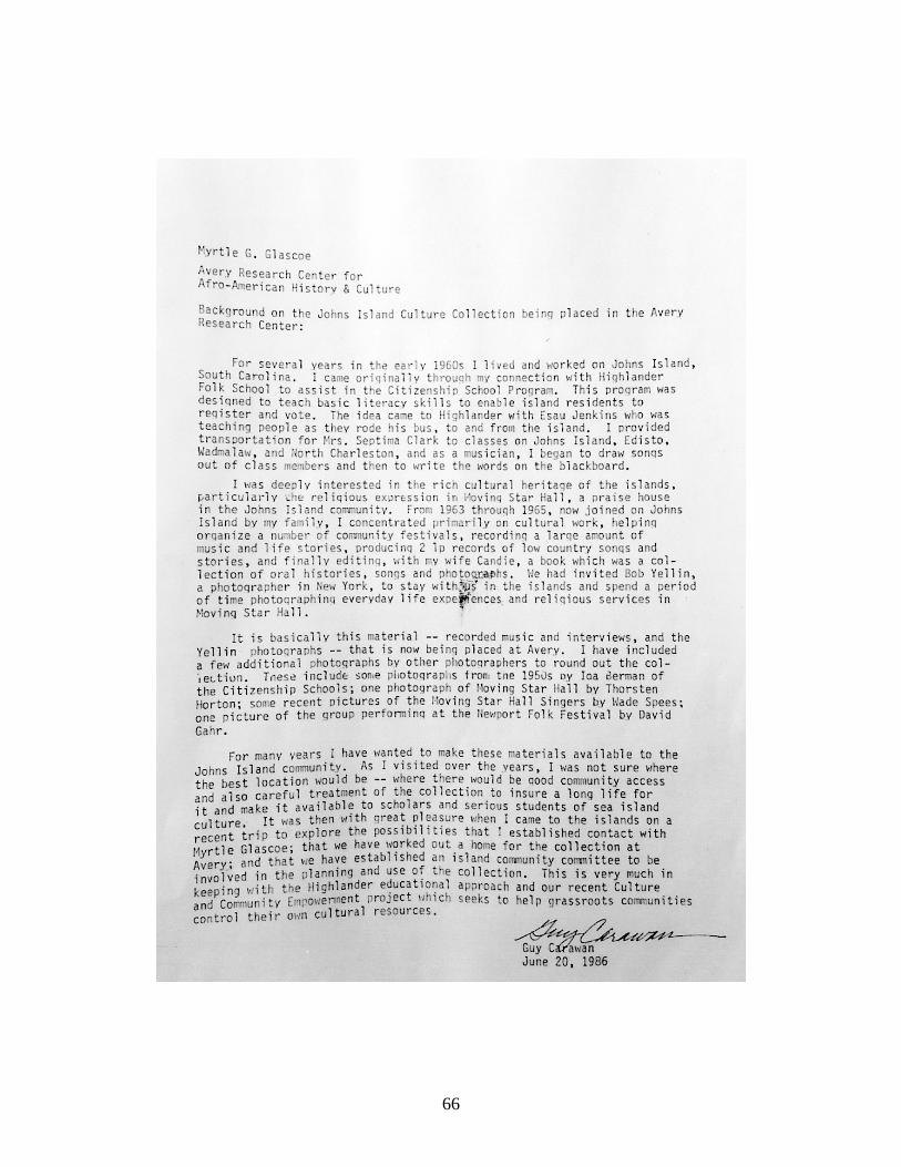
66
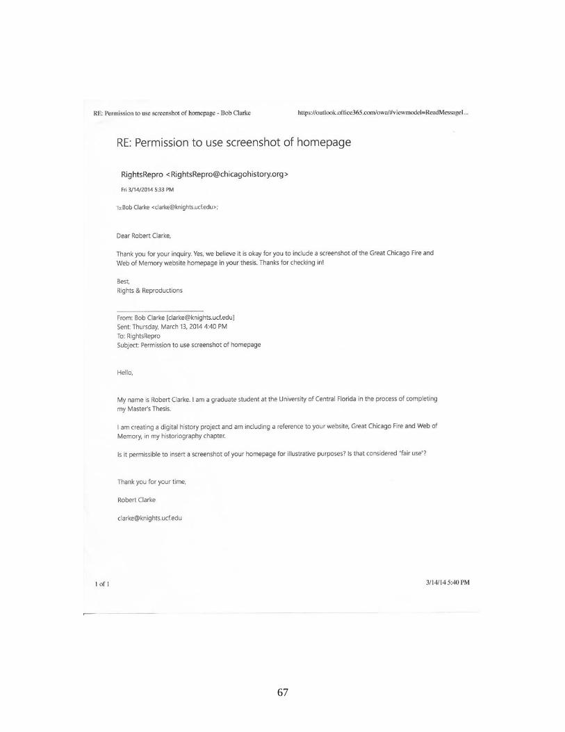
67
LIST OF REFERENCES
Anne Kelly Knowles. “GIS and History.” In Placing History: How Maps, Spatial Data, and GIS Are Changing Historical Scholarship, edited by Anne Kelly Knowles. Redlands, CA: ESRI Press, 2008.
Bastide, Roger. African Civilisations in the New World. New York: Harper & Row, 1971. Berlin, Ira. “Time, Space, and the Evolution of Afro-American Society on British Mainland North America.” The
American Historical Review 85, no. 1 (February 1, 1980): 44–78. doi:10.2307/1853424. Berlin, Ira, and Philip D. Morgan. Cultivation and Culture: Labor and the Shaping of Slave Life in the Americas.
Carter G Woodson Institute Series in Black Studies. Charlottesville, VA: University Press of Virginia, 1993.
Blassingame, John W. Black New Orleans, 1860-1880. Chicago, IL: University of Chicago Press, 1973. ———. The Slave Community: Plantation Life in the Antebellum South. Rev. and enl. New York: Oxford
University Press, 1979. Bodenhamer, David J, John Corrigan, and Trevor M Harris. The Spatial Humanities: GIS and the Future of
Humanities Scholarship. Bloomington: Indiana University Press, 2010. Carawan, Candie, and Guy Carawan. Ain’t You Got a Right to the Tree of Life?: People of John’s Island, South
Carolina - Their Faces, Their Words and Their Songs. Athens, GA: The Univ. of Georgia Press, 1994. Carl Smith. “Can You Do Serious History on the Web?” Perspectives on History 36, no. 2 (February 1998).
http://www.historians.org/perspectives/issues/1998/9802/9802COM.CFM. Cohen, Daniel J, and Roy Rosenzweig. Digital History: A Guide to Gathering, Preserving, and Presenting the Past
on the Web. Philadelphia: University of Pennsylvania Press, 2006. Conway, Cecelia. African Banjo Echoes in Appalachia: A Study of Folk Traditions. 1st ed. Publications of the
American Folklore Society New Series. Knoxville, TN: University of Tennessee Press, 1995. CONWAY, CECELIA. “Mountain Echoes of the African Banjo.” Appalachian Journal 20, no. 2 (January 1, 1993):
146–160. doi:10.2307/40933510. Cross, Wilbur. Gullah Culture in America. Winston-Salem, N.C.: John F. Blair, Publisher, 2012. Daniel C. Littlefield. Rice and Slaves: Ethnicity and the Slave Trade in Colonial South Carolina. Baton Rouge, LA:
Louisiana State University Press, 1981. David J. Bodenhamer. “History and GIS: Implications for the Discipline.” In Placing History: How Maps, Spatial
Data, and GIS Are Changing Historical Scholarship, edited by Anne Kelly Knowles. Redlands, CA: ESRI Press, 2008.
———. “The Potential of Spatial Humanities.” In The Spatial Humanities: GIS and the Future of Humanities
Scholarship, edited by David J. Bodenhamer, Trevor M. Harris, and John Corrigan. Bloomington, IN: Indiana University Press, 2010.
E. Franklin Frazier. The Negro Family in the United States. Chicago, IL: University of Chicago Press, 1940.
68
Edward L. Ayers. “Does Digital Scholarship Have a Future?” Educase Review Online. Accessed October 1, 2013. http://www.educause.edu/ero/article/does-digital-scholarship-have-future.
———. “The Pasts and Future of Digital History.” Virginia Center for Digital Humanities, 1999. http://www.vcdh.virginia.edu/PastsFutures.html.
———. “Turning Toward Place, Space, and Time.” In The Spatial Humanities: GIS and the Future of Humanities
Scholarship, edited by David J. Bodenhamer, Trevor M. Harris, and John Corrigan. Bloomington, IN: Indiana University Press, 2010.
Epstein, Dena J. “The Folk Banjo: A Documentary History.” Ethnomusicology 19, no. 3 (September 1, 1975): 347–
371. doi:10.2307/850790. Epstein, Dena J. Polacheck. Sinful Tunes and Spirituals: Black Folk Music to the Civil War. Music in American
Life. Urbana, IL: University of Illinois Press, 1977. Ferster, Bill. Interactive Visualization: Insight Through Inquiry. Cambridge, MA: MIT Press, 2013. Gershenhorn, Jerry. Melville J. Herskovits and the Racial Politics of Knowledge. Critical Studies in the History of
Anthropology. Lincoln, NE: University of Nebraska Press, 2004. Contributor biographical information http://www.loc.gov/catdir/enhancements/fy0708/2003016335-b.html Publisher description http://www.loc.gov/catdir/enhancements/fy0708/2003016335-d.html.
Hall, Gwendolyn Midlo. Africans in Colonial Louisiana: The Development of Afro-Creole Culture in the Eighteenth
Century. Baton Rouge, LA: Louisiana State University Press, 1992. ———. Slavery and African Ethnicities in the Americas: Restoring the Links. Chapel Hill, NC: University of North
Carolina Press, 2005. Table of contents only http://www.loc.gov/catdir/toc/ecip058/2005005917.html Publisher description http://www.loc.gov/catdir/enhancements/fy0632/2005005917-d.html Book review (H-Net) http://www.h-net.org/review/hrev-a0e8o0-aa.
Herskovits, Melville J. The Myth of the Negro Past. Beacon Paperback No 69. Boston: Beacon Press, 1958. Ian Gregory. “Exploiting Time and Space: A Challenge for GIS in the Digital Humanities.” In The Spatial
Humanities: GIS and the Future of Humanities Scholarship, edited by David J. Bodenhamer, John Corrigan, and Trevor M. Harris. Bloomington, IN: Indiana University Press, 2010.
Joyner, Charles W. Down By the Riverside: A South Carolina Slave Community. 25th anniversary. Urbana, IL:
University of Illinois Press, 2009. Knowles, Anne Kelly, ed. Placing History: How Maps, Spatial Data, and GIS Are Changing Historical
Scholarship. 1st ed. Redlands, CA: ESRI Press, 2008. Kulikoff, Allan, and Institute of Early American History and Culture (Williamsburg VA). Tobacco and Slaves: The
Development of Southern Cultures in the Chesapeake, 1680-1800. Chapel Hill, NC: Published for the Institute of Early American History and Culture, Williamsburg, Virginia by the University of North Carolina Press, 1986.
Marquetta L. Goodwine, ed. The Legacy of Ibo Landing: Gullah Roots of African American Culture. Atlanta, GA:
Clarity Press, Inc., 1998. Mintz, Sidney Wilfred, and Richard Price. The Birth of African-American Culture : An Anthropological Perspective.
Boston: Beacon Press, 1992. Publisher description
69
http://www.loc.gov/catdir/description/hm031/91041020.html Contributor biographical information http://www.loc.gov/catdir/enhancements/fy0737/91041020-b.html.
National Park Service. “Gullah Geechee Special Resource Study Guide,” n.d. Parrish, Lydia. Slave Songs of the Georgia Sea Islands. Athens: University of Georgia Press, 1992. Peter H. Wood. Black Majority: Negroes in Colonial South Carolina From 1670 through the Stono Rebellion. New
York, NY: Alfred A. Knopf, 1974. Pollitzer, William S. The Gullah People and Their African Heritage. Athens, GA: University of Georgia Press,
2005. Raboteau, Albert J. Slave Religion: The “Invisible Institution” in the Antebellum South. Updated. New York:
Oxford University Press, 2004. Richard White. “What Is Spatial History?” The Spatial History Lab, no. Feb, 2010 (February 2010).
http://www.stanford.edu/group/spatialhistory/media/images/publication/what%20is%20spatial%20history%20pub%20020110.pdf.
Rose, Gillian. Visual Methodologies: An Introduction to Researching With Visual Materials. Los Angeles, CA:
SAGE, 2012. Rosenzweig, Roy. Clio Wired: The Future of the Past in the Digital Age. New York: Columbia University Press,
2011. Rosenzweig, Roy, and David P Thelen. The Presence of the Past: Popular Uses of History in American Life. New
York: Columbia University Press, 1998. Roy Rosenzweig. “Can History Be Open Source? Wikipedia and the Future of the Past.” The Journal of American
History 93, no. 1 (June 2006): 117–46. Southern, Eileen. The Music of Black Americans: A History. 3rd ed. New York: Norton, 1997. Staley, David J. Computers, Visualization, and History: How New Technology Will Transform Our Understanding
of the Past. Armonk, NY: M.E. Sharpe, 2003. ———. History and Future: Using Historical Thinking to Imagine the Future. Lanham, MD: Lexington Books,
2007. Table of contents only http://www.loc.gov/catdir/toc/ecip0618/2006024442.html. Thornton, John K. Africa and Africans in the Making of the Atlantic World, 1400-1800. 2nd ed. New York:
Cambridge University Press, 1998. Tullos, Allen. “Music of the Louisiana Gulf Coast.” Southern Spaces, February 26, 2004.
http://www.southernspaces.org/2004/music-louisiana-gulf-coast. Turner, Lorenzo Dow. Africanisms in the Gullah Dialect. Columbia, SC: University of South Carolina Press, 2002.
70