Embed Size (px)
Citation preview
5/14/2018 Some Issues on Interlinking of Rivers in India - slidepdf.com
http://slidepdf.com/reader/full/some-issues-on-interlinking-of-rivers-in-india 1/8
GENERAL ARTICLE
CURRENT SCIENCE, VOL. 95, NO. 6, 25 SEPTEMBER 2008 728
†The views and opinions expressed in the article are of the authors and
may not necessarily reflect those of the organization to which they belong.
The authors are in the National Institute of Hydrology, Roorkee 247 667,India. *For correspondence. (e-mail: [email protected])
Some issues on interlinking of rivers in India†
S. K. Jain*, Vijay Kumar and N. Panigrahy
Inter-basin water transfer (IBWT) is one of the options to remedy spatial mismatch in water avail-
ability and demand. To overcome this mismatch in India, a massive scheme consisting of nearly 44
links has been proposed to interlink the major rivers. Feasibility reports of most of the links have
been completed and preparation of a detailed project report about the Ken–Betwa link is in pro-
gress. The entire programme will involve a huge volume of data analysis and design. In this article,
attention is focused on issues pertaining to hydrologic data, analysis and regulation of the system.
Keywords: Himalayan rivers, inter-basin water transfer, interlinking of rivers, surplus water transfer, water balance.
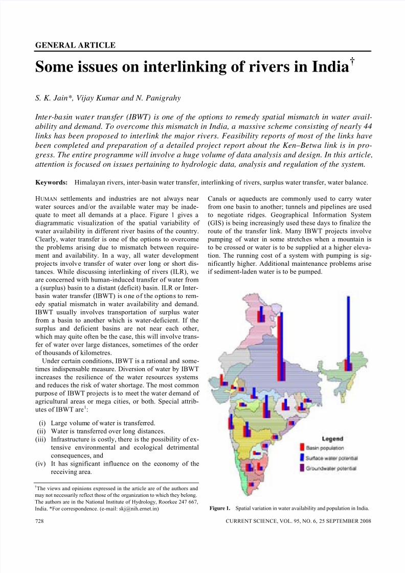
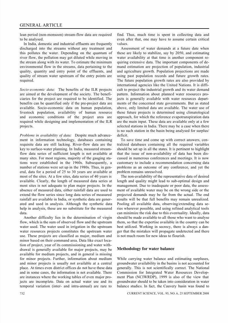
HUMAN settlements and industries are not always nearwater sources and/or the available water may be inade-
quate to meet all demands at a place. Figure 1 gives a
diagrammatic visualization of the spatial variability of
water availability in different river basins of the country.
Clearly, water transfer is one of the options to overcome
the problems arising due to mismatch between require-
ment and availability. In a way, all water development
projects involve transfer of water over long or short dis-
tances. While discussing interlinking of rivers (ILR), we
are concerned with human-induced transfer of water from
a (surplus) basin to a distant (deficit) basin. ILR or Inter-
basin water transfer (IBWT) is one of the options to rem-
edy spatial mismatch in water availability and demand.
IBWT usually involves transportation of surplus water
from a basin to another which is water-deficient. If the
surplus and deficient basins are not near each other,
which may quite often be the case, this will involve trans-
fer of water over large distances, sometimes of the order
of thousands of kilometres.
Under certain conditions, IBWT is a rational and some-
times indispensable measure. Diversion of water by IBWT
increases the resilience of the water resources systems
and reduces the risk of water shortage. The most common
purpose of IBWT projects is to meet the water demand of
agricultural areas or mega cities, or both. Special attrib-utes of IBWT are1:
(i) Large volume of water is transferred.
(ii) Water is transferred over long distances.
(iii) Infrastructure is costly, there is the possibility of ex-
tensive environmental and ecological detrimental
consequences, and
(iv) It has significant influence on the economy of the
receiving area.
Canals or aqueducts are commonly used to carry waterfrom one basin to another; tunnels and pipelines are used
to negotiate ridges. Geographical Information System
(GIS) is being increasingly used these days to finalize the
route of the transfer link. Many IBWT projects involve
pumping of water in some stretches when a mountain is
to be crossed or water is to be supplied at a higher eleva-
tion. The running cost of a system with pumping is sig-
nificantly higher. Additional maintenance problems arise
if sediment-laden water is to be pumped.
Figure 1. Spatial variation in water availability and population in India.
5/14/2018 Some Issues on Interlinking of Rivers in India - slidepdf.com
http://slidepdf.com/reader/full/some-issues-on-interlinking-of-rivers-in-india 2/8
GENERAL ARTICLE
CURRENT SCIENCE, VOL. 95, NO. 6, 25 SEPTEMBER 2008 729
Cox2 suggested the following five criteria to justify or
reject IBWT projects:
(1) The area of delivery must face a substantial deficit
in meeting present or projected future water demands
after due consideration has been given to alternativewater-supply sources and reasonable measures for
reducing water demand have been attempted.
(2) The future development of the area of origin must
not be substantially constrained by water scarcity;
however, consideration to transfer that constrains fu-
ture development of an area of origin may be appro-
priate if the area of delivery compensates the area of
origin for productivity losses.
(3) A comprehensive environmental impact assessment
must indicate that there is a reasonable degree of
certainty that it will not substantially degrade envi-
ronmental quality within the area of origin or area of delivery. However, water transfer may be justified
where compensation to offset environmental injury
is provided.
(4) A comprehensive assessment of socio-cultural im-
pacts must indicate a reasonable degree of certainty
that water transfer will not cause substantial socio-
cultural disruption in the area of origin or area of
water delivery. However, transfer of water may be
justified where compensation to offset potential
socio-cultural losses is provided.
(5) The net benefits from transfer must be shared equi-
tably between the area of transfer origin and the areaof water delivery.
The present article discusses several hydrological and as-
sociated issues that are of critical importance in the con-
text of IBWT, with particular reference to India. Before
discussing these, a brief historical and current perspective
of the topic is provided.
Historical perspective
Although IBWT as a means to alleviate water deficit has
drawn the attention of Indian planners since independ-ence, two grand schemes that were proposed in the 1970s
evoked widespread interest and enthusiasm. These were
the Ganga–Cauvery Canal proposal of Rao3, and the Gar-
land canal system proposed by Dastur4. Rao’s proposal
required large amounts of power (5 to 7 MkW) for lifting
the water and had no flood-control benefits5. Dastur was
an engineer and pilot, who after an aerial survey of the
land realized that ‘we have more wealth in our water than
Arabia has in oil’ and proposed ‘The Great Water Gar-
lands’ as a ‘scheme for conservation of water and gener-
ating hydro-electric power by connecting all the rivers of
India’. However, when this proposal was examined in de-tail, it was found to be technically unsound and the cost
was prohibitive. Both these proposals were, therefore, not
given further serious consideration although they contin-
ued to catch popular attention.
Notwithstanding the fact that these schemes did not
materialize, the ideas of the proponents formed the step-
ping stone for more concrete and technically sound pro-posals that emerged later. The Government of India
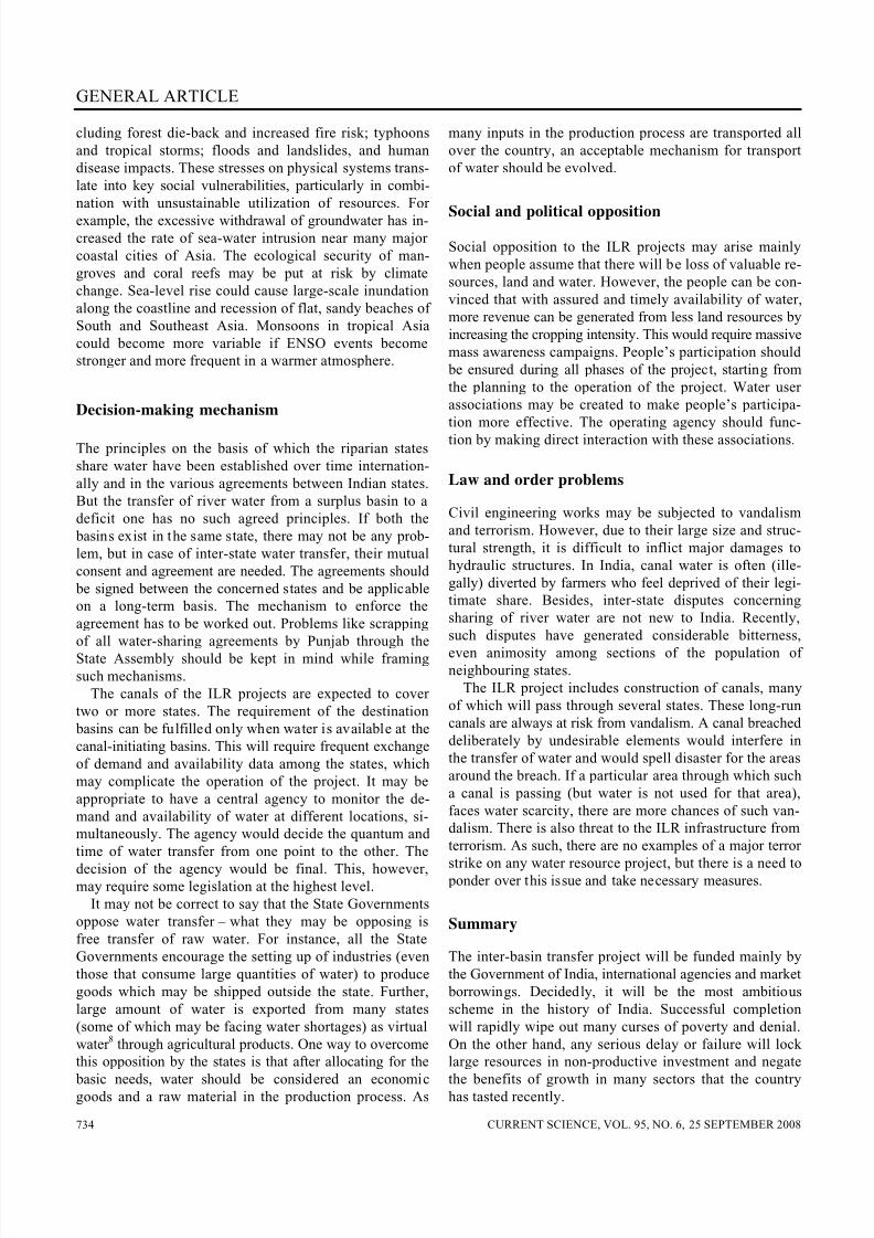
decided to set up a National Water Development Agency
(NWDA) about a quarter century ago. After a detailed
study of the earlier proposals, topography, river network,
water availability and demands, NWDA formulated a Na-
tional Perspective Plan (NPP) for water resources deve-
lopment. The distinctive feature of the NPP is that the
transfer of water is essentially by gravity and only in
small reaches by lifts (not exceeding 120 m). This plan
comprised of two components: (i) Himalayan Rivers De-
velopment and (ii) Peninsular Rivers Development. A
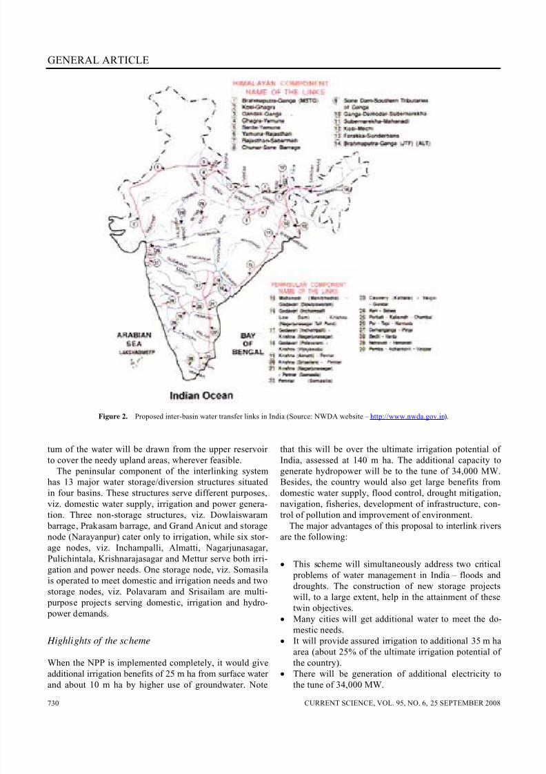
map of the proposed scheme of ILR is shown in Figure 2.
Himalayan rivers development component
The Himalayan component envisages construction of
storage reservoirs on the main Ganga and Brahmaputra
rivers and their principal tributaries in India and Nepal,
so as to conserve monsoon flows for irrigation and hydro-
power generation, besides flood control. Links will transfer
surplus flows of the Kosi, Gandak and Ghagra to the west.
In addition, the Brahmaputra–Ganga link will augment
dry-weather flow of the Ganga. Surplus flows that will
become available on account of interlinking of the Gangaand the Yamuna are proposed to be transferred to the
drought-prone areas of Haryana, Rajasthan and Gujarat.
With this proposal about 14 m ha-m of additional water
would be available from these river systems for irrigating
an estimated 22 m ha in the Ganga–Brahmaputra basin,
apart from Haryana, Punjab, Rajasthan and Gujarat. It
would also provide 1120 cumec to Calcutta Port and
would provide navigation facility across the country. It
will also provide flood moderation in the Ganga–Brahma-
putra system. Fourteen links are proposed in the Himala-
yan component.
Peninsular rivers development component
The main component of Peninsular Rivers Development
is popularly known as the ‘Southern water grid’, which is
envisaged to link Mahanadi, Godavari, Krishna, Pennar
and Cauvery rivers. The scheme was prima facie found to
be technically feasible and economically viable5. The link
system is conceived on the basis of ‘substitution and ex-
change’ to avoid unnecessary lifts. Substitution envisages
that the surplus water is delivered at the downstream use
points in the basins facing water deficit, substituting for
the existing committed releases from the upstream loca-tion in the deficit basin. In exchange, whole or part quan-
5/14/2018 Some Issues on Interlinking of Rivers in India - slidepdf.com
http://slidepdf.com/reader/full/some-issues-on-interlinking-of-rivers-in-india 3/8
GENERAL ARTICLE
CURRENT SCIENCE, VOL. 95, NO. 6, 25 SEPTEMBER 2008 730
Figure 2. Proposed inter-basin water transfer links in India (Source: NWDA website – http://www.nwda.gov.in
).
tum of the water will be drawn from the upper reservoir
to cover the needy upland areas, wherever feasible.
The peninsular component of the interlinking system
has 13 major water storage/diversion structures situated
in four basins. These structures serve different purposes,
viz. domestic water supply, irrigation and power genera-
tion. Three non-storage structures, viz. Dowlaiswaram
barrage, Prakasam barrage, and Grand Anicut and storage
node (Narayanpur) cater only to irrigation, while six stor-age nodes, viz. Inchampalli, Almatti, Nagarjunasagar,
Pulichintala, Krishnarajasagar and Mettur serve both irri-
gation and power needs. One storage node, viz. Somasila
is operated to meet domestic and irrigation needs and two
storage nodes, viz. Polavaram and Srisailam are multi-
purpose projects serving domestic, irrigation and hydro-
power demands.
Highlights of the scheme
When the NPP is implemented completely, it would give
additional irrigation benefits of 25 m ha from surface waterand about 10 m ha by higher use of groundwater. Note
that this will be over the ultimate irrigation potential of
India, assessed at 140 m ha. The additional capacity to
generate hydropower will be to the tune of 34,000 MW.
Besides, the country would also get large benefits from
domestic water supply, flood control, drought mitigation,
navigation, fisheries, development of infrastructure, con-
trol of pollution and improvement of environment.
The major advantages of this proposal to interlink rivers
are the following:
• This scheme will simultaneously address two critical
problems of water management in India – floods and
droughts. The construction of new storage projects
will, to a large extent, help in the attainment of these
twin objectives.
• Many cities will get additional water to meet the do-
mestic needs.
• It will provide assured irrigation to additional 35 m ha
area (about 25% of the ultimate irrigation potential of
the country).
•
There will be generation of additional electricity tothe tune of 34,000 MW.
5/14/2018 Some Issues on Interlinking of Rivers in India - slidepdf.com
http://slidepdf.com/reader/full/some-issues-on-interlinking-of-rivers-in-india 4/8
GENERAL ARTICLE
CURRENT SCIENCE, VOL. 95, NO. 6, 25 SEPTEMBER 2008 731
• The rivers and canals can be used to transport goods
and traffic at lesser cost and in an environment-
friendly manner.
All of the above will help the country achieve a higher
GDP growth and improve the environment. The total outlayfor the scheme has been estimated at Rs 560,000 crore.
Note that this is an approximate estimation. When de-
tailed project reports are prepared and the actual costs of
different projects are worked out, the final figure may be
substantially different. It is pertinent to note that the GNP
of India for 2007 was Rs 3,536,400 crore.
Issues to be addressed for successfulimplementation of ILR
When a big scheme like the ILR is taken up, a number of
issues from various sectors are likely to crop up. These
include social, political, economic, legal, engineering and
environmental problems. The remaining part of this article
will mainly highlight the issues from the last two catego-
ries with possible remedies.
Data-related aspects
Optimal design and management of ILR projects would
require large quantity of data from different disciplines.
Here, our attention is focused on water-related data.
Hydrometeorological data: One of the major objectives
of ILR projects is to divert surplus water from water-
surplus basins to water-scarce basins. This will require
construction of reservoirs for storage of excess water for
a certain period and to regulate it, and canals are to be
constructed to divert the water from one reservoir to an-
other or to the places of need.
The planning of the ILR project would start with com-
puting periodic (monthly) water balance and water avail-
ability in all the basins to be interlinked. These analyses
requires time series of rainfall, stream flow and ground-
water data of sufficient length (at least 30 years). Note
that the discharge measured at the gauging stations maynot be the representative stream flow under natural condi-
tions, if some water development project(s) are utilizing a
part of the available water in the basin upstream of the
gauging sites. The periodic water utilization of such pro-
jects should be accounted for, while estimating the water
availabilities. But frequently data of monthly water utili-
zation of the upstream projects are not available. In that
situation, these can be estimated from the data of the
command area and cropping pattern of the projects, and
normal monthly rainfall and evaporation in the command
area of the projects.
Design flood is one of the key parameters for designand construction of dams. It is the maximum flood that a
structure can pass without causing any damage to it. The
design flood for a structure is estimated using different
approaches depending on its size, storage capacity and
catchment area. For small and medium projects, floods of
specific return period, estimated by frequency analysis,
are designated as the design flood. For large projects, thedesign flood hydrograph is computed using the unit hy-
drograph (UH) principles. To apply frequency analysis
method, the annual maximum discharge series of suffi-
cient length is required. The design flood hydrograph
method requires the UH for the catchment, the design hy-
drograph (rainfall intensity vs time) hydrological loss in-
dices and baseflow contribution. The UH for a catchment is
derived either by analysing the short duration (event
based) rainfall run-off data or synthetically from basin
parameters. The design hydrograph is estimated from the
probable maximum precipitation and time distribution of
rainfall in the catchment area. The hydrological loss indi-ces and baseflow contribution are estimated from the
rainfall run-off data.
The expected life of a reservoir is estimated on the basis
of rate of siltation, which in turn is computed from the
sediment content of the reservoir inflow. Hence, sediment
data of the streams are also needed for design of reser-
voirs and catchment area treatment recommendations.
Topography, soil and geological data: The interlinking
canals should be designed to carry the required volume of
water safely. The canals may be lined at some critical areas.
Topography governs the slope of the canal and soil typeaffects the seepage through it. Hence, to design the canal
sections and for proper layout detailed topographic, soil
and geological data are required. Geophysical data are
required for identifying suitable locations for dams and
the design of their foundation.
The maximum water level of a reservoir is fixed by
simulation and reservoir routing. This requires detailed
topographical data (area–elevation–capacity curves) at
the reservoir site, inflow to the reservoir, various de-
mands downstream and losses such as evaporation and
percolation from the reservoir. Analyses of geological
data are required before construction of dams.
River cross-section and roughness data downstream of the dam are required for the hydraulic analysis of the
river such as to compute the carrying capacity, sufficiency
of embankment heights, morphological modelling, river
routing, safe disposal of dam break flood, etc. These data
at the upstream of the dam are also required to study the
backwater effect of the dam.
Biological and biochemical data: The ILR projects
should not have adverse effects on the environment. To
preserve the ecological system of the rivers, some minimum
flow in the rivers should be maintained. This requires ex-
tensive study of the existing flora and fauna in the riversystem. To estimate the minimum flow in the river, the
5/14/2018 Some Issues on Interlinking of Rivers in India - slidepdf.com
http://slidepdf.com/reader/full/some-issues-on-interlinking-of-rivers-in-india 5/8
GENERAL ARTICLE
CURRENT SCIENCE, VOL. 95, NO. 6, 25 SEPTEMBER 2008 732
lean period (non-monsoon) stream-flow data are required
to be analysed.
In India, domestic and industrial effluents are frequently
discharged into the streams without any treatment and
this pollutes the water. Depending on the quantum of
river flow, the pollution may get diluted while moving inthe stream along with its water. To estimate the minimum
environmental flow in the streams, data pertaining to the
quality, quantity and entry point of the effluents, and
quality of stream water upstream of the entry points are
required.
Socio-economic data: The benefits of the ILR projects
are aimed at the development of the society. The benefi-
ciaries for the project are required to be identified. The
benefits can be quantified only if the pre-project data are
available. Socio-economic data on human population,
livestock population, availability of human resourceand economic conditions of the project area are
required while designing and implementation of the ILR
projects.
Problems in availability of data: Despite much advance-
ment in information technology, databases containing
requisite data are still lacking. River-flow data are the
key to surface-water planning. In India, measured stream-
flow data series of sufficient length is not available at
many sites. For most regions, majority of the gauging sta-
tions were established in the 1960s. Subsequently, a
number of stations were set up in the 1980s. Thus, in gen-eral, data for a period of 25 to 30 years are available at
most of the sites. At a few sites, data series of 40 years is
available. Clearly, the length of measured data series at
most sites is not adequate to plan major projects. In the
absence of measured data, either rainfall data are used to
extend the flow series since long data series of measured
rainfall are available in India, or synthetic data are gener-
ated and used in analysis. Although the synthetic data
help in analysis, these are no substitute for the measured
data.
Another difficulty lies in the determination of virgin
flow, which is the sum of observed flow and the upstream
water used. The water used in irrigation in the upstreamwater resources projects constitutes the upstream water
use. These projects are classified as major, medium and
minor based on their command area. Data like exact loca-
tion of project, year of its commissioning and water with-
drawal is generally available for major projects, may be
available for medium projects, and in general is missing
for minor projects. Further, information about medium
and minor projects is usually not available at a central
place. At times even district offices do not have these data
and in some cases, the information is not available. There
are instances where the working tables of even major pro-
jects are incomplete. Data on actual water use and itstemporal variation (inter- and intra-annual) are rare to
find. Thus, much time is spent in collecting data and
even after that, one may have to assume certain critical
values.
Assessment of water demands at a future date when
these are likely to stabilize, say by 2050, and estimating
water availability at that time is another component re-quiring extensive data. The important components of de-
mand estimation are projection of population, industrial
and agriculture growth. Population projections are made
using past population records and future growth rates.
The future population growth rates are also provided by
international agencies like the United Nations. It is diffi-
cult to project the industrial growth and its water demand
pattern. Information about planned water resources pro-
jects is generally available with water resources depart-
ments of the concerned state governments. But as stated
above, only limited data are available. The water use of
these future projects is determined using climatologicalapproach, for which the reference evapotranspiration data
are the main input. These data are available only at a few
selected stations in India. There may be a case when there
is no such station in the basin being analysed for surplus/
deficit.
To save time and come up with correct answers, cen-
tralized databases containing all the required variables
should be set up in all the states. It is pertinent to highlight
that the issue of non-availability of data has been dis-
cussed in numerous conferences and meetings. It is now
customary to include a recommendation concerning data
problems as an outcome of any conference, and yet theproblem remains unresolved.
The non-availability of the representative data of desired
length and quality might lead to sub-optimal design and
management. Due to inadequate or poor data, the assess-
ment of available water may be on the wrong side or the
projected demands may be far from the actual. The end
results will be that full benefits may remain unrealized.
Pooling all available data, observing/extending data se-
ries wherever possible, and using refined analytical tools
can minimize the risk due to this eventuality. Ideally, data
should be made available to all those who want to analyse
them, so that the expertise available in the country can be
best utilized. Working in secrecy, there is always a dan-ger that the mistakes will propagate undetected and there
is not much room for new ideas to flourish.
Methodology for water balance
While carrying water balance and estimating surpluses,
groundwater availability in the basins is not accounted for
generally. This is not scientifically correct. The National
Commission for Integrated Water Resources Develop-
ment Plan (NCIWRDP), 1999 is also of the view that
groundwater should to be taken into consideration in waterbalance studies. In fact, the Cauvery basin was found to

5/14/2018 Some Issues on Interlinking of Rivers in India - slidepdf.com
http://slidepdf.com/reader/full/some-issues-on-interlinking-of-rivers-in-india 6/8
GENERAL ARTICLE
CURRENT SCIENCE, VOL. 95, NO. 6, 25 SEPTEMBER 2008 733
be water-deficit by the NWDA on ignoring groundwater,
while NCIWRDP reported that when groundwater is con-
sidered, the basin will have surplus water.
Nowadays groundwater is extensively used to meet irri-
gation, domestic and industrial demands. Since surface
water potential and groundwater potential are interde-pendent, computation of the former disregarding the latter
is not the right approach. Therefore, the guidelines should
be modified to include groundwater in water balance
computations. This will align the guidelines with scientifi-
cally correct principles. Further, ownership rights of water
are not clearly defined in India and this leads to different
interpretations and inter-state disputes.
Skilled manpower needs
On account of the large size of the projects, skilled man-
power needs for ILR will be extensive. Also, extensive
field investigations will be required to prepare detailed
reports for all projects. These will involve hydrological
observations, topographical surveys, surveys of dam and
reservoir areas, command area surveys, canal alignments,
geologic and geotechnical investigations, construction
material survey, socio-economic surveys in command areas
and surveys related to EIA. All these activities need
skilled technical manpower and some activities require
specialists in their respective fields. With the advent of
new technology (like total station) in surveying, the task
of surveying is not that time-consuming, but to operate
such sophisticated equipment and analyse the data re-quires skilled hands. Experts will also be needed for
office and field studies such as hydrologic analysis
and design, civil engineering design, geological and geo-
technical investigations, environmental and ecological
studies.
Any single organization such as the NWDA does not
have experts with the range of background and experience
needed for this work. Further, in view of the magnitude
of work, adequate personnel are not found in any organi-
zation. Hence, much work will have to be outsourced.
Supervision of the work being done by different organi-
zations/consultants also requires different specialists.During construction, managers and supervisory staff will
be needed to ensure quality and timely completion of
the work. Moreover, many experienced staff are leaving
government jobs these days. Thus, institutional strength-
ening and capacity building will have to be undertaken
urgently.
Time and cost overruns
The estimated cost of the project is Rs 560,000 crore (Rs
365,000 crore for the Himalayan component and the re-
maining Rs 185,000 crore for the peninsular component).It is to be completed in a time-span of 10–15 years. There
may be only a few water resources projects in India
which have been completed recently, within the stipu-
lated cost and time. There are chances that the ILR pro-
ject will overrun the estimated cost and time. This may be
classified as ‘managerial risk’. A major lapse on this
count may seriously undermine the benefits and may even jeopardize the viability of the scheme.
Raising of funds for the present estimated cost of the
ILR project will be a problem and this will burden the
economy of India. The cost escalation will further compli-
cate the matter. After the construction of the project,
money will be required for its operation and maintenance.
These recurring costs are to be realized from the users,
which is again a complex problem.
Environmental issues
There is likely to be opposition to the ILR scheme from
environmentalists. Views have been expressed that the
ILR may cause environmental impacts much different
from those caused by general water resources development
projects. However, this eventuality will arise only if the
scheme is not properly designed, constructed and man-
aged. If properly executed, this proposal has the potential
to significantly improve the ecosystem in the receiving
basins without degrading the same in the donor basins.
However, the project should be undertaken with full rec-
ognition of the ecological damages that may be caused
and that the benefits should far outweigh these costs6.
Impact of climate change
Analysis of measured hydro-meteorological data suggests
that the climate of the earth may be undergoing signifi-
cant long-term changes. For a water planner, the changes
may manifest in altered spatial and temporal patterns of
precipitation, evapotranspiration and streamflow. Such
changes, if at all they take place, might adversely influence
the reliability of the project. Some of the components
may fail to perform up to the mark and others may become
redundant.
According to the Intergovernmental Panel on ClimateChange7, the major impacts of global warming in temperate
Asia will be large northward shifts of subtropical crop
areas. Large increases in surface run-off leading to soil
erosion and degradation, frequent waterlogging in the
South, and spring droughts in the North will ultimately
affect agricultural productivity. The volume of run-off
from glaciers in Central Asia may increase threefold by
2050.
In monsoon Asia, the issue of sensitivity of physical
and natural systems to the hydrological cycle is linked to
major stresses caused by the projected climate change on
agricultural production and increased exposure of socialand economic systems to impacts of extreme events, in-
5/14/2018 Some Issues on Interlinking of Rivers in India - slidepdf.com
http://slidepdf.com/reader/full/some-issues-on-interlinking-of-rivers-in-india 7/8
GENERAL ARTICLE
CURRENT SCIENCE, VOL. 95, NO. 6, 25 SEPTEMBER 2008 734
cluding forest die-back and increased fire risk; typhoons
and tropical storms; floods and landslides, and human
disease impacts. These stresses on physical systems trans-
late into key social vulnerabilities, particularly in combi-
nation with unsustainable utilization of resources. For
example, the excessive withdrawal of groundwater has in-creased the rate of sea-water intrusion near many major
coastal cities of Asia. The ecological security of man-
groves and coral reefs may be put at risk by climate
change. Sea-level rise could cause large-scale inundation
along the coastline and recession of flat, sandy beaches of
South and Southeast Asia. Monsoons in tropical Asia
could become more variable if ENSO events become
stronger and more frequent in a warmer atmosphere.
Decision-making mechanism
The principles on the basis of which the riparian states
share water have been established over time internation-
ally and in the various agreements between Indian states.
But the transfer of river water from a surplus basin to a
deficit one has no such agreed principles. If both the
basins exist in the same state, there may not be any prob-
lem, but in case of inter-state water transfer, their mutual
consent and agreement are needed. The agreements should
be signed between the concerned states and be applicable
on a long-term basis. The mechanism to enforce the
agreement has to be worked out. Problems like scrapping
of all water-sharing agreements by Punjab through theState Assembly should be kept in mind while framing
such mechanisms.
The canals of the ILR projects are expected to cover
two or more states. The requirement of the destination
basins can be fulfilled only when water is available at the
canal-initiating basins. This will require frequent exchange
of demand and availability data among the states, which
may complicate the operation of the project. It may be
appropriate to have a central agency to monitor the de-
mand and availability of water at different locations, si-
multaneously. The agency would decide the quantum and
time of water transfer from one point to the other. The
decision of the agency would be final. This, however,may require some legislation at the highest level.
It may not be correct to say that the State Governments
oppose water transfer – what they may be opposing is
free transfer of raw water. For instance, all the State
Governments encourage the setting up of industries (even
those that consume large quantities of water) to produce
goods which may be shipped outside the state. Further,
large amount of water is exported from many states
(some of which may be facing water shortages) as virtual
water8 through agricultural products. One way to overcome
this opposition by the states is that after allocating for the
basic needs, water should be considered an economicgoods and a raw material in the production process. As
many inputs in the production process are transported all
over the country, an acceptable mechanism for transport
of water should be evolved.
Social and political opposition
Social opposition to the ILR projects may arise mainly
when people assume that there will be loss of valuable re-
sources, land and water. However, the people can be con-
vinced that with assured and timely availability of water,
more revenue can be generated from less land resources by
increasing the cropping intensity. This would require massive
mass awareness campaigns. People’s participation should
be ensured during all phases of the project, starting from
the planning to the operation of the project. Water user
associations may be created to make people’s participa-
tion more effective. The operating agency should func-
tion by making direct interaction with these associations.
Law and order problems
Civil engineering works may be subjected to vandalism
and terrorism. However, due to their large size and struc-
tural strength, it is difficult to inflict major damages to
hydraulic structures. In India, canal water is often (ille-
gally) diverted by farmers who feel deprived of their legi-
timate share. Besides, inter-state disputes concerning
sharing of river water are not new to India. Recently,
such disputes have generated considerable bitterness,
even animosity among sections of the population of neighbouring states.
The ILR project includes construction of canals, many
of which will pass through several states. These long-run
canals are always at risk from vandalism. A canal breached
deliberately by undesirable elements would interfere in
the transfer of water and would spell disaster for the areas
around the breach. If a particular area through which such
a canal is passing (but water is not used for that area),
faces water scarcity, there are more chances of such van-
dalism. There is also threat to the ILR infrastructure from
terrorism. As such, there are no examples of a major terror
strike on any water resource project, but there is a need toponder over this issue and take necessary measures.
Summary
The inter-basin transfer project will be funded mainly by
the Government of India, international agencies and market
borrowings. Decidedly, it will be the most ambitious
scheme in the history of India. Successful completion
will rapidly wipe out many curses of poverty and denial.
On the other hand, any serious delay or failure will lock
large resources in non-productive investment and negate
the benefits of growth in many sectors that the countryhas tasted recently.
5/14/2018 Some Issues on Interlinking of Rivers in India - slidepdf.com
http://slidepdf.com/reader/full/some-issues-on-interlinking-of-rivers-in-india 8/8
GENERAL ARTICLE
CURRENT SCIENCE, VOL. 95, NO. 6, 25 SEPTEMBER 2008 735
Finally, ILR alone will not solve all water-related prob-
lems of the country. Concepts such as water conservation,
optimal regulation of existing facilities, rainwater har-
vesting, watershed management, water reuse, etc. will
continue to be highly relevant and this grand scheme will
be an important supplement to these. A holistic view of the scenario is always important and necessary.
1. Jain, S. K., Agarwal, P. K. and Singh, V. P., Hydrology and Water
Resources of India, Springer, The Netherlands, 2007.
2. Cox, W. E., Preface. In Proceedings of International Workshop on
Interbasin Water Transfer, International Hydrological Programme,
UNESCO, Paris, 1999.
3. Rao, K. L., India’s Water Wealth, Orient Longman Limited, New
Delhi, 1973.
4. Dastur, D. J., This or Else…: A Master Plan for India’s Survival .
Jaico Publishing House, Bombay, 1974.
5. Theme paper on Inter-basin transfers of water for national develop-
ment – Problems and prospects. Indian Water Resources Society,
Roorkee, 1996.
6. Ali, I., Interlinking of Indian rivers. Curr. Sci., 2004, 86, 498–499.
7. Solomon, S. et al. (eds), Climate Change 2007: The Physical Sci-
ence Basis. Contribution of Working Group I to the Fourth Assess-
ment Report of the Intergovernmental Panel on Climate Change ,
Cambridge University Press, Cambridge.
8. Kumar, V. and Jain, S. K., Status of virtual water trade from India.
Curr. Sci., 2007, 93, 1093–1099.
Received 3 February 2008; revised accepted 1 August 2008
CURRENT SCIENCESpecial Section: Squirrels
10 October 2008
Guest Editors: R. Nandini and Anindya Sinha
Global hotspots and knowledge gaps for tree and flying squirrels
John L. Koprowski and R. Nandini
Differing rates of macroevolutionary diversification in arboreal squirrels
V. Louise Roth and John M. Mercer
The life histories of orders of mammals: Fast and slow breeding
F. Stephen Dobson and Madan K. Oli
Why are there so many giants, including giant squirrels, in the Old World tropics?Renee M. Borges
Evolutionary interactions between tree squirrels and trees: A review and synthesis
Michael A. Steele
The group-nesting and food-hoarding behaviour of the southern flying squirrel, Glaucomys volans
Michael F. Winterrowd
Nesting sites of Indian giant squirrels in Sitanadi Wildlife Sanctuary, India
Ravi Shanker Kanoje
Measuring Indian giant squirrel ( Ratufa indica) abundance in southern India using distance sampling
Devcharan Jathanna, N. Samba Kumar and K. Ullas Karanth
Site occupancy of the Indian giant squirrel Ratufa indica (Erxleben) in Kalakad–Mundanthurai Tiger Reserve,
Tamil Nadu, IndiaV. Srinivas, P. Dilip Venugopal and Sunita Ram
Responses of diurnal tree squirrels to selective logging in western Arunachal Pradesh
Aparajita Datta and S. P. Goyal
Introduction of the American grey squirrel (Sciurus carolinensis) in Europe: a case study in biological invasion
Bertolino Sandro
Crop raiding and management of Funambulus palmarum in cardamom ( Elettaria cardamomum) plantations of
Western Ghats of Karnataka, south India
A. K. Chakravarthy, N. E. Thyagaraj, L. Vijay Kumar and A. C. Girish
The importance of radio-telemetry in arboreal squirrel research
D. L. Haughland, K. W. Larsen and M. Wheatley
The use of GIS and modelling approaches in squirrel population management and conservation: A review
P. W. W. Lurz, J. L. Koprowski and D. J. A. Wood


![Study of Interlinking of Rivers by using Geographic ... · Study of Interlinking of Rivers by using Geographic Information System (GIS) With Quantum-GIS [1] Anupriya , [2] Lalit R](https://img.pdfslide.us/doc/110x75/5ebbcd53ab03d3799645346d/study-of-interlinking-of-rivers-by-using-geographic-study-of-interlinking-of.jpg)