Embed Size (px)
Citation preview

Statewide Orthoimagery 2010
Data Delivery
(excerpts for imagery review)Center for Geographic Information and Analysis
Tim Johnson, Director
March 2011

Project In Brief
• City of Durham PSAP
• Funded by NC 911 Board
• 100 counties
• Flights – early 2010
• Imagery to counties – early 2011
• 59,000 “tiles” (5,000 by 5,000 feet)
• 6-inch ground resolution
2NC Statewide Orthoimagery 2010

3
Four regions for image acquisition, processing and delivery. Contractors were Sanborn (Mts), Photo
Science (W. Peid.), Surdex (E. Pied),and AeroMetric (coastal).

4
Blocks for Aerial Triangulation and Processing
Contractors used large blocks for aerial triangulation
and processing. Larger in the east where gentle slopes
and long North-South flight lines.

Visual QC
• Third party quality control – AECOM
• Selected tiles
• Attention to edges of regions (four
processing contractors)
• Expectations

“NC Technical Specifications for Digital
Orthophoto Base Mapping” from Land
Records Management Program in the
Secretary of State’s Office (2009):
•Methods
•Formats
•Quality and accuracy
•Reports certified by surveyor
licensed in NC
6
NC Specifications

• Transportation
• Major bridges
• Urban areas
• No seam lines cutting buildings or large structures
• Areas of state importance
• Color and contrast well balanced at seam edges between contractors
Areas of great importance
• Highly vegetated areas
• Water bodies (color and seam lines)
• Utility lines above the ground
Areas of least importance
Visual Quality Control

• High quality, but not perfect
• Contractors: 25 percent of tiles inspected
• CGIA: 5 percent of tiles inspected (focus
on transportation and urban cores)
• 70-75 percent not inspected unless a
systematic problem in the sample
• Positional accuracy from sample points,
not every location
8
Is the imagery flawless?

• What is a flaw that should be fixed?
• Project expectations
• What is the cost of misrepresentation
of a feature?
• What is the effort to modify?
• State Specifications
• Contact CGIA
• 90-day period before final repairs
9
What is a Flaw?

Visual Quality is High
Cumberland County example

Bay River, Pamlico County example.

Stonewall in Pamlico County example


What you should not see
•Major bridge is distorted
•Transportation feature cut and offset by a
seam line
•Tall building is cut by a seam line or is
leaning extremely
•Areas of state importance distorted or
obscured
•Color and contrast changes abruptly at seam
edges between contractors
•Artifacts from a flaw in rectification
•Wash out from brightness or too dark to see
features

Automated processing
based on digital elevation
model distorted
the elevated highway in this
example. Elevated features
can be warped in processing,
but can be fixed.

Same
example
after
repair.

Combination of
digital
exposures
into tiles
requires subtle
seams between
exposures.
This example
has abrupt
seam lines
and displaced
roadways.
This can
be fixed.

This example
has abrupt
seam lines
and displaced
features.
This can
be fixed.

This is an
example
of an anomaly
from an
automated
process.
Parts of the
images were
pulled toward
an elevation
point in the
water.
This can
be fixed.

Same
example
after
repair.

What is acceptable?
• Color balance between regions /
contractors
• Some building lean (not nadir)
• Bright roof tops
• Power lines discontinuous
• Leaning trees
• Water as is
• No tiles in the sounds

Color balance varies from
one region to the next.
Color balancing relied on
statistics from sample locations
within a region. Contractors
smoothed color balance in tiles
at the edge of regions.
Some of the tallest
buildings appear to
lean over adjacent
features. Some
lean is acceptable
and inevitable
because the
digital sensors are
not directly above
all tall buildings.

Some locations
are bright
where rooftops
soils or concrete
are very
reflective.
If feature
outlines are
not washed out,
this is acceptable.
Adjacent areas
may get too
dark if the tile
were darkened.
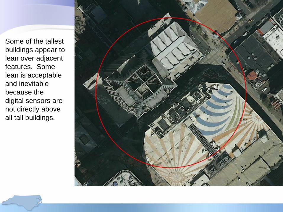
Features high
above the ground
such as power
lines in this
example may
appear distorted or
displaced.
Photos are
rectified to the
ground, not to
elevated features.
This is an example
of acceptable
visual quality.

Some locations
have trees that
partly obscure
roads. Some of
this is inevitable
given camera
angles and
vegetation.
The north and
south portions
of the road are
visible and can
be extrapolated
for 911 and GIS
purposes.

Water reflects
differently from
different flight lines
and images.
Contractors were not
expected to color
balance large
water bodies like
the one in this
example.

The project
did not
acquire
images over
the sounds.
Recent
imagery from
NOAA is
included in
distribution
(orange tiles).
The large
area of open
water in the
sounds
will not have
imagery tiles.

If you display
multiple
county
mosaics,
white space
will appear in
counties
displayed
under an
adjacent
county. The
compression
software
creates a
rectangle to
include county
tiles. Where
boundaries
are irregular,
parts of the
rectangle
have no
imagery from
that county.

A solution is to go to
the layer properties for
a mosaic, and display
background value as
255-255-255. This
nearly eliminates the
white pixels, but a few
may remain (software
bug) as shown in this
example. If zoomed in
far enough to see the
white pixels, change
the display order of the
county mosaics.
There is no current fix
to this display
problem.
There is no missing
data in any of the
county mosaics.

What if you find a flaw?
• 90-day period for review
• Contact your county 911 or GIS
coordinator and CGIA (Darrin Smith or
Jeff Brown) with the issue
• Include the image name and a snapshot
if practical
• Project team will review
• If deemed a flaw that can be fixed,
replacement tiles will be generated after
the 90-day period

• Expected sharing:
• PSAPs within your county
• GIS operations in municipalities
• NC OneMap for online access
(www.nconemap.gov)
• Download
• Imagery services by end of May
• Requests for copies – data are public
records; distribute as you wish. 32
Reminder: Share the Data

Project Information Online
911 Board Feedback
• The Board invites your feedback
• 4-Year Quarter State Plan
• Next Generation 911
• Richard Taylor, Executive Director

Acknowledgements• NC 911 Board
• City of Durham
• CGIA staff
• Geospatial and Technology Management Office
• NC Geodetic Survey
• Land Records Management, Secretary of State
• Private contractors
• USGS and NGA
• NC ITS: Enterprise Project Management Office; Hosting Services
• State Chief Information Officer
• GICC and Statewide Mapping Advisory Committee
• Working Group for Orthophotography Planning
• Local Government Committee

Contact
www.ncgicc.org
www.nconemap.com