Embed Size (px)
Citation preview
Review of Ministerial Conditions on the Groundwater Resources of the Gnangara Mound
Draft for public comment
Prepared by
Water Allocation Planning Branch
Water Resource Use
Department of Water
Department of Water
January 2008
Review of Ministerial Conditions on the Groundwater Resources of the Gnangara Mound
ii Department of Water
Department of Water Ground Floor, The Atrium 168 St Georges Terrace Perth Western Australia 6000
www.water.wa.gov.au
Telephone +61-8-6364 7600 Facsimile +61-8-6364 7601
For more information about this report, contact: Water Allocation Planning Branch or email
January 2008
ISBN 978-1-921094-78-1 (pbk.) ISBN 978-1-921094-79-8 (pdf)
Review of Ministerial Conditions on the Groundwater Resources of the Gnangara Mound
Department of Water iii
Invitation The Environmental Protection Authority (EPA) invites people to make a submission on this proposal. The environmental impact assessment process is designed to be transparent and accountable, and includes specific points for public involvement, including opportunities for public review of environmental review documents. In releasing this document for public comment, the EPA advises that no decisions have been made to allow this proposal to be implemented.
The Department of Water proposes amendments to Ministerial Statement No: 687 Gnangara Mound Groundwater Resources (including Groundwater Resource Allocation, East Gnangara City of Swan). In accordance with section 46 of the Environmental Protection Act, a review of Ministerial conditions has been prepared which describes this proposal and its likely effects on the environment. The review document is available for a public review period of 4 weeks from 7 January 2008 closing on 4 February 2008.
Comments from government agencies and from the public will assist the EPA to prepare an assessment report in which it will make recommendations to government.
Where to get copies of this document
Printed copies of this document may be obtained from the Department of Water, Ground Floor, The Atrium 168 St Georges Tce Perth, 6364 7600.
Copies may also be obtained from www.water.wa.gov.au
Why write a submission?
A submission is a way to provide information, express your opinion and put forward your suggested course of action - including any alternative approach. It is useful if you indicate any suggestions you have to improve the proposal.
All submissions received by the EPA will be acknowledged. Electronic submissions will be acknowledged electronically. The proponent will be required to provide adequate responses to points raised in submissions. In preparing its assessment report for the Minister for the Environment, the EPA will consider the information in submissions, the proponent’s responses and other relevant information. Submissions will be treated as public documents unless provided and received in confidence, subject to the requirements of the Freedom of Information Act, and may be quoted in full or in part in each report.
Why not join a group?
If you prefer not to write your own comments, it may be worthwhile joining with a group or other groups interested in making a submission on similar issues. Joint
Review of Ministerial Conditions on the Groundwater Resources of the Gnangara Mound
iv Department of Water
submissions may help to reduce the workload for an individual or group, as well as increase the pool of ideas and information. If you form a small group (up to 10 people) please indicate all the names of the participants. If your group is larger, please indicate how many people your submission represents.
Developing a submission
You may agree or disagree with, or comment on, the general issues discussed in the review document or the specific proposals. It helps if you give reasons for your conclusions, supported by relevant data. You may make an important contribution by suggesting ways to make the proposal environmentally more acceptable.
When making comments on specific proposals in the review document:
• clearly state your point of view;
• indicate the source of your information or argument if this is applicable;
• suggest recommendations, safeguards or alternatives.
Points to keep in mind.
By keeping the following points in mind, you will make it easier for your submission to be analysed:
• attempt to list points so that issues raised are clear. A summary of your submission is helpful;
• refer each point to the appropriate section, chapter or recommendation in the review document;
• if you discuss different chapters of the review document, keep them distinct and separate, so there is no confusion as to which chapter you are considering;
• attach any factual information you may wish to provide and give details of the source. Make sure your information is accurate.
Remember to include:
• your name,
• address,
• date; and
• whether you want your submission to be confidential.
The closing date for submissions is: 4 February 2008.
Review of Ministerial Conditions on the Groundwater Resources of the Gnangara Mound
Department of Water v
The EPA prefers submissions to be made electronically using one of the following:
• the submission form on the EPA’s website www.epa.wa.gov.au/submissions.asp;
• by email to <[email protected]>;
• by email to the officer [email protected]
Alternatively submissions can be
• posted to: Chairman, Environmental Protection Authority, Locked Bag 33, CLOISTERS SQUARE WA 6850, Attention: (Murray Hogarth); or
• delivered to the Environmental Protection Authority, Level 4, The Atrium, 168 St Georges Terrace, Perth, Attention: (Murray Hogarth); or
• faxed to (08) 6467 5562.
If you have any questions on how to make a submission, please ring the EPA assessment officer, Murray Hogarth on 6467 5429.
Review of Ministerial Conditions on the Groundwater Resources of the Gnangara Mound
vi Department of Water
Contents Invitation ..................................................................................................................... iii Contents ..................................................................................................................... vi
Appendices .........................................................................................................................viii Figures................................................................................................................................viii Tables ..................................................................................................................................xii
Preface ..................................................................................................................... xiii Summary ................................................................................................................... xv
1 Introduction .........................................................................................................1 1.1 Purpose of this report ..................................................................................................1 1.2 Overview of proposed changes...................................................................................2
2 Background.........................................................................................................3 2.1 The Gnangara groundwater system............................................................................3 2.2 Role of the Department of Water.................................................................................6 2.3 Protecting the groundwater dependent ecosystems of the Gnangara Mound.............6 2.4 Reviewing and improving the management of the Gnangara Mound..........................8
3 Management approach for Gnangara ...............................................................11
4 Review of environmental conditions – Gnangara Mound ..................................15 4.1 Introduction ...............................................................................................................15
4.1.1 Environmental water requirements and ecological trend methodology ...........................16 4.1.2 Hydrological assessment ................................................................................................23
4.2 Yanchep groundwater area .......................................................................................27 4.2.1 Loch McNess ..................................................................................................................27 4.2.2 Lake Wilgarup .................................................................................................................32 4.2.3 Lake Yonderup................................................................................................................35 4.2.4 Pipidinny Swamp.............................................................................................................39
4.3 Perth groundwater area – Whitfords subarea............................................................42 4.3.1 Lake Goollelal (459) ........................................................................................................42 4.3.2 Lake Joondalup (8281) ...................................................................................................45
4.4 Gnangara groundwater area – Reserve subarea ......................................................49 4.4.1 PM9.................................................................................................................................49
4.5 Gnangara groundwater area – Wanneroo wellfield subarea .....................................52 4.5.1 Melaleuca Park Dampland 78 (GNM31) .........................................................................52 4.5.2 Melaleuca Park EPP 173 (GNM14SG) ...........................................................................55 4.5.3 L30C ...............................................................................................................................58 4.5.4 L110C .............................................................................................................................61 4.5.5 L220C .............................................................................................................................64 4.5.6 NR6C ..............................................................................................................................67 4.5.7 NR11C ............................................................................................................................70 4.5.8 WM1................................................................................................................................74 4.5.9 WM2................................................................................................................................77 4.5.10 WM8................................................................................................................................80 4.5.11 MM12 ..............................................................................................................................82
4.6 Wanneroo groundwater area – Pinjar subarea..........................................................85 4.6.1 PM24...............................................................................................................................85
Review of Ministerial Conditions on the Groundwater Resources of the Gnangara Mound
Department of Water vii
4.6.2 PM25...............................................................................................................................88 4.7 Wanneroo groundwater area – Nowergup subarea ..................................................90
4.7.1 Lake Nowergup ...............................................................................................................90 4.8 Wanneroo groundwater area – Mariginiup subarea ..................................................94
4.8.1 Lake Jandabup (1944) ....................................................................................................94 4.8.2 Lake Mariginiup (MS10) ..................................................................................................98 4.8.3 MT3S ............................................................................................................................102
4.9 Wanneroo groundwater area – Gnangara subarea.................................................105 4.9.1 Lake Gnangara .............................................................................................................105
4.10 Wanneroo groundwater area – Adams subarea...................................................... 108 4.10.1 WM6..............................................................................................................................108
4.11 Swan groundwater area – North Swan subarea......................................................111 4.11.1 Lexia 86 (GNM16).........................................................................................................111 4.11.2 Lexia 94 (GNM17a).......................................................................................................114 4.11.3 Lexia 186 (GNM15).......................................................................................................118 4.11.4 Edgecombe Seepage (B10) ..........................................................................................121 4.11.5 Egerton Seepage (B25) ................................................................................................124
4.12 Mirrabooka groundwater area – Landsdale subarea...............................................127 4.12.1 MM16 ............................................................................................................................127
4.13 Mirrabooka groundwater area – Whiteman Park subarea .......................................130 4.13.1 MM18 ............................................................................................................................130 4.13.2 MM49B..........................................................................................................................133 4.13.3 MM53 ............................................................................................................................135 4.13.4 MM55B..........................................................................................................................137 4.13.5 MM59B..........................................................................................................................140
5 Review of Administrative conditions – Gnangara Mound ................................143 5.1 Ministerial conditions and procedures .....................................................................143 5.2 Proponent commitments .........................................................................................143
6 Into the future ..................................................................................................149
7 Summary of request to changes to Ministerial conditions ...............................153 7.1 Environmental Conditions .......................................................................................153 7.2 Administrative conditions.........................................................................................158
Appendices..............................................................................................................159
Glossary ..................................................................................................................210
References ..............................................................................................................213
Review of Ministerial Conditions on the Groundwater Resources of the Gnangara Mound
viii Department of Water
Appendices
Appendix A — Ministerial Statement 687 ................................................................160
Appendix B — Sources used for assessment of ecological trends of Ministerial criteria sites.....................................................................................................170
Appendix C — Froend et al., (2004b) recent water level trends (2004 — 2007) for Ministerial criteria sites....................................................................................172
Appendix D — Risk of impact and possible response to drawdown for wetlands and terrestrial phreatophytic sites. .........................................................................179
Appendix E — CDFM and PRAMS..........................................................................185
Appendix F — Existing and proposed administrative conditions .............................196
Figures
Figure 1 Planning framework for the Gnangara groundwater resources. .......... xvi Figure 2 The Gnangara Mound showing Groundwater management areas,
groundwater Management sub areas and Ministerial criteria sites. ........5 Figure 3 Planning framework for the Gnangara groundwater resources. .............9 Figure 4 Risk of impact categories for wetland ecosystems based on rate and
magnitude of groundwater drawdown (from Froend et al., 2004b). ......18 Figure 5 Risk of impact categories for phreatophytic vegetation in the 0-3m depth
to groundwater grouping based on rate and magnitude of groundwater drawdown (from Froend et al., 2004b)..................................................18
Figure 6 Risk of impact categories for phreatophytic vegetation in the 3-6m depth to groundwater grouping based on rate and magnitude of groundwater drawdown (from Froend et al., 2004b)..................................................19
Figure 7 Risk of impact categories for phreatophytic vegetation in the 6-10m depth to groundwater grouping based on rate and magnitude of groundwater drawdown (from Froend et al., 2004b).............................19
Figure 8 Historic groundwater level change for terrestrial vegetation (Froend et al., 2004b). ...........................................................................................22
Figure 9 Views of Loch McNess: a) aerial, and b) looking north from the current staff gauge (photo taken by Renée Rowling, 2007)..............................27
Figure 10 Hydrograph from Loch McNess 8754. ..................................................30 Figure 11 Private licences greater than 0.15 GL in the vicinity of Loch McNess
(shown as yellow dots). ........................................................................31 Figure 12 Views of Lake Wilgarup: a) aerial, and b) looking north across the band
of Melaleuca rhaphiophylla (photo taken from Loomes et al., 2007). ...32 Figure 13 Hydrograph from Lake Wilgarup...........................................................34 Figure 14 Views of Lake Yonderup: a) aerial, and b) looking south across the lake
(photo taken from Loomes et al., 2007)................................................35 Figure 15 Hydrograph from Lake Yonderup 8780. ...............................................37
Review of Ministerial Conditions on the Groundwater Resources of the Gnangara Mound
Department of Water ix
Figure 16 Private licenses greater than 0.15 GL in the vicinity of Lake Yonderup (yellow dots). ........................................................................................38
Figure 17 Views of Pipidinny Swamp a) aerial, and b) burnt vegetation on fringes of lake (photo taken by Sandie McHugh, 2005)....................................39
Figure 18 Hydrograph from Pipidinny Swamp. .....................................................41 Figure 19 Views of Lake Goollelal: a) aerial, and b) looking east towards the lake
(photo taken from Bertuch et al., 2004). ...............................................42 Figure 20 Hydrograph from Lake Goollelal. ..........................................................44 Figure 21 Views of Lake Joondalup: a) aerial showing existing criterion bore and
new bore JNP_Wc, and b) looking towards the lake showing exotic species dominating the understorey (photo taken from Loomes et al., 2007). ...................................................................................................45
Figure 22 Hydrograph from Lake Joondalup. .......................................................47 Figure 23 Views of Pinjar PM9: a) aerial, and b) resprouting of understorey and
overstorey species following a fire in May 2006 (photo taken from Loomes et al., 2007).............................................................................49
Figure 24 Hydrograph at Pinjar Monitoring PM9...................................................50 Figure 25 Views of Melaleuca Park (Dampland 78): a) aerial, and b) looking south
from the vegetation transect (photo taken from Bertuch et al., 2004). ..52 Figure 26 Hydrograph from Melaleuca Park (Dampland 78). ...............................54 Figure 27 Views of Melaleuca Park EPP 173: a) aerial, and b) looking south onto
the wetland basin (photo taken from Bertuch et al., 2004). ..................55 Figure 28 Hydrograph from Melaleuca Park EPP173...........................................57 Figure 29 Aerial view of L30C...............................................................................58 Figure 30 Hydrograph from L30C. ........................................................................59 Figure 31 Aerial view of L110C.............................................................................61 Figure 32 Hydrograph from L110C. ......................................................................62 Figure 33 Aerial view of L220C.............................................................................64 Figure 34 Hydrograph from L220C. ......................................................................65 Figure 35 Aerial view of NR6C. ............................................................................67 Figure 36 Hydrograph from NR6C........................................................................68 Figure 37 Aerial view of NR11C. ..........................................................................70 Figure 38 Hydrograph from NR11C......................................................................71 Figure 39 Private licences greater than 0.15 GL in the vicinity of NR11C (shown
as yellow dots)......................................................................................72 Figure 40 Views of WM1: a) aerial, and b) vegetation showing effects of recent fire
(photo taken from Loomes et al., 2007)................................................74 Figure 41 Hydrograph from WM1. ........................................................................75 Figure 42 Aerial of WM2.......................................................................................77 Figure 43 Hydrograph of WM2. ............................................................................78 Figure 44 Aerial of WM8.......................................................................................80
Review of Ministerial Conditions on the Groundwater Resources of the Gnangara Mound
x Department of Water
Figure 45 Hydrograph of WM8. ............................................................................81 Figure 46 Aerial view of MM12. ............................................................................82 Figure 47 Hydrograph from MM12........................................................................83 Figure 48 Aerial view of PM24..............................................................................85 Figure 49 Hydrograph from PM24. .......................................................................86 Figure 50 Aerial view of PM25..............................................................................88 Figure 51 Hydrograph from PM25. .......................................................................89 Figure 52 Views of Lake Nowergup: a) aerial, and b) looking north towards the
lake (photo taken from Loomes et al., 2007). .......................................90 Figure 53 Hydrograph from Lake Nowergup. .......................................................92 Figure 54 Views of Lake Jandabup: a) aerial, and b) encroachment of Melaleuca
preissiana and Eucalyptus rudis into the lake basin (photo taken from Loomes et al., 2007).............................................................................94
Figure 55 Hydrograph from Lake Jandabup. ........................................................96 Figure 56 Views of Lake Mariginiup: a) aerial showing existing criterion bore and
new bore MGP_c, and b) Eucalyptus rudis encroaching into the wetland basin (photo taken from Loomes et al., 2007). .....................................98
Figure 57 Hydrograph from Lake Mariginiup. .....................................................100 Figure 58 Aerial view of MT3S............................................................................102 Figure 59 Hydrograph from MT3S. .....................................................................103 Figure 60 Views of Lake Gnangara: a) aerial, and b) looking south-east across the
wetland basin (photo taken from Loomes et al., 2007). ......................105 Figure 61 Hydrograph from Lake Gnangara. ......................................................107 Figure 62 Aerial view of WM6.............................................................................108 Figure 63 Hydrograph from WM6. ......................................................................109 Figure 64 Views of Lexia 86: a) aerial, and b) fringing vegetation showing zonation
(photo taken from Bertuch et al., 2004). .............................................111 Figure 65 Hydrograph from Lexia 86. .................................................................113 Figure 66 Views of Lexia 94: a) aerial, and b) looking across wetland basin
towards band of Melaleuca preissiana (photo taken from Loomes et al., 2007). .................................................................................................114
Figure 67 Hydrograph from Lexia 94. .................................................................116 Figure 68 Private licences greater than 0.15 GL in the vicinity of Lexia 94 (shown
as yellow dots)....................................................................................117 Figure 69 Views of Lexia 186: a) GIS aerial, and b) terrestrialisation of the wetland
basin (photo taken from Loomes et al., 2007). ...................................118 Figure 70 Hydrograph from Lexia 186. ...............................................................120 Figure 71 Aerial view of Edgecombe Seepage...................................................121 Figure 72 Hydrograph from Edgecombe Seepage. ............................................122
Review of Ministerial Conditions on the Groundwater Resources of the Gnangara Mound
Department of Water xi
Figure 73 Views of Egerton Seepage: a) aerial showing existing criterion bore and new bore EGT_c, and b) healthy vegetation community (photo taken by Sandie McHugh, 2006).......................................................................124
Figure 74 Hydrograph from Egerton Seepage....................................................125 Figure 75 Views of MM16: a) aerial, and b) looking south showing healthy Banksia
woodland (photo taken from Loomes et al., 2007). ............................127 Figure 76 Hydrograph from MM16......................................................................128 Figure 77 Views of MM18 a) aerial, and b) vegetation showing recent Banksia
deaths (photo taken from Loomes et al., 2007). .................................130 Figure 78 Hydrograph from MM18......................................................................131 Figure 79 Aerial view of MM49B.........................................................................133 Figure 80 Hydrograph from MM49B. ..................................................................134 Figure 81 Views of MM53: a) aerial, and b) vegetation around the bore (photo
taken from Loomes et al., 2007). ........................................................135 Figure 82 Hydrograph from MM53......................................................................136 Figure 83 Views of MM55B: a) aerial, and b) recovery of vegetation in fenced area
(photo taken from Loomes et al., 2007)..............................................137 Figure 84 Hydrograph from MM55B. ..................................................................138 Figure 85 Views of MM59B: a) aerial, and b) vegetation showing recent deaths
and mature and juvenile Banksia (photo taken from Loomes et al., 2007). .................................................................................................140
Figure 86 Hydrograph for MM59B. .....................................................................141
Review of Ministerial Conditions on the Groundwater Resources of the Gnangara Mound
xii Department of Water
Tables
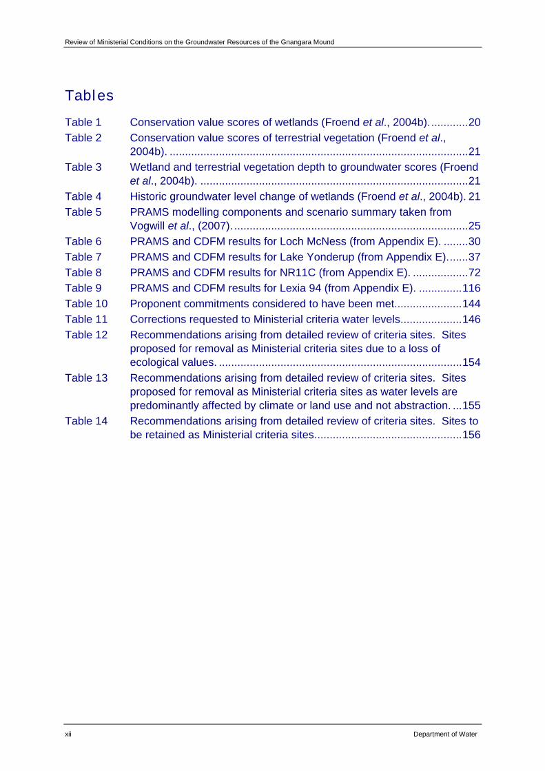
Table 1 Conservation value scores of wetlands (Froend et al., 2004b).............20 Table 2 Conservation value scores of terrestrial vegetation (Froend et al.,
2004b). .................................................................................................21 Table 3 Wetland and terrestrial vegetation depth to groundwater scores (Froend
et al., 2004b). .......................................................................................21 Table 4 Historic groundwater level change of wetlands (Froend et al., 2004b). 21 Table 5 PRAMS modelling components and scenario summary taken from
Vogwill et al., (2007). ............................................................................25 Table 6 PRAMS and CDFM results for Loch McNess (from Appendix E). ........30 Table 7 PRAMS and CDFM results for Lake Yonderup (from Appendix E).......37 Table 8 PRAMS and CDFM results for NR11C (from Appendix E). ..................72 Table 9 PRAMS and CDFM results for Lexia 94 (from Appendix E). ..............116 Table 10 Proponent commitments considered to have been met......................144 Table 11 Corrections requested to Ministerial criteria water levels....................146 Table 12 Recommendations arising from detailed review of criteria sites. Sites
proposed for removal as Ministerial criteria sites due to a loss of ecological values. ...............................................................................154
Table 13 Recommendations arising from detailed review of criteria sites. Sites proposed for removal as Ministerial criteria sites as water levels are predominantly affected by climate or land use and not abstraction. ...155
Table 14 Recommendations arising from detailed review of criteria sites. Sites to be retained as Ministerial criteria sites................................................156
Review of Ministerial Conditions on the Groundwater Resources of the Gnangara Mound
Department of Water xiii
Preface This document has been prepared to outline the amendments that are sought by the Department of Water to conditions set by the Minister for the Environment under Ministerial Statement No: 687 Gnangara Mound Groundwater Resources (including Groundwater Resource Allocation, East Gnangara City of Swan).

Review of Ministerial Conditions on the Groundwater Resources of the Gnangara Mound
Department of Water xv
Summary The water resources of the Gnangara groundwater system represent one of the single largest sources of potable water in the south-west of Western Australia. The Gnangara Mound supports a variety of ecosystems, including wetlands and large areas of groundwater dependent native vegetation. Changes in the depth to groundwater (increased or reduced groundwater levels) as a result of changes to recharge or abstraction may impact significantly on these ecosystems.
The mound is an important source of water for horticulture, viticulture, parks and gardens, industry and other users. Approximately 55 per cent of groundwater pumped from the Gnangara system is for private use with the majority of this water coming from the superficial aquifer. Western Australia’s Integrated Water Supply System (IWSS) has relied substantially on water pumped from the Gnangara system for many years. Approximately 45 per cent of groundwater pumped from the Gnangara system is for the IWSS.
Since the 1970s, groundwater levels across the mound have been in decline. This coincides with a general trend of declining annual rainfall across the south-west of Western Australia. In recent years, the importance of climate as a factor affecting groundwater levels, and therefore groundwater dependent ecosystems, has been recognised.
In addition to climate and abstraction, there are other factors influencing groundwater level decline. Land use, such as pine plantations, and land management practices, such as alterations in the burning frequency of native vegetation, also impede recharge. Declines in groundwater levels are considered to be a response to variations in the climate regime, upon which abstraction and land use impacts are superimposed.
The Department of Water has not previously comprehensively reviewed the management of the Gnangara Mound in the context of the consequences of climate and land use changes. In light of this, the department has initiated a consolidation of its management approach for the resources of the Gnangara groundwater areas with the aim of reducing the overall impact of abstraction on important ecosystems. This approach aims for sustainable management of the groundwater resources in the context of the current land use and climate.
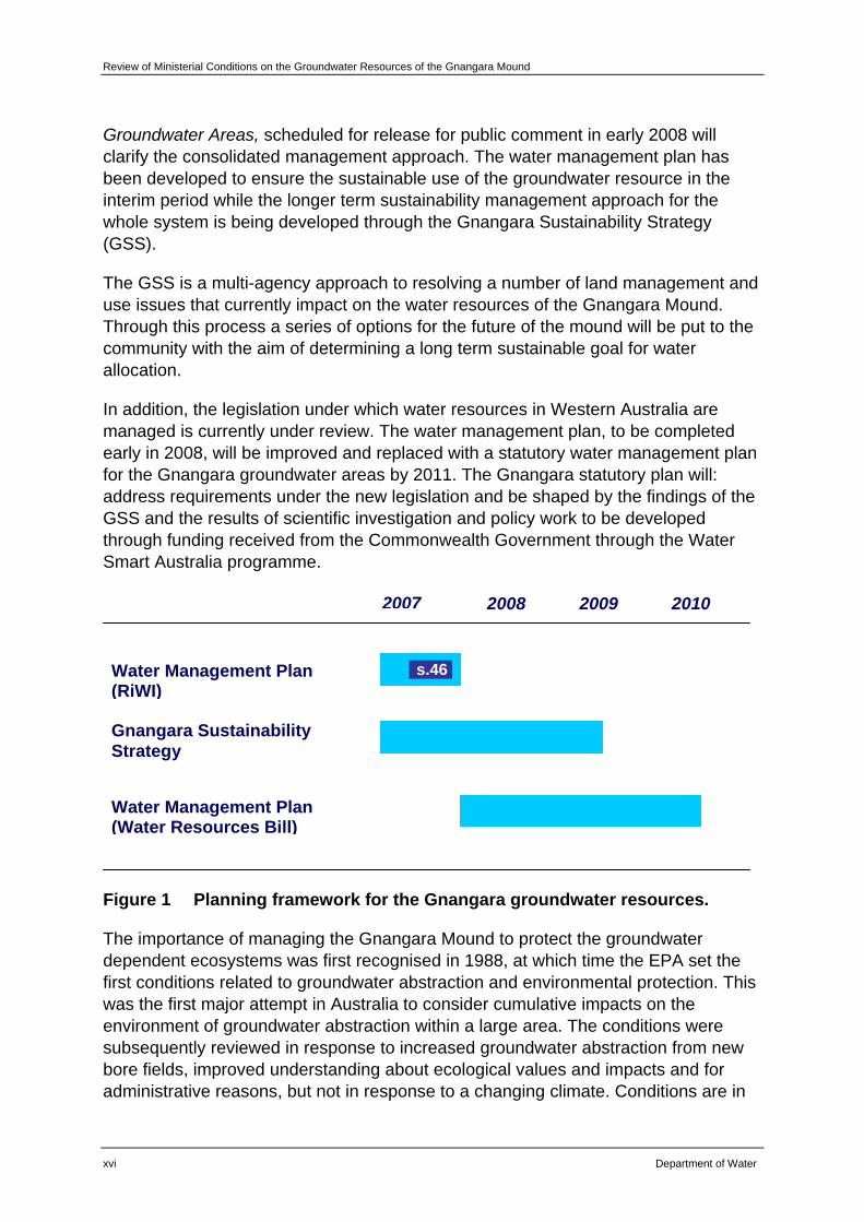
This review of Ministerial conditions on the Groundwater Resources of the Gnangara Mound is part of a broader approach to the long term management of the Gnangara system. Figure 1 provides an outline of the key components of the departments planning for the groundwater resources of the Gnangara system. This review of conditions will result in management actions to protect important groundwater dependent ecosystems being better integrated with the overall management of water abstraction from the Gnangara Mound. A Water Management Plan for the Gnangara
Review of Ministerial Conditions on the Groundwater Resources of the Gnangara Mound
xvi Department of Water
Groundwater Areas, scheduled for release for public comment in early 2008 will clarify the consolidated management approach. The water management plan has been developed to ensure the sustainable use of the groundwater resource in the interim period while the longer term sustainability management approach for the whole system is being developed through the Gnangara Sustainability Strategy (GSS).
The GSS is a multi-agency approach to resolving a number of land management and use issues that currently impact on the water resources of the Gnangara Mound. Through this process a series of options for the future of the mound will be put to the community with the aim of determining a long term sustainable goal for water allocation.
In addition, the legislation under which water resources in Western Australia are managed is currently under review. The water management plan, to be completed early in 2008, will be improved and replaced with a statutory water management plan for the Gnangara groundwater areas by 2011. The Gnangara statutory plan will: address requirements under the new legislation and be shaped by the findings of the GSS and the results of scientific investigation and policy work to be developed through funding received from the Commonwealth Government through the Water Smart Australia programme.
Figure 1 Planning framework for the Gnangara groundwater resources.
The importance of managing the Gnangara Mound to protect the groundwater dependent ecosystems was first recognised in 1988, at which time the EPA set the first conditions related to groundwater abstraction and environmental protection. This was the first major attempt in Australia to consider cumulative impacts on the environment of groundwater abstraction within a large area. The conditions were subsequently reviewed in response to increased groundwater abstraction from new bore fields, improved understanding about ecological values and impacts and for administrative reasons, but not in response to a changing climate. Conditions are in
Water Management Plan (RiWI)
Gnangara Sustainability Strategy
Water Management Plan (Water Resources Bill)
2007 2008 2009 2010
s.46
Review of Ministerial Conditions on the Groundwater Resources of the Gnangara Mound
Department of Water xvii
the form of environmental conditions, which relate specifically to water levels that are to be met at specific times of the year and administrative conditions that relate to operation matters.
This current review of Ministerial conditions was initiated in 2001 and was to be completed in two stages. Stage I was finalised in 2004 with further work undertaken as part of Stage II. Following the announcement of the Gnangara Sustainability Strategy (GSS), it was recognised that a full review of the existing environmental conditions would be better undertaken when the GSS is completed. Therefore this review document has been prepared to finalise Stage II and will update existing conditions for both environmental and administrative criteria. The Department of Water has requested changes to conditions to reflect the current climate and land use across the Gnangara system. In general, the Department of Water is requesting changes to a number of conditions. These are grouped into the following:
• to remove criteria for sites where the ecological values have been shown to no longer exist generally because the site has been cleared;
• to remove criteria for sites where the impacts on groundwater levels have been shown to be predominantly driven not by abstraction, but by climate or land use and land management practices that are outside the control of the department; and
• To rationalise the administrative criteria for conditions and commitments that have previously been met which will simplify reporting and auditing processes.
Through this review, a detailed assessment of each Ministerial criteria site was undertaken. This assessment included: a summary of compliance with existing water level criteria and an assessment of water level trends; information on the current ecological condition of sites and the recommendations made by ecologists with respect to changes noted from monitoring programs; and detailed work on the possible causes of groundwater decline at each site. Key recommendations have been proposed with respect to amending Ministerial criteria and/or for modifying existing monitoring programs and networks.
As a result of this assessment, it is requested that Ministerial criteria be removed from five sites (Lake Gnangara, Edgecombe Seepage, WM6, MM49B and PM25) because the ecological values at these sites have been lost due to land clearing and disturbance activities. These activities are beyond the control of the department and are not related to abstraction of groundwater.
Based on an analysis as to the probable cause of groundwater decline at each site, it is requested that Ministerial criteria be removed from an additional four sites (Loch McNess, Lake Yonderup, Lexia 94 and NR11C). It has been shown that abstraction is not impacting on water levels at these sites and the predominant cause of groundwater decline is either climate or land use. An additional 11 sites, not included in the list proposed for removal, were also shown to be predominantly impacted by
Review of Ministerial Conditions on the Groundwater Resources of the Gnangara Mound
xviii Department of Water
factors other than abstraction. However, the department has chosen to adopt a precautionary approach with these sites and recommends they remain as criteria sites until further work in this area has been completed.
It is recommended that the other 28 sites remain as criteria sites and that existing monitoring programs continue. Additional monitoring of water levels and vegetation have been recommended for some sites.
Sites where ecological values have been lost 5
Sites where abstraction is not the predominant cause of groundwater decline 4
Sites where no changes are requested to Ministerial criteria 28
Following a review of the Ministerial conditions, a number of amendments are proposed. These relate to the roles and responsibilities of Government departments and authorities with respect to implementation and auditing of these conditions.
In addition, a number of commitments (10) made by the department and subsequently set as conditions have been met. It is requested that these be recognised as having been met and that they are subsequently removed as legally binding conditions.
Review of Ministerial Conditions on the Groundwater Resources of the Gnangara Mound
Department of Water 1
1 Introduction This report documents a proposal to amend conditions set by the Minister for the Environment under Ministerial Statement No: 687 Gnangara Mound Groundwater Resources (including Groundwater Resource Allocation, East Gnangara City of Swan) (herein referred to as Statement 687). These conditions were set for the management and abstraction of groundwater for public and private water supply from the Gnangara Mound. The amendments proposed are a result of a detailed review of existing conditions in the context of reduced rainfall. This report finalises the review of conditions initially agreed to by the Environmental Protection Authority (EPA) in 2001. In September 2007, the scope of this review was revised and the Minister for the Environment requested that the EPA report to the Minister on:
• Whether the water level criteria for any environmental monitoring site should be removed or varied, including as a result of changes to environmental values which have occurred at the site since the criteria were originally set; and
• Whether the water level criteria for any environmental monitoring site should be removed or varied due to water levels at the site being predominantly affected by climate variation rather than abstraction.
1.1 Purpose of this report
The purpose of this report is to describe the proposed changes to a number of environmental and administrative conditions set for the management of the Gnangara Mound. In particular, this document:
• Outlines the framework for progressive improvements to the sustainable management of the Gnangara Mound;
• Describes the adaptive management approach used by the department on an annual cycle, to maximise ecosystem protection and compliance with set water level criteria;
• Provides information for each of the sites for which water level criteria exist outlining the causes of non-compliance with some of the existing water level criteria;
• Proposes changes to some environmental and administrative conditions, where the ecological values at sites have been shown to no longer exist or where the impacts on water levels are predominantly climate driven; and
• Proposes changes to some administrative criteria that have already been met by the department and its predecessors.
Review of Ministerial Conditions on the Groundwater Resources of the Gnangara Mound
2 Department of Water
1.2 Overview of proposed changes
The department is seeking approval to amend some of the conditions that are currently detailed in Statement 687. Proposed amendments are outlined in Chapters 4 and 5 of this report.
In general, the changes to existing conditions and commitments are grouped into the following categories:
• Request to remove criteria for sites where the ecological values have been shown to no longer exist ;
• Request to remove criteria for sites where the impacts on groundwater levels have been shown to be predominantly driven by climate or land use and land management practices that are beyond the control of the department; and
• Rationalise the administrative criteria for conditions and commitments that have previously been met which will simplify reporting and audit processes.
These changes were recommended following a detailed review of each criteria site. This review considered: the ecological values and management objectives and Ministerial criteria set at each site; an assessment of compliance with Ministerial criteria; a review of current ecological condition; and technical work, which assessed the ecological condition of criteria sites based on more recent water levels recommended by ecologists. Through this review process, the department has made a number of recommendations with respect to improving monitoring and management at some sites. A detailed description of this work and the results can be found in Chapter 4.
The impact of reduced rainfall on the groundwater dependent ecosystems of the Gnangara Mound has been acknowledged in previous publications (Department of Environment, 2005; Environmental Protection Authority, 2007). A complete revision of environmental criteria, with particular focus on the development of new climate-relative criteria is not being proposed at this time as the research and development work required to do this is scheduled for completion in 2008-09. Until this time, the department will continue to implement a series of management actions designed to address the sustainable use of the resources of the mound at all existing criteria sites.
Review of Ministerial Conditions on the Groundwater Resources of the Gnangara Mound
Department of Water 3
2 Background
2.1 The Gnangara groundwater system
The Gnangara groundwater system consists predominantly of three loosely connected aquifers, the superficial – commonly known as the Gnangara Mound, the Leederville and the Yarragadee. The Leederville and Yarragadee aquifers are deep, confined aquifers that extend beyond the bounds (north and south) of the Gnangara Mound. The aquifers of the Gnangara system represent one of the largest sources of potable water in the south-west of Western Australia. While abstraction of groundwater occurs across the system, impacts of abstraction predominantly manifest on the mound.
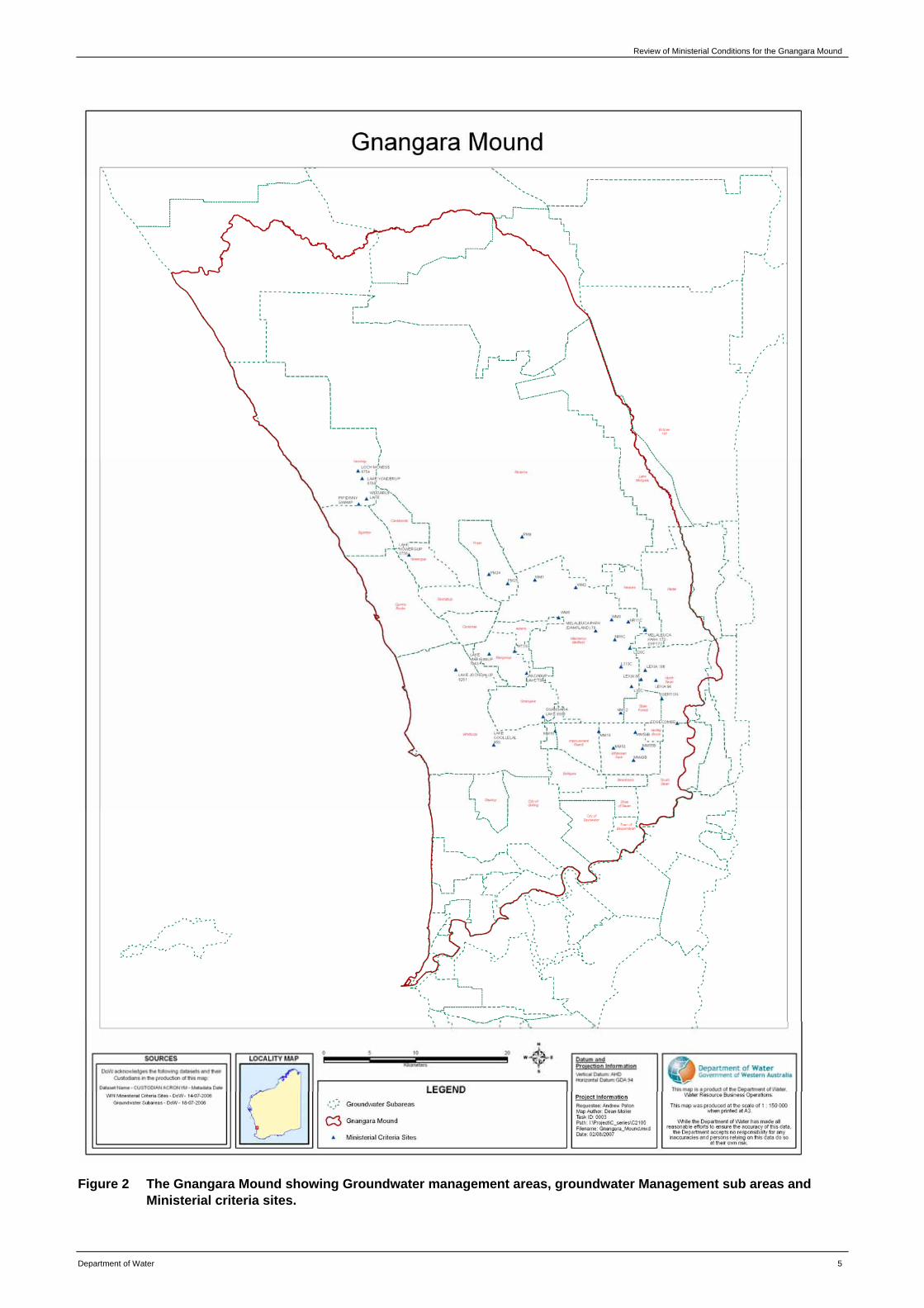
The Gnangara Mound covers an area of approximately 2 200 square kilometres. It is a large shallow groundwater system which is bounded by the Swan River in the south, Gingin Brook and Moore River to the north and extends inland to the Darling fault (Figure 2). The aquifer is recharged by rainfall and it discharges on the edges of the Mound to streams, rivers and the coast.
The Mound supports a variety of ecosystems, including wetlands and large areas of groundwater dependent native vegetation. Changes in the depth to groundwater (increased or reduced groundwater levels) as a result of changes to recharge or abstraction may impact significantly on these ecosystems.
The Gnangara Mound is an important resource for horticulture, viticulture, parks and gardens, industry and other users. Approximately 55 per cent of groundwater pumped from the Gnangara system is for private use with the majority of this water coming from the superficial aquifer.
Western Australia’s Integrated Water Supply System (IWSS) has relied substantially on water pumped from the Gnangara system for many years. The IWSS supplies water to 1.5 million of the 1.9 million people living in WA (Water Corporation, 2006). The scheme is supplied from multiple groundwater and surface (dam) water sources and more recently from the Perth Seawater Desalination Plant. With respect to groundwater, the first bore field, at Mirrabooka, was built in 1970. There are now eight main scheme/well fields on the Mound (Pinjar, Wanneroo, Lexia, Mirrabooka, Gwelup, Yanchep/Two Rocks, Quinns and Whitfords) and a series of artesian bores which, in all, produced approximately 60 per cent of the water supplied to the IWSS in 2006-07. Originally designed to supplement the Darling Scarp dam water supplies, the Gnangara system bore fields have provided an increasingly large and important proportion of water supplies, given the low rainfalls and reduced inflow to the dams. Approximately 45 per cent of groundwater pumped from the Gnangara system is for the IWSS.
Review of Ministerial Conditions on the Groundwater Resources of the Gnangara Mound
4 Department of Water
Across the south-west of Western Australia there has been a general trend of decline in annual rainfall since the mid 1970s. This shift to a drier climate represents a decline of approximately 11 per cent of rainfall when compared to the wetter rainfall period that occurred prior to the 1970s. Groundwater levels on the Gnangara Mound have declined progressively since the early 1970s. The most notable decline has occurred over the last eight years. This decline is thought to be a response to variations in the climate regime, upon which abstraction and land use impacts are superimposed (Department of Environment, 2005). More simply, the impacts of reduced rainfall on recharge rates, and hence groundwater levels, have been compounded by abstraction regimes and land use impacts such as pine plantations.
Recent declines in wetland and groundwater levels across the Gnangara Mound are attributed to a combination of a drying climate, land use changes and private and public abstraction. In a number of cases, this has resulted in water levels falling below criterion set to protect environmental values. The degree to which this has caused ecological impact is varied and is discussed further on a site by site basis in Chapter 4.
Review of Ministerial Conditions for the Gnangara Mound
Department of Water 5
Figure 2 The Gnangara Mound showing Groundwater management areas, groundwater Management sub areas and Ministerial criteria sites.
Review of Ministerial Conditions on the Groundwater Resources of the Gnangara Mound
6 Department of Water
2.2 Role of the Department of Water
The Department of Water is the manager of the State’s water resources. It has the responsibility for planning and managing groundwater use on the Gnangara Mound for the benefit of the community. This involves identifying and protecting important groundwater dependent ecosystems and managing private and public water supply abstraction to protect those systems. The department regulates the Water Corporation and private use through licensing and monitors impacts on water levels and ecosystems.
With respect to ecosystem protection, the department identifies those ecosystems which are dependent on groundwater and identifies water regimes required to protect their values. In general, water allocation decisions are then made in the context of meeting the agreed ecosystem water regimes. For Gnangara, the department has had to modify this approach in recent years to assist in meeting the high water supply demand during a period of urban growth and drying climate. This was achieved through the development of a drought management strategy for the Water Corporations IWSS. Through the strategy it was recognised that a number of Ministerial criteria would not be met if annual rainfall was consistently below average. In recognition of this, the department advised the EPA of its predictions with respect to compliance.
2.3 Protecting the groundwater dependent ecosystems of the Gnangara Mound
The importance of managing the Gnangara Mound to protect the groundwater dependent ecosystems was first formally recognised in 1988. In response to the Gnangara Mound Water Resources Environmental Review and Management Program, the EPA set the first conditions on abstracting groundwater and protecting the environment on the mound.
The program was published by the former Water Authority of Western Australia (WAWA) in 1986. It was the first major attempt in Australia to consider the cumulative impacts of groundwater abstraction on the environment within a large area. The conditions included individual water level criteria based on environmental knowledge at the time. These were considered by the WAWA to provide a reasonable level of maintenance of values of key elements of the environment. The criteria took into account planned groundwater abstraction limits for the region, future land use expectations and rainfall variations. Some of the levels set as criteria by the Minister for the Environment were substantially higher than had been experienced under ‘natural’ conditions; however, the WAWA accepted these criteria.
In 1995, the Water Authority reviewed the Ministerial conditions (WAWA, 1995). The importance of climate as a factor affecting groundwater levels was highlighted, as was the uncertainty of predicting future groundwater levels based on the uncertainty of future climatic conditions. The report also acknowledged that non-compliances
Review of Ministerial Conditions for the Gnangara Mound
Department of Water 7
with wetland water levels were likely under the climate regime experienced at that time, particularly if the anticipated pine thinning and urbanisation of the area did not occur within the expected timeframe.
The Water Authority acknowledged that the proposed criteria were a compromise between the ecological water requirements and the full bore field abstraction quota and that non-compliance with criteria would occur in up to 30 per cent of years. Measures were put in place to minimise non-compliances such as reduced abstraction in dry years and the artificial maintenance of wetlands.
In September 2001, the Water and Rivers Commission requested that the Minister for the Environment consider a review of the existing Ministerial conditions. The Minister for the Environment subsequently asked the EPA to “inquire into and advise on changes to the existing Ministerial conditions” under section 46 of the Environmental Protection Act, 1986. The EPA endorsed a two-stage approach to a review of the Ministerial conditions for the management of the shallow groundwater resources of the Gnangara Mound under section 46.
Stage I of the review comprised an initial investigation into the critical areas where breaches of environmental conditions have occurred and a proposal for a short-term management strategy for the summers of 2001-02 and 2002-03. Management beyond this timeframe was to be considered under the Stage II review. Stage I was submitted to the EPA in 2004 and in November of the same year, the EPA reported on the review advising of limited changes that could be made based on information available at the time. This review led to the release of Statement 687 which was issued in September 2005 as a means of consolidating and refining the conditions applying to the Gnangara Mound.
Stage II was to involve a rigorous investigation and review of environmental criteria, climate variability, long-term groundwater level behaviour, management of public and private abstraction and pine management plus offsetting factors such as urbanisation. The State of the Mound Report (Department of Environment, 2005) was submitted to the EPA in August 2005. This document provided an update to Stage II of the review. As outlined in the Introduction of this report, the scope of this review was revised in September 2007 with the Minister for the Environment recognising that a full review of conditions would be better undertaken at the completion of the Gnangara Sustainability Strategy.
As demonstrated above, the original conditions have been reviewed in the past in response to increased groundwater abstraction from new bore fields, improved understanding about ecological values and impacts, or for administrative reasons, but not in response to a changing climate.
The conditions specify minimum water regimes which must be met to protect ecosystem values that have been identified. Essentially the aim of these criteria is to protect the status quo of these systems, with limited consideration of how they may
Review of Ministerial Conditions on the Groundwater Resources of the Gnangara Mound
8 Department of Water
vary naturally in response to climatic cycles and variations. This has set a goal that is difficult to achieve, particularly in the face of a drying climate and altered water levels resulting from activities such as urbanisation and land use and management practices.
There are currently 37 sites at which environmental criteria have been set. These sites are discussed in detail in Chapter 4 of this report. A list of these is included in the conditions relating to the water resource management on the Gnangara Mound as given in Appendix A.
2.4 Reviewing and improving the management of the Gnangara Mound
There are a number of factors beyond abstraction which influence water levels on the Gnangara Mound, and which are not within the control of the department. These include changes to land use and land management practices which affect recharge, in particular urban development, changes to burning frequency of native vegetation and the management of extensive areas of pine plantation on the mound. The single most important factor is changes in rainfall.
Perth has experienced a decade of significantly reduced rainfall which has impacted groundwater levels in the Gnangara Mound in two ways:
• Reduced recharge to the groundwater aquifers has resulted in declining water tables over much of the mound, particularly where they have not been offset by increased recharge associated with urban development. It has been shown that climate is the most important factor in groundwater level decline; and
• Reduced rainfall and inflow to dams has reduced water availability from surface water sources for the Integrated Water Supply Scheme, coincident with a large increase in water demand associated with growth in Perth. This has resulted in significantly increased abstraction from groundwater to meet the shortfall in supplies.
The department has not previously reviewed the management of the Gnangara Mound in the context of these consequences of climate changes. In particular, allocation limits which set the maximum volume of water available for abstraction from the Gnangara System, had not been comprehensively reviewed to take into account reduced recharge.
Over the last five to six years, groundwater abstraction from Gnangara Mound has been relatively high to meet the high water supply demand in this period of urban growth and drying climate. While the Gnangara Mound stores a very large amount of groundwater, the current level of abstraction from the superficial aquifer cannot be sustained without exacerbating climate and land use impacts on the important wetland systems in the metropolitan area. While approaches to reducing the impacts on Gnangara have been initiated by the Government over recent years, some gains
Review of Ministerial Conditions for the Gnangara Mound
Department of Water 9
were obscured by a lack of rainfall recharge to the mound through the very dry winter of 2006.
The reduced recharge and increased abstraction associated with demand for public water supplies have resulted in an increase in the number of sites at which ecological water regimes have not been met. The department has responded by initiating a process to review the environmental values, groundwater science and its own management of the Gnangara Mound.
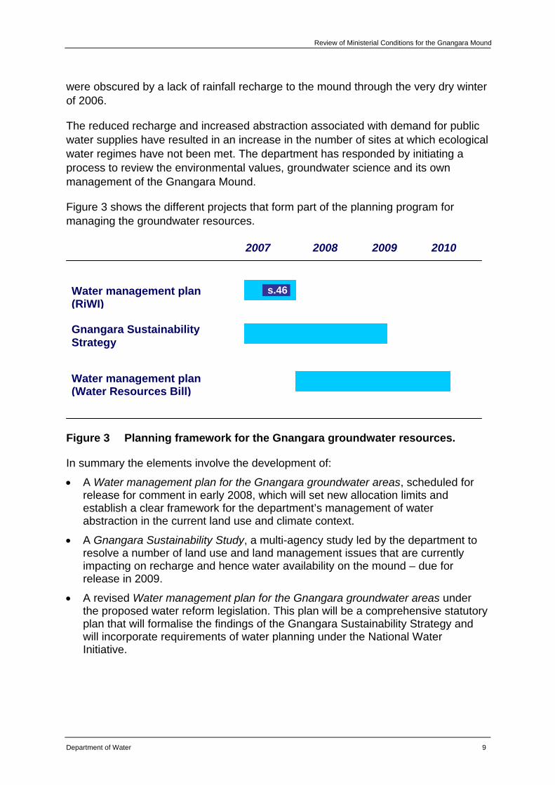
Figure 3 shows the different projects that form part of the planning program for managing the groundwater resources.
Figure 3 Planning framework for the Gnangara groundwater resources.
In summary the elements involve the development of:
• A Water management plan for the Gnangara groundwater areas, scheduled for release for comment in early 2008, which will set new allocation limits and establish a clear framework for the department’s management of water abstraction in the current land use and climate context.
• A Gnangara Sustainability Study, a multi-agency study led by the department to resolve a number of land use and land management issues that are currently impacting on recharge and hence water availability on the mound – due for release in 2009.
• A revised Water management plan for the Gnangara groundwater areas under the proposed water reform legislation. This plan will be a comprehensive statutory plan that will formalise the findings of the Gnangara Sustainability Strategy and will incorporate requirements of water planning under the National Water Initiative.
Water management plan (RiWI)
Gnangara Sustainability Strategy
Water management plan (Water Resources Bill)
2007 2008 2009 2010
s.46
Review of Ministerial Conditions on the Groundwater Resources of the Gnangara Mound
10 Department of Water
Protecting environmental values forms a key component of each of these elements, and will be addressed in the following ways:
• The Water management plan for the Gnangara groundwater areas will include an initial review of the current Ministerial conditions and criteria sites;
• The Gnangara Sustainability Strategy will establish the overall environmental objectives to which the mound will be managed over the next 20 years; and
• The Revised Water management plan for the Gnangara groundwater areas will incorporate revised climate relevant environmental water allocations, targeted to the environmental objectives determined through the Gnangara Sustainability Strategy, and based on comprehensive ecological and hydrogeological studies.
This review will form a component of the Water management plan for the Gnangara groundwater areas. Given the department’s non-compliance with some of the environmental conditions, an interim review and risk assessment of the environmental conditions was considered an important component of the water management plan. This takes into account the risks associated with climate change, and assisted in finalising new allocation limits.
The recommendations proposed in this report are considered an interim measure, with a comprehensive review to be undertaken over the coming years leading to a revised water management plan for the Gnangara groundwater areas.
The water management plan is seen as the key tool in ensuring longer-term sustainability of the mound is not compromised prior to the sustainability goal being set through the Gnangara Sustainability Strategy due in 2009.
Review of Ministerial Conditions for the Gnangara Mound
Department of Water 11
3 Management approach for Gnangara Impacts from abstraction will be managed through the department’s water management framework for Gnangara. The approach is based on other frameworks for managing natural resources: National Water Quality Management Strategy (ANZECC & ARMCANZ, 1994); and EPA Position Statement No. 8: Environmental Protection in Natural Resource Management (EPA, 2005).
The department will implement management actions that will:
• Maintain key ecological values of criteria wetland and vegetation sites, recognising adjustments required to manage to reduced recharge.
• Clarify the link between resource use and impacts on in-situ values; and
• Assist in limiting the rate of decline that is currently observed in the superficial aquifer.
Management will be aimed at three key goals and be implemented at the whole of the mound scale as well as within specific groundwater or management areas and at specific sites. These goals are to:
• Protect existing environmental values of groundwater dependent ecosystems from abstraction and land use impacts;
• Reduce total abstraction towards a sustainability goal that is to be set through the Gnangara Sustainability Strategy; and
• Optimise the use of water resources.
Protect environmental values
Protection of environmental values will be achieved through a number of measures. The department implements internal policies such as Managing abstraction in areas of declining water levels affecting groundwater dependent ecosystems. This policy assists licensing officers in determining appropriate location of private bores near sensitive environments.
The department also works with the Water Corporation to establish bore abstraction patterns to limit impacts on groundwater dependent ecosystems. This process occurs on an annual basis and is amended as required.
The department has invested in a number of additional projects that will lead to improved understanding and hence management of groundwater dependent ecosystems. These are detailed in Chapter 6 of this report.
Reduce total abstraction
Reducing allocation limits is the primary approach to reducing total abstraction. A revision of water allocation limits has been undertaken by the department, and will lead to reductions in availability of water for private abstraction over the coming
Review of Ministerial Conditions on the Groundwater Resources of the Gnangara Mound
12 Department of Water
years. These reductions will be phased in and will initially be achieved through the recouping of water made available through changes in land use such as urbanisation of the agricultural areas.
Within this context the IWSS will be managed to reduced annual abstraction over the life of the forthcoming Water management plan for the Gnangara groundwater areas. As well as reducing total abstraction from current infrastructure this may include a shift of abstraction from the superficial to the confined aquifers for a limited period and where possible. As groundwater dependent ecosystems across the mound are reliant upon the superficial aquifer, maximising abstraction from the deeper confined aquifers allows abstraction to be minimised from the superficial aquifer which assists in protecting these systems from changes in water level.
To ensure continued supply, the department is working with the Water Corporation to develop contingency water sources including the confined aquifer bores an additional Leederville bore on the Jandakot Mound, surface water from Logue Brook Dam and Harris Dam. This will lead to a reduced reliance on the groundwater resources from the Gnangara Mound while the next major water source is being developed. Further, the Gnangara Sustainability Strategy will define a longer term sustainable goal for abstraction from the Gnangara system.
Optimise use of water
The department is working with stakeholders to develop water conservation and efficiency plans. These plans will be implemented by stakeholders and linked to water licenses. The department is working closely with local government to improve efficiency of water use for parks and reserves. Recent initiatives in this area have resulted in a positive effect on groundwater levels in the Perth groundwater area. This approach applies to both private licensees and the Water Corporation. The Gnangara Metering Project is supporting improved efficiency of water use in the horticulture sector.
The new water efficiency measures that came into effect on 1 October 2007 will also assist in optimising the use of groundwater resources by water user groups. The demand management campaign was developed in partnership with the Water Corporation, and includes initiatives such as:
• The introduction of watering days for garden bore owners in the Perth region;
• Providing updated advice on where bores can and cannot be drilled;
• Requiring compliance with the State-wide daytime sprinkler ban by metropolitan councils; and
• Water efficiency plans will be developed by local councils and implementation of water efficiency measures are required by large commercial users, local government, government departments and schools.
Review of Ministerial Conditions for the Gnangara Mound
Department of Water 13
Monitoring and evaluation
The department currently implements both hydrogeological and ecological monitoring programs across the Gnangara Mound. Analysis of the condition of the resource, based on water levels, is undertaken at key sites across the mound. Ecological monitoring reports commissioned by the department for a range of parameters are assessed for potential impacts on groundwater dependent ecosystems on an annual basis. Assessment is undertaken in October of each year, prior to the determination of water to be made available to the IWSS. The department also commissions end of summer condition monitoring to assess ecological condition at a time when water levels are at their minimum and vegetation is most stressed.
The department will monitor and evaluate the effectiveness of its management strategies through annual assessments of the condition of the resource and associated ecological systems. This process will enable the department to review performance in relation to the implementation of the actions under the water management plan.

Review of Ministerial Conditions for the Gnangara Mound
Department of Water 15
4 Review of environmental conditions – Gnangara Mound
4.1 Introduction
This chapter documents the review and assessment of data and observations for each of the current Ministerial criteria sites. It involves a review of compliance with the Ministerial criteria and an assessment of water level trends, current ecological condition and factors influencing water level change. Based on this assessment, the department has identified future management of each site. Where appropriate, the department seeks the EPA’s approval for amending Ministerial criteria and/or for modifying the monitoring network.
Sites are arranged by groundwater management area and groundwater management sub area, with wetland sites presented first, followed by terrestrial sites. A brief background description is provided for each site and then reviewed using the following approaches and methodologies.
Ecological values and management objectives
The ecological values for which the site is protected and the management objectives are outlined. Water regime management objectives are outlined for wetland sites. Ecological values and management objectives are those which were identified or reviewed in the section 46 Review of Environmental Conditions undertaken in 1995 (WAWA, 1995), or the East Gnangara Public Environmental Review 1997 (Water and Rivers Commission, 1997).
Current Ministerial criteria
The Ministerial water level criteria determined in 1995 or 1997 for wetlands and terrestrial sites are outlined. Water level criteria, based on environmental water provisions (EWPs – refer to Glossary), were developed to ensure the protection of the ecological, social and economic values of the site. At some sites, where the community benefit of water supply outweighed the potential impacts to the environment, the EWPs were set lower than the water level required to maintain ecological condition.
Compliance with current ministerial criteria and ecological condition
Compliance with Ministerial criteria and general water level trends between 1995 or 1997 and 2007 is reviewed for each criteria site. Where available, hydrograph trend analyses by Bekesi (2007a) were used to describe water level trends.
Ecological trends for each site between 1995 or 1997 and 2007 are described using information derived from Froend et al., (2004a) and annual ecological monitoring
Review of Ministerial Conditions on the Groundwater Resources of the Gnangara Mound
16 Department of Water
undertaken for the department between 2004 and 2007 (Appendix B). Information on the end of summer condition was taken from assessments by Loomes et al., (2003) and Loomes et al., (2007).
Recent Environmental Water Requirements, ecological trends and recommendations
In addition to the assessment against Ministerial criteria levels, for each site an assessment against the ecological water requirements (EWR – refer to glossary) recommended in Froend et al., (2004b) is provided. Although these EWRs have not been formally adopted, the work to develop them was originally commissioned as part of Stage II of the review of environmental conditions on the Gnangara Mound. Stage II was to involve a rigorous investigation and review of environmental criteria and development of methodology to underpin new climate relative criteria. While the methodology to inform new criteria has not been completed, the ecological work to identify and re-evaluate the ecological values on the Mound and to determine EWRs to protect the values as of 2004, described in Froend et al., (2004a & 2004b) provides a valuable source to inform this review.
4.1.1 Environmental water requirements and ecological trend methodology
The EWRs revised in 2004 were developed using an improved method for EWR determination. This method varied from previous methodology in that it allowed for determining water requirements for multiple components of ecosystems (such as vertebrates, macroinvertebrates and waterbirds) and it considered the rate and magnitude of groundwater change that can occur while maintaining vegetation at a low level of risk.
A description of the approach to assessing water levels and ecological condition of criteria sites between 2004 and 2007 in relation to recent ecological water requirements is outlined below:
1. Assessment of monitoring information and expert advice to determine whether the site retained groundwater dependent ecological values.
2. Assessment of whether a water level based criterion was an appropriate measure of ecological health for each site. Where water level change had been associated with a respective change in ecological condition, a water level based criterion was deemed to be appropriate for that particular site.
3. An assessment of whether water levels in 2007 were below or above the EWR recommended by Froend et al., (2004b) was undertaken for sites that retained ecological values (Appendix C – column B).
4. Assessment of whether groundwater levels in 2007 were within 0.3m of the EWR recommended by Froend et al., (2004b) for vegetation. Based on a review of changes in depth to groundwater during low recharge periods a site is
Review of Ministerial Conditions for the Gnangara Mound
Department of Water 17
considered to be ‘at risk’ of breaching the EWR if groundwater levels are within 0.3m of the EWR (Appendix C – column C).
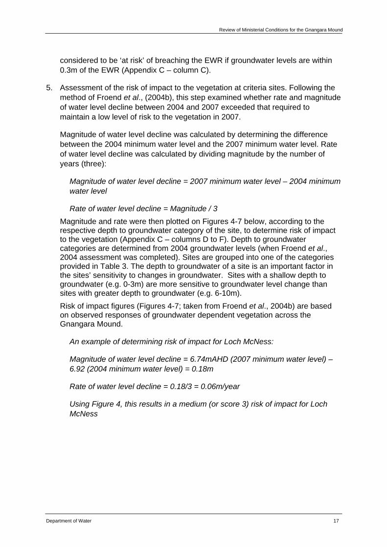
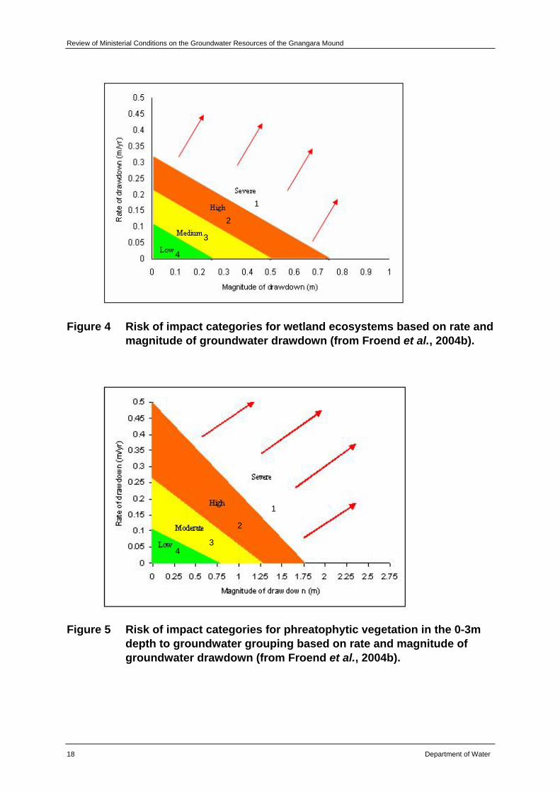
5. Assessment of the risk of impact to the vegetation at criteria sites. Following the method of Froend et al., (2004b), this step examined whether rate and magnitude of water level decline between 2004 and 2007 exceeded that required to maintain a low level of risk to the vegetation in 2007.
Magnitude of water level decline was calculated by determining the difference between the 2004 minimum water level and the 2007 minimum water level. Rate of water level decline was calculated by dividing magnitude by the number of years (three):
Magnitude of water level decline = 2007 minimum water level – 2004 minimum water level
Rate of water level decline = Magnitude / 3 Magnitude and rate were then plotted on Figures 4-7 below, according to the respective depth to groundwater category of the site, to determine risk of impact to the vegetation (Appendix C – columns D to F). Depth to groundwater categories are determined from 2004 groundwater levels (when Froend et al., 2004 assessment was completed). Sites are grouped into one of the categories provided in Table 3. The depth to groundwater of a site is an important factor in the sites’ sensitivity to changes in groundwater. Sites with a shallow depth to groundwater (e.g. 0-3m) are more sensitive to groundwater level change than sites with greater depth to groundwater (e.g. 6-10m). Risk of impact figures (Figures 4-7; taken from Froend et al., 2004b) are based on observed responses of groundwater dependent vegetation across the Gnangara Mound.
An example of determining risk of impact for Loch McNess:
Magnitude of water level decline = 6.74mAHD (2007 minimum water level) – 6.92 (2004 minimum water level) = 0.18m
Rate of water level decline = 0.18/3 = 0.06m/year
Using Figure 4, this results in a medium (or score 3) risk of impact for Loch McNess
Review of Ministerial Conditions on the Groundwater Resources of the Gnangara Mound
18 Department of Water
Figure 4 Risk of impact categories for wetland ecosystems based on rate and magnitude of groundwater drawdown (from Froend et al., 2004b).
Figure 5 Risk of impact categories for phreatophytic vegetation in the 0-3m depth to groundwater grouping based on rate and magnitude of groundwater drawdown (from Froend et al., 2004b).
4
3
2
1
4 3
2
1

Review of Ministerial Conditions for the Gnangara Mound
Department of Water 19
Figure 6 Risk of impact categories for phreatophytic vegetation in the 3-6m depth to groundwater grouping based on rate and magnitude of groundwater drawdown (from Froend et al., 2004b).
Figure 7 Risk of impact categories for phreatophytic vegetation in the 6-10m depth to groundwater grouping based on rate and magnitude of groundwater drawdown (from Froend et al., 2004b).
4 3
2
1
4 3
2
1
Review of Ministerial Conditions on the Groundwater Resources of the Gnangara Mound
20 Department of Water
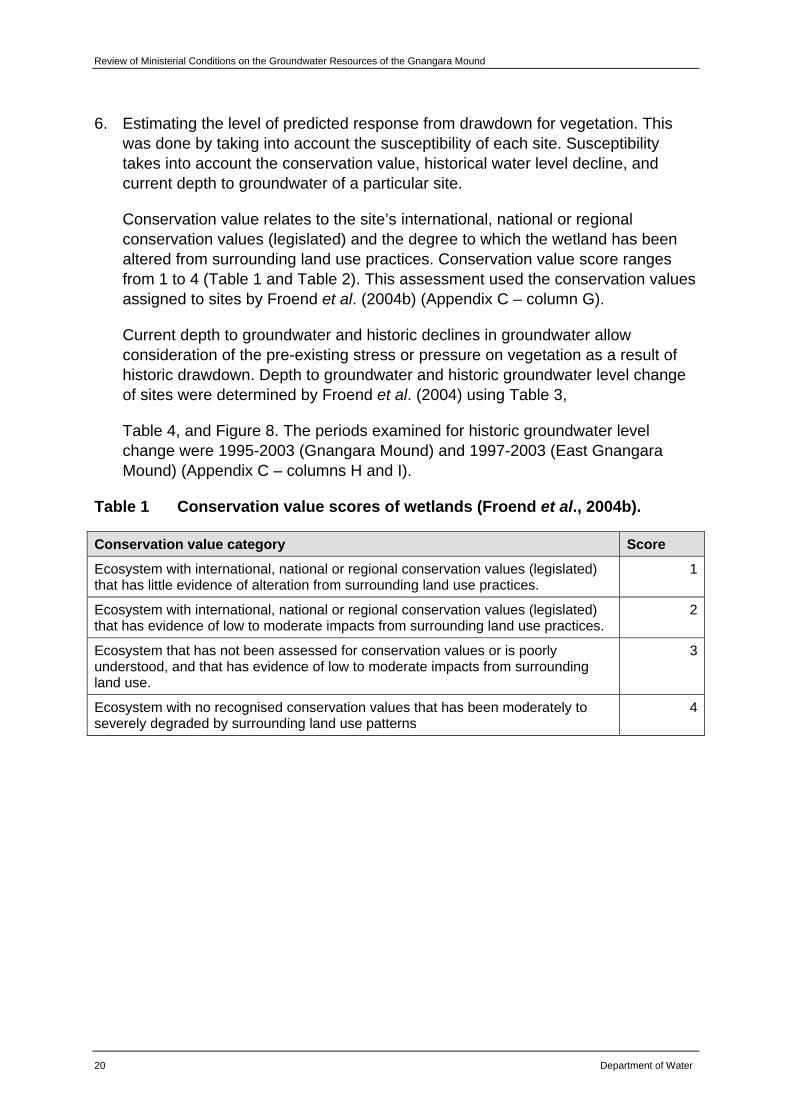
6. Estimating the level of predicted response from drawdown for vegetation. This was done by taking into account the susceptibility of each site. Susceptibility takes into account the conservation value, historical water level decline, and current depth to groundwater of a particular site.
Conservation value relates to the site’s international, national or regional conservation values (legislated) and the degree to which the wetland has been altered from surrounding land use practices. Conservation value score ranges from 1 to 4 (Table 1 and Table 2). This assessment used the conservation values assigned to sites by Froend et al. (2004b) (Appendix C – column G).
Current depth to groundwater and historic declines in groundwater allow consideration of the pre-existing stress or pressure on vegetation as a result of historic drawdown. Depth to groundwater and historic groundwater level change of sites were determined by Froend et al. (2004) using Table 3,
Table 4, and Figure 8. The periods examined for historic groundwater level change were 1995-2003 (Gnangara Mound) and 1997-2003 (East Gnangara Mound) (Appendix C – columns H and I).
Table 1 Conservation value scores of wetlands (Froend et al., 2004b).
Conservation value category Score
Ecosystem with international, national or regional conservation values (legislated) that has little evidence of alteration from surrounding land use practices.
1
Ecosystem with international, national or regional conservation values (legislated) that has evidence of low to moderate impacts from surrounding land use practices.
2
Ecosystem that has not been assessed for conservation values or is poorly understood, and that has evidence of low to moderate impacts from surrounding land use.
3
Ecosystem with no recognised conservation values that has been moderately to severely degraded by surrounding land use patterns
4
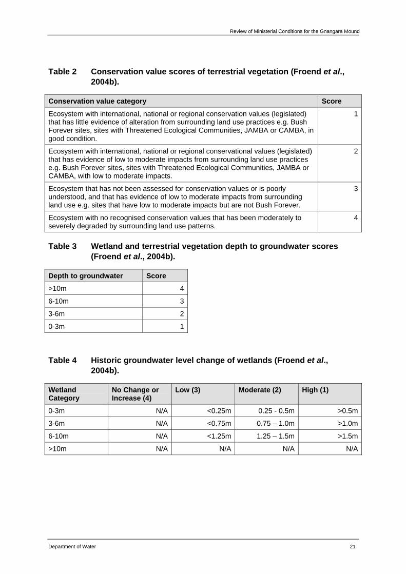
Review of Ministerial Conditions for the Gnangara Mound
Department of Water 21
Table 2 Conservation value scores of terrestrial vegetation (Froend et al., 2004b).
Conservation value category Score
Ecosystem with international, national or regional conservation values (legislated) that has little evidence of alteration from surrounding land use practices e.g. Bush Forever sites, sites with Threatened Ecological Communities, JAMBA or CAMBA, in good condition.
1
Ecosystem with international, national or regional conservational values (legislated) that has evidence of low to moderate impacts from surrounding land use practices e.g. Bush Forever sites, sites with Threatened Ecological Communities, JAMBA or CAMBA, with low to moderate impacts.
2
Ecosystem that has not been assessed for conservation values or is poorly understood, and that has evidence of low to moderate impacts from surrounding land use e.g. sites that have low to moderate impacts but are not Bush Forever.
3
Ecosystem with no recognised conservation values that has been moderately to severely degraded by surrounding land use patterns.
4
Table 3 Wetland and terrestrial vegetation depth to groundwater scores (Froend et al., 2004b).
Depth to groundwater Score
>10m 4
6-10m 3
3-6m 2
0-3m 1
Table 4 Historic groundwater level change of wetlands (Froend et al., 2004b).
Wetland Category
No Change or Increase (4)
Low (3) Moderate (2) High (1)
0-3m N/A <0.25m 0.25 - 0.5m >0.5m
3-6m N/A <0.75m 0.75 – 1.0m >1.0m
6-10m N/A <1.25m 1.25 – 1.5m >1.5m
>10m N/A N/A N/A N/A
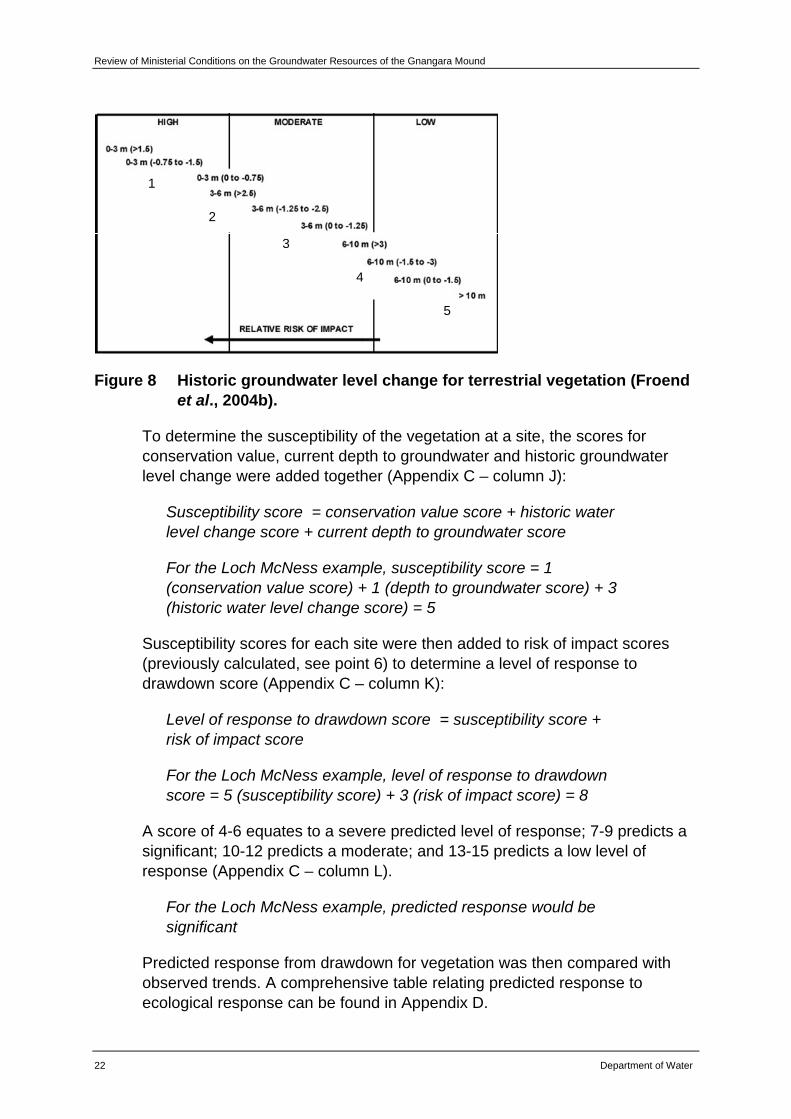
Review of Ministerial Conditions on the Groundwater Resources of the Gnangara Mound
22 Department of Water
1
2
3
4
5
Figure 8 Historic groundwater level change for terrestrial vegetation (Froend et al., 2004b).
To determine the susceptibility of the vegetation at a site, the scores for conservation value, current depth to groundwater and historic groundwater level change were added together (Appendix C – column J):
Susceptibility score = conservation value score + historic water level change score + current depth to groundwater score
For the Loch McNess example, susceptibility score = 1 (conservation value score) + 1 (depth to groundwater score) + 3 (historic water level change score) = 5
Susceptibility scores for each site were then added to risk of impact scores (previously calculated, see point 6) to determine a level of response to drawdown score (Appendix C – column K):
Level of response to drawdown score = susceptibility score + risk of impact score
For the Loch McNess example, level of response to drawdown score = 5 (susceptibility score) + 3 (risk of impact score) = 8
A score of 4-6 equates to a severe predicted level of response; 7-9 predicts a significant; 10-12 predicts a moderate; and 13-15 predicts a low level of response (Appendix C – column L).
For the Loch McNess example, predicted response would be significant
Predicted response from drawdown for vegetation was then compared with observed trends. A comprehensive table relating predicted response to ecological response can be found in Appendix D.
Review of Ministerial Conditions for the Gnangara Mound
Department of Water 23
Consideration of Froend et al., (2004b) recommended EWRs
As part of this review process, it was considered whether to propose replacing existing EWPs i.e. the current water levels set as Ministerial criteria, with the EWRs recommended by Froend et al., (2004b). The department decided not to proceed with this approach at this time on the basis that it was considered inappropriate to replace considered EWPs with EWRs that do not incorporate social or economic considerations. A major project to address this issue is to be developed for the Gnangara statutory water management plan.
4.1.2 Hydrological assessment
Groundwater modelling and hydrograph analysis were used to investigate possible causes of groundwater level decline by determining the relative influence of climate, abstraction and land use on each criteria site. Two techniques were used; Cumulative Deviation From Mean rainfall (CDFM) and Perth Regional Aquifer Modelling System (PRAMS).
A CDFM analysis is an evaluation technique where actual rainfall over a defined period is subtracted from the long-term mean rainfall of the same period. A relationship between groundwater level data and the CDFM was established using a reference site situated in an area of native vegetation. This relationship was then applied to a sub sample of hydrographs, approximately 100, across the Gnangara Mound (Yesertener, 2007). This method was used in combination with the PRAMS to examine relative influence of different factors on groundwater levels.
The PRAMS is a numerical modelling tool that can provide predictions of relative water level changes at a regional scale and has been developed as a quantitative and integrated modelling tool to support management planning. PRAMS has been used to provide information on changes in water levels across the Gnangara Mound. A comprehensive modelling study was undertaken and provided valuable information to previous updates on the review of conditions published as the State of the Mound report (Department of Environment, 2005) and more recently in Vogwill, et al., (2007). PRAMS was used to predict the relative influence of climate, abstraction (public and private) and land use (pines and native vegetation) between 2004 and 2014.
Modelling using PRAMS was used to predict future groundwater level decline based on a number of management scenarios. Firstly a base case was established, that assumed abstraction for public and private supply, thinning regime of pines and burning frequency of native vegetation occurring at a particular rate. Additional scenarios comprising of changes to public and private abstraction and thinning rates of pines etc were developed to determine which scenario would have the greatest impact on groundwater decline at existing Ministerial criteria sites. Table 5 shows the scenarios that were modelled using PRAMS. Whilst interpreting modelling outputs, consideration was given to the constraints set through scenarios modelled. Results
Review of Ministerial Conditions on the Groundwater Resources of the Gnangara Mound
24 Department of Water
from this modelling are included within the assessments of sites for which climate and/or land use were identified as the predominant cause of groundwater level decline.
As noted above, PRAMS is a regional scale model. Results are provided at the scale of 500m by 500m and are therefore not particular to individual sites. Results are extrapolated for individual sites based on the changes in regional water level as predicted for the grid and surrounding grids in which sites are located. This was taken into consideration when assessing results of PRAMS for each site. Outcomes were cross checked with other methodologies as well as licensing data and information to determine the predominant cause of groundwater level decline at each site. The department has only requested changes to sites where it can be confidently stated that the predominant cause of decline was not abstraction.
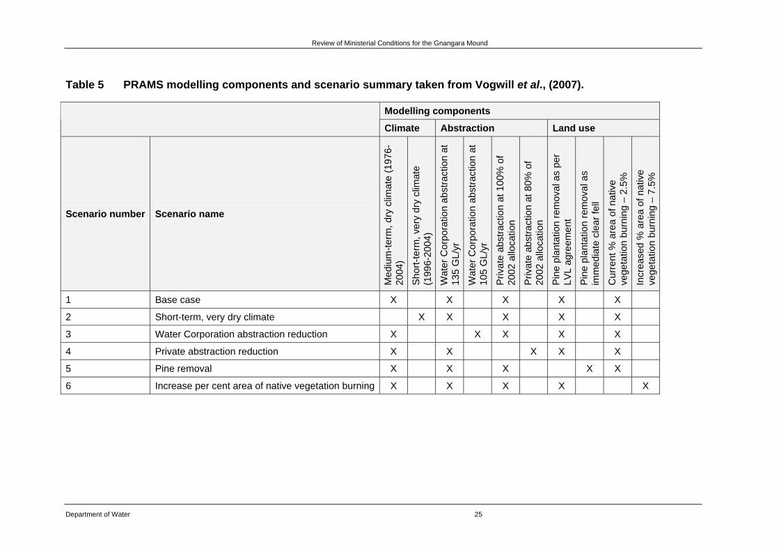
Review of Ministerial Conditions for the Gnangara Mound
Department of Water 25
Table 5 PRAMS modelling components and scenario summary taken from Vogwill et al., (2007).
Modelling components
Climate Abstraction Land use
Scenario number Scenario name
Med
ium
-term
, dry
clim
ate
(197
6-20
04)
Sho
rt-te
rm, v
ery
dry
clim
ate
(1
996-
2004
)
Wat
er C
orpo
ratio
n ab
stra
ctio
n at
13
5 G
L/yr
Wat
er C
orpo
ratio
n ab
stra
ctio
n at
10
5 G
L/yr
Priv
ate
abst
ract
ion
at 1
00%
of
2002
allo
catio
n
Priv
ate
abst
ract
ion
at 8
0% o
f 20
02 a
lloca
tion
Pin
e pl
anta
tion
rem
oval
as
per
LVL
agre
emen
t
Pin
e pl
anta
tion
rem
oval
as
imm
edia
te c
lear
fell
Cur
rent
% a
rea
of n
ativ
e ve
geta
tion
burn
ing
– 2.
5%
Incr
ease
d %
are
a of
nat
ive
vege
tatio
n bu
rnin
g –
7.5%
1 Base case X X X X X
2 Short-term, very dry climate X X X X X
3 Water Corporation abstraction reduction X X X X X
4 Private abstraction reduction X X X X X
5 Pine removal X X X X X
6 Increase per cent area of native vegetation burning X X X X X

Review of Ministerial Conditions on the Groundwater Resources of the Gnangara Mound
26 Department of Water
Monitoring review and recommendations
The monitoring network at each criteria site was also assessed based on an examination of monitoring techniques and programs by Froend, Rogan, Loomes, Horwitz, Bamford and Storey (2004c) and a hydrogeological review by Rockwater (2004). Key recommendations from these reports are included for each criteria site.
Based on the ecological and hydrological assessments described above, the department has made recommendations and commitments relating to the future management of each site. Where appropriate, the department seeks the EPA’s approval for changes to the monitoring network and/or for removal of Ministerial criteria at some sites.
The following sections of this Chapter outline the results of analysis using the methods described here for each of the sites for which Ministerial criteria exist namely:
• Loch McNess
• Lake Wilgarup
• Lake Yonderup
• Pipidinny Swamp
• Lake Goollelal (459)
• Lake Joondalup (8281)
• PM9
• Melaleuca Park Dampland 78 (GNM31)
• Melaleuca Park EPP 173 (GNM14SG)
• L30C
• L110C
• L220C
• NR6C
• NR11C
• WM1
• WM2
• WM8
• MM12
• PM24
• PM25
• Lake Nowergup
• Lake Jandabup
• Lake Mariginiup
• MT3S
• Lake Gnangara
• WM6
• Lexia 86 (GNM16)
• Lexia 94 (GNM17a)
• Lexia 186 (GNM15)
• Edgecombe Seepage (B10)
• Egerton Seepage (B25)
• MM16
• MM18
• MM49B
• MM53
• MM55B
• MM59B
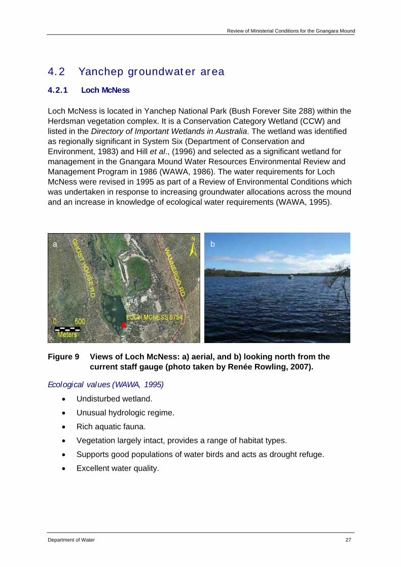
Review of Ministerial Conditions for the Gnangara Mound
Department of Water 27
4.2 Yanchep groundwater area
4.2.1 Loch McNess
Loch McNess is located in Yanchep National Park (Bush Forever Site 288) within the Herdsman vegetation complex. It is a Conservation Category Wetland (CCW) and listed in the Directory of Important Wetlands in Australia. The wetland was identified as regionally significant in System Six (Department of Conservation and Environment, 1983) and Hill et al., (1996) and selected as a significant wetland for management in the Gnangara Mound Water Resources Environmental Review and Management Program in 1986 (WAWA, 1986). The water requirements for Loch McNess were revised in 1995 as part of a Review of Environmental Conditions which was undertaken in response to increasing groundwater allocations across the mound and an increase in knowledge of ecological water requirements (WAWA, 1995).
Figure 9 Views of Loch McNess: a) aerial, and b) looking north from the current staff gauge (photo taken by Renée Rowling, 2007).
Ecological values (WAWA, 1995)
• Undisturbed wetland.
• Unusual hydrologic regime.
• Rich aquatic fauna.
• Vegetation largely intact, provides a range of habitat types.
• Supports good populations of water birds and acts as drought refuge.
• Excellent water quality.
a b
Review of Ministerial Conditions on the Groundwater Resources of the Gnangara Mound
28 Department of Water
Management objectives (WAWA, 1995)
• To maintain the environmental quality of the lake.
• To maintain North Loch McNess’ pristine state.
• To continue to use south Loch McNess for low key recreation.
• To maintain east Loch McNess in a natural state, to restore, where possible natural flow.
Water regime management objectives (WAWA, 1995)
• To maintain the existing hydrological regime.
Current Ministerial criterion (WAWA, 1995; Statement 687)
• 6.95mAHD absolute summer minimum.
Compliance with current Ministerial criterion and ecological condition
Between 1995 and 2007, water levels at Loch McNess have met end of summer Ministerial criterion on all but five occasions. Water levels have been declining by approximately 0.02m/yr since 1998 (Bekesi, 2007a) until an unprecedented drop of 0.17m between summer 2006 and 2007 (Figure 10).
Vegetation monitoring at Loch McNess commenced in 2004. At this time vegetation condition was moderate to high. A fire in January 2005 temporarily had an impact on parts of the vegetation around the wetland. There is some evidence of terrestrialisation, with the replacement of wetland species with those typical of a Tuart woodland, and the encroachment of fringing vegetation into the basin.
Loch McNess is noted as having good water quality as well as the highest cumulative macroinvertebrate family richness of all monitored wetlands on Gnangara.
Recent EWR and ecological trends
Recent summer water levels have been below Froend et al., (2004b) recommended EWR for vegetation (Figure 10; Appendix C). The magnitude and rate of drawdown is exceeds that required to maintain a low risk of impact to the vegetation at this site. This combined with depth to groundwater, historic water level changes and conservation values, predicts a significant level of response to drawdown (Appendix C). This is reflected by some evidence of terrestrialisation and encroachment of fringing vegetation into the basin.
The summer minimum water levels have also been below Froend et al., (2004b) recommended EWR for waterbirds, macroinvertebrates, vertebrates and sediment processes (Figure 10; Appendix C). This has been reflected by minor evidence of declining macroinvertebrate family richness.
Review of Ministerial Conditions for the Gnangara Mound
Department of Water 29
Given that there has been an additional decline in water levels in the past 12 months it is possible that there will be a lag effect before seeing any further impact to macroinvertebrates and other ecological features.
Currently water levels at Loch McNess are measured from a staff gauge on the eastern side of the lake (6162564). Through a recent audit (Management Area Review) of the monitoring network on the Gnangara and Jandakot mounds it has been identified that there is a lack of a suitable monitoring bore at the vegetation transect on the western side of the lake (Department of Water, 2007). The department has initiated a project known as the Shallow Groundwater Systems Investigation (SGS Investigation). For information on this project refer to Chapter 6 of this report. As part of Stage Two of this investigation, a shallow monitoring bore will be established at the vegetation transect. If water levels between the bore and the current staff gauge are well correlated, the department may recommend to the EPA that the bore be used in conjunction with the staff gauge to measure water levels against the criterion. Stage Two of the SGS Investigation is due to be complete in early 2008.
A sudden drop in water levels was recorded during the last year (Figure 10). A desktop investigation was conducted and it was determined that the decline in regional groundwater levels up gradient of the wetland were likely to have dropped below the buffering capacity of the lake, causing surface water levels to decline over a short period of time (Bekesi, 2007b). This regional decline may also have impacts on hydrology of caves in the region and associated groundwater dependent ecosystems.
Water levels at Loch McNess are being addressed by the Yanchep Caves recovery team. The recovery team meets bi-monthly and is comprised of officers from the Department of Environment and Conservation, the Department of Water, the Water Corporation and independent ecologists. The team is considering alternatives for managing the issue.
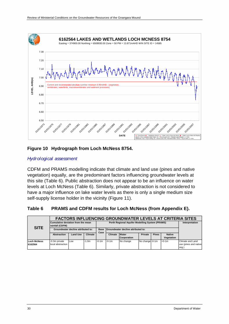
Review of Ministerial Conditions on the Groundwater Resources of the Gnangara Mound
30 Department of Water
6162564 LAKES AND WETLANDS LOCH MCNESS 8754Easting = 374900.00 Northing = 6508930.00 Zone = 50 PM = 13.871mAHD WIN SITE ID = 14585
6.50
6.60
6.70
6.80
6.90
7.00
7.10
7.20
7.30
01/01
/1973
01/01
/1975
01/01
/1977
01/01
/1979
01/01
/1981
01/01
/1983
01/01
/1985
01/01
/1987
01/01
/1989
01/01
/1991
01/01
/1993
01/01
/1995
01/01
/1997
01/01
/1999
01/01
/2001
01/01
/2003
01/01
/2005
01/01
/2007
DATE
LEVE
L A
HD
(m)
Current and recommended absolute summer minimum 6.95mAHD - (vegetation, vertebrates, waterbirds, macroinvertebrates and sediment processes)
Figure 10 Hydrograph from Loch McNess 8754.
Hydrological assessment
CDFM and PRAMS modelling indicate that climate and land use (pines and native vegetation) equally, are the predominant factors influencing groundwater levels at this site (Table 6). Public abstraction does not appear to be an influence on water levels at Loch McNess (Table 6). Similarly, private abstraction is not considered to have a major influence on lake water levels as there is only a single medium size self-supply license holder in the vicinity (Figure 11).
Table 6 PRAMS and CDFM results for Loch McNess (from Appendix E).
Abstraction Land Use Climate Climate Water Corporation
Private Pines Native Vegetation
Loch McNess6162564
-0.3m private local abstraction
Low -1.0m -0-1m -0-1m No change No change -0-1m +0-1m Climate and Land use (pines and native veg.)
FACTORS INFLUENCING GROUNDWATER LEVELS AT CRITERIA SITES
Groundwater decline attributed to: Base Case
Groundwater decline attributed to:
Perth Regional Aquifer Modelling System (PRAMS) Interpretation
SITECumulative deviation from the mean rainfall (CDFM)

Review of Ministerial Conditions for the Gnangara Mound
Department of Water 31
Figure 11 Private licences greater than 0.15 GL in the vicinity of Loch McNess (shown as yellow dots).
Recommendations
As CDFM and PRAMS modelling indicate that climate and land use are the predominant factors influencing groundwater levels at this site, rather than abstraction, the department recommends that the EPA supports the removal of Loch McNess as a Ministerial criteria site.
The department will continue to monitor groundwater levels to add to the long-term data set that exists for this site. Information collected will provide important data for future hydrogeological assessments of groundwater levels across the Gnangara Mound. The Yanchep Caves Recovery Team will consider alternatives for managing the issue of declining water levels at Loch McNess.
The department will establish a new bore at the vegetation transect as part of Stage Two of the SGS Investigation.
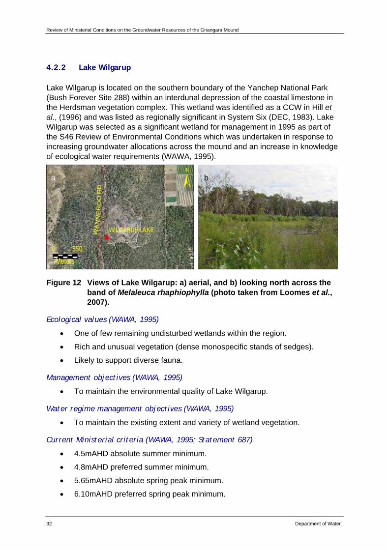
Review of Ministerial Conditions on the Groundwater Resources of the Gnangara Mound
32 Department of Water
4.2.2 Lake Wilgarup
Lake Wilgarup is located on the southern boundary of the Yanchep National Park (Bush Forever Site 288) within an interdunal depression of the coastal limestone in the Herdsman vegetation complex. This wetland was identified as a CCW in Hill et al., (1996) and was listed as regionally significant in System Six (DEC, 1983). Lake Wilgarup was selected as a significant wetland for management in 1995 as part of the S46 Review of Environmental Conditions which was undertaken in response to increasing groundwater allocations across the mound and an increase in knowledge of ecological water requirements (WAWA, 1995).
Figure 12 Views of Lake Wilgarup: a) aerial, and b) looking north across the band of Melaleuca rhaphiophylla (photo taken from Loomes et al., 2007).
Ecological values (WAWA, 1995)
• One of few remaining undisturbed wetlands within the region.
• Rich and unusual vegetation (dense monospecific stands of sedges).
• Likely to support diverse fauna.
Management objectives (WAWA, 1995)
• To maintain the environmental quality of Lake Wilgarup.
Water regime management objectives (WAWA, 1995)
• To maintain the existing extent and variety of wetland vegetation.
Current Ministerial criteria (WAWA, 1995; Statement 687)
• 4.5mAHD absolute summer minimum.
• 4.8mAHD preferred summer minimum.
• 5.65mAHD absolute spring peak minimum.
• 6.10mAHD preferred spring peak minimum.
a b
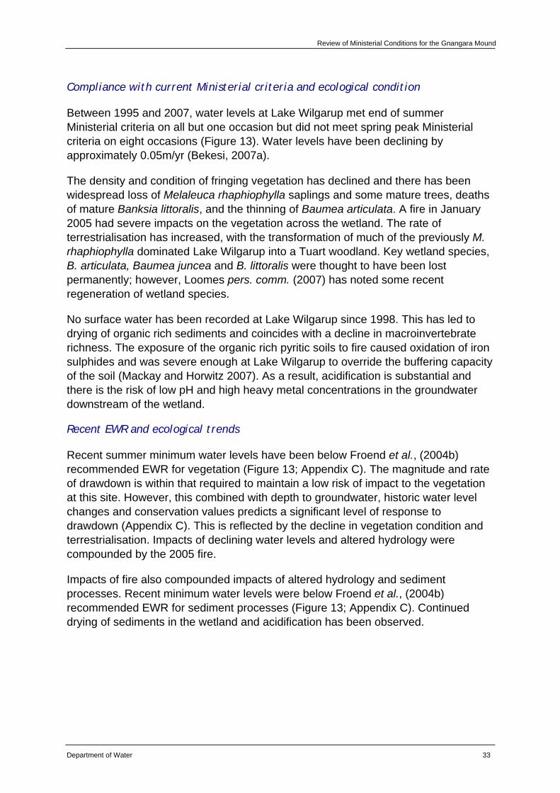
Review of Ministerial Conditions for the Gnangara Mound
Department of Water 33
Compliance with current Ministerial criteria and ecological condition
Between 1995 and 2007, water levels at Lake Wilgarup met end of summer Ministerial criteria on all but one occasion but did not meet spring peak Ministerial criteria on eight occasions (Figure 13). Water levels have been declining by approximately 0.05m/yr (Bekesi, 2007a).
The density and condition of fringing vegetation has declined and there has been widespread loss of Melaleuca rhaphiophylla saplings and some mature trees, deaths of mature Banksia littoralis, and the thinning of Baumea articulata. A fire in January 2005 had severe impacts on the vegetation across the wetland. The rate of terrestrialisation has increased, with the transformation of much of the previously M. rhaphiophylla dominated Lake Wilgarup into a Tuart woodland. Key wetland species, B. articulata, Baumea juncea and B. littoralis were thought to have been lost permanently; however, Loomes pers. comm. (2007) has noted some recent regeneration of wetland species.
No surface water has been recorded at Lake Wilgarup since 1998. This has led to drying of organic rich sediments and coincides with a decline in macroinvertebrate richness. The exposure of the organic rich pyritic soils to fire caused oxidation of iron sulphides and was severe enough at Lake Wilgarup to override the buffering capacity of the soil (Mackay and Horwitz 2007). As a result, acidification is substantial and there is the risk of low pH and high heavy metal concentrations in the groundwater downstream of the wetland.
Recent EWR and ecological trends
Recent summer minimum water levels have been below Froend et al., (2004b) recommended EWR for vegetation (Figure 13; Appendix C). The magnitude and rate of drawdown is within that required to maintain a low risk of impact to the vegetation at this site. However, this combined with depth to groundwater, historic water level changes and conservation values predicts a significant level of response to drawdown (Appendix C). This is reflected by the decline in vegetation condition and terrestrialisation. Impacts of declining water levels and altered hydrology were compounded by the 2005 fire.
Impacts of fire also compounded impacts of altered hydrology and sediment processes. Recent minimum water levels were below Froend et al., (2004b) recommended EWR for sediment processes (Figure 13; Appendix C). Continued drying of sediments in the wetland and acidification has been observed.
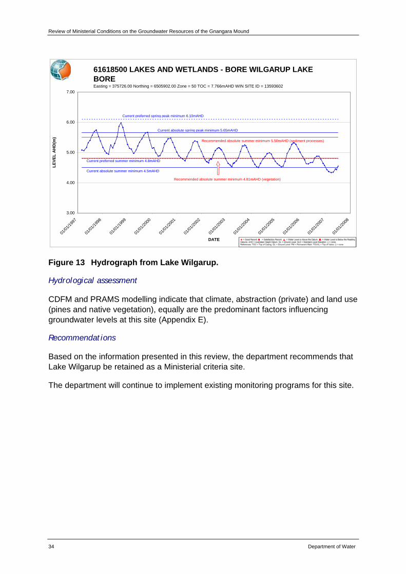
Review of Ministerial Conditions on the Groundwater Resources of the Gnangara Mound
34 Department of Water
61618500 LAKES AND WETLANDS - BORE WILGARUP LAKE BOREEasting = 375726.00 Northing = 6505902.00 Zone = 50 TOC = 7.766mAHD WIN SITE ID = 13593602
3.00
4.00
5.00
6.00
7.00
01/01
/1997
01/01
/1998
01/01
/1999
01/01
/2000
01/01
/2001
01/01
/2002
01/01
/2003
01/01
/2004
01/01
/2005
01/01
/2006
01/01
/2007
01/01
/2008
DATE
LEVE
L A
HD
(m)
Current absolute summer minimum 4.5mAHD
Current preferred summer minimum 4.8mAHD
Current absolute spring peak minimum 5.65mAHD
Current preferred spring peak minimum 6.10mAHD
Recommended absolute summer minimum 5.50mAHD (sediment processes)
Recommended absolute summer minimum 4.81mAHD (vegetation)
Figure 13 Hydrograph from Lake Wilgarup.
Hydrological assessment
CDFM and PRAMS modelling indicate that climate, abstraction (private) and land use (pines and native vegetation), equally are the predominant factors influencing groundwater levels at this site (Appendix E).
Recommendations
Based on the information presented in this review, the department recommends that Lake Wilgarup be retained as a Ministerial criteria site.
The department will continue to implement existing monitoring programs for this site.
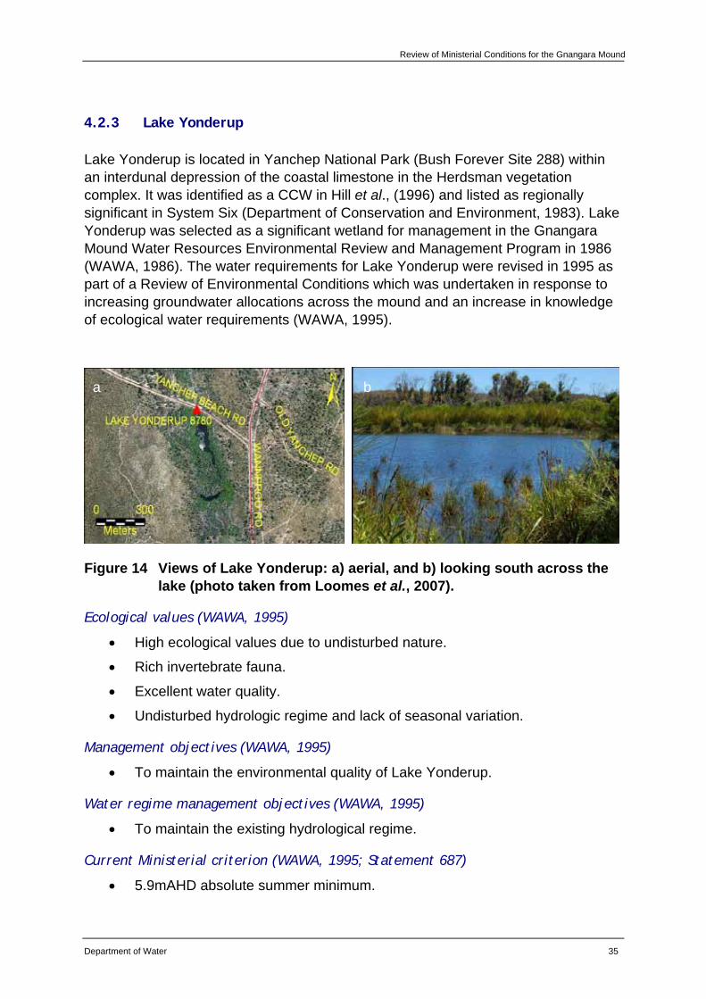
Review of Ministerial Conditions for the Gnangara Mound
Department of Water 35
4.2.3 Lake Yonderup
Lake Yonderup is located in Yanchep National Park (Bush Forever Site 288) within an interdunal depression of the coastal limestone in the Herdsman vegetation complex. It was identified as a CCW in Hill et al., (1996) and listed as regionally significant in System Six (Department of Conservation and Environment, 1983). Lake Yonderup was selected as a significant wetland for management in the Gnangara Mound Water Resources Environmental Review and Management Program in 1986 (WAWA, 1986). The water requirements for Lake Yonderup were revised in 1995 as part of a Review of Environmental Conditions which was undertaken in response to increasing groundwater allocations across the mound and an increase in knowledge of ecological water requirements (WAWA, 1995).
Figure 14 Views of Lake Yonderup: a) aerial, and b) looking south across the lake (photo taken from Loomes et al., 2007).
Ecological values (WAWA, 1995)
• High ecological values due to undisturbed nature.
• Rich invertebrate fauna.
• Excellent water quality.
• Undisturbed hydrologic regime and lack of seasonal variation.
Management objectives (WAWA, 1995)
• To maintain the environmental quality of Lake Yonderup.
Water regime management objectives (WAWA, 1995)
• To maintain the existing hydrological regime.
Current Ministerial criterion (WAWA, 1995; Statement 687)
• 5.9mAHD absolute summer minimum.
a b
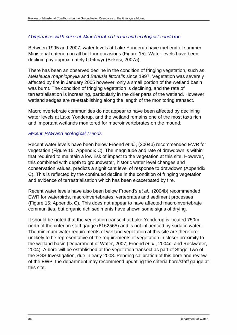
Review of Ministerial Conditions on the Groundwater Resources of the Gnangara Mound
36 Department of Water
Compliance with current Ministerial criterion and ecological condition
Between 1995 and 2007, water levels at Lake Yonderup have met end of summer Ministerial criterion on all but four occasions (Figure 15). Water levels have been declining by approximately 0.04m/yr (Bekesi, 2007a).
There has been an observed decline in the condition of fringing vegetation, such as Melaleuca rhaphiophylla and Banksia littoralis since 1997. Vegetation was severely affected by fire in January 2005 however, only a small portion of the wetland basin was burnt. The condition of fringing vegetation is declining, and the rate of terrestrialisation is increasing, particularly in the drier parts of the wetland. However, wetland sedges are re-establishing along the length of the monitoring transect.
Macroinvertebrate communities do not appear to have been affected by declining water levels at Lake Yonderup, and the wetland remains one of the most taxa rich and important wetlands monitored for macroinvertebrates on the mound.
Recent EWR and ecological trends
Recent water levels have been below Froend et al., (2004b) recommended EWR for vegetation (Figure 15; Appendix C). The magnitude and rate of drawdown is within that required to maintain a low risk of impact to the vegetation at this site. However, this combined with depth to groundwater, historic water level changes and conservation values, predicts a significant level of response to drawdown (Appendix C). This is reflected by the continued decline in the condition of fringing vegetation and evidence of terrestrialisation which has been exacerbated by fire.
Recent water levels have also been below Froend’s et al., (2004b) recommended EWR for waterbirds, macroinvertebrates, vertebrates and sediment processes (Figure 15; Appendix C). This does not appear to have affected macroinvertebrate communities, but organic rich sediments have shown some signs of drying.
It should be noted that the vegetation transect at Lake Yonderup is located 750m north of the criterion staff gauge (6162565) and is not influenced by surface water. The minimum water requirements of wetland vegetation at this site are therefore unlikely to be representative of the requirements of vegetation in closer proximity to the wetland basin (Department of Water, 2007; Froend et al., 2004c; and Rockwater, 2004). A bore will be established at the vegetation transect as part of Stage Two of the SGS Investigation, due in early 2008. Pending calibration of this bore and review of the EWP, the department may recommend updating the criteria bore/staff gauge at this site.
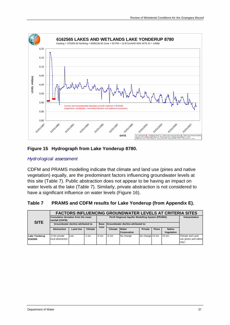
Review of Ministerial Conditions for the Gnangara Mound
Department of Water 37
6162565 LAKES AND WETLANDS LAKE YONDERUP 8780Easting = 375305.00 Northing = 6508126.00 Zone = 50 PM = 13.871mAHD WIN SITE ID = 14586
5.80
5.85
5.90
5.95
6.00
6.05
6.10
6.15
6.20
01/01
/1987
01/01
/1989
01/01
/1991
01/01
/1993
01/01
/1995
01/01
/1997
01/01
/1999
01/01
/2001
01/01
/2003
01/01
/2005
01/01
/2007
DATE
LEVE
L A
HD
(m)
Current and recommended absolute summer minimum 5.9mAHD (vegetation, vertebrates, macroinvertebrates and sediment processes)
Figure 15 Hydrograph from Lake Yonderup 8780.
Hydrological assessment
CDFM and PRAMS modelling indicate that climate and land use (pines and native vegetation) equally, are the predominant factors influencing groundwater levels at this site (Table 7). Public abstraction does not appear to be having an impact on water levels at the lake (Table 7). Similarly, private abstraction is not considered to have a significant influence on water levels (Figure 16).
Table 7 PRAMS and CDFM results for Lake Yonderup (from Appendix E).
Abstraction Land Use Climate Climate Water Corporation
Private Pines Native Vegetation
Lake Yonderup6162565
-0.3m private local abstraction
Low -1.1m -0-1m -0-1m No change No change +0-1m +0-1m Climate and Land use (pines and native veg.)
FACTORS INFLUENCING GROUNDWATER LEVELS AT CRITERIA SITES
Groundwater decline attributed to: Base Case
Groundwater decline attributed to:
Perth Regional Aquifer Modelling System (PRAMS) Interpretation
SITECumulative deviation from the mean rainfall (CDFM)
Review of Ministerial Conditions on the Groundwater Resources of the Gnangara Mound
38 Department of Water
Figure 16 Private licenses greater than 0.15 GL in the vicinity of Lake Yonderup (yellow dots).
Recommendations
As CDFM and PRAMS modelling indicate that climate and land use are the predominant factors influencing groundwater levels at this site, rather than abstraction, the department recommends that the EPA support the removal of Lake Yonderup as a Ministerial criteria site.
The department will continue to monitor groundwater levels to add to the long term data set that exists for this site. Information collected will provide important data for future hydrogeological assessments of groundwater levels across the Gnangara Mound.
The department will establish a new bore at the vegetation transect as part of Stage Two of SGS Investigation.
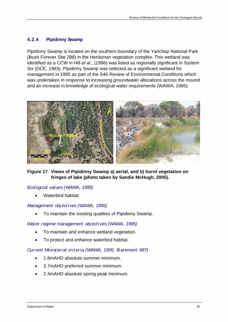
Review of Ministerial Conditions for the Gnangara Mound
Department of Water 39
4.2.4 Pipidinny Swamp
Pipidinny Swamp is located on the southern boundary of the Yanchep National Park (Bush Forever Site 288) in the Herdsman vegetation complex. This wetland was identified as a CCW in Hill et al., (1996) was listed as regionally significant in System Six (DCE, 1983). Pipidinny Swamp was selected as a significant wetland for management in 1995 as part of the S46 Review of Environmental Conditions which was undertaken in response to increasing groundwater allocations across the mound and an increase in knowledge of ecological water requirements (WAWA, 1995).
Figure 17 Views of Pipidinny Swamp a) aerial, and b) burnt vegetation on fringes of lake (photo taken by Sandie McHugh, 2005).
Ecological values (WAWA, 1995)
• Waterbird habitat.
Management objectives (WAWA, 1995)
• To maintain the existing qualities of Pipidinny Swamp.
Water regime management objectives (WAWA, 1995)
• To maintain and enhance wetland vegetation.
• To protect and enhance waterbird habitat.
Current Ministerial criteria (WAWA, 1995; Statement 687)
• 1.6mAHD absolute summer minimum.
• 2.7mAHD preferred summer minimum.
• 2.4mAHD absolute spring peak minimum.
a b
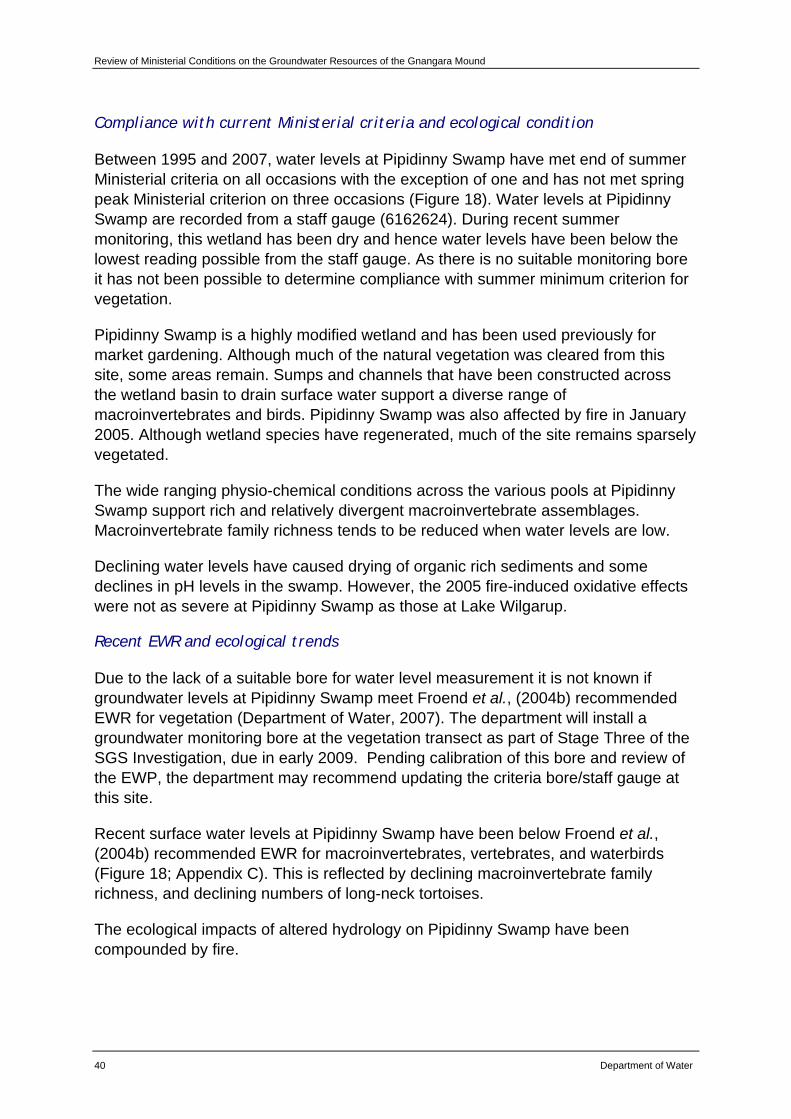
Review of Ministerial Conditions on the Groundwater Resources of the Gnangara Mound
40 Department of Water
Compliance with current Ministerial criteria and ecological condition
Between 1995 and 2007, water levels at Pipidinny Swamp have met end of summer Ministerial criteria on all occasions with the exception of one and has not met spring peak Ministerial criterion on three occasions (Figure 18). Water levels at Pipidinny Swamp are recorded from a staff gauge (6162624). During recent summer monitoring, this wetland has been dry and hence water levels have been below the lowest reading possible from the staff gauge. As there is no suitable monitoring bore it has not been possible to determine compliance with summer minimum criterion for vegetation.
Pipidinny Swamp is a highly modified wetland and has been used previously for market gardening. Although much of the natural vegetation was cleared from this site, some areas remain. Sumps and channels that have been constructed across the wetland basin to drain surface water support a diverse range of macroinvertebrates and birds. Pipidinny Swamp was also affected by fire in January 2005. Although wetland species have regenerated, much of the site remains sparsely vegetated.
The wide ranging physio-chemical conditions across the various pools at Pipidinny Swamp support rich and relatively divergent macroinvertebrate assemblages. Macroinvertebrate family richness tends to be reduced when water levels are low.
Declining water levels have caused drying of organic rich sediments and some declines in pH levels in the swamp. However, the 2005 fire-induced oxidative effects were not as severe at Pipidinny Swamp as those at Lake Wilgarup.
Recent EWR and ecological trends
Due to the lack of a suitable bore for water level measurement it is not known if groundwater levels at Pipidinny Swamp meet Froend et al., (2004b) recommended EWR for vegetation (Department of Water, 2007). The department will install a groundwater monitoring bore at the vegetation transect as part of Stage Three of the SGS Investigation, due in early 2009. Pending calibration of this bore and review of the EWP, the department may recommend updating the criteria bore/staff gauge at this site.
Recent surface water levels at Pipidinny Swamp have been below Froend et al., (2004b) recommended EWR for macroinvertebrates, vertebrates, and waterbirds (Figure 18; Appendix C). This is reflected by declining macroinvertebrate family richness, and declining numbers of long-neck tortoises.
The ecological impacts of altered hydrology on Pipidinny Swamp have been compounded by fire.
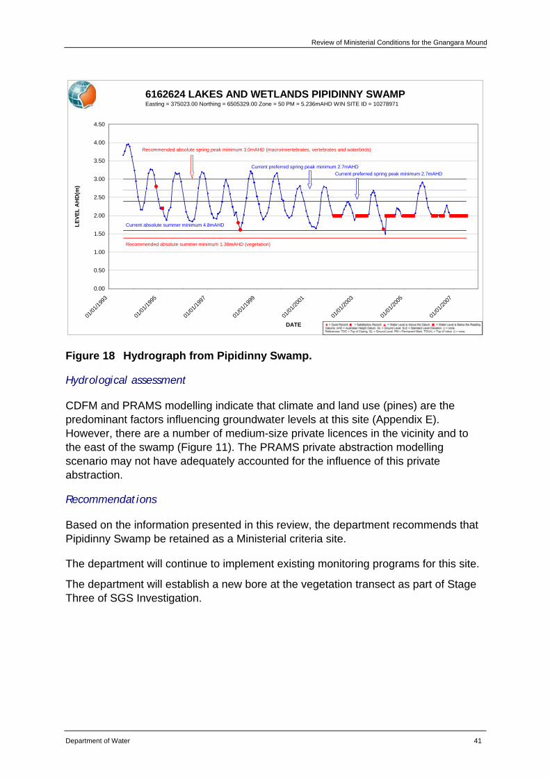
Review of Ministerial Conditions for the Gnangara Mound
Department of Water 41
6162624 LAKES AND WETLANDS PIPIDINNY SWAMPEasting = 375023.00 Northing = 6505329.00 Zone = 50 PM = 5.236mAHD WIN SITE ID = 10278971
0.00
0.50
1.00
1.50
2.00
2.50
3.00
3.50
4.00
4.50
01/01
/1993
01/01
/1995
01/01
/1997
01/01
/1999
01/01
/2001
01/01
/2003
01/01
/2005
01/01
/2007
DATE
LEVE
L A
HD
(m)
Current absolute summer minimum 4.8mAHD
Current preferred spring peak minimum 2.7mAHDCurrent preferred spring peak minimum 2.7mAHD
Recommended absolute summer minimum 1.38mAHD (vegetation)
Recommended absolute spring peak minimum 3.0mAHD (macroinvertebrates, vertebrates and waterbirds)
Figure 18 Hydrograph from Pipidinny Swamp.
Hydrological assessment
CDFM and PRAMS modelling indicate that climate and land use (pines) are the predominant factors influencing groundwater levels at this site (Appendix E). However, there are a number of medium-size private licences in the vicinity and to the east of the swamp (Figure 11). The PRAMS private abstraction modelling scenario may not have adequately accounted for the influence of this private abstraction.
Recommendations
Based on the information presented in this review, the department recommends that Pipidinny Swamp be retained as a Ministerial criteria site.
The department will continue to implement existing monitoring programs for this site.
The department will establish a new bore at the vegetation transect as part of Stage Three of SGS Investigation.
Review of Ministerial Conditions on the Groundwater Resources of the Gnangara Mound
42 Department of Water
4.3 Perth groundwater area – Whitfords subarea
4.3.1 Lake Goollelal (459)
Lake Goollelal is situated within the Yellagonga Regional Park (Bushforever Site 299) in the Herdsman vegetation complex. This wetland was identified as a CCW in Hill et al., (1996) and was identified as regionally significant in System Six (DCE, 1983). Lake Goollelal was selected as a significant wetland for management in the Gnangara Mound Water Resources Environmental Review and Management Program in 1986 (WAWA, 1986). The water requirements for Lake Goollelal were revised in 1995 as part of a Review of Environmental Conditions which was undertaken in response to increasing groundwater allocations across the mound and an increase in knowledge of ecological water requirements (WAWA, 1995).
Figure 19 Views of Lake Goollelal: a) aerial, and b) looking east towards the lake (photo taken from Bertuch et al., 2004).
Ecological values (WAWA, 1995)
• Waterbird habitat and drought refuge.
• Supports good populations of native fish species, Swan River goby (Pseudogobius olorum) and the western pygmy perch (Edelia vittata).
Management objectives (WAWA, 1995)
• Conservation and public enjoyment of natural and modified landscapes.
Water regime management objectives (WAWA, 1995)
• To protect and if possible enhance, fringing wetland vegetation including woodland and sedge vegetation.
• To maintain permanent, deep water for water bird habitat and as a drought refuge.
a b
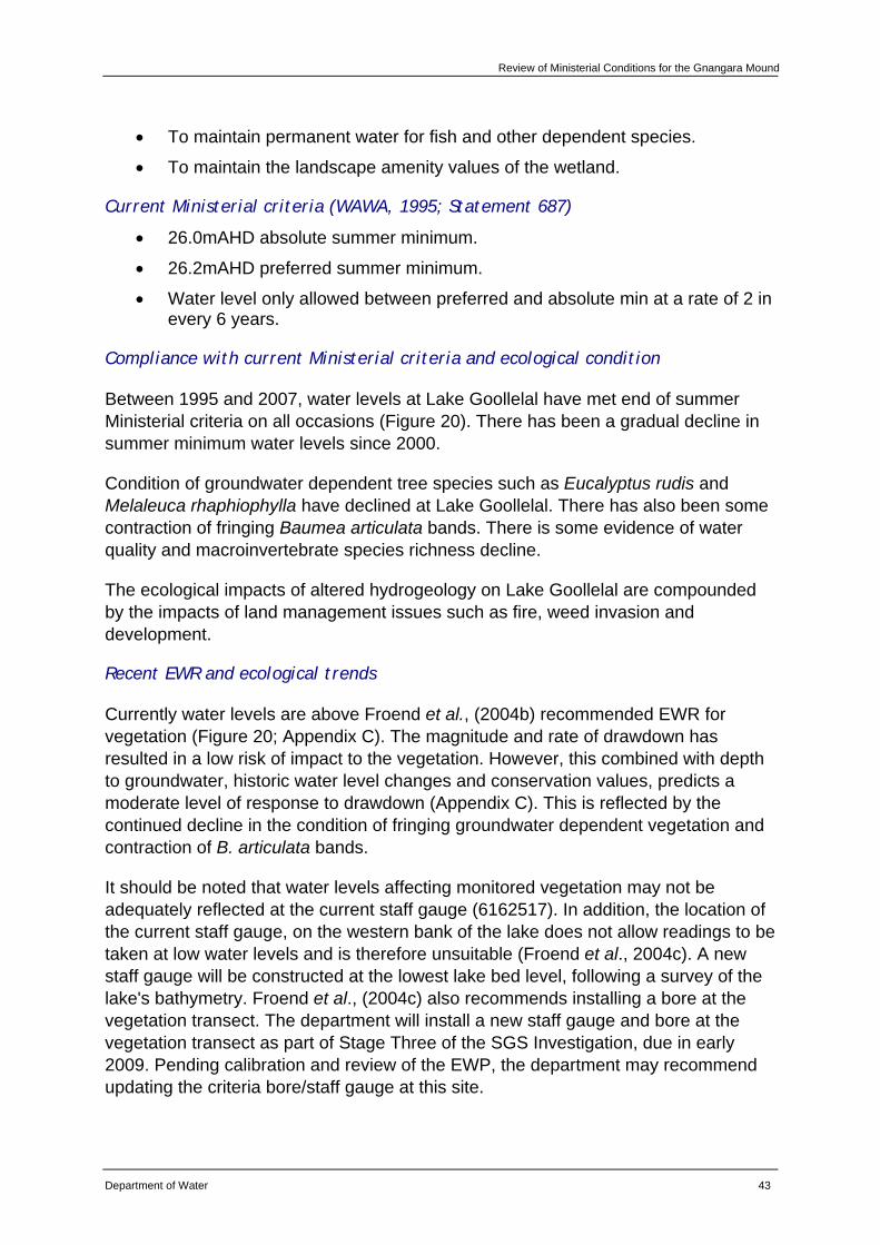
Review of Ministerial Conditions for the Gnangara Mound
Department of Water 43
• To maintain permanent water for fish and other dependent species.
• To maintain the landscape amenity values of the wetland.
Current Ministerial criteria (WAWA, 1995; Statement 687)
• 26.0mAHD absolute summer minimum.
• 26.2mAHD preferred summer minimum.
• Water level only allowed between preferred and absolute min at a rate of 2 in every 6 years.
Compliance with current Ministerial criteria and ecological condition
Between 1995 and 2007, water levels at Lake Goollelal have met end of summer Ministerial criteria on all occasions (Figure 20). There has been a gradual decline in summer minimum water levels since 2000.
Condition of groundwater dependent tree species such as Eucalyptus rudis and Melaleuca rhaphiophylla have declined at Lake Goollelal. There has also been some contraction of fringing Baumea articulata bands. There is some evidence of water quality and macroinvertebrate species richness decline.
The ecological impacts of altered hydrogeology on Lake Goollelal are compounded by the impacts of land management issues such as fire, weed invasion and development.
Recent EWR and ecological trends
Currently water levels are above Froend et al., (2004b) recommended EWR for vegetation (Figure 20; Appendix C). The magnitude and rate of drawdown has resulted in a low risk of impact to the vegetation. However, this combined with depth to groundwater, historic water level changes and conservation values, predicts a moderate level of response to drawdown (Appendix C). This is reflected by the continued decline in the condition of fringing groundwater dependent vegetation and contraction of B. articulata bands.
It should be noted that water levels affecting monitored vegetation may not be adequately reflected at the current staff gauge (6162517). In addition, the location of the current staff gauge, on the western bank of the lake does not allow readings to be taken at low water levels and is therefore unsuitable (Froend et al., 2004c). A new staff gauge will be constructed at the lowest lake bed level, following a survey of the lake's bathymetry. Froend et al., (2004c) also recommends installing a bore at the vegetation transect. The department will install a new staff gauge and bore at the vegetation transect as part of Stage Three of the SGS Investigation, due in early 2009. Pending calibration and review of the EWP, the department may recommend updating the criteria bore/staff gauge at this site.
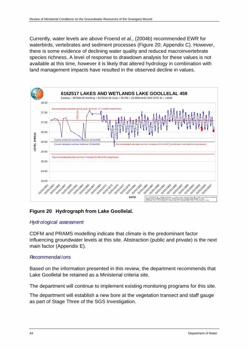
Review of Ministerial Conditions on the Groundwater Resources of the Gnangara Mound
44 Department of Water
Currently, water levels are above Froend et al., (2004b) recommended EWR for waterbirds, vertebrates and sediment processes (Figure 20; Appendix C). However, there is some evidence of declining water quality and reduced macroinvertebrate species richness. A level of response to drawdown analysis for these values is not available at this time, however it is likely that altered hydrology in combination with land management impacts have resulted in the observed decline in values.
6162517 LAKES AND WETLANDS LAKE GOOLLELAL 459Easting = 387838.00 Northing = 6479242.00 Zone = 50 PM = 29.959mAHD WIN SITE ID = 14538
24.00
24.50
25.00
25.50
26.00
26.50
27.00
27.50
28.00
01/01
/1951
01/01
/1953
01/01
/1955
01/01
/1957
01/01
/1959
01/01
/1961
01/01
/1963
01/01
/1965
01/01
/1967
01/01
/1969
01/01
/1971
01/01
/1973
01/01
/1975
01/01
/1977
01/01
/1979
01/01
/1981
01/01
/1983
01/01
/1985
01/01
/1987
01/01
/1989
01/01
/1991
01/01
/1993
01/01
/1995
01/01
/1997
01/01
/1999
01/01
/2001
01/01
/2003
01/01
/2005
01/01
/2007
DATE
LEVE
L A
HD
(m)
Recommended absolute summer minimum 25.38mAHD (vegetation)
Current absolute summer minimum 26.0mAHD
Current preferred summer minimum 26.2mAHD
Recommended absolute summer minimum 26.0mAHD (vertebrates and sediment processes)
Recommended absolute spring peak minimum 27.1mAHD (waterbirds)
Figure 20 Hydrograph from Lake Goollelal.
Hydrological assessment
CDFM and PRAMS modelling indicate that climate is the predominant factor influencing groundwater levels at this site. Abstraction (public and private) is the next main factor (Appendix E).
Recommendations
Based on the information presented in this review, the department recommends that Lake Goollelal be retained as a Ministerial criteria site.
The department will continue to implement existing monitoring programs for this site.
The department will establish a new bore at the vegetation transect and staff gauge as part of Stage Three of the SGS Investigation.
Review of Ministerial Conditions for the Gnangara Mound
Department of Water 45
4.3.2 Lake Joondalup (8281)
Lake Joondalup is situated within the Yellagonga Regional Park (Bush Forever Site 299) in the Herdsman vegetation complex. The 611.5ha CCW is on the Register of the National Estate and was identified as regionally significant in System Six (DCE, 1983) and by Hill et al., (1996). Lake Joondalup was selected as a significant wetland for management in the Gnangara Mound Water Resources Environmental Review and Management Program in 1986 (WAWA, 1986). The water requirements for Lake Joondalup were revised in 1995 as part of a Review of Environmental Conditions which was undertaken in response to increasing groundwater allocations across the mound and an increase in knowledge of ecological water requirements (WAWA, 1995).
Figure 21 Views of Lake Joondalup: a) aerial showing existing criterion bore and new bore JNP_Wc, and b) looking towards the lake showing exotic species dominating the understorey (photo taken from Loomes et al., 2007).
Ecological values (WAWA, 1995)
• Waterbird habitat.
• Diverse range of macrophytes.
Management objectives (WAWA, 1995)
• Conservation and public enjoyment of natural and modified landscapes.
Water regime management objectives (WAWA, 1995)
• To conserve existing wetland vegetation, including sedge beds, fringing woodland and aquatic macrophytes.
• To maintain and if possible enhance the aquatic fauna of the lake.
a b
Review of Ministerial Conditions on the Groundwater Resources of the Gnangara Mound
46 Department of Water
• In conjunction with Lake Goollelal, to support the full range of habitats for avian fauna.
• To ensure the landscape and amenity values of the lake are maintained, except under very low rainfall climatic conditions.
Current Ministerial criteria (WAWA, 1995; Statement 687)
• 15.8mAHD absolute summer minimum.
• 16.2mAHD preferred summer minimum.
• Water level only allowed between preferred and absolute minimum at a rate of 2 in every 6 years.
Compliance with current Ministerial criteria and ecological condition
Between 1995 and 2007, water levels at Lake Joondalup have not met with the end of summer two-in-six-year criteria on nine occasions (Figure 22). A decline in surface water levels was recorded between 1992 and 1998; since this time water levels have remained relatively constant.
Lake Joondalup has experienced some decline in the condition of fringing vegetation and encroachment of shrub and tree species into the wetland basin. In some areas, Baumea articulata is in poor condition with exotic terrestrial species encroaching. Sediments have dried and contributed to wind-throw of some mature Melaleuca rhaphiophylla. Water quality has also been impacted, with high nutrients, high chlorophyll and low dissolved oxygen recorded during summer. However, recent macroinvertebrate species richness has remained relatively stable.
It is difficult to distinguish the contribution of land management issues from altered hydrology on the ecological condition. The predicted risk to ecological values as a result of current and historic hydrology is discussed below.
Recent EWR and ecological trends
Recent minimum water levels have been above Froend et al., (2004b) recommended EWR for vegetation (though within 0.3m of the EWR) (Figure 22; Appendix C). The magnitude and rate of drawdown is within that required to maintain a low risk of impact to the vegetation at this site. However, this combined with depth to groundwater, historic water level changes and conservation values, predicts a significant level of response to drawdown (Appendix C). This is reflected by the continued decline in the condition of fringing vegetation and encroachment of shrub and tree species into the wetland basin.
Recent minimum water levels are below the recommended 2004 EWR for sediment processes (Figure 22; Appendix C). This is reflected by drying of sediments in the wetland basin and some risk of acidification.
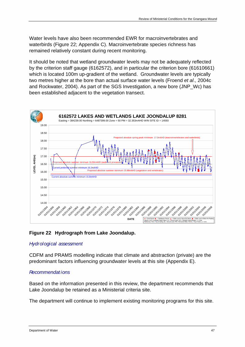
Review of Ministerial Conditions for the Gnangara Mound
Department of Water 47
Water levels have also been recommended EWR for macroinvertebrates and waterbirds (Figure 22; Appendix C). Macroinvertebrate species richness has remained relatively constant during recent monitoring.
It should be noted that wetland groundwater levels may not be adequately reflected by the criterion staff gauge (6162572), and in particular the criterion bore (61610661) which is located 100m up-gradient of the wetland. Groundwater levels are typically two metres higher at the bore than actual surface water levels (Froend et al., 2004c and Rockwater, 2004). As part of the SGS Investigation, a new bore (JNP_Wc) has been established adjacent to the vegetation transect.
6162572 LAKES AND WETLANDS LAKE JOONDALUP 8281Easting = 384239.00 Northing = 6487399.00 Zone = 50 PM = 32.353mAHD WIN SITE ID = 14593
14.00
14.50
15.00
15.50
16.00
16.50
17.00
17.50
18.00
18.50
19.00
01/01
/1954
01/01
/1956
01/01
/1958
01/01
/1960
01/01
/1962
01/01
/1964
01/01
/1966
01/01
/1968
01/01
/1970
01/01
/1972
01/01
/1974
01/01
/1976
01/01
/1978
01/01
/1980
01/01
/1982
01/01
/1984
01/01
/1986
01/01
/1988
01/01
/1990
01/01
/1992
01/01
/1994
01/01
/1996
01/01
/1998
01/01
/2000
01/01
/2002
01/01
/2004
01/01
/2006
01/01
/2008
DATE
LEVE
L A
HD
(m)
Current absolute summer minimum 15.8mAHD
Current preferred summer minimum 16.2mAHDProposed absolute summer minimum 15.88mAHD (vegetation and vertebrates)
Proposed absolute spring peak minimum 17.0mAHD (macroinvertebrates and waterbirds)
Proposed absolute summer minimum 16.50mAHD (sediment processes)
Figure 22 Hydrograph from Lake Joondalup.
Hydrological assessment
CDFM and PRAMS modelling indicate that climate and abstraction (private) are the predominant factors influencing groundwater levels at this site (Appendix E).
Recommendations
Based on the information presented in this review, the department recommends that Lake Joondalup be retained as a Ministerial criteria site.
The department will continue to implement existing monitoring programs for this site.
Review of Ministerial Conditions on the Groundwater Resources of the Gnangara Mound
48 Department of Water
The department recommends that the EPA support that Ministerial criterion is assessed against water levels from bore JNP_Wc rather than the existing bore (61610661) following the review outlined below:
• JNP_Wc is currently being monitored. On completion of twelve months monitoring, a review of the water levels in JNP_Wc and the current criterion bore (61610661) will be conducted to calibrate JNP_Wc.
• A review of the existing EWP will be conducted and if necessary and appropriate, the EWP will be transferred to be measured at JNP_Wc.
• The department will summarise the information reviewed and formally request an amendment to the EPA.
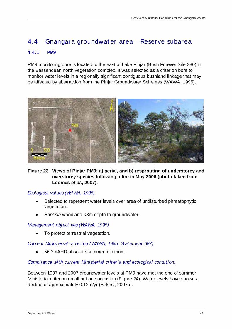
Review of Ministerial Conditions for the Gnangara Mound
Department of Water 49
4.4 Gnangara groundwater area – Reserve subarea
4.4.1 PM9
PM9 monitoring bore is located to the east of Lake Pinjar (Bush Forever Site 380) in the Bassendean north vegetation complex. It was selected as a criterion bore to monitor water levels in a regionally significant contiguous bushland linkage that may be affected by abstraction from the Pinjar Groundwater Schemes (WAWA, 1995).
Figure 23 Views of Pinjar PM9: a) aerial, and b) resprouting of understorey and overstorey species following a fire in May 2006 (photo taken from Loomes et al., 2007).
Ecological values (WAWA, 1995)
• Selected to represent water levels over area of undisturbed phreatophytic vegetation.
• Banksia woodland <8m depth to groundwater.
Management objectives (WAWA, 1995)
• To protect terrestrial vegetation.
Current Ministerial criterion (WAWA, 1995; Statement 687)
• 56.3mAHD absolute summer minimum.
Compliance with current Ministerial criteria and ecological condition:
Between 1997 and 2007 groundwater levels at PM9 have met the end of summer Ministerial criterion on all but one occasion (Figure 24). Water levels have shown a decline of approximately 0.12m/yr (Bekesi, 2007a).
a b
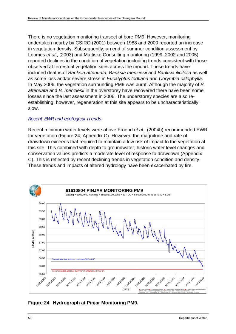
Review of Ministerial Conditions on the Groundwater Resources of the Gnangara Mound
50 Department of Water
There is no vegetation monitoring transect at bore PM9. However, monitoring undertaken nearby by CSIRO (2001) between 1988 and 2000 reported an increase in vegetation density. Subsequently, an end of summer condition assessment by Loomes et al., (2003) and Mattiske Consulting monitoring (1999, 2002 and 2005) reported declines in the condition of vegetation including trends consistent with those observed at terrestrial vegetation sites across the mound. These trends have included deaths of Banksia attenuata, Banksia menziesii and Banksia ilicifolia as well as some loss and/or severe stress in Eucalyptus todtiana and Corymbia calophylla. In May 2006, the vegetation surrounding PM9 was burnt. Although the majority of B. attenuata and B. menziesii in the overstorey have recovered there have been some losses since the last assessment in 2006. The understorey species are also re-establishing; however, regeneration at this site appears to be uncharacteristically slow.
Recent EWR and ecological trends
Recent minimum water levels were above Froend et al., (2004b) recommended EWR for vegetation (Figure 24; Appendix C). However, the magnitude and rate of drawdown exceeds that required to maintain a low risk of impact to the vegetation at this site. This combined with depth to groundwater, historic water level changes and conservation values predicts a moderate level of response to drawdown (Appendix C). This is reflected by recent declining trends in vegetation condition and density. These trends and impacts of altered hydrology have been exacerbated by fire.
61610804 PINJAR MONITORING PM9Easting = 390239.00 Northing = 6501937.00 Zone = 50 TOC = 64.62mAHD WIN SITE ID = 5145
55.50
56.00
56.50
57.00
57.50
58.00
58.50
59.00
59.50
60.00
01/01
/1976
01/01
/1978
01/01
/1980
01/01
/1982
01/01
/1984
01/01
/1986
01/01
/1988
01/01
/1990
01/01
/1992
01/01
/1994
01/01
/1996
01/01
/1998
01/01
/2000
01/01
/2002
01/01
/2004
01/01
/2006
01/01
/2008
DATE
LEVE
L A
HD
(m)
Current absolute summer minimum 56.3mAHD
Recommended absolute summer minimum 55.79mAHD ( t ti )
Figure 24 Hydrograph at Pinjar Monitoring PM9.
Review of Ministerial Conditions for the Gnangara Mound
Department of Water 51
Hydrological assessment
CDFM and PRAMS modelling indicate that climate is the predominant factor influencing groundwater levels at this site. Abstraction (public) is the next main factor, followed by land use (native vegetation and pines) (Appendix E).
Recommendations
Based on the information presented in this review, the department recommends that PM9 be retained as a Ministerial criteria site.
The department will continue to implement existing monitoring programs for this site.
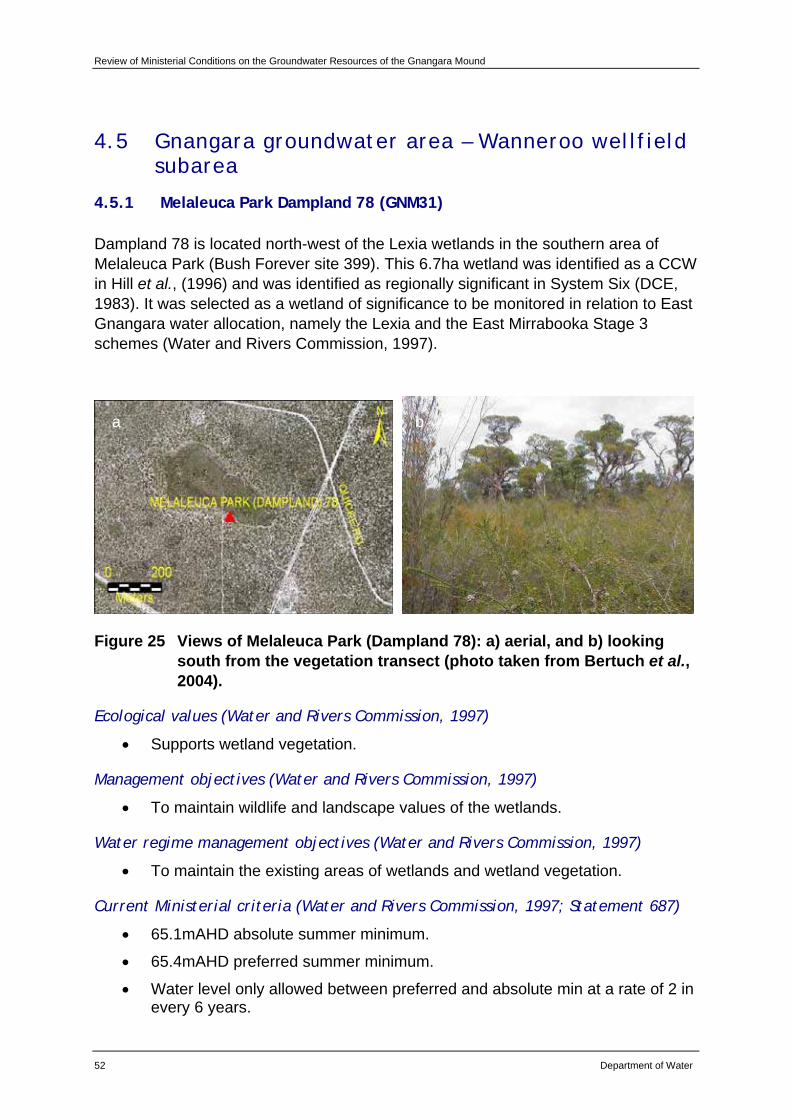
Review of Ministerial Conditions on the Groundwater Resources of the Gnangara Mound
52 Department of Water
4.5 Gnangara groundwater area – Wanneroo wellfield subarea
4.5.1 Melaleuca Park Dampland 78 (GNM31)
Dampland 78 is located north-west of the Lexia wetlands in the southern area of Melaleuca Park (Bush Forever site 399). This 6.7ha wetland was identified as a CCW in Hill et al., (1996) and was identified as regionally significant in System Six (DCE, 1983). It was selected as a wetland of significance to be monitored in relation to East Gnangara water allocation, namely the Lexia and the East Mirrabooka Stage 3 schemes (Water and Rivers Commission, 1997).
Figure 25 Views of Melaleuca Park (Dampland 78): a) aerial, and b) looking south from the vegetation transect (photo taken from Bertuch et al., 2004).
Ecological values (Water and Rivers Commission, 1997)
• Supports wetland vegetation.
Management objectives (Water and Rivers Commission, 1997)
• To maintain wildlife and landscape values of the wetlands.
Water regime management objectives (Water and Rivers Commission, 1997)
• To maintain the existing areas of wetlands and wetland vegetation.
Current Ministerial criteria (Water and Rivers Commission, 1997; Statement 687)
• 65.1mAHD absolute summer minimum.
• 65.4mAHD preferred summer minimum.
• Water level only allowed between preferred and absolute min at a rate of 2 in every 6 years.
a b
Review of Ministerial Conditions for the Gnangara Mound
Department of Water 53
Compliance with current Ministerial criteria and ecological condition
Between 1997 and 2007, water levels at Dampland 78 have met end of summer Ministerial criteria on all occasions (Figure 26). However, summer minimum water levels have been declining since 1997 and are now within 0.3m of the Ministerial criteria.
Dampland 78 has experienced a decline in the condition of fringing vegetation species, such as Melaleuca preisianna and Banksia ilicifolia. There is also evidence of a thinning understorey and terrestrialisation. Macroinvertebrate diversity has declined, and due to sediment drying there is a risk of acidification. Numbers of calling frogs have also been declining.
Recent EWR and ecological trends
Recent minimum water levels at Dampland 78 have been above Froend et al., (2004b) recommended EWR for vegetation (Figure 26; Appendix C). The magnitude and rate of drawdown exceeds that required to maintain a low risk of impact to the vegetation at this site. This combined with depth to groundwater, historic water level changes and conservation values, represents a moderate level of response to drawdown (Appendix C). This is reflected by the continued declining trend in condition of fringing vegetation and evidence of terrestrialisation noted since 2004 (Loomes et al., 2004, 2005 and 2006).
Recent minimum water levels have been below Froend et al., (2004b) recommended EWR for frog breeding at Dampland 78 (Figure 26; Appendix C). Annual frog monitoring has observed a decline in the number of calling frogs at this site in recent years.
It should be noted that groundwater may not be adequately reflected at the criterion bore (GNM31), which is located 50m upslope of the vegetation transect (Department of Water, 2007; Rockwater, 2004). As part of the Stage Two of the SGS Investigation, a hydrogeological review of the site will be undertaken to determine if a more appropriate criterion bore is needed.
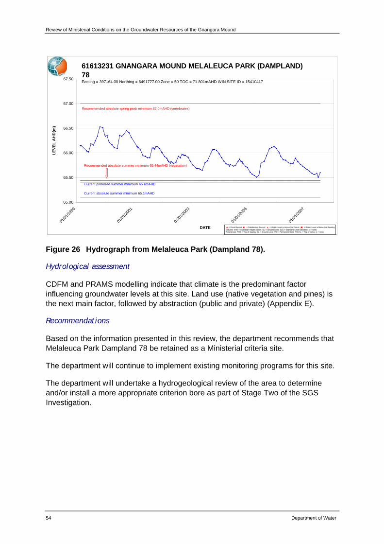
Review of Ministerial Conditions on the Groundwater Resources of the Gnangara Mound
54 Department of Water
61613231 GNANGARA MOUND MELALEUCA PARK (DAMPLAND) 78Easting = 397164.00 Northing = 6491777.00 Zone = 50 TOC = 71.801mAHD WIN SITE ID = 15410417
65.00
65.50
66.00
66.50
67.00
67.50
01/01
/1999
01/01
/2001
01/01
/2003
01/01
/2005
01/01
/2007
DATE
LEVE
L A
HD
(m)
Current absolute summer minimum 65.1mAHD
Current preferred summer minimum 65.4mAHD
Recommended absolute summer minimum 65.44mAHD (vegetation)
Recommended absolute spring peak minimum 67.0mAHD (vertebrates)
Figure 26 Hydrograph from Melaleuca Park (Dampland 78).
Hydrological assessment
CDFM and PRAMS modelling indicate that climate is the predominant factor influencing groundwater levels at this site. Land use (native vegetation and pines) is the next main factor, followed by abstraction (public and private) (Appendix E).
Recommendations
Based on the information presented in this review, the department recommends that Melaleuca Park Dampland 78 be retained as a Ministerial criteria site.
The department will continue to implement existing monitoring programs for this site.
The department will undertake a hydrogeological review of the area to determine and/or install a more appropriate criterion bore as part of Stage Two of the SGS Investigation.
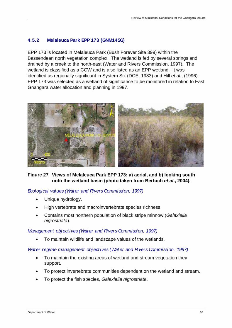
Review of Ministerial Conditions for the Gnangara Mound
Department of Water 55
4.5.2 Melaleuca Park EPP 173 (GNM14SG)
EPP 173 is located in Melaleuca Park (Bush Forever Site 399) within the Bassendean north vegetation complex. The wetland is fed by several springs and drained by a creek to the north-east (Water and Rivers Commission, 1997). The wetland is classified as a CCW and is also listed as an EPP wetland. It was identified as regionally significant in System Six (DCE, 1983) and Hill et al., (1996). EPP 173 was selected as a wetland of significance to be monitored in relation to East Gnangara water allocation and planning in 1997.
Figure 27 Views of Melaleuca Park EPP 173: a) aerial, and b) looking south onto the wetland basin (photo taken from Bertuch et al., 2004).
Ecological values (Water and Rivers Commission, 1997)
• Unique hydrology.
• High vertebrate and macroinvertebrate species richness.
• Contains most northern population of black stripe minnow (Galaxiella nigrostriata).
Management objectives (Water and Rivers Commission, 1997)
• To maintain wildlife and landscape values of the wetlands.
Water regime management objectives (Water and Rivers Commission, 1997)
• To maintain the existing areas of wetland and stream vegetation they support.
• To protect invertebrate communities dependent on the wetland and stream.
• To protect the fish species, Galaxiella nigrostriata.
a b
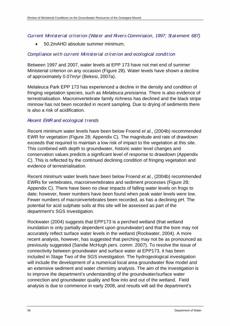
Review of Ministerial Conditions on the Groundwater Resources of the Gnangara Mound
56 Department of Water
Current Ministerial criterion (Water and Rivers Commission, 1997; Statement 687)
• 50.2mAHD absolute summer minimum.
Compliance with current Ministerial criterion and ecological condition
Between 1997 and 2007, water levels at EPP 173 have not met end of summer Ministerial criterion on any occasion (Figure 28). Water levels have shown a decline of approximately 0.07m/yr (Bekesi, 2007a).
Melaleuca Park EPP 173 has experienced a decline in the density and condition of fringing vegetation species, such as Melaleuca preisianna. There is also evidence of terrestrialisation. Macroinvertebrate family richness has declined and the black stripe minnow has not been recorded in recent sampling. Due to drying of sediments there is also a risk of acidification.
Recent EWR and ecological trends
Recent minimum water levels have been below Froend et al., (2004b) recommended EWR for vegetation (Figure 28; Appendix C). The magnitude and rate of drawdown exceeds that required to maintain a low risk of impact to the vegetation at this site. This combined with depth to groundwater, historic water level changes and conservation values predicts a significant level of response to drawdown (Appendix C). This is reflected by the continued declining condition of fringing vegetation and evidence of terrestrialisation.
Recent minimum water levels have been below Froend et al., (2004b) recommended EWRs for vertebrates, macroinvertebrates and sediment processes (Figure 28; Appendix C). There have been no clear impacts of falling water levels on frogs to date; however, fewer numbers have been found when peak water levels were low. Fewer numbers of macroinvertebrates been recorded, as has a declining pH. The potential for acid sulphate soils at this site will be assessed as part of the department’s SGS Investigation.
Rockwater (2004) suggests that EPP173 is a perched wetland (that wetland inundation is only partially dependent upon groundwater) and that the bore may not accurately reflect surface water levels in the wetland (Rockwater, 2004). A more recent analysis, however, has suggested that perching may not be as pronounced as previously suggested (Sandie McHugh pers. comm. 2007). To resolve the issue of connectivity between groundwater and surface water at EPP173, it has been included in Stage Two of the SGS investigation. The hydrogeological investigation will include the development of a numerical local area groundwater flow model and an extensive sediment and water chemistry analysis. The aim of the investigation is to improve the department’s understanding of the groundwater/surface water connection and groundwater quality and flow into and out of the wetland. Field analysis is due to commence in early 2008, and results will aid the department’s
Review of Ministerial Conditions for the Gnangara Mound
Department of Water 57
management of EPP 173. Depending on the results of the model, it may be appropriate to install or appoint a more appropriate criterion bore.
61613213 GNANGARA MOUND GNM14 MELALEUCA PARK EPP173Easting = 401832.00 Northing = 6491872.00 Zone = 50 TOC = 51.884mAHD WIN SITE ID = 12282904
48.00
48.50
49.00
49.50
50.00
50.50
51.00
51.50
01/01
/1995
01/01
/1997
01/01
/1999
01/01
/2001
01/01
/2003
01/01
/2005
01/01
/2007
DATE
LEVE
L A
HD
(m)
Current and recommended absolute summer minimum 50.2mAHD (sediment processes)
Recommended absolute spring peak minimum 51.1mAHD (macroinvertebrates and vertebrates)
Recommended absolute summer minimum 49.41mAHD (vegetation and vertebrates)
Figure 28 Hydrograph from Melaleuca Park EPP173.
Hydrological assessment
Irrespective of the extent to which EPP173 may or may not be perched, CDFM and PRAMS modelling indicate that climate is the predominant factor influencing groundwater levels at this site. Abstraction (private) is the next main factor, followed by land use (native vegetation) (Appendix E).
Recommendations
Based on the information presented in this review, the department recommends that Melaleuca Park EPP 173 be retained as a Ministerial criteria site.
The department will continue to implement existing monitoring programs for this site.
The department will undertake a hydrogeological review of the area to determine and/or install a more appropriate criterion bore than GNM14SG as part of Stage Two of the SGS Investigation.
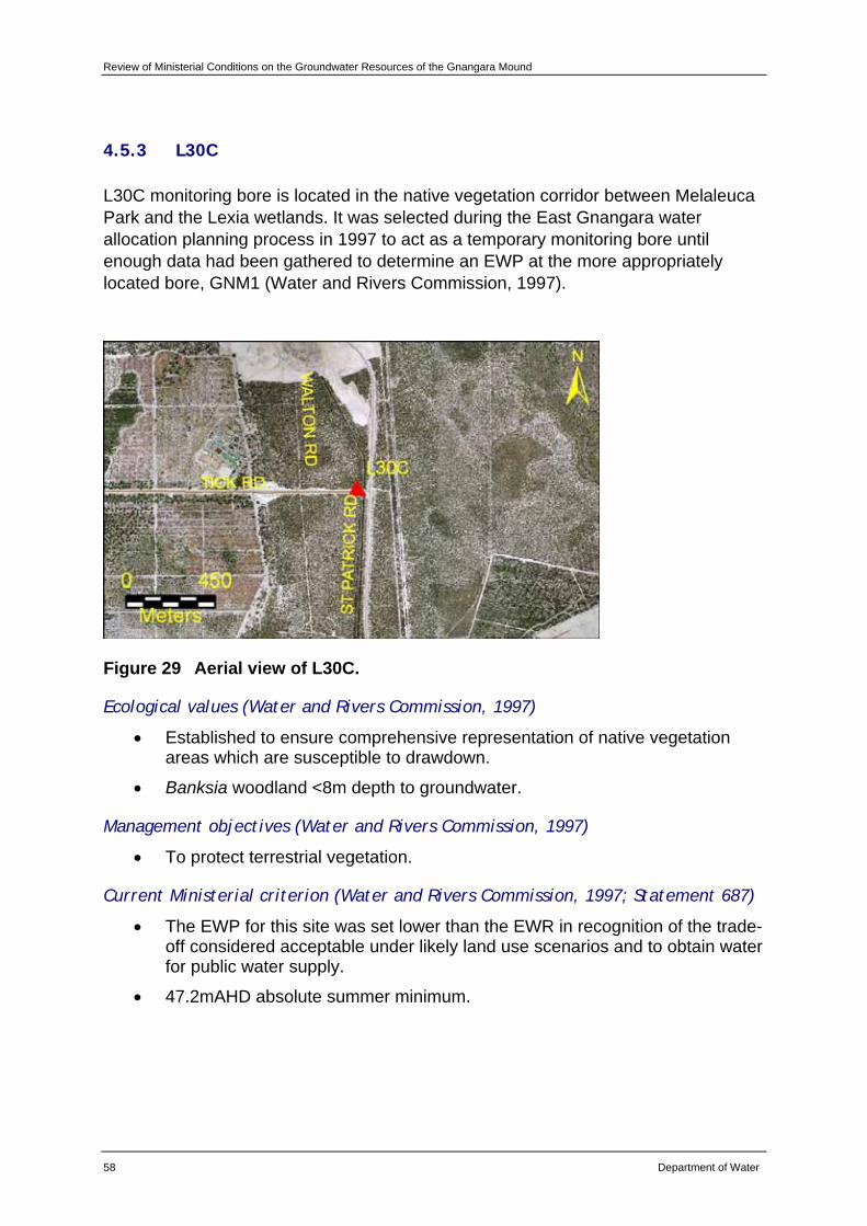
Review of Ministerial Conditions on the Groundwater Resources of the Gnangara Mound
58 Department of Water
4.5.3 L30C
L30C monitoring bore is located in the native vegetation corridor between Melaleuca Park and the Lexia wetlands. It was selected during the East Gnangara water allocation planning process in 1997 to act as a temporary monitoring bore until enough data had been gathered to determine an EWP at the more appropriately located bore, GNM1 (Water and Rivers Commission, 1997).
Figure 29 Aerial view of L30C.
Ecological values (Water and Rivers Commission, 1997)
• Established to ensure comprehensive representation of native vegetation areas which are susceptible to drawdown.
• Banksia woodland <8m depth to groundwater.
Management objectives (Water and Rivers Commission, 1997)
• To protect terrestrial vegetation.
Current Ministerial criterion (Water and Rivers Commission, 1997; Statement 687)
• The EWP for this site was set lower than the EWR in recognition of the trade-off considered acceptable under likely land use scenarios and to obtain water for public water supply.
• 47.2mAHD absolute summer minimum.
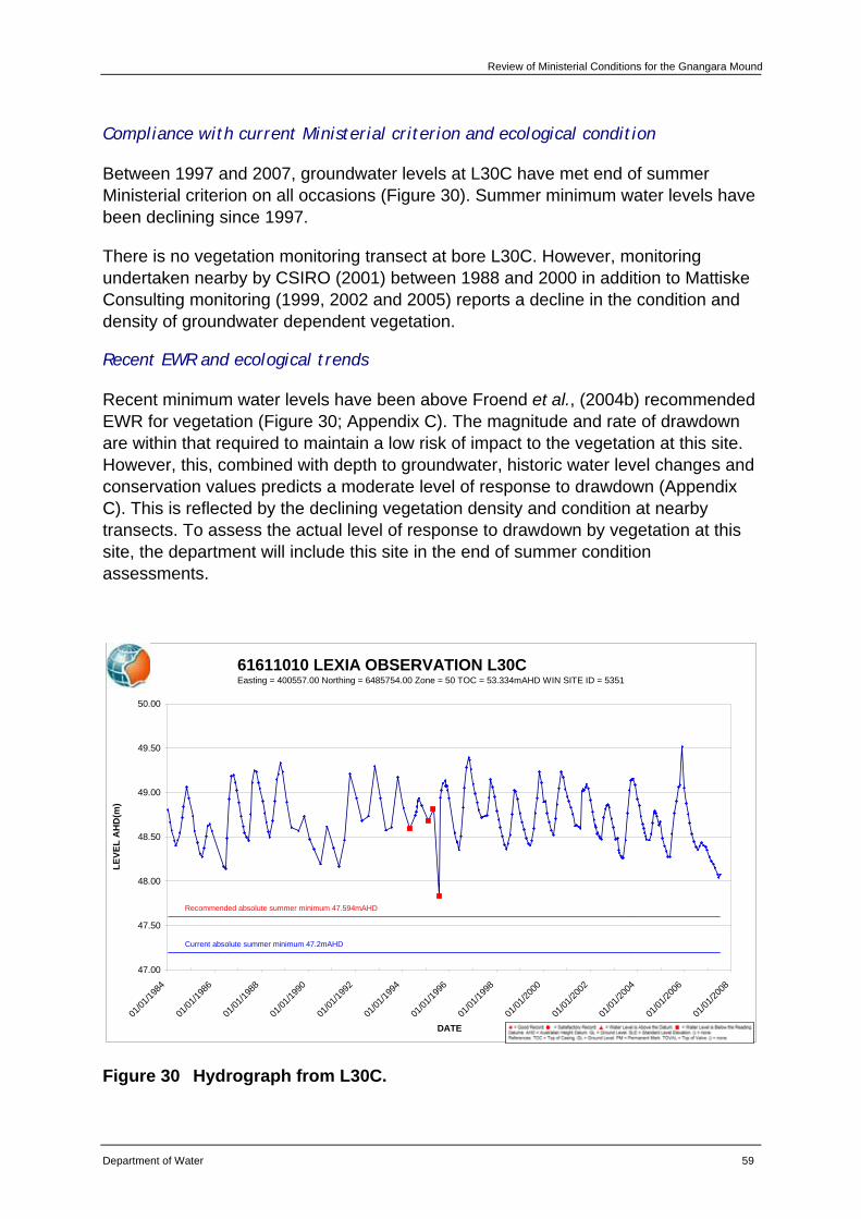
Review of Ministerial Conditions for the Gnangara Mound
Department of Water 59
Compliance with current Ministerial criterion and ecological condition
Between 1997 and 2007, groundwater levels at L30C have met end of summer Ministerial criterion on all occasions (Figure 30). Summer minimum water levels have been declining since 1997.
There is no vegetation monitoring transect at bore L30C. However, monitoring undertaken nearby by CSIRO (2001) between 1988 and 2000 in addition to Mattiske Consulting monitoring (1999, 2002 and 2005) reports a decline in the condition and density of groundwater dependent vegetation.
Recent EWR and ecological trends
Recent minimum water levels have been above Froend et al., (2004b) recommended EWR for vegetation (Figure 30; Appendix C). The magnitude and rate of drawdown are within that required to maintain a low risk of impact to the vegetation at this site. However, this, combined with depth to groundwater, historic water level changes and conservation values predicts a moderate level of response to drawdown (Appendix C). This is reflected by the declining vegetation density and condition at nearby transects. To assess the actual level of response to drawdown by vegetation at this site, the department will include this site in the end of summer condition assessments.
61611010 LEXIA OBSERVATION L30CEasting = 400557.00 Northing = 6485754.00 Zone = 50 TOC = 53.334mAHD WIN SITE ID = 5351
47.00
47.50
48.00
48.50
49.00
49.50
50.00
01/01
/1984
01/01
/1986
01/01
/1988
01/01
/1990
01/01
/1992
01/01
/1994
01/01
/1996
01/01
/1998
01/01
/2000
01/01
/2002
01/01
/2004
01/01
/2006
01/01
/2008
DATE
LEVE
L A
HD
(m)
Recommended absolute summer minimum 47.594mAHD
Current absolute summer minimum 47.2mAHD
Figure 30 Hydrograph from L30C.
Review of Ministerial Conditions on the Groundwater Resources of the Gnangara Mound
60 Department of Water
Hydrological assessment
CDFM and PRAMS modelling indicate that climate is the predominant factor influencing groundwater levels at this site. Abstraction (public and private) is the next main factor, followed by land use (native vegetation and pines) (Appendix E).
Recommendations
Based on the information presented in this review, the department recommends that L30C be retained as a Ministerial criteria site.
The department will continue to implement existing monitoring programs for this site.
The department recommends that the EPA support that Ministerial criterion is assessed against water levels from bore GNM1 rather than the existing bore L30C (61611010) following the review outlined below:
• There is sufficient monitoring data of GNM1. A review of the water levels in GNM1 and the current criterion bore L30C (61611010) will be conducted to calibrate GNM1.
• A review of the existing EWP will be conducted and if necessary and appropriate, the EWP will be transferred to be measured at GNM1.
• The department will summarise the information reviewed and formally request an amendment to the EPA.
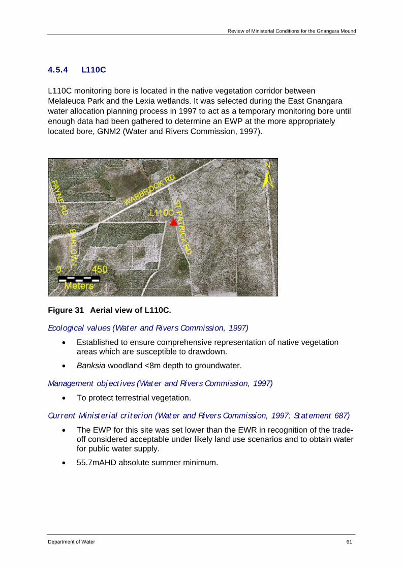
Review of Ministerial Conditions for the Gnangara Mound
Department of Water 61
4.5.4 L110C
L110C monitoring bore is located in the native vegetation corridor between Melaleuca Park and the Lexia wetlands. It was selected during the East Gnangara water allocation planning process in 1997 to act as a temporary monitoring bore until enough data had been gathered to determine an EWP at the more appropriately located bore, GNM2 (Water and Rivers Commission, 1997).
Figure 31 Aerial view of L110C.
Ecological values (Water and Rivers Commission, 1997)
• Established to ensure comprehensive representation of native vegetation areas which are susceptible to drawdown.
• Banksia woodland <8m depth to groundwater.
Management objectives (Water and Rivers Commission, 1997)
• To protect terrestrial vegetation.
Current Ministerial criterion (Water and Rivers Commission, 1997; Statement 687)
• The EWP for this site was set lower than the EWR in recognition of the trade-off considered acceptable under likely land use scenarios and to obtain water for public water supply.
• 55.7mAHD absolute summer minimum.
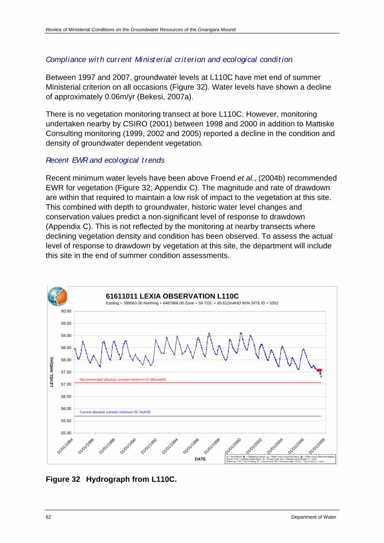
Review of Ministerial Conditions on the Groundwater Resources of the Gnangara Mound
62 Department of Water
Compliance with current Ministerial criterion and ecological condition
Between 1997 and 2007, groundwater levels at L110C have met end of summer Ministerial criterion on all occasions (Figure 32). Water levels have shown a decline of approximately 0.06m/yr (Bekesi, 2007a).
There is no vegetation monitoring transect at bore L110C. However, monitoring undertaken nearby by CSIRO (2001) between 1998 and 2000 in addition to Mattiske Consulting monitoring (1999, 2002 and 2005) reported a decline in the condition and density of groundwater dependent vegetation.
Recent EWR and ecological trends
Recent minimum water levels have been above Froend et al., (2004b) recommended EWR for vegetation (Figure 32; Appendix C). The magnitude and rate of drawdown are within that required to maintain a low risk of impact to the vegetation at this site. This combined with depth to groundwater, historic water level changes and conservation values predict a non-significant level of response to drawdown (Appendix C). This is not reflected by the monitoring at nearby transects where declining vegetation density and condition has been observed. To assess the actual level of response to drawdown by vegetation at this site, the department will include this site in the end of summer condition assessments.
61611011 LEXIA OBSERVATION L110CEasting = 399563.00 Northing = 6487868.00 Zone = 50 TOC = 65.612mAHD WIN SITE ID = 5352
55.00
55.50
56.00
56.50
57.00
57.50
58.00
58.50
59.00
59.50
60.00
01/01
/1984
01/01
/1986
01/01
/1988
01/01
/1990
01/01
/1992
01/01
/1994
01/01
/1996
01/01
/1998
01/01
/2000
01/01
/2002
01/01
/2004
01/01
/2006
01/01
/2008
DATE
LEVE
L A
HD
(m)
Current absolute summer minimum 55.7mAHD
Recommended absolute summer minimum 57.062mAHD
Figure 32 Hydrograph from L110C.
Review of Ministerial Conditions for the Gnangara Mound
Department of Water 63
Hydrological assessment
CDFM and PRAMS modelling indicate that climate is the predominant factor influencing groundwater levels at this site. Abstraction (public and private) and land use (native vegetation and pines) equally are the next factors (Appendix E).
Recommendations
Based on the information presented in this review, the department recommends that L110C be retained as a Ministerial criteria site.
The department will continue to implement existing monitoring programs for this site.
The department recommends that the EPA support that Ministerial criterion is assessed against water levels from bore GNM2 rather than the existing bore L110C (61611011) following the review outlined below:
• There is sufficient monitoring data of GNM2. A review of the water levels in GNM2 and the current criterion bore L110C (61611011) will be conducted to calibrate GNM2.
• A review of the existing EWP will be conducted and if necessary and appropriate, the EWP will be transferred to be measured at GNM2.
• The department will summarise the information reviewed and formally request an amendment to the EPA.
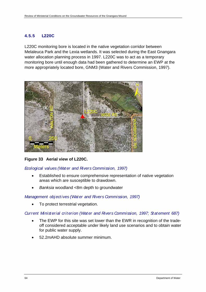
Review of Ministerial Conditions on the Groundwater Resources of the Gnangara Mound
64 Department of Water
4.5.5 L220C
L220C monitoring bore is located in the native vegetation corridor between Melaleuca Park and the Lexia wetlands. It was selected during the East Gnangara water allocation planning process in 1997. L220C was to act as a temporary monitoring bore until enough data had been gathered to determine an EWP at the more appropriately located bore, GNM3 (Water and Rivers Commission, 1997).
Figure 33 Aerial view of L220C.
Ecological values (Water and Rivers Commission, 1997)
• Established to ensure comprehensive representation of native vegetation areas which are susceptible to drawdown.
• Banksia woodland <8m depth to groundwater
Management objectives (Water and Rivers Commission, 1997)
• To protect terrestrial vegetation.
Current Ministerial criterion (Water and Rivers Commission, 1997; Statement 687)
• The EWP for this site was set lower than the EWR in recognition of the trade-off considered acceptable under likely land use scenarios and to obtain water for public water supply.
• 52.2mAHD absolute summer minimum.
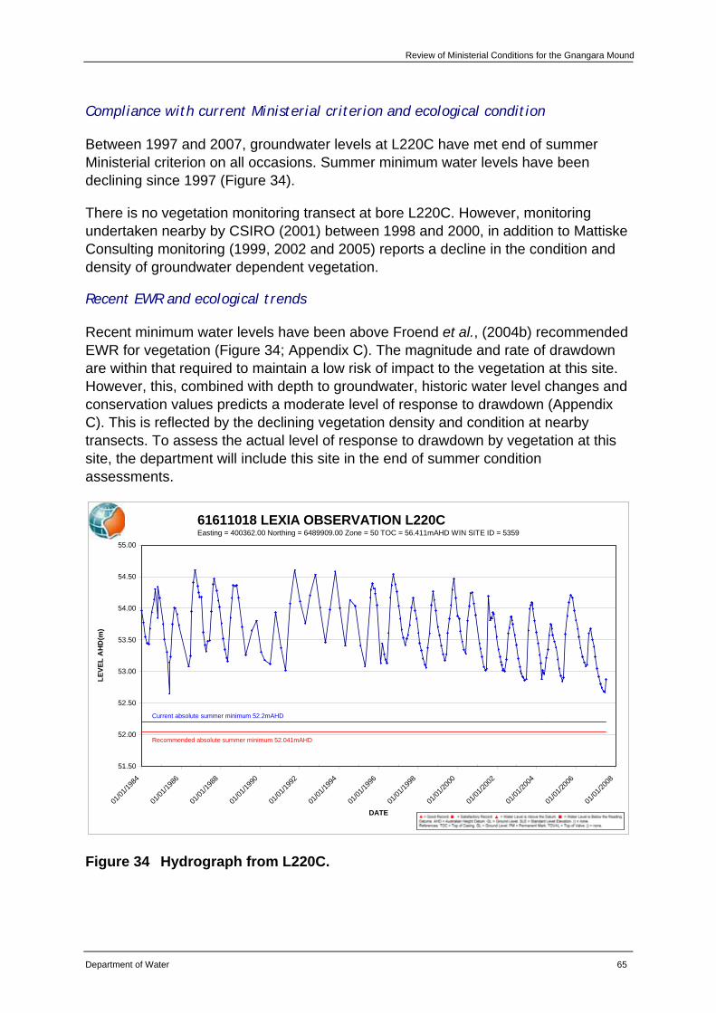
Review of Ministerial Conditions for the Gnangara Mound
Department of Water 65
Compliance with current Ministerial criterion and ecological condition
Between 1997 and 2007, groundwater levels at L220C have met end of summer Ministerial criterion on all occasions. Summer minimum water levels have been declining since 1997 (Figure 34).
There is no vegetation monitoring transect at bore L220C. However, monitoring undertaken nearby by CSIRO (2001) between 1998 and 2000, in addition to Mattiske Consulting monitoring (1999, 2002 and 2005) reports a decline in the condition and density of groundwater dependent vegetation.
Recent EWR and ecological trends
Recent minimum water levels have been above Froend et al., (2004b) recommended EWR for vegetation (Figure 34; Appendix C). The magnitude and rate of drawdown are within that required to maintain a low risk of impact to the vegetation at this site. However, this, combined with depth to groundwater, historic water level changes and conservation values predicts a moderate level of response to drawdown (Appendix C). This is reflected by the declining vegetation density and condition at nearby transects. To assess the actual level of response to drawdown by vegetation at this site, the department will include this site in the end of summer condition assessments.
61611018 LEXIA OBSERVATION L220CEasting = 400362.00 Northing = 6489909.00 Zone = 50 TOC = 56.411mAHD WIN SITE ID = 5359
51.50
52.00
52.50
53.00
53.50
54.00
54.50
55.00
01/01
/1984
01/01
/1986
01/01
/1988
01/01
/1990
01/01
/1992
01/01
/1994
01/01
/1996
01/01
/1998
01/01
/2000
01/01
/2002
01/01
/2004
01/01
/2006
01/01
/2008
DATE
LEVE
L A
HD
(m)
Current absolute summer minimum 52.2mAHD
Recommended absolute summer minimum 52.041mAHD
Figure 34 Hydrograph from L220C.
Review of Ministerial Conditions on the Groundwater Resources of the Gnangara Mound
66 Department of Water
Hydrological assessment
CDFM and PRAMS modelling indicate that climate is the predominant factor influencing groundwater levels at this site. Abstraction (public) and land use (native vegetation and pines) equally are the next factors (Appendix E).
Recommendations
Based on the information presented in this review, the department recommends that L220C be retained as a Ministerial criteria site.
The department will continue to implement existing monitoring programs for this site.
The department recommends that the EPA support that Ministerial criterion is assessed against water levels from bore GNM3 rather than the existing bore L220C (61611018) following the review outlined below:
• There is sufficient monitoring data of GNM3. A review of the water levels in GNM3 and the current criterion bore L220C (61611018) will be conducted to calibrate GNM3.
• A review of the existing EWP will be conducted and if necessary and appropriate, the EWP will be transferred to be measured at GNM3.
• The department will summarise the information reviewed and formally request an amendment to the EPA.
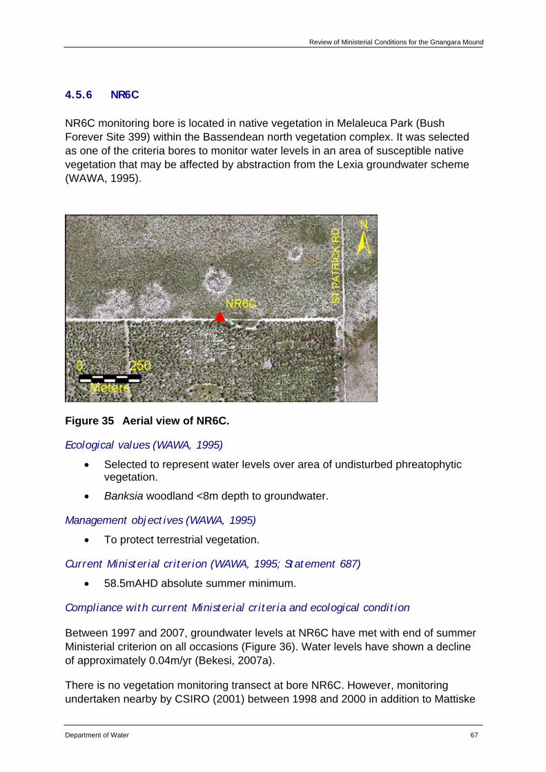
Review of Ministerial Conditions for the Gnangara Mound
Department of Water 67
4.5.6 NR6C
NR6C monitoring bore is located in native vegetation in Melaleuca Park (Bush Forever Site 399) within the Bassendean north vegetation complex. It was selected as one of the criteria bores to monitor water levels in an area of susceptible native vegetation that may be affected by abstraction from the Lexia groundwater scheme (WAWA, 1995).
Figure 35 Aerial view of NR6C.
Ecological values (WAWA, 1995)
• Selected to represent water levels over area of undisturbed phreatophytic vegetation.
• Banksia woodland <8m depth to groundwater.
Management objectives (WAWA, 1995)
• To protect terrestrial vegetation.
Current Ministerial criterion (WAWA, 1995; Statement 687)
• 58.5mAHD absolute summer minimum.
Compliance with current Ministerial criteria and ecological condition
Between 1997 and 2007, groundwater levels at NR6C have met with end of summer Ministerial criterion on all occasions (Figure 36). Water levels have shown a decline of approximately 0.04m/yr (Bekesi, 2007a).
There is no vegetation monitoring transect at bore NR6C. However, monitoring undertaken nearby by CSIRO (2001) between 1998 and 2000 in addition to Mattiske
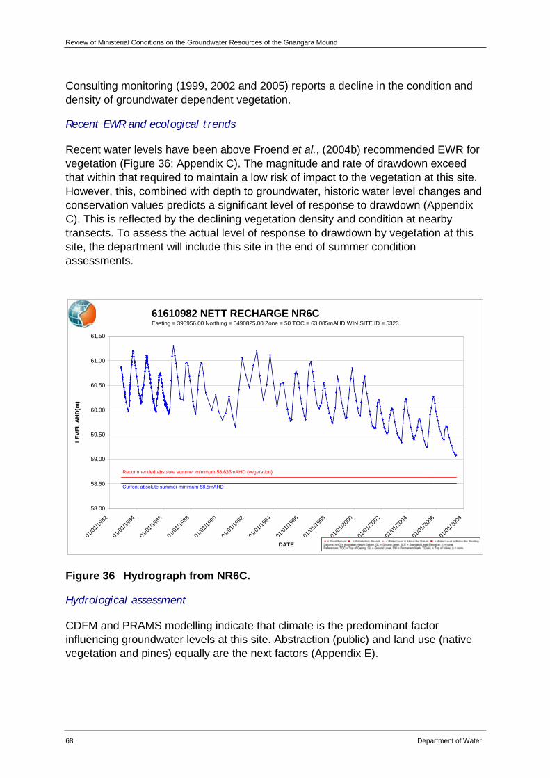
Review of Ministerial Conditions on the Groundwater Resources of the Gnangara Mound
68 Department of Water
Consulting monitoring (1999, 2002 and 2005) reports a decline in the condition and density of groundwater dependent vegetation.
Recent EWR and ecological trends
Recent water levels have been above Froend et al., (2004b) recommended EWR for vegetation (Figure 36; Appendix C). The magnitude and rate of drawdown exceed that within that required to maintain a low risk of impact to the vegetation at this site. However, this, combined with depth to groundwater, historic water level changes and conservation values predicts a significant level of response to drawdown (Appendix C). This is reflected by the declining vegetation density and condition at nearby transects. To assess the actual level of response to drawdown by vegetation at this site, the department will include this site in the end of summer condition assessments.
61610982 NETT RECHARGE NR6CEasting = 398956.00 Northing = 6490825.00 Zone = 50 TOC = 63.085mAHD WIN SITE ID = 5323
58.00
58.50
59.00
59.50
60.00
60.50
61.00
61.50
01/01
/1982
01/01
/1984
01/01
/1986
01/01
/1988
01/01
/1990
01/01
/1992
01/01
/1994
01/01
/1996
01/01
/1998
01/01
/2000
01/01
/2002
01/01
/2004
01/01
/2006
01/01
/2008
DATE
LEVE
L A
HD
(m)
Current absolute summer minimum 58.5mAHD
Recommended absolute summer minimum 58.635mAHD (vegetation)
Figure 36 Hydrograph from NR6C.
Hydrological assessment
CDFM and PRAMS modelling indicate that climate is the predominant factor influencing groundwater levels at this site. Abstraction (public) and land use (native vegetation and pines) equally are the next factors (Appendix E).
Review of Ministerial Conditions for the Gnangara Mound
Department of Water 69
Recommendations
Based on the information presented in this review, the department recommends that NR6C be retained as a Ministerial criteria site.
The department will continue to implement existing monitoring programs for this site.
The department will include monitoring the vegetation at NR6C in future end of summer condition assessments.
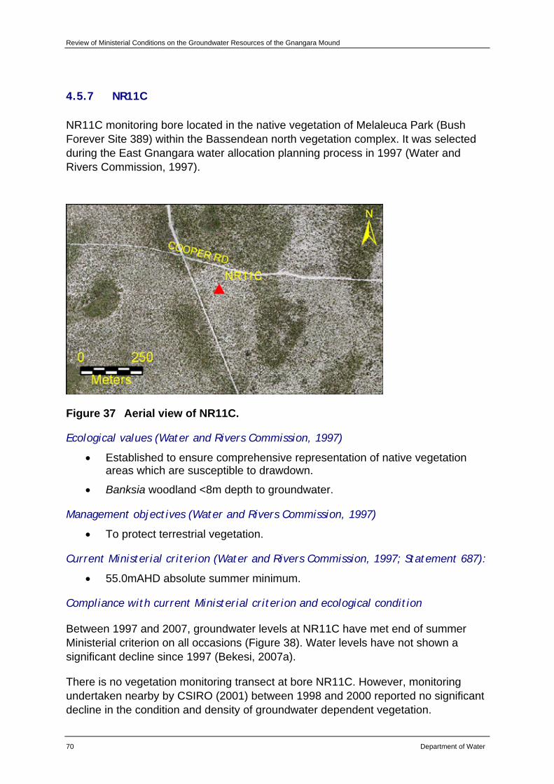
Review of Ministerial Conditions on the Groundwater Resources of the Gnangara Mound
70 Department of Water
4.5.7 NR11C
NR11C monitoring bore located in the native vegetation of Melaleuca Park (Bush Forever Site 389) within the Bassendean north vegetation complex. It was selected during the East Gnangara water allocation planning process in 1997 (Water and Rivers Commission, 1997).
Figure 37 Aerial view of NR11C.
Ecological values (Water and Rivers Commission, 1997)
• Established to ensure comprehensive representation of native vegetation areas which are susceptible to drawdown.
• Banksia woodland <8m depth to groundwater.
Management objectives (Water and Rivers Commission, 1997)
• To protect terrestrial vegetation.
Current Ministerial criterion (Water and Rivers Commission, 1997; Statement 687):
• 55.0mAHD absolute summer minimum.
Compliance with current Ministerial criterion and ecological condition
Between 1997 and 2007, groundwater levels at NR11C have met end of summer Ministerial criterion on all occasions (Figure 38). Water levels have not shown a significant decline since 1997 (Bekesi, 2007a).
There is no vegetation monitoring transect at bore NR11C. However, monitoring undertaken nearby by CSIRO (2001) between 1998 and 2000 reported no significant decline in the condition and density of groundwater dependent vegetation.
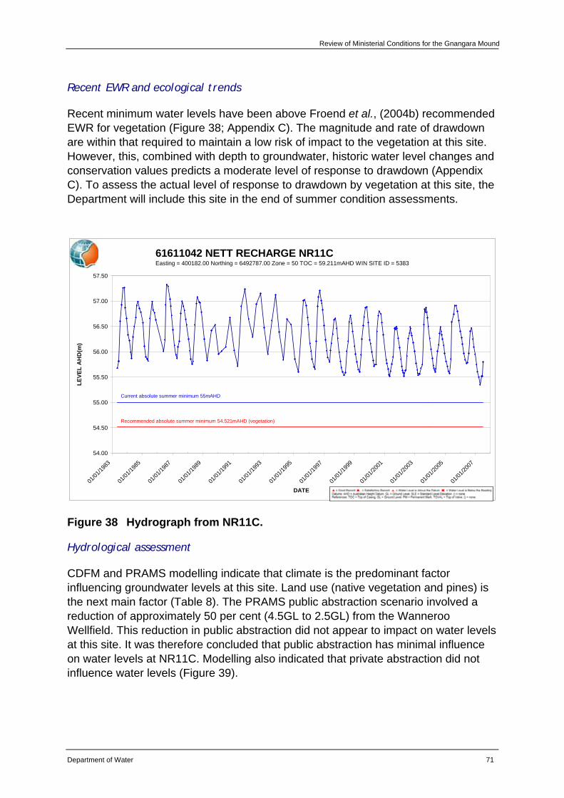
Review of Ministerial Conditions for the Gnangara Mound
Department of Water 71
Recent EWR and ecological trends
Recent minimum water levels have been above Froend et al., (2004b) recommended EWR for vegetation (Figure 38; Appendix C). The magnitude and rate of drawdown are within that required to maintain a low risk of impact to the vegetation at this site. However, this, combined with depth to groundwater, historic water level changes and conservation values predicts a moderate level of response to drawdown (Appendix C). To assess the actual level of response to drawdown by vegetation at this site, the Department will include this site in the end of summer condition assessments.
61611042 NETT RECHARGE NR11CEasting = 400182.00 Northing = 6492787.00 Zone = 50 TOC = 59.211mAHD WIN SITE ID = 5383
54.00
54.50
55.00
55.50
56.00
56.50
57.00
57.50
01/01
/1983
01/01
/1985
01/01
/1987
01/01
/1989
01/01
/1991
01/01
/1993
01/01
/1995
01/01
/1997
01/01
/1999
01/01
/2001
01/01
/2003
01/01
/2005
01/01
/2007
DATE
LEVE
L A
HD
(m)
Current absolute summer minimum 55mAHD
Recommended absolute summer minimum 54.521mAHD (vegetation)
Figure 38 Hydrograph from NR11C.
Hydrological assessment
CDFM and PRAMS modelling indicate that climate is the predominant factor influencing groundwater levels at this site. Land use (native vegetation and pines) is the next main factor (Table 8). The PRAMS public abstraction scenario involved a reduction of approximately 50 per cent (4.5GL to 2.5GL) from the Wanneroo Wellfield. This reduction in public abstraction did not appear to impact on water levels at this site. It was therefore concluded that public abstraction has minimal influence on water levels at NR11C. Modelling also indicated that private abstraction did not influence water levels (Figure 39).
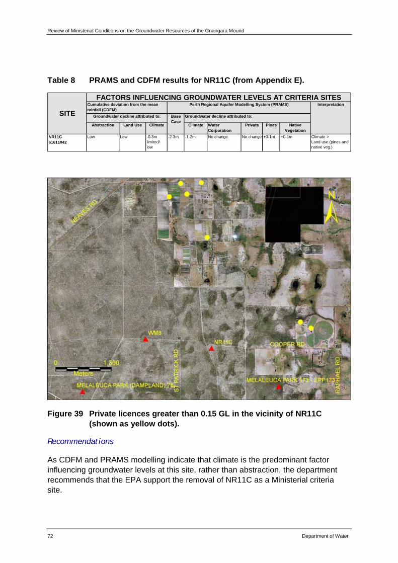
Review of Ministerial Conditions on the Groundwater Resources of the Gnangara Mound
72 Department of Water
Table 8 PRAMS and CDFM results for NR11C (from Appendix E).
Abstraction Land Use Climate Climate Water Corporation
Private Pines Native Vegetation
NR11C61611042
Low Low -0.3m limited/ low
-2-3m -1-2m No change No change +0-1m +0-1m Climate >Land use (pines and native veg.)
FACTORS INFLUENCING GROUNDWATER LEVELS AT CRITERIA SITES
Groundwater decline attributed to: Base Case
Groundwater decline attributed to:
Perth Regional Aquifer Modelling System (PRAMS) Interpretation
SITECumulative deviation from the mean rainfall (CDFM)
Figure 39 Private licences greater than 0.15 GL in the vicinity of NR11C (shown as yellow dots).
Recommendations
As CDFM and PRAMS modelling indicate that climate is the predominant factor influencing groundwater levels at this site, rather than abstraction, the department recommends that the EPA support the removal of NR11C as a Ministerial criteria site.
Review of Ministerial Conditions for the Gnangara Mound
Department of Water 73
The department will continue to monitor groundwater levels to add to the long-term data set that exists for this site. Information collected will provide important data for future hydrogeological assessments of groundwater levels across the Gnangara Mound.
The department will include monitoring of vegetation at NR11C in future end of summer condition assessments.
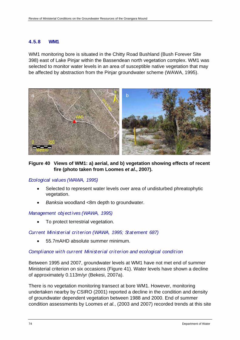
Review of Ministerial Conditions on the Groundwater Resources of the Gnangara Mound
74 Department of Water
4.5.8 WM1
WM1 monitoring bore is situated in the Chitty Road Bushland (Bush Forever Site 398) east of Lake Pinjar within the Bassendean north vegetation complex. WM1 was selected to monitor water levels in an area of susceptible native vegetation that may be affected by abstraction from the Pinjar groundwater scheme (WAWA, 1995).
Figure 40 Views of WM1: a) aerial, and b) vegetation showing effects of recent fire (photo taken from Loomes et al., 2007).
Ecological values (WAWA, 1995)
• Selected to represent water levels over area of undisturbed phreatophytic vegetation.
• Banksia woodland <8m depth to groundwater.
Management objectives (WAWA, 1995)
• To protect terrestrial vegetation.
Current Ministerial criterion (WAWA, 1995; Statement 687)
• 55.7mAHD absolute summer minimum.
Compliance with current Ministerial criterion and ecological condition
Between 1995 and 2007, groundwater levels at WM1 have not met end of summer Ministerial criterion on six occasions (Figure 41). Water levels have shown a decline of approximately 0.113m/yr (Bekesi, 2007a).
There is no vegetation monitoring transect at bore WM1. However, monitoring undertaken nearby by CSIRO (2001) reported a decline in the condition and density of groundwater dependent vegetation between 1988 and 2000. End of summer condition assessments by Loomes et al., (2003 and 2007) recorded trends at this site
a b
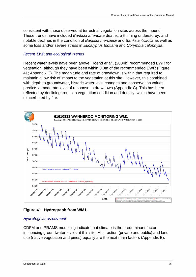
Review of Ministerial Conditions for the Gnangara Mound
Department of Water 75
consistent with those observed at terrestrial vegetation sites across the mound. These trends have included Banksia attenuata deaths, a thinning understorey, and notable declines in the condition of Banksia menziesii and Banksia ilicifolia as well as some loss and/or severe stress in Eucalyptus todtiana and Corymbia calophylla.
Recent EWR and ecological trends
Recent water levels have been above Froend et al., (2004b) recommended EWR for vegetation, although they have been within 0.3m of the recommended EWR (Figure 41; Appendix C). The magnitude and rate of drawdown is within that required to maintain a low risk of impact to the vegetation at this site. However, this combined with depth to groundwater, historic water level changes and conservation values predicts a moderate level of response to drawdown (Appendix C). This has been reflected by declining trends in vegetation condition and density, which have been exacerbated by fire.
61610833 WANNEROO MONITORING WM1Easting = 391479.00 Northing = 6497246.00 Zone = 50 TOC = 61.155mAHD WIN SITE ID = 5174
54.50
55.00
55.50
56.00
56.50
57.00
57.50
58.00
58.50
59.00
59.50
01/01
/1975
01/01
/1977
01/01
/1979
01/01
/1981
01/01
/1983
01/01
/1985
01/01
/1987
01/01
/1989
01/01
/1991
01/01
/1993
01/01
/1995
01/01
/1997
01/01
/1999
01/01
/2001
01/01
/2003
01/01
/2005
01/01
/2007
DATE
LEVE
L A
HD
(m)
Current absolute summer minimum 55.7mAHD
Recommended absolute summer minimum 54.7mAHD (vegetation)
Figure 41 Hydrograph from WM1.
Hydrological assessment
CDFM and PRAMS modelling indicate that climate is the predominant factor influencing groundwater levels at this site. Abstraction (private and public) and land use (native vegetation and pines) equally are the next main factors (Appendix E).
Review of Ministerial Conditions on the Groundwater Resources of the Gnangara Mound
76 Department of Water
Recommendations
Based on the information presented in this review, the department recommends that WM1 be retained as a Ministerial criteria site.
The department will continue to implement existing monitoring programs for this site.
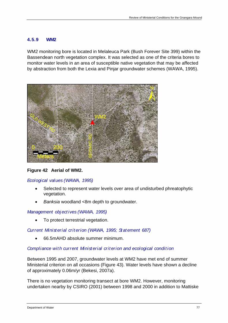
Review of Ministerial Conditions for the Gnangara Mound
Department of Water 77
4.5.9 WM2
WM2 monitoring bore is located in Melaleuca Park (Bush Forever Site 399) within the Bassendean north vegetation complex. It was selected as one of the criteria bores to monitor water levels in an area of susceptible native vegetation that may be affected by abstraction from both the Lexia and Pinjar groundwater schemes (WAWA, 1995).
Figure 42 Aerial of WM2.
Ecological values (WAWA, 1995)
• Selected to represent water levels over area of undisturbed phreatophytic vegetation.
• Banksia woodland <8m depth to groundwater.
Management objectives (WAWA, 1995)
• To protect terrestrial vegetation.
Current Ministerial criterion (WAWA, 1995; Statement 687)
• 66.5mAHD absolute summer minimum.
Compliance with current Ministerial criterion and ecological condition
Between 1995 and 2007, groundwater levels at WM2 have met end of summer Ministerial criterion on all occasions (Figure 43). Water levels have shown a decline of approximately 0.06m/yr (Bekesi, 2007a).
There is no vegetation monitoring transect at bore WM2. However, monitoring undertaken nearby by CSIRO (2001) between 1998 and 2000 in addition to Mattiske
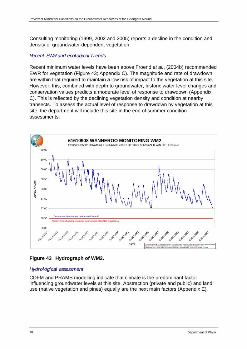
Review of Ministerial Conditions on the Groundwater Resources of the Gnangara Mound
78 Department of Water
Consulting monitoring (1999, 2002 and 2005) reports a decline in the condition and density of groundwater dependent vegetation.
Recent EWR and ecological trends
Recent minimum water levels have been above Froend et al., (2004b) recommended EWR for vegetation (Figure 43; Appendix C). The magnitude and rate of drawdown are within that required to maintain a low risk of impact to the vegetation at this site. However, this, combined with depth to groundwater, historic water level changes and conservation values predicts a moderate level of response to drawdown (Appendix C). This is reflected by the declining vegetation density and condition at nearby transects. To assess the actual level of response to drawdown by vegetation at this site, the department will include this site in the end of summer condition assessments.
61610908 WANNEROO MONITORING WM2Easting = 395282.00 Northing = 6496476.00 Zone = 50 TOC = 72.675mAHD WIN SITE ID = 5249
66.00
66.50
67.00
67.50
68.00
68.50
69.00
69.50
70.00
01/01
/1975
01/01
/1977
01/01
/1979
01/01
/1981
01/01
/1983
01/01
/1985
01/01
/1987
01/01
/1989
01/01
/1991
01/01
/1993
01/01
/1995
01/01
/1997
01/01
/1999
01/01
/2001
01/01
/2003
01/01
/2005
01/01
/2007
DATE
LEVE
L A
HD
(m)
Current absolute summer minimum 66.5mAHD
Recommended absolute summer minimum 66.495mAHD (vegetation)
Figure 43 Hydrograph of WM2.
Hydrological assessment
CDFM and PRAMS modelling indicate that climate is the predominant factor influencing groundwater levels at this site. Abstraction (private and public) and land use (native vegetation and pines) equally are the next main factors (Appendix E).

Review of Ministerial Conditions for the Gnangara Mound
Department of Water 79
Recommendations
Based on the information presented in this review, the department recommends that WM2 be retained as a Ministerial criteria site.
The department will continue to implement existing monitoring programs for this site.
The department will include monitoring the vegetation at WM2 in future end of summer condition assessments.
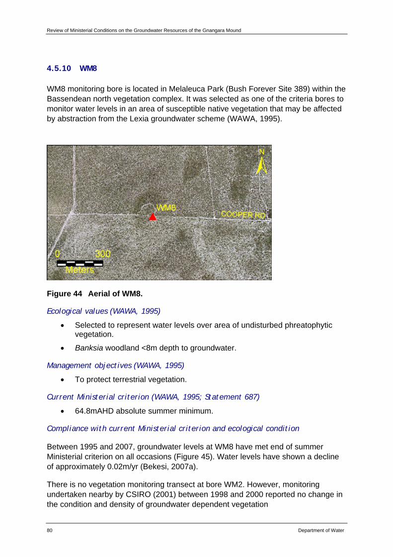
Review of Ministerial Conditions on the Groundwater Resources of the Gnangara Mound
80 Department of Water
4.5.10 WM8
WM8 monitoring bore is located in Melaleuca Park (Bush Forever Site 389) within the Bassendean north vegetation complex. It was selected as one of the criteria bores to monitor water levels in an area of susceptible native vegetation that may be affected by abstraction from the Lexia groundwater scheme (WAWA, 1995).
Figure 44 Aerial of WM8.
Ecological values (WAWA, 1995)
• Selected to represent water levels over area of undisturbed phreatophytic vegetation.
• Banksia woodland <8m depth to groundwater.
Management objectives (WAWA, 1995)
• To protect terrestrial vegetation.
Current Ministerial criterion (WAWA, 1995; Statement 687)
• 64.8mAHD absolute summer minimum.
Compliance with current Ministerial criterion and ecological condition
Between 1995 and 2007, groundwater levels at WM8 have met end of summer Ministerial criterion on all occasions (Figure 45). Water levels have shown a decline of approximately 0.02m/yr (Bekesi, 2007a).
There is no vegetation monitoring transect at bore WM2. However, monitoring undertaken nearby by CSIRO (2001) between 1998 and 2000 reported no change in the condition and density of groundwater dependent vegetation
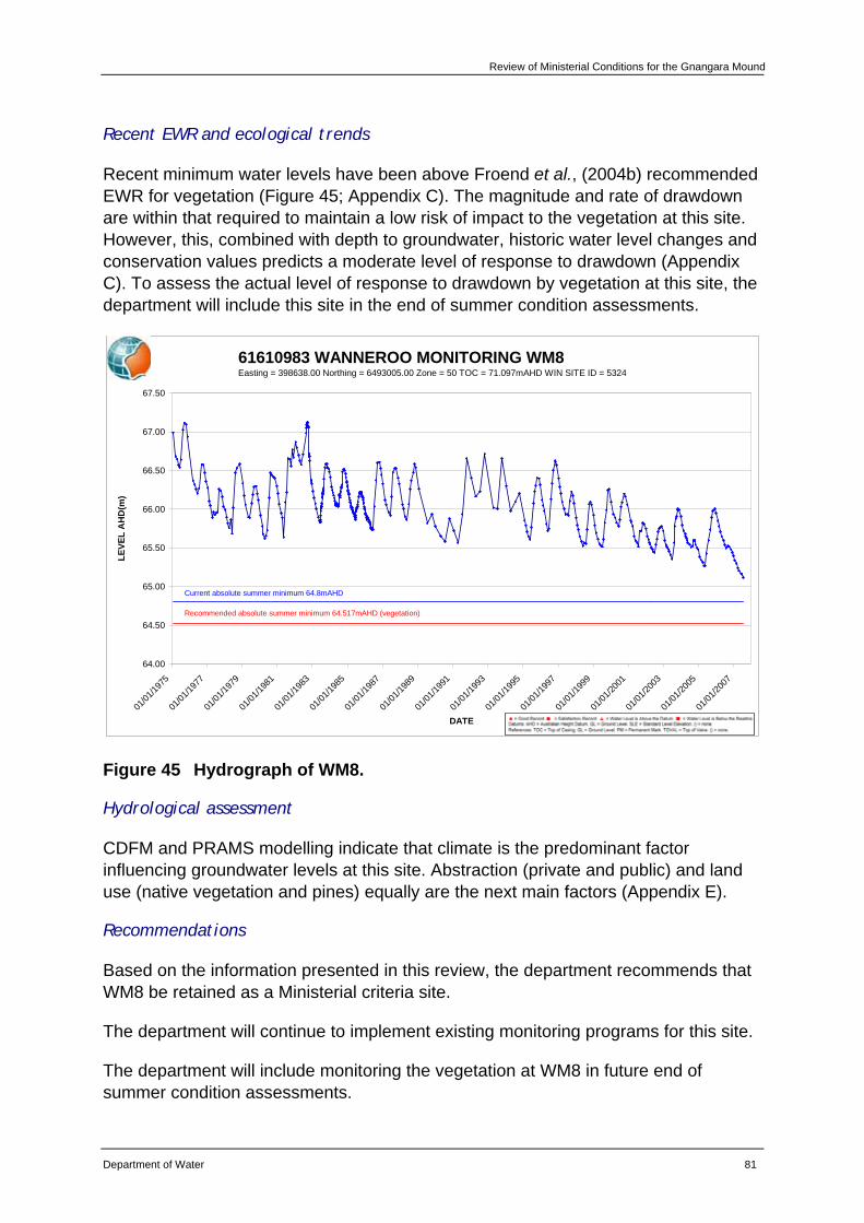
Review of Ministerial Conditions for the Gnangara Mound
Department of Water 81
Recent EWR and ecological trends
Recent minimum water levels have been above Froend et al., (2004b) recommended EWR for vegetation (Figure 45; Appendix C). The magnitude and rate of drawdown are within that required to maintain a low risk of impact to the vegetation at this site. However, this, combined with depth to groundwater, historic water level changes and conservation values predicts a moderate level of response to drawdown (Appendix C). To assess the actual level of response to drawdown by vegetation at this site, the department will include this site in the end of summer condition assessments.
61610983 WANNEROO MONITORING WM8Easting = 398638.00 Northing = 6493005.00 Zone = 50 TOC = 71.097mAHD WIN SITE ID = 5324
64.00
64.50
65.00
65.50
66.00
66.50
67.00
67.50
01/01
/1975
01/01
/1977
01/01
/1979
01/01
/1981
01/01
/1983
01/01
/1985
01/01
/1987
01/01
/1989
01/01
/1991
01/01
/1993
01/01
/1995
01/01
/1997
01/01
/1999
01/01
/2001
01/01
/2003
01/01
/2005
01/01
/2007
DATE
LEVE
L A
HD
(m)
Current absolute summer minimum 64.8mAHD
Recommended absolute summer minimum 64.517mAHD (vegetation)
Figure 45 Hydrograph of WM8.
Hydrological assessment
CDFM and PRAMS modelling indicate that climate is the predominant factor influencing groundwater levels at this site. Abstraction (private and public) and land use (native vegetation and pines) equally are the next main factors (Appendix E).
Recommendations
Based on the information presented in this review, the department recommends that WM8 be retained as a Ministerial criteria site.
The department will continue to implement existing monitoring programs for this site.
The department will include monitoring the vegetation at WM8 in future end of summer condition assessments.
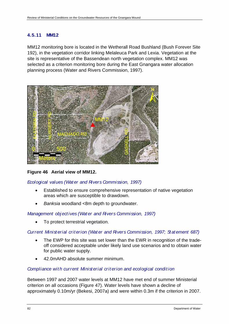
Review of Ministerial Conditions on the Groundwater Resources of the Gnangara Mound
82 Department of Water
4.5.11 MM12
MM12 monitoring bore is located in the Wetherall Road Bushland (Bush Forever Site 192), in the vegetation corridor linking Melaleuca Park and Lexia. Vegetation at the site is representative of the Bassendean north vegetation complex. MM12 was selected as a criterion monitoring bore during the East Gnangara water allocation planning process (Water and Rivers Commission, 1997).
Figure 46 Aerial view of MM12.
Ecological values (Water and Rivers Commission, 1997)
• Established to ensure comprehensive representation of native vegetation areas which are susceptible to drawdown.
• Banksia woodland <8m depth to groundwater.
Management objectives (Water and Rivers Commission, 1997)
• To protect terrestrial vegetation.
Current Ministerial criterion (Water and Rivers Commission, 1997; Statement 687)
• The EWP for this site was set lower than the EWR in recognition of the trade-off considered acceptable under likely land use scenarios and to obtain water for public water supply.
• 42.0mAHD absolute summer minimum.
Compliance with current Ministerial criterion and ecological condition
Between 1997 and 2007 water levels at MM12 have met end of summer Ministerial criterion on all occasions (Figure 47). Water levels have shown a decline of approximately 0.10m/yr (Bekesi, 2007a) and were within 0.3m if the criterion in 2007.
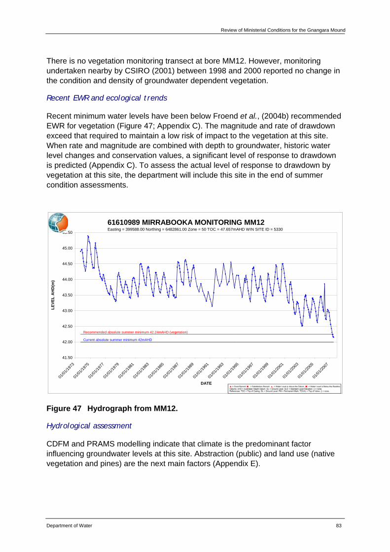
Review of Ministerial Conditions for the Gnangara Mound
Department of Water 83
There is no vegetation monitoring transect at bore MM12. However, monitoring undertaken nearby by CSIRO (2001) between 1998 and 2000 reported no change in the condition and density of groundwater dependent vegetation.
Recent EWR and ecological trends
Recent minimum water levels have been below Froend et al., (2004b) recommended EWR for vegetation (Figure 47; Appendix C). The magnitude and rate of drawdown exceed that required to maintain a low risk of impact to the vegetation at this site. When rate and magnitude are combined with depth to groundwater, historic water level changes and conservation values, a significant level of response to drawdown is predicted (Appendix C). To assess the actual level of response to drawdown by vegetation at this site, the department will include this site in the end of summer condition assessments.
61610989 MIRRABOOKA MONITORING MM12Easting = 399588.00 Northing = 6482861.00 Zone = 50 TOC = 47.657mAHD WIN SITE ID = 5330
41.50
42.00
42.50
43.00
43.50
44.00
44.50
45.00
45.50
01/01
/1973
01/01
/1975
01/01
/1977
01/01
/1979
01/01
/1981
01/01
/1983
01/01
/1985
01/01
/1987
01/01
/1989
01/01
/1991
01/01
/1993
01/01
/1995
01/01
/1997
01/01
/1999
01/01
/2001
01/01
/2003
01/01
/2005
01/01
/2007
DATE
LEVE
L A
HD
(m)
Recommended absolute summer minimum 42.24mAHD (vegetation)
Current absolute summer minimum 42mAHD
Figure 47 Hydrograph from MM12.
Hydrological assessment
CDFM and PRAMS modelling indicate that climate is the predominant factor influencing groundwater levels at this site. Abstraction (public) and land use (native vegetation and pines) are the next main factors (Appendix E).

Review of Ministerial Conditions on the Groundwater Resources of the Gnangara Mound
84 Department of Water
Recommendations
Based on the information presented in this review, the department recommends that MM12 be retained as a Ministerial criteria site.
The department will continue to implement existing monitoring programs for this site.
The department will include monitoring of vegetation at MM12 in future end of summer condition assessments.
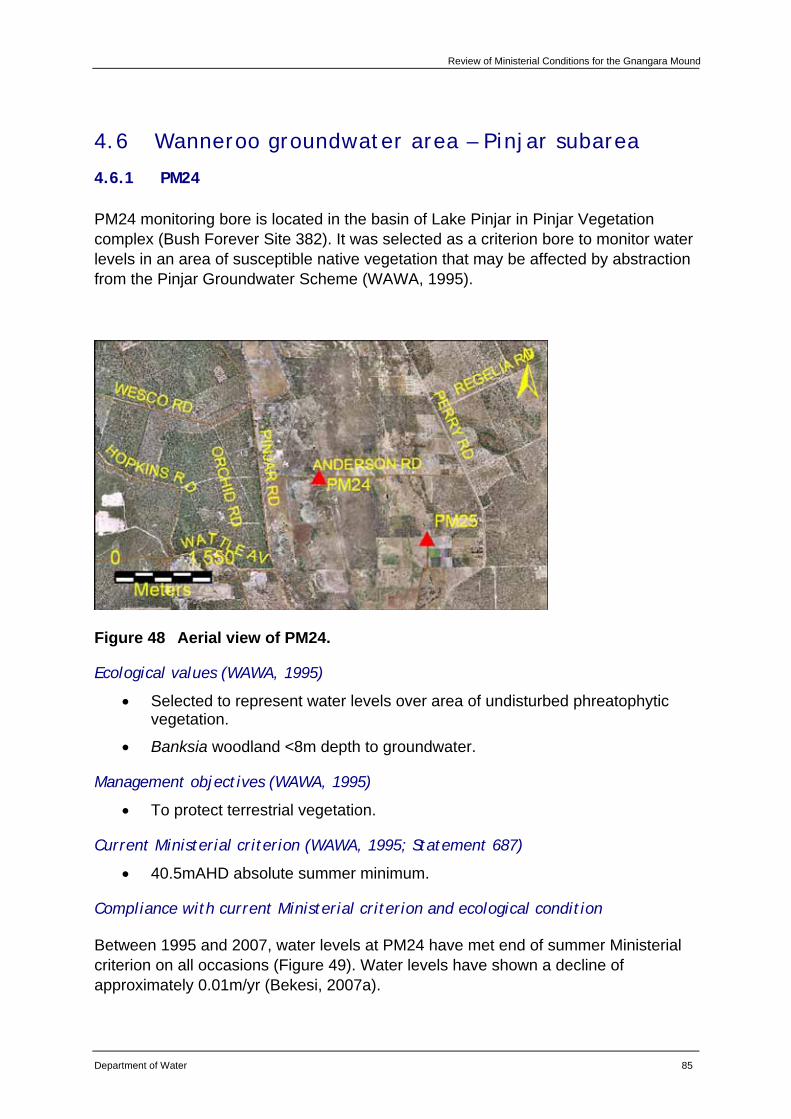
Review of Ministerial Conditions for the Gnangara Mound
Department of Water 85
4.6 Wanneroo groundwater area – Pinjar subarea
4.6.1 PM24
PM24 monitoring bore is located in the basin of Lake Pinjar in Pinjar Vegetation complex (Bush Forever Site 382). It was selected as a criterion bore to monitor water levels in an area of susceptible native vegetation that may be affected by abstraction from the Pinjar Groundwater Scheme (WAWA, 1995).
Figure 48 Aerial view of PM24.
Ecological values (WAWA, 1995)
• Selected to represent water levels over area of undisturbed phreatophytic vegetation.
• Banksia woodland <8m depth to groundwater.
Management objectives (WAWA, 1995)
• To protect terrestrial vegetation.
Current Ministerial criterion (WAWA, 1995; Statement 687)
• 40.5mAHD absolute summer minimum.
Compliance with current Ministerial criterion and ecological condition
Between 1995 and 2007, water levels at PM24 have met end of summer Ministerial criterion on all occasions (Figure 49). Water levels have shown a decline of approximately 0.01m/yr (Bekesi, 2007a).
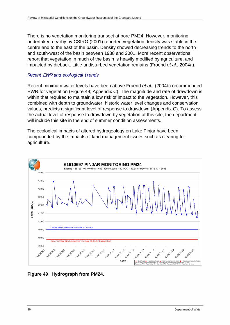
Review of Ministerial Conditions on the Groundwater Resources of the Gnangara Mound
86 Department of Water
There is no vegetation monitoring transect at bore PM24. However, monitoring undertaken nearby by CSIRO (2001) reported vegetation density was stable in the centre and to the east of the basin. Density showed decreasing trends to the north and south-west of the basin between 1988 and 2001. More recent observations report that vegetation in much of the basin is heavily modified by agriculture, and impacted by dieback. Little undisturbed vegetation remains (Froend et al., 2004a).
Recent EWR and ecological trends
Recent minimum water levels have been above Froend et al., (2004b) recommended EWR for vegetation (Figure 49; Appendix C). The magnitude and rate of drawdown is within that required to maintain a low risk of impact to the vegetation. However, this combined with depth to groundwater, historic water level changes and conservation values, predicts a significant level of response to drawdown (Appendix C). To assess the actual level of response to drawdown by vegetation at this site, the department will include this site in the end of summer condition assessments.
The ecological impacts of altered hydrogeology on Lake Pinjar have been compounded by the impacts of land management issues such as clearing for agriculture.
61610697 PINJAR MONITORING PM24Easting = 387197.00 Northing = 6497829.00 Zone = 50 TOC = 43.98mAHD WIN SITE ID = 5038
39.50
40.00
40.50
41.00
41.50
42.00
42.50
43.00
43.50
44.00
01/01
/1977
01/01
/1979
01/01
/1981
01/01
/1983
01/01
/1985
01/01
/1987
01/01
/1989
01/01
/1991
01/01
/1993
01/01
/1995
01/01
/1997
01/01
/1999
01/01
/2001
01/01
/2003
01/01
/2005
01/01
/2007
DATE
LEVE
L A
HD
(m)
Current absolute summer minimum 40.5mAHD
Recommended absolute summer minimum 39.9mAHD (vegetation)
Figure 49 Hydrograph from PM24.
Review of Ministerial Conditions for the Gnangara Mound
Department of Water 87
Hydrological assessment
CDFM and PRAMS modelling indicate that climate is the predominant factor influencing groundwater levels at this site. Abstraction (public and private) and land use (native vegetation and pines) equally are the next main factors (Appendix E).
Recommendations
Based on the information presented in this review, the department recommends that PM24 be retained as a Ministerial criteria site.
The department will continue to implement existing monitoring programs for this site.
The department will include monitoring the vegetation at PM24 in future end of summer condition assessments.
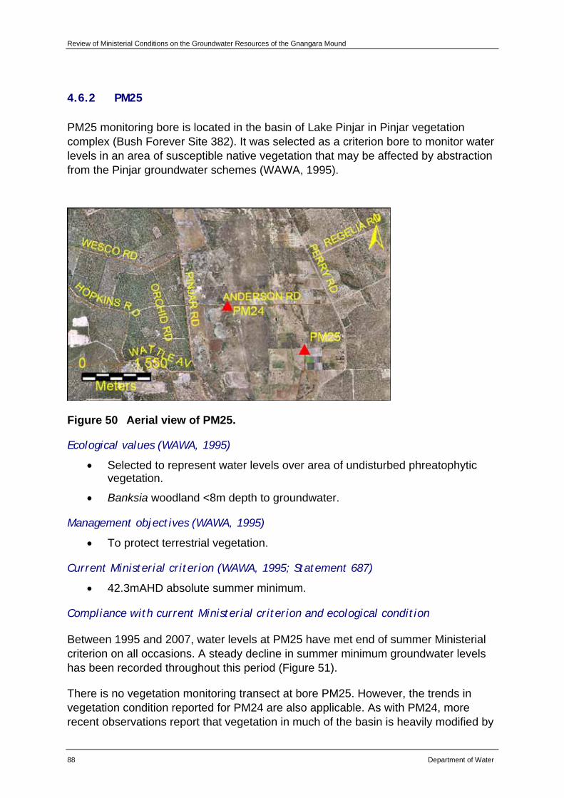
Review of Ministerial Conditions on the Groundwater Resources of the Gnangara Mound
88 Department of Water
4.6.2 PM25
PM25 monitoring bore is located in the basin of Lake Pinjar in Pinjar vegetation complex (Bush Forever Site 382). It was selected as a criterion bore to monitor water levels in an area of susceptible native vegetation that may be affected by abstraction from the Pinjar groundwater schemes (WAWA, 1995).
Figure 50 Aerial view of PM25.
Ecological values (WAWA, 1995)
• Selected to represent water levels over area of undisturbed phreatophytic vegetation.
• Banksia woodland <8m depth to groundwater.
Management objectives (WAWA, 1995)
• To protect terrestrial vegetation.
Current Ministerial criterion (WAWA, 1995; Statement 687)
• 42.3mAHD absolute summer minimum.
Compliance with current Ministerial criterion and ecological condition
Between 1995 and 2007, water levels at PM25 have met end of summer Ministerial criterion on all occasions. A steady decline in summer minimum groundwater levels has been recorded throughout this period (Figure 51).
There is no vegetation monitoring transect at bore PM25. However, the trends in vegetation condition reported for PM24 are also applicable. As with PM24, more recent observations report that vegetation in much of the basin is heavily modified by
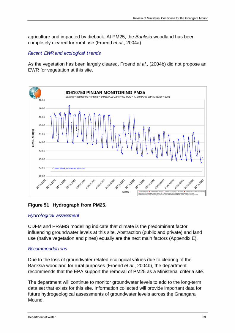
Review of Ministerial Conditions for the Gnangara Mound
Department of Water 89
agriculture and impacted by dieback. At PM25, the Banksia woodland has been completely cleared for rural use (Froend et al., 2004a).
Recent EWR and ecological trends
As the vegetation has been largely cleared, Froend et al., (2004b) did not propose an EWR for vegetation at this site.
61610750 PINJAR MONITORING PM25Easting = 388939.00 Northing = 6496827.00 Zone = 50 TOC = 47.19mAHD WIN SITE ID = 5091
42.00
42.50
43.00
43.50
44.00
44.50
45.00
45.50
46.00
46.50
01/01
/1976
01/01
/1978
01/01
/1980
01/01
/1982
01/01
/1984
01/01
/1986
01/01
/1988
01/01
/1990
01/01
/1992
01/01
/1994
01/01
/1996
01/01
/1998
01/01
/2000
01/01
/2002
01/01
/2004
01/01
/2006
01/01
/2008
DATE
LEVE
L A
HD
(m)
Current absolute summer minimum
Figure 51 Hydrograph from PM25.
Hydrological assessment
CDFM and PRAMS modelling indicate that climate is the predominant factor influencing groundwater levels at this site. Abstraction (public and private) and land use (native vegetation and pines) equally are the next main factors (Appendix E).
Recommendations
Due to the loss of groundwater related ecological values due to clearing of the Banksia woodland for rural purposes (Froend et al., 2004b), the department recommends that the EPA support the removal of PM25 as a Ministerial criteria site.
The department will continue to monitor groundwater levels to add to the long-term data set that exists for this site. Information collected will provide important data for future hydrogeological assessments of groundwater levels across the Gnangara Mound.
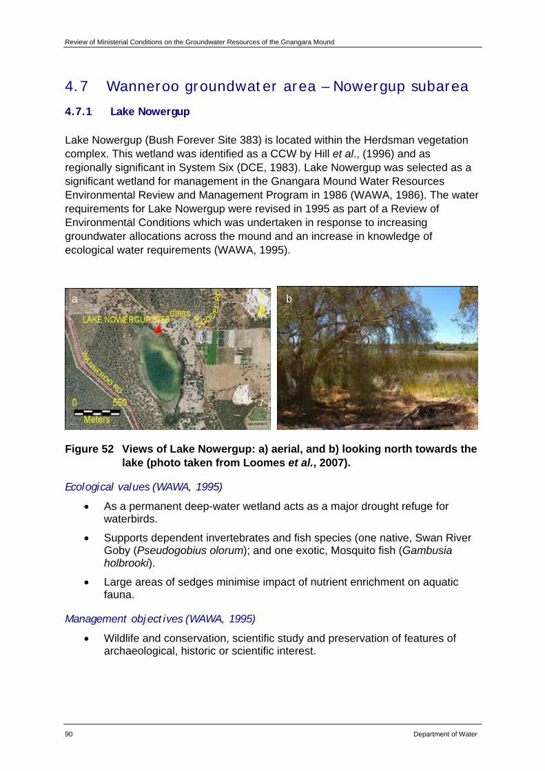
Review of Ministerial Conditions on the Groundwater Resources of the Gnangara Mound
90 Department of Water
4.7 Wanneroo groundwater area – Nowergup subarea
4.7.1 Lake Nowergup
Lake Nowergup (Bush Forever Site 383) is located within the Herdsman vegetation complex. This wetland was identified as a CCW by Hill et al., (1996) and as regionally significant in System Six (DCE, 1983). Lake Nowergup was selected as a significant wetland for management in the Gnangara Mound Water Resources Environmental Review and Management Program in 1986 (WAWA, 1986). The water requirements for Lake Nowergup were revised in 1995 as part of a Review of Environmental Conditions which was undertaken in response to increasing groundwater allocations across the mound and an increase in knowledge of ecological water requirements (WAWA, 1995).
Figure 52 Views of Lake Nowergup: a) aerial, and b) looking north towards the lake (photo taken from Loomes et al., 2007).
Ecological values (WAWA, 1995)
• As a permanent deep-water wetland acts as a major drought refuge for waterbirds.
• Supports dependent invertebrates and fish species (one native, Swan River Goby (Pseudogobius olorum); and one exotic, Mosquito fish (Gambusia holbrooki).
• Large areas of sedges minimise impact of nutrient enrichment on aquatic fauna.
Management objectives (WAWA, 1995)
• Wildlife and conservation, scientific study and preservation of features of archaeological, historic or scientific interest.
a b
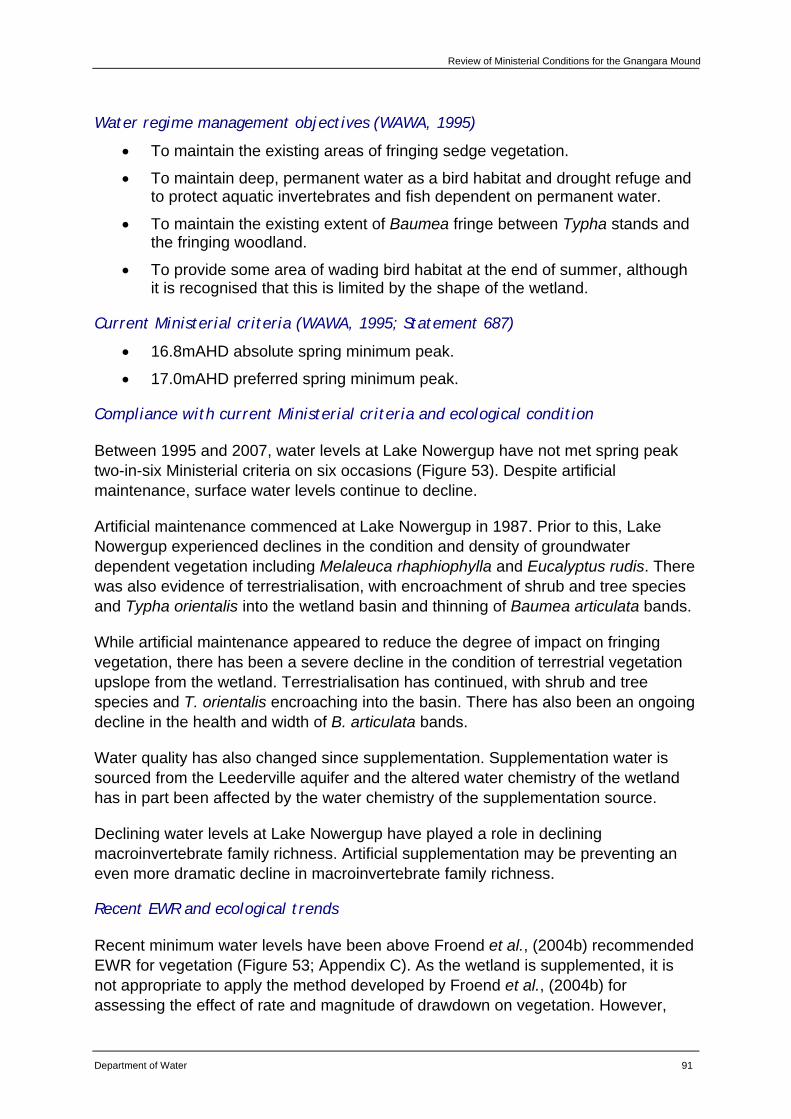
Review of Ministerial Conditions for the Gnangara Mound
Department of Water 91
Water regime management objectives (WAWA, 1995)
• To maintain the existing areas of fringing sedge vegetation.
• To maintain deep, permanent water as a bird habitat and drought refuge and to protect aquatic invertebrates and fish dependent on permanent water.
• To maintain the existing extent of Baumea fringe between Typha stands and the fringing woodland.
• To provide some area of wading bird habitat at the end of summer, although it is recognised that this is limited by the shape of the wetland.
Current Ministerial criteria (WAWA, 1995; Statement 687)
• 16.8mAHD absolute spring minimum peak.
• 17.0mAHD preferred spring minimum peak.
Compliance with current Ministerial criteria and ecological condition
Between 1995 and 2007, water levels at Lake Nowergup have not met spring peak two-in-six Ministerial criteria on six occasions (Figure 53). Despite artificial maintenance, surface water levels continue to decline.
Artificial maintenance commenced at Lake Nowergup in 1987. Prior to this, Lake Nowergup experienced declines in the condition and density of groundwater dependent vegetation including Melaleuca rhaphiophylla and Eucalyptus rudis. There was also evidence of terrestrialisation, with encroachment of shrub and tree species and Typha orientalis into the wetland basin and thinning of Baumea articulata bands.
While artificial maintenance appeared to reduce the degree of impact on fringing vegetation, there has been a severe decline in the condition of terrestrial vegetation upslope from the wetland. Terrestrialisation has continued, with shrub and tree species and T. orientalis encroaching into the basin. There has also been an ongoing decline in the health and width of B. articulata bands.
Water quality has also changed since supplementation. Supplementation water is sourced from the Leederville aquifer and the altered water chemistry of the wetland has in part been affected by the water chemistry of the supplementation source.
Declining water levels at Lake Nowergup have played a role in declining macroinvertebrate family richness. Artificial supplementation may be preventing an even more dramatic decline in macroinvertebrate family richness.
Recent EWR and ecological trends
Recent minimum water levels have been above Froend et al., (2004b) recommended EWR for vegetation (Figure 53; Appendix C). As the wetland is supplemented, it is not appropriate to apply the method developed by Froend et al., (2004b) for assessing the effect of rate and magnitude of drawdown on vegetation. However,
Review of Ministerial Conditions on the Groundwater Resources of the Gnangara Mound
92 Department of Water
despite supplementation, the condition of fringing vegetation at Lake Nowergup continues to decline and terrestrial shrub and tree species continue to encroach into the wetland basin.
Lake Nowergup water levels have not met with the proposed 2004 EWR for waterbirds and macroinvertebrates (Figure 53; Appendix C). This is reflected by declining macroinvertebrate family richness.
Lake Nowergup has been included within the department’s SGS investigation for a number of key reasons. These include its value as one of the deepest wetlands on the Swan Coastal Plain, the severity of water level declines noted at this site and the cost of artificial supplementation. The SGS investigation includes the development of a numerical local area groundwater flow model and an extensive sediment and water chemistry analysis program. The aim of the investigation is to improve the department’s understanding of the groundwater/surface water connection and groundwater quality. The investigation is due to be completed in May 2008, and information gained will be used to improve management at this site.
6162567 LAKES AND WETLANDS LAKE NOWERGUP 8756Easting = 379746.00 Northing = 6499839.00 Zone = 50 PM = 20.145mAHD WIN SITE ID = 14588
15.00
15.50
16.00
16.50
17.00
17.50
18.00
01/01
/1973
01/01
/1975
01/01
/1977
01/01
/1979
01/01
/1981
01/01
/1983
01/01
/1985
01/01
/1987
01/01
/1989
01/01
/1991
01/01
/1993
01/01
/1995
01/01
/1997
01/01
/1999
01/01
/2001
01/01
/2003
01/01
/2005
01/01
/2007
DATE
LEVE
L A
HD
(m)
Current preferred Spring peak 17.0mAHD
Current absolute Spring peak 16.8mAHD
Recommended absolute Summer minimum 16.353mAHD (sediment processes)Recommended absolute Summer minimum 16.35mAHD (vegetation)
Recommended absolute Summer minimum 16.853mAHD (waterbirds and macroinvertebrates)
Figure 53 Hydrograph from Lake Nowergup.
Hydrological assessment
CDFM and PRAMS modelling indicate that climate and abstraction (private) are the predominant factors influencing groundwater levels at this site, followed by land use (pines) (Appendix E).
Review of Ministerial Conditions for the Gnangara Mound
Department of Water 93
Recommendations
Based on the information presented in this review, the department recommends that Lake Nowergup be retained as a Ministerial criteria site.
The department will continue to implement existing monitoring programs for this site.
As artificial supplementation of water levels is preventing a more pronounced ecological impact, the department will continue this program in the short-term. This will be reassessed following the development of the local area model as outlined above. The department will establish a steering group to provide the best possible site specific management of Lake Nowergup.
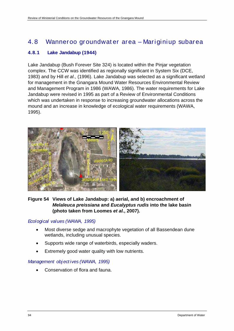
Review of Ministerial Conditions on the Groundwater Resources of the Gnangara Mound
94 Department of Water
4.8 Wanneroo groundwater area – Mariginiup subarea
4.8.1 Lake Jandabup (1944)
Lake Jandabup (Bush Forever Site 324) is located within the Pinjar vegetation complex. The CCW was identified as regionally significant in System Six (DCE, 1983) and by Hill et al., (1996). Lake Jandabup was selected as a significant wetland for management in the Gnangara Mound Water Resources Environmental Review and Management Program in 1986 (WAWA, 1986). The water requirements for Lake Jandabup were revised in 1995 as part of a Review of Environmental Conditions which was undertaken in response to increasing groundwater allocations across the mound and an increase in knowledge of ecological water requirements (WAWA, 1995).
Figure 54 Views of Lake Jandabup: a) aerial, and b) encroachment of Melaleuca preissiana and Eucalyptus rudis into the lake basin (photo taken from Loomes et al., 2007).
Ecological values (WAWA, 1995)
• Most diverse sedge and macrophyte vegetation of all Bassendean dune wetlands, including unusual species.
• Supports wide range of waterbirds, especially waders.
• Extremely good water quality with low nutrients.
Management objectives (WAWA, 1995)
• Conservation of flora and fauna.
a b
Review of Ministerial Conditions for the Gnangara Mound
Department of Water 95
Water regime management objectives (WAWA, 1995)
• Maintenance of the current extent of wading bird habitat.
• No expansion in the areas of sedge vegetation, but maintenance of existing areas.
• Removal of mosquito fish from the lake.
• Maintenance of high species richness of aquatic macroinvertebrates, macrophytes and sedge vegetation.
Current Ministerial criteria (WAWA, 1995; Statement 687)
• 44.3mAHD absolute summer minimum.
• 44.2mAHD absolute spring minimum peak.
• 44.7mAHD preferred spring minimum peak.
• Water level only allowed between preferred and absolute min at a rate of 2 in every 6 years.
Compliance with current Ministerial criteria and ecological condition
Between 1995 and 2007, water levels at Lake Jandabup have met spring peak Ministerial criteria on all occasions but have not met end of summer Ministerial criteria on eight occasions (Figure 55). Spring peak criteria are likely to be met as Lake Jandabup is artificially supplemented by the Water Corporation.
Artificial supplementation commenced at Lake Jandabup in 1990. Prior to supplementation Lake Jandabup experienced a decline in the condition and density of groundwater dependent vegetation species including Melaleuca rhaphiophylla and Eucalyptus rudis. There was also encroachment of shrub and tree species into the wetland basin.
Water quality at this site had also declined and there has been a loss of macroinvertebrate taxa. The decline in water levels caused drying of organic rich sediments and acidification of the wetland.
Following supplementation, pH increased and a return of some macroinvertebrate species was recorded. While the majority of declines in ecological condition have been arrested through artificial maintenance, the condition of fringing vegetation continues to decline.
Recent EWR and ecological trends
Recent minimum water levels have been above Froend et al., (2004b) recommended EWR for vegetation (Figure 55; Appendix C). As the wetland is supplemented, it is not appropriate to apply Froend's method for assessing the effect of rate and magnitude of drawdown on vegetation. However, despite supplementation, Lake Jandabup still continues to experience declines in condition and abundance of
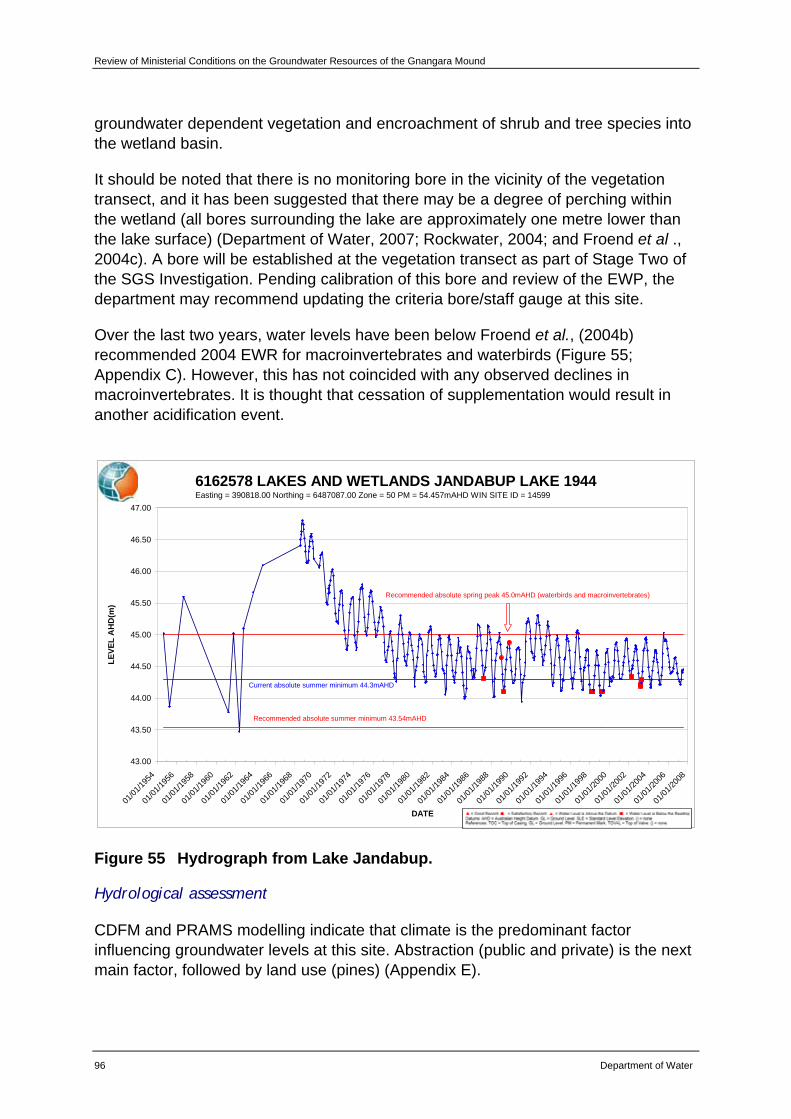
Review of Ministerial Conditions on the Groundwater Resources of the Gnangara Mound
96 Department of Water
groundwater dependent vegetation and encroachment of shrub and tree species into the wetland basin.
It should be noted that there is no monitoring bore in the vicinity of the vegetation transect, and it has been suggested that there may be a degree of perching within the wetland (all bores surrounding the lake are approximately one metre lower than the lake surface) (Department of Water, 2007; Rockwater, 2004; and Froend et al ., 2004c). A bore will be established at the vegetation transect as part of Stage Two of the SGS Investigation. Pending calibration of this bore and review of the EWP, the department may recommend updating the criteria bore/staff gauge at this site.
Over the last two years, water levels have been below Froend et al., (2004b) recommended 2004 EWR for macroinvertebrates and waterbirds (Figure 55; Appendix C). However, this has not coincided with any observed declines in macroinvertebrates. It is thought that cessation of supplementation would result in another acidification event.
6162578 LAKES AND WETLANDS JANDABUP LAKE 1944Easting = 390818.00 Northing = 6487087.00 Zone = 50 PM = 54.457mAHD WIN SITE ID = 14599
43.00
43.50
44.00
44.50
45.00
45.50
46.00
46.50
47.00
01/01
/1954
01/01
/1956
01/01
/1958
01/01
/1960
01/01
/1962
01/01
/1964
01/01
/1966
01/01
/1968
01/01
/1970
01/01
/1972
01/01
/1974
01/01
/1976
01/01
/1978
01/01
/1980
01/01
/1982
01/01
/1984
01/01
/1986
01/01
/1988
01/01
/1990
01/01
/1992
01/01
/1994
01/01
/1996
01/01
/1998
01/01
/2000
01/01
/2002
01/01
/2004
01/01
/2006
01/01
/2008
DATE
LEVE
L A
HD
(m)
Current absolute summer minimum 44.3mAHD
Recommended absolute summer minimum 43.54mAHD
Recommended absolute spring peak 45.0mAHD (waterbirds and macroinvertebrates)
Figure 55 Hydrograph from Lake Jandabup.
Hydrological assessment
CDFM and PRAMS modelling indicate that climate is the predominant factor influencing groundwater levels at this site. Abstraction (public and private) is the next main factor, followed by land use (pines) (Appendix E).
Review of Ministerial Conditions for the Gnangara Mound
Department of Water 97
Recommendations
Based on the information presented in this review, the department recommends that Lake Jandabup be retained as a Ministerial criteria site.
The department will continue to implement existing monitoring programs for this site.
The department will establish a new bore at the vegetation transect as part of Stage Two of SGS Investigation.
In light of benefits that supplementation has had on some of the ecological values of Lake Jandabup, the department recommends the continuation of the supplementation scheme by the Water Corporation.
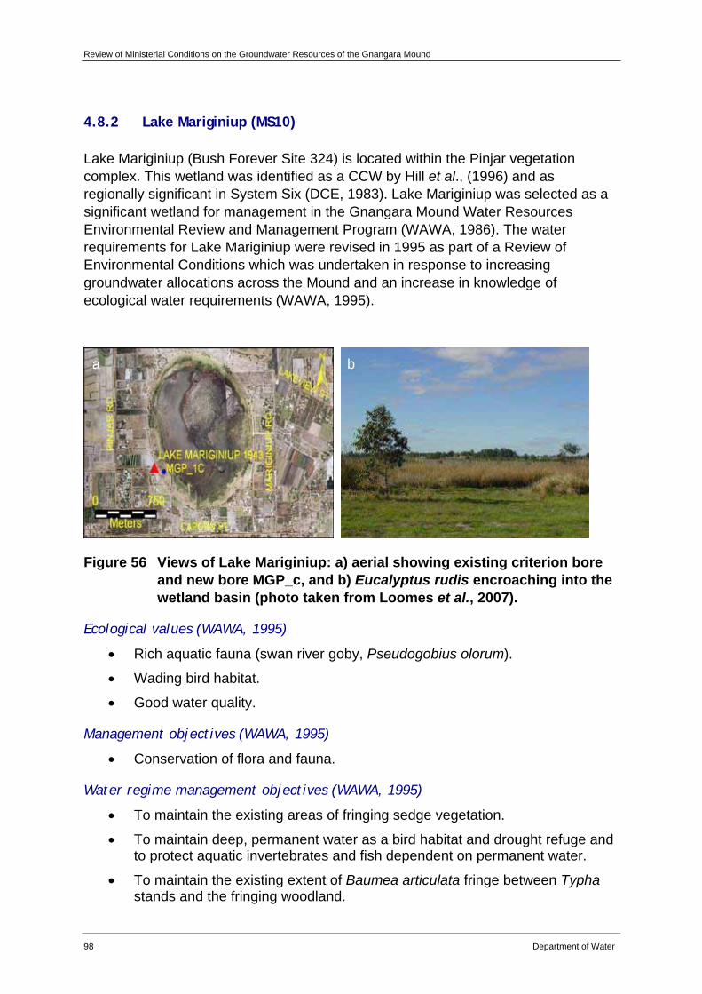
Review of Ministerial Conditions on the Groundwater Resources of the Gnangara Mound
98 Department of Water
4.8.2 Lake Mariginiup (MS10)
Lake Mariginiup (Bush Forever Site 324) is located within the Pinjar vegetation complex. This wetland was identified as a CCW by Hill et al., (1996) and as regionally significant in System Six (DCE, 1983). Lake Mariginiup was selected as a significant wetland for management in the Gnangara Mound Water Resources Environmental Review and Management Program (WAWA, 1986). The water requirements for Lake Mariginiup were revised in 1995 as part of a Review of Environmental Conditions which was undertaken in response to increasing groundwater allocations across the Mound and an increase in knowledge of ecological water requirements (WAWA, 1995).
Figure 56 Views of Lake Mariginiup: a) aerial showing existing criterion bore and new bore MGP_c, and b) Eucalyptus rudis encroaching into the wetland basin (photo taken from Loomes et al., 2007).
Ecological values (WAWA, 1995)
• Rich aquatic fauna (swan river goby, Pseudogobius olorum).
• Wading bird habitat.
• Good water quality.
Management objectives (WAWA, 1995)
• Conservation of flora and fauna.
Water regime management objectives (WAWA, 1995)
• To maintain the existing areas of fringing sedge vegetation.
• To maintain deep, permanent water as a bird habitat and drought refuge and to protect aquatic invertebrates and fish dependent on permanent water.
• To maintain the existing extent of Baumea articulata fringe between Typha stands and the fringing woodland.
a b
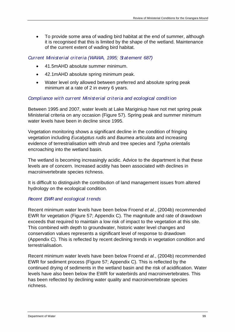
Review of Ministerial Conditions for the Gnangara Mound
Department of Water 99
• To provide some area of wading bird habitat at the end of summer, although it is recognised that this is limited by the shape of the wetland. Maintenance of the current extent of wading bird habitat.
Current Ministerial criteria (WAWA, 1995; Statement 687)
• 41.5mAHD absolute summer minimum.
• 42.1mAHD absolute spring minimum peak.
• Water level only allowed between preferred and absolute spring peak minimum at a rate of 2 in every 6 years.
Compliance with current Ministerial criteria and ecological condition
Between 1995 and 2007, water levels at Lake Mariginiup have not met spring peak Ministerial criteria on any occasion (Figure 57). Spring peak and summer minimum water levels have been in decline since 1995.
Vegetation monitoring shows a significant decline in the condition of fringing vegetation including Eucalyptus rudis and Baumea articulata and increasing evidence of terrestrialisation with shrub and tree species and Typha orientalis encroaching into the wetland basin.
The wetland is becoming increasingly acidic. Advice to the department is that these levels are of concern. Increased acidity has been associated with declines in macroinvertebrate species richness.
It is difficult to distinguish the contribution of land management issues from altered hydrology on the ecological condition.
Recent EWR and ecological trends
Recent minimum water levels have been below Froend et al., (2004b) recommended EWR for vegetation (Figure 57; Appendix C). The magnitude and rate of drawdown exceeds that required to maintain a low risk of impact to the vegetation at this site. This combined with depth to groundwater, historic water level changes and conservation values represents a significant level of response to drawdown (Appendix C). This is reflected by recent declining trends in vegetation condition and terrestrialisation.
Recent minimum water levels have been below Froend et al., (2004b) recommended EWR for sediment process (Figure 57; Appendix C). This is reflected by the continued drying of sediments in the wetland basin and the risk of acidification. Water levels have also been below the EWR for waterbirds and macroinvertebrates. This has been reflected by declining water quality and macroinvertebrate species richness.
Review of Ministerial Conditions on the Groundwater Resources of the Gnangara Mound
100 Department of Water
Due to the severity of water level and ecological decline, Lake Mariginiup was included in Stage One of the department’s SGS Investigation. The hydrogeological investigation includes the development of a numerical local area groundwater flow model and an extensive sediment and water chemistry analysis. The aim is to improve the department’s understanding of the groundwater/surface water connection and groundwater quality and flow into and out of the wetland. The investigation is due to be completed in May 2008, and will improve the department’s management of Lake Mariginiup. As part of the SGS Investigation, a new bore (MGP_c) has been established adjacent to the vegetation transect (where the EWR were determined). Currently, water levels are below the readable level on the Ministerial staff gauge.
The department has established a Lake Mariginiup steering group to advise on management of this wetland, including assessing the possibility of artificial supplementation. This group is comprised of government and non-government representatives with relevant expertise.
61610685 MARIGINIUP MONITORING LAKE MARIGINIUP - MS10Easting = 387344.00 Northing = 6489116.00 Zone = 50 TOC = 43.495mAHD WIN SITE ID = 5026
40.00
40.50
41.00
41.50
42.00
42.50
01/01
/1979
01/01
/1981
01/01
/1983
01/01
/1985
01/01
/1987
01/01
/1989
01/01
/1991
01/01
/1993
01/01
/1995
01/01
/1997
01/01
/1999
01/01
/2001
01/01
/2003
01/01
/2005
01/01
/2007
DATE
LEVE
L A
HD
(m) Current absolute Spring peak 41.5mAHD
Recommended absolute Spring peak 42.1mAHD (waterbirds and macroivertebrates)Current preferred Spring peak 42.1mAHD
Recommended absolute Summer minimum 40.8mAHD (sediment )
Recommended absolute Summer minimum 40.55mAHD (vegetation)
Figure 57 Hydrograph from Lake Mariginiup.
Hydrological assessment
CDFM and PRAMS modelling indicate that climate is the predominant factor influencing groundwater levels at this site. Abstraction (private) is the next main factor, followed by land use (pines) (Appendix E).
Review of Ministerial Conditions for the Gnangara Mound
Department of Water 101
Recommendations
Based on the information presented in this review, the department recommends that Lake Mariginiup be retained as a Ministerial criteria site.
The department will continue to implement existing monitoring programs for this site.
The department recommends that the EPA support that Ministerial criterion is assessed against water levels from bore MGP_c rather than the existing bore MS10 (61610685) following the review outlined below:
• MCP_c is currently being monitored. On completion of twelve months monitoring, a review of the water levels in MGP_c and the current criterion bore (61610661) will be conducted to calibrate MGP_c.
• A review of the existing EWP will be conducted and if necessary and appropriate, the EWP will be transferred to be measured at MGP_c.
• The department will summarise the information reviewed and formally request an amendment to the EPA.
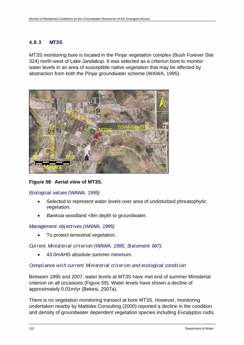
Review of Ministerial Conditions on the Groundwater Resources of the Gnangara Mound
102 Department of Water
4.8.3 MT3S
MT3S monitoring bore is located in the Pinjar vegetation complex (Bush Forever Site 324) north-west of Lake Jandabup. It was selected as a criterion bore to monitor water levels in an area of susceptible native vegetation that may be affected by abstraction from both the Pinjar groundwater scheme (WAWA, 1995).
Figure 58 Aerial view of MT3S.
Ecological values (WAWA, 1995)
• Selected to represent water levels over area of undisturbed phreatophytic vegetation.
• Banksia woodland <8m depth to groundwater.
Management objectives (WAWA, 1995)
• To protect terrestrial vegetation.
Current Ministerial criterion (WAWA, 1995; Statement 687):
• 43.0mAHD absolute summer minimum.
Compliance with current Ministerial criterion and ecological condition
Between 1995 and 2007, water levels at MT3S have met end of summer Ministerial criterion on all occasions (Figure 59). Water levels have shown a decline of approximately 0.01m/yr (Bekesi, 2007a).
There is no vegetation monitoring transect at bore MT3S. However, monitoring undertaken nearby by Mattiske Consulting (2000) reported a decline in the condition and density of groundwater dependent vegetation species including Eucalyptus rudis,
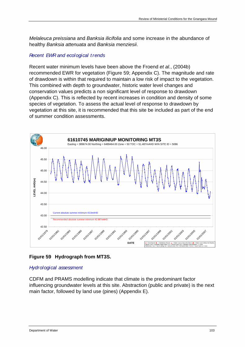
Review of Ministerial Conditions for the Gnangara Mound
Department of Water 103
Melaleuca preissiana and Banksia ilicifolia and some increase in the abundance of healthy Banksia attenuata and Banksia menziesii.
Recent EWR and ecological trends
Recent water minimum levels have been above the Froend et al., (2004b) recommended EWR for vegetation (Figure 59; Appendix C). The magnitude and rate of drawdown is within that required to maintain a low risk of impact to the vegetation. This combined with depth to groundwater, historic water level changes and conservation values predicts a non significant level of response to drawdown (Appendix C). This is reflected by recent increases in condition and density of some species of vegetation. To assess the actual level of response to drawdown by vegetation at this site, it is recommended that this site be included as part of the end of summer condition assessments.
61610745 MARIGINIUP MONITORING MT3SEasting = 389674.00 Northing = 6489464.00 Zone = 50 TOC = 51.487mAHD WIN SITE ID = 5086
42.50
43.00
43.50
44.00
44.50
45.00
45.50
46.00
01/01
/1979
01/01
/1981
01/01
/1983
01/01
/1985
01/01
/1987
01/01
/1989
01/01
/1991
01/01
/1993
01/01
/1995
01/01
/1997
01/01
/1999
01/01
/2001
01/01
/2003
01/01
/2005
01/01
/2007
DATE
LEVE
L A
HD
(m)
Current absolute summer minimum 43.0mAHD
Recommended absolute summer minimum 42.887mAHD
Figure 59 Hydrograph from MT3S.
Hydrological assessment
CDFM and PRAMS modelling indicate that climate is the predominant factor influencing groundwater levels at this site. Abstraction (public and private) is the next main factor, followed by land use (pines) (Appendix E).
Review of Ministerial Conditions on the Groundwater Resources of the Gnangara Mound
104 Department of Water
Recommendations
Based on the information presented in this review, the department recommends that MT3S be retained as a Ministerial criteria site.
The department will continue to implement existing monitoring programs for this site.
The department will include monitoring the vegetation at MT3S in future end of summer condition assessments.
Review of Ministerial Conditions for the Gnangara Mound
Department of Water 105
4.9 Wanneroo groundwater area – Gnangara subarea
4.9.1 Lake Gnangara
Lake Gnangara (Bush Forever Site 193) is located within the Pinjar vegetation complex. This CCW was identified as regionally significant in System Six (DCE, 1983) and by Hill et al., (1996). Lake Gnangara was selected as a significant wetland for management in the Gnangara Mound Water Resources Environmental Review and Management Program (WAWA, 1986). The water requirements for Lake Gnangara were revised in 1995 as part of a Review of Environmental Conditions which was undertaken in response to increasing groundwater allocations across the Mound and an increase in knowledge of ecological water requirements (WAWA, 1995).
Figure 60 Views of Lake Gnangara: a) aerial, and b) looking south-east across the wetland basin (photo taken from Loomes et al., 2007).
Ecological values (WAWA, 1995)
• Low value due to poor water quality, especially high acidity.
Management objectives (WAWA, 1995)
• To maintain and enhance the natural attributes and functions of the lake.
• To manage Lake Gnangara for the dual purposes of conservation and recreation.
Water regime management objectives (WAWA, 1995)
• To improve water quality through increased water levels as a means of enhancing both environmental and social values of the lake.
a b
Review of Ministerial Conditions on the Groundwater Resources of the Gnangara Mound
106 Department of Water
Current Ministerial criteria (WAWA, 1995; Statement 687)
• 41.3mAHD absolute summer minimum.
• 42.0mAHD preferred summer minimum.
Compliance with current Ministerial criteria and ecological condition
Between 1995 and 2007, water levels at Lake Gnangara have met end of summer absolute minimum Ministerial criteria on all but one occasion (Figure 61). Water levels have shown a decline of approximately 0.01m/yr (Bekesi, 2007a).
There has been a significant impact on vegetation communities at Lake Gnangara. A decline in the density and condition of fringing vegetation species and encroachment of shrub and tree species into the wetland basin has been noted. There is also evidence of terrestrialisation. Results of water quality monitoring show elevated conductivity levels, low pH and increased sulphate concentrations. Due to drying of sediments there is a risk of acidification. There is also evidence of declining macroinvertebrate species richness.
Froend et al., (2004b) reported that groundwater related ecological values have been lost at Lake Gnangara and management objectives have been irreversibly compromised.
Recent EWR and ecological trends
Due to the loss of groundwater related ecological values, Froend et al., (2004b) did not propose an EWR for the site in 2004.
Review of Ministerial Conditions for the Gnangara Mound
Department of Water 107
61618440 LAKES AND WETLANDS LAKE GNANGARA - BORE 8386Easting = 393395.00 Northing = 6482300.00 Zone = 50 TOC = 46.164mAHD WIN SITE ID = 12781594
41.00
41.20
41.40
41.60
41.80
42.00
42.20
42.40
42.60
42.80
43.00
01/01/1996 01/01/1998 01/01/2000 01/01/2002 01/01/2004 01/01/2006 01/01/2008
DATE
LEVE
L A
HD
(m)
Current absolute summer minimum 41.3mAHD
Current preferred summer minimum 42.0mAHD
Figure 61 Hydrograph from Lake Gnangara.
Hydrological assessment
CDFM and PRAMS modelling indicate that climate is the predominant factor influencing groundwater levels at this site. Abstraction (public and private) is the next main factor, followed by land use (pines) (Appendix E).
Recommendations
Due to the loss of groundwater related ecological values as identified by Froend et al., (2004b), the department recommends that the EPA supports the removal of Lake Gnangara as a Ministerial criteria site.
The department will continue to monitor groundwater levels to add to the long-term data set that exists for this site. Information collected will provide important data for future hydrogeological assessments of groundwater levels across the Gnangara Mound.
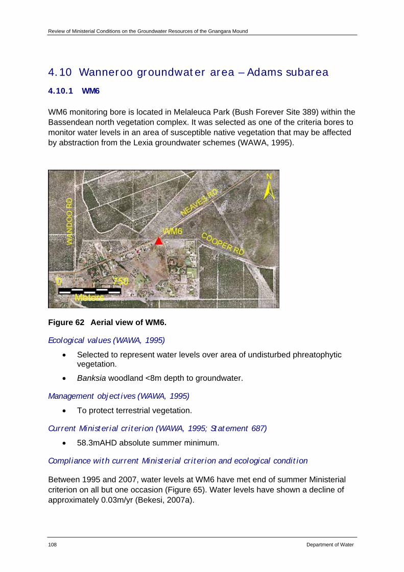
Review of Ministerial Conditions on the Groundwater Resources of the Gnangara Mound
108 Department of Water
4.10 Wanneroo groundwater area – Adams subarea
4.10.1 WM6
WM6 monitoring bore is located in Melaleuca Park (Bush Forever Site 389) within the Bassendean north vegetation complex. It was selected as one of the criteria bores to monitor water levels in an area of susceptible native vegetation that may be affected by abstraction from the Lexia groundwater schemes (WAWA, 1995).
Figure 62 Aerial view of WM6.
Ecological values (WAWA, 1995)
• Selected to represent water levels over area of undisturbed phreatophytic vegetation.
• Banksia woodland <8m depth to groundwater.
Management objectives (WAWA, 1995)
• To protect terrestrial vegetation.
Current Ministerial criterion (WAWA, 1995; Statement 687)
• 58.3mAHD absolute summer minimum.
Compliance with current Ministerial criterion and ecological condition
Between 1995 and 2007, water levels at WM6 have met end of summer Ministerial criterion on all but one occasion (Figure 65). Water levels have shown a decline of approximately 0.03m/yr (Bekesi, 2007a).
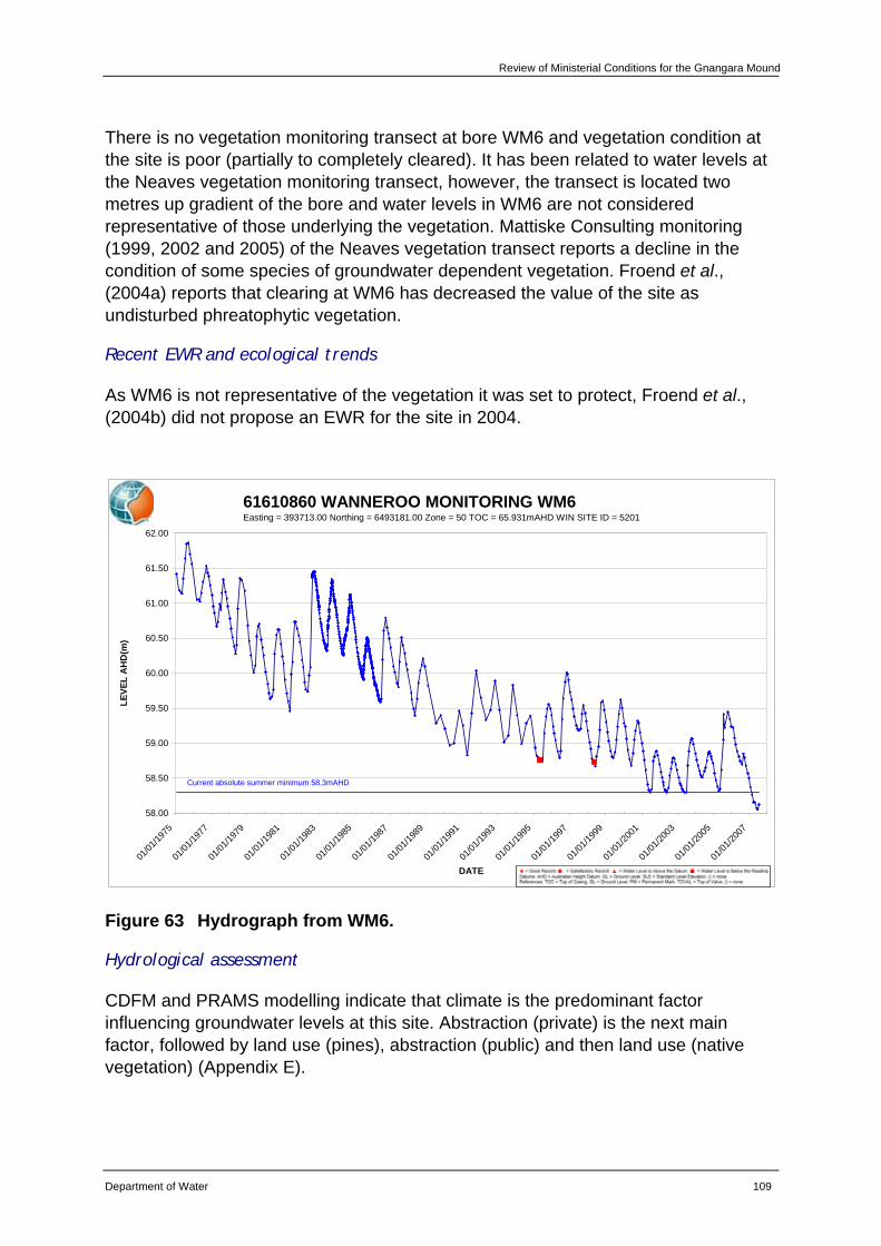
Review of Ministerial Conditions for the Gnangara Mound
Department of Water 109
There is no vegetation monitoring transect at bore WM6 and vegetation condition at the site is poor (partially to completely cleared). It has been related to water levels at the Neaves vegetation monitoring transect, however, the transect is located two metres up gradient of the bore and water levels in WM6 are not considered representative of those underlying the vegetation. Mattiske Consulting monitoring (1999, 2002 and 2005) of the Neaves vegetation transect reports a decline in the condition of some species of groundwater dependent vegetation. Froend et al., (2004a) reports that clearing at WM6 has decreased the value of the site as undisturbed phreatophytic vegetation.
Recent EWR and ecological trends
As WM6 is not representative of the vegetation it was set to protect, Froend et al., (2004b) did not propose an EWR for the site in 2004.
61610860 WANNEROO MONITORING WM6Easting = 393713.00 Northing = 6493181.00 Zone = 50 TOC = 65.931mAHD WIN SITE ID = 5201
58.00
58.50
59.00
59.50
60.00
60.50
61.00
61.50
62.00
01/01
/1975
01/01
/1977
01/01
/1979
01/01
/1981
01/01
/1983
01/01
/1985
01/01
/1987
01/01
/1989
01/01
/1991
01/01
/1993
01/01
/1995
01/01
/1997
01/01
/1999
01/01
/2001
01/01
/2003
01/01
/2005
01/01
/2007
DATE
LEVE
L A
HD
(m)
Current absolute summer minimum 58.3mAHD
Figure 63 Hydrograph from WM6.
Hydrological assessment
CDFM and PRAMS modelling indicate that climate is the predominant factor influencing groundwater levels at this site. Abstraction (private) is the next main factor, followed by land use (pines), abstraction (public) and then land use (native vegetation) (Appendix E).
Review of Ministerial Conditions on the Groundwater Resources of the Gnangara Mound
110 Department of Water
Recommendations
Due to the degree of clearing and associated decreased value of this site as undisturbed phreatophytic vegetation (Froend et al., 2004a), the department recommends that the EPA support the removal of WM6 as a Ministerial criteria site.
The department will continue to monitor groundwater levels to add to the long term data set that exists for this site. Information collected will provide important data for future hydrogeological assessments of groundwater levels across the Gnangara Mound.
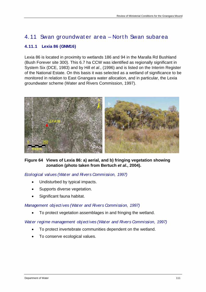
Review of Ministerial Conditions for the Gnangara Mound
Department of Water 111
4.11 Swan groundwater area – North Swan subarea
4.11.1 Lexia 86 (GNM16)
Lexia 86 is located in proximity to wetlands 186 and 94 in the Maralla Rd Bushland (Bush Forever site 300). This 6.7 ha CCW was identified as regionally significant in System Six (DCE, 1983) and by Hill et al., (1996) and is listed on the Interim Register of the National Estate. On this basis it was selected as a wetland of significance to be monitored in relation to East Gnangara water allocation, and in particular, the Lexia groundwater scheme (Water and Rivers Commission, 1997).
Figure 64 Views of Lexia 86: a) aerial, and b) fringing vegetation showing zonation (photo taken from Bertuch et al., 2004).
Ecological values (Water and Rivers Commission, 1997)
• Undisturbed by typical impacts.
• Supports diverse vegetation.
• Significant fauna habitat.
Management objectives (Water and Rivers Commission, 1997)
• To protect vegetation assemblages in and fringing the wetland.
Water regime management objectives (Water and Rivers Commission, 1997)
• To protect invertebrate communities dependent on the wetland.
• To conserve ecological values.
a b
Review of Ministerial Conditions on the Groundwater Resources of the Gnangara Mound
112 Department of Water
Current Ministerial criteria (Water and Rivers Commission, 1997; Statement 687)
• 47.0mAHD absolute summer minimum.
• 47.3mAHD preferred summer minimum.
• Water level only allowed between preferred and absolute min at a rate of 2 in every 6 years.
Compliance with current Ministerial criteria and ecological condition
Between 1997 and 2007, water levels at Lexia 86 have met end of summer Ministerial criteria on all occasions (Figure 70). Water levels have shown a decline of approximately 0.02m/yr (Bekesi, 2007a).
A decline in the condition of fringing vegetation has been recorded at Lexia 86. There is also evidence of terrestrialisation, with Baumea articulata contracting into the basin. Due to drying of sediments there is a risk of acidification. Vertebrate species have become less common and macroinvertebrate family richness has declined. There have been no clear impacts of falling water levels on frogs to date, however, fewer numbers have been found when peak water levels are low.
Recent EWR and ecological trends
Recent water levels at Lexia 86 have been above Froend et al., (2004b) recommended EWR for vegetation (Figure 65; Appendix C). The magnitude and rate of drawdown is within that required to maintain a low risk of impact to the vegetation at this site. However, this combined with depth to groundwater, historic water level changes and conservation values, predicts a significant level of response to drawdown (Appendix C). This is reflected by the continued decline in the condition of fringing vegetation and evidence of terrestrialisation.
Recent water levels have been below Froend et al., (2004b) recommended EWR for sediment processes (Figure 65; Appendix C). This is reflected by the continued drying of sediments in the wetland basin and risk of acidification.
Currently, levels have also been below Froend et al., (2004b) recommended EWR for vertebrates and macroinvertebrates (Figure 65; Appendix C). This has corresponded with declining macroinvertebrate family richness and fewer numbers of frogs when peak water levels are low.
Due to the lack of detailed hydrogeological knowledge of the Lexia wetlands (Department of Water, 2007), the department is developing a numerical local area groundwater flow model of the area as part of Stage Two of the SGS Investigation. Field analysis is due to commence in early 2008, and results will aid the department’s management of Lexia 86.
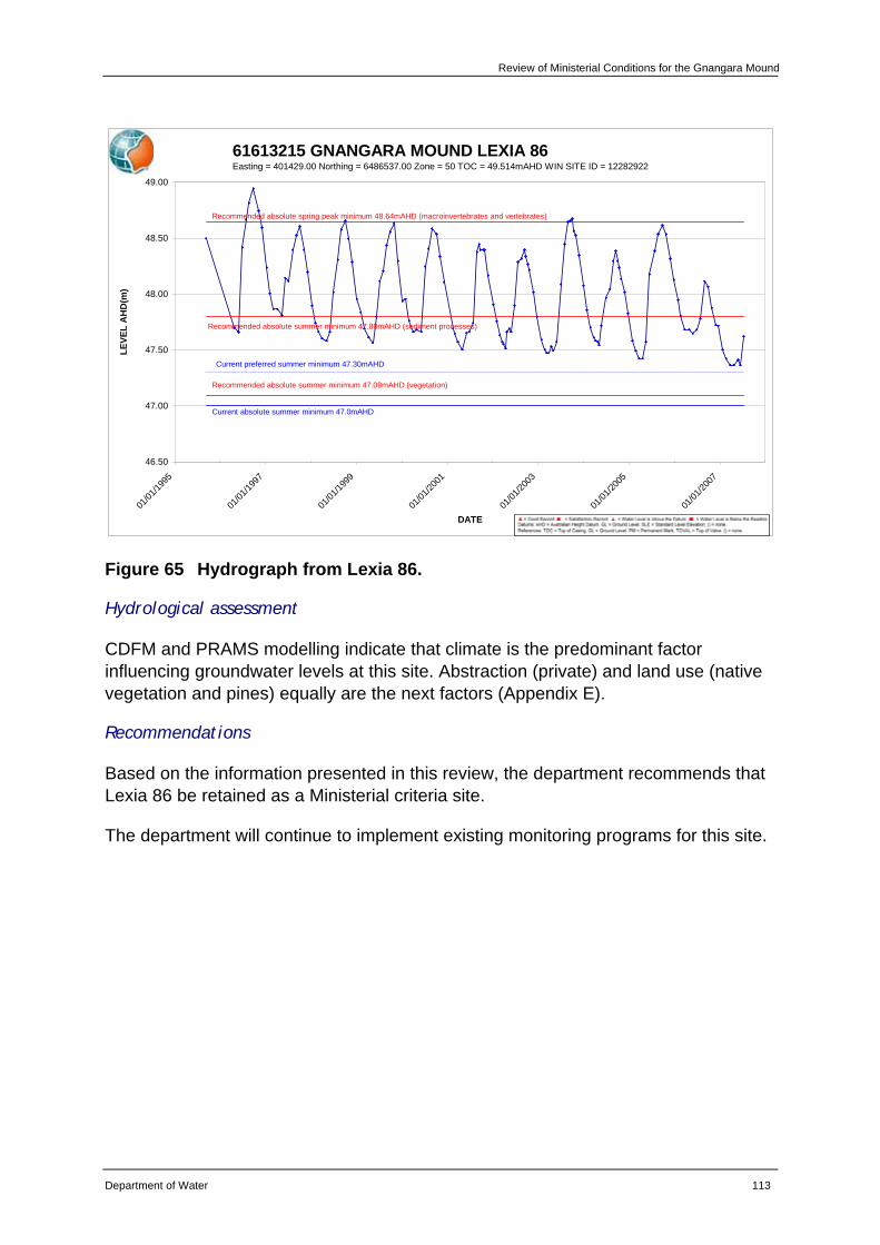
Review of Ministerial Conditions for the Gnangara Mound
Department of Water 113
61613215 GNANGARA MOUND LEXIA 86Easting = 401429.00 Northing = 6486537.00 Zone = 50 TOC = 49.514mAHD WIN SITE ID = 12282922
46.50
47.00
47.50
48.00
48.50
49.00
01/01
/1995
01/01
/1997
01/01
/1999
01/01
/2001
01/01
/2003
01/01
/2005
01/01
/2007
DATE
LEVE
L A
HD
(m)
Current absolute summer minimum 47.0mAHD
Current preferred summer minimum 47.30mAHD
Recommended absolute spring peak minimum 48.64mAHD (macroinvertebrates and vertebrates)
Recommended absolute summer minimum 47.09mAHD (vegetation)
Recommended absolute summer minimum 47.80mAHD (sediment processes)
Figure 65 Hydrograph from Lexia 86.
Hydrological assessment
CDFM and PRAMS modelling indicate that climate is the predominant factor influencing groundwater levels at this site. Abstraction (private) and land use (native vegetation and pines) equally are the next factors (Appendix E).
Recommendations
Based on the information presented in this review, the department recommends that Lexia 86 be retained as a Ministerial criteria site.
The department will continue to implement existing monitoring programs for this site.
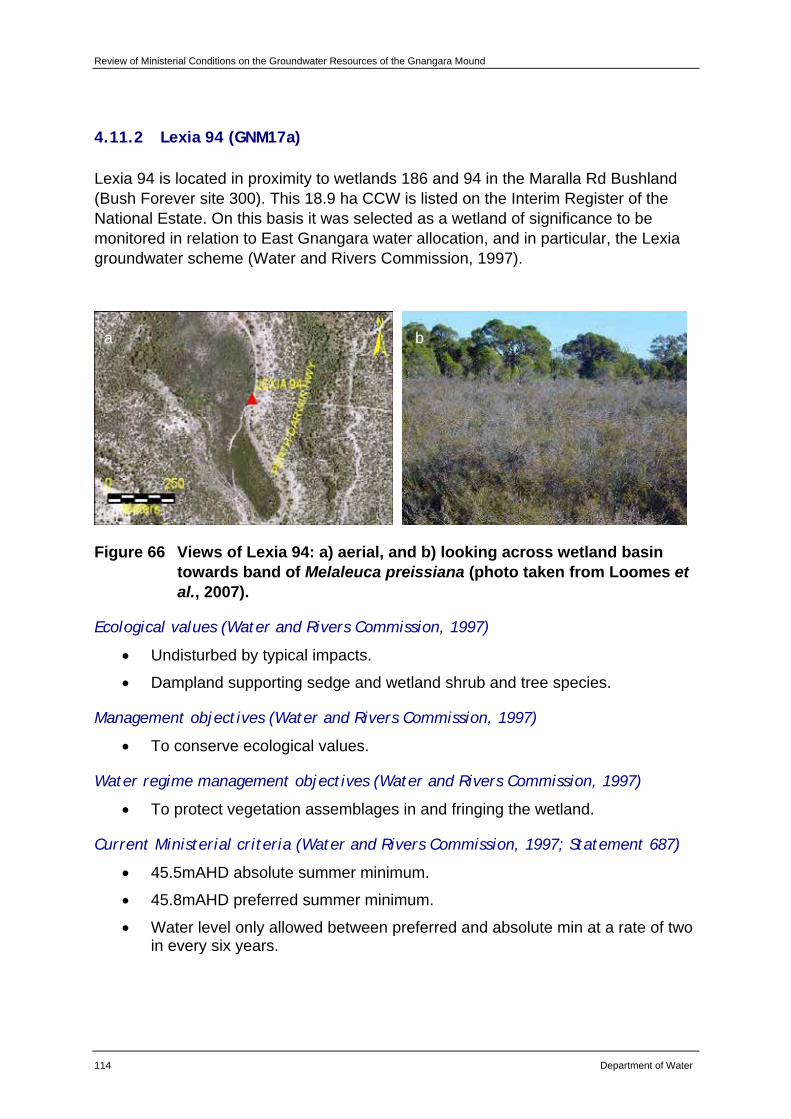
Review of Ministerial Conditions on the Groundwater Resources of the Gnangara Mound
114 Department of Water
4.11.2 Lexia 94 (GNM17a)
Lexia 94 is located in proximity to wetlands 186 and 94 in the Maralla Rd Bushland (Bush Forever site 300). This 18.9 ha CCW is listed on the Interim Register of the National Estate. On this basis it was selected as a wetland of significance to be monitored in relation to East Gnangara water allocation, and in particular, the Lexia groundwater scheme (Water and Rivers Commission, 1997).
Figure 66 Views of Lexia 94: a) aerial, and b) looking across wetland basin towards band of Melaleuca preissiana (photo taken from Loomes et al., 2007).
Ecological values (Water and Rivers Commission, 1997)
• Undisturbed by typical impacts.
• Dampland supporting sedge and wetland shrub and tree species.
Management objectives (Water and Rivers Commission, 1997)
• To conserve ecological values.
Water regime management objectives (Water and Rivers Commission, 1997)
• To protect vegetation assemblages in and fringing the wetland.
Current Ministerial criteria (Water and Rivers Commission, 1997; Statement 687)
• 45.5mAHD absolute summer minimum.
• 45.8mAHD preferred summer minimum.
• Water level only allowed between preferred and absolute min at a rate of two in every six years.
a b
Review of Ministerial Conditions for the Gnangara Mound
Department of Water 115
Compliance with current Ministerial criteria and ecological condition
Between 1997 and 2007, water levels at Lexia 94 have not met the end of summer two in six year Ministerial criteria since 2001 (Figure 67). Water levels have shown a decline of approximately 0.025m/yr (Bekesi, 2007a).
A decline in the condition of fringing vegetation species such as Melaleuca preissiana has been noted at Lexia 94. There is also evidence of terrestrialisation.
Macroinvertebrate species richness is declining and there is a risk of acidification with the sediment drying. Calling frog numbers have also been in decline.
Recent EWR and ecological trends
Recent minimum water levels at Lexia 94 have been above the Froend et al., (2004b) recommended EWR for vegetation (Figure 67; Appendix C). The magnitude and rate of drawdown is within that required to maintain a low risk of impact to the vegetation. However, this combined with depth to groundwater, historic water level changes and conservation values, represents a significant level of response to drawdown (Appendix C). This is reflected by the decline in condition of fringing vegetation.
Water levels have been below Froend et al., (2004b) recommended EWR for vertebrates for a number of years (Figure 67; Appendix C). This may be impacting on the decline in the numbers of calling frogs recorded.
The local area model developed for the Lexia wetlands as part of Stage Two of the SGS Investigation will aid the department’s management of Lexia 94.
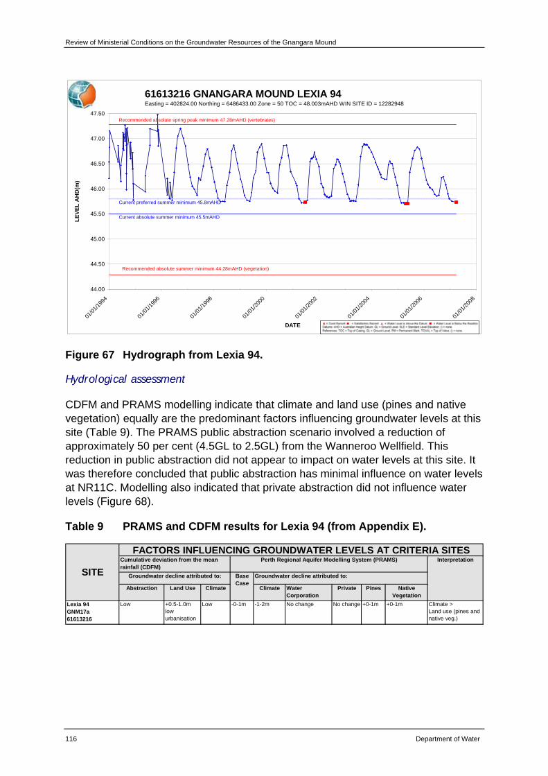
Review of Ministerial Conditions on the Groundwater Resources of the Gnangara Mound
116 Department of Water
61613216 GNANGARA MOUND LEXIA 94Easting = 402824.00 Northing = 6486433.00 Zone = 50 TOC = 48.003mAHD WIN SITE ID = 12282948
44.00
44.50
45.00
45.50
46.00
46.50
47.00
47.50
01/01
/1994
01/01
/1996
01/01
/1998
01/01
/2000
01/01
/2002
01/01
/2004
01/01
/2006
01/01
/2008
DATE
LEVE
L A
HD
(m)
Current absolute summer minimum 45.5mAHD
Current preferred summer minimum 45.8mAHD
Recommended absolute spring peak minimum 47.28mAHD (vertebrates)
Recommended absolute summer minimum 44.28mAHD (vegetation)
Figure 67 Hydrograph from Lexia 94.
Hydrological assessment
CDFM and PRAMS modelling indicate that climate and land use (pines and native vegetation) equally are the predominant factors influencing groundwater levels at this site (Table 9). The PRAMS public abstraction scenario involved a reduction of approximately 50 per cent (4.5GL to 2.5GL) from the Wanneroo Wellfield. This reduction in public abstraction did not appear to impact on water levels at this site. It was therefore concluded that public abstraction has minimal influence on water levels at NR11C. Modelling also indicated that private abstraction did not influence water levels (Figure 68).
Table 9 PRAMS and CDFM results for Lexia 94 (from Appendix E).
Abstraction Land Use Climate Climate Water Corporation
Private Pines Native Vegetation
Lexia 94GNM17a61613216
Low +0.5-1.0m low urbanisation
Low -0-1m -1-2m No change No change +0-1m +0-1m Climate >Land use (pines and native veg.)
FACTORS INFLUENCING GROUNDWATER LEVELS AT CRITERIA SITES
Groundwater decline attributed to: Base Case
Groundwater decline attributed to:
Perth Regional Aquifer Modelling System (PRAMS) Interpretation
SITECumulative deviation from the mean rainfall (CDFM)
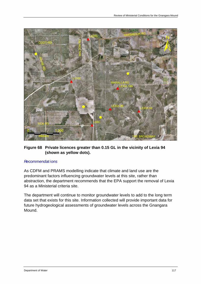
Review of Ministerial Conditions for the Gnangara Mound
Department of Water 117
Figure 68 Private licences greater than 0.15 GL in the vicinity of Lexia 94 (shown as yellow dots).
Recommendations
As CDFM and PRAMS modelling indicate that climate and land use are the predominant factors influencing groundwater levels at this site, rather than abstraction, the department recommends that the EPA support the removal of Lexia 94 as a Ministerial criteria site.
The department will continue to monitor groundwater levels to add to the long term data set that exists for this site. Information collected will provide important data for future hydrogeological assessments of groundwater levels across the Gnangara Mound.
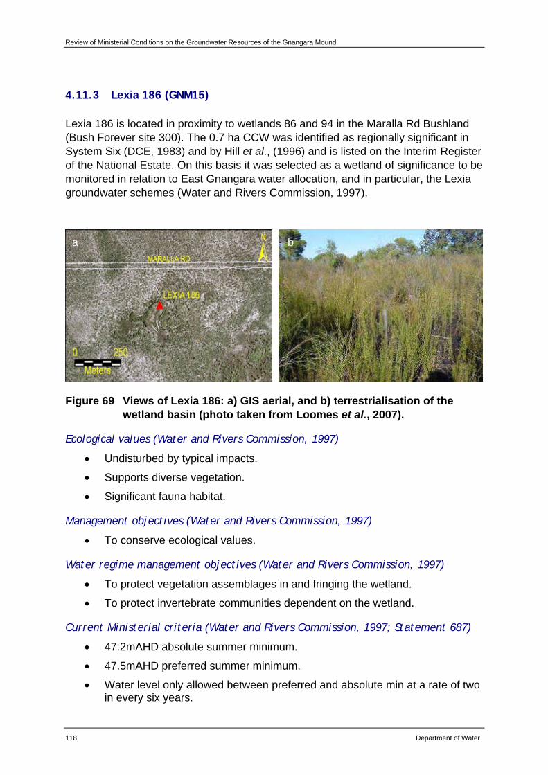
Review of Ministerial Conditions on the Groundwater Resources of the Gnangara Mound
118 Department of Water
4.11.3 Lexia 186 (GNM15)
Lexia 186 is located in proximity to wetlands 86 and 94 in the Maralla Rd Bushland (Bush Forever site 300). The 0.7 ha CCW was identified as regionally significant in System Six (DCE, 1983) and by Hill et al., (1996) and is listed on the Interim Register of the National Estate. On this basis it was selected as a wetland of significance to be monitored in relation to East Gnangara water allocation, and in particular, the Lexia groundwater schemes (Water and Rivers Commission, 1997).
Figure 69 Views of Lexia 186: a) GIS aerial, and b) terrestrialisation of the wetland basin (photo taken from Loomes et al., 2007).
Ecological values (Water and Rivers Commission, 1997)
• Undisturbed by typical impacts.
• Supports diverse vegetation.
• Significant fauna habitat.
Management objectives (Water and Rivers Commission, 1997)
• To conserve ecological values.
Water regime management objectives (Water and Rivers Commission, 1997)
• To protect vegetation assemblages in and fringing the wetland.
• To protect invertebrate communities dependent on the wetland.
Current Ministerial criteria (Water and Rivers Commission, 1997; Statement 687)
• 47.2mAHD absolute summer minimum.
• 47.5mAHD preferred summer minimum.
• Water level only allowed between preferred and absolute min at a rate of two in every six years.
a b
Review of Ministerial Conditions for the Gnangara Mound
Department of Water 119
Compliance with current Ministerial criteria and ecological condition
Between 1997 and 2007, water levels at Lexia 186 have not met end of summer two-in-six-year Ministerial criteria since 2000 (Figure 70). Water levels have shown a decline of approximately 0.025m/yr (Bekesi, 2007a).
There has been a decline in the condition of fringing vegetation species such as Melaleuca preissiana at Lexia 186. There is also evidence of some terrestrialisation with Baumea articulata contracting into the basin and declining in health.
A decline in macroinvertebrate species richness has coincided with a reduction in the area of surface water in the basin. There is a risk of acidification due to sediment drying. Calling frog numbers have also declined.
Recent EWR and ecological trends
Recent minimum water levels have been below the Froend et al., (2004b) recommended EWR for vegetation (Figure 70; Appendix C). The magnitude and rate of drawdown is within that required to maintain a low risk of impact to the vegetation at this site. However, this combined with depth to groundwater, historic water level changes and conservation values, predicts a significant level of response to drawdown (Appendix C). This is reflected by the decline in the condition of fringing vegetation.
Recent water levels have been below the Froend et al., (2004b) recommended EWR for sediment process (Figure 70; Appendix C). This is reflected by the continued drying of sediments in the wetland basin and risk of acidification.
Water levels have also been below the Froend et al., (2004b) recommended EWR for vertebrates (Figure 70; Appendix C). A decrease in the numbers of calling frogs is a possible indication of the impacts on vertebrates.
It should be noted that there is not a suitable staff gauge at Lexia 186 (Department of Water, 2007). A new staff gauge will be installed as part of Stage Two of the SGS Investigation, due in early 2008. Pending calibration and review of the EWP, the department may recommend updating the criterion staff gauge at this site. Results from the local area model of the Lexia wetlands will aid the department’s management of Lexia 186.
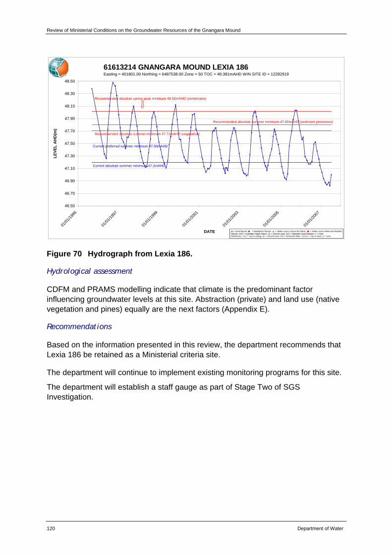
Review of Ministerial Conditions on the Groundwater Resources of the Gnangara Mound
120 Department of Water
61613214 GNANGARA MOUND LEXIA 186Easting = 401801.00 Northing = 6487538.00 Zone = 50 TOC = 49.381mAHD WIN SITE ID = 12282919
46.50
46.70
46.90
47.10
47.30
47.50
47.70
47.90
48.10
48.30
48.50
01/01
/1995
01/01
/1997
01/01
/1999
01/01
/2001
01/01
/2003
01/01
/2005
01/01
/2007
DATE
LEVE
L A
HD
(m)
Current absolute summer minimum 47.2mAHD
Current preferred summer minimum 47.50mAHD
Recommended absolute spring peak minimum 48.02mAHD (vertebrates)
Recommended absolute summer minimum 47.80mAHD (sediment processes)
Recommended absolute summer minimum 47.71mAHD (vegetation)
Figure 70 Hydrograph from Lexia 186.
Hydrological assessment
CDFM and PRAMS modelling indicate that climate is the predominant factor influencing groundwater levels at this site. Abstraction (private) and land use (native vegetation and pines) equally are the next factors (Appendix E).
Recommendations
Based on the information presented in this review, the department recommends that Lexia 186 be retained as a Ministerial criteria site.
The department will continue to implement existing monitoring programs for this site.
The department will establish a staff gauge as part of Stage Two of SGS Investigation.
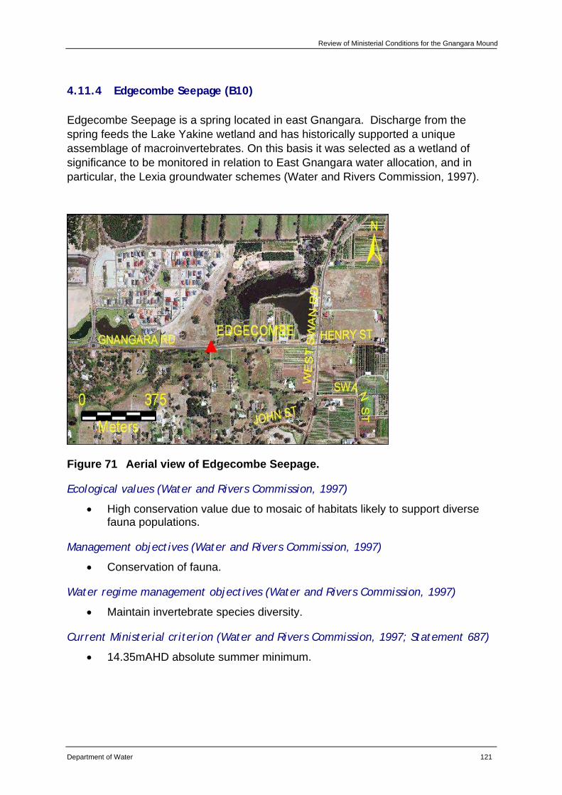
Review of Ministerial Conditions for the Gnangara Mound
Department of Water 121
4.11.4 Edgecombe Seepage (B10)
Edgecombe Seepage is a spring located in east Gnangara. Discharge from the spring feeds the Lake Yakine wetland and has historically supported a unique assemblage of macroinvertebrates. On this basis it was selected as a wetland of significance to be monitored in relation to East Gnangara water allocation, and in particular, the Lexia groundwater schemes (Water and Rivers Commission, 1997).
Figure 71 Aerial view of Edgecombe Seepage.
Ecological values (Water and Rivers Commission, 1997)
• High conservation value due to mosaic of habitats likely to support diverse fauna populations.
Management objectives (Water and Rivers Commission, 1997)
• Conservation of fauna.
Water regime management objectives (Water and Rivers Commission, 1997)
• Maintain invertebrate species diversity.
Current Ministerial criterion (Water and Rivers Commission, 1997; Statement 687)
• 14.35mAHD absolute summer minimum.
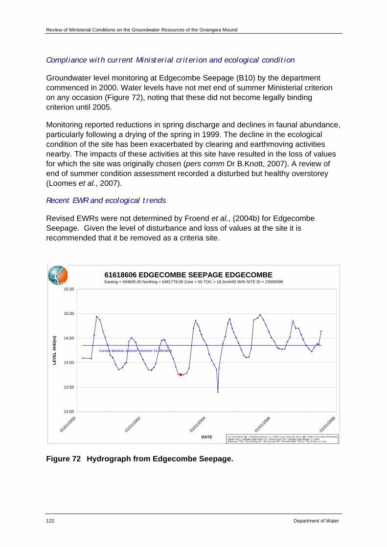
Review of Ministerial Conditions on the Groundwater Resources of the Gnangara Mound
122 Department of Water
Compliance with current Ministerial criterion and ecological condition
Groundwater level monitoring at Edgecombe Seepage (B10) by the department commenced in 2000. Water levels have not met end of summer Ministerial criterion on any occasion (Figure 72), noting that these did not become legally binding criterion until 2005.
Monitoring reported reductions in spring discharge and declines in faunal abundance, particularly following a drying of the spring in 1999. The decline in the ecological condition of the site has been exacerbated by clearing and earthmoving activities nearby. The impacts of these activities at this site have resulted in the loss of values for which the site was originally chosen (pers comm Dr B.Knott, 2007). A review of end of summer condition assessment recorded a disturbed but healthy overstorey (Loomes et al., 2007).
Recent EWR and ecological trends
Revised EWRs were not determined by Froend et al., (2004b) for Edgecombe Seepage. Given the level of disturbance and loss of values at the site it is recommended that it be removed as a criteria site.
61618606 EDGECOMBE SEEPAGE EDGECOMBEEasting = 404835.00 Northing = 6481778.00 Zone = 50 TOC = 18.3mAHD WIN SITE ID = 23000098
13.00
13.50
14.00
14.50
15.00
15.50
01/01
/2000
01/01
/2002
01/01
/2004
01/01
/2006
01/01
/2008
DATE
LEVE
L A
HD
(m)
Current absolute summer minimum 14.35mAHD
Figure 72 Hydrograph from Edgecombe Seepage.
Review of Ministerial Conditions for the Gnangara Mound
Department of Water 123
Hydrological assessment
PRAMS modelling indicate that climate is the predominant factor influencing groundwater levels at this site followed by abstraction (private) (Appendix E).
Recommendations
Given the high level of disturbance and loss of values due to clearing and earthmoving activities at this site as identified by Froend et al., (2004b), the department recommends that the EPA supports the removal of Edgecombe Seepage as a Ministerial criteria site.
The department will continue to monitor groundwater levels to add to the long term data set that exists for this site. Information collected will provide important data for future hydrogeological assessments of groundwater levels across the Gnangara Mound.
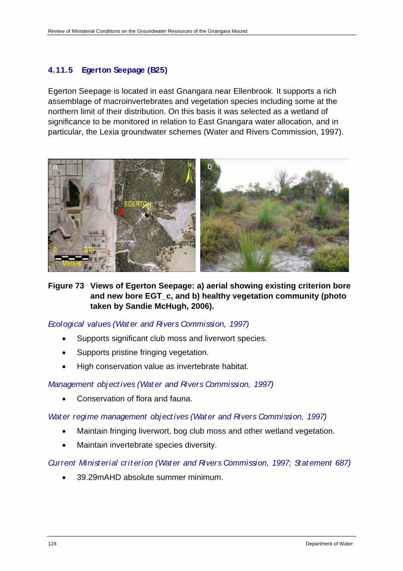
Review of Ministerial Conditions on the Groundwater Resources of the Gnangara Mound
124 Department of Water
4.11.5 Egerton Seepage (B25)
Egerton Seepage is located in east Gnangara near Ellenbrook. It supports a rich assemblage of macroinvertebrates and vegetation species including some at the northern limit of their distribution. On this basis it was selected as a wetland of significance to be monitored in relation to East Gnangara water allocation, and in particular, the Lexia groundwater schemes (Water and Rivers Commission, 1997).
Figure 73 Views of Egerton Seepage: a) aerial showing existing criterion bore and new bore EGT_c, and b) healthy vegetation community (photo taken by Sandie McHugh, 2006).
Ecological values (Water and Rivers Commission, 1997)
• Supports significant club moss and liverwort species.
• Supports pristine fringing vegetation.
• High conservation value as invertebrate habitat.
Management objectives (Water and Rivers Commission, 1997)
• Conservation of flora and fauna.
Water regime management objectives (Water and Rivers Commission, 1997)
• Maintain fringing liverwort, bog club moss and other wetland vegetation.
• Maintain invertebrate species diversity.
Current Ministerial criterion (Water and Rivers Commission, 1997; Statement 687)
• 39.29mAHD absolute summer minimum.
a b
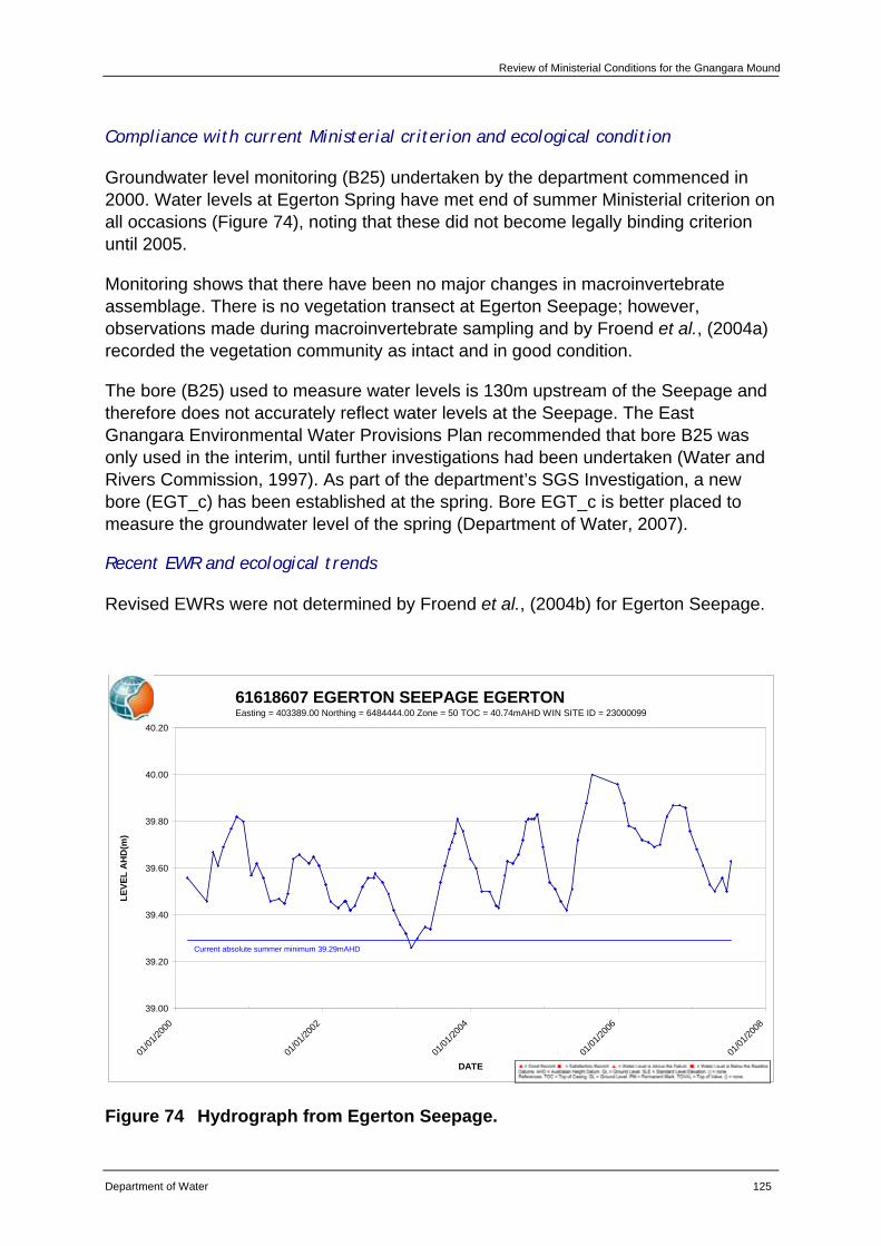
Review of Ministerial Conditions for the Gnangara Mound
Department of Water 125
Compliance with current Ministerial criterion and ecological condition
Groundwater level monitoring (B25) undertaken by the department commenced in 2000. Water levels at Egerton Spring have met end of summer Ministerial criterion on all occasions (Figure 74), noting that these did not become legally binding criterion until 2005.
Monitoring shows that there have been no major changes in macroinvertebrate assemblage. There is no vegetation transect at Egerton Seepage; however, observations made during macroinvertebrate sampling and by Froend et al., (2004a) recorded the vegetation community as intact and in good condition.
The bore (B25) used to measure water levels is 130m upstream of the Seepage and therefore does not accurately reflect water levels at the Seepage. The East Gnangara Environmental Water Provisions Plan recommended that bore B25 was only used in the interim, until further investigations had been undertaken (Water and Rivers Commission, 1997). As part of the department’s SGS Investigation, a new bore (EGT_c) has been established at the spring. Bore EGT_c is better placed to measure the groundwater level of the spring (Department of Water, 2007).
Recent EWR and ecological trends
Revised EWRs were not determined by Froend et al., (2004b) for Egerton Seepage.
61618607 EGERTON SEEPAGE EGERTONEasting = 403389.00 Northing = 6484444.00 Zone = 50 TOC = 40.74mAHD WIN SITE ID = 23000099
39.00
39.20
39.40
39.60
39.80
40.00
40.20
01/01
/2000
01/01
/2002
01/01
/2004
01/01
/2006
01/01
/2008
DATE
LEVE
L A
HD
(m)
Current absolute summer minimum 39.29mAHD
Figure 74 Hydrograph from Egerton Seepage.
Review of Ministerial Conditions on the Groundwater Resources of the Gnangara Mound
126 Department of Water
Hydrological assessment
PRAMS modelling indicate that climate is the predominant factor influencing groundwater levels at this site. Abstraction (private) and land use (native vegetation and pines) equally are the next factors (Appendix E).
Recommendations
Based on the information presented in this review, the department recommends that Egerton Seepage be retained as a Ministerial criteria site.
The department will continue to implement existing monitoring programs for this site.
The department recommends that the EPA support that Ministerial criterion is assessed against water levels from bore EGT_c rather than the existing bore B25 (61618607) following the review outlined below:
• EGT_c is currently being monitored. On completion of twelve months monitoring, a review of the water levels in EGT_c and the current criterion bore (61618607) will be conducted to calibrate EGT_c.
• A review of the existing EWP will be conducted and if necessary and appropriate, the EWP will be transferred to be measured at EGT_c.
• The department will summarise the information reviewed and formally request an amendment to the EPA.
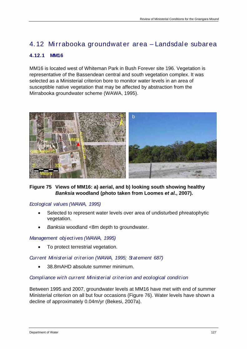
Review of Ministerial Conditions for the Gnangara Mound
Department of Water 127
4.12 Mirrabooka groundwater area – Landsdale subarea
4.12.1 MM16
MM16 is located west of Whiteman Park in Bush Forever site 196. Vegetation is representative of the Bassendean central and south vegetation complex. It was selected as a Ministerial criterion bore to monitor water levels in an area of susceptible native vegetation that may be affected by abstraction from the Mirrabooka groundwater scheme (WAWA, 1995).
Figure 75 Views of MM16: a) aerial, and b) looking south showing healthy Banksia woodland (photo taken from Loomes et al., 2007).
Ecological values (WAWA, 1995)
• Selected to represent water levels over area of undisturbed phreatophytic vegetation.
• Banksia woodland <8m depth to groundwater.
Management objectives (WAWA, 1995)
• To protect terrestrial vegetation.
Current Ministerial criterion (WAWA, 1995; Statement 687)
• 38.8mAHD absolute summer minimum.
Compliance with current Ministerial criterion and ecological condition
Between 1995 and 2007, groundwater levels at MM16 have met with end of summer Ministerial criterion on all but four occasions (Figure 76). Water levels have shown a decline of approximately 0.04m/yr (Bekesi, 2007a).
a b

Review of Ministerial Conditions on the Groundwater Resources of the Gnangara Mound
128 Department of Water
There is no vegetation monitoring transect at bore MM16. Monitoring undertaken nearby by CSIRO (2001) reported no change in the condition and density of groundwater dependent vegetation between 1988 and 2000. However, end of summer condition assessments by Loomes et al., (2003 and 2007) recorded trends at this site consistent with those observed at terrestrial vegetation sites across the mound. These trends have included deaths of Banksia attenuata, Banksia menziesii and Banksia ilicifolia as well as some loss and/or severe stress in Eucalyptus todtiana and Corymbia calophylla.
Recent EWR and ecological trends
Recent minimum water levels at MM16 have been above the Froend et al., (2004b) recommended EWR for vegetation (Figure 76; Appendix C). However, the magnitude and rate of drawdown exceeds that required to maintain a low risk of impact to vegetation at this site. This combined with depth to groundwater, historic water level changes and conservation values, predicts a moderate level of response to drawdown (Appendix C). This has been reflected by the continued declining trends in vegetation condition and density.
61610835 MIRRABOOKA MONITORING MM16Easting = 393515.00 Northing = 6480780.00 Zone = 50 TOC = 44.46mAHD WIN SITE ID = 5176
37.50
38.00
38.50
39.00
39.50
40.00
40.50
41.00
41.50
42.00
42.50
01/01
/1973
01/01
/1975
01/01
/1977
01/01
/1979
01/01
/1981
01/01
/1983
01/01
/1985
01/01
/1987
01/01
/1989
01/01
/1991
01/01
/1993
01/01
/1995
01/01
/1997
01/01
/1999
01/01
/2001
01/01
/2003
01/01
/2005
01/01
/2007
DATE
LEVE
L A
HD
(m)
Recommended absolute summer minimum 37.8mAHD
Current absolute summer minimum 38.8mAHD
Figure 76 Hydrograph from MM16.
Review of Ministerial Conditions for the Gnangara Mound
Department of Water 129
Hydrological assessment
CDFM and PRAMS modelling indicate that climate is the predominant factor influencing groundwater levels at this site. Abstraction (public and private) is the next main factor, followed by land use (pines) (Appendix E).
Recommendations
Based on the information presented in this review, the department recommends that MM16 be retained as a Ministerial criteria site.
The department will continue to implement existing monitoring programs for this site.
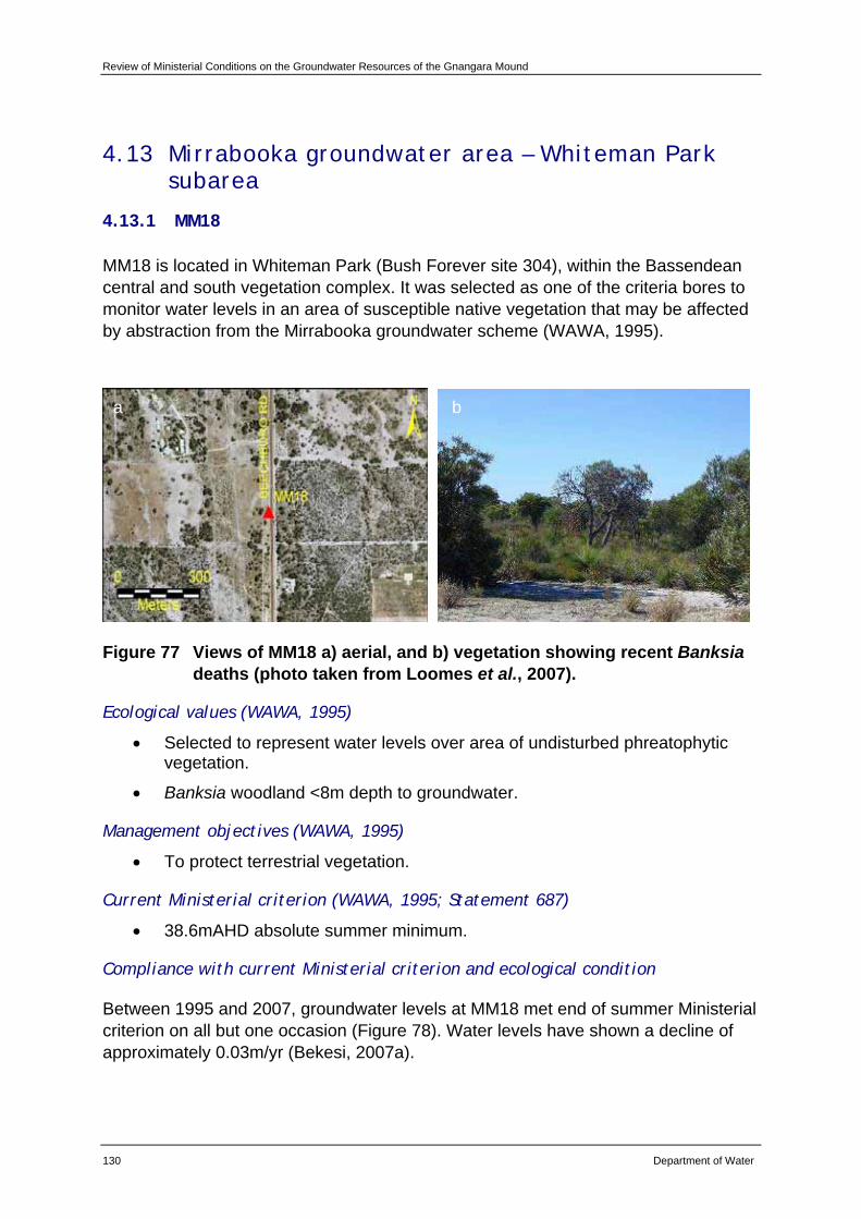
Review of Ministerial Conditions on the Groundwater Resources of the Gnangara Mound
130 Department of Water
4.13 Mirrabooka groundwater area – Whiteman Park subarea
4.13.1 MM18
MM18 is located in Whiteman Park (Bush Forever site 304), within the Bassendean central and south vegetation complex. It was selected as one of the criteria bores to monitor water levels in an area of susceptible native vegetation that may be affected by abstraction from the Mirrabooka groundwater scheme (WAWA, 1995).
Figure 77 Views of MM18 a) aerial, and b) vegetation showing recent Banksia deaths (photo taken from Loomes et al., 2007).
Ecological values (WAWA, 1995)
• Selected to represent water levels over area of undisturbed phreatophytic vegetation.
• Banksia woodland <8m depth to groundwater.
Management objectives (WAWA, 1995)
• To protect terrestrial vegetation.
Current Ministerial criterion (WAWA, 1995; Statement 687)
• 38.6mAHD absolute summer minimum.
Compliance with current Ministerial criterion and ecological condition
Between 1995 and 2007, groundwater levels at MM18 met end of summer Ministerial criterion on all but one occasion (Figure 78). Water levels have shown a decline of approximately 0.03m/yr (Bekesi, 2007a).
a b
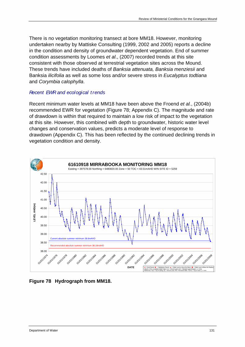
Review of Ministerial Conditions for the Gnangara Mound
Department of Water 131
There is no vegetation monitoring transect at bore MM18. However, monitoring undertaken nearby by Mattiske Consulting (1999, 2002 and 2005) reports a decline in the condition and density of groundwater dependent vegetation. End of summer condition assessments by Loomes et al., (2007) recorded trends at this site consistent with those observed at terrestrial vegetation sites across the Mound. These trends have included deaths of Banksia attenuata, Banksia menziesii and Banksia ilicifolia as well as some loss and/or severe stress in Eucalyptus todtiana and Corymbia calophylla.
Recent EWR and ecological trends
Recent minimum water levels at MM18 have been above the Froend et al., (2004b) recommended EWR for vegetation (Figure 78; Appendix C). The magnitude and rate of drawdown is within that required to maintain a low risk of impact to the vegetation at this site. However, this combined with depth to groundwater, historic water level changes and conservation values, predicts a moderate level of response to drawdown (Appendix C). This has been reflected by the continued declining trends in vegetation condition and density.
61610918 MIRRABOOKA MONITORING MM18Easting = 397578.00 Northing = 6480820.00 Zone = 50 TOC = 43.51mAHD WIN SITE ID = 5259
38.00
38.50
39.00
39.50
40.00
40.50
41.00
41.50
42.00
42.50
01/01
/1974
01/01
/1976
01/01
/1978
01/01
/1980
01/01
/1982
01/01
/1984
01/01
/1986
01/01
/1988
01/01
/1990
01/01
/1992
01/01
/1994
01/01
/1996
01/01
/1998
01/01
/2000
01/01
/2002
01/01
/2004
01/01
/2006
01/01
/2008
DATE
LEVE
L A
HD
(m)
Current absolute summer minimum 38.6mAHD
Recommended absolute summer minimum 38.18mAHD
Figure 78 Hydrograph from MM18.
Review of Ministerial Conditions on the Groundwater Resources of the Gnangara Mound
132 Department of Water
Hydrological assessment
CDFM and PRAMS modelling indicate that climate is the predominant factor influencing groundwater levels at this site, followed by abstraction (public) (Appendix E).
Recommendations
Based on the information presented in this review, the department recommends that MM18 be retained as a Ministerial criteria site.
The department will continue to implement existing monitoring programs for this site.
The department will include monitoring the vegetation at MM18 in future end of summer condition assessments.
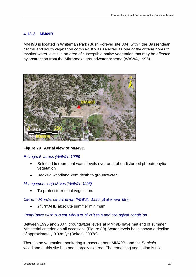
Review of Ministerial Conditions for the Gnangara Mound
Department of Water 133
4.13.2 MM49B
MM49B is located in Whiteman Park (Bush Forever site 304) within the Bassendean central and south vegetation complex. It was selected as one of the criteria bores to monitor water levels in an area of susceptible native vegetation that may be affected by abstraction from the Mirrabooka groundwater scheme (WAWA, 1995).
Figure 79 Aerial view of MM49B.
Ecological values (WAWA, 1995)
• Selected to represent water levels over area of undisturbed phreatophytic vegetation.
• Banksia woodland <8m depth to groundwater.
Management objectives (WAWA, 1995)
• To protect terrestrial vegetation.
Current Ministerial criterion (WAWA, 1995; Statement 687)
• 24.7mAHD absolute summer minimum.
Compliance with current Ministerial criteria and ecological condition
Between 1995 and 2007, groundwater levels at MM49B have met end of summer Ministerial criterion on all occasions (Figure 80). Water levels have shown a decline of approximately 0.03m/yr (Bekesi, 2007a).
There is no vegetation monitoring transect at bore MM49B, and the Banksia woodland at this site has been largely cleared. The remaining vegetation is not
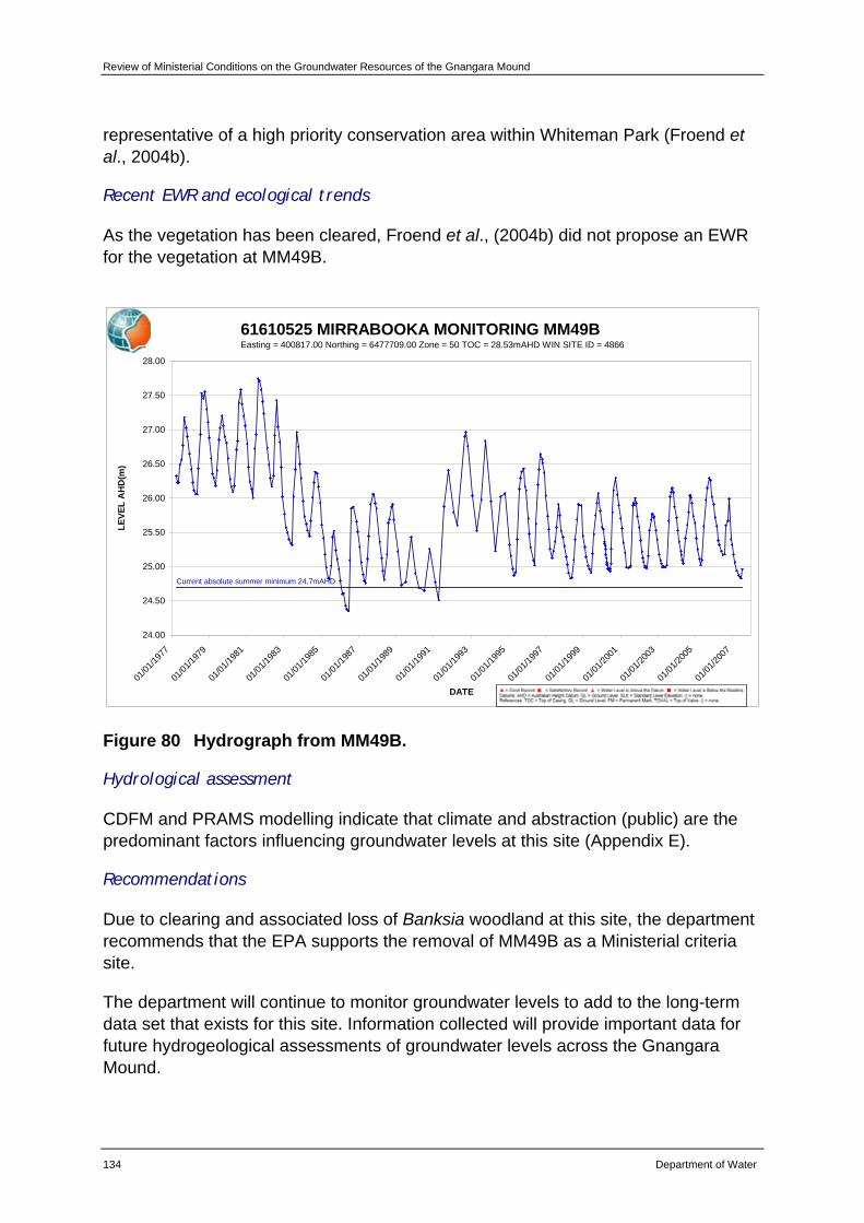
Review of Ministerial Conditions on the Groundwater Resources of the Gnangara Mound
134 Department of Water
representative of a high priority conservation area within Whiteman Park (Froend et al., 2004b).
Recent EWR and ecological trends
As the vegetation has been cleared, Froend et al., (2004b) did not propose an EWR for the vegetation at MM49B.
61610525 MIRRABOOKA MONITORING MM49BEasting = 400817.00 Northing = 6477709.00 Zone = 50 TOC = 28.53mAHD WIN SITE ID = 4866
24.00
24.50
25.00
25.50
26.00
26.50
27.00
27.50
28.00
01/01
/1977
01/01
/1979
01/01
/1981
01/01
/1983
01/01
/1985
01/01
/1987
01/01
/1989
01/01
/1991
01/01
/1993
01/01
/1995
01/01
/1997
01/01
/1999
01/01
/2001
01/01
/2003
01/01
/2005
01/01
/2007
DATE
LEVE
L A
HD
(m)
Current absolute summer minimum 24.7mAHD
Figure 80 Hydrograph from MM49B.
Hydrological assessment
CDFM and PRAMS modelling indicate that climate and abstraction (public) are the predominant factors influencing groundwater levels at this site (Appendix E).
Recommendations
Due to clearing and associated loss of Banksia woodland at this site, the department recommends that the EPA supports the removal of MM49B as a Ministerial criteria site.
The department will continue to monitor groundwater levels to add to the long-term data set that exists for this site. Information collected will provide important data for future hydrogeological assessments of groundwater levels across the Gnangara Mound.
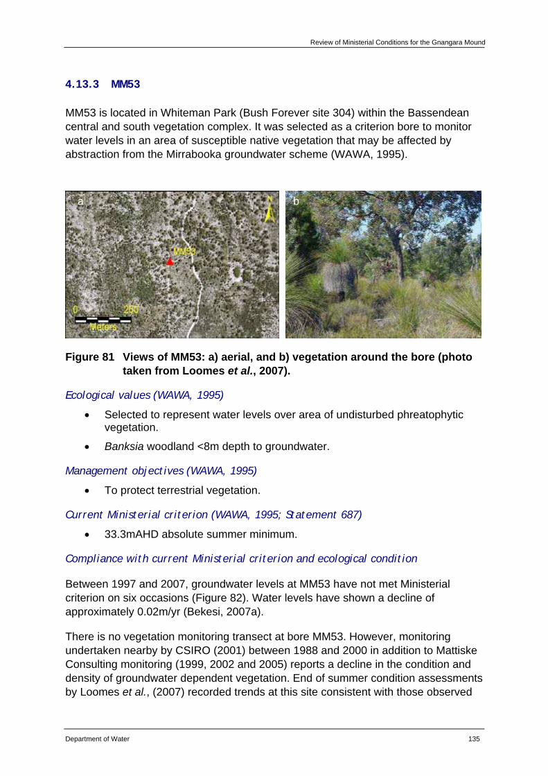
Review of Ministerial Conditions for the Gnangara Mound
Department of Water 135
4.13.3 MM53
MM53 is located in Whiteman Park (Bush Forever site 304) within the Bassendean central and south vegetation complex. It was selected as a criterion bore to monitor water levels in an area of susceptible native vegetation that may be affected by abstraction from the Mirrabooka groundwater scheme (WAWA, 1995).
Figure 81 Views of MM53: a) aerial, and b) vegetation around the bore (photo taken from Loomes et al., 2007).
Ecological values (WAWA, 1995)
• Selected to represent water levels over area of undisturbed phreatophytic vegetation.
• Banksia woodland <8m depth to groundwater.
Management objectives (WAWA, 1995)
• To protect terrestrial vegetation.
Current Ministerial criterion (WAWA, 1995; Statement 687)
• 33.3mAHD absolute summer minimum.
Compliance with current Ministerial criterion and ecological condition
Between 1997 and 2007, groundwater levels at MM53 have not met Ministerial criterion on six occasions (Figure 82). Water levels have shown a decline of approximately 0.02m/yr (Bekesi, 2007a).
There is no vegetation monitoring transect at bore MM53. However, monitoring undertaken nearby by CSIRO (2001) between 1988 and 2000 in addition to Mattiske Consulting monitoring (1999, 2002 and 2005) reports a decline in the condition and density of groundwater dependent vegetation. End of summer condition assessments by Loomes et al., (2007) recorded trends at this site consistent with those observed
a b
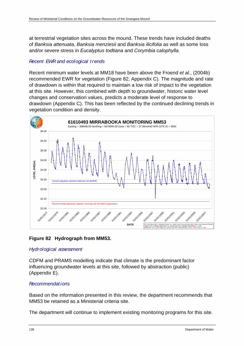
Review of Ministerial Conditions on the Groundwater Resources of the Gnangara Mound
136 Department of Water
at terrestrial vegetation sites across the mound. These trends have included deaths of Banksia attenuata, Banksia menziesii and Banksia ilicifolia as well as some loss and/or severe stress in Eucalyptus todtiana and Corymbia calophylla.
Recent EWR and ecological trends
Recent minimum water levels at MM18 have been above the Froend et al., (2004b) recommended EWR for vegetation (Figure 82; Appendix C). The magnitude and rate of drawdown is within that required to maintain a low risk of impact to the vegetation at this site. However, this combined with depth to groundwater, historic water level changes and conservation values, predicts a moderate level of response to drawdown (Appendix C). This has been reflected by the continued declining trends in vegetation condition and density.
61610493 MIRRABOOKA MONITORING MM53Easting = 398946.00 Northing = 6479044.00 Zone = 50 TOC = 37.06mAHD WIN SITE ID = 4834
32.00
32.50
33.00
33.50
34.00
34.50
35.00
35.50
36.00
01/01
/1977
01/01
/1979
01/01
/1981
01/01
/1983
01/01
/1985
01/01
/1987
01/01
/1989
01/01
/1991
01/01
/1993
01/01
/1995
01/01
/1997
01/01
/1999
01/01
/2001
01/01
/2003
01/01
/2005
01/01
/2007
DATE
LEVE
L A
HD
(m)
Current absolute summer minimum 33.3mAHD
Recommended absolute summer minimum 32.37mAHD (vegetation)
Figure 82 Hydrograph from MM53.
Hydrological assessment
CDFM and PRAMS modelling indicate that climate is the predominant factor influencing groundwater levels at this site, followed by abstraction (public) (Appendix E).
Recommendations
Based on the information presented in this review, the department recommends that MM53 be retained as a Ministerial criteria site.
The department will continue to implement existing monitoring programs for this site.
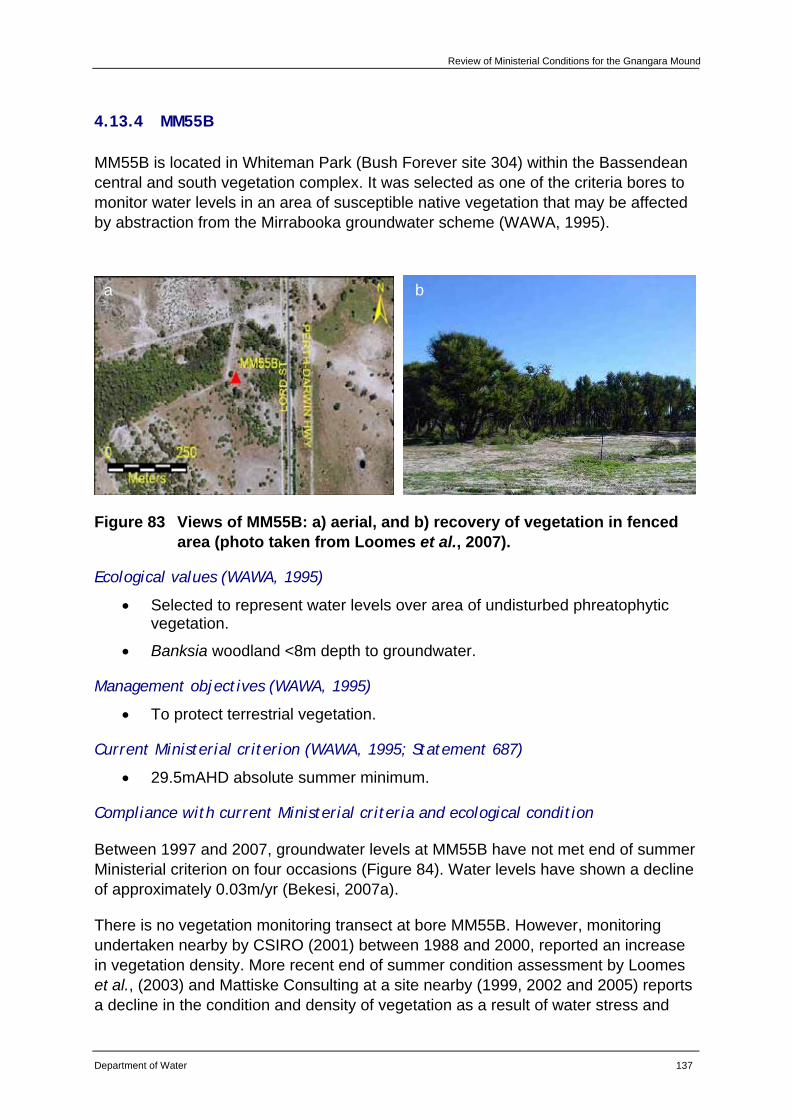
Review of Ministerial Conditions for the Gnangara Mound
Department of Water 137
4.13.4 MM55B
MM55B is located in Whiteman Park (Bush Forever site 304) within the Bassendean central and south vegetation complex. It was selected as one of the criteria bores to monitor water levels in an area of susceptible native vegetation that may be affected by abstraction from the Mirrabooka groundwater scheme (WAWA, 1995).
Figure 83 Views of MM55B: a) aerial, and b) recovery of vegetation in fenced area (photo taken from Loomes et al., 2007).
Ecological values (WAWA, 1995)
• Selected to represent water levels over area of undisturbed phreatophytic vegetation.
• Banksia woodland <8m depth to groundwater.
Management objectives (WAWA, 1995)
• To protect terrestrial vegetation.
Current Ministerial criterion (WAWA, 1995; Statement 687)
• 29.5mAHD absolute summer minimum.
Compliance with current Ministerial criteria and ecological condition
Between 1997 and 2007, groundwater levels at MM55B have not met end of summer Ministerial criterion on four occasions (Figure 84). Water levels have shown a decline of approximately 0.03m/yr (Bekesi, 2007a).
There is no vegetation monitoring transect at bore MM55B. However, monitoring undertaken nearby by CSIRO (2001) between 1988 and 2000, reported an increase in vegetation density. More recent end of summer condition assessment by Loomes et al., (2003) and Mattiske Consulting at a site nearby (1999, 2002 and 2005) reports a decline in the condition and density of vegetation as a result of water stress and
a b
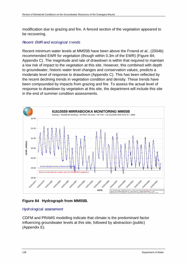
Review of Ministerial Conditions on the Groundwater Resources of the Gnangara Mound
138 Department of Water
modification due to grazing and fire. A fenced section of the vegetation appeared to be recovering.
Recent EWR and ecological trends
Recent minimum water levels at MM55B have been above the Froend et al., (2004b) recommended EWR for vegetation (though within 0.3m of the EWR) (Figure 84; Appendix C). The magnitude and rate of drawdown is within that required to maintain a low risk of impact to the vegetation at this site. However, this combined with depth to groundwater, historic water level changes and conservation values, predicts a moderate level of response to drawdown (Appendix C). This has been reflected by the recent declining trends in vegetation condition and density. These trends have been compounded by impacts from grazing and fire. To assess the actual level of response to drawdown by vegetation at this site, the department will include this site in the end of summer condition assessments.
61610559 MIRRABOOKA MONITORING MM55BEasting = 401638.00 Northing = 6479017.00 Zone = 50 TOC = 32.31mAHD WIN SITE ID = 4900
29.00
29.50
30.00
30.50
31.00
31.50
32.00
01/01
/1977
01/01
/1979
01/01
/1981
01/01
/1983
01/01
/1985
01/01
/1987
01/01
/1989
01/01
/1991
01/01
/1993
01/01
/1995
01/01
/1997
01/01
/1999
01/01
/2001
01/01
/2003
01/01
/2005
01/01
/2007
DATE
LEVE
L A
HD
(m)
Recommended absolute summer minimum 29.38mAHD (vegetation)
Current absolute summer minimum 29.50mAHD
Figure 84 Hydrograph from MM55B.
Hydrological assessment
CDFM and PRAMS modelling indicate that climate is the predominant factor influencing groundwater levels at this site, followed by abstraction (public) (Appendix E).

Review of Ministerial Conditions for the Gnangara Mound
Department of Water 139
Recommendations
Based on the information presented in this review, the department recommends that MM55B be retained as a Ministerial criteria site.
The department will continue to implement existing monitoring programs for this site.
The department will include monitoring the vegetation at MM55B in future end of summer condition assessments.
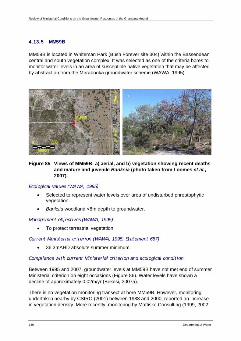
Review of Ministerial Conditions on the Groundwater Resources of the Gnangara Mound
140 Department of Water
4.13.5 MM59B
MM59B is located in Whiteman Park (Bush Forever site 304) within the Bassendean central and south vegetation complex. It was selected as one of the criteria bores to monitor water levels in an area of susceptible native vegetation that may be affected by abstraction from the Mirrabooka groundwater scheme (WAWA, 1995).
Figure 85 Views of MM59B: a) aerial, and b) vegetation showing recent deaths and mature and juvenile Banksia (photo taken from Loomes et al., 2007).
Ecological values (WAWA, 1995)
• Selected to represent water levels over area of undisturbed phreatophytic vegetation.
• Banksia woodland <8m depth to groundwater.
Management objectives (WAWA, 1995)
• To protect terrestrial vegetation.
Current Ministerial criterion (WAWA, 1995; Statement 687)
• 36.3mAHD absolute summer minimum.
Compliance with current Ministerial criterion and ecological condition
Between 1995 and 2007, groundwater levels at MM59B have not met end of summer Ministerial criterion on eight occasions (Figure 86). Water levels have shown a decline of approximately 0.02m/yr (Bekesi, 2007a).
There is no vegetation monitoring transect at bore MM59B. However, monitoring undertaken nearby by CSIRO (2001) between 1988 and 2000, reported an increase in vegetation density. More recently, monitoring by Mattiske Consulting (1999, 2002
a b
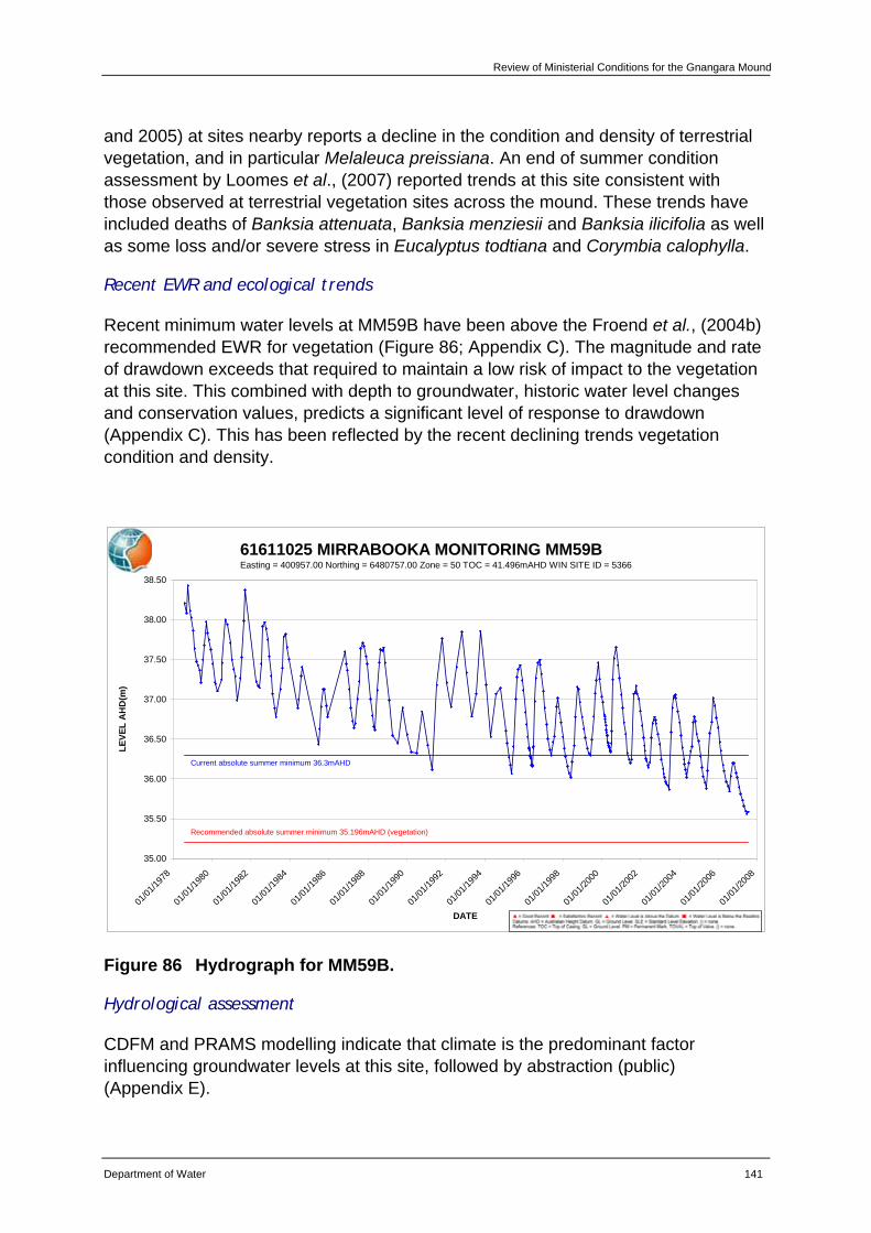
Review of Ministerial Conditions for the Gnangara Mound
Department of Water 141
and 2005) at sites nearby reports a decline in the condition and density of terrestrial vegetation, and in particular Melaleuca preissiana. An end of summer condition assessment by Loomes et al., (2007) reported trends at this site consistent with those observed at terrestrial vegetation sites across the mound. These trends have included deaths of Banksia attenuata, Banksia menziesii and Banksia ilicifolia as well as some loss and/or severe stress in Eucalyptus todtiana and Corymbia calophylla.
Recent EWR and ecological trends
Recent minimum water levels at MM59B have been above the Froend et al., (2004b) recommended EWR for vegetation (Figure 86; Appendix C). The magnitude and rate of drawdown exceeds that required to maintain a low risk of impact to the vegetation at this site. This combined with depth to groundwater, historic water level changes and conservation values, predicts a significant level of response to drawdown (Appendix C). This has been reflected by the recent declining trends vegetation condition and density.
61611025 MIRRABOOKA MONITORING MM59BEasting = 400957.00 Northing = 6480757.00 Zone = 50 TOC = 41.496mAHD WIN SITE ID = 5366
35.00
35.50
36.00
36.50
37.00
37.50
38.00
38.50
01/01
/1978
01/01
/1980
01/01
/1982
01/01
/1984
01/01
/1986
01/01
/1988
01/01
/1990
01/01
/1992
01/01
/1994
01/01
/1996
01/01
/1998
01/01
/2000
01/01
/2002
01/01
/2004
01/01
/2006
01/01
/2008
DATE
LEVE
L A
HD
(m)
Recommended absolute summer minimum 35.196mAHD (vegetation)
Current absolute summer minimum 36.3mAHD
Figure 86 Hydrograph for MM59B.
Hydrological assessment
CDFM and PRAMS modelling indicate that climate is the predominant factor influencing groundwater levels at this site, followed by abstraction (public) (Appendix E).
Review of Ministerial Conditions on the Groundwater Resources of the Gnangara Mound
142 Department of Water
Recommendations
Based on the information presented in this review, the department recommends that MM59B be retained as a Ministerial criteria site.
The department will continue to implement existing monitoring programs for this site.
Review of Ministerial Conditions for the Gnangara Mound
Department of Water 143
5 Review of Administrative conditions – Gnangara Mound
The Department of Water has reviewed all Ministerial conditions and procedures and proponent commitments that are outlined in Statement 687.
5.1 Ministerial conditions and procedures
Minor changes are requested to a number of Ministerial conditions and procedures. These are provided as Appendix F: Existing and proposed administrative conditions – Ministerial Conditions and Procedures.
It is requested that the statement be updated to reflect that all future compliance and auditing be undertaken by the Department of Environment and Conservation as per previous Ministerial Statements for this proposal (namely Ministerial Statements 438 and 496) and in line with the revocation order published in the Government Gazette, WA on 31 August 2007. This is requested in recognition of the separation of the Department of Environment to form the Department of Water and the Department of Environment and Conservation. As the agencies have been separated, the Department of Water believes that there is no longer a perceived conflict of interest and hence need for the Environmental Protection Authority to undertake audit and compliance functions for this proposal. This request is in line with other major proposals of its type in Western Australia.
Minor changes relating to updating the nomenclature of current State Government Departments are also requested.
It is requested that one condition be deleted. Condition 4-1 states that the proposal to abstract groundwater is to have been substantially commenced within five years of approvals being granted. As proposals under this statement have been substantially commenced, the condition is now redundant and it is requested that it be deleted.
5.2 Proponent commitments
Due to the length of time that has passed since the initial proposals submitted to the Environmental Protection Authority were assessed, there are a number of proponent commitments that have been met. These commitments have been acknowledged as being met by either the former Department of Environmental Protection or the Environmental Protection Authority. These are presented in Table 10 and it is requested that these be deleted as commitments. There are also some commitments that are waiting clearance from the Department of Environment and Conservation. These are also outlined in Table 10. Further information is also provided in Appendix F: Existing and proposed administrative conditions – Proponent commitments.
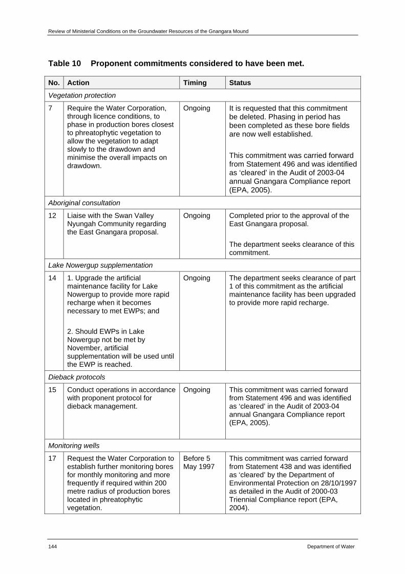
Review of Ministerial Conditions on the Groundwater Resources of the Gnangara Mound
144 Department of Water
Table 10 Proponent commitments considered to have been met.
No. Action Timing Status
Vegetation protection
7 Require the Water Corporation, through licence conditions, to phase in production bores closest to phreatophytic vegetation to allow the vegetation to adapt slowly to the drawdown and minimise the overall impacts on drawdown.
Ongoing It is requested that this commitment be deleted. Phasing in period has been completed as these bore fields are now well established. This commitment was carried forward from Statement 496 and was identified as ‘cleared’ in the Audit of 2003-04 annual Gnangara Compliance report (EPA, 2005).
Aboriginal consultation
12 Liaise with the Swan Valley Nyungah Community regarding the East Gnangara proposal.
Ongoing Completed prior to the approval of the East Gnangara proposal. The department seeks clearance of this commitment.
Lake Nowergup supplementation
14 1. Upgrade the artificial maintenance facility for Lake Nowergup to provide more rapid recharge when it becomes necessary to met EWPs; and 2. Should EWPs in Lake Nowergup not be met by November, artificial supplementation will be used until the EWP is reached.
Ongoing The department seeks clearance of part 1 of this commitment as the artificial maintenance facility has been upgraded to provide more rapid recharge.
Dieback protocols
15 Conduct operations in accordance with proponent protocol for dieback management.
Ongoing This commitment was carried forward from Statement 496 and was identified as ‘cleared’ in the Audit of 2003-04 annual Gnangara Compliance report (EPA, 2005).
Monitoring wells
17 Request the Water Corporation to establish further monitoring bores for monthly monitoring and more frequently if required within 200 metre radius of production bores located in phreatophytic vegetation.
Before 5 May 1997
This commitment was carried forward from Statement 438 and was identified as ‘cleared’ by the Department of Environmental Protection on 28/10/1997 as detailed in the Audit of 2000-03 Triennial Compliance report (EPA, 2004).
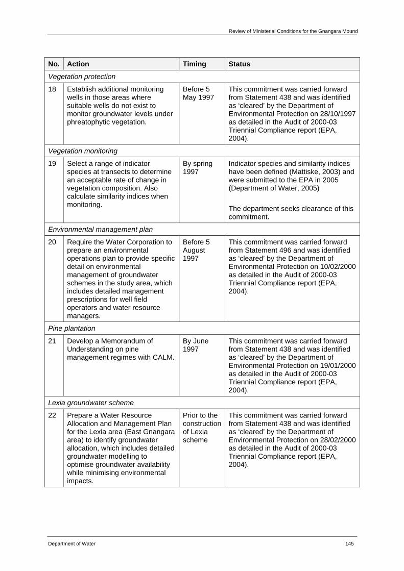
Review of Ministerial Conditions for the Gnangara Mound
Department of Water 145
No. Action Timing Status
Vegetation protection
18 Establish additional monitoring wells in those areas where suitable wells do not exist to monitor groundwater levels under phreatophytic vegetation.
Before 5 May 1997
This commitment was carried forward from Statement 438 and was identified as ‘cleared’ by the Department of Environmental Protection on 28/10/1997 as detailed in the Audit of 2000-03 Triennial Compliance report (EPA, 2004).
Vegetation monitoring
19 Select a range of indicator species at transects to determine an acceptable rate of change in vegetation composition. Also calculate similarity indices when monitoring.
By spring 1997
Indicator species and similarity indices have been defined (Mattiske, 2003) and were submitted to the EPA in 2005 (Department of Water, 2005) The department seeks clearance of this commitment.
Environmental management plan
20 Require the Water Corporation to prepare an environmental operations plan to provide specific detail on environmental management of groundwater schemes in the study area, which includes detailed management prescriptions for well field operators and water resource managers.
Before 5 August 1997
This commitment was carried forward from Statement 496 and was identified as ‘cleared’ by the Department of Environmental Protection on 10/02/2000 as detailed in the Audit of 2000-03 Triennial Compliance report (EPA, 2004).
Pine plantation
21 Develop a Memorandum of Understanding on pine management regimes with CALM.
By June 1997
This commitment was carried forward from Statement 438 and was identified as ‘cleared’ by the Department of Environmental Protection on 19/01/2000 as detailed in the Audit of 2000-03 Triennial Compliance report (EPA, 2004).
Lexia groundwater scheme
22 Prepare a Water Resource Allocation and Management Plan for the Lexia area (East Gnangara area) to identify groundwater allocation, which includes detailed groundwater modelling to optimise groundwater availability while minimising environmental impacts.
Prior to the construction of Lexia scheme
This commitment was carried forward from Statement 438 and was identified as ‘cleared’ by the Department of Environmental Protection on 28/02/2000 as detailed in the Audit of 2000-03 Triennial Compliance report (EPA, 2004).
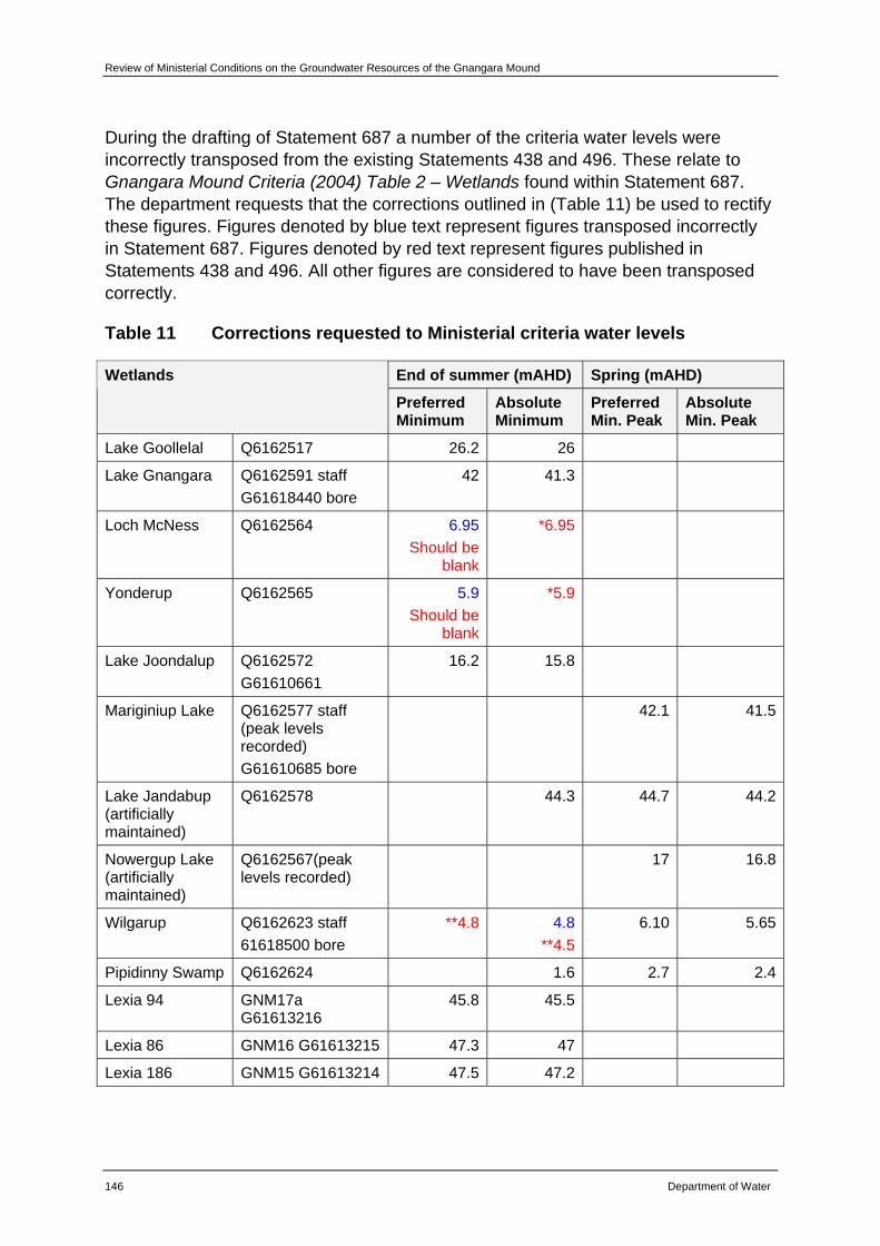
Review of Ministerial Conditions on the Groundwater Resources of the Gnangara Mound
146 Department of Water
During the drafting of Statement 687 a number of the criteria water levels were incorrectly transposed from the existing Statements 438 and 496. These relate to Gnangara Mound Criteria (2004) Table 2 – Wetlands found within Statement 687. The department requests that the corrections outlined in (Table 11) be used to rectify these figures. Figures denoted by blue text represent figures transposed incorrectly in Statement 687. Figures denoted by red text represent figures published in Statements 438 and 496. All other figures are considered to have been transposed correctly.
Table 11 Corrections requested to Ministerial criteria water levels
End of summer (mAHD) Spring (mAHD) Wetlands
Preferred Minimum
Absolute Minimum
Preferred Min. Peak
Absolute Min. Peak
Lake Goollelal Q6162517 26.2 26
Lake Gnangara Q6162591 staff G61618440 bore
42 41.3
Loch McNess Q6162564 6.95Should be
blank
*6.95
Yonderup Q6162565 5.9Should be
blank
*5.9
Lake Joondalup Q6162572 G61610661
16.2 15.8
Mariginiup Lake Q6162577 staff (peak levels recorded) G61610685 bore
42.1 41.5
Lake Jandabup (artificially maintained)
Q6162578 44.3 44.7 44.2
Nowergup Lake (artificially maintained)
Q6162567(peak levels recorded)
17 16.8
Wilgarup Q6162623 staff 61618500 bore
**4.8 4.8**4.5
6.10 5.65
Pipidinny Swamp Q6162624 1.6 2.7 2.4
Lexia 94 GNM17a G61613216
45.8 45.5
Lexia 86 GNM16 G61613215 47.3 47
Lexia 186 GNM15 G61613214 47.5 47.2

Review of Ministerial Conditions for the Gnangara Mound
Department of Water 147
End of summer (mAHD) Spring (mAHD) Wetlands
Preferred Minimum
Absolute Minimum
Preferred Min. Peak
Absolute Min. Peak
Melaleuca Park (EPP) 173
GNM14 Q6162628 staff G61613213 bore
50.2
Melaleuca Park (Dampland) 78
GNM31 G61613231 65.4 65.1
Edgecombe B10G 61618606
14.35
Egerton B25 G61618607
39.29
* As stated in Statement 438
** As stated in (WRC, 2001)

Review of Ministerial Conditions for the Gnangara Mound
Department of Water 149
6 Into the future As outlined within Chapter 3 of this report, the department has initiated a consolidation of its management approach for the resources of the Gnangara groundwater areas which will be documented in the Water management plan for the Gnangara groundwater areas. This plan will set the management framework for the groundwater resources during the period prior to determination of a long term sustainability goal set through the Gnangara Sustainability Strategy.
In addition to this review, and the Gnangara Sustainability Strategy, the department has invested in a number of research projects that will lead to a better understanding and improved management of the Gnangara groundwater resources. These projects will inform future management and planning decisions in a number of ways.
Gnangara Sustainability Strategy
The Gnangara Sustainability Strategy is a multi-agency approach to management of water and land issues on the Gnangara Mound. The Department of Water has joined forces with the Department of Agriculture and Food, Department of Environment and Conservation, Department of Planning and Infrastructure, Forest Products Commission, the Water Corporation and CSIRO.
The State Government has committed $7.5million to develop the GSS which will recommend options to ensure the sustainable use of water for drinking and commercial purposes and to protect the environment. This consultative approach will ensure that land, water and biodiversity issues on the Gnangara Mound will be addressed through a transparent and cooperative framework.
In 2009, a number of proposed land use options will be presented to the community in a draft strategy. These include: alternative land uses once pine forests have been cleared; establishment of a horticulture precinct using treated wastewater; recycling wastewater for other uses; changing vegetation management to increase recharge and maintain biodiversity values; revising groundwater allocation to public and private water supplies; or a combination of these and other options.
The draft strategy will be available for public comment in 2009. More information is available at www.gnangara.water.wa.gov.au.
Determining ecological water requirements and environmental water provisions in a changing climate
In recognition that declining rainfall trends have implications for determining an ecological water requirement and environmental water provisions, the department has contracted Dr Ray Froend of Edith Cowan University to develop a framework that assists this process in a changing climate. It is recognised that there are a number of drivers that may result in ecosystems undergoing a transition of state including
Review of Ministerial Conditions on the Groundwater Resources of the Gnangara Mound
150 Department of Water
climatic change or variability. These states are known as eco-hydrological states. This project will further investigate the concept of eco-hydrological states that have been defined on the basis of ecological and hydrological parameters. The concept forms a key part of the framework under development which will be used to assist in predicting ecological response under specific hydrological regimes which will improve the department’s ability to make predictions and decisions about acceptable hydrological regimes for key groundwater dependent ecosystems.
Investigation of the sustainability of shallow groundwater systems on the Gnangara Mound
As introduced in Chapter 4 of this document, the department is currently undertaking research to improve its understanding of the interrelationship between wetlands and the superficial aquifer. This project has been established to investigate the complex, superimposed impacts of climate change, land use and abstraction on groundwater levels. The overall benefit of the project will be regionally focused scientific data that will assist in the development of management strategies that promote the sustainable use of the groundwater resources of the Gnangara Mound, while ensuring the protection of the environmental features dependent on that groundwater.
This project involves:
• Designing and upgrading existing monitoring infrastructure and installing new monitoring networks at key sites; and
• Establishing a large monitoring program which consists of groundwater level monitoring and a program to analyse groundwater and sediment from within and around lakes and wetlands.
This will enable geochemical and hydrochemical characterisation to be developed for sites. Additional ecological monitoring transects will also be established and an initial palaeohydrological and palaeoclimatological interpretation of key wetlands will be undertaken from analysis of sediment cores. Data from the existing monitoring network will be assessed to determine groundwater/surface water interactions.
State groundwater investigation program
Over the next two years, three additional groundwater investigations are planned for the northern part of the Gnangara Mound. The first of these, known as the Gnangara North investigation, will focus on defining the recharge window into the Yarragadee aquifer. A second project will provide an understanding of how Gingin Brook functions and will assess the potential impacts on the brook from groundwater abstraction. As part of this project, a new monitoring network will be developed to assist in quantifying groundwater contribution to this surface water system. The third project will initiate the installation of a monitoring network in an area to the west of Gingin. This area currently has no monitoring network and the department has been successful in securing Commonwealth funding to provide for the installation of bores
Review of Ministerial Conditions for the Gnangara Mound
Department of Water 151
in this area. Information and learning’s gained from these investigations will be used as part of water allocation planning in the future.
Groundwater modelling
As discussed in Chapter 4, the Perth Regional Aquifer Modelling System or PRAMS, is a numerical modelling tool that can provide predictions of relative changes in water level across the Gnangara Mound and has been developed as a quantitative and integrated modelling tool to support management planning. PRAMS has been used to assess groundwater availability, in particular rainfall recharge and aquifer yields, based on various climate scenarios, and to study the impact of land and water use change on water levels and wetlands. Modelling results using PRAMS have been used to revise allocation limits in the superficial aquifer across the Gnangara Mound.
Modelling work undertaken as part of this review shows that if the current trend of reduced rainfall continues, current rates of abstraction from the superficial aquifer will make it difficult for water levels to be met at an increasing number of criteria sites.
Considerable additional modelling is proposed as part of the Gnangara Sustainability Strategy. Following an upgrade to PRAMS, a comprehensive suite of 50 scenarios will be modelled. These runs will provide predictions of water resources impacts caused by changes to land use, abstraction and climate. This work will provide a basis for understanding the constraints on the sustainable management of the water resources across the Gnangara Mound.
Gnangara Mound Metering Project
In 2005, the department initiated a project to assess volumes of groundwater abstracted by irrigators on the Gnangara Mound. Meters have been designed to effectively monitor licensed private water usage. The project has targeted areas where there is high demand for the resource and where there is the presence of groundwater dependent ecosystems with high ecological value. In the management areas of Carabooda, Nowergup, Mariginiup and Neaves, meters have been installed on licensed bores with entitlements between 5000 and 500 000 kL/yr. Installations are now underway in the management areas of South Swan, North Swan, Adams and Neerabup. By October 2007, over 500 meters had been installed.
The project has enabled accurate data to be collected on groundwater abstraction and has been used to promote better water resource management both on-farm (e.g. through improved efficiency) and by Government (e.g. through more accurate measurement).

Review of Ministerial Conditions for the Gnangara Mound
Department of Water 153
7 Summary of request to changes to Ministerial conditions
The following provides a summary of the recommendations made within this report with respect to proposed amendments to existing Ministerial conditions as outlined in Statement 687. These are provided for consideration by the EPA.
7.1 Environmental Conditions
Following a detailed review of each Ministerial criteria site, it is proposed that a total of five sites (Lake Gnangara, Edgecombe Seepage, WM6, MM49B and PM25) (Table 12) be removed due to a loss of ecological values due to land clearing and disturbance activities. These activities have occurred outside of the control of the department.
CDFM and PRAMS results clearly demonstrate that climate induced reduced rainfall is the predominant factor affecting groundwater levels at all sites. Other factors include abstraction, in addition to land use and management practices, such as pine plantations and the burning frequency of native vegetation, both of which impede recharge. On this basis it is proposed that an additional four sites (Loch McNess, Lake Yonderup, Lexia 94 and NR11C) (Table 13) be removed as it has been shown that abstraction is not impacting on water levels at these sites. A number of other sites, not included in the list proposed for removal, were also shown to be predominantly impacted on by factors other than abstraction. However, the department has chosen to adopt a precautionary approach with these sites and recommends they remain as criteria sites until further work in this area has been completed.
It is recommended that the other 28 sites remain as criteria sites (Table 14) and that existing monitoring programs continue. Additional monitoring of water levels and vegetation has been recommended for some sites.
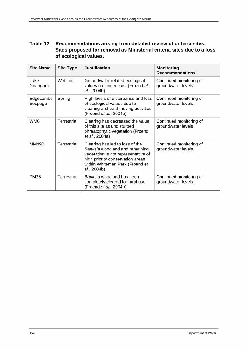
Review of Ministerial Conditions on the Groundwater Resources of the Gnangara Mound
154 Department of Water
Table 12 Recommendations arising from detailed review of criteria sites. Sites proposed for removal as Ministerial criteria sites due to a loss of ecological values.
Site Name Site Type Justification Monitoring Recommendations
Lake Gnangara
Wetland Groundwater related ecological values no longer exist (Froend et al., 2004b)
Continued monitoring of groundwater levels
Edgecombe Seepage
Spring High levels of disturbance and loss of ecological values due to clearing and earthmoving activities (Froend et al., 2004b)
Continued monitoring of groundwater levels
WM6 Terrestrial Clearing has decreased the value of this site as undisturbed phreatophytic vegetation (Froend et al., 2004a)
Continued monitoring of groundwater levels
MM49B Terrestrial Clearing has led to loss of the Banksia woodland and remaining vegetation is not representative of high priority conservation areas within Whiteman Park (Froend et al., 2004b)
Continued monitoring of groundwater levels
PM25 Terrestrial Banksia woodland has been completely cleared for rural use (Froend et al., 2004b)
Continued monitoring of groundwater levels
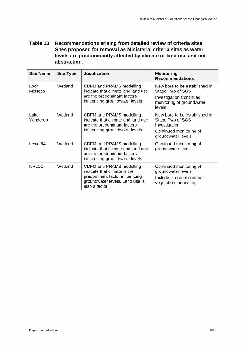
Review of Ministerial Conditions for the Gnangara Mound
Department of Water 155
Table 13 Recommendations arising from detailed review of criteria sites. Sites proposed for removal as Ministerial criteria sites as water levels are predominantly affected by climate or land use and not abstraction.
Site Name Site Type Justification Monitoring Recommendations
Loch McNess
Wetland CDFM and PRAMS modelling indicate that climate and land use are the predominant factors influencing groundwater levels
New bore to be established in Stage Two of SGS Investigation Continued monitoring of groundwater levels
Lake Yonderup
Wetland CDFM and PRAMS modelling indicate that climate and land use are the predominant factors influencing groundwater levels
New bore to be established in Stage Two of SGS Investigation Continued monitoring of groundwater levels
Lexia 94 Wetland CDFM and PRAMS modelling indicate that climate and land use are the predominant factors influencing groundwater levels
Continued monitoring of groundwater levels
NR11C Wetland CDFM and PRAMS modelling indicate that climate is the predominant factor influencing groundwater levels. Land use is also a factor
Continued monitoring of groundwater levels Include in end of summer vegetation monitoring

Review of Ministerial Conditions on the Groundwater Resources of the Gnangara Mound
156 Department of Water
Table 14 Recommendations arising from detailed review of criteria sites. Sites to be retained as Ministerial criteria sites.
Site Name Site Type Monitoring Recommendations
Lake Wilgarup
Wetland Continued implementation of existing monitoring programs
Pipidinny Swamp
Wetland New bore to be established in Stage Three of the SGS Investigation Continued implementation of existing monitoring programs
Melaleuca Park EPP 173
Wetland Undertake a hydrogeological review as part of Stage Two SGS Investigation. Possible new bore Continued implementation of existing monitoring programs
Lake Jandabup
Wetland New bore to be established in Stage Two of SGS Investigation Continued implementation of existing monitoring programs Continuation of the supplementation scheme by the Water Corporation
Lake Joondalup
Wetland New bore, JNP_Wc, to replace existing criterion bore (61610661) following review and calibration by the department Continued implementation of existing monitoring programs
Lake Mariginiup
Wetland New bore, MGP_c, to replace existing criterion bore MS10 (61610685) following review and calibration by the department Continued implementation of existing monitoring programs
Lake Nowergup
Wetland Continued implementation of existing monitoring programs Continuation of the supplementation scheme by Department of Water Establishment of a Steering Group
Lexia 186 Wetland New staff gauge to be established in Stage Two SGS Investigation Continued implementation of existing monitoring programs
Lake Goollelal
Wetland New bore and staff gauge to be established in Stage Three of the SGS Investigation Continued implementation of existing monitoring programs
Lexia 86 Wetland Continued implementation of existing monitoring programs
Melaleuca Park Dampland 78
Wetland Undertake a hydrogeological review as part of Stage Two of the SGS Investigation. Possible new bore Continued implementation of existing monitoring programs
Egerton Spring
Spring New bore, EGT_c, to replace existing criterion bore (61618607) following review and calibration by the department Continued implementation of existing monitoring programs
MM16 Terrestrial Continued implementation of existing monitoring programs
PM9 Terrestrial Continued implementation of existing monitoring programs
MM18 Terrestrial Include in end of summer monitoring Continued implementation of existing monitoring programs
MM53 Terrestrial Continued implementation of existing monitoring programs
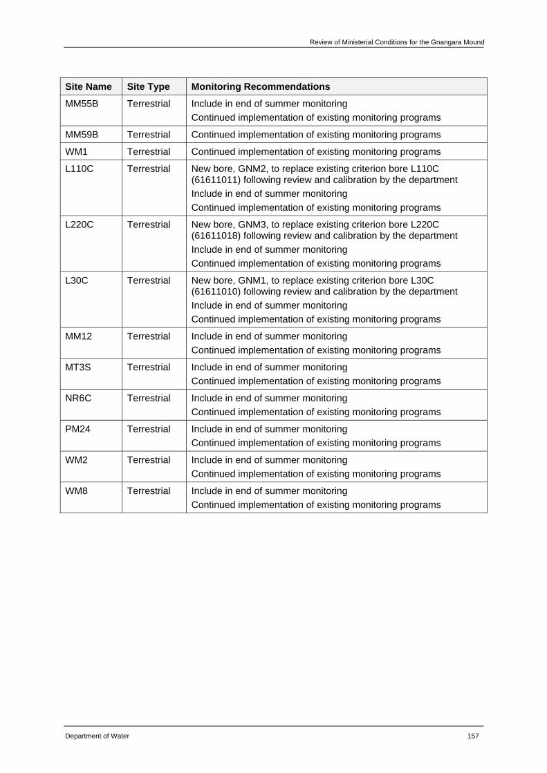
Review of Ministerial Conditions for the Gnangara Mound
Department of Water 157
Site Name Site Type Monitoring Recommendations
MM55B Terrestrial Include in end of summer monitoring Continued implementation of existing monitoring programs
MM59B Terrestrial Continued implementation of existing monitoring programs
WM1 Terrestrial Continued implementation of existing monitoring programs
L110C Terrestrial New bore, GNM2, to replace existing criterion bore L110C (61611011) following review and calibration by the department Include in end of summer monitoring Continued implementation of existing monitoring programs
L220C Terrestrial New bore, GNM3, to replace existing criterion bore L220C (61611018) following review and calibration by the department Include in end of summer monitoring Continued implementation of existing monitoring programs
L30C Terrestrial New bore, GNM1, to replace existing criterion bore L30C (61611010) following review and calibration by the department Include in end of summer monitoring Continued implementation of existing monitoring programs
MM12 Terrestrial Include in end of summer monitoring Continued implementation of existing monitoring programs
MT3S Terrestrial Include in end of summer monitoring Continued implementation of existing monitoring programs
NR6C Terrestrial Include in end of summer monitoring Continued implementation of existing monitoring programs
PM24 Terrestrial Include in end of summer monitoring Continued implementation of existing monitoring programs
WM2 Terrestrial Include in end of summer monitoring Continued implementation of existing monitoring programs
WM8 Terrestrial Include in end of summer monitoring Continued implementation of existing monitoring programs
Review of Ministerial Conditions on the Groundwater Resources of the Gnangara Mound
158 Department of Water
7.2 Administrative conditions
Following a review of Ministerial conditions and procedures and proponent commitments, a number of amendments are proposed.
With respect to Ministerial conditions and procedures it is requested that future compliance and auditing be undertaken by the Department of Environment and Conservation as per previous Ministerial statements 438 and 496 and in line with the revocation order published in the Government Gazette, WA on 31 August 2007. This request is made in recognition of the formation of the Department of Water and the Department of Environment and Conservation. Minor amendments to reflect changes in roles and responsibilities of government agencies are also requested.
The department considers that a number of proponent commitments made at the time that Statements 438 and 496 were developed have been met. It is requested that these be recognised as having been met and that they are subsequently removed as legally binding conditions. These relate to the commitments outlined in Table 10 of this report.
Review of Ministerial Conditions for the Gnangara Mound
Department of Water 159
Appendices
Review of Ministerial Conditions on the Groundwater Resources of the Gnangara Mound
160 Department of Water
Appendix A — Ministerial Statement 687
Review of Ministerial Conditions for the Gnangara Mound
Department of Water 161
Review of Ministerial Conditions on the Groundwater Resources of the Gnangara Mound
162 Department of Water
Review of Ministerial Conditions for the Gnangara Mound
Department of Water 163
Review of Ministerial Conditions on the Groundwater Resources of the Gnangara Mound
164 Department of Water
Review of Ministerial Conditions for the Gnangara Mound
Department of Water 165
Review of Ministerial Conditions on the Groundwater Resources of the Gnangara Mound
166 Department of Water
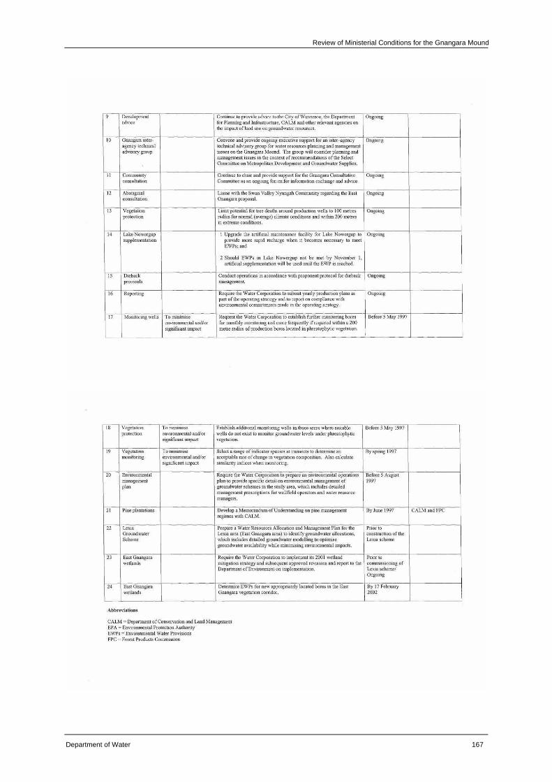
Review of Ministerial Conditions for the Gnangara Mound
Department of Water 167
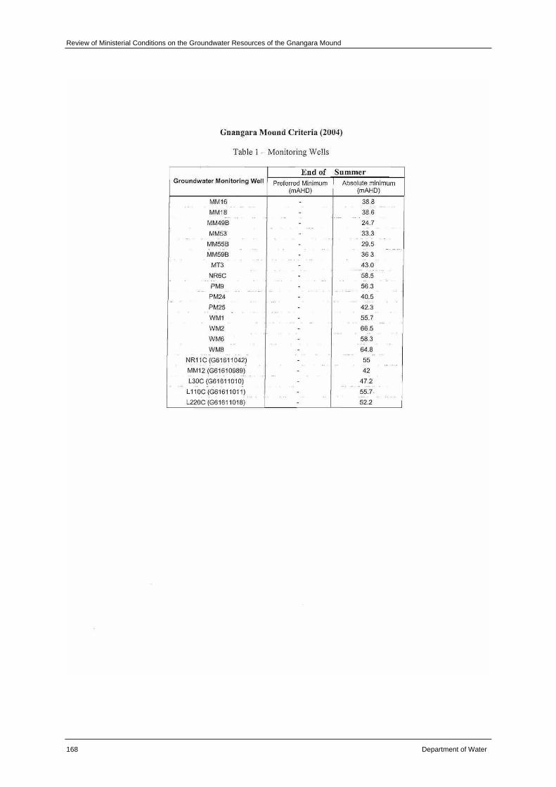
Review of Ministerial Conditions on the Groundwater Resources of the Gnangara Mound
168 Department of Water
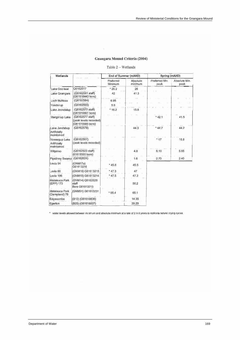
Review of Ministerial Conditions for the Gnangara Mound
Department of Water 169
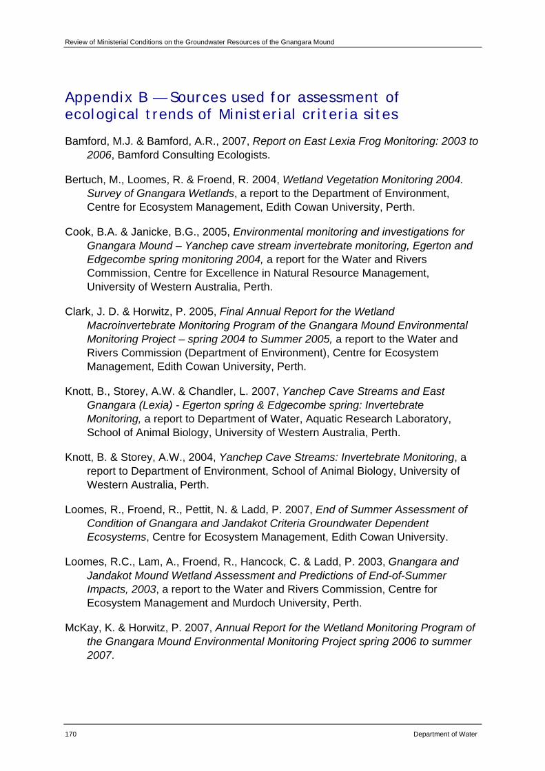
Review of Ministerial Conditions on the Groundwater Resources of the Gnangara Mound
170 Department of Water
Appendix B — Sources used for assessment of ecological trends of Ministerial criteria sites
Bamford, M.J. & Bamford, A.R., 2007, Report on East Lexia Frog Monitoring: 2003 to 2006, Bamford Consulting Ecologists.
Bertuch, M., Loomes, R. & Froend, R. 2004, Wetland Vegetation Monitoring 2004. Survey of Gnangara Wetlands, a report to the Department of Environment, Centre for Ecosystem Management, Edith Cowan University, Perth.
Cook, B.A. & Janicke, B.G., 2005, Environmental monitoring and investigations for Gnangara Mound – Yanchep cave stream invertebrate monitoring, Egerton and Edgecombe spring monitoring 2004, a report for the Water and Rivers Commission, Centre for Excellence in Natural Resource Management, University of Western Australia, Perth.
Clark, J. D. & Horwitz, P. 2005, Final Annual Report for the Wetland Macroinvertebrate Monitoring Program of the Gnangara Mound Environmental Monitoring Project – spring 2004 to Summer 2005, a report to the Water and Rivers Commission (Department of Environment), Centre for Ecosystem Management, Edith Cowan University, Perth.
Knott, B., Storey, A.W. & Chandler, L. 2007, Yanchep Cave Streams and East Gnangara (Lexia) - Egerton spring & Edgecombe spring: Invertebrate Monitoring, a report to Department of Water, Aquatic Research Laboratory, School of Animal Biology, University of Western Australia, Perth.
Knott, B. & Storey, A.W., 2004, Yanchep Cave Streams: Invertebrate Monitoring, a report to Department of Environment, School of Animal Biology, University of Western Australia, Perth.
Loomes, R., Froend, R., Pettit, N. & Ladd, P. 2007, End of Summer Assessment of Condition of Gnangara and Jandakot Criteria Groundwater Dependent Ecosystems, Centre for Ecosystem Management, Edith Cowan University.
Loomes, R.C., Lam, A., Froend, R., Hancock, C. & Ladd, P. 2003, Gnangara and Jandakot Mound Wetland Assessment and Predictions of End-of-Summer Impacts, 2003, a report to the Water and Rivers Commission, Centre for Ecosystem Management and Murdoch University, Perth.
McKay, K. & Horwitz, P. 2007, Annual Report for the Wetland Monitoring Program of the Gnangara Mound Environmental Monitoring Project spring 2006 to summer 2007.
Review of Ministerial Conditions for the Gnangara Mound
Department of Water 171
McKay, K. & Horwitz, P. 2006, Annual Report for the Wetland Monitoring Program of the Gnangara Mound Environmental Monitoring Project spring 2005 to autumn 2006.
Mattiske Consulting Pty Ltd. 2006, Monitoring the effects of groundwater extraction on native vegetation on the Northern Swan Coastal Plain, 2005.
Pettit, N., Loomes, R. & Froend, R. 2007, Wetland Vegetation Monitoring 2006 - Survey of Gnangara Wetland, Centre for Ecosystem Management, Edith Cowan University, Perth.
Rogan, R., Loomes, R. & Froend, R. 2006, Wetland Vegetation Monitoring 2005 – Survey of Gnangara Wetlands, a report to the Department of Environment, Centre for Ecosystem Management, Edith Cowen University, Perth.
Sommer, B. & Horwitz, P. 2007, Annual Report for the Wetland Macroinvertebrate Monitoring Program of the Gnangara Mound Environmental Monitoring Project – spring 2006 to summer 2007, a report to the Department of Water, Centre for Ecosystem Management, Edith Cowan University, Perth.
Water Authority of Western Australia 1986, Gnangara Mound Groundwater Resources, Environmental Review and Management Program, Government of Western Australia, Perth.
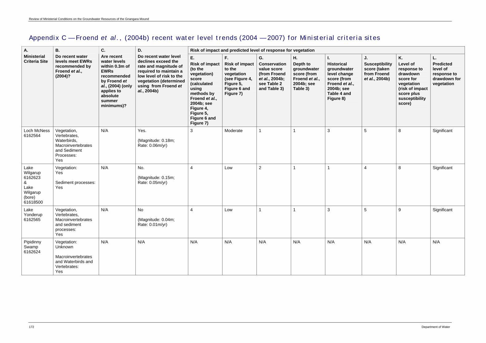
Review of Ministerial Conditions on the Groundwater Resources of the Gnangara Mound
172 Department of Water
Appendix C — Froend et al., (2004b) recent water level trends (2004 — 2007) for Ministerial criteria sites
Risk of impact and predicted level of response for vegetation A. Ministerial Criteria Site
B. Do recent water levels meet EWRs recommended by Froend et al., (2004)?
C. Are recent water levels within 0.3m of EWRs recommended by Froend et al., (2004) (only applies to absolute summer minimums)?
D. Do recent water level declines exceed the rate and magnitude of required to maintain a low level of risk to the vegetation (determined using from Froend et al., 2004b)
E. Risk of impact (to the vegetation) score (calculated using methods by Froend et al., 2004b; see Figure 4, Figure 5, Figure 6 and Figure 7)
F. Risk of impact to the vegetation (see Figure 4, Figure 5, Figure 6 and Figure 7)
G. Conservation value score (from Froend et al., 2004b; see Table 2 and Table 3)
H. Depth to groundwater score (from Froend et al., 2004b; see Table 3)
I. Historical groundwater level change score (from Froend et al., 2004b; see Table 4 and Figure 8)
J. Susceptibility score (taken from Froend et al., 2004b)
K. Level of response to drawdown score for vegetation (risk of impact score plus susceptibility score)
L. Predicted level of response to drawdown for vegetation
Loch McNess 6162564
Vegetation, Vertebrates, Waterbirds, Macroinvertebrates and Sediment Processes: Yes
N/A Yes. (Magnitude: 0.18m; Rate: 0.06m/yr)
3 Moderate 1 1 3 5 8 Significant
Lake Wilgarup 6162623 & Lake Wilgarup (bore) 61618500
Vegetation: Yes Sediment processes: Yes
N/A No. (Magnitude: 0.15m; Rate: 0.05m/yr)
4 Low 2 1 1 4 8 Significant
Lake Yonderup 6162565
Vegetation, Vertebrates, Macroinvertebrates and sediment processes: Yes
N/A No (Magnitude: 0.04m; Rate: 0.01m/yr)
4 Low 1 1 3 5 9 Significant
Pipidinny Swamp 6162624
Vegetation: Unknown Macroinvertebrates and Waterbirds and Vertebrates: Yes
N/A N/A N/A N/A N/A N/A N/A N/A N/A N/A
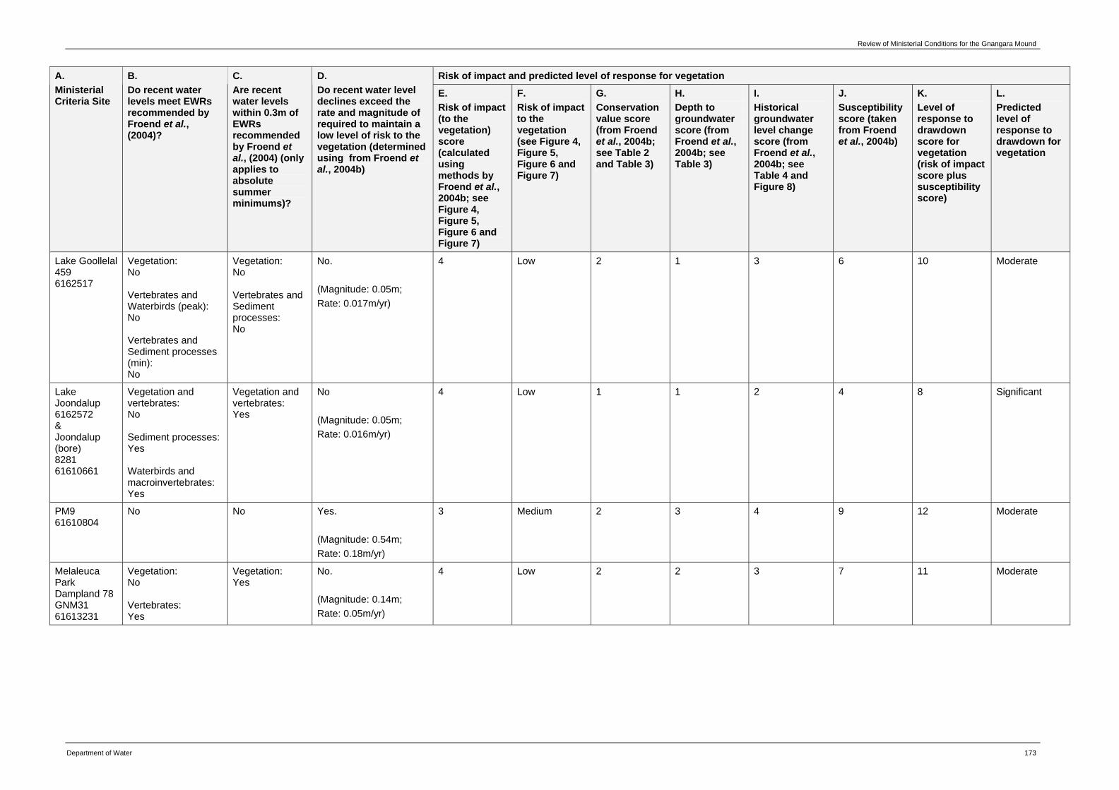
Review of Ministerial Conditions for the Gnangara Mound
Department of Water 173
Risk of impact and predicted level of response for vegetation A. Ministerial Criteria Site
B. Do recent water levels meet EWRs recommended by Froend et al., (2004)?
C. Are recent water levels within 0.3m of EWRs recommended by Froend et al., (2004) (only applies to absolute summer minimums)?
D. Do recent water level declines exceed the rate and magnitude of required to maintain a low level of risk to the vegetation (determined using from Froend et al., 2004b)
E. Risk of impact (to the vegetation) score (calculated using methods by Froend et al., 2004b; see Figure 4, Figure 5, Figure 6 and Figure 7)
F. Risk of impact to the vegetation (see Figure 4, Figure 5, Figure 6 and Figure 7)
G. Conservation value score (from Froend et al., 2004b; see Table 2 and Table 3)
H. Depth to groundwater score (from Froend et al., 2004b; see Table 3)
I. Historical groundwater level change score (from Froend et al., 2004b; see Table 4 and Figure 8)
J. Susceptibility score (taken from Froend et al., 2004b)
K. Level of response to drawdown score for vegetation (risk of impact score plus susceptibility score)
L. Predicted level of response to drawdown for vegetation
Lake Goollelal 459 6162517
Vegetation: No Vertebrates and Waterbirds (peak): No Vertebrates and Sediment processes (min): No
Vegetation: No Vertebrates and Sediment processes: No
No. (Magnitude: 0.05m; Rate: 0.017m/yr)
4 Low 2 1 3 6 10 Moderate
Lake Joondalup 6162572 & Joondalup (bore) 8281 61610661
Vegetation and vertebrates: No Sediment processes: Yes Waterbirds and macroinvertebrates: Yes
Vegetation and vertebrates: Yes
No (Magnitude: 0.05m; Rate: 0.016m/yr)
4 Low 1 1 2 4 8 Significant
PM9 61610804
No No Yes. (Magnitude: 0.54m; Rate: 0.18m/yr)
3 Medium 2 3 4 9 12 Moderate
Melaleuca Park Dampland 78 GNM31 61613231
Vegetation: No Vertebrates: Yes
Vegetation: Yes
No. (Magnitude: 0.14m; Rate: 0.05m/yr)
4 Low 2 2 3 7 11 Moderate
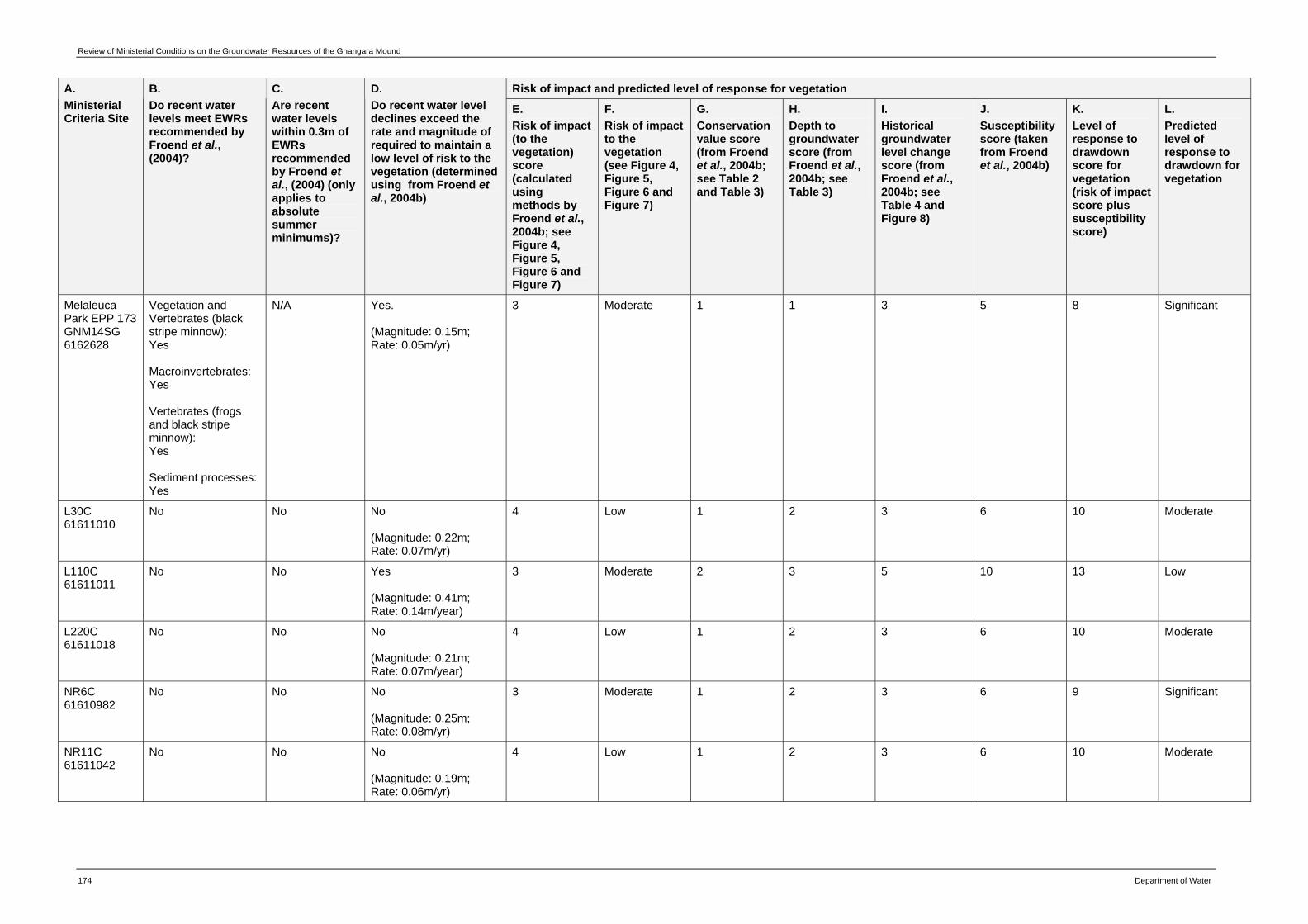
Review of Ministerial Conditions on the Groundwater Resources of the Gnangara Mound
174 Department of Water
Risk of impact and predicted level of response for vegetation A. Ministerial Criteria Site
B. Do recent water levels meet EWRs recommended by Froend et al., (2004)?
C. Are recent water levels within 0.3m of EWRs recommended by Froend et al., (2004) (only applies to absolute summer minimums)?
D. Do recent water level declines exceed the rate and magnitude of required to maintain a low level of risk to the vegetation (determined using from Froend et al., 2004b)
E. Risk of impact (to the vegetation) score (calculated using methods by Froend et al., 2004b; see Figure 4, Figure 5, Figure 6 and Figure 7)
F. Risk of impact to the vegetation (see Figure 4, Figure 5, Figure 6 and Figure 7)
G. Conservation value score (from Froend et al., 2004b; see Table 2 and Table 3)
H. Depth to groundwater score (from Froend et al., 2004b; see Table 3)
I. Historical groundwater level change score (from Froend et al., 2004b; see Table 4 and Figure 8)
J. Susceptibility score (taken from Froend et al., 2004b)
K. Level of response to drawdown score for vegetation (risk of impact score plus susceptibility score)
L. Predicted level of response to drawdown for vegetation
Melaleuca Park EPP 173 GNM14SG 6162628
Vegetation and Vertebrates (black stripe minnow): Yes Macroinvertebrates: Yes Vertebrates (frogs and black stripe minnow): Yes Sediment processes: Yes
N/A Yes. (Magnitude: 0.15m; Rate: 0.05m/yr)
3 Moderate 1 1 3 5 8 Significant
L30C 61611010
No No No (Magnitude: 0.22m; Rate: 0.07m/yr)
4 Low 1 2 3 6 10 Moderate
L110C 61611011
No No Yes (Magnitude: 0.41m; Rate: 0.14m/year)
3 Moderate 2 3 5 10 13 Low
L220C 61611018
No No No (Magnitude: 0.21m; Rate: 0.07m/year)
4 Low 1 2 3 6 10 Moderate
NR6C 61610982
No No No (Magnitude: 0.25m; Rate: 0.08m/yr)
3 Moderate 1 2 3 6 9 Significant
NR11C 61611042
No No No (Magnitude: 0.19m; Rate: 0.06m/yr)
4 Low 1 2 3 6 10 Moderate
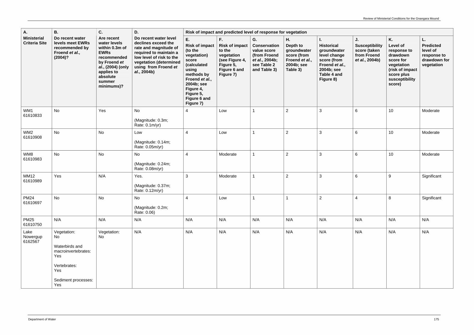
Review of Ministerial Conditions for the Gnangara Mound
Department of Water 175
Risk of impact and predicted level of response for vegetation A. Ministerial Criteria Site
B. Do recent water levels meet EWRs recommended by Froend et al., (2004)?
C. Are recent water levels within 0.3m of EWRs recommended by Froend et al., (2004) (only applies to absolute summer minimums)?
D. Do recent water level declines exceed the rate and magnitude of required to maintain a low level of risk to the vegetation (determined using from Froend et al., 2004b)
E. Risk of impact (to the vegetation) score (calculated using methods by Froend et al., 2004b; see Figure 4, Figure 5, Figure 6 and Figure 7)
F. Risk of impact to the vegetation (see Figure 4, Figure 5, Figure 6 and Figure 7)
G. Conservation value score (from Froend et al., 2004b; see Table 2 and Table 3)
H. Depth to groundwater score (from Froend et al., 2004b; see Table 3)
I. Historical groundwater level change score (from Froend et al., 2004b; see Table 4 and Figure 8)
J. Susceptibility score (taken from Froend et al., 2004b)
K. Level of response to drawdown score for vegetation (risk of impact score plus susceptibility score)
L. Predicted level of response to drawdown for vegetation
WM1 61610833
No Yes No (Magnitude: 0.3m; Rate: 0.1m/yr)
4 Low 1 2 3 6 10 Moderate
WM2 61610908
No No Low (Magnitude: 0.14m; Rate: 0.05m/yr)
4 Low 1 2 3 6 10 Moderate
WM8 61610983
No No No (Magnitude: 0.24m; Rate: 0.08m/yr)
4 Moderate 1 2 3 6 10 Moderate
MM12 61610989
Yes N/A Yes. (Magnitude: 0.37m; Rate: 0.12m/yr)
3 Moderate 1 2 3 6 9 Significant
PM24 61610697
No No No (Magnitude: 0.2m; Rate: 0.06)
4 Low 1 1 2 4 8 Significant
PM25 61610750
N/A N/A N/A N/A N/A N/A N/A N/A N/A N/A N/A
Lake Nowergup 6162567
Vegetation: No Waterbirds and macroinvertebrates: Yes Vertebrates: Yes Sediment processes: Yes
Vegetation: No
N/A N/A N/A N/A N/A N/A N/A N/A N/A
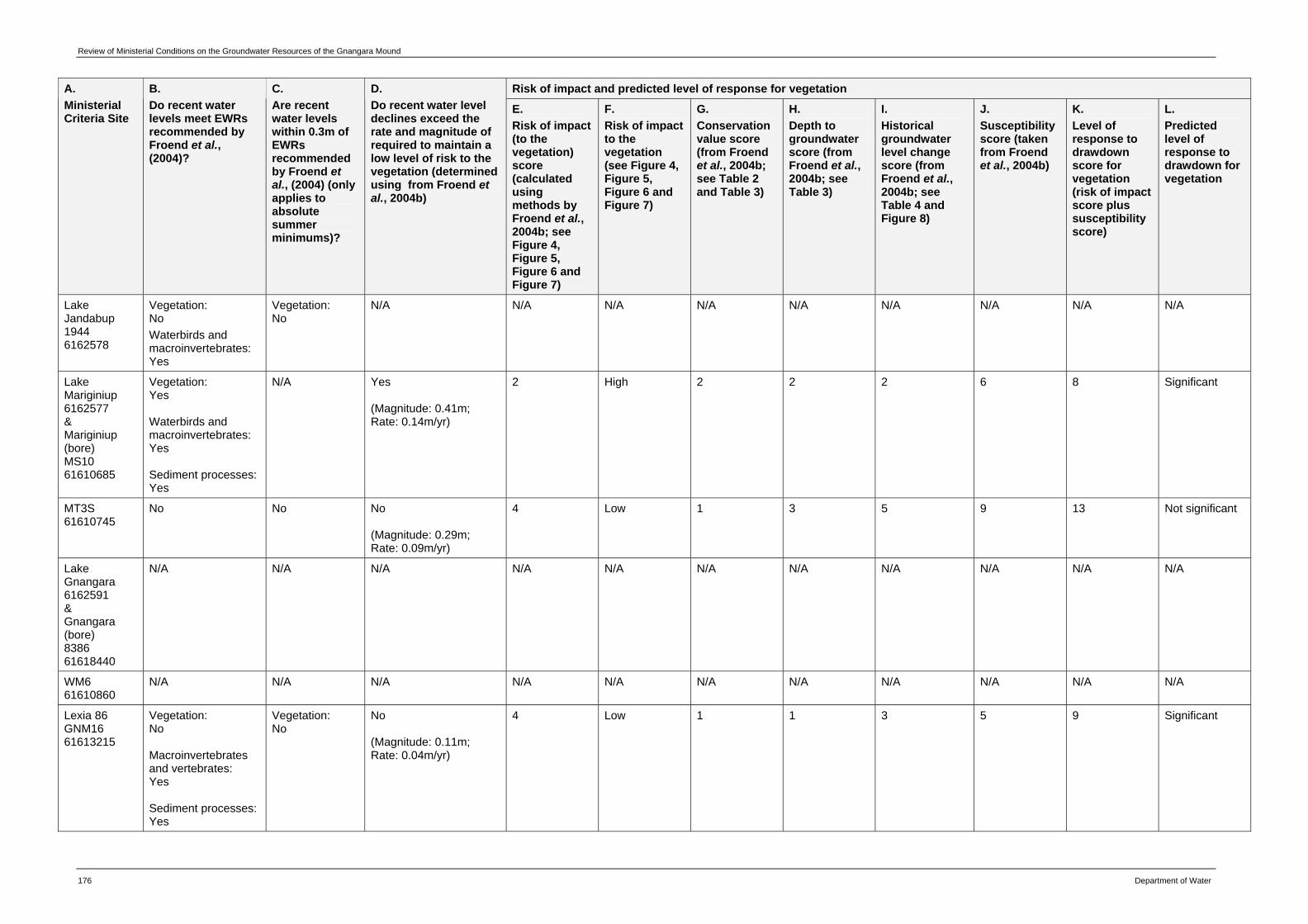
Review of Ministerial Conditions on the Groundwater Resources of the Gnangara Mound
176 Department of Water
Risk of impact and predicted level of response for vegetation A. Ministerial Criteria Site
B. Do recent water levels meet EWRs recommended by Froend et al., (2004)?
C. Are recent water levels within 0.3m of EWRs recommended by Froend et al., (2004) (only applies to absolute summer minimums)?
D. Do recent water level declines exceed the rate and magnitude of required to maintain a low level of risk to the vegetation (determined using from Froend et al., 2004b)
E. Risk of impact (to the vegetation) score (calculated using methods by Froend et al., 2004b; see Figure 4, Figure 5, Figure 6 and Figure 7)
F. Risk of impact to the vegetation (see Figure 4, Figure 5, Figure 6 and Figure 7)
G. Conservation value score (from Froend et al., 2004b; see Table 2 and Table 3)
H. Depth to groundwater score (from Froend et al., 2004b; see Table 3)
I. Historical groundwater level change score (from Froend et al., 2004b; see Table 4 and Figure 8)
J. Susceptibility score (taken from Froend et al., 2004b)
K. Level of response to drawdown score for vegetation (risk of impact score plus susceptibility score)
L. Predicted level of response to drawdown for vegetation
Lake Jandabup 1944 6162578
Vegetation: No Waterbirds and macroinvertebrates: Yes
Vegetation: No
N/A N/A N/A N/A N/A N/A N/A N/A N/A
Lake Mariginiup 6162577 & Mariginiup (bore) MS10 61610685
Vegetation: Yes Waterbirds and macroinvertebrates: Yes Sediment processes: Yes
N/A Yes (Magnitude: 0.41m; Rate: 0.14m/yr)
2 High 2 2 2 6 8 Significant
MT3S 61610745
No No No (Magnitude: 0.29m; Rate: 0.09m/yr)
4 Low 1 3 5 9 13 Not significant
Lake Gnangara 6162591 & Gnangara (bore) 8386 61618440
N/A N/A N/A N/A N/A N/A N/A N/A N/A N/A N/A
WM6 61610860
N/A N/A N/A N/A N/A N/A N/A N/A N/A N/A N/A
Lexia 86 GNM16 61613215
Vegetation: No Macroinvertebrates and vertebrates: Yes Sediment processes: Yes
Vegetation: No
No (Magnitude: 0.11m; Rate: 0.04m/yr)
4 Low 1 1 3 5 9 Significant
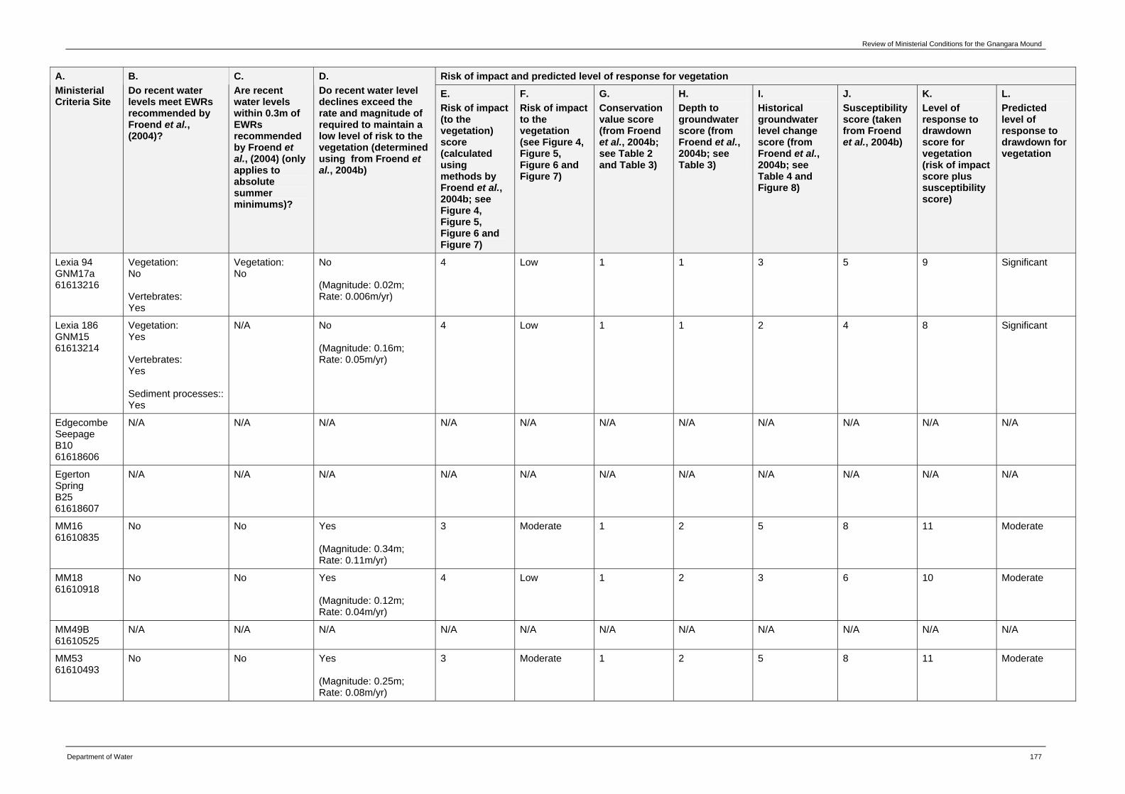
Review of Ministerial Conditions for the Gnangara Mound
Department of Water 177
Risk of impact and predicted level of response for vegetation A. Ministerial Criteria Site
B. Do recent water levels meet EWRs recommended by Froend et al., (2004)?
C. Are recent water levels within 0.3m of EWRs recommended by Froend et al., (2004) (only applies to absolute summer minimums)?
D. Do recent water level declines exceed the rate and magnitude of required to maintain a low level of risk to the vegetation (determined using from Froend et al., 2004b)
E. Risk of impact (to the vegetation) score (calculated using methods by Froend et al., 2004b; see Figure 4, Figure 5, Figure 6 and Figure 7)
F. Risk of impact to the vegetation (see Figure 4, Figure 5, Figure 6 and Figure 7)
G. Conservation value score (from Froend et al., 2004b; see Table 2 and Table 3)
H. Depth to groundwater score (from Froend et al., 2004b; see Table 3)
I. Historical groundwater level change score (from Froend et al., 2004b; see Table 4 and Figure 8)
J. Susceptibility score (taken from Froend et al., 2004b)
K. Level of response to drawdown score for vegetation (risk of impact score plus susceptibility score)
L. Predicted level of response to drawdown for vegetation
Lexia 94 GNM17a 61613216
Vegetation: No Vertebrates: Yes
Vegetation: No
No (Magnitude: 0.02m; Rate: 0.006m/yr)
4 Low 1 1 3 5 9 Significant
Lexia 186 GNM15 61613214
Vegetation: Yes Vertebrates: Yes Sediment processes:: Yes
N/A No (Magnitude: 0.16m; Rate: 0.05m/yr)
4 Low 1 1 2 4 8 Significant
Edgecombe Seepage B10 61618606
N/A N/A N/A N/A N/A N/A N/A N/A N/A N/A N/A
Egerton Spring B25 61618607
N/A N/A N/A N/A N/A N/A N/A N/A N/A N/A N/A
MM16 61610835
No No Yes (Magnitude: 0.34m; Rate: 0.11m/yr)
3 Moderate 1 2 5 8 11 Moderate
MM18 61610918
No No Yes (Magnitude: 0.12m; Rate: 0.04m/yr)
4 Low 1 2 3 6 10 Moderate
MM49B 61610525
N/A N/A N/A N/A N/A N/A N/A N/A N/A N/A N/A
MM53 61610493
No No Yes (Magnitude: 0.25m; Rate: 0.08m/yr)
3 Moderate 1 2 5 8 11 Moderate
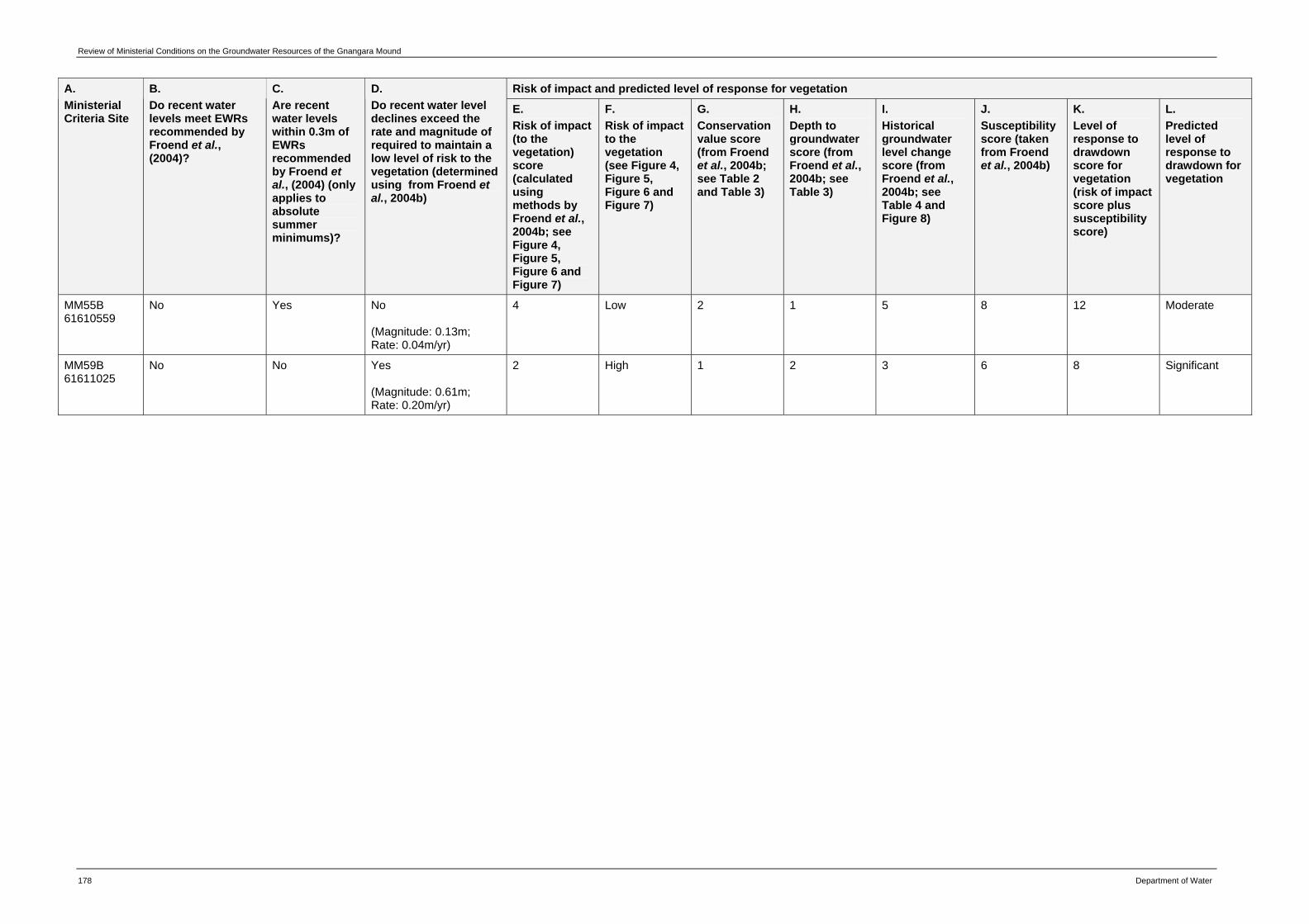
Review of Ministerial Conditions on the Groundwater Resources of the Gnangara Mound
178 Department of Water
Risk of impact and predicted level of response for vegetation A. Ministerial Criteria Site
B. Do recent water levels meet EWRs recommended by Froend et al., (2004)?
C. Are recent water levels within 0.3m of EWRs recommended by Froend et al., (2004) (only applies to absolute summer minimums)?
D. Do recent water level declines exceed the rate and magnitude of required to maintain a low level of risk to the vegetation (determined using from Froend et al., 2004b)
E. Risk of impact (to the vegetation) score (calculated using methods by Froend et al., 2004b; see Figure 4, Figure 5, Figure 6 and Figure 7)
F. Risk of impact to the vegetation (see Figure 4, Figure 5, Figure 6 and Figure 7)
G. Conservation value score (from Froend et al., 2004b; see Table 2 and Table 3)
H. Depth to groundwater score (from Froend et al., 2004b; see Table 3)
I. Historical groundwater level change score (from Froend et al., 2004b; see Table 4 and Figure 8)
J. Susceptibility score (taken from Froend et al., 2004b)
K. Level of response to drawdown score for vegetation (risk of impact score plus susceptibility score)
L. Predicted level of response to drawdown for vegetation
MM55B 61610559
No Yes No (Magnitude: 0.13m; Rate: 0.04m/yr)
4 Low 2 1 5 8 12 Moderate
MM59B 61611025
No No Yes (Magnitude: 0.61m; Rate: 0.20m/yr)
2 High 1 2 3 6 8 Significant
Review of Ministerial Conditions for the Gnangara Mound
Department of Water 179
Appendix D — Risk of impact and possible response to drawdown for wetlands and terrestrial phreatophytic sites.
Wetlands
Risk of impact and possible response to drawdown
Key elements Low (no detectable change)
Moderate (small change)
Significant (moderate change)
Severe (large change)
Ecosystem processes
Primary production
Rates of primary production are maintained within the limits of natural variation.
Some evidence of reduction in rates of primary production in response to drying.
Measurable reductions in rates of primary production in response to drying.
Severe reductions in rates of primary production in response to drying.
Nutrient recycling
Rates of nutrient recycling are maintained within the limits of natural variation.
Some evidence of reduction in rates of nutrient recycling in response to drying.
Measurable reductions in rates of nutrient recycling in response to drying.
Severe reductions in rates of nutrient recycling in response to drying.
Food chains No detectable change in food chains.
Some evidence of disruption to food chains.
Measurable disruptions to food chains.
Severe disruptions to food chains.
Sediment stabilisation
No detectable change in sediment stabilisation.
No detectable change in sediment stabilisation.
Some evidence of sediment destabilisation.
Measurable destabilisation of wetland sediments.
Pollutant filtration
No detectable change in rates of pollutant filtration
No detectable change in rates of pollutant filtration
Some evidence of change in rates of pollutant filtration.
Measurable reductions in rates of pollutant filtration.
Biodiversity (vegetation)
Species composition
No detectable change in species composition.
Some evidence of establishment of exotic species as result of disturbance and/or drying.
Measurable encroachment of xeric species into wetland.
Significant change in dominant populations with terrestrialisation through encroachment of xeric species.
Review of Ministerial Conditions for the Gnangara Mound
180 Department of Water
Risk of impact and possible response to drawdown
Key elements Low (no detectable change)
Moderate (small change)
Significant (moderate change)
Severe (large change)
Species distribution
No detectable change in distribution of species.
Some evidence of changing distribution with disturbance and/or drying allowing establishment of exotic species.
Measurable contraction of wetland through changing demographics of more than one species, with encroachment of xeric species into the wetland.
Greater than 50 per cent reduction in abundance of dominant species and /or significance change in dominant populations, with terrestrialisation through encroachment of xeric species.
Species mortality No detectable mortality.
Some mortality of individuals.
Greater than 15 per cent reduction in abundance of dominant species.
Greater than 50 per cent reduction in abundance of dominant species.
Species richness No detectable change in species richness.
Some evidence of decline in richness of wetland species.
Measurable decline in richness of wetland species and/or increase xeric species richness.
Significant change in richness of wetland species and replacement by xeric species.
Community structure
No detectable change in community structure.
Some evidence of change in community structure.
Notable change in community structure.
Significant change in community structure.
Abundances and biomass of biota
Vegetation density, cover and frequency
No detectable change in density, cover and abundance.
Some evidence of reduced growth in overstorey and/or understorey species.
Measurable crown dieback in overstorey species and/or reduction in cover of understorey.
Substantial crown dieback in overstorey species and loss of density and cover in understorey.
Vegetation height and diameter
No detectable change in vegetation height and diameter.
Some evidence of change in height due to loss of vigour and/or thinning of canopy.
Measurable reductions in height due to loss of canopy and/or reduced diameter of adult stems.
Significant reductions in height due to loss of canopy and reduced diameter of adult stems.
Review of Ministerial Conditions for the Gnangara Mound
Department of Water 181
Risk of impact and possible response to drawdown
Key elements Low (no detectable change)
Moderate (small change)
Significant (moderate change)
Severe (large change)
Vertebrate abundance
No detectable change in vertebrate abundance.
Some evidence of reduced vertebrate abundance.
Measurable changes in vertebrate abundance due to reduction in food and/or habitat availability as result of drying.
Greater than 50 per cent reduction in vertebrate abundance due to reduction in food and/or habitat availability as result of drying.
Macroinvertebrate abundance
No detectable change in macroinvertebrate abundance.
Some evidence of reduced macroinvertebrate abundance.
Measurable changes in vertebrate abundance due to reduction in food and/or habitat availability as result of drying.
Greater than 50 per cent reduction in vertebrate abundance due to reduction in food and/or habitat availability as result of drying.
Quality of water and sediment
Physical and biochemical properties of sediments and groundwater
Levels of contaminants & other measures of quality remain within limits of natural variation.
Small detectable changes beyond limits of natural variation but no resultant effect on biota.
Moderate changes beyond limits of natural variation but not to exceed specified criteria.
Substantial changes beyond limits of natural variation.
Review of Ministerial Conditions for the Gnangara Mound
182 Department of Water
Terrestrial phreatophytic vegetation sites
Risk of impact and possible response to drawdown Key elements
Low (no detectable change)
Moderate (small change)
Significant (moderate change)
Severe (large change)
Ecosystem processes
Primary production Rates of primary production are maintained within the limits of natural variation.
Some evidence of reduction in rates of primary production in response to drying.
Measurable reductions in rates of primary production in response to drying.
Severe reductions in rates of primary production in response to drying.
Nutrient recycling Rates of nutrient recycling are maintained within the limits of natural variation.
Some evidence of reduction in rates of nutrient recycling in response to drying.
Measurable reductions in rates of nutrient recycling in response to drying.
Severe reductions in rates of nutrient recycling in response to drying.
Food chains No detectable change in food chains.
Some evidence of disruption to food chains.
Measurable disruptions to food chains.
Severe disruptions to food chains.
Sediment /soil stabilization
No detectable change in soil stabilisation.
No detectable change in soil stabilisation.
Some evidence of soil destabilisation/ erosion.
Measurable destabilisation/ erosion of soil.
Biodiversity
Species composition
No detectable change in species composition.
Some evidence of encroachment of more drought tolerant species.
Measurable signs of encroachment of more drought tolerant species.
Loss of less drought tolerant species from ecosystem, with establishment of exotic species and gradual dominance by more drought tolerant species.
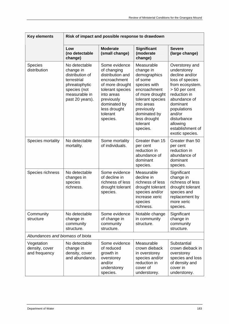
Review of Ministerial Conditions for the Gnangara Mound
Department of Water 183
Risk of impact and possible response to drawdown Key elements
Low (no detectable change)
Moderate (small change)
Significant (moderate change)
Severe (large change)
Species distribution
No detectable change in distribution of terrestrial phreatophytic species (not measurable in past 20 years).
Some evidence of changing distribution and encroachment of more drought tolerant species into areas previously dominated by less drought tolerant species.
Measurable change in demographics of some species with encroachment of more drought tolerant species into areas previously dominated by less drought tolerant species.
Overstorey and understorey decline and/or loss of species from ecosystem. > 50 per cent reduction in abundance of dominant populations and/or disturbance allowing establishment of exotic species.
Species mortality No detectable mortality.
Some mortality of individuals.
Greater than 15 per cent reduction in abundance of dominant species.
Greater than 50 per cent reduction in abundance of dominant species.
Species richness No detectable changes in species richness.
Some evidence of decline in richness of less drought tolerant species.
Measurable decline in richness of less drought tolerant species and/or increase xeric species richness.
Significant change in richness of less drought tolerant species and replacement by more xeric species.
Community structure
No detectable change in community structure.
Some evidence of change in community structure.
Notable change in community structure.
Significant change in community structure.
Abundances and biomass of biota
Vegetation density, cover and frequency
No detectable change in density, cover and abundance.
Some evidence of reduced growth in overstorey and/or understorey species.
Measurable crown dieback in overstorey species and/or reduction in cover of understorey.
Substantial crown dieback in overstorey species and loss of density and cover in understorey.
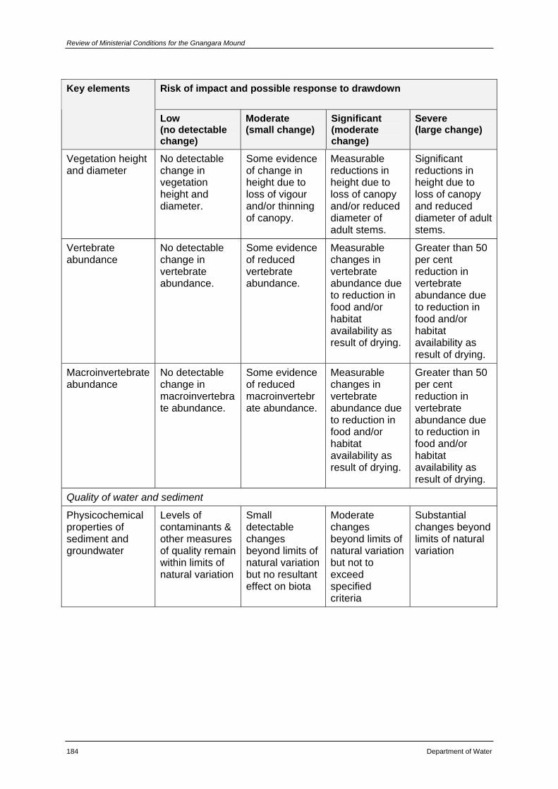
Review of Ministerial Conditions for the Gnangara Mound
184 Department of Water
Risk of impact and possible response to drawdown Key elements
Low (no detectable change)
Moderate (small change)
Significant (moderate change)
Severe (large change)
Vegetation height and diameter
No detectable change in vegetation height and diameter.
Some evidence of change in height due to loss of vigour and/or thinning of canopy.
Measurable reductions in height due to loss of canopy and/or reduced diameter of adult stems.
Significant reductions in height due to loss of canopy and reduced diameter of adult stems.
Vertebrate abundance
No detectable change in vertebrate abundance.
Some evidence of reduced vertebrate abundance.
Measurable changes in vertebrate abundance due to reduction in food and/or habitat availability as result of drying.
Greater than 50 per cent reduction in vertebrate abundance due to reduction in food and/or habitat availability as result of drying.
Macroinvertebrate abundance
No detectable change in macroinvertebrate abundance.
Some evidence of reduced macroinvertebrate abundance.
Measurable changes in vertebrate abundance due to reduction in food and/or habitat availability as result of drying.
Greater than 50 per cent reduction in vertebrate abundance due to reduction in food and/or habitat availability as result of drying.
Quality of water and sediment
Physicochemical properties of sediment and groundwater
Levels of contaminants & other measures of quality remain within limits of natural variation
Small detectable changes beyond limits of natural variation but no resultant effect on biota
Moderate changes beyond limits of natural variation but not to exceed specified criteria
Substantial changes beyond limits of natural variation
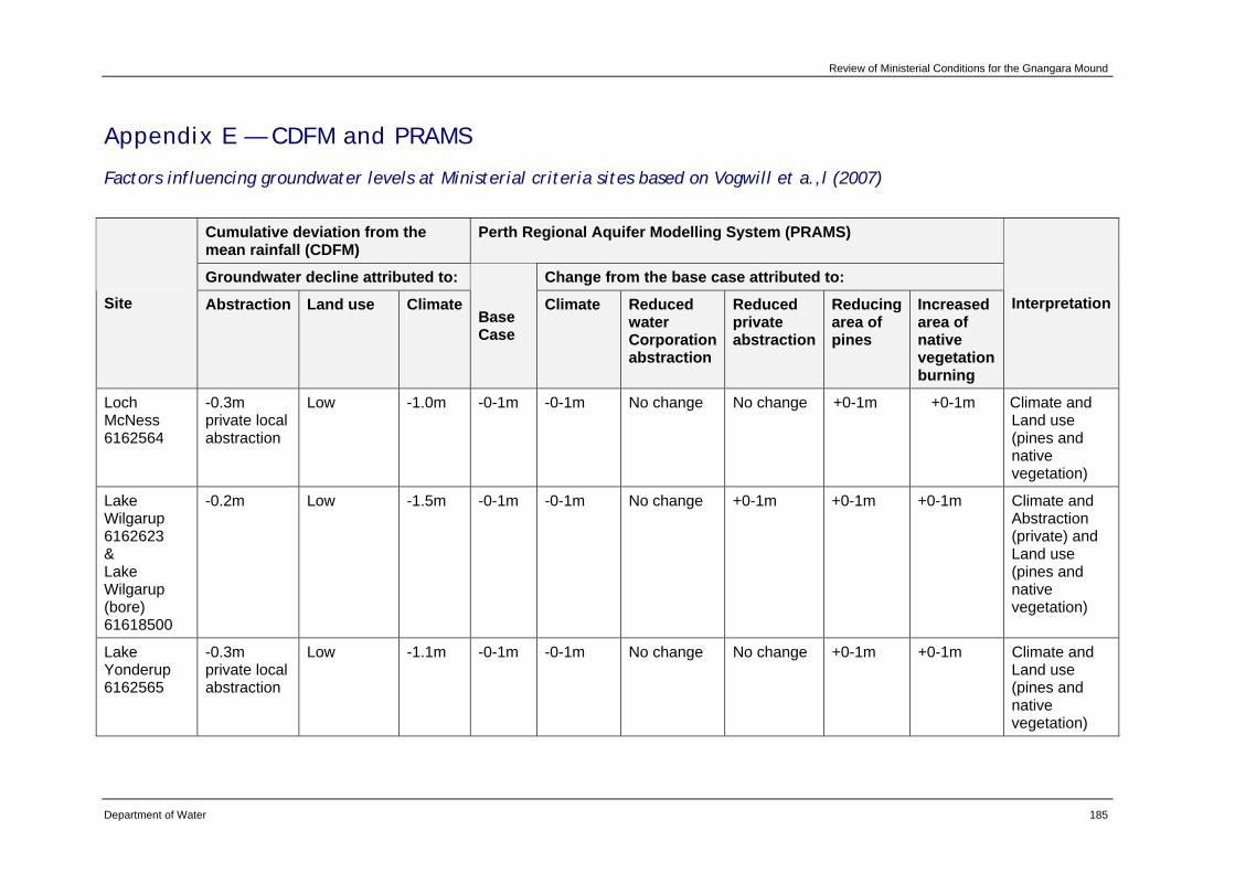
Review of Ministerial Conditions for the Gnangara Mound
Department of Water 185
Appendix E — CDFM and PRAMS
Factors influencing groundwater levels at Ministerial criteria sites based on Vogwill et a.,l (2007)
Cumulative deviation from the mean rainfall (CDFM)
Perth Regional Aquifer Modelling System (PRAMS)
Groundwater decline attributed to: Change from the base case attributed to: Site Abstraction Land use Climate
Base Case
Climate Reduced water Corporation abstraction
Reduced private abstraction
Reducing area of pines
Increased area of native vegetation burning
Interpretation
Loch McNess 6162564
-0.3m private local abstraction
Low -1.0m -0-1m -0-1m No change No change +0-1m +0-1m Climate and Land use (pines and native vegetation)
Lake Wilgarup 6162623 & Lake Wilgarup (bore) 61618500
-0.2m Low -1.5m -0-1m -0-1m No change +0-1m +0-1m +0-1m Climate and Abstraction (private) and Land use (pines and native vegetation)
Lake Yonderup 6162565
-0.3m private local abstraction
Low -1.1m -0-1m -0-1m No change No change +0-1m +0-1m Climate and Land use (pines and native vegetation)
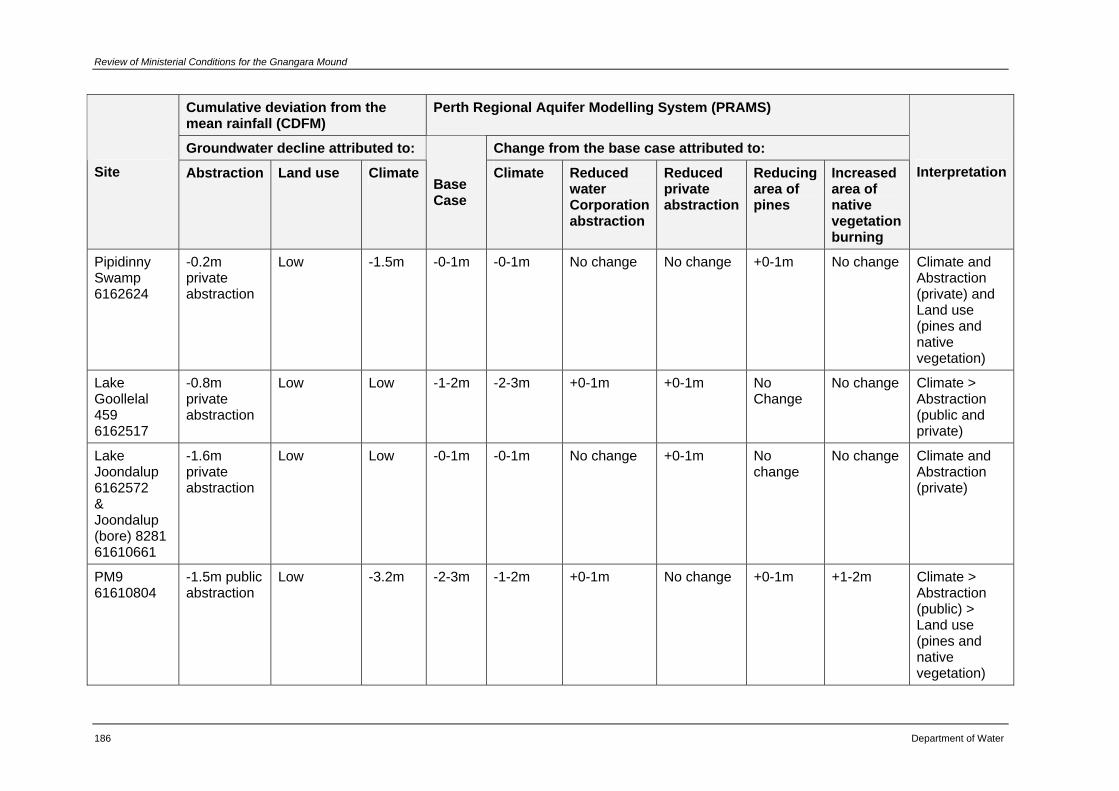
Review of Ministerial Conditions for the Gnangara Mound
186 Department of Water
Cumulative deviation from the mean rainfall (CDFM)
Perth Regional Aquifer Modelling System (PRAMS)
Groundwater decline attributed to: Change from the base case attributed to: Site Abstraction Land use Climate
Base Case
Climate Reduced water Corporation abstraction
Reduced private abstraction
Reducing area of pines
Increased area of native vegetation burning
Interpretation
Pipidinny Swamp 6162624
-0.2m private abstraction
Low -1.5m -0-1m -0-1m No change No change +0-1m No change Climate and Abstraction (private) and Land use (pines and native vegetation)
Lake Goollelal 459 6162517
-0.8m private abstraction
Low Low -1-2m -2-3m +0-1m +0-1m No Change
No change Climate > Abstraction (public and private)
Lake Joondalup 6162572 & Joondalup (bore) 8281 61610661
-1.6m private abstraction
Low Low -0-1m -0-1m No change +0-1m No change
No change Climate and Abstraction (private)
PM9 61610804
-1.5m public abstraction
Low -3.2m -2-3m -1-2m +0-1m No change +0-1m +1-2m Climate > Abstraction (public) > Land use (pines and native vegetation)
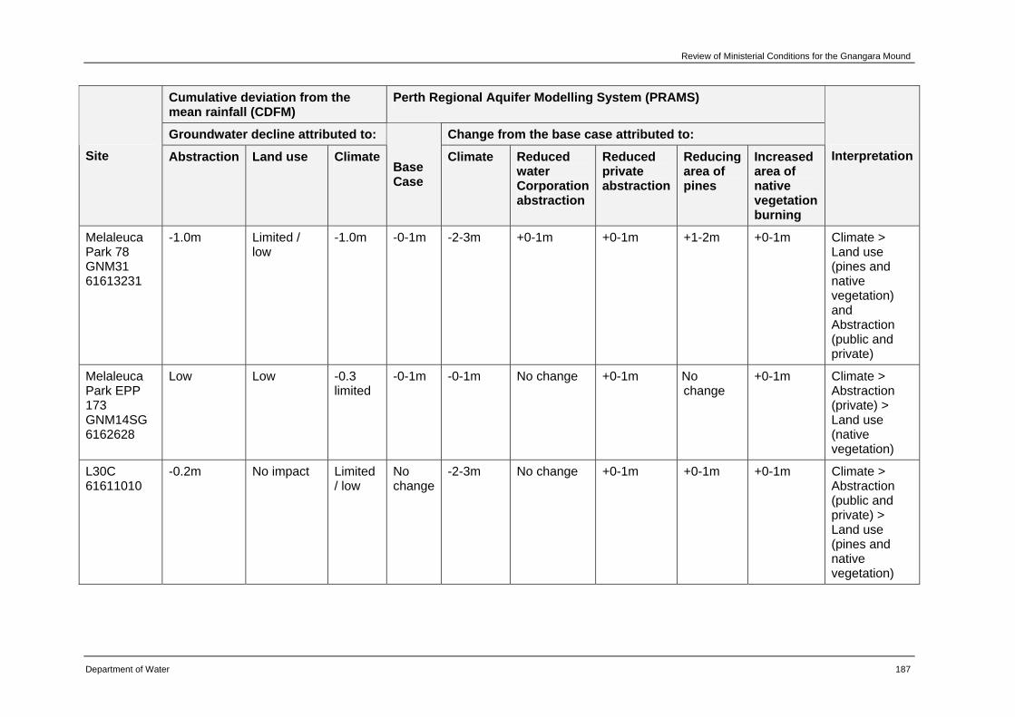
Review of Ministerial Conditions for the Gnangara Mound
Department of Water 187
Cumulative deviation from the mean rainfall (CDFM)
Perth Regional Aquifer Modelling System (PRAMS)
Groundwater decline attributed to: Change from the base case attributed to: Site Abstraction Land use Climate
Base Case
Climate Reduced water Corporation abstraction
Reduced private abstraction
Reducing area of pines
Increased area of native vegetation burning
Interpretation
Melaleuca Park 78 GNM31 61613231
-1.0m Limited / low
-1.0m -0-1m -2-3m +0-1m +0-1m +1-2m +0-1m Climate > Land use (pines and native vegetation) and Abstraction (public and private)
Melaleuca Park EPP 173 GNM14SG 6162628
Low Low -0.3 limited
-0-1m -0-1m No change +0-1m No change
+0-1m Climate > Abstraction (private) > Land use (native vegetation)
L30C 61611010
-0.2m No impact Limited / low
No change
-2-3m No change +0-1m +0-1m +0-1m Climate > Abstraction (public and private) > Land use (pines and native vegetation)
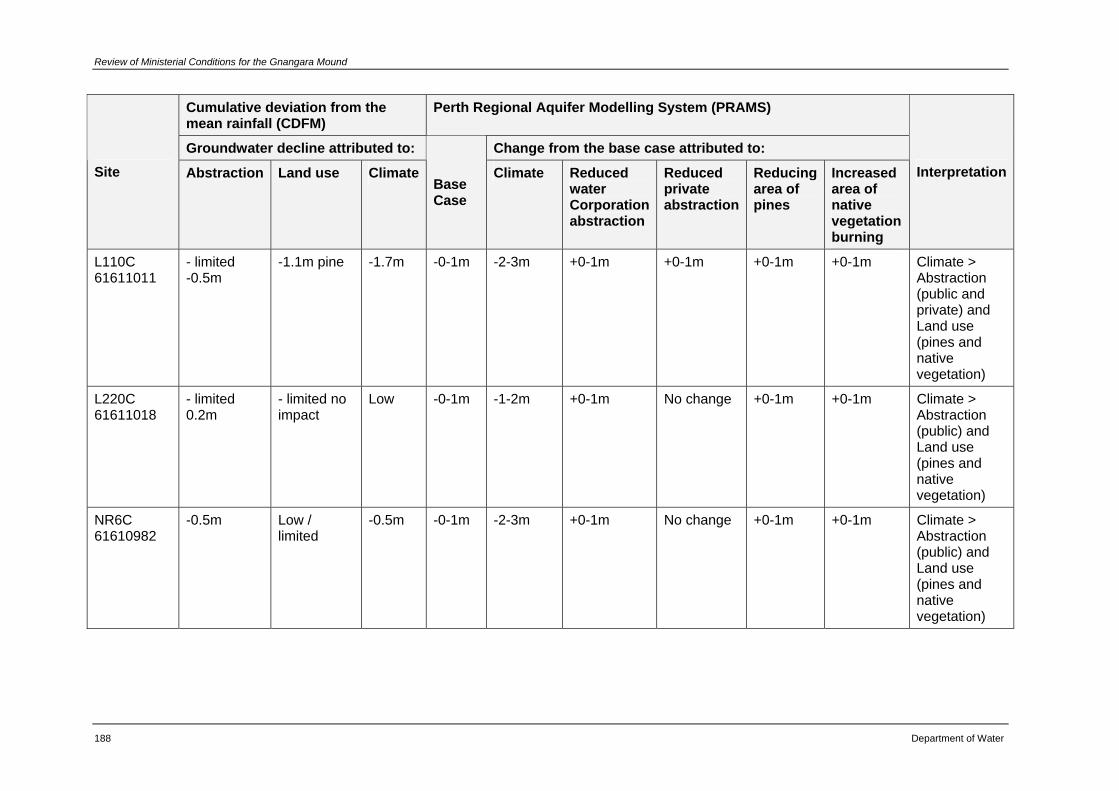
Review of Ministerial Conditions for the Gnangara Mound
188 Department of Water
Cumulative deviation from the mean rainfall (CDFM)
Perth Regional Aquifer Modelling System (PRAMS)
Groundwater decline attributed to: Change from the base case attributed to: Site Abstraction Land use Climate
Base Case
Climate Reduced water Corporation abstraction
Reduced private abstraction
Reducing area of pines
Increased area of native vegetation burning
Interpretation
L110C 61611011
- limited -0.5m
-1.1m pine -1.7m -0-1m -2-3m +0-1m +0-1m +0-1m +0-1m Climate > Abstraction (public and private) and Land use (pines and native vegetation)
L220C 61611018
- limited 0.2m
- limited no impact
Low -0-1m -1-2m +0-1m No change +0-1m +0-1m Climate > Abstraction (public) and Land use (pines and native vegetation)
NR6C 61610982
-0.5m Low / limited
-0.5m -0-1m -2-3m +0-1m No change +0-1m +0-1m Climate > Abstraction (public) and Land use (pines and native vegetation)
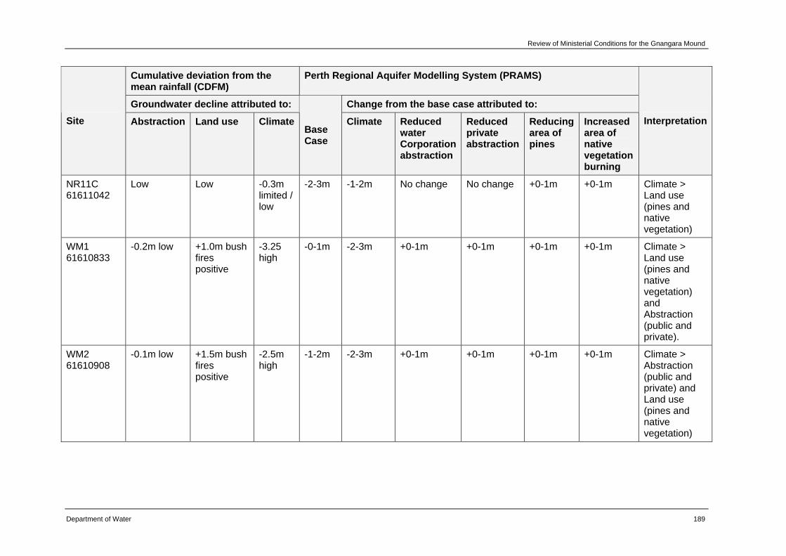
Review of Ministerial Conditions for the Gnangara Mound
Department of Water 189
Cumulative deviation from the mean rainfall (CDFM)
Perth Regional Aquifer Modelling System (PRAMS)
Groundwater decline attributed to: Change from the base case attributed to: Site Abstraction Land use Climate
Base Case
Climate Reduced water Corporation abstraction
Reduced private abstraction
Reducing area of pines
Increased area of native vegetation burning
Interpretation
NR11C 61611042
Low Low -0.3m limited / low
-2-3m -1-2m No change No change +0-1m +0-1m Climate > Land use (pines and native vegetation)
WM1 61610833
-0.2m low +1.0m bush fires positive
-3.25 high
-0-1m -2-3m +0-1m +0-1m +0-1m +0-1m Climate > Land use (pines and native vegetation) and Abstraction (public and private).
WM2 61610908
-0.1m low +1.5m bush fires positive
-2.5m high
-1-2m -2-3m +0-1m +0-1m +0-1m +0-1m Climate > Abstraction (public and private) and Land use (pines and native vegetation)
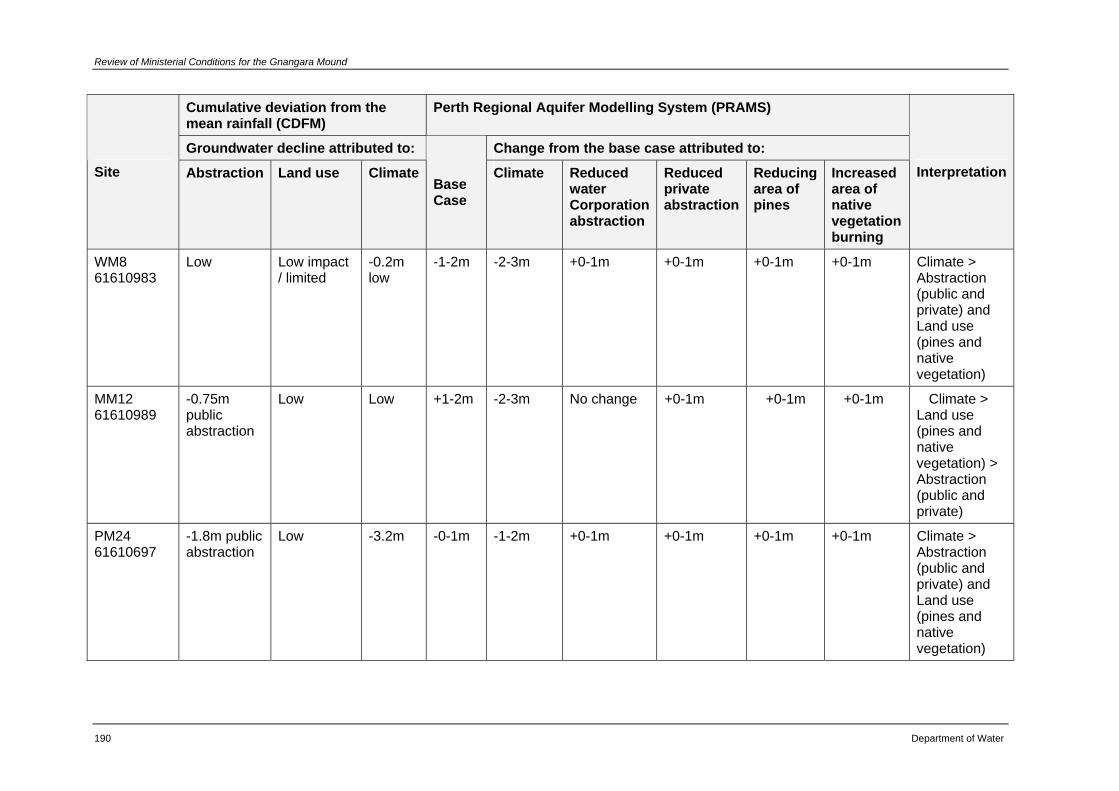
Review of Ministerial Conditions for the Gnangara Mound
190 Department of Water
Cumulative deviation from the mean rainfall (CDFM)
Perth Regional Aquifer Modelling System (PRAMS)
Groundwater decline attributed to: Change from the base case attributed to: Site Abstraction Land use Climate
Base Case
Climate Reduced water Corporation abstraction
Reduced private abstraction
Reducing area of pines
Increased area of native vegetation burning
Interpretation
WM8 61610983
Low Low impact / limited
-0.2m low
-1-2m -2-3m +0-1m +0-1m +0-1m +0-1m Climate > Abstraction (public and private) and Land use (pines and native vegetation)
MM12 61610989
-0.75m public abstraction
Low Low +1-2m -2-3m No change +0-1m +0-1m +0-1m Climate > Land use (pines and native vegetation) > Abstraction (public and private)
PM24 61610697
-1.8m public abstraction
Low -3.2m -0-1m -1-2m +0-1m +0-1m +0-1m +0-1m Climate > Abstraction (public and private) and Land use (pines and native vegetation)
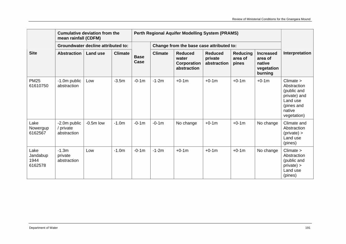
Review of Ministerial Conditions for the Gnangara Mound
Department of Water 191
Cumulative deviation from the mean rainfall (CDFM)
Perth Regional Aquifer Modelling System (PRAMS)
Groundwater decline attributed to: Change from the base case attributed to: Site Abstraction Land use Climate
Base Case
Climate Reduced water Corporation abstraction
Reduced private abstraction
Reducing area of pines
Increased area of native vegetation burning
Interpretation
PM25 61610750
-1.0m public abstraction
Low -3.5m -0-1m -1-2m +0-1m +0-1m +0-1m +0-1m Climate > Abstraction (public and private) and Land use (pines and native vegetation)
Lake Nowergup 6162567
-2.0m public / private abstraction
-0.5m low -1.0m -0-1m -0-1m No change +0-1m +0-1m No change Climate and Abstraction (private) > Land use (pines)
Lake Jandabup 1944 6162578
-1.3m private abstraction
Low -1.0m -0-1m -1-2m +0-1m +0-1m +0-1m No change Climate > Abstraction (public and private) > Land use (pines)
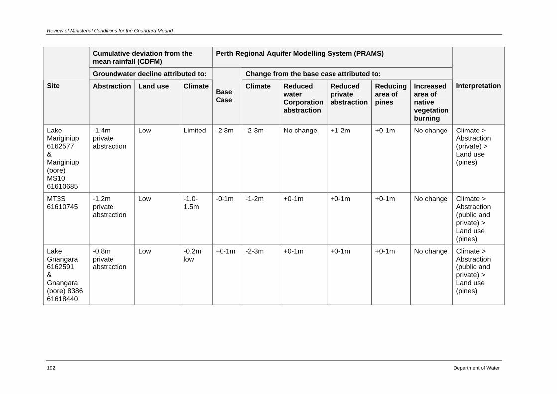
Review of Ministerial Conditions for the Gnangara Mound
192 Department of Water
Cumulative deviation from the mean rainfall (CDFM)
Perth Regional Aquifer Modelling System (PRAMS)
Groundwater decline attributed to: Change from the base case attributed to: Site Abstraction Land use Climate
Base Case
Climate Reduced water Corporation abstraction
Reduced private abstraction
Reducing area of pines
Increased area of native vegetation burning
Interpretation
Lake Mariginiup 6162577 & Mariginiup (bore) MS10 61610685
-1.4m private abstraction
Low Limited -2-3m -2-3m No change +1-2m +0-1m No change Climate > Abstraction (private) > Land use (pines)
MT3S 61610745
-1.2m private abstraction
Low -1.0-1.5m
-0-1m -1-2m +0-1m +0-1m +0-1m No change Climate > Abstraction (public and private) > Land use (pines)
Lake Gnangara 6162591 & Gnangara (bore) 8386 61618440
-0.8m private abstraction
Low -0.2m low
+0-1m -2-3m +0-1m +0-1m +0-1m No change Climate > Abstraction (public and private) > Land use (pines)
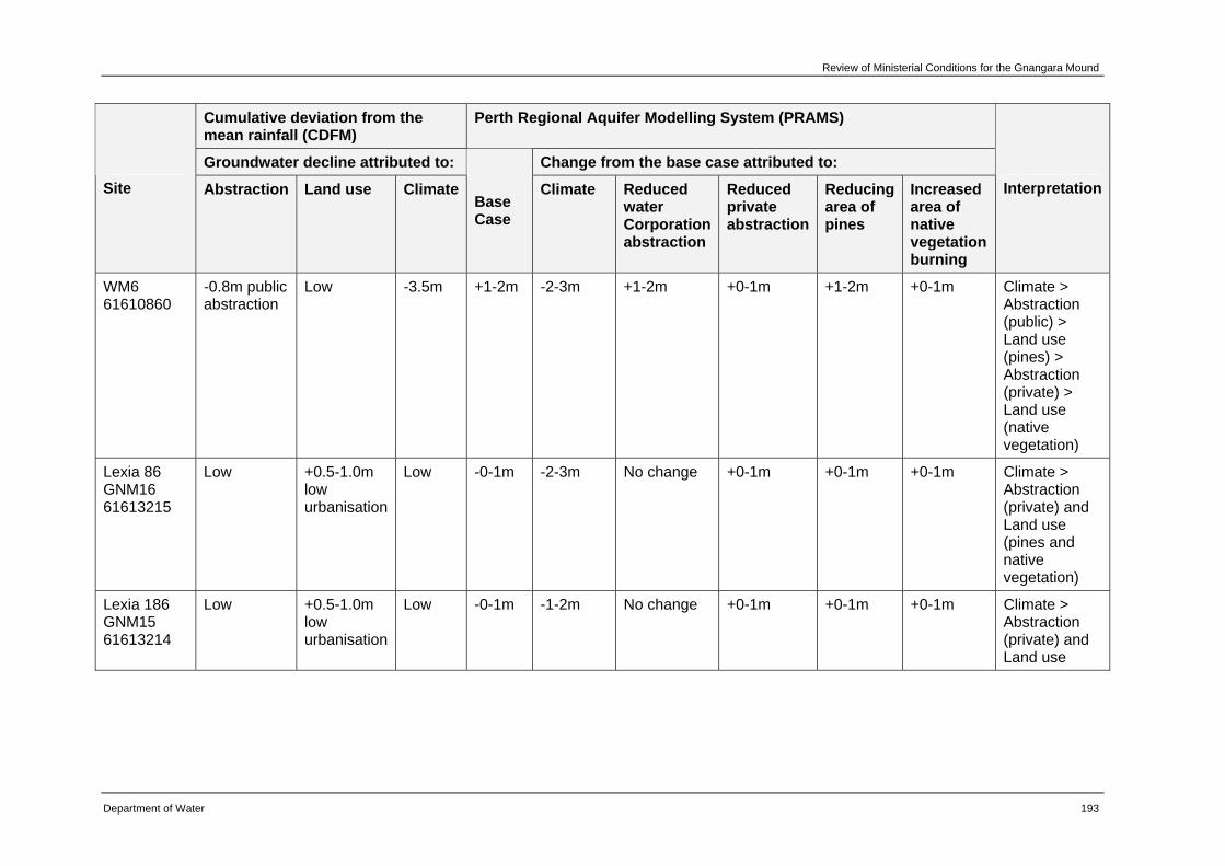
Review of Ministerial Conditions for the Gnangara Mound
Department of Water 193
Cumulative deviation from the mean rainfall (CDFM)
Perth Regional Aquifer Modelling System (PRAMS)
Groundwater decline attributed to: Change from the base case attributed to: Site Abstraction Land use Climate
Base Case
Climate Reduced water Corporation abstraction
Reduced private abstraction
Reducing area of pines
Increased area of native vegetation burning
Interpretation
WM6 61610860
-0.8m public abstraction
Low -3.5m +1-2m -2-3m +1-2m +0-1m +1-2m +0-1m Climate > Abstraction (public) > Land use (pines) > Abstraction (private) > Land use (native vegetation)
Lexia 86 GNM16 61613215
Low +0.5-1.0m low urbanisation
Low -0-1m -2-3m No change +0-1m +0-1m +0-1m Climate > Abstraction (private) and Land use (pines and native vegetation)
Lexia 186 GNM15 61613214
Low +0.5-1.0m low urbanisation
Low -0-1m -1-2m No change +0-1m +0-1m +0-1m Climate > Abstraction (private) and Land use
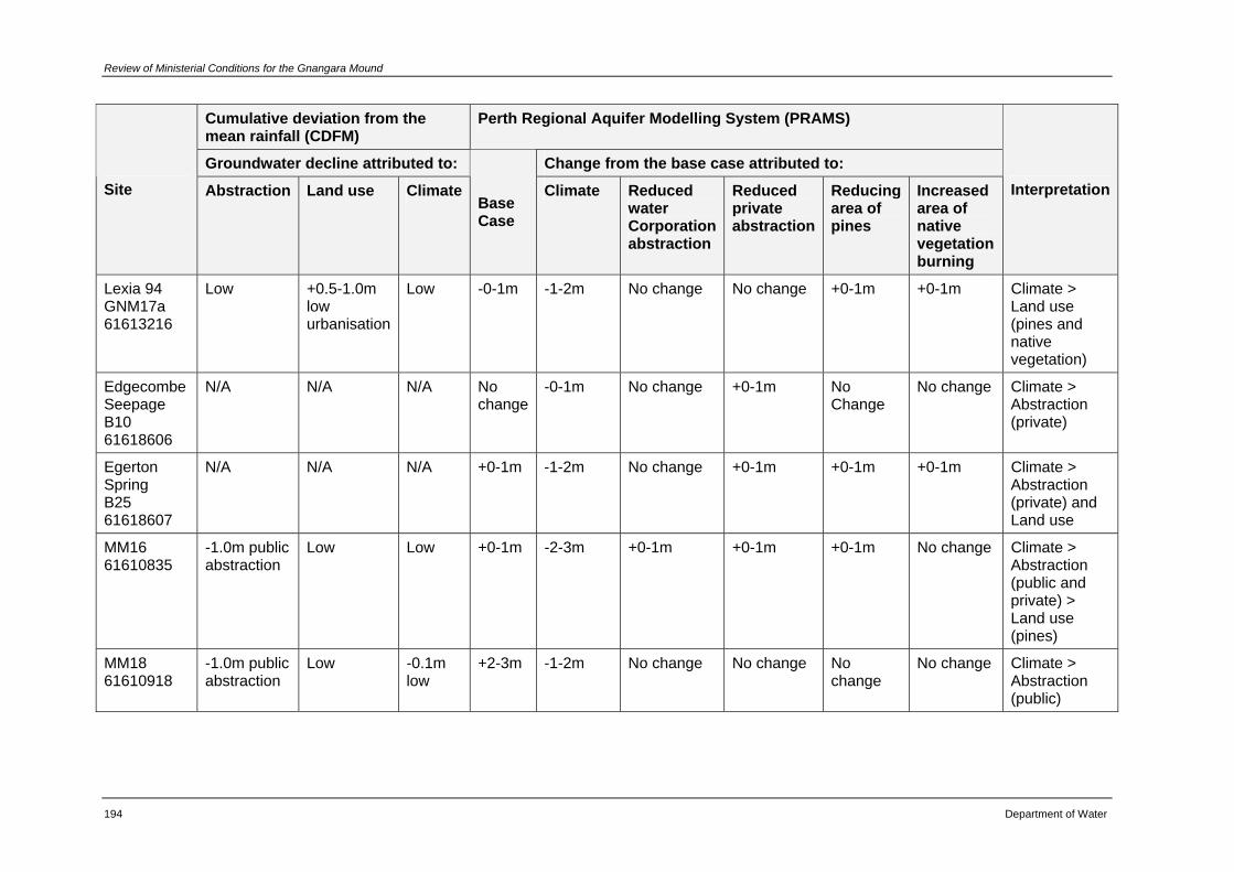
Review of Ministerial Conditions for the Gnangara Mound
194 Department of Water
Cumulative deviation from the mean rainfall (CDFM)
Perth Regional Aquifer Modelling System (PRAMS)
Groundwater decline attributed to: Change from the base case attributed to: Site Abstraction Land use Climate
Base Case
Climate Reduced water Corporation abstraction
Reduced private abstraction
Reducing area of pines
Increased area of native vegetation burning
Interpretation
Lexia 94 GNM17a 61613216
Low +0.5-1.0m low urbanisation
Low -0-1m -1-2m No change No change +0-1m +0-1m Climate > Land use (pines and native vegetation)
Edgecombe Seepage B10 61618606
N/A N/A N/A No change
-0-1m No change +0-1m No Change
No change Climate > Abstraction (private)
Egerton Spring B25 61618607
N/A N/A N/A +0-1m -1-2m No change +0-1m +0-1m +0-1m Climate > Abstraction (private) and Land use
MM16 61610835
-1.0m public abstraction
Low Low +0-1m -2-3m +0-1m +0-1m +0-1m No change Climate > Abstraction (public and private) > Land use (pines)
MM18 61610918
-1.0m public abstraction
Low -0.1m low
+2-3m -1-2m No change No change No change
No change Climate > Abstraction (public)
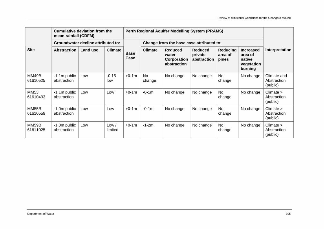
Review of Ministerial Conditions for the Gnangara Mound
Department of Water 195
Cumulative deviation from the mean rainfall (CDFM)
Perth Regional Aquifer Modelling System (PRAMS)
Groundwater decline attributed to: Change from the base case attributed to: Site Abstraction Land use Climate
Base Case
Climate Reduced water Corporation abstraction
Reduced private abstraction
Reducing area of pines
Increased area of native vegetation burning
Interpretation
MM49B 61610525
-1.1m public abstraction
Low -0.15 low
+0-1m No change
No change No change No change
No change Climate and Abstraction (public)
MM53 61610493
-1.1m public abstraction
Low Low +0-1m -0-1m No change No change No change
No change Climate > Abstraction (public)
MM55B 61610559
-1.0m public abstraction
Low Low +0-1m -0-1m No change No change No change
No change Climate > Abstraction (public)
MM59B 61611025
-1.0m public abstraction
Low Low / limited
+0-1m -1-2m No change No change No change
No change Climate > Abstraction (public)
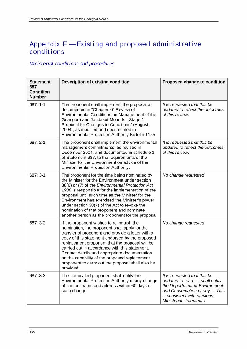
Review of Ministerial Conditions for the Gnangara Mound
196 Department of Water
Appendix F — Existing and proposed administrative conditions
Ministerial conditions and procedures
Statement 687 Condition Number
Description of existing condition Proposed change to condition
687: 1-1 The proponent shall implement the proposal as documented in ”Chapter 46 Review of Environmental Conditions on Management of the Gnangara and Jandakot Mounds - Stage 1 Proposal for Changes to Conditions” (August 2004), as modified and documented in Environmental Protection Authority Bulletin 1155
It is requested that this be updated to reflect the outcomes of this review.
687: 2-1 The proponent shall implement the environmental management commitments, as revised in December 2004, and documented in schedule 1 of Statement 687, to the requirements of the Minister for the Environment on advice of the Environmental Protection Authority.
It is requested that this be updated to reflect the outcomes of this review.
687: 3-1 The proponent for the time being nominated by the Minister for the Environment under section 38(6) or (7) of the Environmental Protection Act 1986 is responsible for the implementation of the proposal until such time as the Minister for the Environment has exercised the Minister’s power under section 38(7) of the Act to revoke the nomination of that proponent and nominate another person as the proponent for the proposal.
No change requested
687: 3-2 If the proponent wishes to relinquish the nomination, the proponent shall apply for the transfer of proponent and provide a letter with a copy of this statement endorsed by the proposed replacement proponent that the proposal will be carried out in accordance with this statement. Contact details and appropriate documentation on the capability of the proposed replacement proponent to carry out the proposal shall also be provided.
No change requested
687: 3-3 The nominated proponent shall notify the Environmental Protection Authority of any change of contact name and address within 60 days of such change.
It is requested that this be updated to read ‘…shall notify the Department of Environment and Conservation of any…’ This is consistent with previous Ministerial statements.
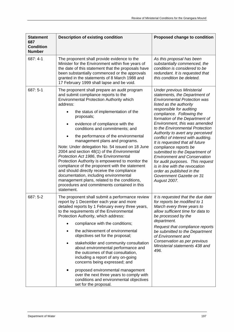
Review of Ministerial Conditions for the Gnangara Mound
Department of Water 197
Statement 687 Condition Number
Description of existing condition Proposed change to condition
687: 4-1 The proponent shall provide evidence to the Minister for the Environment within five years of the date of this statement that the proposals have been substantially commenced or the approvals granted in the statements of 8 March 1988 and 17 February 1999 shall lapse and be void.
As this proposal has been substantially commenced, the condition is considered to be redundant. It is requested that this condition be deleted.
687: 5-1 The proponent shall prepare an audit program and submit compliance reports to the Environmental Protection Authority which address:
• the status of implementation of the proposals;
• evidence of compliance with the conditions and commitments; and
• the performance of the environmental management plans and programs.
Note: Under delegation No. 54 issued on 18 June 2004 and section 48(1) of the Environmental Protection Act 1986, the Environmental Protection Authority is empowered to monitor the compliance of the proponent with the statement and should directly receive the compliance documentation, including environmental management plans, related to the conditions, procedures and commitments contained in this statement.
Under previous Ministerial statements, the Department of Environmental Protection was listed as the authority responsible for auditing compliance. Following the formation of the Department of Environment, this was amended to the Environmental Protection Authority to avert any perceived conflict of interest with auditing. It is requested that all future compliance reports be submitted to the Department of Environment and Conservation for audit purposes. This request is in line with the revocation order as published in the Government Gazette on 31 August 2007.
687: 5-2 The proponent shall submit a performance review report by 1 December each year and more detailed reports by 1 February every three years, to the requirements of the Environmental Protection Authority, which address:
• compliance with the conditions;
• the achievement of environmental objectives set for the proposal;
• stakeholder and community consultation about environmental performance and the outcomes of that consultation, including a report of any on-going concerns being expressed; and
• proposed environmental management over the next three years to comply with conditions and environmental objectives set for the proposal.
It is requested that the due date for reports be modified to 1 March every three years to allow sufficient time for data to be processed by the department. Request that compliance reports be submitted to the Department of Environment and Conservation as per previous Ministerial statements 438 and 496.
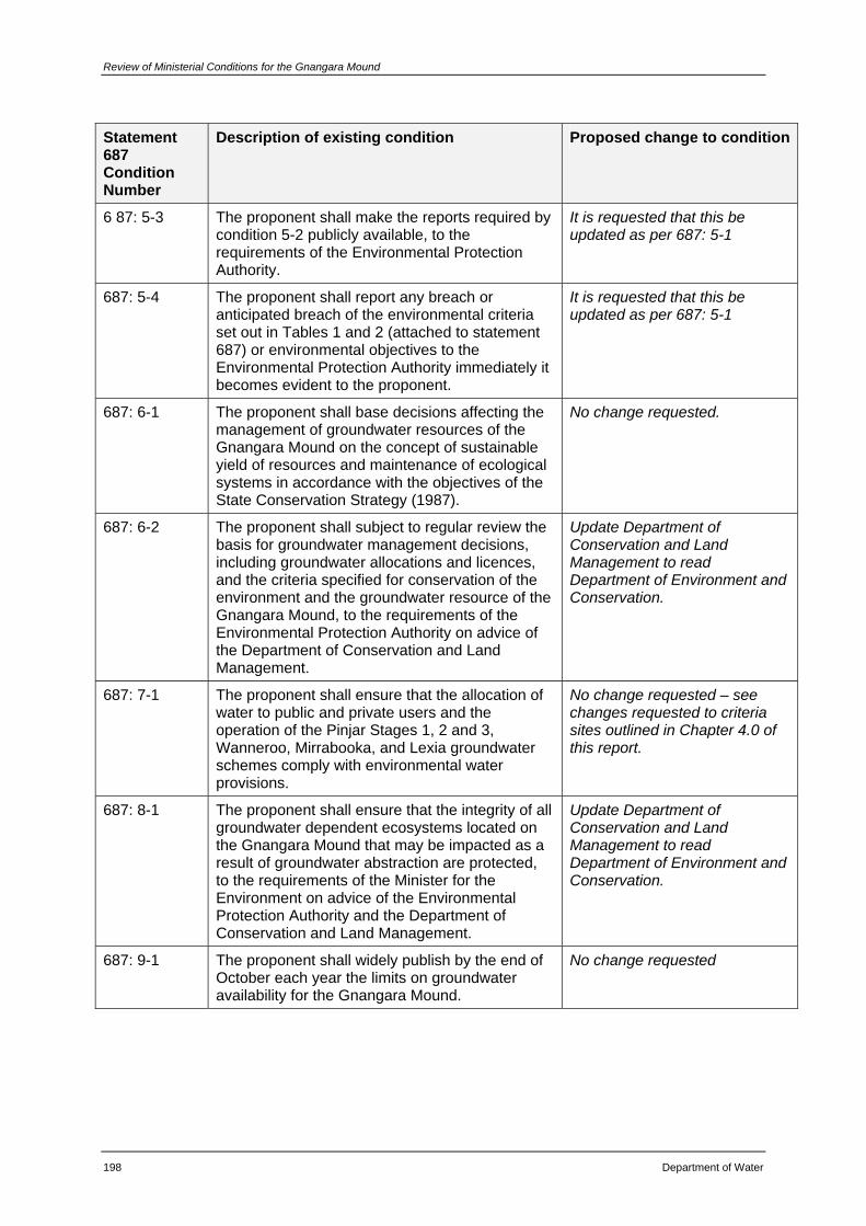
Review of Ministerial Conditions for the Gnangara Mound
198 Department of Water
Statement 687 Condition Number
Description of existing condition Proposed change to condition
6 87: 5-3 The proponent shall make the reports required by condition 5-2 publicly available, to the requirements of the Environmental Protection Authority.
It is requested that this be updated as per 687: 5-1
687: 5-4 The proponent shall report any breach or anticipated breach of the environmental criteria set out in Tables 1 and 2 (attached to statement 687) or environmental objectives to the Environmental Protection Authority immediately it becomes evident to the proponent.
It is requested that this be updated as per 687: 5-1
687: 6-1 The proponent shall base decisions affecting the management of groundwater resources of the Gnangara Mound on the concept of sustainable yield of resources and maintenance of ecological systems in accordance with the objectives of the State Conservation Strategy (1987).
No change requested.
687: 6-2 The proponent shall subject to regular review the basis for groundwater management decisions, including groundwater allocations and licences, and the criteria specified for conservation of the environment and the groundwater resource of the Gnangara Mound, to the requirements of the Environmental Protection Authority on advice of the Department of Conservation and Land Management.
Update Department of Conservation and Land Management to read Department of Environment and Conservation.
687: 7-1 The proponent shall ensure that the allocation of water to public and private users and the operation of the Pinjar Stages 1, 2 and 3, Wanneroo, Mirrabooka, and Lexia groundwater schemes comply with environmental water provisions.
No change requested – see changes requested to criteria sites outlined in Chapter 4.0 of this report.
687: 8-1 The proponent shall ensure that the integrity of all groundwater dependent ecosystems located on the Gnangara Mound that may be impacted as a result of groundwater abstraction are protected, to the requirements of the Minister for the Environment on advice of the Environmental Protection Authority and the Department of Conservation and Land Management.
Update Department of Conservation and Land Management to read Department of Environment and Conservation.
687: 9-1 The proponent shall widely publish by the end of October each year the limits on groundwater availability for the Gnangara Mound.
No change requested
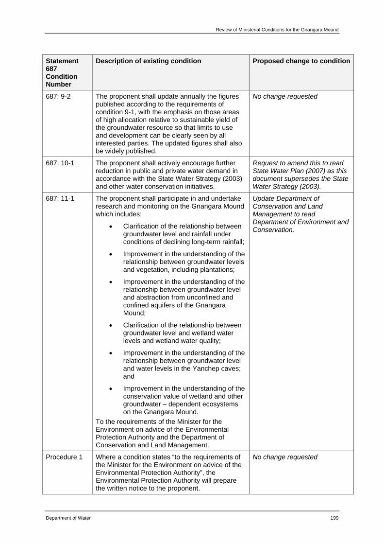
Review of Ministerial Conditions for the Gnangara Mound
Department of Water 199
Statement 687 Condition Number
Description of existing condition Proposed change to condition
687: 9-2 The proponent shall update annually the figures published according to the requirements of condition 9-1, with the emphasis on those areas of high allocation relative to sustainable yield of the groundwater resource so that limits to use and development can be clearly seen by all interested parties. The updated figures shall also be widely published.
No change requested
687: 10-1 The proponent shall actively encourage further reduction in public and private water demand in accordance with the State Water Strategy (2003) and other water conservation initiatives.
Request to amend this to read State Water Plan (2007) as this document supersedes the State Water Strategy (2003).
687: 11-1 The proponent shall participate in and undertake research and monitoring on the Gnangara Mound which includes:
• Clarification of the relationship between groundwater level and rainfall under conditions of declining long-term rainfall;
• Improvement in the understanding of the relationship between groundwater levels and vegetation, including plantations;
• Improvement in the understanding of the relationship between groundwater level and abstraction from unconfined and confined aquifers of the Gnangara Mound;
• Clarification of the relationship between groundwater level and wetland water levels and wetland water quality;
• Improvement in the understanding of the relationship between groundwater level and water levels in the Yanchep caves; and
• Improvement in the understanding of the conservation value of wetland and other groundwater – dependent ecosystems on the Gnangara Mound.
To the requirements of the Minister for the Environment on advice of the Environmental Protection Authority and the Department of Conservation and Land Management.
Update Department of Conservation and Land Management to read Department of Environment and Conservation.
Procedure 1 Where a condition states “to the requirements of the Minister for the Environment on advice of the Environmental Protection Authority”, the Environmental Protection Authority will prepare the written notice to the proponent.
No change requested
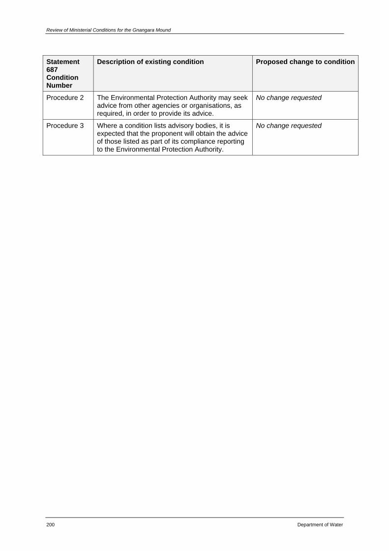
Review of Ministerial Conditions for the Gnangara Mound
200 Department of Water
Statement 687 Condition Number
Description of existing condition Proposed change to condition
Procedure 2 The Environmental Protection Authority may seek advice from other agencies or organisations, as required, in order to provide its advice.
No change requested
Procedure 3 Where a condition lists advisory bodies, it is expected that the proponent will obtain the advice of those listed as part of its compliance reporting to the Environmental Protection Authority.
No change requested
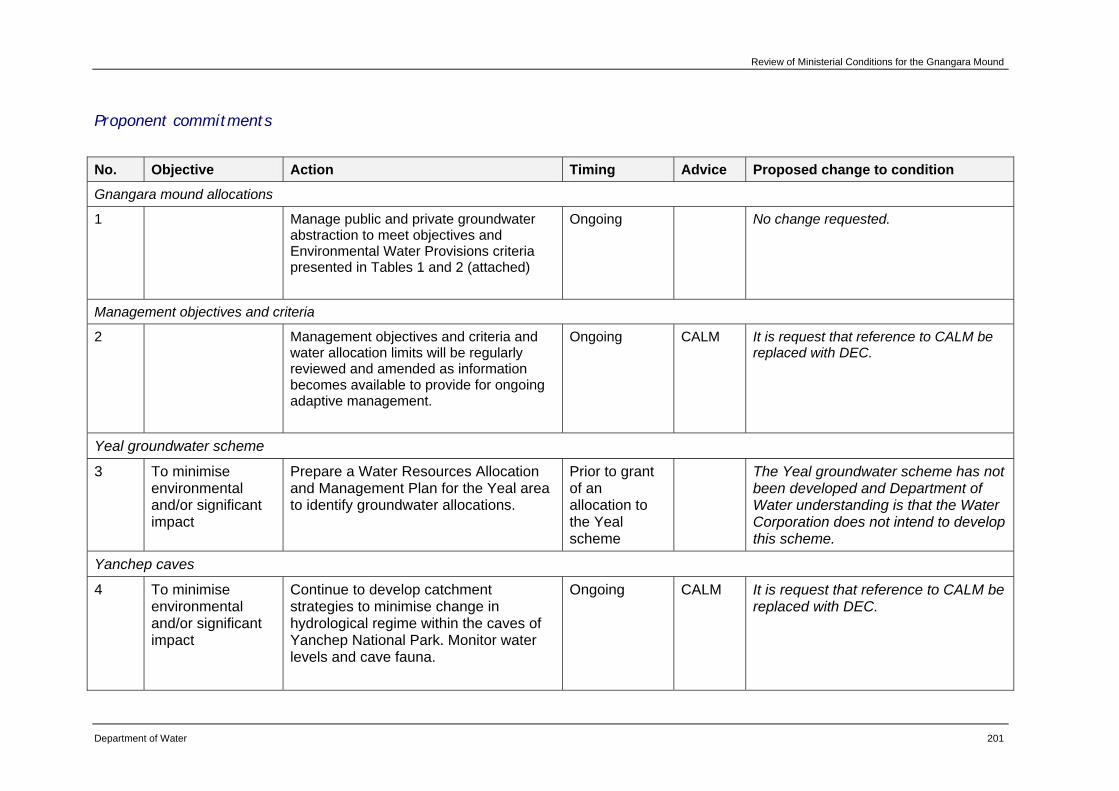
Review of Ministerial Conditions for the Gnangara Mound
Department of Water 201
Proponent commitments
No. Objective Action Timing Advice Proposed change to condition
Gnangara mound allocations
1 Manage public and private groundwater abstraction to meet objectives and Environmental Water Provisions criteria presented in Tables 1 and 2 (attached)
Ongoing No change requested.
Management objectives and criteria
2 Management objectives and criteria and water allocation limits will be regularly reviewed and amended as information becomes available to provide for ongoing adaptive management.
Ongoing CALM It is request that reference to CALM be replaced with DEC.
Yeal groundwater scheme
3 To minimise environmental and/or significant impact
Prepare a Water Resources Allocation and Management Plan for the Yeal area to identify groundwater allocations.
Prior to grant of an allocation to the Yeal scheme
The Yeal groundwater scheme has not been developed and Department of Water understanding is that the Water Corporation does not intend to develop this scheme.
Yanchep caves
4 To minimise environmental and/or significant impact
Continue to develop catchment strategies to minimise change in hydrological regime within the caves of Yanchep National Park. Monitor water levels and cave fauna.
Ongoing CALM It is request that reference to CALM be replaced with DEC.
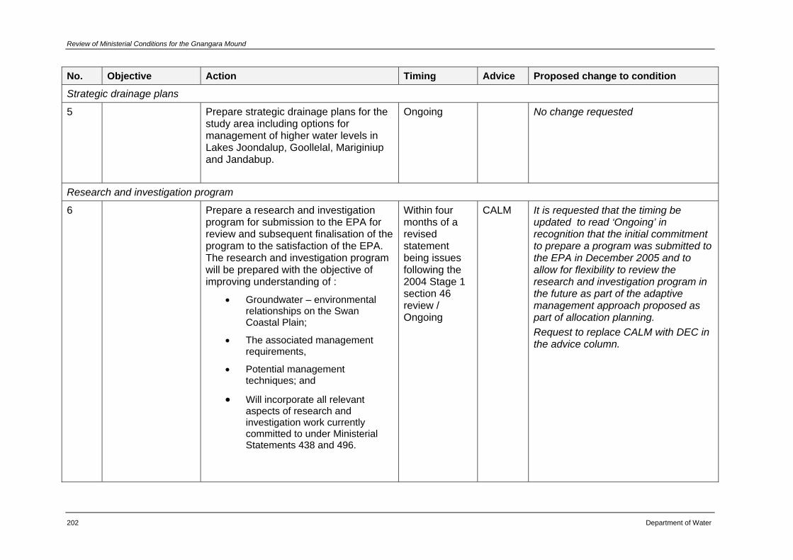
Review of Ministerial Conditions for the Gnangara Mound
202 Department of Water
No. Objective Action Timing Advice Proposed change to condition
Strategic drainage plans
5 Prepare strategic drainage plans for the study area including options for management of higher water levels in Lakes Joondalup, Goollelal, Mariginiup and Jandabup.
Ongoing No change requested
Research and investigation program
6 Prepare a research and investigation program for submission to the EPA for review and subsequent finalisation of the program to the satisfaction of the EPA. The research and investigation program will be prepared with the objective of improving understanding of :
• Groundwater – environmental relationships on the Swan Coastal Plain;
• The associated management requirements,
• Potential management techniques; and
• Will incorporate all relevant aspects of research and investigation work currently committed to under Ministerial Statements 438 and 496.
Within four months of a revised statement being issues following the 2004 Stage 1 section 46 review / Ongoing
CALM It is requested that the timing be updated to read ‘Ongoing’ in recognition that the initial commitment to prepare a program was submitted to the EPA in December 2005 and to allow for flexibility to review the research and investigation program in the future as part of the adaptive management approach proposed as part of allocation planning. Request to replace CALM with DEC in the advice column.
Review of Ministerial Conditions for the Gnangara Mound
Department of Water 203
No. Objective Action Timing Advice Proposed change to condition
Vegetation protection
7 To minimise environmental and/or significant impact
Require the Water Corporation, through licence conditions, to phase in production bores closest to phreatophytic vegetation to allow the vegetation to adapt slowly to the drawdown and minimise the overall impacts on drawdown.
Ongoing Propose that this commitment be deleted from the statement as it has been full filled. These bore fields have been in operation for some years now. This commitment was carried forward from Statement 496 and was identified as ‘cleared’ in the Audit of 2003-04 annual Gnangara Compliance report (EPA, 2005).
Environmental monitoring program
8 Prepare an environmental monitoring program for submission to the EPA for review and subsequent finalisation of the program to the satisfaction of the EPA. The monitoring program will include:
• monitoring of groundwater levels in all relevant aquifer systems;
• relevant wetland water levels and water quality;
• condition of vegetation and fauna associated with groundwater- dependant ecosystems, and
• cave water levels.
Within four months of a revised statement being issued following the 2004 Stage 1 Chapter 46 review / Ongoing
CALM It is requested that the timing be amended to read ‘Ongoing’ in recognition that the initial commitment to prepare a program was submitted to the EPA in December 2005 and to allow for flexibility to review the environmental monitoring program in the future as part of the adaptive management approach proposed as part of allocation planning. Request to replace CALM with DEC Request that reports be submitted to DEC rather than to the EPA.
Review of Ministerial Conditions for the Gnangara Mound
204 Department of Water
No. Objective Action Timing Advice Proposed change to condition
Development advice
9 Continue to provide advice to the City of Wanneroo, the Department for Planning and Infrastructure, CALM and other relevant agencies on the impact of land use on groundwater resources.
Ongoing No change requested
Gnangara inter- agency technical advisory group
10 Convene and provide ongoing executive support for an inter-agency technical advisory group for water resources planning and management issues on the Gnangara Mound. The group will consider planning and management issues in the context of recommendations of the Select Committee on Metropolitan Development and Groundwater Supplies.
Ongoing No change requested
Community consultation
11 Continue to chair and provide support for the Gnangara Consultative Committee as an ongoing forum for information exchange and advice.
Ongoing No change requested.
Review of Ministerial Conditions for the Gnangara Mound
Department of Water 205
No. Objective Action Timing Advice Proposed change to condition
Aboriginal consultation
12 Liaise with the Swan Valley Nyungah Community regarding the East Gnangara proposal.
Ongoing It is requested that this commitment be deleted. The Swan Valley Nyungah Community were consulted with respect to the East Gnangara proposal. The department continues to consult with members of the indigenous community on matters relating to groundwater investigation and management. Nyungah elders have been consulted as part of a study commissioned into the Aboriginal heritage values of the Gnangara Mound (Estill & Assoc 2005). Further, indigenous consultation is being undertaken for the Shallow Groundwater System project.
Vegetation protection
13 Limit potential for tree deaths around production wells to 100 metres radius for normal (average) climate conditions and within 200 metres to extreme conditions.
Ongoing No change requested
Review of Ministerial Conditions for the Gnangara Mound
206 Department of Water
No. Objective Action Timing Advice Proposed change to condition
Lake Nowergup supplementation
14 Upgrade the artificial maintenance facility for Lake Nowergup to provide more rapid recharge when it becomes necessary to met EWPs; and should EWPs in Lake Nowergup not be met by November, artificial supplementation will be used until the EWP is reached.
Ongoing It is requested that part 1 of this commitment be deleted as the artificial maintenance facility has been upgraded to provide more rapid recharge.
Dieback protocols
15 Conduct operations in accordance with proponent protocol for dieback management.
Ongoing It is requested that this commitment be deleted. This commitment was carried forward from Statement 496 and was identified as ‘cleared’ in the Audit of 2003-04 annual Gnangara Compliance report (EPA, 2005).
Reporting
16 Require the Water Corporation to submit yearly production plans as part of the operating strategy and to report on compliance with environmental commitments made in the operating strategy.
Ongoing No change requested.
Review of Ministerial Conditions for the Gnangara Mound
Department of Water 207
No. Objective Action Timing Advice Proposed change to condition
Monitoring wells
17 To minimise environmental and/or significant impact
Request the Water Corporation to establish further monitoring bores for monthly monitoring and more frequently if required within 200 metre radius of production bores located in phreatophytic vegetation.
Before 5 May 1997
It is requested that this commitment be deleted. This commitment was carried forward from Statement 438 and was identified as ‘cleared’ by the Department of Environmental Protection on 28/10/1997 as detailed in the Audit of 2000-03 Triennial Compliance Report (EPA, 2004).
Vegetation protection
18 To minimise environmental and/or significant impact
Establish additional monitoring wells in those areas where suitable wells do not exist to monitor groundwater levels under phreatophytic vegetation.
Before 5 May 1997
It is requested that this commitment be deleted. This commitment was carried forward from Statement 438 and was identified as ‘cleared’ by the Department of Environmental Protection on 28/10/1997 as detailed in the Audit of 2000-03 Triennial Compliance Report (EPA, 2004).
Vegetation monitoring
19 To minimise environmental and/or significant impact
Select a range of indicator species at transects to determine an acceptable rate of change in vegetation composition. Also calculate similarity indices when monitoring.
By spring 1997
Indicator species and similarity indices have been defined (Mattiske, 2003) and were submitted to the EPA in 2005 (Department of Water, 2005). The Department seeks clearance of this commitment.
Review of Ministerial Conditions for the Gnangara Mound
208 Department of Water
No. Objective Action Timing Advice Proposed change to condition
Environmental management plan
20 Require the Water Corporation to prepare an environmental operations plan to provide specific detail on environmental management of groundwater schemes in the study area, which includes detailed management prescriptions for well field operators and water resource managers.
Before 5 August 1997
Propose that this commitment be deleted. This commitment was carried forward from Statement 496 and was identified as ‘cleared’ by the Department of Environmental Protection on 10/02/2000 as detailed in the Audit of 2000-03 Triennial Compliance Report (EPA, 2004).
Pine plantation
21 Develop a Memorandum of Understanding on pine management regimes with CALM.
By June 1997 CALM and FPC
Propose that this commitment be deleted. This commitment was carried forward from Statement 438 and was identified as ‘cleared’ by the Department of Environmental Protection on 19/01/2000 as detailed in the Audit of 2000-03 Triennial Compliance Report (EPA, 2004).
Review of Ministerial Conditions for the Gnangara Mound
Department of Water 209
No. Objective Action Timing Advice Proposed change to condition
Lexia Groundwater Scheme
22 Prepare a Water Resource Allocation and Management Plan for the Lexia area (East Gnangara area) to identify groundwater allocation, which includes detailed groundwater modelling to optimise groundwater availability while minimising environmental impacts.
Prior to the construction of Lexia scheme
Propose that this commitment be deleted. This commitment was carried forward from Statement 438 and was identified as ‘cleared’ by the Department of Environmental Protection on 28/02/2000 as detailed in the Audit of 2000-03 Triennial Compliance Report (EPA, 2004).
East Gnangara wetlands
23 Require the Water Corporation to implement its 2001 wetland mitigation strategy and subsequent approved revision and report to the DoE on implementation.
Prior to commissioning of the Lexia scheme / Ongoing
No change requested.
East Gnangara wetlands
24 Determine EWPs for new appropriately located bores in the East Gnangara vegetation corridor.
By 17 February 2002
No change requested. This commitment relates to sites L30C, L110C and L220C, more detailed information is provided for each of these sites in the descriptions provided in Chapter 4.

Review of Ministerial Conditions for the Gnangara Mound
210 Department of Water
Glossary
Abstraction The permanent or temporary withdrawal of water from any source of supply, so that it is no longer part of the resources of the locality.
Allocation Limit
The amount of water set aside for annual licensed use.
In the department's current water licensing system, the allocation limit is a volumetric licensing limit. As such, the allocation limit does not always account for basic stock and domestic water rights which do not require a licence. However, the meaning of the term will become broader as the department's water accounting systems are developed.
Aquifer
A geological formation or group of formations capable of receiving, storing and transmitting significant quantities of water. Usually described by whether they consist of sedimentary deposits (sand and gravel) or fractured rock. Aquifer types include unconfined, confined and artesian.
Bore A narrow, normally vertical hole drilled in soil or rock to monitor or withdraw groundwater from an aquifer. See Well.
Bore field A group of bores to monitor or withdraw groundwater.
Confined aquifer An aquifer lying between confining layers of low permeability strata (such as clay, coal or rock) so that the water in the aquifer cannot easily flow vertically.
Ecological values
The natural ecological processes occurring within water dependent ecosystems and the biodiversity of these systems.
Ecological Water Requirements (EWR)
The water regime needed to maintain the ecological values (including assets, functions and processes) of water dependent ecosystems at a low level of risk.
Ecosystem
A community or assemblage of communities of organisms, interacting with one another, and the specific environment in which they live and with which they also interact, e.g. lake, to include all the biological, chemical and physical resources and the interrelationships and dependencies that occur between those resources.
Environmental Water Provisions (EWP)
The water regimes that are provided as a result of the water allocation decision-making process taking into account ecological, social, cultural and economic impacts. They may meet in part or in full the ecological water requirements.
Review of Ministerial Conditions for the Gnangara Mound
Department of Water 211
Gigalitre (GL) A measure equal to one million kilolitres or one billion litres.
Groundwater Water which occupies the pores and crevices of rock or soil beneath the land surface.
Groundwater area
Are the boundaries that are proclaimed under the Rights in Water and Irrigation Act and used for water allocation planning and management.
Groundwater dependent ecosystem
An ecosystem that is dependent on groundwater for its existence and health.
Groundwater mound
A mound-shape formation of the water table resulting from rainwater trickling down into the open space between particles in an elevated area of deep sand or other porous material. Groundwater will move slowly away from the central area to discharge into wetlands, rivers and oceans.
Groundwater sub area
Areas defined by the Department of Water within a groundwater area, used for water allocation planning and management.
Hydrogeology The hydrological and geological science concerned with the occurrence, distribution, quality and movement of groundwater, especially relating to the distribution of aquifers, groundwater flow and groundwater quality.
Hydrograph A graph showing the height of a water surface above an established datum plane for level, flow, velocity, or other property of water with respect to time.
Kilolitre (kL) A unit of volume in the metric system, equal to 1000 litres.
Licence A formal permit which entitles the licence holder to ‘take’ water from a watercourse, wetland or underground source.
Megalitre (mL) A unit of capacity (volume) in the metric system equal to one million litres, a thousand kilolitres or a thousand cubic metres.
Recharge Water that infiltrates into the soil to replenish an aquifer.
Scheme supply Water diverted from a source (or sources) by a water services authority or private company and supplied via a distribution network to customers for urban, industrial or irrigation use.
Social values A particular in-situ quality, attribute or use that is important for public benefit, welfare, state or health (physical and spiritual).
Sub area A sub-division within a surface or groundwater area, defined for the purpose
Review of Ministerial Conditions for the Gnangara Mound
212 Department of Water
of managing the allocation of groundwater resources. Sub areas are not proclaimed and can therefore be changed internally without being gazetted.
Unconfined Aquifer
Is the aquifer nearest the surface, having no overlying confining layer. The upper surface of the groundwater within the aquifer is called the watertable. An aquifer containing water with no upper non-porous material to limit its volume or to exert pressure. See Aquifer.
Water dependent ecosystem
Those parts of the environment, the species composition and natural ecological processes of which are determined by the permanent or temporary presence of water resources, including flowing or standing water and water within groundwater aquifers.
Well An opening in the ground made or used to obtain access to underground water. This includes soaks, wells, bores and excavations.
Well field A group of wells to monitor or withdraw groundwater, including for scheme supply.
Wetland
Wetlands are areas that are permanently, seasonally or intermittently waterlogged or inundated with water that may be fresh, saline, flowing or static, including areas of marine water of which the depth at low tide does not exceed six metres.
Review of Ministerial Conditions for the Gnangara Mound
Department of Water 213
References Agricultural and Resource Management Council of Australia and New Zealand
(ARMCANZ) & Australian and New Zealand Environment and Conservation Council (ANZECC), 1994, National Water Quality Management Strategy.
Bamford, M.J. & Bamford, A.R., 2007, Report on East Lexia Frog Monitoring: 2003 to 2006. Bamford Consulting Ecologists.
Bekesi, G. 2007a, Hydrograph trend analysis 1998-2006, Gnangara Mound, unpublished report for the Water Allocation Planning Branch, Department of Water.
Bekesi, G. 2007b, The affects of Hydrogeology on water levels at Loch McNess, unpublished report for the Water Allocation Planning Branch, Department of Water.
Bertuch, M., Loomes, R. & Froend, R., 2004, Wetland Vegetation Monitoring 2004. Survey of Gnangara Wetlands, a report to the Department of Environment, Centre for Ecosystem Management, Edith Cowan University, Perth.
Cook, B.A. & Janicke, B.G., 2005, Environmental monitoring and investigations for Gnangara Mound – Yanchep cave stream invertebrate monitoring, Egerton and Edgecombe spring monitoring 2004, a report for the Water and Rivers Commission, Centre for Excellence in Natural Resource Management, University of Western Australia, Perth.
Clark, J. D. & Horwitz, P. 2005, Final Annual Report for the Wetland Macroinvertebrate Monitoring Program of the Gnangara Mound Environmental Monitoring Project – spring 2004 to summer 2005, a report to the Water and Rivers Commission (Department of Environment), Centre for Ecosystem Management, Edith Cowan University, Perth.
CSIRO, 2001, Land Monitor Project – Vegetation Extent and Change, Mathematical and Information Sciences.
Department of Conservation and Environment, 1986, Draft guidelines for wetland conservation in the Perth Metropolitan Area, EPA Bulletin 227.
Department of Environment, 2005, Section 46 Progress Report – State of the Gnangara Mound, Government of Western Australia, Perth.
Department of Water, 2007, Environmental Management of Groundwater Abstraction from the Gnangara Groundwater Mound 2004-05, annual compliance report to the Environmental Protection Authority, July 2004 to June 2005, Government of Western Australia, Perth.
Review of Ministerial Conditions for the Gnangara Mound
214 Department of Water
Environmental Protection Authority, 2007, Environmental Management of Groundwater Abstraction from the Gnangara Mound July 2004 - June 2005 – Annual Compliance Report (Bulletin 1252), report to the Water and Rivers Commission by the Environmental Protection Authority under section 48(1a) of the Environmental Protection Act 1986.
Environmental Protection Authority, 2005, Environmental Management of Groundwater Abstraction from the Gnangara Mound July 2003 - June 2004 – Annual Compliance Report (Bulletin 1187), report to the Water and Rivers Commission by the Environmental Protection Authority under section 48(1a) of the Environmental Protection Act 1986.
Environmental Protection Authority, 2004, Environmental Management of Groundwater Abstraction from the Gnangara Mound July 2000 - June 2003 – Triennial Report (Bulletin 1139), report to the Water and Rivers Commission by the Environmental Protection Authority under section 48(1a) of the Environmental Protection Act 1986.
Froend, R., Loomes, R., Horwitz, P., Rogan, R., Lavery, P., How, J., Storey, A., Bamford, M. & Metcalf, B. 2004a, Study of Ecological Water Requirements on the Gnangara and Jandakot Mounds under Chapter 46 of the Environmental Protection Act. Task 1: Identification and Re-evaluation of Ecological Values, Centre for Ecosystem Management, Edith Cowan University; School of Animal Biology, University of Western Australia; and M.J. & A.R. Bamford, Consulting Ecologists.
Froend, R., Loomes, R., Horwitz, P., Rogan, R., Lavery, P., How, J., Storey, A., Bamford, M. & Metcalf, B. 2004b, Study of Ecological Water Requirements on the Gnangara and Jandakot Mounds under Chapter 46 of the Environmental Protection Act, Task 2: Determination of Ecological Water Requirements, Centre for Ecosystem Management, Edith Cowan University; School of Animal Biology, University of Western Australia; and M.J. & A.R. Bamford, Consulting Ecologists.
Froend, R., Rogan, R., Loomes, R., Horwitz, P., Bamford, M. & Storey, A. 2004c, Study of Ecological Water Requirements on the Gnangara and Jandakot Mounds under Chapter 46 of the Environmental Protection Act, Task 3 & 5: Parameter Identification and Monitoring Program Review, Centre for Ecosystem Management, Edith Cowan University; School of Animal Biology, University of Western Australia; and M.J. & A.R. Bamford, Consulting Ecologists.
Hill, A. L., Semenuik, C. A., Semenuik, V. & Del Marco, A. 1996, Wetlands of the Swan Coastal Plain, Vol 2A: Wetland Mapping, Classification and Evaluation, Main Report, Water and Rivers Commission/Department of Environmental Protection, Perth.
Review of Ministerial Conditions for the Gnangara Mound
Department of Water 215
Knott, B., Storey, A.W. & Chandler, L. 2007, Yanchep Cave Streams and East Gnangara (Lexia) - Egerton spring & Edgecombe spring: Invertebrate Monitoring. Report to Department of Water, Aquatic Research Laboratory, School of Animal Biology, University of Western Australia, Perth.
Knott, B. & Storey, A.W., 2004, Yanchep Cave Streams: Invertebrate Monitoring, report to Department of Environment, School of Animal Biology, University of Western Australia, Perth.
Loomes, R., Froend, R., Pettit, N. & Ladd, P. 2007, End of summer Assessment of Condition of Gnangara and Jandakot Criteria Groundwater Dependent Ecosystems, Centre for Ecosystem Management, Edith Cowan University.
Loomes, R.C., Lam, A., Froend, R., Hancock, C. & Ladd, P. 2003, Gnangara and Jandakot Mound Wetland Assessment and Predictions of End-of-summer Impacts, 2003, a report to the Water and Rivers Commission, Centre for Ecosystem Management and Murdoch University, Perth.
Loomes, R.C., O'Neill, K. & Froend, R.H., 2001, Wetland Vegetation Monitoring 2000 - survey of Gnangara Wetlands, Centre for Ecosystem Management, Edith Cowan University, Perth.
McKay, K. & Horwitz, P. 2007, Annual Report for the Wetland Monitoring Program of the Gnangara Mound Environmental Monitoring Project spring 2006 to summer 2007, reporting to the Department of Water, Centre for Ecosystem Management, Edith Cowan University, Perth.
McKay, K. & Horwitz, P. 2006, Annual Report for the Wetland Monitoring Program of the Gnangara Mound Environmental Monitoring Project spring 2005 to Autumn 2006, reporting to the Department of Environment (Water and Rivers Commission), Centre for Ecosystem Management, Edith Cowan University, Perth.
Mattiske Consulting Pty Ltd., 2006, Monitoring the effects of groundwater extraction on native vegetation on the Northern Swan Coastal Plain, 2005, prepared for Department of Water.
Mattiske Consulting Pty Ltd., 2003, Monitoring the effects of groundwater extraction on native vegetation on the Northern Swan Coastal Plain, 2002, prepared for the Water and Rivers Commission.
Mattiske Consulting Pty Ltd., 2000, Monitoring the effects of groundwater extraction on native vegetation on the Northern Swan Coastal Plain, 1999, prepared for the Water and Rivers Commission.
Review of Ministerial Conditions for the Gnangara Mound
216 Department of Water
Pettit, N., Loomes, R. & Froend, R. 2007, Wetland Vegetation Monitoring 2006 - Survey of Gnangara Wetlands, Centre for Ecosystem Management, Edith Cowan University, Perth.
Rockwater Pty Ltd., 2003, Report for the Investigation of Groundwater-Wetland Water Level Relationships on the Gnangara and Jandakot Mounds, a report for Department of Environment, Government of Western Australia, Perth.
Rogan, R., Loomes, R. & Froend, R. 2006, Wetland Vegetation Monitoring 2005 – Survey of Gnangara Wetlands, a report to the Department of Environment, Centre for Ecosystem Management, Edith Cowan University, Perth.
Sommer, B. & Horwitz, P. 2007, Annual Report for the Wetland Macroinvertebrate Monitoring Program of the Gnangara Mound Environmental Monitoring Project – spring 2006 to summer 2007, a report to the Western Australian Department of Water, Centre for Ecosystem Management, Edith Cowan University, Perth.
Vogwill, R.I.J., McHugh, S.L., Yu, X. & O’Boy, C.A., 2007, Sensitivity of the Watertable in the Perth Region to Changes in Climate, Land use and Groundwater Abstraction using the PRAMS model: Stage 2, Department of Water, Hydrogeological Record Series, Report No. HG21.
Water and Rivers Commission, 1997, East Gnangara Environmental Water Provisions Plan, Public Environmental Review, Perth.
Water Authority of Western Australia, 1995, Review of Proposed Changes to Environmental Conditions, Gnangara Mound Groundwater Resources (Chapter 46), Perth.
Water Authority of Western Australia, 1986, Gnangara Mound Groundwater Resources, Environmental Review and Management Program, Report No. WM4, Government of Western Australia, Perth.
Water Corporation, 2006, Integrated Water Supply Scheme, Security through Diversity 2005-2050, Water Recycling, www.watercorporation.com.au.
Yesertener, 2007, Assessment of the Declining Groundwater Levels in the Gnangara Groundwater Mound, Western Australia, Department of Water, Hydrogeological Record Series HG14.