Embed Size (px)
Citation preview

Hydrology of Warm Humid Regions (Proceedings of the Yokohama Symposium, July 1993). lAHSP0ol.no. 216, 1993. * * * P 433
Groundwater conditions and problems characteristic of the humid tropics
S. S. D. FOSTER Groundwater and Geotechnical Surveys Division, British Geological Survey, Keyworth, Nottingham NG12 5GG, UK
Abstract Unconfmed or semi-confined aquifers underlie geographically large areas of the humid tropics. In many nations they have become increasingly important as an economical source of high-quality water supply for the urban and rural population and for supplementary agricultural irrigation. The groundwater systems tend to fall into a number of distinct types according to the geological build of the land, which also exerts an important control on soil type and surface water regime, and thus has considerable influence on the vegetation and ecosystem. In consequence a sound understanding of groundwater systems is required for rational water and land management. The hydrogeological characteristics of the commonest types are presented by reference to specific examples from selected countries. Characteristic groundwater recharge/discharge mechanisms, quality controls, and development/management problems are discussed.
INTRODUCTORY BACKGROUND
Hydrological importance of geological build
The land area of the humid tropics includes a wide range of geological build, which interacts with the prevailing climate to produce distinctive geomorphological features and hydrological regimes. The groundwater systems developed in, and characteristic of, the humid tropics tend, therefore, to fall into one of five main types (Table 1). Such a subdivision is useful for a general discussion of groundwater conditions and problems characteristic of the humid tropics, but it must be recognized that it is more difficult to generalize about groundwater systems, than about the climate, vegetation and other aspects of the hydrology of these regions (Foster & Chilton, 1993).
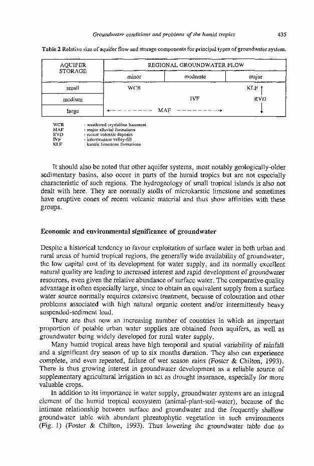
The principal types of groundwater system have very different scales of regional flow and aquifer storage (Table 2), which determine their hydrological influence and water-supply potential. The major alluvial formations and the crystalline basement (with its weathered mantle) occupy very extensive land areas and are thus discussed in detail in this paper. Groundwater systems developed in intermontane valley-fill, karstic limestone and recent volcanic deposits are of much more limited geographical distribution. They are, however, of major importance in some areas supporting large wellfields of high-yielding production boreholes. Only the lattermost category, however, is selected here for more detailed presentation.

Groundwater conditions and problems of the humid tropics 435
Table 2 Relative size of aquifer flow and storage components for principal types of groundwater system.
AQUIFER STORAGE
small
medium
large
minor
WCB
REGIONAL GROUNDWATER FLOW
moderate major
KLF |
IVF RVD
- - MAF » 1 WCB - weathered crystalline basement MAF - major alluvial formations RVD - recent volcanic deposits IVF - intermontane valley-fill KLF - karstic limestone formations
It should also be noted that other aquifer systems, most notably geologically-older sedimentary basins, also occur in parts of the humid tropics but are not especially characteristic of such regions. The hydrogeology of small tropical islands is also not dealt with here. They are normally atolls of microkarstic limestone and sometimes have eruptive cones of recent volcanic material and thus show affinities with these groups.
Economic and environmental significance of groundwater
Despite a historical tendency to favour exploitation of surface water in both urban and rural areas of humid tropical regions, the generally wide availability of groundwater, the low capital cost of its development for water supply, and its normally excellent natural quality are leading to increased interest and rapid development of groundwater resources, even given the relative abundance of surface water. The comparative quality advantage is often especially large, since to obtain an equivalent supply from a surface water source normally requires extensive treatment, because of colouration and other problems associated with high natural organic content and/or intermittently heavy suspended-sediment load.
There are thus now an increasing number of countries in which an important proportion of potable urban water supplies are obtained from aquifers, as well as groundwater being widely developed for rural water supply.
Many humid tropical areas have high temporal and spatial variability of rainfall and a significant dry season of up to six months duration. They also can experience complete, and even repeated, failure of wet season rains (Foster & Chilton, 1993). There is thus growing interest in groundwater development as a reliable source of supplementary agricultural irrigation to act as drought insurance, especially for more valuable crops.
In addition to its importance in water supply, groundwater systems are an integral element of the humid tropical ecosystem (animal-plant-soil-water), because of the intimate relationship between surface and groundwater and the frequently shallow groundwater table with abundant phreatophytic vegetation in such environments (Fig. 1) (Foster & Chilton, 1993). Thus lowering the groundwater table due to

436 S. S. D. Foster
(a) groundwater discharge mechanisms in dry season
E( phreatic évapotranspiration Ig deep infiltration to groundwater Qs surface runoff * Q r r rejected recharge Qj interflow Qg aquifer discharge to surface water body
*if soil infiltration capacity exceeded by high-intensity rainfall
Fig. 1 Groundwater recharge and discharge mechanisms characteristic of many lowland aquifers in the humid tropics.
abstraction or drainage will often directly impact on natural tropical vegetation and removing natural vegetation for agricultural cultivation will affect the groundwater recharge and flow regime.
CHARACTERISTICS OF PRINCIPAL SYSTEMS
Weathered crystalline basement
Extensive regions of Africa, and to a lesser extent of South America and Asia, are directly underlain by a crystalline basement formed mainly from major suites of Pre-Cambrian rocks. The predominant lithological types are granitic gneisses and lower-grade metamorphic rocks (derived from volcanic and sedimentary deposits) and some more recent anorogenic intrusive rocks.
The ancient continental land surface has been exposed to protracted weathering with the formation of an alteration mantle, normally more than 10 m thick, known as
(b) groundwater recharge mechanism in wet season (in areas of phreatophytic vegetation net infiltration to aquifer will be Ig- Et)

Groundwater conditions and problems of the humid tropics 437
(remnant of earlier erosion surface)
inselberg
water-tabie fluctuation between wet and dry season
soil profile recharging in wet season discharging through
phreatophytic vegetation locally in dry season
shallow interflow
weak groundwater flow -regime in very low T aquifer
intrusive dyke
Fig. 2 Generalized section of the weathered crystalline basement in Malawi illustrating typical aquifer flow regime (after Chilton & Foster, 1993).
the regolith (Fig. 2). The transition from regolith to unweathered bedrock is normally gradual and occurs over some metres depth range, with remnants of unweathered bedrock set in an altered matrix (known by the term saprock) as the intermediate condition. A basal brecciated zone of the regolith is also often present, with rock fragmentation but little mineralogical change.
Certain horizons within the regolith and saprock have sufficient permeability to yield small water supplies to appropriately designed and constructed wells on a fairly widespread basis. This low-productivity aquifer system is of major importance because: (a) It has very widespread occurrence in areas of relatively high rural population
density. (b) Its groundwater is sufficiently shallow to allow exploitation at low cost, with
simple technology appropriate to the low level of economic development. (c) Surface water resources are generally unreliable with no readily available source
of water of adequate quality. A preliminary conceptual model of the system was developed by Foster (1984),
based on results of Chilton & Smith-Carington (1984). Attention was drawn to potentially important differences in maximum well yield, sustainability and quality of supply with the relative position of the water table in the weathering profile. A factor which was expected to vary with both geomorphology and climate. It identified the basal part of the regolith together with the saprock as normally providing most of the yield to successful boreholes, with the presence of a thick saturated regolith of significance in terms of overall aquifer storage and available well drawdown. This model has been confirmed with relatively minor modifications by subsequent investigations in various countries (Fig. 3).
Sufficient pumping tests have now been conducted to confirm that the aquifer system normally has very low overall transmissivity (1-5 m2 day-1), with occasional values up to an order-of-magnitude lower and higher (Chilton & Smith-Carington, 1984; Houston, 1992; Wright, 1992). Such generally low values imply that although the basement aquifer has an essentially regular occurrence in any given area, it exhibits significant local variation in well yield and abstraction response due to poor

438 S. S. D. Foster
TYPICAL LITHOLOGIES
red silty quartz-sand with
basa! lateritic concretions
massive accumulation of mainly secondary clay minerals (especially kaolinite) with subordinate silty sand and occasional weathered rock fragments
as above but with much high proportion of primary minerals and rock fragments
deeply-weathered and partially decomposed rock with some fractures filled by secondary clays
largely unweathered bedrock vyjth some staining on fractures
THICKNESS
0.5m
<5m
5-30m
up to 20m
up to 20m
~
variation of T and S with groundwater level (relative scales)
open fracture
T (m2/d)
spatially-variable contribution from bedrock fractures
v effective oorosity •9)
Fig. 3 Conceptual hydrogeological model of the African weathered basement aquifer (after Foster, 1984; Chilton & Smith-Carington, 1984; Chilton & Foster, 1993).
connectivity of bedrock fractures and low permeability of parts of the saturated regolith. This can reduce the success rate of boreholes, even within areas of relatively uniform bedrock geology and geomorphology.
The location of boreholes with sufficient yield for hand-pumps to supply rural domestic and livestock demands (more than 0.2 1 s -1) is generally possible in the humid tropics. However, if higher yields for small-scale irrigation or minor urban water supply are required, the investment in exploration and development rises steeply, and the likelihood of success may still not be high. In all cases, the more detailed is the attention paid to borehole design and construction the greater is the success rate, because of the shallow nature of the aquifer system and the limited available drawdown. It is particularly important not to seal-off any more permeable horizons by solid lining tubes and to make reliable prediction of minimum drought groundwater level.
The most detailed research on the groundwater regime and geomorphological evolution of the weathered crystalline basement has been conducted in Malawi (Chilton & Smith-Carington 1984; Wright, 1992; McFarlane, 1992). The African erosion surface here has low relief between 1200-1300 m a.s.l. with broad interfluves separating seasonally-waterlogged depressions (known locally as dambos).
Over very long periods infiltrating acidic rainfall has reacted with the alkaline minerals of the crystalline basement, leaching the more soluble and mobile components and re-precipitating less mobile minerals, such as kaolinite and Fe/Al oxides. At the final stage kaolinite dissolution also occurs, leaving only quartz sand. This process has spanned numerous climatic and tectonic cycles, which determined the relative levels of land surface and groundwater table, and thus controlled the rate and depth of weathering.

Groundwater conditions and problems of the humid tropics 439
There are differing hypothesis concerning the origin of the land surface, but it appears likely that slow subsidence (resulting from leaching, bioturbation and eventual collapse of the regolith) has dominated (McFarlane, 1992), with concomitant colluvial redistribution of residual materials downslope in the land surface depressions. The more clayey material lining the floor of depressions prevents groundwater discharge, creating an arc of small seepages around their margin, where the deposition of leached minerals such as MgS04, Al silicates and Fe/Mn oxides occurs.
The relationship of the weathering process to permeability development in the regolith is complex. Dissolution of minerals and leaching should tend to increase porosity, permeability and specific yield, but the deposition of secondary clay minerals could tend to reverse this process. In theory, at least, bedrock type might be expected to exert a major control, with coarser-grained quartz-rich crystalline rocks developing a higher permeability regolith. However, more schistose and/or fractured metamorphic rocks are likely to promote deeper weathering and a thicker regolith, although the presence of abundant Fe-Mg minerals, such as biotite (which readily weather to secondary products), is likely to reduce permeability.
Values of regolith permeability are not believed to average more than 0.1 m day-1
(Wright, 1992), and thus a saturated thickness well in excess of 10 m would be needed for the regolith alone to act as a useful aquifer, even in the context of village water supply. The importance of the saturated thickness of the regolith is not primarily because of its significance in terms of transmissivity, but more that it provides the dominant element of aquifer storage and determines available drawdown to the most-productive aquifer horizons, thus effectively dictating the approach to well siting, design and construction (Chilton & Foster, 1993).
Natural groundwater quality problems may be encountered in parts of the aquifer system in some areas (Chilton & Foster, 1993). These include high soluble Fe and Mn at depth (below the weathered horizons) as a result of low pH and Eh and elevated concentrations of MgS04 derived from the weathering of clay minerals and oxidation of pyrite, especially close to groundwater discharge areas. There is also a question about the presence of Al released by weathering and possibly present in organic colloidal form (McFarlane, 1992).
Basement aquifers may be more vulnerable to pollution from anthropogenic activities than their generally low permeability suggests. This is because their vadose zone is often thin and preferential flow through regolith cracking and macropores can occur (Chilton & Foster, 1993).
Recent volcanic deposits
Important active volcanic arcs lie within the humid tropics. Their eruptive episodes have lead to the deposition of large quantities of relatively viscous lavas, interbedded with pyroclastic deposits, known geologically as tuffs or ignimbrites, of andesitic-to-rhyolitic composition. Volcanic cones are subject to rapid erosion by heavy tropical rainfall, with the main surface water courses often becoming deeply incised.
The complex interbedding of brecciated or fractured lava, porous tuffs, and thin, more welded, volcanic deposits of low-permeability leads to the development of frequent perched aquifers in addition to some more extensive aquifers of high yield and drought reliability (Foster & Chilton, 1993).
440 S. S. D. Foster
The exploitation of groundwater in volcanic terrains is greatly complicated by the highly heterogenous character of such groundwater systems. Considerable effort in hydrogeological exploration is needed for successful production borehole siting and design. This tends to increase development costs, and, in the steeply-sloping volcanic terrain, both groundwater levels and productive aquifer horizons may be very deep, giving rise to drilling problems. The development of shallow perched aquifers presents less technical difficulty and requires reduced investment, but production boreholes and springhead captures may suffer substantial reduction in yield during drought.
While the natural quality of groundwater in volcanic terrains is normally excellent, the presence of potentially-toxic constituents (such as arsenic, fluoride, boron and selenium), associated with the volcanicity itself, may locally occur (Foster & Chilton, 1993).
The vulnerability of volcanic aquifers to pollution is extremely variable. Where brecciated or fractured lavas outcrop at the land surface and in the beds of influent
A : across upper part of valley
NNW
2000-1 Volcan Barba (Cerro Redonda)
1500-
1000-
lahares
J£y alluvium
0 l a v a
SSE
Alto Coris r- 2000
-1500
VW'!'"'» *V,//.V//A/ -/// 'Tprtiarv-
7// 'Tertiary-i/l //sediments
FA#V'" Mooo
• • • groundwater piezometric levels
' major springheads
vertical exaggeration x 10 approx.
ENE
700
1000
900
800
B = Barba T . Tiribi CS = Colima Superior PM = Puente Mulas CI = Colima Inferior
B : down northern flank of valley in main discharge area of Barba and Colima aquifers
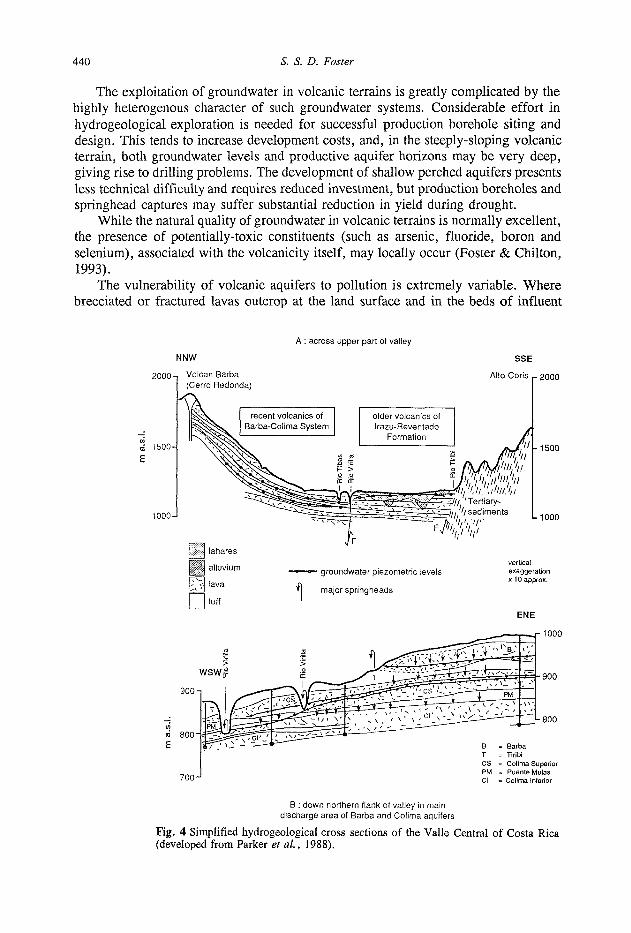
Fig. 4 Simplified hydrogeological cross sections of the Valle Central of Costa Rica (developed from Parker et al., 1988).

Groundwater conditions and problems of the humid tropics 441
surface water courses, the risk of groundwater pollution could be high if adequate measures to avoid soil and surface water pollution are not taken. Where the surface cover is of porous pyroclastic deposits or a well-developed soil mantle is present, vulnerability of groundwater to pollution will be substantially reduced and associated only with highly-mobile and persistent contaminants.
The Valle Central of Costa Rica is a good example of a volcanic groundwater system and has been investigated in considerable detail (Foster et al., 1985; Parker et al., 1988). It is situated between the southernmost active volcanoes of the Middle American arc and mountains of Tertiary sedimentary rocks (Fig. 4). The northern flank of the valley is a Quaternary volcanic complex formed by emissions from the craters and vents of the Barba volcano, with subordinate influences from other neighbouring volcanoes.
The eroded volcanic cones comprise interbedded andesitic lava flows, exhibiting abrupt variations in thickness across pre-existing topographic depressions, and more extensive edge-flow tuffs and ignimbrites, deposited from gaseous clouds.
Geological correlation presents formidable problems, since both lavas and pyroclasts vary little in chemical composition and show wide lateral variation in depositional texture and thickness. One pyroclastic deposit (the Puente de Mulas ignimbrite) has distinctive lithology and widespread occurrence, which has considerably aided geological interpretation.
Groundwater levels throughout this multi-aquifer sequence are complex and correlation between boreholes can be difficult. The most prominent and extensive of the shallow lavas, known as the Barba, forms a persistent perched aquifer. The lavas of the deeper prolific Colima aquifers have very limited outcrop and must be recharged by large-scale natural leakage from overlying perched aquifers.
The area has high, altitude-dependent, rainfall (1800-3500 mm year-1) falling mainly during May to November, and is drained by both infiltration to groundwater and by surface runoff. There are a large number of small rivers, with long narrow catchments, which exhibit complex influent-effluent relationships with underlying aquifers.
The groundwater system has a number of distinctive features: (a) Aquifers tend to have steeply-sloping bases, as a result of the conical form of
volcanic deposition. (b) Whilst the shallowest perched water tables are subject to marked seasonal
fluctuation (generally more than 5 m), monitoring boreholes in deeper aquifers exhibit little or no temporal variation in water level.
(c) Aquifer hydraulic gradients are both very steep (often exceeding 2%) and essentially constant (Fig. 4).
The latter two features imply steady recharge rates, by implication from downward leakage. The explanation of this behaviour was found in the hydraulic properties of the pyroclastic tuffs, which play a key role in the regional groundwater flow regime (Foster et al., 1985). Their extremely high effective porosity (Fig. 5), coupled with moderate intergranular hydraulic conductivity and pore-size distributions indicated specific yield in the range 0.10-0.20 and proved that: (a) Tuffs are not generally the limiting aquitards responsible for perching in recent
volcanic aquifer systems; this role is more likely to be played by the least-fractured ignimbrites.

442 S. S. D. Foster
75-
50-
2 5 -
undifferentiated tuffs (generally weathered)
somewhat weathered
effect of large-scale fracturing
1 1 1 1 1— 106 10-5 W 10-3 10'2 10-'
hydraulic conductivity (m/d) 10"
"1 10*:
Fig. 5 Hydraulic properties of recent volcanic formations in the Valle Central, Costa Rica (developed from Foster et al., 1985).
(b) Large storage is present in thick tuffaceous deposits and provides steady recharge to underlying lava aquifers by natural downward leakage, damping-out seasonal and annual fluctuations in infiltration.
(c) Where such tuffs are saturated and occur immediately above lava aquifers they will increase the unconfmed storage coefficient manyfold.
While the tuffaceous deposits unquestionably provide the bulk of the storage capacity, it is the lava flows which possess high transmissivity. This is especially true where they are of brecciated or highly-fractured texture (Fig. 5). More massive sections may on the other hand act as aquitards.
Aquifer pumping tests are difficult to conduct because of the very steep hydraulic gradients and rapid equilibration of individual production boreholes. Transmissivity values generally appear to be greater than 1000 m2 day"1 for the Colima aquifers, and exceed 5000 m2 day"1 in some areas.
This is witnessed by the excellent performance of production boreholes, which has been quite consistently achieved where both Colima Superior and Inferior aquifers are both well developed, despite the gross heterogeneity exhibited by volcanic formations. It should be noted that much more variable performance is exhibited by production boreholes in the shallower Barba aquifer, and boreholes in the older volcanic formations have performance in the poor, or occasionally moderate, category.
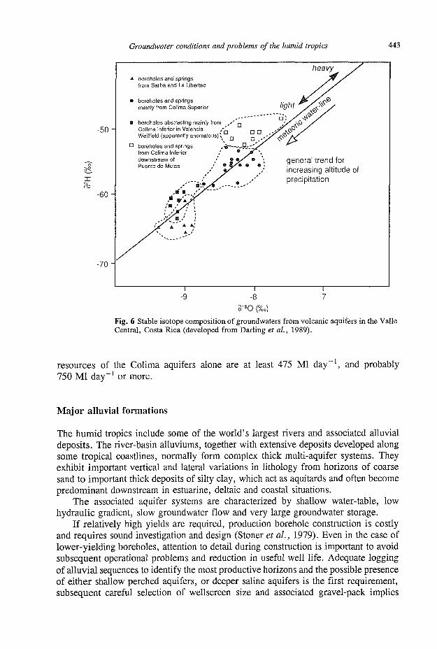
The variability and complexity of aquifer recharge make groundwater resources very difficult to quantify directly, and even the use of environmental isotopes (2H, 3H and 180) confirmed some hypotheses but raised other questions about recharge mechanisms (Fig. 6) (Darling et al, 1987). Numerical aquifer simulation is also subject to questionable assumptions and major uncertainty due to the complexity of the groundwater flow regime.
Resource evaluation can, however, be approached from measurement of aquifer discharge, since, in the cases of three principal aquifers (the Barba, Colima Superior and Inferior), the predominant discharge mechanism appears to be a series of major springheads in the lower parts of the valley and along the canyon of the Virilla River incised some 100 m below general land surface. Analysis of baseflow, together with springflow and differential riverflow gauging in the dry season, suggests that the
Groundwater conditions and problems of the humid tropics 443
-50-
- 6 0 -
-70
A boreholes and springs from Barba and La Libertad
• boreholes and springs mainly from Colima Superior
B boreholes abstracting mainly from Colima Inferior in Valencia Wellfield (apparently anomalous)
n boreholes and springs from Colima Inferior , downstream of / Puente de Mulas
general trend for increasing altitude of precipitation
- r -9
a i 8 o (%o
Fig. 6 Stable isotope composition of groundwaters from volcanic aquifers in the Valle Central, Costa Rica (developed from Darling et ah, 1989).
resources of the Colima aquifers alone are at least 475 Ml day , and probably 750 Ml day ' or more.
Major alluvial formations
The humid tropics include some of the world's largest rivers and associated alluvial deposits. The river-basin alluviums, together with extensive deposits developed along some tropical coastlines, normally form complex thick multi-aquifer systems. They exhibit important vertical and lateral variations in lithology from horizons of coarse sand to important thick deposits of silty clay, which act as aquitards and often become predominant downstream in estuarine, deltaic and coastal situations.
The associated aquifer systems are characterized by shallow water-table, low hydraulic gradient, slow groundwater flow and very large groundwater storage.
If relatively high yields are required, production borehole construction is costly and requires sound investigation and design (Stoner et al., 1979). Even in the case of lower-yielding boreholes, attention to detail during construction is important to avoid subsequent operational problems and reduction in useful well life. Adequate logging of alluvial sequences to identify the most productive horizons and the possible presence of either shallow perched aquifers, or deeper saline aquifers is the first requirement, subsequent careful selection of wellscreen size and associated gravel-pack implies

444 S. S. D. Foster
adequate sampling and testing, and is necessary to avoid sand pumping and borehole infilling by silt.
The stratigraphical and hydrogeological complexity of major alluvial formations is well illustrated in Bangladesh (Fig. 7). Here a detailed study has been carried out in the Saturia-Dhamrai-Manikang area of the Ganges-Brahmaputra flood plain (Davies, 1989), involving some 16 deep investigation boreholes. The work was aimed at optimizing deep borehole (tubewell) design and operation to improve the efficiency of groundwater use in agricultural irrigation.
Alluvial/deltaic deposition in this area has been strongly influenced by tectonic and climatic controls over land and sea level, which determined the river gradients, the erosion-sedimentation balance and the sedimentary conditions. The coarsest sediments are of Lower Pleistocene age and form the Lower Alluvial Aquifer (Fig. 7). The entire Pleistocene sequence has been more compacted, has a lower organic carbon content, and is oxidized particularly in its upper part, although the division between this and the geologically-recent Upper Alluvial Aquifer can still be difficult to identify.
The shallowest aquifer unit in the multi-aquifer sequence commonly developed in thick alluvial formations is rather vulnerable to pollution from human activities at the land surface, given its shallow water table. In some areas surface inundation of flood-plain areas can also result in direct wellhead pollution. Deeper, semi-confined, aquifers within the alluvial system are more protected against surface pollution. However, where they underlie a highly-polluted water-table aquifer they may suffer
WEST EAST
Uverbank Hood Sediments ( f ]~
Waning Meander Sediments (2)
Active Meander Sediments (3)
grsdwl Hfyçf ga rne t *» (.4-)
Waning Meander Sediments (2)
where pafaesol present unconformity well defined
Active Meander Sediments {3}
ScaMed ffivB? Sadirnèrt» |4j
Gmfà ftcm SarSratsHte $ } £Frr (1)(2)(3)(4)(5)
0.001 •
"E 0.01 •
CD
£ 0.1 J c -CO
1 -
10 -
CLAY
SILT
SAND
GRAVEL
Fig. 7 Schematic section of the sedimentary units of the alluvial aquifer succession in the Ganges-Brahmaputra flood plain of Bangladesh (developed from Davies, 1989).

Groundwater conditions and problems of the humid tropics 445
the same fate as a result of inadequate production borehole construction leading to direct vertical leakage or of heavy pumping inducing localised vertical leakage with penetration of more mobile and persistent contaminant species.
In many urban areas local overexploitation of semi-confined aquifers has lead to lowering of the piezometric surface and reversal of vertical hydraulic gradients in low-lying areas. As a result polluted surface water courses and shallow aquifers have begun to leak downwards and contaminate underlying aquifers exploited for public water supply (Fig. 8).
Imported surface water from outside city
Major groundwater abstraction
Infiltration of some excess rainfall
Discharge of septic tank wastewater + minor urban
soakaway drainage
Infiltration from canals receiving urban drainage and domestic wastewater
Shallow •-. water-ianiè" 11̂111*!
.;.- l j Shal'ôw grounowateT • ' S . " [Induced SANDS,'SltXS^'_ ,-"" contamine'ed bv . " ^ V v f o a k a g C i , CtÀYS-".r"'™-"t',,~ . - . canals/soaraways
SANDS, ffiroughf/ow GRAVELS
HAT YAI AQUIFER
piczjiiiel'c w rf-
"V.«'.V ' .U l lL l l a
Fig. 8 Schematic section illustrating the urban groundwater flow regime in the alluvial aquifers of Hat Yai, Thailand.
The uncontrolled exploitation of alluvial aquifers can also result in significant problems, including dewatering of overlying water table aquifers, major interference with shallow production boreholes and, under certain conditions, dewatering and compaction of aquitards with serious subsidence of the land surface. In coastal areas saline intrusion frequently occurs where uncontrolled exploitation is allowed to cause landward hydraulic gradients.
The situation in Metropolitan Bangkok illustrates well the problem of land subsidence associated with aquifer overexploitation. The city is situated on 15-30 m of unconsolidated silty clay of the flood plain of the Chao Phraya River, overlying a multi-aquifer alluvial sequence with interbedded clayey aquitards. Large-scale development of these aquifers for public water supply began in 1954. Abstraction stabilized in the 1970s at around 400 Ml day"1, causing groundwater level decline at rates of 1-4 m year"1 (Ramnarong & Buapeng, 1991).
Despite reductions in municipal groundwater abstraction since 1980, total pumpage has continued to increase as a result of uncontrolled private abstraction, reaching about 1400 Ml day"1 in the late 1980s. This has led to continuing depression of the piezometric surface of the semi-confined alluvial aquifers together with a progressive

446 S. S. D. Foster
20km
depression (in m) of piezometric surface of confined Nakhon Luang alluvial aquifer in 1987
20-40cm
40-60cm
? , • 60-80cm
Gulf of Thailand
Fig. 9 Piezometric depression and land-surface subsidence due to groundwater resource exploitation in Metropolitan Bangkok (compiled from Ramnarong & Buapeng, 1991).
and now serious subsidence resulting from aquitard compaction (Fig. 9). This subsidence has aggravated urban drainage and flood control problems, and caused serious damage to buildings and other infrastructure.
CONCLUDING DISCUSSION
Groundwater recharge and discharge mechanisms
In the humid tropics, groundwater recharge and discharge are more often closely interrelated than in temperate or arid regions, and this is manifest in terms of the rainfall-runoff response of catchments. The subject has been reviewed in some detail for natural forest vegetation (Bruijnzeel, 1990) and is a consequence of the shallow groundwater table developed over large areas of most, although not all, geological builds in the humid tropics.
Given the frequent occurrence of high-intensity precipitation, and the widespread presence of residual soils and deep weathering with some horizons of low vertical permeability (for example rich in kaolinitic clays or hardened by iron oxides), excess rainfall often exceeds soil profile infiltration capacity. In consequence a variable (and often high) proportion of the excess rainfall generates shallow soil interflow (Weyman, 1973) or overland sheet-flow (Dunne, 1978) to land surface depressions (Fig. 1), from where it either evaporates or runs off into surface water courses. This phenomenon greatly complicates the estimation of diffuse aquifer recharge in many hydrogeological environments of the humid tropics.

Groundwater conditions and problems of the humid tropics 447
In the upper parts of some catchments and towards the lateral margins of groundwater systems, tributary streams will often be perched above regional groundwater table, and streambed recharge of the underlying aquifers will be a frequent and significant process.
Many groundwater systems in the humid tropics are characterized by shallow groundwater tables. Aquifers tend to fill-up rapidly in the wet season with the water-table virtually reaching the land surface (Fig. 1). Further excess rainfall is then rejected because of the absence of storage space, and once again will lead to overland sheet-flow (Dunne, 1978; Ward, 1984). It will also result in truncated groundwater level rises in well hydrographs.
The natural vegetation of the humid tropics is equatorial or tropical rainforest, or the more richly-vegetated type of savannah grassland. All these vegetation groups include phreatophytic species, which, at least in part, draw their moisture from the water table, evaporating large quantities of groundwater. Phreatophyic évapotranspiration is thus a very common process throughout areas with groundwater table at less than 5 m depth (Fig. 1), and can continue even where it is substantially deeper. The rate of aquifer discharge by this route can be difficult to calculate because of uncertainties and inaccuracies in the overall hydrological balance.
The important conclusion, however, is that (while soil infiltration and vadose zone percolation rates may be relatively high) at any one site the profile may be both recharging and discharging to different degrees at different times. The net recharge rate at the groundwater table is always likely to be much less than the excess rainfall, even in highly permeable soil profiles.
Aquifers also discharge in large volumes by seepage in riparian areas and other surface depressions such as swamps and lagoons (Fig. 1). Because of the shallow groundwater table, this discharge may increase rapidly in volume following groundwater recharge events from excess rainfall (Pearce et al., 1986), and contribute to the peak surface runoff response of some tropical catchments. In the case of areas of significant relief underlain by recent volcanic lavas and karstic limestones, groundwater discharge also occurs by springflow, sometimes of prodigious volume.
If natural forest vegetation is cleared for agricultural cultivation, excess rainfall will, in general, increase as a result of reductions in évapotranspiration. Excess supplementary irrigation in the dry season may also add to natural groundwater recharge. Whether this, in turn, will result in increased groundwater recharge and higher water table will depend on the overall soil-profile infiltration capacity and on the depth to groundwater table. A recent review (Bruijnzeel, 1990) suggests that diverse responses may occur. In some cases there is evidence of rising water table and potential soil waterlogging problems, but more commonly compaction of the superficial soil layers during deforestation and land preparation decreases infiltration capacity. This results in increased surface runoff and soil erosion, and in lowering of groundwater levels in shallow aquifers with associated reduction in some well yields, spring discharges and dry weather streamflows.
Factors controlling groundwater quality
The natural groundwater chemistry of aquifers in the humid tropics is distinguished by two processes:

448 S. S. D. Foster
(a) Relatively rapid dissolution of minerals, associated with the high rates of circulation of infiltrating meteoric water, leading quite commonly to high dissolved Si02 concentrations, for example.
(b) Very large dilution and thus generally low levels of salts concentrated in the soil by transpiration (such as NaCl and CaS04), as a result of high groundwater recharge rates. Important aspects of the natural groundwater chemistry are inadequately
understood, notably the controls on Eh, and on pH in non-carbonate systems. In relation to the former the consumption of dissolved oxygen in tropical soil profiles appears generally to be rapid, as a result of the oxidation of organic material and/or inorganic minerals, and thus anaerobic groundwaters may be relatively widespread.
Elevated dissolved organic carbon concentrations and total coliform counts have been reported from aquifers in the humid tropics, in areas that appear to be free from surface contamination, suggesting that these may arise naturally and be related to the unusually deep biologically-active soil profiles.
The vulnerability of aquifers to anthropogenic pollution is primarily a function of the character of the strata in the vadose zone and secondarily of the depth to the groundwater table. It will be exceptionally high where recent fractured or brecciated lavas or karst limestone form the land surface and less for all other formations (Table 1). However, in view of the widespread shallow water table in the humid tropics phreatic aquifers of all types will be relatively vulnerable to a considerable range of contaminants.
The high precipitation rates in the humid tropics cause rapid leaching of pollutants from urban and industrial wastes disposed in (or on) the land surface resulting in significant pollution risk for vulnerable aquifers. Increasing N03, CI, and/or DOC concentrations within and downstream of urban areas normally indicate the incipient signs of such contamination (Foster, 1991). In relation to the sanitatary aspects of waste disposal, it should be noted that pathogens are likely to be more persistent in aquifers of tropical regions because of higher ambient groundwater temperatures (normally in excess of 25 °C).
Little information is available on vulnerability to contamination from agricultural cultivation practices. There is some evidence to suggest that traditional rotations of subsistence crops have little impact on quality, partly as a result of large dilution offered by high rates of annual infiltration. However, attempts to intensify cultivation and introduce highly-productive monocultures are likely to lead to soil breakdown and more excessive leaching of nutrients.
Final remarks
Groundwater resources are widely and favourably distributed in the humid tropics and likely to be subjected to increasing exploitation for water supply. Groundwater should be regarded as a valuable, but potentially fragile, resource in some cases highly vulnerable to anthropogenic pollution and mismanagement. Because of the close association of groundwater with the surface water environment, development of groundwater resources may have major ecological implications and thus always needs careful evaluation.

Groundwater conditions and problems of the humid tropics 449
Acknowledgements This paper is published with the permission of Dr Peter Cook, Director of the British Geological Survey (BGS), a component institute of the Natural Environment Research Council. The author is indebted to three present/past BGS colleagues - John Chilton, Jeff Davies and Judy Parker — for valuable discussion and detailed information on the field investigation areas in Malawi, Bangladesh and Costa Rica. The hydrogeological investigations in these countries were carried out by BGS for, and in association with, the (Malawi) Ministry of Works/Water Department, the Bangladesh Agricultural Development Corporation and the Instituto Costarricense de Acueductos y Alcantarrillados respectively, under funding from the (British) Overseas Development Administration and the World Bank.
REFERENCES
Bruijnzeel, L. A. (1990) Hydrology of Moist Tropical Forests and Effects of Conversion — A State-ofKnowledge Review. UNESCO-IHP Humid Tropics Programme Publication (Paris).
Chilton, P. J. & Foster, S. S. D. (1993) Hydrogeological characterisation and water-supply potential of basement aquifers in tropical Africa. IAH XXIV Congress Mémoires (in press).
Chilton, P. J. & Smith-Carington, A. K. (1984) Characteristics of the weathered basement aquifer in Malawi in relation to rural water-supplies. In: Challenges in African Hydrology and Water Resources (ed. by D. E. Walling etal.) (Proc. Harare Symp., July 1984), 57-74. IAHS Publ. no. 144.
Darling, W. G., Parker, J. M., Rodriguez-Estrada, H. V. & Laudres, A. J. (1987) Investigations of a volcanic aquifer system in Costa Rica using environmental isotopes. Proc IAEA Seminar "Application of Isotope Techniques in Hydrology of Latin America" (Mexico City, September 1987).
Davies, J. (1989) The geology of the alluvial aquifers of central Bangladesh. BGS Tech. Report WD/89/9. Dunne, T. (1978) Field studies of hillslope flow processes. In: Hillslope Hydrology, 227-293. Wiley, New York. Foster, S. S. D. (1984) African groundwater development - the challenges for hydrogeological science. In:
Challenges in African Hydrology and Water Resources (ed. by D. E. Walling etal.) (Proc. HarareSymp., July 1984), 3-14. IAHS Publ. no. 144.
Foster, S. S. D. (1991) Impact ofurbanization on groundwater. In: Hydrological Processes and Water Management in Urban Areas (ed. by H. Massing et al.), 187-207. IAHS Publ. no. 198.
Foster, S. S. D. & Chilton, P. J. (1993) Groundwater systems in the humid tropics. In: UNESCO-IHP Humid Tropics Book (in press). Cambridge University Press.
Foster, S. S. D., Ellis, A. T., Losilla-Penon, M. & Rodriguez-Estrada, H. V. (1985) Role of volcanic tuffs in the groundwater regime of the Valle Central, Costa Rica (CA). Ground Water 23, 795-802.
Houston, J. F. T. (1992) Rural water-supplies: comparative case histories from Nigeria and Zimbabwe. Geol. Soc. Spec. Publ. no. 66, 243-257.
McFarlane, M. J. (1992) Groundwater movement and water chemistry associated with weathering profiles of the African surface in parts of Malawi. Geol Soc Spec Publ. no. 66, 101-130.
Parker, J. M., Foster, S. S. D. & Gomez-Cruz, A. (1988) Key hydrogeological features of a recent andesitic volcanic complex in Central America. Geolis 2, 13-23.
Pearce, A. J., Stewart, M. K. & Sklash, M. G. (1986) Storm runoff generation in humid headwater catchments -where does the water come from? Wat. Resour. Res. 22, 1263-1272.
Ramnarong, V. & Buapeng, S. (1991) Mitigation of groundwater crisis and land subsidence in Bangkok. Proc. AGWSE 4th Int. Symp. on Land Subsidence (Houston, May 1991).
Stoner, R. F., Milne, D. M. & Lund, P. J. (1979) Economic design of wells. Quart. J. Engng Geol. 12, 63-78. Ward, R. C. (1984) On the response to precipitation of headwater streams. / . Hydrol. 74, 171-189. Weyman, D. R. (1973) Measurements of the downslope flow of water in a soil. J. Hydrol. 20, 267-288. Wright, E. P. (1992) The hydrogeology of crystalline basement aquifers in Africa. Geol. Soc. Spec. Publ. no. 66,
1-28.