Embed Size (px)
Citation preview
!n
!n
!n
!n
!n
!n
!n
!n
!n
!n
!n!n
!n
!n
!H
!o
t
t
t
t
t
t
t
t
t
t
t
t
t
t
t
t
t
t
t
t
t
t
t
t
t
t
tt
t
t
t
t
t
t
t
t
t
t
t
t
t
t
t
t
t
t
t
t
t
t
t
t
t
t
t
t
t
t
t
t
t
t
t
t
t
t
t
t
t
t
t
t
t
t
t
t
t
t
t
t
t
t
t
tt
t
t
t
t
t
t
6000-00
6700-00
6502-00
6400-00
6500-00
6017-00
8101-00
6501-00
6304-00
6000-37
6700-11
6016-00
6000-32
6401-00
6700-25
6000-34
8103-00
6500-08
6600-00
6400-02
6016-03
6000-28
6400-03
6700-20
6300-00
6300-01
6700-27
6700-26
6706-02
6000-38
6700-30
6000-45
6600-12
6300-02
6700-14
6700-15
6700-17
6700-34
6700-28
6700-23
6000-35
6401-01
6017-01
6401-02
6500-05
6700-22
6500-06
6600-11
6500-07
6000-29
8101-01
6501-01
6700-13
6000-406400-01
6700-21
6000-30
6000-36
6000-39
6700-24
6502-09
6000-31
6000-41
6706-00
6016-02
6700-31
6700-32
6700-12
6700-18
6502-08
6502-05
6000-27
6502-07
6700-29
6016-01
6000-46
6700-33
6700-16
6000-33
6500-04
6017-02
6502-06
6700-19
6705-00
6306-00
6402-016402-02
6000-26
N E W M I L F O R D
K E N T
S H E R M A N
R O X B U R Y
W A R R E N
Lanesville
Marble Dale
New Preston
Birch Groves
Merwinsville
Bulls Bridge
GaylordsvilleLower Merryall
Upper Merryall
Roxbury Station
Hut Hill
Ore Hill
Town Hill
Fort Hill
Mine Hill
Pine Knob
Mount Tom
Bell Hill
Fenn Hill
Iron Hill
Bear Hill
Pine Hill
Peet Hill
Mount Rat
Oak Point
Bogus Hill
Booth Hill
Steep Rock
Robin Hill
Cedar Hill
Tower Hill
Birch Hill
Oak IslandGreat Neck
Pond Point
Kent Hollow
Second Hill
Briggs Hill
Towner Hill
Barnes Hill
Church Hill
Sawyer Hill
Tinker Hill
Deer Island
Rock Island
Little Neck
Birch Point
Arrow Point
Lovers Leap
Kelly Slide
The Pinnacle
Indian Field
Marks Hollow
Pumpkin Hill
Hubbell Hill
Straits Rock
Tenmile Hill
Baldwin Hill
Spooner Hill
Cedar Island
Green Island
Vaughns Neck
Point Hedden
Willow Point
Botsford Hill
Fort Mountain
Aspetuck Hill
Bull Mountain
Turners Point
Holiday Point
Lookout Point
Cheeree Point
Clatter Valley
Great Mountain
Greenleaf Hill
Moosehorn Hill
Mount Bushnell
Segar Mountain
Thistle Island
Randalls Point
Pinnacle Valley
Wanzer Mountain
Turner Mountain
Sugar Loaf Hill
Goodyear Island
Rock Cobble Hill
New Preston Hill
Housatonic Valley
Wolf Pit Mountain
Guarding Mountain
Boardman Mountain
Lower Church Hill
Wannuppee Islands
Marks Hollow Point
Green Pond Mountain
Candlewood Mountain
Pine Ledge
Ney Pond
Mud Pond
Hop Brook
Bee Brook
Mine Pond
Mill Pond
Deer Pond
Ash Swamp
Glen Brook
Fenn Brook
Camp Brook
Young Pond
Sarah Pond
Quist Pond
Marsh Pond
Lodge Pond
Hatch Pond
Green Pond
Still River
Rocky River
Kirby Brook
Great Brook
Cross Brook
Valley Pond
Shurick Dam
Hickory Dam
Gunther Dam
Timber Lake
Spring Lake
School Pond
Rogers Pond
Raikes Pond
Platts Pond
Miller Pond
Ferris Pond
Chapel Pond
Allens Cove Quipy Swamp
Worden Brook
Walker Brook
Walker Brook
Quaker Brook
Quaker Brook
Pierce Brook
Denman Brook
Wrights Pond
Squantz Pond
Seeleys Pond
Mathews Pond
Mallory Pond
Kenwood Lake
Irvings Pond
Heddons Pond
Frisble Pond
Edmonds Pond
Poplar Swamp
Meeker Swamp
Turrill Brook
Tenmile River
Shepaug River
Shepaug River
Shepaug River
Shepaug River
Sawmill Brook
McMahon Brook
Mallory Brook
Baldwin Brook
Woodruff Pond
Wimisink Pond
Paparazzo Dam
Carpenter Dam
Mayflower Dam
Peckerman Dam
Pine Hill Dam
Newfield Pond
Merryall Pond
Lake Waramaug
Kinstler Pond
Johnsons Pond
Jennings Pond
Griffith Pond
Wimisink Brook
Tollgate Brook
Merryall Brook
Zalesskys Pond
Worcester Pond
G.J. Keefe Dam
Robin Hill DamBlackville Dam
Cedar Hill Dam
Town Hall Pond
Strastrom Pond
Parkhurst Pond
Mount Rat Pond
Lake Mauweehoo
Greenwood Pond
Shelter Harbor
Tamarack Swamp
Town Farm Brook
Morrissey Brook
Morrissey Brook
Moosehorn Brook
Greenwood Brook
Bullymuck Brook
Church Hill Dam
Lake Lillinonah
Lake Lillinonah
Lake Candlewood
Lake Candlewood
New Milford Bay
Levenworth Brook
Housatonic River
Housatonic River
Housatonic River
Green Pond Brook
Popple Swamp Dam
Merwinsville Dam
Mettinghouse Dam
Schaufflers Pond
Womenshenuk Brook
Womenshenuk Brook
Second Hill BrookHaviland Millpond
Little Jacks Brook
Battle Swamp Brook
Adams & White Pond
West Aspetuck River
Squash Hollow Brook
East Aspetuck River
East Aspetuck River
Bull Mountain Brook
Grassvale Farm Pond
Ella Fohs Camp Pond
Hitchcock Mill Brook
New Milford Reservoir No 4
New Milford Reservoir No 3
New Milford Reservoir No 2New Milford Reservoir No 1
Candlelight FarmsAirport
New Milford Hospital
The Gunnery
Sherman School
Burnham School
South Kent School
Booth Free School
Washington Primary
John Pettibone School
New Milford High School
Shepaug Valley High School
Schaghticoke Middle School
Shepaug Valley Middle School
Northville Elementary School
Hill and Plain Elementary School
Kent Rd
US Hwy 7 US Hwy 202
State Hwy 39
Litchfield Tpke
State
Hwy 3
7
Route 3
7
State
Hwy 1
09
Danb
ury R
d
State Hwy 67
Bee Brook Rd
Main St
North St
State Hwy 47
Church Rd
Route 39
Litch
field
Rd
Merryall Rd
State
Hwy 1
99
Gaylo
rdsvill
e Rd
Grove St
Meetinghouse Rd
Long Mountain Rd
Tunnel Rd
Greenw
oods H
ill Rd
Ridge Rd
Hut Hill Rd
River Rd
Calhoun St
Shore Rd
New
Fairfi
eld R
d
Kent Hollow Rd
South St
Mine Hill Rd
Baker Rd
Chestnut Land Rd
Roxbury Rd
State
Hwy 1
33
Judds Bridge Rd
New M
ilford
Tpke
Route
37 C
tr
Bulls Bridge Rd
Baldwin Hill Rd
Cand
lewoo
d Lak
e Rd
Christian St
Aspetuck Ridge Rd
Fire RdGaylord Rd
Pape
r Mill R
d
Pumpkin Hill Rd
Route 55
Stilson Hill Rd
Green Pond Rd
Cherniske Rd
State
Hwy 4
5
Ore Hill Rd
Big Trl
Old Turnpike Rd
Church Hill Rd
Hine Rd
State Hwy 55
Painter Hill Rd
Park Lane Rd
Ande
rson R
d
Candlewood Mountain Rd
Taylo
r Rd
North Rd
Sawyer Hill Rd
Schag
hticoke
Rd
South Kent
Spring Lake Rd
Sabb
aday
Ln
Kinney
Hill Rd
Keeler Rd
Taber Rd
Whea
ton Rd
Chapin Rd
Curtis Rd
Chapel H
ill Rd
Bucks
Roc
k Rd
Upper Church Hill Rd
Mud P
ond R
d
Bass Rd
Wellsvill
e Ave
Indian Trail Rd
Whittlesey Rd
Davenport Rd
Popple Swamp Rd
Old Rd
State Route 39
Blackville Rd
Picke
tt Dist
rict R
d
Erick
son R
d
Treas
ure H
ill Rd
Hartwell Rd
Sunset Ln
Camps Flat Rd
Town Line Rd
New Milford Rd
Old Stone Rd
Romf
ord R
d
Barnes Hill Rd
Nichols Hill Rd
Hemlock Rd
Long Mill Rd
Aldrich Rd
West St
Second Hill Rd
Squire Hill Rd
Barker Rd
Frenchmen Rd
Mountain Rd
Hipp Rd
Findlay Rd
Findley Rd
New Preston Hill Rd
Uplan
d Rd
Stuart R
d
Town Farm Rd
Beardsley Rd
Boardman Rd
Geer
Moun
tain R
d
Briggs Hill Rd
Geiger Rd
West Shore Rd
Burnett Rd
Woodbury Rd
Lowe
r Grov
e St
State R
oute 3
7
The Big Trl
Botsford Hill Rd
Wykeham Rd
Sullivan
Rd
Elm St
Spoo
ner H
ill Rd
Sherman Rd
Linda Ln
Bear Hill Rd
Legion Rd
Peet
Hill R
d
Clapboard Rd
Southbury Rd
Osborn Rd
Minor Bridge Rd
Old M
ill Rd
Reservoir Rd
Mallory Rd
Squash Hollow Rd
Green Hill Rd
Littlefield Rd
June
Rd
Wakeman Hill Rd
Cros
sbroo
k Rd
Still River Dr
Buckingham Rd
Gunn Hill Rd
Henry Sanford Rd
Fort H
ill Rd
Skyline Dr
Sunset Dr
Grove Rd
Edmo
nds R
dWeba
tuck R
d
Moosehorn Rd
Sentr
y Hill
Rd
Sherry Ln
Pine Hill Rd
Squire Rd
Garnet Rd
Walker Brook Rd
Shinar Mountain Rd
Candlelight Rd
Long River Rd
Park Ln
Apple Ln
Holiday Point Rd
Kielwasser Rd
Howlan
d Rd
Bostwick Rd
Standish Rd
Leach Hollow Rd
Myga
tt Rd
Barnes Rd
Malle
tts Ln
McNu
lty Dr
Lake Dr
Hodge R
d
Garrity Ln
Frisbie Rd
Sabbath Day Lane NO 2
Battle S
wamp R
d
Fox Rdg
Club Dr
Judge Rd
Crossm
on Rd
Scofield Hill Rd
Wago
n Whe
el Rd
Benson Rd
Hubbell Mountain Rd
Bullymuck Rd
Farm Rd
Prospect Hill Rd
Clatter Valley Rd
Wash
ington
Ridg
e Rd
Sail Harbour Dr
Little
Bea
r Hill
Rd
Carlson Farm Rd
Flag Swamp Rd
Camps Rd
Misty Brook Ln
Bridge St
Fenn Hill Rd
Churc
h St
Plumb Hill Rd
Dorwin Hill Rd
Advance Dr
Morey Rd
Brow
ns Fo
rge R
d
Cedar Ln
State Hwy 317
Sawmill Rd
VL View Ln
Tappen Rd
Popla
r St
Hine Hill Rd
Cook St
Buffum Rd
Evans Hill Rd
Perry
Dr
Sunny Valley Rd
Chalybes Rd
Lanesville Rd
Connelly Rd
Foulois Rd
Tamarack Rd
Coburn Rd
Rock
y Mou
ntain
Rd
Jericho Rd
Wells Rd
Old R
idge R
d
Lower Church Hill Rd
Old Northville Rd
Bell Hill Rd
Bridgewater Rd
Upper Reservoir Rd
Lillis Rd
Lone Oak Dr
Lovers Leap Rd
Flirtation Ave
Berry Rd
Fox Run
Brinsmade Ln
Frenchmans Rd
Revere Rd
Vista Dr
Hardscrabble Rd
Old North Rd
Wander
Wind Rd
Mary Bee Ln
Bogus Hill Rd
East St
Van Car Rd
Sidec
ut Rd
Warner Rd
Irene LnQuarry Rd
Valley View Ln
Dean Rd
Carmen Hill Rd
Hifield Dr
McMahon Rd
Lake Rd
Tinker Hill Rd
Fox R
idge D
r
Old Ln
Sand Rd
Wieti
ng R
d
Dodd Rd
Turkey Trot Rd
New Bridge Rd
Ash Swamp Rd
Comm
erce R
d
Rock
y Hill
Rd
Old Bridge Rd
Fair Ln
Wilbur Rd
Pleasant View Rd
Echo Dr
Hat Shop Hill Rd
Winston Dr
Terrace Dr
Everwood Dr
Outlook
Rd
Durgy Ln
Rabbit Hill Rd
Maplewood Dr
Coote Hl
Ranney Hill Rd
Big Bear Hill Rd
Oak St
Lavelle Ave
Ashley Ln
Day Ln
Maple
Dr
Forest Farm Dr
Orchard Rest Rd
Bridle Rd
Lake
Lillin
onah
Rd
Birch
Hill R
un
Shortwoods Rd
Steph
anie D
r
Field
Rd
Wildl
ife D
r
Mount Tom Rd
Creamery Rd
School St
Atchis
on C
ove R
d
Taylor St
Sawyer Rd
Oran
ge P
eppe
r Rd
Brook Dr
Cornw
all Dr
Cross Rd
Flak Ln
Hillside DrMill St
Newton Rd
Candlewood Shr
Hall Ln
Avery Rd
Mauweehoo Hl
Norto
n Ln
Sunny Valley Ln
Railroad St
Wewa
ka B
rook R
d
Gelston R
d
Candle Hill Rd
Spargo
Rd
Old Mine Rd
Chinmoy Ln
Pros
pect
Pl
Hilldale Rd
Heritage Dr
Kelly Rd
Ash Ln
Great Brook R
d
Polaris Dr
Oak D
r
Ledgemere Dr
Larson Rd
Elena Dr
Putnam Rd
Deer Run Trl
Candlewood Vis
Esse
x Rd
Greenview Rd
Bayb
erry L
n
White Oaks Rd
Elm Ln
Everg
reen L
n
Meadow
ood Dr
Cherry Dr
Old Hickory L
n
Old Pumpkin Hill Rd
Skyview Dr
Lyric Ln
Wynwood Dr
Elena
Ct
Hillcrest Dr
Fordyce Rd
Meadowland Dr
Crawford Ln
Dorset Dr
Mare Ln
Biliski Rd
Weathervane Dr
April Dr
Ceda
r Poin
t Dr
Wimis
ink Rd
Pine Hill Trl
Wood
Cree
k Rd
Taylor Ter
Fort Hill St
Sullivan Farm
Timothy Ln
Guernsey Ln
Ferris Estates Rd
Hoyt Rd
New St
Bayberry Hl
Steeples Rd
Unicorn Dr
Boxw
ood L
n
Rave
n Roc
k
Planz
Ln
Glenbrook Dr
Old Stilson Hill Rd
Crofut Ln
Spring Hill Rd
Cortland Dr
Waller RdStrid Ln
Mist Hill Dr
Shelter Cove Rd
Parke
r Rd
Debra Ln
Old Farms Ln
Willow R
d
White Swan Dr
Ridge Crest Dr
Allen Rd
Halpine Rd
Colon
ial R
idge D
r
Evergreen Dr
Curtis Dr
Isalnd View Dr
Mead Ln
Timber Ln
Dons
Ter
Mered
ith Ln
Mountain View Ave
Tama
rack D
r
Parad
ise R
d
Partri
dge T
rl
Sherwood Hill Rd
Echo Ln
Laure
l Ln
Briarwood Dr
Sunset Ter
Pano
rama D
rAutumn Dr
Deer Hill Rd
Diamond Ln
Cathr
yn St
Sunrise Ln
Old Lant
ern Rd
Granite Rd
Highv
iew Ln
Candleview Dr
Tito Ln
Walnut Ln
Squantz View Dr
Rodney Ln
Cedar Vale Dr
Blueberry Hill Rd
Hebert Dr
Bear
Ln
Indian Ridge Rd
Grandview Ln
Charterhouse Rd
Magpie Ln
Pratt Ln
Birch Hill L
n
Aja Ln
Bilberry Rd
Chatfield Rd
Joeys Ln
Twin O
aks
Bank St
Old Hayrake Ln
Spruce Ln
Caldwell Dr
Edsan
ds Fa
rm Ln
North Cv
Clearview Dr
Sterling Dr
Lake Shore Woods RdDonna Dr
Gran
ts Ln
Dartm
outh
Rd
Longview Rd
Mill Ln
Pheasant Ln
Stone Oak Dr
Ryans Ln
Maple StHig
hland
Rd
Hillendal
e Dr
Sterling Rd
Mallory Brook Rd
Wash
burn
Dr
Benedict Ln
Bittersw
eet Blf
Stone Tent Rd
Heath
er Ct
Long Hill Rd
Harm
ony T
rl
Foggy Hill Ln
Jotham Rd
Cres
t Rd
Medlicott Ln
Archers Ln
Eastview Dr
Melanie Ln
Laurel Rdg
Tamshell Dr
Kennedy Ct
Bonnybrook Dr
Early View Ln
Coopers Ln
Eliza
beth
Ln
Kelsey Ln
Belair
Dr
Indian Valley Ln
Shore Dr
Dawn
s Rd
Titus Rd
Birchwood Dr
Woods End Rd
Arcadia
Ln
Pinewood ShrsSquantz Pond Rd
Bridgeworth Ln
Puritan Vly
Quail Ridge Rd
Morrisey Ln
Hubbell Ridge Rd
Valmar Dr
Surre
y Ln
Winston
Way
Hay Mdw
Cambridge Cir
Farmview Dr
Short Dr
Memory Ln
Craw
ford R
d
Elbo Dr
Dunc
an Ln
Brus
hy H
ill Ln
Loomarwick Rd
Pleas
ant S
t
Lois Ln
Paget Ln
Brushy Hill Rd
Country Farm Ln
Moody St
Veterans Plz
Inglenook Rd
Lake Point Dr
Kaylyn Ln
Glen A
yre Dr
Sundance Rd
McCure Ct
Powder Horn Ln
Haviland Rd
Junip
er Ln
Nutmeg Ln
Sears
Dr
Ferry Bridge Rd
Heritage Island Rd
Waramaug Ln
Lost
Acre
Trl
Wood
chuc
k Ln
Hous
atonic
Pt
Holly Ln
Lake
wood
Ter
Schwab Rd
Partridge Ln
River Oaks Ln
Acorn Ln
Granite Hl
Hammond Ln
Pine Tree Hl
Susie Ln
Fiddlehead Dr
Little Quarry Ln
Schaghticoke Trl
Wades Lndg
Poss
um Ln
Sandy Acres Ln
Heml
ock P
oint D
r
Bluestone Ln
Gatehouse Rd
Four Steeples Rd
Southview Dr
Tuccio Ct
Black
Snak
e Ln
Birch
wood
Ln
Colto
n Rd
Farmers Ln
Eber
Rd
Sabb
aday
Ln
Coburn Rd
Beardsley Rd
Christian St
South St
Coburn Rd
Ridge Rd
Main St
Church Hill Rd
Main St
Curtis RdLong Mountain Rd
Fox Run
River Rd
Tinker Hill Rd
Creamery Rd
River
Rd
Sunrise Ln
Kent
Rd
Hemlock Rd
Second Hill Rd
Ridge
Rd
Main St
Lake Lillinonah Rd
Christian St
Route 39
Anderson Rd
Chapin RdJune Rd
Jericho Rd
River Rd
Deer Run Trl
£¤202
£¤7
SV133
SV39
SV47
SV199
SV109
SV37
SV67
SV55
SV317
SV45
Sarah Noble Intermediate School
64 3
5
7
122
8
8
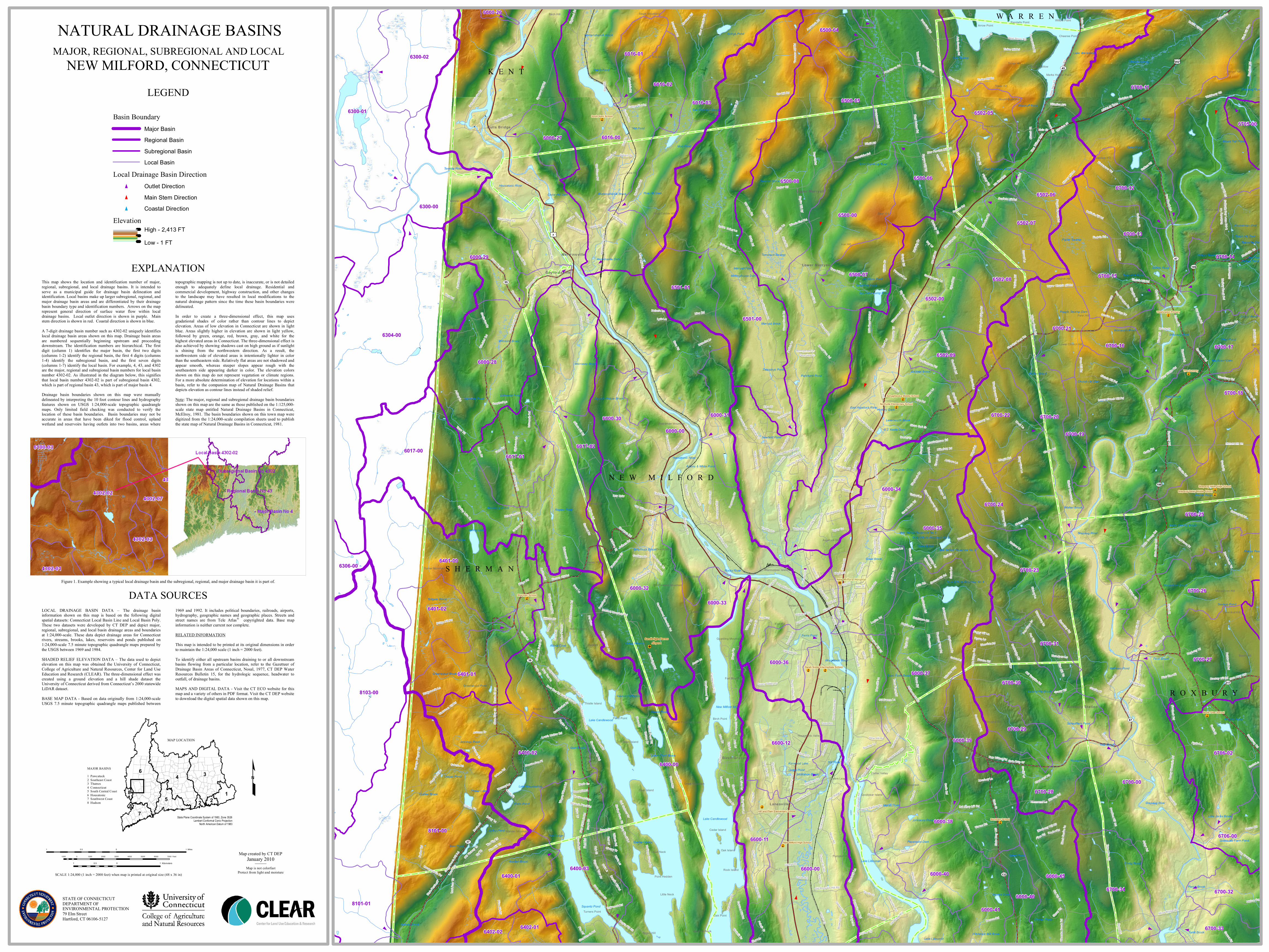
Basin BoundaryMajor BasinRegional BasinSubregional BasinLocal Basin
Local Drainage Basin Directiont Outlet Directiont Main Stem Directiont Coastal Direction
ElevationHigh - 2,413 FT Low - 1 FT
MAP LOCATION
State Plane Coordinate System of 1983, Zone 3526Lambert Conformal Conic Projection
North American Datum of 1983
MAJOR BASINS
1 Pawcatuck2 Southeast Coast3 Thames4 Connecticut5 South Central Coast6 Housatonic7 Southwest Coast8 Hudson
£
LEGEND
NATURAL DRAINAGE BASINSMAJOR, REGIONAL, SUBREGIONAL AND LOCAL
NEW MILFORD, CONNECTICUT
SCALE 1:24,000 (1 inch = 2000 feet) when map is printed at original size (48 x 36 in)
LOCAL DRAINAGE BASIN DATA – The drainage basininformation shown on this map is based on the following digitalspatial datasets: Connecticut Local Basin Line and Local Basin Poly.These two datasets were developed by CT DEP and depict major,regional, subregional, and local basin drainage areas and boundariesat 1:24,000-scale. These data depict drainage areas for Connecticutrivers, streams, brooks, lakes, reservoirs and ponds published on1:24,000-scale 7.5 minute topographic quadrangle maps prepared bythe USGS between 1969 and 1984.
SHADED RELIEF ELEVATION DATA – The data used to depictelevation on this map was obtained the University of Connecticut,College of Agriculture and Natural Resources, Center for Land UseEducation and Research (CLEAR). The three-dimensional effect wascreated using a ground elevation and a hill shade dataset theUniversity of Connecticut derived from Connecticut’s 2000 statewideLiDAR dataset.
BASE MAP DATA - Based on data originally from 1:24,000-scaleUSGS 7.5 minute topographic quadrangle maps published between
1969 and 1992. It includes political boundaries, railroads, airports,hydrography, geographic names and geographic places. Streets andstreet names are from Tele Atlas® copyrighted data. Base mapinformation is neither current nor complete.
RELATED INFORMATIONThis map is intended to be printed at its original dimensions in orderto maintain the 1:24,000 scale (1 inch = 2000 feet).
To identify either all upstream basins draining to or all downstreambasins flowing from a particular location, refer to the Gazetteer ofDrainage Basin Areas of Connecticut, Nosal, 1977, CT DEP WaterResources Bulletin 15, for the hydrologic sequence, headwater tooutfall, of drainage basins.MAPS AND DIGITAL DATA - Visit the CT ECO website for thismap and a variety of others in PDF format. Visit the CT DEP websiteto download the digital spatial data shown on this map.
DATA SOURCESFigure 1. Example showing a typical local drainage basin and the subregional, regional, and major drainage basin it is part of.
EXPLANATIONThis map shows the location and identification number of major,regional, subregional, and local drainage basins. It is intended toserve as a municipal guide for drainage basin delineation andidentification. Local basins make up larger subregional, regional, andmajor drainage basin areas and are differentiated by their drainagebasin boundary type and identification numbers. Arrows on the maprepresent general direction of surface water flow within localdrainage basins. Local outlet direction is shown in purple. Mainstem direction is shown in red. Coastal direction is shown in blue.
A 7-digit drainage basin number such as 4302-02 uniquely identifieslocal drainage basin areas shown on this map. Drainage basin areasare numbered sequentially beginning upstream and proceedingdownstream. The identification numbers are hierarchical. The firstdigit (column 1) identifies the major basin, the first two digits(columns 1-2) identify the regional basin, the first 4 digits (columns1-4) identify the subregional basin, and the first seven digits(columns 1-7) identify the local basin. For example, 4, 43, and 4302are the major, regional and subregional basin numbers for local basinnumber 4302-02. As illustrated in the diagram below, this signifiesthat local basin number 4302-02 is part of subregional basin 4302,which is part of regional basin 43, which is part of major basin 4.Drainage basin boundaries shown on this map were manuallydelineated by interpreting the 10 foot contour lines and hydrographyfeatures shown on USGS 1:24,000-scale topographic quadranglemaps. Only limited field checking was conducted to verify thelocation of these basin boundaries. Basin boundaries may not beaccurate in areas that have been diked for flood control, uplandwetland and reservoirs having outlets into two basins, areas where
topographic mapping is not up to date, is inaccurate, or is not detailedenough to adequately define local drainage. Residential andcommercial development, highway construction, and other changesto the landscape may have resulted in local modifications to thenatural drainage pattern since the time these basin boundaries weredelineated.
In order to create a three-dimensional effect, this map usesgradational shades of color rather than contour lines to depictelevation. Areas of low elevation in Connecticut are shown in lightblue. Areas slightly higher in elevation are shown in light yellow,followed by green, orange, red, brown, gray, and white for thehighest elevated areas in Connecticut. The three-dimensional effect isalso achieved by showing shadows cast on high ground as if sunlightis shining from the northwestern direction. As a result, thenorthwestern side of elevated areas is intentionally lighter in colorthan the southeastern side. Relatively flat areas are not shadowed andappear smooth, whereas steeper slopes appear rough with thesoutheastern side appearing darker in color. The elevation colorsshown on this map do not represent vegetation or climate regions.For a more absolute determination of elevation for locations within abasin, refer to the companion map of Natural Drainage Basins thatdepicts elevation as contour lines instead of shaded relief.
Note: The major, regional and subregional drainage basin boundariesshown on this map are the same as those published on the 1:125,000-scale state map entitled Natural Drainage Basins in Connecticut,McElroy, 1981. The basin boundaries shown on this town map weredigitized from the 1:24,000-scale compilation sheets used to publishthe state map of Natural Drainage Basins in Connecticut, 1981.
1 0 10.5 Miles
1 0 10.5 Kilometers
1000 0 1000 2000 3000 4000 5000 6000 7000 Feet
STATE OF CONNECTICUTDEPARTMENT OF ENVIRONMENTAL PROTECTION79 Elm StreetHartford, CT 06106-5127
Map created by CT DEPJanuary 2010
Map is not colorfastProtect from light and moisture