Embed Size (px)
Citation preview
Maryland State Highway Administration • Research Division Street Address: 707 North Calvert Street • Baltimore, Maryland 21202 • E-mail: [email protected]
INPUT DATA MOSAIC MODEL OUTPUT DATA
Research Project: SP309B4H Date: February 2015
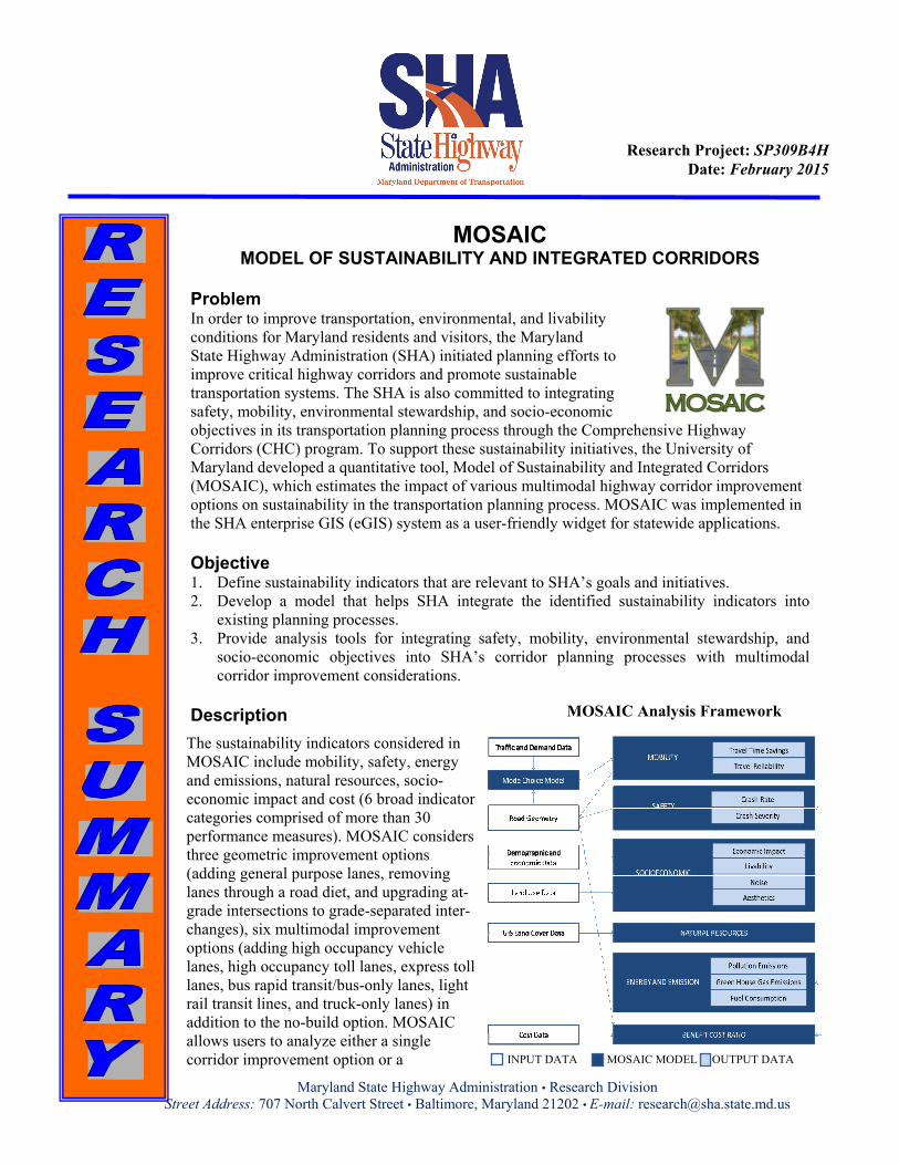
MOSAIC MODEL OF SUSTAINABILITY AND INTEGRATED CORRIDORS
Problem In order to improve transportation, environmental, and livability conditions for Maryland residents and visitors, the Maryland State Highway Administration (SHA) initiated planning efforts to improve critical highway corridors and promote sustainable transportation systems. The SHA is also committed to integrating safety, mobility, environmental stewardship, and socio-economic objectives in its transportation planning process through the Comprehensive Highway Corridors (CHC) program. To support these sustainability initiatives, the University of Maryland developed a quantitative tool, Model of Sustainability and Integrated Corridors (MOSAIC), which estimates the impact of various multimodal highway corridor improvement options on sustainability in the transportation planning process. MOSAIC was implemented in the SHA enterprise GIS (eGIS) system as a user-friendly widget for statewide applications. Objective 1. Define sustainability indicators that are relevant to SHA’s goals and initiatives. 2. Develop a model that helps SHA integrate the identified sustainability indicators into
existing planning processes. 3. Provide analysis tools for integrating safety, mobility, environmental stewardship, and
socio-economic objectives into SHA’s corridor planning processes with multimodal corridor improvement considerations.
Description
MOSAIC Analysis Framework
The sustainability indicators considered in MOSAIC include mobility, safety, energy and emissions, natural resources, socio-economic impact and cost (6 broad indicator categories comprised of more than 30 performance measures). MOSAIC considers three geometric improvement options (adding general purpose lanes, removing lanes through a road diet, and upgrading at-grade intersections to grade-separated inter-changes), six multimodal improvement options (adding high occupancy vehicle lanes, high occupancy toll lanes, express toll lanes, bus rapid transit/bus-only lanes, light rail transit lines, and truck-only lanes) in addition to the no-build option. MOSAIC allows users to analyze either a single corridor improvement option or a

Maryland State Highway Administration • Research Division Street Address: 707 North Calvert Street • Baltimore, Maryland 21202 • E-mail: [email protected]
combination of one geometric improvement option and one multimodal improvement option. After users select improvement options, MOSAIC first applies a pivot-point incremental logit mode choice model to generate new mode share parameters. Results of the mode choice model, together with other inputs, are used in the six impact analysis modules, including Mobility, Safety, Socio-Economics, Natural Resources, Energy and Emissions, and Cost Impact modules. These quantitative tools were calibrated and validated with Maryland data. The estimated sustainability impacts were visualized to support decision-making. Results MOSAIC was implemented in the SHA Enterprise GIS (eGIS) environment through a desktop-accessible widget. This integrated MOSAIC-eGIS system leverages other GIS datasets in eGIS (e.g., traffic, safety, geometry, land use, and nature resources layers) to drive high-level MOSAIC sustainability models. Results from the six sustainability impact modules are shown side-by-side for various improvement options to provide comprehensive evaluation and comparison. A final evaluation report is generated that includes: location maps, final sustainability indicator scores, section and corridor level performance scores, and raw module output data (i.e. effective roadway speeds, travel time savings, annual crashes, emissions, broader economic impact, livability impact, social influence, cost implications, etc.). Users may use MOSAIC to support streamlined decision-making processes for the Highway Needs Inventory, corridor planning, environmental screening, benefit-cost analysis, and social and economic impact studies.
MOSAIC Report: Corridor Location Map Corridor-Level Summary Results
Report Information Lei Zhang (Project P.I.), Associate Professor, Dept. of Civil and Environmental Engineering, University of Maryland, Phone: 301-405-2881, Email: [email protected]
Link to Reports: Phase I: http://www.roads.maryland.gov/OPR_Research/MD-11-SP009B4E-Comprehensive-Highway-Corridor-Planning-with-Sustainability-Indicators-Report.pdf Phase II: http://www.roads.maryland.gov/OPR_Research/MD-13-SP109B4Q-Comprehensive-Highway-Corridor-Planning-with-Sustainability-Indicators_Report.pdf Phase III: http://www.roads.maryland.gov/OPR_Research/MD-15-SHA-UM-3-7_MOSAIC-Phase3_Report.pdf
MOE MobilityNatural
ResourcesEnergy and
Env.Socio-
EconomicSafety
Benefit Cost
Score 45.0 -40.0 15.0 65.0 10.0 2.0
Corridor Level Sustainability Indicators
-100.0
-80.0
-60.0
-40.0
-20.0
0.0
20.0
40.0
60.0
80.0
100.0