Embed Size (px)
Citation preview

1
FRV MASRIK
Closed Joint Stock Company
Masrik 1
Solar Power Plant
Environmental and Social Impact
Assessment report
FRV Masrik CJSC
_________________Nicolas Fasquelle
Yerevan, 2019
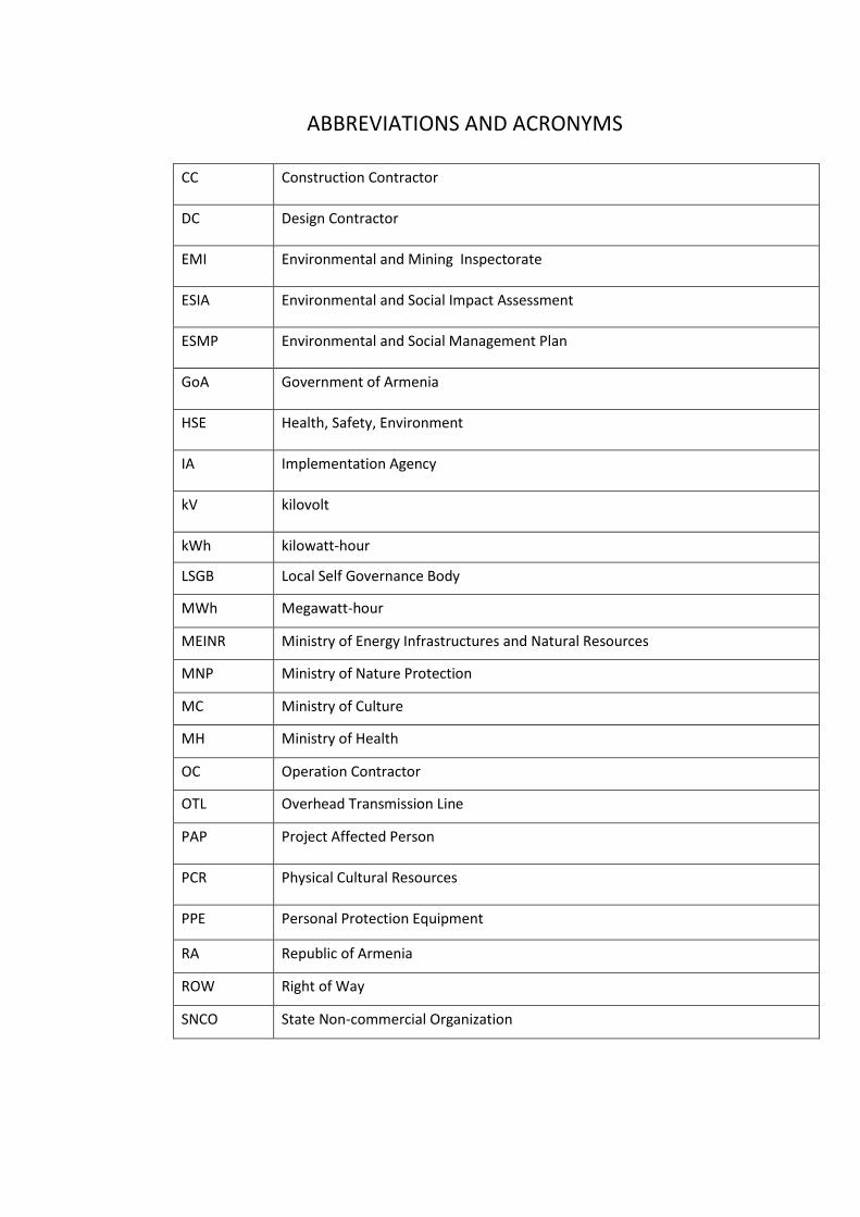
ABBREVIATIONS AND ACRONYMS
CC Construction Contractor
DC Design Contractor
EMI Environmental and Mining Inspectorate
ESIA Environmental and Social Impact Assessment
ESMP Environmental and Social Management Plan
GoA Government of Armenia
HSE Health, Safety, Environment
IA Implementation Agency
kV kilovolt
kWh kilowatt-hour
LSGB Local Self Governance Body
MWh Megawatt-hour
MEINR Ministry of Energy Infrastructures and Natural Resources
MNP Ministry of Nature Protection
MC Ministry of Culture
MH Ministry of Health
OC Operation Contractor
OTL Overhead Transmission Line
PAP Project Affected Person
PCR Physical Cultural Resources
PPE Personal Protection Equipment
RA Republic of Armenia
ROW Right of Way
SNCO State Non-commercial Organization

CONTENT
1. EXECUTIVE SUMMARY ............................................................... 6
1.1. Introduction ................................................................................................... 6
1.2. Objectives and Methodology......................................................................... 6
1.3. Legal and Regulatory Framework ................................................................. 7
1.4. Institutional Framework ................................................................................. 8
1.5. Baseline Conditions ...................................................................................... 8
1.6. Impact Assessment ...................................................................................... 9
1.7. Environmental and Social Management Plan ............................................. 10
1.8. Information, Disclosure, Consultation ......................................................... 10
1.9. Grievance Redress Mechanism .................................................................. 10
2. INTRODUCTION ......................................................................... 12
3. POLICY, LEGAL, AND ADMINISTRATIVE FRAMEWORK ........ 14
3.1. National Legislation .................................................................................... 14
3.2. Permits and consents required prior to commencement of construction works
of the Solar Power Plant and the Transmission line connecting the Plant to the Grid.19
3.3. International Agreements ............................................................................ 19
3.4. The World Bank Safeguard Policies ........................................................... 21
3.5. Codes and Standards ................................................................................. 22
3.6. The comparative analyses of the RA and international norms .................... 24
3.7. Administrative Framework .......................................................................... 26
4. PROJECT DESCRIPTION .......................................................... 29
4.1. Masrik 1 PV Plant ....................................................................................... 29
4.1.1. General Description ........................................................................................ 29
4.1.2. Generating System ......................................................................................... 30
4.1.3. Generation Medium voltage transformers ...................................................... 30
4.1.4. Grounding General Description ...................................................................... 30
4.1.5. Auxiliary Services ....................................................................................... 31
4.1.6. Monitoring System ...................................................................................... 31
4.2.Overhead Power Line ......................................................................................... 33
4.3. Civil Works Description ..................................................................................... 37
4.3.1. Roads and Parking area ................................................................................. 37
4.3.2. Buildings ......................................................................................................... 37
4.3.3. Structure of photovoltaic modules .................................................................. 38
4.3.4. Foundations.................................................................................................... 38
4.3.5. Drainage ......................................................................................................... 38
4.3.6. Perimeter fence .............................................................................................. 38
5. METHODOLOGY OF ESIA ......................................................... 41
5.1. Scope and Objectives of the ESIA .................................................................... 41
5.2. Procedures and Methodology ........................................................................... 41
6. BASELINE DATA........................................................................ 43
6.1. Location ...................................................................................................... 43
6.2. Relief, Geomorphology, Geological Structure ............................................. 44
6.3. Meteorological and Climate ........................................................................ 45
6.3.1. National Climatic Conditions........................................................................... 45
6.3.2. Local climatic conditions ................................................................................. 45

6.4. Characteristics of seismic conditions .......................................................... 49
6.5. Surface water quality characteristics .......................................................... 51
6.6. Ambient air quality characteristics .............................................................. 53
6.7. Noise and Vibration .................................................................................... 54
6.8. Soil quality characteristics .......................................................................... 54
6.9. Biodiversity ................................................................................................. 55
6.9.1. Flora ............................................................................................................... 56
6.9.2. Fauna ............................................................................................................. 60
6.9.3. Endangered ecosystems, specially protected nature areas ........................... 62
6.10. Historical and cultural environment ................................................................. 63
6.11. Social environment of Project site ................................................................... 66
6.11.1. Sociodemographic picture and livelihood ................................................ 66
6.11.2. Vulnerable groups ................................................................................... 67
7. ANTICIPATED ENVIRONMENTAL AND SOCIAL IMPACTS AND
MITIGATION MEASURES ................................................................... 68
7.1. Environmental Impacts and their Mitigation during Construction ................ 68
7.1.1. Landscape ...................................................................................................... 68
7.1.2. Flora and Fauna ............................................................................................. 68
7.1.3. Soil Erosion .................................................................................................... 69
7.1.4. Soil and Water Resources .............................................................................. 70
7.1.5. Solid and Liquid Wastes ................................................................................. 71
7.1.6. Noise .............................................................................................................. 72
7.1.7. Air Quality ....................................................................................................... 73
7.1.8. Historical and Cultural Sites ........................................................................... 73
7.1.9. Health and Safety ........................................................................................... 74
7.1.10. Gender Aspects ....................................................................................... 74
7.2. Environmental Impacts and their Mitigation during Operation ........................... 75
7.2.1. Flora ............................................................................................................... 75
7.2.2. Fauna ............................................................................................................. 75
7.2.3. Water resources ............................................................................................. 75
7.2.4. Noise .............................................................................................................. 76
7.2.5. Electric and Magnetic Fields .......................................................................... 76
7.3. Social impact and mitigation measures ............................................................. 76
7.3.1. Survey Methodology ....................................................................................... 76
7.3.2. Assessment of affected land .......................................................................... 77
7.3.3. Land losses .................................................................................................... 78
8. ASSESSMENT OF POTENTIAL ECONOMIC DAMAGE................. 80
9. ANALYSES OF ALTERNATIVES .................................................... 81
9.1. The "No Action" Option ..................................................................................... 81
9.2. Proposed Project of PV plants .................................................................... 81
9.2.1. Technology Assessment ................................................................................ 81
9.2.2. Mounting Systems .......................................................................................... 83
9.2.3. Cost estimation ............................................................................................... 84
9.2.4. Conclusions .................................................................................................... 84
10. INFORMATION DISCLOSURE, CONSULTATIONS, AND
PARTICIPATION ................................................................................. 85
10.1. Background ..................................................................................................... 85

10.2. Consultations with Main Stakeholders ........................................................ 85
11. ENVIRONMENTAL AND SOCIAL MANAGEMENT PLAN (ESMP)86
11.1. Institutonal Requirements ................................................................................ 86
11.2. Capacity Development and Training ............................................................... 87
11.3. Mitigation Measures ........................................................................................ 88
11.4. Monitoring Measures ....................................................................................... 97
12. GRIEVANCE REDRESS MECHANISM ....................................... 102
13. REFERENCES ............................................................................. 105
14. ANNEXES .............................................................................. 105
ANNEX 1. Calculation of Emissions Occuring During the
Construction of the Masrik 1 Solar Power Plant and Overhead Lines105
ANNEX 2. Assessment of Economic Damage ................................ 105

6
1. EXECUTIVE SUMMARY
1.1. Introduction
General Information1
Armenia has large solar energy potential (the average annual value of solar energy flow on 1m2
horizontal surface is 1720 kWh/m2, and a quarter of the territory of the Republic possesses the solar
energy reserves with 1850 kWh/m2 intensity).
Solar thermal energy is rapidly developing in Armenia.
The private sector imports both separate parts of solar water heating systems for their future
assembly and the complete systems. Presently, use of water heaters in Armenia not only results in
energy efficiency but is also economically beneficial.
In Armenian communities without gas supply, the “Energy Efficient” loan project launched in August
2017, under which, as for October 2018, 1364 solar heaters and 41 photovoltaic systems were
installed.
Promoting the activities of a wide range of autonomous power producers
To implement the activities of independent power producers, the parameters of 636 autonomous
power producers (with about 8,5 MW total capacity) have been approved, of which 567 have already
been connected to power system (with about 6,8 MW total capacity).
In the renewable energy sector, within the frames of implementing incentive measures aimed at
popularization of autonomous energy producers, the RA National Assembly in December 21, 2017
adopted the Laws HO-262-N and HO-261-N. In the Law “On Energy” of RA, the limit of 150 kW has
been revised setting it to be 500 kW for legal entities, as a result. The legislative framework has been
developed for heavy users of electricity, in order for them to carry out the functions of autonomous
power producers exclusively to meet the own needs. In the Law “On Energy Efficiency and Renewable
Energy” of RA, the provision has been set on the volumes of non providing compensation against the
energy supplied (delivered) in the frames of power exchange, and the exchange conducting regime
timelines have been improved for the renewable energy resource users - autonomous energy
producer and energy distributor license holder person.
According to the Article 59 of the Law “On Energy” of RA adopted on March 7, 2001, the entire power
(capacity) produced by the use of small hydroelectric power stations, within fifteen years, and other
renewable energy resources (wind, solar, geothermal and biomass), within twenty years, are subject
to purchase in accordance with market rules.
The tariff is set and reviewed according to the method adopted by the Decision of the Committee
number 88-N of April 22, 2015.
The purpose of this initiative is to build and operate the first industrial solar power plant in Armenia.
1.2. Objectives and Methodology
The proposed Masrik 1 PV plant and Overhead Transmission Lines (OTLs) will have several impacts on
various environmental and social components. The main objectives of the ESIA are to identify, assess
the magnitude of the expected impacts, furthermore, to provide measures for their mitigation
commensurate in accordance with the national and international standards. The ESIA report provides
1 RA EINR official website: http://www.minenergy.am/page/416
useful data to the General Contractor on how PV modules and high voltage power lines should be
designed and planned in order to avoid or mitigate negative impacts and to use more efficiently the
anticipated environmental and social benefits.
After public disclosure of the draft ESIA report, stakeholder consultation will be carried out to receive
feedback as well as hear concerns of the people affected by the planned works.
General overview on biophysical environment was carried out through a desktop study, and a field
survey was conducted by the environmental and social experts. This implied walk-through along the
proposed area and path of the OTLs, including hotspots like the crossing of valleys and villages
affected by the Masrik 1 PV plant Project.
Additional information was gained through consultations with representatives of relevant
governmental organizations and local communities. Intense consultations were conducted with the
representatives of the Historical and Cultural Monument Protection Agency of the Ministry of Culture
and with the representatives of the Ministry of Nature Protection.
1.3. Legal and Regulatory Framework
The implementation of any activity in Armenia which may cause environmental impacts needs a
positive conclusion outcome from an Environmental Impact Assessment (EIA) expertise.
Environmental impacts of a planned physical activity or a sectorial or regional development
plan/program has to be assessed during the pre-implementation period. The Republic of Armenia (RA)
Law on Environmental Assessment and Expertise of 2014 stipulates provisions regarding to
environmental impact assessment, impacting the environment and conditions under which causing of
such impact is allowed, thus, eventually it is the most important national law for EIA development.
According to this law, activities are classified into 3 categories: A, B and C. The activities related to
solar power plant are included in category C if the power plant occupies 40 hectares or more as in the
case of Masrik 1 Solar Plant, which occupies 128.3 ha.
EIA expertise shall also be conducted for construction of high voltage overhead power lines, which is
according to the Law of the RA on EIA are the overhead power lines of 110 kV (category “B”) or higher
voltage.
The PV Plant of Masrik 1 will occupy 97.5 ha area, and the voltage of the OTLs will be 110 kV, thus,
according to this Law, Masrik 1 PV plant is subject to the environmental expertise under category B.
According to World Bank OP 4.01, the Project falls into environmental Category B; therefore, it also
requires EIA and environmental management planning.
GoA has ratified a number of international agreements and conventions related to the protection of
the environment and biodiversity. In addition, an important environmentally relevant international
agreement to which Armenia is a signatory is the Aarhus Convention on access to information, public
participation in decision-making and access to justice in environmental matters (signed 1998, ratified
2001).
The following safeguard policies of the WB are triggered for the proposed project:
• OP 4.01 - Environmental Assessment
• OP 4.04 - Natural Habitats
• OP 4.11 - Physical Cultural Resources
• OP 4.12 – Involuntary Resettlement

1.4. Institutional Framework
Implementation Agency will be responsible for all operations under the Project, including its
compliance with the national environmental, social legislation; IFC, the World Bank’s and other
institutions’ safeguard policies. As part of the project implementation, IA can hire design, construction
and operation contractors as well as other consultants.
Also, government agencies that are likely to be involved in the Project implementation according to
their mandates include the Ministry of Energy and Natural Resources, the Ministry of Nature
Protection and the Ministry of Culture.
1.5. Baseline Conditions
The area requested for Masrik 1 PV Plant is situated in Vardenis sub region of Gegharkunik Marz, in
Lake Sevan in-shore Masrik valley, in the territory of Mets Masrik community.
Vardenis sub region is situated in southeast of Sevan basin – between Sevan, Eastern Sevan and
Vardenis mountain ranges. In general, the mountain surface prevails in the region. The dominant
landscapes are the mountain steppe and mountain meadow.
The average temperature in January ranges from -6 °C to -14 °C, and in July –from 8°C to 16 °C, the
annual precipitation is 350-650 mm and the active vegetation period is 40-130 days. Masrik, Babajan,
Pambak, Dara, Karchaghbyur and other rivers run through the area. Masrik, Sotk, Gilli and other canals
are functioning.
Figure 1.1: Site location (Source: Google Earth)
Masrik 1 PV Plant is located in the central part of Masrik field. Masrik field occupies the downstream
basin of River Masrik. The altitude is 1900-2000 m a.s.l. The flat surface has steepness to the west and
is covered by the strong alluvial sediments layer. To the west, at the location of the former Lake Gilli,
there are turf resources.
The potato, cereal, tobacco, vegetables, etc. are cultivated here.

During the spring season, waters occurring in a result of precipitations and thaw are mainly being
absorbed or partially form the small temporary ponds, which cause waterlogging of the soil. During
summer, only traces of these waterloggings remain – the stripping’s with depth of up to 0.5 meters
covered by lusher vegetation.
The main part of the land requested for Masrik 1 PV Plant is occupied by black soils, which is typical
for damp valleys and plateaus at the higher altitudes. There are large numbers of wetlands, which,
nevertheless, completely dry and harden during summer.
The area belongs to the floristic region of Sevan. It is situated in Masrik field, which is rich with alluvial
sediments. The vegetation in the vicinity of Mets Masrik contains steppe and meadow elements.
During field works stage, it was revealed, that due to the yearly overgrazing of the area, its flora is very
poor.
Nearest Mets Masrik is a rural community with an area of 36 km2. The population is 3,428. They are
mainly engaged in agriculture.
1.6. Impact Assessment
Main types of possible environmental impacts expected from construction of Masrik 1 PV plant
comprise the following:
• During construction works, impacts to flora and fauna are unavoidable, including the OTLs
corridor.
• New roads will be built, in the result of which the vegetation and habitats of some animals
will be damaged.
• As the area has a thick layer of topsoil, during the construction works it will be necessary to
cut and remove the topsoil from construction site, parking areas, which partly loses its
properties during storage.
• Small amounts of construction waste will be generated.
Most important possible social impacts areas are as follows:
• Land acquisition, possible damages to pastures and cattle paths during construction of access
roads, installation of towers, conductor stringing, and ROW maintenance.
• Nuisance to local communities due to movement of construction vehicles and machinery.
• Positive social impacts related to the services and infrastructures in the area, and the
potential employment generation.
• There is no historical or cultural resource found at the project site and no impacts are
expected, nevertheless OP 4.11 should be considered because non-recognized resources
adjacent to the site can be found during the project implementation.
ESIA report shows that the proposed Project will have low to medium environmental and social
impacts if the proposed ESMP is implemented and all proposed mitigation measures are applied.
According to the ESIA, negative environmental and social impacts occur mainly during the
construction phase. During the operational phase, the positive impacts are obvious and composed in a
much more environmental friendly and reliable power supply.

1.7. Environmental and Social Management Plan
The proposed Project of Masrik 1 PV plant will have impacts on various environmental and social
receptors. The ESMP covers a set of measures that need to be taken in order to prevent, minimize, or
compensate these impacts. Monitoring measures are deployed to ensure implementation of these
mitigation measures.
Design Phase
Detailed design shall be developed in the way to minimizing needs for land take and physical
relocation. Minimal need for the construction of new access roads shall also be targeted.
Construction Phase
During works required for construction of PV plant and installation of towers for OTLs, large amount
of topsoil shall be stripped, stored separately and used for site restoration once the modules and
towers are in place. Areas used for workers’ camps will be rehabilitated after decommissioning of
these camps.
Pollution of soil and water will be avoided by maintenance and re-fueling of construction equipment
on sealed and enclosed areas, provision of spill-control materials, storage of liquid materials in
adequate storage areas, provision of proper sanitation facilities, and training of workers.
Construction Contractor will discuss with the local municipalities how to arrange disposal of waste
through the communal service providers. Although there are no standard sanitary landfills in this
region, waste disposal through municipal service providers will at least ensure that there is no free
dumping or open air burning of waste. Scrap metal may be sold for recycling purposes to specialized
companies (e.g. METEXIM LLC), which should pick up the scrap metal directly at the dismantling sites.
Where the OTL corridor goes near villages or houses, the Construction Contractor has to control noise
emissions from all equipment. For residents the noise levels may not exceed 55 dB (A). Workers will
wear ear protection devices as part of their PPE if they are exposed to noise levels higher than 80 dB
(A). Nuisance by construction noise will be minimized by different measures (e.g. truck movements
only during daylight use of low sound power mechanical equipment etc.).
1.8. Information, Disclosure, Consultation
ESIA process involved dialogue of the ESIA team with various agencies of the Government and
specialists of the relevant fields with the purpose of sharing their experience and take advice.
Consultant’s environmental and social specialists held meetings with the representatives of Ministry
of Nature Protection, Ministry of Culture, and conducted field trips to the proposed area of PV plant
and corridor of OTL. The Ministry of Culture, Agency for Protection of Historical and Cultural
Monuments was consulted on the procedures to protect historical and cultural sites.
The Final Draft version of the ESIA report, including the ESMP, will be disclosed to the public in English
and Armenian versions to allow stakeholders to familiarize with it. The document will be posted on
MNP’s website and hard copies will be delivered to local administration offices. Printed copies will be
also provided to representative civil society organizations.
1.9. Grievance Redress Mechanism
In the course of the construction process, project affected people (PAP) may feel treated unjustly, for
which case IA shall maintain a viable grievance redress mechanism. PAP is encouraged to proceed in
the following way:

a) Contact the contractor’s designated grievance staff during periodical site visits in person or via
designated telephone number or the community leader or NGO staff.
• Lodge complaint and provide information on the case.
• Agree with the contractor on mitigation measure or agree with the contractor on time
limit for grievance settlement. (Grievances have to be settled within two weeks, or
otherwise specified in scheduled agreement).
b) Seek redress from the IA (In case of major grievances grievance committee will be called) if not
satisfied with above mentioned procedure.
c) Seek redress from court if all else fails.
Nevertheless, the above mentioned grievance mechanism does not limit the citizen’s right to submit
the case straight to the court of law just in the first stage of grievance process. The grievance
mechanism is designed to avoid lengthy court procedures.

2. INTRODUCTION
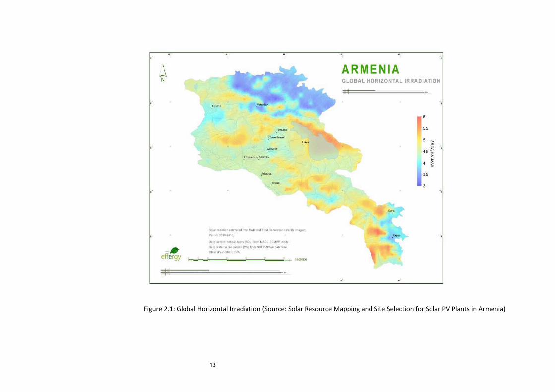
Armenia has a high potential of solar power. Figure 2.1 below presents the Global Horizontal
Irradiation based on the data collected from the period 2000-2015. Highest values of GHI are obtained
at eastern strip, Aragats mount and south part of the country, of around 5.5-6 kWh/m2/day (~2000-
2200 kWh/m2/year), reaching minimum values of 3 kWh/m2/day (~1100 kWh/m2/year) at north east
region, Araks and Debet valleys. (Source: Solar Resource Mapping and Site Selection for Solar PV
Plants in Armenia). For comparison, the average annual value in Europe is 1000 kWh/m2.
Nevertheless, Armenia considerably lags behind the European countries in sphere of solar power.
Though in Armenia the solar thermal collectors (water heaters) with 1.38-4.12 m2 standard size are
made, and the 2.75 m2 size water heater produces 120-160l hot water daily, its use is not widespread.
The solar power electrical converters are rarely used. To date, the small capacity demonstrative
photovoltaic (PV) modules have been installed in Armenia. In Armenian American Wellness Centre in
Yerevan (Institute of Mammography), the polymer photovoltaic converters, produced by the
technologies of Germany and USA, are installed on the roof and their total surface is 200 m2 and the
capacity - 9.8 kW.
Solar is not yet cost competitive under purely commercial financing assumptions, but the combination
of several factors could make it more so in the near future. The factors include: (i) new, higher-cost
thermal plants being built to serve demand in Armenia; (ii) lower solar installation costs that will result
as a domestic industry develops around it; (iii) lower financing costs as lenders become more
comfortable with the technology, and (iv) potential further reductions in the global costs of PV panels.
Financial and technical support can help Armenia nurture its solar industry so that, as these factors
converge, Armenia can look to utility-scale solar as a commercially viable alternative to some thermal
power generation.
13
Figure 2.1: Global Horizontal Irradiation (Source: Solar Resource Mapping and Site Selection for Solar PV Plants in Armenia)

3. POLICY, LEGAL, AND ADMINISTRATIVE FRAMEWORK
This chapter provides an overview of the national policy within which the Utility-Scale Solar Power
Project is being developed. This chapter discusses the overall policy and legal framework in the Republic
of Armenia with specific sectorial laws on environment, land use and health and safety.
3.1. National Legislation
Constitution
In accordance with article 12 of the Constitution of the Republic of Armenia (adopted in 1995 and
amended in 2005 and 2015) “The State stimulates protection, improvement and restoration of the
environment and reasonable use of the natural resources based on the principle of steady development
and taking into account the responsibility to the future generation. Everybody is obliged to take care of
environmental protection”. Article 85 of the constitution provides that “Everyone has, in accordance
with the law, the right of health protection”.
Since 1991 more than 25 codes and laws as well as numerous by-laws and regulations have been
adopted to protect the environment.
Land Code (2001)
The preamble of the Land Code stipulates that the possession, disposition and use of lands shall not
cause damage to the environment, defensibility and security of the country shall not violate the rights
and lawful interests of citizens and other persons. The Land Code defines the main directions for use and
disposition of the state lands, included those allocated for various purposes, such as agriculture, urban
construction, industry and mining, energy production, transmission and communication lines, transport
and other purposes.
The Code also defines the lands under the specially protected areas as well as forest, water and reserved
lands. It also establishes the measures aimed to the lands protection, as well as the rights of state
bodies, local authorities and citizens towards the land.
The Government of the Republic of Armenia directly or by means of the authorized bodies implements
the State management of the land resources of the RA.
Following the requirements of this Code, the decree on the establishment of technical regulations for
general requirements for protection of lands from pollution, list of substances polluting the lands, and
assessment of level of land pollution (24.08.2006 N1277-N) was adopted by the Government of the
Republic of Armenia. The RA Government Decrees “On Approval of the Technical Regulations for
Definition of the Norms for Topsoil Removal and for Removed Topsoil Maintenance and Use” number
1026-N of July 20, 2016 and “On Recognizing Void the RA Government Decree number 1026-N of July 20,
2006” (02.1.2017 number 1404-N).
“Calculation and Indexing Procedure of Reclamation Activities Estimated Values” was adopted by the
Order of the RA Minister of Nature Protection number 365-N of 24.12.2012.
Masrik 1 PV plant’s and OTL’s land allocation will be carried out according to the provisions of this Code.
Water Code (2002)
The main purpose of the Water Code is to provide the legal basis for the protection of the country’s
water resources, the satisfaction of water needs of citizens and economic sectors through effective

management of water resources, and safeguarding the protection of water resources for future
generations. The Water Code addresses the following key issues: responsibilities of state/local
authorities and public, development of the National Water Policy (2005) and National Water Program
(2006), water cadastre and monitoring system, public access to the relevant information, water use and
water system use permitting systems, trans-boundary water resources use, water quality standards,
hydraulic structures operation safety issues, protection of water resources and state supervision.
A PV plant does not use water to generate electricity. Only minimum quantities of water are used during
construction works, apart from the drinking water needs for workers.
Code on subsoil (2011)
The code defines principles and rules of mining in the RA, the relations related to preservation and use
of the deposits, conditions and requirements of efficient use, complex use and preservation of deposits,
security of mining and protecting the environment from its negative impacts, as well as protection of
rights of the state, citizens and users of deposits. According to the Code, natural deposits are under the
exclusive ownership of the state. They may be given out for use for a certain period of time, and cannot
be privatized. The law also determines conditions, requirements and peculiarities of the natural
resources and deposits. It also establishes payment principles, compensation, monitoring, and limitation
for mining activities.
If due to the construction works it will be more appropriate to carry out the inert materials’ (sand, gravel)
supply from their own mine, all registrations will be done according to the requirements of this Code.
Labour Code
The Labour Code of the RA, adopted on 9 November, 2004, protects the rights and interests of
employees and employers in collective and individual employment relationships, establishes state
guarantees for labour rights and freedoms, and promotes the creation of favorable conditions of work.
The labour relations between the employee and employer are originated on the basis of labour contract
concluded in a procedure established by the Labour Code and other normative legal acts containing
norms on labour Code.
Activities and operations of the project shall be implemented in accordance with the mentioned Code in
order to assure the protection of the rights and interests of the employees.
Law on Environmental Impact Assessment and Expertise (2014)
The Law on environmental impact assessment and expertise was adopted on July 2014. The Law
provides legal basis undertaking state environmental expertise of planned activities and concepts and
presents standard steps of EIA process. The Law establishes general legal, economic, and organizational
principles for conducting mandatory State EIA of various types of projects and concepts of sectorial
development.
According to this law, activities are classified into 3 categories: A, B and C. The categories are defined on
the basis of the volume of the activity, characteristics and the level of impact on environment.
The state expertise procedure consists of 2 stages. During the first stage lasting 1 month the Ministry of
Nature Protection and the public are notified on the project (short summary), and the first round of
public hearings is held. The Ministry of Nature Protection undertakes classification of a project and
recommends TOR for the EIA, if the EIA is required according to the classification outcome.

At the second stage, an EIA report is submitted to the Ministry of Nature Protection and the Ministry
undertakes its review during 60 days for a category “A” project or 40 days for a category “B” project.
Two public consultation meetings are required at this stage. The Ministry may extend the review
deadline for up to 30 days after which it issues a positive or a negative conclusion of the expert review.
The length and the complexity of the procedure depend on the categorization of the planned activity.
The activities related to solar power plant are included in category C, in case if the power plant occupies
40 hectares and more. Assessment and expertise are implemented prior to the implementation of
planned activity. Also, for the activities of category C only the initial stage is exercised. Following the
examination of the application at initial stage, the authorized body makes a decision on the issuance of
an EIA conclusion for activities under category C.
EIA expertise shall also be conducted for construction of high voltage overhead power lines, which,
according to the Law of the RA on EIA and, are the overhead power lines of 110 kV and more voltage.
Pursuant to article 14 of the Law, installation of OTLs is classified as activity of category B. For planned
activities of category B EIA expertise shall consist of both initial and main stages.
The PV Plant of Masrik 1 will occupy 128.3 ha area, and the voltage of the OTLs will be 110 kV, thus, the
design of the entire Plant, respectively, will be subject to environmental expertise as a higher Category
“B”.
Law on Ensuring Sanitary-epidemiological Security of the RA Population (1992)
The Law On Ensuring Sanitary-Epidemiological Security of the RA Population was adopted in 1992, which
sets legal, economic and institutional bases for ensured sanitary and epidemiological safety of the
population, as well as other guaranties provided for by the State to exclude influence of adverse and
hazardous factors on human organism and ensure favorable conditions for vital capacity of the present
and future generations.
Sanitary-epidemiological conditions of the staff must comply with the terms of this law.
Law on Provision of Medical Care and Services to the Population (1996)
The Armenian Law on Medical Care and Services to the population establishes the legal, economic and
financial guidelines for medical care and service delivery, which ensures the realization of people’s
constitutional right to preserve their health.
Activities and operations of the project shall be implemented in accordance with the mentioned laws in
order to insure health and safety of the employees as well as of the surrounding population.
Law on the Protection and Use of Fixed Cultural and Historic Monuments and Historic
Environment (1998)
The Law on the Protection and Use of Fixed Cultural and Historic Monuments and Historic Environment
was adopted by the National Assembly on November 11, 1998. It provides the legal and policy basis for
the protection and use of such monuments in Armenia and regulates the relations between protection
and use activities. Article 15 of the Law describes procedures for, among other things, the discovery and
state registration of monuments, the assessment of protection zones around them, and the creation of
historic-cultural reserves. Article 22 requires approval of the authorized body (Department of Historic
and Cultural Monuments Preservation) before land can be allocated for construction, agricultural and
other types of activities in areas containing monuments.
The issues regarding to the cultural and historical monuments in Masrik 1 PV plant’s and OTL’s sites will
be regulated by this law, as well as the World Bank policy. Although no historical values exist on the site,

the LAW should be considered because non-recognized resources can be found during the project
implementation.
Law on Flora (1999)
The law defines RA state policy in the field of maintenance, protection, usage and regeneration of flora.
The law defines objectives of flora examination, state monitoring, state inventory, requirements and
approaches of red book preparation on flora, conditions, peculiarities, limitations of allocation of flora
objects for purposeful usage, basis of termination of the right to use, provisions on flora maintenance,
and economic encouragement of usage and implementation of supervision. The law also defines the
rights and obligations of the state governance and local governmental bodies in the field of flora
maintenance, protection, reproduction and usage, mechanisms of state inventory, principles of deciding
their indicator.
In Masrik 1 PV plant’s and OTL’s sites, the natural flora’s protection norms are regulated by the law
above.
Law on Fauna (2000)
The law defines RA state policy in the field of maintenance, protection, usage and regeneration of fauna.
The law defines the objectives of survey of the fauna, state monitoring, state inventory, requirements
and approaches of red book preparation on fauna, conditions, peculiarities, limitations of allocation of
fauna objects for purposeful usage, basis of termination of the right to use, provisions on fauna
maintenance, and economic encouragement of usage and implementation of supervision. The law also
defines the rights and obligations of the state governance and local governmental bodies in the field of
flora maintenance, protection, reproduction and usage.
In Masrik 1 PV plant’s and OTL’s sites, the wildlife protection measures are regulated by this law.
To ensure compliance with the requirements of this Law, the RA Government approved the
Red Book of Animals of the Republic of Armenia with its Decree number 71-N of 29.01.2010
and the Red Book of Plants of the Republic of Armenia - with its Decree number 72-N of
29.01.2010.
Law on Wastes (2004)
The law regulates legal and economic relations connected to the collection, transfer, maintenance,
development, reduction of volumes, prevention of negative impact on human health and environment.
The law defines the main principles and directions of state policy, the principles of state standardization,
inventory, and introduction of statistical data, the implementation of their requirements and
mechanisms, the principles of wastes processing, the requirements for presenting wastes for the state
monitoring, activities to decrease the amount of the wastes, including nature utilization payments, as
well as the compensation for the damages caused to the human health and environment by the legal
entities and individuals, using the wastes, as well as requirements for state monitoring and legal
violations. The law defines the rights and obligations of the state governmental and local governmental
bodies, as legal entities and individuals.
Constructional and daily waste management occurred during the construction and operation of PV plant
must comply with this law.
Law on Environmental Oversight (2005)
The Law regulates the issues of organization and enforcement of oversight over the implementation of
environmental legislation of the Republic of Armenia, and defines the legal and economic bases

underlying the specifics of oversight, the relevant procedures, conditions and relations, as well as
environmental oversight in the Republic of Armenia. The existing legal framework governing the use of
natural resources and environmental protection includes a large variety of legal documents.
Governmental resolutions are the main legal instruments for implementing the environmental laws.
Environmental field is also regulated by presidential orders, Prime-Minister’s resolutions and ministerial
decrees.
The compliance with the environmental legisltaion during construction and operation of the Masrik 1
Power Plant will be controlled by the Environmental Protection and Mining Inspectorate as per the
provisions of this Law.
Law on Specially Protected Natural Areas (2006)
The law defines legal basis and relations of state policy for development, restoration, maintenance,
reproduction and use of natural complex and separate objects, as well as ecosystems of specially
protected natural areas of the Republic. According to the law, specially protected natural areas are
divided into four categories, National parks, State Reserves, Natural museums and the forth category is
divided into three separate types: areas of international, republican and local importance. Law defines
concepts, regimes of maintenance, principles of preparation of specially protected natural areas
management plans, monitoring, calculation and state registrar, as well as the requirements of usage,
limitations and principles, rights and obligations of state governmental and local governmental bodies,
maintenance bodies of the protected areas, the rights public to get an information on protected areas,
financial sources of protected areas, requirement of supervision and responsibility for violating the Law
on Specially Protected Natural Areas.
Masrik 1 PV plant’s territory is located in “Sevan” National Park’s buffer zone.
RA Health Minister’s N 01-N order as of January 25, 2010, «On approving sanitary rules and norms of soil
quality hygiene requirements N 2.1.7.003-10».
The sanitary rules and hygienic norms determine the hygienic requirements of soil quality, such as the
hygienic evaluation of land sanitary condition, soil quality monitoring, assessment of main indicators of
the sanitary condition of the soil, depending on their functional significance, as well the degree of soil
pollution on land use proposals.
RA Health Minister’s N 533-N order as of May 17, 2006, «On approving HN N 2.2.4-009-06 vibration
hygiene norms at workplaces, residential and public buildings».
The hygienic norms determine the vibration classification, regulation standards, the maximum
permissible level of vibration at workplaces, as well as the permissible levels of vibration at residential
and public buildings.
Protocol Decree N 54-13 of the Government of the RA, dated 10 December 2015 On Approval of the
Program “Ways of long-term (up to 2036) development of the energy system of the Republic of
Armenia”.
The program of strategic development of the energy system titled as “Ways of long-term (up to 2036)
development of the energy system of the Republic of Armenia” was developed and adopted by the
Government of Armenia in 2015.
The document is based on the Armenia Least Cost Energy Development Plan prepared under the USAID
Project “Low Emissions Strategies and Clean Energy Development in E&E” and USAID grant “Support to
National and Regional Energy Planning and Capacity Building at the Scientific Research Institute of

Energy”. At the same time, the World Bank, which is financing diverse energy system infrastructure
development projects, initiated the analysis of Armenian energy system and presented a number of
proposals.
Energy Security Concept of the Republic of Armenia” (adopted by the President of RA, 2013)
Energy Security Concept of the Republic of Armenia is aimed to ensure the energy security of the
Republic of Armenia in conformity with the provisions of the national security strategy. According to this
concept energy security is a complex of political, economic, legal, organizational and other measures
which aim to provide reliable and high-quality power supply on daily basis, as well as in emergency
situations and in times of war.
The implementation of this document is motivated by the rapidly developing social-economic and
political situation in the region, the global economic crisis, as well as by need to ensure RA’s energetic
independence and security in times of possible emergencies and war. The document also has an
objective to ensure RA’s proper engagement in regional programs organized by international
organizations, the European Union, the Russian Federation and the United States of America and finally
by the importance of creating long term strategic supply (stock) of fuel and energy resources.
3.2.Permits and consents required prior to commencement of construction works of the Solar Power Plant
and the Transmission line connecting the Plant to the Grid.
• Positive conclusion for construction of the Solar Plant and the Transmission line connecting the
Plant to the Grid issued by the State Environmental Expertise SNCO of the Ministry of Nature
Protection. Such conclusion is required in accordance with the Law on Environmental Impact
Assessment and Expertise.
• Construction license in the area of the capital construction, including development of documents
for urban development, engineering research and expertise to be held by the design company.
• Construction license in the area of capital construction to be held by the construction company
providing works.
• Constructions permit to be issued by the Head of Community.
• Technical expertise of PV plant design.
• Consent from the relevant local/regional authorities (usually community administration) for
disposal of excavated materials and construction wastes in the approved dump site shall be
obtained by Construction Contractor prior to transportation and disposal of construction
concrete rubbles, debris and spoils as well as excessive excavation materials in such dump sites.
• Power Generation license to be issued by the RA Public Services Regulatory Commission.
3.3. International Agreements
In addition to the above presented list of laws, numerous strategies, concept frameworks, and national
programs related to the nature protection have been developed, as well as a number of international
agreements and conventions have been signed and ratified by the Republic of Armenia.
The table below shows the list of relevant International Conventions and Protocols as well as their status
with respect to signing and ratification by the Republic of Armenia.
Table 3.1: International Conventions and Protocols signed and ratified by the RA

NN Convention or Protocol, Name and
Place In Force Signed Ratified Comment
1 Convention on Biological Diversity, (Rio-De-
Janeiro, 1992) 1993 1992 1993
Re-registered in
UN 1993
2 UN Framework Convention on Climate
Change, (New-York, 1992) 1994 1992 1993
Re-registered in
UN in 1993
3 Kyoto Protocol, (Kyoto, 1997) 2005 2002
4 Convention on Wetlands of International
Importance especially as Waterfowl Habitat
(Ramsar, 1971)
1975 Acceded as assignee by the request of
MFA RA 1993
5
Convention on Long-range Transboundary Air
Pollution, (Geneva, 1979) 1983 1996
Re-registered in
UN in 1997
Protocol on Persistent Organic Pollutants,
(Aarhus, 1998)
1998
Protocol to Abate Acidification,
Eutrophication and Ground-level Ozone,
(Gothenburg, 1999)
1999
6
Convention on Environmental Impact
Assessment in a Trans-boundary Context,
(Espoo, 1991)
1997 1996 Re-registered in
UN in 1997
Protocol on Strategic Environmental
Assessment, (Kiev, 2003) 2003
7 UN Convention to Combat Desertification,
(Paris, 1994) 1996 1994 1997
Re-registered in
UN in 1997
8
Convention on the Control of Transboundary
Movements of Hazardous Wastes and Their
Disposal, (Basel, 1989)
1992 1999 Re-registered in
UN in 1999
9
Convention for the Protection of the Ozone
Layer, (Vienna, 1985.) 1988 1999
Re-registered in
UN in 1999
Montreal Protocol on Substances that
Deplete the Ozone Layer, (Montreal, 1987) 1989 1999
Re-registered in
UN in 1999
10
Convention on Access to Information, Public
Participation in Decision-Making and Access to
Justice in Environmental Matters,
(Aarhus, 1998)
2001 1998 2001
11
Convention on Protection and Use of
Trans-boundary Watercourses and
International Lakes, (Helsinki, 1992)
1996 1999
Protocol on Water and Health, (London,
1999) 1999

3.4. The World Bank Safeguard Policies
The World Bank OP/BP 4.01 Environmental Assessment is considered to be the umbrella policy for the
Bank's environmental safeguard policies. These policies are critical for ensuring that potentially adverse
environmental and social consequences are identified, minimized, and properly mitigated. The safeguard
policies, the triggers for each policy, as well as status of their relevancy for the proposed project are
presented in the table below:
Table 3.2: WB safeguards policies
Operational Policy Triggers Status
Environmental
Assessment (OP 4.01)
If a project is likely to have (adverse) environmental risks and
impacts in its area of influence.
Yes
Forests (OP
4.36)
Forest sector activities and other Bank sponsored interventions
which have potential to impact significantly upon forested areas.
No
Involuntary
Resettlement
Physical relocation and land loss resulting in: (i) relocation or loss of
shelter; (ii) loss of assets or access to assets; (iii)
Yes
(OP 4.12) Land acquisition, loss of income sources or means of livelihood,
whether or not the affected people must move to another
location.
Indigenous Peoples
(OP 4.10)
If there are indigenous peoples in the project area, and potential
adverse impacts on indigenous peoples are anticipated, and
indigenous peoples are among the intended beneficiaries.
No
Safety of Dams (OP
4.37)
If a project involves construction of a large dam (15 m or higher)
or a high hazard dam; If a project is dependent upon an existing
dam, or dam under construction.
No
Pest Management (OP
4.09)
If procurement of pesticides is envisaged; If the project may
affect pest management in the way that harm could be done,
even though the project is not envisaged to procure pesticides.
This includes projects that may (i) lead to substantially increased
pesticide use and subsequent increase in health and
environmental risk, (ii) maintain or expand present pest
management practices that are unsustainable, not based on an
IPM approach, pose significant health or environmental risks.
No
Physical Cultural
Resources (OP
4.11)
The policy is triggered by projects which, prima facie, entail the
risk of damaging cultural property (e.g. any project that includes
large scale excavations, movement of earth, surface
environmental changes or demolition).
No
Natural Habitats (OP
4.04)
The policy is triggered by any project with the potential to cause
significant conversion (loss) or degradation of natural habitats
whether directly (through construction) or indirectly (through
human activities induced by the project).
Yes
Projects in Disputed Areas
(OP 7.60)
The policy is triggered if the proposed project will be in a “disputed
area”.
No

Operational Policy Triggers Status
Projects on
International
Waterways
(OP 7.50)
If the project is on international waterway such as: any river, canal,
lake, or similar body of water that forms a boundary between, or
any river or body of surface water that flows through, two or more
states ( or any tributary or other body of surface water that is a
component of this waterway); any bay, gulf, strait, or channel
bounded by two or more states or, if within one state, recognized
as a necessary channel of communication between the open sea
and other states-and any river flowing into such waters.
No
The project is classified as the Environmental Category “B” in accordance with the World Bank OP/BP
4.01.
3.5. Codes and Standards
It must comply with applicable Armenian laws and regulations, national, regional or local level, and the
regulations or directives of the International Electrotechnical Commission in force at the time of order
placement.
Armenian requirements:
• The RA PSRC Resolution No. 314-N, 2007, “Procedures for Connection of Power Plants to the
Power System”.
• The RA PSRC Resolution No. 358-N, 2006, “Rules of power supply and use”.
• The RA PSRC Resolution No. 176-N, 2004, “Rules and procedures to ensure safety and reliability
of the Power System of Armenia”.
• Standard defining general requirements and procedures for connection of up to 5 MW solar
photoelectric power plants to the common electric grid of the power supplying company of the
Power System.
• The RA PSRC Resolution Decree N 374-N, 2013 on Approval of licensing procedures for activity
in the power sector and to annul the number of resolutions”.
• The RA Government Decree N 1605-N dated December 27, 2007, Technical Regulations on
operation of the electric power plants and networks.
• The RA Government Decree N 1033-N, 2008, Technical Regulations “Requirements to the
electric distribution devices and the equipment of substations”.
• The RA Government Decree N 42-N, 2008, Technical Regulations “Requirements to power plants
relay protection and automation devices”.
• The RA Government Decree N 1933-N dated November 23, 2006, Technical Regulations “Safety
rules for operation of the electric installations”.
• The RA Government Decree N 1033-N dated September 4, 2008, Technical Regulations
“Requirements to the electric distribution devices and the equipment of substations”.
• The RA Government Decree N 1943-N dated December 21, 2006, Technical Regulations
“General Requirements to the equipment of electric installations”.

• The RA Government Decree N 1922-N dated November 23, 2006, Technical Regulations “Safety
Requirements to the electric devices converting voltage of 1000V and higher”.
• The RA Government Decree N 961-N dated July 12, 2007, Technical Regulations on transmission
and distribution of electric energy.
• The RA Government Decree N 1918-N, 2011, on Approval of procedure for development of
temporary schemes for land use and to annul the GoA Resolution N30 dated January 17,
2001.
• The RA Government Decree N 777-N of 2009 on Approval of licensing procedure for
construction works in the area of civil construction (excluding the works not requiring
construction permit).
• The RA Government Decree N 739-N of 2005, on Approval of procedure for issuing conclusion
on commissioning of newly constructed and rehabilitated power installations with voltage of
6kV and higher.
• The RA Government Decree N 1920-N of 2011, on Approval of procedure on development,
expertise, agreement, approval and amending of General Plan for communities (settlements)
of Republic of Armenia and to annul the GoA Resolution N 609-N dated May 2, 2003 and N 208-
N dated March 4, 2010.
• The RA Government Decree N596-N of 2015 on Approval of procedure for obtaining permits
and other documents on the development in the RA and consider void of some of the
Government Decrees of RA.
• The RA Government N510-N of 2011 on Approval of licensing procedure and form on
development and expertise of the urban development documents (except of activities not
required construction permit) and to annul the Government Decrees of Republic of Armenia N
778-N and N 779-N, dated July 2, 2009.
International standards:
• IEC 60904-1: Photovoltaic devices
• IEC 61683: Photovoltaic systems - Power conditioners - Procedure for measuring efficiency
• IEC 61727: Photovoltaic (PV) systems - Characteristics of the utility interface
• IEC 61730: Photovoltaic (PV) module safety qualification
• IEC 62093: Balance-of-system components for photovoltaic systems - Design qualification
natural environments
• IEC 62124: Photovoltaic (PV) standalone systems - Design verification
• IEC 61557-1: Electrical safety in low voltage distribution systems up to 1000 Vac and 1500 Vdc
• IEC 61558: Specification for safety of power transformers, power supply units and similar
apparatus
• IEC 61173: Over-voltage protection for photovoltaic (PV) power generating systems
• IEC 61194: Characteristic parameters of stand-alone photovoltaic (PV) systems

• IEC 61724: Photovoltaic system performance monitoring - Guidelines for measurement, data
exchange and analysis
• IEC 62446: Grid connected photovoltaic systems - Minimum requirements for system
documentation, commissioning tests and inspection
• ISO 9355-1: Ergonomic requirements for the design of displays and control actuators Applicable
editions of these standards will be the last published, including corrections, at the time of order
placement.
3.6. The comparative analyses of the RA and international norms
The WB, ADB and RA comparative analysis of the environmental and social regulatory requirements is
provided in the tables 3.3 and 3.4 below:
Table 3.3: Environmental Impact Assessment
RA Legislation
WB The Law of the RA On Environmental Impact Assessment and Expertise (the “Law”) limits the concept
of “area of influence” to “affected community”, which,
according to the Law is the population of the
community(ies) of the possible impact zone, including
individuals and legal entities.
The area likely to be affected by the project, including all
its ancillary aspects, such as power transmission
corridors, pipelines, canals, tunnels, relocation and
access roads, borrow and disposal areas, and
construction camps, as well as unplanned developments
induced by the project.
The Law provides for less vague rules for environmental
categorization of the planned activity. The planned
activities are classified into category A, B and C, based on
descending impact scale. According to the Law, PV plants
occupying an area of 40 hectare and more are listed as
category C, and high voltage lines of 110kV and more are
classified as Category B.
A proposed project is classified as Category B if its
potential adverse environmental impacts on human
populations or environmentally important areas,
including wetlands, forests, grasslands, and other
natural habitats are less adverse than those of Category
A projects. These impacts are site-specific.
Environmental monitoring during project implementation
provides information about key environmental aspects of
the project, particularly the environmental impacts of the
project and the effectiveness of mitigation measures.
Such information enables the borrower and WB to
evaluate the success of mitigation as part of project
needed.
The EMP shall: (a) describe monitoring measures with technical details,
including parameters to be measured, methods to be
used, sampling locations, frequency of measurements,
detection limits and definition of thresholds that will
signal the need for corrective actions; and (b) describe
monitoring and reporting procedures to ensure early
detection of conditions that necessitate particular
mitigation measures and document the progress and
results of mitigation.
Table 3.4: Social Impact Assessment
RA Legislation WB SPS
Land compensation only for titled landowners. Persons who have no recognizable legal right are provided
compensation or resettlement assistance, as specified in the RPF.
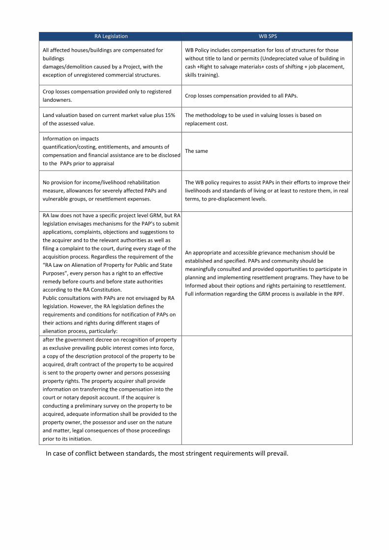
RA Legislation WB SPS
All affected houses/buildings are compensated for
buildings damages/demolition caused by a Project, with the
exception of unregistered commercial structures.
WB Policy includes compensation for loss of structures for those
without title to land or permits (Undepreciated value of building in
cash +Right to salvage materials+ costs of shifting + job placement,
skills training).
Crop losses compensation provided only to registered
landowners. Crop losses compensation provided to all PAPs.
Land valuation based on current market value plus 15%
of the assessed value. The methodology to be used in valuing losses is based on
replacement cost.
Information on impacts quantification/costing, entitlements, and amounts of
compensation and financial assistance are to be disclosed
to the PAPs prior to appraisal
The same
No provision for income/livelihood rehabilitation
measure, allowances for severely affected PAPs and
vulnerable groups, or resettlement expenses.
The WB policy requires to assist PAPs in their efforts to improve their
livelihoods and standards of living or at least to restore them, in real
terms, to pre-displacement levels.
RA law does not have a specific project level GRM, but RA
legislation envisages mechanisms for the PAP's to submit
applications, complaints, objections and suggestions to
the acquirer and to the relevant authorities as well as
filing a complaint to the court, during every stage of the
acquisition process. Regardless the requirement of the
“RA Law on Alienation of Property for Public and State Purposes”, every person has a right to an effective
remedy before courts and before state authorities
according to the RA Constitution. Public consultations with PAPs are not envisaged by RA
legislation. However, the RA legislation defines the
requirements and conditions for notification of PAPs on
their actions and rights during different stages of
alienation process, particularly:
An appropriate and accessible grievance mechanism should be
established and specified. PAPs and community should be
meaningfully consulted and provided opportunities to participate in
planning and implementing resettlement programs. They have to be
Informed about their options and rights pertaining to resettlement.
Full information regarding the GRM process is available in the RPF.
after the government decree on recognition of property
as exclusive prevailing public interest comes into force,
a copy of the description protocol of the property to be
acquired, draft contract of the property to be acquired
is sent to the property owner and persons possessing
property rights. The property acquirer shall provide
information on transferring the compensation into the
court or notary deposit account. If the acquirer is
conducting a preliminary survey on the property to be
acquired, adequate information shall be provided to the
property owner, the possessor and user on the nature
and matter, legal consequences of those proceedings
prior to its initiation.
In case of conflict between standards, the most stringent requirements will prevail.
3.7. Administrative Framework
This section identifies all major parties to be involved in the project implementation and summarizes their
roles and responsibilities primarily, but not exclusively from an environmental perspective. More details
including capacity development and training needs are provided in Section 10 of this report.
Implementation Agency (IA)
FVR Masrik CJSC will be an implementation agency of the.
Prticularly in the ESIA framework, IA will be responsible for overall project implementation monitoring and
reporting to WB, including but not limited to:
i. Guarantee that all relevant requirements of Environmental Management Plan (including nature
protection designing and mitigation measures) are properly included in the project tender
documents.
ii. Ensure that all necessary permissions and/or agreement required from the relevant government
institutions are received by Developer prior to any construction works under the Project.
iii. Ensure that Developers (contractors) understood their obligations on mitigation of the problems of
environmental protection connected with construction and training of their personnel in
implementation of EMP.
iv. Monitoring of EMP implementation by the Developer according to the plan of environment
monitoring.
Ministry of Nature Protection
The Ministry of Nature Protection (MNP) is responsible for protection, sustainable use, and regeneration of
natural resources as well as the improvement of the environment in the Republic of Armenia. In those areas,
the MNP’s authority includes overseeing national policy development, developing environmental standards
and guidelines, and enforcement. The MNP implements those functions through the following structural
departments:
• Department of Environmental Protection Policy
• Department on Monitoring of Environmental Strategic Program
• Legal Department
• Information and Public Relation Department
• Financial-economic Department
• Department of Underground Resources and Land Protection Policy
• Department of International Cooperation
The MNP also undertakes several functions through the following key detached divisions and subordinate
bodies:
• Water Resources Management Agency
WRMA is the key institution responsible for the water resources management: development of National
Water Policy and National Water Plan; classification of water resources by their purpose of usage;
participation in water standards development and supervise their application, issue water use permits, etc.
Prior to operation of the PV Plant, it is necessary to receive the Water System Use Permit from this Agency.

• Environmental Impact Expertise Center SNCO (conduct environmental assessments, issue expertise
conclusions). Masrik 1 PV Plant is subject to the environmental expertise to be implemented by this
Center.
• Environmental Impact Monitoring Center (collects water quality data from 131 sampling points),
including from River Masrik, which is adjacent to the PV Plant’s area.
Ministry of Energy Infrastructures and Natural Resources
The MEINR is a state body of executive authority, which elaborates and implements the policies of the
Republic of Armenia Government in the energy and natural resources management sector. The MEINR
implements the functions related to natural resources management through the following structural
departments:
• Subsoil Concession Agency
• Mineral Resources Agency
• State Energy Inspectorate – the inspectorate issues startup conclusion for the power plants.
• State Committee of Water Economy
Public Services Regulatory Commission
• Construction and operation of the solar power plants are regulated by the Power Generation License
issued to the IE. According to the local legislation, the RA Public Services Regulatory Commission
issues Power Generation License to the legal entity in accordance with the PSRC Resolution N374
dated November 1, 2013.
Ministry of Health
The Ministry of Health is a state body of executive authority, which elaborates and implements the policies of
the Republic of Armenia Government in the healthcare sector. The MH implements the functions related to
development and organization of implementation of healthcare management policy and state projects,
development and approval and sanitary norms and rules, drafting as well as oversight over implementation
of laws and regulations related to healthcare sector.
The MH has the following separate divisions and state agencies:
• Medical Aid Policy Department
• Maternal and Child Healthcare Department
• Legal Department
• Medication and Medical Technology Policy Department
• Licensing Agency
• National Healthcare Inspectorate
This Inspectorate implements the supervision of the population and employees health. During construction
and operation of the PV plant, meeting the obligations related to employees’ health will be supervised by the
Inspectorate.
RA Environmental Protection and Mining Inspectorate

The RA Environmental Protection and Mining Inspection Body established according to the requirements
of the Law of the Republic of Armenia “On Inspection Bodies”, on the basis of the RA Ministry of Nature
Protection Staff Nature Protection State Inspection and the RA Ministry of Energy Infrastructures and Natural
Resources Staff State Mining Inspection. The RA Environmental Protection and Mining Inspection Body
implements control and (or) other functions provided by the law, as well as applies sanctions in spheres of
environmental protection, use, reproduction of natural resources and mining industry, on behalf of the
Republic of Armenia.
Table 3.5: Key Stakeholders Matrix:
No. Stakeholder Role / Responsibility
1 Implementation Agency IA is responsible for overall project
implementation monitoring and reporting
to WB.
2 Head of Local Community Issues Construction permit
3 Public Services Regulatory Commission IssuesPower Generation License
4 Ministry of Nature Protection /
Environmental Inspectorate/Environmental
Impact Assessment Expertise Centre
Environmental impact assessment
expertise;
Supervision of the compliance with the
effective environmental legislation
5 Ministry of Energy Infrastructures and Natural
Resources/ State energy inspectorate
Issues Startup conclusion for the power
plants.
6 Ministry of Health/ National Healthcare
Inspectorate
Supervision of the population and
employees health
7 Ministry of Culture / Agency for Protection of
Historical and Cultural Monuments
Accompany design team to ensure that
cultural heritage sites are bypassed or
over-spanned

4. PROJECT DESCRIPTION
4.1. Masrik 1 PV Plant
4.1.1. General Description
AC power: 55.0 MWn
Peak Power: 62.013 MWp
Fanced Area: 128.3 ha
These production units (hereafter ITC “Inverter Transformer Center”) are formed by several parallel and
series associations of photovoltaic modules, which in turn are mounted on fixed structures with horizontal
PV module assembly.
• ITC contains following MV switchgears:
- 1 Incoming switchgear.
- 1 Outgoing switchgear.
- 1 Protection switchgear.
Each ITC will be equipped with an auxiliary power transformer which will supply energy to necessary auxiliary
services for proper operating of PV plant.
The interconnection of the production units that composed the PV Plant will be by 2 circuits of 6 ITCs and 2
circuits of 4 ITCs each through medium voltage cables (35kV). These aluminum medium voltage cables will be
preferably installed under duct through several trenches converge in the Connection Center (CC).
In the CC will be interconnected the internal medium voltage power lines (35kV) with 110kV PV electrical
substation through two lines (one line for each power transformer) connecting the PV plant with PV Electrical
Substation redundantly.
Connection Center contains following MV switchgears:
- 4 Line switchgears, that correspond with the 4 connection circuits.
- 1 PV production measurement/coupling switchgear.
- 2 Evacuation switchgear.
- 1 Auxiliary Services Protection Switchgear.
The CC will be equipped with certified and homologated measurement system connected to the MV
switchgears to get a measurement of the net energy.
From the CC an auxiliary power transformer will supply the necessary energy to devices (Aux. Services,
lighting, power suppliers, etc.) of the Control Center used to control the operation of PV plant and
Warehouse used to store maintenance elements. The consumption of the auxiliary services of the
photovoltaic plant will be upstream of the general PV production to discriminate incoming and outgoing
power.
Generally fixed tilted systems are employed on sites with high wind or snow loads. However, some tracker

4.1.2. Generating System
The generating system consists of a group of PV modules connected in series and in parallel with each other
to achieve an optimal level of output voltage and current ranges compatible with the input of inverter model
selected.
The parallel connection of the PV modules series will take place in direct current combiner boxes distributed
by the solar field. In this combiner box, will be installed protection (fuses and surge arrester) and switch of
series that will allow maintenance and switching operations.
The number of trackers and piles the numbers are:
• Number of trackers 2,953,
• Number of piles per tracker 5,
• Number of PV modules per tracker 56,
The direct current received from solar panels will be transformed into alternating current through a number
of inverters that in turn will be connected to the average voltage transformers forming a medium voltage
network. A medium voltage network will be connected to the substation located in the territory of the plant,
where the voltage will rise to 110 kV in order to be connected to the Electric Networks of Armenia (ENA).
It is planned to construct a 33/110 kV voltage substation in the territory of the Solar Power Plant.
4.1.3. Generation Medium voltage transformers
In PV plant will be installed 12 Medium voltage transformers
- 6 Transformer station 5MVA (x42/43 inverters SUN2000-105KTL-H1)
- 6 Transformer station 5.1 MVA (x44 inverters SUN2000-105KTL-H1)
The transformers will be employed to step up the low voltage output from inverters (two inverters by ITC) to
the internal medium voltage of the plant.These transformers will have double secondary windings to
optimize the interconnection with the two inverters. The transformers will be with very low losses (1%).
4.1.4. Grounding General Description
A grounding system should be installed in a manner that will limit the effect of ground potential gradients to
such voltage and current levels that will not endanger the safety of people or equipment under normal and
fault conditions. The system should also ensure continuity of service.
The system of ground electrodes will have the form of a grid of horizontally buried conductors,
supplemented by a number of vertical ground rods connected to the grid. Horizontal (grid) conductors are
most effective in reducing the danger of high step and touch voltages on the earth’s surface
Rods penetrating the lower resistivity soil are far more effective in dissipating fault currents whenever a two-
layer or multilayer soil will be encountered and the upper soil layer has higher resistivity than the lower
layers.
Grounding conductors shall be stranded soft drawn annealed copper material or equivalent.
Ground rods shall be Copperweld material or equivalent.
As a general conception grounding system shall be such that when connected to other on site grounding
networks, the electrical resistance between networks shall be 0.5Ω or less.

4.1.5. Auxiliary Services
The general auxiliary services of the PV plant will be feed from auxiliary medium voltage power transformer
located inside of Connection Centre. This auxiliary transformer will step down medium voltage of the grid
connection to low voltage and it will be interconnected with the auxiliary low voltage panel board which will
supply the auxiliary services of Control Centre and Warehouse.
The general auxiliary services will be the following:
• Lighting
• Sockets
• Fire protections
• Security
• CCTV
• Control system
• Warehouse electrical consumption
On the other hand, the ITCs will have electrical consumption which will be feed from an auxiliary low voltage
power transformer located inside of each ITC and it will step down the output voltage of inverters to low
voltage of following auxiliary services:
• Inverter power supply
• Cooling fans power supply
• Lighting
• Sockets
• Smoke detectors
4.1.6. Monitoring System
It shall be designed in order to achieve a global and detailed view of the operation of the plant and a failure
or deviation detection tool.
The data acquisition levels are:
• Junction boxes: measuring voltage and intensity in photovoltaic generators
• Inverters: input and output process variables at the inverter
• Meteorological station
• Measuring counters at the battery limit of the PV plant, in order to know the energy delivered to the
electric company.
All these data are sent, by means of a fiber optic net, to the Control Centre, where a SCADA application is
installed. This SCADA will be continuously evaluating inverter values in order to supervise which are
producing with poor performance and to allow corrective actuations.

Fig. 4.1. PV plant area and infrastructure

4.2.Overhead Power Line
The PV Electrical Substation will be connected to the energy system at the nearest tension towers of 110kV
“Kaputak” and “Akunk” overhead lines by constructing 9.2 km overhead branch lines (T-off lines).
Masrik-1 110kV double circuit overhead power transmission line is intended to connect existing two single
line overhead power transmission line Kaputak N452 tower and Akunq N86 tower. The selected trajectory is
coordinated by all stakeholders.
The trajectory is in the third climatic zone where the ice cover thickness is 20mm, and the maximum wind
speed is 36mps, the maximum air temperature is +35°C, and the minimum is -26°C.
In the trajectory will be placed 41 towers, 13 of them will be devitation towers.
The lightning protection will be perform with OPGW-50 optical lightning conductor.
The selection of the foundation was based on the forces acting on them based on the physical and technical
properties of the ground.
There are three type of foundations, which will used for the project. For tangent tower will used F2-2
foundation. For devitation tower will used F2-У and F4-У foundations.
Under foundations it is planned 100mm crushed stone. After the foundations installation need to do ground
backfill with compaction. The grounding system of each foundations are separately.
As the conductor will be used aluminum steel conductor AS150/24. As vibration dumper will used GVH-3-17.
For suspension string of insulation will used 10 PS70-E insulators, and for supporting insulation string will
used 9 PS70-E insulations.
In the part of lightning protection optical conductor, which is tension are isolated and the supporting
fasteners are not insulated.
Connection of aluminum steel conductors in plume is foreseen PA-4-1 hinges clamp, and for each connection
provide two hinges clamp.
For connecting aluminum steel conductors in flights foreseen SOAS-150-3 clamps, and for connection
lightning protection optical conductor SBS-50-3 clamps.

Fig. 4.2. Transmisión line area

Fig. 4.3. OTL Towers

Fig. 4.4. El.Scheme

4.3. Civil Works Description
4.3.1. Roads and Parking area
Perimeter road
A perimeter road will be implemented joining the internal roads in the outline of the General Blocks to
improve the mobility.
Internal road
The purpose of the internal roads is to allow access to various facilities in the solar plant, during construction,
operation and maintenance on a safe way. There will all interior roads needed to allow access to each ITC.
Considering the hydrology study and drainage system designed in the plant will assess the design of the roads
drainage.
The roads will have the appropriate transversal slope for drainage to reduce pending and infiltration of water
into the pavement and sub-grade materials. The construction of perimeter swales, edge drains, curbs and
gutters, or combination of these drainage devices is recommended to reduce the adverse effects of surface
water runoff. The design of the alignment of each road will be carried out adequately to let the vehicles to
pass over these roads under safety and comfortable conditions.
The sizing of the type section will be done taking into account the heavy traffic category (number of vehicles
per day) and types of soils of the embankment, ensuring the correct transmission of loads during the useful
life of the plant.
A parking with capacity of at least 15 vehicles will be necessary. This parking is available in the vicinity Control
Centre.
4.3.2. Buildings
The following buildings are considered:
• Control Centre
Prefabricated galvanized steel building (container blocks-type). It will contain a control room, toilet and
dressing room, kitchenette and electrical room. It will be available in the vicinity a parking.
• Warehouse
Prefabricated galvanized steel building (container blocks-type).
Inverter transformer centre (ITC)
Prefabricated galvanized steel building (container-type) with two inverters, one medium power transformer,
one auxiliary power transformer, and all auxiliary elements to lighting, auxiliary power supply, ventilation,
security and fire protection.
• Connection centre (CC)
There will be a prefabricated concrete with auxiliary medium voltage power transformer, medium voltage
switchgears and all auxiliary elements to lighting, auxiliary power supply, ventilation, security and fire
protection.

4.3.3. Structure of photovoltaic modules
According to photovoltaic structures providers the supporting structure (columns, tubes, bars and levers) of
photovoltaic modules normally is hot-dip galvanized steel (according to EN ISO 1461). All the elements will be
bolted. Welding, drilling or cutting is not necessary on site.
Main structure will be formed by foundation posts and rails, both produced by hot-dip galvanized steel
profiles. Two foundation posts will form one support unit. This allows wider support distances and bigger
module areas. The PV modules will be horizontally assembly on the rails with the appropriate fastening
system to withstand the loads due to the weight of the PV panels and to those generated by weather
conditions.
4.3.4. Foundations
The foundations depend on the structure itself, the wind requirements, the terrain characteristics, and the
good durability strategy. For this reason there is not a general optimal solution and it always depends on the
combination of the mentioned factors.
In later stages of the project, the choice of the type, shape and size will be handled as well as the structure
type for supports and the loads transmitted to the foundation, taking into account the existing conditions the
geological and geotechnical study of the location.
4.3.5. Drainage
A philosophy of drainage will be previously evaluated according to the site conditions that allow deciding the
need of protection of the plant against floods, avoiding damage to people and facilities during the phases of
construction, operation and maintenance.
4.3.6. Perimeter fence
Perimeter enclosure will be erected a perimeter fence 2 m height with strands of barbed wire for security,
with steel posts separated adequately and steel post reinforcement each 15 m and in each direction change.
A galvanized steel wire mesh of simple twist at least, will be placed between the steel posts. Steel posts must
be adequately installed on the ground for proper working of the fence. It will be taken into account the
location of the accesses for the vehicles and pedestrians.
The total length of the perimeter fence will be 5870 m.

Fig.4.5. Foundation Position

Fig. 4.6. Internal Roads

5. METHODOLOGY OF ESIA
5.1. Scope and Objectives of the ESIA
Within the scope of this Environmental and Social Impact Assessment, the environmental and social impacts
of the construction of Masrik 1 PV plant and OTLs are investigated.
The proposed construction of Masrik 1 PV plant will have several impacts on different environmental and
social components. The main objective of the ESIA was to ensure that requisite environmental and social
mitigation measures, commensurate with the national and international standards, are recommended and
implemented. The ESIA provides useful information to IE and to the general constructor on how the PV plant
shall be designed and planned, to avoid or mitigate negative impacts as well as to better capture anticipated
environmental and social benefits.
On the basis of the existing environmental situation, the environmental and social impacts during
construction and operation of the proposed PV plant are determined and evaluated. In a second step,
appropriate mitigation measures and monitoring measures were considered to reduce possible adverse
impacts.
During the investigation of OTL routing, main focus was stressed on finding a line routing that is feasible from
an economic and technical point of view avoiding:
a) environmental impacts to the possible extent,
b) the need of resettlement actions or any other adverse social impacts to the greatest possible extent,
c) avoid interaction with cultural and historical sites as much as possible.
After public disclosure of the ESIA, including the ESMP, public consultations will be executed in order to seek
feedback and concerns of people affected by the Project.
5.2. Procedures and Methodology
General overview about biophysical settings has been done as desktop study, and a field survey was
conducted by the environmental and social experts in July-September 2016. No rare, endangered, endemic,
or other species of concern were found during the survey.
The additional field surveys, including surveys along the alignment of the overhead lines, were carried out in
October, 2018. In a result of surveys, no species registered in the Red Book of Animals and Plants of the
Republic of Armenia, were detected.
Additional information was gained by consultations of representatives of governmental organizations and
local communities. Intense consultations have also been conducted with members of the Historical and
Cultural Monument Protection Agency of the Ministry of Culture.
To ensure the expressiveness of the assessments, in addition to the calculation method required by the RA
legislation, the matrix method is also applied. This method is largely applied by many international
companies.
On the basis of a point scale, the severity of the particular environmental impact together with its general
trend is described. The evaluation scale applied is as follows:

Extent of impact:
= high
= medium
= low
= no impact
For judgment: international standards like standards from the EU, World Bank, ADB are used supported by
national Armenian standards.
With the presented method it can be clarified which environmental impacts are most important and for
which impacts mitigation measures must be applied, in order to reduce negative effects on the environment.

6. BASELINE DATA
6.1. Location
The area requested for Masrik 1 PV Plant is situated in Vardenis sub region of Gegharkunik Marz, in Lake
Sevan in-shore Masrik valley, in the territory of Mets Masrik community. The distance from the nearby
settlements is as follows: 4.2 km from Mets Masrik, 3.35 km from Pokr Masrik, 4.5 km from Norakert, 6.95
km from Arpunk, 5.2 km from Vardenis, and 7.2 km from Lake Sevan shore. Geographical coordinates and
altitude:
• Latitude: 40º 13.564´N
• Longitude: 45º 43.565´E
• Altitude: 1930 m above sea level
In the west, through the midfield road, it borders upon Ararat-Sotk railroad, in the south and west there are
arable lands of Mets Masrik community, and in the north, there are similar uncultivated and flat land areas,
used as pastures.
Vardenis sub region is situated in southeast of Sevan basin – between Sevan, Eastern Sevan and Vardenis
mountain ranges. In general, the mountain surface prevails in the region. The dominant landscapes are the
mountain steppe and mountain meadow.
The slopes of Vardenis mountain range facing the Lake Sevan are relatively of mild steepness; here the
stream of lava erupted by numerous volcanic cones of those mountains, in addition to the volcanic slopes,
created also plateaus and moraines. It is precisely in these parts – in the territories between Vardenis
mountain range and Lake Sevan, where there are significant flat areas, very convenient for farming. It is
specifically the valley of River Masrik and the relatively extensive Masrik field. Those flat areas are at the
altitude of 1900-2200m above sea level. The eastern, southern and western riparian flat areas of Lake Sevan
are characterized by mountain steppe fertile black soils, with the relatively upland parts being characterized
by mountain meadow soils. Among the plant species, prevail mountain steppe, subalpine and alpine plant
species serving as summer pastures and highlands. In Gegharkunik Marz, there is scarce forest vegetation;
there are sparse shrub parks of oak, juniper and some other tree species in northeastern slopes, with the
artificial forest layers grown in the areas formed in a result of lake level drawdown. The holly parks occupy
significant areas here. The fauna is not rich; the birds and fish species had significantly decreased in a result
of lake level drawdown.
The average temperature in January ranges from -6 °C to -14 °C, and in July –from 8°C to 16 °C, the annual
precipitation is 350-650 mm and the active vegetation period is 40-130 days. Masrik, Babajan, Pambak, Dara,
Karchaghbyur and other rivers run through the area. Masrik, Sotk, Gilli and other canals are functioning.

Figure 6.1: The panorama of the area requested for Masrik 1 PV Plant
6.2. Relief, Geomorphology, Geological Structure
Masrik 1 PV Plant is located in the central part of Masrik field. Masrik field occupies the downstream basin of
River Masrik. The altitude is 1900-2000 m a.s.l. The flat surface has steepness to the west and is covered by
the strong alluvial sediments layer. To the west, at the location of the former Lake Gilli, there are turf
resources.
The potato, cereal, tobacco, vegetables, etc. are cultivated here. The area requested for the PV Plant has the
valley relief. During the spring season, waters occurring in a result of precipitations and thaw, are mainly
being absorbed or partially form the small temporary ponds, which cause waterlogging of the soil. During
summer, only traces of these waterloggings remain – the stripping´s with depth of up to 0.5 meters covered
by lusher vegetation.
Masrik valley to the west (to Lake Sevan) is the concavity of mild steepness surrounded by the mountain
ranges of Sevan (from northeast), Eastern Sevan (from southeast) and Vardenis (from south).
Eastern Sevan Kongur mountain range is situated in the confine of the RA Gegharkunik Marz and Artsakh. It
encompasses the Lake Sevan by length of 40 km in the southeast. It serves as water division between River
Tartar and Lake Sevan. The average altitude of the mountain range is 2700 m. The highest zone is the
northern part, where the Mets Tsarasar peak (3441 m) is. Of the high peaks there are also Pokr Tsarasar -
3427 m, Gomk - 3052 m, Mokhrasar - 3037 m, Katarajayr - 3008 m and Tsrasar - 2869 m. Sotkr mountain
pass is in Eastern Sevan mountain range (2366 m). In Mets Tsarasar area, steepness of slopes reaches the
maximum (above 30°C). In many areas, scattered stones are spread. In the mid parts of Eastern Sevan, the
altitudes decrease and the asymmetry of mountain range increases.
Sevan mountain range is extending along the eastern part of Sevan concavity, gradually increasing from the
northwest to the southeast, with the highest point being Kochasar (Satanakhach) mountain (3319 m) in the

territory of Azerbaijan, and Perezak Mountain (3290) – in the territory of the Republic of Armenia. The slopes
differ from each other by both vegetation cover and steepness. The north-eastern slopes are forest covered
and south-western slopes - covered with steppe vegetation. The rivers running down to Lake Sevan are active
for 3-4 months in a year. There are temporary active streams on these slopes, which periodically turn into
mudflows. The flat alluvial cones can occur on the slopes, and they result from the raised mountain range, at
the one hand, and vibrations of Lake, on the other hand.
Vardenis mountain range demarcates the Gegharkunik and Vayots dzor Marzes of Armenia and Artsakh. It
extends from Gndasar Peak of Geghama Mountains to Mets Tsarasar mountain loop. The length is 60 km
with Vardenis Mountain (3552 m) being the maximum height. Of mountain peaks there are Sandukhtasar
(3454 m) and Porak mountain (3047 m), which is a young volcano with the lava flows reaching Vardenis city.
The mountain ranges surrounding Masrik field are composed of the chalk, Paleogene and Miocene rocks and
are with folded-fragmental structure. They consist of volcanic, partially – sedimentary (limestone) rocks.
These rocks are leached to Lake Sevan and make the alluvial rocks of Masrik field base.
The steepness of Masrik field increases towards the mountain slopes. In the area requested for the solar
plant, the area has an insignificant steepness towards Lake Sevan. In the lowland zones of Masrik field prevail
the black soils, and in the upland zones – mountain meadow soils.
6.3. Meteorological and Climate
6.3.1. National Climatic Conditions
The landlocked location and in-country mountain ranges produce climatic conditions within the RA generally
dry and continental, although significant variation does occur within the different regions. The RA is
categorized as “Dfb” in the Köppen-Geiger climate classification groups. This indicates that RA has a Warm
Summer Continental climate. In this designation, the D represents the Continental/Micro thermal climate
group, which has an average temperature over 10oC in the warmest months with a coldest month averaging
below -3oC. This climatic type usually occurs in the interiors of continents or on their east coasts, and north
of 40oN in latitude. The f indicates that there is significant rainfall throughout all seasons and the b indicates
that the warmest month averages below 22oC; however at least four months average above 10oC.
Regional climate variation across the RA is noticeable, with lower altitudes having longer and hotter
summers, averaging around 25oC with winter temperatures in the foothills falling to around -5oC rather than -
12oC which can be recorded in the mountains.
Annual rainfall variations occur across the RA and are influenced by topography. The Lesser Caucasus
Mountains prevent humid air masses from reaching the inner areas of the country. Elevations between 1400
m and 2000 m above sea level tend to receive around 800 mm of rainfall per year, with the inland plains only
receiving 200 mm to 400 mm.
6.3.2. Local climatic conditions
For description of climatic conditions of the area requested for the construction of Masrik 1 PV Plant
“Construction Climatology” RACN 11-7.01-2011 document was used, which is approved by the RA Minister of
Urban Development order No 167-N of September 26, 2011. The document sets up the climatic parameters
applied during design of buildings and constructions, heating, ventilation, air improvement, water supply
systems, as well as during planning and construction of urban and rural settlements. Climate indicators are
mainly calculated for those settlements of the Republic of Armenia where there are meteorological stations
with rather long series of observations (of not less than 30 years). The indicators are proofread taking into
account the data for the last decade (2009 inclusive). For calculation of certain parameters of precipitations,

also the data of meteorological stations with short series of observations have been used. To characterize the
climatic conditions of Mets Masrik climate, the results of long-term observations of Masrik meteorological
station located in the vicinity were taken as a basis. As per the data of the meteorological stations, the
climate of Mets Masrik should be characterized as cold, mountainous; Winter – very cold, windy, humid, with
the average temperature in January ranging from minus 5°C to minus 12°C, relative humidity (at 15 hours) is
70% and above, the average wind speed - 5.0-7.0 m/s. For the winter season, the steady snow cover with the
duration of almost three months is typical. The average annual amount of precipitations is 432 mm, though
the showers are also possible that will add up to 72 mm daily. The hottest and driest month of the year is
August (maximum temperature - 34 0C, the minimum relative air humidity - 47 %).
The wind rose study shows that the east-west wind direction prevails. Moreover, the picture worsens
particularly during the hot seasons of the year, and probably depends on the location of the requested area
in relevance to Lake Sevan. Nevertheless, the requested area with fewer storms can be characterized as
secure.

47
Table 6.1: Average ambient temperature
Table 6.2: Average humidity
Altitude
above sea
level, m
Relative air humidity as per months, % Average
annual
Average monthly at
15:00
in January in August
1 2 3 4 5 6 7 8 9 10 11 12
Mets
Masrik 1940 76 77 75 69 68 69 67 68 66 70 74 76 71 66 47
Table 6.3: Atmospheric precipitations
Name of
settlement
Amount of precipitations average
monthly / maximum daily, mm
Snow cover, mm
Maximum ten
days snow
cover
Snow cover
days of the
year
Maximum
quantity of
water in the
snow
As per months Annual
1 2 3 4 5 6 7 8 9 10 11 12
Mets Masrik 19 19 27 37 62 65 43 35 29 43 31 22 432
73 107 154 23 29 32 30 44 48 54 72 36 40 35 18 72
Altitude
above sea
level, m
Average temperature as per months, ºC Average
annual
Absolute
minimum
Absolute
maximum
1 2 3 4 5 6 7 8 9 10 11 12
M.
Masrik 1940 -8.5 -7.9 -3.1 4.2 9.4 12.9 16.2 16.0 12.5 6.7 0.6 -5.9 4.4 -38.4 34

48
Table 6.4 Wind parameters in Mets Masrik
Name of
settlement,
meteorological
station
Average annual
atmospheric
pressure,
kPa
Month
Repeatability, %
Average speed, m/s
As per directions
Repeatability
of calm, %
Average
monthly
speed m/s
Average
annual
speed
m/s
Number of
days with
strong
(speed>5
m/s)
Estimated
speed
possible
once during
"n" years,
m/s
Northern
(N)
North-
eastern
(NE)
Eastern
(E)
South
eastern
(SE)
Southern
(S)
South
western
(SW)
Western
(W)
North
western
(NW) 2
0 50 100
1 2 3 4 5 6 7 8 9 10 11 12 13 14 15 1
6 17 18
Mets Masrik 834.9
Jan 3 3 57 3 7 6 19 2
55 2.3
3.1 84 2
7 30 32
2.2 2.6 3.0 3.4 5.0 4.6 5.2 3.5
April 3 2 43 3 8 6 32 3
64 3.0 3.5 3.0 4.2 4.3 6.1 4.4 46 3.6
July 3 2 84 2 1 1 6 1
77 5.0 2.9 4.6 6.4 5.1 3.6 3.0 3.3 3.1
October 2. 2 53 3 4 4 29 3.
59 2.4 2.1 2.9 3.9 3.8 4.6 4.2 4.2 3.5

49
6.4. Characteristics of seismic conditions
The Republic of Armenia is situated in the active earthquake zone with the following seismic zones
differentiated from north to south: Near-Kura, Somkheta-Karabakh, Near-Sevan, Kapan-Gogoran,
Tsaghkunyats-Zangezur, Yerevan-Orbudar and Urts-Vayk. The deep crustal faults mainly pass through the
borders of the mentioned zones, with the largest of them being Sevan-Akera, Shirak-Zangezur and Mid-Arax
(Yerevan) faults. These fault zones penetrate into the 40-50 meter depths of earth crust, and on the earth
crust surface they are expressed by 5-10 km width zones, for which the altered ophiolitic rock associations
are typical.
Figure 6.2: Main deep faults of earth’s crust

50
Figure 6.3: Seismic zoning schematic map (Source: National Statistical Service, a = 0.2g, up to 3 points, a =
0.3g, 3 to 9 points, a = 0.4g, 9 points or more, a = 0.5g, the devastating earthquake)
The RA Seismic Zoning map, dividing the area of the country into the zones – as per the same magnitude of
seismic hazard level, was prepared. According to the map, the area requested for Masrik 1 PV plant is
attributed to the peak horizontal ground acceleration v= 300cm/sec2 a= 0.4g (ground acceleration intensity in
horizontal direction on the upper surface of the ground depth, occurring during earthquake), which is
equivalent to 3-9 earthquake intensity points.
The RA Minister of Urban Development Order RACN II-6.02-2006 establishes criteria to be met during design
and construction of buildings and structures (Basic principles of seismic resistance). The seismic resistant
construction is carried out in a differentiated manner as per increasing intensity sequence – in seismic zones
1, 2, 3, for which the peak horizontal acceleration intensity is 200, 300 and 400 cm/sec2 accordingly. In the
Annex of the same Order, List of the RA settlements is provided as per seismic zones. In the List, Mets Masrik,
Pokr Masrik, Vardenis and Norakert settlements of Vardenis region are in the same seismic zone 3. The RA

51
Minister of Emergency Situations Order No 100-N of 12.02.2013, defines the provisions of organization and
implementation of seismic risk assessment works, according to which the seismic risk assessment maps are
being prepared, serving as a basis for the marzes and communities development programs, as well as for
preparing urban development documents, that are applied for the planning of seismic vulnerability reduction
measures for buildings and constructions, for the management of emergency situations and reduction of
their consequences.
For construction of the solar plant at the requested area, the compliance with the requirements of the RA
Law “On Seismic Protection” and the above mentioned legal documents should be ensured. This
consideration will be assumed in the technical specifications in relation with the corresponding load
calculations design.
6.5. Surface water quality characteristics
The main hydrographic units of the region are River Masrik and Lake Sevan. The area requested for the PV
Plant, up to the mid 20th century, was adjacent to the Lake Gilli, which disappeared as a result of Lake Sevan
level drawdown.
River Masrik
River Masrik originates in the southwestern slopes of Eastern Sevan mountains and flows into Lake Sevan in
north from Tsovak village. (Presently, the estuary of the River is largely displaced). The length is 45 km, and
the catchment basin - 685 km2. Ii is composed of the tributaries originating from Eastern Sevan mountain
range. It is a mountain valley river. In Masrik field, the river flow slows down and creates ornaments and a
waterlogged valley. Presently, at a distance of 2 km from Mets Masrik village, passing the railway bridge, the
river is incorporated into the artificial river bed. 2.5 km up the river from Mets Masrik village, part of Masrik
waters, through the Masrik canal, flows to the west and irrigates fields of several communities. The river is
predominantly fed with snows/rains, including groundwaters. It rises in spring. The water is used for
irrigation purposes. The average annual water consumption is 3.01 m3/s (Torfavan observation station), the
flow is 94.8 mln m3. In winter, River Masrik is partially frozen.
The RA Government Decree “On adopting the norms providing the water quality for each water basin
management area, depending on the peculiarities of the area” (RA Government Decree No 75-N of January
27, 2011) establishes the surface water quality assessment system in the RA for each chemical water quality
indicator. The Decree defines five status classes - excellent (1st class), good (2nd class), average (3rd class),
insufficient (4th class) and bad (5th class). The general assessment of chemical quality is formed by the worst
quality indicator class. The surface water quality monitoring in the RA is implemented by ArmEcoMonitoring
SNCO. The data on the Masrik and Sotk rivers pollution as per the Armecomonitoring Summary Report for
2017, are provided in the Table 6.5.
Table 6.5. Water Quality in the Local Rivers
Water
resourse
Observation Post Location
(number)
Water Quality
Indicator
Water Quality
Indicator Class
General
Water Quality Class
Masrik 0,5 km above Verin Shorzha
village (62
∑ 2nd 2nd
Masrik Estuary (63) Phosphate Ion, Cobalt 2nd

52
Vanadium 5nd 5nd
Sotq 0,5 km above mine
(64)
∑ 2nd 2nd
Sotq Estuary (63) Nitrate, Vanadium,
Aluminum, Suspended Solids
3rd 3rd
Lake Sevan
Lake Sevan is situated at the altitude of 1900 meter above sea level. It is the second freshwater high-altitude
lake in the world. In ancient times, it has been referred to as Geghama tsov and Gegharkunyats tsov.
The length is 70 km, the maximum width is 55 km. It is the largest by its surface area in South Caucasus
Region - 1260 km2. The average depth is 26.8 m, and the deepest part is 83 m (Small Sevan). The water
volume is 32.92 billion m3. Lake Sevan is divided by Shorja underwater dam into 2 parts: Mets Sevan (37.7 m
average depth) and Pokr Sevan (50.9 m). Lake Sevan is an open lake with freshwater. 28 large and small
rivers and streams run into the Lake with only one – Hrazdan, originating from it. Due to the latter, the
annual water leakage is 0.7 km3.
According to one of the genealogical hypothesis of the Lake, it originated in the Quaternary. It emerged in a
result of the volcanic action – due to glacial and snow melting waters filling the intermountain tectonic rift
valley. It is particularly surrounded from four sides by Areguni, Sevan, Vardenis and Geghama mountains.
During the years of Soviet Governing, the level of the lake has decreased significantly (18 m), which resulted
in the ecological problem for the region. In 1978, the Sevan National Park was established. To restore the
water level, Arpa-Sevan (48.3 km, 1963-1981) and then also Vorotan – Arpa (21.6 km, 2004) derivation
tunnels were constructed.
Lake Gilli is the former wetland lake in southeastern part of Lake Sevan, near Norakert village in Gegharkunik
Marz. Before the drawdown of Lake Sevan water level, it had the surface area of about 1000 ha and average
depth of 2 m. It had been fed by the waters of River Masrik and of mountain streams. It had the unique
biodiversity of birds and fishes. In the swampy part of the basin, out of the nesting birds, there were herons,
ibises, gray geese, ducks, cranes, turganes, Eurasian spoonbilsl and Great crested grebes. On the global
migration path of birds, there were a number of birds’ resting places, as well as wintering places with
favorable weather conditions for certain species. It served as a spawning site for fishes of Sevan. In the area
of the Lake, a rare aquatic plant – Marsh clover, could occur.
After the launch of the Sevan Water Level Lowering Project, the water level of Gilli has also decreased, and in
1953 – it was completely dried up. The area of the former lake is used as a peat mine and agricultural lands.
In 2000, the RA Ministry of Nature Protection developed the “Rehabilitation of Lake Gilli” Project, which,
nevertheless, was not implemented. As per the experts, the restoration of the lake’s water level to the Pre-
Soviet period level of Lake Sevan, would impact the swamping process of Lake Sevan.
There are no rivers, streams, lakes and other water bodies running through the area requested for Masrik 1
PV Solar Plant. Presently, the area is used as waterless pasture. Therefore, the construction of the area does
not disturb the water balance of the region. In the requested area and in adjacent territories there are a
number of sites, which are at the risk of swamping and flooding during the spring season of the year. No
permanent spring exits were detected in the requested area. There are traces of a number of shallow springs

53
with temporary, and not permanent, exits, along the northwestern border of the requested area. The waters
of their exits flow to the south-west through the stripping with 30-50 cm depth, accumulating before they
reach the railroad poster – creating the small sites of wetlands and marshy lands.
Surface and groundwater quality characteristics
The area requested for Masrik 1 PV Plant is a valley situated on the strong alluvial rocks layers. Those rocks
are soaked with water. The level of groundwater depends on the season of the year and on the level of River
Masrik watercourse. It is supposed, that it is situated within 3 – 10 meters range from the ground level. The
flow of groundwater is directed to Lake Sevan, situated on the lower elevation.
In the lowlands near the area, there are a number of deep pits, the waters of which are used to irrigate the
surrounding valleys. In Mets Masrik and other affected communities, the groundwater is not used for
household purposes. The groundwater quality indicators meet the requirements for irrigation water
established by the Annex 1 to the RA Government Decree No 75-N of January 27, 2011. The high level of the
groundwater shall be taken into account when designing of the sewerage and drainage system of the PV
Plant.
6.6. Ambient air quality characteristics
The area requested for Masrik 1 PV Plant is situated at a distance of 4-5 km from the settlements the largest
of which is Vardenis city (with population of 12500 people as per data of 2015). In the PV Plant’s nearby
settlements, there are no functioning industrial enterprises, which could be the potential sources of ambient
air pollution. At a distance of about 1 kilometer from the area, there is Vardenis - Mets Masrik – Shorja
asphalt road (M14) with not an intensive traffic (approximately a vehicle per minute). The border of the area
is crossing the Sevan-Sotk railroad. Thus, it can be mentioned that in the area requested for the Masrik 1
plant and in its vicinity, there are no active objects polluting the ambient air. Considering the predominant
eastwest direction of wind rose, it can be stated that the pollution of the ambient air of the requested area
can be identified with the pollution of Mets Masrik ambient air.
The background atmospheric pollution in the RA territory is controlled by the RA Ministry of Nature
Protection “Environmental Impact Monitoring Centre” SNCO (“ArmEcoMonitoring”).
Nevertheless, in Mets Masrik and in nearby villages, there are no permanent (stationary) observation stations
or passive samplers installed, and in “ArmEcoMonitoring” there are no data on ambient air pollution.
It is possible to get some idea on the pollution of the atmospheric air of the settlements by method of
calculation. For that purpose, “ArmEcoMonitoring” offers relevant manual-guideline2. As per that guideline,
for the settlements with population of up to 10 thousand people, such as Mets Masrik, the background
atmospheric pollution indicators3 are as follows:
• Dust - 0.2 mg/m3
• Sulfur dioxide - 0.02 mg/m3
• Nitrogen dioxide - 0.008 mg/m3
• Carbon monoxide - 0.4 mg/m3
2 RA Ministry of Nature Protection “Environmental Impact Monitoring Center” SNCO: “The ambient air pollutants'
background concentrations in the RA settlements” Manual-Guideline. Yerevan-2011 3 EIMC N 15-1/14 On Results of the Ecological Monitoring of the RA Environment: Reference, Atmosphere, Page 22.

54
Taking into account, that the site chosen for the solar plant is far from the industrial companies and large
settlements, and the practically null pollution generated for the PV plant under operation, the level of air
basin pollution can be assessed as low.
6.7. Noise and Vibration
Maximum allowable noise levels are prescribed within the Sanitary Norms N2-III-11.3 “Noise at workplaces,
residential and public buildings, and urban areas” approved by the RA Ministry of Health (Order No 138
dated 6 March 2002).
These maximum allowable noise levels are shown in Table 6.6.
Table 6.6: Maximum allowable noise levels in RA
Maximum allowable noise levels RECEPTOR HOURS dBLAEQ dBLAMAX
Near residential dwellings
and public buildings 06:00-22:00 55 70
22:00-06:00 45
60
Source : Sanitary Norms N2-III-11.3 “Noise at workplaces, residential and public buildings, and urban areas”.
In the area the source of noise may be the vehicles, air conditioning system and compressor station supplying
compressed air at high pressure, explosions, loading and unloading operations. In initial conditions noise
level is low, practically noise sources are not anthropogenic (they are natural sounds). Underground
explosions can be source of the earth’s crust shaking (vibration).
6.8. Soil quality characteristics
Mountain meadow soils are most typical for Vardenis region. Here, the low temperature and strong humidity
promoted the development of dwarf, heavy sod making cereal miscellaneous plants and legume plant
associations. The vegetation cover of the main part of mountain meadow soils is used mostly for livestock
farming – as pastures. The humus content of the mountain meadow soils is 13-20%; they have light
mechanical composition and fragile structure, with cation exchange capacity below average (15-20 mg/meq)
and acidity reaction (pH=4.8-5.5), and with favorable water physical properties.
The main part of the land requested for Masrik 1 PV Plant is occupied by meadow black soils, which is typical
for damp valleys and plateaus at the higher altitudes. There are a large number of wetlands, which,
nevertheless, completely dry and harden during summer.
The meadow black soils, as azonal type of soil, were formed in the areas of alpine plains, occurring
separately, and not by large areas, in Ashotsk, Lori, Shirak, Aparan and Sevan basin. Development of those
soils proceeds under the permanent influence of underground freshwaters on the depth of 11.5-3.0m. The
meadow black soils are typically non-calcareous and with coriander-grainy structure, with high humus
content – up to 15%, low acidity reaction, high cation exchange absorption capacity (up to 54 mg/meq), and
with heavy sandy clay and clayey mechanical composition. They are used as arable lands and meadowlands.
The fertile soil layer capacity of the area requested for Masrik 1 PV plant is high – sometimes exceeding one
meter. In the requested area, twenty measurements of fertile soil layer capacity have been carried out in two
places – in lowland and upland sites of the area, the average capacity of fertile soil layer has been calculated

55
(about 80 cm), soil sampling was taken; two representative samples were made from soil samples for two
typical areas and their analysis/ results are presented in Annex 5.
According to the requirements of the RA Government Decree number 1404-N of 02.01.2017 “On Approval of
the Technical Regulations for Definition of the Norms for Topsoil Removal and for Removed Topsoil Maintenance and Use and on Recognizing Void the RA Government Decree number 1026-N of July 20, 2006”
the topsoil is extracted and stored before the construction.
During earthworks, the fertile soil layer shall be extracted separately from the rocks. The fertile soil layer is
excavated during warm and dry period of the year. Before excavation of fertile layer, the preparatory works
of cleaning the soil surface from stumps, bushes and large stones are carried out. The calculation results of
the volumes of fertile soil, extracted from various sites of Masrik 1 PV plant, are presented in Annex 5.
The requirements for the extracted fertile soil layer conservation, in accordance with the RA Government
Decree No 1026 of 20.06.2006, are as follows:
a) During earthworks, the excavated fertile layer of the unused soil, shall immediately be piled up.
b) The height and form of the piles shall exclude development of soil leaching processes.
c) If the excavated fertile soil layer is envisaged to be kept for the period exceeding 2 years, then, in
order to prevent rinsing and leaching, the surface area and slopes of the piles shall be fixed with
grass sowing or other methods. It is allowed to make the sowing on slopes of the piles via hydro
methods.
d) The excavated fertile soil layer in piles can be kept for up to 20 years.
e) The piles are installed on sites unfit for agricultural works or in lands with low productivity; water-
logging, salinization of the piles, as well as their contamination with industrial wastes, hard objects,
stones, gravel, pebbles and construction waste, shall be excluded.
f) The fertile soil layer, before its extraction, shall not be contaminated or littered by industrial or
domestic wastes, hard objects, stones, gravel and construction waste, and shall meet the sanitary
requirements.
As the capacity of fertile soil layer subject to extraction is high – 70 cm in average, there is a large volume of
extracted fertile soil, the storage and conservation of which requires large surface areas. Besides, the
surfaces of soils disturbed for the construction of the solar plant, mainly remain under construction, thus, the
core bulk of the extracted fertile soil is not used on site for recultivation purposes. In order to avoid expenses
for the storage of extracted fertile soil and for the conservation of the stored fertile soil, the measures are to
be developed in advance to address the issues of use of the extracted fertile soil. One of the solutions may be
not to extract the soil remaining under solar panels, except for the fertile soil remaining under the
fundaments of the panel bearing structures. Nevertheless, it is necessary to verify the compliance of such a
solution with the requirements of laws and normative documents.
The owner of the area requested for Masrik 1 PV Plant is Mets Masrik community. The area has the land fund
of agricultural purpose and pastures of operational purpose.
6.9. Biodiversity
For the survey of the flora and fauna of the area requested for Masrik 1 PV Plant and its nearby areas, in the
first stage, the research of the requested area biodiversity was carried out, based on literature and published
materials (see Annex 4). Then, the research was complimented by the field surveys. There were tours in the

56
area and its vicinities, observation of fauna representatives through optical devices and photographing done,
the traps installed and the results of vital activity of the fauna representatives surveyed (nests, excrements,
etc.). The observations, photographing, sampling and herbarization of the flora representatives were made.
Then, the collected herbarium material was examined in the laboratory conditions. When determining the
plant species, the book of research “Flora of Armenia” (Volumes 1-11, 1954-2010) and other literature
sources were used. In the field survey stage, the List of flora and fauna representatives potentially
occurring/or highly probable to occur, prepared during the office survey, was verified. In the List of flora and
fauna representatives, prepared during the office survey stage, the presence of a part of them was not
proved, nevertheless, other animals and plant species, not included in the List, were detected.
The survey of the area requested for Masrik 1 Plant showed that:
a) the area is not situated in the specially protected areas and/or in forest areas, within the boundaries of the
historical and cultural monuments or in green areas of common use;
b) the area is situated in the protection zone of Sevan National Park; there are no plant or animal species,
which may become extinct or are endangered. In the Charter of the National Park, the role of the protection
zone is presented as an area, where those types of activities, which can impact the protected species in the
area, are restricted. The Solar Stations are not included in the List of restricted types;
c) it is used as pasture and is practically overgrazed every year;
d) there are wetlands in the area, that should have served as habitats of water related plants and animals
(waterfowls, amphibians, of invertebrates – the snails, dragonflies, etc.). As a result of field surveys and
information received from local residents, it had been found out that those lands are boggy during April –
May, not creating the stable swampy environment.
6.9.1. Flora
The area belongs to the floristic region of Sevan. It is situated in Masrik field, which is rich with alluvial
sediments. The vegetation in the vicinity of Mets Masrik contains steppe and meadow elements. Separately,
in wetlands and on the shores of River Masrik, the hydrophilous vegetation can occur. In stage of office
works, the presence of Astragal Xerophytic /Astragalus xerophylus/ plant species was considered possible in
the requested area. Nevertheless, during field works stage, no plant species registered in the Red Book of
Armenia were detected in the requested area. The prevailing forms of the surveyed area vegetation are
mountain steppes and meadows. Nevertheless, in this area there is a significant depression, sparse and
impoverished species composition of the vegetation due to overgrazing (Image 1).

57
Figure 6.4: Image 1: The area in the North-West from Mets Masrik, scenery
Thus, for example, the Safflower (Carthamus sp., Image 2), growing in other areas of Armenia – in rocky or
grassy slopes, reaches 1 m height. Here it has “dwarf” looks and gives rise to flowers directly in the land-
attached leaf-plugs.
Figure 6.5:Image 2. Carthamus sp
The Bird's-foot Trefoil (Lotus corniculatus L., Image 3), typical for meadows and riversides in Armenia, also
occurs here. Usually, this plant has 15-40 cm height. Here it also grows attached to the land.
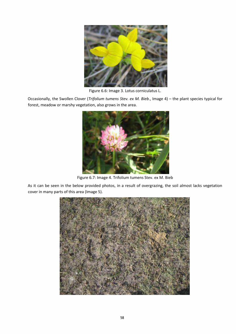
58
Figure 6.6: Image 3. Lotus corniculatus L.
Occasionally, the Swollen Clover (Trifolium tumens Stev. ex M. Bieb., Image 4) – the plant species typical for
forest, meadow or marshy vegetation, also grows in the area.
Figure 6.7: Image 4. Trifolium tumens Stev. ex M. Bieb
As it can be seen in the below provided photos, in a result of overgrazing, the soil almost lacks vegetation
cover in many parts of this area (Image 5).

59
Figure 6.8: Image 5: Soil degradation due to overgrazing
In the third section of the surveyed area, the prevailing form of vegetation is the steppe mountain (Image 6).
There are also many elements typical for steppes. The overgrazing phenomenon is marked here, though, in
lesser degree as compared with previous section.
Figure 6.9: Image 6: Panorama of the third section of the area requested for Masrik 1 PV Plant The Thistle
(Cousinia sp., Image 7) is one of the common plants here.
Figure 6.10:Image 7 Cousinia sp
As separate “islands”, the Austrian Wormwood is growing.
African Sage (Salvia aethiopis L., Image 8), typical for arid areas, is quite common in the area. Of meadow
elements, there is Neilrechi's Yarrow (Achillea neilrechii A. Kerner, Image 9). There are also Felty Germander
(Teucrium polium L., Image. 10) and Longleaf Spinach (Falcaria vulgaris L., Image 11), etc.
There are also many cereals plants growing in the area – various species of Sheep's Fescue (Festuca sp.),
Ryegrass (Lolium sp.) and Bluegrass (Poa sp.) (Image 12).

60
Image 8. Salvia aethiopis L. Image 9. Achillea neilrechii A. Kerner Image 10. Teucrium polium L.
Image 11. Falcaria vulgaris L. Image 12. Poa sp.
6.9.2. Fauna
The area requested for Masrik 1 PV Plant is close to the “Gilli” preserve of “Sevan National Park” (6.3 km
distance by the straight line), and during the stage of the office works, the potential presence of many animal
species, especially, of birds, was considered possible in the area. During field works stage, it was revealed,
that due to the yearly overgrazing of the area, its flora is very poor. The area's landscape is flat and
monotonous; there are no suitable nesting areas and adequate habitats for the abovementioned animal
species. During the field works, no animal species registered in the Red Book of Armenia were detected in
the area requested for Masrik 1 Solar Power Station. It is likely, that the requested area includes the habitats
of certain birds registered in the Red Book of Armenia; nevertheless, there are no nesting site conditions for
those birds in surveyed area. The construction of the requested area cannot have a significant impact on the
number and habitats of those birds.
The surveyed area is adjacent to River Masrik, on the shores of which, of the amphibians, typical for the
region - the Long-legged Wood Frog and Marsh Frog, were detected. It is possible, that those animals shall
pass their breeding season in the wetlands of the surveyed area, which, nevertheless, completely dry up
during the summer. 5 types of lizards, small rodents and birds were detected in the area. Of the insects,
certain types of straight-winged (Othoptera), membrane-winged (Hymenoptera) and scale-winged
(Lepidopteran), were detected. Below is presented the Table of the animal species detected during the field
works.

61
Table 6.7: Detected animal species
Class Order Family Genus Species Name
Amphibians Anura Ranidae Rana ridibunda Marsh Frog
Amphibians Anura Ranidae Rana macrochnemis Long-legged Wood Frog
Reptilia Squamata Lacertidae Darevskia raddei Radde's Lizard
Reptilia Squamata Lacertidae Darevskia unisexualis White-Bellied Lizard
Reptilia Squamata Lacertidae Lacerta agilis Sand Lizard
Reptilia Squamata Lacertidae Lacerta media (Medium Lizard)
Reptilia Squamata Lacertidae Lacerta strigata Striated Lizard
Aves Galliformes Phasianidae Coturnix coturnix Common Quail
Aves Passeriformes Corvidae Pica pica Eurasian Magpie
Aves Passeriformes Turdidae Turdus torquat us Ring Ouzel
Aves Cuculiformes Cuculidae Cuculus conorus Common Cuckoo
Aves Passeriformes Corvidae Corvus monedu la Eurasian Jackdaw
Aves Passeriformes Passeridae Passer domesti cus House Sparrow
Aves Accipitriformes Accipitridae Buteo buteo Common Buzzard
Aves Apodiformes Apodidae Apus apus Common Swift
Mammalia Rodentia Cricetidae Microtu s arv alis Common Vole
Image 13 Marsh Frog Image 14 Radde's Lizzard Image 15. Eurasian Magpie

62
Image 16. Straight-winged (Othoptera); Image 176 Membrane-winged (Hymenoptera); Image 18. Anthills in
the surveyed area
6.9.3. Endangered ecosystems, specially protected nature areas
Sevan National Park
Near the area requested for Masrik 1 PV Plant is the Sevan National Park. It occupies the entire mirror of Lake
Sevan and its riparian areas. The total area of the Park, together with the mirror of Lake Sevan, is 147,343 ha,
and without the mirror of the Lake – 22,585 ha. The area of the protective zone is 342,920 ha.
The Park is under the jurisdiction of the RA Ministry of Nature Protection. It was established on March 14,
1978, by joint Decree No 125 of the Central Committee of Communist Party of Armenia and Council of
Ministers of Armenian Republic.
“Sevan National Park” State Non-Commercial Organization provides the scientific research, preservation,
protection, restoration, recreation, inventory, observation of the natural ecosystems, landscape, biodiversity
and nature heritage of the area of the park, as well as sustainable use of natural resources of the park. It is a
non-profit environmental, scientific research, scientific and cognitive organization with a status of legal
entity, functioning on the basis of the RA Constitution, the RA Laws “On Specially Protected Nature Areas”
and “On State Non-Commercial Organizations”, as well as of the SNCO Charter and other legal acts.
According to the RA Law “On Lake of Sevan” (May 15, 2001), the whole area of the national park was
included in the Sevan Ecosystem Central Zone, being determined as the specially regulated object of urban
development activity.
The area of Sevan National Park is divided into 4 territorial-functional zones – nature reserves, preserves,
recreational and economic. There are 4 natural reserves in the territory of the park: “Norashen”, “Lichk-
Argich”, “Gilli” and “Artanish”, the total area of which is 7,464ha, of which land area – 4,289ha, and water
area – 3,175ha; there are 2 preserves – “Gavaraget” and “Gihikaghnut relict”, the total area of which is
2,652ha, of which land area –2,359 ha, and water area - 293 ha, recreational zone with total area of 4,753ha
total and economic zone with total area of 11,266ha.
Preservation “Gilli” is the closest to the initiative. Preservation “Gilli” is situated in the southeastern part of
the national park – in the estuaries of Gilli canal, Masrik and Geghamasar rivers, and occupies the area of
1,810ha, of which land area is 1,325ha, and water area – 485ha. The area of the preservation extends with
about 10.4 km length and 1.8 km width. The objective of the preservation is to provide protection of
estuaries of Masrik and Geghamasar rivers for the valuable and rare fish species spawn and development, as
well as to protect adjacent marshlands – as birds nesting locations.

63
The area requested for Masrik 1 PV Plant is by the straight line 6.3 km far from “Gilli” preservation and is
separated from the preservation by arable lands and pastures.
Wetlands
The status of wetlands, their vulnerability degree and preservation procedures are regulated by the
Convention on Wetlands of International Importance especially as Waterfowl Habitat (Ramsar, 1971). There
are three areas presented in Armenia’s page of the Convention’s official website.
Lake Sevan.06/07/93; Gegharquniq Province; 490,231 ha; 40°24'N 045°17'E. National Park, Ornithological
Preserve, State Sanctuary. One of the largest freshwater, alpine wetlands in the world, Sevan lies at
1,900m asl and is surrounded by mountains. The Ramsar Site incorporates the entire hydrological system
of the lake including its watershed, tributaries and outflow. About 1,600 plant species have been
recorded, including rare and endemic species. The site is important for numerous species of nesting and
staging waterbirds, several of which are endangered in Armenia.
Khor Virap Marsh.25/01/07; Ararat Province; 50 ha; 39°53'16"N 044°34'18"E. State Sanctuary. Located in
the ancient Arax riverbed in the central part of the country, close to the capital city of Yerevan, this
freshwater marsh of semi-artificial origin consists mainly of reed beds fed by an irrigation canal and
surrounded by drainage channels.
Lake Arpi.06/07/93; Shirak Province; 3,230 ha; 41°03'N 043°37'E. National Park, IBA, State Sanctuary
(Government approval pending). Lake Arpi is a freshwater lake high in the Ashotzk Mountains, fed by
small rivers, springs and melt-water and fringed by marshy areas giving way to meadows and meadow-
steppe. The Ramsar site consists of four sub-sites including Lake Arpi, the human-made wetlands of Alvar
Sanctuary as well as the ephemeral wetlands of Ardenis Sanctuary consisting of Ardenis pond and the
wet meadows of Aghvorik.
Masrik 1 Solar Power Plant is situated in the Sevan National Park protection zone, and though the protection zone is included in the Ramsar area, there are no wetlands and it does not have immediate impact on
wetlands.
In the area requested for Masrik 1 PV Plant and in the adjacent areas there are no natural monuments,
approved by the RA Government Decree No 967-N of 14.08.2008 “On Approving List of Natural Monuments
of Armenia”.
6.10. Historical and cultural environment
The Gegharkunik Marz, as well as Vardenis region, are rich with historical and cultural monuments. Those
monuments represent all types of monuments with secular and spiritual functions, known in the region.
Those are ancient habitations, Stone Age houses, medieval village territories, protective, spiritual, economic
structures, cemeteries, obelisks and khachkars (cross stones), etc. Chronologically, they include the period
from 15th millenium B.C., i.e. from Stone Age, to our times. Particularly Mets Masrik, out of affected
communities, has rich heritage of monuments of history and culture. There are five historical cemeteries in
the territory of the village, of which the most famous is the family cemetery of the local ruling dynasty of
15th-17th centuries – Melik – Shahnazaryans, and the upland khachkar dated Year 881 (the second oldest
dated khachkar). The Table provides the List of Monuments of Mets Masrik village approved by the RA
Government Decree No 80 of 09.01.2003 ”On Approving State List of Immovable Monuments of History and
Culture of Gegharkunik Marz”.
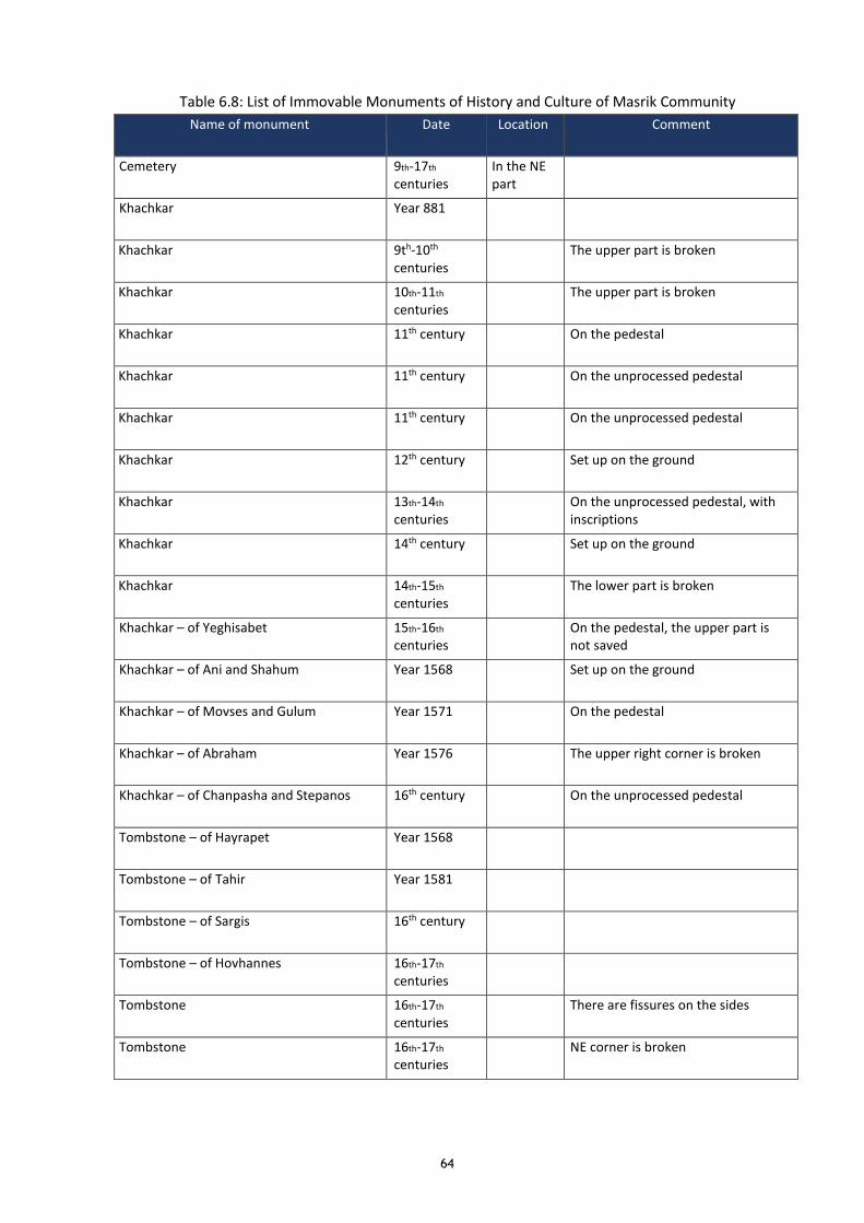
64
Table 6.8: List of Immovable Monuments of History and Culture of Masrik Community
Name of monument Date Location Comment
Cemetery 9th-17th
centuries In the NE part
Khachkar Year 881
Khachkar 9th-10th centuries
The upper part is broken
Khachkar 10th-11th
centuries The upper part is broken
Khachkar 11th century On the pedestal
Khachkar 11th century On the unprocessed pedestal
Khachkar 11th century On the unprocessed pedestal
Khachkar 12th century Set up on the ground
Khachkar 13th-14th centuries
On the unprocessed pedestal, with inscriptions
Khachkar 14th century Set up on the ground
Khachkar 14th-15th centuries
The lower part is broken
Khachkar – of Yeghisabet 15th-16th
centuries On the pedestal, the upper part is
not saved
Khachkar – of Ani and Shahum Year 1568 Set up on the ground
Khachkar – of Movses and Gulum Year 1571 On the pedestal
Khachkar – of Abraham Year 1576 The upper right corner is broken
Khachkar – of Chanpasha and Stepanos 16th century On the unprocessed pedestal
Tombstone – of Hayrapet Year 1568
Tombstone – of Tahir Year 1581
Tombstone – of Sargis 16th century
Tombstone – of Hovhannes 16th-17th
centuries
Tombstone 16th-17th
centuries There are fissures on the sides
Tombstone 16th-17th centuries
NE corner is broken

65
Name of monument Date Location Comment
Tombstone – of Melikdjan Year 1638
Tombstone – of Pap, Melikbek, Atichan Year 1683
Tombstone Year 1685 The upper left part is broken
Tombstone – of Atarbek Year 1685
Tombstone – of Djanibek Year 1692
Cemetery 9th-17th centuries
In the E part
On the right shore of River Masrik, in the territory of functioning cemetery
Khachkar 11th century In the N part
Set up on the ground
Khachkar 11th century In the N part
Set up on the ground
Khachkar 12th-13th centuries
In the N part
Lying on the ground
Khachkar 14th century In the N part
Set up horizontally as a tombstone
Khachkar 14th-15th
centuries In the N part
Set up horizontally as a tombstone
Khachkar Year 1600 In the N part
Set up on the ground, with inscriptions
Cemetery - Novaghin Year 1620 In the N part
Lying on the ground
Cemetery 10th-17th centuries
In the centre
Im Mariam Kurdyan's homestead area
Cemetery 12th-19th centuries
In the S part
Near the school, in Rafik Poghosyan’s homestead area
Khachkar 12th-13th
centuries Lying on the ground
Cemetery: the family mausoleum of Melik-Shahnazaryans
16th-17th centuries
In the centre
Khachkar 15th-16th centuries
Set up on the ground
Khachkar 16th century The upper part is broken
Khachkar Year 1571 The upper half is not saved, dated
Khachkar – of Melik bek Year 1578 On the two-level pedestal
Khachkar – of Abas bek Year 1641 On the unprocessed pedestal
Khachkar – of Yavri bek and Gulasar Year 1656 On the pedestal

66
Name of monument Date Location Comment
Khachkar – of Mirza Year 1698 On the pedestal, the upper part is not saved
Tombstone – of Babajan 16th-17th centuries
Tombstone 16th-17th centuries
Tombstone 16th–17th centuries
Horse-shaped
Tombstone – of Marian Year 1670
Tombstone Year 1682
Tombstone Year 1685
Tombstone – of Papam Year 1713
Village territory “SRKHANA” 10th-17th centuries
2 km to the W
Mausoleum 1st millennium B.C.
In the S part
In the S outskirts of the village, to the left from the road entering the village
S. Astvatsatsin Church 13th-14th centuries
In the S part
On the hill of the right shore of River Masrik
Khachkar Year 1539 Fits in the W wall, with
inscriptions
Khachkar – of Emkar Year 1551 To the S from church, lying on the ground
Khachkar – of ter Sargis, Dovlat and others Year 1552
Tombstone – of Tirun Year 1541 On the W wall
Tombstone 16th-17th centuries
On the W wall
Khachkar Year 1551 In the E part
On the E outskirts, lying on the ground, dated, has transverse fracture
Khachkar Year 1580 m.h. On the edge of the road, in the S from historical cemetery of the village
6.11. Social environment of Project site
The information for the baseline data draws primarily on the following sources:
• National Statistical Service of the Republic of Armenia
• Official website of the Government of the Republic of Armenia
• The analysis of Socio-Economic condition of Gegharkunik marz in 2015 (National Statistical Service)
6.11.1. Sociodemographic picture and livelihood
This Location is situated in the Gegharkunik marz. It is located at the eastern part of Armenia, bordering
Azerbaijan and the Shahumyan Marz of Nagorno-Karabakh Republic. With an area of 5,348 km², Gegharkunik
67
is the largest marz in Armenia. However, approximately 1,278 km² of its territory is covered by Lake Sevan,
the largest lake in the Caucasus and a major tourist attraction of the marz.
According to the date of official census conducted in 2011, Gegharkunik has a population of 235,075 (119,180
men and 115,895 women), forming around 7.8% of the entire population of Armenia. The urban population
is 71,423 (30.4%) and the rural is 163,652 (69.6%). The marz has 5 urban and 87 rural communities. The
largest urban community is the regional centre of Gavar, with a population of 20,765. The other urban
centres are Sevan, Martuni, Vardenis and Chambarak. With a population of 9,880, the village of Vardenik is
the largest rural municipality of Gegharkunik and is also the largest rural community in Armenia.
The economy of Gegharkunik has a predominantly agricultural orientation, including farming and cattle-
breeding. It has a share of 18% in the annual total agricultural product of Armenia. Around 65% (3,487 km²)
of the total area of the marz are arable lands. Around 60,000 farms in Gegharkunik are operated by the
private sector. The main crops are potato and grains. Fishing and fish farming is also dominant in the marz.
Recently, beekeeping has significantly developed.
Mets Masrik is a rural community in Gegharkunik marz with an area of 36 km2.The community has a school, a
primary school, two kindergartens, medical clinic and a flour mill, hotel, gas stations, ten shopping centres,
tower, meteorological station, a post station, irrigation system. The population according to the data of RoA
government is 3,428. They are mainly engaged in agriculture.
6.11.2. Vulnerable groups
In the study area the following vulnerable groups have been identified:
• Poor households - based on the information disclosed in official website of the regional
administration (marzpetaran) of Gegharkunik for August, 100 households are registered in the
evaluation system of vulnerability of families (ESVF) in Mets Masrik. They receive a family allowance
in average 34,250.00 AMD (minimum is 24,000.00 AMD, maximum is 63,000.00) in case when the
minimum salary of RA is amounted to 55,000.00 AMD. Taking into account that 3,428 people is about
857 households (4 persons per AH), 11.6% of the total households are poor in Mets Masrik. Besides
the family allowance, 21 households receive additional social allowance amounts to 18,000.00 AMD,
out of which the head of 14 households are women and head of 6 households are men respectively.
• Women and elderly headed households - Single and divorced women headed households and elderly
headed households in the area are among the most vulnerable people. If resettlement issues arise,
they will receive support as a vulnerable group.
Sometimes, the vulnerable people can have some limitation do not raise their grievances/complaints in
public and often do not seek legal support even if they perceive a situation to be unjust. It is suggested that
during all of the stage of the Project a social specialists investigate potential grievances individually with the
affected households. Otherwise, many justified complaints will never be made and therefore impossible to
address, preventing full livelihood restoration and thereby violating safeguard principles.
In case, if vulnerable households lose their livelihood caused by the Project (loss of land or other losses), a
special livelihood support program shall be implemented as specified by the project RPF and safeguard
policies. As suggested in OP 4.12 for the full livelihood restoration the vulnerable households, additionally to
cash compensation, will receive the support/allowance to build up a future livelihood.

68
7. ANTICIPATED ENVIRONMENTAL AND SOCIAL IMPACTS AND MITIGATION
MEASURES
7.1. Environmental Impacts and their Mitigation during Construction
7.1.1. Landscape
The land envisaged for Masrik 1 PV Plant is located in the central part of Masrik field. The altitude is 1900-
2000 m a.s.l. The flat surface has steepness to the west and is covered by the strong alluvial sediments layer.
In the west, through the midfield road, it borders upon Ararat-Sotk railroad, in the south and west there are
arable lands of Mets Masrik community.
When preparing for construction, certain leveling works, insignificantly changing the landscape, will be made.
After the preparation of the area, the modules will be installed. The change of a scene will be visible from
Mets Masrik and Vardenis villages, however for the vicinity it will be not a relevant visual impact.
The OTL corridor will mainly pass through the unused areas or pastures.
Impact of/ on Sensitivity Extent of Impact on/ by Duration of
Impact
Direct/ Indirect
Landscape ◼ ◼ Long term
impacts
Direct by the
physical
presence of the
PV plant
7.1.2. Flora and Fauna
During the construction stage of Masrik 1 PV Plant, the biodiversity of the requested area will be affected by
soil disturbance, change of quality of the ambient air, man-made noise, etc. Certain fauna representatives
will leave the area.
The survey conducted by the specialists in the area requested for Masrik 1 PV Plant showed, that the
biodiversity of the area is much poorer than that presented in a result of the office survey of the same areas.
The main reason for this is the overgrazing of the mentioned areas by small hoofed domestic animals for
years long.
In a result of Project implementation, in the section of modules within the areas envisaged for the PV Plant,
the microenvironment will be created, which will result in change of biodiversity.
As a result of construction of the PV Plant, a part of the area will be covered by the solar modules and a part
of the soil will be shadowed. According to the schematic image (Feasibility Study: ARIES INGENIERÍA Y
SISTEMAS), it has been calculated, that 30 - 35 percent of the occupied area will be in the shade of the Solar
Power Station. The remaining area will be shadowed partially, moreover, at sunrise and sunset it will be fully
lit up – being situated under the direct sunlight. The essential part of the area remaining directly under the
panels will be under the diffuse light. It is expected that in these partially lit up areas, the new plant
assemblage will be formed, having in its composition both the native sciophyte plants, as well as new plants,
which have not been growing in those areas before, but which are growing in the lower layer of the forests
growing in the similar climatic conditions, e.g. the representatives of the nearby “Gilli” reserve’s forest layer
sciophyte vegetation. The new ecosystem formed is going to be affected to some extent by the new soil
humidity regime resulting from the distribution of the humidity occurring from atmospheric precipitations.

69
The precipitations of the area covered with solar modules, running downstream from the lower edge of the
modules, are distributed in a new way, however, it is expected that the change will be insignificant.
The new scheme of air masses movement, resulting from the resistance of modules to the air movement
(wind) and the upward movement of the air in a result of panels’ heating, is also going to have certain
impact. The orientation of the solar module lines is the East-West with the prevalent wind rose direction
being the same. It is expected, that in the area occupied by the solar modules the new ecosystem will be
formed, which will be gradually stabilized over time. The most important role here belongs to the man-made
factor, which may be expressed, for example, in regular mowing of the partially lit up areas grasslands.
No construction is envisaged for a part of the area requested for Masrik 1 PV Plant (4 meter wide belt
between the fence and the perimeter road, the inner edges of roads, etc.). In these areas the flora will be
restored fully with the fauna being restored partially.
At the same time, it shall be noted, that though the area of Masrik 1 PV Plant will be situated in the
protection zone of Sevan National Park, there are no endangered plant and animal species, and the nature of
activities and the distance from the Park (6.3 km far from “Gilli” reserve and is separated from the reserve by
arable lands and pastures), allows to conclude, that the construction and operation of the PV Plant will not
impact the National Park.
Impact of/ on Sensitivity Extent of Impact on/ by Duration of
Impact
Direct/ Indirect
Flora and Fauna ◼ ◼ Long term Direct
7.1.3. Soil Erosion
Loss of vegetation and soil compaction increases the soils’ vulnerability to erosion. It can be difficult for
vegetation to recolonize bare and compacted areas of ground. Once vegetation is lost and not restored, the
areas affected by erosion often tend to spread through the effects of wind and rain.
Erosion of exposed soil and the resulting sediment produced can occur from the project development,
causing air (form dust). Earthmoving activities such as grading and grubbing for the site preparation and
heavy equipment hauling over unpaved ground, may loosen soils and cause fugitive dust and particulate
matter to become airborne. The potential risk for erosion is increased by placing project components in areas
with steep slopes; on unstable soils such as alluvial soils; and on clays, which are fine-grained and susceptible
to dust and erosion in dry conditions.
Damage to soils also has further effects on land-use. When soil is compacted, it cannot support native grasses
or other vegetation. This in turn reduces the pasturage that can be used by the livestock of local herders or
that is available for other creatures. The loss of grass affects biodiversity, since grass is a food source for
small mammals, which in turn provide food for predators.
Removal of topsoil will be only in construction site, roads and around towers feet. But the amount of topsoil
will be large.
The volumes of the removed topsoil for the foundations of the solar panels bearers are calculated as per
number of the bases and the required volumes of holes for each foundation, which is 1.4m x 0.7m x 0.7m =
0.686 m3.
- Under the bearers of the foundations: 2953 bearers x 5 bases/bearer x 0.686 m3 = 6950 m3.

70
The approximate length of the newly operated roads will be 2km, their width will be 4 km, and the volumes
of the extracted soil – 2000m x 4m = 8000 m3.
The topsoil under the bearers and roads will be 14950 m3, and will be stored in the outskirts of the Solar
Power Plant area, in the specially furnished warehouse, in accordance with the requirements of the RA
Government Decree number 1404-N of 02.01.2017 “On Approval of the Technical Regulations for Definition
of the Norms for Topsoil Removal and for Removed Topsoil Maintenance and Use”.
The topsoil under the foundations of the overhead line towers will also be cut and removed, placed near the
towers for the short while, and immediately used for the improvement of tower platforms after construction
of the foundations.
The removed topsoil will be stored in special conditions and used for the area improvement in future,
particularly will be brought back after construction and soil will be replanted when towers are erected in
steeper slopes. Access roads that are not needed anymore after construction will be rehabilitated and
replanted.
At the same time, changes in site conditions will result in the increased soil moisture content, which in turn
will reduce the risk of erosion.
Additional to the mitigation measures given in Section 10.1, preparation and implementation of specific
erosion control plans is recommended, once the final technical design of the PV plant and OTLs is available.
Impact of/ on Sensitivity Extent of Impact on/ by Duration of
Impact
Direct/ Indirect
Soil Erosion ◼◼ ◼◼ Long term Direct
7.1.4. Soil and Water Resources
There is a risk of pollution of soil and groundwater by fuel and lubricants from the construction vehicles and
machinery, which can be avoided by proper maintenance. Additionally, oil, fuel, paint, chemicals, soil run-off
during construction could pollute surface waters. Measures to prevent pollution of soil and water resources
by oil and chemical spills have to be implemented during construction phase.
The PV modules will not present a hazard with respect to soil contamination unless paint or other coating is
used. The leaching potential for modules from plant structures is extremely low. If soil will be contaminated
by drips and spills it will be cleaned up and removed for safe disposal.
The roads will have the appropriate transversal slope for drainage to reduce pending and infiltration of water
into the sub-grade materials. The construction of perimeter swales, edge drains, curbs and gutters, or
combination of these drainage devices is recommended to reduce Operation of work camps - namely
functioning of sanitation and catering facilities, storage and servicing of equipment, stockpiling of
construction materials and waste - can lead to sewage and garbage pollution and spills from construction
equipment operation and servicing. Construction camp must be equipped with toilets according to IFC/ADB
Guidances - separately for men and women - and waste bins to accommodate the entire labor force during
construction period. The measures preventing pollution of surface and ground water and soil with chemical
products must be applied at the construction site. Dismantlement of construction camps and harmonization
of the area with the landscape shall be implemented after completion of construction works.
Water supply and sanitation

71
Sanitary water demands in the plant during the construction phase will be satisfied through tanker trucks,
and drinking water will be supply with individual bottles. Sanitary water will be stored in the water reservoir
on the site.
It is estimated that the amount of water utilized by 1 person is 3 litres.
Chemical toilets will be enabled at the beginning of the construction phase. After this phase, modular
wastewater treatment plants will be constructed.
Water treatment
Basically wastewater generated during the construction phase is the wastewater from chemical toilets, staff
and general facilities services and wastewater for concrete mixer and the cleaning of equipment.
The wastewater from chemical toilets will be managed through authorized management agent, in order to
avoid any risk of spillage. This solution will be provisional until the plants wastewater treatment modular,
consisting of modules, independent wastewater treatment are built.
It is usual to install general facilities services for the workers, providing them a place to relax and personal
care.
Table 7.1: Water usage quantity
Water usage Quantity (consumed volume)
Workers - personal care 130 persons x 15 l/person/day
Wetting of access roads 12 m3/km
Watering for dust control 1 l/module
Contingency 6300 m3/year
The activities for wetting the access roads will be twice per day during the dry period of the year. The service
will be provided troughs tanker trucks.
The cleaning of the modules will be at the end of the construction phase, in order to commence with the
commissioning tests. This process only uses water, without any chemical additives.
Impact of/ on Sensitivity Extent of Impact on
/by
Duration of
Impact
Direct/ Indirect
Soil
Water Resources a)
Groundwater
b) Surface Water
◼◼
◼
◼
◼◼
◼
◼
Short term
during
construction
Direct
7.1.5. Solid and Liquid Wastes
The sensitivity of the PV plant area and OTL corridors for solid and liquid wastes is assessed to be medium.
The generation of wastes will be minimized by a proper waste management, implemented by the
construction contractor. Small amounts of hazardous waste like residual oil, fuel, paint or spill contaminated
soil will be stored at PV plant site, which should contains adequate space and roofed, concreted and bonded

72
facilities for storing of hazardous waste. The hazardous waste will be provided to the relevant licensed
organizations to transport it for the future processing or placement.
Fuel usage
Fuel will be requested as combustible, for machines and trucks base on the construction activities demand.
The consumption related to trucks and machine use can vary, depending on machine type, fluctuating
between 40-80 l/h.
Specific area for the fuel storage will be determined. This area will have a concrete platform and a spillage
manage system. The fuel tank volume is provided 100l.
The Construction Contractor will agree with municipal authorities regarding to the using services of
communal service providers for waste disposal purposes. Construction wastes include small amounts of
packaging material, remaining metal parts, ceramics etc. While there are no standard sanitary landfills in the
region, disposal of waste through official communal service providers. It will ensure that at least no free
dumping and no open air burning of waste occurs.
Impact of/ on Sensitivity Extent of Impact on/ by Duration of
Impact
Direct/ Indirect
Solid Waste (generated
by construction activities
and by workers) ◼◼ ◼
Short term during
construction
Indirect
7.1.6. Noise
Workers will wear ear protection devices as part of their PPE if they are exposed to noise levels higher than
80 dB (A).
Wherever the line corridor is near to villages or houses, the construction contractor has to control noise
emissions from all equipment. For residents the noise levels may not exceed 55 dB (A) daytime or result in a
maximum increase in background levels of 3 dB (A) at the nearest receptor location off-site. In order to keep
nuisance from construction noise low, construction works near villages or houses shall be done between 9
am and 5 pm. However, due to the limited time of the construction period and the sparsely populated area,
nuisance caused by noise during construction activities will be generally low.
Impact of/ on Sensitivity Extent of Impact on/ by Duration of
Impact
Direct/ Indirect
Noise
◼ ◼
Short term
during
construction
Direct

73
7.1.7. Air Quality
During construction of PV and installation of the OTLs, certain substance of emissions will occur. Particularly,
there will be dust emissions during the soil digging, loading and transportation works. During operation of
the construction machinery, in a result of fuel burning, the oxides of nitrogen, carbon and sulfur, as well as
solid particles (soot), will be produced.
The calculations of the quantities of materials generated during the construction works are presented in the
Annexes.
Due to the limited time of the construction period the impacts on ambient air quality by construction
activities will be low. Machines and vehicles will be checked regularly to minimize exhausted pollutants. Dust
generated by construction activities will be suppressed by spraying water, where necessary.
Impact of/ on Sensitivity Extent of Impact on/ by Duration of
Impact
Direct/ Indirect
Air Quality ◼ ◼
Short term
during
construction
Direct
7.1.8. Historical and Cultural Sites
According to the RA Ministry of Culture Agency for Protection of Historical and Cultural Monuments, there
are no historical or cultural sites located in the proposed PV plant site and OTL corridor.
Chance Finding Procedure
In case of unexpected encounter of Cultural and Historical Sites a Chance Finding Procedure has to be
implemented. In case of any chance findings, the construction has to be stopped immediately and the Agency
for Protection of Historical and Cultural Monuments, Ministry of Culture has to be informed to agree on
further steps (according to the Armenian Law). The Chance Finding Procedure will include:
• Stop the construction activities immediately in the area of the finding.
• Notify the responsible local authorities and the Ministry of Culture.
• Evaluation of the findings to be performed by the archaeologists of the Agency for Protection of
Historical and Cultural Monuments and Ministry of Culture.
• Decision on how to handle the find to be taken by the responsible authorities and implementation of
the decision concerning the management of the finding.
• Construction works can be resumed only after written permission is given from the responsible local
authorities and the Ministry of Culture concerning safeguard of the heritage.
For implementing the Chance Finding Procedure no costs will arise for the Construction Contractor and the
related excavation and conservation costs will be paid from the Government budget. The Construction
Contractor will not be entitled for compensation for idle time while Chance Finds are dealt with it, because
due to linear nature of the infrastructure, Contractor will be able to continue works on other sections of the
OTLs.

74
Impact of/ on Sensitivity Extent of Impact on/ by Duration of
Impact
Direct/ Indirect
Historical and Cultural
Sites
◼◼ ◼
Short term during
construction
Direct
7.1.9. Health and Safety
Direct impacts on Health and Safety during construction of the planned PV plant and transmission lines may
result from various factors as electrocution during construction, sanitary situation during construction, e.g.
contamination of water, sexually transmitted diseases (STD) due to contact of workers and population etc.
A potential impact for the health and safety of workers could be further related to work accidents during
construction of the PV plant and OTLs or due to contaminated drinking water or food.
Workers’ camps have to meet the requirements of IFC/ADB guidances on worker accommodations, including
e.g. provision of an adequate number of sanitation facilities, medical facilities, dormitory facilities etc.
The Construction Contractor will develop an appropriate Health, Safety and Environment Management Plan
for the construction phase and implement a Health, Safety and Environment Management System (HSEMS)
during construction. An H&S manager of the CC shall be on duty all the time during construction period.
Impact of/ on Sensitivity Extent of Impact on/ by Duration of
Impact
Direct/ Indirect
Health and Safety
◼◼ ◼
Short term
during
construction
Direct
7.1.10. Gender Aspects
The construction of the PV plant and lines may increase existing gender disparities, as benefits from
construction work will be earned mostly by men, therefore, access and control over compensation payments
are likely to be at the disposal of men and not of women, which increases the probability that the family will
benefit less. There are a considerable percentage of single women headed households in the area, who are
among the most vulnerable people.
Special vulnerability allowance will be provided to affected women-headed households and holding targeted
consultations with women who will be affected by construction works.
Impact of/ on Sensitivity Extent of Impact on/ by Duration of
Impact
Direct/ Indirect
Gender Aspects ◼◼ ◼ if any Short term Indirect

75
7.2. Environmental Impacts and their Mitigation during Operation
7.2.1. Flora
The vegetation under PV plant, towers and roads, tracks will partly be destroyed permanently. Thus, the
impact of the proposed Project on the flora during operation is assessed to be low, as the main impact
already occurs during the construction phase.
Impact of/ on Sensitivity Extent of Impact on/ by Duration of
Impact
Direct/ Indirect
Flora ◼ ◼ Long term Direct
7.2.2. Fauna
Birds are the animal group which may be most affected by OTLs in operation, mainly because of the risk of
electrocution and risk of collision. Different bird species may also use the towers for perching, thus risking
electrocution.
Concerning habitat alteration and habitat loss the main impacts (if any) already occur during the construction
phase even though the results are of permanent nature.
Impact of/ on Sensitivity Extent of Impact on/ by Duration of
Impact
Direct/ Indirect
Fauna ◼ ◼ Long term Direct
7.2.3. Water resources
Water supply and sanitation
Sanitary water demands in the plant during the operation phase will be satisfied through tanker trucks,
unless a suitable installation of water pipes from a reservoir is possible. If not, sanitary water will be stored in
the water tanks on the site.
Drinking water will be supply with individual bottles. It is estimated 3 l/day per person for drinking water.
Water treatment
Basically, wastewater generated during the operation phase is the wastewater from staff and general
facilities services. These facilities will be connected to a septic tank.
A septic system is a natural sewage and disposal system that relies on bacteria to digest and clean the waste
water.
Table 7.2: Water usage quantity
Water usage Quantity (consumed volume)
Workers - personal care 8 persons x 15 l/person/day
Watering for dust control 1 l/module
76
The cleaning of the modules will be no more than twice per year. This periodicity will depend on the intensity
of the fouling process.
Impact of/ on Sensitivity Extent of Impact on/ by Duration of
Impact
Direct/ Indirect
Water basin ◼◼ ◼ Long term Direct
7.2.4. Noise
The impacts on the villages through noise resulting from the operation of the PV plant and OTL are assessed
to be low. Noise emitted by substation will be minimal. Specific mitigation measures are not necessary.
Impact of/ on Sensitivity Extent of Impact on/ by Duration of
Impact
Direct/ Indirect
Noise ◼◼ ◼ Long term Indirect
7.2.5. Electric and Magnetic Fields
The substation and OTLs will be designed the way to conform with the national and the ICNIRP’s standards -
whichever is more stringent - and, therefore, people residing in the vicinity of the OTLs will be protected
from the negative impacts of exposure to the electric and magnetic fields. In order to provide the equal
conditions for women, it is envisaged, prior to commencing of the works, to receive from Local Self
Governance Body’s (LSGB) Office the number of women capable of working and to organize targeted
consultations with the women willing to work.
Impact of/ on Sensitivity Extent of Impact on/ by Duration of
Impact
Direct/ Indirect
Electric and Magnetic
Fields
• for the public
• at the workplaces
◼
◼
◼
◼
Long term
Indirect
7.3. Social impact and mitigation measures
7.3.1. Survey Methodology
The methodology adopted for the social impact assessment part of the study aims to describe and assess the
magnitude of the social impact to the extent sufficient to assist the assessment of the feasibility of the
studied design and alignments and to plan in advance the appropriate mitigation measures.
In order to assess the extent of the social impacts caused by construction of PV Plant and OTL, the following
steps were undertaken for them based on the technical and current possibilities:

77
• Obtaining of common references - to describe the characteristics of the land plots based on the
official information provided by the Cadaster: the lot-code, total surface, legal status, name of
registered legal entity, target position, registered right to the buildings and structures, if any,
limitation of property rights and other property relative information.
• Cadastral maps analysis - to measure the total surface and prepare individual maps for each affected
land plot.
• Study of the local standards and norms required for the construction of pylon and transmission of the
high voltage lines - to identify and measure the required surface area of affected land plots based on
the technical characteristics of the Project.
• Inventory of losses based on data from cadastral maps, field visit and meetings with head of the
affected community - to identify the characteristics of the land plots to be acquired.
• Collection and review of general socio-economic data (deskwork): to describe the current
socioeconomic condition of the Project location.
The scope of the social survey and assets inventory includes identification, classification and measurement of
the land plots as the main asset have been impacted by the Project taking into account the particularity of
the Project to construct the solar PV plants and high voltage line far from the buildings, structures and trees.
7.3.2. Assessment of affected land
Determination of affected surface area of the land plot needed for construction of the panel PV plant is
based on the Preliminary Design. The common reference has been requested from the Cadaster based on
which the state registration of the right was not done. The updated cadastral map for affected location has
been acquired non-officially. The measurement specialist has calculated the total and affected surface area,
quantities (cadastral lot-code quantities) of the affected land plots by their targeted position based on the
relevant cadastral map. The MWp for the plant is shown in the table below
Table 7.3: Determination of affected land plot for panel PV plant
Location MWp Affected area (ha)
Masrik 1 55.0 128.3
As the alignment of the high voltage lines is subject for the further modification and finalization,
identification of the affected surface area and number of affected land plots has been done taking into
account the technical requirements for construction of the pylons and transmission of the lines.
• Identification of the number of affected land plots- the number of affected land plots is related to the
number of constructed pylons. It is envisaged to construct one pylon in one land plot. In case if the
pylon touches more than one land plot, the alignment will be adjusted to avoid and minimize the
impact size during finalization of design. For identification of the pylon’s number, the length of the
line is divided to average span required for the pylon with capacity of 110 kV.

78
• Identification of the affected surface area-the required surface area for construction of one pylon
with capacity of 110 kV is 196 m2 (14mX14m)4 . For calculation of the total affected surface area the
average number of pylons is multiplied by the surface area required for one pylon.
Identification of the legal status and target position of the affected land plots- legal status and target
position has been identified based on the information collected during field visit and meetings with
head of the affected community.
Total surface of the affected area is: 196 x 41 = 8036 m2:
Table 7.4: Determination of affected land plot for high voltage lines
Capacity of the line Length of the line Average span Average number of Pylon
kV m m no
110 9200 224 41
i. Project Impact on Land
The Land Code of the RA (2 May, 2001) classifies land fund into the following nine categories: (1) Agricultural,
(2) Settlements or residential, (3) Industrial, Mining and Production (4) Power, Transport, Communication,
Utility infrastructure facilities (5) Specially protected land, (6) Special significance, (7) Forested, (8) Water and
(9) State Reserve lands.
ii. Existing categories of affected land
The study has found the following land categories in the study area:
• Agricultural land – used to grow crops, vegetables, perennial plantations, harvesting and cattle
grazing.
iii. Existing categories of affected land.
The study has found the following land categories in the study area:
• Agricultural land – used to grow crops, vegetables, perennial plantations, harvesting and cattle
grazing.
• Special protected areas - land having aesthetic, environmental, scientific, historical and cultural,
recreational and health value.
7.3.3. Land losses
The land plots required for the:
• PV Plant is community land plots and free of rights of the third parties, the target position is agricultural.
The land impact data is summarized in the table below. There will be only 1 affected land plot with 128.3 ha
surface area. The area is used only as a pasture. There are no cereals or other crops, as well as constructions
or infrastructures.
• High Voltage Lines (110kV) are privately owned land plots by agricultural target position. The land impact
data is summarized in the table below. In the envisaged corridor, there are no constructions or
4 The surface area includes additional plus 1m from both sides of the poles based on the requirements of the SNIP СН
465-74 dated on 22 June, 1974

79
infrastructures. The loss of each owner will be calculated when designing the high-voltage line. The areas for
the overhead lines bases cover 14 land-plots. Their indicators and terms of compensation will be defined
based on the negotiations with the landowners.
State and community/municipal lands will be alienated in accordance with subparagraph 7 of the paragraph
1 of Article 66 of the Land Code of RA and in full compliance with the RPF, and only after the communities
have changed the lands category to the category of energy, transportation, communications, utilities
infrastructure. In accordance with paragraph 2 of Article 66 of the Land Code of RA the lands will be alienated
by price equal to the cadastral price of the lands with category of energy, transportation, communications,
utilities infrastructure.
As the private land plots are affected, adoption of the Government Decree for Eminent Domain will be
required. It should be noted that in case of privately owned land plot, the acquired area can be more than
identified affected area. The land plot can be acquired completely by the request of the owner5 because of
insignificancy of the remaining part when it will not be appropriate for the further functional usage.
Taking into account that 14 private land plots are owned by 14 AHs as minimum, the total number of PAPs
will be about 56 (4 PAPs per 1 AH in average). The resettlement will be governed by the RPF and
Resettlement Action Plan(s) that will be prepared on its basis. No construction works will begin until
compensation is paid in full to all project affected people.
5 The owner has a right to present request on the acquisition of non-affected part of the property within two months after
the GoA decree on acknowledging the exceptional prioritized public interest (RA Law on Expropriation of Property for
Public and State Purposes, Article 5, 2.2 point )

80
8. ASSESSMENT OF POTENTIAL ECONOMIC DAMAGE
Assessment of potential economic damage for the environment is carried out as per the environmental components.
The economic damage is calculated according to the RA Government Decree 764-N of 27.05.2015.
Potential economic damage is calculated as follows:
ED = LIA + WIA +AIA;
where:
ED is the potential economic damage in monetary terms;
LIA is the value assessment of impact of damage to land resources as a result of economic activity (adverse
environmental changes resulting in natural environment pollution, natural resources depletion, ecosystems
degradation or damage). No soil pollution or damage is expected during the construction of Masrik 1 Solar Power Plant
and overhead lines (OL).
WIA is the value assessment of impact of damage to water resources caused by the direct and indirect economic
impact. No polluted runoff or damage to water resources is expected during the construction and operation of Masrik 1
Solar Power Plant and OL.
AIA is the value assessment of impact of damage to ambient air caused by the economic activity impact.
Ambient Air
Economic damage is the cost of the measures required to eliminate the damage caused to the environment
in monetary terms.
The economic damage has been calculated based on the “Procedure of Assessment of Impact on Ambient Air
Caused by Economic Activity” approved by the RA Government Decree of January 25, 2005.
Calculation of economic damage done in Annex 2. According to this calculation economic damage is assessed
999364 AMD

81
9. ANALYSES OF ALTERNATIVES
Project alternatives are considered from two perspectives.
9.1. The "No Action" Option
The “No Action” alternative refers to a situation in which the Masrik 1 and other PV plants are not built. The
no action alternative will result in the demand for electricity exceeding supply, with an increasing deficit as
demand increases in future years.
A lack of a secure and reliable electricity generation has significant social and economic implications, since it
will:
• constrain existing and future economic development and investment through lack of energy
resources to meet industrial demand;
• restrict socio-economic development through lack of electricity supply, or poor reliability and
shortages in electricity supply for domestic users, community and other public facilities and public
services;
• inhibit provision of social services, including public health and poverty eradication. As a result, the
"no action" option is not a viable or acceptable alternative to the proposed project.
9.2. Proposed Project of PV plants
Planned Project is intended to achieve the following:
• meet future demand for electricity;
• maintain and improve generation reliability;
• introduce new environmentally friendly technologies.
9.2.1. Technology Assessment
The PV technology is based on the effect of the sunlight (photons) on the molecular structure of some
materials. These materials must be semiconductors, for example Silicon, Cadmium telluride (CdTe), Copper
indium diselenide (CISG), Gallium arsenide (GaaS) and other organic materials.
These materials, under the effect of sunlight, have the property of produce electrons movement, absorbing
then the energy of the photons.
Many are the technologies and designs for Photovoltaic plants. Considering the worldwide recognized
commercial viability of numerous types of PV systems, only those solutions which are commercially viable
are addressed in this document. This section focuses on the following primary system components:
i. Module technology:
• Crystalline (polycrystalline or monocrystalline)
• Thin-film
ii. Mounting structure:
• Fixed Structure
• Single-axis tracking
• Double-axis tracking

82
Photovoltaic module technologies
There are various models of photovoltaic panels with different types of cells made of silicon, thin film or
other technologies. The cost of the panels usually represents more than 40% of the cost of a PV installation
and the selection of the panel will, therefore, directly affect the energy production of the plant and the
profitability of the project. Recently, a downward cost trend has been developed for panel prices.
The division between technology efficiency c-Si and thin film is significant but with a clear tendency to
decline in recent years. Also it can be seen that the learning curve of the thin layer is delayed in time with
respect to crystalline technologies.
Crystalline technologies
Approximately 75% of the solar PV cells sold are made from crystalline silicon due to the fact that the silicon
manufacturing technology is standardized.
The higher efficiency and global production capacity of crystalline technologies are due to the several
reasons:
• Crystalline silicon cells have benefited from intensive research and development activities carried out
by the semiconductor industry for electronic applications.
• Crystalline silicon is the most intensively studied semiconductor investigated and understood.
• Amorphous silicon and polycrystalline thin-film materials have physical properties more complicated
and less studied.
• The crystalline quality of semiconductor wafer substrates deposit may not be as perfect as the
crystalline silicon wafers.
• The heterogeneities in polycrystalline material cause losses of efficiency with respect to the ideal
crystalline structure.
There are two different types of crystalline technology cells:
• Monocrystalline silicon cells: composed of slices of a single silicon crystal. Their efficiency is higher
than polycrystalline cells but they are the most expensive among the commercial technologies based
in silicon.
• Polycrystalline silicon cells: composed of several small silicon crystals, and are less expensive than
monocrystalline cells; however, they have lower efficiencies.
The main difference between them is the original silicon brick to manufacture the wafers. In the case of
monocrystalline cells the initial material is a brick with only one crystalline structure. According to this, all the
atoms and molecules of the whole brick (and in consequence the wafers and cells) have the same orientation
and they have a perfect crystalline structure.
Nowadays, polycrystalline modules are widely used in commercial PV plants because the reduction of prices
clearly compensates efficiency differences with respect to monocrystalline ones.
Thin film technologies
The manufacture of thin film solar modules involves depositing extremely thin layers of photosensitive
materials on glass, metal or plastic. This method of manufacture involves a great saving of raw materials,
versatility of installation and reduction of production costs.

83
The name “thin film” is given by the thickness of the layer of active material deposited on 5-6 microns. The
most important materials are amorphous silicon (a-Si), polycrystalline silicon into thin films of cadmium
telluride (CdTe), copper indium selenide (CuInSe2 or CIS) and gallium arsenide (GaAs).
In general it can be understood as valid for all the thin-film photovoltaic materials the following advantages
and disadvantages:
Advantages:
• Require less material, representing a cost reduction.
• Continuous manufacturing process that allows for lower cost.
• A variety of methods of manufacture and deposition of the layers. There are many methods for
laboratory scale, but it is more difficult to transfer them to industrial scale, especially by the fact that
sheets need a huge area and are very consistent with each other.
• Theoretical efficiencies high (in both absorption coefficients and by the energy gap).
• Adjustable gap values (varying material composition: addition of elements in the structure of the
material) depending on the device you want to make.
• Variety of substrates (rigid, flexible, plastics, metals).
• Better temperature coefficients.
Disadvantages:
• Achieved conversion efficiencies are lower.
• Industry is less established, at least in some materials, especially because there are innovative
manufacturing processes that are not yet ready to develop this kind of technology.
• Staembler Wronski Effect that limits the long term efficiency of photovoltaic devices.
9.2.2. Mounting Systems
Fixed structure mounting
Fixed structure mounting is based on panels with a fixed orientation and inclination. The efficiency depends
exclusively on an optimal orientation of the solar panels and the local solar resource at the site of
installation, based on an accurate engineering and otherwise detailed analysis of the solar resource for the
selected site.
These types of installations can be installed on land and are suitable for all types of roofs too, including
industrial roofs, individual homes and urban buildings. In this case the power installed depends on the area
available and the load capacity of the building. The principal benefit is that they are more economical than
the tracking systems, the cost of operation and maintenance are significantly lower, and there is no auxiliary
electricity consumption from tracking motors. The roof-mounted option can be completely integrated in the
roofs of buildings or homes. By installing the panels in roofs, it is not necessary to look for open ground
space, and the administrative permitting process may be simplified, depending on the project location.
Mounting with solar tracking equipment
The objective of this type of mounting is to orient the position of the modules towards the sun in order to
increase the exposure to solar radiation and subsequently the performance of the installation. There are
several commercial models of solar tracking equipment that use different methods to improve the exposure
of the panels to solar radiation.
84
• Double-axis tracking: The tracking structure rotates in the azimuth and zenith directions.
Improvements in solar radiation absorption of 40-50% in comparison to fixed structures.
• Single-axis tracking: The configuration of tracker in N-S horizontal axis is the most widely developed
commercial structure. In that case the panel rotates around a horizontal axis orientated in the north-
south direction. The rotation is adjusted, so that the angle of the panel surface follows the path of
the sun throughout the day. Improvements in solar radiation absorption could be around 20-40%,
depending on site.
The backtracking can vary the angles of ideal track, so as to avoid at all times the shadows of some panels
towards others and thereby eliminate the losses due to shading in photovoltaic generators.
9.2.3. Cost estimation
Cost estimation has been performed in order to show CAPEX & OPEX of each analyzed scenario based on
ARIES worldwide experience in other similar PV plants and on internal databases. In further stages of the
project a detailed cost estimation of selected PV plant will be performed.
9.2.4. Conclusions
Different technologies and DC/AC ratios have been taken into account for the determination of the best
option. The design cases that have been analyzed are:
• Fixed structure + polycrystalline module (DC/AC ratio variation)
• One axis tracker + polycrystalline module (DC/AC ratio variation)
From this preliminary assessment the following conclusions can be drawn:
• For all locations tariff evaluations shown that the optimum techno-economical solution is the
configuration with one axis tracking and polycrystaline modules although not very significant
differences have been found.
• Fixed structure configuration shows a tariff 2-4% more expensive than one axis tracker.
• Differences between the DC/AC ratio between each case are due to the variations of the solar
radiation distribution in each location.
• Economies of scale should be taken into account. Therefore, when the final configuration is studied
for each of the selected sites, the largest plant that fits the available space should be considered in
order to achieve the lowest tariff.
• TMYs provided are the result of a preliminary resource assessment. Final data will be generated after
the one year ground measurement campaign. This final TMY may have a significant impact on the
generation figures and, therefore, on the calculated tariff.
These results are preliminary and just give an idea of the recommended technology to be used on each site
given the fact that boundary conditions are the same (except for resource conditions). It is important to take
into account that final plant configuration will depend on several factors such as:
• Distance from plant to substation • Land availability and size • Topography • Other strategic issues
All these factors are taken into account for the final plant arrangement.

85
10. INFORMATION DISCLOSURE, CONSULTATIONS, AND PARTICIPATION
10.1. Background
According to WB and ADB social safeguard policies the main stakeholders must be fully consulted and
provided with opportunities to participate in the planning and implementation of projects and environmental
issues. Under the same principles, the APs have to be informed in an appropriate and timely manner of the
outcomes of the planning process, as well as the schedules and procedures for the implementation of the
Project. A public information and consultation campaign must be carried out by the Developer during all
stages of the environmental and social processes.
The Construction Contractor provides the required information to all the affected LSGB’s Offices in a form of
a non-technical report and posts it on the own or on the R2E2’s website. Full ESIA also will posted on this
website. The location of materials to be acquainted with, as well as the addresses and phone numbers
through which the questions may be raised, are published in mass media.
This chapter describes the mechanisms for the public consultation process that will be applied (1) in the
course of selection of the road alignment that will be held with the main project stakeholders, and (2)
consultations with the APs, disclosure of the final report.
10.2. Consultations with Main Stakeholders
The main objective of conducting of public consultation is to present to the public draft ESIA document to
seek feedback and hear concerns of people affected by the planned works.
The discussions are carried out after the selection of the Main Contractor. After verification of the corridor of
the high-voltage lines, the Construction Contractor organizes the consultations, where the representatives of
the RA MP and Ministry of Energy, Governor’s Offices and LSGB’s Offices, are involved. The consultations will
be gender-balanced and the Construction Contractor will invest all efforts to actively engage women in the
consultations process.
Environmental and social impact surveys have required the meetings with head of affected communities.
Stakeholder feedback shall be used to focus the impact assessment and, where appropriate, influence
project design and execution.
After the completion of the feasibility study, the IA in cooperation with Consultant will also conduct wide-
ranging stakeholder consultations including the representatives of State Bodies and NGOs. In particular
intensive consultations will be conducted with representatives of the Historical and Cultural Monument
Protection Agency of the Ministry of Culture and with representatives of the Ministry of Nature Protection.
The consultations at this stage are necessary to complete the detailed design document. The consultations
will be organized both in Yerevan and in the affected communities.
The final Report will be disclosed in the communities where the selected sites are located and after public
disclosure of the draft Report stakeholder consultation will be carried out to seek feedback and hear
concerns of people affected by the planned works. The hard copy of the final report will be provided to WB,
to the affected LSGB’s Offices, and will be posted on the official website of MNP. At the later stages of the
project, information disclosure and the wide range of consultations with APs will be conducted in accordance
with the WB social safeguard policies.

86
11. ENVIRONMENTAL AND SOCIAL MANAGEMENT PLAN (ESMP)
The ESMP establishes a critical link between the management and mitigation measures specified in this
report and the proper implementation of the measures during design, construction and operation phases of
the Project. It summarizes the anticipated environmental and social impacts and provides details on the
measures; responsibilities to mitigate these impacts; the costs of mitigation; and, the ways in which
implementation and effectiveness of the measures will be monitored and supervised.
The ESMP will be part of the tender documents for construction of Masrik 1 PV plant and OTLs and will
become integral part of civil works contract(s).
In summary it can be concluded that the proposed Masrik 1 PV plant and OTLs can be constructed and
operated without having significant adverse impacts on the ecological and social environment, if all
mitigation measures proposed in the ESMP are implemented.
11.1. Institutonal Requirements
This section presents a discussion of the environmental management activities that will be undertaken as
part of overall project implementation. The roles and responsibilities of relevant organizations in undertaking
these activities are defined and the capacity development and training needs that will be required to allow
the organizations to achieve their roles and responsibilities are then provided.
Implementation Agency (IA)
FVR Masrik CJSC will be an implementation agency of the project.
Particularly in the ESIA framework, IA will be responsible for overall project implementation monitoring and
reporting to WB, including but not limited to:
o Guarantee that all relevant requirements of Environmental Management Plan (including nature
protection designing and mitigation measures) are properly included in the project tender
documents.
o Ensure that all necessary permissions and/or agreement required from the relevant government
institutions are received by Developer prior to any construction works under the project.
o Ensure that Developers (contractors) understood their obligations on mitigation of the problems
of environmental protection connected with construction and training of their personnel in
implementation of EMP.
o Monitoring of EMP implementation by the Developer according to the plan of environment
monitoring.
Construction Contractor
CC being the direct implementing organization for management of construction under the project is
responsible for environmental management, but it is not limited, to the following certain obligations:
• receiving of necessary permissions and/or agreement
• ensure that mitigation measures to reduce impacts during the construction phase are implemented;
• ensure that monitoring to be undertaken during construction is implemented;
• ensure compliance with the environmental and social management plan; and
• ensure that health and safety requirements are respected.

87
11.2. Capacity Development and Training
Capacity Development
IA should be staffed with highly qualified and experienced professionals. With regard to the first in kind
utility-scale solar PV project implementation in Armenia, IA will need to hire environmental and social
experts to ensure proper implementation and monitoring of the project from the environmental point of
view. These specialists can be hired individually on contractual basis or as consulting firm.
The Environmental and Social Specialists will be responsible for overall implementation of the project form
environmental aspect and monitoring activities. They will be responsible to perform formal monthly field
monitoring checks of all project sites and produce monthly monitoring reports, including photo
documentation. Results of environmental monitoring and other findings shall be properly recorded and
quarterly submitted to WB.
Environmental and Social Specialists will carry out the overall supervision of the implementation of the
Environmental and Social Management Plan, reveal and report on incompliance with ESMP or issues that
may arise in the course of construction works that had not been covered in the ESMP.
CC
While IA is responsible for overall project implementation and monitoring, the project implementation
complying with the environmental and safeguards issues will be primarily under the CC’s responsibility.
Selected CC will be staffed with highly qualified and experienced professionals, both in environmental and
safeguards aspects, to ensure project implementation in accordance with the Operations Manual (OM), as
well as to demonstrate that the EMP provisions are fully integrated into project implementation, monitoring
and reporting required by the World Bank.
Training
The Environmental and Social Specialists of IA will provide required trainings to relevant staff of CC and OP in
order to ensure that all measures of ESMP for both the construction and operation phases are executed in an
appropriate manner.
Training of CC staff is required. Training will focus on the application of World Bank safeguard policy and shall
contain the implementation of the mitigation and monitoring measures.
All staff employed for construction and operation phases will be trained in the following:
• specific job roles and procedures;
• occupational health and safety; and
• contingency plans and emergency procedures.
Training will include:
• induction training on appointment;
• specialist training (as required for their prescribed job role); and
• refresher training as required.
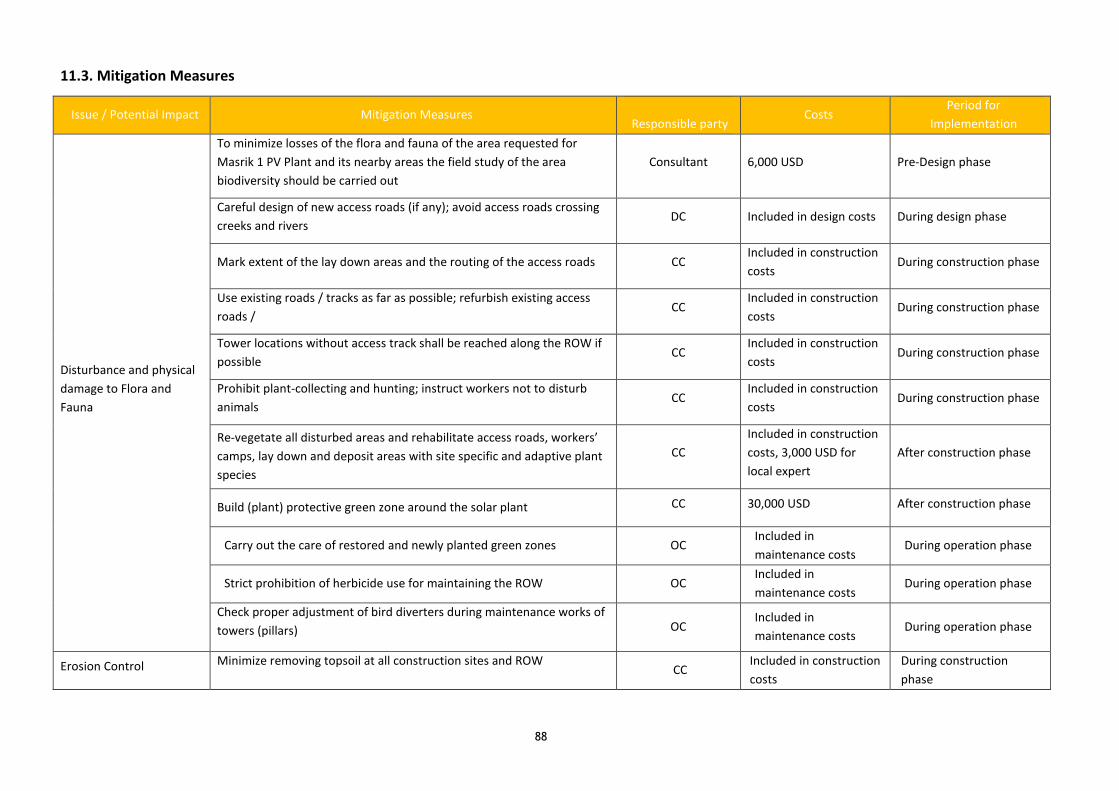
88
11.3. Mitigation Measures
Issue / Potential Impact Mitigation Measures
Responsible party Costs
Period for
Implementation
Disturbance and physical
damage to Flora and
Fauna
To minimize losses of the flora and fauna of the area requested for
Masrik 1 PV Plant and its nearby areas the field study of the area
biodiversity should be carried out
Consultant 6,000 USD Pre-Design phase
Careful design of new access roads (if any); avoid access roads crossing
creeks and rivers DC Included in design costs During design phase
Mark extent of the lay down areas and the routing of the access roads CC Included in construction
costs During construction phase
Use existing roads / tracks as far as possible; refurbish existing access
roads / CC
Included in construction
costs During construction phase
Tower locations without access track shall be reached along the ROW if
possible CC
Included in construction
costs During construction phase
Prohibit plant-collecting and hunting; instruct workers not to disturb
animals CC
Included in construction
costs During construction phase
Re-vegetate all disturbed areas and rehabilitate access roads, workers’
camps, lay down and deposit areas with site specific and adaptive plant
species
CC
Included in construction
costs, 3,000 USD for
local expert
After construction phase
Build (plant) protective green zone around the solar plant CC 30,000 USD After construction phase
Carry out the care of restored and newly planted green zones OC Included in
maintenance costs During operation phase
Strict prohibition of herbicide use for maintaining the ROW OC Included in
maintenance costs During operation phase
Check proper adjustment of bird diverters during maintenance works of
towers (pillars) OC Included in
maintenance costs During operation phase
Erosion Control Minimize removing topsoil at all construction sites and ROW CC
Included in construction
costs
During construction
phase

89
Issue / Potential Impact Mitigation Measures
Responsible party Costs
Period for
Implementation
Bring back topsoil to its original place, after having finished the
construction works and erection of the towers CC
Included in construction
costs After construction works
Reseeding / replanting of native grass / shrub species at tower sites CC 20,000 USD During construction
phase
Implement erosion prevention measures at access roads:
• protect the soil surface with some form of cover
• control runoff before it develops into an erosive force.
CC Included in construction
costs
During construction
phase
Avoid deposits of loose spoils on steep slopes or near rivers: Mets
Masrik and drainage channels of the nearest landplots CC
Included in construction
costs
During construction
phase
Protect excess spoils from runoff CC
Included in construction
costs
During construction
phase
Excess spoil and soil will be left in orderly piles, covered with topsoil,
and re-vegetated with native species CC
Included in construction
costs
During construction
phase
Avoid construction near watercourses CC N/A
During construction
phase
Rehabilitation of new access roads not needed anymore after
construction works CC
Included in construction
costs After construction works
Repair landscape damage due to work in wet weather as soon as
possible when construction is complete in that area CC
Included in construction
costs After construction works
Carry out the care of restored and newly planted green zones OC
Included in maintenance
costs During operation phase
Strict prohibition of herbicide use for maintaining the ROW OC N/A During operation phase
Check proper adjustment of bird diverters during maintenance works of
towers (pillars) OC Included in maintenance
costs During operation phase
Implement drainage control measures (culverts, berms, etc.) on
permanent access roads, if they are in steep or erosion prone areas OC
Included in maintenance
costs During operation phase
Minimize off-road vehicle and equipment use OC N/A During operation phase
Activities concerning Soil Regular maintenance of all vehicles and machines at regular service CC Included in construction During construction

90
Issue / Potential Impact Mitigation Measures
Responsible party Costs
Period for
Implementation
and Water Pollution stations, if possible costs phase
Maintenance and re-fuelling of the construction equipment only on
sealed and enclosed areas CC N/A
During construction
phase
Store all liquid materials (e.g. fuel, engine oil, etc.) and lubricants in
locked tanks and on sealed and roofed areas CC Included in construction
costs During construction
phase
Store construction material as bags of cement etc. in containers in order
to avoid rinsing out CC
Included in construction
costs
During construction
phase
Train workers in appropriate sanitation practices CC, OC
Included in construction
and operation costs
During construction and
operation phases
Place plastic or other protective cloth under any areas where towers or
other materials will be painted CC
Included in construction
costs
During construction
phase
Train transporters and workers in spill prevention and control especially
in handling of oil and fuel CC, IA
Included in construction
costs
During construction
phase
Provide spill-control materials to drivers and workers, in order to clean
up spills, if necessary CC
Included in construction
costs
During construction
phase
Report and respond to spills promptly and train workers in how to
report CC, IA
Included in construction
costs
During construction
phase
Remove contaminated soil if spills occur and handle as hazardous waste CC, OC
Included in construction
and operation costs
During construction and
operation phases
Collect contaminated spill materials and manage as hazardous waste CC, OC
Included in construction
and operation costs
During construction and
operation phases
Repair any damage to riparian areas, including riverbanks and
riverbeds (if any), as soon as construction is complete CC
Included in construction
costs After construction works
Provide a drainage for precipitation flows from modules OC Included in maintenance
costs During operation phase
Waste Management
Development of Waste Management Plan within the HSE Management
Plan considering following principles: (i) waste management hierarchy
of avoidance-minimization-reuse-treatment-disposal; (ii) segregation of
waste; (iii) minimization of construction waste by good technical
Consultant, DC 3,000 USD During design phase

91
Issue / Potential Impact Mitigation Measures
Responsible party Costs
Period for
Implementation
planning; (iv) training of staff
Store all hazardous waste (e.g. oil, fuel, paint, spill contaminated soil) in
adequate storage sites CC
Included in construction
costs During construction phase
Collect all type of wastes including domestic and sanitary wastes.
Agree with municipal authorities about using services of communal
service providers for waste disposal purposes.
CC, OC Included in construction
and operation costs
During construction and
operation phases
Train workers in handling and disposal of recyclable, sanitary, solid,
liquid and hazardous waste CC, OC, IA
Included in construction
and operation costs
During construction and
operation phases
Only certified companies shall be contracted for waste recycling CC, OC Included in construction
and operation costs
During construction and
operation phases
Landscape and Visual
Aspects
Dismantling of workers’ camps and harmonization of the areas with the
landscape CC
Included in construction
costs After construction works
Noise
Optimization of transportation management to avoid needless truck
drives CC, OC
Included in construction
and operation costs
During construction and
operation phases
Allow truck movements only during daylight CC, OC Included in construction
and operation costs
During construction and
operation phases
Reduce vehicle speeds (stick to recommended speeds) in populated
areas CC, OC
Included in construction
and operation costs
During construction and
operation phases
Use low sound power mechanical equipment, whenever possible CC Included in construction
costs During construction phase
Regular maintenance and service of building machinery and other
vehicles CC
Included in construction
costs During construction phase
Shut down or throttling down of noisy machinery to a minimum CC Included in construction
costs During construction phase
For workers noise levels shall be kept below 80 dB (A), wherever
possible. In case of exceeding this value, hearing protections must be
provided to workers and warning signs must be installed
CC, OC N/A
Warning signs: 800 USD
During construction and
operation phases
For residents the noise levels may not exceed 55 dB (A) or result in a
maximum increase in background levels of 3 dB (A) at the nearest
receptor location off-site
CC, OC N/A During construction and
operation phases
Notify nearby residents at least 24 hours in advance if particularly noisy CC, OC N/A During construction and

92
Issue / Potential Impact Mitigation Measures
Responsible party Costs
Period for
Implementation
activities are anticipated operation phases
Activities concerning Air
Quality
Optimize transportation management to avoid needless truck trips CC, OC N/A During construction and
operation phases
Maintain vehicles and construction machinery properly, as
recommended by suppliers CC
Included in construction
costs During construction phase
Cover truck beds with tarps during material transport CC Included in construction
costs During construction phase
Use dust-suppressing water spray during civil works, where necessary CC Included in construction
costs During construction phase
Store and handle material appropriately to limit dust (e.g.
protect cement with tarpaulins) CC N/A During construction phase
Avoid unnecessary idling of construction machines and vehicles CC N/A During construction phase
Prohibit open burning of construction / waste material at the site CC, OC N/A During construction and
operation phases
Maintain vehicles and engines properly, as recommended by suppliers CC, OC N/A During construction and
operation phases
Avoid unnecessary idling of vehicles CC, OC N/A During construction and
operation phases
Train maintenance workers accordingly CC, OC, IA Included in construction
and operation costs
During construction and
operation phases
Risks for
Historical and Cultural
Sites
Implementation of Chance Find Procedure and training of the
construction workers CC N/A During construction phase
Report chance finds immediately to the Ministry of Culture of RA, Dep.
Protection of Monuments and Historical Sites CC N/A During construction phase
Agree with representatives of Dep. Protection of Monuments and
Historical Sites of RA about location of towers and new access roads
(including proposed bypasses) in advance of construction
CC N/A During construction phase
Risks for Public and
Employee Health and
Safety
Development of an HSE Policy for the construction phase, in advance of
construction activities CC
Included in construction
costs Before construction works
Development of an HSE Management Plan for the construction phase
(shall include Waste Management Plan), in advance of construction CC
Included in construction
costs Before construction works

93
Issue / Potential Impact Mitigation Measures
Responsible party Costs
Period for
Implementation
activities
Installation of an HSE Management System (HSEMS) CC Included in construction
costs During construction phase
Make sure that all workers have a health insurance CC N/A Before construction works
Provide proper sanitation facilities with hand-washing facilities in
adequate number, separately for men and women CC
Included in construction
costs Before construction works
Provide HIV/AIDS protection equipment for workers CC Included in construction
costs Before construction works
Install warning signs “Danger of Electrocution” at towers, substations
etc. CC 800 USD Before construction works
Accommodation of workers in adjacent villages has the first priority. In
the case that construction camps are necessary these will be located in
accordance with relevant municipal authorities
CC Included in
construction costs Before construction works
Provide workers with appropriate protective equipment (PPE) 20,000 USD During construction phase
Train workers accordingly regarding work at heights, electrical and
vehicular safety, handling of hazardous materials, PPE, hazard avoidance
and reduction measures, use of first aid and rescue techniques,
emergency response etc.
CC, IA Included in
construction costs During construction phase
Risks for Public and
Employee Health and
Safety
All work crews shall have at least one person (two is strongly preferred)
trained in first aid CC
Included in construction
costs During construction phase
Provide first aid kits and fire extinguishers at all Project sites and in all
vehicles CC
Included in construction
costs Before construction works
If work crews are in remote areas, they shall be equipped with cellular
phones or radios CC 2,000 USD During construction phase
Forbid alcohol and other drugs at construction sites / workers’ camps CC N/A During construction phase
Set up mobile clinics for workers capable of treating all injuries and
diseases occurring at the construction sites CC
Included in construction
costs Before construction works
Assure transfer of injured workers to hospitals in the case of serious
accidents CC
Included in construction
costs During construction phase
Identify area emergency responders, hospitals, and clinics, and provide CC N/A During construction phase

94
Issue / Potential Impact Mitigation Measures
Responsible party Costs
Period for
Implementation
advance notice of Project activities
Implement programs for medical screening, health and safety
monitoring, and reporting CC
Included in construction
costs During construction phase
Limit occupational exposure to EMF by use of shielding materials, and
train workers accordingly CC
Included in construction
costs During construction phase
Record work-hours as well as all accidents and incidents CC Included in construction
costs During construction phase
Notification of the public on upcoming construction activities in
adjacent villages and through media, in advance of construction period CC 200 USD During construction phase
Public education and outreach efforts to provide information about
hazard awareness, safety measures, reporting unsafe conditions and
environmental impacts in adjacent villages, in advance of construction
period
CC 2,000 USD During construction phase
Inform population along public roads in advance in case of transporting
heavy equipment CC N/A During construction phase
Provide adequate security measures to prevent accidents and injury
(e.g. keeping speed limits on public roads, grounding objects) CC N/A During construction phase
Use warning signs at access points along main roads, and around work
sites near villages or residences CC 800 USD
During construction and
operation phases
Risks for Public and
Employee Health and
Safety
Provide clear and adequate signage to identify work areas and
hazardous equipment, before commencement of relevant construction CC 800 USD After construction works
Install warning signs at all towers and sensitize the community on
dangers of electricity, and risks of electrocution CC, OC 800 USD After construction works
Provide adequate security to prevent public access to the substations,
work sites, hazardous materials and waste CC, OC
Included in construction
costs Before operation phase
Establish worker code of conduct to help prevent friction or conflict with
communities OC
Included in operation
costs During operation phase
No houses are allowed in 50 m corridor (way leave) of the overhead line OC N/A During construction phase
Develop a Health and Safety Management Plan (HSMP) and implement
an Health and Safety Management System (HSMS) for operation and
maintenance
OC Included in operation
costs During operation phase

95
Issue / Potential Impact Mitigation Measures
Responsible party Costs
Period for
Implementation
Social Impact
Announce start and duration of works through media and signs to the
public in advance of construction period CC 800 USD Before construction works
Limitation of construction of access roads and careful routing to
minimize impacts on agricultural land CC
Included in construction
costs During construction phase
Location of laydown areas close to existing roads in nonproductive areas
to minimize interference with agricultural activities and to facilitate site
clean-up and rehabilitation
CC Included in construction
costs During construction phase
Keep speed limits in public roads CC, OC N/A During construction and
operation phases
Minimize surface of and damage caused by workers’ camps CC N/A During construction phase
Shift towers to avoid orchards, vineyards, gardens CC Included in construction
costs During construction phase
Establishment and operationalization of a grievance redress mechanism CC, Consultant Included in construction
costs During construction phase
Presence of an impartial person to receive complaints during the
construction process CC, IA
Should be included in
construction costs During construction phase
Social Impact
Develop and implement a non-discriminatory hiring and wage policy
(clearly stating that the company will not discriminate in hiring and
salaries based on gender, age, religion, ethnicity or place of origin)
CC, Consultant Included in construction
costs During construction phase
Prioritize employment of local people for construction works CC N/A During construction phase
Legal experts will support PAP who are not registered land owners with
legalization of land titles CC, Consultant
Included in construction
costs During construction phase
Social consultant will work with vulnerable APs in the project area. CC Included in construction
costs During construction phase
Independent monitoring consultant will oversee all resettlement-related
activities. IA, Consultant
Included in construction
costs During construction phase
Develop and implement a RAP based on the Project related RPF
(Consultation with PAP about their development priorities in the
framework of RAP development)
CC, Consultant Included in construction
costs During construction phase
Develop and implement a RAP implementation compliance report CC, Consultant Included in construction During construction phase

96
Issue / Potential Impact Mitigation Measures
Responsible party Costs
Period for
Implementation
costs
Gender Issues
Improve recruitment of women for construction works according to
consultations and interviews with householder women CC N/A During construction phase
Strengthen district administrations on gender issues (i.e.
Social expert will check receiving complaints by women) CC, Consultant N/A During construction phase
Zero tolerance for sexual harassment at the work place or in workers’
camps / overnight locations CC N/A During construction phase

97
11.4. Monitoring Measures
What parameter is
to be monitored
Why is parameter to be
monitored
Where is the
parameter to be
monitored
When (or how often) is
the parameter to be
monitored
How is the parameter to be
monitored
What is the cost of
monitoring
Who is responsible
for monitoring
Survey of
Biodiversity of
selected area
To avoid loss of species
registered in the Red Book of
Armenia
Area of Masrik 1 PV Before construction
works
Inspection of the report on
preconstruction survey of PV
Plant area
3,000 USD DC, Consultant, IA
Corridor of OTL Before the selection of
the OTL corridor
Inspection of the report on
preconstruction survey of
OTL corridor
4,000 USD DC, Consultant, IA
Historical and
cultural sites
To avoid damages of Historical
and cultural monuments
Location of PV
plant, towers and
new access roads
Before construction
works
Before the selection of
OTL corridor
Inspection of records Included in design
costs
DC, Consultant, IA
Top soil: depth of
top soil, content of
humus, pH
To minimize loss of top soil Area of Masrik 1 PV
Plant Corridor of
OTL.
Place for new
roads
Before construction
works
Measurement of depth,
sampling and analyzing
4,000 USD DC, Consultant
Quality of
construction
materials
Ensure reliability of
construction materials and their
safety for human health
In the provider’s
office or
warehouse
During conclusion of
supply contracts
Verification of documents Included in
construction costs
CC

98
Transportation of
construction
materials and
waste
- Limit pollution of soil and air
from emissions;
- Limit nuisance to local
communities from noise and
vibration;
- Minimize traffic disruption.
- Construction site
- Routs of
transportation of
construction
materials and
wastes
Undeclared inspections
during work hours and
beyond
Inspection of roads adjacent
to the construction object in
the direction of the
movement rout
Included in
construction costs
CC
Movement of
construction
machinery
- Avoid pollution of water and
soil with oil products due to
operation of equipment
Construction camp
and temporary
sites along of OTLs
During operation of
equipment
Inspection of activities Included in
construction costs
CC
Soil Erosion To prevent further erosion Side slopes and
material storage
sites
Weekly during
construction works
Visual inspection of erosion
prevention measures and
occurrence of erosion
Included in
construction costs
CC
Soil Pollution To minimize pollution of soil At all construction
sites, including
construction camp,
approach roads
and OTL corridor
Weekly during
construction works
Visual inspection Included in
construction costs
CC
To prevent pollution of soil Parking sites,
approach roads
and OTL corridor
Monthly during
operation phase
Visual inspection Included in
operation costs
OC
Air Quality: dust,
smoke
To minimize pollution of air At all construction
sites, including
construction camp,
approach roads
and OTL corridor
Daily during construction
works
Visual inspection Included in
operation costs
CC
Air Quality: smoke To minimize pollution of air Parking sites,
approach roads
Weekly during operation
phase
Visual inspection Included in
operation costs
OC

99
Noise To minimize level of noise At all construction
sites, including
construction camp,
approach roads
and OTL corridor
Weekly during
construction works
Sound meter 80 USD CC
Noise To minimize level of noise Parking sites,
approach roads
Weekly Sound meter 80 USD OC
Traffic Safety To ensure safety of traffic All common roads
used by CC
Daily during construction
works
Visual inspection Included in
construction costs
CC
All common roads
used by CC
Weekly during operation
phase
Visual inspection Included in
operation costs
OC
Generation of
construction waste
Prevent pollution of soil,
surface water and ground
water,
Avoid accidents at the
construction site due to
scattered fragments of
construction materials and
debris,
Retain esthetic appearance of
the construction site and its
surroundings
Construction site;
Waste disposal site
Periodically during
construction and upon its
completion
Inspection of construction
camp and temporary sites
Included in
construction costs
CC
Generation of
domestic wastes
Prevent pollution of soil,
surface water and ground
water
PV Plant site and
surrounding area
Periodically during
operation phase
Visual observation Included in
operation costs
OC

100
Construction site
re-cultivation and
landscaping
Reduce loss of aesthetical value
of the landscape due to the PV
Plant and OTLs construction
At all construction
sites, including
construction camp,
approach roads
and OTL corridor
Final period of
construction
Visual inspection Included in
construction costs
CC, Consultant, IA
Workers’ health
and safety
Reduce probability of traumas
and accidents
At all construction
sites
Total period of
construction works
Inspection of activities Included in
construction costs
CC, IA
PV plant Total period of
operation
Inspection of logs Included in
operation costs
OC, IA
Emergency
preparedness
- Reduce risks for the
construction workers
At all construction
sites
Total period of
construction works
Periodic check-ups Included in
construction costs
CC, IA
-Reduce risks for the staff of the
PV Plant
- Avoid disruption in the
maintenance of the PV Plant
and OTLs
PV Plant and OTLs Total period of
operation of the PV
Plant
Periodic check-ups Included in
operation costs
OC, IA
Awareness of
Communities
Reduce risks for the Residents
living near to construction sites
Local Communities Before construction
works
Inspection of notification
documents
Interviews of Residents living
near to construction sites
Included in
operation costs
DC, Consultant
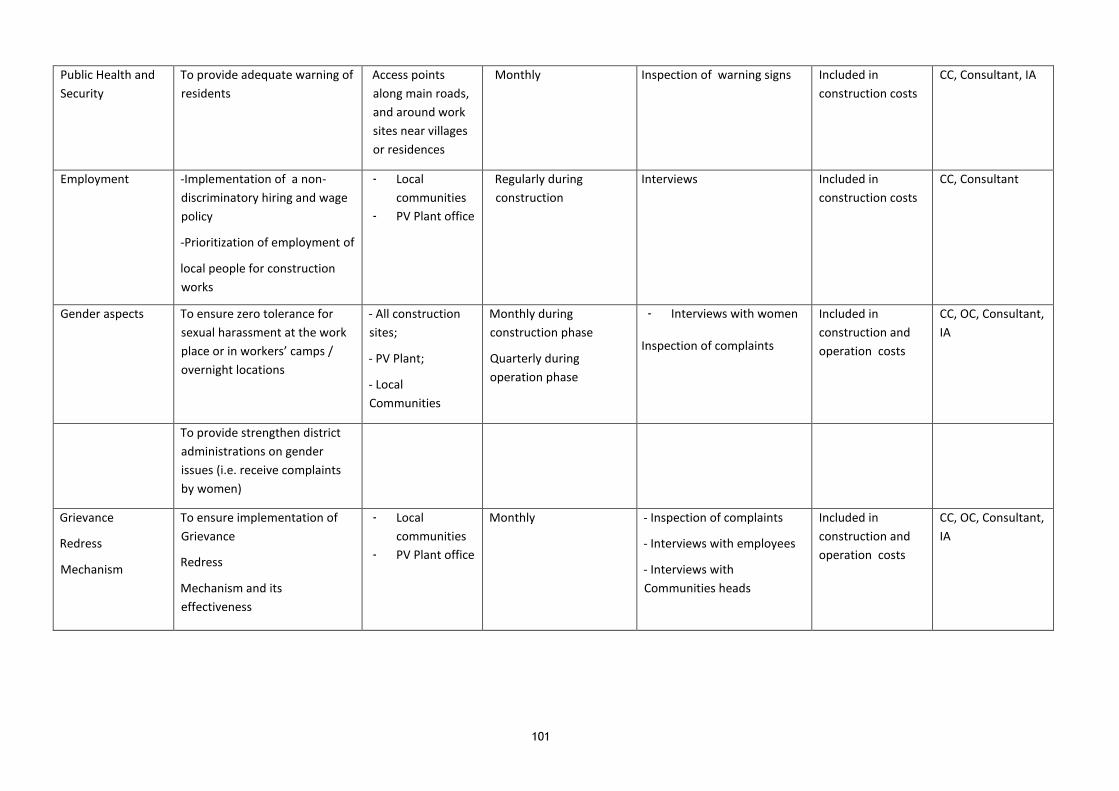
101
Public Health and
Security
To provide adequate warning of
residents
Access points
along main roads,
and around work
sites near villages
or residences
Monthly Inspection of warning signs Included in
construction costs
CC, Consultant, IA
Employment -Implementation of a non-
discriminatory hiring and wage
policy
-Prioritization of employment of
local people for construction
works
- Local
communities
- PV Plant office
Regularly during
construction
Interviews Included in
construction costs
CC, Consultant
Gender aspects To ensure zero tolerance for
sexual harassment at the work
place or in workers’ camps /
overnight locations
- All construction
sites;
- PV Plant;
- Local
Communities
Monthly during
construction phase
Quarterly during
operation phase
- Interviews with women
Inspection of complaints
Included in
construction and
operation costs
CC, OC, Consultant,
IA
To provide strengthen district
administrations on gender
issues (i.e. receive complaints
by women)
Grievance
Redress
Mechanism
To ensure implementation of
Grievance
Redress
Mechanism and its
effectiveness
- Local
communities
- PV Plant office
Monthly - Inspection of complaints
- Interviews with employees
- Interviews with
Communities heads
Included in
construction and
operation costs
CC, OC, Consultant,
IA

102
12. GRIEVANCE REDRESS MECHANISM
In the course of the construction process, people affected by the project may feel treated unjustly. This
might happen for various reasons: the CC does not adhere to sound construction principles, the damages to
crops are not paid for, resettlement measures have not been implemented, people have been forgotten
during land survey or simply misunderstandings have arisen and so forth. This may also be disagreement
with procedures of consultation, notification or valuation.
When this happens people are encouraged to lodge their complaints. The grievance redress mechanism is
implemented, so that people can get their problems solved and grievances redressed in a timely and
effective manner without directly addressing the court.
During consultation, survey and compensation the AP shall be notified orally or in a written form about their
rights and the procedure of complaints introduction. Local NGOs e.g. via the local Aarhus Centre can inform
communities about the possibility to raise complaints and how and where to address them. The grievance
redress mechanism has to be locally implemented at the level of village institutions and local self-
government as well as bundled on national level at the IA.
Grievances can be addressed at the local community level ("Head of the LSGB"), where the grievance is
recorded and forwarded to the IA’s grievance coordinator responsible for registration of grievances and
decision on grievance redress.
Grievances that are addressed to the CC during the execution of civil works shall also be forwarded to the IA
grievance coordinator. Even if the constructor decides to settle the grievance on the spot, the
documentation of the grievance settlement procedure needs to be documented at the IE’s grievance
coordinator/focal point.
Also, all project related complaints can be directly addressed to the IA grievance coordinator via phone, e-
mail or grievance form. A project grievance hotline shall be made available by the IA for direct complaints (at
national level) and all received grievances shall be recorded by the IA grievance coordinator in a grievance
log-book.
The IE’s grievance coordinator then decides whether to settle directly, call for grievance committee meeting
or go to the court. The decision has to be taken within 2 (two) days after receipt and registration of the
grievance.
In case of major grievances, that cannot be directly settled, permanent and not-permanent members of the
grievance committee will be called for a meeting. The meeting will take place during 15 (fifteen) business
days after receipt and registration of the grievance. Decisions in the grievance committee are taken by
majority vote of the members who registered in the protocol of the meeting (Permanent and Non-
permanent). PAP will be informed about time and place of the meeting 10 (ten) days before (as Non-
permanent member).
In case of failure of the grievance redress system, the PAPs can submit their case to the appropriate court.
The Committee will be composed of permanent and non-permanent members.
Permanent members: IA, the CC and a lawyer.
Non-permanent members: PAP, Appropriate marz representative, community representative and NGO
representative. Non-permanent members will be notified of the date and venue of the meeting 10 (ten) days

103
before the meeting. Absence of non-permanent members cannot be the reason for the cancellation of the
meeting. A lawyer can represent one of the permanent members.
The CC is obliged to carry out the work in accordance with the contractual requirements that include:
• A person of staff responsible for grievance procedure who will provide technical assistance to the IA
in handling any grievances that may arise during RAP preparation and implementation (The person
shall have 3 or more years of similar experience, bachelor/master degree in Law or Sociology is
preferable);
• Preparation of regular monitoring reports on the status of RAP preparation and implementation,
including details of any complaints that arose and how they were handled (if the RAP preparation
obligation is delegated to the CC);
• If vulnerable affected people are identified following census completion, then the CC will appoint
professional advocates (social workers / legal experts) to assist those people during the entire
process, and to act as independent advocates for them should any grievances arise (if the RAP
preparation obligation is delegated to the CC);
• Handling of grievances with the IA and PAP and participation in the grievance committee.
The IA will carry out works that include:
• A person of staff responsible for the grievance procedure coordination, hereby referred to as
grievance coordinator (including first contact, periodical site visiting of mitigation measure to be
implemented by CC);
• A telephone line, e-mail address and contact name on project boards;
• Handling of grievances with the CC and PAP and participation in the grievance committee.
• Liaison with court.
However PAPs have the option to choose a different representative or directly liaison with the IA staff,
responsible for grievance redress. Vulnerable households will have the support of their individual social
worker and legal support.
Additionally, legal experts will support PAPs who are not registered land owners with legalization of land
titles.
NGOs, e.g. Aarhus Centre or local member organizations will monitor grievance redress negotiations, assist
with grievance arbitration, raise public awareness (local legislation doesn’t define any formal arrangement
for monitoring; this issue is regulated by the company’s internal documentation, which may differ depending
on the company charter). PAPs need to be informed that in case of conflict with the community leader they
can address NGO staff to follow up their complaint. NGOs will monitor relationship between PAPs and
community leader.
The World Bank is not directly a part of the Grievance procedure but should receive regular reports on which
complaints were received and how they have been followed up / mitigated.
Special consideration has to be taken for PAPs living in remote areas and vulnerable people as complaint
mechanisms may be unusual and contact with legal procedures let alone courts of law may appear not very
promising from their experience. This would prevent the most disadvantaged persons from addressing their
grievance.
104
A close monitoring on village level by an independent social expert during the implementation of the project
and a personal contact with PAPs is therefore recommended.
Vulnerable PAPs (all women headed households and all households below the poverty line) will be entitled to
a legal aid / social worker to support them with complaints procedures.
Communication with CC Staff:
During the construction phase there will be an influx of people into the project area. As these people would
have cultural differences with the resident population there are potential that a conflicts may arise because
of issues related to the environment, safety and privacy issues of the women in the surrounding villages,
spread of various communicable diseases, nuisance caused by workers due to improper sanitation facilities,
etc.
The Project will provide a grievance mechanism where employees may raise reasonable work place concerns.
The mechanism should involve appropriate level of management involvement and address concerns
promptly, using a transparent process that provides feedback to those concerns without any retribution.
During design phase the Consultant should prepare a framework for redressal of grievances/complaints
during all phases of the project. This framework will be continuously monitored & improved as the project
moves from one stage to other.
As a part of the grievance redressal, it will perform the following actions.
• Continuously collect and analyze complaint/grievance related data and
• Disseminate this information into its organizational set up
• Review and upgrade exiting plans if required;
• Publicize the existence of the GRM among local communities
In addition, this procedure will help to improve the project social performance. This is because the number
and nature of received complaints including punctuality, nature and effectiveness of grievance redressal are
indicators of the manner in which the Project should be implemented.

105
13. REFERENCES
• Council of Europe (CE), European Commission (EC) 2010: Heritage Assessment Report Armenia.
Strasbourg, 2010.
• EuropeAid 2010: Landfill Operations Guidance Manual. Waste Governance – ENPI East. Brussels,
October 2010.
• EU Directive on Electromagnetic Fields 2004: Council Directive 2004/40/EC of 29 April 2004 on the
minimum health and safety requirements regarding the exposure of workers to the risks arising from
physical agents (electromagnetic fields).
• Government of the Republic of Armenia (GRA) 2009: Decree No 363-n on "Approval of Technical
Regulation on Safety Zones of Electric Networks". Yerevan.
• Scaling Up Renewable Energy Program (SREP). Investment Plan for Armenia. Yerevan, 2016
• International Finance Corporation (IFC) 2007: Environmental, Health and Safety (EHS) Guidelines.
Available at: http://www.ifc.org/ehsguidelines
• Ministry of Nature Protection RA (MNP) (2014): Fifth National Report of the Republic of Armenia to
the Convention on Biological Diversity. Yerevan. Available at: http://www.cbd.int/doc/world/am/am-
nr-05-en.pdf
• World Wide Fund for Nature (WWF) 2011: Forest Restoration Guidelines: Restoration of Forest
Landscapes in the Southern Caucasus. WWF - Caucasus Programme Office, April 2011.
• World Bank Group: Operational Directive 4.01: Environmental Assessment.
• International Fund For Agricultural Development (IFAD)
• (2003): Country Strategic Opportunities Paper.
• National Atlas of Armenia. Yerevan, 2007
14. ANNEXES
ANNEX 1. Calculation of Emissions Occuring During the Construction of the Masrik 1 Solar Power
Plant and Overhead Lines
ANNEX 2. Assessment of Economic Damage
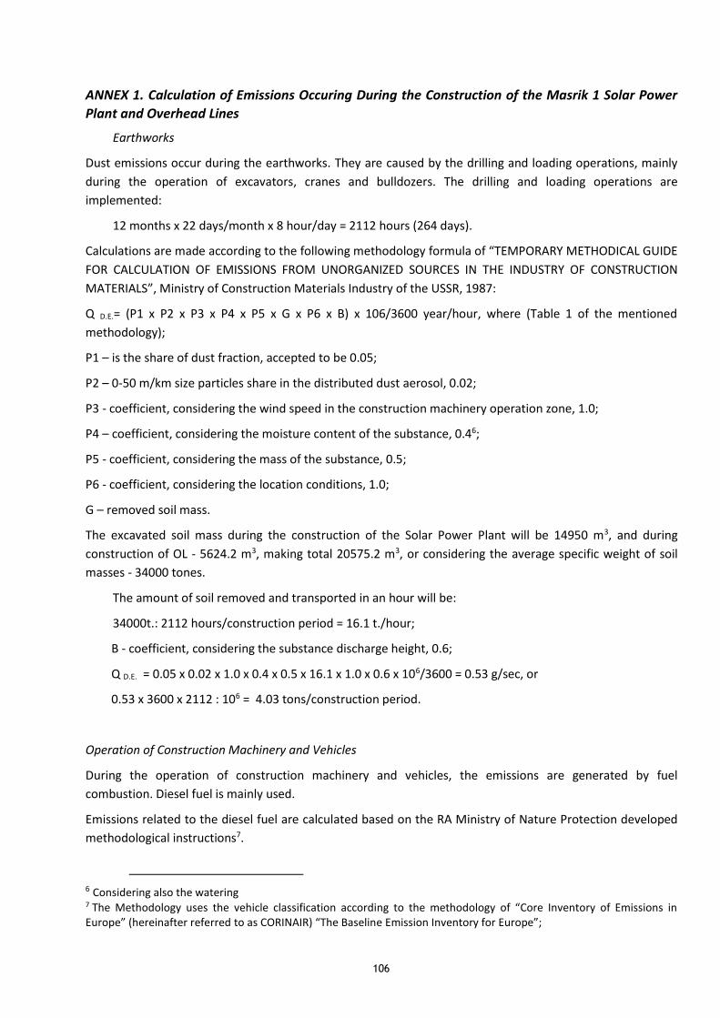
106
ANNEX 1. Calculation of Emissions Occuring During the Construction of the Masrik 1 Solar Power
Plant and Overhead Lines
Earthworks
Dust emissions occur during the earthworks. They are caused by the drilling and loading operations, mainly
during the operation of excavators, cranes and bulldozers. The drilling and loading operations are
implemented:
12 months x 22 days/month x 8 hour/day = 2112 hours (264 days).
Calculations are made according to the following methodology formula of “TEMPORARY METHODICAL GUIDE
FOR CALCULATION OF EMISSIONS FROM UNORGANIZED SOURCES IN THE INDUSTRY OF CONSTRUCTION
MATERIALS”, Ministry of Construction Materials Industry of the USSR, 1987:
Q D.E.= (P1 x P2 x P3 x P4 x P5 x G x P6 x B) x 106/3600 year/hour, where (Table 1 of the mentioned
methodology);
P1 – is the share of dust fraction, accepted to be 0.05;
P2 – 0-50 m/km size particles share in the distributed dust aerosol, 0.02;
P3 - coefficient, considering the wind speed in the construction machinery operation zone, 1.0;
P4 – coefficient, considering the moisture content of the substance, 0.46;
P5 - coefficient, considering the mass of the substance, 0.5;
P6 - coefficient, considering the location conditions, 1.0;
G – removed soil mass.
The excavated soil mass during the construction of the Solar Power Plant will be 14950 m3, and during
construction of OL - 5624.2 m3, making total 20575.2 m3, or considering the average specific weight of soil
masses - 34000 tones.
The amount of soil removed and transported in an hour will be:
34000t.: 2112 hours/construction period = 16.1 t./hour;
B - coefficient, considering the substance discharge height, 0.6;
Q D.E. = 0.05 x 0.02 x 1.0 x 0.4 x 0.5 x 16.1 x 1.0 x 0.6 x 106/3600 = 0.53 g/sec, or
0.53 x 3600 x 2112 : 106 = 4.03 tons/construction period.
Operation of Construction Machinery and Vehicles
During the operation of construction machinery and vehicles, the emissions are generated by fuel
combustion. Diesel fuel is mainly used.
Emissions related to the diesel fuel are calculated based on the RA Ministry of Nature Protection developed
methodological instructions7.
6 Considering also the watering 7 The Methodology uses the vehicle classification according to the methodology of “Core Inventory of Emissions in Europe” (hereinafter referred to as CORINAIR) “The Baseline Emission Inventory for Europe”;

107
This calculation is made according to the amount of fuel consumption, which is mainly diesel in this case.
According to the mentioned methodology, the specific emissions of vehicles and construction machinery are
presented in the below Table 1.
Table 1. Specific Emissions (g/kg fuel)
Type of Fuel Name of Substance
NO2 CH VOCs CO N2O CO28 PM
Diesel Fuel 42.3 0.243 8.16 36.4 0.122 3138 4.3
Excavators, bulldozers, road rollers and trucks will be operated during construction. Passenger cars are not
considered in this assessment.
The construction machinery will be operated throughout the whole construction process which is 2 years
(440 days, 3520 hours).
As there are no accurate design data, indicators based on experts’ assessments were used for the
calculations, according to which, the amounts of diesel fuel are as follows:
- Construction machinery: 0.1 t/day; total - 0.1 t/day x 264 days = 26.4 tons;
- Motor vehicles: 0.2 t/day; total - 0.2t/day x 264 days = 52.8 tons. In total - 79.2 tons.
Calculations of emissions by type of the equipment operated are mentioned in Table 2. Nitrogen oxide, as
well as border hydrocarbons have been combined in the Table.
Table 2. Results of Emission Calculations
Harmful Substance Specific Emissions, g/kg Emissions, t
g/sec t
CO (Carbon monoxide) 36.4 0.379 2.88
CH (Carbohydrates) 8.403 0.087 0.66
NO2 (Nitrogen oxides, with Dioxide
calculation)
42.422
0.44 3.36
PM (Particulate matter) 4.3 0.045 0.34
Sulfuric Anhydride
Sulfuric Anhydride (SO2) emissions are calculated based on the approach that all the sulfur contained in the
fuel is entirely converted into SO2. In that case the CORINAIR Inventory System formula is applied.
ESO2 = 2Σksb, where:
ks is the average sulfur content in fuel 0.002 t/t;
b is the fuel consumption – 79.2 t/construction hour;
SO2 = 2 x 79.2 x 0.002 = 0.32 t. or 0.042 g/sec.
8 According to the RA Legislation, the Carbon Dioxide is not a harmful substance and is not subject to regulation,
therefore it was not considered in further calculations.

108
ANNEX 2. Assessment of Economic Damage
The potential economic impact for each emission source is assessed according to the following formula:
I = Sc Tc ∑ SiQi , where: (1)
I is the impact expressed in Drams of the Republic of Armenia;
Sc is the coefficient expressing the characteristics of the surrounding of contaminating source (active
contaminating zone); according to the mentioned procedure’s Table 9, it is 0.1 for pasture areas;
Si is the value expressing the comparative harmfulness of the substance i (dust type); according to
the mentioned procedure’s Tables 10 and 11, for inorganic powder it is 10, for carbon oxide – 1, for
nitrogene dioxide – 12.5, for sulfur anhydride – 16.5, for carbohydrates – 3.16 and for soot it is 41.5;
Qi is the coefficient connected with the emissions of the given (i) substance;
Tc is the transportation coefficient, which is constant and is selected based on the principle of
promotion of environmental process.
According to this procedure:
Tc = 1000 AMD.
Qi coefficient is determined according to the follwing formula:
Qi = g (3 Sei - 2 MPEi), Sei > MPEi (2), where:
MPEi – is the annual maximum permissible emission of substance i in tones. Given the emissions of
harmful substances are few and of temporary nature, actual emissions are considered as MPE.
Sei – is the actual annual emissions of substance i in tones:
g = 1 – for fixed sources;
g = 3 – for mobile sources.
The impact is not assessed for substances the normative concentration of which is not defined by the State
Standards.
The fixed and mobile sources have been distinguished during the calculation.
The calculation of economic damage resulting from the construction of Masrik 1 and OL is presented in the
Table 2. Emissions’ quantities are in the Annex 1.
Table 2. Results of Economic Damage Indicators Calculation
Name of Emitted
Substance
Indicators Required for
Calculation
D
Sc
Economic
Damage: AMD
Si g Si=Տi x g I = Sc Tc ∑ SiQi
Mineral Dust 4.03 1 4.03 10 0.1 4030
Carbone Monoxide 2.88 3 8.64 1 5 43200
Carbohydrates 0.66 3 1.98 3.16 5 31284
Nitrogen Dioxide 3.36 3 10.08 12.5 5 630000
PM 0.34 3 1.02 41.5 5 211650
Sulfur Anhydride 0.32 3 0.96 16.5 5 79200
Total 999364
Total: 999364 AMD.