Embed Size (px)
Citation preview
PLANS LIST – 04 APRIL 2012
LIST OF MAJOR APPLICATIONS
No: BH2012/00114 Ward: HOVE PARK
App Type: Full Planning
Address: Park House, Old Shoreham Road, Hove
Proposal: Demolition of former residential language school and erection of 5 storey block of 71 flats incorporating basement car park and surface car parking to provide 71 parking spaces, including landscaping and other associated works.
Officer: Christopher Wright Valid Date: 18/01/2012
Con Area: N/A Expiry Date: 18 April 2012
Listed Building Grade: N/A
Agent: Lewis and Co Planning SE Ltd, Paxton Business Centre, Portland Road, Hove
Applicant: Hyde Newbuild Limited, C/O Lewis & Co Planning
1 RECOMMENDATIONThat the Committee has taken into consideration and agrees with the reasons for the recommendation set out below and the policies and guidance in section 7 of this report and resolves it is MINDED TO GRANT planningpermission subject to the completion of a S106 Agreement and the following Conditions and Informatives.
S106 Heads of Terms
Affordable housing – 40%.
A contribution of £180,000.00 for open space
A contribution of £35,000.00 towards the Local Employment Scheme –
A commitment to achieve 20% on site Local Employment during construction.
A contribution of £53,000.00 for Sustainable Transport.
A contribution of £139,000.00 for education.
Regulatory Conditions1) The development hereby permitted shall be commenced before the
expiration of three years from the date of this permission.Reason: To ensure that the Local Planning Authority retains the right to review unimplemented permissions.
2) The development hereby permitted shall be carried out in accordance with the approved Design and Access Statement; Planning Supporting Statement; Sustainability Checklist; Sustainability Report; Landscape Specification; One Hove Park Planning Application Supporting Documents; and drawing nos. Y023-001, Y023-001 Revision A, Y023-010 Revision F, Y023-012 Revision D, Y023-013 Revision D, Y023-014 Revision E, Y023-015 Revision E, Y023-017 Revision B, Y023-020 Revision E, Y023-050, OHP-ND-001, OHP-ND-002, OHP-ND-003 OHP-
11
PLANS LIST – 04 APRIL 2012
ND-004, J37.82/01 Revision B and J37.82/03 received on 17 January 2012; the Archaeological Desk-Based Assessment received on 18 January 2012; the Phase 1 Preliminary Contamination Assessment Report received on 6 March 2012; and drawing nos. Y023-011 Revision G, Y023-016 Revision F and Y023-021 Revision E received on 20 March 2012.Reason: For the avoidance of doubt and in the interests of proper planning.
3) No cables, wires, aerials, pipework (except rainwater downpipes as shown on the approved plans), meter boxes or flues shall be fixed to any elevation facing a highway.Reason: To safeguard the appearance of the building and the visual amenities of the locality and to comply with policies QD1 and QD27 of the Brighton & Hove Local Plan.
4) Unless otherwise agreed in writing by the Local Planning Authority, the new dwellings hereby permitted shall be constructed to Lifetime Home standards prior to their first occupation and shall be retained as such thereafter.Reason: To ensure satisfactory provision of homes for people with disabilities and to meet the changing needs of households and to comply with policy HO13 of the Brighton & Hove Local Plan.
5) The hard surfaces hereby approved shall be made of porous materials and retained thereafter or provision shall be made and retained thereafter to direct run-off water from the hard surface to a permeable or porous area or surface within the curtilage of the property.Reason: To reduce the risk of flooding and pollution and increase the level of sustainability of the development and to comply with policy SU4 of the Brighton & Hove Local Plan.
6) The vehicle parking areas shown on the approved plans shall not be used otherwise than for the parking of private motor vehicles belonging to the occupants of and visitors to the development hereby approved. Reason: To ensure that adequate parking provision is retained and to comply with policy TR19 of the Brighton & Hove Local Plan.
7) Notwithstanding the drawings submitted, the development shall provide for a minimum of 7 disabled accessible parking spaces and these shall not be used otherwise than for the parking of private motor vehicles belonging to the occupants of and visitors to the development hereby approved.Reason: To ensure adequate parking provision is retained and to comply with policy TR19 of the Brighton & Hove Local Plan.
8) The windows and other openings to the rooms fronting Goldstone Crescent, Old Shoreham Road and Hove Park Gardens within the development hereby permitted, shall not be glazed other than with glazing which meets or exceeds the standard required for satisfactory attenuation of external noise cited in the approved PPG24 Noise Assessment Final Report received on 17 January 2012.Reason: In order to safeguard the amenities and living conditions of future occupiers of the development and to comply with policies SU9, SU10 and QD27 of the Brighton & Hove Local Plan.
12
PLANS LIST – 04 APRIL 2012
Pre-Commencement Conditions-9) No development shall commence until a scheme for the landscaping of
the site has been submitted to and approved in writing by the Local Planning Authority, which shall include details of hard landscaping, planting plans, written specifications (including cultivation and other operations associated with tree, shrub, hedge or grass establishment), schedules of plants noting species, plant sizes and proposed numbers/densities and an implementation programme. The development shall be implemented in accordance with the approved details.Reason: To enhance the appearance of the development in the interest of the visual amenities of the area and to comply with policies QD1 and QD15 of the Brighton & Hove Local Plan.
10) All planting, seeding or turfing comprised in the approved scheme of landscaping shall be carried out in the first planting and seeding seasons following the occupation of the building or the completion of the development, whichever is the sooner; and any trees or plants which within a period of 5 years from the completion of the development die, are removed or become seriously damaged or diseased shall be replaced in the next planting season with others of similar size and species, unless the Local Planning Authority gives written consent to any variation. All hard landscaping and means of enclosure shall be completed before the development is occupied.Reason: To enhance the appearance of the development in the interest of the visual amenities of the area and to comply with policies QD1 and QD15 of the Brighton & Hove Local Plan.
11) No development shall commence (including any tree felling, tree pruning, demolition works, soil moving, temporary access construction and or widening or any operations involving the use of motorised vehicles or construction machinery) until a detailed Arboricultural Method Statement has been submitted to and approved in writing by the Local Planning Authority. No development shall take place except in strict accordance with the approved Arboricultural Method Statement. The method statement shall include:- i) Implementation, supervision and monitoring of all approved
construction works within any area designated as being fenced off or otherwise protected in the approved Tree Protection Scheme;
ii) Timing and phasing of Arboricultural works in relation to the approved development.
Reason: To protect the trees which are to be retained on the site in the interest of the visual amenities of the area and to comply with policies QD1 and QD16 of the Brighton & Hove Local Plan.
12) Piling or any other foundation designs using penetrative methods shall not be permitted other than with the express written consent of the Local Planning Authority, which may be given for those parts of the site where it has been demonstrated that there is no resultant unacceptable risk to ground water. The development shall be carried out in accordance with the approved details.Reason: To ensure that the method of foundation construction does not result in the deterioration of groundwater quality and in order to comply with policies SU3 and SU11 of the Brighton & Hove Local Plan.
13
PLANS LIST – 04 APRIL 2012
13) No development shall take place until samples of the materials (including colour of render, paintwork and colourwash) to be used in the construction of the external surfaces of the development hereby permitted have been submitted to and approved in writing by the Local Planning Authority. Development shall be carried out in accordance with the approved details.Reason: To ensure a satisfactory appearance to the development and to comply with policy QD1 of the Brighton & Hove Local Plan.
14) Notwithstanding the drawings submitted, no development shall take place until the precise details of the canopy shelters, including materials, scale and design, over the surface disabled parking spaces hereby approved, have been submitted to and approved in writing by the Local Planning Authority. The development shall be carried out in accordance with the approved details.Reason: To ensure a satisfactory appearance to the development and to comply with policy QD1 of the Brighton & Hove Local Plan.
15) No development shall take place until the precise details of an alternative method of ventilation, such as passive or mechanical ventilation, for the rooms fronting Goldstone Crescent, Old Shoreham Road and Hove Park Gardens within the development hereby permitted, have been submitted to and approved in writing by the Local Planning Authority. Reason: In order to safeguard the amenities and living conditions of future occupiers of the development and to comply with policies SU9, SU10 and QD27 of the Brighton & Hove Local Plan.
16) No development shall take place until the precise details of a satisfactory visibility splay at the vehicular access to the site off Old Shoreham Road have been submitted to and approved in writing by the Local Planning Authority. Thereafter the visibility splays shall be maintained for the lifetime of the development.Reason: In order to safeguard inter-visibility between motorists and pedestrians, in the interests of highway safety and to comply with policy TR7 of the Brighton & Hove Local Plan.
17) No development shall take place until a method statement providing the precise details of how the badger sett on site will be protected during the construction and successfully accommodated within the development hereby permitted, has been submitted to and approved in writing by the Local Planning Authority. Development shall be carried out in accordance with the approved details. Reason: In the interests of nature conservation and the safeguarding of a protected species and their habitat and in order to comply with policies QD17 and QD18 of the Brighton & Hove Local Plan.
18) No development shall take place until the applicant, or their agents or successors in title, has secured the implementation of a programme of archaeological work in accordance with a written scheme of investigation, including a timetable for the investigation, which has been submitted to and approved in writing by the Local Planning Authority and the works shall be undertaken in accordance with the approved details.Reason: To enable the recording of any items of historical or archaeological interest, as the development is likely to disturb remains of archaeological interest, in accordance with requirements within PPS5
14
PLANS LIST – 04 APRIL 2012
‘Planning for the Historic Environment’; and policy HE12 of the Brighton & Hove Local Plan.
19) Unless otherwise agreed in writing by the Local Planning Authority, no residential development shall commence until: (a) evidence that the development is registered with an accreditation
body under the Code for Sustainable Homes and a Design Stage/Interim Report showing that the development will achieve a minimum of Code level 4 for all residential units have been submitted to the Local Planning Authority; and
(b) a Design Stage/Interim Code for Sustainable Homes Certificate demonstrating that the development will achieve a minimum of Code level 4 for all residential units has been submitted to, and approved in writing by, the Local Planning Authority.
A completed pre-assessment estimator will not be acceptable. Reason: To ensure that the development is sustainable and makes efficient use of energy, water and materials and to comply with policy SU2 of the Brighton & Hove Local Plan and Supplementary Planning Document SPD08 Sustainable Building Design.
20) (i) The development hereby permitted shall not be commenced until there has been submitted to and approved in writing by the Local Planning Authority:
(a) a desk top study documenting all the previous and existing land uses of the site and adjacent land in accordance with national guidance as set out in Contaminated Land Research Report Nos. 2 and 3 and BS10175:2001 - Investigation of Potentially Contaminated Sites - Code of Practice; and, unless otherwise agreed in writing by the Local Planning Authority,
(b) a site investigation report documenting the ground conditions of the site and incorporating chemical and gas analysis identified as appropriate by the desk top study in accordance with BS10175:2001; and, unless otherwise agreed in writing by the Local Planning Authority,
(c) a detailed scheme for remedial works and measures to be undertaken to avoid risk from contaminants and/or gases when the site is developed and proposals for future maintenance and monitoring. Such scheme shall include the nomination of a competent person to oversee the implementation of the works.
(ii) The development hereby permitted shall not be occupied or brought into use until there has been submitted to the Local Planning Authority verification by the competent person approved under the provisions of (i) (c) above that any remediation scheme required and approved under the provisions of (i) (c) above has been implemented fully in accordance with the approved details (unless varied with the written agreement of the Local Planning Authority in advance of implementation). Unless otherwise agreed in writing by the Local Planning Authority such verification shall comprise: a) as built drawings of the implemented scheme; b) photographs of the remediation works in progress; and c) certificates demonstrating that imported and/or material left in situ
is free from contamination.
15
PLANS LIST – 04 APRIL 2012
Thereafter the scheme shall be monitored and maintained in accordance with the scheme approved under (i) (c). If during development contamination not previously identified is found to be present at the site, no further development, unless otherwise agreed in writing by the local planning authority, shall be carried out until the developer has submitted, and obtained written approval from the local planning authority, for a method statement to identify, risk assess and address the unidentified contaminants.Reason: To safeguard the health of future residents or occupiers of the site and to comply with policy SU11 of the Brighton & Hove Local Plan.
21) No development shall take place until the permission of the Local Planning Authority for infiltration of surface water drainage into the ground has been requested and approved in writing, in order to prevent unacceptable risk to controlled waters. The development shall be carried out in accordance with the approved details.Reason: To ensure that the proposed surface water drainage scheme does not cause the mobilisation or introduction of pollutants into the ground and to comply with policies SU3, SU4 and SU11 of the Brighton & Hove Local Plan.
Pre-Occupation Conditions-22) Unless otherwise agreed in writing by the Local Planning Authority, none
of the residential units hereby approved shall be occupied until a Final/Post Construction Code Certificate issued by an accreditation body confirming that each residential unit built has achieved a Code for Sustainable Homes rating of Code level 4 or higher has been submitted to, and approved in writing by, the Local Planning Authority. Reason: To ensure that the development is sustainable and makes efficient use of energy, water and materials and to comply with policy SU2 of the Brighton & Hove Local Plan and Supplementary Planning Document SPD08 Sustainable Building Design.
23) Unless otherwise agreed in writing by the Local Planning Authority, the development hereby approved shall not be occupied until 4 x bird and 4 x bat roosting boxes, which should be made from ‘Woodcrete’ or equivalent, and fixed securely to the external walls of the building, have been provided.Reason: In the interests of nature conservation and enhancement of the biodiversity of the site and in order to comply with policy QD17 of the Brighton & Hove Local Plan.
24) The development hereby approved shall not be occupied until the refuse and recycling storage facilities indicated on the approved plans have been fully implemented and made available for use. These facilities shall thereafter be retained for use at all times. Reason: To ensure the provision of satisfactory facilities for the storage of refuse and recycling and to comply with policy QD27 of the Brighton & Hove Local Plan.
25) The development hereby permitted shall not be occupied until the cycle parking facilities shown on the approved plans have been fully implemented and made available for use. The cycle parking facilities shall thereafter be retained for use by the occupants of, and visitors to,
16
PLANS LIST – 04 APRIL 2012
the development at all times. Reason: To ensure that satisfactory facilities for the parking of cycles are provided and to encourage travel by means other than private motor vehicles and to comply with policy TR14 of the Brighton & Hove Local Plan.
Informatives:1. This decision to grant Planning Permission has been taken:
(i) having regard to the policies and proposals in the Brighton & Hove Local Plan set out below, including Supplementary Planning Guidance and Supplementary Planning Documents: (Please see section 7 of the report for the full list); and
(ii) for the following reasons:- The proposed development is acceptable in principle and the amount of affordable housing provision, together with the unit sizes and tenure split reflects and responds to housing need in the city. The form, siting, design and external finishes together with the detailed landscaping scheme are considered appropriate to the site context and would not have a detrimental impact on the character and appearance of the local area on this prominent corner site. The siting and layout of the development in relation to existing neighbouring buildings is such that there would be no significant adverse impact on amenity by way of overlooking or an overbearing impact. The proposal seeks to achieve a high level of sustainability meeting Level 4 of the Code for Sustainable Homes and makes adequate provision for transport demand generated by the development and also provision to mitigate the impact of the development on both protected trees and protected species and their habitats.
2. The applicant is advised that details of the Code for Sustainable Homes can be found on the Planning Portal (www.planningportal.gov.uk), on the Department for Communities and Local Government website (www.communities.gov.uk) and in Supplementary Planning Document SPD08 Sustainable Building Design, which can be accessed on the Brighton & Hove City Council website (www.brighton-hove.gov.uk). Accreditation bodies at March 2010 include BRE and STROMA; other bodies may become licensed in future.
3. The applicant is advised that new legislation on Site Waste Management Plans (SWMP) was introduced on 6 April 2008 in the form of Site Waste Management Plans Regulations 2008. As a result, it is now a legal requirement for all construction projects in England over £300,000 (3+ housing units (new build), 11+ housing units (conversion) or over 200sq m non-residential floorspace (new build)) to have a SWMP, with a more detailed plan required for projects over £500,000. Further details can be found on the following websites: www.netregs.gov.uk/netregs/businesses/construction/62359.aspx and www.wrap.org.uk/construction/tools_and_guidance/site_waste_2.html.
17
PLANS LIST – 04 APRIL 2012
4. The applicant is advised that advice regarding permeable and porous hardsurfaces can be found in the Department of Communities and Local Government document ‘Guidance on the permeable surfacing of front gardens’ which can be accessed on the DCLG website (www.communities.gov.uk).
5. The above condition on land contamination has been imposed because the site is known to be, or suspected to be contaminated. Please be aware that the responsibility for the safe development and secure occupancy of the site rests with the developer. The local planning authority has determined the application on the basis of the information made available to it. The phased risk assessment should be carried out in accordance with the procedural guidance and UK policy formed under the Environmental Protection Act 1990. To satisfy the condition a desktop study shall be the very minimum standard accepted. Pending the results of the desk top study, the applicant may have to satisfy the requirements of (i) (b) and (i) (c) of the condition. It is strongly recommended that in submitting details in accordance with this condition the applicant has reference to Contaminated Land Report 11, Model Procedures for the Management of Land Contamination. This is available on both the DEFRA website (www.defra.gov.uk) and the Environment Agency website (www.environment-agency.gov.uk).
6. The applicant is hereby reminded of their duty to observe the requirements of the Wildlife and Countryside Act 1981, including a duty to conserve bats, and that no clearance of vegetation suitable for nesting birds should take place during the bird nesting season taken as 1st March until 31st July without the supervision or authorisation of a qualified Ecologist.
7. The applicant/developer should enter into a formal agreement with Southern Water to provide the necessary sewerage infrastructure required to service this development, and for connection to the water supply. Please contact Atkins Ltd., Anglo St. James’ House, 39A Southgate Street, Winchester, SO23 9EH (telephone 01962 858688), or www.southernwater.co.uk.
2 THE SITE The application relates to a prominent corner site on rising land in between Hove Park and Hove Recreation Ground. The site is bounded on three sides by Goldstone Crescent, Old Shoreham Road and Hove Park Gardens, and backs onto the Hove Park Manor and Gannet House flat development and associated parking and garaging. The site is 0.35 hectares in area and was formerly occupied by a residential language school. The buildings formerly used by the school remain on site and are in a poor and dilapidated condition. These include Park House and modern part one and part two storey annexes.
The site is not situated in a Conservation Area and the existing buildings are not Listed.
18
PLANS LIST – 04 APRIL 2012
3 RELEVANT HISTORY BH2009/01464: Demolition of former residential language school and erection of part 4 storey and part 5 storey block of 72 flats. Refused on 11 November 2009. Appeal dismissed by decision letter dated 1 April 2010. BH2008/03640: Demolition of former residential language school and erection of 5 storey block of 72 flats. Refused on 2 March 2009. Appeal dismissed by decision letter dated 1 April 2010. 3/95/0150(F): Conversion of existing roof space into 14 study bedrooms plus ancillary WCs and showers and fire escape. Approved on 30 May 1995. 3/94/0480(F): Removal of window to be replaced with door and steps down to garden from canteen and to provide security bars to ground floor windows overlooking Hove Park. Approved on 7 September 1994. 3/92/0361(CN): (Amended) Outline application for the demolition of the existing buildings and redevelopment of the site for 47 sheltered residential units and associated car parking. Objection to county council proposal. 3/92/0360 (CN): (Amended) Outline application for the demolition of the existing buildings and redevelopment of the site for 32 flats and associated car parking. Objection to county council proposal. 3/92/0159 (CN): Outline application for the demolition of the existing buildings and redevelopment of the site for 47 sheltered residential units and associated car parking. Objection to county council scheme lodged 23 April 1992.3/92/0158 (CN): Outline application for the demolition of the existing buildings and redevelopment of the site for 32 flats and associated car parking. Objection to county council proposal lodged 23 April 1992. 3/89/0744: Outline application for the demolition of Park House and erection of sheltered housing development. Adverse comments.
4 THE APPLICATION Planning permission is sought for the demolition of the existing buildings on the site and redevelopment comprising the erection of a 5 storey block (4 levels plus attic storey) of 71 self contained flats, 42% (30 units) of which would be affordable housing, together with basement and surface car parking for 71 cars including 5 for disabled, two vehicular accesses off Goldstone Crescent and Old Shoreham Road, 126 cycle parking spaces and associated landscaping and planting.
5 CONSULTATIONSExternalNeighbours: Forty-seven (47) letters of representation have been received from addresses, listed in Appendix A, objecting to the application for the following reasons:- Design
Detrimental to visual amenity.
Harmful to long views.
Industrial scale.
Excessive height.
Poor siting.
Not sufficiently set back from road.
Obtrusive.
19
PLANS LIST – 04 APRIL 2012
Too bulky.
Incongruous attic storey.
Impact on skyline.
Unsympathetic.
Dominant.
Over development.
Density too high.
Inaccurate visuals.
Park House should be preserved and not demolished.
Green corridor lost.
Inadequate tree planting.
Insufficient room for landscaping.
Inappropriate materials and finishes.
Materials and finishes may age/weather poorly.
Plot too small.
Contrary to parkland setting.
Characterless.
Does not look residential.
Detrimental to setting of Hove Park.
Amenity
Impact on local facilities, schools, shops.
Overshadowing.
Loss of privacy.
Noise and disturbance.
More users of Hove Park.
Un-useable terraces and balconies.
Hove Park and Hove Recreation Ground are at capacity.
Potential vibration damage.
Intrusive.
Parking
Increase parking pressures.
No provision for delivery vehicles, households with more than one car.
Refuse vehicle access difficult.
Emergency vehicle access difficult.
Insufficient off-street parking space.
Increased congestion.
Highway safety.
CPZ Zone T does not have free spaces.
Infrequent local buses.
Loss of parking in Hove Park Gardens used by Old Shoreham Road residents.
Residents will have more than one car.
Development will cut across new cycle lanes.
Goldstone Crescent access too near traffic lights.
20
PLANS LIST – 04 APRIL 2012
Other considerations
Does not comply with Planning Brief (e.g. storeys, bulk, siting)
Does not overcome previous refusals (e.g. design, height)
Contrary to policy.
Detrimental impact on badgers.
Insufficient renewable energy and energy efficiency.
Greed.
Developer bought site prior to obtaining planning consent.
Excavation could cause subsidence.
Site should be developed as a primary school.
Would set a dangerous precedent.
Construction period will cause disruption and noise.
A petition containing eighty-eight (88) signatures has been received, objecting to the application and having the following pre-amble:-
The appearance and size of the new building is inappropriate (5 floors and not in keeping with the area)
There will be an increase in the volume of traffic in the area (which is already heavily congested at peak times)
The density does not follow the public ‘Planning Brief’ produced in March 2011.
Cllr Bennett and Cllr Brown object to the application (copy of letter attached).
Hove Civic Society has submitted a letter in support of the application, for the reasons summarised as follows:-
High quality materials, design, layout and green spaces.
Enhance appearance of corner site.
Would not appear out of place.
Orientation and landscaping reduce any impression of bulk or intrusion.
Orientation maximises natural light.
Continuity with adjacent park.
Housing of a density required by City Plan.
Acceptable tenure mix including shared ownership and affordable renting.
Lifetime Home standards met.
At least 20% of site’s energy requirements generated by low carbon heat source and renewable energy from array of solar panels.
Air source heat pumps and mechanical ventilation and heat recovery systems will save energy.
Each dwelling will emit 25% less carbon dioxide compared with 2010 standards.
Cycle provision and connection with cycle routes.
Near public transport along Old Shoreham Road.
Car club facility welcomed.
Local bus services may improve as a result.
21
PLANS LIST – 04 APRIL 2012
Environment Agency: No objection.Subject to conditions relating to risk of potential contamination of the site; an approved remediation strategy and long term monitoring and maintenance plan; cessation of development if contamination not previously identified is found to be present; control of surface water drainage to prevent risk to controlled waters; and piling or other foundation designs using penetrative methods should only be used where there is no resultant unacceptable risk to ground water.
The application does not take into consideration historic mapping or former uses or development at the location.
The basement car parking may offer an opportunity to remove any shallow contamination but the construction of the basement may pose an increased risk to the groundwater abstraction with the potential mobilisation of contaminants. Further consideration of ground conditions must be undertaken.
County Archaeologist: No objection.In light of the potential archaeological significance of this site it is recommended the area affected by the proposals should be subject to a programme of archaeological works to enable archaeological deposits and features disturbed by the proposed works to be adequately recorded and a condition is recommended which should include preparation of a written scheme of investigation.
Brighton & Hove Archaeological Society: No objection.The recommendations of the County Archaeologist should be followed.
Crime Prevention Design Adviser Sussex Police: No objection.The level of crime and anti-social behaviour in this area is average when compared with the rest of Sussex and no major concerns with the proposals are identified. The Planning Statement submitted by the applicant clearly indicates they are committee to obtaining accreditation under the Secured by Design scheme.
East Sussex Fire & Rescue Service: No objection.The installation of sprinkler systems is recommended.
Southern Water: No objection.Southern Water can provide a water supply to the site but there is currently inadequate capacity in the local network to provide foul and surface water disposal to service the proposed development. The proposed development would increase flows to the public sewerage system, and existing properties and land may be subject to a greater risk of flooding as a result. Additional off-site sewers or improvements to existing sewers will be required to provide sufficient capacity to service the development. Section 98 of the Water Industry Act 1991 provides a legal mechanism through which the appropriate infrastructure can be requested (by the developer) and provided to drain to a specific location. Alternatively the developer can discharge foul flow no
22
PLANS LIST – 04 APRIL 2012
greater than existing levels if proven to be connected and it is ensured that there is no overall increase in flows into the foul system. An informative should be added to the decision to this effect.
The Sustainable Urban Drainage System (SUDS) proposed is not adoptable by sewerage undertakers and the applicant will need to ensure that arrangements exist for the long term maintenance of the SUDS facilities. Good management will avoid flooding from the proposed surface water system. A condition requiring details of proposed means of foul and surface water sewerage disposal is recommended.
No excavation, mounding or tree planting should be carried out within 3 metres of the public water main and sewer without the consent of Southern Water, and any sewer found during construction works should be investigated to ascertain its condition, number of properties served and potential means of access before works continue.
Southern Gas Networks: No objection.There are low/medium/intermediate pressure gas mains in proximity of the site (map enclosed). No mechanical excavations should take place within 0.5m of low and medium pressure systems and 3m of intermediate pressure systems. Where required hand dug trial holes should be dug to confirm mains positions.
UK Power Networks: No objection.
Internal:Environmental Health: No objection.No objection subject to conditions for ensuring that the appropriate levels of enhanced glazing are provided, a scheme for ventilation to be agreed, and for land quality assessment. No objection from an air quality perspective.
Sustainable Transport: No objection.The Transport Assessment submitted covers impact on traffic, parking and public transport. Attention should be given to providing adequate visibility at the Old Shoreham Road access, provision of 7 disabled car parking spaces as opposed to 5, and painting of ‘Keep Clear’ road markings in front of the proposed Goldstone Crescent access. Public transport facilities, for example nearby bus stops, would need to be improved. The applicant proposes electric car charging points at each parking space and provision of 2 car club parking bays on street, with the first two years’ membership fees for occupiers of the development.
Contributions towards providing sustainable transport infrastructure to support the demand for travel generated by the development is sought and this would go towards safety road markings; improving local bus stops and providing real time bus information and shelters; and improving footway accessibility.
The proposal includes boundary retaining walls and deep basement walls that will support the public highway. The technical approval of these walls will be
23
PLANS LIST – 04 APRIL 2012
required by the highway authority.
Planning Policy: No objection.The scheme would help to meet the city’s general and affordable housing needs and would provide a mix of unit sizes. The proposed density is high for this area, but the Inspector for the previous appeals considered this density to be acceptable provided that related design issues were resolved. Provision of recreation facilities is not fully addressed in the current application and should be discussed further with the applicant to ensure that adequate provision is made for new residents. This should include a financial contribution to off-site provision.
Overall, there is no policy objection subject to the provision of recreation facilities to meet the needs of new residents, a legal agreement to secure other infrastructure requirements and the satisfactory resolution of detailed development control issues such as design, impact on neighbours and tree issues.
Housing Commissioning: No objection.Housing Commissioning welcome this development which will provide 30 high quality affordable homes (42% of the total scheme), 5 of which will be fully accessible for disabled people in wheelchairs in line with the Affordable Housing Brief. These units will be managed by Hyde Housing Group, one of the Registered Providers of affordable housing.
This scheme, if approved, will help meet the very pressing need for affordable homes in the city. There are currently over 12,000 people on the Housing Register waiting for affordable rented housing and 676 people waiting for low cost home ownership.
Education: No objection.If this development was to be granted planning consent it would be necessary to receive a contribution towards the cost of providing the necessary education infrastructure to support the development (primary, secondary and sixth form). Education is an essential part of any community and therefore any development needs to be able to provide for the education infrastructure that it requires, in addition the council has a statutory duty to provide a school place for every child that wants one. The sum requested under a S106 agreement is calculated using child yields per dwelling and tenure type multiplied by the cost of providing a school place as calculated by the Department for Education.
The closest primary schools to the development are all full and therefore this development of 71 residential units will need to provide the funding to allow the Local Authority to increase school places to provide for every child the development generates. With regard to secondary provision, the proposed development is in the catchment area for Blatchington Mill and Hove Park Schools, both of these schools are full and oversubscribed.
A financial contribution is requested to help provide for the education
24
PLANS LIST – 04 APRIL 2012
infrastructure that will be required to meet the demand generated by the proposed development
Economic Development: No objection.The senior economic development officer raises no adverse comments and requests a contribution through a s106 Agreement for a financial contribution towards the Local Employment Scheme in accordance with the Developer Contributions Interim Guidance and the provision of an Employment and Training Strategy with the developer committing to using 20% local employment during the construction phase.
Accessibility: No objection.The proposed plans appear generally satisfactory in respect of Lifetime Homes standards
Policy HO13 does not envisage the wheelchair accessible units all being in the affordable sector. At least one unit would normally be expected in the shared ownership or open market sector. On the other it is understood Housing Commissioning is pleased to have all the wheelchair accessible units at their disposal.
The wheelchair accessible units on levels 02, 03, 04 and 05 do not have access to two lifts but in mitigation the maintenance of the lift will be controlled by Hyde Housing Association and there will be a specific policy regarding provision of alternative accommodation if required due to longer term lift maintenance or failure.
It will be useful to have written confirmation of level access to balconies and that the wheelchair accessible bathrooms will have drainage facilities within the floor space to enable the installation of level entry showers.
Ecology: No objection.The application addresses the existing nature conservation interest if the site but does not appear to adequately address nature conservation enhancement requirements and further information is required by condition. Conditions are recommended.
Sustainability: No objection.The proposal demonstrates that all aspects of sustainability policy from Local Plan policy SU2, SPD08 and the Park House Planning Brief, have been addressed comprehensively and minimum standards have been met.
All residential units will be delivered to Code Level 4 as recommended in SPD08. There are several ways in which the scheme delivers a positive contribution to sustainability. These include efficient provision of heat and electricity incorporating 264 metres squared of roof mounted photovoltaic array and air source heat pumps for each unit; passive design measures; water efficiency; rainwater butts; use of sustainable materials; food growing areas; tree-planting; and composting provision.
25
PLANS LIST – 04 APRIL 2012
Arboriculture: No objection.No objection subject to suitable conditions requiring a scheme for tree protection and for a landscaping scheme.
6 MATERIAL CONSIDERATIONS Section 38 (6) of the Planning and Compulsory Purchase Act 2004 states that “if regard is to be had to the Development Plan for the purpose of any determination to be made under the Planning Acts the determination must be made in accordance with the plan unless material considerations indicate otherwise.”
The development plan is the Regional Spatial Strategy, The South East Plan (6 May 2009); East Sussex and Brighton & Hove Minerals Local Plan (1999); East Sussex and Brighton & Hove Waste Local Plan (February 2006); Brighton & Hove Local Plan (21 July 2005).
7 RELEVANT POLICIES & GUIDANCE Planning Policy Statements (PPS):PPS 1: Delivering Sustainable Development PPS 3: Housing PPS 4: Planning for Sustainable Economic Growth PPS 9: Biodiversity and Geological Conservation PPS 10: Planning for Sustainable Waste Management PPS 22: Renewable Energy PPS 23: Planning and Pollution Control PPS 25: Development and Flood Risk
Planning Policy Guidance Notes (PPGs):PPG 13: Transport PPG 17: Planning for Open Space, Sport, Recreation PPG 24: Planning and Noise
Planning Brief:Planning Brief – Park House, Old Shoreham Road. Adopted March 2011.
Brighton & Hove Local Plan:TR1 Development and the demand for travel TR3 Development in areas of low public transport accessibility TR5 Sustainable transport corridors and bus priority routes TR7 Safe development TR8 Pedestrian routes TR13 Pedestrian network TR14 Cycle access and parking TR19 Parking standards SU2 Efficiency of development in the use of energy, water and
materialsSU3 Water resources and their quality SU4 Surface water run-off and flood risk SU9 Pollution and nuisance control SU10 Noise nuisance
26
PLANS LIST – 04 APRIL 2012
SU11 Polluted land and buildings SU13 Minimisation and re-use of construction industry waste QD1 Design – quality of development and design statements QD2 Design – key principles for neighbourhoods QD3 Design – efficient and effective use of sites QD4 Design – strategic impact QD5 Design – street frontagesQD6 Public Art QD15 Landscape design QD16 Trees and hedgerows QD27 Protection of Amenity QD28 Planning Obligations HO3 Dwelling type and size HO4 Dwelling densities HO5 Provision of private amenity space in residential development HO6 Provision of outdoor recreation space in housing schemes HO7 Car free housing HO9 Residential conversions and the retention of smaller dwellings HO13 Accessible hosing and lifetime homes HE12 Scheduled ancient monuments and other important archaeological
sites
Supplementary Planning Guidance:SPGBH4 Parking Standards SPGBH9 A guide for Residential Developers on the provision of recreational
space
Supplementary Planning Documents:SPD03 Construction & Demolition Waste SPD06 Trees & Development Sites SPD08 Sustainable Building Design SPD09 Architectural Features SPD11 Nature Conservation & Development
8 CONSIDERATIONSThe main considerations in the determination of this application relate to the principle of development; appropriateness of the design and appearance together with the impact on amenity, protected species, parking and transport and the sustainability of the proposal.
Background: Two previous applications for re-development of the site with 72 flats have been refused (BH2008/03640 and BH2009/01464) and subsequent appeals against both decisions to refuse permission were dismissed following a Public Inquiry in March 2010. The Inspector’s decision letter, dated 1 April 2010, raised no objection to the proposed footprint or building line, and found the proposed density not to be unacceptable in itself, but concluded the attic storey designs were poorly related to the appearance of the floor below, whilst in the second scheme the design of the attic storey and also the corner of the building at Goldstone Crescent and Old Shoreham Road were considered
27
PLANS LIST – 04 APRIL 2012
unacceptable in appearance. The Inspector supported the stepped approach to the building height along the Old Shoreham Road façade. The Inspector did not raise concerns over levels of parking or the general height of the development proposals.
In order to provide clear guidance in relation to re-development of the site, the Council undertook public and stakeholder consultation on a Planning Brief for the site. The Planning Brief was formally adopted at Environment Cabinet Member’s Meeting on 31 March 2011 and is a material planning consideration when considering proposals for future re-development of the site. As such, reference is made to the adopted Planning Brief in the report.
Although not prescriptive, the Planning Brief set out general principles including siting, generalised building line and set back from highway), height (not to significantly exceed the height of surrounding properties), parking and the introduction of a secondary vehicular access to Goldstone Crescent. Additionally the Brief sought to cover principles of sustainability, tree planting and landscaping, and the impact on protected species and their habitats.
Prior to the application being submitted the applicant has presented evolving proposals twice to the South East Regional Design Panel which has responded generally positively to the amendments and revisions made to the scheme.
Principle:The redevelopment of the site for residential use is acceptable in principle and would help to meet housing demand. The site has been vacant for some time and the proposal seeks to make more effective and efficient use of the land in accordance with policy QD3 of the Local Plan.
For residential developments producing 10 or more dwelling units, policy HO2 of the Local Plan requires developers to provide an element of affordable housing of 40%. Annex B of PPS3: Housing (reissued June 2011) defines affordable housing as including social rented, affordable rented and intermediate housing, provided to eligible households whose needs are not met by the market. The proposal is for 71 self contained flats of which 42% (30 units) would be affordable and as such the requirements of policy HO2 are exceeded.
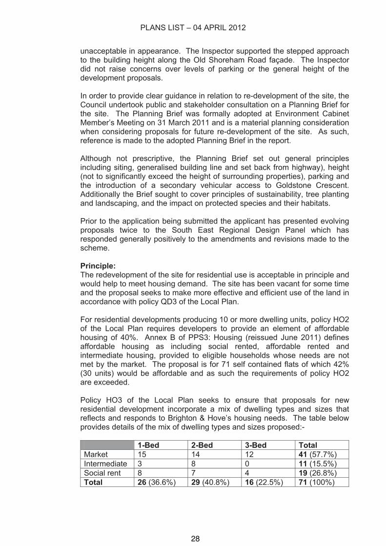
Policy HO3 of the Local Plan seeks to ensure that proposals for new residential development incorporate a mix of dwelling types and sizes that reflects and responds to Brighton & Hove’s housing needs. The table below provides details of the mix of dwelling types and sizes proposed:-
1-Bed 2-Bed 3-Bed Total
Market 15 14 12 41 (57.7%)
Intermediate 3 8 0 11 (15.5%)
Social rent 8 7 4 19 (26.8%)
Total 26 (36.6%) 29 (40.8%) 16 (22.5%) 71 (100%)
28
PLANS LIST – 04 APRIL 2012
Of the 30 affordable units proposed, 11 would be available for shared ownership and 19 as social rented accommodation. The mix of affordable dwelling types breaks down to a ratio split of 37/50/13 1-bed, 2-bed and 3-bed units whilst for the market housing the ratio is 37/34/29 1-bed, 2-bed and 3-bed units. The overall split would be 37/41/22 of 1-bed, 2-bed and 3-bed residential units.
The proposal also includes 5 affordable units which would be fully wheelchair accessible, which accords with the council’s Affordable Housing Brief. Both the proportion of affordable housing proposed, the mix of tenure types and the mix of dwelling sizes, are considered acceptable and both reflect and respond to the city’s housing needs. In these respects the proposal is welcomed by the council’s Housing Commissioning team and the application meets the requirements of policy HO3 of the Local Plan.
Policy QD3 of the Local Plan, which requires development to make effective and efficient use of a site, is linked with policy HO4. Policy HO4 permits residential development at higher densities than those typically found in the locality where it can be demonstrated that the proposal: a. exhibits high standards of design and architecture; b. includes a mix of dwelling types and sizes which reflect local needs; c. is well served by public transport, walking and cycling routes, local
services and community facilities; and d. respects the capacity of the local area to accommodate additional
dwellings.
The proposed density of the development would be 206 dwellings per hectare (dph) and this is higher than those of adjacent sites which are referred to in the adopted Planning Brief for the Park House site. Adjoining Hove Park Manor and Gannet House are 70dph and the semi-detached villas opposite, on the southern side of Old Shoreham Road, are 29dph. However, the density of the development is related to the design and appearance of the proposal, and if this is well related and integrated with its surroundings, the density in itself is also acceptable. The Inspector’s decision with regards to the previous applications of 2008 and 2009 does not refer to the density as a reason in itself for upholding the council’s decisions to refuse these applications, but rather certain issues in the design and appearance needed to be resolved. The proposed density is considered acceptable and accords with policies QD3 and HO4 and the Planning Policy team is in agreement that provided the design of the scheme is acceptable they have no objection to the density.
Design:The existing buildings within the site are linked together and are set back from the street frontages. The proposed development follows a similar footprint and although brought forward to create more open space behind the building, the set backs from Goldstone Crescent and Old Shoreham Road are sufficient and follow the generalised building lines between the frontage of Hove Park Manor and the top of Fonthill Road, and the set backs of the villas opposite the site on the southern side of Old Shoreham Road. These set
29
PLANS LIST – 04 APRIL 2012
backs help maintain the existing character and sense of enclosure experienced when passing through the area, and are considered appropriate and in accordance with the adopted Planning Brief for the site.
In terms of height, the proposed building would be 5 storeys, the top attic storey would be set back a minimum of 1 metre from the front elevation of the lower storeys in order to appear more recessive and reduce the visual impact in terms of bulk and height. The site is on a hillside sloping upwards in a west-east direction and the Old Shoreham Road façade is cranked to follow the line of the road and also steps up in height to give the development the appearance of three buildings which gradually step upwards in harmony with the natural topography.
The adopted Planning Brief for the site does not identify a maximum or minimum number of storeys that would be acceptable but refers to the heights of adjoining developments and an established generalised height line. Redevelopment of the site is expected to incorporate a varied and interesting roofline but the overall height should not rise significantly above the generalised height line or break the skyline in long views.
The generalised height line follows the villas at the top end of Fonthill Road and Old Shoreham Road, which are two storey with pitched roofs and which are built on plinths which are higher than street level; and the top of Hove Park Manor, which is a 3 storey flat roof block of flats again at higher level than the street because it is built on a grassy bank. It is along this plane that longer views of the proposed development would be more readily visible from along Old Shoreham Road. The generalised height line along the east-west axis follows the height of Park House itself and the rising ground level owing to the hillside topography.
The height of the proposed development would not significantly rise above either of the generalised height lines contained in the Planning Brief and it should be noted that the first and second floors of the development would be lower than the ground and first floor storeys of Hove Park Manor, because that block is built on a grassy bank that is more than one storey high. The top edge of the proposed building, excluding the attic storey, aligns with the top of Hove Park Manor and the ridge height of building at the top of Fonthill Road and similarly, the Old Shoreham Road frontage steps up in height along the generalised height line given by the existing Park House building. The villas opposite on the southern side of Old Shoreham Road also step upwards as ground level naturally rises.
The attic storey of the development would exceed the established generalised height lines but would be set well back from the facades of the building and would not appear as a full extra storey owing to the parapet walls rising in front of it. As such the bulk, massing and height of the fifth storey would be sufficiently mitigated and preclude the development appearing unduly high in relation to its surroundings.
The height of the proposal would not break the skyline in long views. At
30
PLANS LIST – 04 APRIL 2012
present Gannet House rises up behind existing buildings on the Park House site in longer views. This is due to the rising ground level. Behind Gannet House and along the edge of Hove Recreation Ground, there are established trees which are higher still, and form the backdrop to the development site. In longer views from a westerly direction across Hove Park and along Old Shoreham Road, the proposed development would not rise above the height of existing trees both in front of the site or the tree line behind the application site. It is the tree line which forms the skyline and the proposed development would not break that line. This is illustrated by the accurate computer generated image pack submitted by the applicant.
The proposed external finishes would be a light facing brick to the walls and zinc to the attic storey. The zinc would weather to a light, matt grey colour and the Weinerberger-Hurstwood Multi facing brick has been chosen to give the building a light and contemporary appearance whilst also blending in with existing buildings near to the site which are built from light or yellow bricks. Similarly, the boundary wall around the site would be of matching brickwork. This approach is supported by the adopted Planning Brief.
The windows would be made from timber with an aluminium finish and balconies balustrades are proposed to be glass with stainless steel handrails whilst the platforms would be edged in steel C-section channels powder coated grey. The glass balustrades would slot into a channel fixing behind the steel C-section so that no fixing would be visible on the glass panels themselves. The ground level terraces would feature areas of hardwood decking and stone paving.
The two longer frontages onto Goldstone Crescent and Old Shoreham Road feature strong vertical columns and projections similar to bays, that would articulate and relieve these facades and reflect the scale of detailing on neighbouring buildings, such as the bay frontages of properties in Fonthill Road. The balconies would be suspended between the projecting and recessed lines of the façade whilst a clear pattern in the alignment and width of windows on each floor has been incorporated appropriately into the design. The fenestration detail of the attic storey continues up from the windows and brick uprights and balconies of the floors below and the form, set back and stepped heights of the attic storey would give the building an attractive silhouette and address the concerns raised by the Planning Inspector in relation the scheme submitted in 2008 and 2009. In addition, at the junction with Goldstone Crescent and Old Shoreham Road the building would have a corner feature of tinted glass which would add architectural interest to this important corner elevation, and this would be reflected at the corner adjacent to Hove Park Gardens also. The setting of the building would also be well landscaped and this accords with the adopted Planning Brief.
The design, detailing and palette of materials and finishes proposed are considered of satisfactory quality and represent a high quality of design which is appropriate to the site and the scale of development proposed.
31
PLANS LIST – 04 APRIL 2012
Landscaping:Policy QD15 of the Local Plan requires proposals to submit details to show that adequate consideration has been given to landscape design, including all the spaces between and around buildings, at an early stage in the design process. The adopted Planning Brief states landscaping should be an intrinsic part of the overall design concept and make effective use of existing landscape features, particularly due to the park side location of the application site.
Policy QD16 requires the application to accurately identify existing trees, shrubs and hedgerows; and seek to retain existing trees and hedgerows. The planting of native species will be sought where appropriate. In addition, development in the vicinity of trees to be retained should make adequate provision to protect those trees. The adopted Planning Brief for the site states that some tree groups and specimens are important landscape features which positively contribute to the character of the area and the retention of these features is desirable. However, if the loss of existing trees is unavoidable (for example if their retention would render development unviable), mitigation should be sought in the form of new tree planting and landscaping.
The applicant has submitted a landscaping scheme which would be well integrated with the development and the proposed communal garden to the rear of the building, together with the balconies and garden terraces, would help to soften and integrate the built form with its surroundings.
There is a row of 5 Elm trees along the boundary of the site between the side of Hove Park Manor and these are protected by a Tree Preservation Order. The applicant has shown that these trees would be retained and protected during construction works. A planning condition is recommended to ensure these trees are protected.
Overall there are 56 trees within the application site. The applicant has submitted an Arboricultural Report which identifies 6 of those trees to be dead, dying or dangerous and appropriate to be removed (category R). 36 of the trees are identified as being of low quality and value, with poor crown form and asymmetry for example (category C). 14 trees fall into category B and their retention would be desirable, whilst no trees within the site have been identified as category A (of high quality and value).
It is proposed that 22 category C trees and 5 of the category B trees would require removal to accommodate the re-development of the site as submitted. The removal of the category C trees should not represent a constraint to redevelopment and their removal would be necessary to maximise appropriate use of the site.
Therefore, notwithstanding the category R trees to be removed, 23 of the existing trees would remain on site as part of the proposal. These trees are shown on drawing J37.82/03 and include the London Plane tree on the public footway outside the site along Old Shoreham Road; a row of 3 trees alongside Hove Park Gardens; and 19 trees (included the protected Elm
32
PLANS LIST – 04 APRIL 2012
trees) between the rear boundary of the site and Hove Park Manor and Gannet House.
The applicant proposes to plant replacement trees to mitigate the loss of existing trees within the site and this is shown by drawing OHP-ND-001. Eight trees, including 5 along the Old Shoreham Road frontage and at the corner of the crossroads junction, and 3 along the Goldstone Crescent frontage. These would help preserve and enhance the green corridor link between Hove Recreation Ground and Hove Park and are considered appropriate to the parkland setting of the application site. The trees proposed would be Hornbeams, and the Landscape Specification document submitted by the applicant describes these as having a pyramidal shape growing up to 20m in height and 8m across. These trees can grow in restricted areas. In addition the Planning Statement submitted proposes these trees will be procured and planted at a stage of height and maturity that would provide immediate visual effect. A planning condition is recommended to secure the precise details and tree size specification at time of planting.
Furthermore, the applicant proposes Birch trees at the four pedestrian entrances to the proposed development and the Landscape Specification submitted together with drawings OHP-ND-002, OHP-ND-003 and OHP-ND-004, provide full details of the proposed private terraces, gardens and balconies, including water features and details of surfacing materials. The hard surfaced areas would be permeable to allow for natural drainage of surface run-off water within the site.
No objection has been received from the Council Arboriculturalist subject to conditions for the protection of existing trees to be retained within the site, and the landscaping proposal is considered acceptable and sufficient to mitigate the impact of the development.
Impact on Amenity: Future occupiers-The unit sizes range between 45-65 square metres for 1-bed flats; 66-91 square metres for 2-bed flats; and 78-100 square metres for the 3-bed units. As a registered social landlord, the applicant has designed all the affordable units to meet the minimum required sizes and meet Lifetime Home standards and the applicant has extended this approach into the market housing also, which is welcomed. As such the proposal is supported by the Housing Commissioning team and Access Officer, and would meet the requirements of policy HO13 of the Local Plan.
For residential proposals in excess of 10 units, policy HO13 also requires 5% of the units to be wheelchair accessible (in this case 3.5 units) and for 10% of the affordable units to be wheelchair accessible (3 units) in order to meet registered need.
Wheelchair access is shown at ground level for the market housing element of the scheme off Goldstone Crescent, and 5 no. fully wheelchair accessible flat in the affordable rented element, a mixture of 1-bed and 2-bed units.
33
PLANS LIST – 04 APRIL 2012
There is no objection from the council’s Accessibility Officer and the Housing team welcomes the provision of 5 wheelchair accessible units within the affordable rented element of the proposal.
In order to meet the requirements of policy HO5 of the Local Plan, the development should provide private and useable amenity space which is appropriate to the scale and nature of the development. In this instance each of the flats would benefit from a good sized private terrace at ground level, balconies on the upper floors and substantial areas of roof terrace at attic storey level. The amount of private and useable amenity space provided meets or exceeds the minimum levels required to meet Code for Sustainable Homes criteria and all would be accessible from living areas.
In order to meet the requirements of policy HO6 of the Local Plan, and those of the adopted Planning Brief, new residential development should suitably provide for the demand for outdoor recreation space generated in accordance with a standard of 2.4 hectares per 1000 population or part thereof; or any subsequent standard adopted by the council following a local assessment of needs and audits of open space and sport and recreation facilities. This provision must be split appropriately between children’s equipped play space, casual/informal play space and adult/youth outdoor sports facilities.
Where it is not practicable or appropriate for all or part of the outdoor recreation space requirements to be provided on site, contributions to their provision on a suitable alternative site may be acceptable. The provision of outdoor recreation space will be in addition to incidental amenity and landscaped areas.
The site lies between Hove Park and Hove Park Recreation Ground. Near to the site is a public bridleway (part of an established long distance route dating back to the 17th century known as ‘Monarch’s Way’ and which forms part of a designated Greenway (policy QD19 of the Local Plan).
The applicant recognises the importance of the parkland setting of the site between Hove Park and Hove Recreation Ground and professional landscape architect has produced a scheme which would form a continuous green corridor through the site, from the line of protected trees alongside the boundary with Hove Park Manor to a planted communal garden to the rear of the building, featuring planted retaining walls and raised planted beds. This communal garden would be situated over part of the basement level parking areas.
In terms of on site childrens equipped play the Inspector when determining the appeals in relation to the two previous applications, considered that there is opportunity to provide children’s play facilities on-site and that this would be desirable. This would allow access to an area for play and for parents or guardians to meet for short periods close to home at times when a trip out to the nearby Hover Park or Hove Recreation Ground might not be possible or convenient. However, SPGBH9 calculates the proposal would create demand for 92 square metres of equipped play area whilst the minimum area
34
PLANS LIST – 04 APRIL 2012
sought by the council to form a sustainable and meaningful equipped play area is 400 square metres.
Therefore it would not be appropriate to provide such a small amount of equipped play space on-site and this should be sought off-site and nearby. Hove Park and Hove Recreation Ground can provide outdoor space for the development but improvements would need to be made to add capacity and improve quality. A contribution calculated at £180,000.00 is appropriate.
It should be noted that this is also required by the adopted Planning Brief for the site, and that the Inspector attached full weight to the requirement of such a contribution in order that outdoor recreation facilities are available for the new occupiers of the proposed development without adversely affecting the existing users of those facilities, e.g. Hove Park and Hove Recreation Ground.
The applicant has submitted a ‘Place Making Strategy’ document which describes provision of local history based games and trails around Hove Park. Such provision would need to tie in with the Council’s strategy for improving Hove Park and the strategy proposed by the applicant has not been costed up. The strategy may be useful in guiding the spending of monies secure by s106 Agreement pursuant to meeting the requirements of the development under policy HO6.
The site allocated next to Old Shoreham Road, which is a busy arterial route in and out of the city. The site is not identified as an air quality ‘hotspot’ or Air Quality Management Area (AQMA).
PPG24: Planning and Noise provides planning guidance relation to residential development proposals near to sources of noise. Policies SU9 and SU10 of the Local Plan require that for permission to be granted for development on such a site the effect of future occupiers and users should not be detrimental and measures should be taken to alleviate effectively potential problems. Planning permission will not be granted if users of a proposed development would be affected adversely by noise. Policy QD27 of the Local Plan also seeks to safeguard future occupiers from material nuisance and loss of amenity.
The applicant has submitted a noise assessment report which concludes the front elevations of the proposed building would fall into Noise Exposure Category (NEC) C, whilst the rear elevations of the building would fall into NEC A.
For the front elevations category C, the noise report recommends a reasonable standard of internal noise could be achieved if standard thermal double glazing is used and the windows remain closed. If however, the windows are partially open to allow for ventilation, the reasonable standard of internal noise levels would be exceeded. Therefore, to ensure adequate protection against noise from Old Shoreham Road and Goldstone Crescent, an alternative ventilation strategy to opening the windows should be provided. One such alternative is passive ventilation such as wall vents or trickle vents.
35
PLANS LIST – 04 APRIL 2012
The Environmental Health team raises no objection in respect of the noise report, subject to a planning condition requiring precise details of the alternative ventilation strategy to be employed.
The applicant has also submitted a daylight analysis of the proposed development which concludes for all habitable rooms in the development levels of internal daylight would pass the criteria set out by the BRE’s Code for Sustainable Homes and that average daylight factor results for all habitable rooms exceed the minimum daylight levels required by BS standards, Code for Sustainable Homes and the BRE guidelines.
In terms of provision of waste and recycling facilities the applicant proposes secure enclosures near to the entrances to the building for communal waste storage and recycling and this is considered acceptable.
Adjoining occupiersPolicy QD27 seeks to ensure that planning permission for any development will not be granted where it would cause material nuisance and loss of amenity to existing and adjacent residents or where it is liable to be detrimental to human health. Neighbours can be affected by changes in overlooking, privacy, daylight, sunlight, disturbance and outlook.
The Goldstone Crescent façade of the proposed development would have an aspect across Hove Park to the west and is not considered likely to cause overshadowing or loss of privacy. Similarly, to the east of the application site is an access road and Hove Recreation Ground and as such there are no residents who would be affected by the development on this side.
In addition, the two northern most flank elevations of the development would be a minimum of 6.4m from Hove Park Manor and 9m from Gannet House respectively. There are no habitable room windows or openings on the flank elevations of Hove Park Manor or Gannet House which would be susceptible to loss of light and overshadowing. Further, between Hove Park Manor and Gannet House there is car parking and garaging for those flats and the siting of the proposed development is such that the east facing windows on the rear of the Goldstone Crescent block, and the northern facing rear windows to the Old Shoreham Road block, would be between 26m and 37m from windows on the front elevation of Gannet House and in excess of 49m from the rear elevation Hove Park Manor respectively and for those windows with a direct line of sight.
These separation distances are acceptable to preclude mutual overlooking, loss of privacy and shadow cast.
Turning to the amenity impact of the proposal opposite the application, nos. 84 to 96 Old Shoreham Road, it should be noted the facades of the proposed building would be set back a minimum of 4m from the edge of public footway and that the road and pavements between are 16.6m in width. Taking into account the front gardens of the houses in Old Shoreham Road, from the edge of the proposed balconies to the front elevations of the properties
36
PLANS LIST – 04 APRIL 2012
opposite would be a minimum of 26m.
The houses in Old Shoreham Road step up in height corresponding to the upward slope of the road, and those houses on the approach to the junction with Fonthill Road are built at higher level than the street and accessed up front steps to a raised ground floor level. The section drawing submitted (Y023-021 Revision D) shows that ground floor level of 94 Old Shoreham Road is approximately the same height as first floor level of the intermediate housing element of the proposal. The eaves height of the house aligns approximately with the second floor level of the intermediate housing block. The fourth storey is approximately the same height as the ridge of the roof to 94 Old Shoreham Road and is the only storey which would be higher than the second floor windows of the houses opposite, whilst the proposed attic storey would be set back 2.2m from the front edge of the building and views into properties on the opposite side of Old Shoreham Road would be prevented by the proposed balustrade around the terraces on the roof of the building.
It is therefore considered that by reason of the separation distance, the presence of the wide public highway, the set back of the proposed attic storey and the fact properties on the opposite side of Old Shoreham Road are raised above street level and also step up in height following the natural topography of the hillside, that these factors would sufficiently preclude overlooking and loss of privacy. In addition, the proposed tree planting discussed previously would also help to mitigate potential overlooking by screening the properties from one another.
Sustainable Transport: Four pedestrian entrances to the development are proposed. These would be directly connected to the public footway with graded pathways. In addition, pedestrian access directly from the car and cycle parking areas underneath the building could be achieved via internal staircases and the four lifts proposed. Furthermore, the existing pedestrian access through to the rear of Gannet House via Hove Park Gardens would be retained. It is understood that this is a public right of way. This is considered to be a satisfactory degree of integration with the existing pedestrian network and demonstrates a good level of connectivity.
There is existing vehicular access to the site from both Goldstone Crescent and Old Shoreham Road. The application proposes two vehicular accesses off both Goldstone Crescent and Old Shoreham Road via Hove Park Gardens.
The Goldstone Crescent access would incorporate an area for vehicles to pass clear of the highway for vehicles entering and leaving the site simultaneously. A controlled gateway in the undercroft would pass down into basement level parking for 46 car parking spaces, some of which are over-sized to allow for disabled parking (e.g. spaces 8 and 46). In the basement parking area, secure, covered and lit cycle parking would be provided for 71 cycles in three separate storage facilities close to the basement parking entrance or internal stair and lift access to the flats above.
37
PLANS LIST – 04 APRIL 2012
The second access via Hove Park Gardens would lead around the back of the affordable rental element of the development to a ramp down to a second basement parking area providing for 12 cars, again with direct internal access to the flats above via stairs or a lift. The area of basement parking would be over the top of the far end of the Goldstone Crescent accessed basement car park, and hence would be two levels of parking. The Hove Park Gardens area would also have surface parking for 13 cars, including 5 disabled spaces which would be covered by an open sided canopy. Ground level access to secure and covered cycle parking for up to 25 cycles would be provided for the affordable rented block also. The 24 cycle parking spaces for the intermediate housing would be covered and secure and situated conveniently next to the front entrance to the block.
In total 71 car parking spaces are proposed and 126 cycle parking spaces, including 6 visitors’ cycle parking spaces in front of the Goldstone Crescent block.
Each of the car parking spaces would have an electric vehicle charging point in order to future proof the development and to encourage the use of emission free vehicles.
These levels of parking accord with the maximum standards set out in SPGBH4: Parking Standards (71 spaces at 1 space per dwelling) and exceeds by 31 spaces the minimum level of cycle parking required (1 secure space per unit and 1 space per 3 dwellings for visitors). All of the cycle parking facilities would be secure, convenient to access, covered and lit.
The Transport Assessment submitted with the application provides evidence that there is sufficient on-street parking capacity to accommodate visitor parking to the development.
In terms of additional traffic movements generated by the proposed development, using National Census data it would be expected to require 59 car parking spaces for residents and a further 14 spaces for visitors, making a total of 73 spaces. As such the provision of 71 spaces leaves a shortfall of 2 parking spaces. However, the applicant also proposes to provide for a car club parking space next to the site in Goldstone Crescent. This is welcomed and would help provide for the transport demand generated by the development and discourage private car use and/or ownership. The provision of a car club parking space should reduce the local demand for car parking by 5 spaces and the city car club has expressed an interest in providing a car at this location. The Transport Assessment submitted states that existing traffic light junctions adjacent to the site have sufficient capacity and subject to highway improvements, for example the painting of Keep Clear road markings, there would not be a significant reduction in highway safety.
The applicant proposes to offer 2 car club parking bays and to cover the cost of setting up the spaces and the first two years’ membership fees for future occupiers of the proposed development.
38
PLANS LIST – 04 APRIL 2012
Accordingly it is considered the proposal is compliant with policies TR1, TR14 and TR19 of the Local Plan.
The application site is within walking distance of Hove railway station but is not served by frequent bus services stopping near to the site. The nearest bus stop is Hove Park Villas which is 200m to the east. Policy TR3 of the Local Plan states planning permission will be granted for development proposals in areas of low public transport accessibility where applicants enter into a legal agreement to eliminate or reduce their car parking requirement by preparing, implementing and monitoring a ‘travel plan’ and where the development incorporates substantial public transport and/or sustainable travel improvements that improve the accessibility rating of the site. Policy TR5 provides support for bus priority measures where feasible along the defined Sustainable Transport Corridors, and this is considered appropriate as Old Shoreham Road is cited as a busy arterial route across the city in the adopted Planning Brief for the site.
Transport Planning has identified that in order to address the additional demand placed on public transport infrastructure as a result of the development, contributions should be sought by way of s106 Agreement to improve existing bus stops by providing better weather protection, real-time information and improved accessibility. In addition the applicant should provide for road safety markings in the vicinity of the development in order to reduce the risk to highway safety and improve traffic flows.
The contribution to be secured has been agreed with the applicant is £53,000.00 which would be used to improve footway accessibility; provide and install real-time bus information and shelters to the two bus stops in Old Shoreham Road nearest the site; the painting of ‘Keep Clear’ road markings; and monies to help provide a car club parking bay on Goldstone Crescent, in front of the proposed development.
Sustainability: Policy SU2 of the Local Plan states planning permission will be granted which demonstrate a high standard of efficiency in the use of energy, water and materials provided that they are otherwise in accordance with the other policies of the development plan. Supplementary Planning Document SPD08: Sustainable Building Design, recommends that new build residential developments of more than 10 residential units on previously developed land should achieve Level 4 of the Code for Sustainable Homes, meet lifetime home standards and have a zero net annual carbon dioxide emission level from energy use.
As well as submitting a sustainability checklist, the applicant has also submitted an independent Sustainability Report. The development is committed to achieving Code Level 4 and incorporates air source heath pumps for each unit to serve heating and hot water requirements as a low carbon heat source; a 33 Kilowatt array of photovoltaic solar panels on the two lower flat roofs of the building; and a range or high performance passive measures such as mechanical ventilation with heat recovery, low building U-
39
PLANS LIST – 04 APRIL 2012
values and a good air permeability rate. The development would achieve a 25% reduction in carbon emissions over the current Building Regulations requirements (2010) and at least 20% of the site energy demand would be from the low or zero carbon heat source and renewable energy technologies. The minimum efficiency of 20% above current Building Regulations is cited in the adopted Planning Brief for the site whilst the zero carbon requirement contained in SPD08 is currently being waived due to the economic climate.
The provision of 126 cycle parking spaces, Lifetime Home standards and adoption of the Considerate Constructors’ Scheme are compliant and help meet maximum standards under the Code for Sustainable Homes.
There is no objection from the Sustainability Officer and the sustainability checklist, Sustainability Report and Code ‘pre-assessment report’ together with a report showing energy modelling using SAP, reflect a good level of preparation to ensure that sustainability standards comply with policy SU2 and SPD08.
Ecology/Nature Conservation:Policy QD17 of the Local Plan states development proposals affecting nature conservation features outside protected sites will only be granted provided the proposal can be subject to conditions that prevent damaging impacts on those features; or the impact is minimised and as many existing features as possible are protected and enhanced and compensating and equivalent features are provided for any that are lost or damaged. Policy QD18 states that where it is evident that a proposal could directly or indirectly affect a protected species, the applicant will be required to undertake an appropriate site investigation. Measures will be required to avoid any harmful impact of a proposed development on such species and their habitats. Where practicable the developer will be expected to enhance the habitat of the respective species. Permission will not be granted for any development that would be liable to cause demonstrable harm to such species and their habitats.
SPD11: Nature Conservation and Development, states it is essential that adequate ecological information is gained from the earliest stages of all development proposals.
There are known to be badgers residing on the site and these and their habitat are protected by the Protection of Badgers Act 1992. The requirement to take into account badgers residing within the application site is made clear in the adopted Planning Brief for the site.
The applicant has submitted a Phase 1 Habitat and Protected Species Report which states there is no evidence of bats within the site, but there is a badger sett.
The current proposal is not considered likely to intersect with any subterranean workings of the badger sett but demolition of the existing buildings on the site will require a disturbance licence from Natural England and should take place only between 1 July and 30 November to be
40
PLANS LIST – 04 APRIL 2012
constrained outside of the badger breeding season. Works in the vicinity of the badger sett would need to be guided by a detailed working method statement. The badger sett is located within a bund at the northwest corner of the site and may overlap under the boundary with the adjoining flats. The report concludes that final landscaping of the proposed development could incorporate the needs of badgers and that a sufficient buffer area around the sett and a corridor of movement across the site from east to west should be retained to enable badger foraging.
The proposals submitted indicate that a tree lined space between the site and Hove Park Manor, going eastwards to Hove Recreation Ground and overlapping with the grounds of Gannet House adjacent, would be retained.
The badger licence cannot be obtained from Natural England before planning permission is granted. However, the outline mitigation strategy for badgers submitted in the Phase 1 survey has been agreed in principle by Natural England.
In addition, the report recommends woody vegetation is cleared from the site outside of the bird nesting season to avoid an offence under the Wildlife and Countryside Act 1981 and provision for nesting birds (and roosting bats) is proposed by the provision of four bird boxes and four bat boxes.
The Council Ecologist raises no objection to the above.
However, the requirements for nature conservation enhancement are not sufficiently addressed in the application. The sustainability checklist submitted states 720 square metres of semi natural habitat would be provided and a 71 square metre roof garden. No further detail is provided.
The Phase 1 survey does, however, suggest habitat enhancement measures such as native trees, shrubs and plants, including climbing plants on walls and fences, to encourage foraging birds and insects, and also adoption of sustainable horticulture management practices, for example use of peat-free composts, mulches and soil conditioners and minimising use of pesticides. Organic based fertilisers and organic material for example from composted waste could be used.
The survey also recommends ‘woodcrete’ bird nesting and bat roosting boxes.
These measures would be acceptable to the Council Ecologist and it is suggested a planning condition is imposed to secure the provision of these biodiversity enhancement measures.
Other Considerations: The application site is considered to be potentially contaminated land owing to former uses as chalk and lime pits and over time the voids left by these uses could have been filled with materials which are not known. On the recommendation of both Environmental Health and in order to comply with
41
PLANS LIST – 04 APRIL 2012
policy SU11 of the Local Plan, a minimum of a desktop study into potential contamination of the land, together with remediation measures as appropriate is required and can be secured by planning condition. The applicant has submitted with the application a Phase 1 Preliminary Contamination Assessment Report which has been seen by Environmental Health and indicates the imposition of the sequential condition to deal with potentially contaminated land is appropriate.
The County Archaeologist advises there is no recorded archaeology on the site prior to an 18/19th century chalk pit. However, there are a number of known sites in the area which together with the known archaeology of the broader Downland landscape, would suggest there is a possibility that there are archaeological remains preserved on the site that may be damaged or destroyed by the proposed development. The applicant has submitted a desk-based Archaeological report which recommends a programme of archaeological assessment should be carried out before building work commences. This recommendation is supported by the County Archaeologist which recommends a condition be imposed requiring details of a programme of archaeological works to enable any archaeological deposits and features disturbed during the works to be adequately recorded. As such the application is in accord with the requirements of policy HE12 of the Local Plan which requires the relative archaeological importance of the site to be considered against the need for the proposal and be satisfied that adverse impacts are minimised. The recording and/or specialist excavation of archaeological items before and during development meets the requirements of policy HE12.
9 CONCLUSION The demolition of existing buildings and redevelopment of the site for residential use is acceptable in principle. The proposed mix of units to provide affordable housing and a mix of dwelling sizes is welcomed and both reflects and responds to housing need in Brighton & Hove. In terms of form, design, siting and external materials the proposal has responded to the previous appeal decisions and the general framework set out in the adopted Planning Brief for the site. The position of the proposed building, the height, bulk and appearance are considered appropriate to the site context and would enhance the appearance of this prominent corner site and it would not detract from the character of the area. The applicant proposes a quality landscaping and tree planting scheme which would respond well to the parkland setting of the site.
The design and layout of the scheme, including provision of private useable amenity spaces, the floor areas of each unit, together with the relationship with existing buildings is such that both future occupiers’ and existing neighbour amenity would not be significantly adversely affected.
The proposal seeks to provide for the transport demand generated by the development providing satisfactory car parking and cycle parking facilities on site, together with provision of 2 car club parking spaces on the highway.
42
PLANS LIST – 04 APRIL 2012
The application proposed electric vehicle charging points, food growing facilities for future residents and a high level of sustainable in terms of building design, achieving a minimum of Code Level 4 of the Code for Sustainable Homes and utilising renewable energy sources such as solar power and air source heat pumps.
The application takes into consideration both protected trees within the site and also the presence of protected species such as badgers and the proposed strategies to mitigate the impact of the development on protected species and also enhance biodiversity within the development are considered to be appropriate.
In view of the above the scheme is considered to be acceptable subject to conditions and completion of a s106 Agreement.
10 EQUALITIES IMPLICATIONS The development provides fully wheelchair accessible units and disabled parking spaces and should be constructed to meet Lifetime Homes standards.
43
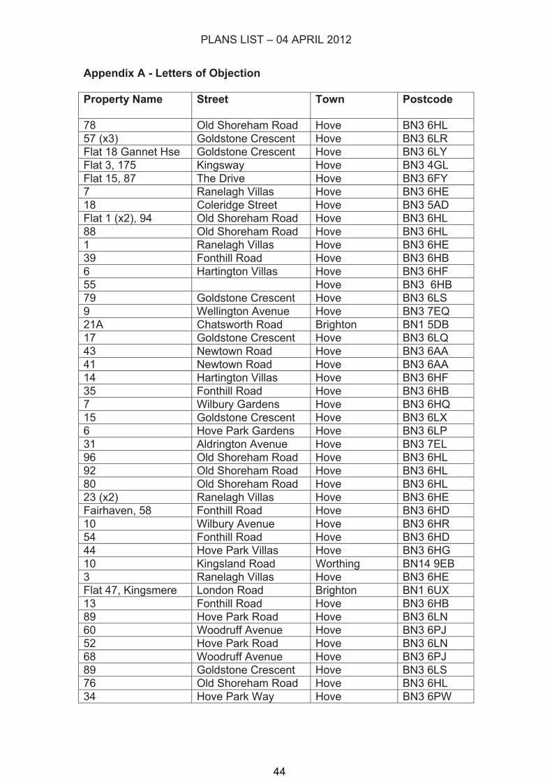
PLANS LIST – 04 APRIL 2012
Appendix A - Letters of Objection
Property Name Street Town Postcode
78 Old Shoreham Road Hove BN3 6HL
57 (x3) Goldstone Crescent Hove BN3 6LR
Flat 18 Gannet Hse Goldstone Crescent Hove BN3 6LY
Flat 3, 175 Kingsway Hove BN3 4GL
Flat 15, 87 The Drive Hove BN3 6FY
7 Ranelagh Villas Hove BN3 6HE
18 Coleridge Street Hove BN3 5AD
Flat 1 (x2), 94 Old Shoreham Road Hove BN3 6HL
88 Old Shoreham Road Hove BN3 6HL
1 Ranelagh Villas Hove BN3 6HE
39 Fonthill Road Hove BN3 6HB
6 Hartington Villas Hove BN3 6HF
55 Hove BN3 6HB
79 Goldstone Crescent Hove BN3 6LS
9 Wellington Avenue Hove BN3 7EQ
21A Chatsworth Road Brighton BN1 5DB
17 Goldstone Crescent Hove BN3 6LQ
43 Newtown Road Hove BN3 6AA
41 Newtown Road Hove BN3 6AA
14 Hartington Villas Hove BN3 6HF
35 Fonthill Road Hove BN3 6HB
7 Wilbury Gardens Hove BN3 6HQ
15 Goldstone Crescent Hove BN3 6LX
6 Hove Park Gardens Hove BN3 6LP
31 Aldrington Avenue Hove BN3 7EL
96 Old Shoreham Road Hove BN3 6HL
92 Old Shoreham Road Hove BN3 6HL
80 Old Shoreham Road Hove BN3 6HL
23 (x2) Ranelagh Villas Hove BN3 6HE
Fairhaven, 58 Fonthill Road Hove BN3 6HD
10 Wilbury Avenue Hove BN3 6HR
54 Fonthill Road Hove BN3 6HD
44 Hove Park Villas Hove BN3 6HG
10 Kingsland Road Worthing BN14 9EB
3 Ranelagh Villas Hove BN3 6HE
Flat 47, Kingsmere London Road Brighton BN1 6UX
13 Fonthill Road Hove BN3 6HB
89 Hove Park Road Hove BN3 6LN
60 Woodruff Avenue Hove BN3 6PJ
52 Hove Park Road Hove BN3 6LN
68 Woodruff Avenue Hove BN3 6PJ
89 Goldstone Crescent Hove BN3 6LS
76 Old Shoreham Road Hove BN3 6HL
34 Hove Park Way Hove BN3 6PW
44

PLANS LIST – 04 APRIL 2012
29 Hove Park Way Hove BN3 6PT
43 Goldstone Crescent Hove BN3 6LR
41 Hove Park Way Hove BN3 6PW
45

Park House
Recreation
Ground
House
32.4m
42.1m
37.0m
38.2m
43.4m
37.2
m
44.27m
38.3
0m
Gannet
CR
ES
CE
NT
GO
LD
ST
ON
E
Hove
Park
Manor
HO
VE
PA
RK
GA
RD
EN
S
to
5
53
84
19
1to
67
to12
72
35
13 to 18
19
to33
50
13
1
96
65
17
2
44
60
51
75
61
6
46
7
Sub Sta
LB
Recreation
House
84
72
1
(c) Crown Copyright. All rights reserved. Licence: 100020999, Brighton & Hove City Council. 2012.
BH2012/00114 Park House, Old Shoreham Road
1:1,250Scale: ̄ 46

PLANS LIST – 04 APRIL 2012
COUNCILLOR REPRESENTATION
47

48