Embed Size (px)
Citation preview
- 1 -
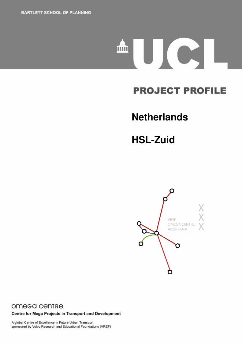
Netherlands HSL-Zuid
- 2 -
This report was compiled by the Dutch OMEGA Team, Amsterdam Institute for Metropolitan Studies, University of Amsterdam, the Netherlands. Please Note: This Project Profile has been prepared as part of the ongoing OMEGA Centre of Excellence work on Mega Urban Transport Projects. The information presented in the Profile is essentially a 'work in progress' and will be updated/amended as necessary as work proceeds. Readers are therefore advised to periodically check for any updates or revisions. The Centre and its collaborators/partners have obtained data from sources believed to be reliable and have made every reasonable effort to ensure its accuracy. However, the Centre and its collaborators/partners cannot assume responsibility for errors and omissions in the data nor in the documentation accompanying them.
- 3 -
CONTENTS
A PROJECT INTRODUCTION Type of project
• Project name
• Technical specification
• Principal transport nodes
• Major associated developments
• Parent projects Spatial extent
• Bridge over the Hollands Diep
• Tunnel Green Heart Current status B PROJECT BACKGROUND Principal project objectives Key enabling mechanisms and decision to proceed
• Financing from earth gas
• Compensation to Belgium Main organisations involved
• Feasibility studies
• HSL Zuid project team
• NS – the Dutch Railways
• The broad coalition Planning and environmental regime
• Planning regime
• Environmental statements and outcomes related to the project
• Overview of public consultation
• Regeneration, archaeology and heritage
• Project appraisal methods
• Complaints procedures Land acquisition
• Number of compulsory acquisitions C PRINCIPAL PROJECT CHARACTERISTICS Detailed description of route Main and intermediate travel nodes
• Amsterdam Central Station
• Schipol Airport
• Rotterdam Central Station
• The Hague Central Station
• Breda
• Planning context Project costs Timeline/overview of project delivery Main engineering features
- 4 -
D PROJECT TIMELINE Key issues E PROJECT FUNDING/FINANCING Overview of project funding Background to funding/financing Traffic forecasts and financing/funding response Funding sources F OPERATIONS G BIBLIOGRAPHY
- 5 -
List of figures
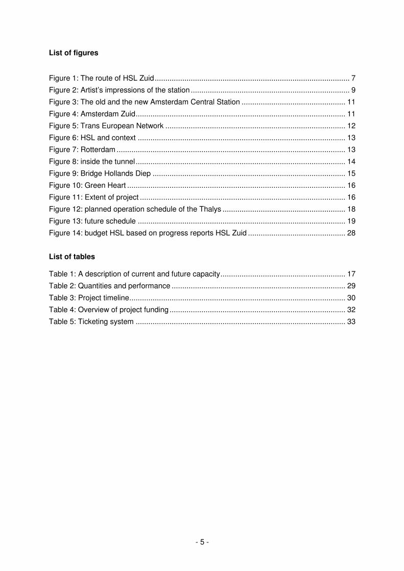
Figure 1: The route of HSL Zuid............................................................................................ 7
Figure 2: Artist’s impressions of the station ........................................................................... 9
Figure 3: The old and the new Amsterdam Central Station ................................................. 11
Figure 4: Amsterdam Zuid................................................................................................... 11
Figure 5: Trans European Network ..................................................................................... 12
Figure 6: HSL and context .................................................................................................. 13
Figure 7: Rotterdam ............................................................................................................ 13
Figure 8: inside the tunnel................................................................................................... 14
Figure 9: Bridge Hollands Diep ........................................................................................... 15
Figure 10: Green Heart ....................................................................................................... 16
Figure 11: Extent of project ................................................................................................. 16
Figure 12: planned operation schedule of the Thalys .......................................................... 18
Figure 13: future schedule .................................................................................................. 19
Figure 14: budget HSL based on progress reports HSL Zuid .............................................. 28
List of tables Table 1: A description of current and future capacity........................................................... 17
Table 2: Quantities and performance .................................................................................. 29
Table 3: Project timeline...................................................................................................... 30
Table 4: Overview of project funding ................................................................................... 32
Table 5: Ticketing system ................................................................................................... 33
- 6 -
A PROJECT INTRODUCTION
Type of project
The HSL Zuid is a high speed train line that links the Netherlands to the Trans European Network of High Speed Lines. It is a dedicated double track infrastructure project and is designed to have a maximum velocity of 300km/hour. It will be secured according to the latest European ERMTS standards. Figure 1 shows the route of the line on Dutch territory. Major redevelopment will take place at all the Dutch stations with the exception of Schiphol airport. Its main stations are:
• Amsterdam; • Schiphol/Amsterdam Airport; • Rotterdam.
Two other stations are connected through shuttle trains and can be considered part of the HSL network:
• The Hague; • Breda.
International stations that are part of the line are:
• Antwerp; • Brussels; • Paris.
The track of the HSL Zuid is 100km long of which 10km are existing track and the other 90km are RHEDA track. RHEDA is a Dutch type of slab track. It has higher stability, durability and gauge retention features than conventional track. There are four tunnels, one aqueduct and many overpasses and bridges. The longest bridge is 2km long and 24m high.
- 7 -
Figure 1: The route of HSL Zuid
Project name HSL Zuid. Dedicated High Speed Rail Connection. Built: 2000-2008. Located: From Amsterdam to Schiphol to Rotterdam to Breda to Belgian border. Owner: Ministry of Transport. Operator: NS Hispeed (NS & KLM).
- 8 -
Technical specification The track of the HSL Zuid is 100km long, of which 10km are existing track and the other 90km are RHEDA track. RHEDA is a Dutch type of slab track. It has higher stability, durability and gauge retention features than conventional track. The high speed train runs on 25,000 Volts. The security system used is ERMTS 3.0. For speech and data communication, GSM for Railways (GSM-R) is used. The whole Dutch train system has used GSM-R since 2003 and it was necessary to construct 300 base stations, make adjustments to 13 traffic control posts and instal special equipment in all railway tunnels (www.hslzuid.nl, November 2008). Principal transport nodes The HSL Zuid starts at Amsterdam Central station, although it is expected that its terminus will become Amsterdam Zuid, a prominent business district in the south of Amsterdam, as soon as the new station and new metroline are finished. It then slowly moves towards Schiphol-Amsterdam Airport, which is the main airport of the Netherlands and the one of the larger airports hubs in Europe. The train then continues through a long drilled tunnel under the Green Heart towards Rotterdam. This is one of the largest ports of the world and the second largest city in the Netherlands. Before Rotterdam it does not stop at The Hague, however a shuttle connection is made between The Hague and Rotterdam that connects to the high speed train at Rotterdam Central Station. It then goes on to pass Breda, which also has a shuttle connection with Brussels, towards the Belgium border and further to Antwerp, Brussels and Paris. Major associated developments The HSL Zuid has been a major push for the redevelopment of the Central Stations of Amsterdam and Rotterdam. The Breda station and The Hague Central Station are also being redeveloped partly due to the HSL project. Descriptions of the new stations are provided below. The Hague Central Station The central station is being redeveloped as a modern multi modal transport centre. Important for the change are the shuttle connection with the High Speed Train and the RandstadRail connection. The station and the surrounding area will be completely renewed. Currently 190,000 passengers use the station. In 2020, it is expected that this number will have doubled to about 400,000. The new station will have 5,000m2 commercial space (now 2,000m2). The area will see an increase of 120,000m2 office space. There will be about 1,600 underground parking spaces for cars and 6,000 underground parking spaces for bicycles. There will be about 500 new apartments, almost all in the upper segment of the market. The investment in the project is about EUR 800m of which EUR 500m is invested by the private sector (Den Haag Nieuw Centraal accessed August 2008).
- 9 -
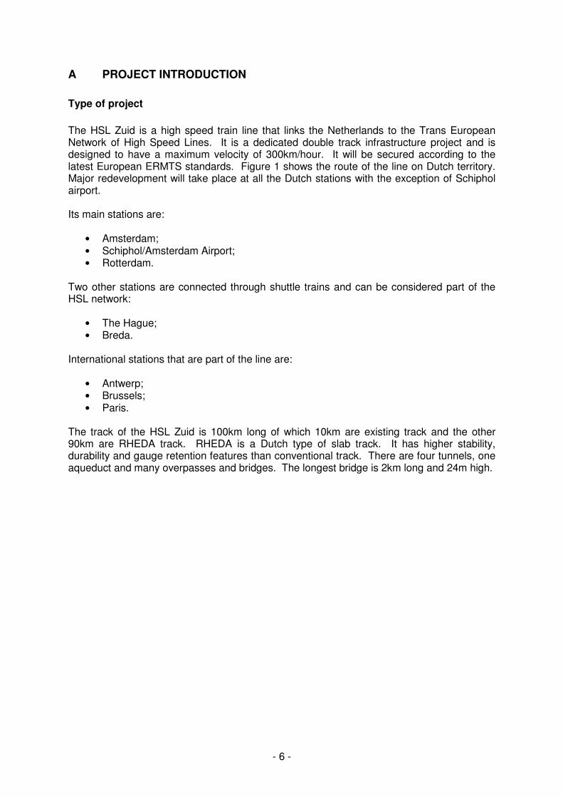
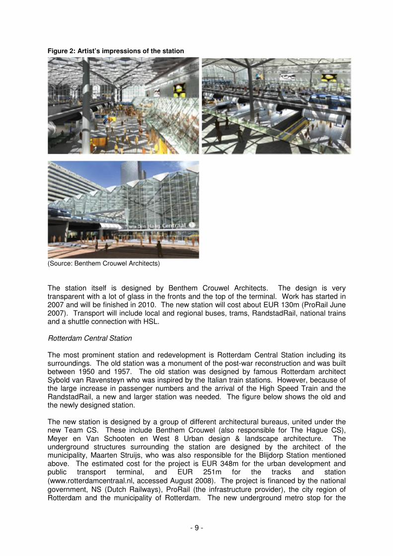
Figure 2: Artist’s impressions of the station
(Source: Benthem Crouwel Architects) The station itself is designed by Benthem Crouwel Architects. The design is very transparent with a lot of glass in the fronts and the top of the terminal. Work has started in 2007 and will be finished in 2010. The new station will cost about EUR 130m (ProRail June 2007). Transport will include local and regional buses, trams, RandstadRail, national trains and a shuttle connection with HSL. Rotterdam Central Station The most prominent station and redevelopment is Rotterdam Central Station including its surroundings. The old station was a monument of the post-war reconstruction and was built between 1950 and 1957. The old station was designed by famous Rotterdam architect Sybold van Ravensteyn who was inspired by the Italian train stations. However, because of the large increase in passenger numbers and the arrival of the High Speed Train and the RandstadRail, a new and larger station was needed. The figure below shows the old and the newly designed station. The new station is designed by a group of different architectural bureaus, united under the new Team CS. These include Benthem Crouwel (also responsible for The Hague CS), Meyer en Van Schooten en West 8 Urban design & landscape architecture. The underground structures surrounding the station are designed by the architect of the municipality, Maarten Struijs, who was also responsible for the Blijdorp Station mentioned above. The estimated cost for the project is EUR 348m for the urban development and public transport terminal, and EUR 251m for the tracks and station
(www.rotterdamcentraal.nl, accessed August 2008). The project is financed by the national government, NS (Dutch Railways), ProRail (the infrastructure provider), the city region of Rotterdam and the municipality of Rotterdam. The new underground metro stop for the
- 10 -
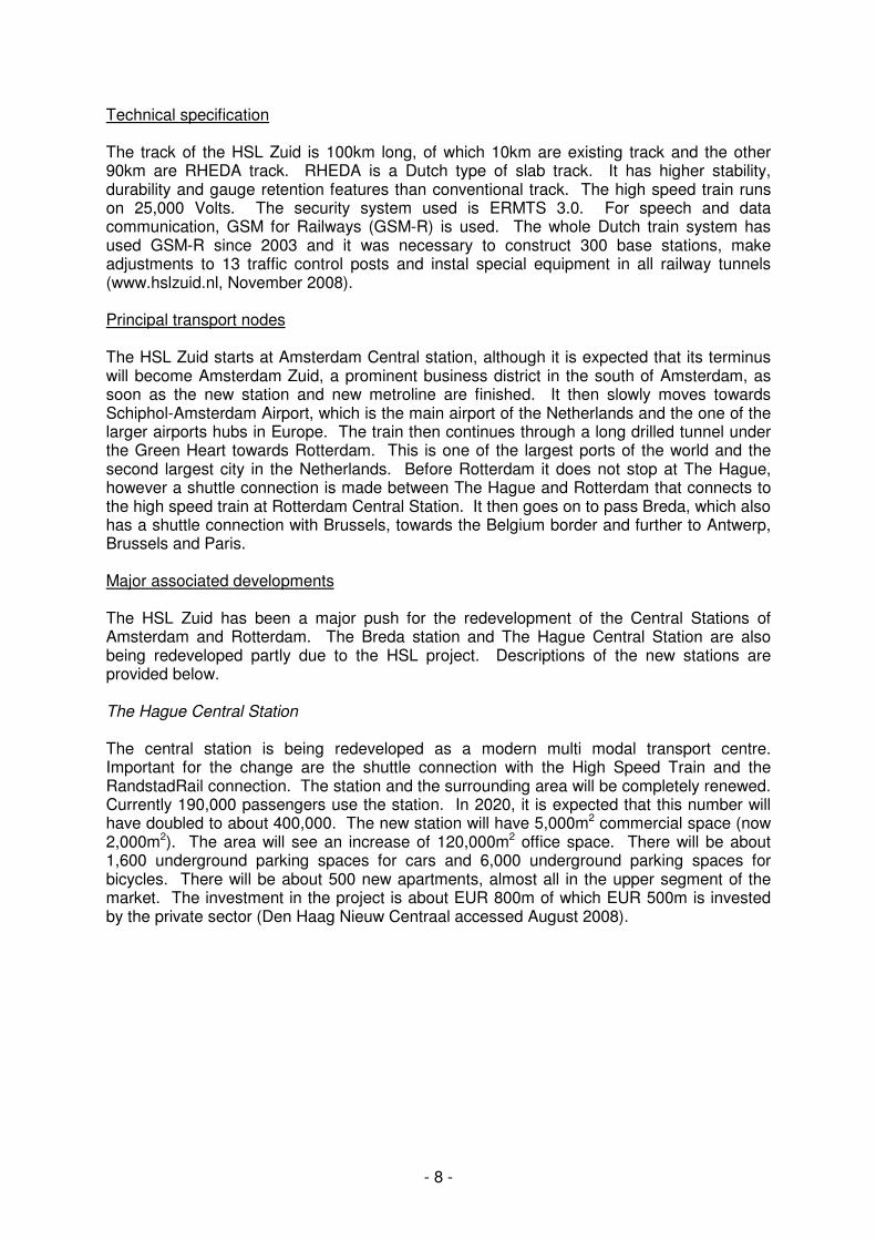
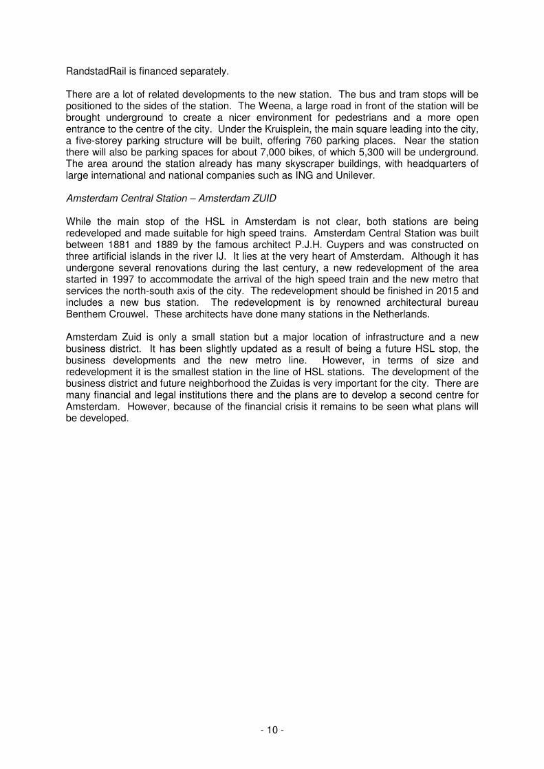
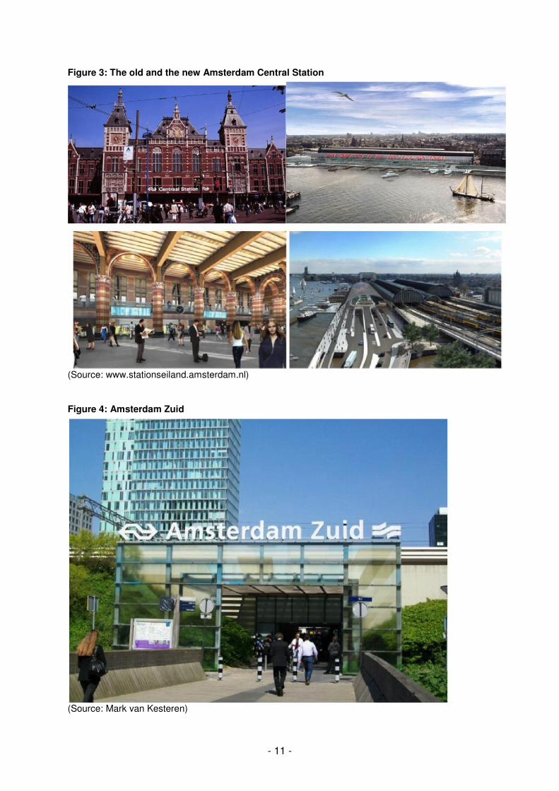
RandstadRail is financed separately. There are a lot of related developments to the new station. The bus and tram stops will be positioned to the sides of the station. The Weena, a large road in front of the station will be brought underground to create a nicer environment for pedestrians and a more open entrance to the centre of the city. Under the Kruisplein, the main square leading into the city, a five-storey parking structure will be built, offering 760 parking places. Near the station there will also be parking spaces for about 7,000 bikes, of which 5,300 will be underground. The area around the station already has many skyscraper buildings, with headquarters of large international and national companies such as ING and Unilever. Amsterdam Central Station – Amsterdam ZUID While the main stop of the HSL in Amsterdam is not clear, both stations are being redeveloped and made suitable for high speed trains. Amsterdam Central Station was built between 1881 and 1889 by the famous architect P.J.H. Cuypers and was constructed on three artificial islands in the river IJ. It lies at the very heart of Amsterdam. Although it has undergone several renovations during the last century, a new redevelopment of the area started in 1997 to accommodate the arrival of the high speed train and the new metro that services the north-south axis of the city. The redevelopment should be finished in 2015 and includes a new bus station. The redevelopment is by renowned architectural bureau Benthem Crouwel. These architects have done many stations in the Netherlands. Amsterdam Zuid is only a small station but a major location of infrastructure and a new business district. It has been slightly updated as a result of being a future HSL stop, the business developments and the new metro line. However, in terms of size and redevelopment it is the smallest station in the line of HSL stations. The development of the business district and future neighborhood the Zuidas is very important for the city. There are many financial and legal institutions there and the plans are to develop a second centre for Amsterdam. However, because of the financial crisis it remains to be seen what plans will be developed.
- 11 -
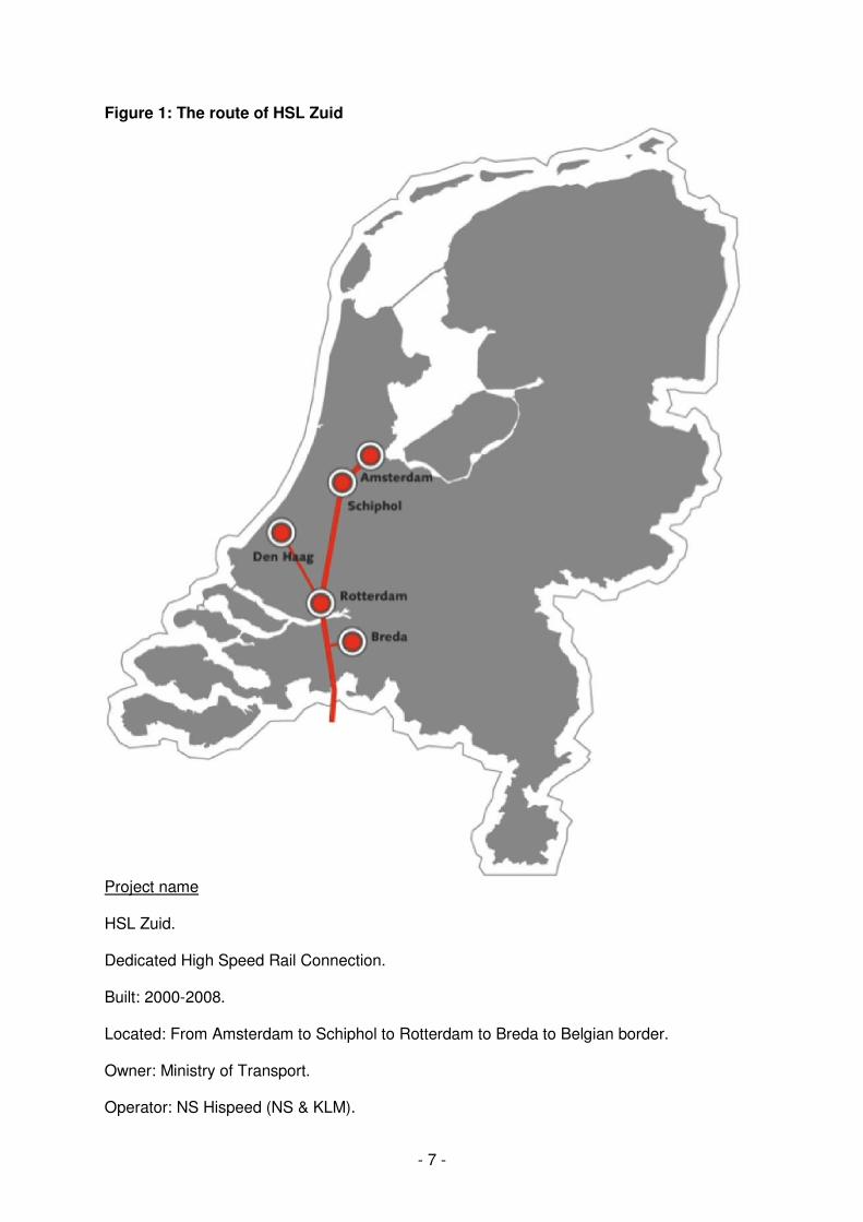
Figure 3: The old and the new Amsterdam Central Station
(Source: www.stationseiland.amsterdam.nl)
Figure 4: Amsterdam Zuid
(Source: Mark van Kesteren)
- 12 -
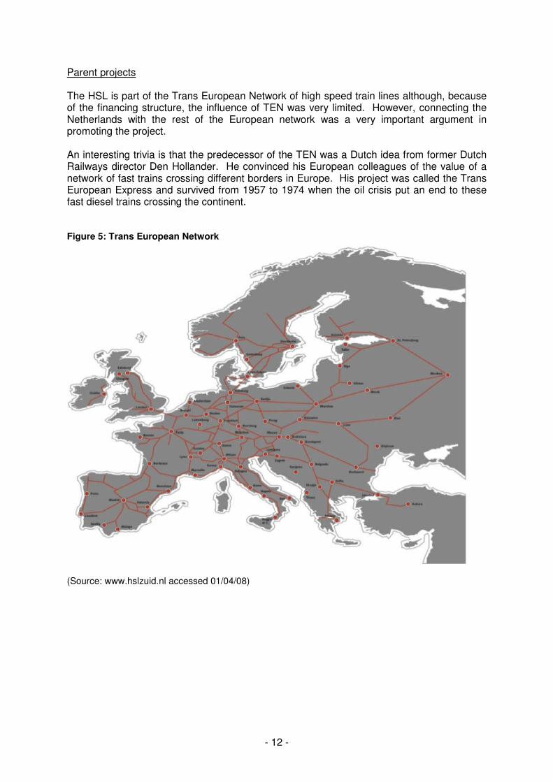
Parent projects The HSL is part of the Trans European Network of high speed train lines although, because of the financing structure, the influence of TEN was very limited. However, connecting the Netherlands with the rest of the European network was a very important argument in promoting the project. An interesting trivia is that the predecessor of the TEN was a Dutch idea from former Dutch Railways director Den Hollander. He convinced his European colleagues of the value of a network of fast trains crossing different borders in Europe. His project was called the Trans European Express and survived from 1957 to 1974 when the oil crisis put an end to these fast diesel trains crossing the continent. Figure 5: Trans European Network
(Source: www.hslzuid.nl accessed 01/04/08)
- 13 -
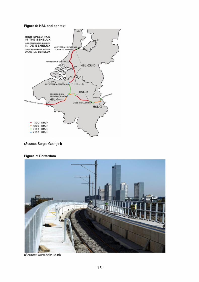
Figure 6: HSL and context
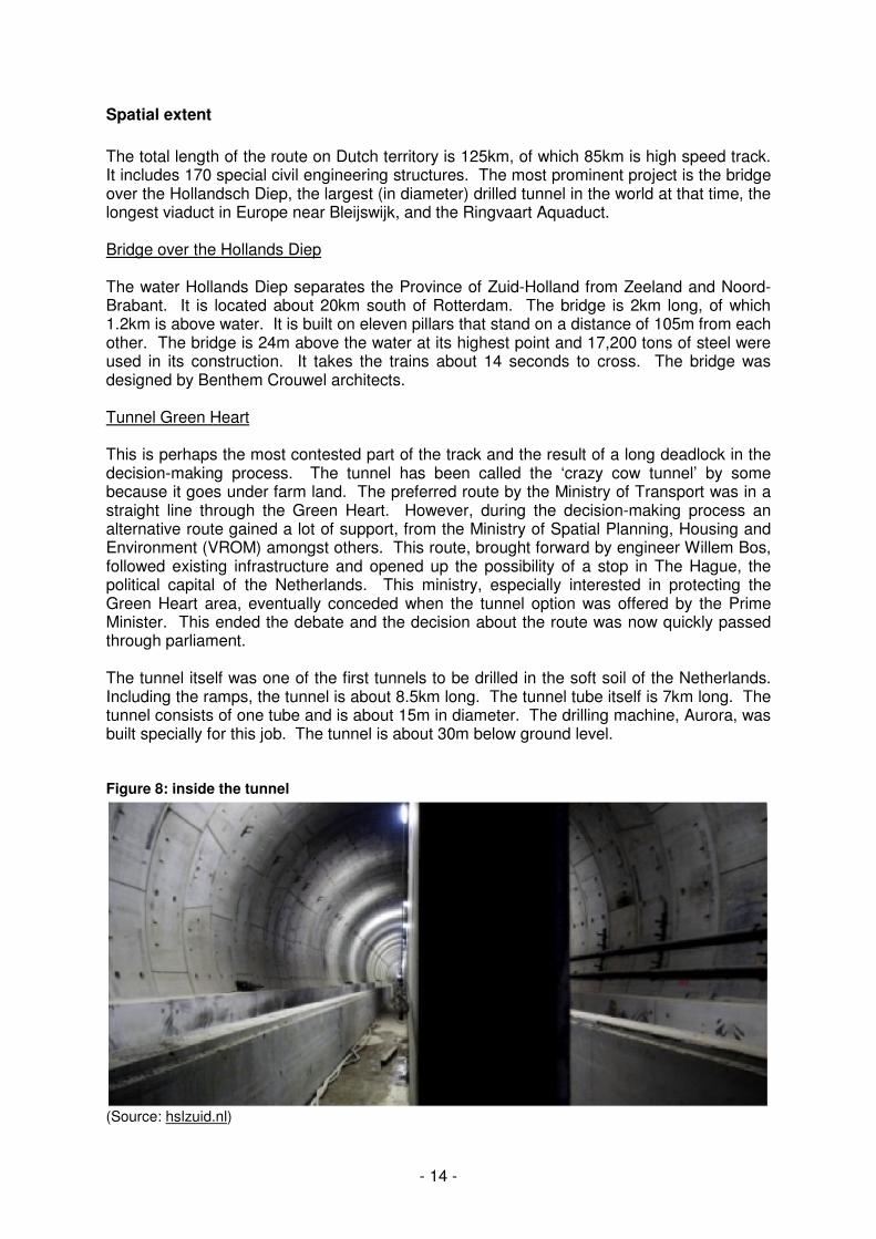
(Source: Sergio Georgini) Figure 7: Rotterdam
(Source: www.hslzuid.nl)
- 14 -
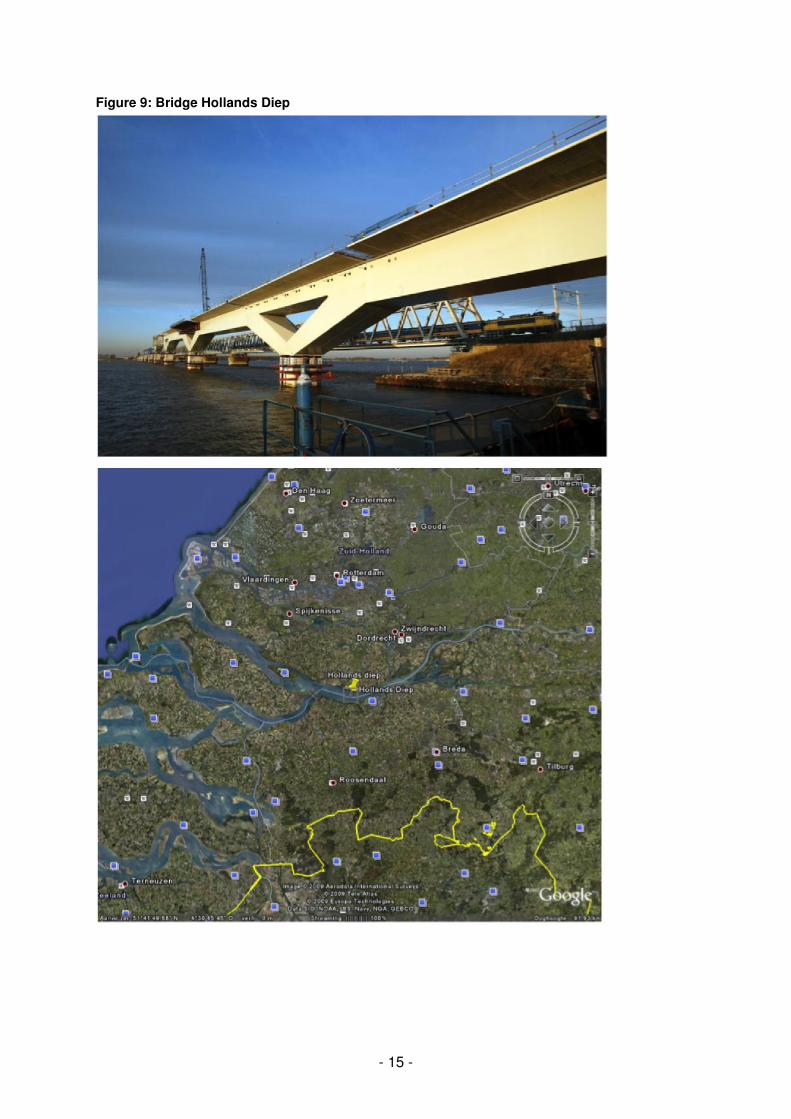
Spatial extent
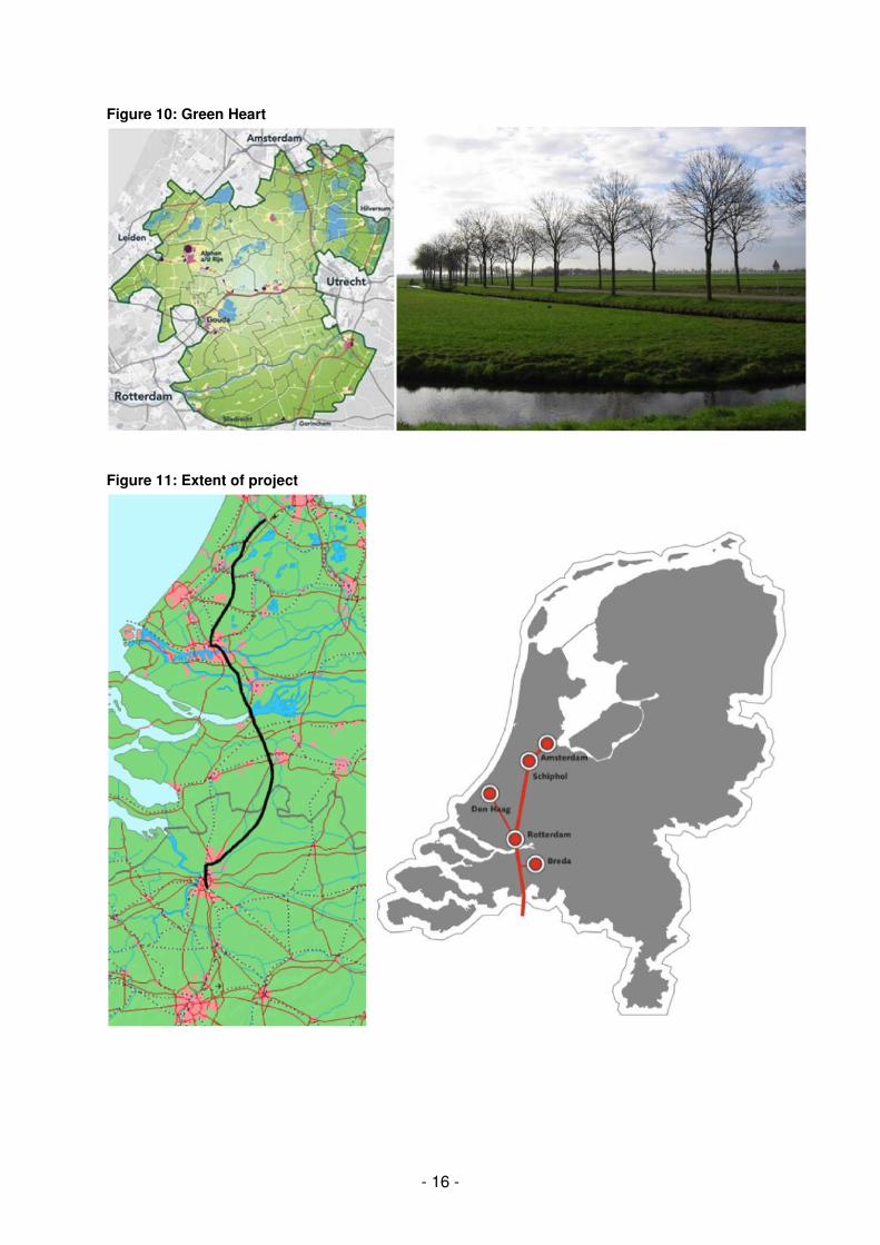
The total length of the route on Dutch territory is 125km, of which 85km is high speed track. It includes 170 special civil engineering structures. The most prominent project is the bridge over the Hollandsch Diep, the largest (in diameter) drilled tunnel in the world at that time, the longest viaduct in Europe near Bleijswijk, and the Ringvaart Aquaduct. Bridge over the Hollands Diep The water Hollands Diep separates the Province of Zuid-Holland from Zeeland and Noord-Brabant. It is located about 20km south of Rotterdam. The bridge is 2km long, of which 1.2km is above water. It is built on eleven pillars that stand on a distance of 105m from each other. The bridge is 24m above the water at its highest point and 17,200 tons of steel were used in its construction. It takes the trains about 14 seconds to cross. The bridge was designed by Benthem Crouwel architects. Tunnel Green Heart This is perhaps the most contested part of the track and the result of a long deadlock in the decision-making process. The tunnel has been called the ‘crazy cow tunnel’ by some because it goes under farm land. The preferred route by the Ministry of Transport was in a straight line through the Green Heart. However, during the decision-making process an alternative route gained a lot of support, from the Ministry of Spatial Planning, Housing and Environment (VROM) amongst others. This route, brought forward by engineer Willem Bos, followed existing infrastructure and opened up the possibility of a stop in The Hague, the political capital of the Netherlands. This ministry, especially interested in protecting the Green Heart area, eventually conceded when the tunnel option was offered by the Prime Minister. This ended the debate and the decision about the route was now quickly passed through parliament. The tunnel itself was one of the first tunnels to be drilled in the soft soil of the Netherlands. Including the ramps, the tunnel is about 8.5km long. The tunnel tube itself is 7km long. The tunnel consists of one tube and is about 15m in diameter. The drilling machine, Aurora, was built specially for this job. The tunnel is about 30m below ground level. Figure 8: inside the tunnel
(Source: hslzuid.nl)
- 15 -
Figure 9: Bridge Hollands Diep
- 16 -
Figure 10: Green Heart
Figure 11: Extent of project
- 17 -
Current status
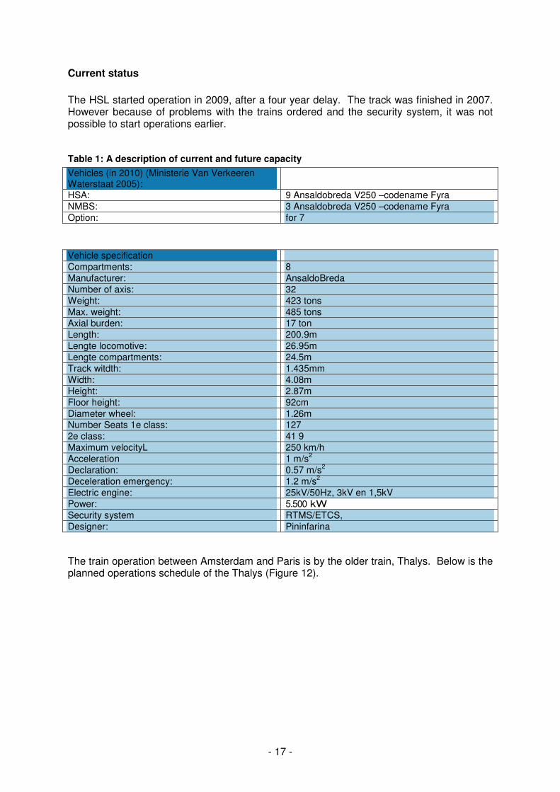
The HSL started operation in 2009, after a four year delay. The track was finished in 2007. However because of problems with the trains ordered and the security system, it was not possible to start operations earlier. Table 1: A description of current and future capacity
Vehicles (in 2010) (Ministerie Van Verkeeren Waterstaat 2005):
HSA: 9 Ansaldobreda V250 –codename Fyra
NMBS: 3 Ansaldobreda V250 –codename Fyra
Option: for 7
Vehicle specification
Compartments: 8
Manufacturer: AnsaldoBreda
Number of axis: 32
Weight: 423 tons
Max. weight: 485 tons
Axial burden: 17 ton
Length: 200.9m
Lengte locomotive: 26.95m
Lengte compartments: 24.5m
Track witdth: 1.435mm
Width: 4.08m
Height: 2.87m
Floor height: 92cm
Diameter wheel: 1.26m Number Seats 1e class: 127
2e class: 41 9
Maximum velocityL 250 km/h
Acceleration 1 m/s2
Declaration: 0.57 m/s2
Deceleration emergency: 1.2 m/s2
Electric engine: 25kV/50Hz, 3kV en 1,5kV
Power: 5.500 kW
Security system RTMS/ETCS,
Designer: Pininfarina
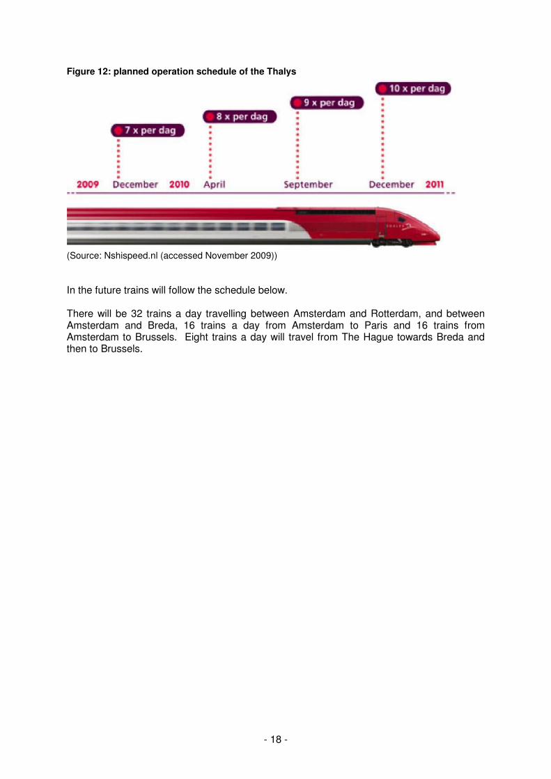
The train operation between Amsterdam and Paris is by the older train, Thalys. Below is the planned operations schedule of the Thalys (Figure 12).
- 18 -
Figure 12: planned operation schedule of the Thalys
(Source: Nshispeed.nl (accessed November 2009))
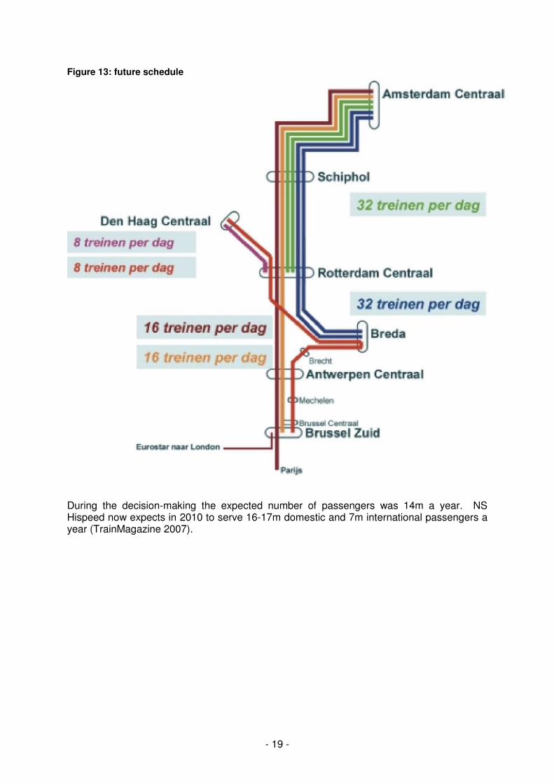
In the future trains will follow the schedule below. There will be 32 trains a day travelling between Amsterdam and Rotterdam, and between Amsterdam and Breda, 16 trains a day from Amsterdam to Paris and 16 trains from Amsterdam to Brussels. Eight trains a day will travel from The Hague towards Breda and then to Brussels.
- 19 -
Figure 13: future schedule
During the decision-making the expected number of passengers was 14m a year. NS Hispeed now expects in 2010 to serve 16-17m domestic and 7m international passengers a year (TrainMagazine 2007).
- 20 -
B PROJECT BACKGROUND
Principal project objectives
Several key objectives were stated over the years by government officials (also principal constructor):
• Linking the main ports of Rotterdam, Schiphol and Amsterdam to the Trans European Network of high speed trains;
• Giving an impulse to economic development to “prevent the Netherlands from becoming the Jutland of Europe”;
• Reduction of air-traffic for medium distances within Europe; • The train should be able to go 300km/hour on the tracks.
The bid for the operation of the train service was won by a consortium, the Hispeed Alliance. Two companies participate in this. These are the airline company KLM, or Royal Dutch Airlines, and the national rail operator NS. The official objectives of the alliance are:
• Fast, comfortable, secure and accessible transport of passengers on the HSL Zuid; • Optimal integration with other modes of transport such as the bicycle, car, airplane,
conventional train, bus, tram, and metro; • A quality of service equal to the other high speed train lines in Europe; • Satisfied and motivated employees who are proud of their product and the
organization. Key enabling mechanisms and decision to proceed
An important moment in the project was the decision to stop the first decision-making procedure and develop a better new starting report (Startnota/PKB1). The development of large spatial projects follows a PKB procedure in the Netherlands. This procedure consists of several phases. In the first phase (PKB1) the government announces its intentions and provides a design and justification of its preferences. Phase two (PKB2) provides an adjusted intention after the consultation rounds and the environmental impact assessments. PKB3 is the intention that has been approved by the parliament. And PKB4, or the Decision, is the project as approved by the senate. The first PKB procedure was stopped because it proved to have too many caveats. The procedure was restarted by De Nieuwe HSL-Nota (Ministerie van Verkeer en Waterstaat, 1994) which was more the size of an encyclopedia containing 24 sub-reports. It did however already include the environmental impact assessments and the consultations from the first report. The consultation and political decision-making eventually led to the PKB3 – the cabinet’s position with augmentation (Ministerie van Verkeer en Waterstaat, 1996). Entering the PKB procedure, and the decision to start a new one, was a key mechanism in producing the project as it is now. Financing from earth gas Very important for the financing of the project were the revenues from gas exports. These were placed in a fund for strengthening the economic structure (Fonds Economische Structuurversterking). Many of the large projects of that time were financed by this fund. There were so many projects constructed at the same time that this caused cost increases (Teulings and Koopmans 2004). In 2008, the financing from the regular FES totalled EUR 1.7bn. Financing within the budget of the Structuurplan V&V including a part of FES (FES
- 21 -
BOR) was EUR 2.6bn. These revenues thus provided an enormous impulse to the development of infrastructure in general and the HSL Zuid in particular. Without these funds, it would have been much more difficult to have financed such an expensive project. (Ministerie van Financiën 2008) Compensation to Belgium In deciding the definite route, there was a conflict between the Dutch and Belgium/Flemish government about the best route to cross the border and enter Antwerp. The Dutch preferred route was to pass along Breda and enter Antwerp from the northeastern side through the Peerdsbos (a forest where many politicians live, which is seen as the birthplace of the Flemish environmental movement – a contested place). The Belgian preference was along the existing tracks through the harbour of Antwerp. Because the border between the two countries is skewed, both preferences would be more expensive for the other party. Eventually the Netherlands provided financial compensation to Belgium in order to get their preferred route and to break the deadlock (Ruimtelijk Planbureau 2007). Main organisations involved
• Ministry of Transport – project leaders, owners, financiers; • Ministry of VROM – spatial plans; • Cabinet of Kok – decisions are made unanimously within the cabinet; • Parliament – give approval; • Provinces and municipalities – change their land allocation plans.
Feasibility studies
• McKinsey (1992) Aard en omvang va het hogesnelheidslijnvervoer, verkenning van marktpotentieel en commerciële levensvatbaarheid;
• NEI (1994) Kosten-Batenanalyse Hoge Snelheidslijn. Rotterdam, • NEIHaselen, H.W,J. van, Schijndel-Pronk, M.Y. van (1996) Kosten-Batenanalyse
HSL-Zuid A1 variant; • Commissie vna Wijzen (1999) Advies inzake de aanbesteding van het vervoer over
de HSLZuid; • CPB (1994) Macro-economische analyse van de hogesnelheidslijn, werkdocument
66. HSL Zuid project team The main organisation involved in the development of the project was the HSL Zuid project team set up at the start of the project. The team was a separate group, but fell under the supervision of the Ministry of Transport. The project has had only two team leaders during the whole decision-making process. Next to people from the Ministry, many employees, especially the engineers, came from the Ministry’s implementation organisation Rijkswaterstaat. Over time there were also many external consultants involved in the organisation. Over time the ministry remained the initiator and the main responsible organisation of the project. It was also the principal financier of the HSL Zuid. NS – the Dutch Railways The HSL Zuid was the first train project developed by the ministry without a strong influence from NS. Dutch railways were privatized and it was deemed preferable to create some
- 22 -
distance. NS did have the first possibility to bid for the exploitation of the track. However, the bid was too low and also for the first time a public tender was started for the exploitation of the track. Eventually a consortium of NS and KLM (royal Dutch airlines) won the tender. Interestingly, since the merger between KLM and Air-France, KLM has a very strong position on the travel market between Amsterdam and Paris. The construction of the civil works of the line was divided into several parts, each worth about EUR 400m. These were done by several different consortia. The upper part, rail, electrics, communication, safety and signaling systems were developed by a consortium named Infraspeed. The consortium consisted of the following companies:
• Fluor Infrastructure B.V.; • Siemens Nederland N.V.; • Koninklijke BAM Groep N.V.; • Innisfree Ltd; • HSBC Infrastructure Ltd.
The contract was a Design, Build, Finance and Maintenance (DBFM) contract. The maintenance section included a clause that for the duration of 25 years, the track had to be available 99% of the time. This contract started in 2006 and runs until 2031. From 2006 the Dutch state will pay a fee to the infrastructure provider for the availability of the track. The amount is dependent on whether or not the 99% is achieved. The broad coalition Influential in the debate, but not so much for the end result, was the co-operation between several interest groups from different backgrounds. This broad coalition, as it was called in the media, consisted of Stichting Natuur en Milieu, an environmental group, the ANWB, a union for users of transport with wheels, LTO Nederland, an organization for agri- and horticultural entrepreneurs and employers, the Chambers of Commerce of the region of The Hague, and the WWF. This coalition started a strong lobby campaign in favor of the linking of infrastructure along existing tracks and with a stop in The Hague. Planning and environmental regime
As already mentioned, the planning of the project followed the Spatial Core Decision (PKB) procedure. This has a fairly strict sequence and planning. This is explained in Working Paper 2. The SCD includes a Environmental Impact Assessment. These have prognoses of the environmental effects of the project. Evaluations will be carried out one year and ten years after transportation has commenced. If the results are worse than expected, extra measures will have to be taken. There are no numbers known for issues as environmental mitigation. Planning regime The HSL was previously mentioned in several policy documents such as the Tweede Structuurschema Verkeer en Vervoer (SVV2), the white paper Economie met open grenzen, The Fourth Note on Spatial Planning Extra (Vierde Nota Ruimtlijke Ordening Extra, VINEX) and the national Environmental Plan (NMP+). The most important or relevant legislation is the PKB+ and the Tracéwet. The SVV-2 (Ministerie van Verkeer en Waterstaat, 1990) is the first document to mention the HSL. In the document there is an important focus on sustainability and on providing alternatives to the car. It searches for a balance between liveability and mobility/
- 23 -
accessibility. In this light, the document finds it important that the Netherlands is linked to the European high speed network. The nota Economie met open grenzen (Ministerie van Economische Zaken, 1990) adds an economic perspective to this vision, and argues that as a country so dependent on international trade and business the Netherlands needs national and cross-national infrastructure of high quality. In the VINEX (Ministerie van VROM, 1993), the cabinet explicitly commits itself to “actively support the connection of the Randstad to the West European network of high speed connections. This concerns both the southern direction with Brussels, Paris, London as well as the eastern direction towards the Ruhrgebiet and the south of Germany”. The NMP+ (VROM, 1990) again has a strong focus on sustainable development. It sees the high speed train connections as especially important to replacing short distance (<1000km) air travel. The Trace Act from 1994 is introduced because of the need for more coordination on the national level. Before the Act, line infrastructure was developed as a planning document without any legal status. It was then implemented through the Spatial Planning Act that gives a lot of power to the provinces and municipalities that will have to adjust their land allocation plans. Both the spatial core decision and the land allocation procedures have participation rounds, as does the environmental impact assessment. The Trace Act links these different procedures together. The Trace Act deals with three issues. Firstly as discussed above, it aims to coordinate the different procedures, and sets specific time limits for the different phases. This should speed up the decision-making process. Secondly, it creates a structure that enables a line project to be planned as one project, instead of several small parts that together form the whole project. Thirdly, the act changes the balance between local and state powers. The national government is given several tools to force localities to co-operate. One of these tools is the spatial core decision for projects (PKB+) that leads to a legally binding decision for all follow-up decisions (e.g. land allocation plans). Another tool is the obligation for the minister to make a ‘suggestion’ to non-cooperating municipalities. The ‘suggestion’ can be used pro-actively and reactively. The first usage means that the national government wants to arrange something for one specific situation/project. Local government then has to adjust its land allocation plan according to the guidelines given by the state. Re-active usage of the instrument means that the national government can stop certain lower levels of government from making plans that conflict with the ‘national interest’. It is actually a tool from the Spatial Planning Act that was hardly used in the Dutch consensus planning model. However, the Trace Act now obliges the minister to use this euphemistically named power tool. The budget of the government also includes a list of projects that are on the agenda or that are already being built. For a project it is essential to get on this list in order to get funded. The MIT (Meerjarenprogramma Infrastructuur en Transport) is updated annually as part of the State Budget and has a scope of four years. Since 2004, it has an outlook till 2020. Some developments can easily remain in the MIT for decades without ever being built. This is possible because the MIT categorizes projects in three different phases (Koenders and Noordsij 2004):
1. exploratory phase: projects are placed on the agenda by political parties or ministries and are discussed for desirability;
2. plan study phase: projects have proven their desirability and it can be reasonably be
expected that these projects will be developed. Plans are studied on the best approach to the technical, judicial and political dimensions of the project;
3. execution phase: projects are ready to be carried out or are already being realized.
- 24 -
As already said, projects can stay in the MIT for very long times, never leaving the first two phases. This often happens because the consociational nature of Dutch politics (Lijphart 1999) demands that many different parties are consulted and more or less agree on the importance and route of the project. Because of the many parties and the many possible projects possible, there are very narrow windows of opportunity for projects to get past the first two phases and into the third. It is usually only after finishing the whole decision-making process that attempts are started to acquire external funding. However in the budget of the proposals, assumptions have been made about the possible contributions from third parties in the private sector as well as from the EU. An example of the financing structure of infrastructure projects is the HSL-Zuid budget (Ministerie van Verkeer en Waterstaat 2007). From the total of EUR 7bn, EUR 2.6bn (37%) is derived from the SVV-budget of the Ministry of Transport and Water Management. This includes an amount from the FES-BOR fund that was set-up to develop the accessibility of the Randstad. Slightly over EUR 1.7bn (24%) is financed from the regular FES. Although the line is seen as a financial disaster, it is also seen as a successful public-private partnership (Koppenjan 2005). Indeed, about EUR 1bn (14%) is privately funded, which is a substantial amount for a Dutch infrastructure project. However, this successful PPP project, owes its success to a transport concession that retrospectively can be considered as too expensive. The national railway company (NS) overbid in an effort to keep the train line out of the hands of foreign companies. For a while, it was expected that public-private partnerships would become common and that it would reduce the financial costs for the government. However to date, most attempts at public-private partnerships in large scale projects have ended in deception. Klein and Teisman argue that this is because the institutional system is not ready for such a change and that public-private partnership is “an example of the right proposal at the wrong time” (Klijn and Teisman 2003). Environmental statements and outcomes related to the project The Nieuwe HSL Nota (Ministerie van Verkeer en Waterstaat 1994) integrated the environmental impact assessment into the whole document. Throughout the nota, the emphasis is put on the environmental friendliness of the train versus the automobile and the airplane. A differentiation in the nota is made between natural environment, landscape, water and ecology, and the living environment, sound and vibration nuisance and social aspects. In looking for the environmentally best alternative, several criteria were indicated. Firstly, a maximum substitution of automobile and air traffic should be achieved. Secondly, the possibility of using the route for national train traffic and fitting the new track optimally into the urban and rural environment and taking into consideration the environmental interests. The shortest route, the new track alternative turned out to be the most environmentally friendly if a section near Bleiswijk was tunnelled. Both environmentally, economically and strategic environmentally, the new tracks with the preferred routes proved to be the best option. Crossing the Belgian border In order to reach agreement with the Belgium and Flemish government, a combined environmental impact assessment was done for several alternative routes. The preferred Dutch route that followed the A16 and passed Breda proved to be the most environmentally friendly option and provided the highest transport value. However the route would go through the Peerdsbos near Antwerp and the viability of the route was dependant on finding
- 25 -
an adequate solution for minimizing the impact (for more detail about the negotiation: Ruimtelijk Planbureau 2007). Overview of public consultation The public consultation in such large line projects is divided into two sections. After publication of de Nieuwe HSL Nota a round of consultation begins. These are presented and answered in the PKB2a (public consultation and official advisory boards, (Ministerie van Verkeer en Waterstaat 1998)) and PKB2b (administrative consultation). An additional PKB2 supplement was made in the form of extra studies into the alternatives of clustering different infrastructure and the WB3 alternative which is better known as the Willem Bos route (TK 1995). The public consultation discussed in the PKB2had 1,250 reactions. Of these reactions 54 are wider in scope and are supported by over 17,000 people. Quite a few of the people objected to the sheer size of the PKB1 which made it almost impossible to prepare an objection. However, the most important criticism was aimed at the A1, or preferred route, because it would negatively affect the green area of the Green Heart. Some were also doubtful whether it would be a truly open process or if the result was already fixed because the preferred route was already agreed upon in the regeerakkoord (agreement between coalition partners when forming a cabinet). Many people also objected to the need for a dedicated new route for the HSL. Reference was often made to a study by the University of Delft, which looks at adjusting and upgrading the current infrastructure, and to the Willem Bos alternative that explores the clustering of infrastructure. The consultation round did not however provide a clear image of the route preferred by the public, and the decision was left to the decision-making about alternatives in parliament, a process which is described further below. A second round of consultation was around the tracébesluit (PKB4) (Ministerie van Verkeer en Waterstaat, 1998) in which the preferred route was accepted by the parliament. Because of the tracéwet, the whole line could be presented as one consultation round (for adjusting the land allocation plan). However, to be able to accommodate the consultation, the route was divided into seven sections. The process started with, in the Netherlands quite usual, administrative consultation. If there was a contested area, multiple options were developed. In order to let the population participate, seminars were organised to develop the PKB3 decision to the design tracebesluit. Eventually, 40 suggestions were incorporated into the design. The design was furthermore discussed in twelve information markets in order to give the population feedback about what had happened with their ideas. In addition, brochures were given out about compensation, ground acquisition, sound nuisance and possibilities for further public consultation. Furthermore, a free 0800 number was introduced and communicated for further questions or complaints. From 7 November to 17 December the design tracébesluit was open for public consultation. In this period about 700 responses were received either in writing or orally. During this period seven information meetings were organised, when information columns were placed in city halls. The documents included all the plans and in several municipalities visualisations of possible alternatives. In addition a phone was also built into the column which could be used to call the information line directly. The 700 responses were answered in eight reports. Regeneration, archaeology and heritage Although an archeological investigation was done for the whole route, the focus of archeological research was on a stretch land of 5.5km2 near the HSL/A16 link at Breda. Because of the construction works several different types of landscapes were uncovered.
- 26 -
These included strips of surface sands, and river valleys and river courses often covered by turf fertilization. This provided new insights into the history of Breda and its surroundings. Many different habitats were found, ranging from the Early Middle Ages (500AD) to the 17th century. The findings show that people moved to lower areas throughout the centuries (Kranendonk, Van der Kroft et al. 2006). Project appraisal methods No information in public domain. Complaints procedures The complaints procedure starts with the public consultation described above. If disagreeing with the results, one can go to the department Administrative Justice of the Supreme Court. (Afdeling bestuursrechtspraak van de Raad van State). Land acquisition
Number of compulsory acquisitions In 2005, the expenditure of land acquisition topped EUR 307.9m (Ministerie van verkeer en Waterstaat 2005). The number of compulsory acquisitions is not clear.
- 27 -
C PRINCIPAL PROJECT CHARACTERISTICS
Detailed description of route
The HSL trains depart from Amsterdam Central Station and follow the regular train line in the direction of Schiphol Airport. Starting at Hoofddorp, the route changes to a dedicated track. From there it goes to Schiphol Airport. It then goes through the Green Heart region via a tunnel. After coming back up, it then continues to Rotterdam where a shuttle train hooks up with passengers from The Hague and Breda. It then goes to Breda, where it will not always stop and then turns in the shortest line straight to the Belgium border. From there it goes on to Antwerp and Brussels. Main and intermediate travel nodes
Amsterdam Central Station The terminal station for the High Speed Train in the Netherlands is Amsterdam Central station. The station is right in the centre of Amsterdam and is undergoing a major transformation. The facilities for the High Speed train will be created as well as a new metro line, bus and ferry terminal. The developments are expected to be finished by 2014. The station will then serve 300,000 visitors on a daily basis. Schiphol Airport As one of the major airports in Europe, the airport needs good connections to its hinterland. The connection to the High Speed Network makes a multi-modal trip possible for passengers from, for instance Antwerp, to take an airplane at Schiphol instead of Brussels. Rotterdam Central Station As the second largest town in the Netherlands with several multi-national industries, Rotterdam needs a station with good connections to the airport, Amsterdam and other locations in Europe. The High Speed Network is part of the development of a new Central Station Area that will have an increased capacity. There are two stations that are serviced by the High Speed Train Line without truly being part of the train track. The Hague Central Station As the location of the parliament and important international institutions such as the International Court of Justice, The Hague had to be somehow connected to the European High Speed Train Network. This is done by a shuttle train linking to the high speed trains stopping at Rotterdam. Eventually there will be eight trains going to Brussels via Rotterdam, Breda and Antwerp. There will also be eight high speed shuttle trains linking to the high speed trains leaving Rotterdam for Paris. Breda The central station of Breda is linked to the High Speed Network in the same way as The Hague. Eight times a day there will be a train to Brussels and eight times a day there will be a shuttle train leaving for Rotterdam to connect to the High Speed Train to Paris. The station is to become a public transport complex combining different modes of international, interregional, regional and local transport.
- 28 -
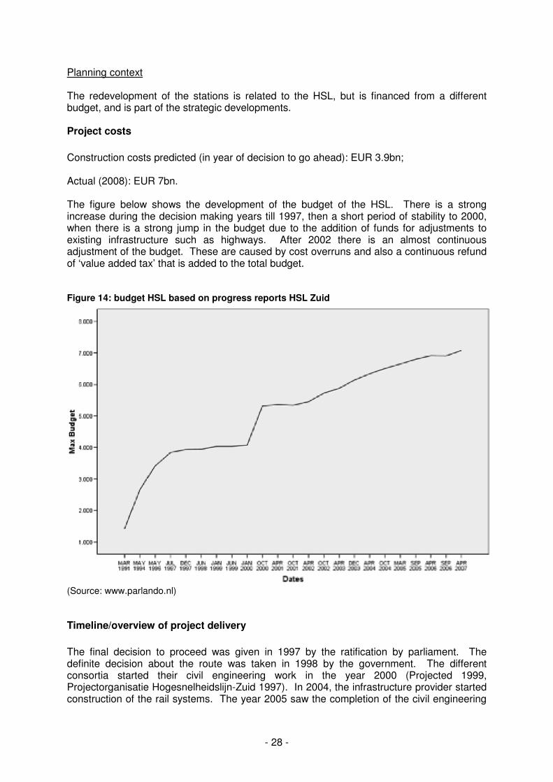
Planning context The redevelopment of the stations is related to the HSL, but is financed from a different budget, and is part of the strategic developments. Project costs
Construction costs predicted (in year of decision to go ahead): EUR 3.9bn; Actual (2008): EUR 7bn. The figure below shows the development of the budget of the HSL. There is a strong increase during the decision making years till 1997, then a short period of stability to 2000, when there is a strong jump in the budget due to the addition of funds for adjustments to existing infrastructure such as highways. After 2002 there is an almost continuous adjustment of the budget. These are caused by cost overruns and also a continuous refund of ‘value added tax’ that is added to the total budget. Figure 14: budget HSL based on progress reports HSL Zuid
(Source: www.parlando.nl)
Timeline/overview of project delivery
The final decision to proceed was given in 1997 by the ratification by parliament. The definite decision about the route was taken in 1998 by the government. The different consortia started their civil engineering work in the year 2000 (Projected 1999, Projectorganisatie Hogesnelheidslijn-Zuid 1997). In 2004, the infrastructure provider started construction of the rail systems. The year 2005 saw the completion of the civil engineering
- 29 -
part of the project. In 2006, testing of the systems commenced and the southern part of the track, between Rotterdam and the Belgian border, was finished. In 2007, the northern part of the track was finished. Commercial exploitation is now expected to commence in 2009 (projected in 2005). The reason for the delay is the security system ERMTS, which is still not working properly. Also, the specifications of the system were known too late, causing a delay in ordering the trains. And in addition, the Italian company building the new trains will not be able to provide the trains on time. Main engineering features
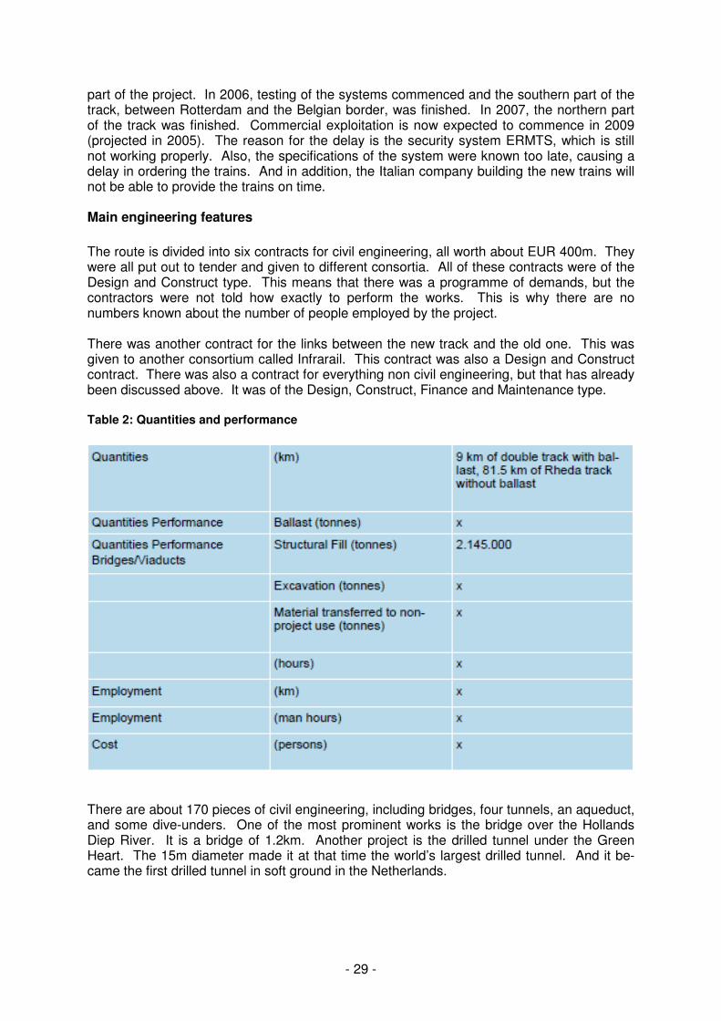
The route is divided into six contracts for civil engineering, all worth about EUR 400m. They were all put out to tender and given to different consortia. All of these contracts were of the Design and Construct type. This means that there was a programme of demands, but the contractors were not told how exactly to perform the works. This is why there are no numbers known about the number of people employed by the project. There was another contract for the links between the new track and the old one. This was given to another consortium called Infrarail. This contract was also a Design and Construct contract. There was also a contract for everything non civil engineering, but that has already been discussed above. It was of the Design, Construct, Finance and Maintenance type. Table 2: Quantities and performance
There are about 170 pieces of civil engineering, including bridges, four tunnels, an aqueduct, and some dive-unders. One of the most prominent works is the bridge over the Hollands Diep River. It is a bridge of 1.2km. Another project is the drilled tunnel under the Green Heart. The 15m diameter made it at that time the world’s largest drilled tunnel. And it be-came the first drilled tunnel in soft ground in the Netherlands.
- 30 -
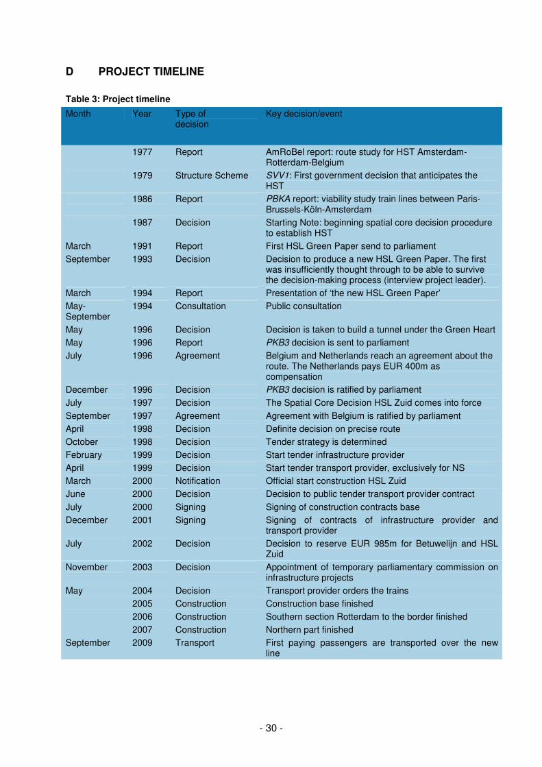
D PROJECT TIMELINE
Table 3: Project timeline
Month Year Type of decision
Key decision/event
1977 Report AmRoBel report: route study for HST Amsterdam-Rotterdam-Belgium
1979 Structure Scheme SVV1: First government decision that anticipates the HST
1986 Report PBKA report: viability study train lines between Paris-Brussels-Köln-Amsterdam
1987 Decision Starting Note: beginning spatial core decision procedure to establish HST
March 1991 Report First HSL Green Paper send to parliament
September 1993 Decision Decision to produce a new HSL Green Paper. The first was insufficiently thought through to be able to survive the decision-making process (interview project leader).
March 1994 Report Presentation of ‘the new HSL Green Paper’
May-September
1994 Consultation Public consultation
May 1996 Decision Decision is taken to build a tunnel under the Green Heart
May 1996 Report PKB3 decision is sent to parliament
July 1996 Agreement Belgium and Netherlands reach an agreement about the route. The Netherlands pays EUR 400m as compensation
December 1996 Decision PKB3 decision is ratified by parliament
July 1997 Decision The Spatial Core Decision HSL Zuid comes into force
September 1997 Agreement Agreement with Belgium is ratified by parliament
April 1998 Decision Definite decision on precise route
October 1998 Decision Tender strategy is determined
February 1999 Decision Start tender infrastructure provider
April 1999 Decision Start tender transport provider, exclusively for NS
March 2000 Notification Official start construction HSL Zuid
June 2000 Decision Decision to public tender transport provider contract
July 2000 Signing Signing of construction contracts base
December 2001 Signing Signing of contracts of infrastructure provider and transport provider
July 2002 Decision Decision to reserve EUR 985m for Betuwelijn and HSL Zuid
November 2003 Decision Appointment of temporary parliamentary commission on infrastructure projects
May 2004 Decision Transport provider orders the trains
2005 Construction Construction base finished
2006 Construction Southern section Rotterdam to the border finished
2007 Construction Northern part finished
September 2009 Transport First paying passengers are transported over the new line
- 31 -
Key issues
There are two main issues arising from the timeline. The first is the decision-making process, which eventually focused on alternative routes for the HSL. The second is the negotiations with Belgium. The third main issue, which is less visible on the timeline but dominates the recent history of the project, is the choice of the ERMTS security system and the current delays that are a direct result of this choice. The first issue concerns the decision making process. There was a false start with the first Starting Note being revoked because it was not sufficient to use as a basis for the decision-making process (interview project leader). So the final Spatial Core Decision procedure began in 1994 with the New HSL Green Paper. Eventually the public and political discussion started focusing on the choice between the preferred route of the government and an alternative route presented by an individual and adopted by many public organisations and a few political parties. But the government was also divided. The Ministry of Housing, Spatial Planning and Environment (VROM) supported the alternative, and the Ministry of Transport was a strong proponent of the preferred route. This was also a struggle between a minister from the Labor Party (PvdA) and the Conservative Liberals (VVD). The preferred route was in a straight line from Schiphol Airport to Rotterdam, and went through the sensitive green area called the Green Heart. The alternative route was a new track next to existing track and an extra stop in The Hague. Eventually VROM decided that it would either be the alternative route or a tunnel under the Green Heart. The PM at that time, Wim Kok, was anxious to have the project go through and to prevent a cabinet crisis. So he forced his own political party (PvdA) to support the preferred route including the tunnel below the Green Heart. The second issue was the negotiations with Belgium about the route crossing the border (Ruimtelijk Planbureau, 2007). The Dutch government had a preference for the E19-A16 route (on the right side of figure 4). The Belgian government had a preference for the train to travel over the existing track Lijn 12. Or else, they wanted a new route along the Havenweg (the road between the harbours of Rotterdam and Antwerp). One of the dilemmas in selecting a route is that the cost of a line is determined by the length of the track on national soil. The Netherlands also had arguments about the problems of spatial planning and argued that the preferred route was the best option concerning transport. Eventually, the ministers (Deheane (B) and Maij-Weggen (NL)) were not able to reach an agreement. There were several problems. The Havenweg route crossed several sensitive natural environments. The E19-A16 route crossed a sensitive area in Belgium, the Peerdsbos. This is the only forest of Flanders, and is the place where the Flemish environmental movement started in opposition to the road E19. It is also a region where many Flemish politicians live. Another reason why the negotiations are so difficult is that there is still strong resentment against the Netherlands for the lost negotiations about that same road, in addition to other cross border issues such as the deepening of the river Schelde. Eventually, there were several joint fact finding exercises between the Dutch and Belgian railroad companies and the project groups, and the E19-A16 route was the best in transport benefits. With financial compensation paid by the Netherlands to Belgium of about EUR 400m, the agreement was made and finally ratified by parliament in 1996. The third issue is that of the security system ERMTS. The decision was made to use the, at that time not specified, European standard ERMTS. Eventually this was a strong cause of the delay in the commencement of transport. The specifications of the standard were known very late and that meant that the trains were also ordered late. In addition the Italian producer of the trains proved unable to deliver the trains on time. The expectation is that transport will commence in 2009 with trains that will travel at a maximum speed of 160km/hr.
- 32 -
E PROJECT FUNDING/FINANCING
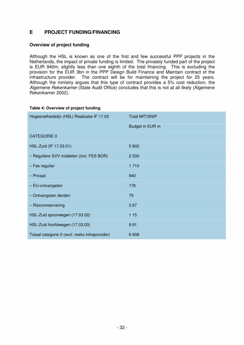
Overview of project funding
Although the HSL is known as one of the first and few successful PPP projects in the Netherlands, the impact of private funding is limited. The privately funded part of the project is EUR 940m, slightly less than one eighth of the total financing. This is excluding the provision for the EUR 3bn in the PPP Design Build Finance and Maintain contract of the infrastructure provider. The contract will be for maintaining the project for 25 years. Although the ministry argues that this type of contract provides a 5% cost reduction, the Algemene Rekenkamer (State Audit Office) concludes that this is not at all likely (Algemene Rekenkamer 2002). Table 4: Overview of project funding
Hogesnelheidslijn (HSL) Realisatie IF 17.03 Total MIT/SNIP
Budget in EUR m
CATEGORIE 0
HSL-Zuid (IF 17.03.01) 5 802
– Reguliere SVV middelen (incl. FES BOR) 2 530
– Fes regulier 1 710
– Privaat 940
– EU-ontvangsten 176
– Ontvangsten derden 79
– Risicoreservering 3 67
HSL-Zuid spoorwegen (17.03.02) 1 15
HSL-Zuid hoofdwegen (17.03.03) 9 91
Totaal categorie 0 (excl. reeks Infraprovider) 6 908
- 33 -
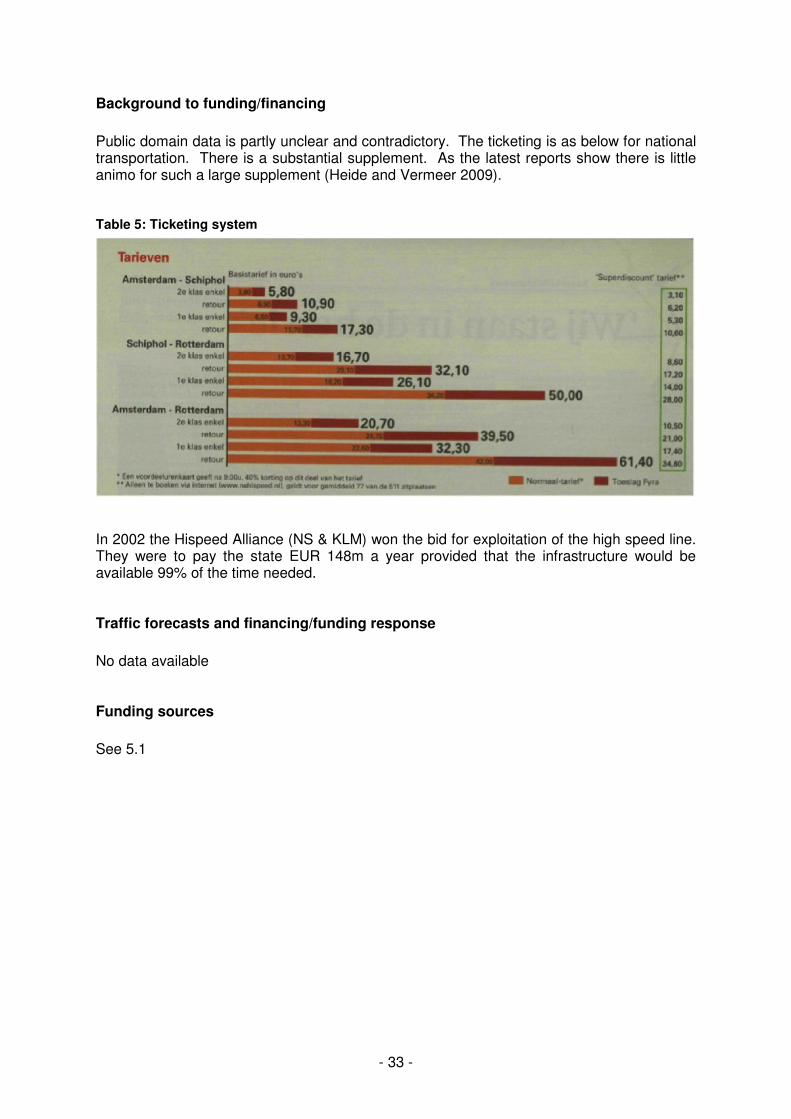
Background to funding/financing
Public domain data is partly unclear and contradictory. The ticketing is as below for national transportation. There is a substantial supplement. As the latest reports show there is little animo for such a large supplement (Heide and Vermeer 2009). Table 5: Ticketing system
In 2002 the Hispeed Alliance (NS & KLM) won the bid for exploitation of the high speed line. They were to pay the state EUR 148m a year provided that the infrastructure would be available 99% of the time needed. Traffic forecasts and financing/funding response
No data available Funding sources
See 5.1
- 34 -
F OPERATIONS
There are no clear numbers about the actual ridership on the high speed train line as it only started operation in September 2009 for national ridership. NS Hispeed, the transport provider, expects to transport 24m passengers in 2010 of which 16m will be national passengers.
- 35 -
G BIBLIOGRAPHY
Algemene Rekenkamer (2002). Nieuwe financiële instrumenten in publiek-private samenwerking. Heide, L. v. d. and O. Vermeer (2009). Snel, sneller, snelst. NRC Handelsblad. Klijn, E.-H. and G. R. Teisman (2003). "Institutional and Strategic Barriers to Public-Private Partnership: An Analysis of Dutch Cases." Public Money and Management 23(3): 137- 146. Koppenjan, J. F. M. (2005). "The Formation of Public-Private Partnerships: Lessons from Nine Transport Infrastructure Projects in the Netherlands." Public Administration 83(1): 135-157. Kranendonk, P., P. Van der Kroft, et al., Eds. (2006). Witte vlekken ingekleurd. Archeologie in het trace van de HSLZuid. Deel 1: Tekst, Deel 2: Catalogi en bijlagen. Amersfoort, ROB. Ministerie van Economische Zaken (1990). Economie met open grenzen. Den Haag, Sdu. 3: Kabinetsstandpunt en nota van toelichting. Den Haag, Sdu. Ministerie van Verkeer en Waterstaat (1998). Nota van Toelichting bij Tracebesluit hogesnelheidslijn-zuid. Den Haag, Ministerie van Verkeer en Waterstaat. Ministerie van Verkeer en Waterstaat (2005). 205-142, 2050602400 Feitenrelaas treinen HSL-Zuid. Den Haag. Ministerie van verkeer en Waterstaat (2005). Voortgansrapport 17 Hogesnelheidslijn-Zuid. Ministerie van Verkeer en Waterstaat (2007). Voortgansrapport 20 Hogesnelheidslijn-Zuid. Den Haag, Ministerie van Verkeer en Waterstaat. Ministerie van VROM (1993). Vierde Nota Ruimtelijke Ordening Extra. Den Haag, Sdu. Projectorganisatie Hogesnelheidslijn-Zuid (1997). Voortgangsrapportage 1. Den Haag, Projectorganisatie Hogesnelheidslijn-Zuid. Ministerie van Financiën (2008). "Begroting 2008." from http://rijksbegroting.minfin.nl/2008/voorbereiding/begrotin g,kst108441b_13.html. Ministerie van Verkeer en Waterstaat (1990). Tweede Structuurschema Verkeer en Vervoer. Den Haag, Sdu. Ministerie van Verkeer en Waterstaat (1994). Nieuwe HSLNota: Nederlands deel hogesnelheidsspoorverbinding Amsterdam-Brussel-Parijs/London. Beleidsnota. Den Haag, Sdu. Ministerie van Verkeer en Waterstaat (1996). Planologische Kernbeslissing HSL Zuid: Nederlands deel hogesnelheidsspoorverbinding Amsterdam-Brussel-Parijs/London; dl Ruimtelijk Planbureau (2007). Grensoverschrijdende projecten in Nederland en Vlaanderen. Rotterdam, Nai Uitgevers. Teulings, C. N. and C. C. Koopmans (2004). Rendement en Publieke Belangen. Amsterdam, SEO.
- 36 -
TK, T. K. d. S. G. (1995). TK, 1995-1996,22026 nr 14. TrainMagazine (2007) NS Hispeed/HAS VROM, M. v. (1990). Nationaal Milieubeleidsplan Plus. Den Haag, Sdu.