Embed Size (px)
Citation preview
Department of Transport and Main Roads
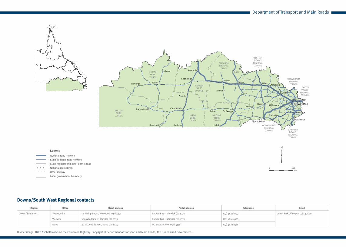
Downs/South West
BALONNESHIRE
COUNCIL
BULLOOSHIRE
COUNCIL
GOONDIWINDIREGIONALCOUNCIL
LOCKYERVALLEY
REGIONALCOUNCIL
MARANOAREGIONALCOUNCIL
MURWEHSHIRE
COUNCIL
PAROOSHIRE
COUNCIL
QUILPIESHIRE
COUNCIL
SOUTHERNDOWNS
REGIONALCOUNCIL
TOOWOOMBAREGIONALCOUNCIL
WESTERNDOWNS
REGIONALCOUNCIL
WARWICK
TOOWOOMBA
Goondiwindi
St George
Stanthorpe
RomaCharleville
Gatton
Chinchilla
Dalby
Miles
CunnamullaMillmerran
Injune
Surat
Mitchell
Augathella
Quilpie
Thargomindah
Inglewood
WestmarMoonie
Hebel
Dunkeld
Adavale
Eromanga
Hungerford
Wyandra
Bollon
Barringun
\\imapsfile\jobs\jobs\CORPORATE PRODUCTS\Annual Report and RIP Maps\RIP Maps\2013\Region RIP Maps\Downs South West\Downs South West Region QTRIP_2013.mxd April 2013
downs south west region
³0 150
Km
LegendNational road networkState strategic road networkState regional and other district roadNational rail network
Local government boundaryOther railway
Downs/South West Regional contacts
Region Office Street address Postal address Telephone Email
Downs/South West Toowoomba 1-5 Phillip Street, Toowoomba Qld 4350 Locked Bag 1, Warwick Qld 4370 (07) 4639 0777 [email protected]
Warwick 306 Wood Street, Warwick Qld 4370 Locked Bag 1, Warwick Qld 4370 (07) 4661 6333
Roma 30 McDowall Street, Roma Qld 4455 PO Box 126, Roma Qld 4455 (07) 4622 9511
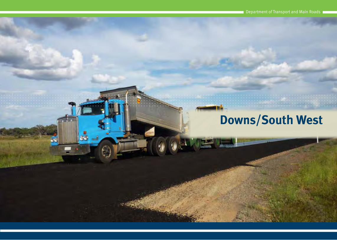
Divider image: TNRP Asphalt works on the Carnarvon Highway. Copyright © Department of Transport and Main Roads, The Queensland Government.
Department of Transport and Main Roads
Department of Transport and Main Roads
Queensland Transport and Roads Investment Program 2013-14 to 2016-17 | Page 49Downs/South West | Regional Profile
Overview
The Downs/South West Region covers an area of about 399,515km2, or around 23% of Queensland.1 It extends from Augathella and Wandoan in the north, south to Goondiwindi on the New South Wales Border, east to Yarraman, Toowoomba and Warwick and west to the South Australia Border.
The region has an estimated residential population of about 295,070 people or around 6.6% of Queensland’s total population.1
The region looks after about 7356km of other state-controlled roads and about 1134km of the National Network.
Regional program highlights
In 2012-13 the department completed:
• pavement widening of a 24km section on Dalby-Kogan Road, Dalby
• paving and sealing works on various sections of Roma-Taroom Road to complete bitumen sealing of this road
• repairs to flood damaged roads across the region as part of the Natural Disaster Relief and Recovery Arrangements (NDRRA) program, jointly funded by the Australian Government and Queensland Government.
• rehabilitation of a 6km section of the Leichhardt Highway, north of Goondiwindi.
In 2013-14 the department will:
• commence bridge replacement at Braemar Creek, on Dalby-Kogan Road, Dalby
• commence bridge replacement at Bum Bum Creek, on the New England Highway
• continue upgrading the Warrego Highway between Roma and Mitchell to allow Type 2 road train access as part of the Nation Building Program, jointly funded by the Australian Government and Queensland Government
• continue pavement widening to provide overtaking opportunities on Diamantina Developmental Road between Quilpie and Windorah
• complete the final stage of the New England Highway Upgrade Project between Hampton and Geham, including road widening, intersection improvements and construction of a southbound overtaking lane
• complete three new overtaking lanes on the Warrego Highway, east of Dalby, at Auchmar and Malu
• commence a two year program to upgrade various links on the Surat Basin coal seam gas (CSG) road network to accommodate traffic growth due to mining development, as part of the LNG Proponent Funded Program.
Future plans
The department is continuing to plan for the future transport requirements of residents in the Downs/South West Region.
In 2013-14 the department plans to:
• continue the Toowoomba Sub-Regional Transport Strategy Stage 2 which will assess and test scenarios to determine an appropriate multi-modal system that responds to future growth and economic development
• undertake a Principal Cycle Network Plan for the region which will prioritise cycle infrastructure investment through the Transport Infrastructure Development Scheme (TIDS) and will enable fit-for-purpose cycle investment in projects
• complete the development of the Road Link Plan for the Toowoomba-Cecil Plains Road, including planning layouts and identified priority works.
Regional profile
1 Source: Queensland Regional Profile statistical report as at 30 June 2011
(www.oesr.qld.gov.au)
Department of Transport and Main Roads
Queensland Transport and Roads Investment Program 2013-14 to 2016-17 | Page 50Downs/South West | Regional Profile
Department of Transport and Main Roads
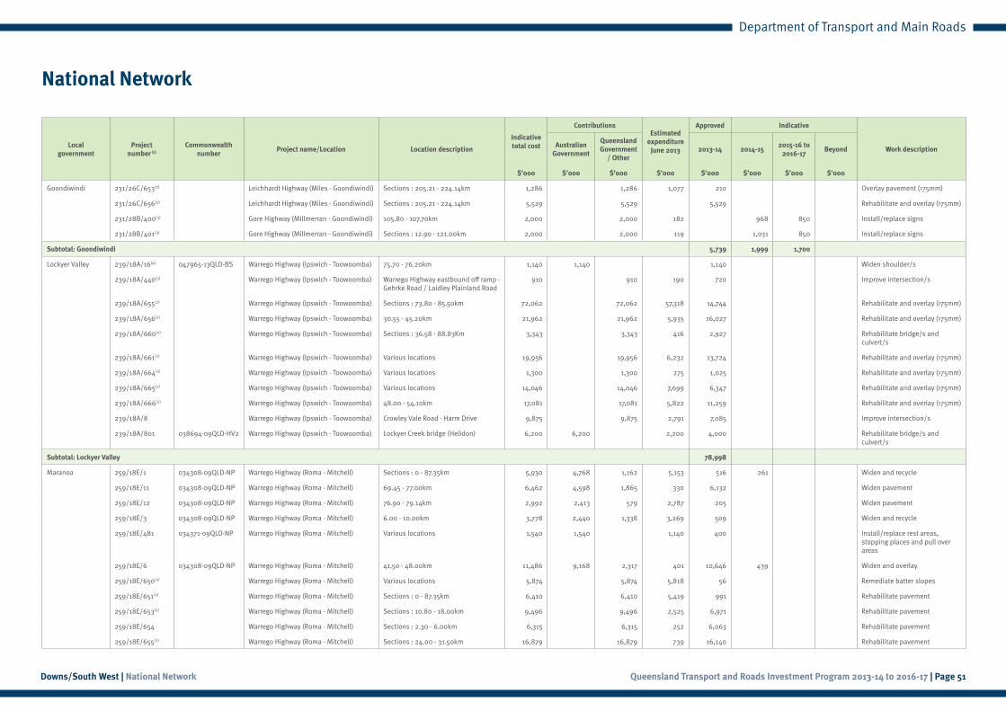
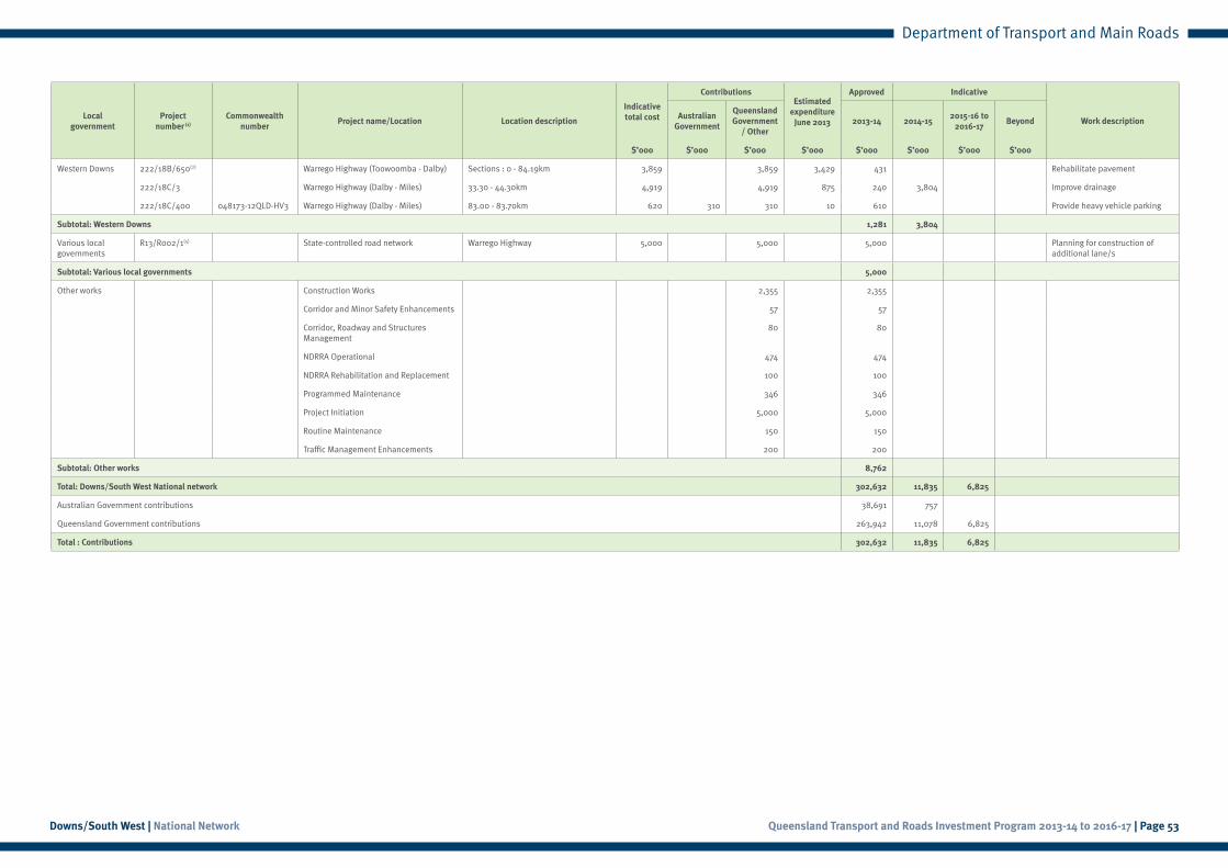
National Network
Localgovernment
Project number (1)
Commonwealthnumber
Project name/Location Location description
Indicative total cost
ContributionsEstimated
expenditure June 2013
Approved Indicative
Work descriptionAustralian
Government
Queensland Government
/ Other2013-14 2014-15
2015-16 to 2016-17
Beyond
$’000 $’000 $’000 $’000 $’000 $’000 $’000 $’000
Goondiwindi 231/26C/653(2) Leichhardt Highway (Miles - Goondiwindi) Sections : 205.21 - 224.14km 1,286 1,286 1,077 210 Overlay pavement (>75mm)
231/26C/656(2) Leichhardt Highway (Miles - Goondiwindi) Sections : 205.21 - 224.14km 5,529 5,529 5,529 Rehabilitate and overlay (>75mm)
231/28B/400(3) Gore Highway (Millmerran - Goondiwindi) 105.80 - 107.70km 2,000 2,000 182 968 850 Install/replace signs
231/28B/401(3) Gore Highway (Millmerran - Goondiwindi) Sections : 12.90 - 121.00km 2,000 2,000 119 1,031 850 Install/replace signs
Subtotal: Goondiwindi 5,739 1,999 1,700
Lockyer Valley 239/18A/16(4) 047965-13QLD-BS Warrego Highway (Ipswich - Toowoomba) 75.70 - 76.20km 1,140 1,140 1,140 Widen shoulder/s
239/18A/440(3) Warrego Highway (Ipswich - Toowoomba) Warrego Highway eastbound off ramp - Gehrke Road / Laidley Plainland Road
910 910 190 720 Improve intersection/s
239/18A/655(2) Warrego Highway (Ipswich - Toowoomba) Sections : 73.80 - 85.50km 72,062 72,062 57,318 14,744 Rehabilitate and overlay (>75mm)
239/18A/656(2) Warrego Highway (Ipswich - Toowoomba) 30.55 - 45.20km 21,962 21,962 5,935 16,027 Rehabilitate and overlay (>75mm)
239/18A/660(2) Warrego Highway (Ipswich - Toowoomba) Sections : 36.58 - 88.83Km 3,343 3,343 416 2,927 Rehabilitate bridge/s and culvert/s
239/18A/661(2) Warrego Highway (Ipswich - Toowoomba) Various locations 19,956 19,956 6,232 13,724 Rehabilitate and overlay (>75mm)
239/18A/664(2) Warrego Highway (Ipswich - Toowoomba) Various locations 1,300 1,300 275 1,025 Rehabilitate and overlay (>75mm)
239/18A/665(2) Warrego Highway (Ipswich - Toowoomba) Various locations 14,046 14,046 7,699 6,347 Rehabilitate and overlay (>75mm)
239/18A/666(2) Warrego Highway (Ipswich - Toowoomba) 48.00 - 54.10km 17,081 17,081 5,822 11,259 Rehabilitate and overlay (>75mm)
239/18A/8 Warrego Highway (Ipswich - Toowoomba) Crowley Vale Road - Harm Drive 9,875 9,875 2,791 7,085 Improve intersection/s
239/18A/801 038694-09QLD-HV2 Warrego Highway (Ipswich - Toowoomba) Lockyer Creek bridge (Helidon) 6,200 6,200 2,200 4,000 Rehabilitate bridge/s and culvert/s
Subtotal: Lockyer Valley 78,998
Maranoa 259/18E/1 034308-09QLD-NP Warrego Highway (Roma - Mitchell) Sections : 0 - 87.35km 5,930 4,768 1,162 5,153 516 261 Widen and recycle
259/18E/11 034308-09QLD-NP Warrego Highway (Roma - Mitchell) 69.45 - 77.00km 6,462 4,598 1,865 330 6,132 Widen pavement
259/18E/12 034308-09QLD-NP Warrego Highway (Roma - Mitchell) 76.90 - 79.14km 2,992 2,413 579 2,787 205 Widen pavement
259/18E/3 034308-09QLD-NP Warrego Highway (Roma - Mitchell) 6.00 - 10.00km 3,778 2,440 1,338 3,269 509 Widen and recycle
259/18E/481 034371-09QLD-NP Warrego Highway (Roma - Mitchell) Various locations 1,540 1,540 1,140 400 Install/replace rest areas, stopping places and pull over areas
259/18E/6 034308-09QLD-NP Warrego Highway (Roma - Mitchell) 41.50 - 48.00km 11,486 9,168 2,317 401 10,646 439 Widen and overlay
259/18E/650(2) Warrego Highway (Roma - Mitchell) Various locations 5,874 5,874 5,818 56 Remediate batter slopes
259/18E/651(2) Warrego Highway (Roma - Mitchell) Sections : 0 - 87.35km 6,410 6,410 5,419 991 Rehabilitate pavement
259/18E/653(2) Warrego Highway (Roma - Mitchell) Sections : 10.80 - 18.00km 9,496 9,496 2,525 6,971 Rehabilitate pavement
259/18E/654 Warrego Highway (Roma - Mitchell) Sections : 2.30 - 6.00km 6,315 6,315 252 6,063 Rehabilitate pavement
259/18E/655(2) Warrego Highway (Roma - Mitchell) Sections : 24.00 - 31.50km 16,879 16,879 739 16,140 Rehabilitate pavement
Queensland Transport and Roads Investment Program 2013-14 to 2016-17 | Page 51Downs/South West | National Network
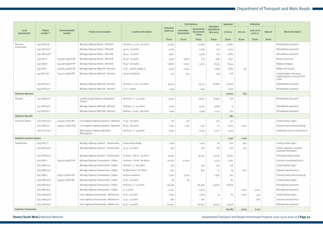
Department of Transport and Main Roads
Localgovernment
Project number (1)
Commonwealthnumber
Project name/Location Location description
Indicative total cost
ContributionsEstimated
expenditure June 2013
Approved Indicative
Work descriptionAustralian
Government
Queensland Government
/ Other2013-14 2014-15
2015-16 to 2016-17
Beyond
$’000 $’000 $’000 $’000 $’000 $’000 $’000 $’000
Maranoa (continued)
259/18E/656 Warrego Highway (Roma - Mitchell) Sections : 52.00 - 59.00km 12,964 12,964 303 12,661 Rehabilitate pavement
259/18E/657(2) Warrego Highway (Roma - Mitchell) 59.00 - 63.50km 5,339 5,339 134 5,205 Rehabilitate pavement
259/18E/658(2) Warrego Highway (Roma - Mitchell) 69.45 - 72.50km 5,967 5,967 107 5,860 Rehabilitate pavement
259/18E/7 034308-09QLD-NP Warrego Highway (Roma - Mitchell) 56.00 - 63.50km 3,500 2,825 675 648 2,852 Widen pavement
259/18E/8 034308-09QLD-NP Warrego Highway (Roma - Mitchell) 86.50 - 86.85km 16,800 11,007 5,793 8,355 8,445 Replace bridge/s
259/18F/1 000584-05QLD-NP Warrego Highway (Mitchell - Morven) 0.30 - 3.90km (stage 2) 5,042 5,042 1,099 3,786 157 Widen and recycle
259/18F/481 034371-09QLD-NP Warrego Highway (Mitchell - Morven) Various locations 257 257 149 108 Install/replace rest areas, stopping places and pull over areas
259/18F/651(2) Warrego Highway (Mitchell - Morven) Sections : 11.00 - 92.60km 43,715 43,715 18,889 24,826 Rehabilitate pavement
259/18F/652(2) Warrego Highway (Mitchell - Morven) 1.20 - 3.75km 1,455 1,455 1,455 Rehabilitate pavement
Subtotal: Maranoa 113,827 857
Murweh 247/13B/651(2) Landsborough Highway (Augathella - Tambo)
Sections : 0 - 45.40km 19,371 19,371 18,993 378 Rehabilitate pavement
247/18F/650(2) Warrego Highway (Mitchell - Morven) Sections : 0 - 92.60km 4,704 4,704 4,698 6 Rehabilitate pavement
247/18F/651(2) Warrego Highway (Mitchell - Morven) Sections : 67.44 - 88.00km 1,346 1,346 1,145 201 Rehabilitate pavement
Subtotal: Murweh 585
Southern Downs 262/17B/400(4) 041990-11QLD-BS Cunningham Highway (Ipswich - Warwick) 71.00 - 83.50km 750 750 213 537 Install/replace signs
262/17B/401 048172-12QLD-HV3 Cunningham Highway (Ipswich - Warwick) 85.00 - 85.70km 2,300 1,150 1,150 50 1,000 1,250 Provide heavy vehicle parking
262/22C/651(2) New England Highway (Warwick - Wallangarra)
Sections : 0 - 97.06km 6,747 6,747 3,227 3,520 Undertake routine maintenance
Subtotal: Southern Downs 5,057 1,250
Toowoomba 265/18A/1(3) Warrego Highway (Ipswich - Toowoomba) Toowoomba Range 1,190 1,190 85 200 905 Install/replace signs
265/18A/404(3) Warrego Highway (Ipswich - Toowoomba) 94.13 - 94.15km 650 650 80 150 420 Install, upgrade or replace roadside delineation
265/18A/653(2) Warrego Highway (Ipswich - Toowoomba) Sections : 88.83 - 95.01km 55,091 55,091 15,730 39,361 Remediate batter slopes
265/18B/1 034370-09QLD-NP Warrego Highway (Toowoomba - Dalby) Sections : 28.86 - 80.80km 10,000 10,000 5,533 4,467 Construct overtaking lane/s
265/18B/202(3) Warrego Highway (Toowoomba - Dalby) Sections : 0 - 84.36km 350 350 194 156 Install/replace signs
265/18B/203(3) Warrego Highway (Toowoomba - Dalby) Bridge Street / Tor Street 650 650 31 19 600 Improve intersection/s
265/18B/3 034371-09QLD-NP Warrego Highway (Toowoomba - Dalby) Various locations 2,500 2,500 1,997 503 Provide heavy vehicle parking
265/18B/403(4) 047943-13QLD-BS Warrego Highway (Toowoomba - Dalby) 17.80 - 18.50km 85 85 85 Install/replace signs
265/18B/652(2) Warrego Highway (Toowoomba - Dalby) Sections : 0 - 74.61km 66,465 66,465 47,627 18,839 Rehabilitate pavement
265/18B/803 Warrego Highway (Toowoomba - Dalby) 0 - 4.50km 5,300 5,300 1,000 4,300 Rehabilitate pavement
265/28A/400(3) Gore Highway (Toowoomba - Millmerran) 8.00 - 79.00km 1,650 1,650 20 85 1,000 545 Install/replace signs
265/28A/401(3) Gore Highway (Toowoomba - Millmerran) 13.50 - 13.80km 280 280 280 Improve intersection/s
265/28A/650(2) Gore Highway (Toowoomba - Millmerran) 61.70 - 74.60km 50,042 50,042 30,525 19,518 Rehabilitate pavement
Subtotal: Toowoomba 83,383 3,925 5,125
Queensland Transport and Roads Investment Program 2013-14 to 2016-17 | Page 52Downs/South West | National Network
Department of Transport and Main Roads
Localgovernment
Project number (1)
Commonwealthnumber
Project name/Location Location description
Indicative total cost
ContributionsEstimated
expenditure June 2013
Approved Indicative
Work descriptionAustralian
Government
Queensland Government
/ Other2013-14 2014-15
2015-16 to 2016-17
Beyond
$’000 $’000 $’000 $’000 $’000 $’000 $’000 $’000
Western Downs 222/18B/650(2) Warrego Highway (Toowoomba - Dalby) Sections : 0 - 84.19km 3,859 3,859 3,429 431 Rehabilitate pavement
222/18C/3 Warrego Highway (Dalby - Miles) 33.30 - 44.30km 4,919 4,919 875 240 3,804 Improve drainage
222/18C/400 048173-12QLD-HV3 Warrego Highway (Dalby - Miles) 83.00 - 83.70km 620 310 310 10 610 Provide heavy vehicle parking
Subtotal: Western Downs 1,281 3,804
Various local governments
R13/R002/1(5) State-controlled road network Warrego Highway 5,000 5,000 5,000 Planning for construction of additional lane/s
Subtotal: Various local governments 5,000
Other works Construction Works 2,355 2,355
Corridor and Minor Safety Enhancements 57 57
Corridor, Roadway and Structures Management
80 80
NDRRA Operational 474 474
NDRRA Rehabilitation and Replacement 100 100
Programmed Maintenance 346 346
Project Initiation 5,000 5,000
Routine Maintenance 150 150
Traffic Management Enhancements 200 200
Subtotal: Other works 8,762
Total: Downs/South West National network 302,632 11,835 6,825
Australian Government contributions 38,691 757
Queensland Government contributions 263,942 11,078 6,825
Total : Contributions 302,632 11,835 6,825
Queensland Transport and Roads Investment Program 2013-14 to 2016-17 | Page 53Downs/South West | National Network
Department of Transport and Main Roads
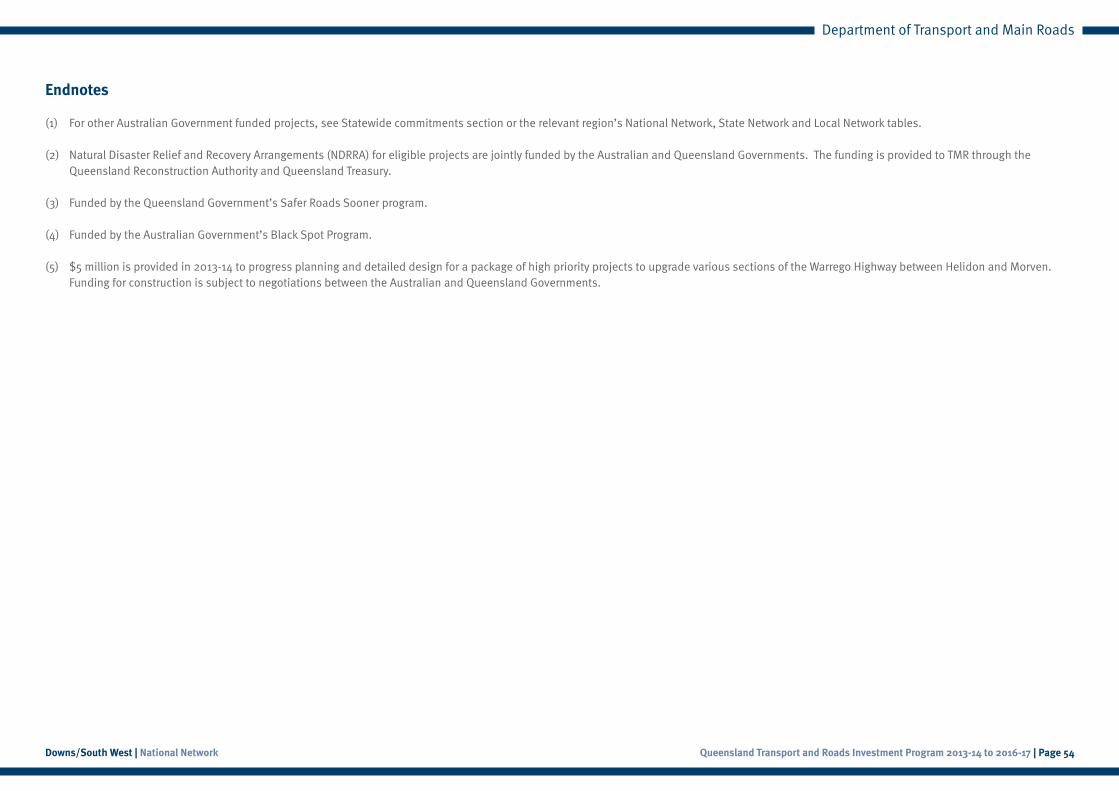
Endnotes
(1) For other Australian Government funded projects, see Statewide commitments section or the relevant region’s National Network, State Network and Local Network tables.
(2) Natural Disaster Relief and Recovery Arrangements (NDRRA) for eligible projects are jointly funded by the Australian and Queensland Governments. The funding is provided to TMR through the Queensland Reconstruction Authority and Queensland Treasury.
(3) Funded by the Queensland Government’s Safer Roads Sooner program.
(4) Funded by the Australian Government’s Black Spot Program.
(5) $5 million is provided in 2013-14 to progress planning and detailed design for a package of high priority projects to upgrade various sections of the Warrego Highway between Helidon and Morven. Funding for construction is subject to negotiations between the Australian and Queensland Governments.
Queensland Transport and Roads Investment Program 2013-14 to 2016-17 | Page 54Downs/South West | National Network
Queensland Transport and Roads Investment Program 2013-14 to 2016-17 | Page 55Downs/South West | State Network
Department of Transport and Main Roads
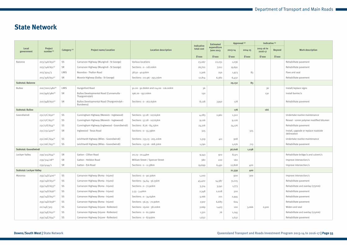
State Network
Local government
Project number (1) Category (2) Project name/Location Location description
Indicative total cost
Estimatedexpenditure
June 2013
Approved (3) Indicative (4)
Work description2013-14 2014-152015-16 to
2016-17Beyond
$’000 $’000 $’000 $’000 $’000 $’000
Balonne 203/24A/650(5) SS Carnarvon Highway (Mungindi - St George) Various locations 23,067 22,031 1,036 Rehabilitate pavement
203/24A/651(5) SR Carnarvon Highway (Mungindi - St George) Sections : 0 - 118.00km 26,702 7,011 19,691 Rehabilitate pavement
203/3514/3 LRRS Noondoo - Thallon Road 38.50 - 40.92km 2,306 250 1,973 83 Pave and seal
203/35A/652(5) SR Moonie Highway (Dalby - St George) Sections : 211.96 - 293.75km 12,814 6,382 6,432 Rehabilitate pavement
Subtotal: Balonne 29,132 83
Bulloo 210/7001/480(6) LRRS Hungerford Road 91.20 - 92.80km and 114.00 - 116.00km 36 36 Install/replace signs
210/94A/480(6) SR Bulloo Developmental Road (Cunnamulla - Thargomindah)
196.20 - 197.20km 130 130 Install barrier/s
210/94B/650(5) SR Bulloo Developmental Road (Thargomindah - Bundeena)
Sections : 0 - 162.65km 8,128 7,950 178 Rehabilitate pavement
Subtotal: Bulloo 178 166
Goondiwindi 231/17C/650(5) SS Cunningham Highway (Warwick - Inglewood) Sections : 57.28 - 107.65km 4,283 2,961 1,322 Undertake routine maintenance
231/17C/651(5) SS Cunningham Highway (Warwick - Inglewood) Sections : 57.28 - 107.65km 9,126 9,126 Reseal - 10mm polymer modified bitumen
231/17D/654(5) SS Cunningham Highway (Inglewood - Goondiwindi) Sections : 8.76 - 84.75km 24,176 24,176 Rehabilitate pavement
231/231/400(6) SR Inglewood - Texas Road Sections : 0 - 55.39km 325 325 Install, upgrade or replace roadside delineation
231/26C/654(5) SS Leichhardt Highway (Miles - Goondiwindi) Sections : 133.13 - 205.21km 1,319 411 908 Undertake routine maintenance
231/26C/657(5) SS Leichhardt Highway (Miles - Goondiwindi) Sections : 137.16 - 168.31km 1,790 1,076 713 Rehabilitate pavement
Subtotal: Goondiwindi 36,608 1,038
Lockyer Valley 239/313/654(5) SR Gatton - Clifton Road 20.23 - 20.44km 9,343 972 8,371 Rehabilitate bridge/s and culvert/s
239/314/28(6) SR Gatton - Helidon Road William Street / Spencer Street 380 220 160 Improve intersection/s
239/4144/1 SR Gatton - Esk Road Sections : 0 - 11.58km 19,699 6,491 12,808 400 Improve intersection/s
Subtotal: Lockyer Valley 21,339 400
Maranoa 259/24D/400(7) SS Carnarvon Highway (Roma - Injune) Sections : 0 - 90.30km 1,200 900 300 Improve intersection/s
259/24D/652(5) SS Carnarvon Highway (Roma - Injune) Sections : 34.64 - 56.35km 45,402 14,387 31,015 Rehabilitate pavement
259/24D/653(5) SS Carnarvon Highway (Roma - Injune) Sections : 0 - 72.90km 5,314 3,541 1,773 Rehabilitate and overlay (>75mm)
259/24D/656(5) SS Carnarvon Highway (Roma - Injune) 3.33 - 3.40km 2,348 2,028 320 Rehabilitate pavement
259/24D/657(5) SS Carnarvon Highway (Roma - Injune) Sections : 0 - 34.64km 3,166 221 2,945 Rehabilitate pavement
259/24D/658(5) SS Carnarvon Highway (Roma - Injune) Sections : 56.35 - 72.90km 7,307 6,683 624 Rehabilitate pavement
22/24E/303 SS Carnarvon Highway (Injune - Rolleston) Sections : 29.60 - 38.20km 7,069 1,403 100 3,066 2,500 Widen and seal
259/24E/652(5) SS Carnarvon Highway (Injune - Rolleston) Sections : 0 - 61.79km 1,321 76 1,245 Rehabilitate and overlay (>75mm)
259/24E/654(5) SS Carnarvon Highway (Injune - Rolleston) Sections : 0 - 87.93km 1,632 1,632 Rehabilitate pavement
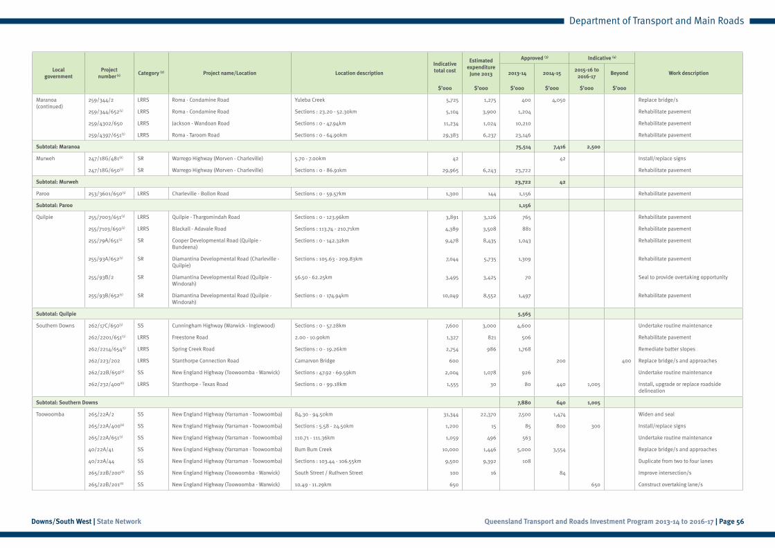
Queensland Transport and Roads Investment Program 2013-14 to 2016-17 | Page 56Downs/South West | State Network
Department of Transport and Main Roads
Local government
Project number (1) Category (2) Project name/Location Location description
Indicative total cost
Estimatedexpenditure
June 2013
Approved (3) Indicative (4)
Work description2013-14 2014-152015-16 to
2016-17Beyond
$’000 $’000 $’000 $’000 $’000 $’000
Maranoa (continued)
259/344/2 LRRS Roma - Condamine Road Yuleba Creek 5,725 1,275 400 4,050 Replace bridge/s
259/344/652(5) LRRS Roma - Condamine Road Sections : 23.20 - 52.30km 5,104 3,900 1,204 Rehabilitate pavement
259/4302/650 LRRS Jackson - Wandoan Road Sections : 0 - 47.94km 11,234 1,024 10,210 Rehabilitate pavement
259/4397/651(5) LRRS Roma - Taroom Road Sections : 0 - 64.90km 29,383 6,237 23,146 Rehabilitate pavement
Subtotal: Maranoa 75,514 7,416 2,500
Murweh 247/18G/481(6) SR Warrego Highway (Morven - Charleville) 5.70 - 7.00km 42 42 Install/replace signs
247/18G/650(5) SR Warrego Highway (Morven - Charleville) Sections : 0 - 86.91km 29,965 6,243 23,722 Rehabilitate pavement
Subtotal: Murweh 23,722 42
Paroo 253/3601/650(5) LRRS Charleville - Bollon Road Sections : 0 - 59.57km 1,300 144 1,156 Rehabilitate pavement
Subtotal: Paroo 1,156
Quilpie 255/7003/651(5) LRRS Quilpie - Thargomindah Road Sections : 0 - 123.96km 3,891 3,126 765 Rehabilitate pavement
255/7103/650(5) LRRS Blackall - Adavale Road Sections : 113.74 - 210.71km 4,389 3,508 881 Rehabilitate pavement
255/79A/651(5) SR Cooper Developmental Road (Quilpie - Bundeena)
Sections : 0 - 142.32km 9,478 8,435 1,043 Rehabilitate pavement
255/93A/652(5) SR Diamantina Developmental Road (Charleville - Quilpie)
Sections : 105.63 - 209.83km 7,044 5,735 1,309 Rehabilitate pavement
255/93B/2 SR Diamantina Developmental Road (Quilpie - Windorah)
56.50 - 62.25km 3,495 3,425 70 Seal to provide overtaking opportunity
255/93B/652(5) SR Diamantina Developmental Road (Quilpie - Windorah)
Sections : 0 - 174.94km 10,049 8,552 1,497 Rehabilitate pavement
Subtotal: Quilpie 5,565
Southern Downs 262/17C/650(5) SS Cunningham Highway (Warwick - Inglewood) Sections : 0 - 57.28km 7,600 3,000 4,600 Undertake routine maintenance
262/2201/651(5) LRRS Freestone Road 2.00 - 10.90km 1,327 821 506 Rehabilitate pavement
262/2214/654(5) LRRS Spring Creek Road Sections : 0 - 19.26km 2,754 986 1,768 Remediate batter slopes
262/223/202 LRRS Stanthorpe Connection Road Carnarvon Bridge 600 200 400 Replace bridge/s and approaches
262/22B/650(5) SS New England Highway (Toowoomba - Warwick) Sections : 47.92 - 69.59km 2,004 1,078 926 Undertake routine maintenance
262/232/400(6) LRRS Stanthorpe - Texas Road Sections : 0 - 99.18km 1,555 30 80 440 1,005 Install, upgrade or replace roadside delineation
Subtotal: Southern Downs 7,880 640 1,005
Toowoomba 265/22A/2 SS New England Highway (Yarraman - Toowoomba) 84.30 - 94.50km 31,344 22,370 7,500 1,474 Widen and seal
265/22A/400(6) SS New England Highway (Yarraman - Toowoomba) Sections : 5.58 - 24.50km 1,200 15 85 800 300 Install/replace signs
265/22A/651(5) SS New England Highway (Yarraman - Toowoomba) 110.71 - 111.36km 1,059 496 563 Undertake routine maintenance
40/22A/41 SS New England Highway (Yarraman - Toowoomba) Bum Bum Creek 10,000 1,446 5,000 3,554 Replace bridge/s and approaches
40/22A/44 SS New England Highway (Yarraman - Toowoomba) Sections : 103.44 - 106.55km 9,500 9,392 108 Duplicate from two to four lanes
265/22B/200(6) SS New England Highway (Toowoomba - Warwick) South Street / Ruthven Street 100 16 84 Improve intersection/s
265/22B/201(6) SS New England Highway (Toowoomba - Warwick) 10.49 - 11.29km 650 650 Construct overtaking lane/s

Queensland Transport and Roads Investment Program 2013-14 to 2016-17 | Page 57Downs/South West | State Network
Department of Transport and Main Roads
Local government
Project number (1) Category (2) Project name/Location Location description
Indicative total cost
Estimatedexpenditure
June 2013
Approved (3) Indicative (4)
Work description2013-14 2014-152015-16 to
2016-17Beyond
$’000 $’000 $’000 $’000 $’000 $’000
Toowoomba (continued)
265/22B/404(6) SS New England Highway (Toowoomba - Warwick) 18.00 - 20.00km 1,152 500 652 Install/replace signs
265/321/1(6) SR Drayton Connection Road 3.75 - 7.50km 1,871 198 73 1,600 Widen and seal shoulder/s
265/321/650(5) SR Drayton Connection Road Sections : 0 - 11.17km 1,297 1,058 238 Undertake routine maintenance
265/323/650(5) SR Oakey - Pittsworth Road Sections : 4.61 - 35.20km 5,455 5,455 Rehabilitate pavement
265/324/400(6) LRRS Toowoomba - Cecil Plains Road 26.50 - 30.50km 200 50 150 Install, upgrade or replace roadside delineation
265/324/401(8) LRRS Toowoomba - Cecil Plains Road 15.00 - 20.00km 194 194 Install, upgrade or replace roadside delineation
265/324/650 LRRS Toowoomba - Cecil Plains Road Sections : 14.85 - 55.15km 4,594 4,594 Rehabilitate pavement
265/3251/400(6) SR Millmerran - Cecil Plains Road Sections : 0 - 28.00km 205 205 Install/replace signs
265/3304/401(8) LRRS Cambooya Connection Road 4.70 - 5.30km 29 29 Install/replace signs
265/3341/400(8) LRRS Greenmount Connection Road 2.80 - 4.67km 50 50 Install/replace signs
265/40C/400(6) SS D’Aguilar Highway (Yarraman - Kingaroy) 0 - 6.00km 400 10 50 340 Improve intersection/s
265/417/651(5) SR Oakey - Cooyar Road Sections : 0 - 55.72km 9,390 1,850 7,541 Undertake routine maintenance
Subtotal: Toowoomba 32,282 8,057 950
Western Downs 116/26B/35 SS Leichhardt Highway (Taroom - Miles) Sections : 29.90 - 35.01km 3,050 1,950 1,100 Widen pavement
222/26B/202(7) SS Leichhardt Highway (Taroom - Miles) 90.90 - 92.00km 1,980 1,700 280 Widen pavement
222/26B/203(7) SS Leichhardt Highway (Taroom - Miles) 28.80 - 30.70km 1,990 1,990 Widen pavement
222/26B/650(5) SS Leichhardt Highway (Taroom - Miles) Sections : 0 - 127.61km 1,550 873 676 Undertake routine maintenance
222/340/2 LRRS Dalby - Kogan Road Braemar Creek 6,000 1,000 4,000 1,000 Replace bridge/s and approaches
222/340/3(7) LRRS Dalby - Kogan Road Sections : 11.50 - 47.00km 4,580 1,000 3,580 Widen pavement
222/3402/400(7) LRRS Tara - Kogan Road 39.60 - 39.90km 150 150 Replace/upgrade guardrail section/s and end/s
222/341/2(7) LRRS Chinchilla - Tara Road Sections : 1.60 - 22.50km 6,910 500 4,000 2,410 Widen pavement
222/341/3(7) LRRS Chinchilla - Tara Road 21.60 - 21.70km 6,000 500 2,000 3,500 Widen bridge/s
222/341/4(7) LRRS Chinchilla - Tara Road Sections : 32.90 - 49.00km 3,440 1,000 2,440 Widen pavement
222/342/2(7) LRRS Kogan - Condamine Road Sections : 2.90 - 69.00km 5,880 500 3,000 2,380 Widen pavement
222/342/400(6) LRRS Kogan - Condamine Road Various locations 200 50 150 Install/replace signs
222/35A/650(5) SR Moonie Highway (Dalby - St George) Sections : 0 - 211.96km 7,000 661 6,339 Rehabilitate pavement
222/35A/652(5) SR Moonie Highway (Dalby - St George) Sections : 7.87 - 99.72km 6,292 6,292 Rehabilitate pavement
222/416/650(5) SR Dalby - Cooyar Road Sections : 0 - 36.90km 8,707 2,496 6,211 Rehabilitate pavement
222/45A/651(5) SR Bunya Highway (Dalby - Kingaroy) 5.36 - 9.40km 4,399 1,376 3,023 Rehabilitate pavement
222/45A/652(5) SR Bunya Highway (Dalby - Kingaroy) 60.95 - 61.48km 2,946 711 2,234 Rehabilitate pavement
222/R001/400(7) SN State-controlled road network Various locations 470 300 170 Install/replace signs
Subtotal: Western Downs 35,675 18,460 8,290
Queensland Transport and Roads Investment Program 2013-14 to 2016-17 | Page 58Downs/South West | State Network
Department of Transport and Main Roads
Local government
Project number (1) Category (2) Project name/Location Location description
Indicative total cost
Estimatedexpenditure
June 2013
Approved (3) Indicative (4)
Work description2013-14 2014-152015-16 to
2016-17Beyond
$’000 $’000 $’000 $’000 $’000 $’000
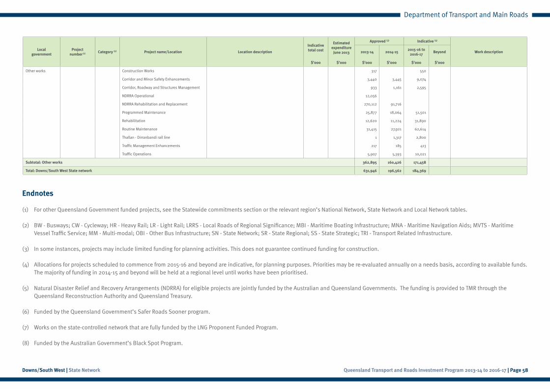
Other works Construction Works 317 550
Corridor and Minor Safety Enhancements 3,440 3,445 9,074
Corridor, Roadway and Structures Management 933 1,161 2,595
NDRRA Operational 12,056
NDRRA Rehabilitation and Replacement 270,112 91,716
Programmed Maintenance 25,877 18,064 51,501
Rehabilitation 12,620 11,224 31,890
Routine Maintenance 31,415 27,921 62,614
Thallan - Dirranbandi rail line 1 1,317 2,800
Traffic Management Enhancements 217 185 413
Traffic Operations 5,907 5,393 10,021
Subtotal: Other works 362,895 160,426 171,458
Total: Downs/South West State network 631,946 196,562 184,369
Endnotes
(1) For other Queensland Government funded projects, see the Statewide commitments section or the relevant region’s National Network, State Network and Local Network tables.
(2) BW - Busways; CW - Cycleway; HR - Heavy Rail; LR - Light Rail; LRRS - Local Roads of Regional Significance; MBI - Maritime Boating Infrastructure; MNA - Maritime Navigation Aids; MVTS - Maritime Vessel Traffic Service; MM - Multi-modal; OBI - Other Bus Infrastructure; SN - State Network; SR - State Regional; SS - State Strategic; TRI - Transport Related Infrastructure.
(3) In some instances, projects may include limited funding for planning activities. This does not guarantee continued funding for construction.
(4) Allocations for projects scheduled to commence from 2015-16 and beyond are indicative, for planning purposes. Priorities may be re-evaluated annually on a needs basis, according to available funds. The majority of funding in 2014-15 and beyond will be held at a regional level until works have been prioritised.
(5) Natural Disaster Relief and Recovery Arrangements (NDRRA) for eligible projects are jointly funded by the Australian and Queensland Governments. The funding is provided to TMR through the Queensland Reconstruction Authority and Queensland Treasury.
(6) Funded by the Queensland Government’s Safer Roads Sooner program.
(7) Works on the state-controlled network that are fully funded by the LNG Proponent Funded Program.
(8) Funded by the Australian Government’s Black Spot Program.
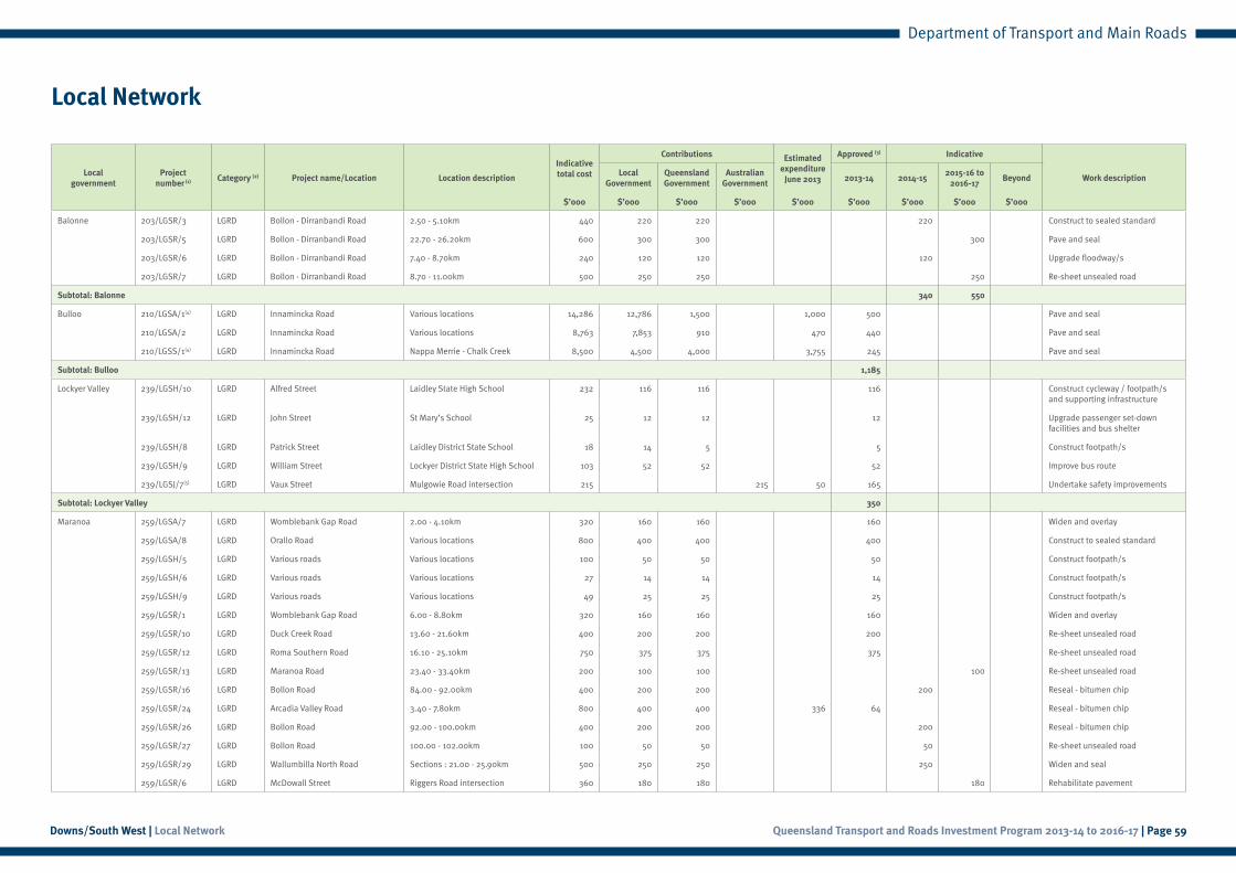
Queensland Transport and Roads Investment Program 2013-14 to 2016-17 | Page 59Downs/South West | Local Network
Department of Transport and Main Roads
Local Network
Local government
Project number (1) Category (2) Project name/Location Location description
Indicative total cost
Contributions Estimatedexpenditure
June 2013
Approved (3) Indicative
Work descriptionLocal
GovernmentQueensland Government
Australian Government
2013-14 2014-152015-16 to
2016-17Beyond
$’000 $’000 $’000 $’000 $’000 $’000 $’000 $’000 $’000
Balonne 203/LGSR/3 LGRD Bollon - Dirranbandi Road 2.50 - 5.10km 440 220 220 220 Construct to sealed standard
203/LGSR/5 LGRD Bollon - Dirranbandi Road 22.70 - 26.20km 600 300 300 300 Pave and seal
203/LGSR/6 LGRD Bollon - Dirranbandi Road 7.40 - 8.70km 240 120 120 120 Upgrade floodway/s
203/LGSR/7 LGRD Bollon - Dirranbandi Road 8.70 - 11.00km 500 250 250 250 Re-sheet unsealed road
Subtotal: Balonne 340 550
Bulloo 210/LGSA/1(4) LGRD Innamincka Road Various locations 14,286 12,786 1,500 1,000 500 Pave and seal
210/LGSA/2 LGRD Innamincka Road Various locations 8,763 7,853 910 470 440 Pave and seal
210/LGSS/1(4) LGRD Innamincka Road Nappa Merrie - Chalk Creek 8,500 4,500 4,000 3,755 245 Pave and seal
Subtotal: Bulloo 1,185
Lockyer Valley 239/LGSH/10 LGRD Alfred Street Laidley State High School 232 116 116 116 Construct cycleway / footpath/s and supporting infrastructure
239/LGSH/12 LGRD John Street St Mary’s School 25 12 12 12 Upgrade passenger set-down facilities and bus shelter
239/LGSH/8 LGRD Patrick Street Laidley District State School 18 14 5 5 Construct footpath/s
239/LGSH/9 LGRD William Street Lockyer District State High School 103 52 52 52 Improve bus route
239/LGSJ/7(5) LGRD Vaux Street Mulgowie Road intersection 215 215 50 165 Undertake safety improvements
Subtotal: Lockyer Valley 350
Maranoa 259/LGSA/7 LGRD Womblebank Gap Road 2.00 - 4.10km 320 160 160 160 Widen and overlay
259/LGSA/8 LGRD Orallo Road Various locations 800 400 400 400 Construct to sealed standard
259/LGSH/5 LGRD Various roads Various locations 100 50 50 50 Construct footpath/s
259/LGSH/6 LGRD Various roads Various locations 27 14 14 14 Construct footpath/s
259/LGSH/9 LGRD Various roads Various locations 49 25 25 25 Construct footpath/s
259/LGSR/1 LGRD Womblebank Gap Road 6.00 - 8.80km 320 160 160 160 Widen and overlay
259/LGSR/10 LGRD Duck Creek Road 13.60 - 21.60km 400 200 200 200 Re-sheet unsealed road
259/LGSR/12 LGRD Roma Southern Road 16.10 - 25.10km 750 375 375 375 Re-sheet unsealed road
259/LGSR/13 LGRD Maranoa Road 23.40 - 33.40km 200 100 100 100 Re-sheet unsealed road
259/LGSR/16 LGRD Bollon Road 84.00 - 92.00km 400 200 200 200 Reseal - bitumen chip
259/LGSR/24 LGRD Arcadia Valley Road 3.40 - 7.80km 800 400 400 336 64 Reseal - bitumen chip
259/LGSR/26 LGRD Bollon Road 92.00 - 100.00km 400 200 200 200 Reseal - bitumen chip
259/LGSR/27 LGRD Bollon Road 100.00 - 102.00km 100 50 50 50 Re-sheet unsealed road
259/LGSR/29 LGRD Wallumbilla North Road Sections : 21.00 - 25.90km 500 250 250 250 Widen and seal
259/LGSR/6 LGRD McDowall Street Riggers Road intersection 360 180 180 180 Rehabilitate pavement
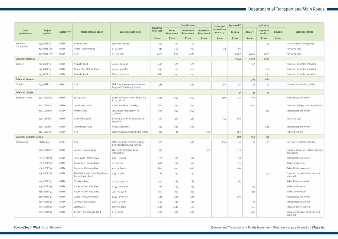
Queensland Transport and Roads Investment Program 2013-14 to 2016-17 | Page 60Downs/South West | Local Network
Department of Transport and Main Roads
Local government
Project number (1) Category (2) Project name/Location Location description
Indicative total cost
Contributions Estimatedexpenditure
June 2013
Approved (3) Indicative
Work descriptionLocal
GovernmentQueensland Government
Australian Government
2013-14 2014-152015-16 to
2016-17Beyond
$’000 $’000 $’000 $’000 $’000 $’000 $’000 $’000 $’000
Maranoa (continued)
259/LGSR/7 LGRD Bowen Street Wyndham Street 150 100 50 50 Install intersection lighting
259/LGSS/4(4) LGRD Injune - Taroom Road 0 - 2.20km 339 169 169 73 96 Pave and seal
259/LGSS/7(6) LGRD N/a 0 - 37.00km 5,635 600 5,035 2,000 2,000 1,035 Pave and seal
Subtotal: Maranoa 3,544 2,700 1,365
Murweh 247/LGSR/3 LGRD Adavale Road 46.90 - 51.10km 650 325 325 325 Construct to sealed standard
247/LGSR/4 LGRD Charleville - Bollon Road 45.30 - 49.70km 440 220 220 220 Construct to sealed standard
247/LGSR/5 LGRD Adavale Road 88.30 - 96.70km 880 440 440 440 Construct to sealed standard
Subtotal: Murweh 325 660
Quilpie 255/LGSR/1 LGAC N/a TMR / local government alliance - Regional Road Group funded
385 385 197 47 47 94 Develop technical capability
Subtotal: Quilpie 47 47 94
Southern Downs 262/LGSR/13 LGRD Eukey Road Sugarloaf Road - Storm King Drive (0 - 5.00km)
1,285 642 642 199 278 166 Rehabilitate and widen
262/LGSR/16 LGRD Lyndhursdt Lane Condamine River crossing 800 400 400 400 Construct bridge/s and approaches
262/LGSR/17 LGRD Amiens Road Texas Road intersection (0 - 2.00km)
500 250 250 250 Rehabilitate and widen
262/LGSR/3 LGRD Cullendore Road Barlows Gate Road South (12.50 - 16.90km)
870 435 435 135 300 Pave and seal
262/LGSR/8 LGRD Inverramsay Road Various locations 592 296 296 296 Rehabilitate and widen
262/LGSS/1 LGRD N/a Warwick saleyards loading facilities 150 30 120 120 Improve ramp/s
Subtotal: Southern Downs 698 566 546
Toowoomba 29/LGSL/4 LGAC N/a TMR / local government alliance – Regional Road Group funded
433 433 250 61 61 61 Develop technical capability
265/LGSJ/1(5) LGRD Gowrie - Lilyvale Road 1km north of Burkes Road intersection
375 375 375 Install, upgrade or replace roadside delineation
265/LGSR/22 LGRD Bowenville - Moola Road 2.50 - 3.50km 270 135 135 135 Rehabilitate and widen
265/LGSR/27 LGRD Crows Nest - Haden Road 0 - 7.22km 668 334 334 334 Widen and overlay
265/LGSR/37 LGRD Drayton - Wellcamp Road 4.10 - 5.80km 800 400 400 400 Rehabilitate pavement
265/LGSR/38 LGRD The Bluff Road - Crows Nest Road - Toogoolawah Road
1.43 - 2.74km 284 142 142 142 Construct to new sealed two lane standard
265/LGSR/40 LGRD St Helens Road 13.25 - 15.50km 370 185 185 185 Rehabilitate and widen
265/LGSR/41 LGRD Haden - Crows Nest Road 12.57 - 16.04km 198 99 99 99 Widen and overlay
265/LGSR/42 LGRD Haden - Crows Nest Road 7.22 - 12.57km 302 151 151 151 Widen and overlay
265/LGSR/43 LGRD Clifton - Pittsworth Road 17.40 - 19.10km 596 298 298 298 Rehabilitate and widen
265/LGSR/44 LGRD Gowrie Junction Road 2.90 - 4.36km 260 130 130 130 Rehabilitate pavement
265/LGSR/48 LGRD West Street Drayton Road 1,600 1,494 106 106 Improve intersection/s
265/LGSR/49 LGRD Geham - Groomsville Road 0 - 2.50km 1,250 625 625 625 Construct to new sealed two lane standard
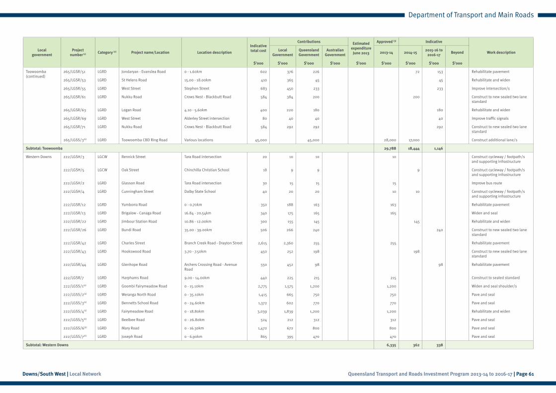
Queensland Transport and Roads Investment Program 2013-14 to 2016-17 | Page 61Downs/South West | Local Network
Department of Transport and Main Roads
Local government
Project number (1) Category (2) Project name/Location Location description
Indicative total cost
Contributions Estimatedexpenditure
June 2013
Approved (3) Indicative
Work descriptionLocal
GovernmentQueensland Government
Australian Government
2013-14 2014-152015-16 to
2016-17Beyond
$’000 $’000 $’000 $’000 $’000 $’000 $’000 $’000 $’000
Toowoomba (continued)
265/LGSR/51 LGRD Jondaryan - Evanslea Road 0 - 1.60km 602 376 226 72 153 Rehabilitate pavement
265/LGSR/53 LGRD St Helens Road 15.00 - 18.00km 410 365 45 45 Rehabilitate and widen
265/LGSR/55 LGRD West Street Stephen Street 683 450 233 233 Improve intersection/s
265/LGSR/61 LGRD Nukku Road Crows Nest - Blackbutt Road 584 384 200 200 Construct to new sealed two lane standard
265/LGSR/63 LGRD Logan Road 4.10 - 5.60km 400 220 180 180 Rehabilitate and widen
265/LGSR/69 LGRD West Street Alderley Street intersection 80 40 40 40 Improve traffic signals
265/LGSR/71 LGRD Nukku Road Crows Nest - Blackbutt Road 584 292 292 292 Construct to new sealed two lane standard
265/LGSS/3(6) LGRD Toowoomba CBD Ring Road Various locations 45,000 45,000 28,000 17,000 Construct additional lane/s
Subtotal: Toowoomba 29,788 18,444 1,146
Western Downs 222/LGSH/3 LGCW Rennick Street Tara Road intersection 20 10 10 10 Construct cycleway / footpath/s and supporting infrastructure
222/LGSH/5 LGCW Oak Street Chinchilla Christian School 18 9 9 9 Construct cycleway / footpath/s and supporting infrastructure
222/LGSH/2 LGRD Glasson Road Tara Road intersection 30 15 15 15 Improve bus route
222/LGSH/4 LGRD Cunningham Street Dalby State School 40 20 20 10 10 Construct cycleway / footpath/s and supporting infrastructure
222/LGSR/12 LGRD Yumborra Road 0 - 0.70km 350 188 163 163 Rehabilitate pavement
222/LGSR/13 LGRD Brigalow - Canaga Road 16.84 - 20.54km 340 175 165 165 Widen and seal
222/LGSR/22 LGRD Jimbour Station Road 10.86 - 12.00km 300 155 145 145 Rehabilitate and widen
222/LGSR/26 LGRD Bundi Road 35.00 - 39.00km 506 266 240 240 Construct to new sealed two lane standard
222/LGSR/42 LGRD Charles Street Branch Creek Road - Drayton Street 2,615 2,360 255 255 Rehabilitate pavement
222/LGSR/43 LGRD Hookswood Road 3.70 - 7.50km 450 252 198 198 Construct to new sealed two lane standard
222/LGSR/44 LGRD Glenhope Road Archers Crossing Road - Avenue Road
550 452 98 98 Rehabilitate pavement
222/LGSR/7 LGRD Harphams Road 9.00 - 14.00km 440 225 215 215 Construct to sealed standard
222/LGSS/1(6) LGRD Goombi Fairymeadow Road 0 - 15.10km 2,775 1,575 1,200 1,200 Widen and seal shoulder/s
222/LGSS/2(6) LGRD Weranga North Road 0 - 35.10km 1,415 665 750 750 Pave and seal
222/LGSS/3(6) LGRD Bennetts School Road 0 - 24.60km 1,372 602 770 770 Pave and seal
222/LGSS/4(6) LGRD Fairymeadow Road 0 - 18.80km 3,039 1,839 1,200 1,200 Rehabilitate and widen
222/LGSS/5(6) LGRD Beelbee Road 0 - 26.80km 524 212 312 312 Pave and seal
222/LGSS/6(6) LGRD Mary Road 0 - 16.30km 1,472 672 800 800 Pave and seal
222/LGSS/7(6) LGRD Joseph Road 0 - 6.90km 865 395 470 470 Pave and seal
Subtotal: Western Downs 6,335 362 338
Queensland Transport and Roads Investment Program 2013-14 to 2016-17 | Page 62Downs/South West | Local Network
Department of Transport and Main Roads
Local government
Project number (1) Category (2) Project name/Location Location description
Indicative total cost
Contributions Estimatedexpenditure
June 2013
Approved (3) Indicative
Work descriptionLocal
GovernmentQueensland Government
Australian Government
2013-14 2014-152015-16 to
2016-17Beyond
$’000 $’000 $’000 $’000 $’000 $’000 $’000 $’000 $’000
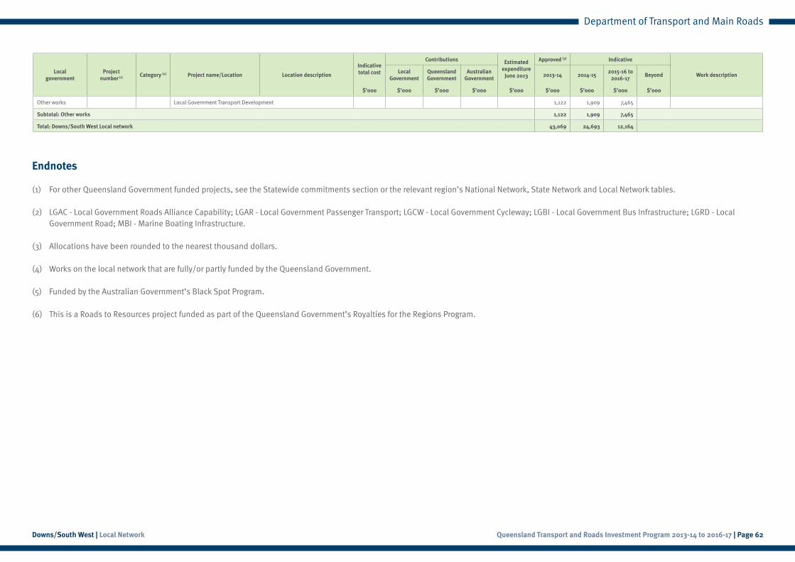
Other works Local Government Transport Development 1,122 1,909 7,465
Subtotal: Other works 1,122 1,909 7,465
Total: Downs/South West Local network 43,069 24,693 12,164
Endnotes
(1) For other Queensland Government funded projects, see the Statewide commitments section or the relevant region’s National Network, State Network and Local Network tables.
(2) LGAC - Local Government Roads Alliance Capability; LGAR - Local Government Passenger Transport; LGCW - Local Government Cycleway; LGBI - Local Government Bus Infrastructure; LGRD - Local Government Road; MBI - Marine Boating Infrastructure.
(3) Allocations have been rounded to the nearest thousand dollars.
(4) Works on the local network that are fully/or partly funded by the Queensland Government.
(5) Funded by the Australian Government’s Black Spot Program.
(6) This is a Roads to Resources project funded as part of the Queensland Government’s Royalties for the Regions Program.