Embed Size (px)
Citation preview

An easy-to-use ordering toolfor Jeppesen Electronic Charts
and Weather/Piracy Services
:: Ordering of:• Jeppesen PRIMAR ECDIS Service• C-MAP ENC• C-MAP Professional+• C-MAP Professional• C-MAP Fishery Database• C-MAP Weather Service• Jeppesen Piracy Update
:: Standard prices are automatically calculated to your order
:: Supports import of routes from major ECDIS and ECS manufacturers, as well as from C-MAP OceanView
:: Automatic selection of electronic charts along a route, or an area to generate ordering portfolio
:: Free of charge Catalog – from our web-page or from CD
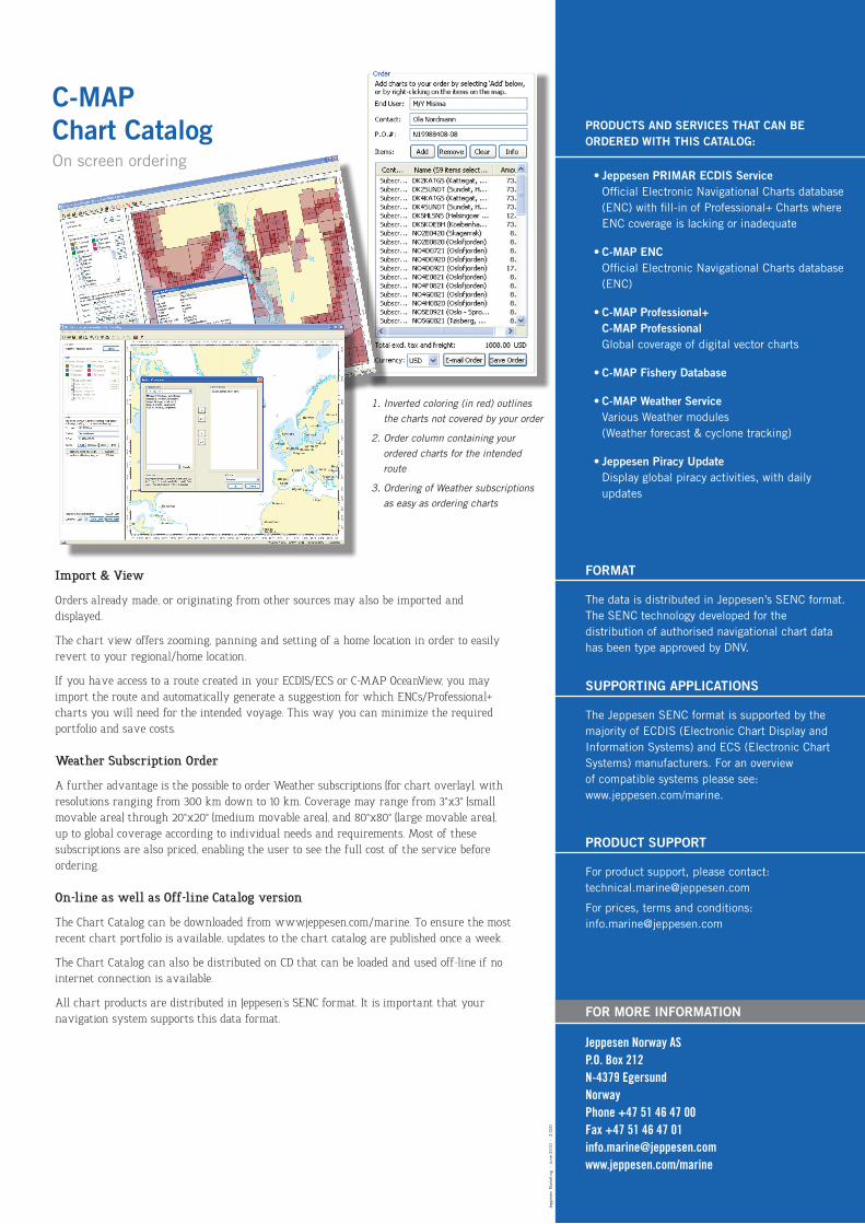
The C-MAP Chart Catalog allows you to browse, select and order the range of
Jeppesen’s chart products, or various weather options, in an interactive way.
Worldwide information on sea piracy incidents is now also available.
Orders can be electronically tailored to your specific needs using advanced tools,
such as bounding box selection, freehand selection, route selection, and more.
After selection of required items is completed, simply press the “E-mail order” button,
and enter the address of your local Jeppesen distributor.
The order file will be automatically attached.
C-MAPChart CatalogOrdering Tool for Charts and Weather/Piracy Services
jeppesen.com/marine
- -
Import & View
Orders already made, or originating from other sources may also be imported and displayed.
The chart view offers zooming, panning and setting of a home location in order to easily revert to your regional/home location.
If you have access to a route created in your ECDIS/ECS or C-MAP OceanView, you may import the route and automatically generate a suggestion for which ENCs/Professional+ charts you will need for the intended voyage. This way you can minimize the required portfolio and save costs.
Weather Subscription Order
A further advantage is the possible to order Weather subscriptions (for chart overlay), with resolutions ranging from 300 km down to 10 km. Coverage may range from 3°x3° (small movable area) through 20°x20° (medium movable area), and 80°x80° (large movable area), up to global coverage according to individual needs and requirements. Most of these subscriptions are also priced, enabling the user to see the full cost of the service before ordering.
On-line as well as Off-line Catalog version
The Chart Catalog can be downloaded from www.jeppesen.com/marine. To ensure the most recent chart portfolio is available, updates to the chart catalog are published once a week.
The Chart Catalog can also be distributed on CD that can be loaded and used off-line if no internet connection is available.
All chart products are distributed in Jeppesen’s SENC format. It is important that your navigation system supports this data format.
PRODUCTS AND SERVICES THAT CAN BE ORDERED WITH THIS CATALOG:
• Jeppesen PRIMAR ECDIS Service Official Electronic Navigational Charts database (ENC) with fill-in of Professional+ Charts where ENC coverage is lacking or inadequate
• C-MAP ENC Official Electronic Navigational Charts database (ENC)
• C-MAP Professional+ C-MAP ProfessionalGlobal coverage of digital vector charts
• C-MAP Fishery Database
• C-MAP Weather ServiceVarious Weather modules (Weather forecast & cyclone tracking)
• Jeppesen Piracy UpdateDisplay global piracy activities, with daily updates
FOR MORE INFORMATION
Jeppesen Norway AS P.O. Box 212 N-4379 Egersund Norway Phone +47 51 46 47 00 Fax +47 51 46 47 01 [email protected] www.jeppesen.com/marine
C-MAP Chart CatalogOn screen ordering
1.Invertedcoloring(inred)outlinesthechartsnotcoveredbyyourorder
2.Ordercolumncontainingyourorderedchartsfortheintendedroute
3.OrderingofWeathersubscriptionsaseasyasorderingcharts
Jepp
esen
Mar
keti
ng
– Ju
ne 2
01
0
- 2
.00
0
FORMAT
The data is distributed in Jeppesen’s SENC format.The SENC technology developed for the distribution of authorised navigational chart data has been type approved by DNV.
SUPPORTING APPLICATIONS
The Jeppesen SENC format is supported by themajority of ECDIS (Electronic Chart Display and Information Systems) and ECS (Electronic Chart Systems) manufacturers. For an overviewof compatible systems please see:www.jeppesen.com/marine.
PRODUCT SUPPORT
For product support, please contact:[email protected]
For prices, terms and conditions: [email protected]