Embed Size (px)
Citation preview
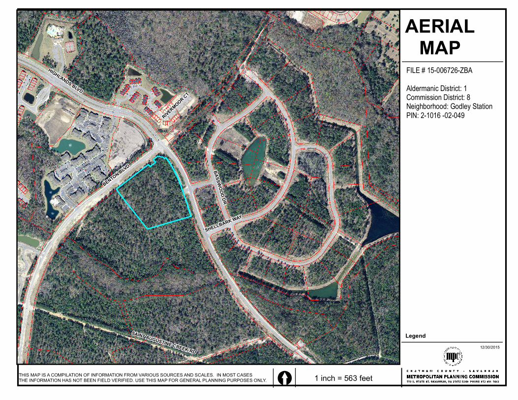
HIGHLANDS BLVD
BENTON BLVD
SHELLBARK WAY
BASSWOOD DR
SAINT AUGUSTINE CREEK RD
RIVERMOOR CT
AERIALMAP
THIS MAP IS A COMPILATION OF INFORMATION FROM VARIOUS SOURCES AND SCALES. IN MOST CASES THE INFORMATION HAS NOT BEEN FIELD VERIFIED. USE THIS MAP FOR GENERAL PLANNING PURPOSES ONLY. [ 1 inch = 563 feet
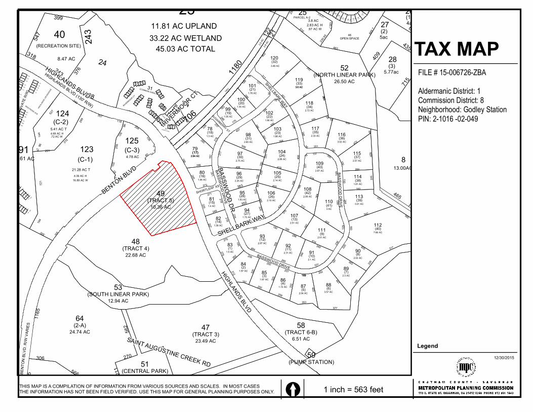
FILE # 15-006726-ZBAAldermanic District: 1Commission District: 8Neighborhood: Godley StationPIN: 2-1016 -02-049
Legend12/30/2015
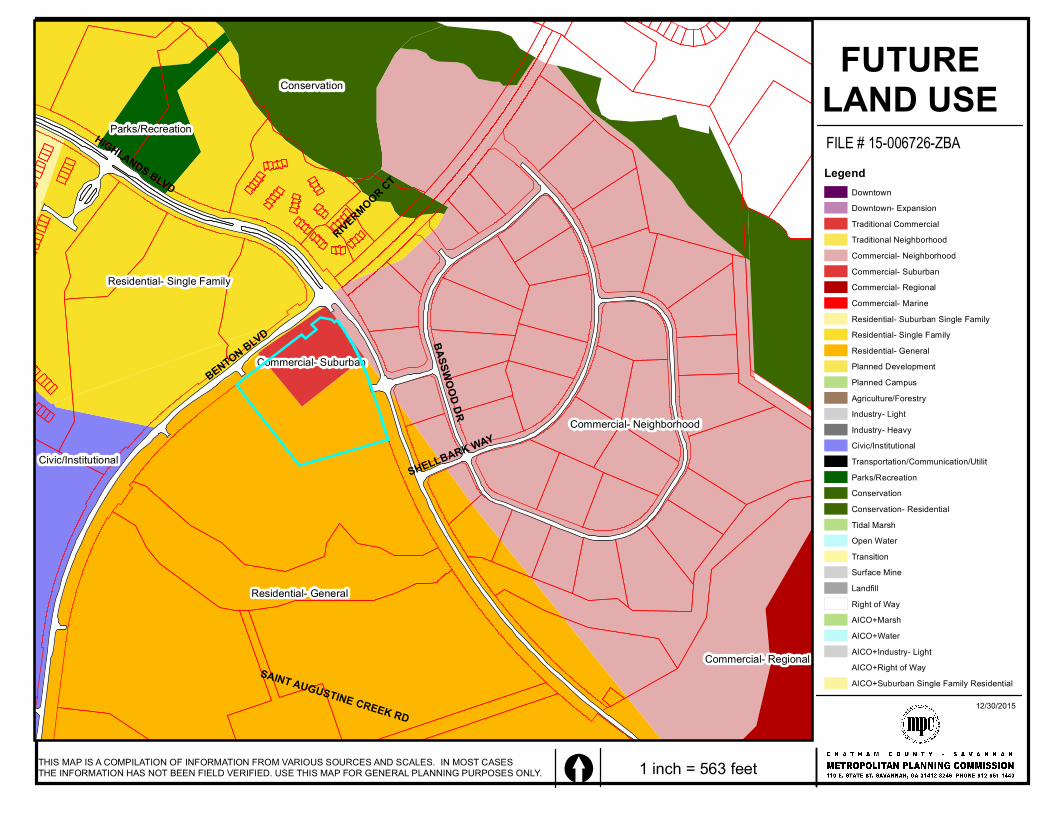
HIGHLANDS BLVD
BENTON BLVD
SHELLBARK WAY
BASSWOOD DR
SAINT AUGUSTINE CREEK RD
RIVERMOOR CT
Residential- General
Commercial- Neighborhood
Residential- Single Family
Conservation
Civic/Institutional
Parks/Recreation
Commercial- Regional
Commercial- Suburban
THIS MAP IS A COMPILATION OF INFORMATION FROM VARIOUS SOURCES AND SCALES. IN MOST CASES THE INFORMATION HAS NOT BEEN FIELD VERIFIED. USE THIS MAP FOR GENERAL PLANNING PURPOSES ONLY. [ 1 inch = 563 feet
FILE # 15-006726-ZBAAldermanic District: 1Commission District: 8Neighborhood: Godley StationPIN: 2-1016 -02-049
FUTURELAND USELegend
DowntownDowntown- ExpansionTraditional CommercialTraditional NeighborhoodCommercial- NeighborhoodCommercial- SuburbanCommercial- RegionalCommercial- MarineResidential- Suburban Single FamilyResidential- Single Family Residential- GeneralPlanned DevelopmentPlanned CampusAgriculture/ForestryIndustry- LightIndustry- HeavyCivic/InstitutionalTransportation/Communication/UtilitParks/RecreationConservationConservation- ResidentialTidal MarshOpen WaterTransitionSurface MineLandfillRight of WayAICO+MarshAICO+WaterAICO+Industry- LightAICO+Right of WayAICO+Suburban Single Family Residential
12/30/2015
566
270
365
1165
306
211
562
(1)
(3)(4)
(5)
78
10
11 (12)
(16)(17)
20
(30)
25 26
(29)(30)
2
45(7)
(8)
12 (13)
15
1617
18
23
(20)
30
(24)(25)
(26)
30
24
1
9(9)
13 (15)
(18) 19(19)28(28) 29
27(27)
(2)
3
6(6)
(10)
(11)14(14)
(23)
22(22)
21(21)
28(28) 29(29)
24
(CENTRAL PARK)
(2-A) 4723.49 AC
12.94 AC
22.68 AC
5226.50 AC
58
5951
12.50 AC
64(TRACT 3)
(SOUTH LINEAR PARK)
(TRACT 4)
49
(TRACT 6-B)
(PUMP STATION)
24.74 AC6.51 AC
53
48
(TRACT 5)10.36 AC
45.03 AC TOTAL33.22 AC WETLAND
25
6
54
57
61
83
4
2(3)
(7)
(11)
(12)
(52)
(55)
8
1011
52
56
5958
8586
87
8990
(9)
(63)
(62)
(61)
(84)
(85)
(88)
(89)
(90)
(57)
(82)
(86)
91
7
52
53
55
60
88
5
3
1
(5)(4)
(2)
(6)
(8)
(10)
(13)
(15)
(54)
(56)
(59)
(64)
(83)
(87)
19.61 AC
9
1213
14
6362
84
(1)
(14)
(50)(51
)
(53)
(58)
(60)
(81)
8.47 AC
243
465
31(COMMON AREA)
8
(RECREATION SITE)40 11.81 AC UPLAND
BENT
ONBL
VD. R
/WVA
RIES
23
706
(NORTH LINEAR PARK)
HIGHLANDS BLVD
79(17)
2.64 AC
80(16)1.46 AC
(17)2.64 AC
237228
216
78(18)1.3 AC
163
246
99(19)
1.05 AC
175
98(31)2.60 AC
97(30)2.75 AC
96(29)2.25 AC
383
81(15)1.4 AC
(28)951.63 AC
271
225
249
218
227
218
270
82(14)1.38 AC
94(27)1.73 AC
350
9392
91
(12)
(11)(10)
2.87 AC
2.31 AC
2.1 AC
83
8485
8687 88
89
90(1)
(2)
(3)(4)
(5) (6)
(7)
(8)1.5 AC
1.97 AC
1.87 AC
1.72 AC
2.04 AC 3.57 AC
2.3 AC
2.02 AC
275
278
262
195212
151
325
325
250
250
206
259
201189
332 403
353
202189
377
441 346
197
225
383 226
405
285
348
349
531
286
190
358
484
355
235
310
220210
200
309 158
150
150
506
407
273
245
201
190
191
300280
296
BASSWOOD DRIVE
SHORTLEAF XS
24SUGARBERRY ST
COMMON A
REA
FALK
LAND
AVEN
UE
(PRIV
ATE R
/W)
RIVERMOOR CT
HIGHLANDS BLVD (130' R/W)MONTROSE AVE
HIGHL
ANDS
CROSS
INGS
268
100(20)1.35 AC
286
101(21)1.78 AC
189161
222
395
102(22)1.90 AC
317
496
118(34)
2.72 AC
117(35)2.33 AC 116(36)
3.02 AC
115(37)2.57 AC
114
222
103(23)
1.98 AC
104(24)
2.86 AC
105(25)
2.14 AC
106(26)2.10 AC
189
107(13)2.51 AC
189 108(42)2.06 AC
109(43)2.67 AC
110(41)3 AC
111(9)
2.51 AC
120(32)
119(33)3.6 AC
(38)1.81 AC
113(39)3.01 AC
112(40)7.66 AC
317
582542
183244
350
350
225150
150
429
472
49
180
454
357
50
26
25136
249
355
251
451 363100
301
293
448313402
692
121
363
184
356
35
35
35
298
356
408231
419
400
225
226
63
369434
376
312
228210
227
16 137 320
149
129
483
405
384
297
236
414
BASSWOOD DRIVE
BASSWOOD DRIVE
SHELLBARK WAY
4ac26(1)
27(2)5ac
28(3)
5.77ac
435
692
409
715
243
318
547
399
898
376
102
256
8793 441
20
80 5165
24
12
106
35896126
(C-3)4.78 AC
5.41 AC T(C-2)124
4.69 AC H.72 AC W
118357
310
299
4714
496
251
527
340
125
300
194
16.89 AC W4.39 AC H
21.28 AC T
(C-1)123
721
208
565
229
20
5
15
65
1957
1180
122121
3.6 AC
3.48 AC
2.8 AC2.9
AC
254
46OPEN SPACE
252.4
9
PARCEL A-2
2.83 AC H.97 AC W
3.8 AC
463
516
230.95
100.7
318.41
669.7
50 505050
5050
50
43 43
43
4321
100.05
100.05
100.05100
.05
100 100
100
4039
3837 36
4543
(9 10)(9 11)
(9 12)(9 13)
(9 14)(9 15) (9 16)
3575.21 75.21
(9 18)33
(9 17)34
60.62
75.21
75.21
100
(9 19)32
100.58
13.00AC
32
33 3435(34)
(31)(32)
(33)
36(35)
37(36)
38(37)
RIVERMOOR CT
(COMMON AREA)
31
HIGHLANDS BLVD
BENTON BLVD
SHELLBARK WAY
BASSWOOD DR
SAINT AUGUSTINE CREEK RD
RIVERMOOR CT
TAX MAP
THIS MAP IS A COMPILATION OF INFORMATION FROM VARIOUS SOURCES AND SCALES. IN MOST CASES THE INFORMATION HAS NOT BEEN FIELD VERIFIED. USE THIS MAP FOR GENERAL PLANNING PURPOSES ONLY. [ 1 inch = 563 feet
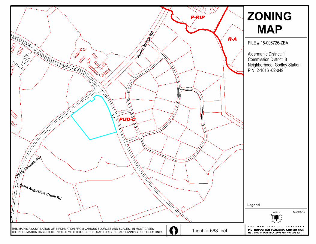
FILE # 15-006726-ZBAAldermanic District: 1Commission District: 8Neighborhood: Godley StationPIN: 2-1016 -02-049
Legend12/30/2015
Jimmy Deloach Pky
Punk
in Br
idge R
d
Saint Augustine Creek Rd
PUD-C
R-A
P-RIP ZONINGMAP
THIS MAP IS A COMPILATION OF INFORMATION FROM VARIOUS SOURCES AND SCALES. IN MOST CASES THE INFORMATION HAS NOT BEEN FIELD VERIFIED. USE THIS MAP FOR GENERAL PLANNING PURPOSES ONLY. [ 1 inch = 563 feet
FILE # 15-006726-ZBAAldermanic District: 1Commission District: 8Neighborhood: Godley StationPIN: 2-1016 -02-049
Legend12/30/2015
1
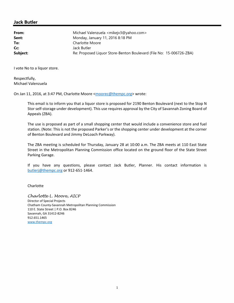
Jack Butler
From: Michael Valenzuela <[email protected]>Sent: Monday, January 11, 2016 8:18 PMTo: Charlotte MooreCc: Jack ButlerSubject: Re: Proposed Liquor Store-Benton Boulevard (File No: 15-006726-ZBA)
I vote No to a liquor store. Respectfully, Michael Valenzuela On Jan 11, 2016, at 3:47 PM, Charlotte Moore <[email protected]> wrote:
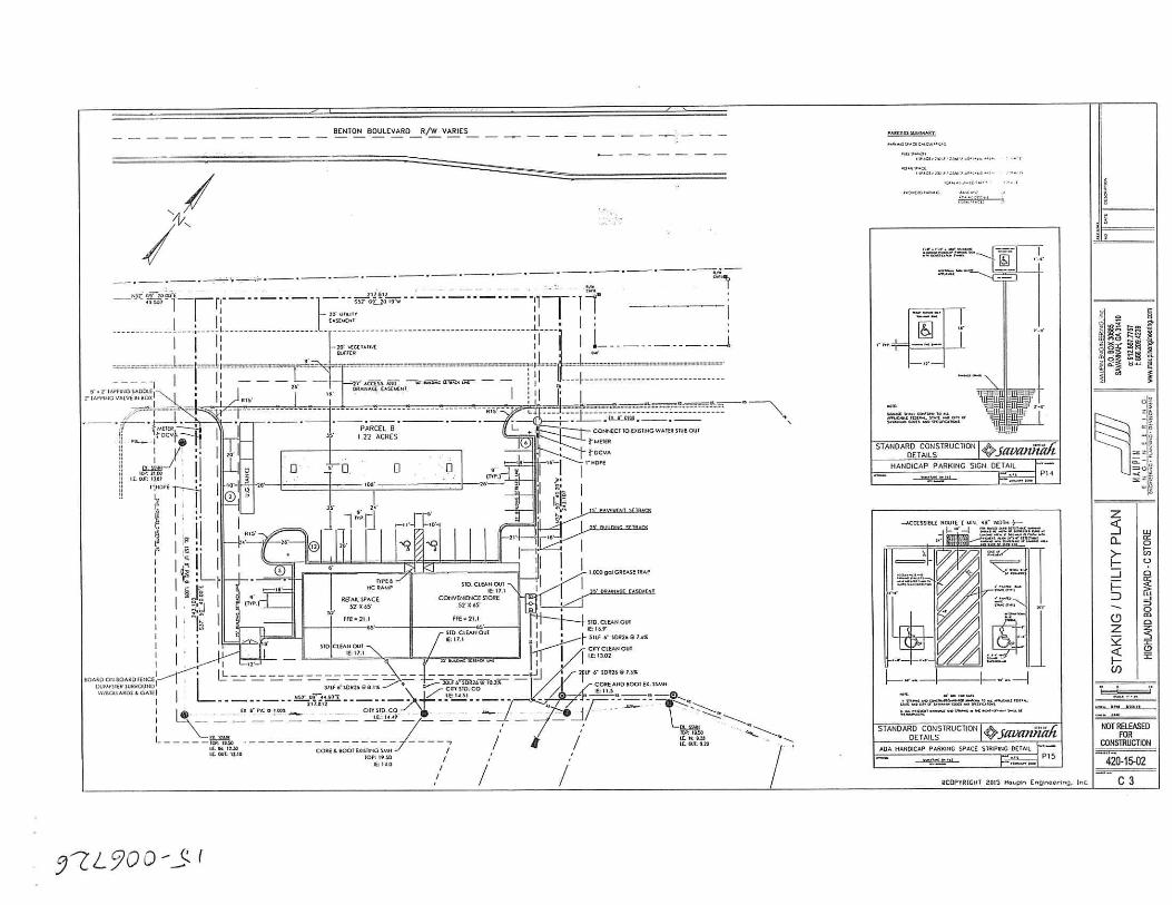
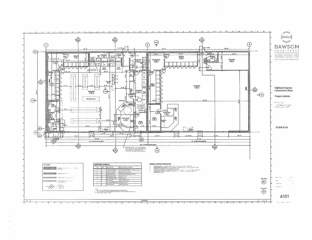
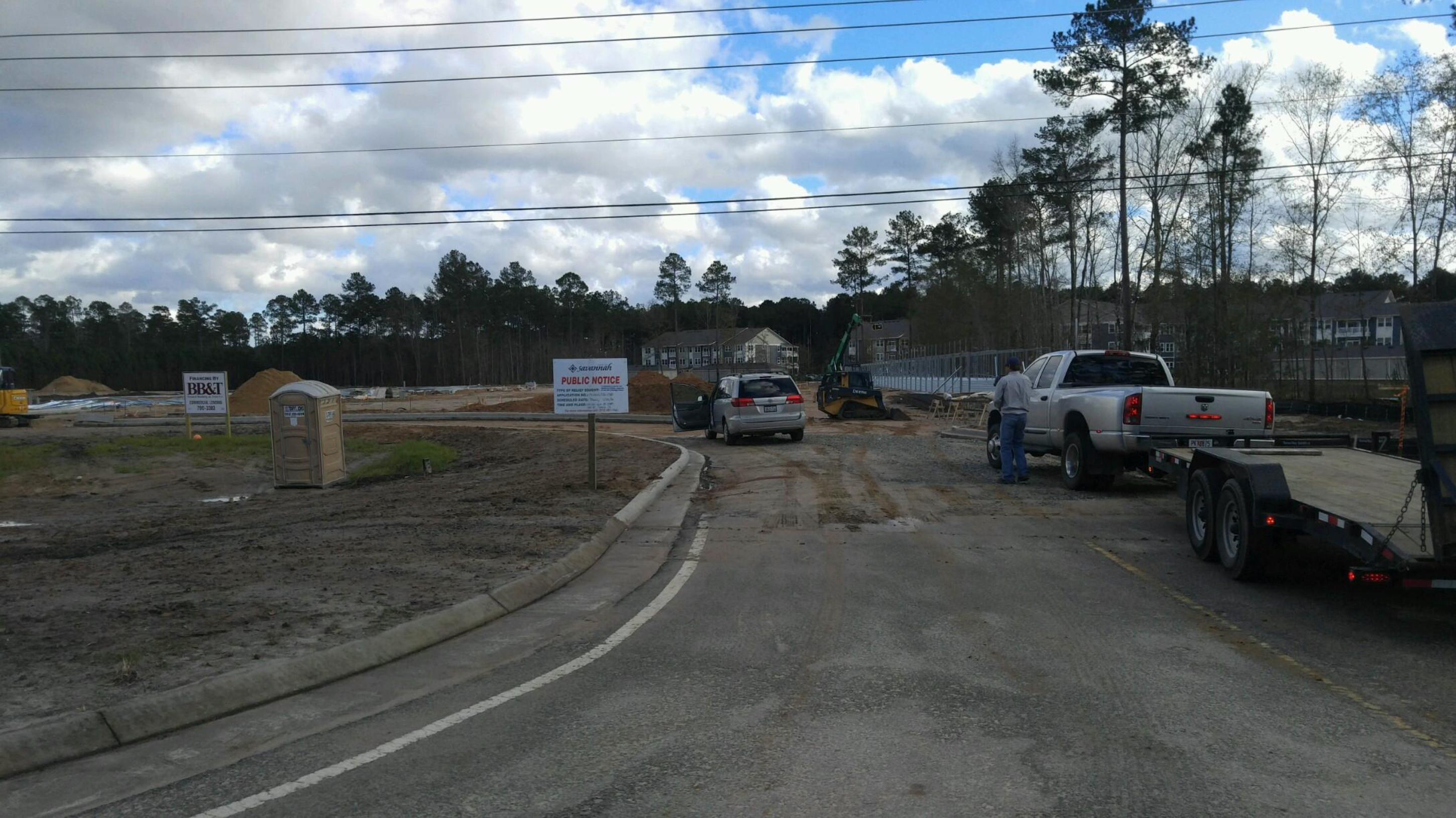
This email is to inform you that a liquor store is proposed for 2190 Benton Boulevard (next to the Stop N Stor self‐storage under development). This use requires approval by the City of Savannah Zoning Board of Appeals (ZBA). The use is proposed as part of a small shopping center that would include a convenience store and fuel station. (Note: This is not the proposed Parker’s or the shopping center under development at the corner of Benton Boulevard and Jimmy DeLoach Parkway). The ZBA meeting is scheduled for Thursday, January 28 at 10:00 a.m. The ZBA meets at 110 East State Street in the Metropolitan Planning Commission office located on the ground floor of the State Street Parking Garage. If you have any questions, please contact Jack Butler, Planner. His contact information is [email protected] or 912‐651‐1464. Charlotte Charlotte L. Moore, AICP Director of Special Projects Chatham County‐Savannah Metropolitan Planning Commission 110 E. State Street | P.O. Box 8246 Savannah, GA 31412‐8246 912.651.1465 www.thempc.org
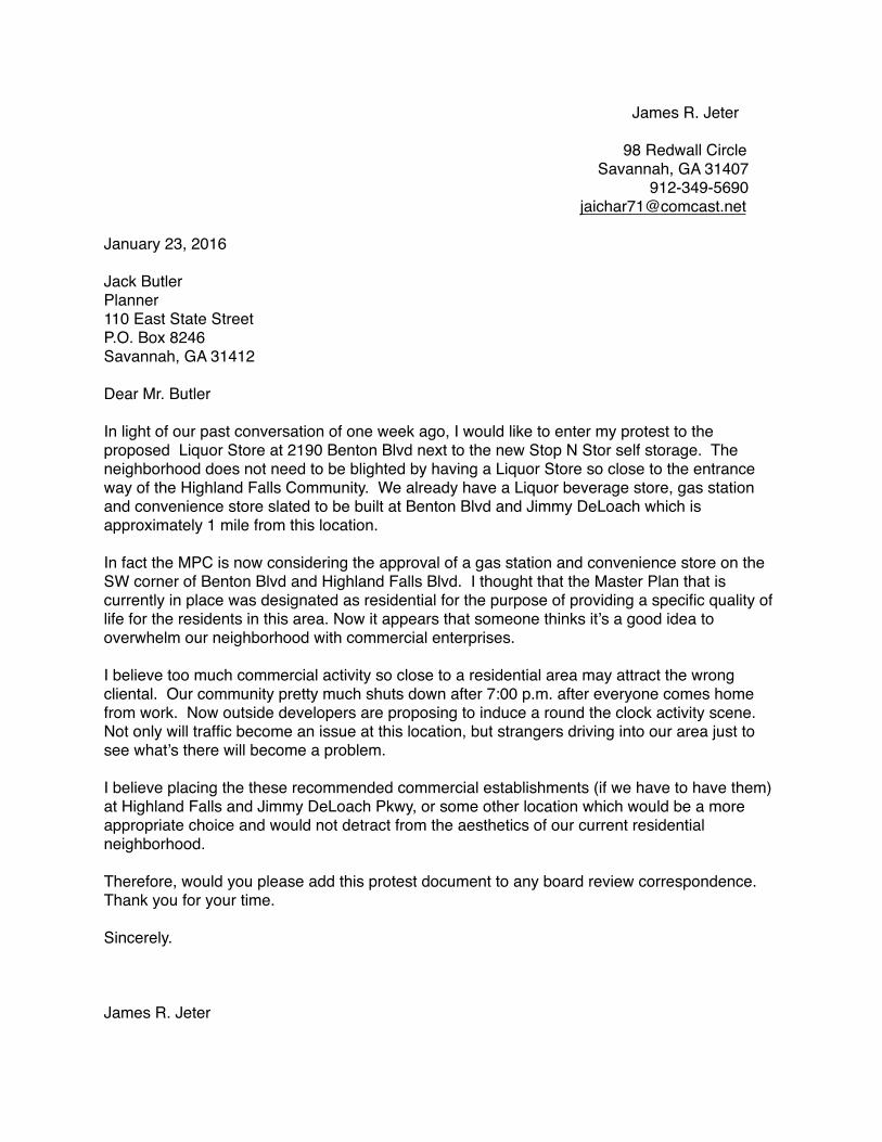
James R. Jeter
98 Redwall Circle Savannah, GA 31407
912-349-5690 [email protected]
January 23, 2016
Jack ButlerPlanner110 East State StreetP.O. Box 8246Savannah, GA 31412
Dear Mr. Butler
In light of our past conversation of one week ago, I would like to enter my protest to the proposed Liquor Store at 2190 Benton Blvd next to the new Stop N Stor self storage. The neighborhood does not need to be blighted by having a Liquor Store so close to the entrance way of the Highland Falls Community. We already have a Liquor beverage store, gas station and convenience store slated to be built at Benton Blvd and Jimmy DeLoach which is approximately 1 mile from this location.
In fact the MPC is now considering the approval of a gas station and convenience store on the SW corner of Benton Blvd and Highland Falls Blvd. I thought that the Master Plan that is currently in place was designated as residential for the purpose of providing a specific quality of life for the residents in this area. Now it appears that someone thinks it’s a good idea to overwhelm our neighborhood with commercial enterprises.
I believe too much commercial activity so close to a residential area may attract the wrong cliental. Our community pretty much shuts down after 7:00 p.m. after everyone comes home from work. Now outside developers are proposing to induce a round the clock activity scene. Not only will traffic become an issue at this location, but strangers driving into our area just to see what’s there will become a problem.
I believe placing the these recommended commercial establishments (if we have to have them) at Highland Falls and Jimmy DeLoach Pkwy, or some other location which would be a more appropriate choice and would not detract from the aesthetics of our current residential neighborhood. Therefore, would you please add this protest document to any board review correspondence. Thank you for your time.
Sincerely.
James R. Jeter