Embed Size (px)
Citation preview
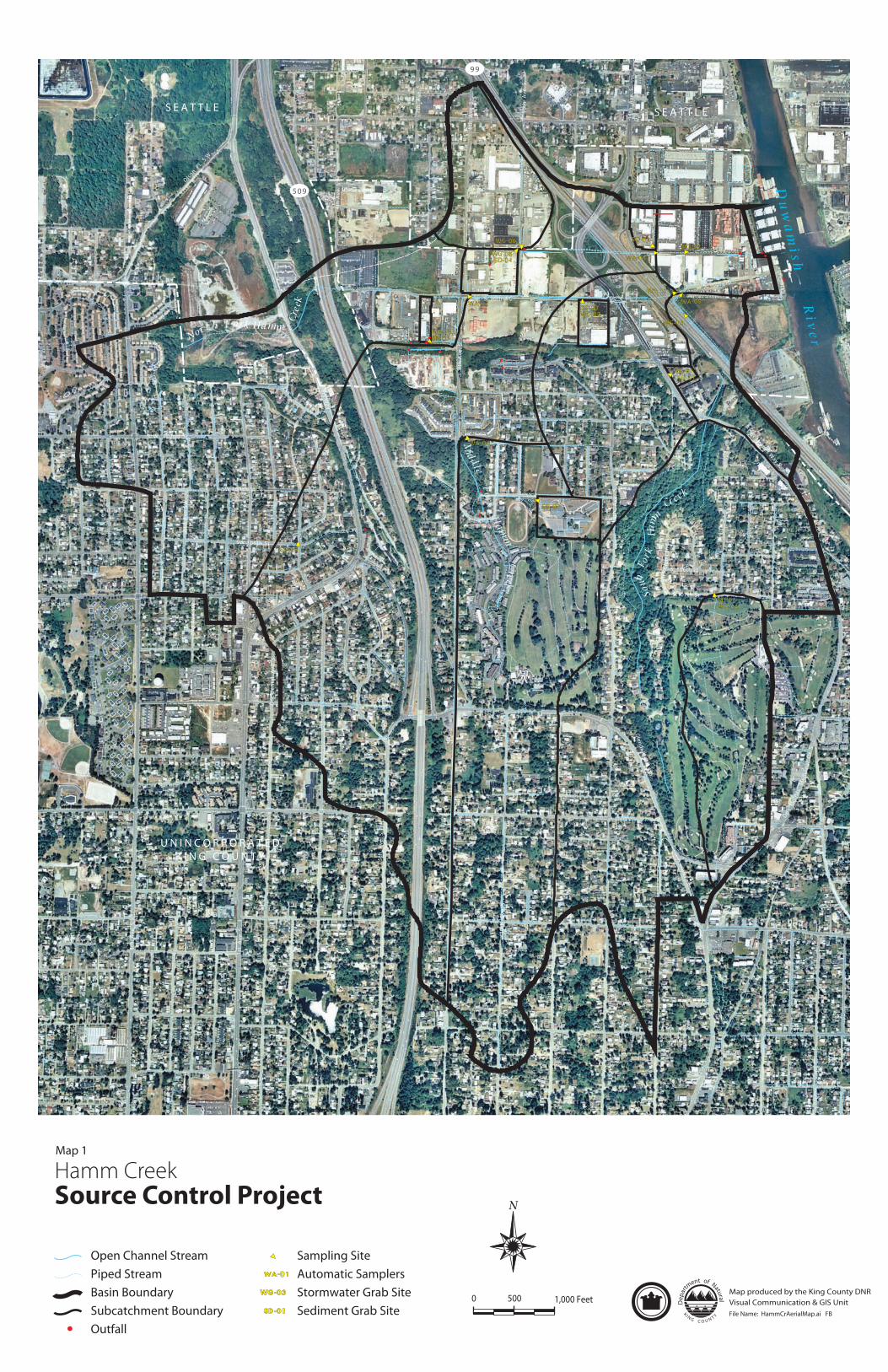
S E A T T L E
U N I N C O R P O R A T E DK I N G C O U N T Y
S E A T T L E
509
99
Myers W
ay
De s M
oine
s M
emor
ial
Dr
S
S. 112th St. Glendale Wa
y S.
S. 96th St.
10t
h A
ve. S
.
10t
h A
ve. S
.
8th
Ave
. S.
14t
h A
ve. S
.
12t
h A
ve. S
.
10t
h A
ve. S
.
5th
Ave
. S.
Occ
iden
tal
Ave
. S.
1st
Ave
. S.
4th
. Ave
. S.W
.
7th
Ave
. S.
8th
Ave
. S.
4th
Ave
. S.
S. 96th St.
14t
h.
Ave
. S.
S. W. 102nd St.
Olson P
l. S.W
.
2nd
Ave
SW
2nd
Ave
SW
SW 106th St
SW 104th St
S. 106th Pl
S.107th St
Coun
try
Cl u
b L
ane
S.
Des Moines W
ay S.
WA-01
WA-02
WA-03
WA-04
SD-04
SD-03
SD-01
SD-02
WA-05
WG-05
WG-01
WG-02
WG-03SD-05
SD-06
WG-04SD-08
SD-07
WG-06
WG-08WG-07
Du
wa
mi s h
Ri v
er
Sou
th
F or k
H
amm
C
r eek
Midd
le Fork
Ham
m C
reek
Nor t h F o rk Hamm
Cre
ek
Open Channel StreamPiped StreamBasin BoundarySubcatchment BoundaryOutfall
Hamm CreekSource Control Project N
0 500 1,000 FeetFile Name: HammCrAerialMap.ai FB
Sampling SiteAutomatic SamplersStormwater Grab SiteSediment Grab SiteSD-01
WA-01
Map produced by the King County DNRVisual Communication & GIS UnitD
epar
tment of Natural
K I N G C O U N T Y
WG-03
Map 1