PA 03347/16
PROPOSED CONSTRUCTION OF PETROL STATION AND AUTO REPAIR AND
MAINTENANCE CENTRE INSTEAD OF AN EXISTING OPEN STORAGE YARD,
L-IMQABBA
ENVIRONMENTAL PLANNING STATEMENT
VOLUME 1: COORDINATED ASSESSMENT
Version 1: September 2017

i
Report Reference:
Adi Associates Environmental Consultants Ltd, 2017. PA03347/16: Proposed
Construction of Petrol Station and Auto Repair and Maintenance Centre
instead of an Existing Open Storage yard, L-Imqabba. Environmental
Planning Statement. San Gwann, September 2017; xvii + 225 pp. + 1
Appendix.
THIS IS A DIGITAL COPY OF THE REPORT.
RESPECT THE ENVIRONMENT – KEEP IT DIGITAL

iii
This document has been prepared in accordance with the scope of Adi Associates’ appointment with its client and is subject to the terms of that appointment. It is addressed to and for the sole and confidential use and
reliance of Adi Associates’ client. Adi Associates accepts no liability for any use of this document other than by its client and only for the purposes for which it was prepared
and provided. Except as provided for by legislation, no person other than the client may copy (in whole or in part) use or rely on the contents of this document, without the prior written permission of Adi
Associates. Any advice, opinions, or recommendations within this document should be read and relied upon only in the context of the document as a whole. The contents of this document do not provide
legal or tax advice or opinion. It is pointed out that ISO14001 certification covers the management
system only and not the contents of this report.
© Adi Associates Environmental Consultants Ltd 2017
Kappara Business Centre
113 Triq Birkirkara
San Gwann SGN 4197
MALTA
Tel. / Fax: 21378172 - 77
Email: [email protected]
Web: www.adi-associates.com
Quality Assurance
Proposed Construction of Petrol Station and Auto Repair and Maintenance
Centre instead of an Existing Open Storage yard, l-Imqabba
Environmental Planning Statement
September 2017
Report for: Denfar Ltd
Revision Schedule
Rev Date Details Written by: Checked by: Approved by:
00 Sept 2017 Submission to client Rachel Xuereb Director
Adrian Mallia Managing Director
Adrian Mallia Managing Director
File ref: G:\_Active Projects\EIA\DEN002 - Mqabba Petrol Station\EPS\MASTER EPS.doc

v
CONTRIBUTORS
Adi Associates Environmental Consultants Ltd prepared this Environmental Planning
Statement in association with the specialist consultants listed below:
Specialist Consultant: Topic responsible for:
Joseph A Pace Base photos and photomontages
Marco Cremona Hydrology Baseline Study
Adi Associates staff was involved in the following parts of this EPS:
Staff Member: Area responsible for:
Rachel Xuereb Coordination, quality review
Rachel Decelis Air quality, environmental risk assessment, decommissioning,
climate change
Krista Farrugia Landscape and visual amenity
Yury Zammit Traffic and transportation
Andrea Pace Land cover, land use, mapping, and GIS
Chantal Cassar Cultural heritage baseline study


vii
CONSULTANTS’ DECLARATION
Adi Associates Environmental Consultants Ltd, Malta, prepared this Environmental Planning
Statement (EPS).
The Environmental Impact Assessment Regulations, 2007, Sections 28(3) and 29(1) require each
of the Consultants to declare that they carried out the study or part thereof, that they take
responsibility for statements and conclusions contained in their reports or part thereof, and
that they have no personal or financial interest in the proposed development.
We declare that Adi Associates Environmental Consultants Ltd has no personal or financial
interest in the proposed development.
Adi Associates has coordinated this EPS and has provided technical input to specific parts of
the Statement as identified in the previous page.
Adi Associates Environmental Consultants Ltd takes responsibility for statements and
conclusions contained in the parts of the report prepared directly by its staff. However,
statements made and conclusions drawn by the independent sub-consultants who prepared
the baseline studies reproduced in the Technical Appendices and which informed the
Environmental Statement remain the responsibility of the individual sub-consultants.
Adrian Mallia Rachel Xuereb
Managing Director, Adi Associates Director, Adi Associates


ix
The undersigned hereby declare that they carried out the study or part thereof, and that
they have no personal or financial interest in the proposed development.
Joseph A Pace
Marco Cremona
Rachel Xuereb
Rachel Decelis
Krista Farrugia
Yury Zammit
Andrea Pace
Chantal Cassar


xi
CONTENTS
1. Introduction ........................................................................................ 1
Purpose of the EPS ..................................................................................................................................... 1
Structure of the EPS ................................................................................................................................... 1
2. EIA METHODOLOGY ....................................................................... 5
Introduction .................................................................................................................................................. 5
The EIA Process .......................................................................................................................................... 5
Terms of Reference .................................................................................................................................... 5
Method Statements ..................................................................................................................................... 5
EIA Approach ............................................................................................................................................... 6
Significance of Impacts ................................................................................................................................ 6
Uncertainty ................................................................................................................................................... 7
Consultation ................................................................................................................................................. 7
Presentation of the EPS ............................................................................................................................. 8
3. Description of Scheme and Site ...................................................... 11
Introduction ................................................................................................................................................ 11
Objectives of the Scheme ....................................................................................................................... 11
Demand for the Scheme .......................................................................................................................... 11
Consultation ............................................................................................................................................... 11
Assessment of Alternatives ..................................................................................................................... 15
Alternative Sites ........................................................................................................................................ 15
Zero Option (Do-nothing Scenario) .................................................................................................... 15
Alternative Layouts and Techniques ..................................................................................................... 15
Description Of the Site and its Surroundings ..................................................................................... 21
Scheme Site ................................................................................................................................................ 21
Land Use in the Vicinity of the Scheme Site ....................................................................................... 21
Natural Heritage Designations ............................................................................................................... 22
Scheme Description.................................................................................................................................. 29
Access and Parking ................................................................................................................................... 29
Landscaping and Exterior Lighting ......................................................................................................... 29
Services ........................................................................................................................................................ 30
Car Wash .................................................................................................................................................... 43
Electric Charging Points ........................................................................................................................... 43
Operating Hours ....................................................................................................................................... 43
Resources ................................................................................................................................................... 53
Electricity Supply ....................................................................................................................................... 53
Water .......................................................................................................................................................... 53
Raw Materials ............................................................................................................................................. 53
Scheme Construction ............................................................................................................................... 54

xii
Construction Timing ................................................................................................................................ 54
Plant and Machinery .................................................................................................................................. 54
Construction Waste ................................................................................................................................. 54
Construction Personnel........................................................................................................................... 55
Construction Management...................................................................................................................... 55
Scheme Operation .................................................................................................................................... 61
Employment ................................................................................................................................................ 61
Operational Waste ................................................................................................................................... 61
Emissions ..................................................................................................................................................... 61
Emissions to Air ........................................................................................................................................ 61
Noise and Vibration .................................................................................................................................. 65
Scheme Decommissioning ....................................................................................................................... 65 Outline Decommissioning Plan .............................................................................................................. 66
4. Legislation and Policy Context........................................................ 67
Introduction ................................................................................................................................................ 67
International legislation ............................................................................................................................ 67
The Geneva Protocol on VOC emissions ........................................................................................... 67
The European Cultural Convention ..................................................................................................... 68
The European Convention on the Protection of the Archaeological Heritage (Revised) ........ 68
European Policy and Legislation ............................................................................................................. 70
National legislation .................................................................................................................................... 70
The Constitution of Malta ....................................................................................................................... 70
Environment Protection Act 2016 (Act I of 2016) ............................................................................ 71
Development Planning Act, 2016 (Act VII of 2016) .......................................................................... 72
Environmental Management Construction Site Regulations, 2007 ................................................ 73
Legal Notices .............................................................................................................................................. 75
Malta Resources Authority Act 2001 ................................................................................................... 77
Protection of Antiquities Regulations, 1932 ....................................................................................... 79
Cultural Heritage Act, 2002 ................................................................................................................... 79
Waste Management Plan for the Maltese Islands: A Resource Management Approach 2014 -
2020 .............................................................................................................................................................. 80
Planning Policy ............................................................................................................................................ 81
Strategic Plan for Environment and Development ............................................................................ 81
South Malta Local Plan ............................................................................................................................. 82
Fuel Service Stations Policy ..................................................................................................................... 91
Conclusion .................................................................................................................................................. 96
5. Geo-Environment ............................................................................. 97
Introduction ................................................................................................................................................ 97
Assessment Methodology ....................................................................................................................... 97
Standards and Policy Guidance .............................................................................................................. 97
Area of Influence ....................................................................................................................................... 98
Geo-environment Methodology ............................................................................................................ 98

xiii
Baseline: Geology ................................................................................................................................... 103
Stratigraphy .............................................................................................................................................. 103
Lithology of the Lower Globigerina Limestone member .............................................................. 107
Structural Geology ................................................................................................................................. 108
Quality of the Stone Material .............................................................................................................. 108
Soils ........................................................................................................................................................... 108
Baseline: Geomorphology .................................................................................................................... 109
Geomorphic Features ........................................................................................................................... 109
Baseline: Hydrogeology......................................................................................................................... 109
Surface Hydrology .................................................................................................................................. 109
Runoff Generated Within the Scheme Site ...................................................................................... 110
Mean Sea Level Aquifer ........................................................................................................................ 110
Assessment of Impacts .......................................................................................................................... 114 Impact Significance ................................................................................................................................. 114
Prediction and Significance of Impacts ............................................................................................... 114
Change in quality of aquifer ................................................................................................................. 114
Change in quality of run-off ................................................................................................................. 115
Mitigation ................................................................................................................................................. 115
Residual Impacts ..................................................................................................................................... 115
6. Cultural Heritage ........................................................................... 119
Terms of Reference ............................................................................................................................... 119
Assessment Methodology .................................................................................................................... 119
Objectives of the Assessment ............................................................................................................. 119
Standards and Policy Guidance ........................................................................................................... 120
Policy Importance of Archaeological Features ................................................................................ 121
Area of Influence .................................................................................................................................... 123
Methodology ........................................................................................................................................... 123
Desktop Survey Results ........................................................................................................................ 127
Cultural Heritage Features................................................................................................................... 128
Assessment of Impacts .......................................................................................................................... 135
Determining Impact Significance ......................................................................................................... 135
Prediction and Significance of Impacts ............................................................................................... 135
Mitigation Measures ............................................................................................................................... 136
Residual Impacts ..................................................................................................................................... 137
Monitoring Requirements .................................................................................................................... 137
7. Landscape and Visual Amenity ..................................................... 141
Introduction ............................................................................................................................................. 141
Objectives of the Assessment ............................................................................................................. 141
Legislation and Policy Guidance .......................................................................................................... 142
South Malta Local Plan .......................................................................................................................... 142
Landscape Assessment Study of the Maltese Islands ..................................................................... 143
Standards and Guidelines ..................................................................................................................... 143

xiv
Assessment Methodology .................................................................................................................... 143
Desk Study Methodology ..................................................................................................................... 143
Photomontages ....................................................................................................................................... 146
Determining Impact Significance ......................................................................................................... 161
Landscape Assessment .......................................................................................................................... 161
Visual Amenity ........................................................................................................................................ 161
Existing Conditions ................................................................................................................................ 163
Landscape ................................................................................................................................................. 163
Visual Amenity: Zone of Theoretical Visibility ................................................................................ 166
Changes in the Landscape and Visual Amenity ................................................................................ 168
Changes in the Landscape and their Significance ............................................................................ 168 Changes in Visual Amenity and their Significance ........................................................................... 169
Mitigation ................................................................................................................................................. 181
Residual Impacts ..................................................................................................................................... 181
8. Air Quality ...................................................................................... 191
Introduction ............................................................................................................................................. 191
Terms of Reference ............................................................................................................................... 191
Objectives of the Assessment ............................................................................................................. 191
Legislation and Guidance ...................................................................................................................... 191
Assessment Methodology .................................................................................................................... 192
Sensitive Receptors................................................................................................................................ 193
Baseline Data ........................................................................................................................................... 193
Emissions .................................................................................................................................................. 203
Determining Impact Significance ......................................................................................................... 209
Benzene .................................................................................................................................................... 209
Odours ..................................................................................................................................................... 209
Baseline Air Quality ............................................................................................................................... 210
Benzene .................................................................................................................................................... 210
Odour ....................................................................................................................................................... 210
Assessment of Impact from the Scheme........................................................................................... 212
Benzene .................................................................................................................................................... 212
Odours ..................................................................................................................................................... 212
Mitigation and Residual Impacts .......................................................................................................... 213
Future Monitoring Requirements ....................................................................................................... 213
9. Summary of key impacts, interaction between impacts and
mitigation ........................................................................................ 217
Introduction ............................................................................................................................................. 217
Summary of Key Impacts ...................................................................................................................... 217
Geo-environment ................................................................................................................................... 217
Cultural Heritage.................................................................................................................................... 218
Landscape and Visual Amenity ............................................................................................................ 218
Emissions to Air ..................................................................................................................................... 218

xv
Interaction of Impacts ........................................................................................................................... 218
Cumulative Impacts ............................................................................................................................... 219
Mitigation ................................................................................................................................................. 219
Required Authorisations....................................................................................................................... 219
FIGURES
Figure 1.1: Location of the Scheme site ................................................................................................. 3
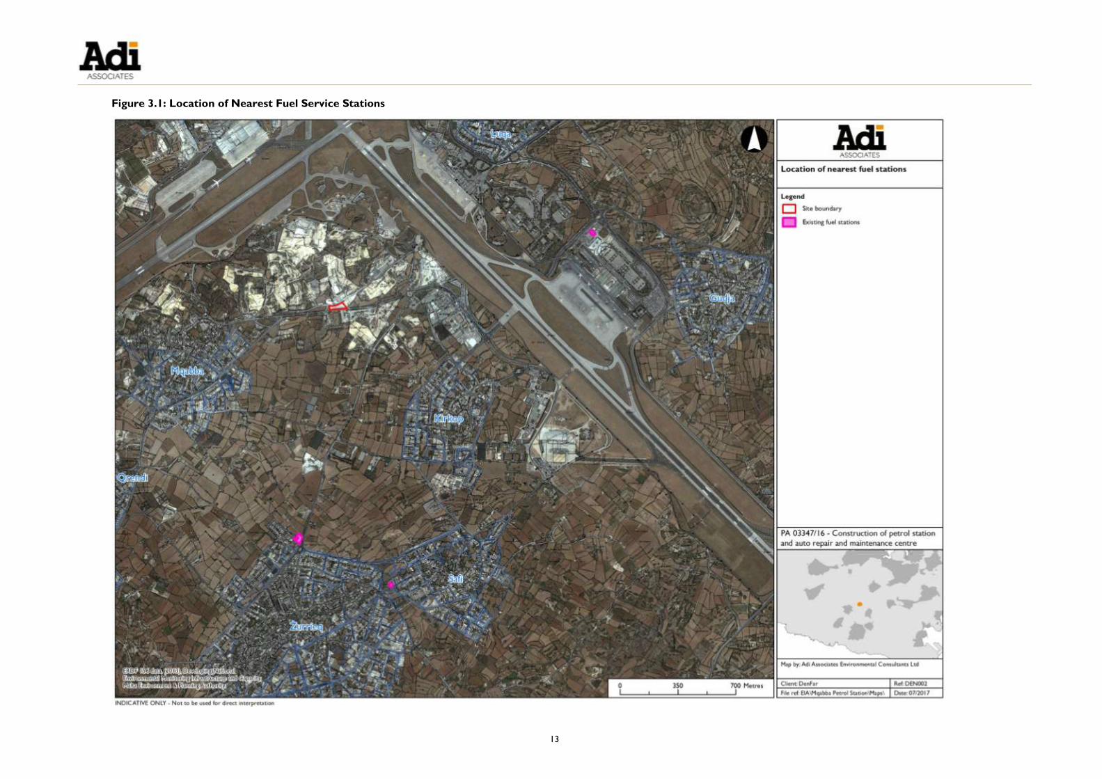
Figure 3.1: Location of Nearest Fuel Service Stations ..................................................................... 13
Figure 3.2: Layout of Initial Design Option ........................................................................................ 17
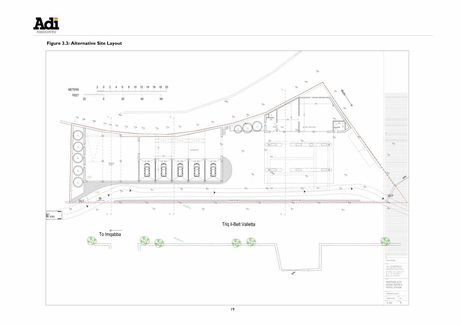
Figure 3.3: Alternative Site Layout ....................................................................................................... 19
Figure 3.4: Images of the Scheme Site ................................................................................................. 23
Figure 3.5: Images of Surrounding Land Uses .................................................................................... 25
Figure 3.6: Surrounding Land Uses ....................................................................................................... 27
Figure 3.7: Scheme Layout ..................................................................................................................... 31
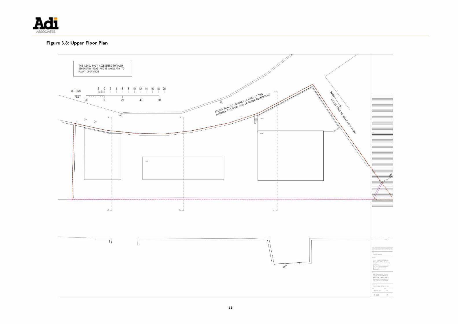
Figure 3.8: Upper Floor Plan.................................................................................................................. 33
Figure 3.9: Scheme Elevations / Sections ............................................................................................ 35
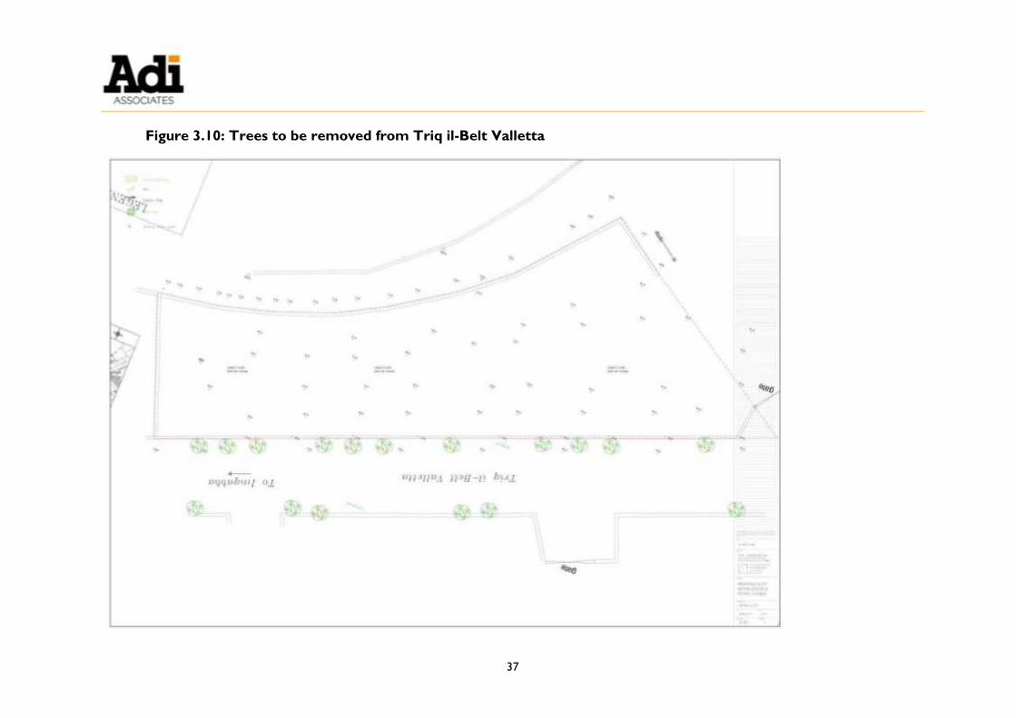
Figure 3.10: Trees to be removed from Triq il-Belt Valletta ......................................................... 37
Figure 3.11: Exterior Lighting Plan ....................................................................................................... 39
Figure 3.12: Tank Layout ........................................................................................................................ 45
Figure 3.13: Vapour Recovery System ................................................................................................. 47
Figure 3.14: Details of LPG Tank and Pipework ............................................................................... 49
Figure 3.15: Surface Water Drainage .................................................................................................. 51
Figure 3.16: Construction Site Layout Plan ........................................................................................ 59
Figure 4.1: Mqabba Environmental Constraints Map (extracted from the South Malta Local
Plan, and showing the Scheme site outlined in red) ................................................................ 85
Figure 4.2: Kirkop Environmental Constraints Map (extracted from the South Malta Local
Plan, and showing the Scheme site outlined in red) ................................................................ 87
Figure 4.3: Ground Water Resources Protection Map (extracted from the South Malta Local Plan, and showing the Scheme site outlined in black) ............................................................. 89
Figure 5.1: Hydrology / Hydrogeology Area of Influence ............................................................... 99
Figure 5.2: Geo-technical investigation: Location of Boreholes .................................................. 101
Figure 5.3: Geological Map of the Area of Influence (OED, 1993) ............................................. 105
Figure 5.4: Geological cross section ................................................................................................. 107
Figure 5.5: Hydrology map showing features of interest within the Area of Influence .......... 113

xvi
Figure 6.1: Area of Influence for Cultural Heritage Study ............................................................ 125
Figure 6.2: Cultural Heritage Features within the Area of Influence ......................................... 129
Figure 6.3: Rural Room close to the Scheme Site (KKP001) ....................................................... 131
Figure 6.4: Farmhouse (MQB003) ...................................................................................................... 132
Figure 6.5: Another two farmhouses within the Area of Influence - KKP003 (top) and
MQB007 (bottom) ........................................................................................................................ 133
Figure 6.6: Rubble walls (KKPMQB002) ........................................................................................... 134
Figure 7.1: South Malta Local Plan Map (Scheme Site outlined in red) ...................................... 151
Figure 7.2: Zone of Theoretical Visibility .......................................................................................... 153
Figure 7.3: Zone of Theoretical Visibility using both the digital terrain model (DTM) and the
digital elevation model (DEM) .................................................................................................... 155
Figure 7.4: Zone of Theoretical Visibility (DTM + DEM) and selected viewpoints ................ 157
Figure 7.5: Landscape Character Areas and Local Landscape Tracts ......................................... 159
Figure 7.6: Viewpoint 1 photomontage 10 years into growth of plants used in landscaping 183
Figure 7.7: Viewpoint 2 photomontage 10 years into growth of plants used in landscaping 185
Figure 8.1: Surrounding Land Uses ..................................................................................................... 195
Figure 8.2: ERA Diffusion Tube Locations for Benzene Baseline Data ...................................... 197
Figure 8.3: Baseline Odour Survey Locations .................................................................................. 201
Figure 8.4: Emissions of Benzene giving rise to an Annual Mean Ground-level Concentration
of 0.22 µg/m3 at Receptors.......................................................................................................... 204
Figure 8.5: Odour Survey Locations (operational petrol station) ............................................... 207
TABLES Table 3.1: Estimated Raw Materials for Construction ..................................................................... 53
Table 3.2: Construction Timing ............................................................................................................ 54
Table 3.3: Construction Plant and Machinery ................................................................................... 54
Table 3.4: Construction Waste ............................................................................................................ 57
Table 3.5: Estimates of Operational Waste ....................................................................................... 63
Table 3.6: CO2 Emissions from Scheme Operations ....................................................................... 65
Table 5.1: Summary of Impacts on the Geo-environment............................................................ 117
Table 6.1: Protection Ratings and Cultural Significance ................................................................ 122
Table 6.2: Cultural Heritage Features ............................................................................................... 128
Table 6.3: Impact Significance Criteria .............................................................................................. 135
Table 6.4: Summary of Impacts on Cultural Heritage .................................................................. 139
Table 7.1: Landscape Character Sensitivity ...................................................................................... 145
Table 7.2: Magnitude of Change to Landscape Resource ............................................................. 145

xvii
Table 7.3: Magnitude of Visual Change.............................................................................................. 147
Table 7.4 Landscape Receptors .......................................................................................................... 148
Table 7.5 Identification of Impact Significance ................................................................................. 163
Table 7.6: Landscape Character Types and Landscape Character Areas .................................. 164
Table 7.7: Summary of Scheme Site Visibility from Viewpoints .................................................. 167
Table 7.8 Changes in Landscape Character and Significance of the Impacts ............................ 168
Table 7.9: Summary of Impacts on Landscape and Visual Amenity ........................................... 187
Table 8.1: Baseline Odour Survey Details ........................................................................................ 199
Table 8.2: Odour Intensity Categories .............................................................................................. 199
Table 8.3: Benzene Emission Factors ................................................................................................. 203
Table 8.4: Odour Survey Details (operational petrol station) ..................................................... 205
Table 8.5: Criteria of Significance: Benzene Annual Levels ........................................................... 209
Table 8.6: Odour Exposure Matrix .................................................................................................... 209
Table 8.7: Matrix to Assess the Odour Effect at Receptors ........................................................ 210
Table 8.8: Benzene Baseline Data ....................................................................................................... 210
Table 8.9: Weather Conditions (baseline odour survey).............................................................. 211
Table 8.10: Results of Baseline Odour Survey ................................................................................ 211
Table 8.11: Predicted Benzene Concentrations at Air Sensitive Receptor .............................. 212
Table 8.12: Weather Conditions (survey at operational fuel station) ....................................... 212
Table 8.13: Results of Odour Survey (operational service station) ............................................ 214
Table 8.14: Summary of Impacts on Air Quality ............................................................................ 215
Table 9.1: Summary of Impact Assessment ...................................................................................... 221
APPENDIX
Appendix 1: A3 Photographs

1
1. INTRODUCTION
1.1. This Environmental Planning Statement (EPS) describes a proposal for a fuel service
station on a site on Triq Valletta in Mqabba (see Figure 1.1). The service station
will include a fuel filling station, car wash and drying area, auto gas filling facilities, and
a tyre service garage, as well as ancillary commercial premises and office space.
1.2. The project is proposed by Denfar Ltd. Denfar Ltd is hereinafter in this EPS referred
to as ‘the Applicant’; the project is hereinafter referred to as ‘the Scheme’.
1.3. A Full Development Permit application was submitted to the former Malta
Environment and Planning Authority (MEPA)1 in April 2014 (PA 03347/16). Following
the submission of a Project Description Statement (PDS), in May 2016, the
Environment and Resources Authority (ERA) determined that the Scheme required
an EPS in accordance with Schedule 1A, Category 7.6.2.6 Environmental Impact
Assessment Regulations, 2007 (Legal Notice 114 of 2007 as amended, S.L.549.46).
PURPOSE OF THE EPS
1.4. The purpose of this EPS is to present the findings of the Environmental Impact
Assessment (EIA). EIA is the process of systematically assessing the likely significant
environmental impacts of development proposals. EIA also ensures that the
significance of these impacts, and the scope for reducing them, is clearly understood
by the public, and by ERA and the Planning Authority (PA), before a decision is made
on whether or not the development should be approved.
STRUCTURE OF THE EPS
1.5. Following this introduction, the EPS is structured as follows:
Chapter 2: EIA Methodology
Chapter 3: Description of Site and Scheme
Chapter 4: Legislation and Policy Context
Chapter 5: Geo-environment
Chapter 6: Cultural Heritage
Chapter 7: Landscape and Visual Amenity
Chapter 8: Emissions to Air
1 MEPA has since been split into the Planning Authority (PA) and the Environment and Resources Authority
(ERA).

2
Chapter 9: Key Impacts, Cumulative Effects and Summary of Mitigation
Appendix 1: A3 Photographs
1.6. The Environmental Risk Assessment is presented as Volume 2 of the EPS.
1.7. The EPS also contains the following Technical Appendices (compiled separately as
Volume 3 of the EPS):
Technical Appendix 1: Terms of Reference and Method Statements
Technical Appendix 2: Geo-environment Baseline Report
Technical Appendix 3: Cultural Heritage Baseline Report
1.8. The EPS includes a Non-Technical Summary in Maltese and English.

3
Figure 1.1: Location of the Scheme site

5
2. EIA METHODOLOGY
INTRODUCTION
2.1. This chapter sets out the broad methodology that was used for the Environmental
Impact Assessment (EIA) of the Scheme. It outlines the key stages that were
followed, in line with EIA best practice. The chapter also explains how the
significance of impacts was assessed, and how this was a consistent process
throughout the EIA.
THE EIA PROCESS
2.2. The current guidance on the EIA process is contained in the Environmental Impact
Assessment (EIA) Regulations, 2007 (Legal Notice 114 of 2007 as amended) (S.L.
549.46). The Environment and Resources Authority (ERA) has directed that an EPS
be prepared for the Scheme.
Terms of Reference
2.3. The Terms of Reference (ToR) for the EIA were prepared by ERA in consultation
with the relevant Government Departments. The final version of the ToR is included
in Technical Appendix 1: Terms of Reference and Method Statements.
2.4. The ToR were formulated following a scoping exercise, undertaken by ERA, to
identify the issues to be considered in the EIA. The ToR focused on those impacts of
the Scheme considered by ERA to be significant and, therefore, requiring further
assessment, and avoiding the examination of all environmental impacts. The ToR also
outlined the various components of the EIA.
Method Statements
2.5. As required by the EIA Regulations, the Consultants involved in this EPS were
approved by ERA.
2.6. Method Statements were prepared in respect of the topic areas: geo-environment;
cultural heritage; landscape and visual amenity; and emissions to air. The Method
Statements addressed the following:
Introduction, listing the objectives of the study and reference to the ToR;
Details of baseline survey methodology;
Description of the Area of Influence;
Field survey methodology;
Analytical methodology;
Evaluation of data;

6
Identification of impacts;
Prediction of impacts;
Impact significance; and
Mitigation.
2.7. All Method Statements were accepted by ERA, and were subsequently used as the
basis for carrying out the individual baseline surveys. The Method Statements are
included in Technical Appendix 1: Terms of Reference and Method
Statements.
EIA Approach
2.8. Good practice necessitates that EIA be treated as an iterative process, rather than a
one-off, post-design environmental appraisal. In this way, the findings from the EIA
can be fed into the design process, resulting in a more environmentally sensitive
project. This approach was adopted for this EIA.
2.9. Baseline surveys for the specialist EIA topics were undertaken by the Consultants
based on the Area of Influence (A of I) agreed with ERA for each topic area. A
detailed assessment of the Scheme’s impact on the features present within the A of I
was undertaken, and any potential environmental benefits of the Scheme were
identified.
Significance of Impacts
2.10. Assessment of the significance of impacts arising from a development is a key stage in
the EIA process. This judgement is critical in informing the decision-making process.
However, defining significance can be difficult. In general terms, environmental
significance involves assessing the amount of change to the environment perceived to
be acceptable to the community (Sippe, 1999).
2.11. The following criteria were used in this EIA to assess the significance of an impact:
Type of impact (adverse / beneficial);
Extent and magnitude of impact;
Direct or indirect impact;
Duration of impact (short term / long term; permanent / temporary);
Comparison with legal requirements, policies and standards;
Sensitivity of receptor (residential dwellings, hotels, recreational areas, etc.);
Probability of impact occurring (certain, likely, uncertain, unlikely, remote);

7
Reversibility of impact;
Scope for mitigation / enhancement (very good, good, none); and
Residual impacts.
2.12. Using these criteria, the significance of the impacts arising from the Scheme was
categorised in the EPS, as follows:
Not significant;
Minor significance;
Moderate significance (in the case of the landscape and visual amenity assessment
only); and
Major significance.
2.13. Definitions of the meaning of the ‘significance categories’ above in relation to each
topic area are included in the individual topic area chapters (see Chapter 5 to
Chapter 8). However, in general terms, if an impact is ‘not significant’, it is
considered to be environmentally acceptable; an impact of ‘minor significance’ refers
to an impact that is considered to be manageable; an impact of ‘moderate significance’
refers to an impact that may be manageable in certain circumstances, although is
likely to require implementation of suitable mitigation measures; and an impact of
‘major significance’ refers to an impact that is considered to be environmentally
damaging such as to require that the Scheme be redesigned, or that mitigation
measures be put in place to minimise the impact.
2.14. The EPS includes an assessment of the significance of predicted impacts and, following
the implementation of any proposed mitigation measures, the significance of any
residual impacts. A summary of the identified significant impacts is included in
Chapter 9. The recommended mitigation measures, and the residual impacts, are
described in respect of each topic area, at the end of the relevant chapter (see
Chapter 5 to Chapter 8).
UNCERTAINTY
2.15. The EIA process is designed to enable good decision-making based on the best
possible information about the environmental implications of a development. There
will always be some uncertainty in predicting potential impacts, as to the exact nature
and scale of the impacts. This arises through shortcomings in information, doubts, or
lack of certainty on the likelihood that an incidence would occur, and / or due to the
limitations of the prediction process itself. Where uncertainties have arisen, and
where they remain, this is clearly stated in the EPS.
CONSULTATION
2.16. There has been consultation with ERA throughout the EIA process. Additionally, the

8
l-Imqabba and Ħal Kirkop Local Councils were also consulted. The purpose of this consultation was to identify the issues these entities considered important in respect
of the locality, and to inform the EIA. The feedback from this consultation is
described in Chapter 3.
PRESENTATION OF THE EPS
2.17. This EPS is divided into three main parts following this chapter.
2.18. Part 1 comprises Chapters 3 and 4:
Chapter 3 explains the purpose of and justification for the Scheme, and includes
a description of the site and its surroundings; and
Chapter 4 summarises the relevant legislation and policy context, including
planning policies.
2.19. Part 2 comprises Chapters 5 to 8, which describe the potential environmental
impacts of the Scheme in relation to each of the topic areas. Each of the chapters is
structured as follows:
Introduction: identifying the key issues and how the chapter relates to the ToR;
Assessment methodology: summarising the methods used in undertaking the
baseline survey;
Existing conditions: a summary of the existing baseline situation and trends
irrespective of the Scheme; and
Assessment of impacts arising from the Scheme, identifying:
o Potential impacts: a summary of the potential impacts of the Scheme;
o Prediction and significance of impacts: a prediction of the likely impacts of
the Scheme against the baseline situation and an assessment of the
significance of the impacts;
o Mitigation measures: a summary of potential mitigation / enhancement
measures, to offset any identified adverse impacts;
o Residual impacts: a clear statement of those impacts that still have an
impact following mitigation, indicating the significance of the residual
impact; and
o Summary: a summary table of the impacts.
2.20. Part 3 comprises Chapter 9, which addresses the cumulative effects of the Scheme,
and summarises the impacts and proposed mitigation measures.
2.21. The Environmental Risk Assessment is presented as a separate volume (Volume 2)

9
since the risk assessment addresses abnormal operation whereas the impact
assessment chapters assess normal operation of the Scheme.


11
3. DESCRIPTION OF SCHEME AND SITE
INTRODUCTION
3.1. This chapter describes the Scheme. It explains the purpose of and justification for
the Scheme, and includes a description of the Scheme site and its surroundings.
OBJECTIVES OF THE SCHEME
3.2. As described by the Applicant, the main objectives of the Scheme are:
To provide a fuel service station that meets current environmental and safety
requirements; and
To provide a comprehensive service to customers through the provision of
ancillary facilities, including car wash facilities, retail facilities supplying automobile
consumables, and a tyre services garage.
DEMAND FOR THE SCHEME
3.3. The Scheme is located on Triq il-Belt Valletta, a distributor road. The closest
existing fuel service stations to the Scheme site are located at the edge of Iż-Żurrieq
(2.2 km driving distance), the Malta International Airport (2.4 km driving distance)
and at Ħal Safi (2.9 km driving distance) - see Figure 3.1.
3.4. The Applicant explains that the Scheme will meet the requirement for fuel stations to
comply with current EU Directives and local regulations, for example, in relation to
vapour recovery systems, and in the provision of charging points for electric vehicles.
The Applicant also explains that the Scheme will meet customer expectations
through providing a 24/7 service, as well as car wash and tyre service facilities, and a
shop selling car accessories and car care products.
CONSULTATION
3.5. As mentioned in Chapter 2, the L-Imqabba and Ħal Kirkop Local Councils were
both consulted during the preparation of this EPS. The purpose of this consultation
was to identify the issues that the Councils considered important for the locality, and
to inform the EIA.
3.6. The issues identified by the L-Imqabba Local Council can be summarised as follows:
Traffic management and security measures as Valletta Road is an arterial road and
thus Transport Malta needs to be consulted being responsible for this road;
The uprooting of mature endemic pine trees in Valletta Road and the visual
impact of the Scheme; and
Air borne dust particles next to the proposed car wash emanating from open air

12
stockpiles of sand and aggregate.
3.7. The issues identified by the Ħal Kirkop Local Council can be summarised as follows:
Traffic coming from Ħal Kirkop towards the Scheme will make a right hand turn
on Triq il-Belt Valletta, thus creating a potential hazard on the road; and
The poor state of the road needs to be addressed.
13
Figure 3.1: Location of Nearest Fuel Service Stations


15
ASSESSMENT OF ALTERNATIVES
Alternative Sites
3.8. The Applicant did not consider any alternative site(s) for the Scheme. The Scheme
site is owned by the Applicant, is concreted over and is currently being used for the
storage of concrete blockwork, in line with a Full Development Permit issued under
PA 05616/01. The Scheme site also satisfies the locational criteria for the relocation
of fuel service stations as outlined in the Fuel Service Stations Policy 2015.
Zero Option (Do-nothing Scenario)
3.9. The Terms of Reference (ToR) issued by the Environment and Resources Authority
(ERA) require that the alternative assessment considers the zero option, or do-
nothing scenario, which envisages there being no intervention on the site in
connection with the Scheme, and assumes the Scheme being located elsewhere (or
not constructed at all). This alternative option considers the way the site would
develop in the absence of the Scheme.
3.10. As mentioned, the Scheme site currently comprises an open storage yard in connection with a permit granted under PA 05616/01. The permit relates to a larger
site, including lands to the northeast issued “To sanction the siting of a mobile crusher
(softstone) and blockwork producing machine in an existing quarry”. Figure 3.4 shows
various images of the Scheme site as it is currently. In the absence of the Scheme,
the site would continue to be used as permitted under PA 05616/01.
3.11. The Scheme requires the felling of 11 mature Aleppo pine trees (Pinus halepenis -
Żnuber) on Triq il-Belt Valletta, in order to enhance accessibility to the site, and because of the flammable nature of these trees. In the absence of the Scheme these
trees would remain.
Alternative Layouts and Techniques
3.12. The Applicant explored a number of alternative layouts for the Scheme on the
Scheme site, primarily as a result of the access requirements investigated during the
formulation of the Traffic Impact Assessment (TIA)2.
3.13. Figure 3.2 shows one of the original designs for the Scheme, where the layout
included a number garages to be used for panel beating and spray painting, and a
mechanic and electrician’s workshop. The layout plan also included offices and a
retail outlet located to the north of the site. The layout was subsequently amended
during the process of the TIA, wherein the workshops where replaced by a
showroom, and five car wash bays were introduced to the west of the workshops
(see Figure 3.3). A later modification resulted in removal of the showroom and its
2 Bjorn Bonello, 2016, TRK156478 – Fuel Refuelling Station, il-Triq Valletta, Mqabba. Traffic Impact Assessment.

16
replacement by a tyre services garage and valeting area.

17
Figure 3.2: Layout of Initial Design Option

19
Figure 3.3: Alternative Site Layout


21
DESCRIPTION OF THE SITE AND ITS SURROUNDINGS
Scheme Site
3.14. The Scheme site has an area of approximately 2,630 m2. The site is located
approximately 700 m southwest of the Malta International Airport (MIA) runway
2406 at its closest point, 1.5 km (plan distance) from the MIA terminal buildings at
their closest point, and equidistant (approximately 650 m – 550 m) from L-Imqabba
and Ħal Kirkop (see Figure 3.1).
3.15. The Scheme site is located in an area characterised by both operational and disused
quarries and by construction-related uses that have been established in the disused
quarries. The Scheme site is roughly rectangular in shape and is bounded to the
north by a narrow laneway that separates the site from a concrete batching plant and
associated lorry parking / maintenance garage, and an operational softstone quarry.
Another operational softstone quarry is immediately adjacent to the east of the Scheme site. Along its southern boundary, the Scheme site is adjacent to the arterial
Triq il-Belt Valletta and disused land despoiled by dumping. Triq il-Belt Valletta is
lined with mature Aleppo pines trees (Pinus halepenis - Żnuber).
3.16. There are no dwellings within 260 m of the Scheme site, and there is no record of
habitation on the Scheme site. As mentioned, the whole of the Scheme site is given
over to concrete block manufacture and storage.
3.17. Figure 3.4 shows images of the Scheme site as it is currently.
Land Use in the Vicinity of the Scheme Site
3.18. Land cover and land use in the area surrounding the Scheme site were recorded
during a survey carried out in March 2017. The land uses are illustrated in Figure
3.5 and Figure 3.6.
3.19. The predominant land use in the immediate vicinity of the Scheme site is mineral
extraction (quarrying). Ordinance Survey sheets from the beginning of the twentieth
century show that the area was already extensively used for quarrying. This history
of quarrying activities in the area is also evident from the number of inactive and
disused quarries noted during the survey; a distinction was made between active and
inactive quarries when mapping the land uses (see Figure 3.6).
3.20. The quarries are soft stone quarries and ancillary facilities include batching plants.
The inactive quarries are either completely abandoned, and have been re-vegetated (some have been restored to agricultural use), or are being used for open storage or
other industrial purposes.
3.21. Arable land dominates the area to the southwest of the Scheme site, although there
are also some pockets of agricultural land to the north of Triq il-Belt Valletta. The
agricultural use is primarily taking place within former quarries.
3.22. The industrial (including open storage) sites are primarily concentrated along Triq il-
22
Belt Valletta.
3.23. The nearest residential property to the Scheme site is located approximately 230 m
to the southwest. The nearest urban area is the settlement of Ħal Kirkop, located approximately 485 m to the southwest; the settlement of L-Imqabba is located
approximately 660 m to the southeast.
Natural Heritage Designations
3.24. The closest natural heritage designation to the Scheme site is the Ħal Luqa Airport
Bird Sanctuary, which is located approximately 250 m to the east of the site.

23
Figure 3.4: Images of the Scheme Site
Aerial views of the Scheme Site


25
Figure 3.5: Images of Surrounding Land Uses
Active quarry Inactive quarry Storage within an inactive quarry
Industrial / storage use on disturbed land Agricultural land Residential unit


27
Figure 3.6: Surrounding Land Uses


29
SCHEME DESCRIPTION
3.25. The Scheme layout is illustrated in Figure 3.7. Floor plans and elevation / section
drawings are included as Figure 3.8 and Figure 3.9, respectively. Specifically, the
Scheme takes the form of:
Six sets of fuel dispensers (two of the dispensers will be of the 4-product, 8-hose type, including the two for autogas; the other four dispeners will be of the 3-
product, 6-hose type); the canopy covering the fuel dispensing area will have an
area of 820 m2 and will be approximately 6.3 m high at its highest point);
Two charging stations for electric vehicles;
Car wash / drying facilities (three wash bays and three drying bays within a
structure with a maximum height of approximately 4 m);
A garage for tyre services (vulcaniser) and one for valeting (with a cumulative
floor area of 250 m2 and a maximum height of approximately 5.6 m);
A retail unit (Class 4B Retail) selling car parts and accessories and an office (Class
4A Offices), which will be used in connection with the fuel service station
(cumulative floor area of approximately 200 m2 and a maximum height of
approximately 4.9 m); and
Surface parking in the forecourt for six vehicles and ten bicycle parking racks.
Access and Parking
3.26. The Scheme will be accessed off Triq il-Belt Valletta. There are no pedestrian
footways along this stretch of Triq il-Belt Valletta and little or no pedestrian traffic in
the area. There will be separate ingress and egress to the Scheme. The TIA of the
Scheme included a Road Safety Audit which informed the access design. There will
be no right turn into or out of the Scheme site, as recommended in the TIA.
3.27. As mentioned, car parking will be provided in the forecourt (a total of six spaces).
Bicycle parking (10 bike stands) will also be provided in the forecourt.
Landscaping and Exterior Lighting
3.28. The landscaping details are shown in Figure 3.7. As mentioned, it is intended to
remove 11 of the existing trees on Triq il-Belt Valletta, including the protected Pinus
halepensis (Aleppo pine) - see Figure 3.10. The trees are to be removed to
accommodate access to the Scheme and provide for better visibility. Additionally,
Pinus halepensis (Aleppo pine) trees are identified in Appendix 1 (Table 1) of the Fuel
Service Stations Policy 2015 as being a flammable tree species not to be located in the
vicinity of a fuel service station. The closest of the trees (to be removed) to the fuel
pump is 23 m. Transplanting the mature Pinus halepensis is not an option as they will
not survive.

30
3.29. New planting will take the form of five Judas (Cercis siliquastrum) trees. These tree
species are listed in Appendix 3 of the Guidelines on Trees, Shrubs and Plants for Planting
and Landscaping in the Maltese Islands, 2002, as being acceptable species for planting in
locations ODZ and in the urban fringe. Cercis siliquastrum (Judas) trees are also listed
in Appendix 1 (Table 2) of the Fuel Service Stations Policy as being a lower
flammability species, acceptable for planting in the vicinity of fuel service stations.
Compensatory planting for the loss of the pine trees would need to be explored with
ERA.
3.30. The exterior lighting layout for the Scheme is shown in Figure 3.11. Energy
efficient lighting will provide adequate illumination levels to the forecourt, with
minimum glare and light pollution.
Services
3.31. As explained by the Applicant, all the utility services required to accommodate the
Scheme (electricity, mains water, sewerage, and telecommunications) are readily
available near the Scheme site.

31
Figure 3.7: Scheme Layout

33
Figure 3.8: Upper Floor Plan


35
Figure 3.9: Scheme Elevations / Sections

37
Figure 3.10: Trees to be removed from Triq il-Belt Valletta


39
Figure 3.11: Exterior Lighting Plan


41
Fuel Storage and Dispensing
3.32. Liquid fuel will be stored in four underground storage tanks in accordance with
EN12285-1:2003, and as shown in Figure 3.12. The tanks will be compartmented;
tank compartments T21, T22, and T42 will each have a diesel fuel capacity of 30,000
litres, tank compartments T11, T12, and T41 will contain unleaded petrol, with a fuel
capacity of 30,000 litres each, and compartments T31, T32, and T33 will contain
unleaded petrol, biodiesel, and diesel respectively, each with a 20,000 litres capacity.
3.33. The tanks will be double-skinned; an interstitial Class 1 leak detection system (MSA
EN 13160) will also be installed. These storage tanks will also be protected against
cathodic corrosion by an external polyurethane protective coating, having a 15 year
anti-corrosion guarantee.
3.34. The tanks will be placed inside a pit constructed on a 150 mm granular base fill, made
from compacted fine sand over a solid base, free from water ingress. Moreover, the
tanks will be evenly backfilled with non-cohesive, chemically inert material such as
sand, as recommended in Table A.1 of EN12285-1: 2003 and dry lean mix up to the
manhole neck. The tanks will have a minimum backfill of 300 mm between the tank
and the wall of pit.
3.35. The proposed pit will be built to act as a reservoir that is impermeable to any fuel
such that, if there is a fuel spill, the fuel will be retained within the structure and will
not be lost outside the pit structure. The pit will be lined with a fuel resistant and a
hydraulic barrier geotextile lining, suitable for secondary containment of unleaded
petrol, diesel, and bio-diesel to EN14214:2003 and other hydrocarbons. The
geotextile will have a permeability of 5x10⁻⁹ centimetres per second. The lining will
have a self-healing capability. The base of each pit will provide a firm continuous level
of support for the tank. It will be slightly inclined towards a hydrocarbon monitoring
well.
3.36. This monitoring will be in the form of a small pit, some 300 mm x 300 mm x 200 mm
depth, which shall be equipped with a Class 5 leak detection probe. This leak
detection system was proposed by the engineer following the recommendations by
Ing Marco Cremona in the Hydrology Report (see Technical Appendix 2: Geo-
Environment Study). If the two skins of the tank fail, and the Class 1 interstitial leak
detection also fails to detect such double skin failure, fuel will be trapped in the tank
chamber, with progressive accumulation in the monitoring well. This leak will be
detected by this additional Class 5 detection system.
3.37. The fuel dispensers will be in accordance to European directive ATEX94/9/EC and
EN13617-1. Dispensers will be installed over a glass reinforced fuel dispenser sump
to prevent any fuel contamination. Collision protection, such as bollards or an
adequately sized kerb, will be installed for all dispensers. Dispensing nozzles will be
clearly labelled in accordance with the Malta Resources Authority (MRA)
requirements.

42
3.38. A suction system will be used to transfer fuel from the underground fuel storage
tanks to the fuel dispensers, where a non-return valve will be installed to ensure that
the suction pipe remains primed whilst the dispenser is at rest. This non-return valve
will be installed immediately below the fuel dispenser, at the point of connection of
the pipework. The fuel dispensers will be wired in armoured cables.
3.39. Stage IB and Stage II vapour recovery systems will be installed to recover most of the vapours generated during petrol delivery to the storage tanks, and during fuel
dispensing to clients’ vehicles respectively (see Figure 3.13).
3.40. Pipelines from tanks to the offset filling points, dispensing equipment and vent pipes
will be routed below ground, away from buildings and / or other features that would
prevent access to the pipelines if a need arises after installation. The vent pipes
above ground will be in galvanised steel. All underground pipework will be
surrounded with a minimum thickness of 150 mm fine sand to support the pipe
system, protect it from mechanical damage and to handle the effect of heavy traffic or
other loading imposed on the pipe system. All vent pipework shall have a flame
arrestor to EN 7244 and EN ISO 16852, at the discharge points.
3.41. In order to prevent fuel entering the vapour return pipework manifold in the event
that a fuel storage tank is overfilled, a liquid-operated overspill prevention valve will
be installed. Moreover, a Type ‘A’ overfill prevention system, in accordance to BS
EN 13616: 2004, will be installed on each tank fill-line. The overfill prevention valve
will be certified to a Phase 1 vapour recovery system by CARB, ULC-Approved, or
better. This system has the advantage that in case of fuel tank overfilling, it prevents
pressurising the fuel storage tank and fuel dispenser, with the head of liquid in the
vehicle compartment.
3.42. The Scheme will also be equipped with one or two Outside Payment Terminals
(OPT) that will be activated by cash, credit card or a key system. A limit of not more
than 100 litres to be delivered in a single transaction will be set. The OPT will have a
timing function to prevent continuous operation for a period of more than three
minutes, in order to avoid any spillages or fuel run-off.
3.43. Autogas will be stored in one above ground storage tank with a capacity of 5,000
litres (see Figure 3.14). Installation of the LPG tank will be carried out in
accordance with the MRA LPG Codes of Practice. The tank will be enclosed in a
protective compartment with a 1.8 m high fence, having two exit doors at extreme
ends. The tank will be installed and fitted with the appropriate fittings in accordance
with the MRA Codes of Practice. It will be pre-fabricated in corrosion resistant steel
of suitable thickness.
3.44. There will be two autogas dispensers, each equipped for 1-product, and being of the
dual hose type. These will be located on the island adjacent to the other fuel
dispensers. Autogas will be supplied to the dispenser in liquid form from a remote
pump installed near the tank (inside the fenced compartment).

43
3.45. All forecourt surface water shall be passed through a light liquid separator system
(see Figure 3.15). The fuel separator system to be installed will be a full retention
‘Forecourt’ Separator Class 1 equipped with an alarm kit, in accordance to EN858.
The fuel separator is designed to discharge to the main sewer, through an
appropriate siphon trap; this type of separator is designed to achieve a concentration
of less than 5 mg/l of oil. The fuel separator will be sized in accordance to EN858-2:
2003 and its size will be of 10,000 litres with 7,000 litres of fuel retention, suitable for
a maximum flow rate of 20 l/s.
3.46. The forecourt surface will be impermeable to all hydrocarbons and will not allow
seepage through or below the surface; this will be achieved through the laying of a
concrete surface finish and any associated expansion or joining material will also be
impermeable and resistant to any hydrocarbons. In addition, a fuel resistant
geotextile lining will be installed under the forecourt area, to ensure that no fuel will
contaminate groundwater.
3.47. The forecourt will be equipped with an overhead canopy, manufactured from fire-
retardant material. Energy efficient lighting will provide adequate illumination levels
with minimum glare and light pollution.
Car Wash
3.48. The car wash area will consist of six jet washer bays and an associated drying areas.
The area will be contained by peripheral surface drainage channels to divert any
contaminated water towards the full-retention separator. The drainage channels will be sufficiently sized to allow run-off to be intercepted positively and to freely enter
the channel without over-passing. Drainage from the car washing / drying area will
be discharged via a full-retention Class 1 oil / water separator, designed for water
recycling. The discharge from the separator will be diverted either to the recycling
water reservoir, or into the sewer, depending on the water recovery and demand of
the fuel service station.
Electric Charging Points
3.49. Two electric car charging stations are proposed, located in two parking bays. Power
supplied to each charging post will be in the region of 7.3 kW 3-phase, 400 Volts
alternating current.
Operating Hours
3.50. The fuel dispensers and car wash facilities will be open to the public 24 hours, seven
days a week (self-service outside of staffed hours). A limit of 100 L of fuel will be set
on all self-service transactions. For safety reasons, the autogas dispensers will only
be available for use when the fuel service station is staffed.
3.51. The service station, retail unit, and services garage will be staffed from Monday to
Friday, from 06:30 to 18:00, and on Saturday from 06:30 to 15:00.


45
Figure 3.12: Tank Layout


47
Figure 3.13: Vapour Recovery System


49
Figure 3.14: Details of LPG Tank and Pipework

50

51
Figure 3.15: Surface Water Drainage


53
RESOURCES
Electricity Supply
3.52. The Scheme will have an estimated annual electrical consumption of 48,000 kWh.
Water
3.53. The Scheme will have a large rain water reservoir, having a capacity of 720 m3 (see Figure 3.15 above). This reservoir will harvest rain water collected from the roofs
of the buildings, as well as from the canopies above the forecourt and carwash bays. .
3.54. Used water from the car wash area will be collected in a separate water reservoir for
reuse in the car wash (see Figure 3.15). This recycled water reservoir will have a
capacity of 44 m3. The used water will first be diverted through a full-retention Class
1 oil / water separator manufactured and testing in accordance to EN 858-1 and PPG
3, and designed for water recycling. The car wash area comprises three manual jet
wash booths, each having a water usage of 72 L per cycle. Assuming 600 car washes
per month, the total average water demand amounts to 86,400 L per month or
1,036.8 m3 per annum.
3.55. It is projected that 60% of the water used in the car wash operation will be
recovered and recycled. Thus the annual demand is 0.4 x 1,036.8 = 414 m3 per
annum.
Raw Materials
3.56. The principal raw materials (and estimated volumes) to be used in the construction
of the Scheme are shown in Table 3.1.
Table 3.1: Estimated Raw Materials for Construction
Material Volume
Hollow concrete blocks 2,520 m2
Other concrete materials (e.g. bases, strip foundations, flooring,
slab, infill, columns, beams, lintels) 750 m3
Damp proof course 465 m2
Waterproofing membrane 465 m2
Reinforcement 18,000 kg
Rendering 1,300 m2
3.57. The principal raw materials in use during operation are the fuels that will be
dispensed to vehicles; these will consist of diesel, biodiesel, gasoline, and autogas.
Vehicle tyres will also be used in the tyre services garage, and detergents will be used
in the car wash facilities.

54
SCHEME CONSTRUCTION
Construction Timing
3.58. The estimated duration of the construction period is envisaged to be approximately
six months. The construction will be carried out concurrently across the Scheme
site and there will be some overlapping of the various construction phases. The
indicative timing of the construction phases is described in Table 3.2.
Table 3.2: Construction Timing
Phase Approximate Duration
(months)
Site clearance and excavation for the fuel tanks 1
Construction of the fuel station and other structures 4
Finishing and landscaping works 2
Commissioning of the fuel service station 1
Plant and Machinery
3.59. The plant and machinery envisaged to be used during the construction of the Scheme
is shown in Table 3.3.
Table 3.3: Construction Plant and Machinery
Plant / Machinery Numbers
Site Clearance / Excavation
Excavator 1
Mechanical shovel 1
Dump trucks 1
Construction / Finishing
Mobile crane 1
Concrete ready mix trucks 1
Delivery trucks 1
Construction Waste
3.60. The principal wastes expected to be generated during construction of the Scheme
are identified in Table 3.4. This will primarily consist of excavation waste, estimated
at 2,353 m3, which will comprise a mix of rock and fill. The sub-surface geotechnical
site investigations revealed material belonging to the Lower Globigerina Limestone
Member. Part of the site was a former quarry which has been infilled with inert
material. The extent of the quarry could not be determined through the two cores
that were taken (see Chapter 5 of the EPS). However, the Applicant confirmed that

55
all excavated material will be taken to the Applicant’s facility next door to the
Scheme site to be reused.
3.61. There may be steel off cuts, residue inert building material (like broken concrete
blocks), residue timber used during construction, and domestic waste generated by
the construction workers. When the mechanical, electrical and finishing works begin,
other wastes will likely include plastic conduit, copper wires covered in plastic, off cuts of steel supporting rods and cable trays, ceramic tiles, marble off cuts, paper and
plastic bags for materials, aluminium off cuts, broken glass items, and gypsum soffit
ceiling parts.
3.62. A waste management area will be identified on the construction site, with colour
coded skips for segregating waste types; if required, smaller bins for separated waste
types will be positioned across the site.
3.63. Water run-off during excavation will drain to one area of the excavation for
settlement (silt traps) before collection by vacuum pumps for disposal as directed by
the Malta Resources Authority. The silt traps will also be water proofed to ensure
that the highly turbid run-off does not leave the site.
Construction Personnel
3.64. It is envisaged that there will be up to ten personnel employed during the
construction stage.
Construction Management
3.65. A detailed Construction Management Plan (CMP) will be prepared by the contractor
awarded responsibility for the construction works. This will detail the layout of the
site during the construction phase, and the measures to be put in place to mitigate
impacts from construction, as well as safety measures. The placement of the
temporary site office(s), details on hoarding, access and signage will also be described
in the CMP, as will the arrangements to be made for construction traffic. Figure
3.16 illustrates what is envisaged at this stage in terms of the layout of the
construction site. Given that the Applicant is also a supplier of raw materials and can
process inert waste, very little construction material is expected to leave the site.
3.66. If any utilities need to be relocated during excavation this will be at the expense of
the Applicant and in cooperation with the relevant utility suppliers / operators prior
to the commencement of the excavations.


57
Table 3.4: Construction Waste
Phase EWC Code Description Estimated Quantity Destination
Excavation
17 02 01
17 02 03 Packaging waste Small quantities Sent for recycling if clean (otherwise to landfill)
01 01 02 Excavated material 2,353 m3 All material will go to the neighbouring Denfar facility
for processing (as also operated by the Applicant)
Construction /
finishing
17 01 02 Bricks Small quantities All material will go to the neighbouring Denfar facility
for processing (as also operated by the Applicant)
17 01 03 Tiles Small quantities Licensed inert landfill
17 02 03 Plastic waste Small quantities Sent for recycling if clean (otherwise to landfill)
17 04 02
17 04 05 Rebar cut-offs, steel, aluminium Small quantities Sold as scrap metal
15 01 01
15 01 02 Packaging Small quantities Għallis non-hazardous landfill


59
Figure 3.16: Construction Site Layout Plan


61
SCHEME OPERATION
Employment
3.67. It is envisaged that the Scheme will employ up to approximately five employees when
it becomes operational.
Operational Waste
3.68. Operational waste likely to be generated by the Scheme will be primarily municipal
waste. Table 3.5 lists the principal wastes expected to be generated during the
operation of the Scheme. Waste oil rags and waste tyres from the tyre service
garage will be stored, pending collection, in a bunded waste management area (see
Figure 3.7 above). Non-hazardous waste from the shop and office will be stored in
waste bins prior to its removal from site. Sludge from the separators will be
removed as needed, and will be retained in the separators prior to removal.
3.69. Waste will be removed from the site using waste carriers registered for that type of
waste, or collected by authorised waste brokers. Wastes will be sent to authorised
facilities; where possible, recycling / recovery will be preferred over disposal. All hazardous waste transferred from the Scheme site will accompanied by a valid
hazardous waste consignment permit, issued by ERA. Each consignment under the
consignment permit will also be accompanied by a consignment note.
EMISSIONS
Emissions to Air
3.70. Emissions to air in respect of the operation of the Scheme are discussed in detail in
Chapter 8; the following summarises the emissions to air likely to be generated
during the construction and operation phases.
Construction
3.71. The construction processes are expected to generate minor dust emissions (both
total suspended particulates and PM10), which are temporary and can also be
mitigated to some extent.
Operation
VOC Emissions
3.72. In fuel service stations where there is no abatement, emissions of Volatile Organic
Compounds (VOC) arise mainly from the following activities related to the handling
of petrol:
Tank emissions: vapour displacement when an incoming bulk delivery of petrol is
received into storage tanks; and

62
Emissions during refuelling: occur when petrol is transferred from the tanks to
vehicles. They are a combination of vapour from the larger tank’s contents and
the vapour evolved in the vehicle’s fuel tank as a result of splashing and
turbulence during filling.
3.73. These emissions are caused by the release of vapour from petrol, due to its high
vapour pressure and low flash point (-43 oC). Diesel and other fuels handled at the
Scheme have a lower vapour pressure and a higher flash point, and therefore do not
release significant emissions, even without abatement.
3.74. Legal Notice 228 of 2016, the Control of VOC Emissions (Storage and Distribution of
Petrol from Terminals to Service Stations) Regulations (S.L. 549.52), stipulates that service
stations meeting certain criteria must be fitted with the following vapour recovery
systems:
Stage IB recovery: designed to reduce the total annual loss of petrol resulting from loading into storage installations at service stations to below 0.01% of the
throughput mass by mass (m/m), by returning the vapours through a vapour-tight
connection line to the mobile container delivering the petrol; and
Stage II recovery: designed to recover petrol vapours during refuelling, where the
efficiency of the system must be at least 85% and the vapour / petrol ratio must
be from 0.95 to 1.05 when the petrol vapour is transferred to an underground
storage tank at the service station.
3.75. As shown in Figure 3.13 above, both Stage IB and Stage II recovery will be installed
at the Scheme.
Emissions from Road Traffic
3.76. It is expected that most of the trips to and from the Scheme will be ‘pass-by’ trips,
that is, vehicles that would pass by the Scheme site anyway. The Annual Average
Daily Traffic (AADT) for Triq il-Belt Valletta is estimated at 24,780, while the amount
of vehicles that will stop at the Scheme is estimated at about 324 per day on average,
roughly 110,000 per annum3. As stated in the TIA carried out for the Scheme, it is
estimated that a very significant majority of trips to and from the Scheme will not be
new trips. These ‘pass-by’ trips will not result in a net increase in traffic; hence,
there is no significant increase in the AADT as a result of the Scheme.
Odour Emissions
3.77. Odour emissions may also arise from the handling of fuel. The impact from odour
emissions is assessed in Chapter 8.
3 Bjorn Bonello, author of Transport Impact Assessment for the Scheme. E-mail dated 28th July 2017.

63
Table 3.5: Estimates of Operational Waste
Activity EWC Code HP codes Waste Description Estimated Quantity
(annual) Destination
Tyre servicing 16 01 03 - Tyres 520 Tyres Sent for recycling
15 02 02* HP3, HP7, HP14 Contaminated rags 230 L Waste Oils Co. Ltd
Retail facilities 15 01 01
15 01 02 - Cardboard and plastic packaging 9,200 L Sent for recycling
Office
20 03 01 - Mixed domestic waste 5,200 L Għallis non-hazardous landfill
20 01 01
20 01 02
20 01 39
20 01 40
- Recyclable waste 1,000 L Sent for recycling
Effluent management 13 05 07* HP3, HP6, HP7,
HP14 Oil-water separator contents 2,600 L Waste Oils Co. Ltd


65
Greenhouse Gases
3.78. Greenhouse gases are expected to be generated primarily off-site, as a result of
electricity consumption by the Scheme during operation. Table 3.6 shows the
estimated CO2 emissions from the Scheme in operation. The loss of mature trees
will also increase emissions due to their carbon capture capabilities. This could be
offset by compensatory planting.
Table 3.6: CO2 Emissions from Scheme Operations
Activity Annual Consumption CO2 Emissions
Rate Annual CO2 Emissions
Electricity consumption 48,000 kWh 0.77 kg/kWh4 36,960 kg
Noise and Vibration
3.79. An increase in traffic would also result in increased noise emissions. However, as it
is expected that most of the trips to and from the Scheme will be ‘pass-by’ trips,
noise impacts from additional traffic are not expected to be significant.
3.80. The car wash facilities will also generate noise. The nearest residence is located
approximately over 230 m to the southwest of where it is proposed to locate the car
wash bays. The bays will be located on the southern perimeter of the Scheme site.
The bays will be enclosed to the rear and sides and covered overhead by a
polycarbonate canopy. The orientation and the overhead and rear / side enclosure of
the car wash area will serve to reduce noise emissions.
3.81. There will be no sources of vibration during the operation of the Scheme.
SCHEME DECOMMISSIONING
3.82. Given that the Scheme has not been constructed yet, there are no immediate plans
for decommissioning. If and when in the future the Scheme operators decided to
decommission the Scheme, the relevant authorities will be informed and a full
decommissioning plan will be prepared and submitted for approval prior to
commencement of decommissioning works.
3.83. The full decommissioning plan will follow any local or international guidelines
applicable at that time, including in relation to the environment and health and safety,
and will also include a waste management plan. The full approved decommissioning
plan will be implemented within 12 months of the final cessation of activities, or in
accordance with another timeframe as may be agreed with the relevant authorities at
the time. An outline decommissioning plan is described below.
4 Value based on the CO2 per unit kWh generated by Delimara and Marsa Power Stations (2014 data).

66
Outline Decommissioning Plan
3.84. The tanks, associated pipework, and fuel dispensers will be emptied in a process
known as bottoming. The separators will also be emptied of all contents. All tank
bottoms and separator contents will be removed from the site and disposed of as
hazardous waste.
3.85. The tanks will then need to be made safe by removal of any explosive vapours. This
will be done by filling the tank with inert gas (usually nitrogen) or with water. If
water is used, it will be passed through the separator prior to discharge into the
sewer, or collected and sent off-site for treatment.
3.86. Tanks may either be decommissioned in situ or off-site, although removal is
preferred5. In either case, care will be taken to avoid damage to the tanks during
decommissioning, to avoid risk of contamination. If the tanks are decommissioned in
the ground, they will be filled with solid material, such as hydrophobic foam,
concrete, or a sand and cement slurry.
3.87. If practicable, the oil / water separators will be removed for off-site disposal;
otherwise they will be decommissioned in the ground by cleaning out the residues,
making safe with nitrogen or water, and filling with solid material in a similar manner
to the tanks. All inlets and outlets will be sealed.
3.88. The ground will be checked for visible signs of contamination. Site records will also
be consulted to check for past spillages or leakages. If necessary, and in consultation
with the relevant authorities, core samples will be taken and tested for hydrocarbon contamination. Where test results show contamination which poses a significant risk
to human health or the environment, recommendations will be made for removal,
control, containment, or reduction of the contamination so that the site, taking into
account its future use, ceases to pose such a risk. Applicable ERA and international
guidance on remediation6 will be consulted.
3.89. Tanks and pipework will be classified as hazardous waste and transported to facilities
in Malta or overseas that are licensed to accept and treat such wastes.
3.90. All waste transfers will be carried out by licensed waste carriers, and the
consignment note procedure will be followed for hazardous waste. Exports of waste
will be carried out in accordance with the requirements of Trans-frontier Shipment of
Waste Regulations (1013/2006/EC). ADR-certified carriers will be used when
required by the European Agreement concerning the International Carriage of Dangerous
Goods by Road.
5 Institute of Petroleum (2002) Guidelines for Soil, Groundwater and Surface Water Protection and Vapour Emission
Control at Petrol Filling Stations http://publishing.energyinst.org/_data/assets/file/0005/9824/Guidelines-for-soil-
groundwater-and-surface-water-Jun-2002.pdf. 6 Such as Mobile Plant for Site Remediation Guidance Note
(https://era.org.mt/en/Documents/GBR%2018%20Mobile%20Plant%20for%20Site%20Remediation%20ERA.pdf).

67
4. LEGISLATION AND POLICY CONTEXT
INTRODUCTION
4.1. This chapter discusses the relevance of international and national legislation, and
Maltese planning policy, and the compatibility of the Scheme with this legislation /
policy. It highlights and assesses the policies of Government Ministries, where
relevant, and outlines those European Union (EU) Directives and Regulations, and
other international obligations, applicable to the Scheme.
4.2. As discussed, the legal basis for the Environment and Resources Authority’s (ERA)
request for the preparation of an Environmental Impact Assessment stems from the
Environmental Impact Assessment Regulations published in 2007 (Legal Notice 114 of
2007) (S.L. 549.46).
INTERNATIONAL LEGISLATION
4.3. International legislation relevant to the Scheme arises from International Treaties and
Conventions to which Malta is a signatory, EU legislation, and local legislation
transposing these.
4.4. The International Protocols and Conventions relevant to the Scheme include:
The Geneva Protocol concerning the Control of Emissions of Volatile Organic Compounds
(VOCs) or their Transboundary Fluxes (Geneva, 18.11.1991)7;
The European Cultural Convention (Paris, 19.XII.1954)8; and
The European Convention on the Protection of the Archaeological Heritage (Revised)
(Valletta, 16.I.1992)9.
The Geneva Protocol on VOC emissions
4.5. This Protocol was adopted in Geneva on the 18th November 1991 and entered into
force on the 29th September 1997. The objective of the Protocol is to control and
reduce emissions of VOCs, which is the second major air pollutant responsible for
the formation of ground level ozone, so as to protect human health and the
environment from adverse effects. The Protocol extends the 1979 Geneva
Convention on Long-range Transboundary Air Pollution (CLRTAP).
4.6. Article 2.3(b)(ii) of this Protocol requires parties in those areas in which national or
international tropospheric ozone standards are exceeded or where transboundary
7 www.unece.org/fileadmin/DAM/env/lrtap/full%20text/1991.VOC.e.pdf 8 http://conventions.coe.int/Treaty/en/Treaties/Word/018.doc 9 http://conventions.coe.int/Treaty/en/Treaties/Word/143.doc

68
fluxes originate or are expected to originate to implement VOC controls during
petrol distribution and motor vehicle refuelling, and to reduce the volatility of petrol.
Implications for the Scheme
o The Scheme has been designed to take account of Malta’s obligations to
control and reduce emissions of VOCs. The impacts on air quality arising
from the Scheme are assessed in Chapter 8; the impacts of VOC emissions arising from the operation of the Scheme are considered to be
not significant.
The European Cultural Convention
4.7. This Convention was adopted in Paris on the 19th December 1954 and entered into
force on 5th May 1955. The objective of the Convention is to develop mutual understanding among the peoples of Europe and reciprocal appreciation of their
cultural diversity, to safeguard European culture, to promote national contributions
to Europe's common cultural heritage respecting the same fundamental values and to
encourage in particular the study of the languages, history, and civilisation of the
Parties to the Convention.
4.8. The Convention requires the Contracting Parties to “regard the objects of European
cultural value placed under its control as integral parts of the common cultural heritage of
Europe”, and “shall take appropriate measures to safeguard them and shall ensure
reasonable access thereto”.
Implications for the Scheme:
o The impacts on cultural heritage features and on landscape arising from
the Scheme are assessed in Chapter 6 and Chapter 7, respectively, of
the EPS. It is considered unlikely that there will be any significant impact
on the closest identified cultural heritage features to the Scheme site.
There is the potential for impacts on unrecorded archaeological artefacts
during the remaining excavation to be carried out on the site; the extent
of this impact is uncertain, as it will depend on whether artefacts are
present, their importance, and the extent of any loss or damage. The
impacts on landscape are considered to be of moderate impact to being of
no significant impact.
The European Convention on the Protection of the Archaeological
Heritage (Revised)
4.9. This Convention, which was agreed in Valletta on 16th January 1992, amends the
original Convention (agreed in London in 1969) on the protection of archaeological
heritage. The aim of this (revised) Convention is “to protect the archaeological heritage
as a source of the European collective memory and as an instrument for historical and
scientific study”. This revision was brought about through the acknowledgement that
European archaeological heritage is under serious threat from deterioration as a

69
result of “major planning schemes, natural risks, clandestine and unscientific excavations,
and insufficient public awareness”. In the context of the Convention, archaeological
heritage includes “structures, constructions, groups of buildings, developed sites, moveable
objects, monuments of other kinds as well as their context, whether situated on land or
under water”.
4.10. The Convention requires the Contracting Parties to institute a legal system for the
protection of archaeological heritage, including:
The creation and maintenance of a heritage inventory;
The creation of archaeological reserves; and
Mandatory reporting to competent authorities of the chance discovery of
archaeological material.
4.11. The Convention also requires the Parties to apply procedures for the authorisation
and supervision of excavations and other archaeological activities to ensure that they
are undertaken by qualified persons and in a scientific manner.
4.12. Other provisions of the Convention include:
The physical protection of archaeological heritage;
Integrated conservation of the archaeological heritage (including through
reconciliation with development plans and other planning processes);
Resourcing rescue archaeology;
Collection and dissemination of scientific information;
Public awareness; and
Prevention of illicit circulation of elements of archaeological heritage.
4.13. Malta ratified this Convention on 24th November 1994 and it entered into force on
25th May 1995. The provisions of this Convention have been transposed into local
legislation by the Cultural Heritage Act of 2002 (see below).
Implications for the Scheme:
o The impacts on recorded features of archaeological importance arising
from the Scheme are assessed in Chapter 6 of the EPS. The impacts on
recorded features of archaeological importance are considered to be of
no significance. There is the potential for impacts on unrecorded
archaeological artefacts during the remaining excavation to be carried out
on the site; the extent of this impact is uncertain, as it will depend on
whether artefacts are present, their importance, and the extent of any loss
or damage.
70
EUROPEAN POLICY AND LEGISLATION
4.14. The Treaty establishing the European Community (Article 174) provides that
members should pursue the preservation, protection and improvement of the quality
of the quality of the environment, aim at a high level of environmental protection and
apply policies “….based on the precautionary principle and on the principles that Preventive action should be taken, that environmental damage should as a priority be
rectified at source”.10
4.15. The relevant EU Directives include the EIA Directive 2011/92/EU on the assessment
of the effects of certain public and private projects on the environment, which has been
transposed by the Maltese Environmental Impact Assessment Regulations 2007, and
various Directives that relate to waste, water, air quality, fuel quality and others. A
revised Environmental Impact Assessment (EIA) Directive (2014/52/EU) also entered
into force in 2014 and will start to be applied as from 16th May 2017. The EIA
Regulations are currently being reviewed to ensure transposition of the EIA
Directive.
4.16. Since the European Union’s environment acquis has been transposed into national
legislation, the Directives per se have not been assessed and instead the national
legislation transposing these Directives is assessed below.
NATIONAL LEGISLATION
The Constitution of Malta
Declaration of Principles
4.17. The Constitution of Malta (Section 9) declares that the State shall safeguard the
landscape and the historical and artistic patrimony of the Nation. These are the only
aspects of the environment referred to in the Constitution, underlining the
importance of the landscape and historical heritage.
10 Article 191 (ex Article 174 of the Treaty establishing the European Community):
1. Union policy on the environment shall contribute to pursuit of the following objectives:
- Preserving, protecting and improving the quality of the environment;
- Protecting human health;
- Prudent and rational utilisation of natural resources;
- Promoting measures at international level to deal with regional or worldwide environmental problems,
and in particular combating climate change.
2. Union policy on the environment shall aim at a high level of protection taking into account the diversity of
situations in the various regions of the Union. It shall be based on the precautionary principle and on the
principles that preventive action should be taken, that environmental damage should as a priority be
rectified at source and that the polluter should pay.
In this context, harmonisation measures answering environmental protection requirements shall include,
where appropriate, a safeguard clause allowing Member States to take provisional measures, for non-
economic environmental reasons, subject to a procedure of inspection by the Union.

71
4.18. Local legislation relevant to the Scheme is described in the following sections.
Environment Protection Act 2016 (Act I of 2016)
4.19. The former Environment and Development Planning Act, 2010 which consolidated
the provisions of the Development Planning Act 1992 (as amended) and the
Environment Protection Act 2001, has recently been replaced by the Environment
Protection Act and the Development Planning Act.
4.20. The Environment Protection Act stipulates that “It shall be the duty of every person and
entity, whether public or private, to protect the environment and to assist in the taking of
preventive and remedial measures to protect the environment and manage natural
resources in a sustainable manner”.
4.21. Various duties fall to the Government. Those relevant to the Scheme are:
“4(a) to manage the environment in a sustainable manner by
integrating and giving due consideration to environmental concerns in
decisions and policies on land use, socioeconomic, educational and other
matters;
4(b) to take such preventive and remedial measures as may be
necessary to address and abate the problem of pollution and any other
form of environmental degradation in Malta and beyond, in accordance
with the polluter pays principle and the precautionary principle;
4(e) to apply scientific and technical knowledge and resources in
determining matters that affect the environment;
4(f) to ensure the sustainable management of wastes, to promote the
reduction of waste and the proper use, reuse and recovery of matter;
4(g) to safeguard biological diversity;
4(h) to combat all forms of pollution and environmental degradation;
4(i) to consider the environment as the common heritage and common
concern of mankind; and
4(j) to provide incentives leading to a higher level of environmental
protection”.
4.22. The Act makes provision for the establishment of an authority to implement the
duties of Government under the Act – the Environment and Resources Authority
(ERA). ERA’s principal duties include:
to perform and succeed in the functions, assets, rights, liabilities and obligations of the competent authority established under the provisions of article 6 of the
Environment and Development Planning Act and under the provisions of article 3

72
of the Malta Resources Authority Act in so far as such functions, assets, rights,
liabilities and obligations refer to the role of the competent authority established
under the said Act in relation to the protection and management of the
environment and sustainable management of natural resources, and the
prevention, mitigation, offsetting or remediation of adverse effects on the
environment;
to formulate and implement policies relating to the protection and management
of the environment and the sustainable management of natural resources;
to carry out and or commission surveys, studies, assessments, investigations,
audits, monitoring and promote research on any matter relating to the
environment and the natural resources;
to provide information and issue guidelines to the public and to commercial and
other entities on matters relating to the environment and natural resources;
to establish measures for the protection of the environment and to promote the
efficient use of natural resources;
to ensure that national and international obligations relative to the matters
regulated by or under the Act are entered into force and complied with;
to permit, assess, investigate, audit, monitor, and take action on, any activity, intervention, project, operation or land use that may have an effect on the
environment;
to advise the Minister on international legislation and on the formulation of
national policy; and
to carry out, review or request others to carry out environmental assessments, environmental audits and environmental monitoring of activities and works having
an impact on the environment.
Development Planning Act, 2016 (Act VII of 2016)
4.23. The Development Planning Act (DPA) establishes the Planning Authority. According
to the Act the role of the Planning Authority is:
(a) to perform and succeed in the functions which were previously assigned to the Malta Environment and Planning Authority under the provisions of the Environment and
Development Planning Act and are now contained in this Act and to perform and succeed in
the assets, rights, liabilities and obligations of the Malta Environment and Planning Authority
established under the provisions of the Environment and Development Planning Act to the
extent that the Minister may prescribe by regulations under this Act;
(b) the functions of the Executive Council and the Planning Board listed under articles 38
and 64;

73
(c) to facilitate and coordinate the permit granting process for projects of common interest;
(d) to perform and succeed in the functions which were previously assigned to the Building
Regulation Board and the Building Regulation Office under the provisions of the Building
Regulation Act and which are now contained in this Act and to perform and succeed in the
assets, rights, liabilities and obligations of the Building Regulation Board and the Building
Regulation Office established under the provisions of the Building Regulation Act to the
extent that the Minister may prescribe by regulations under this Act; and
(e) the performance of any other functions as may from time to time be assigned to it by the
Minister, including the functions required to give effect to any international obligation entered
into by Malta relative to matters regulated by this Act.
4.24. The Act details the various activities to be carried out by the Planning Authority.
With respect to development permits applications Regulation 71 of the Act requires
that:
(1) Any person, including a department of government or body corporate established by law,
wishing to carry out any development referred to in article 70, shall apply to the Planning
Board for such permission, in such manner, on such form and giving such information as the
Planning Board may prescribe.
(2) The Planning Board may grant three types of development permissions:
(a) an outline development permission which gives approval in principle to the proposed
development, but specifies reserved matters which need to be included in a full development
permit application or applications. A period of time shall be stated within which the full
development permit application or applications shall be submitted, failure of which would
render the outline development permit null. Such period shall in no case exceed five years.
No development may commence without a full development permit;
(b) a full development permission is required before any development can commence,
whether or not preceded by an outline development permission. The full development
permission will be given subject to conditions included in the permission;
(c) a non-executable full development permission which approves the development but
imposes conditions to be adhered to before a full development permission is issued.
(3) Any person may also apply to the Planning Board for a determination as to whether a
proposal requires a development permission and the Planning Board is bound to inform that
person whether a development permission or any other form of notification is required in
terms of this Act or not.
Environmental Management Construction Site Regulations, 2007
4.25. The aim of the Environmental Management Construction Site Regulations
(S.L.552.09) is to limit environmental degradation through construction management
practices that cause least nuisance to neighbours, minimise risk to workers, and
safeguard private and public property. The Regulations came into force on 1st

74
November 2007.
4.26. The Regulations apply to “...any construction, water mining, or any other disturbances to
the soil, including land clearing, scraping, ground excavation, land levelling, grading, cut and
fill operations, and ancillary activities that include travel to the construction site, travel on
access roads to and from the construction site and demolition activities”.
4.27. The Schedules within the Regulations provide requirements for reducing nuisance to
neighbours through:
Erection of a site notice containing details of the owner, site manager, architect
and contractor;
Conditions for cutting of stone and bricks on site;
Transportation of loose material;
Obstruction of pavements;
Hazards to vehicular traffic;
Cleaning of the site and its immediate vicinity;
Rodent control;
Hoardings around development sites;
Covered ways and barricades;
Safe passage past the site;
Nuisance abatement, including construction times; and
Control of dust emissions.
4.28. Technical guidelines and specifications are also provided for minimisation of noise and
vibration levels; health and hygiene, including waste management; hazardous materials
handling; and point source pollution from storm water.
4.29. The Regulations apply to any construction site, except where the Minister has
exempted such development under the provisions of Schedule VI ‘Exemptions’.
Implications for the Scheme:
o Regard has been given to the requirements of the Regulations in
addressing the construction impacts of the Scheme. An explanation of construction management is included in Chapter 3 of the EPS. Relevant
mitigation measures have been included in specific chapters of the EPS.
The construction of the Scheme will fall under the remit of these
regulations.

75
Legal Notices
4.30. The Regulations in force under the Environment Protection Act and the
Development Planning Act include the following Legal Notices that are relevant to
the Scheme:
Waste Management
Legal Notice 106 of 2007: Waste Management (Activity Registration) Regulations,
S.L.549.45 and Legal Notice 184 of 2011: The Waste Regulations (as amended,
S.L.504.37). These Regulations regulate the production and disposal of hazardous
and non-hazardous wastes. The Regulations aim to control all operations relating to the production and management of waste and promote sound waste
management practices so as to safeguard human health and the environment.
Legal Notice 55 of 2010: Waste Management (Waste Batteries and Accumulators) Regulations (as amended, S.L.549.54). These Regulations aim to maximise the
separate collection of waste batteries and accumulators.
Legal Notice 277 of 2006: Waste Management (Packaging and Packaging Waste) Regulations (as amended, S.L.549.43). These Regulations aim to reduce the
amounts of packaging waste disposed, including through the use of recycling.
Legal Notice 99 of 2004: Waste Management (End of Life Vehicles) Regulations
(as amended, S.L.549.36). These Regulations aim to prevent, reduce, recycle or
recover waste generated from vehicles.
Implications for the Scheme:
o Waste management issues related to the construction and operation of
the Scheme are discussed in Chapter 3 of the EPS. The Construction
Management Plan that will be prepared for the Scheme will also address
waste management issues during construction. A waste management plan
for the operation may also be required as part of the environmental
permit for the operation of the Scheme. Construction and operational
waste management must be in accordance with these regulations.
Water
Legal Notice 194 of 2004: Water Policy Framework Regulations (as amended,
S.L.423.20). These Regulations are issued under both the Environment
Protection Act and the Malta Resources Authority Act. They establish a
framework for the protection of coastal waters as well as inland surface waters,
transitional waters and groundwater. The framework is intended to prevent
further deterioration, and to protect, enhance, and restore the status of aquatic
systems.
Implications for the Scheme:
76
o The Scheme has been designed taking account of the need to ensure
against the contamination of water, as described in Chapter 3 of the EPS.
The impacts on groundwater quality and surface water run-off patterns
arising from the Scheme are assessed in Chapter 5 of the EPS; the
impacts are considered to be of minor significance.
Air Quality
Legal Notice 478 of 2010: Ambient Air Quality Regulations (as amended,
S.L.549.59). These Regulations lay down measures aimed at defining and
establishing objectives for ambient air quality designed to avoid, prevent or
reduce harmful effects on human health and the environment as a whole; and
assessing the ambient air quality in Malta on the basis of specified methods and
criteria. The Regulations do not set a target or limit value for Volatile Organic
Compounds (VOCs). However, they set a limit value for benzene of 5 µg/m3
(annual average).
Legal Notice 291of 2002: National Emission Ceilings for Certain Atmospheric Pollutants Regulations (as amended, S.L.549.32). The Regulations stipulate that
Malta must limit emissions of volatile organic compounds. It is the responsibility
of ERA to ensure that the thresholds laid down in the Regulations are not
exceeded.
Legal Notice 54 of 2009: Control of VOC Emissions (Storage and Distribution of Petrol from Terminals to Service Stations) Regulations (as amended, S.L.435.16).
These Regulations stipulate that service stations meeting certain criteria must be
fitted with Stage IB and Stage II vapour recovery systems.
Implications for the Scheme:
o Of relevance to the Scheme are emissions in the form of VOCs,
particularly benzene, which is a component of petrol vapour. The Scheme
is envisaged to employ both Stage IB and Stage II vapour recovery to limit
benzene emissions. The Scheme will also necessarily require an
Environmental Permit from ERA. The impacts on air quality arising from
the Scheme are assessed in Chapter 8; the impacts of VOC emissions
arising from the operation of the Scheme are considered to be not
significant.
Biodiversity
Legal Notice 200 of 2011: Trees and Woodland Protection Regulations
(S.L.549.64). These Regulations protect a number of tree and shrub species
present in the Maltese Islands. Tree species listed in Schedules I and II are
protected, and all trees (except Schedule III species) sited in Tree Protected
Areas or other protected areas are also protected. When a development is likely
to have an effect on Schedule I or II trees, ERA may refuse the application,
impose permit conditions, require amendments to or relocation of the proposed

77
development, or a combination of these.
Implications for the Scheme:
o The Scheme site is not located within a Tree Protected Area; however,
there are a row of mature Pinus halepensis (Aleppo Pine) trees on the
perimeter of the site, protected by Schedule I of LN 200 of 2011
(S.L.549.64), which will be removed to accommodate the Scheme. The potential for successfully relocating this tree species is considered to be
relatively limited, especially given the maturity of the trees. Pinus
halepensis is considered to be a flammable species of tree to be avoided
adjacent to fuel service stations.
Other
Legal Notice 116 of 2005: Freedom of Access to Information on the Environment Regulations (as amended, S.L.549.39). These Regulations ensure
freedom of access to and the dissemination of information held by public
authorities on the environment.
Implications for the Scheme:
o The EPS and its supporting documents fall under this Legal Notice and are
to be made public.
Malta Resources Authority Act 2001
4.31. The Malta Resources Authority Act established the Malta Resources Authority
(MRA) and assigns it a number of functions in relation to the regulation of the water,
minerals, and energy sector. The Minister responsible for resources may, among
others, also make regulations for the granting, renewal, transfer, suspensions, and
cancellation of licences, permits, or other authorisations.
4.32. The regulations currently in force under the Malta Resources Authority Act that are
relevant to the Scheme include the Legal Notices listed hereunder:
Fuels
Legal Notice 53 of 2010: Petroleum for the Inland (Retail) Fuel Market Regulations (as amended, S.L.423.37). These Regulations regulate the inland retail fuel market
of petroleum, with the aim of safeguarding public interest and public safety.
Legal Notice 249 of 2008: Liquefied Petroleum Gas Market Regulations (as
amended, S.L.423.31). These Regulations regulate the LPG market, with the aim
of safeguarding public interest and public safety.
Legal Notice 44 of 2008: Quality of Fuels Regulations (as amended, S.L.423.29).

78
These Regulations seek to regulate the quality of fuels.
Implications for the Scheme:
o The Scheme will comply with the requirements of these Regulations. The
Scheme requires a permit from the Regulator for Energy and Water
Services (REWS)11. Once the Scheme has been constructed and certified
by a competent person, the REWS will consider the issue of the permit.
Water
Legal Notice 17 of 2009: Water intended for Human Consumption Regulations (as amended, S.L.449.57). The Regulations aim to protect human health through the
provision of water that is wholesome and clean and to set in place a regime that
provides protection to persons consuming the water. They apply to any water
supplied by a water supplier.
Implications for the Scheme:
o The Scheme has been designed taking account of the need to ensure against the contamination of water, including water intended for human
consumption, as described in Chapter 3. The impact on groundwater
quality arising from the Scheme is assessed in Chapter 5; the impact is
considered to be of minor significance.
Legal Notice 139 of 2002: Sewer Discharge Control Regulations (as amended, S.L.423.15). The Regulations control the discharge of effluents to the sewerage
system and prohibit the discharge of effluents containing substances listed in
Schedule A of the Regulations.
Implications for the Scheme: o The Scheme has been designed so as avoid hydrocarbon contamination in
discharge to the sewer through the installation of an oil-water separator.
Moreover, a sewer discharge permit is required for the Scheme; the
Applicant has not yet applied to the Water Services Corporation for this
permit.
Legal Notice 108 of 2009: The Protection of Groundwater against Pollution and Deterioration Regulations (as amended, S.L.423.36). These Regulations aim to
protect groundwater against pollution and deterioration.
11 The Regulator for Energy and Water Services (REWS) took over some of the functions of the Malta
Resources Authority (MRA) in 2015
79
Implications for the Scheme:
o The Scheme has been designed taking account of the need to ensure
against the contamination of water, including groundwater, as described in
Chapter 3. The impacts on groundwater quality arising from the Scheme
are assessed in Chapter 5, and an Environmental Risk Assessment is
included as Volume 2 of this EPS. The impact on groundwater quality is
considered to be of minor significance.
Protection of Antiquities Regulations, 1932
4.33. Originally issued under the Antiquities (Protection) Act12 of 1925, these Protection of
Antiquities Regulations (as amended, S.L.445.01) apply to monuments and other
objects, whether movable or immovable, having a geological, palaeontological,
archaeological, antiquarian or artistic importance that have been in Malta for at least
50 years. The Regulations afford protection to buildings or sites of such importance,
ensuring that they are not demolished or altered without the permission of the
Minister responsible for Culture. The Regulations include a list of properties, sites
and features that qualify for protection under the Act.
Implications for the Scheme:
o The impact of the Scheme on antiquities is discussed in Chapter 6 of the
EPS. It is considered unlikely that there will be any significant impact on
the closest identified antiquities to the Scheme site. There is the potential
for impacts on unrecorded antiquities during the remaining excavation to
be carried out on the site; the extent of this impact is uncertain, as it will
depend on whether artefacts are present, their importance, and the
extent of any loss or damage; however, seeing that most of the site is
located on a former (infilled) quarry, the likelihood of artefacts being
present within the site is extremely small.
Cultural Heritage Act, 2002
4.34. The Cultural Heritage Act provides overall protection to “...all movable or immovable
objects of artistic, architectural, historical, archaeological, ethnographic, palaeontological, and
geological importance...” and includes information and data relative to cultural heritage
in Malta. It also includes “...archaeological, palaeontological or geological sites and
deposits, landscapes, groups of buildings…which have an historical value”.
4.35. The Act also controls interventions that may be made on cultural property, all of
which require a permit from the Superintendent of Cultural Heritage and are subject
to tests, examinations or investigations. Furthermore, archaeological or
palaeontological excavations, or explorations on land, as well as in the territorial
waters, or in the contiguous zone of Malta, can only be made by the Superintendent,
12 The Antiquities (Protection) Act was repealed by the Cultural Heritage Act of 2002.

80
or with written permission of the Superintendent (Section 43(1)). Chance
discoveries of archaeological remains are also regulated by the Act: “Any person who,
even accidentally, discovers any object, site or building to which this Act applies in
accordance with article 3, shall immediately inform the Superintendent, keep the object
found in situ, and shall not for a period of six working days after informing the
Superintendent proceed with any work on the site where the object of cultural property is
discovered”. The details about rights and obligations by all parties in the eventuality of
an archaeological discovery are described in Sections 43(3), 43(4), 43(5), 43(6), and
43(7) of the Act.
Implications for the Scheme:
o The impact of the Scheme on cultural heritage is discussed in Chapter 6
of the EPS. The impacts on recorded cultural heritage are considered to
be of no significance. There is the potential for impacts on unrecorded
archaeological artefacts during the remaining excavation to be carried out
on the site; the extent of this impact is uncertain, as it will depend on
whether artefacts are present, their importance, and the extent of any
loss or damage; however, seeing that most of the site is located on a
former (infilled) quarry, the likelihood of artefacts being present within the
site is extremely small.
4.36. The Act specifies that “No person shall make any interventions on such cultural property
or classes thereof without first having obtained a permit thereof from the Superintendence
(of Cultural Heritage)”. Applications are determined subject to the results of prior
investigation. There are restrictions on archaeological excavations is stated in
Section 43(1) whereby excavations or explorations can only be made by the
Superintendence of Cultural Heritage, or with written permission of the
Superintendence. Chance discoveries of archaeological remains are also regulated
and must be reported to the Superintendence.
Waste Management Plan for the Maltese Islands: A Resource
Management Approach 2014 - 2020
4.37. The new Waste Management Plan for the Maltese Islands: A Resource Management
Approach, 2014 – 2020 discusses legislation relevant to waste management in the
Maltese Islands, presents a detailed picture of the waste arisings, and includes a
strategy in relation to all waste streams, with the objective of moving waste
management in Malta up the waste hierarchy through increased prevention of waste,
re-use, recycling and recovery. The Plan provides the framework through which the
various requirements and targets contained in the European Waste Directives will be
implemented, in particular the Waste Framework Directive (2008/98/EC); Landfill
Directive (1999/31/EC); Packaging and Packaging Waste Directive (1994/62/EC); Waste
Electrical and Electronic Equipment Directive (WEEE) (2002/96/EC); Batteries and
Accumulators Directive (2006/66/EC); and End of Life Vehicles (2000/53/EC).
4.38. The Waste Management Plan defines waste management policy based on four
principles:

81
To reduce waste and to prevent waste occurring, with a view to achieving a
zero-waste society by 2050.
To manage waste in accordance with the waste hierarchy, whereby it is
recognised that waste should be prevented or reduced, and that what is
generated should be recovered by means of re-use, recycling or other
recovery options, in order to reduce waste going to landfill, and to use the
collection system to aid with achieving these goals.
To cause the least possible environmental impacts in the management of
waste.
To ensure that the polluter-pays principle is incorporated in all waste
management procedures.
Implications for the Scheme:
o Waste management related to the construction and operation of the
scheme is discussed in Chapter 3. The Construction Management Plan
that will be prepared for the Scheme will also address waste management
issues during construction.
PLANNING POLICY
4.39. Planning policy relevant to the Scheme comprises policies embodied in the Strategic
plan for Environment and Development, 2015; the South Malta Local Plan 2006; the
Development Control Policy, Guidance and Standards 2015; and the Fuel Service Stations
Policy 2015.
Strategic Plan for Environment and Development
4.40. The Strategic Plan for the Environment and Development (SPED) outlines a National
Spatial Framework (NSF) for the Maltese Islands. The General Principles of this NSF
advocate a sequential approach to the use of land, as follows:
3.1. The sustainable use of land and sea resources depends on the efficient
use of available space. In preparing policies, plans and programmes
Government will adopt a sequential approach to the use of land where
development should be guided:
• firstly to the re-use of existing developed land and buildings (through
change of use);
• secondly to re-development of existing developed land and buildings;
and
• finally, where no other feasible alternatives exist, to the use of
vacant land.

82
This sequential approach is being adopted in order to ensure that land
take up in the Rural Area is considered as a last resort and where it is
essential for the achievement of sustainable development.
Furthermore,…
(iv) plans and policies prepared under the SPED shall seek the
conservation of all resources especially water in line with the approach
taken in the preparation of supplementary planning guidelines related
to firework factories, fuel stations and cemeteries.
4.41. In relation to guiding socio-economic development, Thematic Objective 1 of the
NSF advocates:
To manage the available potential space and environmental resources on
land and sea sustainably to ensure that socio-economic development needs
are met whilst protecting the environment and limiting land take up within
the Rural Area by:
1. Guiding the location of the bulk of new jobs and homes within the
Urban Area...
5. Achieving a wider mix of compatible uses on land and sea...
8. Facilitating the implementation of an integrated transport strategy...
10. Socio-economic development should ensure that rural areas are not
exploited by uses which are not legitimate or necessary.
Implications for the Scheme:
o The Scheme site is located in the Rural Area (Outside Development
Zone). The whole of the site is currently used in connection with
quarrying and mineral processing activity, specifically for concrete block
manufacture and storage and recycled soft stone processing.
o As described in Chapter 3, the Scheme seeks the conservation of water
resources in line with the supplementary planning guidelines Fuel Service
Stations Policy 2015.
South Malta Local Plan
4.42. As mentioned, the Scheme Site is located in the Rural Area (Outside Development
Zone). For the most part, the Scheme Site lies within the Mqabba Local Council
administrative area; the southeast corner of the sites lies with the Kirkop Local
Council administrative area.
4.43. Figure 4.1 and Figure 4.2 are the Environmental Constraints Maps for Mqabba and
Kirkop, extracted from the South Malta Local Plan. These identify the Scheme site as

83
lying within the Aquifer Protection Zone (POLICY SMCO 08), specifically the
Water Protection Zone (see Figure 4.3, which is the Ground Water Resources
Protection Map, extracted from the Local Plan). A small portion of the site (on its
extreme southeast corner) is identified as lying within an Archaeologically Sensitive
Area (POLICY SMCO 04), described in Appendix C of the Local Plan as
comprising a ‘rock cut tomb’, listed as Class E.
4.44. POLICY SMCO 08 of the Local Plan addresses the protection of groundwater
resources and water quality in relation to the Water Protection Zone, as follows:
Development will only be permitted in accordance with the Level of
Protection Zones as set out below:
Water Protection Zone
Development permitted within the Water Protection Zone, as indicated on
Map 5 (see Figure 4.3), subject to the following criteria:
1. the connection to a public sewer system or sealed cesspool. Septic
tanks will be prohibited;
2. where the development involves or includes a road, adequate provision shall be made for the collection and storage of run-off water,
particularly in the immediate vicinity of water discharge points;
3. the provision of adequate collection areas for waste material;
4. the preservation of a sufficient rock layer above the ground water
table;
5. industrial development will not be permitted in the vicinity of public
boreholes, underground gallery systems of springs and pumping dolines
which contribute to the natural recharge of aquifers which are tapped
for drinking water purposes;
6. the prohibition of disposal of harmful effluents into the sewer system;
7. at agricultural establishments, the provision of a proper collection
system, adequate storage, containment of manure and animal slurry;
8. livestock breeding and rearing will not be permitted in doline areas or
in quarries; and
9. the provision of storage facilities for inorganic fertilisers on farming and
agriculture developments.
Implications for the Scheme:
o The Aquifer Protection Zones and Water Protection Zones identified in

84
the Local Plan have since been have clarified as Groundwater Safeguard
Zones. The Scheme site does not lie within a designated Groundwater
Safeguard Zone. The nearest Groundwater Safeguard Zone to the site is
located approximately 198 m to the east (plan distance to nearest extent
of the 300 m Buffer Zone). Nevertheless, the Scheme has been designed
taking account of the need to ensure against the contamination of water,
including groundwater, as described in Chapter 3. The impacts on
groundwater quality arising from the Scheme are assessed in Chapter 5,
and an Environmental Risk Assessment is included as Volume 2 of this
EPS. The impact on groundwater quality is considered to be of minor
significance.
4.45. POLICY SMCO 04 of the Local Plan, which addresses Archaeologically Sensitive
Areas, advocates that:
On Class C, D and E sites, prior to any development occurring, the
developer must enter into a planning obligation that secures proper
investigation and documentation of these sites, following a monitored programme of archaeological excavation and recording by a competent
archaeologist. Development may be allowed on these types of sites subject
to modifications as required and as directed by MEPA in consultation with
the Museums Department or relevant Government agency, based on an
assessment of the archaeological significance of the findings.
In considering applications for development permission, MEPA in
collaboration with the Museum’s Department or relevant Government
agency will identify and advise on the level of protection appropriate to the
specific area or site in question and it will reserve the right to reclassify
areas and sites listed as Class E following further investigations.
Furthermore, the following buffer zones for Archaeological protection
classes A-E are established as follows:
...ii. a minimum of 50m for Class B-E features.
Implications for the Scheme:
o Chapter 6 of the EPS identifies the archaeological and cultural heritage
features present in the area around the Scheme site. The Area of
Archaeological Sensitivity identified in the Local Plan is not identified; the
cultural heritage study did not identify any scheduled archaeological or
cultural heritage features in the vicinity of the Scheme site.

85
Figure 4.1: Mqabba Environmental Constraints Map (extracted from the South Malta Local Plan, and showing the Scheme site outlined in red)


87
Figure 4.2: Kirkop Environmental Constraints Map (extracted from the South Malta Local Plan, and showing the Scheme site outlined in red)

88

89
Figure 4.3: Ground Water Resources Protection Map (extracted from the South Malta Local Plan, and showing the Scheme site outlined in black)


91
Fuel Service Stations Policy
4.46. The Fuel Service Stations Policy identifies areas considered potentially suitable for
both new fuel service stations and fuel service stations that are being relocated from
elsewhere, in relation the locational and design requirements. Paragraph 3.2 of the
Policy identifies the following potentially suitable for new and relocated fuel service
stations:
a) Designated Industrial Areas
b) Small and Medium Enterprise Sites
c) Areas of Containment
d) Open Storage sites, as identified in the Open Storage Policy
e) Other areas designated for development in a subsidiary plan for:
(i) non-residential development; or
(ii) planning designation or existing uses which do not contemplate a
Social and Community facility or function;
and where in both cases MRA, CPD and TM deem it would be safe to
locate a fuel station.
f) Sites already occupied by fuel stations
g) Sites opposite to, or adjacent to designated industrial areas, as well as
sites opposite or adjacent to Areas of Containment.
4.47. Paragraph 4.1 of the Policy identifies the following additional sites for the location
of relocated fuel stations:
...sites lying outside areas designated for development in a subsidiary plan
legitimately committed for non-agricultural uses through planning
permission and disused quarries13.
13 The Policy does not infer that there should be a sequential approach to the identification of sites qualifying
under parts (a) to (g) of paragraph 3.2, or sites qualifying under paragraph 4.1. However, in discussions with
the Planning Authority, the interpretation of these paragraphs was qualified such that preference should first be
given to sites qualifying under parts (a) to (f) of paragraph 3.2, then to sites qualifying under part (g) of
paragraph 3.2, and then to sites qualifying under paragraph 4.1.
92
4.48. Furthermore, in relation to relocated fuel stations, Paragraph 4.2 of the Policy
advocates that:
...where a case can be made to consider sites other than indicated in
paragraph 4.1 above, this may be favourably considered especially in
circumstances where the community would benefit...and where the site
proposed for relocation does not give rise to unacceptable adverse environmental concerns.
4.49. In such cases, paragraph 4.3 of the Policy further advocates that:
In line with the spirit of the Structure Plan Policy SET1214, the proposal
should be justified on technical and / or planning grounds that there is no
feasible or suitable location within the areas identified for a RFS by this
policy...; and
The proposal should not be located on:
Good quality agricultural land as thus certified by the Department of Agriculture;
Areas of High Landscape Sensitivity as indicated in the respective
Subsidiary Plans;
Special Areas of Conservation (SAC’s) / Special Protection Areas (SPA’s);
A site within 50m from a listed or scheduled site. In cases where a
scheduled buffer zone is included, the distance shall be measured from
the edge of the buffer zone and shall be reduced to 20m ;
Garrigue or maquis;
A designated watercourse/valley-system;
A designated Area Prone to Flooding;
A site whose perimeter lies within the distance stipulated by law from a
fireworks factory complex;
14 The Structure Plan for the Maltese Islands 1992 has since been superseded by the Strategic Plan for the
Environment and Development, 2015, and in discussions with the Planning Authority the interpretation of this
statement has been qualified as “In line with the spirit of the Strategic Plan for the Environment and Development,
2015; Thematic Objective 1”.
93
A site lying on an escarpment, ridge edge or a comparatively steep
slope;
A site whose boundaries are closer than 15m or more than 500 m from the nearest Development Zone boundary.
c) The proposal should not negatively impinge on areas protected for
their scenic value or buildings or structures which, in the opinion of the
MEPA constitute ‘landmark buildings’ and whose context deserves
protection from visual intrusion; and...
Implications for the Scheme:
o As mentioned, the Scheme site is currently used in connection with
quarrying activity, specifically for concrete block manufacture and storage
and recycled soft stone processing; there is a development permit relating
to the site for the sanctioning of “the siting of a mobile crusher (soft stone)
and blockwork producing machine in an existing quarry” (PA 05616/01,
approved in March 2004). The Scheme site qualifies as a site potentially
suitable for relocated fuel service stations in respect of paragraph 3.2
part (d) Open Storage sites, as identified in the Open Storage Policy. The
supplementary policy guidance document Areas for Open Storage, 2005
identifies “Land having a valid MEPA (Planning Authority) permit to
accommodate obnoxious industrial uses” as open storage sites.
4.50. Paragraph 3.1 also makes the following provisions which are applicable to new and
relocated fuel stations:
...shall have a footprint not exceeding three thousand (3,000) sqm and the height of any built structures shall in no case be higher than 7m.
...facilities which complement fuel stations in terms of economic
sustainability of the fuel stations would be encouraged, subject to other
relevant planning, environmental, transportation, civil protection, amenity or
resource protection constraints.
Implications for the Scheme:
o The Scheme has regard to these policy objectives. Details of the Scheme
design are addressed in Chapter 3. It is the remit of the PA to assess the
compliance of the Scheme with the requirements of the Fuel Service
Stations Policy.
4.51. The following general provisions also apply to the siting and other aspects of both
new and relocated fuel service stations (Section 5):
Sites should not be located within 300m from a groundwater source that is
used for the abstraction of groundwater intended for human consumption

94
or intended for future use, such as boreholes, underground galleries of
pumping stations and spring valley systems.
Sites should be located at an appropriate setback from a Distributor or
Arterial Road. In all cases, the entrance to the fuel station should be visible
from the Distributor or Arterial Road and the access thereto should
preferably be already a schemed road.
Sites that may create a hazard (be it direct or indirect) to the traffic flow or
the surrounding environment will not be acceptable.
MEPA will not normally permit the location of a fuel service station within a
500 m distance of an existing fuel service station, in the same direction of
traffic. However, MEPA may favourably consider fuel stations on the
opposite side of the road from an existing fuel service station, if it can be
demonstrated that traffic on the opposite lane from the an existing fuel
service station cannot easily access it.
Implications for the Scheme:
o The Scheme site is not located within 300 m of a groundwater source.
o The site is located on a distributor road; the access arrangements to the
Scheme have been informed by a Road Safety Audit conducted as part of
the Transport Impact Assessment (TIA.
o The closest existing fuel service stations to the Scheme site are located at
the edge of Iż-Żurrieq (2.2 km driving distance), at the Malta International
Airport (2.4 km driving distance) and Ħal Safi (2.9 km driving distance).
4.52. The following access provisions also apply to both new and relocated fuel service
stations (Section 6):
Access points to Fuel Stations should:
• Not be located on or close to a major junction
• Have separate entry and exit points separated by at least 20m
• Preferably operate using a one-way system
• Have a entry / exit minimum approach width of 6.0m
• Visibility splays kept free of any visual obstruction for motorists such as
advertising signs.

95
Implications for the Scheme:
o As mentioned, the access arrangements to the Scheme have been
informed by a Road Safety Audit conducted as part of the TIA.
4.53. The following provisions also apply to both new and relocated fuel service stations
(Section 8):
In all cases, but especially in cases of fuel stations lying outside designated
areas, the scale, external materials and use of colour shall take into account
the context within which they are located and should fit rather than contrast
with the surrounding landscape.
Fuel storage tanks and services (including services leading to the site) should
be located underground unless safe construction and operation
considerations are deemed to dictate otherwise.
Any buildings or structures on sites located outside potential candidate sites
indicated as appropriate by this policy shall not exceed 7m in height. Any
services should be located inside the structure or the basement and where
this is not technically possible shall be adequately screened.
The canopy of the fuel station should be aesthetically pleasing and
compatible with its surroundings through appropriate design. It should be
designed in light weight materials and cover the least possible area. Such
canopies should not have an excessive amount of advertising on them. They
should also have light fittings in order to illuminate the station forecourt at
night (down lighting). However, such lighting should be designed in such a
manner so as to avoid direct light distracting motorists along the highway
and causing undue light pollution or disturbance to the surrounding
environment, especially in the countryside. Canopies should not protrude
onto the road or footpath.
The use of photovoltaic panels on the roof of the canopy shall be
encouraged. In cases where the fuel station is located outside potential
candidate sides indicated as appropriate by this policy, these shall be
mounted flat on the canopy so as to impart the least possible visual
signature.
The fuel station shall include a landscaping scheme which shall screen the
development as much as possible whilst enhancing its appearance. The
landscaping shall comply with MEPA’s Guidelines on Trees, Shrubs and
Plants for Planting & Landscaping in the Maltese Islands and shall also
include specifications for hard landscaping and lighting.
Any signage, including for the display of pricing, logos, etc. shall be included
in the application for development permission and shall be located in such a
way as to create the least possible visual intrusion into the surroundings. In
cases of fuel stations located ODZ, the use of illuminated panels shall be

96
kept to a minimum.
Implications for the Scheme:
o The details of the Scheme design are addressed in Chapter 3.
CONCLUSION
4.54. This chapter reviewed the legislation and planning policies relevant to the Scheme. It has considered the relevant laws of Malta, Government Policies, and the policies of
the SPED and subsidiary planning documents, including the Fuel Service Stations Policy
2015, as well as EU legislation.

97
5. GEO-ENVIRONMENT
INTRODUCTION
5.1. This chapter describes the geology, geomorphology and hydrogeology within the
Scheme site and its surroundings. It also includes an assessment of the impacts and
risks posed by the Scheme on the geo-environment.
5.2. The key geo-environment issues arising from the Scheme are outlined below:
ASSESSMENT METHODOLOGY
5.3. The assessment methodology for the geo-environment study is described below.
The guidance on the protection of geology, geomorphology and hydrogeology is
outlined at the outset.
Standards and Policy Guidance
5.4. The principal sources of guidance for the impact assessment were the Strategic Plan
for the Environment and Development 2015, the Structure Plan for the Maltese Islands
199215, the South Malta Local Plan 2006, the Minerals Subject Plan 2002, and The Earth
Conservation Strategy 1991 (The British Nature Conservancy Council).
5.5. The European Union (EU) does not have any directive that protects the geo-
environment per se; however, Directive 92/43/EEC (Habitats Directive) seeks to
preserve and protect certain geology / geomorphologic features where these features
constitute important habitats. This Directive has been transposed into national
legislation (Legal Notice 311 of 2006 / S.L. 549.44).
5.6. Conservation profiles are intended to prevent future potential damage to sites. Since
no earth conservation model exists for the Maltese Islands, it has been suggested in
15 The Structure Plan for the Maltese Islands 1992 has been superseded by the Strategic Plan for the Environment
and Development 2015 (SPED); however, the SPED does not outline policy guidance relating to the geo-
environment in the level of detail that it was outlined in the Structure Plan. In the absence of specific policy
guidance, reference is still made to the relevant policies of the Structure Plan.
Key Issues:
Extraction of resources / geology features
Impact on ground water
Impact on surface water run-off

98
past studies (for example, Debono & Scerri, 199616 and Mallia et al., 199917) that until
such a model is formulated, models used in other countries can be adopted for local
use. The conservation model that has been used is that adopted by The Earth
Conservation Strategy of the Nature Conservancy Council (UK).
Area of Influence
5.7. The Area of Influence (A of I) for the geology study was taken to be the extent of the
Scheme site, having regard to the nature of the Scheme and to the extent of the
excavation works in particular. The A of I for the hydrology / hydrology study is
shown in Figure 5.1.
Geo-environment Methodology
5.8. The geo-environment study involved:
Identification and description of the geology, geomorphology and hydrogeology of
the A of I;
Identification, mapping and description of the structural features present, outcrop
formations, members, or bed sub-divisions, including their palaeontologic content;
Identification and description of aquifers, water courses, drainage patterns;
surface run-off; and springs and wells (as identified); and
Identification of features protected by legislation, or which warrant such
protection, and their appropriate level of protection, as necessary.
5.9. The study resulted in the preparation of the following:
Geological Map;
Hydrology Map;
Report of the quality of the stone material to be excavated and its potential
reuse. Two boreholes were also drilled as part of the baseline survey; the
location of these boreholes is shown in Figure 5.2.
16 Debono, G. and Scerri, S., 1996. North Harbours Local Plan Geology Survey Report. Prepared by Malta
University Services for the Planning Authority, Floriana, Malta; 72 pp. + 210 data cards + 15 figures + 20 plates. 17 Mallia, A., Briguglio, M., Ellul, A.E., and Formosa, S., 1999. Population, Tourism, Land-Use and Non-
Renewable Resources in the State of the Environment Report for Malta 1998, commissioned by the
Environment Protection Department, Government of Malta, Malta Council for Science and Technology, Malta.

99
Figure 5.1: Hydrology / Hydrogeology Area of Influence


101
Figure 5.2: Geo-technical investigation: Location of Boreholes


103
BASELINE: GEOLOGY
Stratigraphy
5.10. The five late-tertiary formations exposed on the Maltese Islands are:
Upper Coralline Limestone (youngest);
Greensand;
Blue Clay;
Globigerina Limestone; and
Lower Coralline Limestone (oldest).
5.11. In addition to these formations, Quaternary continental deposits are also known to
occur sporadically on the Maltese Islands. An unconformity and an erosional surface
separate this unit from the underlying marine sedimentary succession.
5.12. In a geology survey undertaken for the EPS for a former development permit
application on the same site (PA 05616/0118), examination of the formations was carried out at the quarry at “Il-Bur Ta’ Dingli”, which adjoins and is lower than the
Scheme site. Of the five rock formations listed above, the only unit exposed within
the A of I is the Lower Globigerina Limestone Member (Franka) of the Globigerina
Limestone Formation (see Figure 5.3). The base of the unit has not been reached in
the quarry at Il-Bur Ta’ Dingli as it lies some 40 m below ground level (see Figure
5.4), but can be observed at Wied Ħanżira, about 1.5 km to the west, where the Lower Coralline Limestone is exposed. Lower Coralline Limestone can be best
observed in the gorge of the watercourses in this valley.
5.13. The Middle and Upper Globigerina Members of the formation are not preserved in
the area. The nearest good exposure of these two units is at Laferla Cross about 5
km west of the Scheme Site.
18 Adi Associates Environmental Consultants Ltd, 2003, Environmental Planning Statement for PA5616/01 To
Sanction a Softstone Crusher and a Concrete Block Making Machine at Triq il-Belt Valletta, Mqabba. San
Gwann.

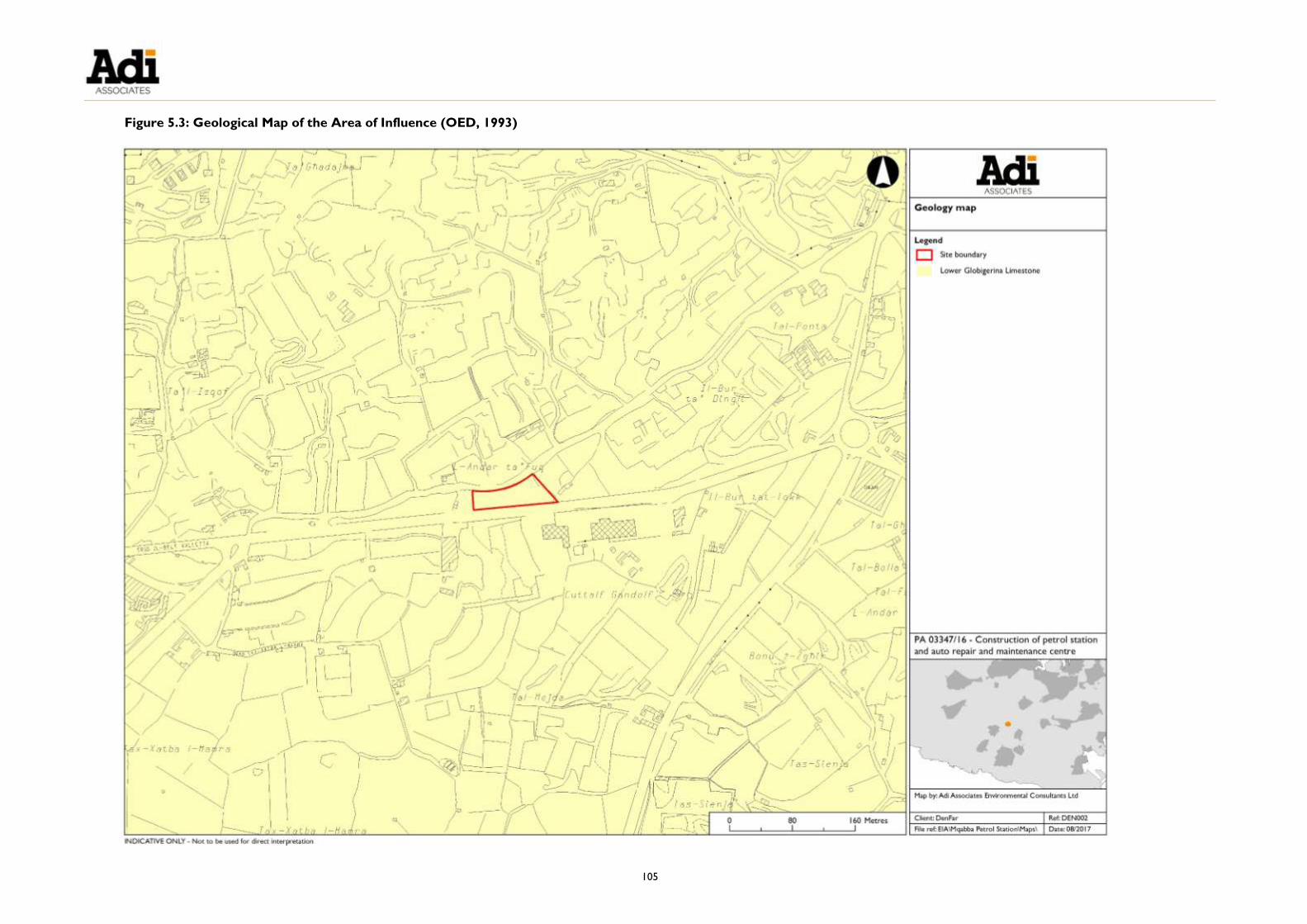
105
Figure 5.3: Geological Map of the Area of Influence (OED, 1993)


107
Figure 5.4: Geological cross section
Lithology of the Lower Globigerina Limestone member
5.14. This member is mostly composed of several beds sometimes bounded by laterally
discontinuous phosphate pebble or conglomerate beds.
5.15. The only bed identified in the quarry at Il-Bur Ta’ Dingli is the Globigerinid bed,
which basically makes up the whole Lower Globigerina Limestone member, as the
other beds are usually less than 1 m thick. In the area of the Scheme site, it is
estimated to be 40 m thick.
5.16. This bed is composed of soft cream to yellow, intensely bioturbated, medium to fine
calcarenite. The microfaunal content is dominated by benthonic and planktonic
microforaminifera that account for its lighter colour and can be defined as a
globigerinid wackestone. Macrofauna are represented by pectinid bivalves, echinoids
and vertebrate debris. The most common trace fossils are represented by
Thalassinoides. In complete sections, this unit is terminated by an erosional surface
representing a hardground (Felix, 1973), termed the terminal Lower Globigerina
Hard Ground (Pedley, 1976), and is succeeded by a flat-topped phosphate
conglomerate bed of the Middle Globigerina Member.
5.17. In the building industry the Lower Globigerina Limestone can be divided into two
principal beds:
Franka stone at the top
Soll at the base
5.18. Franka stone comprises an upper massive light white or yellow to cream, fine to
medium grained, soft porous limestone. Judging by the depths of the quarries within
the A of I, this is estimated to be about 15 m to 20 m thick.

108
5.19. It is underlain by a thickly-bedded, cream clayey limestone of similar thickness. The
latter is locally known as Soll and unlike the upper bed is characterised by evident
burrows, thick to very thick bedding with thick patches or entire beds of bluish grey,
clayey limestone that weathers by flaking.
5.20. The region around Ħal Kirkop, L-Imqabba and il-Qrendi contains some of the best quality Franka stone resource in the Maltese Islands and this explains the prevalence
of a high density of franka stone quarries in the region.
Structural Geology
5.21. The Maltese Islands have two main faulting systems. The Magħlaq Fault runs along
the northwest – southeast coast and has resulted in the northeast tilt of the Maltese
Islands. The Great Fault runs from Pembroke to Fomm ir-Riħ, dividing the island of
Malta into two main blocks. The north of the Great Fault is characterised by horst
and grabens (that is, ridges and rifts), whilst to the south is flat land, with the
exception of the Rabat - Dingli Uplands. In the southern part of Malta, the Upper
Coralline Limestone and Greensands formations have been eroded away and what
remain are the Globigerina Limestone and the Lower Coralline Limestone
formations. The predominant rock type is the Lower Globigerina Limestone
Member.
5.22. The Mqabba and Qrendi area appears to lie in a graben, possibly explaining the
thickening of the franka stone resource bounded by the Siġġiewi and Wied iż-Żurrieq
faults both striking NE-SW.
5.23. No major fault traverses the Scheme site. The nearest fault is the Siġġiewi Fault that passes some 1.2 km to the west of the site. The strata dip at about 5° to the
northeast.
Quality of the Stone Material
5.24. The geo-technical investigation involved the drilling of two boreholes within the
Scheme site (see Figure 5.2 above). The cores extracted consisted entirely of
Lower Globigerina Limestone; some 10 - 15 cm of reinforced concrete was present
at the top of the cores extracted from the boreholes. The Lower Globigerina
Limestone extracted from BH1 had some ‘rust’ stains. The tests conducted showed
that the rock has a low fracture frequency and over all is of good quality. Unconfined
Compressive Strength results vary from 13.6 to 19.7 MPa, which is normal for this
type of rock. With regards to BH2, the first 70 cm were drilled with open hole: the
first 10 cm consisted of concrete, 30 cm was fill, and the rest was rock.
Soils
5.25. Maltese soils reflect the young age of the Maltese rocks, which has resulted in the
close similarity of the soil with the parent material.
5.26. Lang (1960) used the Kubiena classification system to categorise the different soils of

109
the Maltese Islands. He identified four main categories of soils, namely, the
Carbonate Raw Soils, the Terra Soils, the Xerorendzinas, and the Soil Complexes
and Rdum Sequence.
5.27. The A of I is dominated by Tas-Siġra series (Terra soil) and Tad-Dawl complex (soil
complex). Tas-Siġra series is characterised by its typical flateness, complete lack of lapis or out rock surfaces, and almost complete lack of terracing. Tad-Dawl complex is similar
to the Xagħra series, which is a very fertile Terra soil found in karstic environments, but which contains more minerals and lacks the profile characteristics of the
Xagħra series.
BASELINE: GEOMORPHOLOGY
Geomorphic Features
5.28. The Scheme site is located in the flat land that characterises the central and southern
areas of Malta (south of the Great Fault). There are no traces of limestone
formations, and other formations, above the surface Lower Globigerina Limestone,
since the overlying layers have been eroded off.
5.29. The A of I is also affected by the Magħlaq fault, which runs from the northwest to the southeast. As mentioned, this faulting system has also contributed to Malta’s
northeast tilt.
5.30. There are no specific geomorphic features within the Scheme site or in the A of I.
The A of I is characterised by extensive anthropogenic activity related to mineral
extraction from quarries. The closest geomorphic features are Wied Silani (1.5 km
from the Scheme site), Wied Garnaw (2 km from the Scheme site), and the Maqluba
subsidence solution structure (2.5 km from the Scheme site).
BASELINE: HYDROGEOLOGY
5.31. As mentioned, the exposed geological formation at the Scheme site is the Lower
Globigerina Limestone Member of the Globigerina Limestone Formation. The Lower
Globigerina formation is the most widely exposed formation in the central and
southern areas of Malta. Globigerina Limestone is a fine grained limestone and, as
such, presents an almost impermeable layer and is therefore a barrier to infiltration.
Nevertheless, varying degrees of fissuring in all directions through the rock stratum
gives rise to a wide range of permeability. The A of I does not manifest tectonic
faults, with the closest fault lines running through iż-Żurrieq, approximately 1.2 km to
the southeast, and 1.6 km to the northwest at Ħal Farruġ.
Surface Hydrology
5.32. The Scheme site lies adjacent to a road - Triq il-Belt Valletta. The Scheme will lie at a
slightly higher elevation than the road, therefore, potentially-polluted storm water on
Triq il-Belt Valletta will not flow into the site. On a rainy day during the survey, it
was noted that rainwater collected in small puddles along Triq il-Belt Valletta. During

110
the survey, it was also observed that there is no stormwater infrastructure along Triq
il-Belt Valletta, which likely accounts for this. Excess water is likely to run off into
low-lying fields and into the quarries bordering the road. There are no valleys in the
area through which excess runoff could flow. This means that any contaminated
surface runoff that is generated at or around the site is unlikely to travel far, and that
the polluting effect will be geographically contained.
Runoff Generated Within the Scheme Site
5.33. Runoff within the Scheme site when the Scheme comes into operation will arise
from:
The uncovered forecourt; and
Roofs and canopies of the buildings and structures.
5.34. The roof and canopy areas will cumulatively measure approximately 1,200 m2. Runoff
from these surfaces will be channelled into a 720 m3 capacity reservoir and the water
so collected is envisaged to be used in the car wash area. With an annual rainfall of
553 mm and using a run-off coefficient of 0.9, the amount of rainwater that is likely to
be collected annually amounts to 597 m3, all of which can be contained in the
reservoir, leaving a 15% contingency. This reservoir will only overflow if the supply
exceeds demand, year after year, in which case the reservoir will overflow into Triq
il-Belt Valletta.
5.35. It is envisaged that surface runoff from the forecourt will be diverted to a Class 1 fuel
retention separator (as described in Chapter 3 of the EPS). The remaining areas
will drain to Triq il-Belt Valletta..
5.36. The car wash area will be contained within a system of peripheral surface drainage
channels, designed to collect and divert the wash water into a recycled water
reservoir (capacity of 44 m3) having first been filtered through a Class I oil / water
separator. It is projected that 60% of the water used in the car wash operation will
be recovered and recycled.
Mean Sea Level Aquifer
5.37. The Scheme site overlies the Mean Sea Level Aquifer, which is located at sea level
and exists in the Globigerina and Lower Coralline Limestone Formations that also
form the geological strata at the site. The Scheme site lies approximately 82 m above
the Mean Sea Level Aquifer of Malta.
5.38. The main recharge area to this Aquifer is the extensive Globigerina Limestone
Formation outcropping to the south of the Victoria Lines, of which the Scheme site
forms part. The first rains during the winter months serve to saturate the soil water
deficit; prolonged rainfall results in the generation of runoff and infiltration to the
aquifer. Water balance estimates for the Maltese Islands indicate ground water
recharge as being 20-25% of rainfall. Runoff and evapo-transpiration losses account
for 5% and 70% of rainfall, respectively. On a regional level, these figures may vary,

111
depending on topography, soil cover, underlying geology, slope and other factors.
5.39. The Scheme site is located within the Groundwater Protection Zone, as established
by the Malta Resources Authority; however, it lies outside the 300 m Groundwater
Safeguard Zone established by the former Malta Environment and Planning Authority
(MEPA).
5.40. There are four private boreholes and two Water Services Corporation boreholes
located within the A of I (see Figure 5.5).


113
Figure 5.5: Hydrology map showing features of interest within the Area of Influence

114
ASSESSMENT OF IMPACTS
Impact Significance
5.41. The following criteria were used to assess the significance of the negative impacts of
the Scheme on the geo-environment:
Not significant:
o Little or no change to the geological, geomorphological and
hydrogeological regime.
Minor significance:
o Changes to the geological, geomorphological and hydrogeological regime
that may affect neighbouring properties but which may be offset by
mitigation measures.
Major significance:
o Changes to the geological, geomorphological and hydrogeological regime
that may affect neighbouring properties and which may not be offset by
mitigation measures (if negative) or may be enhanced by mitigation
measures (if positive).
Prediction and Significance of Impacts
Extraction of Resources
5.42. As discussed above, the two cores that were drilled within the Scheme site show
that part of the site is partly infilled. Old survey sheets show that part of the site is a
former quarry that has been infilled with inert material (this was also confirmed by
the Applicant). The predicted impact of the Scheme on the underlying geology is
therefore considered to be of minor to major negative significance, since it involves
some extraction of mineral resources and removal of inert dumped material. The
extent of the infilling is unknown hence the impact being judged minor to major. It is
envisaged that approximately 2,353 m3of material will be excavated from the site.
5.43. The impact of water consumption from the car wash is considered to be of minor
significance due to the fact that 60% of the water will be recycled.
Change in quality of aquifer
5.44. In terms of quality of the aquifer, the predicted impact of the Scheme is considered
to be of minor significance, subject to the appropriate mitigation measures being in
place. Given the nature of the Scheme, there is a potential risk of contamination of
the aquifer; however, the mitigation measures included in the Scheme would avoid
this risk. The underground fuel storage tanks will have double skins and a leak
detection system; they will also be installed within special pits that have been

115
rendered impermeable to avoid accidental leakage. Above ground, the forecourt will
also be rendered impermeable to avoid losses to the aquifer, and oil-water
separators will also be installed, as described in Chapter 3 of the EPS.
Change in quality of run-off
5.45. Without mitigation, spillage of large quantities of fuel above ground would see the
run-off flowing downstream. However the mitigation measures designed into the Scheme will reduce this risk substantially. As mentioned, the surface of the site will
be impermeable and any spill will be directed towards the oil-water interceptors.
Hence, the predicted impact of the Scheme in relation to the quality of surface water
run-off is considered to be minor, subject to the appropriate mitigation measures
being in place.
MITIGATION
5.46. Mitigation measures to protect hydrogeological resources are:
Construction of the Scheme in accordance with all the appropriate industry
standards for fuel service stations, including the installation of the underground
fuel storage tanks with double skins, leak detection systems and surrounded by
impermeable bunding, and the installation of an impermeable forecourt and oil-
water interceptors. The mitigation measures are discussed in Chapter 3 and the
risks of the operation are described in Volume 2 of the EPS.
Preparation of a Construction Management Plan that also addresses issues of
groundwater and surface water pollution arising from the construction of the
Scheme; and
Adoption of operational management practices designed to monitor the performance of pollution control measures, including leak detection systems for
the tanks, pipework and dispensers, regular emptying of the oil-water interceptor
chambers, and regular inspections of the surface water drainage system
(particularly after storms) to avoid contaminated surface water run-off entering
the watercourse.
RESIDUAL IMPACTS
5.47. With the mitigation measures in place, the impact on the aquifer and on surface
water is considered to be of minor significance. Residual impacts will remain as being
of minor to major negative significance, depending on the extent of mineral resource
to be extracted.


117
Table 5.1: Summary of Impacts on the Geo-environment
Predicted
Impact
Beneficial
/Adverse
Nature, Scale and Type of Impact Probability of
Impact
Occurring
(Likely/
Unlikely/
Remote/
Uncertain)
Significance
of Impact
(Major/
Moderate/
Minor/Not
Significant)
Proposed
Mitigation
Measures
Significance
of Residual
Impact
(Major/
Moderate/
Minor/Not
Significant)
Constr’
n
/Oper’n
Extent
of
Impact
(Nat/
Local
/Site)
Direct/
Indirect
S’term
/
L’term
Perm/
Temp
Revers/
Irrevers
Mineral
resources /
geological
features
Adverse Constr’n Local Direct Long-
term Perm Irrevers Likely
Minor to
major
significance
Re-use of
excavated material
Minor to
major
significance
Water
resources Adverse Oper’n Local Direct
Long-
term Perm Irrevers Likely
Minor
significance
Collection of
water from the
canopy for re-use;
Re-cycling of water
used in the car
wash facilities
Minor
significance
Change in
the quality
of ground
water
Adverse Constr’n
/ Oper’n Local Indirect
Short-
term /
Long-
term
Perm Irrevers Likely Minor
significance
Construction in
accordance with
industry standards
for pollution
avoidance
CMP
Operational
management
practices to
monitor
performance of
pollution control
measures.
Minor
significance
Change in
the surface
water run-
off patterns
Adverse Constr’n Local Direct Long-
term Perm Irrevers Likely
Minor
significance
Minor
significance

119
6. CULTURAL HERITAGE
6.1. This chapter describes the cultural heritage within the Scheme site and the wider
Area of Influence (A of I). The potential key issues with regards to cultural heritage
are:
Key Issues:
Loss or damage to features of cultural heritage significance
Alteration or degradation of the quality of the setting of the features
of cultural heritage significance as a result of the Scheme
Terms of Reference
6.2. The Terms of Reference provided by the Environment and Resources Authority
(ERA) are provided in Technical Appendix 1: Terms of Reference and Method
Statements.
ASSESSMENT METHODOLOGY
Objectives of the Assessment
6.3. The objectives of the cultural heritage desktop study were to:
Identify, document, and present information on the known archaeological and
cultural heritage features within the A of I;
Identify the potential for additional archaeological remains within the A of I, from
desk study research;
Assess the cultural heritage significance of the A of I;
Describe and assess the impact of the Scheme on the archaeological and cultural
heritage features within the A of I;
Describe any mitigation measures designed to minimise any adverse impacts on
the archaeological and cultural heritage features within the A of I; and
Describe appropriate monitoring measures to safeguard archaeological and
cultural heritage features during the construction and operation of the Scheme.

120
Standards and Policy Guidance
National Policy and Legislation
6.4. Guidance on the protection of cultural heritage in the context of planning was taken
from the Cultural Heritage Act 2002, and the urban conservation and archaeology
policies of the former Structure Plan for the Maltese Islands 199219.
Cultural Heritage Act, 2002
6.5. This Act provides overall protection to all “movable or immovable objects of artistic,
architectural, historical, archaeological, ethnographic, palaeontological and geological
importance and includes information or data relative to cultural heritage pertaining to Malta
or to any other country (section 2)”. It also includes “archaeological, palaeontological or
geological sites and deposits, landscapes, groups of buildings…which have an historical
value”. In Section 3, it also specifies that “For the purposes of this Act, an object shall not
be deemed to form part of the cultural heritage unless it has existed in Malta, including the
territorial waters thereof, or in any other country, for fifty years, or unless it is an object of
cultural, artistic, historical, ethnographic, scientific or industrial value, even if contemporary,
that is worth preserving”.
6.6. Furthermore, “No person shall make any interventions on such cultural property or classes
thereof without first having obtained a permit therefore from the Superintendent” (Section
44.3). Applications are determined subject to the results of prior investigation:
“Before determining an application under sub-article (3) hereof the Superintendent may
require such information including the results of such tests, examinations or inspection by
such persons accredited under this Act for the purpose as may be required by the
Superintendent” (Section 44.4).
6.7. The restrictions on archaeological excavations are stated in Section 43(1), whereby
“Archaeological or palaeontological excavations or explorations on land as well as in the
territorial waters or in the contiguous zone of Malta can only be made by the
Superintendent, or with written permission of the Superintendent”. Chance discoveries of
archaeological remains are also regulated by Section 43(2): “Any person who, even
accidentally, discovers any object, site or building to which this Act applies in accordance with
article 3, shall immediately inform the Superintendent, keep the object found in situ, and
shall not for a period of six working days after informing the Superintendent proceed with
any work on the site where the object of cultural property is discovered”. The details
regarding rights and obligations by all parties in the eventuality of an archaeological
discovery are described in Sections 43(3), 43(4), 43(5), 43(6), and 43(7).
19 The Structure Plan for the Maltese Islands 1992 has been superseded by the Strategic Plan for the Environment
and Development 2015 (SPED); however, the SPED does not outline policy guidance for cultural heritage in the
level of detail that it was outlined in the Structure Plan. In the absence of specific policy guidance, and
specifically in respect of the classification of cultural heritage features, reference is still made to the relevant
policies of the Structure Plan.
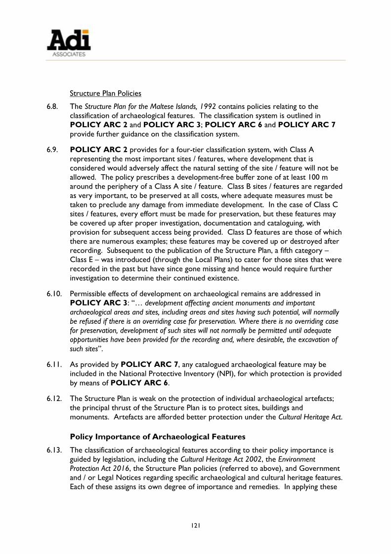
121
Structure Plan Policies
6.8. The Structure Plan for the Maltese Islands, 1992 contains policies relating to the
classification of archaeological features. The classification system is outlined in
POLICY ARC 2 and POLICY ARC 3; POLICY ARC 6 and POLICY ARC 7
provide further guidance on the classification system.
6.9. POLICY ARC 2 provides for a four-tier classification system, with Class A
representing the most important sites / features, where development that is
considered would adversely affect the natural setting of the site / feature will not be
allowed. The policy prescribes a development-free buffer zone of at least 100 m
around the periphery of a Class A site / feature. Class B sites / features are regarded
as very important, to be preserved at all costs, where adequate measures must be
taken to preclude any damage from immediate development. In the case of Class C
sites / features, every effort must be made for preservation, but these features may
be covered up after proper investigation, documentation and cataloguing, with
provision for subsequent access being provided. Class D features are those of which there are numerous examples; these features may be covered up or destroyed after
recording. Subsequent to the publication of the Structure Plan, a fifth category –
Class E – was introduced (through the Local Plans) to cater for those sites that were
recorded in the past but have since gone missing and hence would require further
investigation to determine their continued existence.
6.10. Permissible effects of development on archaeological remains are addressed in
POLICY ARC 3: “… development affecting ancient monuments and important
archaeological areas and sites, including areas and sites having such potential, will normally
be refused if there is an overriding case for preservation. Where there is no overriding case
for preservation, development of such sites will not normally be permitted until adequate opportunities have been provided for the recording and, where desirable, the excavation of
such sites”.
6.11. As provided by POLICY ARC 7, any catalogued archaeological feature may be
included in the National Protective Inventory (NPI), for which protection is provided
by means of POLICY ARC 6.
6.12. The Structure Plan is weak on the protection of individual archaeological artefacts;
the principal thrust of the Structure Plan is to protect sites, buildings and
monuments. Artefacts are afforded better protection under the Cultural Heritage Act.
Policy Importance of Archaeological Features
6.13. The classification of archaeological features according to their policy importance is
guided by legislation, including the Cultural Heritage Act 2002, the Environment
Protection Act 2016, the Structure Plan policies (referred to above), and Government
and / or Legal Notices regarding specific archaeological and cultural heritage features.
Each of these assigns its own degree of importance and remedies. In applying these

122
to the EIA process three categories are used:
Features of International Importance (major importance);
Features of National Importance (major importance); and
Features of Local Importance (minor importance).
6.14. Table 6.1 summarises the cultural significance of different features.
Table 6.1: Protection Ratings and Cultural Significance
Cultural Significance Class Grade Protection
Major
National Importance A 1 Conserve, plus 100 m buffer zone
Medium
Local Importance B 2 Conserve
Minor C 3 Record / may be covered
None D - May be covered, destroyed, or recycled
Uncertain E - Further investigation is required
6.15. The laws, policies, classification systems, etc., pertaining to the conservation of
buildings or other structures have been assigned to these categories of policy
importance as follows:
Features of International Importance
6.16. Cultural features of international importance are those:
Protected specifically by legislation;
Qualifying as Class A features under Structure Plan POLICY ARC 2; or
Similarly identified by the Minister responsible for cultural heritage or the
Superintendence of Cultural Heritage.
Features of National Importance
6.17. Features of international importance would also be of national importance.
Additionally, cultural features of national importance are those:
Qualifying as Class B features under Structure Plan POLICY ARC 2; or
Similarly identified by the Minister responsible for cultural heritage or the
Superintendence of Cultural Heritage.

123
Features of Local Importance
6.18. Cultural features of local importance are those:
Qualifying as Class C or Class D features under Structure Plan POLICY ARC 2;
or
Similarly identified by the Minister responsible for cultural heritage or the
Superintendence of Cultural Heritage.
Remaining Features
6.19. All catalogued cultural heritage features may be included in the NPI, and those not
already protected are afforded protection under Structure Plan POLICY ARC 6,
which provides that all sites / features listed in the NPI will be protected in
accordance with the Environment and Development Planning Act (now the
Environment Protection Act and the Development Planning Act) powers and by
reference to the classification ratings outlined in Structure Plan POLICY ARC 2.
Area of Influence
6.20. The A of I for the cultural heritage study is illustrated in Figure 6.1.
Methodology
6.21. The methodology for the cultural heritage desktop study consisted of a research-
based baseline survey of the cultural heritage assets (artistic, architectural, historical,
archaeological, and ethnographic assets) and an evaluation of their importance.
Literature Search
6.22. The literature search included primary and secondary sources: analysis of
cartographic and photographic material; analysis of secondary written sources; and
analysis of conservation legislation.
Mapping
6.23. The archaeological, rural, vernacular, historical, and cultural heritage features within
the A of I were mapped, primarily through consultation of documentary sources.
Cataloguing
6.24. The relevant information for each feature was recorded on cards and using digital
media, in the format currently used by ERA. Each feature was individually identified
using a consecutive numbered reference; the information for each feature includes:
A short written description of the feature;
Co-ordinates recorded up to 5 digits for each Eastings and Northings, based on
the local UTM grid reference;

124
Locality and address;
Site map (Scale 1:2500);
Colour photograph(s);
Sketch of the feature showing the most significant details (wherever possible);
Conservation importance of the site / feature (proposed grading in accordance
with Structure Plan policies);
Existing and / or proposed legislative and physical protection;
Current and proposed use / enhancement;
References; and
Name of cataloguer and date of compilation.
Evaluation
6.25. An archaeological assessment and significance of the archaeological, rural, vernacular, historical, and cultural heritage features was undertaken from the desktop study. The
conservation importance of the identified sites / features has been identified with
reference to relevant legislation standards, guidance and practices as described above.

125
Figure 6.1: Area of Influence for Cultural Heritage Study


127
DESKTOP SURVEY RESULTS
6.26. The A of I lies within the L-Imqabba and Ħal Kirkop Local Council administrative areas. The Scheme site is located on the outskirts of the locality of L-Imqabba, which
has in the region of 3,223 inhabitants20. The environs of the village of L-Imqabba are
dominated by quarrying activities, related industrial uses, and agriculture.
Prehistory
6.27. There have been a number of pre-historic archaeological finds at L-Imqabba.
Remains of extinct animals were discovered at Ta’ Kandja and at Tax-Xantin to the
northwest and north of L-Imqabba settlement respectively. Quaternary deposits
were discovered within a cave within one of the quarries at Bur Mogħoż. The site included animal remains and Neolithic inhumations. Other artefacts found included
ceramics, flints, and shell ornaments. The area is also known to have included
megaliths.
Classical Antiquity
6.28. L-Imqabba and its surrounding area are also rich in evidence of human activity during
the classical period. A number of destroyed or filled in rock-tombs where recorded
at Cuttalf Gandolf, which falls within the A of I. Excavations in 1911 uncovered
Punic-type pottery. Glass fragments and bronze objects also found during the
excavation dated the tombs to around the second or third century BC.
6.29. One of the most prominent features from the Classical period is the Tal-Wilga
Punico-Roman tower, located to the north-west of L-Imqabba. The round tower
was constructed using large ashlar blocks. Only the eastern side of the tower has
survived, and it is currently in a good condition. The tower was probably used up to
the third century AD. The tower was discovered by Dr Ashby in 1908, who
considered it be from the prehistoric period. The area around the tower was
excavated in 1910, and the pottery uncovered during this excavation was of the Punic
type.
6.30. The remains of a Roman villa at Tad-Dawl21 were excavated and recorded in 1910;
however, the remains were subsequently destroyed. The site included two cisterns
and olive pressing instruments.
6.31. The Tal-Mintna Catacomb complex is located within the village of L-Imqabba. The
complex is richly decorated and includes an agape table.
20 Census of Population and Housing 2011: Final Report. ‐ Valletta: National Statistics Office, 2014, p. 3 21 Bonanno, A. (1977) ‘Distribution of Villas and some of the Maltese Economy in the Roman Period’ in Journal
of the Faculty of Arts 6(4) : 73-81
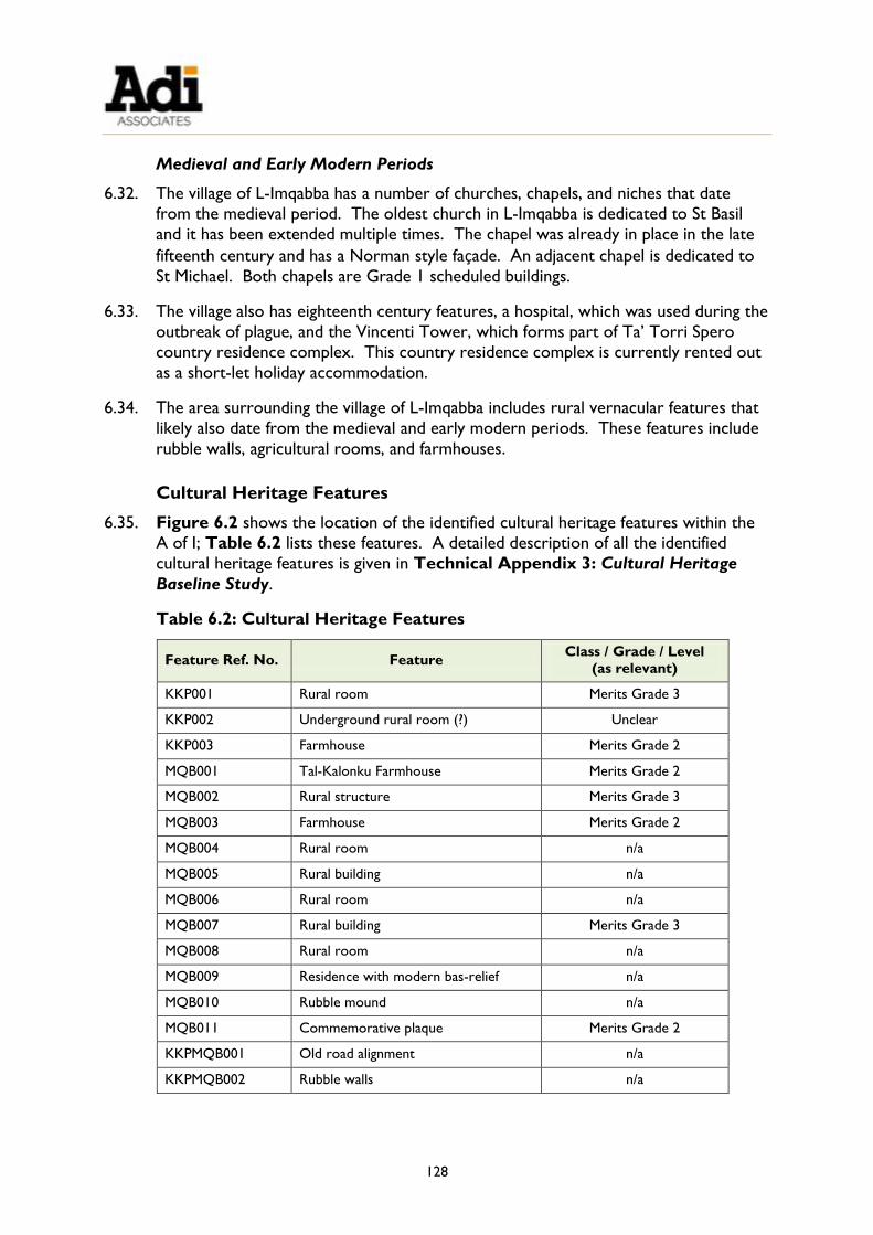
128
Medieval and Early Modern Periods
6.32. The village of L-Imqabba has a number of churches, chapels, and niches that date
from the medieval period. The oldest church in L-Imqabba is dedicated to St Basil
and it has been extended multiple times. The chapel was already in place in the late
fifteenth century and has a Norman style façade. An adjacent chapel is dedicated to
St Michael. Both chapels are Grade 1 scheduled buildings.
6.33. The village also has eighteenth century features, a hospital, which was used during the
outbreak of plague, and the Vincenti Tower, which forms part of Ta’ Torri Spero
country residence complex. This country residence complex is currently rented out
as a short-let holiday accommodation.
6.34. The area surrounding the village of L-Imqabba includes rural vernacular features that
likely also date from the medieval and early modern periods. These features include
rubble walls, agricultural rooms, and farmhouses.
Cultural Heritage Features
6.35. Figure 6.2 shows the location of the identified cultural heritage features within the
A of I; Table 6.2 lists these features. A detailed description of all the identified
cultural heritage features is given in Technical Appendix 3: Cultural Heritage
Baseline Study.
Table 6.2: Cultural Heritage Features
Feature Ref. No. Feature Class / Grade / Level
(as relevant)
KKP001 Rural room Merits Grade 3
KKP002 Underground rural room (?) Unclear
KKP003 Farmhouse Merits Grade 2
MQB001 Tal-Kalonku Farmhouse Merits Grade 2
MQB002 Rural structure Merits Grade 3
MQB003 Farmhouse Merits Grade 2
MQB004 Rural room n/a
MQB005 Rural building n/a
MQB006 Rural room n/a
MQB007 Rural building Merits Grade 3
MQB008 Rural room n/a
MQB009 Residence with modern bas-relief n/a
MQB010 Rubble mound n/a
MQB011 Commemorative plaque Merits Grade 2
KKPMQB001 Old road alignment n/a
KKPMQB002 Rubble walls n/a

129
Figure 6.2: Cultural Heritage Features within the Area of Influence


131
6.36. There are no scheduled heritage features within the A of I. However, the South
Malta Local Plan (SMLP) identifies a Grade E Archaeological Sensitive Area (ASA)
close to the Scheme site. In this area, a rock-cut tomb located in the corner of a
built marble / stone work plant had been identified but its exact location has gone
missing. The identified buffer zone to the feature extends to the southeast corner of
the Scheme site (see Figure 6.2).
6.37. The A of I includes a number of buildings / structures / features that are considered
to be important for their cultural heritage significance. The closest of these features
to the Scheme site is a rural room, where newer structures have been built adjoining
and surrounding the original structure (see Feature KKP001 in Figure 6.3).
Figure 6.3: Rural Room close to the Scheme Site (KKP001)
6.38. The A of I is rich in cultural features related to agricultural activity, including
farmhouses, rural rooms, and rubble walls. These features vary in age and state of
repair.
6.39. One of the most interesting features is a farmhouse (MQB003), which could have
possibly been built for defensive purposes due to its towering dimensions and
features (see Figure 6.4). This structure, located approximately 160 m to the
northwest of the Scheme site, merits consideration as a Grade 2 scheduled building.
6.40. Some of the rubble walls are built with traditionally-sized rubble stones; others show
frequent interventions with the introduction of modern blocks (see Figure 6.6).

132
Figure 6.4: Farmhouse (MQB003)

133
Figure 6.5: Another two farmhouses within the Area of Influence - KKP003
(top) and MQB007 (bottom)

134
Figure 6.6: Rubble walls (KKPMQB002)

135
ASSESSMENT OF IMPACTS
Determining Impact Significance
6.41. The significance of the impacts of the Scheme on cultural heritage is dependent upon
the importance assigned to each of the cultural heritage features, either through
legislation or by the Consultants, and the degree of disturbance or damage likely to
arise from the construction and / or the operation of the Scheme.
6.42. A summary of the significance of the impact was judged in terms of whether the
impact is considered to be not significant, of minor significance, or of major
significance. The assessment criteria applicable in relation to determining the
significance levels are described in Table 6.3.
Table 6.3: Impact Significance Criteria
Potential Damage or
Destruction to Features
Class or Grade of Cultural Heritage Feature
Major
Class /
Grade A / 1
Medium
Class /
Grade B / 2
Minor
Class /
Grade C / 3
None / Not
graded
No material change to the cultural
heritage feature
Not
significant
Not
significant
Not
significant
Not
significant
Small scale changes to the cultural
heritage feature (i.e. alterations),
which are unlikely to affect the
integrity of the feature
Major Minor Minor Not
significant
Loss of, or disturbance to, the
cultural heritage feature which is
likely to affect the integrity of the
feature
Major Major Minor Not
significant
Prediction and Significance of Impacts
6.43. There are no identified cultural heritage features within the Scheme site. The site is a
former softstone quarry that has been infilled and concreted over. Notwithstanding,
there is the potential for impacts on cultural heritage arising from possible loss of, or
damage to, unrecorded archaeological artefacts during the excavation. The extent of
this impact is uncertain, as it will depend on whether artefacts are present, their
importance, and the extent of any loss or damage. However, any potential impact
would be ascertained through the presence of an archaeology monitor during
excavation works and the necessary mitigation / documentation taken.
6.44. The artefacts in close proximity to the site include a rural building (Feature MQB005
in Figure 6.2) to the west of the Scheme site and a rural room (feature KKP001 in
Figure 6.2) to the east of the site. These rooms are remnants of a former rural
activity in the area but since the opening of the quarries and the subsequent open
storage / industrial use of the area, their setting has been significantly altered and they

136
remain as solitary reminders of the former use of the area. The introduction of a
modern fuel station, complete with industrial canopy, signs, lights, etc, while removing
the dusty activity from the site, is likely to further alter the setting of these rooms
and of the general area.
6.45. It is also unlikely that there will be any impact on the structural integrity of these
structures arising from vibrations during the construction of the Scheme. British Standard (BS) 7385: 1993 - Part 222 outlines limit values for transient vibration, above
which cosmetic damage23 to buildings / structures would occur24. Also considering
vibration monitoring data for excavations collected by MEPA in Malta25, the level of
vibration is likely to be lower than the trigger value for cosmetic damage to buildings
/ structures prescribed by the relevant standards.
6.46. There is also unlikely to be any significant impact from the operation of the Scheme
on these structures, given the nature and scale of the development and the distance
between them.
6.47. Although there might be a rock-cut tomb in the vicinity of the site, the Scheme
boundary is just outside the buffer zone of the Grade E tomb. Given the limited
excavation and also noting that the Scheme is outside the buffer zone then there are
unlikely to be impacts on this feature from the excavation.
6.48. The route to be used for heavy vehicles during the construction of the Scheme is not
expected to have an impact on any of the cultural heritage features within the A of I,
including the rubble walls.
MITIGATION MEASURES
6.49. In the event that the Scheme proceeds, and in view of the potential for impacts on
cultural heritage arising from possible loss of, or damage to, unrecorded
archaeological artefacts, it is recommended that the Superintendence of Cultural Heritage is consulted to determine whether archaeology monitoring is required.
This monitoring would ensure that in the eventuality that uncharted artefacts are
encountered, any cultural heritage features removed from the Scheme site would be
appropriately recorded and, wherever possible, significant features should be
salvaged. This should be carried out in accordance with the directions issued by the
Superintendence of Cultural Heritage.
22 BS 7385: 1993, Evaluation and Measurement for Vibration in Buildings – Guide to Damage Levels from
Ground Borne Vibration: Part 2, British Standards Institution. 23 Cosmetic damage is defined as “the formation of hairline cracks on drywall surfaces, or the growth of existing
cracks in plaster or drywall surfaces; in additional the formation of hairline cracks in mortar joints of brick/ concrete
block construction”. 24 15 mm/s at 4 Hz. 25 Vibration monitoring data indicates that at 7 m the level vibration is lower than the 15 mm/s value prescribed
by BS 7385.

137
RESIDUAL IMPACTS
6.50. The residual impacts are uncertain, as this will depend on whether artefacts are
present within the Scheme site, the importance of these artefacts, and the extent of
any loss or damage to the artefacts.
6.51. Table 6.4 summarises the impact assessment.
MONITORING REQUIREMENTS
6.52. It is recommended that prior to the excavation and construction of the Scheme, the
Superintendence of Cultural Heritage is consulted on the requirement for
archaeology monitoring.


139
Table 6.4: Summary of Impacts on Cultural Heritage
Predicted
Impact
Beneficial/
Adverse/
Neutral
Nature, Scale and Type of Impact Probability
of Impact
Occurring
(Likely,
Unlikely,
Remote,
Uncertain)
Significance of
Impact
(Major/Minor/
Not
Significant)
Proposed
Mitigation
Measures
Significance
of Residual
Impact
(Major/Minor
/Not Significant)
Constr’n
/ Oper’n
Extent of
impact
(Nat /
Local /
Site)
Direct/
Indirect
S-term /
L-term
Perm /
Temp
Revers /
Irrevers
Loss or damage
to unrecorded
archaeological
or cultural
heritage
artefacts on site
Adverse Constr’n Site Direct L-term Perm Irrevers Uncertain
Uncertain,
depending on
whether
artefacts are
present, their
level of
importance,
and the extent
of any loss or
damage
Archaeological
monitoring
during excavation
/ recording of
features /
salvaging of
significant
features, if
requested by
SCH
Uncertain
(depending on
whether artefacts
are present, their
importance and the
extent of any loss
or damage)
Alteration or
degradation of
the structural
integrity and
quality of the
setting of the
rural rooms
close to the
Scheme Site
Adverse Constr’n /
Oper’n Local Direct L-term Perm Irrevers Likely
Not significant to
minor None
Not significant to
minor


141
7. LANDSCAPE AND VISUAL AMENITY
INTRODUCTION
7.1. This chapter addresses the potential impacts of the Scheme on landscape and visual
amenity. It describes the existing landscape and visual amenity of the Scheme Site
and its surroundings, and assesses how this might change through the development of
the Scheme.
7.2. Assessment of landscape and visual amenity involves examination of the wide range of
factors that contribute to the qualities and attributes of the existing landscape and
that may contribute to the landscape of the Scheme. This involves consideration of
the evolution of the landscape and the factors that have led to its current condition,
from the underlying geology through to anthropogenic activities.
7.3. Landscape and visual impacts are distinct, albeit strongly related. Landscape impacts
result from the interaction between a development and the existing landscape
resources, experienced through changes to any element or combination of landscape
elements. Visual impacts relate to the effect that a development would have on the
amenity of sensitive receptors (those experiencing views of the site), relating to the
actual or perceived visible changes to the character and quality of the landscape.
7.4. The key issues for the assessment are:
Key Issues:
Effects on the landscape setting of the Scheme
Changes in views of key receptors
OBJECTIVES OF THE ASSESSMENT
7.5. The objectives of the landscape and visual amenity study were to:
Undertake a baseline survey and characterisation of the landscape and visual
amenity at and around the Scheme Site, using desk top and field survey
techniques;
Evaluate the landscape character of the Scheme site and its setting;
Establish the Zone of Theoretical Visibility (ZTV)26 for the Scheme and identify
the key viewpoints and receptors;
26 In accordance with the Guidelines for Landscape and Visual Impact Assessment (Third Edition) (2013), the term
Zone of Theoretical Visibility (ZTV) is being used in place of the term Zone of Visual Influence (ZVI) since it
makes clear that the area thus defined shows land from which the proposal may theoretically be visible and
does not take account of potential screening by vegetation and buildings.

142
Input the potentially beneficial design measures to the Scheme;
Predict the impacts of the Scheme on the visual amenity in the ZTV;
Assess the significance of the impacts on the landscape and visual amenity of the
ZTV; and
Describe the mitigation measures designed into the Scheme to minimise adverse
impacts and enhance any beneficial impacts on the landscape and visual amenity.
LEGISLATION AND POLICY GUIDANCE
7.6. The Constitution of Malta (Section 9) declares that the State shall safeguard the
landscape and the historical and artistic patrimony of the Nation. These are the only
aspects of the environment referred to in the Constitution, underlining the
importance of the landscape and historical heritage.
South Malta Local Plan
7.7. The South Malta Local Plan (SMLP) 2006 is relevant to the Scheme. The site is
surrounded by quarries to the north and agricultural land to the south. The site itself
lies within a white area (see Figure 7.1).
7.8. POLICY SMCO 06 describes Areas of High Landscape Value designated in the
SMLP region within which, the policy states, there will be a presumption against
development of new built structures. Activities and interventions that will upgrade
and enhance these areas, such as establishment of cycling routes, will be encouraged.
Reference to ensuring that light pollution is avoided is also included in the Plan’s text
accompanying the policy. The AHLVs listed in the policy are the following:
Wied tal-Baqqiegħa (Haż-Żebbuġ) and Wied Ħesri (Is-Siġġiewi);
The slopes flanking Wied Ta’ Kandja (Is-Siġġiewi);
Wied Qirda (Haż-Żebbuġ / Is-Siġġiewi);
Għar Ħanzir and Wied Sillani (Is-Siġġiewi);
Wied il-Kbir (Is-Siġġiewi / Ħal-Luqa);
Wied ta’ Ħas-Saptan (Ħal-Għaxaq);
Wied ta’ Ħal-Saflieni (Ħal-Luqa);
Wied il-Qoton (Ħal-Għaxaq);
The rocky steppe at Ta’ Ħaxum (Ħal-Għaxaq);
The promontory of Għassa tal-Munxar (Wied il-Għajn);
The afforested sites along is-Swar tal-Kottonera (Iż-Żabbar, Il-Fgura); and
143
Between Żonqor Point (Wied il-Għajn) and Blata l-Bajda (Ix-Xgħajra).
7.9. As indicated in Figure 7.1, the Scheme site does not lie within an AHLV.
Landscape Assessment Study of the Maltese Islands
7.10. MEPA’s Landscape Assessment Study of the Maltese Islands was undertaken in 2004
as part of the Structure Plan Review. The Study does not provide an assessment
methodology to use in order to consider the impacts of a specific development; it
does however provide a useful baseline assessment of the prevailing landscape
character of the Maltese Islands. The primary purpose of the Study appears to have
been as a topic paper to identify Areas of High Landscape Sensitivity and inform the
Structure Plan Review.
7.11. The Scheme site lies within Landscape Character Area M40 which describes the
Mqabba Quarry Area. This area includes a number of large quarries; however, due
to the general flatness of the area, the quarries are generally not noticeable in long-
distance views.
7.12. The Scheme site borders Landscape Character Area M38 which describes the South
Airport Hinterland, which includes the settlements of Il-Qrendi, L-Imqabba, Ħal
Kirkop, Iż-Żurrieq, and Ħal Safi. Similarly to the Ħal Għaxaq – Il-Gudja hinterland, the
settlements are each dominated by a parish church. This large plain includes
extensive areas of dry farmland between the settlements. A number of rural
buildings are largely associated with cultivation as well as animal husbandry although a number of buildings are also associated with micro-industry and quarries are also
frequent.
Standards and Guidelines
7.13. In view of the fact that there are no Malta-specific landscape and visual amenity
assessment guidelines, ERA requested that the landscape and visual assessment be carried out in line with the UK’s Guidelines for Landscape and Visual Impact Assessment
2013 (GLVIA)(Institute of Environmental Management & Assessment (IEMA) and the
Landscape Institute).
7.14. The photomontages were prepared by Perit Joseph A. Pace in accordance with the
Malta Environment and Planning Authority’s (MEPA) 2015 Best Practice Guide Visual
Simulations.
ASSESSMENT METHODOLOGY
Desk Study Methodology
Landscape Assessment
7.15. The landscape baseline conditions were determined through desk study and field
surveys. The desk study included:
A review of the information shown on the base map of the area and reference to

144
the maps prepared for the geo-environment and land use aspects of the EPS;
An analysis of aerial photographs to determine land use trends; and
A review of existing baseline information from:
o Literature searches;
o Previous environmental and planning studies undertaken in the area;
o Historic maps; and
o Legislation and policy documents.
Landscape Character, Value and Sensitivity
7.16. As mentioned, MEPA’s Landscape Assessment Study of the Maltese Islands was
carried out as part of the Structure Plan review. This study characterised the
landscape at a national level into a series of units known as landscape character areas
(LCAs). It describes landscape characteristics, qualities and influences on the
landscape. The landscape character area of the site and its surroundings consider MEPA’s Landscape Assessment Study as well as the results of the desk and field
studies when characterising the landscape in the area.
7.17. The value of the landscape receptor should also be considered. The value of a
landscape character receptor is a reflection of its importance in terms of any
designations that may apply, or its importance in itself as a landscape or townscape
resource, which may be due to its ecological, cultural, or recreational value. The
higher the value of the receptor, the greater is its sensitivity to the development.
Value is assessed as being high, medium, or low in line with the following criteria:
High landscape value – high importance and rarity, no or limited potential for substitution. Importance may be on an international, national, regional or local
scale e.g. Areas of High Landscape Value.
Moderate landscape value – moderate importance and rarity, limited potential for substitution. Importance on a regional or local scale e.g. undesignated but value
perhaps expressed through non-official publications or demonstrable use.
Low landscape value – low importance and rarity with considerable potential for substitution on a local scale, e.g. areas identified as having some redeeming
feature or features and possibly identified for improvement or recovery.
7.18. The condition of the landscape was assessed using the following criteria:
Good landscape condition: where the landscape and its features are in good
repair / good quality and have a high contribution to landscape character.
Moderate landscape condition: where the landscape and its features are in average repair / average quality and make a medium contribution to the landscape
character.
Low landscape condition: where the landscape and its features are in poor repair

145
/ poor quality and make a low contribution to landscape character.
7.19. Landscape sensitivity is a complex issue. The GLVIA refer to consideration of a
landscape’s susceptibility to change, meaning ‘...the ability of the landscape receptor...to
accommodate the proposed development without undue consequences for the maintenance
of the baseline situation and/or the achievement of landscape planning policies and
strategies.’
7.20. Landscape character sensitivity was then defined in accordance with the criteria set
out in Table 7.1.
Table 7.1: Landscape Character Sensitivity
Landscape Condition
Good Moderate Low
Landscape
value
High High High Moderate
Moderate High Moderate Low
Low Moderate Low Low
Magnitude of Change to Landscape Resource
7.21. The GLVIA describe that the identification of the magnitude of change depends on (i)
the size or scale of change in the landscape that is likely to be experienced as a result
of each effect; (ii) geographical extent over which the landscape effects will be felt;
and (iii) the duration and reversibility of the landscape effects. The magnitude of
change in a landscape depends on the loss, change, or addition of any feature, or any
change in the backdrop to, or outlook from, a landscape that affects its character.
Table 7.2 presents criteria for magnitude of change to a landscape resource.
Table 7.2: Magnitude of Change to Landscape Resource
High Medium Low Imperceptible change
An obvious change in
landscape characteristics
and character
Discernible changes to
landscape characteristics
and character
Small changes to
landscape characteristics
and character
A largely imperceptible
change to landscape
characteristics and
character
Visual Amenity Assessment
7.22. The Zone of Theoretical Visibility (ZTV) was defined using a combination of desk and
field-based techniques. The extent of the viewshed (ZTV) is shown in Figure 7.2
and was verified in the field along with the four representative viewpoints that were
agreed with the PA for the visual amenity assessment (see below). A fifth viewpoint
was added following consultation with the l-Imqabba Local Council (see below). The
digital terrain model (DTM) was used to establish the ZTV. The DTM considers the
bare-earth surface, that is, the bare ground surface without any objects or structures
such as vegetation and buildings. This model is the model recommended by the
MEPA’s 2015 Best Practice Guide - Visual Simulations. One of the shortcomings of

146
this model is that in reality vegetation and buildings may in fact screen the proposed
scheme even though the DTM viewshed may indicate that it is visible from particular
view points.
7.23. The digital surface model (DSM) does consider vegetation and buildings. A
shortcoming of this model, however, is that Scheme visibility is considered from the
top of any structure such as tree canopies and rooftops.
7.24. In view of the above shortcomings, both models were used to determine viewpoints.
The roads that fall within the viewsheds of both the DTM and the DSM are the areas
from where the proposed scheme is likely to be visible. It is important to identify
solid areas within the DSM viewshed as fragmented parts correspond to vegetation
and rooftops. Thus, when selecting viewpoints, areas where the DTM and DSM
overlap were considered as the most appropriate options. These were then verified
through ground truthing in the field before selection of the final viewpoints. Figure
7.3 shows the DTM and DSM.
7.25. ERA’s agreement to the location of the viewpoints was sought before the visual
amenity study was undertaken. The viewpoints include short and medium distance
views from publicly accessible locations and were identified within the ZTV. These
were agreed with ERA as a basis for assessing changes to visual amenity that may
result from the Scheme. The existing views from these locations were
photographed, photomontages created, and the visual amenity and changes thereto as
a result of the Scheme appraised.
7.26. During a consultation meeting with l-Imqabba Local Council, the Mayor enquired
about the visual impact from Triq il-Belt Valletta, expressing concern about the view
specifically when leaving Mqabba. As a result an additional viewpoint (VP5) was
added during the formulation of the EPS.
7.27. Figure 7.4 shows the selected viewpoints.
Photomontages
7.28. When carrying out the assessment, single frame 50 mm focal length images are used
for proximity views, whereas single frame 75 mm focal length images are used for all
other views, which are prepared in accordance with the 2015 MEPA’s Best Practice
Guide Visual Simulations.
Sensitivity of Visual Receptors
7.29. The sensitivity of visual receptors is dependent on the location from where the
receptors experience the view, their expectations, occupation or activity at the
viewpoint, and the importance of the view. UK Guidelines note that the most
sensitive receptors may include:
Users of outdoor recreation facilities whose attention or interest may be focused
on the landscape;

147
Communities where the development results in changes to the landscape setting
or valued views enjoyed by the community;
Visitors to heritage assets, or to other attractions, where views of the
surroundings are an important contributor to the experience; and
Occupiers of residential properties with views affected by the development.
7.30. The Guidelines also note that other receptors could include people engaged in
outdoor sport or recreation other than those involving an appreciation of the
landscape, people travelling through the area, and people at their place of work. The
latter are regarded as the least susceptible to changes in view.
7.31. The following definitions are used to categorise the sensitivity of receptors:
High sensitivity receptors: those who repeatedly re-visit the viewpoint to partake
of the view. Such views are generally highly valued by the community;
Moderate sensitivity receptors: itinerant visitors (mostly tourists) to the
viewpoint; and
Low sensitivity receptors: road users, workers, etc.
7.32. Residents are not included above because views from private property are not
protected under planning law or other public policy, except in so far as the zoning of
the land implies certainty as to the type of development that may be permitted. The
rights of nearby residents are, however, somewhat protected through the planning
system, since they can object to any change of land use (or airspace). The EIA
process does not assess the impacts of a development on the rights or values of
individuals, but rather on the public collectively, and those rights and values are as
expressed in legislation and planning policy. It is for this reason that this EPS does
not address the effects of loss of view from private properties, land ownership, etc.
Magnitude of Visual Change
7.33. Identification of the magnitude of change depends on the size or scale in change in
view (relating to the extent of visibility, degree of screening, angle of view and
distance from the development) and the degree of contrast or integration of any new
features with existing features as well as the duration and reversibility of visual
effects. Table 7.3 defines magnitude of visual change.
Table 7.3: Magnitude of Visual Change
High Medium Low Imperceptible Change
A substantial change in
view affecting a large
number of viewers
A moderate change in
view affecting many /
some viewers
A smaller change in view
affecting a low number
of viewers
A small, barely perceptible
or no change in view

148
Field Survey Methodology: Landscape
7.34. A comprehensive field survey was undertaken, in accordance with the Guidelines for
Landscape and Visual Impact Assessment (IEMA and the Landscape Institute 2013). The
field survey served to record objective and subjective impressions of the landscape,
and details of landscape condition, land use, and management. It contributed to the
delineation of local landscape tracts and the identification of potentially sensitive
landscape receptors in accordance with the Guidelines.
7.35. Table 7.4 describes the identified landscape receptors.
Table 7.4 Landscape Receptors
Landscape elements
Broad plain: Dominated by the Malta International Airport (MIA) and
runways, providing an open feel and long distance views out of the area
to include views of the sea at Birżebbuġa and visibility of the cranes at
the Freeport.
Apart from the airport and associated structures, such as the hangar,
the plain supports a rural environment dominated by dry farmland and
interspersed with settlements. Parish churches present focal points on
the skyline throughout the plain; a number of countryside chapels are
also noted.
Areas dominated by quarries are also located on the plain, and are
mainly noticeable from short-distance views.
Valleys: The dominant Wied il-Kbir valley system can be described in
the Is-Siġġiewi area. This particular valley system has experienced
development, including industrial development; terraced fields also
feature on the valley sides. The valleys leading to Birżebbuġa are more
associated with agricultural land and less with associated development;
the valley sides are relatively steep in areas.
Landscape characteristics
The MIA is located in the middle of the plain and allows a number of
long distance views out of the area. In addition to the airport, the plain
is largely made up of dry farmland, traditional village settlements, and
quarries.
The Wied il-Kbir valley system has experienced a degree of disturbance
that has degraded the landscape in a number of areas where industrial
activities, rural structures, and urban development have encroached
onto the valley sides. The valley systems leading to Birżebbuġa present
a relatively rural scene and a green environment with little negative
effects from dumping.
Landscape character
The distinct and recognisable pattern of elements that occurs
consistently in the landscape, and how this is perceived. Landscape
character areas have been defined and are illustrated in Figure 7.5.
Field Survey Methodology: Visual Amenity
7.36. The extent of the visibility of the Scheme site was verified during the field survey, and
the ZTV and publicly accessible viewpoints confirmed. The field survey also
confirmed the areas from which the site is not visible.
7.37. Potential sensitive receptors identified in the course of the field survey (in order of
descending sensitivity) were:

149
Recreational users of areas in the vicinity of the Site, walkers and joggers;
Tourists / visitors viewing the area from long to medium distance viewpoints;
Road users (vehicle occupants and pedestrians); and
Workers.


151
Figure 7.1: South Malta Local Plan Map (Scheme Site outlined in red)


153
Figure 7.2: Zone of Theoretical Visibility


155
Figure 7.3: Zone of Theoretical Visibility using both the digital terrain model (DTM) and the digital elevation model (DEM)


157
Figure 7.4: Zone of Theoretical Visibility (DTM + DEM) and selected viewpoints


159
Figure 7.5: Landscape Character Areas and Local Landscape Tracts


161
DETERMINING IMPACT SIGNIFICANCE
7.38. The significance of impacts on the landscape and visual amenity is dependent upon
judgements about the value of the existing visual amenity compared to the new visual
amenity that would be created, the number of people affected, the receptors’
sensitivity to change, the magnitude, duration and permanency of the changes, and subjective judgements about the degree to which these changes would matter to
those concerned
Landscape Assessment
7.39. The significance of landscape impacts has been defined based on the sensitivity and
magnitude criteria as described in Table 7.3 and Table 7.4, as follows:
Major significance: Large negative changes in the landscape that are out of character with the landscape. Where the extent of the negative impact on the
landscape setting is large in scale or magnitude and the landscape sensitive
receptor is of high sensitivity to change and / or a high intrinsic value and, as a
consequence, the integrity of the setting would be significantly altered. The
impact would be of international or national importance. The impact would be of
a long-term nature (or very severe short-term in the case of construction
impacts), irreversible, and certain or likely to occur;
Moderate significance: Discernible changes in the landscape that are out of character with the landscape. Where the extent of the negative impact on the
landscape character is medium in scale and landscape sensitive receptor is of
medium sensitivity to change and/or of medium intrinsic value. The impact would
be of a long-term nature, irreversible and likely to occur;
Minor significance: Small changes in the landscape that are out of character with
the landscape. Where the extent of the negative impact on the landscape setting is small in scale or magnitude and the landscape sensitive receptor is of a low
sensitivity to change or a low intrinsic value. The impact would be of local
importance. The impact would be of a long or short-term nature, and likely to
occur;
Not significant: No perceptible changes to the landscape setting. Where the extent of the negative impact on the landscape setting is of limited importance in
scale or magnitude and the landscape sensitive receptor is of a low sensitivity to
change and / or a low intrinsic value. The impact would be of local importance.
The impact would be of a long to short-term nature, and / or unlikely to occur.
Visual Amenity
7.40. The significance of visual impacts has been assessed in relation to:
The number and sensitivity of receptors affected;
The duration of the changes;

162
The extent of visibility and distance from the Scheme;
The type of view – proportion of development visible, focus on Scheme due to
proximity and whether it is fixed, transient, or sequential;
The changes to the view from the identified view points as shown by the
photomontages; and
The scope for mitigation / enhancement measures to screen the development.
7.41. Based on the above criteria, an assessment of the significance of the visual impact on
each of the agreed viewpoints was made in terms of whether it is considered to be
of:
Major significance - substantial changes in the view. Where the extent of the impact on the view would be large in magnitude and affect a large number of
receptors or is of particular importance to the viewers affected. May be an
advertised viewpoint and/or a view with high amenity and scenic qualities and
few intrusive elements in the view;
Moderate significance – moderate change to the view. Where the extent of the
impact on the view would be moderate in magnitude or extent and affect a
moderate number of receptors or is of some importance to the viewers affected.
May be a viewpoint from which there is a view with some visual amenity /
intrinsic value (this may include views across, or within, a regionally or locally
designated landscape) and potentially some intrusive elements to the view;
Minor significance – smaller changes to the view. Where the extent of the impact on the view would be small in magnitude or extent, and affect relatively
few receptors, or a larger number of receptors with passing interest in their
visual environment. The view would have a low visual amenity / intrinsic value or
with intrusive man-made elements within the view; or
Not significant - little or no obvious changes to the view. Where the extent of the
impact on the visual amenity would be of limited importance in scale or
magnitude, or affect persons of low sensitivity to change, and / or be a view of
low intrinsic value. Alternatively, the impact would affect very few people, be
transient and only affect a small part of the Scheme or panorama.
7.42. Table 7.5 identifies impact significance in a tabular format. It should be noted that there is a gradual transition between categories and magnitude and sensitivity are not
necessarily evenly weighted such that the final decision on significance comes down
to a professional judgement. Impact significance is recorded as one of the four
categories (not significant, minor, moderate, or major).

163
Table 7.5 Identification of Impact Significance
Magnitude of change
Imperceptible Low Medium High
Sensitivity of
Receptor
Low Not significant Not significant or
Minor Minor Minor or moderate
Medium Not significant Minor Moderate Moderate or major
High Not significant Minor or moderate Moderate or major Major
EXISTING CONDITIONS
Landscape
7.43. The Scheme site is currently used as an open storage area. It is situated within a
relatively large area that is dominated by quarries, located largely within the confines
of L-Imqabba. On the ground, evidence of the quarries is generally noticeable in the
immediate vicinity where apart from the quarries themselves, some of the roads are
badly surfaced, and other areas have been used for dumping of construction waste
and storage of large items (e.g. pontoons). In places, amenity has been improved to
a degree through the restoration of the quarries and reclamation to agricultural land.
However, given the extent of quarries in the area, dumping, and badly surfaced roads,
the overall feel of the landscape remains one associated with intense quarrying
activity.
7.44. South of the site, the area is dominated by a rural landscape interspersed with
traditional village settlements. Parish churches associated with these villages including
Ħal Kirkop, L-Imqabba, Iz-Żurrieq, Ħal Safi, and Il-Qrendi break the skyline providing an attractive, distinctive element to the landscape. The agricultural land in the area is
relatively well maintained and a number of chapels are also present in the
countryside.
7.45. A micro-electronics plant acts as somewhat of a landmark feature on the approach to
Ħal Kirkop and L-Imqabba and it is also a dominant feature from certain long distance
views.
7.46. The Malta International Airport (MIA) is located to the north, extending to the east
and partly to the west around the Scheme site area. The entire MIA is located on a
large plain. Most of the area is taken up by the runways, allowing long distance views
beyond the site. The landscape around the runways includes an extent of greenery,
particularly in the vicinity of Ħal Safi and Il-Gudja. Other dominant features in the
area include aircraft hangars, the old airport building, and other associated structures.
The terminal itself is situated at a slightly lower level than street level and this reduces its dominance on the landscape during the day; however, lighting of the
airport at night results in the area dominating the landscape. SkyParks is also a
significant feature when approaching the airport from all directions.

164
7.47. The landscape to the north-east of the Scheme site, beyond the MIA footprint is, in
fact, similar to the rural landscape to the south, with the settlements of Ħal Għaxaq and Il-Gudja dominating the settlement skyline. Directly north, the landscape differs
in that the rural environment is not dominant with the presence of Ħal Luqa and the
Marsa Industrial Estate. Nonetheless, the Addolorata Cemetery, Għammieri Farm
and the Marsa Sports Club contribute to providing a green element to the landscape.
7.48. The area west of the Scheme site is characterised by the Wied il-Kbir valley system
and the Is-Siġġiewi and Haż-Żebbuġ villages, located further away. In the vicinity of
the airport the Ħal-Farruġ settlement is a dominant landscape feature. Industrial
uses, including a construction related plant and a gas plant are also located in this
area and have dominated the landscape, encroaching onto the valley. In addition,
animal husbandry structures and farms as well as a number of green houses are
located at the top of the valley sides. The Tal-Ħandaq Industrial Estate faces Wied Qirda (part of the Wied il-Kbir valley system). Lower down the valley sides, terraced
fields are the main landscape features in places.
Landscape Characterisation
7.49. The landscape types and character areas that provide the landscape context to the
Scheme site are described below. The distinction between the types and areas is
defined in the assessment as:
Landscape Character Types - describe distinct and homogeneous generic landscape
units that share common combinations of elements (listed and described in
Table 7.6); and
Landscape Character Areas - single unique areas that represent the discrete
geographical areas of a particular type. Each Landscape Character Area may be
divided into Local Landscape Tracts (LLT) that describe potential problems and
pressures affecting the landscape character (illustrated in Figure 7.4 and
described in Table 7.6).
Table 7.6: Landscape Character Types and Landscape Character Areas
Defined area / Attribute Summary Description
Character Areas
Malta International Airport Includes the entire footprint of the MIA, which is largely taken up by
the runways but also includes associated buildings of which aircraft
hangars are dominant. Other structures include the old airport.
Landscape Sensitivity
Moderate
South Airport Hinterland Also, largely situated on the plain the Local Landscape Tracts in this
area include:
o The settlements of L-Imqabba, Ħal Kirkop, Ħal Safi, Il-Qrendi and
Iż-Żurrieq
o Active and restored quarries, batching plant
o Agricultural land
Landscape Sensitivity
o Moderate
LLT: Settlements o Traditional villages, each of which include a parish church that

165
Defined area / Attribute Summary Description
breaks the skyline
o Modern development on the outskirts detracts from the
traditional sense of these settlements
Landscape Sensitivity
o High
LLT: Quarries o Series of operational and disused quarries including rock crushing
plant
o Dumping in the area
o Storage of large bulky items
Landscape Sensitivity
o Low
LLT: Agricultural land o Dry farming
o Cultural heritage features including chapels and rubble walls
o Large carob trees
Landscape Sensitivity
o High
North Airport Dominated by Luqa and Marsa. Some greenery associated with Marsa
Sports Club, Għammieri farm and the Addolorata cemetery,
providing a ‘green belt’.
o The settlements of Ħal Luqa and Il-Marsa
o Marsa Industrial Estate
o Green belt
Landscape Sensitivity
o Moderate to low
LLT: Settlements o Settlements that include some modern buildings that detract from
the townscape
o Traffic congestion particularly at Marsa
Landscape Sensitivity
o Low
LLT: Industrial estate o Industrial estate, dominated by factories, and warehouses,
dilapidated in areas
o Associated with low urban quality
Landscape Sensitivity
o Low
LLT: Green belt o Trees and greenery in the area due to the presence of Addolarata
Cemetery, the Malta Sports Complex and the Għammieri Farm
Landscape Sensitivity
o Moderate to high
Ħal Għaxaq Il-Gudja Hinterland Also, largely situated on the plain the Local Landscape Tracts in this
area include:
o The settlements of Ħal Għaxaq and Il-Gudja
o Agricultural land
Landscape Sensitivity
o Moderate
LLT: Settlements o Traditional villages, each of which include a parish church that
breaks the skyline
Landscape Sensitivity
o Moderate
LLT: Agricultural land o Dry farming
o Cultural heritage features including chapels and rubble walls
o Large carob trees
Landscape Sensitivity
o High
Is-Siġġiewi-Haż-Żebbuġ Foreland Landscape of rolling hills and valleys:

166
Defined area / Attribute Summary Description
o The settlements of Is-Siġġiewi, Haż-Żebbuġ and Ħal-Farruġ
o Tal-Ħandaq Industrial Estate
o Wied il-Kbir Valley system
Landscape Sensitivity
o Moderate
LLT: Settlements o Is-Siġġiewi with a dominant parish church
o Haż-Żebbuġ parish church less dominant, townscape affected in
places by modern development
o Housing estate of Ħal-Farruġ, provides a sense of a gated
community, located almost adjacent to MIA footprint and
runways.
Landscape Sensitivity
o Low to moderate
LLT: Industrial Estate o Poor urban quality and industrial areas
o Dumping and tipping in adjacent areas including encroachment
onto the valleys
Landscape Sensitivity
o Low
LLT: Wied il-Kbir valley system o Designated as an AHLV in the Local Plan
o Impacted from development and industry in Is-Siġġiewi, Haż-
Żebbuġ and Ħal Qormi
o Major tributary system in the Maltese Islands
Landscape Sensitivity
o High
Il-Birżebbuġa Valleys Valleys leading to Birżebbuġa dominate this character area and are
designated AHLVs in accordance with the Local Plan, including Wied
il-Qoton and Wied ta’ Ħas-Saptan. Valley sides include terraced
fields. Enemalta fuel storage tank facility located in Wied ta’ Ħas-
Saptan, in the vicinity of the Special Area of Conservation (SAC),
Għar Dalam.
Landscape Sensitivity
High
Visual Amenity: Zone of Theoretical Visibility
7.50. Figure 7.2 illustrates the computer-generated ZTV. In the field it was ascertained
that, as a result of buildings, vegetation, and distance, the Scheme site was not visible
from all areas within the ZTV. The field survey was carried out to select the best viewpoints insofar as could be determined prior to the generation of photomontages
and to identify the long, medium, and short distance views from public places. As
mentioned above, the selected viewpoints were agreed with ERA and are shown in
Figure 7.4.
Scheme Site Visibility
7.51. In assessing views, there is often likely to be a continuum in the degree of visibility of
the development from full view to no view. Table 7.7 summarises the situation in
respect of the Scheme and with regard to the following:

167
Extent of site visibility – full view, partial view, glimpse or no view into the site at
all demonstrates the exposure of the site and the processes thereon to public
view.
o A glimpse of the Scheme site can be seen from Viewpoints 1 and 5 and the
site is partially visible from Viewpoint 2. The site is not visible from
Viewpoint 3 and Viewpoint 4.
Proportion of development visible – expresses the proportion of the
development (the Scheme) that would be visible from the viewpoints: full, most,
some, small amount, or none.
o Some of the Scheme is visible from Viewpoints 1, 2, and 5. The proposed
development will not be visible from Viewpoint 3 and Viewpoint 4.
Focus on Scheme due to proximity – is an indicator of the distance from the Scheme site and whether the viewpoint would focus on the development due to
its proximity (i.e., it is the only thing to look at), or whether the Scheme is part of
a panorama.
o Viewpoints 1, 2, and 5 are proximity viewpoints. The Scheme cannot be
seen from Viewpoints 3 and 4.
Transient or sequential view – the principal receptors will have sequential views
of the Scheme site. Transient views are those that pass quickly (like looking
through a doorway as one walks past), and sequential views expose the receptor
to different yet sequential views of the site. The latter allows the site to be
viewed for a longer period and from different and changing perspectives.
o Viewpoints 1, 2, and 5 are sequential.
Table 7.7: Summary of Scheme Site Visibility from Viewpoints
Viewpoints
VP1 VP2 VP3 VP4 VP5
Distance from Scheme (m) 80 3 960 799 201
Extent of Scheme visibility Partial Partial Not visible Not visible Partial
Proportion of Scheme visible 25% 20% 0% 0% 5%
Focus on Scheme due to proximity Proximity Proximity N/A N/A Proximity
Transient or sequential view Sequential Sequential N/A N/A Sequential

168
CHANGES IN THE LANDSCAPE AND VISUAL AMENITY
7.52. Changes to the landscape and visual amenity of the ZTV are anticipated as a result of
the Scheme. This section focuses on the likely impacts of the Scheme on landscape
and visual amenity, and points to possible mitigation measures, where relevant.
Changes in the Landscape and their Significance
7.53. The changes to the landscape during the construction and operation of the Scheme
are considered together. In terms of landscape character, the impacts likely to occur
as a result of the operation of the Scheme were assessed for all LLTs. No impact
was identified for the following character areas and their LLTs: Birżebbuġa Valleys,
Ħal Ghaxaq – Il-Gudja hinterland, Malta International Airport, North Airport, and Is-
Siggiewi – Haż-Żebbug Foreland. The impact assessment identified an impact on the
LLTs within the South Airport Hinterland as described in Table 7.8.
Table 7.8 Changes in Landscape Character and Significance of the Impacts
Location Changes Effects & Significance
South Airport
Hinterland
Character Area
LLT: Settlements
The introduction of a petrol station
to the approach road towards L-
Imqabba changes somewhat the
current use of this area which is
dominated by quarries and similar
activities and the site itself which is
currently used for open storage.
However, the Scheme site is located
on a road in an area that does not
pass through a settlement directly.
Indirect effects on settlements need
to be considered. As identified by the
visual impact assessment ( see below),
long-distance views will not be
affected, however, other effects on
the landscape could include traffic
implications as well as odour.
Chapter 8 includes an assessment of
odour impact on residential sensitive
receptors, and potential impacts from
the Scheme were assessed to be
negligible. Traffic impacts were also
considered in a separate study, with
no major disruptions identified.
Therefore, the change to the
landscape of this LLT is considered to
be small.
Small scale change to a landscape of
high sensitivity.
Impact: Minor significance
South Airport
Hinterland
Character Area
LLT: Quarries
The Scheme site is located within this
LLT and introduces an entirely new
feature to this landscape, resulting in a
large change.
A large change to a landscape of low
sensitivity.
Impact: Moderate significance
South Airport
Hinterland
Character Area
LLT: Agricultural
The Scheme lies adjacent to this LLT
and introduces a new feature to the
landscape, although it is not
considered to have a direct effect on
A small to medium change to a
landscape of high sensitivity.
Impact: Moderate significance

169
Location Changes Effects & Significance
land this LLT.
Changes in Visual Amenity and their Significance
7.54. The assessment of the impact of the Scheme on the visual amenity of the ZTV takes
account of the:
Scale of change resulting from the Scheme;
Degree of contrast or integration resulting from the change;
Duration and nature of the effect;
Angle of view in relation to the main activity of the receptor;
Distance of the viewpoint from the Scheme site;
Extent of the area over which the changes would be visible; and
Number and level of sensitivity of sensitive receptors who may experience the
views.
7.55. The changes to the visual amenity and their significance are described below. For
Viewpoint 3 and Viewpoint 4, the photomontages indicate that the Scheme will not in
fact be visible from these viewpoints. This is illustrated through the wireframes.
Therefore, with no change to these viewpoints, no impacts are identified and no
assessment is presented.


171
Viewpoint
1
Date: 14th July 2017
Location Triq il-Belt Valletta, L-Imqabba
Key
features
View down the distributor road which is flanked on either
side by Pine trees providing a degree of shading. An
installation is visible on the right hand side over the boundary
wall.
Low visual amenity, low intrinsic value.
Sensitive
receptors
Motorists.
Moderate number of sensitive receptors of low sensitivity.
Change to
Visual
Amenity
The Scheme introduces a modern building which is noticeable
on the right hand side of the road; and some trees have been
removed, creating a gap in the tree-lined road border.
Impact A noticeable change affecting a view of low intrinsic value and
impacting on low sensitive receptors.
Impact: Minor.


173
Viewpoint
2
Date: 14th July 2017
Location Back road behind Triq il-Belt Valletta, L-Imqabba (passes
through site)
Key
features
The view from the back road is onto the rear of the Scheme
site where fork lifters and storage of concrete bricks occurs
and are visibile. Higher structures are also visible. Trees
flanking the distributer road of Triq il-Belt Valletta are
noticeable behind the Scheme site.
Low visual amenity, low intrinsic value.
Sensitive
receptors
Motorists; users of the site.
Low numbers of low sensitive receptors
Change to
Visual
Amenity
Introduction of a more modern-looking structure, taller than
any existing structures on site which blocks long distance
views out of the site such that the trees in the distance are
largely no longer visible.
Impact A noticeable to large change affecting a view of low intrinsic
value and impacting on low sensitive receptors.
Impact: Minor to moderate.


175
Viewpoint
3
Date: 14th July 2017
Location Triq il-Belt Valletta, (route to Iż-Żurrieq)
Key
features
View dominated by the road. Vegeatation flanks the road, and
is also noticeable in the distance. A high fence is visible to the
left of the viewpoint.
Low visual amenity, low intrinsic value.
Sensitive
receptors
Motorists.
Moderate numbers of low sensitive receptors
Change to
Visual
Amenity
None. Refer to wireframe which illustrates that Scheme will
be completely screened from this viewpoint.
Impact N/A


177
Viewpoint
4
Date: 14th July 2017
Location Triq Danny Cremona, Ħ al Kirkop
Key
features
View from a crossroads towards the site. Not much is visible
over the boundary wall which forms the main feature of this
view. Vegetation can be seen to a degree above and around
the wall as well as a long (horizontally) building in the distance.
Low visual amenity, low intrinsic value.
Sensitive
receptors
Motorists, pedestrians.
Low to moderate number of sensitive receptors of low to
moderate sensitivity.
Change to
Visual
Amenity
None. Refer to wireframe which illustrates that Scheme will
be completely screened from this viewpoint.
Impact N/A


179
Viewpoint
5
Date: 5th September 2017
Location Triq il-Belt Valletta, L-Imqabba
Key
features
View down the distributor road which is flanked on either
side by Pine trees providing a degree of shading. A building is
visible on the right hand side over the boundary wall. A
relatively tall rust-coloured silo is noticeable on the
Application Site on the left hand side of the road in between
the trees; some lower grey structures can also be seen on the
skyline though they are not as noticeable.
Low visual amenity, low intrinsic value.
Sensitive
receptors
Motorists.
Moderate number of sensitive receptors of low sensitivity.
Change to
Visual
Amenity
The change to the view relates to a slight change in the lower
lying grey structures behind the trees on the left hand side of
the road, however, the change is barely noticeable.
Impact An unnoticeable change affecting a view of low intrinsic value
and impacting on low sensitive receptors.
Impact: Not significant.


181
7.56. The impacts of the Scheme on the visual amenity of the areas portrayed in the above
photographs and photomontages from the agreed viewpoints range from being of
minor to minor / moderate significance. Significance is dependent on the scale of
change to the landscape and the visual amenity of the area, the intrinsic value of the
view, and the sensitivity of receptors that will view the Scheme. The Scheme will not
be visible from Viewpoint 3 and Viewpoint 4.
MITIGATION
7.57. The Scheme includes some landscaping. Figure 7.6 and Figure 7.7 provide
photomontages of Viewpoints 1 and 2 (for which impacts were identified) following
10 years from planting the landscaping scheme.
RESIDUAL IMPACTS
7.58. The proposed landscaping does not provide any screening to the development from
the considered viewpoints and residual visual impacts therefore remain.
7.59. Table 7.9 summarises the landscape and visual amenity impact assessment.


183
Figure 7.6: Viewpoint 1 photomontage 10 years into growth of plants used in landscaping


185
Figure 7.7: Viewpoint 2 photomontage 10 years into growth of plants used in landscaping

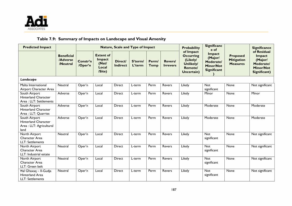
187
Table 7.9: Summary of Impacts on Landscape and Visual Amenity
Predicted Impact
Beneficial
/Adverse
/Neutral
Nature, Scale and Type of Impact Probability
of Impact
Occurring
(Likely/
Unlikely/
Remote/
Uncertain)
Significanc
e of
Impact
(Major/
Moderate/
Minor/Not
Significant
)
Proposed
Mitigation
Measures
Significance
of Residual
Impact
(Major/
Moderate/
Minor/Not
Significant)
Constr’n
/Oper’n
Extent of
Impact
(Nat/
Local
/Site)
Direct/
Indirect
S’term/
L’term
Perm/
Temp
Revers/
Irrevers
Landscape
Malta International
Airport Character Area
Neutral Oper’n Local Direct L-term Perm Revers Likely Not
significant
None Not significant
South Airport
Hinterland Character
Area : LLT: Settlements
Adverse Oper’n Local Direct L-term Perm Revers Likely Minor None Minor
South Airport
Hinterland Character
Area : LLT: Quarries
Adverse Oper’n Local Direct L-term Perm Revers Likely Moderate None Moderate
South Airport
Hinterland Character
Area : LLT: Agricultural
land
Adverse Oper’n Local Direct L-term Perm Revers Likely Moderate None Moderate
North Airport
Character Area
LLT: Settlements
Neutral Oper’n Local Direct L-term Perm Revers Likely Not
significant
None Not significant
North Airport
Character Area
LLT: Industrial estate
Neutral Oper’n Local Direct L-term Perm Revers Likely Not
significant
None Not significant
North Airport
Character Area
LLT: Green belt
Neutral Oper’n Local Direct L-term Perm Revers Likely Not
significant
None Not significant
Ħal Għaxaq – Il-Gudja
Hinterland Area
LLT: Settlements
Neutral Oper’n Local Direct L-term Perm Revers Likely Not
significant
None Not significant

188
Predicted Impact
Beneficial
/Adverse
/Neutral
Nature, Scale and Type of Impact Probability
of Impact
Occurring
(Likely/
Unlikely/
Remote/
Uncertain)
Significanc
e of
Impact
(Major/
Moderate/
Minor/Not
Significant
)
Proposed
Mitigation
Measures
Significance
of Residual
Impact
(Major/
Moderate/
Minor/Not
Significant)
Constr’n
/Oper’n
Extent of
Impact
(Nat/
Local
/Site)
Direct/
Indirect
S’term/
L’term
Perm/
Temp
Revers/
Irrevers
Ħal Għaxaq – Il-Gudja
Hinterland Area
LLT: Agricultural land
Neutral Oper’n Local Direct L-term Perm Revers Likely Not
significant
None Not significant
Is-Siġġiewi – Haż-
Żebbuġ Foreland
Character Area
LLT: Settlements
Neutral Oper’n Local Direct L-term Perm Revers Likely Not
significant
None Not significant
Is-Siġġiewi – Haż-
Żebbuġ Foreland
Character Area
LLT: Industrial estate
Neutral Oper’n Local Direct L-term Perm Revers Likely Not
significant
None Not significant
Is-Siġġiewi – Haż-
Żebbuġ Foreland
Character Area
LLT: Wied il-Kbir
Valley System
Neutral Oper’n Local Direct L-term Perm Revers Likely Not
significant
None Not significant
Birżebbuġa Valleys
Character Area
Neutral Oper’n Local Direct L-term Perm Revers Likely Not
significant
None Not significant
Visual Amenity
Viewpoint 1: Triq il-Belt
Valletta, L-Imqabba
Adverse All Local Direct L-term Perm Revers Likely Minor None Minor
Viewpoint 2: Back road
behind Triq il-Belt
Valletta, L-Imqabba
Adverse All Local Direct L-term Perm Revers Likely Minor to
Moderate
None Minor to
Moderate

189
Predicted Impact
Beneficial
/Adverse
/Neutral
Nature, Scale and Type of Impact Probability
of Impact
Occurring
(Likely/
Unlikely/
Remote/
Uncertain)
Significanc
e of
Impact
(Major/
Moderate/
Minor/Not
Significant
)
Proposed
Mitigation
Measures
Significance
of Residual
Impact
(Major/
Moderate/
Minor/Not
Significant)
Constr’n
/Oper’n
Extent of
Impact
(Nat/
Local
/Site)
Direct/
Indirect
S’term/
L’term
Perm/
Temp
Revers/
Irrevers
(passes through site)
Viewpoint 3: Triq il-Belt
Valletta, (route to Iż-Żurrieq)
N/A
Viewpoint 4: Triq
Danny Cremona, Ħal
Kirkop
N/A
Viewpoint 5: Triq il-Belt
Valletta, L-Imqabba
Adverse All Local Direct L-term Perm Revers Likely Not
significant
None Not
significant


191
8. AIR QUALITY
INTRODUCTION
8.1. This chapter addresses the potential impacts of the emissions from the operational
aspect of the Scheme on air quality.
8.2. The key issue for the assessment is:
Key Issue:
Effects of air emissions and odours arising from the operation of the Scheme on sensitive receptors
Terms of Reference
8.3. The Terms of Reference (ToR) for the air quality assessment, issued by the
Environment and Resources Authority (ERA), are reproduced in Technical
Appendix 1: Terms of Reference and Method Statements.
Objectives of the Assessment
8.4. The objectives of the air quality study were to:
Quantify the expected emissions of benzene from the operational aspect of the
Scheme;
Assess the potential impacts of the Scheme from benzene emissions on air quality
sensitive receptors;
Establish the odour baseline and assess the potential impacts of odour from the
Scheme operations on sensitive receptors; and
Describe the mitigation measures to minimise potential adverse impacts on air
quality.
Legislation and Guidance
8.5. Guidance on air quality related to benzene emissions in the Maltese context is
available in the following national legislation:
Legal Notice 478 of 2010: Ambient Air Quality Regulations, LN 478 of 2010 (as
amended, S.L.549.59);
Legal Notice 291of 2002: National Emission Ceilings for Certain Atmospheric
Pollutants Regulations (as amended, S.L.549.32); and

192
Legal Notice 228 of 2016: Control of VOC Emissions (Storage and Distribution of
Petrol from Terminals to Service Stations) Regulations (S.L. 549.52).
8.6. This legislation is assessed in detail in Chapter 4 of the EPS.
8.7. Maltese and EU regulations do not set a target or limit value for Volatile Organic Compounds (VOCs) in ambient air, and there are no local guidelines for total VOC
levels in ambient air. However, the Ambient Air Quality Regulations set a limit value
for benzene in ambient air of 5 µg/m3 (annual average).
8.8. In the absence of local guidance on the assessment of air quality from fuel service
stations, European guidance is relevant. UK guidance27 states that petrol stations
fitted with Stage II recovery systems do not need to be included in a detailed
assessment for compliance against the benzene limit value and proposes a method to
be used when assessment is required; this method is being used since the ToR
require benzene assessment.
8.9. In the absence of local regulations or guidance on the assessment of odour impacts
from fuel service stations, UK guidance has been referred to (Defra, 2010;28 IAQM,
201429).
ASSESSMENT METHODOLOGY
8.10. As agreed with ERA30, the air quality assessment focused on the potential impacts on
air quality as a result of emissions from fuel delivery to the station and emissions
during vehicle refuelling.
8.11. The need for assessment of air quality arising from the construction of the Scheme
and from increase in traffic during Scheme operation were scoped out since the
Traffic Impact Assessment indicates that there will be a negligible increase in traffic as
a result of the development; therefore the applicable trigger levels31 are not reached by the Scheme. Additionally, although the construction processes are expected to
generate dust emissions, the site is already concreted over and there will be minimal
excavation; therefore such emissions are expected to be minor and temporary, and
can also be mitigated to some extent.
8.12. In the absence of Regulations or local guidelines establishing limit or target values for
27 Defra (2016) Local Air Quality Management Technical Guidance (TG16)
https://laqm.defra.gov.uk/documents/LAQM-TG16-April-16-v1.pdf. 28 Defra (2010) Odour Guidance for Local Authorities
www.gov.uk/government/uploads/system/uploads/attachment_data/file/69305/pb13554-local-auth-guidance-
100326.pdf. 29 Institute of Air Quality Management (2014) Guidance on the Assessment of Odour for Planning
http://www.iaqm.co.uk/text/guidance/odour-guidance-2014.pdf. 30 A method statement was submitted to ERA on 27th April 2017 and accepted on 10th May 2017. This method
statement is included in Technical Appendix 1: Terms of Reference and Method Statements 31 The trigger levels are: daily traffic flows will change by 1,000 AADT or more; or Heavy Duty Vehicle flows
will change by 200 AADT or more. (Design Manual for Roads and Bridges; Volume 11, Section 3).

193
total VOC in ambient air, benzene was selected as the VOC used in the air quality
assessment.
8.13. Since there is no instrument that can be used to objectively measure odours, and
since the human nose is more sensitive to certain odours associated with particular
gases than any instrument, odour assessment was based on the “sniff test”, as
recommended by Defra (2010).32
Sensitive Receptors
8.14. The nearest residence is located over 250 m to the southwest of the Site, as shown
in Figure 8.1. Residences are classified as high sensitivity receptors according to
Institute of Air Quality Management (IAQM) guidance on odour33.
8.15. As shown in Figure 8.1, the predominant land uses in the surroundings are
industrial (including quarries and storage activities) and agricultural. These types of
receptors are considered to be low sensitivity receptors according to IAQM odour
guidance33. In view of the distance of the Scheme site from the nearest residential
receptor, such receptors are also considered in the odour assessment; however, they
are not considered in the benzene assessment. This is since the averaging period for
the benzene limit value is one year; therefore this limit value applies to locations
where members of the public might be regularly exposed (such as residences), but
not the other locations where public exposure is expected to be short term (such as
workplaces or industrial sites).34
Baseline Data
Benzene
8.16. An average of ERA’s long-term diffusion tube data for the year 2016 from the sites
shown in Figure 8.2 was used to obtain a baseline indicating current levels of
benzene. It has therefore been assumed that this baseline (without the Scheme)
currently applies at the nearest residential receptor.
8.17. As a precaution, it was assumed that current benzene concentrations will remain
constant in the future. This is a conservative assumption since the increasing uptake
of vapour recovery systems in petrol stations, and lower hydrocarbon emissions
from newer vehicles are expected to lead to a reduction in ambient benzene levels.
32 Defra (2010) Odour Guidance for Local Authorities
www.gov.uk/government/uploads/system/uploads/attachment_data/file/69305/pb13554-local-auth-guidance-
100326.pdf 33 Institute of Air Quality Management (2014) Guidance on the Assessment of Odour for Planning
http://www.iaqm.co.uk/text/guidance/odour-guidance-2014.pdf. 34 Defra (2016) Local Air Quality Management Technical Guidance (TG16)
https://laqm.defra.gov.uk/documents/LAQM-TG16-April-16-v1.pdf.


195
Figure 8.1: Surrounding Land Uses


197
Figure 8.2: ERA Diffusion Tube Locations for Benzene Baseline Data


199
Odour
8.18. Baseline odour levels were established through a sniff test carried out by two Adi
Associates staff members; details of the survey are given in Table 8.1. The survey
was carried out by noting the odours currently experienced at the nearest residential
receptor and close to the site boundary; the locations are shown in Figure 8.3.
Records were made of any existing odours, including frequency, intensity, duration
and offensiveness, and weather data was also noted.
Table 8.1: Baseline Odour Survey Details
Survey
Date Time
Location
(Figure 8.3) Description
23rd June
2017
10:18 – 10:33 1
Outside residential receptor, surroundings are largely
agricultural with manure application having occurred
recently
10:52 – 10:58 2 Outside Scheme site, industrial surroundings, adjacent to
busy road
8.19. A scale published by the Institute of Air Quality Management (2014) was used to
record odour intensity, as shown in Table 8.2.
Table 8.2: Odour Intensity Categories
Odour Strength Intensity Level Description
No odour / not perceptible 0 No odour
Slight / very weak 1 There is probably some doubt as to whether the odour is
actually present
Slight / weak 2 Odour is present but cannot be described using precise
word or terms
Distinct 3 Odour character is barely recognisable
Strong 4 Odour character is easily recognisable
Very strong 5 Odour is offensive. Exposure to this level would be
considered undesirable
Extremely strong 6 Odour is offensive. An instinctive reaction would be to
mitigate against further exposure


201
Figure 8.3: Baseline Odour Survey Locations

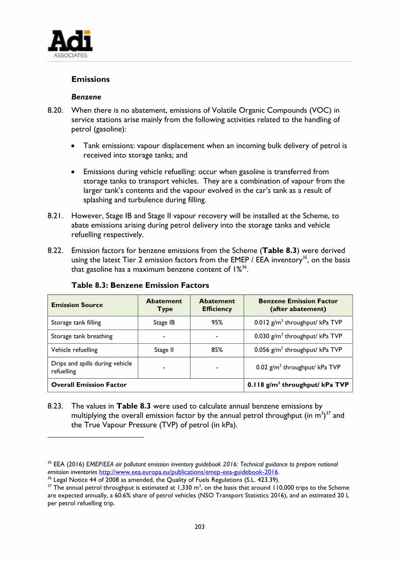
203
Emissions
Benzene
8.20. When there is no abatement, emissions of Volatile Organic Compounds (VOC) in
service stations arise mainly from the following activities related to the handling of
petrol (gasoline):
Tank emissions: vapour displacement when an incoming bulk delivery of petrol is
received into storage tanks; and
Emissions during vehicle refuelling: occur when gasoline is transferred from
storage tanks to transport vehicles. They are a combination of vapour from the
larger tank’s contents and the vapour evolved in the car’s tank as a result of
splashing and turbulence during filling.
8.21. However, Stage IB and Stage II vapour recovery will be installed at the Scheme, to
abate emissions arising during petrol delivery into the storage tanks and vehicle
refuelling respectively.
8.22. Emission factors for benzene emissions from the Scheme (Table 8.3) were derived
using the latest Tier 2 emission factors from the EMEP / EEA inventory35, on the basis
that gasoline has a maximum benzene content of 1%36.
Table 8.3: Benzene Emission Factors
Emission Source Abatement
Type
Abatement
Efficiency
Benzene Emission Factor
(after abatement)
Storage tank filling Stage IB 95% 0.012 g/m3 throughput/ kPa TVP
Storage tank breathing - - 0.030 g/m3 throughput/ kPa TVP
Vehicle refuelling Stage II 85% 0.056 g/m3 throughput/ kPa TVP
Drips and spills during vehicle
refuelling - - 0.02 g/m3 throughput/ kPa TVP
Overall Emission Factor 0.118 g/m3 throughput/ kPa TVP
8.23. The values in Table 8.3 were used to calculate annual benzene emissions by
multiplying the overall emission factor by the annual petrol throughput (in m3)37 and
the True Vapour Pressure (TVP) of petrol (in kPa).
35 EEA (2016) EMEP/EEA air pollutant emission inventory guidebook 2016: Technical guidance to prepare national
emission inventories http://www.eea.europa.eu/publications/emep-eea-guidebook-2016. 36 Legal Notice 44 of 2008 as amended, the Quality of Fuels Regulations (S.L. 423.39). 37 The annual petrol throughput is estimated at 1,330 m3, on the basis that around 110,000 trips to the Scheme
are expected annually, a 60.6% share of petrol vehicles (NSO Transport Statistics 2016), and an estimated 20 L
per petrol refuelling trip.

204
8.24. A TVP of 36.8 kPa was used, calculated using the EMEP/EEA formula:
TVP = RVP x 10AT+B
where:
A = (0.000007047 x RVP) + 0.0132;
B = (0.0002311 x RVP) – 0.5236;
T is the annual average ambient temperature in Malta, 18.6 oC;38
RVP is the Reid Vapour Pressure of petrol (in kPa). A RVP of 66 kPa was used,
based on 2012 data39.
8.25. The assessment of impacts was carried out using a nomogram developed by Defra40
for benzene emissions from fugitive and low-level sources such as petrol stations (see
Figure 8.4).
Figure 8.4: Emissions of Benzene giving rise to an Annual Mean Ground-
level Concentration of 0.22 µg/m3 at Receptors
8.26. To use the nomogram, the line that corresponds to the height of the stack under
consideration was first identified. A conservative stack height of 3 m was used,
38 Galdies (2011) The Climate of Malta: Statistics, Trends and Analysis 1951-2010
https://nso.gov.mt/en/publicatons/Publications_by_Unit/Documents/B3_Environment_Energy_Transport_Agric
ulture_Statistics/The_Climate_of_Malta.pdf. 39 Malta Resources Authority, personal communication (27th January 2014). 40 Defra (2009) Local Air Quality Management: Technical Guidance LAQM.TG(09)
https://laqm.defra.gov.uk/documents/LAQM-TG-(09)-Dec-12.pdf.

205
despite the tank vents being at least 4 m high.
8.27. The point on this line which corresponds to the nearest residential receptor was
identified (that is, around 250 m on the x-axis), and the associated emission rate on
the y-axis was read.41 This emission rate (in tonnes per annum) corresponds to an
increase in ground-level concentration of benzene of 0.22 µg/m3 at the sensitive
receptor.
8.28. The emission rate obtained from this assessment was compared with the actual
annual emission rate for the Scheme (calculated using the emission factors described
earlier), and the increase in benzene ambient levels was estimated using simple
proportion.
Odours
8.29. To establish whether a fuel station equipped with Stage IB and II vapour recovery
(such as the Scheme) has the potential to cause odour impacts, a sniff test was
undertaken in the vicinity of another operational petrol station in Triq Buqana, Rabat.
This petrol station is equipped with Stage IB and II vapour recovery, and so would be
expected to generate similar odour emissions as the Scheme.
8.30. The sniff test was carried out at a distance from the petrol station that approximates
the distance of the nearest air sensitive receptor from the Scheme site, and close to
the site boundary of the petrol station; both locations were downwind of the petrol
station at the time of the survey. Details are given in Table 8.4; the odour survey
locations are shown in Figure 8.5.
Table 8.4: Odour Survey Details (operational petrol station)
Survey
Date Time
Location
(Figure 8.5) Description
23rd June
2017
12:45 – 12:55 A
Small road surrounded by agricultural land, close to an
agricultural building, and located approximately 250 m
east of the operational petrol station
13:13 – 13:22 B Agricultural land about 35 m east42 of the operational
petrol station boundary
8.31. During the test, records were made of the frequency, intensity, duration,
offensiveness and location of any odours, as well as the relevant weather conditions.
41 The graph shows a logarithmic scale. 42 It was not possible to do the survey at the eastern site boundary since this was not accessible.

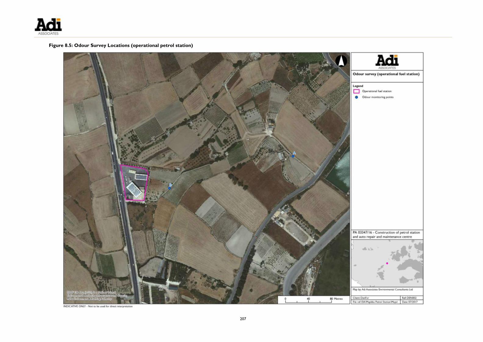
207
Figure 8.5: Odour Survey Locations (operational petrol station)


209
DETERMINING IMPACT SIGNIFICANCE
Benzene
8.32. The significance criteria in Table 8.5 were used to assess the significance of impacts
arising from the Scheme on air quality. These have been calculated as proportions of
the limit value, as is common practice when other pollutants are assessed in EIAs.
Table 8.5: Criteria of Significance: Benzene Annual Levels
Baseline Annual
Levels of Benzene
Change in Annual Benzene Levels due to the Scheme
≥0.05 to <0.25 µg/m3 ≥0.25 to <0.5 µg/m3 ≥0.5 µg/m3
>5 µg/m3 Slight adverse Moderate adverse Substantial adverse
≥4.5 to <5 µg/m3 Slight adverse Moderate adverse Moderate adverse
≥3.75 to <4.5 µg/m3 Negligible Slight adverse Slight adverse
<3.75 µg/m3 Negligible Negligible Negligible
Odours
8.33. The mean odour intensity (Imean) and the percentage odour time tI≥4, i.e. the
percentage of samples where the odour strength was definitely recognisable by the
assessor (therefore having an odour intensity of 4 or more), were first calculated.
IAQM guidance states that when the mean odour intensity is 0, the odour effect can
be considered to be negligible; additionally, when the mean odour intensity is 1 but
tI≥4 is 0%, the odour effect can also be considered to be negligible. However, when
the odour levels exceed these thresholds, the odour effect is then calculated using
the odour exposure matrix for neutral and unpleasant odours in Table 8.643.
Table 8.6: Odour Exposure Matrix
Mean Odour
Intensity
Percentage Odour Time (tI≥4)
≤10% 11 to 20% 21 to 30% 31 to 40% ≥41%
6 Large Very large Very large Very large Very large
5 Medium Large Large Very large Very large
4 Small Medium Medium Large Large
3 Small Medium Medium Medium Medium
2 Small Small Medium Medium Medium
43 Based on IAQM (2014). The matrix would need to be adjusted for pleasant odours, since they cause less
annoyance at the same intensity as unpleasant / neutral odours.

210
1 Small Small Small NA NA
8.34. The odour exposure obtained from the above matrix is then used to assess odour
impact by using a matrix that classifies the odour effect at individual receptors
according to the receptor sensitivity (Table 8.7). As mentioned, residential
dwellings are classified as high sensitivity receptors.
Table 8.7: Matrix to Assess the Odour Effect at Receptors
Overall Odour
Exposure
Receptor Sensitivity
Low Medium High
Very large Substantial adverse Substantial adverse Substantial adverse
Large Moderate adverse Moderate adverse Substantial adverse
Medium Slight adverse Slight adverse Moderate adverse
Small Negligible Negligible Slight adverse
BASELINE AIR QUALITY
Benzene
8.35. ERA’s benzene data is summarised in Table 8.8.
Table 8.8: Benzene Baseline Data
Locality Diffusion Tube Code
(Figure 8.2)
Average Concentration
in 2016 (µg/m3)
Mqabba MQB 3 1.1
MQB 4 0.9
Kirkop KKP 1 1.0
KKP 2 0.7
Luqa LQA 5 1.0
Average 0.9 0.1
8.36. In the existing baseline scenario, all concentrations are well below the limit value of
5 µg/m3.
Odour
8.37. Weather conditions during the baseline odour survey, as measured / observed on
site, were as indicated in Table 8.9. Both monitoring locations were approximately
downwind of the Scheme site during the survey.

211
Table 8.9: Weather Conditions (baseline odour survey)
Date Survey
Location
Weather
Conditions Temperature Wind Direction
Wind
Speed
23rd June 2017
1 Sunny 28 oC NNE 1 m/s
2 Sunny,
minimal wind 31 oC N 0 m/s
8.38. The results of the baseline odour survey are presented in Table 8.10.
Table 8.10: Results of Baseline Odour Survey
Location
Nature
of
Odour
Frequency44
Odour
Intensity (I) 45 Duration
Percentage
Odour Time
(tI≥4)
Offensiveness Mean Max.
1 (outside
residence)
Manure 45% 2 5 Whiffs of a
few
seconds
each to
continuous
40% Unpleasant
2
(industrial
environs)
Vehicle
exhaust
2% 0 1 Whiff 0% Neutral
8.39. Using IAQM criteria, the above results indicate that in the baseline scenario:
The residential receptor experiences a medium odour exposure to manure, which is
considered to have a moderate adverse odour effect. However, considering that the
location is a rural one, the receptors are more likely to be accustomed to and
amenable to accepting such odours. Additionally, it is noted that such odours are
typically transient in nature, occurring in the days after manure spreading, and
therefore on other days the baseline odour effect could be lower.
The odour effect at the industrial surroundings close to the Scheme can be considered negligible, since the odour experienced (vehicle exhaust) had a mean
odour intensity of 0.
44 Monitoring was carried out over 5 minutes consisting of 30 ten-second intervals. The frequency was
calculated on the basis of whether the odour was noted during a particular interval. The results obtained by
the two assessors were then averaged. 45 On a scale of 0 (no odour) to 6 (extremely strong), as per Table 8.2.

212
ASSESSMENT OF IMPACT FROM THE SCHEME
Benzene
8.40. Multiplying the benzene emission factor of 0.118 g by an annual petrol throughput of
1,330 m3 and a TVP of 36.8 kPa gives emissions of benzene from the Scheme that
amount to 0.006 t (6 kg) annually.
8.41. From the nomogram in Figure 8.4, a distance of 250 m between the emission
source and the nearest air sensitive receptor corresponds to around 0.55 t of
benzene emissions. Therefore at this distance, if 0.55 t of benzene are emitted
annually, the benzene concentration at the sensitive receptor would increase by
around 0.22 µg/m3. By simple proportion, it is estimated that 0.006 t of benzene would result in an increase in benzene concentration at the sensitive receptor of
0.002 µg/m3. The predicted concentrations with the Scheme and resultant impact are
presented in Table 8.11. The results show that the impact of the Scheme
operations on benzene concentrations is negligible.
Table 8.11: Predicted Benzene Concentrations at Air Sensitive Receptor
Baseline Change with Scheme Baseline plus Scheme Impact
0.9 µg/m3 0.002 µg/m3 0.902 µg/m3 Negligible
Odours
8.42. Weather conditions during the odour survey in the vicinity of the operational fuel
service station were as indicated in Table 8.12. The activities underway at the
operational petrol station during the survey at location B were observed to include
vehicle refuelling and vehicle washing. Both monitoring locations were
approximately downwind of the Scheme site during the survey.
Table 8.12: Weather Conditions (survey at operational fuel station)
Date Survey
Location
Weather
Conditions Temperature Wind Direction
Wind
speed
23rd June
2017
A Sunny, mild
wind gusts 29 oC W 2 m/s
B Sunny, windy 29 oC W 4 m/s
8.43. The odour survey results at an existing operational fuel station (off-site) are
presented in Table 8.13. According to IAQM criteria, odour effects from the fuel
station are classified as negligible, since all odours noted (including soap / car wax
from the fuel station) had a mean odour intensity of 0. It is noted that fuel odours
were not observed during the survey.

213
8.44. Therefore the odour impacts from the Scheme on the odour sensitive receptors
considered in this study are expected to be negligible.
MITIGATION AND RESIDUAL IMPACTS
8.45. The design of the Scheme includes a number of measures to minimise emissions;
these have been described in detail in Chapter 3 and include Stage IB and II vapour
recovery systems.
8.46. Since these mitigation measures are expected to result in insignificant impacts on air
quality, no further mitigation is considered necessary, and the residual impacts would
remain as described in the previous section, negligible.
8.47. Impacts on air quality are summarised in Table 8.14.
FUTURE MONITORING REQUIREMENTS
8.48. No monitoring of air quality is recommended since the air quality assessment has
shown that emissions from the Scheme operations will have a negligible impact on
benzene concentrations and odours. The Applicant should ensure that vapour
recovery systems are maintained regularly in accordance with manufacturer
specifications and permit conditions applied to ensure their continued effective
operation.

214
Table 8.13: Results of Odour Survey (operational service station)
Location Nature of Odour Frequency Odour Intensity (I) 46
Duration Percentage Odour
Time (tI≥4) Offensiveness
Mean Max.
A
(agricultural
area around
250 m east of
the petrol
station)
Soil 3% 0 1 Continuous 0% Neutral
Vegetation 5% 0 3 Whiffs of a few seconds each 0% Pleasant / neutral
Canine faeces 3% 0 3 Whiffs of a few seconds each 0% Neutral
B
(agricultural
land close to
petrol station
boundary)
Vegetation 5% 0 3 Whiffs of a few seconds each 0% Neutral
Manure 3% 0 3 Whiffs of a few seconds each 0% Unpleasant /
neutral
Soap / car wax 8% 0 4 Whiffs of a few seconds each 5% Unpleasant /
neutral
Flowers 3% 0 4 Continuous 3% Pleasant
46 On a scale of 0 (no odour) to 6 (extremely strong), as per Table 8.2.

215
Table 8.14: Summary of Impacts on Air Quality
Predicted
Impact
Beneficial
/ Adverse
/ Neutral
Nature, scale and type of impact Probability
of Impact
Occurring
(Likely /
Unlikely /
Remote /
Uncertain)
Significance
of Impact
(Major /
Minor / Not
Significant)
Proposed
Mitigation
Measures
Significance
of Residual
Impact
(Major /
Minor / Not
Significant)
Const’n
/ Oper’n
Extent of
Impact
(Nat /
Local /
Site)
Direct /
Indirect
S-term /
L-term
Perm /
Temp
Revers /
Irrevers
Benzene
emissions
from Scheme
operation
Adverse Oper’n Local Direct L-term Perm Revers Likely Not significant None47 Not significant
Odour
emissions
from Scheme
operation
Adverse Oper’n Local Direct L-term Perm Revers Likely Not significant None47 Not significant
47 Stage IB & Stage II vapour recovery are included as part of the design.


217
9. SUMMARY OF KEY IMPACTS, INTERACTION
BETWEEN IMPACTS AND MITIGATION
INTRODUCTION
9.1. The purpose of this chapter is to provide a summary of the key environmental
impacts, their interaction and cumulative effects, and their mitigation. The chapter
addresses the requirements set out in the Terms of Reference (ToR) to describe
mitigation measures to “prevent, eliminate, reduce or offset (as relevant) the identified
significant adverse effects of the project” and to identify cumulative and residual impacts.
The chapter concludes with a summary of the mitigation measures proposed in the
Environmental Planning Statement (EPS) as well as a description of the required
authorisations.
SUMMARY OF KEY IMPACTS
9.2. Chapters 5 to 8 describe the predicted impacts of the Scheme in relation to geo-
environment, cultural heritage, landscape and visual amenity, and emissions to air, in
accordance with the environmental topic areas identified in the ToR.
9.3. For each predicted impact, an assessment has been made as to whether the impact is
likely to be of major or minor significance, or of no significance; the criteria that were
used to judge significance are described in each of the chapters. Predicted major and
minor impacts have been identified and, in the case of negative impacts, there is a description of how these could be mitigated. All the residual impacts identified are
summarised in Table 9.1 at the end of this Chapter.
9.4. Although the only potentially major impact relates to the impact on geo-environment
as a result of the excavation (the impact is minor to major because part of the site is
infilled), moderate impacts arose during the assessment with respect to the visual
amenity and landscape.
9.5. These impacts, relevant mitigation measures, and the residual impacts are discussed
hereunder.
Geo-environment
9.6. The impact on geological resources is considered to be of potentially minor to major
negative significance, since it will likely involve some extraction of mineral resources.
However, the geo-environment survey, as well as knowledge of the area, suggests
that at least part of the excavated material will be inert material, arising from the
filling in of a former quarry at the site. The extent of the infilling is unknown, hence
the impact is judged as being of minor to major significance, depending on the
amount of rock that will actually be excavated.
9.7. The Scheme is judged to have an impact of minor significance in relation to the use of
water resources, the quality of the groundwater and surface run-off, and the impact

218
on surface water drainage.
Cultural Heritage
9.8. There is the potential for impacts on cultural heritage arising from possible loss of, or
damage to, unrecorded archaeological artefacts during the remaining excavation to
be carried out. The extent of this impact is uncertain, as it will depend on whether
artefacts are present, their importance, and the extent of any loss or damage.
Landscape and Visual Amenity
9.9. The impact on landscape character is considered to be of moderate negative
significance in relation to the ‘South Airport Hinterland Character Area Local
Landscape Tract (LLT): Quarries’ and the ‘South Airport Hinterland Character Area
LLT: Agricultural Land’. The impact on the landscape character is considered to be
of minor negative significance in relation to the ‘South Airport Hinterland Character
Area (LLT): Settlements’
9.10. The impact on visual amenity is considered to be of minor to moderate significance in
relation to the view from the back road behind Triq il-Belt Valletta (which passes through site). The impact on views westwards from along Triq il-Belt Valletta is
considered to be of moderate significance, when approaching from Ħal Kirkop.
However, when approaching from l-Imqabba the impact is considered to be not
significant.
9.11. The EIA considered the impact on visual amenity from two other viewpoints –
looking northwards from along Triq il-Belt Valletta and looking northwards from
along Triq Danny Cremona, Ħal Kirkop. The photomontages indicate that the
Scheme will not be visible from these viewpoints.
Emissions to Air
9.12. The impact on air quality as a result of benzene emissions and odour emissions from
the operation of the Scheme is considered to be not significant. Notably, Stage IB
and Stage II vapour recovery are included as part of the Scheme design.
INTERACTION OF IMPACTS
9.13. The interaction of impacts with the current baseline is also described in Chapters 5
to 8. The interactions are summarised in Table 9.1 below. The interaction
between impacts describes the potential cumulative or reactive nature of the various
disturbances caused by the Scheme during construction and operation.
9.14. The fact that a row of mature pine trees will be removed to make way for the
Scheme will adversely affect the visual amenity of the site and its surroundings. In
addition, the ability of the trees to provide screening from dust will also be lost.
9.15. There were no major impacts identified from the Scheme during its operation.
219
CUMULATIVE IMPACTS
9.16. Cumulative impacts are those that result from incremental changes caused by other
past, present, or reasonably foreseeable actions together with the Scheme.
9.17. The various impacts identified in Chapters 5 to 8 were assessed in the context of
the existing baseline (encompassing the past and present context). No major
developments were noted to be underway in the immediate area of the Scheme site
during the baseline surveys, and there are no known committed major developments
in the area.
9.18. The Scheme involves development of the entire site and it is not planned as part of a
phased development, nor is it intended that there will be any further development on
the site once the Scheme has been constructed. Hence, it is likely that there will be
no consequential development on site because of the Scheme.
MITIGATION
9.19. The EPS, including its supporting Technical Appendices, reports the findings of the
EIA, in accordance with the ToR. Where appropriate, mitigation measures have been recommended; these are described at the end of each of Chapters 5 to 8 and
summarised in Table 9.1. It would be appropriate for, and it is recommended that,
these mitigation measures be taken account of in the conditions of any eventual
development permit.
REQUIRED AUTHORISATIONS
9.20. The required authorisations are referred to in the relevant topic area chapters
(Chapters 5 to 8). The Scheme will require an environmental permit / registration
from the Environment and Resources Authority (ERA), and potentially a license /
permit from the Regulator for Energy and Water Services (REWS) and the Malta
Resources Authority. Archaeological investigations / monitoring will require
authorisation from the Superintendence of Cultural Heritage.


221
Table 9.1: Summary of Impact Assessment
Predicted Impact
Beneficial/
Adverse
/Neutral
Nature, Scale and Type of Impact Probability
of Impact
Occurring
(Likely/
Unlikely/
Remote/
Uncertain)
Significance
of Impact
(Major/
Moderate/
Minor/Not
Significant)
Proposed
Mitigation
Measures
Significance
of Residual
Impact
(Major/
Moderate/
Minor/Not
Significant)
Constr’n
/Oper’n
Extent
of
Impact
(Nat/
Local
/Site)
Direct/
Indirect
S’term
/
L’term
Perm/
Temp
Revers/
Irrevers
Geo-environment
Mineral resources /
geological features Adverse Constr’n Local Direct
Long-
term Perm Irrevers Likely
Minor to
major
significance
Re-use of
excavated rock
as fill material
Minor to
major
significance
Water resources Adverse Oper’n Local Direct Long-
term Perm Irrevers Likely
Minor
significance
Collection of
water from the
canopy for re-
use;
Re-cycling of
water used in
the car wash
facilities
Minor
significance
Change in the
quality of ground
water
Adverse Constr’n /
Oper’n Local Indirect
Short-
term /
Long-
term
Perm Irrevers Likely Minor
significance
Construction in
accordance
with industry
standards for
pollution
avoidance
CMP
Operational
management
practices to
monitor
performance of
Minor
significance
Change in the
surface water run-
off patterns
Adverse Constr’n Local Direct Long-
term Perm Irrevers Likely
Minor
significance
Minor
significance

222
Predicted Impact
Beneficial/
Adverse
/Neutral
Nature, Scale and Type of Impact Probability
of Impact
Occurring
(Likely/
Unlikely/
Remote/
Uncertain)
Significance
of Impact
(Major/
Moderate/
Minor/Not
Significant)
Proposed
Mitigation
Measures
Significance
of Residual
Impact
(Major/
Moderate/
Minor/Not
Significant)
Constr’n
/Oper’n
Extent
of
Impact
(Nat/
Local
/Site)
Direct/
Indirect
S’term
/
L’term
Perm/
Temp
Revers/
Irrevers
pollution
control
measures.
Cultural Heritage
Loss or damage to
unrecorded
archaeological or
cultural heritage
artefacts on site
Adverse Constr’n Site Direct L-term Perm Irrevers Uncertain
Uncertain,
depending
on
whether
artefacts
are
present,
their level
of
importanc
e, and the
extent of
any loss or
damage
Archaeologic
al monitoring
during
excavation /
recording of
features /
salvaging of
significant
features, if
requested by
SCH
Uncertain
(depending
on whether
artefacts are
present, their
importance
and the
extent of any
loss or
damage)
Alteration or
degradation of the
structural integrity
and quality of the
setting of the rural
rooms close to the
Adverse Constr’n /
Oper’n Local Direct L-term Perm Irrevers Likely
Not
significant to
minor
None
Not
significant to
minor
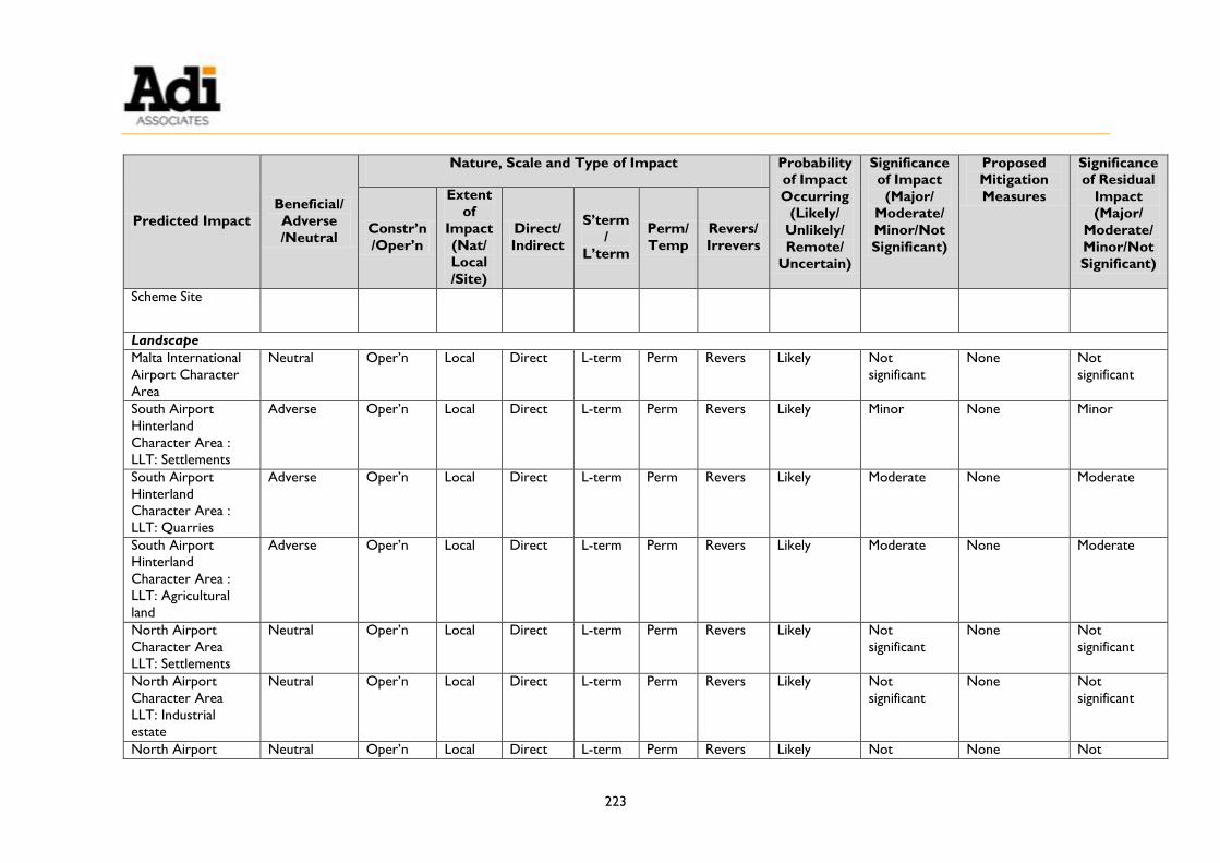
223
Predicted Impact
Beneficial/
Adverse
/Neutral
Nature, Scale and Type of Impact Probability
of Impact
Occurring
(Likely/
Unlikely/
Remote/
Uncertain)
Significance
of Impact
(Major/
Moderate/
Minor/Not
Significant)
Proposed
Mitigation
Measures
Significance
of Residual
Impact
(Major/
Moderate/
Minor/Not
Significant)
Constr’n
/Oper’n
Extent
of
Impact
(Nat/
Local
/Site)
Direct/
Indirect
S’term
/
L’term
Perm/
Temp
Revers/
Irrevers
Scheme Site
Landscape
Malta International
Airport Character
Area
Neutral Oper’n Local Direct L-term Perm Revers Likely Not
significant
None Not
significant
South Airport
Hinterland
Character Area :
LLT: Settlements
Adverse Oper’n Local Direct L-term Perm Revers Likely Minor None Minor
South Airport
Hinterland
Character Area :
LLT: Quarries
Adverse Oper’n Local Direct L-term Perm Revers Likely Moderate None Moderate
South Airport
Hinterland
Character Area :
LLT: Agricultural
land
Adverse Oper’n Local Direct L-term Perm Revers Likely Moderate None Moderate
North Airport
Character Area
LLT: Settlements
Neutral Oper’n Local Direct L-term Perm Revers Likely Not
significant
None Not
significant
North Airport
Character Area
LLT: Industrial
estate
Neutral Oper’n Local Direct L-term Perm Revers Likely Not
significant
None Not
significant
North Airport Neutral Oper’n Local Direct L-term Perm Revers Likely Not None Not

224
Predicted Impact
Beneficial/
Adverse
/Neutral
Nature, Scale and Type of Impact Probability
of Impact
Occurring
(Likely/
Unlikely/
Remote/
Uncertain)
Significance
of Impact
(Major/
Moderate/
Minor/Not
Significant)
Proposed
Mitigation
Measures
Significance
of Residual
Impact
(Major/
Moderate/
Minor/Not
Significant)
Constr’n
/Oper’n
Extent
of
Impact
(Nat/
Local
/Site)
Direct/
Indirect
S’term
/
L’term
Perm/
Temp
Revers/
Irrevers
Character Area
LLT: Green belt
significant significant
Ħal Għaxaq – Il-
Gudja Hinterland
Area
LLT: Settlements
Neutral Oper’n Local Direct L-term Perm Revers Likely Not
significant
None Not
significant
Visual Amenity
Viewpoint 1: Triq il-
Belt Valletta, L-
Imqabba
Adverse All Local Direct L-term Perm Revers Likely Moderate None Moderate
Viewpoint 2: Back
road behind Triq il-
Belt Valletta, L-
Imqabba (passes
through site)
Adverse All Local Direct L-term Perm Revers Likely Minor to
Moderate None
Minor to
Moderate
Viewpoint 3: Triq il-
Belt Valletta, (route
to Iż-Żurrieq) N/A
Viewpoint 4: Triq
Danny Cremona,
Ħal Kirkop N/A
Viewpoint 5: Triq il-
Belt Valletta, L-
Imqabba
Adverse All Local Direct L-term Perm Revers Likely Not
significant
None Not
significant

225
Predicted Impact
Beneficial/
Adverse
/Neutral
Nature, Scale and Type of Impact Probability
of Impact
Occurring
(Likely/
Unlikely/
Remote/
Uncertain)
Significance
of Impact
(Major/
Moderate/
Minor/Not
Significant)
Proposed
Mitigation
Measures
Significance
of Residual
Impact
(Major/
Moderate/
Minor/Not
Significant)
Constr’n
/Oper’n
Extent
of
Impact
(Nat/
Local
/Site)
Direct/
Indirect
S’term
/
L’term
Perm/
Temp
Revers/
Irrevers
Air quality
Benzene emissions
from Scheme
operation
Adverse Oper’n Local Direct L-term Perm Revers Likely Not
significant None48
Not
significant
Odour emissions
from Scheme
operation
Adverse Oper’n Local Direct L-term Perm Revers Likely Not
significant None48
Not
significant
48 Stage IB & Stage II vapour recovery are included as part of the design.


Appendix 1: A3 Photographs
Recommended