Embed Size (px)
Citation preview
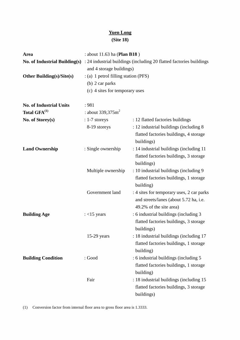
Yuen Long (Site 18)
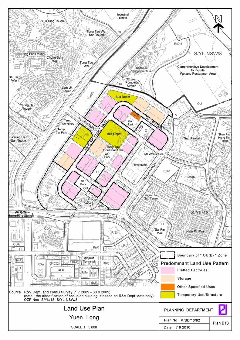
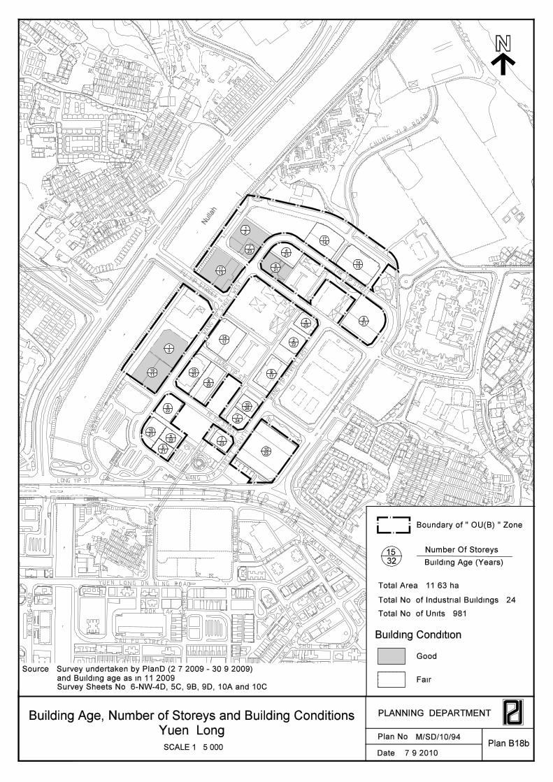
Area : about 11.63 ha (Plan B18 ) No. of Industrial Building(s) : 24 industrial buildings (including 20 flatted factories buildings
and 4 storage buildings) Other Building(s)/Site(s) : (a) 1 petrol filling station (PFS)
(b) 2 car parks (c) 4 sites for temporary uses
No. of Industrial Units : 981 Total GFA(1) : about 339,375m2 No. of Storey(s) : 1-7 storeys : 12 flatted factories buildings 8-19 storeys : 12 industrial buildings (including 8
flatted factories buildings, 4 storage buildings)
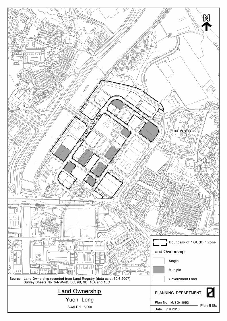
Land Ownership : Single ownership : 14 industrial buildings (including 11 flatted factories buildings, 3 storage buildings)
Multiple ownership : 10 industrial buildings (including 9 flatted factories buildings, 1 storage building)
Government land : 4 sites for temporary uses, 2 car parks and streets/lanes (about 5.72 ha, i.e. 49.2% of the site area)
Building Age : <15 years : 6 industrial buildings (including 3 flatted factories buildings, 3 storage buildings)
15-29 years : 18 industrial buildings (including 17 flatted factories buildings, 1 storage building)
Building Condition : Good : 6 industrial buildings (including 5 flatted factories buildings, 1 storage building)
Fair : 18 industrial buildings (including 15 flatted factories buildings, 3 storage buildings)
(1) Conversion factor from internal floor area to gross floor area is 1.3333.
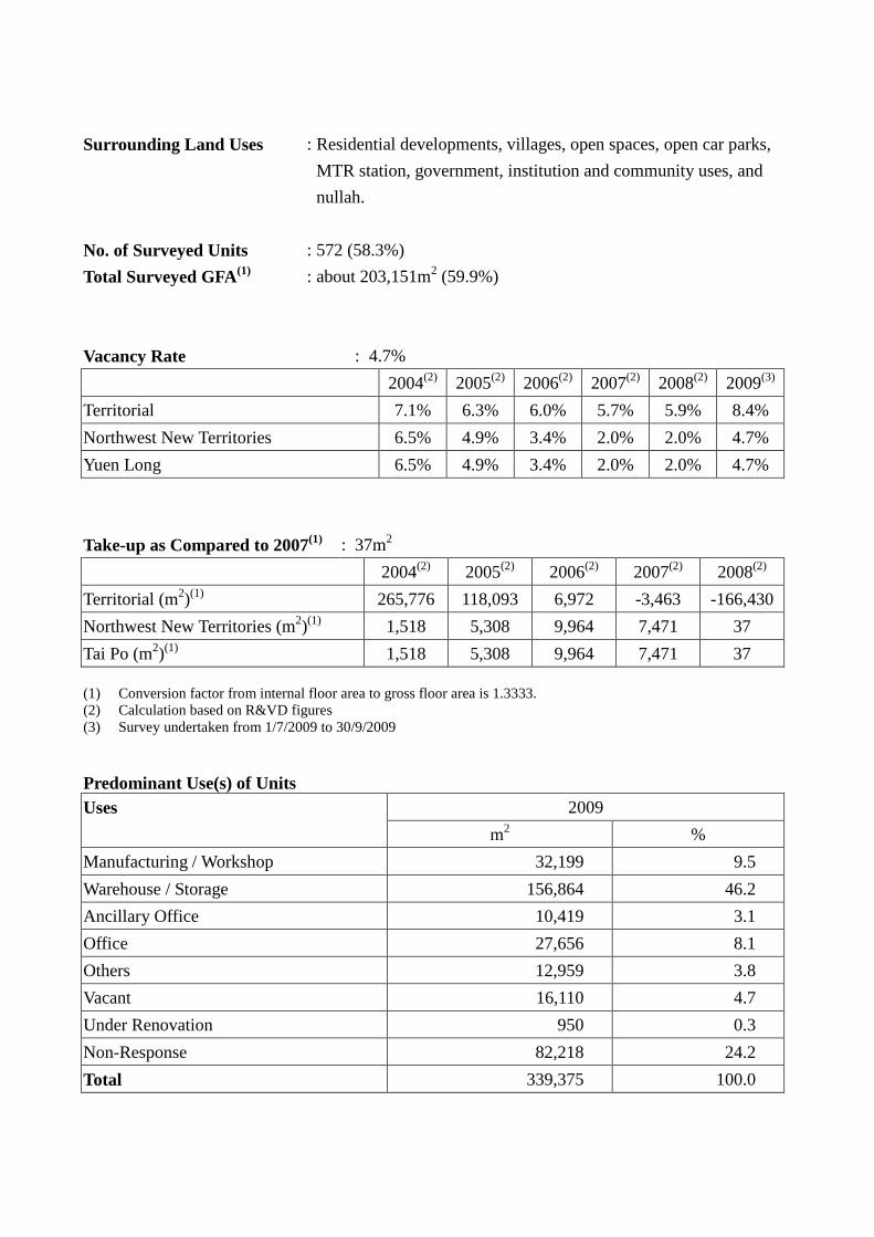
Surrounding Land Uses
: Residential developments, villages, open spaces, open car parks, MTR station, government, institution and community uses, and nullah.
No. of Surveyed Units : 572 (58.3%) Total Surveyed GFA(1) : about 203,151m2 (59.9%)
Vacancy Rate : 4.7%
2004(2) 2005(2) 2006(2) 2007(2) 2008(2) 2009(3) Territorial 7.1% 6.3% 6.0% 5.7% 5.9% 8.4% Northwest New Territories 6.5% 4.9% 3.4% 2.0% 2.0% 4.7% Yuen Long 6.5% 4.9% 3.4% 2.0% 2.0% 4.7%
Take-up as Compared to 2007(1) : 37m2 2004(2) 2005(2) 2006(2) 2007(2) 2008(2)
Territorial (m2)(1) 265,776 118,093 6,972 -3,463 -166,430 Northwest New Territories (m2)(1) 1,518 5,308 9,964 7,471 37 Tai Po (m2)(1) 1,518 5,308 9,964 7,471 37 (1) Conversion factor from internal floor area to gross floor area is 1.3333. (2) Calculation based on R&VD figures (3) Survey undertaken from 1/7/2009 to 30/9/2009 Predominant Use(s) of Units Uses 2009
m2 % Manufacturing / Workshop 32,199 9.5 Warehouse / Storage 156,864 46.2 Ancillary Office 10,419 3.1 Office 27,656 8.1 Others 12,959 3.8 Vacant 16,110 4.7 Under Renovation 950 0.3 Non-Response 82,218 24.2 Total 339,375 100.0
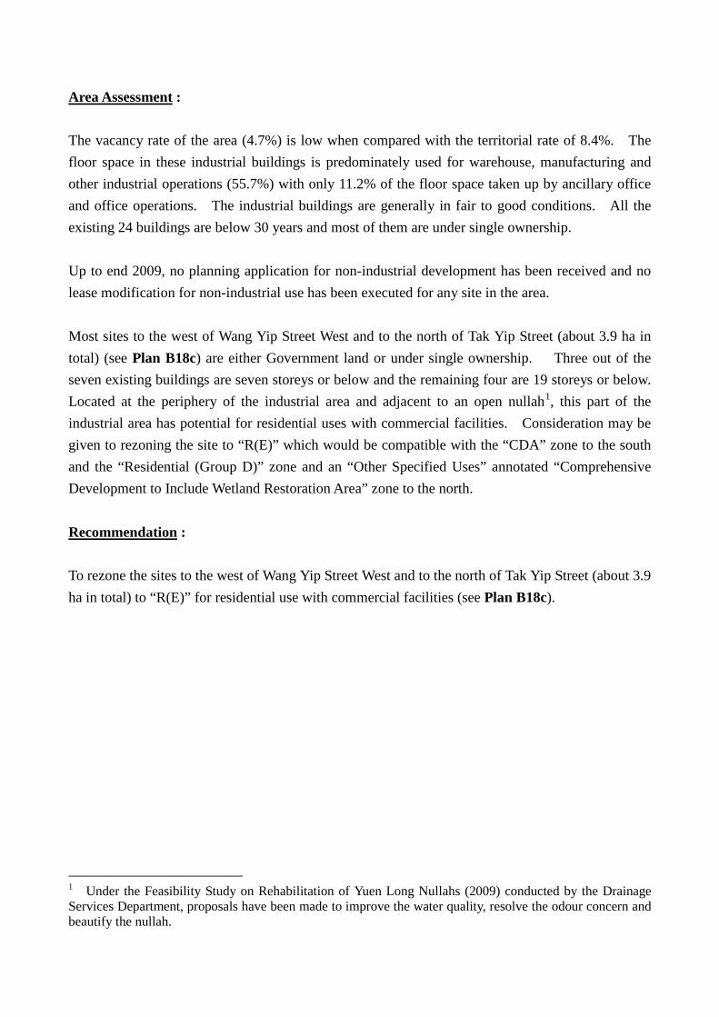
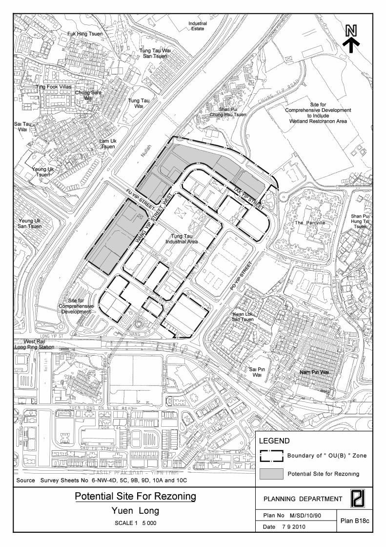
Area Assessment : The vacancy rate of the area (4.7%) is low when compared with the territorial rate of 8.4%. The floor space in these industrial buildings is predominately used for warehouse, manufacturing and other industrial operations (55.7%) with only 11.2% of the floor space taken up by ancillary office and office operations. The industrial buildings are generally in fair to good conditions. All the existing 24 buildings are below 30 years and most of them are under single ownership. Up to end 2009, no planning application for non-industrial development has been received and no lease modification for non-industrial use has been executed for any site in the area. Most sites to the west of Wang Yip Street West and to the north of Tak Yip Street (about 3.9 ha in total) (see Plan B18c) are either Government land or under single ownership. Three out of the seven existing buildings are seven storeys or below and the remaining four are 19 storeys or below. Located at the periphery of the industrial area and adjacent to an open nullah1
, this part of the industrial area has potential for residential uses with commercial facilities. Consideration may be given to rezoning the site to “R(E)” which would be compatible with the “CDA” zone to the south and the “Residential (Group D)” zone and an “Other Specified Uses” annotated “Comprehensive Development to Include Wetland Restoration Area” zone to the north.
Recommendation : To rezone the sites to the west of Wang Yip Street West and to the north of Tak Yip Street (about 3.9 ha in total) to “R(E)” for residential use with commercial facilities (see Plan B18c).
1 Under the Feasibility Study on Rehabilitation of Yuen Long Nullahs (2009) conducted by the Drainage Services Department, proposals have been made to improve the water quality, resolve the odour concern and beautify the nullah.
OU
V
OU
R(B)1
R(A
)
O
O
V
V
G/IC
V
O
CDA
CDA
R(A)
R(A)R(A)
R(A)
O
G/IC
V
O
O
R(A)
V
R(E)
O
O
G/IC
G/IC
OU
R(A)
CDA
G/IC(2)
O
R(A)
G/IC
CDA
O
R(A)
O
R(A)
R(D)1
OU
O
O
R(A)
R(A)R(A)
PO
YIP
STR
EET
TAK
YIP STREET
FU Y
IP STREET
Tung Tau Wai
San Tsuen
Tung Tau
Wai
Lam Uk
Tsuen
Ting Fook Villas
Fuk Hing Tsuen
Chung Sam
Wai
Sai Tau
Wai
Yeung Uk
Tsuen
Yeung Uk
San Tsuen
West Rail
Long Ping Station
Kwan Lok
San Tsuen
Sai Pin
WaiNam Pin Wai
Shan Pui
Hung Tin
Tsuen
Shan Pui
Chung Hau Tsuen
Tung Tau
Industrial Area
KIK
YE
UN
G R
OA
D
TAIL
EE
STREET
KU
K T
ING
ST
SAU FU STREET
LEUNG YIP ST
FOOK TAK ST
SHUI CHE KWUN
ST
YUEN LONG ON LOK ROAD
SHA
N P
UI H
O E
AST
RO
AD
HONGYIP STREET
SHAN PUI ROADW
AN
G Y
IP S
TR
EET E
AST
WANG YIP
ST
RE
ET
SO
UT
H
LON
G Y
IP STREET
YUEN LONG ON NING ROAD
TU
NG
LO
K S
TR
EE
T
YU
EN
LO
NG
KA
UH
UI
RO
AD
KW
ON
GYIP
ST
REET
CHUNGYI
PRO
AD
HI YIP STREET
SA
I TA
I ST
TA
I K
IU R
OA
D
WA
NG
CH
AU
RO
AD
LONG YIP ST
S/YL/18
S/YL-NSW/8
SCALE 1 : 5 000
Land Use Plan
Plan B18Plan No.
PLANNING DEPARTMENT
Date :
Yuen LongM/SD/10/92
Source : R&V Dept. and PlanD Survey (1.7.2009 - 30.9.2009)
OZP Nos. S/YL/18, S/YL-NSW/8
(note : the classification of occupied building is based on R&V Dept. data only)
7.9.2010
Other Specified Uses
Predominant Land Use Pattern
Temporary Use/Structure
Boundary of " OU(B) " Zone
Flatted Factories
Storage
The Parcville
WA
NG
Y
IP STR
EET W
EST
Null
ah
PFS
ESS
Minibus
Terminal
CFC
Industrial
Estate
Vacant
Car
Park
Bus Depot
Bus Depot
Pumping
Station
Comprehensive Development
to Include
Wetland Restorarion Area
Car
Park
Car
Park
School
Playground
HyD Works Area
Temp.
Car Park
Temp.
Workshop
Nul
lah
Date :SCALE 1 : 5 000
Plan No.
PLANNING DEPARTMENTLand Ownership
Land Ownership
Government Land
Multiple
Single
Boundary of " OU(B) " Zone
Survey Sheets No. 6-NW-4D, 5C, 9B, 9D, 10A and 10C
Yuen LongPlan B18a
Source : Land Ownership recorded from Land Registry (data as at 30.6.2007)
M/SD/10/93
WA
NG
Y
IP STR
EET W
EST
The Parcville
7.9.2010
Nul
lah
KIK
YE
UN
G R
OA
D
TAIL
EE
STREET
KU
K T
ING
ST
SAU FU STREET
LEUNG YIP ST
PO
YIP
STR
EET
CASTLE PEAK ROAD - YUEN LONG
FOOK TAK ST
SHUI CHE KWUN
ST
TAK YIP STREET
FU YIP STREET
YUEN LONG ON LOK ROAD
SHA
N P
UI H
O E
AST
RO
AD
HONGYIP STREET
SHAN PUI ROADW
AN
G Y
IP S
TR
EET E
AST
WANG YIP
ST
RE
ET
SO
UT
H
LON
G Y
IP STREET
YUEN LONG ON NING ROAD
TU
NG
LO
K S
TR
EE
T
YU
EN
LO
NG
KA
UH
UI
RO
AD
KW
ON
GYIP
ST
REET
CHUNGYI
PRO
AD
HI YIP STREET
SA
I TA
I ST
TA
I K
IU R
OA
D
WA
NG
CH
AU
RO
AD
LONG YIP ST
Nul
lah
KIK
YE
UN
G R
OA
D
TAIL
EE
STREET
KU
K T
ING
ST
SAU FU STREET
LEUNG YIP ST
PO
YIP
STR
EET
FOOK TAK ST
SHUI CHE KWUN
ST
TAK YIP STREET
FU YIP STREET
WA
NG
YIP
STR
EET W
EST
YUEN LONG ON LOK ROAD
SHA
N P
UI H
O E
AST
RO
AD
HONGYIP STREET
SHAN PUI ROADW
AN
G Y
IP S
TR
EET E
AST
WANG YIP
ST
RE
ET
SO
UT
H
LON
G Y
IP STREET
YUEN LONG ON NING ROAD
TU
NG
LO
K S
TR
EE
T
YU
EN
LO
NG
KA
UH
UI
RO
AD
KW
ON
GYIP
ST
REET
CHUNGYI
PRO
AD
HI YIP STREET
SA
I TA
I ST
TA
I K
IU R
OA
D
WA
NG
CH
AU
RO
AD
LONG YIP ST
Plan No.
PLANNING DEPARTMENT
Date :
Plan B18bSCALE 1 : 5 000
and Building age as in 11.2009
Building Age, Number of Storeys and Building Conditions
Yuen Long
Survey Sheets No. 6-NW-4D, 5C, 9B, 9D, 10A and 10C
M/SD/10/94
Source : Survey undertaken by PlanD (2.7.2009 - 30.9.2009)
19
11
15
21
9
22
6
22
10
215
22
5
21
7
23
7
24
10
26
10
23
9
17
1
3
14
17
17
13
7
23
1
2
4
21
6
21
8
21
14
13
17
14
2
22
4
23
7.9.2010
Good
Fair
15
Building Condition
Building Age (Years)
Number Of Storeys
Total Area : 11.63 ha
Total No. of Industrial Buildings : 24
32
Boundary of " OU(B) " Zone
Total No. of Units : 981
Date :SCALE 1 : 5 000
Plan No.
PLANNING DEPARTMENT
Yuen LongPlan B18c
M/SD/10/90
WA
NG
Y
IP STR
EET W
EST
The Parcville
LEGEND
Boundary of " OU(B) " Zone
Source : Survey Sheets No. 6-NW-4D, 5C, 9B, 9D, 10A and 10C
Null
ah
TAK
YIP STREET
PO
YIP
STR
EET
FU Y
IP STREET
7.9.2010
Tung Tau Wai
San Tsuen
Fuk Hing Tsuen
Chung Sam
WaiTung Tau
Wai
Ting Fook Villas
Sai Tau
Wai
Yeung Uk
Tsuen
Lam Uk
Tsuen
Yeung Uk
San Tsuen
Shan Pui
Chung Hau Tsuen
Shan Pui
Hung Tin
Tsuen
Kwan Lok
San Tsuen
Sai Pin
WaiNam Pin Wai
West Rail
Long Ping Station
Industrial
Estate
Tung Tau
Industrial Area
Nam Pin Wai
Nul
lah
Site for
Comprehensive Development
to Include
Wetland Restorarion Area
Potential Site For Rezoning
Potential Site for Rezoning
Site for
Comprehensive
Development
KIK
YE
UN
G R
OA
D
TAIL
EE
STREET
KU
K T
ING
ST
SAU FU STREET
LEUNG YIP ST
CASTLE PEAK ROAD - YUEN LONG
FOOK TAK ST
SHUI CHE KWUN
ST
YUEN LONG ON LOK ROAD
SHA
N P
UI H
O E
AST
RO
AD
HONGYIP STREET
SHAN PUI ROADW
AN
G Y
IP S
TR
EET E
AST
WANG YIP
ST
RE
ET
SO
UT
H
LON
G Y
IP STREET
YUEN LONG ON NING ROAD
TU
NG
LO
K S
TR
EE
T
YU
EN
LO
NG
KA
UH
UI
RO
AD
KW
ON
GYIP
ST
REET
CHUNGYI
PRO
AD
HI YIP STREET
SA
I TA
I ST
TA
I K
IU R
OA
D
WA
NG
CH
AU
RO
AD
LONG YIP ST