Embed Size (px)
Citation preview

Geography Curriculum Overview: Bushey Heath Primary School
Key Stage 1 National Curriculum North and South Poles, Equator, 4 Compass points N, S, E, W Locational language, name & locate: 7 continents & 5 oceans. Name, locate, identify: 4 countries and capitals of UK &
surrounding seas. Local scale study UK & Non - European country
Identify seasonal & daily weather patterns (UK & local scales) Identify hot & cold areas of the world in relation to Equator & North & South Poles
Progression of Skills and Fieldwork Begin to ask questions. Identify places using maps, atlases, globes, aerial images & plan perspectives, make maps, devise basic symbols, fieldwork, geographical vocabulary.
Use world maps, atlases and globes to identify the United Kingdom and its countries.
Use simple fieldwork and observational skills to study the geography of their school and its grounds and the key human and physical features of its surrounding environment.
Use aerial photographs and plan perspectives to recognise landmarks and basic human and physical features; devise a simple map; and use and construct basic symbols in a key.
Use simple compass directions (North, South, East and West) and locational and directional language [for example, near and far; left and right], to describe the location of features and routes on a map.
Year 1 Focus Country UK and North Pole
Unit 1 8 Weeks Unit 2 8 Weeks
Curriculum Focus
Locational Knowledge General geographical knowledge, position and significance, UK and Global
Identify seasonal & daily weather patterns (UK & local scales) Identify hot &
cold areas of the world in relation to Equator & North & South Poles
Vocabulary:
North and South Poles, Equator, 4 Compass points N, S, E, W Locational language, name & locate: 7 continents & 5 oceans. Name, locate, identify: 4 countries and capitals of UK & surrounding seas.
Identify seasonal & daily weather patterns (UK & local scales) Identify hot &
cold areas of the world in relation to Equator & North & South Poles
Curriculum Focus
Human and physical Local and Global scales
A local scale study of ‘Our Place’ through fieldwork. Investigating the wider
world continents & major features.
Vocabulary
key human features, including: city, town, village, factory, farm, house, office.
key physical features, including:, forest, hill, mountain, soil, valley, vegetation.

Week 1 Research Knowledge
Warm up: ‘continent song’
Focus: UK, continents, local.
Use world maps, atlases and globes to identify the United Kingdom and its
countries.
Name, locate and identify characteristics of the four countries and capital
cities of the United Kingdom and its surrounding seas then zoom in on local
area and geography of school.
Identify seasonal and daily weather patterns in the United Kingdom.
What’s the weather like today? What about in other parts of the UK?
Identify the location of hot and cold areas of the world in relation to the Equator and the North and South Poles
Week 1 Research knowledge
UK: London and North and South Poles
Understand geographical similarities and differences through studying the
human and physical geography of a small area of the United Kingdom, and of
a small area in a contrasting non-European country
For example
Population capital of North Pole V capital of England
Transport/ Housing in North Pole V transport/ housing in England
Week 2 Research visual representation
Research visual representations of the United Kingdom and weather maps
Week 2 Research visual representation
Research visual representation of local area and compare with maps from a contrasting non – European country i.e. North Pole
Lessons 3 and 4 Data collection
Data collection Establish one aspect that you will be collecting data for via field work or research using books/ computing etc. i.e. length of rivers/ types of climate/ different forms of transport E.g. weather station – phoning school in other parts of the UK and checking weather
Lessons 3 and 4 Data collection
Use simple fieldwork and observational skills to study the geography of their school and its grounds and the key human and physical features of its surrounding environment. Collect data in raw form i.e. numbers or tally
Lesson 5 and 6 visual Representation/ Map creation
Produce visual representation of raw data i.e. create map
Lesson 5 and 6 visual Representation/ Map creation
Produce visual representation of raw data i.e. create map
Lesson 7 and 8 Extended writing recapping knowledge and reflecting on learning Lesson 7 and 8 Extended writing recapping knowledge and reflecting on learning

To plan and produce a piece of extended writing:
‘To recap and reflect on my geographical learning’
To plan and produce a piece of extended writing:
‘To recap and reflect on my geographical learning’

Geography Curriculum Overview: Bushey Heath Primary School
Key Stage 1 National Curriculum North and South Poles, Equator, 4 Compass points N, S, E, W Locational language, name & locate: 7 continents & 5 oceans. Name, locate, identify: 4 countries and capitals of UK &
surrounding seas. Local scale study UK & Non - European country
Identify seasonal & daily weather patterns (UK & local scales) Identify hot & cold areas of the world in relation to Equator & North & South Poles
Progression of Skills and Fieldwork Begin to ask questions. Identify places using maps, atlases, globes, aerial images & plan perspectives, make maps, devise basic symbols, fieldwork, geographical vocabulary.
Use world maps, atlases and globes to identify the United Kingdom and its countries.
Use simple fieldwork and observational skills to study the geography of their school and its grounds and the key human and physical features of its surrounding environment.
Use aerial photographs and plan perspectives to recognise landmarks and basic human and physical features; devise a simple map; and use and construct basic symbols in a key.
Use simple compass directions (North, South, East and West) and locational and directional language [for example, near and far; left and right], to describe the location of features and routes on a map.
Year 2 Focus Country UK and Kenya
Unit 1 8 Weeks Unit 2 8 Weeks
Curriculum Focus
Kenyan Safari
Recap prior knowledge re the UK weather and North Pole: Contrast with
Kenya
Identify the location of hot and cold areas of the world in relation to the UK i.e. Kenya
Vocabulary:
Africa, Equator, 4 Compass points N, S, E, W Locational language, name & locate: 7 continents & 5 oceans. Name, locate, identify: 4 countries and capitals of UK & surrounding seas.
Curriculum Focus
Human and physical Local and Global scales
A local scale study of ‘Our Place’ through fieldwork. Investigating the wider
world continents & major features. Key area of focus: comparing Kenya
coast/ sea/ beach / main Kenyan Port compared to Dover. Focus on working
port.
Vocabulary
key physical features, including: beach, endangered, ocean, river, soil, valley, vegetation, season and weather habitats
key human features, including: city, town, village, factory, house, office, port, harbour and shop.

Week 1 Research Knowledge
Kenyan Safari
Recap prior knowledge re the UK weather and North Pole: Contrast with
Kenya
Warm up: ‘continent song’
Identify the location of hot and cold areas of the world in relation to the UK and Kenya. Focus on the hottest place I n Kenya and UK and the coldest place in Kenya and the UK.
Vocabulary:
Africa, Equator, 4 Compass points N, S, E, W Locational language, name & locate: 7 continents & 5 oceans. Name, locate, identify: 4 countries and capitals of UK & surrounding seas
Week 1 Research Knowledge
Warm up: continent song
UK: Kenya
Curriculum Focus
Human and physical Local and Global scales
A local scale study of ‘Our Place’ through fieldwork. Investigating the wider
world continents & major features. Key area of focus: comparing Kenya
coast/ sea/ beach / main Kenyan Port compared to Dover. Focus on working
port.
Vocabulary
key physical features, including: beach, endangered, ocean, river, soil, valley, vegetation, season and weather habitats
key human features, including: city, town, village, factory, house, office, port, harbour and shop.
Week 2 Research visual representation
Research endangered animal population
Kenya: Endangered Species
Grevy's Zebra.
The Black Rhino.
Lesser Kudu.
Thomson's Gazelle.
Hirola/Hunter's Antelope.
16 Apr 2018
Endangered Species of East Africa | Asilia Africa
Week 2 Research visual representation
Continued
Link to Watford Barges/ waterways and how they are now used and have been used in the past
Arrange visit to Canal or – even better a canal trip (Rickmansworth)

https://www.asiliaafrica.com › endangered-species-of-east-africa
Lessons 3 and 4 Data collection Continues
Lessons 3 and 4 Data collection Trip: count boat/ birds/ working boats/ fisherman etc
Lesson 5 and 6 visual Representation/ Map creation Produce 3D visual representation / whole class basis with children making model animals to represent endangered species
Lesson 5 and 6 visual Representation/ Map creation Produce visual representation of raw data i.e. pictorial map sing photographs from field trip
Lesson 5 and 6 visual Representation/ Map creation continued
Lesson 5 and 6 visual Representation/ Map creation Produce visual representation of raw data i.e. pictorial map
Lesson 7 and 8 Extended writing recapping knowledge and reflecting on learning To plan and produce a piece of extended writing: ‘To recap and reflect on my geographical learning’
Lesson 7 and 8 Extended writing recapping knowledge and reflecting on learning To plan and produce a piece of extended writing: ‘To recap and reflect on my geographical learning’

Geography Curriculum Overview: Bushey Heath Primary School
Key Stage 2 National Curriculum Latitude, longitude, Equator, N. & S. hemispheres, Tropics Cancer & Capricorn, Arctic and Antarctic Circle, Prime / Greenwich Meridian & time zones, 8 Compass points, 4 & 6 figure grid references. Locate world's countries, Europe,
(including location of Russia), Americas, concentrating on regions, key physical and human characteristics, countries, major cities. Counties, cities, geographical regions, characteristics, topographical features, land use & changes over time.
Progression of Skills and Fieldwork Begin to ask questions. Identify places using maps, atlases, globes, aerial images & plan perspectives, make maps, devise basic symbols, fieldwork, geographical vocabulary. Develop questioning. Locate, describe, explain using maps (including OS maps), atlases, globes, digital mapping, measure, record and communicate using a range of methods including maps, plans, graphs, writing at length. Fieldwork in local & wider localities & more distant locality – residential.
Use maps, atlases, globes and digital/computer mapping (Google Earth) to locate countries and describe features studied.
Learn the eight points of a compass, 2 figure grid reference (maths co-ordinates), some basic symbols and key (including the use of a simplified Ordnance Survey maps) to build their knowledge of the United
Kingdom and the wider world
Use fieldwork to observe and record the human and physical features in the local area using a range of methods, including sketch maps, plans and graphs, and digital technologies
Year 3 Focus Country: UK Europe Volcanoes Earthquakes
Unit 1 8 Weeks Unit 2 8 Weeks
Curriculum Focus
Europe
To identify European countries and their capital cities
To identify the geographical location of European cities
To compare and contrast longest river, highest mountain and desserts in Europe
Vocabulary:
Hemisphere, tropics, equator, rivers, water cycle, volcanoes, earthquakes,
Polar region, seasonal variation, climate zones
Curriculum Focus
Human and physical Local and Global scales
To understand key aspects of the:
earthquakes
volcanoes
Vocabulary
Volcanoes earthquakes lava natural devastation

Week 1 Research Knowledge
Understand geographical similarities and differences through studying the human and physical geography of a small area of the United Kingdom /Europe
To identify European countries and their capital cities
To identify the geographical location of European cities
Show children visual representation of Europe on the world maps.
Children to locate the following on a blank map – using laptop to help identify features. Major cities:
Moscow, Russia London, United Kingdom St Petersburg, Russia Berlin, Germany Madrid, Spain Rome, Italy Kiev, Ukraine Paris, France Bucharest, Romania Budapest, Hungary
Bordering Bodies of Water: Atlantic Ocean, Mediterranean Sea, Bay of Biscay, North Sea, Baltic Sea, Black Sea Major Rivers and Lakes: Danube River, Elbe River, Loire River, Po River, Rhine River, Volga River, Ladoga Lake, Onega Lake, Lake Geneva, Lake Como Major Geographical Features: Alps, Ural Mountains, Pyrenees, Carpathian Mountains, Apennines, Massif Central plateau, North European Plain, the islands of Great Britain and Ireland, Iberian Peninsula
Week 1 Research Knowledge
To understand key aspects earthquakes
https://www.youtube.com/watch?v=S9ty-ta1wyI
https://www.bbc.co.uk/bitesize/topics/z849q6f/articles/zj89t39
https://www.youtube.com/watch?v=ROVuhDENYh0
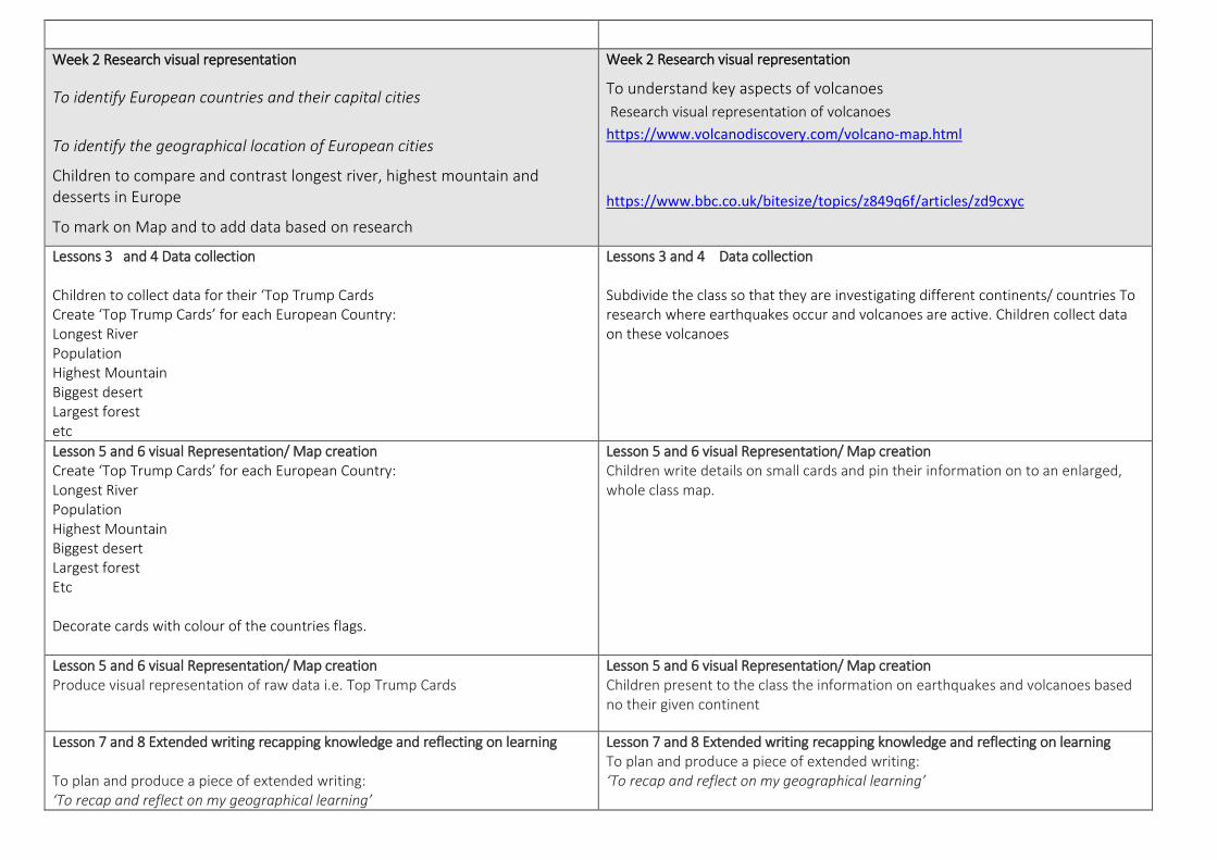
Week 2 Research visual representation
To identify European countries and their capital cities
To identify the geographical location of European cities
Children to compare and contrast longest river, highest mountain and desserts in Europe
To mark on Map and to add data based on research
Week 2 Research visual representation
To understand key aspects of volcanoes
Research visual representation of volcanoes
https://www.volcanodiscovery.com/volcano-map.html
https://www.bbc.co.uk/bitesize/topics/z849q6f/articles/zd9cxyc
Lessons 3 and 4 Data collection Children to collect data for their ‘Top Trump Cards Create ‘Top Trump Cards’ for each European Country: Longest River Population Highest Mountain Biggest desert Largest forest etc
Lessons 3 and 4 Data collection Subdivide the class so that they are investigating different continents/ countries To research where earthquakes occur and volcanoes are active. Children collect data on these volcanoes
Lesson 5 and 6 visual Representation/ Map creation Create ‘Top Trump Cards’ for each European Country: Longest River Population Highest Mountain Biggest desert Largest forest Etc Decorate cards with colour of the countries flags.
Lesson 5 and 6 visual Representation/ Map creation Children write details on small cards and pin their information on to an enlarged, whole class map.
Lesson 5 and 6 visual Representation/ Map creation Produce visual representation of raw data i.e. Top Trump Cards
Lesson 5 and 6 visual Representation/ Map creation Children present to the class the information on earthquakes and volcanoes based no their given continent
Lesson 7 and 8 Extended writing recapping knowledge and reflecting on learning To plan and produce a piece of extended writing: ‘To recap and reflect on my geographical learning’
Lesson 7 and 8 Extended writing recapping knowledge and reflecting on learning To plan and produce a piece of extended writing: ‘To recap and reflect on my geographical learning’

Geography Curriculum Overview: Bushey Heath Primary School
Key Stage 2 National Curriculum Latitude, longitude, Equator, N. & S. hemispheres, Tropics Cancer & Capricorn, Arctic and Antarctic Circle, Prime / Greenwich Meridian & time zones, 8 Compass points, 4 & 6 figure grid references. Locate world's countries, Europe,
(including location of Russia), Americas, concentrating on regions, key physical and human characteristics, countries, major cities. Counties, cities, geographical regions, characteristics, topographical features, land use & changes over time.
Progression of Skills and Fieldwork Begin to ask questions. Identify places using maps, atlases, globes, aerial images & plan perspectives, make maps, devise basic symbols, fieldwork, geographical vocabulary. Develop questioning. Locate, describe, explain using maps (including OS maps), atlases, globes, digital mapping, measure, record and communicate using a range of methods including maps, plans, graphs, writing at length. Fieldwork in local & wider localities & more distant locality – residential.
Use maps, atlases, globes and digital/computer mapping (Google Earth) to locate countries and describe features studied.
Learn the eight points of a compass, 2 figure grid reference (maths co-ordinates), some basic symbols and key (including the use of a simplified Ordnance Survey maps) to build their knowledge of the United
Kingdom and the wider world
Use fieldwork to observe and record the human and physical features in the local area using a range of methods, including sketch maps, plans and graphs, and digital technologies
Year 4 Focus Country: UK North Central South America Rainforests
Unit 1 8 Weeks Unit 2 8 Weeks
Curriculum Focus
To identify compass point and grid reference of North Central and South America Identify physical geography including climate zones, biomes and vegetation belts. Vocabulary:
Hemisphere, tropics, equator, seasonal variation, climate zones biomes
Curriculum Focus
Human and physical Local and Global scales
To describe and understand the differences between a rain forest in a non-
European Country Brazil and a forest in the UK
Vocabulary
Rainforests equator environment
Week 1 Research Knowledge
All children have American Atlas and play guess the country map game
Week 1 Research Knowledge
To understand key features of Rainforests and UK forests

https://www.ducksters.com/games/north_central_america_map_game.php
To identify compass point and grid reference of North America https://www.ducksters.com/geography/northamerica.php Research the below: Create Children to investigate the 8 climate zones of North America and represent each – with facts on an 8 box sheet. 8 Climate Regions Of North America
Coniferous Forest. climate also known as Taiga. ...
Deciduous Forest. climate with four distinct seasons: cold, wet winters and warm summers. ...
Alpine/ Mountain. climate region that is cold, windy, and snowy. ...
Mediterranean. ...
Rainforest. ...
Grassland. ...
Tundra. ...
Desert.
Week 2 Research visual representation
Research visual representations of the North Americas climate zones, biomes and vegetation belts
Week 2 Research visual representation
Research visual representation of Rainforests and UK forests
Lessons 3 and 4 Data collection Establish one aspect that you will be collecting data for via field work or research using books/ computing etc. i.e. length of rivers/ types of climate/ different forms of transport
Lessons 3 and 4 Data collection Use simple fieldwork and observational skills to study the leaf types in their school and its grounds Collect data in raw form i.e. numbers or tally
Lesson 5 and 6 visual Representation/ Map creation Produce visual representation of raw data i.e. create map
Lesson 5 and 6 visual Representation/ Map creation Produce visual representation of raw data i.e. create map

Lesson 5 and 6 visual Representation/ Map creation Produce visual representation of raw data i.e. create map
Lesson 5 and 6 visual Representation/ Map creation Produce visual representation of raw data i.e. create map
Lesson 7 and 8 Extended writing recapping knowledge and reflecting on learning To plan and produce a piece of extended writing: ‘To recap and reflect on my geographical learning’
Lesson 7 and 8 Extended writing recapping knowledge and reflecting on learning To plan and produce a piece of extended writing: ‘To recap and reflect on my geographical learning’
Geography Curriculum Overview: Bushey Heath Primary School
Key Stage 2 National Curriculum Latitude, longitude, Equator, N. & S. hemispheres, Tropics Cancer & Capricorn, Arctic and Antarctic Circle, Prime / Greenwich Meridian & time zones, 8 Compass points, 4 & 6 figure grid references. Locate world's countries, Europe,
(including location of Russia), Americas, concentrating on regions, key physical and human characteristics, countries, major cities. Counties, cities, geographical regions, characteristics, topographical features, land use & changes over time.
Progression of Skills and Fieldwork Begin to ask questions. Identify places using maps, atlases, globes, aerial images & plan perspectives, make maps, devise basic symbols, fieldwork, geographical vocabulary. Develop questioning. Locate, describe, explain using maps (including OS maps), atlases, globes, digital mapping, measure, record and communicate using a range of methods including maps, plans, graphs, writing at length. Fieldwork in local & wider localities & more distant locality – residential.
Use maps, atlases, globes and digital/computer mapping (Google Earth) to locate countries and describe features studied.
Learn the eight points of a compass, 2 figure grid reference (maths co-ordinates), some basic symbols and key (including the use of a simplified Ordnance Survey maps) to build their knowledge of the United
Kingdom and the wider world
Use fieldwork to observe and record the human and physical features in the local area using a range of methods, including sketch maps, plans and graphs, and digital technologies
Year 5 Focus Country: Rivers/Coasts Time Zones
Unit 1 8 Weeks Unit 2 8 Weeks
To consider the distribution of natural resources such as water: sea and rivers
To investigate coast, coastal mapping and the effect of costal erosion using
digital atlases
Curriculum Focus
Identify the position and significance of latitude/longitude and the Greenwich Meridian, linking with science, time zones, night and day

To research the water cycle including transpiration
.
Week 1 Research Knowledge
To consider the distribution of natural resources such as water: sea and
rivers
Week 1 Research Knowledge
To understand Identify the position and significance of latitude/longitude and the Greenwich Meridian, linking with science, time zones, night and day
https://www.bbc.co.uk/bitesize/topics/zvsfr82/articles/zd4rmfr
Week 2 Research visual representation
To investigate coast, coastal mapping and the effect of costal erosion using
digital atlases
https://www.saveteacherssundays.com/uploads/Coasts+KS2+planning.pdf
Week 2 Research visual representation
To understand Identify the position and significance of latitude/longitude and the Greenwich Meridian, linking with science, time zones, night and day
Lessons 3 and 4 Data collection Establish one aspect that you will be collecting data for via field work or research using books/ computing etc. i.e. length of rivers/ types of climate/ different forms of transport Epping Forest Field Centre visit- flow, stone size, depth etc
Lessons 3 and 4 Data collection Use simple fieldwork and observational skills to collect data in raw form i.e. numbers or tally.
Link to schools abroad- exchange of photos to illustrate time differences.
Lesson 5 and 6 visual Representation/ Map creation Produce visual representation of raw data i.e. create map e.g. river bed model, label with data and photos from field trip
Lesson 5 and 6 visual Representation/ Map creation Produce visual representation of raw data i.e. create map Annotated , interactive time zone map showing activities undertaken at set time in different time zones e.g. breakfast in UK, sleeping in Australia (possibly digital? https://www.brightcarbon.com/blog/create-editable-powerpoint-maps/)

Lesson 5 and 6 visual Representation/ Map creation Produce visual representation of raw data i.e. create map
Lesson 5 and 6 visual Representation/ Map creation Produce visual representation of raw data i.e. create map
Lesson 7 and 8 Extended writing recapping knowledge and reflecting on learning To plan and produce a piece of extended writing: ‘To recap and reflect on my geographical learning’
Lesson 7 and 8 Extended writing recapping knowledge and reflecting on learning To plan and produce a piece of extended writing: ‘To recap and reflect on my geographical learning’

Geography Curriculum Overview: Bushey Heath Primary School
Key Stage 2 National Curriculum Latitude, longitude, Equator, N. & S. hemispheres, Tropics Cancer & Capricorn, Arctic and Antarctic Circle, Prime / Greenwich Meridian & time zones, 8 Compass points, 4 & 6 figure grid references. Locate world's countries, Europe,
(including location of Russia), Americas, concentrating on regions, key physical and human characteristics, countries, major cities. Counties, cities, geographical regions, characteristics, topographical features, land use & changes over time.
Progression of Skills and Fieldwork Begin to ask questions. Identify places using maps, atlases, globes, aerial images & plan perspectives, make maps, devise basic symbols, fieldwork, geographical vocabulary. Develop questioning. Locate, describe, explain using maps (including OS maps), atlases, globes, digital mapping, measure, record and communicate using a range of methods including maps, plans, graphs, writing at length. Fieldwork in local & wider localities & more distant locality – residential.
Use maps, atlases, globes and digital/computer mapping (Google Earth) to locate countries and describe features studied.
Learn the eight points of a compass, 2 figure grid reference (maths co-ordinates), some basic symbols and key (including the use of a simplified Ordnance Survey maps) to build their knowledge of the United
Kingdom and the wider world
Use fieldwork to observe and record the human and physical features in the local area using a range of methods, including sketch maps, plans and graphs, and digital technologies
Year 6 Focus Country: Global Trade China
Unit 1 8 Weeks Unit 2 8 Weeks
To research global trade, energy issues and connections
- Distribution of natural resources in Europe
- Distribution of natural resources in UK
Curriculum Focus
RECAP- Identify the position and significance of latitude/longitude and the Greenwich Meridian, linking with science, time zones, night and day
Link to China
Research key environmental / physical/ human characteristics of China i.e. Great China Wall
Week 1 Research Knowledge
To research global trade, energy issues and connections
https://www.conserve-energy-future.com/list-10-natural-resources.php
https://www.visualcapitalist.com/interactive-mapping-flow-international-trade/
Week 1 Research Knowledge
Identify the position and significance of latitude/longitude and the Greenwich Meridian, linking with science, time zones, night and day
Link to China- why only one time zone?
Research key environmental / physical/ human characteristics of China i.e.
https://www.bbc.co.uk/teach/class-clips-video/geography-a-child-led-introduction-to-the-chinese-city-of-shanghai/zdrtvk7
https://www.worldatlas.com/webimage/countrys/asia/china/cnland.htm

https://www.chinahighlights.com/travelguide/geography-facts.htm
Mountains, deserts, rivers, impact of human development on these landscapes, ageing population, economic growth, tourist attractions
Week 2 Research visual representation
To research visual representation of natural resources
https://www.investopedia.com/articles/markets-economy/090516/10-countries-most-natural-resources.asp
https://www.bbc.co.uk/bitesize/topics/zshp34j/articles/z62qy9q
oil pipelines https://worldmap.harvard.edu/maps/5704
Week 2 Research visual representation
To research visual representation of Great China Wall – link to satellite images
https://www.esa.int/ESA_Multimedia/Images/2018/06/Great_Wall_of_China
http://www.spaceref.com/news/viewpr.html?pid=14198
Lessons 3 and 4 Data collection Establish one aspect that you will be collecting data for via field work or research using books/ computing etc. i.e. discover what products the UK exports, and which countries
the UK exports the most to.
(RGS Global Trade unit- lesson four)
Lessons 3 and 4 Data collection Use simple fieldwork and observational skills to study construction of the Great Wall.
https://www.youtube.com/watch?v=m68zyXyeYG0
https://www.youtube.com/watch?v=AB4nXADdPPY
https://www.chinahighlights.com/greatwall/fact/how-the-great-wall-was-built.htm
What raw materials are available in the school grounds to construct a Great Wall?
Collect data in raw form i.e. numbers or tally
Lesson 5 and 6 visual Representation/ Map creation Produce visual representation of raw data i.e. create interactive digital map https://www.brightcarbon.com/blog/create-editable-powerpoint-maps/
Lesson 5 and 6 visual Representation/ Map creation Produce visual representation of raw data i.e. create topographical map of Great Wall of China

https://www.instructables.com/id/How-to-Make-a-Topographic-Model/
Lesson 5 and 6 visual Representation/ Map creation Produce visual representation of raw data i.e. create map
Lesson 5 and 6 visual Representation/ Map creation Produce visual representation of raw data i.e. create map
Lesson 7 and 8 Extended writing recapping knowledge and reflecting on learning To plan and produce a piece of extended writing: ‘To recap and reflect on my geographical learning’
Lesson 7 and 8 Extended writing recapping knowledge and reflecting on learning To plan and produce a piece of extended writing: ‘To recap and reflect on my geographical learning’