Embed Size (px)
Citation preview
Widener & Associates T r a n s p o r t a t i o n & E n v i r o n m e n t a l P l a n n i n g
10108 32nd Ave W, Suite D, Everett, WA 98204 Tel (425) 348-3059 Fax (425) 348-3124
April 11, 2017 Melanie Vance WSDOT Highways & Local Programs PO Box 47390 Olympia, WA 98504-7390
4(f) Update Duportail Street Bridge Project City of Richland, Benton County
Dear Ms. Vance: This memo has been prepared to update the analysis of effects to 4(f) properties. Since the approval of the Environmental Assessment in 2013, there have been design changes necessary to the Duportail Street Bridge Project. This memo addresses revisions which have been made to the project since the approval of the Environmental Assessment, which have the potential to change the information included in previous de minimis determinations or the EA for this topic. The tables below include the original proposal as well as proposed revision as well as the purpose of each revision. The Item numbering coincides with the overall Discipline Reports Update Memo.
Item Original Proposal Revision Needed
12. CID Flume None Steel flume to be removed and replaced with concrete section
During right of way negotiations and design considerations with Columbia Irrigation District, the determination was made that the steel flume portion of the canal on the north side of the bridge would need to be replaced. In order for CID to maintain and operate the canal, transitioning through multiple canal configurations in such short distances would not be feasible. The project will replace the canal under the bridge and to the north end replacing the steel flume which then goes into an underground pipe. This will provide a continuous open channel connecting on either end to existing channels.
14. Gravel Pad Temporary work bridge and piling in river
A temporary gravel pad will replace work bridge in the river. No piles will be driven in the river, but temporary reaction piles will be driven through temporary gravel work berm.
A temporary work bridge was deemed to be too difficult to construct; and therefore, gravel pads will be required to construct the bridge. This is due to the subsurface conditions across the river, specifically that the depth of the bedrock is too shallow to provide lateral support for work bridge piles.
16. Wall None Wall on spread footings on south slope above OHW. Wall used for excavation to construct Pier 2.
The wall is needed to create space to construct the foundation for Pier 2.
Item Original Proposal Revision Needed
20. Construction Duration
500 days
(2 years)
670 days
(2 years 8 months)
Two in-water work windows are required to construct the foundations for the bridge and to erect the bridge girders; therefore, the total duration of the project is extended.
21. Re-grading of SR240 to match railroad tracks
Raise railroad tracks 2.5 feet to match SR240
Approximately 500 feet in either direction from Duportail Street Intersection. Grade would drop 1.5-2 feet. Changes would reduce alteration to railroad grade to meet intersection.
The original design concept was to raise Duportail Street and the railroad tracks approximately 2.5 feet to tie into SR 240. After further design development and right of way evaluations, it was determined that matching into the railroad track by lowering SR 240 would produce a better overall graded area. Raising Duportail and the railroad tracks would produce excessive fill heights around existing residential developed properties. And raising the railroad crossing would require reconstruction of the track for approximately 2200 feet. Work along SR 240 was in the original project scope and lowering the overall grade stays within the milepost limits. Although the construction durations are longer, the overall footprint of the intersection remains the same.
Corps Property The construction of the temporary crane pads will require clearing of additional area on the Corps of Engineers property. Approximately 0.39 acres of additional disturbed riparian vegetation will potentially be removed. The exact footprint of impacts has not been determined but all potential areas have been identified. Any disturbed areas resulting from project activities or previous activities will be restored or re-vegetated to natural conditions with the exception of one designated trail as requested by the Corps. Figure 1 shows the potential areas of impact which were included in the EA as well as the additional riparian impacts now proposed. Figure 2 shows the previous proposal and current locations of permanent and temporary easements on Corps property. The area of temporary easement has increased 0.33 acres for access to the crane pad. The change to the area of riparian impacts is slightly larger as an area of the previously proposed temporary easement was not within the clearing limits shown in the EA.
The project will require that construction continue for a longer duration on the Corps property. This will be necessary in order to provide staging and stockpiling of gravel material for crane pads. Work on the Corps property is not anticipated to continue for the entire construction period, it is expected to last 2 years 3 months. The original de minimis determination had eight prescriptive minimization measures to which the project must adhere to comply with the determination. The project will still comply with all minimization measures.
CID Canal The CID canal was initially proposed to be enclosed. The alterations were limited to the area of canal between 50 feet downstream and 50 feet upstream of the bridge. As part of the project changes, the canal is now proposed to be replaced from the steel flume to approximately 50 feet east of the bridge. The steel canal flume which was constructed in the 1980s will be replaced with an open channel concrete section. These changes have been made as requested by the CID. Analysis of the effects to the CID canal will be undertaken as part of consultation conducted with DAHP for the Section 106 consultation updates. We believe that a de minimis determination will be reissued following consultation with DAHP.
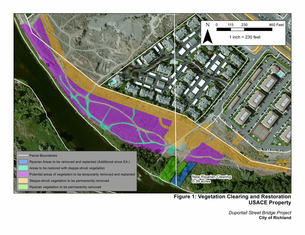
Figure 1: Vegetation Clearing and RestorationUSACE Property
Duportail Street Bridge Project City of Richland
¯0 230 460115 Feet
1 inch = 230 feet
Parcel BoundariesRiparian Areas to be removed and replanted (Additional since EA )Areas to be restored with steppe-shrub vegetationPotential areas of vegetation to be temporarily removed and replantedSteppe-shrub vegetation to be permanently removedRiparian vegetation to be permanently removed
New Riparian Clearing0.39 acres
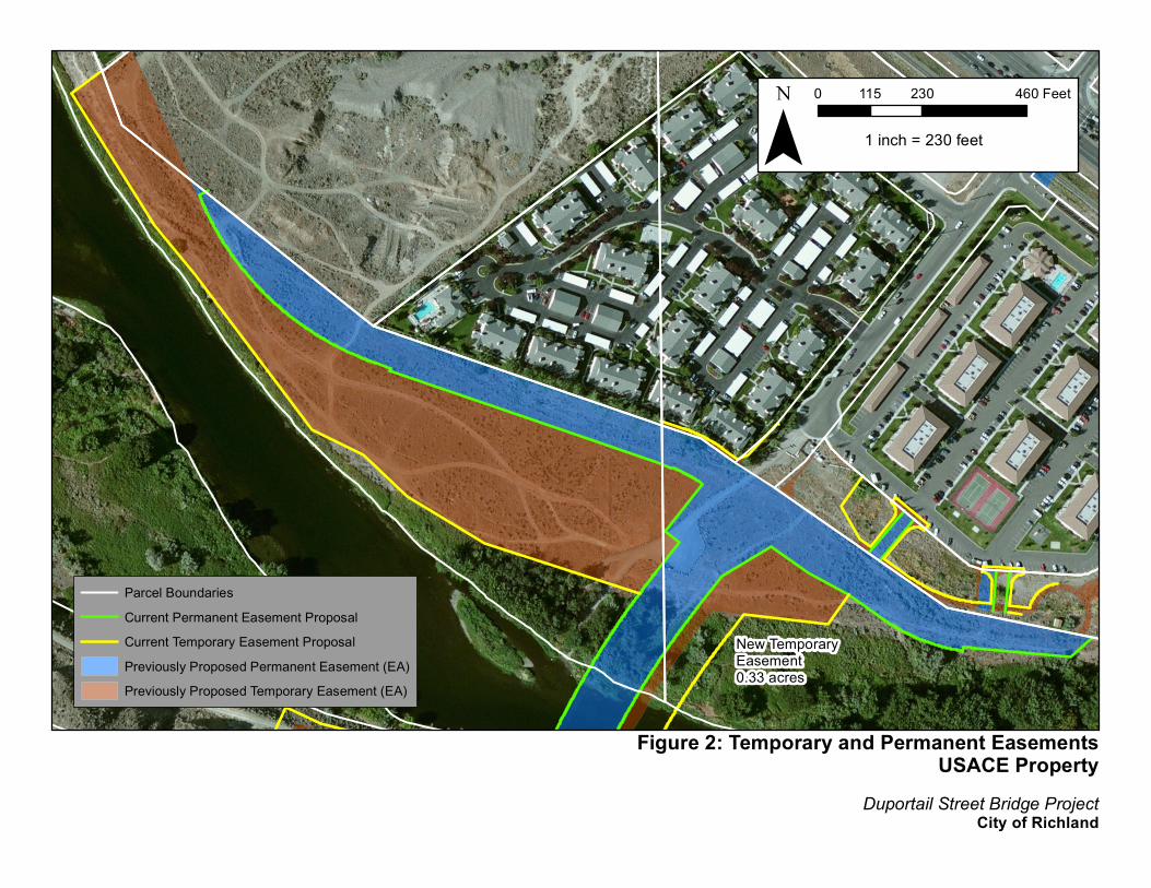
Figure 2: Temporary and Permanent EasementsUSACE Property
Duportail Street Bridge Project City of Richland
¯0 230 460115 Feet
1 inch = 230 feet
Parcel BoundariesCurrent Permanent Easement ProposalCurrent Temporary Easement ProposalPreviously Proposed Permanent Easement (EA)Previously Proposed Temporary Easement (EA)
New Temporary Easement0.33 acres
The construction of the wall for Pier 2 will occur on the CID property. The construction of this wall will require excavation of the hillside adjacent to the canal which will be stabilized with soil anchors and rock bolts. This will not require additional alterations to the canal. Access to the canal and future operation will not be affected. Shelterbelt Park The grading of SR 240 will also include the grading of the trail in the Shelterbelt Park at the intersection where it crosses Duportail Street. The changes will not impair the use of the facility. Temporary impacts are similar to those in the original project and a detour will be provided for pedestrians and bicycles. The original de minimis determination for the Shelterbelt Park will still apply. WDFW Boat Launch No changes to the project impact the WDFW boat launch. Temporary closures of the boat ramp may still be necessary during construction to ensure public safety but these closures will not be of any longer duration due to project changes. The boat launch will remain open during the majority of construction in order to maintain the community’s access to the Yakima River and WDFW will be notified of any temporary closures. Access will be maintained with the reconfigured parking lot which has not been altered since approval of the EA. While these revisions have resulted in minor changes, based on the above analysis it is our understanding that these changes are not significant enough to require an updated discipline report. This memo will be sufficient in supporting the NEPA reevaluation. Please let us know if you have further questions.
Sincerely,
Ross L. Widener Widener & Associates