Embed Size (px)
Citation preview

Lan
cashire WalksWaddington Fell
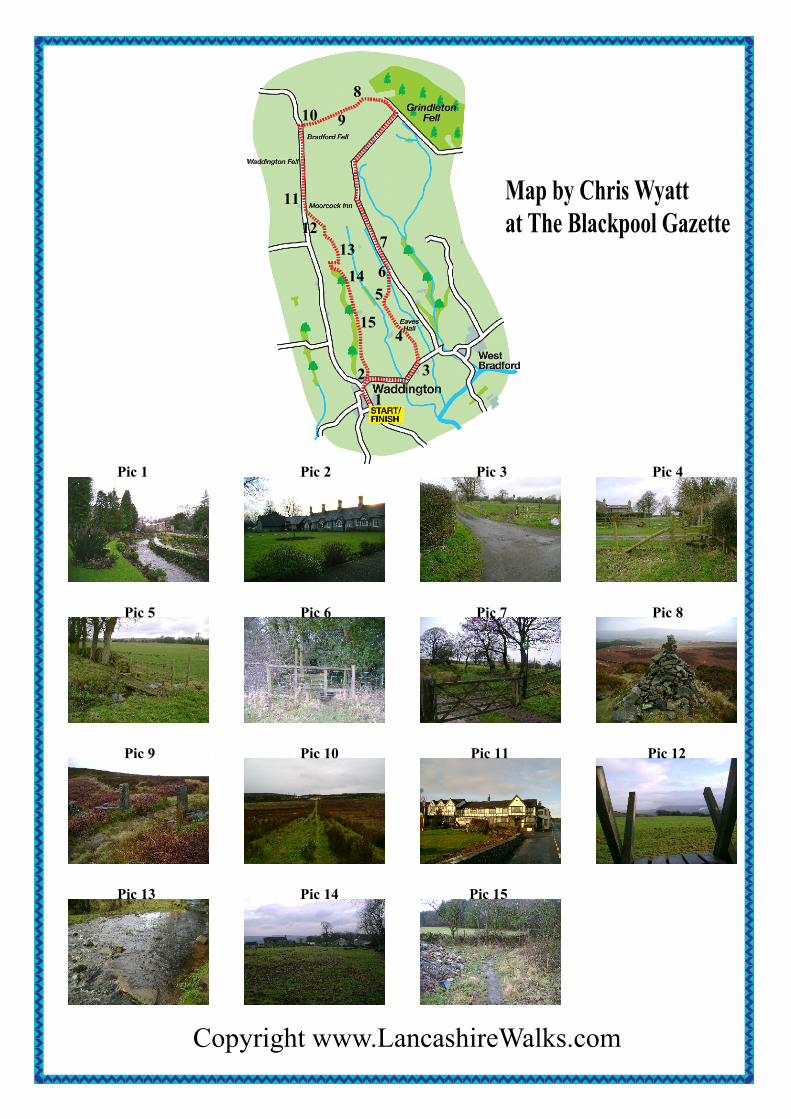
This walk begins in Waddington which has been voted Best Kept Village in the Universe onmore than one occasion. It is a delightful spot and well worth a visit in its own right. The routefrom it goes up across farmland and moorland to reach a fine viewpoint – to the north,Bowland; to the south – the Ribble Valley, to return to the village by way of a superlativeroadside inn.
Start: Waddington village centre.From M6 junction 31, take A59 to Clitheroe. On reaching the town take B6478 to Waddington. The car park can be accessedfrom Waddow View on the left as you enter the village.
Distance: 12.5 Km or 7.5 milesTime: 3 – 4 hoursTerrain: Farmland and moorland with a steady ascent of 300m - just under 1000ft. It should be noted that we do notrecommend this walk after prolonged periods of wet weather.Map: OS OL41 Forest of Bowland and Ribblesdale
1.Waddington to Fell Road summit. (8 Km or 5 miles: 2 - 2½ hours)Walk into the village centre. (Pic 1) At the Higher Buck Inn turn right towards West Bradford. This will take you past theHospital (an 18th century almshouse). (Pic 2) Continue along the lane past the primary school and then turn left towardsMeadow Head. (Pic 3) As you approach the house cross a wooden stile on the right. Continue upwards to reach another stile,which is at the junction of two footpaths. Follow the direction of the right-hand waymark – straight ahead aiming for a largeproperty. On nearing this bear left to reach a pair of stiles on each side of a track. (Pic 4) Cross these and bear left around theside and rear of a farmhouse to arrive at a metal gate at the end of a wall. Follow the direction of the right-hand waymarkpointing diagonally right. The path traverses to a footbridge and stile (Pic 5) and then across a broad field to a footbridge over aditch, to reach a stile set in a wall. Keep on the footpath beyond this to come to a stile before a flight of steps that puts you ontoMoor Lane. (Pic 6) Turn left. At 500m the lane turns left towards Seedals. Here keep ahead on the bridleway. (Pic 7) This roughtrack will take you close to the top of the moors. Beyond a small barn and a pair of wooden gates, the bridleway follows a wallof the left. 500m beyond the barn the track turns slightly to the right and then 300m further on, through a wooden gate, turnssharply right towards an extensive conifer plantation on the skyline. 15-20 minutes later you will reach the edge of thisplantation. Here turn left and continue the ascent. 300m further on, a prominent pile of stones will be seen on a rise. (Pic 8)Take the path through heather to reach it. This is a fine viewpoint for reviewing the route you have just climbed as well asadmiring Pendle Hill across the Ribble Valley. Follow the path through a pair of redundant gateposts (Pic 9) towards the aerialmast on the crest of Waddington Fell. On this upland section of the route the Bowland Fells will come into view to the north.The path will bring you onto Fell Road which connects Waddington to Newton. (Pic 10)
2. Fell Road summit to Waddington. (4 Km or 2½ miles: 1 hour)Turn left onto Fell Road taking proper heed of traffic and descend towards Waddington. Soon the Moorcock Inn will come intosight. (Pic 11) Cross the ladder stile on the left just beyond the inn. (Pic 12) This crosses a large field and then, through agateway on the far side follows the edge of a wooded valley. The path soon drops down to the stream and crosses it by a ford.(Pic 13) Now with the wooded clough on your right, descend to Cuttock Clough Farm. (Pic 14) Turn right at the lane andfollow it over a road bridge. On the left between houses turn left onto a lane and bear left to follow a footpath as it skirts behinda property and then drops to cross a wooden footbridge. As you climb out of the depression again keep close to the woods onyour right. Before the next farm keep to the right of a covered reservoir and then after crossing a stile keep ahead to reach thefarm lane. Turn right and just beyond the farm left onto a footpath. (Pic 15) After crossing a stone stile continue your descent,once again with the woods on your right. After 500m the path bears left along the line of a hedge to pass through a gate onto afarm track. Keep to the left of the almshouses to reach West Bradford Road. Turn right for the village.
Copyright www.LancashireWalks.com
Pic 1 Pic 2 Pic 3
Pic 5 Pic 6 Pic 7
Pic 9 Pic 10 Pic 11
Pic 13 Pic 14 Pic 15
Pic 4
Pic 8
Pic 12
Map by Chris Wyattat The Blackpool Gazette
12 3
4
56
7
8
910
11
1213
14
15