Embed Size (px)
Citation preview
(12)
US006222483B1
United States Patent Twitchell et al.
US 6,222,483 B1 Apr. 24, 2001
(10) Patent N0.: (45) Date of Patent:
(54)
(75)
(73)
(*)
(21) (22) (51)
(52)
(58)
(56)
WO 97/14054
GPS LOCATION FOR MOBILE PHONES USING THE INTERNET
Inventors: Robert W. Twitchell; Andrew Taylor, both of San Diego, CA (US)
Assignee: Nokia Mobile Phones Limited, Espoo (F1)
Notice: Subject to any disclaimer, the term of this patent is extended or adjusted under 35 U.S.C. 154(b) by 0 days.
Appl. No.: 09/163,221
Filed: Sep. 29, 1998
Int. Cl.7 ........................... .. G01S 5/02; H04B 7/185;
H04Q 7/20 US. Cl. ................................ .. 342/357.09; 342/357.1;
455/456 Field of Search ....................... .. 342/357.06, 357.09,
342/357.1, 357.13, 450, 457; 455/456, 457, 426; 701/214
References Cited
U.S. PATENT DOCUMENTS
5,043,736 8/1991 Darnell et al. ..................... .. 342/357
5,101,500 * 3/1992 Marui ................................ .. 455/321
5,159,592 10/1992 Perkins .............................. .. 370/857
5,225,842 7/1993 Brown et al. .. 342/357 5,289,527 * 2/1994 Tiedemann, Jr. 342/457 5,365,450 11/1994 Schuchman et al. . 364/449 5,617,100 4/1997 Akiyoski et al. .................. .. 342/357 5,663,734 9/1997 Krasner .............................. .. 342/357
5,752,218 5/1998 Harrison et al. 701/207 5,786,789 7/1998 Janky ........... .. 342/357
5,841,396 * 11/1998 Krasner ........ .. 342/357.02
5,901,352 * 5/1999 St-Pierre et al. 455/426 5,917,444 * 6/1999 Loomis et al. ................ .. 342/357.12
FOREIGN PATENT DOCUMENTS
4/1997 (W0) .
EGG
WO 98/25157 WO 99/19743 WO 99/44073
6/1998 (W0). 4/1999 (W0). 9/1999 (W0).
OTHER PUBLICATIONS
Valejo, A. et al., “Short—range DGPS for mobile robots With Wireless Ethernet links”, AMC ’98—Coimbra, 1998 IEEE, pp. 334—339, XP—002127554.
* cited by examiner
Primary Examiner—Thomas H. TarcZa Assistant Examiner—Fred H. Mull (74) Attorney, Agent, or Firm—Perman & Green, LLP
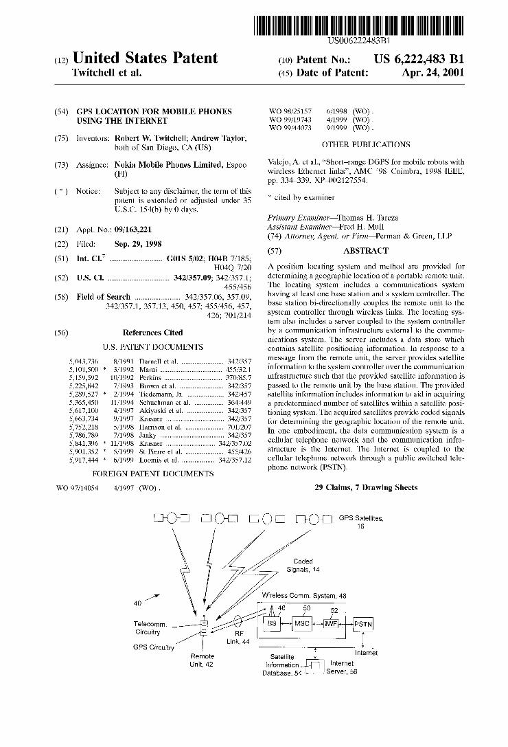
(57) ABSTRACT
A position locating system and method are provided for determining a geographic location of a portable remote unit. The locating system includes a communications system having at least one base station and a system controller. The base station bi-directionally couples the remote unit to the system controller through Wireless links. The locating sys tem also includes a server coupled to the system controller by a communication infrastructure external to the commu nications system. The server includes a data store Which contains satellite positioning information. In response to a message from the remote unit, the server provides satellite information to the system controller over the communication infrastructure such that the provided satellite information is passed to the remote unit by the base station. The provided satellite information includes information to aid in acquiring a predetermined number of satellites Within a satellite posi tioning system. The acquired satellites provide coded signals for determining the geographic location of the remote unit. In one embodiment, the data communication system is a cellular telephone netWork and the communication infra structure is the Internet. The Internet is coupled to the cellular telephone netWork through a public sWitched tele phone netWork (PSTN).
29 Claims, 7 Drawing Sheets
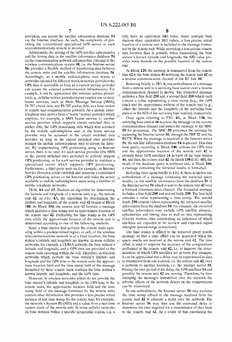
EGG EOE GPSSatellites, 16
Coded Signals, 14
Wireless Comm. System, 48
D-GE
40/ X % E M W +801 Telecomm.
Circuitry Link, 44
GPS Circuitry Remote Unit, 42
Satellite I Internet Information Internet Database, 54 Server' 56

U.S. Patent Apr. 24, 2001 Sheet 1 0f 7 US 6,222,483 B1
mm .LmEww ' ON .528 \ 836w
mm ,Empgw mcozm 22260
@P dwg?mm WAG
3 £22m 88o QUE E 6E F .5
U.S. Patent Apr. 24, 2001 Sheet 3 0f 7 US 6,222,483 B1
/ l___ _________
>~E30E0 zoom-E.
E 229w $0 >
on
y 586 \
mowmmoomm IOmQE M m .5
4 025:. _ lml _ _ _ _ _
.f
U.S. Patent Apr. 24, 2001 Sheet 7 0f 7 US 6,222,483 B1
oww
0mm
E5 90:61 E 5:83 9m§xEQQ<
QEEw mEc.
0mm
E520 ww$>mm oww
CQGELQE mEEEm mam
QEEw mEE. 6:550 Emzcom
US 6,222,483 B1 1
GPS LOCATION FOR MOBILE PHONES USING THE INTERNET
FIELD OF THE INVENTION
This invention relates to a system for determining a latitude and longitude of an individual or object, and speci?cally, to a system Which includes a hand-held locating unit and a telecommunications network Which includes a radiotelephone network, a satellite positioning system and the Internet.
BACKGROUND OF THE INVENTION
Presently, position locating systems may include a por table remote unit Which comprises a receiver for receiving signals from a satellite positioning system (e.g., a global positioning system (GPS)), telecommunications circuitry, clock circuitry and a microprocessor for analyZing coded signals received from the satellite positioning system and from a telecommunications link, for example, a Wireless communication netWork. The microprocessor of this inte grated positioning and telecommunications system may ana lyZe the coded signals to determine the latitude and longi tude of the portable remote unit. An exemplary integrated positioning and telecommunications system can be found in, for example, US. Pat. No. 5,043,736, issued Aug. 27, 1991, entitled “Cellular Position Locating System”, by Darnell et al., Which discloses a portable locating unit useful both as a cellular telephone and a portable global positioning system.
The determination of the position of the remote unit may be calculated With, or Without, information provided to the remote unit over the telecommunications link, e.g., over the Wireless communication netWork.
In one type of a GPS system, Which operates Without information provided over the telecommunications link, the precise position of each of a plurality of satellites at any given time are transmitted to the Earth in the form of coded signals. The coded signals contain information as to the position of each of the satellites in space With respect to GPS time, and also, an indication of the precise time at Which each one of the signals Was transmitted from each one of the satellites. This information may be referred to as ephemeris data. The coded signals also include high rate repetitive signals referred to as pseudorandom (PN) sequences. Each GPS satellite broadcasts a signal With a unique offset to a PN sequence.
The coded signals are transmitted by the GPS satellites Within a predetermined band of frequencies. The remote units search the predetermined band of frequencies in an effort to acquire the coded signals from in-vieW GPS satel lites. In the acquisition process, a remote unit receives signals from the GPS satellites and performs a correlation operation. The correlation operation evaluates the received signals and searches for knoWn PN sequences. The detection of a knoWn PN sequence Within a received signal is an indication that the received signal is a GPS coded signal. Once the PN sequence search is complete and a coded signal is acquired, the range or distance betWeen the GPS satellite transmitting the signal and a receiver, eg the remote unit, may be determined. The distance is determined by using the time of transmission of the coded signal and by noting the time that the signal is received at the remote unit from one of the satellites. The remote unit calculates a propagation time delay from the time difference, ie from the difference betWeen the time the coded signal Was transmitted and the time the signal Was received at the remote unit. The calcu lated time delay, When multiplied by the speed of propaga
10
15
25
35
45
55
65
2 tion of the signal, provides the range or distance value, referred to as a “pseudorange”, betWeen the transmitting satellite and the remote unit. The distance is referred to as a “pseudorange” because, While the actual calculation may be accurate, errors may be introduced in the data by the fact, e.g., that a local clock, Which is generated in the remote unit, may not be precisely synchroniZed With GPS time, and also by the fact that signal propagation through the atmosphere may encounter delays. Once the pseudorange computations are completed, the
position of the remote unit is determined by using the pseudoranges and the satellite timing and ephemeris data. Typically, GPS signals from at least tWo or three line-of sight positioning satellites are needed to supply sufficient information to derive accurate position determinations at an Earth-based station, such as the remote unit. Conventionally four such satellites are used to determine a terrestrial posi tion estimate, three for triangulation and one for correcting for clock bias.
In another type of a GPS system, the position of the remote unit is determined by utiliZing the positioning signals received from in-vieW satellites (as described above) and also satellite information received over a telecommunica tions link from a base station. The telecommunications link may be, for example, a tWo-Way page system or a cellular communication system. Accordingly, the remote unit uti liZes the information received from the GPS satellites and from the telecommunications link to compute pseudoranges and, in turn, to compute its latitudinal and longitudinal position. An exemplary embodiment of a position locating systems Which utiliZes positioning signals received from in-vieW satellites and satellite information received over a data communication link can be found in US. Pat. No. 5,663,734, issued Sep. 2, 1997, entitled “GPS Receiver and Method For Processing GPS Signals”, by Norman F. Kras ner. Similar systems are also disclosed in US. Pat. No. 5,225,842, issued Jul. 6, 1993, entitled “Vehicle Tracking System Employing Global Positioning System (GPS) Satellites”, by BroWn et al. and in US. Pat. No. 5,365,450, issued Nov. 15, 1994, entitled “Hybrid GPS/Data Line Unit For Rapid, Precise, and Robust Position Determination”, by Schuchman et al.
In Schuchman et al., for example, there is disclosed a specialiZed server Which resides on a cellular phone system. The specialiZed server includes a satellite almanac database Which contains ephemeris and time models of a GPS satel lite constellation. In one embodiment, the ephemerides and time model information is provided to the GPS receiver for use in a search and acquisition mode.
In FIG. 1, a conventional GPS locating system 10 is shoWn. A remote unit 12 of the GPS locating system 10 searches a predetermined band of frequencies to acquire coded signals 14 transmitted by orbiting GPS satellites 16. The remote unit 12 also establishes communication, via data link 18, With a service center 20 Which services a region of a cellular phone system 22. The cellular phone system 22 includes a satellite information database 24 Which contains ephemerides and timing data for the GPS satellites 16 Within a GPS satellite constellation.
The remote unit 12 of this conventional GPS locating system 10 uses the coded signals 14 and ephemeris and timing data to determine the latitudinal and longitudinal position of the remote unit 12. The remote unit 12 also uses the data from the satellite information database 24 to aid its search for in-vieW GPS satellites 16 of the GPS constella tion. Aprior knoWledge of the location of the GPS satellites
US 6,222,483 B1 3
16 can decrease the time required to acquire the coded signals 14 from the GPS satellites 16.
The satellite information database 24 is stored in a spe cialiZed server 26 of the cellular phone system 22. Thus, the ephemerides and timing data of the GPS satellites 16 can be requested by the remote unit 12, retrieved from the satellite information database 24, and passed by the cellular phone system 22 through the service center 20 over data link 18 to the requesting remote unit 12. The received ephemerides and timing data can then be used, With the received coded signals 14, to determine the latitude and longitude of the remote unit 12. As can be appreciated, delays may be experienced in this
process of requesting and receiving data from the satellite information data base 24 of the cellular phone system 22. For example, delays in the transmission of a request for data by the remote unit 12, the reception and processing of the request in the cellular phone system 22, and the retrieval and transmission of data from the satellite information data base 24 back to the remote unit 12, may compromise the validity of the information provided. That is, the delays may result in the remote unit 12 receiving information that a GPS satellite is at a ?rst position When, in fact, the GPS satellite has passed the ?rst position and is in a second position. Under these circumstances the attempt to aid the search for in-vieW satellites has failed and may have increased the actual acquisition time. As demonstrated above, the ability of a remote station to
rapidly locate, track and acquire position information from in-vieW, earth orbiting GPS satellites is desirable. Satellite ephemerides and timing information can be provided to aid the acquisition process. While it is also desirable to achieve the goal of rapid acquisition and tracking, it is undesirable to provide a specialiZed server in a radiotelephone system to accomplish the goal.
OBJECTS AND ADVANTAGES OF THE INVENTION
It is therefore a ?rst object and advantage of this invention to provide a method and a system to enhance the ability of a remote unit to locate, track and acquire the position information from GPS satellites While avoiding the necessity to provide a specialiZed GPS server in a radiotelephone system.
It is a further object and advantage of this invention to provide satellite ephemerides data, prior to acquisition, to aid a remote unit in rapidly locating and acquiring in-vieW, GPS satellites, the ephemerides being provided from a server that is coupled to the radiotelephone system through a communication netWork external to the radiotelephone system such as the Internet.
It is another object and advantage of this invention to provide satellite ephemerides data from a single server that is coupled to one or more radiotelephone systems through a communication netWork external to the one or more radio telephone systems, the one or more radiotelephone systems being coupled directly or indirectly to the external commu nication netWork.
It is still another object and advantage of this invention to time stamp messages requesting satellite ephemerides data and messages providing the requested ephemerides data to indicate a quality of the received ephemerides data, and also to aid a remote unit in locating and acquiring in-vieW, GPS satellites.
Further objects and advantages of this invention Will become more apparent from a consideration of the draWings and ensuing description.
10
15
25
35
45
55
65
4 SUMMARY OF THE INVENTION
The foregoing and other problems are overcome and the objects and advantages are realiZed by methods and appa ratus in accordance With embodiments of this invention, Wherein a system and methods for locating and acquiring GPS satellites used to determine a precise latitude and longitude of a remote unit are disclosed.
A position locating system for determining a geographic location of a portable remote unit includes a telecommuni cations system having at least one base station and a system controller. The base station bi-directionally couples the remote unit to the system controller through Wireless links. The locating system also includes a server coupled to the system controller by a communication netWork infrastruc ture external to the telecommunications system. The server includes a data store Which contains satellite positioning information. In response to a request for satellite information, the server provides satellite information to the system controller over the communication netWork infra structure such that the provided satellite information is passed to the remote unit by the base station. The provided satellite information includes information to aid in acquiring a predetermined number of satellites Within a satellite coded system. The acquired satellites provide coded signals that are utiliZed to determine the geographic location of the remote unit. The selected satellites represent GPS satellites in-vieW of the base station as determined from the requested satellite information.
In one embodiment, the telecommunications system is a cellular telephone netWork and the communication netWork infrastructure is the Internet Which is coupled to the cellular telephone netWork through a public sWitched telephone netWork (PSTN). In another embodiment, the communica tion netWork infrastructure is directly coupled to the cellular telephone netWork.
Also disclosed is a method for determining a geographic location of a portable remote unit. The method includes the steps of: (a) providing a telecommunication system com prising at least one base station and a system controller, the at least one base station bi-directionally coupling the remote unit to the system controller through Wireless links; (b) requesting satellite information from a server coupled to the system controller by a communications netWork infrastruc ture external to the telecommunications system; (c) in reply to the request, retrieving the requested satellite information from the server; (d) providing the retrieved satellite infor mation to the remote unit; and (e) acquiring a predetermined number of satellites of a satellite positioning system in accordance With the provided satellite information, Wherein the acquired satellites provide coded signals for determining the geographic location of the remote unit.
In one embodiment, the satellite information provided to the remote unit may include, for example, satellite almanac, ephemeris, and timing information, as Well as information that speci?es Which satellites are expected to be in-vieW and their expected signal strengths (pseudorange corrections).
BRIEF DESCRIPTION OF THE DRAWINGS
The above set forth and other features of the invention are made more apparent in the ensuing Detailed Description of the Invention When read in conjunction With the attached DraWings, Wherein:
FIG. 1 is schematic diagram of a conventional GPS locating system Which utiliZes satellite ephemeris data in an acquisition mode;
US 6,222,483 B1 5
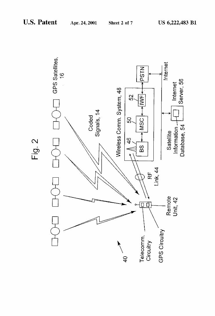
FIG. 2 is schematic diagram of an integrated GPS locating and telecommunications system in accordance With the present invention;
FIG. 3 is schematic diagram of a remote unit of the integrated GPS locating and telecommunications system of FIG. 2;
FIGS. 4A and 4B are ?oWcharts illustrating the integrated GPS locating and telecommunications system’s use of sat ellite information;
FIG. 5 is a ?oWchart illustrating a remote unit’s use of satellite information to facilitate the acquisition of in-vieW GPS satellites to determine its position; and
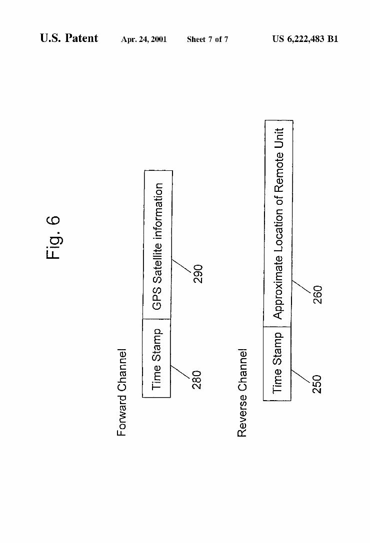
FIG. 6 is a schematic diagram of a reverse communication channel request for a satellite information message and a forWard communication channel message for providing the requested satellite information.
Identically labelled elements appearing in different ones of the above described ?gures refer to the same elements but may not be referenced in the description for all ?gures.
DETAILED DESCRIPTION OF THE INVENTION
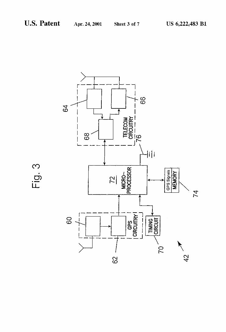
Referring to FIGS. 2 and 3, and accordance With the present invention, an integrated GPS locating and telecom munications system 40 is shoWn. A remote unit 42 of the integrated system 40 includes GPS circuitry (60, 62) for receiving signals from a OPS satellite positioning system, telecommunications circuitry (64, 66 and 68) for supporting the transmission and the reception of RF signals over a telecommunications link, eg a RF link 44 betWeen the remote unit 42 and a base station 46 of a Wireless commu nications netWork 48. The GPS (60, 62) and telecommuni cations circuitry (64, 66 and 68) enables the remote unit 42 to function as a combined portable GPS receiver and a mobile radiotelephone.
It should be appreciated that the Wireless communications system 48 can be, for example, a cellular telephone netWork, a personal communication services (PCS) system, a paging netWork and a trunked dispatch communications system such as a ?eet dispatched service (e.g., a police or other safety agency communications service that requires com munications Within a group of mobile users).
The remote unit 42 further includes timing circuitry 70 and a microprocessor 72 for analyZing coded signals received from the GPS satellite system and from the Wireless communications netWork 48. The remote unit 42 also includes a memory 74 for storing system parameters such as, for example, previously received GPS signals and a plurality of constants and variables that are used by the micropro cessor 72 during the operation of the integrated GPS receiver and mobile Wireless communications device such as the mobile radiotelephone. For example, the memory 74 stores the values of various radiotelephone system param eters (e.g., cellular system parameters and a number assign ment module An operating program for controlling the operation of microprocessor 72 is also stored in a portion of the memory 74 (typically in a ROM device).
The telecommunications circuit 68 includes a modulator, a demodulator, a user interface such as a conventional earphone or speaker, a conventional microphone, a display, and a user input device, typically a keypad, all of Which are coupled to the microprocessor 72. The remote unit 42 may also include a battery 76 for poWering the various circuits that are required to operate the remote unit 42, or alternatively, include circuitry to enable the remote unit 42 to be vehicle mounted.
15
25
35
45
55
65
6 It should therefore be understood that the remote unit 42
can be a vehicle mounted or a handheld device. It should further be appreciated that When operating as a mobile radiotelephone the remote unit 42 may be capable of oper ating With one or more air interface standards, modulation types, and access types. By example, the remote unit 42 may be capable of operating With any of a number air interface standards such as IS-136, GSM and IS-95 (CDMA). It should thus be clear that the teaching of this invention is not to be construed to be limited to any one particular type of mobile radiotelephone or air interface standard.
In accordance With the present invention, the micropro cessor 72 of this integrated positioning and telecommuni cations system 40 analyZes the received, coded signals to determine the latitude and longitude of the remote unit 42.
As shoWn in FIG. 2, the base station 46 is a part of the Wireless communications netWork 48 Which comprises a mobile sWitching center (MSC) 50 and an InterWorking function (IWF) 52. The MSC 50 and the IWF 52 provide a connection to landline trunks When the remote unit 42 is involved in a call. The MSC 50 and the IWF 52 also provide a connection betWeen the remote unit 42 and a communi cation netWork infrastructure external to the Wireless com munications system 48. In a preferred embodiment of the present invention, the communication netWork infrastruc ture is the Internet. As such, the MSC 50 and the IWF 52 provide a connection betWeen the remote unit 42 and the Internet via the PSTN or some other netWork. In one
embodiment, the IWF 52 includes an Internet communica tion interface. In another embodiment, the IWF 52 is directly connected to the Internet and, thus, does not interface With the PSTN.
As used herein, the expression the “Internet” refers to an infrastructure Whose protocols and operating rules effec tively permits the creation of a World-Wide “netWork of netWorks.” By connecting a computing device to the Internet, graphic and textual data may be requested and received by the computing device from any source also connected to the Internet. Thus, a matrix of interconnected communication devices, Which have the ability to exchange information betWeen one another, is formed.
In general, devices connected to the Internet Will adhere to TCP/IP protocols. Traditionally, ?ber optics, Wires, cables, sWitches, routers and other communications tech nologies connect individual computing devices over the public sWitched telephone netWork (PSTN), or directly, to the Internet. Once connected, the individual computing device becomes “linked” to the other communicating devices on the Internet such that there is a perception that there is no physical distance betWeen any of the devices. That is, Whether a device is physically located next the commuting device or on another continent the devices function as if they are physically connected.
Therefore, and in accordance With the present invention, GPS satellite information, for example ephemerides and timing data, stored in a satellite information database 54 on an Internet server 56 is available to one or more telecom
munications systems having access, either directly or indirectly, to the Internet. Upon request, at a predetermined time or at an occurrence of a prede?ned event, the Internet server 56 provides the GPS satellite information, ie the ephemeris and timing data, to the Wireless communications system 48, over the PSTN or directly thereto, for transmis sion to the remote unit 42 over the RF link 44. It can be appreciated that many Wireless telecommunications systems, ie systems operated by numerous Wireless service
US 6,222,483 B1 7
providers, can access the satellite information database 54 via the Internet interface. As such, the complexity of pro viding the conventional specialized GPS server in each telecommunications system is avoided.
Additionally, the storing of the GPS satellite ephemerides and the timing data in the satellite information database 54 on the communication netWork infrastructure external to the Wireless communications system 48, ie the Internet server 56, provides a ?exible method of transferring data betWeen the remote units and the satellite information database 54. Accordingly, as a mobile radiotelephone user roams to netWorks operated by different Wireless service providers the GPS data is accessible as long as a current service provider can access the external communication infrastructure. For example, it can be appreciated that Wireless service provid ers (e. g., cellular service providers) may employ one or more bearer services, such as Short Message Service (SMS), IS-707 circuit data, and IS-707 packet data, as a base station to remote unit communication protocol. As a mobile radio telephone user moves from a “home” service provider Which employs, for example, a SMS bearer service to another service provider Which supports circuit sWitched data or packet data, the GPS positioning data Which Was accessed by the mobile radiotelephone user in the home service provider may be accessed in the circuit sWitched data provider as long as the circuit sWitched data provider permits the mobile radiotelephone user to access the Inter net. By implementing GPS positioning using an Internet server, there is no need for each service provider (the SMS or the circuit sWitched data provider) to actively support GPS positioning, or for each service provider to maintain a specialiZed server Which supports GPS positioning. Furthermore, a third party such as, for example, an Internet Service Provider, could establish and maintain a centraliZed GPS positioning server on the Internet and make the server available to mobile radiotelephone users using a number of mobile telephone netWorks.
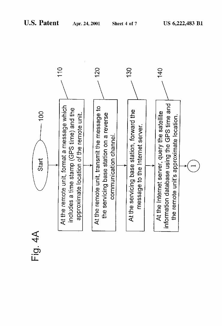
FIGS. 4A and 4B illustrate an algorithm for determining the latitude and longitude of a remote unit, e.g., the remote unit 42. In FIG. 4A, the algorithm for determining the latitude and longitude of the remote unit 42 begins at Block 100. At Block 110, the remote unit 42 formats a message Which includes a time stamp and an approximate location of the remote unit 42. Preferably, the time stamp is the GPS time While the approximate location of the remote unit is determined according to one of the folloWing methods.
Since a base station that services the remote units oper ating Within a predetermined region, or cell, of the Wireless telecommunications netWork is at a ?xed location, the base station’s latitude and longitude are knoWn. In some cellular netWorks, for example a CDMA netWork, the base station’s latitude and longitude, and a GPS time are provided to the remote units operating Within the cell. Therefore, in Wireless netWorks Which provide the base station’s latitude and longitude and the GPS time to the remote units the approxi mate location ?eld and the time stamp ?eld of the message formatted by these remote units contains the base station’s knoWn latitude and longitude, and the GPS time.
HoWever, in Wireless netWorks Which do not provide the base station’s latitude and longitude or the GPS time to the remote units, the approximate location ?eld and the time stamp ?eld of the message formatted by the remote units contain other information that provides a less precise initial location of and time stamp for the remote unit, for example, the netWork’s System ID (SID) and a value from a real time system clock of the remote unit. In some cellular netWorks all base stations Within a speci?c geographic region, eg a
10
15
25
35
45
55
65
8 city, have an equivalent SID value. Since multiple base stations share equivalent SID values, a less precise initial location of a remote unit is included in the message format ted by the remote unit. While providing a less precise remote unit location than is possible When transmitting the base station’s knoWn latitude and longitude, the SID value pro vides some bounds on the possible location of the remote unit.
At Block 120, the message is transmitted from the remote unit 42 to the base station 46 servicing the remote unit 42 on a reverse communication channel of the RF link 44.
Referring brie?y to FIG. 6, one embodiment of a message from a remote unit to a servicing base station over a reverse
communication channel is shoWn. The formatted message includes a ?rst ?eld 250 and a second ?eld 260 Which each contain a value representing a time stamp (e.g., the GPS time) and the approximate address of the remote unit (e.g., either the latitude and the longitude of the servicing base station or the SID of the servicing base station), respectively.
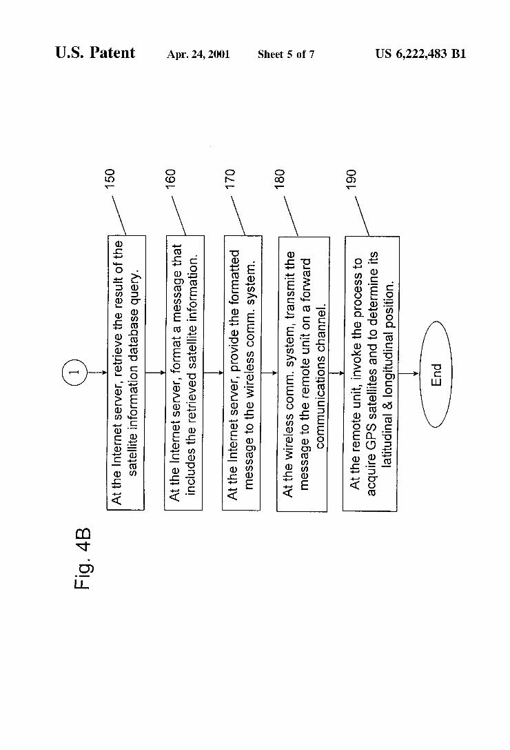
Once again referring to FIG. 4A, at Block 130, the servicing base station 46 receives the message on the reverse communication channel and passes the message to the MSC 50 for processing. The MSC 50 processes the message by accessing the Internet server 56, through the IWF 52 and the PSTN. When the message is received at the Internet server 56, the satellite information database 54 is queried. This data base query, occurring at Block 140, utiliZes the GPS time and the approximate location of the remote unit 42 to identify those GPS satellites 16 in-vieW of the base station 46, and thus, the remote unit 42. At Block 150 (FIG. 4B), the result of the database query is retrieved and, at Block 160, a message containing the retrieved results is formatted.
Referring once again brie?y to FIG. 6, there is shoWn one embodiment of a message containing the retrieved query results, ie the satellite information from the database 54 of the Internet server 56 Which is sent to the remote unit 42 over a forWard communication channel. The formatted message includes a ?rst ?eld 280 and second ?elds 290. The ?rst ?eld contains a value representing a time stamp. The second ?elds 290 contain values representing the retrieved satellite information from the database 54. For example, the retrieved satellite information may include GPS satellite almanac, ephemerides and timing data as Well as data representing velocity vectors, data representing an indication of Which satellites are expected to be in-vieW and expected signal strengths (pseudorange corrections). The time stamp is af?xed to the retrieved query results
message so that a time offset can be generated When the query results are received at the remote unit 42. The time offset is used to improve the accuracy of the computations performed at the remote unit 42, ie to improve the deter mination of Which GPS satellites are in-vieW. For example, it can be appreciated that a delay may be experienced as data is transmitted from one location, ie the remote unit 42, over a netWork to another location, ie the Internet server 56. During the time period of the delay, the GPS satellites 16 and possibly the remote unit 42 are moving. Therefore, by time stamping the messages transmitted over the netWork the adverse effects of the netWork delays on the computations can be minimiZed.
In one embodiment, the Internet server 56 may evaluate the time stamp af?xed to the message received from the remote unit 42 to estimate a delay over the netWork. The Internet server 56 may then use the estimated delay to determine the time required for a transmission of data back to the remote unit 42. As a result of this calculation the
US 6,222,483 B1 9
Internet server 56 may, for example, perform its data base query and the subsequent retrieval of satellite information to account for the estimated delay in the transmission of the Internet server’s message back to the remote unit 42. That is, satellite information is retrieved so that it is as current as possible, based on the estimated delay, When the information is received by the remote unit 42. Similarly, the remote unit 42 may evaluate the satellite information received from the Internet server 56 and the time stamp af?xed thereto. If, for example, a signi?cant time delay is noted from the receipt of the satellite information and the time the Internet server 56 transmitted the information, ie af?xed the time stamp, the remote unit 42 may ignore the information and make another request for data or, alternatively, modify the received satel lite information before use. By anticipating and/or detecting the netWork delay a potentially more precise computation of the remote unit’s latitude and longitude may be realiZed. At Block 170 of FIG. 42, the formatted message contain
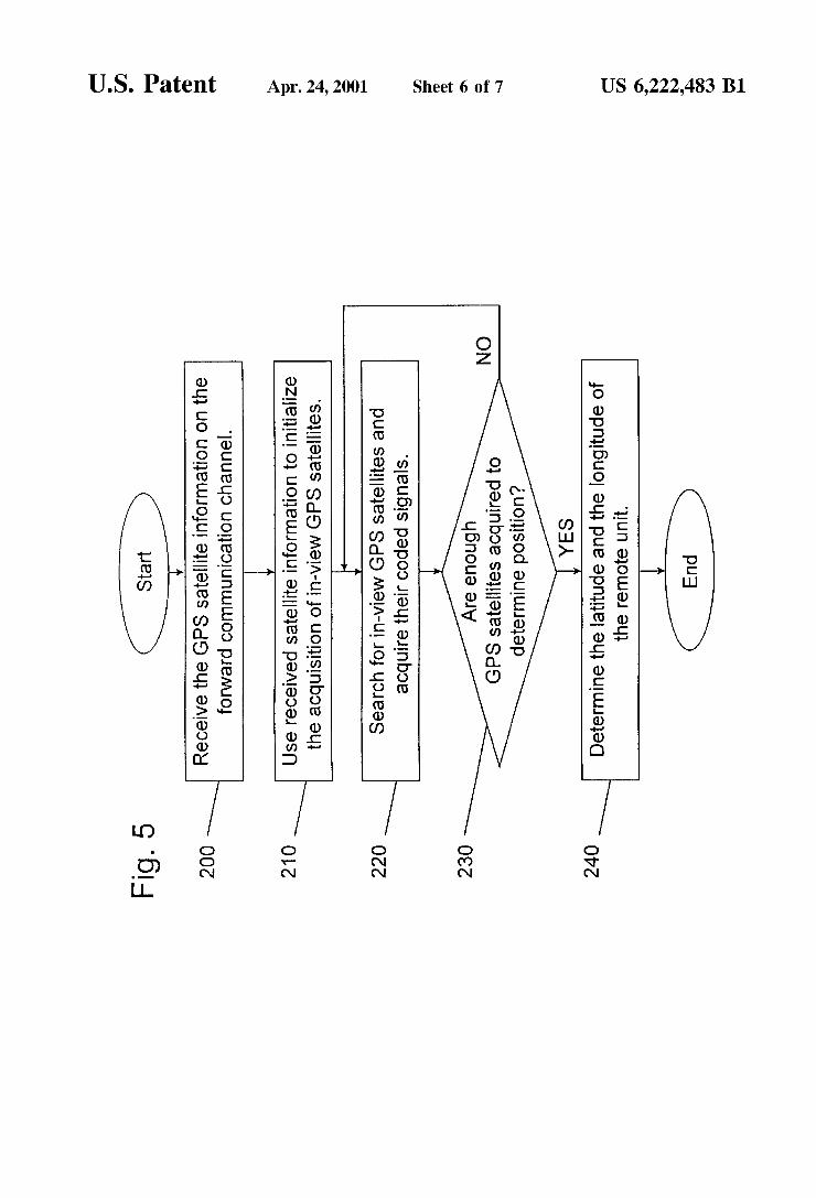
ing the retrieved satellite information is provided to the Wireless communications system 48 through the PSTN. At Block 180, the Wireless communications system 48 trans mits the message to the requesting remote unit 42 over the forWard communication channel of the RF link 44. At Block 190, once received at the remote unit 42 the requested satellite information is utiliZed to locate and acquire coded signals 14 of in-vieW GPS satellites 16 and then to determine an accurate position of the remote unit 42. It should be appreciated that the time for acquisition of the coded signals 14 from orbiting GPS satellites 16 is reduced since satellite ephemerides and timing data provides a prior knoWledge of in-vieW GPS satellites 16. This process is discussed in detail beloW With reference to an algorithm illustrated in FIG. 5.
In FIG. 5, the remote unit 42 receives the satellite infor mation from the satellite information database 54. For example, the remote unit 42 receives satellite ephemerides and timing data particular to those GPS satellites 16 deter mined to be in-vieW of the base station 46 and thus, also in-vieW of the remote unit 42. At Block 200 the satellite information is received at the remote unit 42 on the forWard communication channel from the base station 46. At Block 210, the remote unit 42 utiliZes the received satellite infor mation to initialiZe an acquisition process Which, as described above, searches the PN sequences of received signals so as to acquire coded signals 14 from in-vieW GPS satellites 16. At Block 220, the search continues until enough GPS satellites 16 are located to provide satisfactory data to determine the precise location of the remote unit 42. That is, at Block 230, the number of acquired GPS satellites 16 is compared to a predetermined number of, for example, four GPS satellites. If four GPS satellites have not yet been acquired, then a “NO” path of the algorithm is folloWed and the search for in-vieW GPS satellites continues at Block 220. If, hoWever, enough satellites have been located to deter mine the remote unit’s location, then a “YES” path of the algorithm is folloWed and the determination of the precise position of the remote unit 42 can be determined according to conventional means. That is, at Block 240 the coded signals 14 from the acquired GPS satellites and the satellite information, ie the ephemeris and timing data, are utiliZed to determine a precise latitude and longitude of the remote unit 42. As noted above, a prior knoWledge of the location of
in-vieW GPS satellites 16 can decrease the time required to acquire the coded signals 14 from the GPS satellites 16 and can increase the remote unit’s sensitivity. A perceived dis advantage of conventional methods of providing the prior knoWledge is avoided in the instant invention, since the
10
15
25
35
45
55
65
10 source of the GPS satellite information is implemented outside the Wireless communications netWork. By removing the satellite information database from the Wireless commu nications netWork, While still maintaining accessibility over a communication netWork such as the Internet, the present invention bypasses the need for Wireless communications netWork standardiZation across many Wireless service providers, and furthermore simpli?es the Wireless telecom munications system.
Additionally, the present invention improves the accuracy and validity of the GPS satellite information by employing a time offset Which is used to minimiZe the adverse effects of netWork delays experienced When transmitting the GPS satellite information to a requesting remote unit. As described above, by anticipating the netWork delay a poten tially more precise computation of a remote unit’s latitude and longitude may be realiZed. The time offset may also be used to determine the validity of the GPS satellite informa tion. That is, if a signi?cant delay or offset is detected betWeen the request for, transmission of, or the receipt of the satellite information, then the information may be ignored and a neW request made or, alternatively, the satellite infor mation may be modi?ed before use. Although described in the context of preferred
embodiments, it should be realiZed that a number of modi ?cations to these teachings may occur to one skilled in the art. By example, the teachings of this invention are not intended to be limited to any speci?c communication pro tocol. That is, the Internet interface may readily be replaced With a similarly universal communication platform Which permits access to satellite information to many Wireless communications service providers. Furthermore, the Wire less telecommunications netWork With Which the remote unit communicates may not be a “cellular” netWork per se.
It should also be appreciated that the teachings of the present invention can be applied as Well to Wireline com munication devices. In accordance With the present invention, information retrieved from a centraliZed GPS satellite database is passed over a communication platform such as the Internet to the data communications netWork Which includes the Wireline device. As such, the sensitivity and accuracy of the GPS system Within the Wireline device are improved.
Thus, While the invention has been particularly shoWn and described With respect to preferred embodiments thereof, it Will be understood by those skilled in the art that changes in form and details may be made therein Without departing from the scope and spirit of the invention. What is claimed is: 1. A position locating system for determining a geo
graphic location of a portable remote unit, comprising: a communications system comprising at least one base
station and a system controller, said at least one base station for bi-directionally coupling said remote unit to said system controller through Wireless links; and
a server coupled to said system controller by a commu nication infrastructure external to said communications system, said server comprising a data store Which contains satellite information for a satellite positioning system;
means for transmitting a message from said remote unit to said at least one base station, Wherein said message includes a time stamp indicating a time said message is transmitted;
Wherein in response to said message from said remote unit, said server provides satellite information to said system controller over said communication infrastruc
US 6,222,483 B1 11
ture such that said provided satellite information is passed to said remote unit by said at least one base station;
Wherein said provided satellite information comprises information to aid in acquiring a predetermined number of satellites, said acquired satellites providing coded signals for determining said geographic location of said remote unit; and
Wherein said server further comprises means for evaluat ing said time stamp to determine a time delay betWeen said time stamp and a time said message from said remote unit Was received, said server providing said satellite information in accordance With said time delay such that said provided satellite information represents said satellites at a time said provided satellite informa tion is received at said remote unit.
2. The position locating system as set forth in claim 1, Wherein said communication system is comprised of a cellular telephone netWork.
3. The position locating system as set forth in claim 2, Wherein said communication infrastructure is comprised of the Internet Which is coupled to said cellular telephone netWork through a public sWitched telephone netWork (PSTN).
4. The position locating system as set forth in claim 1, Wherein said remote unit is comprised of an integrated portable global positioning system (GPS) receiver and a mobile radiotelephone.
5. The position locating system as set forth in claim 1, Wherein said remote unit comprises:
means for receiving said satellite information provided by said at least one base station;
processing means for analyZing said provided satellite information and for acquiring said predetermined num ber of satellites, Wherein said acquired satellites com prise satellites in-vieW of said at least one base station as determined from said provided satellite information; and
means for receiving coded signals from each of said acquired positioning satellites.
6. The position locating system as set forth in claim 5, Wherein said received satellite information includes a second time stamp indicating When said received satellite informa tion Was transmitted from said server, and Wherein said processing means analyZes said second time stamp to deter mine a characteristic of said received satellite information.
7. The position locating system as set forth in claim 5, Wherein said message from said remote unit further com prises a value representing an approximate location of said remote unit.
8. The position locating system as set forth in claim 7, Wherein said approximate location of said remote unit is comprised of one of a latitude and a longitude of said at least one base station Which is servicing said remote unit, and a System ID (SID) of said communication system.
9. The position locating system as set forth in claim 1, Wherein said time stamp is comprised of a GPS time.
10. The position locating system as set forth in claim 1, Wherein said satellite information provided by said server is comprised of a message, said message comprising a ?rst ?eld containing a value representing a time stamp af?xed to said message by said server at a time said message is transmitted, and ?elds containing values representing satel lite almanac, ephemerides, timing data, data representing velocity vectors of said satellites, data representing an indication of Which of said satellites are in-vieW of said at least one base station, and data representing signal strengths of said coded signals from said in-vieW satellites.
11. The position locating system as set forth in claim 1, Wherein said satellite positioning system is comprised of a
10
15
25
35
45
55
65
12 GPS satellite positioning system and said predetermined number of satellites is comprised of at least four GPS satellites.
12. A method for determining a geographic location of a portable remote unit, the method comprising the steps of:
providing a communication system comprising at least one base station and a system controller, the at least one base station bi-directionally coupling the remote unit to the system controller through Wireless links;
transmitting a message from the remote unit to the system controller through the at least one base station, the transmitted message including a time stamp;
in response to the transmitted message, requesting satel lite information from a server coupled to the system controller, the server containing satellite information for a satellite positioning system;
in reply to the request, retrieving the requested satellite information from the server;
providing the retrieved satellite information to the remote unit; and
acquiring a predetermined number of satellites of the satellite positioning system in accordance With the provided satellite information, Wherein the acquired satellites provide coded signals for determining the geographic location of the remote unit;
Wherein the step of retrieving the requested satellite information further comprises the steps of: determining a time delay betWeen the time stamp and
time the message from the remote unit Was received; querying a satellite information database stored in a
data store of the server using the time delay and the determined approximate location of the remote unit Within the request for satellite information;
Wherein the retrieved satellite information is comprised of the results of the database query.
13. The method for determining a geographic location of a portable remote unit as set forth in claim 12, Wherein the communication system is comprised of a cellular telephone netWork.
14. The method for determining a geographic location of a portable remote unit as set forth in claim 13, Wherein the communication infrastructure is comprised of the Internet Which couples the cellular telephone netWork through a public sWitched telephone netWork (PSTN) to an Internet server.
15. The method for determining a geographic location of a portable remote unit as set forth in claim 10, Wherein the step of transmitting a message from the remote unit further comprising the steps of:
determining an approximate location of the remote unit; and
formatting the message to be transmitted to include the determined approximate location.
16. The method for determining a geographic location of a portable remote unit as set forth in claim 15, Wherein When a latitude and a longitude of the at least one base station servicing the remote unit is knoWn to the remote unit, the step of determining an approximate location of the remote unit is comprised of a step of assigning to the approximate location a value representing the knoWn latitude and longi tude of the at least one base station.
17. The method for determining a geographic location of a portable remote unit as set forth in claim 15, Wherein When the latitude and the longitude of the at least one base station servicing the remote unit is not knoWn to the remote unit, the step of determining an approximate location of the remote unit is comprised of a step of assigning to the approximate location a value representing a System ID (SID) of the communication system.
US 6,222,483 B1 13
18. The method for determining a geographic location of a portable remote unit as set forth in claim 12, Wherein the step of providing the retrieved satellite information further comprising the step of:
23. A position locating system for determining a geo graphic location of a communication unit, comprising:
14 a communications system comprising a central control
station, said control station bi-directionally coupled to said communication unit; and
a server coupled to said control station by a communica
formatting a message comprising a ?rst ?eld containing a 5 non lnfrastrucmre external to Sald commumcatms value representing a second time stamp af?xed to the System’ Sald .SerYer compnsmg a data! store. .Wh.1Ch message by the Server at a time the message is contains satellite information for a satellite pos1t1on1ng provided, and ?elds containing the results of the data- SYSFeHP . . base query; wherein in response to a messagefrom said communica
. . . t1on unit, said message including a time stamp, sa1d wherein the results of the database query include satellite 10 -d temte information to Said Control
almanac, ephemerides, timing data, data representing Sewer provl 65. Sa - - - . . . . stat1on over said communication infrastructure such
veloclty Vectors of Sald Satelhtes’ data represennng an that said rovided satellite information is assed to said indication of Which of said satellites are in-vieW of said - - _ p
. . . communication unit, at least one base station, and data representing signal . . . . . . .
strengths of said coded signals from said in-vieW 15 Wherem Said proYlded satélllte mformanot} Compnses Satellites‘ information to aid in acquiring a predetermined number
19. AWireless communication system, comprising: of Satelhtes’ Sa1d.a?qu1re.d satelhtesprovldlng C°d‘°:d signals for determining sa1d geographic location of said
a System Controller; _ communication unit; and at least one moblle Stanon; and Wherein said server further comprises means for evaluat at least one base station for bi-directionally coupling said 20 mg Said time Stamp to determine a time delay between
at least one mobile station to said system controller Said time Stamp and a time Said message from Said through Wireless links; communication unit Was received, said server provid
Wherein said system controller comprises an interface for ing said satellite information in accordance With said relaying a message from said at least one mobile station time delay such that said provided satellite information to said communications netWork, said message includ- 25 represents said satellites at a time said provided satellite ing a time stamp, and for receiving a reply, in response information is received at said communication unit. to said message, from a satellite positioning data server 24. The communication system as set forth in claim 23, that is coupled to said communication netWork, said Wherein said communication infrastructure external to said reply being transmitted to said at least one mobile communications system is comprised of the Internet. station to aid said at least one mobile station in acquir- 25. A mobile radiotelephone, comprising: ing Positioning Satellites; and 30 a GPS receiver for receiving coded signals from a plu
Wherein said server further comprises means for evaluat- rality of satellites, said coded signals for determining a ing said time stamp to determine a time delay betWeen geographic location of said mobile radiotelephone; Said time Stamp and a time Said message from Said a telecommunication transmitter for transmitting a mes mobile station Was received, said server providing said Sage from Said mobile radiotelephone to a Communi satellite information in accordance With said time delay 35 Cation System, Said message including a time Stamp, such that said provided satellite information represents Said Communication System coupled to a Communica said satellites at a time said provided satellite informa- tion infrastructure external to Said Communication Sys tion is received at said mobile station. tern;
20- The Wireless Communication System as Set forth in a telecommunication receiver for receiving, in response to claim 19, Wherein said communications netWork is com- 40 Said transmitted message, Satellite information from prised of a Communications network Operating With TCP/IP said external communication infrastructure through network Protocol? _ _ _ said communication system Which aids said mobile 21 A Communlcatlon System, comprlslng? radiotelephone in acquiring and receiving said coded a network; signals from said plurality of satellites; and a plurality of Wireless Service Providers having a plurality 45 Wherein said server further comprises means for evaluat
Of Subscriber units, each of Said plurality of Service ing said time stamp to determine a time delay betWeen Providers being bi'direc?onauy coupled to Said net- said time stamp and a time said message from said Work; and transmitter Was received, said server providing said
a satellite positioning data server bi-directionally coupled satellite information in accordance With said time delay to said netWork for replying to requests received from 50 such that said provided satellite information represents individual ones of said plurality of service providers for said satellites at a time said provided satellite informa individual ones of said plurality of subscriber units, tion is received at said mobile radiotelephone. each of said requests including a message having a time 26. The mobile radiotelephone as set forth in claim 25, stamp and providing an approximate geographical Wherein said satellite information from said external com location of individual ones of said requesting sub- 55 munication infrastructure is stored in a server coupled to scriber units; said external communication infrastructure.
Wherein said server further comprises means for evaluat- 27. The mobile radiotelephone as set forth in claim 25, ing said time stamp to determine a time delay betWeen Wherein said external communication infrastructure is com said time stamp and a time said message from said prised of the Internet. subscriber unit Was received, said server providing said 28. The method for determining a geographic location of satellite information in accordance With said time delay 60 a portable remote unit as set forth in claim 11, Wherein the such that said provided satellite information represents server is coupled to the system controller by a communica said satellites at a time said provided satellite informa- tions infrastructure external to the communications system. tion is received at said subscriber unit. 29. The Wireless communications system as set forth in
22. The communication system as set forth in claim 21, claim 19, Wherein said interface is to an external commu Wherein said netWork is comprised of the Internet. 65 nications netWork.