Embed Size (px)
Citation preview

Case No. 20-1757-EL-BGN
Union Ridge Solar
Exhibit M
Solar Glare Analysis Report

Solar Glare Analysis Report Union Ridge Solar Harrison Township, Licking County, Ohio Prepared for: Leeward Renewable Energy, LLC 6688 North Central Expressway, Suite 500 Dallas, Texas 75206 Contact: Kelly Pacifico Tel: (941) 735-0776 Prepared by:
Environmental Design & Research, Landscape Architecture, Engineering & Environmental Services, D.P.C. 217 Montgomery Street, Suite 1000 Syracuse, New York 13202 315.471.0688 March 2021

Union Ridge Solar Solar Glare Analysis ii
TABLE OF CONTENTS 1.0 PROJECT OVERVIEW .................................................................................................................................... 1
2.0 BACKGROUND ............................................................................................................................................... 1
3.0 METHODS ....................................................................................................................................................... 3
4.0 RESULTS ........................................................................................................................................................ 6
5.0 CONCLUSIONS .............................................................................................................................................. 6
LIST OF TABLES Table 1. Summary of SGHAT Model Inputs ................................................................................................................... 5
LIST OF FIGURES
Figure 1: Regional Project Location Figure 2: Proposed Project Layout Figure 3: Receptors and Road Segments
LIST OF ATTACHMENTS Attachment A: ForgeSolar Glare Analysis
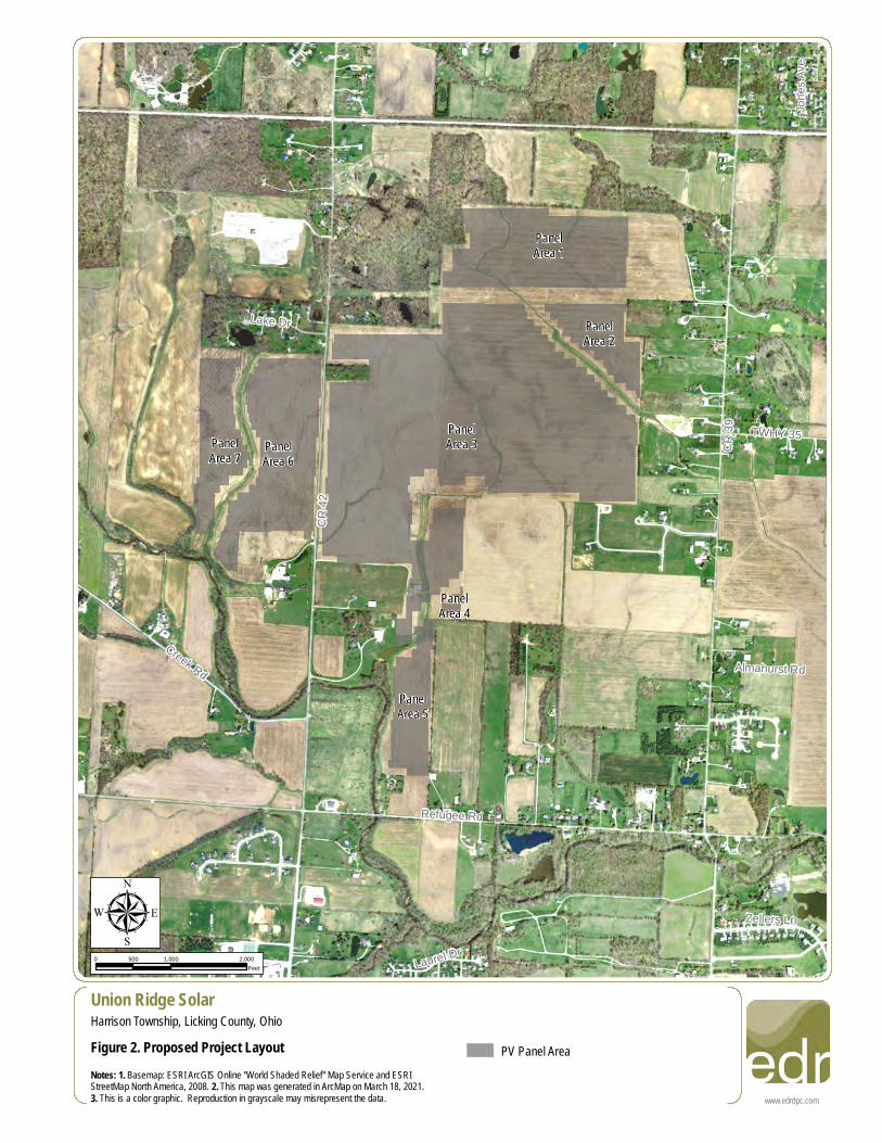
1.0 PROJECT OVERVIEW Union Ridge Solar, LLC (Union Ridge or Applicant), is proposing to construct a 107.7-megawatt (MW) solar energy generation facility in Licking County, Ohio (hereafter referred to as the Project) (see Figure 1). This report provides an assessment of the potential for solar related glare and glint that could be experienced at residences, airports, and roadways located near the proposed Project. The Applicant is proposing the use of single axis tracking photovoltaic (PV) arrays. Each PV array will be comprised of linear rows of PV modules oriented in a north-south direction and equipped with electric motors that slowly rotate the PV panels to track the movement of the sun and minimize the angle of incidence between the sun and the panels. The PV arrays will have a 60-degree resting angle (i.e., will face east at sunrise). The height of the panels will vary as the structures tilt to follow the sun throughout the day. At their tallest position, the PV panels will be approximately 16 feet tall. For this analysis, panels were split or combined into seven named solar arrays and they covered approximately 380 acres of land (Figure 2). The Project is located within Harrison Township, Licking County, Ohio, approximately 1.5 miles east of Pataskala and 14 miles southwest of Newark. Elevations in the Project area range from approximately 950 feet above mean sea level (amsl) to 1,040 feet amsl. Land cover within the vicinity of the Project is dominated by active agriculture, with farms and single-family residences generally located along road frontages.
2.0 BACKGROUND Glare and glint are closely related, but distinct, solar phenomena. Glare is defined as a continuous source of bright light, whereas glint is defined as a momentary flash of bright light. Both glint and glare are common in the existing environment. The sun and artificial light sources can cause glare or glint either directly (such as from a sunset when driving westbound) or indirectly (such as from the sun’s reflection off a lake or glass window). Glare can be received by observers that are either stationary or moving, whereas glint is possible only when the observer is moving rapidly, as is often the case with motorists and aviators. As an example, a motorist traveling along a lake with a forested shoreline, may have only brief glimpses of sunlight reflected off of the water at sunset (i.e., glint), whereas an adjacent home with visibility of the water through a break in the foliage may have a continuous source of bright light (i.e., glare) when sunlight strikes the water at the right angle. The potential effects of glare include annoyance impacts, such as distraction, after-image in the viewer’s vision, or temporary avoidance of a view due to the presence of reflected light (Dwyer, 2017; Slana, 2018); safety impacts, such as the potential to disorient motorists or pilots (Auffray et al., 2007; Ho et al., 2011; Riley and Olson, 2011); and human

health impacts, such as permanent retinal damage (Ho et al., 2009).1 Although less pronounced when compared to glare, the effects of glint are similar and have been conservatively treated the same in all analyses presented in this report. Accordingly, the potential for glint and glare solar phenomena is collectively referred to as glare in the remainder of this report. As there is an inverse correlation between light absorption and reflection, PV panels are designed to absorb as much of the solar spectrum as possible to maximize efficiency. Virtually all PV panels installed in recent years have at least one anti-reflective coating on the glass to minimize reflection and maximize absorption. However, the front-facing surfaces of PV modules are smooth, specular surfaces that have the potential to reflect a significant proportion of the incoming solar radiation at high incidence angles, much like windows on a building or the surface of a pond or lake at sunrise or sunset (Parretta et al., 1999). Under clear sky conditions, fixed-tilt PV arrays can produce glare in the early morning and evening when the sun is low on the horizon and the incidence angle between the PV panels and the sun is approximately 60 degrees or greater (Riley and Olsen, 2011). Unlike fixed-tilt systems, tracking PV arrays maintain relatively low incidence angles and thereby minimize the potential for glare to be produced. Glare that may be produced by a flat-plate PV array can be separated into two general categories: glare with a potential to cause a temporary after-image (i.e., “yellow glare”) and glare with a low potential to produce an after-image (i.e., “green glare”).2 Green glare is relatively low in intensity and is unlikely to produce an after-image. Yellow glare is similar in intensity to glare received from other sources regularly encountered by motorists (e.g., the rising or setting sun and the reflection of the sun off water features, windows, curtain wall buildings, and other smooth surfaces). Yellow glare has the potential to produce a temporary after-image and could temporarily affect a passing motorist. In order to accurately determine the occurrence, duration, and intensity of glare produced by a photovoltaic system at a given observation point, the following information is needed:
(1) Location, orientation, and reflectance of the PV panels; (2) Location of the observation point; (3) Position of the sun; (4) Direct Normal Irradiance (DNI); and
1 Note: human health impacts are typically only associated with concentrating solar power plants or other convex reflective surfaces (e.g., convex curtain wall buildings) that concentrate the incoming solar radiation. Flat-plate photovoltaic systems, such as the proposed Project, do not produce the retinal irradiance levels necessary to result in permanent retinal damage. 2 “Red” glare, which is glare that has the potential to cause eye damage, is typically not possible for non-concentrating solar energy facilities such as the proposed Project.
(5) Geospatial characteristics of any topography, vegetation, buildings, or other potential obstructions between the observation point and the PV panels producing glare and between the PV panels and the sun.
With these inputs, the location and duration of glare can be predicted using computer modeling programs together with follow-up visibility and climatological analyses, as needed. The following terms are used throughout this assessment.
Direct Normal Irradiance (DNI)
The amount of solar radiation received per unit area by a surface that is always held perpendicular (or normal) to the rays that come in a straight line from the direction of the sun at its current position in the sky.
Diffuse Solar Radiation: Solar radiation scattered by molecules and particles in the atmosphere. Direct Solar Radiation: Solar radiation that has travelled from the sun to the earth’s surface in a straight line without
scattering. Direct radiation is the component of solar radiation that causes visible glare from flat-plate photovoltaic systems.
Glare: Glint:
A continuous source of bright light. Momentary flash of bright light.
Incidence Angle: The angle between the direct component of insolation (i.e., the sun) and a ray perpendicular to the PV panel.
PV Panels: Photovoltaic panels that are fixed to a ground mounted racking system. On this Project, a single-axis tracking system is proposed.
Solar Array: A contiguous group of PV panels which collectively will be enclosed by security fencing and landscape screening plantings, where applicable.
Specular Reflection: The mirror-like reflection of waves, such as light, from a surface.
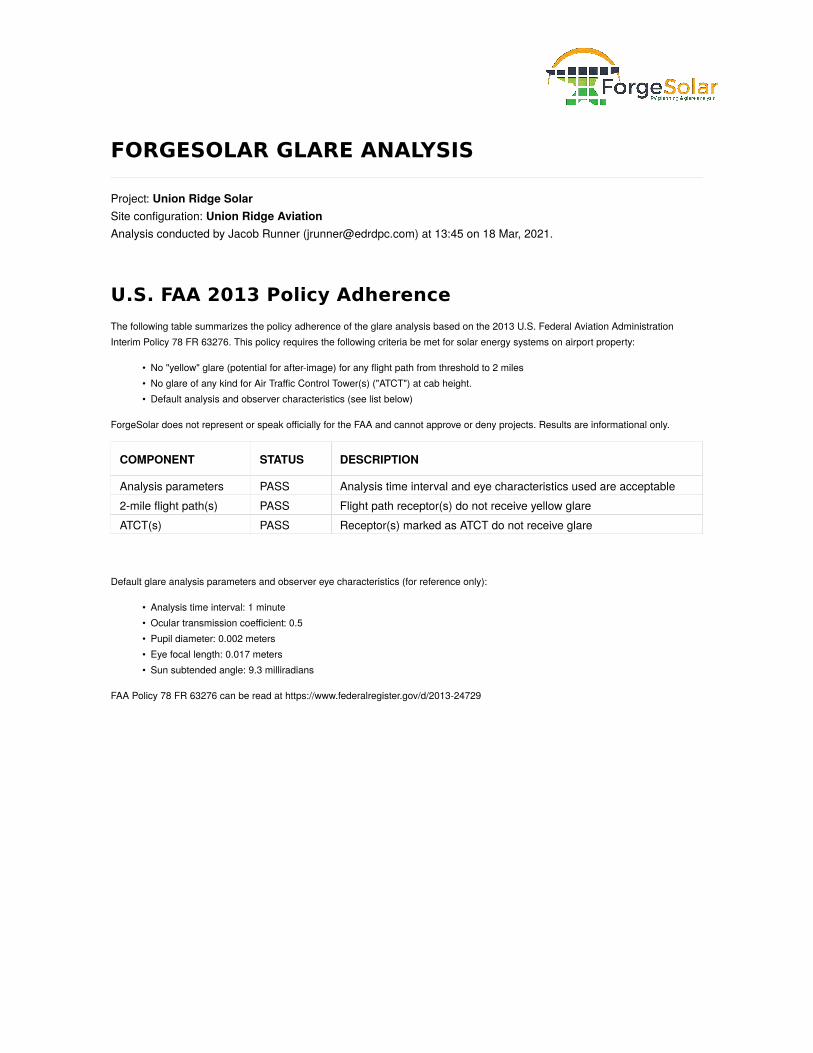
3.0 METHODS ForgeSolar, a commercial software based on the Solar Glare Hazard Analysis Tool (SGHAT) that was developed by Sandia National Laboratories, was used to evaluate the potential for glare for this Project (Ho et al., 2015). ForgeSolar is an industry standard software available to evaluate the potential for glare from a PV system. This software was initially developed for use by the Federal Aviation Administration (FAA) in evaluating safety impacts to pilots while landing aircraft (Ho et al., 2015) and use of this tool to assess glare at airports remains an accepted method in keeping with the FAA’s Interim Solar Policy. The scope of SGHAT’s analytical tools has expanded to include the potential for a PV system to produce glare that may be received by terrestrial receptors, such as residences and motorists. ForgeSolar provides a quantified assessment of when and where glare may occur throughout the year from solar installations, as well as identifying the potential effects on the human eye when glare does occur. However, the

application of this tool in determining the occurrence, duration, and intensity of glare ensures a conservative analysis since it is based on a clear sky and bare earth model, i.e., it does not take into account atmospheric conditions that scatter incoming solar radiation and terrestrial obstructions that visually block the receipt of glare by an observer. Accordingly, SGHAT outputs represent the worst-case scenario.
No consistent national, state, county, or local standards exist that set parameters that could be used to guide the development of a study area for assessing solar glare impacts. However, standards developed in other countries may provide some guidance. In Germany and Switzerland solar glare assessments must be conducted for all dwellings that are located within 100 meters of a solar energy generating facility (Zehndorfer Engineering, 2019). The Study Area selected for this solar impact assessment was conservatively expanded to include all residences and roadways within 1,500 feet and all airports within 2 miles of the Project footprint.3
For this Project, glare was analyzed for the following potentially sensitive receptors. 1. Residences (i.e., receptors) located within the Study Area of the Project.
• A total of 92 residences were identified within the search radius.2. No commercial airports were identified within two miles of the Project. However, a private airport within
two miles and the three closest commercial airports were analyzed to provide a conservative analysis.
• Lee’s Dogpatch Airport – 1.3 miles south of the Project
• Miller Farm Landing Strip – 6.5 miles south of the Project
• Newark-Heath Airport – 9.5 miles east of the Project
• John Glenn Columbus International Airport – 12 miles west of the Project3. Travel routes (i.e., roadways) located within or adjacent to the Project.
• County Route 34 (Blacks road SW) – Located 2,500-feet north of the Project, runs east to west (Route 1)
• County Route 30 (Refugee Road) – Located on the extreme southern border of the Project, runs east to west (Route 2)
• County Route 39 (York Road SW) – Located near the eastern border of the Project, runs north to south (Route 3)
• County Route 42 (Watkins Road SW) – Runs roughly north to south through the Project (Route 4)
• County Route 151 – Located south west of the western border of the Project (Route 5)
3 Although a Study Area with a 2-mile radius is used in many glare reports in assessing impacts to airports, this is not based on FAA recommendations. A 2-mile radius was selected in this case as ForgeSolar’s modeling software uses a 2-mile approach/departure distance, i.e., the selected Study Area is sufficiently large enough to include not only adjacent airports, but potential approach/departure routes that intersect the Project as well.

Residences and travel routes within the Study Area are labeled and shown in Figure 3. Input variables and assumptions used for solar glare modeling calculations for the proposed Project are described below in Table 1 and in detail in Appendix A.
Table 1. Summary of SGHAT Model Inputs
Parameter Purpose Value
DNI: The maximum Direct Normal Irradiance (DNI) at the given location at solar noon. This variable is given in units W/m2. The peak DNI at solar noon is approximately 1,000 W/m2 on a clear, sunny day.
Variable, based on sun position.
Receptor height: Height above ground of viewer. A height of 5.4 feet represents the average human eye viewing level. 5.4 feet
Route height: Height above ground of traveler in a motor vehicle. 4 feet
Array height: Height above ground for the highest height and average height of the solar panels.
16 feet (Maximum); 8 feet (Middle)
Axis tracking: Indicates the type of tracking used by the panels (if any). Single-axis tracking
Fixed
-Tilt
pane
ls Orientation of array:
Orientation of the array in degrees, measured clockwise from true north.
N/A Tracking Panels Used
Tilt of solar panels: Tilt (elevation angle) of the modules in degrees, where 0° is facing up and 90° is facing horizontally.
N/A Tracking Panels Used
Sing
le-Ax
is Tr
ackin
g
Tilt of tracking axis: Specify the elevation angle of the tracking axis in degrees, where 0° is facing up and 90° is facing horizontally. The panels rotate about the tracking axis.
0°
Orientation of tracking axis:
The orientation of the tracking axis in degrees, measured clockwise from true north. Panels facing south at solar noon would have an orientation of 180°. Panels facing east at solar noon would have an orientation of 90°.
180°
Offset angle of module:
The vertical offset angle between the tracking axis and the panel (if any). 0°
Maximum tracking angle:
The maximum angle the panel will rotate in both the clockwise and counterclockwise directions. 60°
Resting angle: The angle at which the panel will rest overnight. 60°
Module surface material: The type of material comprising the PV modules. Smooth Glass w/o
Anti-Reflection Coating

4.0 RESULTS Results from the glare analysis determined that no glint or glare would be received at any of the identified residences, airports, or travel routes. Attachment A provides a detailed breakdown of the results for each potentially sensitive receptor.
5.0 CONCLUSIONS The Applicant conducted a baseline solar glare analysis using ForgeSolar’s SGHAT software to identify potential glare impacts that may result from the operation of the Project. This analysis was conducted using industry standard methods and model inputs and was conducted to comply with the FAA’s Interim Solar Policy. The results of this analysis indicate that none of the potentially sensitive receptors located within or adjacent to the Project Site will receive glare from the Project. This result is consistent with the Project’s proposed use of tracking PV arrays. As noted above, tracking PV arrays maintain low incidence angles by following the sun’s position throughout the day. This increases the amount of incoming solar radiation absorbed by the panels and limits the amount reflected. For this reason, tracking PV arrays rarely reflect enough sunlight to produce retinal irradiance values (W/m2) sufficient to result in either green or yellow glare.
The Project is not anticipated to result in any glare impacts to identified receptors. As no glare is anticipated, no additional avoidance or mitigation measures are necessary.

REFERENCES Auffray, B., Monsere, C.M. and Bertini, R.L., 2008, January. An empirical investigation of the impacts of sun-related glare on traffic flow. In Proc., 87th Annual Meeting of Transportation Research Board (CD-ROM), Transportation Research Board, Washington, DC. Dwyer, C. (2017). Solar Glare: Guidelines and best practice for assessing solar glare in the City of London (Rep.). Available at: http://preview.cityoflondon.contensis.cloud/assets/Services-Environment/solar-glare-planning-advice-note.pdf. Ho, C.K., Ghanbari, C.M. and Diver, R.B., 2009. Hazard Analyses of Glint and Glare from Concentrating Solar Power Plants (No. SAND2009-4131C). Sandia National Lab.(SNL-NM), Albuquerque, NM (United States). Ho, C. K., C. M. Ghanbari, R. B. Diver. 2011. Methodology to assess potential glint and glare hazards from concentrating solar power plants: Analytical models and experimental validation. Journal of Solar Energy Engineering 133:1-9. Ho, C. K., C. A. Sims J. Yellowhair, E. Bush. 2015. Solar Glare Hazard Analysis Tool (SGHAT) Technical Reference Manual. Sandia National Laboratories. Available at: https://share-ng.sandia.gov/glare-tools/references/SGHAT_Technical_Reference-v6.pdf. Parretta, A., Sarno, A., Tortora, P., et al., “Angle-dependent reflectance measurements on photovoltaic materials and solar cells,” Optics Communications, vol. 172, no. 1, pp. 139–151, 1999. Slana, J. (2018). Solar Glare Catalogue Development For Solar Photovoltaic Project Proposals (Unpublished report). University of Calgary, Calgary, AB. Riley, E., S. Olson. 2011. A Study of the Hazardous Glare Potential to Aviators from Utility-Scale Flat-Plate Photovoltaic Systems. ISRN Renewable Energy 2011: Article ID 651857, 6 pages. Zehndorfer Engineering (2019). Solar Glare and Glint Project. Report ZE19060‐AUC produced for the Alberta Utilities Commission.

Figures

Sunbury
Baltimore
Bremen
FairfieldBeach
Lancaster
Millersport
Pickerington
Bexley
BlacklickEstates
CanalWinchester
Columbus
Gahanna
Groveport
Huber Ridge
Minerva Park
NewAlbany
Obetz
Reynoldsburg
Westerville
Whitehall
BeechwoodTrails
Buckeye Lake
Granville
GranvilleSouth
Harbor Hills
Heath
Hebron
Johnstown
Newark
Pataskala
Utica
Ashville
UV16
UV752
UV104
UV605
UV316
UV204
UV161
UV158
UV793
UV317
UV3
UV710
UV657
UV37
UV661
UV61
UV79
UV188
UV664
UV256
UV310
UV674
UV13
£¤33
£¤62
£¤36
£¤22
£¤40
§̈¦670
§̈¦270
§̈¦71
§̈¦70
www.edrdpc.com
µUnion Ridge SolarHarrison Township, Licking County, Ohio
Figure 1. Regional Project LocationNotes: 1. Basemap: ESRI ArcGIS Online "World Shaded Relief" Map Service and ESRI StreetMap North America, 2008. 2. This map was generated in ArcMap on March 18, 2021.3. This is a color graphic. Reproduction in grayscale may misrepresent the data.
0 5 102.5Miles
Project Area
Refugee RdJo
nes
Ave
Laurel Dr
Lake Dr
TWHY 35
Zellers Ln
Almahurst Rd
CR
39
CR
42
Creek Rd
PanelArea 3
PanelArea 4
PanelArea 5
PanelArea 7
PanelArea 6
PanelArea 1
PanelArea 2
www.edrdpc.com
µUnion Ridge SolarHarrison Township, Licking County, Ohio
Figure 2. Proposed Project LayoutNotes: 1. Basemap: ESRI ArcGIS Online "World Shaded Relief" Map Service and ESRI StreetMap North America, 2008. 2. This map was generated in ArcMap on March 18, 2021.3. This is a color graphic. Reproduction in grayscale may misrepresent the data.
0 1,000 2,000500Feet
PV Panel Area

TWHY 35
Lake Dr
Refugee Rd
CR
39
Creek Rd
CR
42
CR 34
PanelArea 3
PanelArea 4
PanelArea 5
PanelArea 7 Panel
Area 6
PanelArea 1
PanelArea 2
683684
685686
687
688
689
690
691
692693
694695
696
697
698700
701
711712713714715
716
717
718719
720 721722723
724725726
727
728
729
730731
732733734735736 737
738
739
922923
924
925
926
927
928929
930
931932
933
934 935
936937
938
939940942
994
996
997
9991000
1001
1002
100310041005
10061007
1008
100910101011
10121013 1014
101610171018
1019
1022
Route 5
Route 2
Route 1
Route 4
Route 3
www.edrdpc.com
µUnion Ridge SolarHarrison Township, Licking County, Ohio
Figure 3. Receptors and Road SegmentsNotes: 1. Basemap: ESRI ArcGIS Online "World Shaded Relief" Map Service and ESRI StreetMap North America, 2008. 2. This map was generated in ArcMap on March 18, 2021.3. This is a color graphic. Reproduction in grayscale may misrepresent the data.
0 1,000 2,000500Feet
Study Receptor
Route
PV Panel Area
1,500-foot Study Area

Attachment A ForgeSolar Glare Analysis
FORGESOLAR GLARE ANALYSIS
Project: Union Ridge SolarSite configuration: Union Ridge AviationAnalysis conducted by Jacob Runner ([email protected]) at 13:45 on 18 Mar, 2021.
U.S. FAA 2013 Policy Adherence
The following table summarizes the policy adherence of the glare analysis based on the 2013 U.S. Federal Aviation AdministrationInterim Policy 78 FR 63276. This policy requires the following criteria be met for solar energy systems on airport property:
• No "yellow" glare (potential for after-image) for any flight path from threshold to 2 miles• No glare of any kind for Air Traffic Control Tower(s) ("ATCT") at cab height.• Default analysis and observer characteristics (see list below)
ForgeSolar does not represent or speak officially for the FAA and cannot approve or deny projects. Results are informational only.
COMPONENT STATUS DESCRIPTION
Analysis parameters PASS Analysis time interval and eye characteristics used are acceptable2-mile flight path(s) PASS Flight path receptor(s) do not receive yellow glareATCT(s) PASS Receptor(s) marked as ATCT do not receive glare
Default glare analysis parameters and observer eye characteristics (for reference only):
• Analysis time interval: 1 minute• Ocular transmission coefficient: 0.5• Pupil diameter: 0.002 meters• Eye focal length: 0.017 meters• Sun subtended angle: 9.3 milliradians
FAA Policy 78 FR 63276 can be read at https://www.federalregister.gov/d/2013-24729

Site Con�guration: Union Ridge
Summary of Results No glare predicted!
PV Name Tilt Orientation "Green" Glare "Yellow" Glare Energy Produced
deg deg min min kWh
1 SA tracking SA tracking 0 0 -
2 SA tracking SA tracking 0 0 -
3 SA tracking SA tracking 0 0 -
4 SA tracking SA tracking 0 0 -
5 SA tracking SA tracking 0 0 -
6 SA tracking SA tracking 0 0 -
7 SA tracking SA tracking 0 0 -
Component Data
PV Array(s)
Project site configuration details and
results.Created Oct. 29, 2020 1:04 p.m.
Updated March 18, 2021 10:16 a.m.
DNI varies and peaks at 1,000.0 W/m^2
Analyze every 1 minute(s)
0.5 ocular transmission coefficient
0.002 m pupil diameter
0.017 m eye focal length
9.3 mrad sun subtended angle
Timezone UTC-5
Site Configuration ID: 45044.8028
ForgeSolar
Union Ridge Site Config | ForgeSolar https://www.forgesolar.com/projects/8028/configs/45044/
1 of 38 3/18/2021, 10:24 AM

Note: PV array encompasses a large surface area (greater than 25 acres). Accuracy of path receptor glare
analysis may be affected by footprint size. Additional analyses of array sub-sections may provide more
information on expected glare.
Name: 1
Axis tracking: Single-axis rotation
Tracking axis orientation: 180.0 deg
Tracking axis tilt: 0.0 deg
Tracking axis panel offset: 0.0 deg
Maximum tracking angle: 60.0 deg
Resting angle: 60.0 deg
Rated power: -
Panel material: Smooth glass without AR
coating
Vary reflectivity with sun position? Yes
Correlate slope error with surface type? Yes
Slope error: 6.55 mrad
Approx. area: 2,215,359 sq-ft
Vertex Latitude Longitude
Ground
elevation
Height above
ground
Total
elevation
deg deg ft ft ft
1 39.991891 -82.630593 1038.15 8.00 1046.15
2 39.990443 -82.630593 1029.85 8.00 1037.85
3 39.990438 -82.630701 1030.75 8.00 1038.75
4 39.989324 -82.630701 1026.95 8.00 1034.95
5 39.989324 -82.639376 1013.75 8.00 1021.75
6 39.989883 -82.639376 1017.15 8.00 1025.15
7 39.989884 -82.638874 1017.25 8.00 1025.25
8 39.990723 -82.638874 1014.25 8.00 1022.25
9 39.990723 -82.638068 1015.25 8.00 1023.25
10 39.991283 -82.638068 1026.75 8.00 1034.75
11 39.991283 -82.638283 1022.25 8.00 1030.25
12 39.991612 -82.638283 1026.55 8.00 1034.55
13 39.991612 -82.638498 1024.35 8.00 1032.35
14 39.991891 -82.638498 1028.55 8.00 1036.55
15 39.991891 -82.638821 1023.25 8.00 1031.25
16 39.992171 -82.638821 1030.35 8.00 1038.35
17 39.992171 -82.634376 1040.05 8.00 1048.05
18 39.991891 -82.634376 1039.55 8.00 1047.55
Union Ridge Site Config | ForgeSolar https://www.forgesolar.com/projects/8028/configs/45044/
2 of 38 3/18/2021, 10:24 AM

Name: 2
Axis tracking: Single-axis rotation
Tracking axis orientation: 180.0 deg
Tracking axis tilt: 0.0 deg
Tracking axis panel offset: 0.0 deg
Maximum tracking angle: 60.0 deg
Resting angle: 60.0 deg
Rated power: -
Panel material: Smooth glass without AR
coating
Vary reflectivity with sun position? Yes
Correlate slope error with surface type? Yes
Slope error: 6.55 mrad
Approx. area: 747,758 sq-ft
Vertex Latitude Longitude
Ground
elevation
Height above
ground
Total
elevation
deg deg ft ft ft
1 39.988715 -82.634536 1009.15 8.00 1017.15
2 39.988715 -82.630701 1017.75 8.00 1025.75
3 39.988435 -82.630701 1017.35 8.00 1025.35
4 39.988435 -82.630808 1017.65 8.00 1025.65
5 39.987315 -82.630808 1028.05 8.00 1036.05
6 39.987315 -82.630038 1023.75 8.00 1031.75
7 39.985307 -82.630038 1001.55 8.00 1009.55
8 39.985307 -82.630199 1000.45 8.00 1008.45
9 39.985586 -82.630199 1002.35 8.00 1010.35
10 39.985587 -82.630701 999.55 8.00 1007.55
11 39.985861 -82.630701 1001.15 8.00 1009.15
12 39.985867 -82.631239 999.85 8.00 1007.85
13 39.986147 -82.631239 1002.15 8.00 1010.15
14 39.986147 -82.631561 1000.55 8.00 1008.55
15 39.986426 -82.631561 1004.45 8.00 1012.45
16 39.986426 -82.631776 1002.15 8.00 1010.15
17 39.986706 -82.631776 1007.45 8.00 1015.45
18 39.986706 -82.632207 1001.25 8.00 1009.25
19 39.987035 -82.632208 1005.45 8.00 1013.45
20 39.987035 -82.632869 1001.45 8.00 1009.45
21 39.987315 -82.632869 1003.15 8.00 1011.15
22 39.987315 -82.633300 1001.75 8.00 1009.75
23 39.987595 -82.633300 1003.95 8.00 1011.95
24 39.987595 -82.633623 1003.05 8.00 1011.05
25 39.987875 -82.633623 1004.85 8.00 1012.85
26 39.987875 -82.633945 1004.65 8.00 1012.65
27 39.988149 -82.633945 1006.25 8.00 1014.25
28 39.988155 -82.634268 1005.35 8.00 1013.35
29 39.988435 -82.634268 1007.25 8.00 1015.25
30 39.988435 -82.634536 1006.75 8.00 1014.75
Union Ridge Site Config | ForgeSolar https://www.forgesolar.com/projects/8028/configs/45044/
3 of 38 3/18/2021, 10:24 AM
Note: PV array encompasses a large surface area (greater than 25 acres). Accuracy of path receptor glare
analysis may be affected by footprint size. Additional analyses of array sub-sections may provide more
information on expected glare.
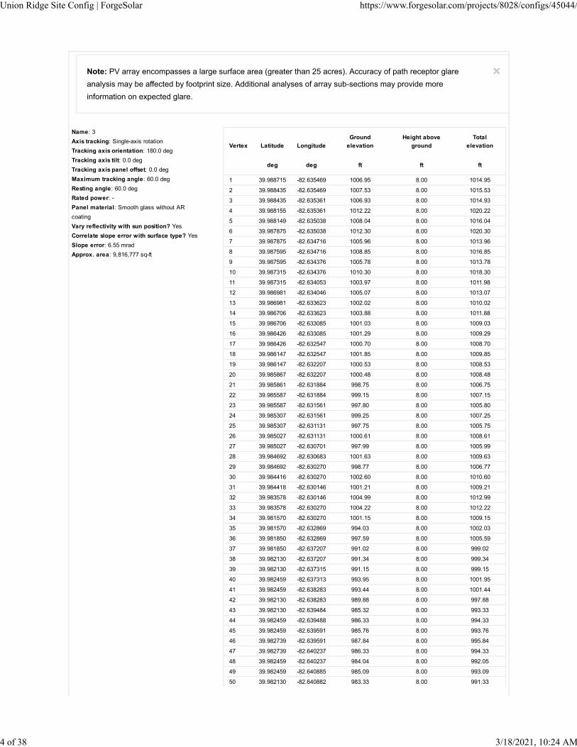
Name: 3
Axis tracking: Single-axis rotation
Tracking axis orientation: 180.0 deg
Tracking axis tilt: 0.0 deg
Tracking axis panel offset: 0.0 deg
Maximum tracking angle: 60.0 deg
Resting angle: 60.0 deg
Rated power: -
Panel material: Smooth glass without AR
coating
Vary reflectivity with sun position? Yes
Correlate slope error with surface type? Yes
Slope error: 6.55 mrad
Approx. area: 9,816,777 sq-ft
Vertex Latitude Longitude
Ground
elevation
Height above
ground
Total
elevation
deg deg ft ft ft
1 39.988715 -82.635469 1006.95 8.00 1014.95
2 39.988435 -82.635469 1007.53 8.00 1015.53
3 39.988435 -82.635361 1006.93 8.00 1014.93
4 39.988155 -82.635361 1012.22 8.00 1020.22
5 39.988149 -82.635038 1008.04 8.00 1016.04
6 39.987875 -82.635038 1012.30 8.00 1020.30
7 39.987875 -82.634716 1005.96 8.00 1013.96
8 39.987595 -82.634716 1008.85 8.00 1016.85
9 39.987595 -82.634376 1005.78 8.00 1013.78
10 39.987315 -82.634376 1010.30 8.00 1018.30
11 39.987315 -82.634053 1003.97 8.00 1011.98
12 39.986981 -82.634046 1005.07 8.00 1013.07
13 39.986981 -82.633623 1002.02 8.00 1010.02
14 39.986706 -82.633623 1003.88 8.00 1011.88
15 39.986706 -82.633085 1001.03 8.00 1009.03
16 39.986426 -82.633085 1001.29 8.00 1009.29
17 39.986426 -82.632547 1000.70 8.00 1008.70
18 39.986147 -82.632547 1001.85 8.00 1009.85
19 39.986147 -82.632207 1000.53 8.00 1008.53
20 39.985867 -82.632207 1000.48 8.00 1008.48
21 39.985861 -82.631884 998.75 8.00 1006.75
22 39.985587 -82.631884 999.15 8.00 1007.15
23 39.985587 -82.631561 997.80 8.00 1005.80
24 39.985307 -82.631561 999.25 8.00 1007.25
25 39.985307 -82.631131 997.75 8.00 1005.75
26 39.985027 -82.631131 1000.61 8.00 1008.61
27 39.985027 -82.630701 997.99 8.00 1005.99
28 39.984692 -82.630683 1001.63 8.00 1009.63
29 39.984692 -82.630270 998.77 8.00 1006.77
30 39.984416 -82.630270 1002.60 8.00 1010.60
31 39.984418 -82.630146 1001.21 8.00 1009.21
32 39.983578 -82.630146 1004.99 8.00 1012.99
33 39.983578 -82.630270 1004.22 8.00 1012.22
34 39.981570 -82.630270 1001.15 8.00 1009.15
35 39.981570 -82.632869 994.03 8.00 1002.03
36 39.981850 -82.632869 997.59 8.00 1005.59
37 39.981850 -82.637207 991.02 8.00 999.02
38 39.982130 -82.637207 991.34 8.00 999.34
39 39.982130 -82.637315 991.15 8.00 999.15
40 39.982459 -82.637313 993.95 8.00 1001.95
41 39.982459 -82.638283 993.44 8.00 1001.44
42 39.982130 -82.638283 989.88 8.00 997.88
43 39.982130 -82.639484 985.32 8.00 993.33
44 39.982459 -82.639488 986.33 8.00 994.33
45 39.982459 -82.639591 985.76 8.00 993.76
46 39.982739 -82.639591 987.84 8.00 995.84
47 39.982739 -82.640237 986.33 8.00 994.33
48 39.982459 -82.640237 984.04 8.00 992.05
49 39.982459 -82.640885 985.09 8.00 993.09
50 39.982130 -82.640882 983.33 8.00 991.33
Union Ridge Site Config | ForgeSolar https://www.forgesolar.com/projects/8028/configs/45044/
4 of 38 3/18/2021, 10:24 AM

51 39.982130 -82.640990 983.07 8.00 991.07
52 39.981850 -82.640990 982.86 8.00 990.87
53 39.981850 -82.640882 982.82 8.00 990.82
54 39.981570 -82.640882 982.49 8.00 990.49
55 39.981570 -82.640775 982.41 8.00 990.41
56 39.980730 -82.640775 981.40 8.00 989.40
57 39.980730 -82.640882 980.50 8.00 988.50
58 39.980116 -82.640881 980.58 8.00 988.58
59 39.980116 -82.639967 981.92 8.00 989.92
60 39.980730 -82.639967 979.99 8.00 987.99
61 39.980730 -82.639806 980.07 8.00 988.08
62 39.981284 -82.639806 981.69 8.00 989.69
63 39.981284 -82.638283 986.02 8.00 994.02
64 39.981010 -82.638283 985.45 8.00 993.45
65 39.981010 -82.638391 984.86 8.00 992.86
66 39.979002 -82.638391 983.25 8.00 991.25
67 39.978996 -82.638606 982.89 8.00 990.89
68 39.978722 -82.638606 981.78 8.00 989.78
69 39.978722 -82.639053 982.62 8.00 990.62
70 39.978442 -82.639053 982.15 8.00 990.15
71 39.978442 -82.639484 980.10 8.00 988.11
72 39.978162 -82.639484 978.54 8.00 986.54
73 39.978162 -82.639914 973.47 8.00 981.47
74 39.977882 -82.639914 973.32 8.00 981.32
75 39.977882 -82.640347 975.40 8.00 983.40
76 39.977553 -82.640344 974.34 8.00 982.34
77 39.977553 -82.640775 978.75 8.00 986.75
78 39.977273 -82.640775 977.53 8.00 985.53
79 39.976459 -82.640793 966.79 8.00 974.79
80 39.976380 -82.641555 967.60 0.00 967.60
81 39.976993 -82.641545 974.05 8.00 982.05
82 39.977273 -82.641545 976.43 8.00 984.43
83 39.977273 -82.641043 978.49 8.00 986.49
84 39.978162 -82.641043 980.46 8.00 988.46
85 39.978162 -82.640990 980.20 8.00 988.20
86 39.978442 -82.640990 980.60 8.00 988.60
87 39.978442 -82.640882 980.64 8.00 988.64
88 39.978722 -82.640882 981.28 8.00 989.28
89 39.978722 -82.640775 980.91 8.00 988.91
90 39.979281 -82.640775 980.67 8.00 988.67
91 39.979281 -82.644305 977.76 8.00 985.76
92 39.979560 -82.644305 973.16 8.00 981.16
93 39.979561 -82.645005 969.60 8.00 977.60
94 39.980730 -82.645005 975.72 8.00 983.73
95 39.980730 -82.644897 977.04 8.00 985.04
96 39.982404 -82.644897 978.76 8.00 986.76
97 39.982404 -82.644790 979.19 8.00 987.19
98 39.984138 -82.644790 985.60 8.00 993.60
99 39.984138 -82.644682 985.25 8.00 993.25
100 39.985861 -82.644682 992.76 8.00 1000.77
101 39.985867 -82.642836 996.54 8.00 1004.54
102 39.986706 -82.642779 1007.70 8.00 1015.70
103 39.986706 -82.644574 995.87 8.00 1003.87
104 39.987315 -82.644574 995.73 8.00 1003.73
105 39.987315 -82.644467 996.26 8.00 1004.26
106 39.987595 -82.644467 996.94 8.00 1004.95
107 39.987595 -82.639376 1013.40 8.00 1021.40
108 39.988155 -82.639376 1011.51 8.00 1019.51
109 39.988715 -82.639376 1012.53 8.00 1020.53
Union Ridge Site Config | ForgeSolar https://www.forgesolar.com/projects/8028/configs/45044/
5 of 38 3/18/2021, 10:24 AM

Name: 4
Axis tracking: Single-axis rotation
Tracking axis orientation: 180.0 deg
Tracking axis tilt: 0.0 deg
Tracking axis panel offset: 0.0 deg
Maximum tracking angle: 60.0 deg
Resting angle: 60.0 deg
Rated power: -
Panel material: Smooth glass without AR
coating
Vary reflectivity with sun position? Yes
Correlate slope error with surface type? Yes
Slope error: 6.55 mrad
Approx. area: 50,601 sq-ft
Vertex Latitude Longitude
Ground
elevation
Height above
ground
Total
elevation
deg deg ft ft ft
1 39.978442 -82.638391 981.95 8.00 989.95
2 39.978162 -82.638391 980.65 8.00 988.65
3 39.977882 -82.638498 979.05 8.00 987.05
4 39.977273 -82.638498 977.25 8.00 985.25
5 39.977273 -82.638874 978.25 8.00 986.25
6 39.977554 -82.638874 979.55 8.00 987.55
7 39.977553 -82.639376 976.15 8.00 984.15
8 39.977827 -82.639376 976.65 8.00 984.65
9 39.977827 -82.638874 979.85 8.00 987.85
10 39.978162 -82.638874 980.95 8.00 988.95
11 39.978162 -82.638498 980.55 8.00 988.55
12 39.978442 -82.638498 981.65 8.00 989.65
Name: 5
Axis tracking: Single-axis rotation
Tracking axis orientation: 180.0 deg
Tracking axis tilt: 0.0 deg
Tracking axis panel offset: 0.0 deg
Maximum tracking angle: 60.0 deg
Resting angle: 60.0 deg
Rated power: -
Panel material: Smooth glass without AR
coating
Vary reflectivity with sun position? Yes
Correlate slope error with surface type? Yes
Slope error: 6.55 mrad
Approx. area: 826,792 sq-ft
Vertex Latitude Longitude
Ground
elevation
Height above
ground
Total
elevation
deg deg ft ft ft
1 39.977273 -82.639806 976.25 8.00 984.25
2 39.976153 -82.639806 971.95 8.00 979.95
3 39.976153 -82.639914 971.35 8.00 979.35
4 39.973865 -82.639914 965.35 8.00 973.35
5 39.973873 -82.640022 965.15 8.00 973.15
6 39.973305 -82.640022 963.35 8.00 971.35
7 39.971576 -82.640022 956.55 8.00 964.55
8 39.971576 -82.640990 957.05 8.00 965.05
9 39.971856 -82.640990 957.05 8.00 965.05
10 39.971856 -82.641868 955.55 8.00 963.55
11 39.972130 -82.641868 957.75 8.00 965.75
12 39.972136 -82.641760 958.45 8.00 966.45
13 39.973305 -82.641760 958.15 8.00 966.15
14 39.973585 -82.641760 959.15 8.00 967.15
15 39.973585 -82.641652 959.35 8.00 967.35
16 39.973865 -82.641652 960.55 8.00 968.55
17 39.973865 -82.641545 960.85 8.00 968.85
18 39.974419 -82.641545 963.45 8.00 971.45
19 39.974424 -82.641652 962.95 8.00 970.95
20 39.975539 -82.641652 969.65 8.00 977.65
21 39.975539 -82.641542 969.25 8.00 977.25
22 39.975873 -82.641545 968.35 8.00 976.35
23 39.975873 -82.640775 969.35 8.00 977.35
24 39.976153 -82.640775 965.45 8.00 973.45
25 39.976153 -82.640559 966.65 8.00 974.65
26 39.976708 -82.640559 972.65 8.00 980.65
27 39.976713 -82.640667 974.45 8.00 982.45
28 39.976993 -82.640667 974.85 8.00 982.85
29 39.976993 -82.640237 968.95 8.00 976.95
30 39.977273 -82.640237 970.45 8.00 978.45
Union Ridge Site Config | ForgeSolar https://www.forgesolar.com/projects/8028/configs/45044/
6 of 38 3/18/2021, 10:24 AM

Note: PV array encompasses a large surface area (greater than 25 acres). Accuracy of path receptor glare
analysis may be affected by footprint size. Additional analyses of array sub-sections may provide more
information on expected glare.
Name: 6
Axis tracking: Single-axis rotation
Tracking axis orientation: 180.0 deg
Tracking axis tilt: 0.0 deg
Tracking axis panel offset: 0.0 deg
Maximum tracking angle: 60.0 deg
Resting angle: 60.0 deg
Rated power: -
Panel material: Smooth glass without AR
coating
Vary reflectivity with sun position? Yes
Correlate slope error with surface type? Yes
Slope error: 6.55 mrad
Approx. area: 2,218,254 sq-ft
Vertex Latitude Longitude
Ground
elevation
Height above
ground
Total
elevation
deg deg ft ft ft
1 39.986706 -82.648051 982.12 8.00 990.12
2 39.986706 -82.645112 990.42 8.00 998.42
3 39.985307 -82.645112 987.23 8.00 995.23
4 39.985307 -82.645220 986.70 8.00 994.70
5 39.983858 -82.645220 982.20 8.10 990.31
6 39.983858 -82.645328 981.15 8.00 989.15
7 39.982459 -82.645328 976.96 8.00 984.96
8 39.982459 -82.645452 977.63 8.00 985.63
9 39.980450 -82.645452 973.76 8.00 981.76
10 39.980450 -82.645560 973.99 8.00 981.99
11 39.980170 -82.645560 970.45 8.00 978.45
12 39.980170 -82.645883 973.15 8.00 981.15
13 39.980450 -82.645883 975.72 8.00 983.72
14 39.980434 -82.648980 969.03 0.00 969.03
15 39.978993 -82.649077 970.35 0.00 970.35
16 39.979024 -82.649486 970.87 0.00 970.87
17 39.979603 -82.650174 967.27 8.00 975.27
18 39.980709 -82.650099 959.53 8.00 967.53
19 39.980730 -82.649558 969.90 8.00 977.90
20 39.981010 -82.649558 964.46 8.00 972.46
21 39.981010 -82.649450 965.51 8.00 973.52
22 39.981570 -82.649450 966.39 8.00 974.39
23 39.981570 -82.649020 971.92 8.00 979.92
24 39.981850 -82.649020 969.45 8.00 977.45
25 39.981850 -82.648482 970.66 8.00 978.66
26 39.982130 -82.648482 968.11 8.00 976.11
27 39.982130 -82.648159 969.66 8.00 977.66
28 39.982404 -82.648159 968.32 8.00 976.33
29 39.982404 -82.648051 969.70 8.00 977.70
30 39.982739 -82.648051 969.93 8.00 977.93
31 39.982739 -82.647944 971.02 8.00 979.02
32 39.983858 -82.647944 975.88 8.00 983.88
33 39.983858 -82.648159 974.30 8.00 982.30
34 39.984138 -82.648159 976.39 8.00 984.39
35 39.984138 -82.648374 974.09 8.00 982.10
36 39.984418 -82.648374 977.62 8.00 985.62
37 39.984418 -82.648482 978.37 8.00 986.37
38 39.984747 -82.648484 977.84 8.00 985.84
39 39.984747 -82.648589 978.14 8.00 986.14
40 39.985027 -82.648589 977.56 8.00 985.56
41 39.985027 -82.648642 977.61 8.00 985.61
42 39.985861 -82.648642 979.24 8.00 987.24
43 39.985867 -82.648482 979.15 8.00 987.15
44 39.986147 -82.648482 979.05 8.00 987.05
45 39.986147 -82.648267 979.53 8.00 987.53
46 39.986426 -82.648267 980.95 8.00 988.95
47 39.986426 -82.648051 981.06 8.00 989.06
Union Ridge Site Config | ForgeSolar https://www.forgesolar.com/projects/8028/configs/45044/
7 of 38 3/18/2021, 10:24 AM
2-Mile Flight Path Receptor(s)
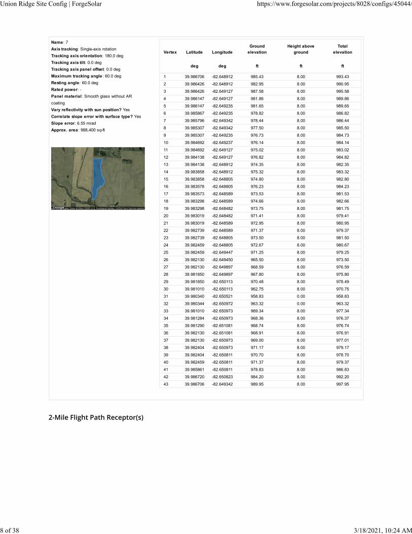
Name: 7
Axis tracking: Single-axis rotation
Tracking axis orientation: 180.0 deg
Tracking axis tilt: 0.0 deg
Tracking axis panel offset: 0.0 deg
Maximum tracking angle: 60.0 deg
Resting angle: 60.0 deg
Rated power: -
Panel material: Smooth glass without AR
coating
Vary reflectivity with sun position? Yes
Correlate slope error with surface type? Yes
Slope error: 6.55 mrad
Approx. area: 988,400 sq-ft
Vertex Latitude Longitude
Ground
elevation
Height above
ground
Total
elevation
deg deg ft ft ft
1 39.986706 -82.648912 985.43 8.00 993.43
2 39.986426 -82.648912 982.95 8.00 990.95
3 39.986426 -82.649127 987.58 8.00 995.58
4 39.986147 -82.649127 981.86 8.00 989.86
5 39.986147 -82.649235 981.65 8.00 989.65
6 39.985867 -82.649235 978.82 8.00 986.82
7 39.985796 -82.649342 978.44 8.00 986.44
8 39.985307 -82.649342 977.50 8.00 985.50
9 39.985307 -82.649235 976.73 8.00 984.73
10 39.984692 -82.649237 976.14 8.00 984.14
11 39.984692 -82.649127 975.02 8.00 983.02
12 39.984138 -82.649127 976.82 8.00 984.82
13 39.984138 -82.648912 974.35 8.00 982.35
14 39.983858 -82.648912 975.32 8.00 983.32
15 39.983858 -82.648805 974.80 8.00 982.80
16 39.983578 -82.648805 976.23 8.00 984.23
17 39.983573 -82.648589 973.53 8.00 981.53
18 39.983298 -82.648589 974.66 8.00 982.66
19 39.983298 -82.648482 973.75 8.00 981.75
20 39.983019 -82.648482 971.41 8.00 979.41
21 39.983019 -82.648589 972.95 8.00 980.95
22 39.982739 -82.648589 971.37 8.00 979.37
23 39.982739 -82.648805 973.50 8.00 981.50
24 39.982459 -82.648805 972.67 8.00 980.67
25 39.982459 -82.649447 971.25 8.00 979.25
26 39.982130 -82.649450 965.50 8.00 973.50
27 39.982130 -82.649897 968.59 8.00 976.59
28 39.981850 -82.649897 967.80 8.00 975.80
29 39.981850 -82.650113 970.48 8.00 978.49
30 39.981010 -82.650113 962.75 8.00 970.75
31 39.980340 -82.650521 958.83 0.00 958.83
32 39.980344 -82.650972 963.32 0.00 963.32
33 39.981010 -82.650973 969.34 8.00 977.34
34 39.981284 -82.650973 968.36 8.00 976.37
35 39.981290 -82.651081 968.74 8.00 976.74
36 39.982130 -82.651081 968.91 8.00 976.91
37 39.982130 -82.650973 969.00 8.00 977.01
38 39.982404 -82.650973 971.17 8.00 979.17
39 39.982404 -82.650811 970.70 8.00 978.70
40 39.982459 -82.650811 971.37 8.00 979.37
41 39.985861 -82.650811 978.83 8.00 986.83
42 39.986720 -82.650823 984.20 8.00 992.20
43 39.986706 -82.649342 989.95 8.00 997.95
Union Ridge Site Config | ForgeSolar https://www.forgesolar.com/projects/8028/configs/45044/
8 of 38 3/18/2021, 10:24 AM

Name: FP 1
Description:
Threshold height : 50 ft
Direction: 93.9 deg
Glide slope: 3.0 deg
Pilot view restricted? Yes
Vertical view restriction: 30.0 deg
Azimuthal view restriction: 50.0 deg
Point Latitude Longitude
Ground
elevation
Height above
ground
Total
elevation
deg deg ft ft ft
Threshold 39.993682 -82.908930 803.59 50.00 853.59
2-mile
point
39.995648 -82.946626 804.30 602.74 1407.04
Name: FP 10
Description:
Threshold height : 50 ft
Direction: 280.7 deg
Glide slope: 3.0 deg
Pilot view restricted? Yes
Vertical view restriction: 30.0 deg
Azimuthal view restriction: 50.0 deg
Point Latitude Longitude
Ground
elevation
Height above
ground
Total
elevation
deg deg ft ft ft
Threshold 39.952769 -82.637881 1045.79 50.00 1095.80
2-mile
point
39.947410 -82.600774 946.05 703.20 1649.25
Name: FP 2
Description:
Threshold height : 50 ft
Direction: 272.9 deg
Glide slope: 3.0 deg
Pilot view restricted? Yes
Vertical view restriction: 30.0 deg
Azimuthal view restriction: 50.0 deg
Point Latitude Longitude
Ground
elevation
Height above
ground
Total
elevation
deg deg ft ft ft
Threshold 39.991577 -82.873224 811.59 50.00 861.59
2-mile
point
39.990130 -82.835490 908.97 506.08 1415.05
Union Ridge Site Config | ForgeSolar https://www.forgesolar.com/projects/8028/configs/45044/
9 of 38 3/18/2021, 10:24 AM

Name: FP 3
Description:
Threshold height : 50 ft
Direction: 274.7 deg
Glide slope: 3.0 deg
Pilot view restricted? Yes
Vertical view restriction: 30.0 deg
Azimuthal view restriction: 50.0 deg
Point Latitude Longitude
Ground
elevation
Height above
ground
Total
elevation
deg deg ft ft ft
Threshold 40.001572 -82.879275 812.08 50.00 862.08
2-mile
point
39.999188 -82.841616 909.33 506.20 1415.53
Name: FP 4
Description:
Threshold height : 50 ft
Direction: 94.4 deg
Glide slope: 3.0 deg
Pilot view restricted? Yes
Vertical view restriction: 30.0 deg
Azimuthal view restriction: 50.0 deg
Point Latitude Longitude
Ground
elevation
Height above
ground
Total
elevation
deg deg ft ft ft
Threshold 40.003183 -82.907728 814.54 50.00 864.54
2-mile
point
40.005386 -82.945407 813.99 604.01 1418.00
Name: FP 5
Description:
Threshold height : 50 ft
Direction: 271.4 deg
Glide slope: 3.0 deg
Pilot view restricted? Yes
Vertical view restriction: 30.0 deg
Azimuthal view restriction: 50.0 deg
Point Latitude Longitude
Ground
elevation
Height above
ground
Total
elevation
deg deg ft ft ft
Threshold 39.883761 -82.585057 922.49 50.00 972.49
2-mile
point
39.883069 -82.547345 916.33 609.61 1525.94
Union Ridge Site Config | ForgeSolar https://www.forgesolar.com/projects/8028/configs/45044/
10 of 38 3/18/2021, 10:24 AM
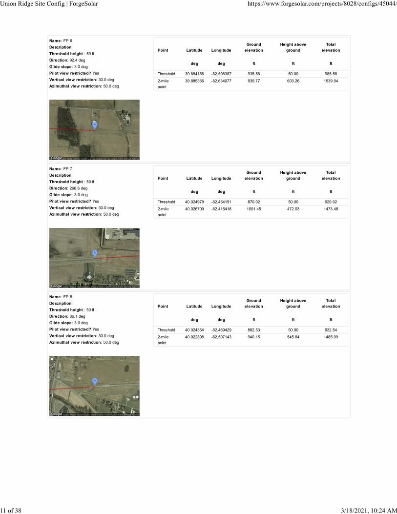
Name: FP 6
Description:
Threshold height : 50 ft
Direction: 92.4 deg
Glide slope: 3.0 deg
Pilot view restricted? Yes
Vertical view restriction: 30.0 deg
Azimuthal view restriction: 50.0 deg
Point Latitude Longitude
Ground
elevation
Height above
ground
Total
elevation
deg deg ft ft ft
Threshold 39.884156 -82.596387 935.58 50.00 985.58
2-mile
point
39.885366 -82.634077 935.77 603.26 1539.04
Name: FP 7
Description:
Threshold height : 50 ft
Direction: 266.6 deg
Glide slope: 3.0 deg
Pilot view restricted? Yes
Vertical view restriction: 30.0 deg
Azimuthal view restriction: 50.0 deg
Point Latitude Longitude
Ground
elevation
Height above
ground
Total
elevation
deg deg ft ft ft
Threshold 40.024979 -82.454151 870.02 50.00 920.02
2-mile
point
40.026709 -82.416418 1001.45 472.03 1473.48
Name: FP 8
Description:
Threshold height : 50 ft
Direction: 86.1 deg
Glide slope: 3.0 deg
Pilot view restricted? Yes
Vertical view restriction: 30.0 deg
Azimuthal view restriction: 50.0 deg
Point Latitude Longitude
Ground
elevation
Height above
ground
Total
elevation
deg deg ft ft ft
Threshold 40.024354 -82.469429 882.53 50.00 932.54
2-mile
point
40.022398 -82.507143 940.15 545.84 1485.99
Union Ridge Site Config | ForgeSolar https://www.forgesolar.com/projects/8028/configs/45044/
11 of 38 3/18/2021, 10:24 AM

Route Receptor(s)
Name: FP 9
Description:
Threshold height : 50 ft
Direction: 101.9 deg
Glide slope: 3.0 deg
Pilot view restricted? Yes
Vertical view restriction: 30.0 deg
Azimuthal view restriction: 50.0 deg
Point Latitude Longitude
Ground
elevation
Height above
ground
Total
elevation
deg deg ft ft ft
Threshold 39.953386 -82.642430 1023.18 50.00 1073.18
2-mile
point
39.959328 -82.679385 1054.73 571.91 1626.63
Name: Route 1
Route type Two-way
View angle: 50.0 degVertex Latitude Longitude
Ground
elevation
Height above
ground
Total
elevation
deg deg ft ft ft
1 39.999813 -82.645853 1052.35 4.00 1056.35
2 39.998654 -82.623279 1072.95 4.00 1076.95
Name: Route 2
Route type Two-way
View angle: 50.0 degVertex Latitude Longitude
Ground
elevation
Height above
ground
Total
elevation
deg deg ft ft ft
1 39.970385 -82.647722 956.25 4.00 960.25
2 39.969431 -82.625870 941.25 4.00 945.25
Name: Route 3
Route type Two-way
View angle: 50.0 degVertex Latitude Longitude
Ground
elevation
Height above
ground
Total
elevation
deg deg ft ft ft
1 39.968699 -82.626771 935.19 4.00 939.19
2 39.969439 -82.626792 944.23 4.00 948.23
3 39.970080 -82.626943 954.36 4.00 958.36
4 39.979487 -82.626407 1004.82 0.00 1004.82
5 39.984114 -82.626148 1011.15 0.00 1011.15
6 39.999867 -82.625176 1083.95 4.00 1087.95
Union Ridge Site Config | ForgeSolar https://www.forgesolar.com/projects/8028/configs/45044/
12 of 38 3/18/2021, 10:24 AM

Name: Route 4
Route type Two-way
View angle: 50.0 degVertex Latitude Longitude
Ground
elevation
Height above
ground
Total
elevation
deg deg ft ft ft
1 40.001070 -82.644231 1071.03 4.00 1075.03
2 39.991162 -82.644598 1019.92 0.00 1019.92
3 39.988932 -82.644758 1005.99 0.00 1005.99
4 39.986744 -82.644907 993.59 0.00 993.59
5 39.984588 -82.645037 985.58 0.00 985.58
6 39.982909 -82.645172 979.15 0.00 979.15
7 39.981312 -82.645265 975.31 0.00 975.31
8 39.977709 -82.645465 957.16 4.00 961.16
9 39.969322 -82.646001 959.16 4.00 963.16
Name: Route 5
Route type Two-way
View angle: 50.0 degVertex Latitude Longitude
Ground
elevation
Height above
ground
Total
elevation
deg deg ft ft ft
1 39.973626 -82.645736 953.19 0.00 953.19
2 39.973618 -82.646541 955.76 0.00 955.76
3 39.973569 -82.647432 960.39 0.00 960.39
4 39.973585 -82.648193 956.20 0.00 956.20
5 39.973742 -82.648590 954.70 0.00 954.70
6 39.974358 -82.649416 954.84 0.00 954.84
7 39.974810 -82.650060 955.14 0.00 955.14
8 39.975772 -82.651830 957.67 0.00 957.67
9 39.976504 -82.653021 959.04 0.00 959.04
10 39.977022 -82.653955 960.56 0.00 960.56
11 39.977647 -82.654953 961.60 0.00 961.60
12 39.977926 -82.655489 962.21 0.00 962.21
13 39.978740 -82.656991 964.74 0.00 964.74
14 39.979801 -82.658987 966.76 0.00 966.76
15 39.980450 -82.660220 968.20 0.00 968.20
16 39.981149 -82.661604 970.23 0.00 970.23
17 39.982012 -82.663267 972.82 0.00 972.82
18 39.982728 -82.664726 976.23 0.00 976.23
Union Ridge Site Config | ForgeSolar https://www.forgesolar.com/projects/8028/configs/45044/
13 of 38 3/18/2021, 10:24 AM

Discrete Observation Receptors
Number Latitude Longitude Ground elevation Height above ground Total Elevation
deg deg ft ft ft
1-ATCT 39.998230 -82.893186 808.54 50.00 858.54
OP 683 39.976857 -82.643479 972.65 5.40 978.05
OP 684 39.976338 -82.643555 977.25 5.40 982.65
OP 685 39.978092 -82.643515 977.85 5.40 983.25
OP 686 39.978153 -82.646766 972.95 5.40 978.35
OP 687 39.969131 -82.643825 958.15 5.40 963.55
OP 688 39.971185 -82.641723 956.55 5.40 961.95
OP 689 39.970318 -82.639747 959.05 5.40 964.45
OP 690 39.969198 -82.639466 955.85 5.40 961.25
OP 691 39.970162 -82.638662 960.15 5.40 965.55
OP 692 39.969279 -82.638103 961.45 5.40 966.85
OP 693 39.969123 -82.637308 961.35 5.40 966.75
OP 694 39.970216 -82.638058 957.95 5.40 963.35
OP 695 39.970092 -82.637120 956.85 5.40 962.25
OP 696 39.968970 -82.636611 960.25 5.40 965.65
OP 697 39.970069 -82.635336 957.55 5.40 962.95
OP 698 39.971988 -82.635298 963.85 5.40 969.25
OP 700 39.971905 -82.636157 967.55 5.40 972.95
OP 701 39.976402 -82.634912 973.35 5.40 978.75
OP 711 39.979942 -82.626008 1001.15 5.40 1006.55
OP 712 39.980059 -82.626699 1007.15 5.40 1012.55
OP 713 39.980637 -82.626994 1004.65 5.40 1010.05
OP 714 39.980660 -82.627750 1002.75 5.40 1008.15
OP 715 39.980855 -82.628417 1003.65 5.40 1009.05
OP 716 39.981493 -82.626745 1004.65 5.40 1010.05
OP 717 39.980995 -82.628974 1002.15 5.40 1007.55
OP 718 39.981099 -82.629737 999.35 5.40 1004.75
OP 719 39.980984 -82.630517 996.65 5.40 1002.05
OP 720 39.980447 -82.629159 997.65 5.40 1003.05
OP 721 39.980176 -82.628521 996.95 5.40 1002.35
OP 722 39.980008 -82.629282 995.15 5.40 1000.55
OP 723 39.979604 -82.628551 995.45 5.40 1000.85
OP 724 39.979165 -82.628649 996.05 5.40 1001.45
OP 725 39.979460 -82.629256 993.15 5.40 998.55
OP 726 39.979426 -82.629975 991.65 5.40 997.05
OP 727 39.980016 -82.630447 993.45 5.40 998.85
OP 728 39.979487 -82.630619 992.25 5.40 997.65
OP 729 39.980059 -82.630998 993.05 5.40 998.45
OP 730 39.979491 -82.631208 992.55 5.40 997.95
OP 731 39.979600 -82.631809 992.25 5.40 997.65
OP 732 39.980087 -82.631525 993.65 5.40 999.05
OP 733 39.979881 -82.632423 989.35 5.40 994.75
OP 734 39.980286 -82.632387 994.25 5.40 999.65
OP 735 39.980939 -82.632289 989.75 5.40 995.15
OP 736 39.981339 -82.632271 991.65 5.40 997.05
OP 737 39.981278 -82.631614 994.15 5.40 999.55
OP 738 39.980892 -82.631589 991.15 5.40 996.55
OP 739 39.978680 -82.626833 1003.05 5.40 1008.45
OP 922 39.986132 -82.644444 998.55 5.40 1003.95
OP 923 39.987355 -82.645152 994.95 5.40 1000.35
OP 924 39.988570 -82.645692 1011.65 5.40 1017.05
OP 925 39.987520 -82.646929 996.25 5.40 1001.65
OP 926 39.988451 -82.647787 999.45 5.40 1004.85
OP 927 39.987628 -82.648072 992.65 5.40 998.05
OP 928 39.988405 -82.646234 1007.15 5.40 1012.55
OP 929 39.988435 -82.646544 1007.05 5.40 1012.45
OP 930 39.987505 -82.646484 998.05 5.40 1003.45
Union Ridge Site Config | ForgeSolar https://www.forgesolar.com/projects/8028/configs/45044/
14 of 38 3/18/2021, 10:24 AM

OP 931 39.988428 -82.647322 1004.55 5.40 1009.95
OP 932 39.988551 -82.648628 999.55 5.40 1004.95
OP 933 39.987272 -82.649299 991.65 5.40 997.05
OP 934 39.988280 -82.643775 1021.05 5.40 1026.45
OP 935 39.988192 -82.642927 1026.85 5.40 1032.25
OP 936 39.988668 -82.642986 1021.05 5.40 1026.45
OP 937 39.988692 -82.643513 1019.35 5.40 1024.75
OP 938 39.990119 -82.642915 1026.35 5.40 1031.75
OP 939 39.991515 -82.644068 1037.65 5.40 1043.05
OP 940 39.991674 -82.644901 1022.05 5.40 1027.45
OP 942 39.992227 -82.643818 1029.75 5.40 1035.15
OP 994 39.993671 -82.626109 1049.95 5.40 1055.35
OP 996 39.991780 -82.626452 1019.35 5.40 1024.75
OP 997 39.989994 -82.625352 1012.35 5.40 1017.75
OP 999 39.989156 -82.627117 1024.85 5.40 1030.25
OP 1000 39.989496 -82.627089 1026.15 5.40 1031.55
OP 1001 39.989953 -82.627234 1032.05 5.40 1037.45
OP 1002 39.990346 -82.627453 1034.25 5.40 1039.65
OP 1003 39.987679 -82.627541 1022.25 5.40 1027.65
OP 1004 39.988140 -82.627900 1023.85 5.40 1029.25
OP 1005 39.988537 -82.627455 1026.85 5.40 1032.25
OP 1006 39.987467 -82.625473 1009.65 5.40 1015.05
OP 1007 39.987105 -82.626523 1016.35 5.40 1021.75
OP 1008 39.986488 -82.625411 1007.75 5.40 1013.15
OP 1009 39.985587 -82.625484 1012.45 5.40 1017.85
OP 1010 39.985717 -82.627208 1013.05 5.40 1018.45
OP 1011 39.985264 -82.626454 1020.35 5.40 1025.75
OP 1012 39.984754 -82.625496 1013.35 5.40 1018.75
OP 1013 39.984334 -82.627117 1011.55 5.40 1016.95
OP 1014 39.984225 -82.625551 1015.85 5.40 1021.25
OP 1016 39.983238 -82.625712 997.95 5.40 1003.35
OP 1017 39.983258 -82.627357 1000.55 5.40 1005.95
OP 1018 39.983803 -82.627108 1003.15 5.40 1008.55
OP 1019 39.983822 -82.625700 1010.95 5.40 1016.35
OP 1022 39.984220 -82.624845 1010.05 5.40 1015.45
1-ATCT map image
Union Ridge Site Config | ForgeSolar https://www.forgesolar.com/projects/8028/configs/45044/
15 of 38 3/18/2021, 10:24 AM

PV Array Results
Summary of PV Glare Analysis PV con�guration and predicted glare
PV Name Tilt Orientation "Green" Glare "Yellow" Glare Energy Produced Data File
deg deg min min kWh
1 SA tracking SA tracking 0 0 - -
2 SA tracking SA tracking 0 0 - -
3 SA tracking SA tracking 0 0 - -
4 SA tracking SA tracking 0 0 - -
5 SA tracking SA tracking 0 0 - -
6 SA tracking SA tracking 0 0 - -
7 SA tracking SA tracking 0 0 - -
Click the name of the PV array to scroll to its results
PV & Receptor Analysis Results detailed results for each PV array and receptor
1 no glare found
Union Ridge Site Config | ForgeSolar https://www.forgesolar.com/projects/8028/configs/45044/
16 of 38 3/18/2021, 10:24 AM

Component Green glare (min) Yellow glare (min)
FP: FP 1 0 0
FP: FP 10 0 0
FP: FP 2 0 0
FP: FP 3 0 0
FP: FP 4 0 0
FP: FP 5 0 0
FP: FP 6 0 0
FP: FP 7 0 0
FP: FP 8 0 0
FP: FP 9 0 0
OP: 1-ATCT 0 0
OP: OP 683 0 0
OP: OP 684 0 0
OP: OP 685 0 0
OP: OP 686 0 0
OP: OP 687 0 0
OP: OP 688 0 0
OP: OP 689 0 0
OP: OP 690 0 0
OP: OP 691 0 0
OP: OP 692 0 0
OP: OP 693 0 0
OP: OP 694 0 0
OP: OP 695 0 0
OP: OP 696 0 0
OP: OP 697 0 0
OP: OP 698 0 0
OP: OP 700 0 0
OP: OP 701 0 0
OP: OP 711 0 0
OP: OP 712 0 0
OP: OP 713 0 0
OP: OP 714 0 0
OP: OP 715 0 0
OP: OP 716 0 0
OP: OP 717 0 0
OP: OP 718 0 0
OP: OP 719 0 0
OP: OP 720 0 0
OP: OP 721 0 0
OP: OP 722 0 0
OP: OP 723 0 0
OP: OP 724 0 0
OP: OP 725 0 0
OP: OP 726 0 0
OP: OP 727 0 0
OP: OP 728 0 0
Union Ridge Site Config | ForgeSolar https://www.forgesolar.com/projects/8028/configs/45044/
17 of 38 3/18/2021, 10:24 AM

OP: OP 729 0 0
OP: OP 730 0 0
OP: OP 731 0 0
OP: OP 732 0 0
OP: OP 733 0 0
OP: OP 734 0 0
OP: OP 735 0 0
OP: OP 736 0 0
OP: OP 737 0 0
OP: OP 738 0 0
OP: OP 739 0 0
OP: OP 922 0 0
OP: OP 923 0 0
OP: OP 924 0 0
OP: OP 925 0 0
OP: OP 926 0 0
OP: OP 927 0 0
OP: OP 928 0 0
OP: OP 929 0 0
OP: OP 930 0 0
OP: OP 931 0 0
OP: OP 932 0 0
OP: OP 933 0 0
OP: OP 934 0 0
OP: OP 935 0 0
OP: OP 936 0 0
OP: OP 937 0 0
OP: OP 938 0 0
OP: OP 939 0 0
OP: OP 940 0 0
OP: OP 942 0 0
OP: OP 994 0 0
OP: OP 996 0 0
OP: OP 997 0 0
OP: OP 999 0 0
OP: OP 1000 0 0
OP: OP 1001 0 0
OP: OP 1002 0 0
OP: OP 1003 0 0
OP: OP 1004 0 0
OP: OP 1005 0 0
OP: OP 1006 0 0
OP: OP 1007 0 0
OP: OP 1008 0 0
OP: OP 1009 0 0
OP: OP 1010 0 0
OP: OP 1011 0 0
OP: OP 1012 0 0
OP: OP 1013 0 0
Union Ridge Site Config | ForgeSolar https://www.forgesolar.com/projects/8028/configs/45044/
18 of 38 3/18/2021, 10:24 AM

2 no glare found
OP: OP 1014 0 0
OP: OP 1016 0 0
OP: OP 1017 0 0
OP: OP 1018 0 0
OP: OP 1019 0 0
OP: OP 1022 0 0
Route: Route 1 0 0
Route: Route 2 0 0
Route: Route 3 0 0
Route: Route 4 0 0
Route: Route 5 0 0
No glare found
Union Ridge Site Config | ForgeSolar https://www.forgesolar.com/projects/8028/configs/45044/
19 of 38 3/18/2021, 10:24 AM

Component Green glare (min) Yellow glare (min)
FP: FP 1 0 0
FP: FP 10 0 0
FP: FP 2 0 0
FP: FP 3 0 0
FP: FP 4 0 0
FP: FP 5 0 0
FP: FP 6 0 0
FP: FP 7 0 0
FP: FP 8 0 0
FP: FP 9 0 0
OP: 1-ATCT 0 0
OP: OP 683 0 0
OP: OP 684 0 0
OP: OP 685 0 0
OP: OP 686 0 0
OP: OP 687 0 0
OP: OP 688 0 0
OP: OP 689 0 0
OP: OP 690 0 0
OP: OP 691 0 0
OP: OP 692 0 0
OP: OP 693 0 0
OP: OP 694 0 0
OP: OP 695 0 0
OP: OP 696 0 0
OP: OP 697 0 0
OP: OP 698 0 0
OP: OP 700 0 0
OP: OP 701 0 0
OP: OP 711 0 0
OP: OP 712 0 0
OP: OP 713 0 0
OP: OP 714 0 0
OP: OP 715 0 0
OP: OP 716 0 0
OP: OP 717 0 0
OP: OP 718 0 0
OP: OP 719 0 0
OP: OP 720 0 0
OP: OP 721 0 0
OP: OP 722 0 0
OP: OP 723 0 0
OP: OP 724 0 0
OP: OP 725 0 0
OP: OP 726 0 0
OP: OP 727 0 0
OP: OP 728 0 0
Union Ridge Site Config | ForgeSolar https://www.forgesolar.com/projects/8028/configs/45044/
20 of 38 3/18/2021, 10:24 AM

OP: OP 729 0 0
OP: OP 730 0 0
OP: OP 731 0 0
OP: OP 732 0 0
OP: OP 733 0 0
OP: OP 734 0 0
OP: OP 735 0 0
OP: OP 736 0 0
OP: OP 737 0 0
OP: OP 738 0 0
OP: OP 739 0 0
OP: OP 922 0 0
OP: OP 923 0 0
OP: OP 924 0 0
OP: OP 925 0 0
OP: OP 926 0 0
OP: OP 927 0 0
OP: OP 928 0 0
OP: OP 929 0 0
OP: OP 930 0 0
OP: OP 931 0 0
OP: OP 932 0 0
OP: OP 933 0 0
OP: OP 934 0 0
OP: OP 935 0 0
OP: OP 936 0 0
OP: OP 937 0 0
OP: OP 938 0 0
OP: OP 939 0 0
OP: OP 940 0 0
OP: OP 942 0 0
OP: OP 994 0 0
OP: OP 996 0 0
OP: OP 997 0 0
OP: OP 999 0 0
OP: OP 1000 0 0
OP: OP 1001 0 0
OP: OP 1002 0 0
OP: OP 1003 0 0
OP: OP 1004 0 0
OP: OP 1005 0 0
OP: OP 1006 0 0
OP: OP 1007 0 0
OP: OP 1008 0 0
OP: OP 1009 0 0
OP: OP 1010 0 0
OP: OP 1011 0 0
OP: OP 1012 0 0
OP: OP 1013 0 0
Union Ridge Site Config | ForgeSolar https://www.forgesolar.com/projects/8028/configs/45044/
21 of 38 3/18/2021, 10:24 AM

3 no glare found
OP: OP 1014 0 0
OP: OP 1016 0 0
OP: OP 1017 0 0
OP: OP 1018 0 0
OP: OP 1019 0 0
OP: OP 1022 0 0
Route: Route 1 0 0
Route: Route 2 0 0
Route: Route 3 0 0
Route: Route 4 0 0
Route: Route 5 0 0
No glare found
Union Ridge Site Config | ForgeSolar https://www.forgesolar.com/projects/8028/configs/45044/
22 of 38 3/18/2021, 10:24 AM

Component Green glare (min) Yellow glare (min)
FP: FP 1 0 0
FP: FP 10 0 0
FP: FP 2 0 0
FP: FP 3 0 0
FP: FP 4 0 0
FP: FP 5 0 0
FP: FP 6 0 0
FP: FP 7 0 0
FP: FP 8 0 0
FP: FP 9 0 0
OP: 1-ATCT 0 0
OP: OP 683 0 0
OP: OP 684 0 0
OP: OP 685 0 0
OP: OP 686 0 0
OP: OP 687 0 0
OP: OP 688 0 0
OP: OP 689 0 0
OP: OP 690 0 0
OP: OP 691 0 0
OP: OP 692 0 0
OP: OP 693 0 0
OP: OP 694 0 0
OP: OP 695 0 0
OP: OP 696 0 0
OP: OP 697 0 0
OP: OP 698 0 0
OP: OP 700 0 0
OP: OP 701 0 0
OP: OP 711 0 0
OP: OP 712 0 0
OP: OP 713 0 0
OP: OP 714 0 0
OP: OP 715 0 0
OP: OP 716 0 0
OP: OP 717 0 0
OP: OP 718 0 0
OP: OP 719 0 0
OP: OP 720 0 0
OP: OP 721 0 0
OP: OP 722 0 0
OP: OP 723 0 0
OP: OP 724 0 0
OP: OP 725 0 0
OP: OP 726 0 0
OP: OP 727 0 0
OP: OP 728 0 0
Union Ridge Site Config | ForgeSolar https://www.forgesolar.com/projects/8028/configs/45044/
23 of 38 3/18/2021, 10:24 AM

OP: OP 729 0 0
OP: OP 730 0 0
OP: OP 731 0 0
OP: OP 732 0 0
OP: OP 733 0 0
OP: OP 734 0 0
OP: OP 735 0 0
OP: OP 736 0 0
OP: OP 737 0 0
OP: OP 738 0 0
OP: OP 739 0 0
OP: OP 922 0 0
OP: OP 923 0 0
OP: OP 924 0 0
OP: OP 925 0 0
OP: OP 926 0 0
OP: OP 927 0 0
OP: OP 928 0 0
OP: OP 929 0 0
OP: OP 930 0 0
OP: OP 931 0 0
OP: OP 932 0 0
OP: OP 933 0 0
OP: OP 934 0 0
OP: OP 935 0 0
OP: OP 936 0 0
OP: OP 937 0 0
OP: OP 938 0 0
OP: OP 939 0 0
OP: OP 940 0 0
OP: OP 942 0 0
OP: OP 994 0 0
OP: OP 996 0 0
OP: OP 997 0 0
OP: OP 999 0 0
OP: OP 1000 0 0
OP: OP 1001 0 0
OP: OP 1002 0 0
OP: OP 1003 0 0
OP: OP 1004 0 0
OP: OP 1005 0 0
OP: OP 1006 0 0
OP: OP 1007 0 0
OP: OP 1008 0 0
OP: OP 1009 0 0
OP: OP 1010 0 0
OP: OP 1011 0 0
OP: OP 1012 0 0
OP: OP 1013 0 0
Union Ridge Site Config | ForgeSolar https://www.forgesolar.com/projects/8028/configs/45044/
24 of 38 3/18/2021, 10:24 AM

4 no glare found
OP: OP 1014 0 0
OP: OP 1016 0 0
OP: OP 1017 0 0
OP: OP 1018 0 0
OP: OP 1019 0 0
OP: OP 1022 0 0
Route: Route 1 0 0
Route: Route 2 0 0
Route: Route 3 0 0
Route: Route 4 0 0
Route: Route 5 0 0
No glare found
Union Ridge Site Config | ForgeSolar https://www.forgesolar.com/projects/8028/configs/45044/
25 of 38 3/18/2021, 10:24 AM

Component Green glare (min) Yellow glare (min)
FP: FP 1 0 0
FP: FP 10 0 0
FP: FP 2 0 0
FP: FP 3 0 0
FP: FP 4 0 0
FP: FP 5 0 0
FP: FP 6 0 0
FP: FP 7 0 0
FP: FP 8 0 0
FP: FP 9 0 0
OP: 1-ATCT 0 0
OP: OP 683 0 0
OP: OP 684 0 0
OP: OP 685 0 0
OP: OP 686 0 0
OP: OP 687 0 0
OP: OP 688 0 0
OP: OP 689 0 0
OP: OP 690 0 0
OP: OP 691 0 0
OP: OP 692 0 0
OP: OP 693 0 0
OP: OP 694 0 0
OP: OP 695 0 0
OP: OP 696 0 0
OP: OP 697 0 0
OP: OP 698 0 0
OP: OP 700 0 0
OP: OP 701 0 0
OP: OP 711 0 0
OP: OP 712 0 0
OP: OP 713 0 0
OP: OP 714 0 0
OP: OP 715 0 0
OP: OP 716 0 0
OP: OP 717 0 0
OP: OP 718 0 0
OP: OP 719 0 0
OP: OP 720 0 0
OP: OP 721 0 0
OP: OP 722 0 0
OP: OP 723 0 0
OP: OP 724 0 0
OP: OP 725 0 0
OP: OP 726 0 0
OP: OP 727 0 0
OP: OP 728 0 0
Union Ridge Site Config | ForgeSolar https://www.forgesolar.com/projects/8028/configs/45044/
26 of 38 3/18/2021, 10:24 AM
OP: OP 729 0 0
OP: OP 730 0 0
OP: OP 731 0 0
OP: OP 732 0 0
OP: OP 733 0 0
OP: OP 734 0 0
OP: OP 735 0 0
OP: OP 736 0 0
OP: OP 737 0 0
OP: OP 738 0 0
OP: OP 739 0 0
OP: OP 922 0 0
OP: OP 923 0 0
OP: OP 924 0 0
OP: OP 925 0 0
OP: OP 926 0 0
OP: OP 927 0 0
OP: OP 928 0 0
OP: OP 929 0 0
OP: OP 930 0 0
OP: OP 931 0 0
OP: OP 932 0 0
OP: OP 933 0 0
OP: OP 934 0 0
OP: OP 935 0 0
OP: OP 936 0 0
OP: OP 937 0 0
OP: OP 938 0 0
OP: OP 939 0 0
OP: OP 940 0 0
OP: OP 942 0 0
OP: OP 994 0 0
OP: OP 996 0 0
OP: OP 997 0 0
OP: OP 999 0 0
OP: OP 1000 0 0
OP: OP 1001 0 0
OP: OP 1002 0 0
OP: OP 1003 0 0
OP: OP 1004 0 0
OP: OP 1005 0 0
OP: OP 1006 0 0
OP: OP 1007 0 0
OP: OP 1008 0 0
OP: OP 1009 0 0
OP: OP 1010 0 0
OP: OP 1011 0 0
OP: OP 1012 0 0
OP: OP 1013 0 0
Union Ridge Site Config | ForgeSolar https://www.forgesolar.com/projects/8028/configs/45044/
27 of 38 3/18/2021, 10:24 AM

5 no glare found
OP: OP 1014 0 0
OP: OP 1016 0 0
OP: OP 1017 0 0
OP: OP 1018 0 0
OP: OP 1019 0 0
OP: OP 1022 0 0
Route: Route 1 0 0
Route: Route 2 0 0
Route: Route 3 0 0
Route: Route 4 0 0
Route: Route 5 0 0
No glare found
Union Ridge Site Config | ForgeSolar https://www.forgesolar.com/projects/8028/configs/45044/
28 of 38 3/18/2021, 10:24 AM

Component Green glare (min) Yellow glare (min)
FP: FP 1 0 0
FP: FP 10 0 0
FP: FP 2 0 0
FP: FP 3 0 0
FP: FP 4 0 0
FP: FP 5 0 0
FP: FP 6 0 0
FP: FP 7 0 0
FP: FP 8 0 0
FP: FP 9 0 0
OP: 1-ATCT 0 0
OP: OP 683 0 0
OP: OP 684 0 0
OP: OP 685 0 0
OP: OP 686 0 0
OP: OP 687 0 0
OP: OP 688 0 0
OP: OP 689 0 0
OP: OP 690 0 0
OP: OP 691 0 0
OP: OP 692 0 0
OP: OP 693 0 0
OP: OP 694 0 0
OP: OP 695 0 0
OP: OP 696 0 0
OP: OP 697 0 0
OP: OP 698 0 0
OP: OP 700 0 0
OP: OP 701 0 0
OP: OP 711 0 0
OP: OP 712 0 0
OP: OP 713 0 0
OP: OP 714 0 0
OP: OP 715 0 0
OP: OP 716 0 0
OP: OP 717 0 0
OP: OP 718 0 0
OP: OP 719 0 0
OP: OP 720 0 0
OP: OP 721 0 0
OP: OP 722 0 0
OP: OP 723 0 0
OP: OP 724 0 0
OP: OP 725 0 0
OP: OP 726 0 0
OP: OP 727 0 0
OP: OP 728 0 0
Union Ridge Site Config | ForgeSolar https://www.forgesolar.com/projects/8028/configs/45044/
29 of 38 3/18/2021, 10:24 AM

OP: OP 729 0 0
OP: OP 730 0 0
OP: OP 731 0 0
OP: OP 732 0 0
OP: OP 733 0 0
OP: OP 734 0 0
OP: OP 735 0 0
OP: OP 736 0 0
OP: OP 737 0 0
OP: OP 738 0 0
OP: OP 739 0 0
OP: OP 922 0 0
OP: OP 923 0 0
OP: OP 924 0 0
OP: OP 925 0 0
OP: OP 926 0 0
OP: OP 927 0 0
OP: OP 928 0 0
OP: OP 929 0 0
OP: OP 930 0 0
OP: OP 931 0 0
OP: OP 932 0 0
OP: OP 933 0 0
OP: OP 934 0 0
OP: OP 935 0 0
OP: OP 936 0 0
OP: OP 937 0 0
OP: OP 938 0 0
OP: OP 939 0 0
OP: OP 940 0 0
OP: OP 942 0 0
OP: OP 994 0 0
OP: OP 996 0 0
OP: OP 997 0 0
OP: OP 999 0 0
OP: OP 1000 0 0
OP: OP 1001 0 0
OP: OP 1002 0 0
OP: OP 1003 0 0
OP: OP 1004 0 0
OP: OP 1005 0 0
OP: OP 1006 0 0
OP: OP 1007 0 0
OP: OP 1008 0 0
OP: OP 1009 0 0
OP: OP 1010 0 0
OP: OP 1011 0 0
OP: OP 1012 0 0
OP: OP 1013 0 0
Union Ridge Site Config | ForgeSolar https://www.forgesolar.com/projects/8028/configs/45044/
30 of 38 3/18/2021, 10:24 AM

6 no glare found
OP: OP 1014 0 0
OP: OP 1016 0 0
OP: OP 1017 0 0
OP: OP 1018 0 0
OP: OP 1019 0 0
OP: OP 1022 0 0
Route: Route 1 0 0
Route: Route 2 0 0
Route: Route 3 0 0
Route: Route 4 0 0
Route: Route 5 0 0
No glare found
Union Ridge Site Config | ForgeSolar https://www.forgesolar.com/projects/8028/configs/45044/
31 of 38 3/18/2021, 10:24 AM

Component Green glare (min) Yellow glare (min)
FP: FP 1 0 0
FP: FP 10 0 0
FP: FP 2 0 0
FP: FP 3 0 0
FP: FP 4 0 0
FP: FP 5 0 0
FP: FP 6 0 0
FP: FP 7 0 0
FP: FP 8 0 0
FP: FP 9 0 0
OP: 1-ATCT 0 0
OP: OP 683 0 0
OP: OP 684 0 0
OP: OP 685 0 0
OP: OP 686 0 0
OP: OP 687 0 0
OP: OP 688 0 0
OP: OP 689 0 0
OP: OP 690 0 0
OP: OP 691 0 0
OP: OP 692 0 0
OP: OP 693 0 0
OP: OP 694 0 0
OP: OP 695 0 0
OP: OP 696 0 0
OP: OP 697 0 0
OP: OP 698 0 0
OP: OP 700 0 0
OP: OP 701 0 0
OP: OP 711 0 0
OP: OP 712 0 0
OP: OP 713 0 0
OP: OP 714 0 0
OP: OP 715 0 0
OP: OP 716 0 0
OP: OP 717 0 0
OP: OP 718 0 0
OP: OP 719 0 0
OP: OP 720 0 0
OP: OP 721 0 0
OP: OP 722 0 0
OP: OP 723 0 0
OP: OP 724 0 0
OP: OP 725 0 0
OP: OP 726 0 0
OP: OP 727 0 0
OP: OP 728 0 0
Union Ridge Site Config | ForgeSolar https://www.forgesolar.com/projects/8028/configs/45044/
32 of 38 3/18/2021, 10:24 AM

OP: OP 729 0 0
OP: OP 730 0 0
OP: OP 731 0 0
OP: OP 732 0 0
OP: OP 733 0 0
OP: OP 734 0 0
OP: OP 735 0 0
OP: OP 736 0 0
OP: OP 737 0 0
OP: OP 738 0 0
OP: OP 739 0 0
OP: OP 922 0 0
OP: OP 923 0 0
OP: OP 924 0 0
OP: OP 925 0 0
OP: OP 926 0 0
OP: OP 927 0 0
OP: OP 928 0 0
OP: OP 929 0 0
OP: OP 930 0 0
OP: OP 931 0 0
OP: OP 932 0 0
OP: OP 933 0 0
OP: OP 934 0 0
OP: OP 935 0 0
OP: OP 936 0 0
OP: OP 937 0 0
OP: OP 938 0 0
OP: OP 939 0 0
OP: OP 940 0 0
OP: OP 942 0 0
OP: OP 994 0 0
OP: OP 996 0 0
OP: OP 997 0 0
OP: OP 999 0 0
OP: OP 1000 0 0
OP: OP 1001 0 0
OP: OP 1002 0 0
OP: OP 1003 0 0
OP: OP 1004 0 0
OP: OP 1005 0 0
OP: OP 1006 0 0
OP: OP 1007 0 0
OP: OP 1008 0 0
OP: OP 1009 0 0
OP: OP 1010 0 0
OP: OP 1011 0 0
OP: OP 1012 0 0
OP: OP 1013 0 0
Union Ridge Site Config | ForgeSolar https://www.forgesolar.com/projects/8028/configs/45044/
33 of 38 3/18/2021, 10:24 AM

7 no glare found
OP: OP 1014 0 0
OP: OP 1016 0 0
OP: OP 1017 0 0
OP: OP 1018 0 0
OP: OP 1019 0 0
OP: OP 1022 0 0
Route: Route 1 0 0
Route: Route 2 0 0
Route: Route 3 0 0
Route: Route 4 0 0
Route: Route 5 0 0
No glare found
Union Ridge Site Config | ForgeSolar https://www.forgesolar.com/projects/8028/configs/45044/
34 of 38 3/18/2021, 10:24 AM

Component Green glare (min) Yellow glare (min)
FP: FP 1 0 0
FP: FP 10 0 0
FP: FP 2 0 0
FP: FP 3 0 0
FP: FP 4 0 0
FP: FP 5 0 0
FP: FP 6 0 0
FP: FP 7 0 0
FP: FP 8 0 0
FP: FP 9 0 0
OP: 1-ATCT 0 0
OP: OP 683 0 0
OP: OP 684 0 0
OP: OP 685 0 0
OP: OP 686 0 0
OP: OP 687 0 0
OP: OP 688 0 0
OP: OP 689 0 0
OP: OP 690 0 0
OP: OP 691 0 0
OP: OP 692 0 0
OP: OP 693 0 0
OP: OP 694 0 0
OP: OP 695 0 0
OP: OP 696 0 0
OP: OP 697 0 0
OP: OP 698 0 0
OP: OP 700 0 0
OP: OP 701 0 0
OP: OP 711 0 0
OP: OP 712 0 0
OP: OP 713 0 0
OP: OP 714 0 0
OP: OP 715 0 0
OP: OP 716 0 0
OP: OP 717 0 0
OP: OP 718 0 0
OP: OP 719 0 0
OP: OP 720 0 0
OP: OP 721 0 0
OP: OP 722 0 0
OP: OP 723 0 0
OP: OP 724 0 0
OP: OP 725 0 0
OP: OP 726 0 0
OP: OP 727 0 0
OP: OP 728 0 0
Union Ridge Site Config | ForgeSolar https://www.forgesolar.com/projects/8028/configs/45044/
35 of 38 3/18/2021, 10:24 AM

OP: OP 729 0 0
OP: OP 730 0 0
OP: OP 731 0 0
OP: OP 732 0 0
OP: OP 733 0 0
OP: OP 734 0 0
OP: OP 735 0 0
OP: OP 736 0 0
OP: OP 737 0 0
OP: OP 738 0 0
OP: OP 739 0 0
OP: OP 922 0 0
OP: OP 923 0 0
OP: OP 924 0 0
OP: OP 925 0 0
OP: OP 926 0 0
OP: OP 927 0 0
OP: OP 928 0 0
OP: OP 929 0 0
OP: OP 930 0 0
OP: OP 931 0 0
OP: OP 932 0 0
OP: OP 933 0 0
OP: OP 934 0 0
OP: OP 935 0 0
OP: OP 936 0 0
OP: OP 937 0 0
OP: OP 938 0 0
OP: OP 939 0 0
OP: OP 940 0 0
OP: OP 942 0 0
OP: OP 994 0 0
OP: OP 996 0 0
OP: OP 997 0 0
OP: OP 999 0 0
OP: OP 1000 0 0
OP: OP 1001 0 0
OP: OP 1002 0 0
OP: OP 1003 0 0
OP: OP 1004 0 0
OP: OP 1005 0 0
OP: OP 1006 0 0
OP: OP 1007 0 0
OP: OP 1008 0 0
OP: OP 1009 0 0
OP: OP 1010 0 0
OP: OP 1011 0 0
OP: OP 1012 0 0
OP: OP 1013 0 0
Union Ridge Site Config | ForgeSolar https://www.forgesolar.com/projects/8028/configs/45044/
36 of 38 3/18/2021, 10:24 AM

OP: OP 1014 0 0
OP: OP 1016 0 0
OP: OP 1017 0 0
OP: OP 1018 0 0
OP: OP 1019 0 0
OP: OP 1022 0 0
Route: Route 1 0 0
Route: Route 2 0 0
Route: Route 3 0 0
Route: Route 4 0 0
Route: Route 5 0 0
No glare found
Union Ridge Site Config | ForgeSolar https://www.forgesolar.com/projects/8028/configs/45044/
37 of 38 3/18/2021, 10:24 AM

AssumptionsTimes associated with glare are denoted in Standard time. For Daylight Savings, add one hour.
Glare analyses do not account for physical obstructions between reflectors and receptors. This includes buildings, tree cover and geographic
obstructions.
Detailed system geometry is not rigorously simulated.
The glare hazard determination relies on several approximations including observer eye characteristics, angle of view, and typical blink
response time. Actual values and results may vary.
The system output calculation is a DNI-based approximation that assumes clear, sunny skies year-round. It should not be used in place of
more rigorous modeling methods.
Several calculations utilize the PV array centroid, rather than the actual glare spot location, due to algorithm limitations. This may affect
results for large PV footprints. Additional analyses of array sub-sections can provide additional information on expected glare.
The subtended source angle (glare spot size) is constrained by the PV array footprint size. Partitioning large arrays into smaller sections will
reduce the maximum potential subtended angle, potentially impacting results if actual glare spots are larger than the sub-array size. Additional
analyses of the combined area of adjacent sub-arrays can provide more information on potential glare hazards. (See previous point on related
limitations.)
Hazard zone boundaries shown in the Glare Hazard plot are an approximation and visual aid. Actual ocular impact outcomes encompass a
continuous, not discrete, spectrum.
Glare locations displayed on receptor plots are approximate. Actual glare-spot locations may differ.
Glare vector plots are simplified representations of analysis data. Actual glare emanations and results may differ.
Glare analysis methods used: OP V1, FP V1, Route V1
Refer to the Help page for assumptions and limitations not listed here.
Union Ridge Site Config | ForgeSolar https://www.forgesolar.com/projects/8028/configs/45044/
38 of 38 3/18/2021, 10:24 AM